HyspIRI Workshop Combined VNIR-SWIR and TIR Combined Question 5 Surface Composition and Change John Car”Lyle” Mars and Anupma Prakash

Welcome message from author
This document is posted to help you gain knowledge. Please leave a comment to let me know what you think about it! Share it to your friends and learn new things together.
Transcript
HyspIRI WorkshopCombined VNIR-SWIR and TIR
Combined Question 5Surface Composition and Change
John Car”Lyle” Marsand
Anupma Prakash
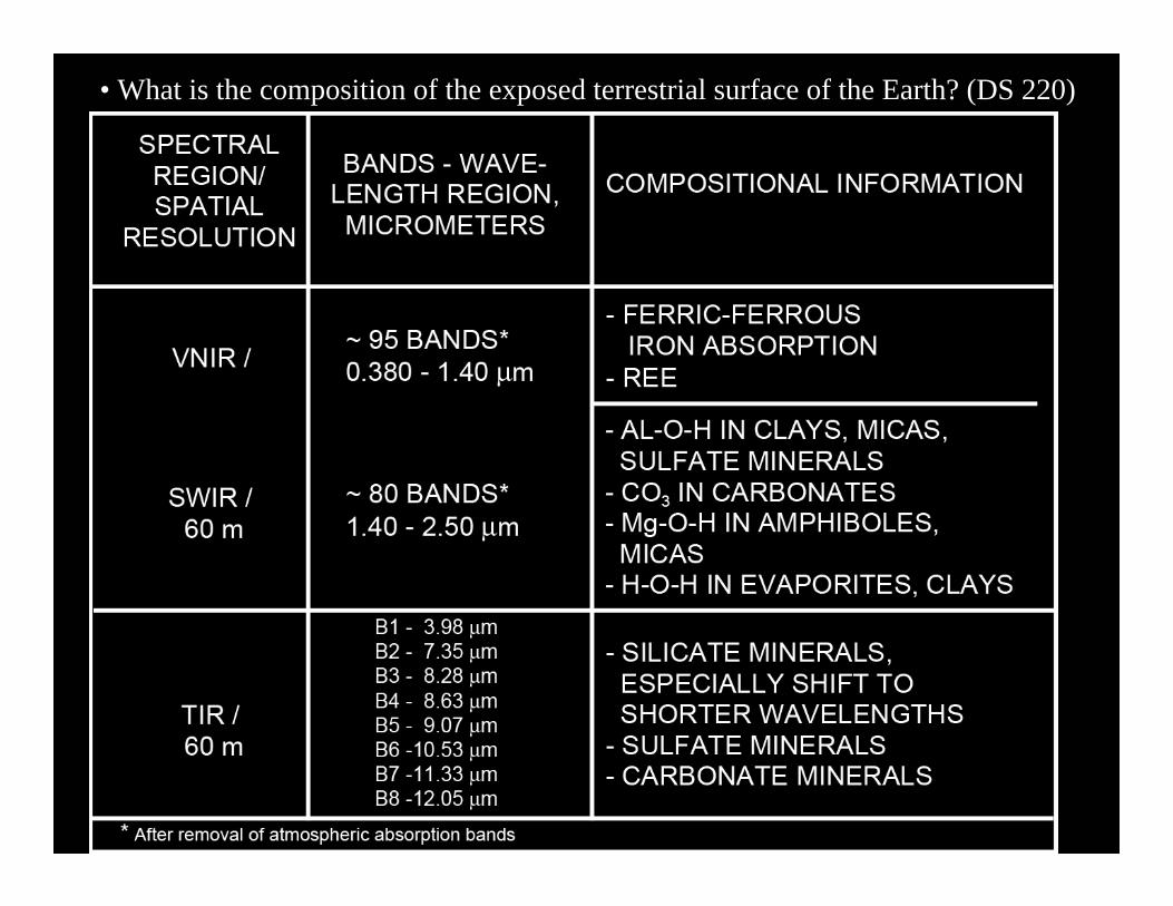
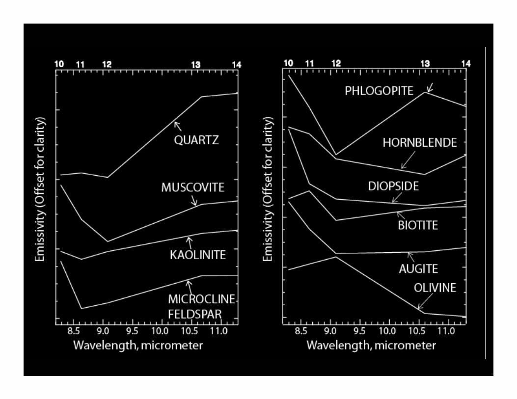
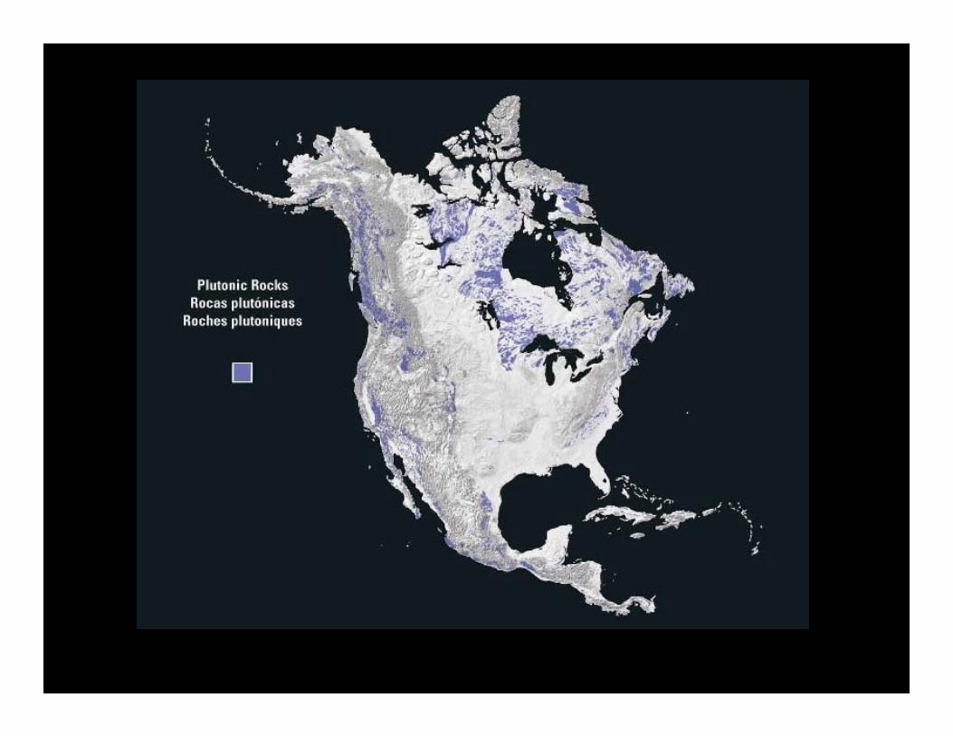
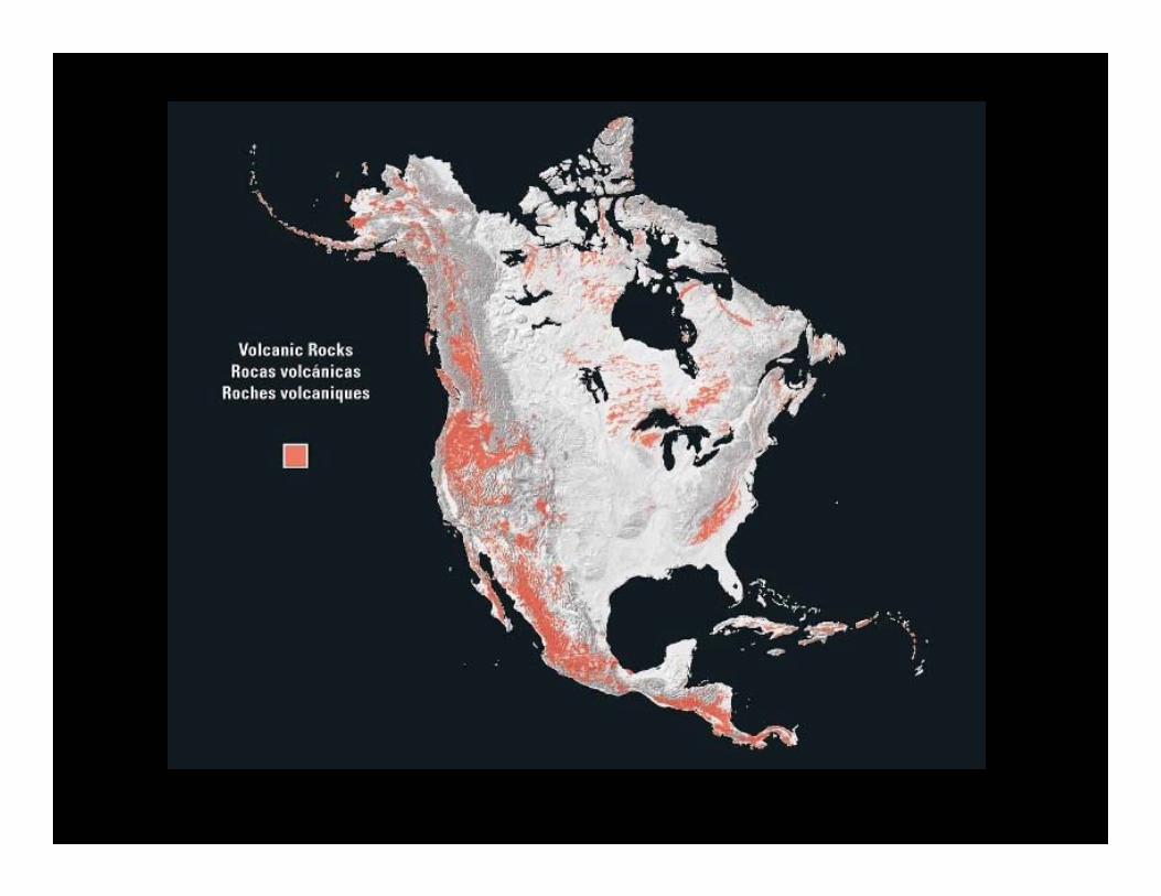
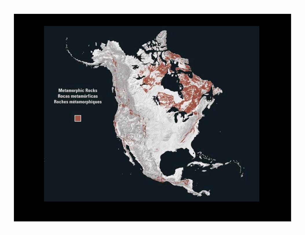
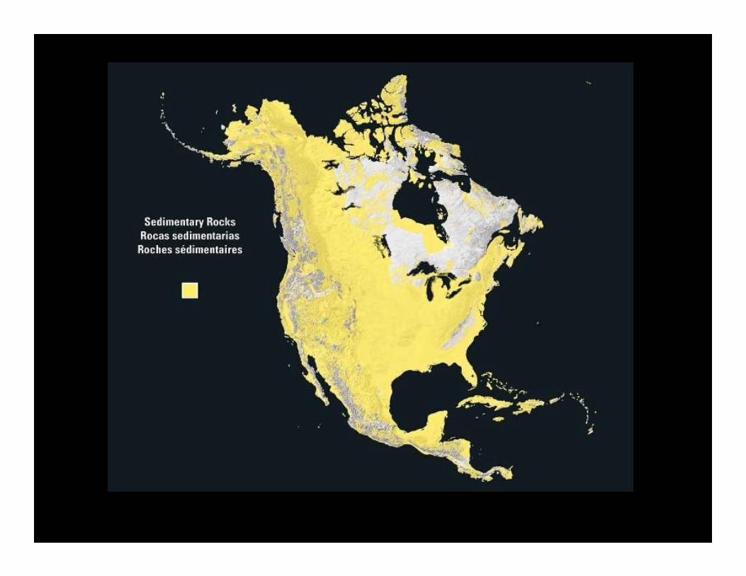
• What is the composition of the exposed terrestrial surface of the Earth? (DS 220)
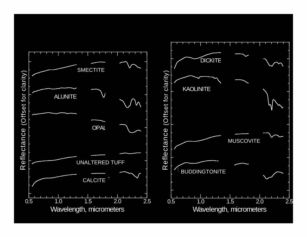
CALCITE
ALUNITE
SMECTITE
OPAL
(Offs
et fo
r cl
arity
)R
efle
ctan
ce
Wavelength, micrometers0.5 1.0 1.5 2.0 2.5
UNALTERED TUFF
MUSCOVITE
KAOLINITE
DICKITE
BUDDINGTONITE(O
ffset
for
clar
ity)
Ref
lect
ance
Wavelength, micrometers0.5 1.0 1.5 2.0 2.5
CALCITE
UNALTERED TUFF
BUDDINGTONITE
MUSCOVITE
SMECTITE

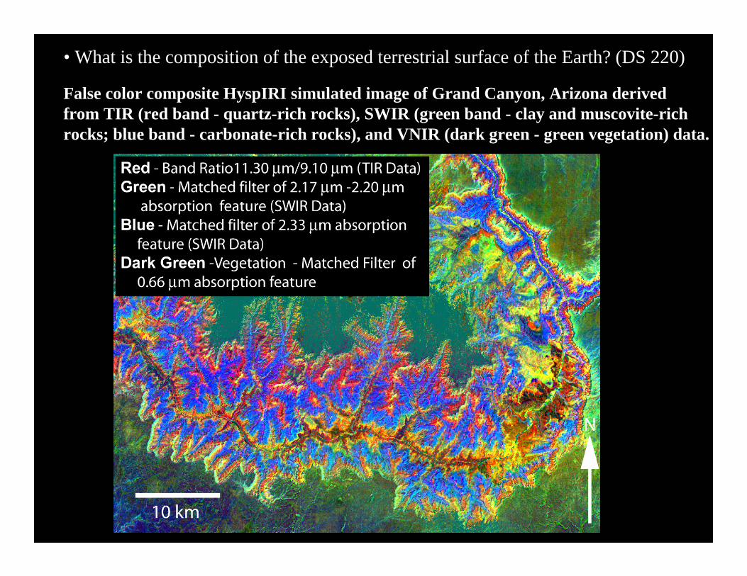
• What is the composition of the exposed terrestrial surface of the Earth? (DS 220)
• What is the composition of the exposed terrestrial surface of the Earth? (DS 220)
False color composite HyspIRI simulated image of Grand Canyon, Arizona derived from TIR (red band - quartz-rich rocks), SWIR (green band - clay and muscovite-rich rocks; blue band - carbonate-rich rocks), and VNIR (dark green - green vegetation) data.
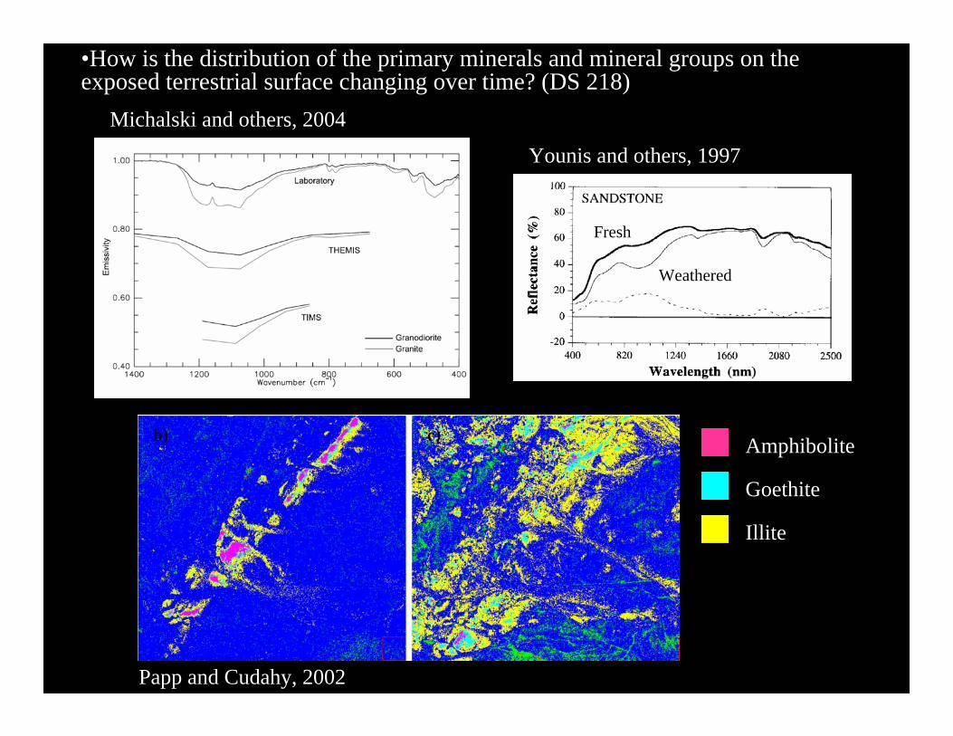
Papp and Cudahy, 2002
•How is the distribution of the primary minerals and mineral groups on the exposed terrestrial surface changing over time? (DS 218)
Younis and others, 1997
Fresh
Weathered
Amphibolite
Goethite
Illite
Michalski and others, 2004
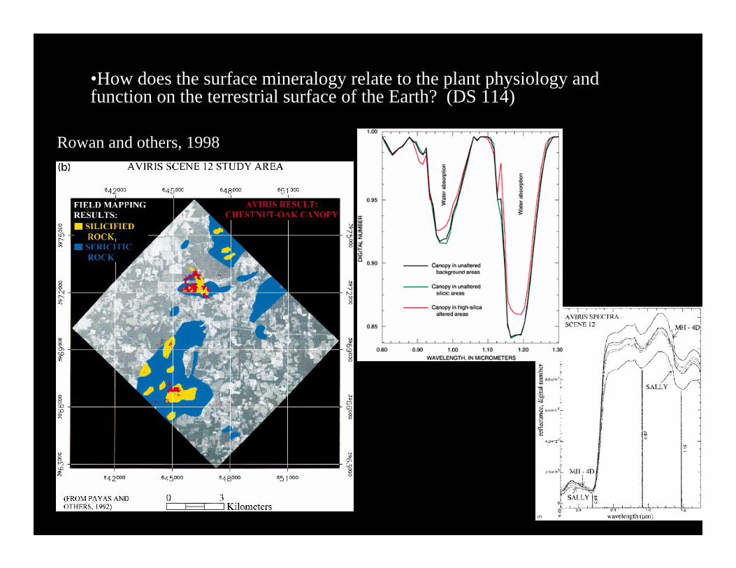
•How does the surface mineralogy relate to the plant physiology and function on the terrestrial surface of the Earth? (DS 114)
Rowan and others, 1998
•How is the composition of exposed terrestrial surface responding to anthropogenic and non anthropogenic drivers (desertification, disturbance e.g. logging, mining)? (DS 114)
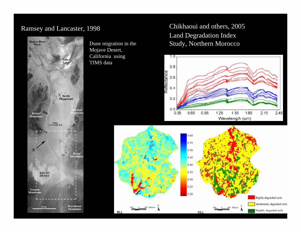
Ramsey and Lancaster, 1998 Chikhaoui and others, 2005Land Degradation Index Study, Northern MoroccoDune migration in the
Mojave Desert, California using TIMS data

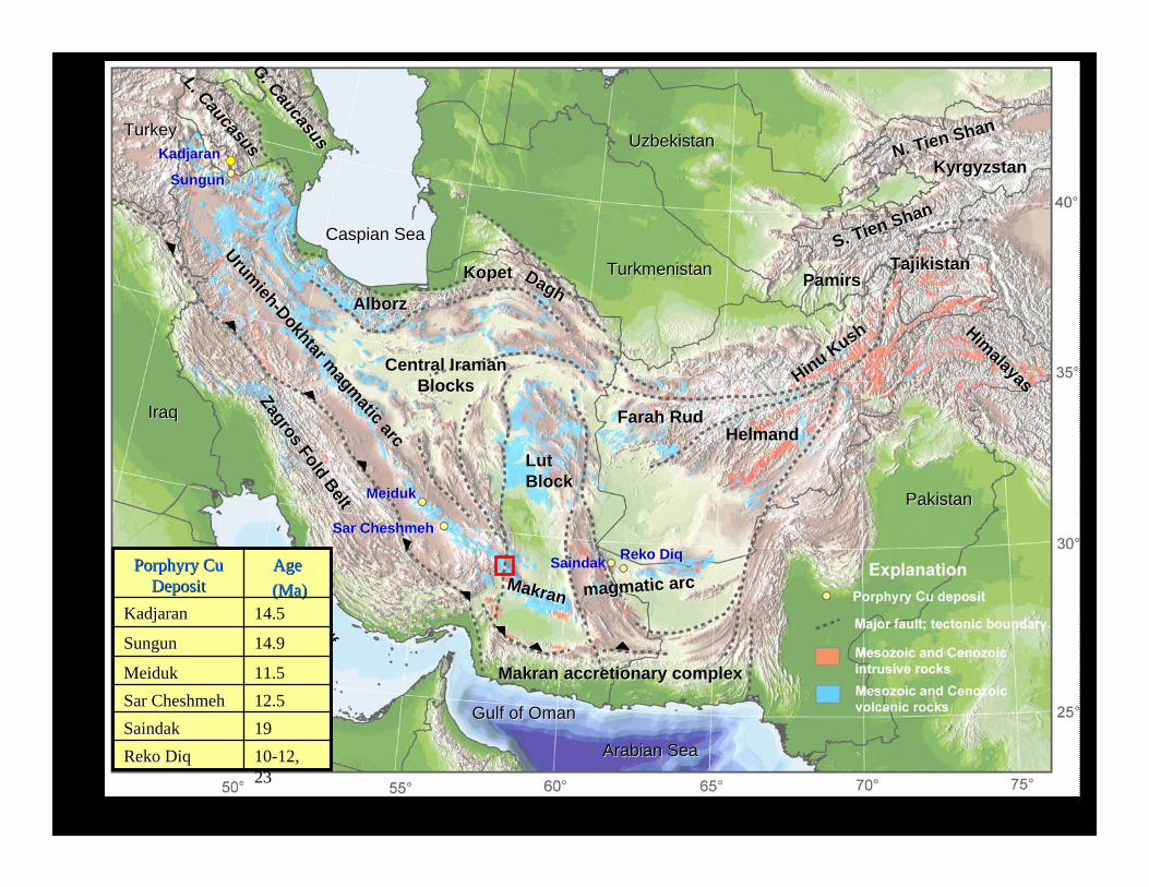
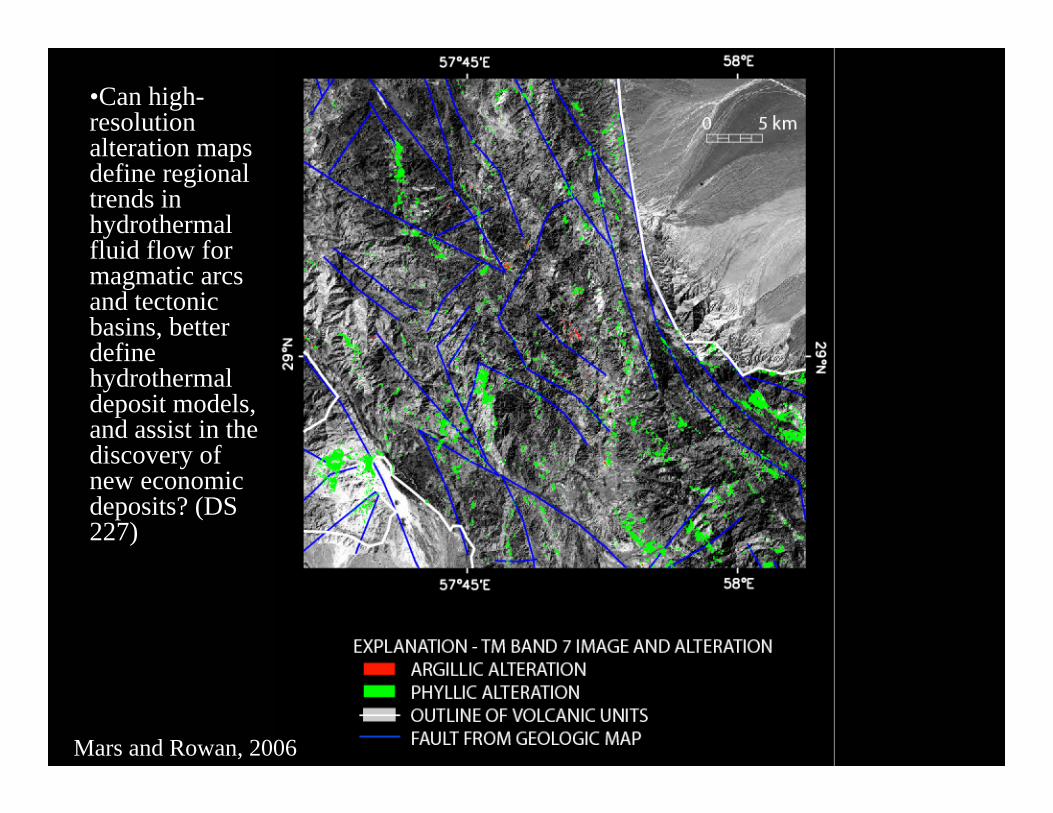
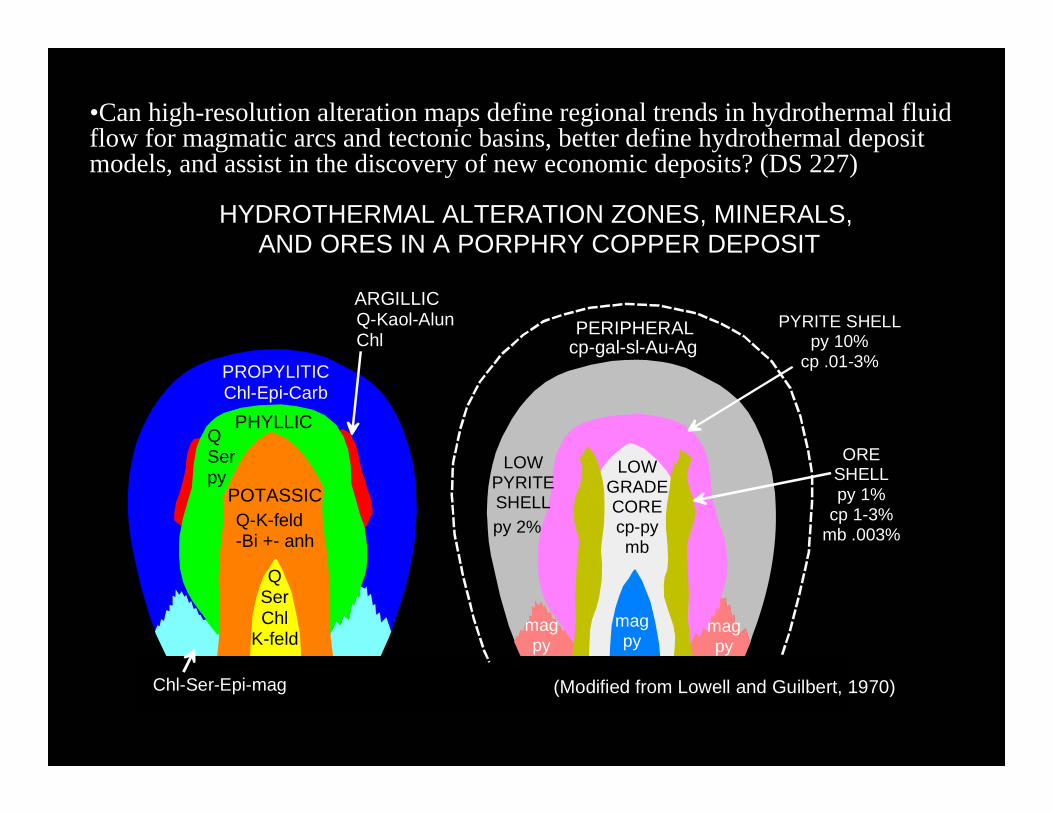
•Can high-resolution alteration maps define regional trends in hydrothermal fluid flow for magmatic arcs and tectonic basins, better define hydrothermal deposit models, and assist in the discovery of new economic deposits? (DS 227)
PROPYLITIC
PHYLLIC
POTASSIC
Chl-Epi-Carb
QSerpy
Q-K-feld-Bi +- anh
ARGILLICQ-Kaol-AlunChl
QSerChl
K-feld
Chl-Ser-Epi-mag
PERIPHERALcp-gal-sl-Au-Ag
LOWPYRITESHELLpy 2%
PYRITE SHELLpy 10%
cp .01-3%
ORESHELLpy 1%
cp 1-3%mb .003%
LOWGRADECOREcp-pymb
mag py
mag py
mag py
HYDROTHERMAL ALTERATION ZONES, MINERALS, AND ORES IN A PORPHRY COPPER DEPOSIT
(Modified from Lowell and Guilbert, 1970)
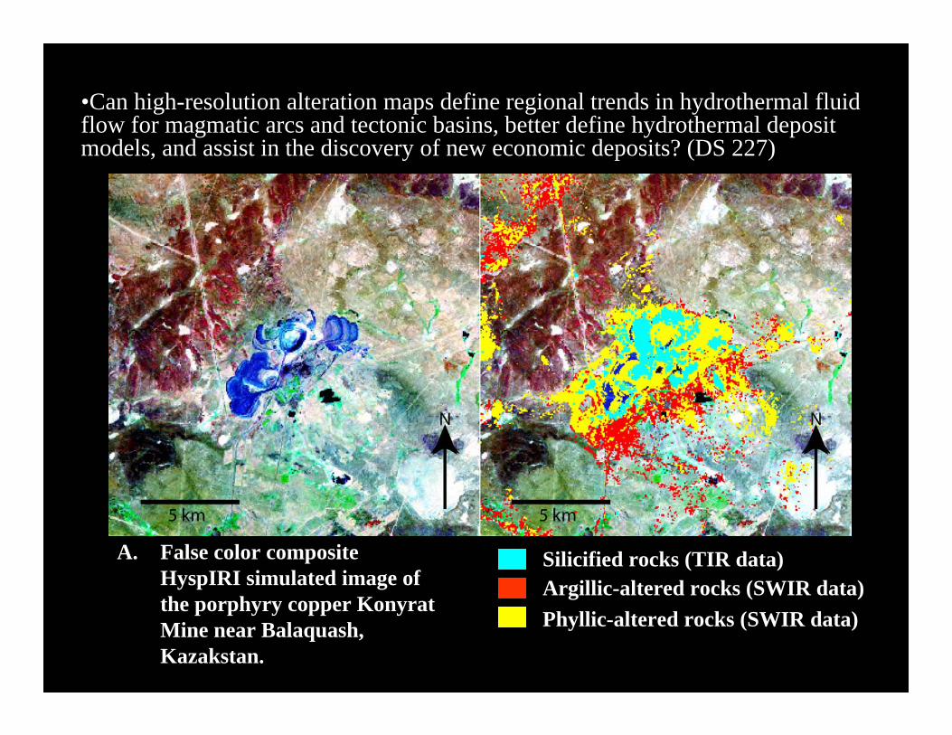
A. False color composite HyspIRI simulated image of the porphyry copper KonyratMine near Balaquash, Kazakstan.
Argillic-altered rocks (SWIR data)Phyllic-altered rocks (SWIR data)
Silicified rocks (TIR data)
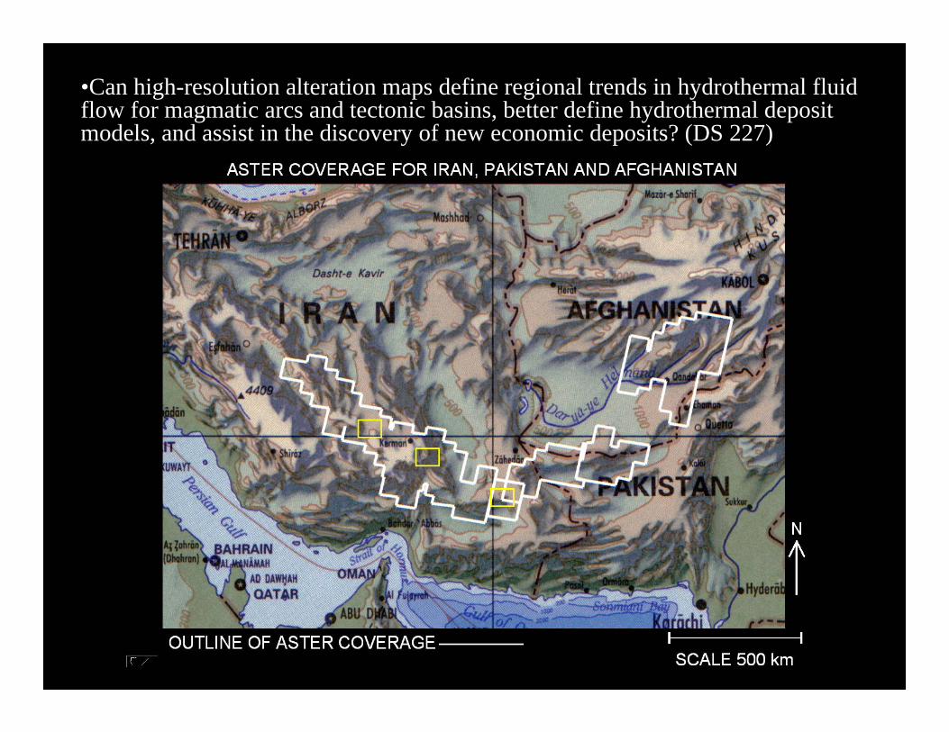
•Can high-resolution alteration maps define regional trends in hydrothermal fluid flow for magmatic arcs and tectonic basins, better define hydrothermal deposit models, and assist in the discovery of new economic deposits? (DS 227)
•Can high-resolution alteration maps define regional trends in hydrothermal fluid flow for magmatic arcs and tectonic basins, better define hydrothermal deposit models, and assist in the discovery of new economic deposits? (DS 227)
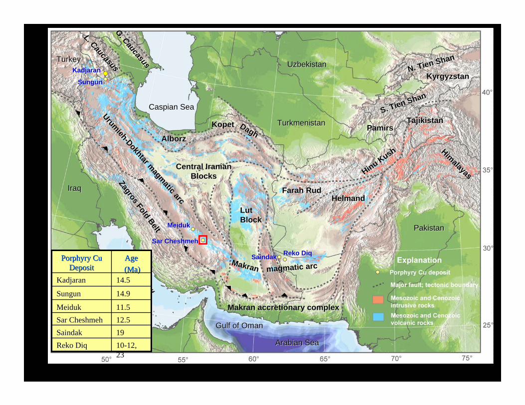
Caspian SeaCaspian Sea
TurkeyTurkey
G. Caucasus
G. Caucasus
L. Caucasus
L. Caucasus
TurkmenistanTurkmenistan
UzbekistanUzbekistan
Persian Gulf
Persian Gulf
TajikistanTajikistan
KyrgyzstanKyrgyzstan
Arabian SeaArabian Sea
Gulf of OmanGulf of Oman
Zagros Fold Belt
Zagros Fold Belt
AlborzAlborz
LutLutBlockBlock
PakistanPakistan
Himalayas
HimalayasHinuHinu Kush
Kush
PamirsPamirs
S. S. TienTien ShanShan
N. N. TienTien ShanShan
MakranMakran accretionaryaccretionary complexcomplex
Central IranianCentral IranianBlocksBlocks
IraqIraq
Urumieh
Urumieh--Dokhtar
Dokhtar magmatic arc
magmatic arc
KopetKopet DaghDagh
SungunSungun
MeidukMeiduk
SarSar CheshmehCheshmeh
SaindakSaindak RekoReko DiqDiq
14.5KadjaranKadjaran
11.5MeidukMeiduk
14.9SungunSungun
10-12, 23
RekoReko DiqDiq19SaindakSaindak12.5SarSar CheshmehCheshmeh
AgeAge(Ma)(Ma)
Porphyry Cu Porphyry Cu DepositDeposit
KadjaranKadjaran
Farah Farah RudRudHelmandHelmand
MakranMakran magmatic arcmagmatic arc
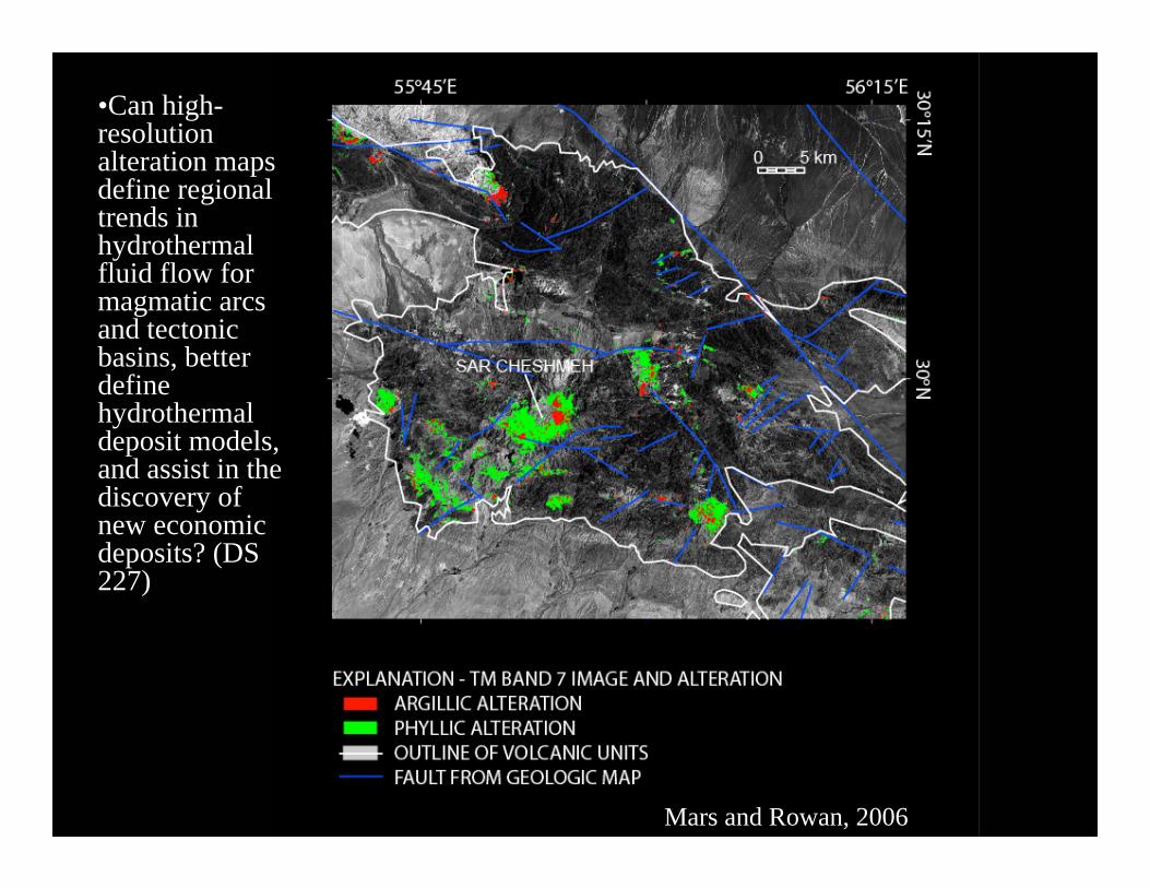
•Can high-resolution alteration maps define regional trends in hydrothermal fluid flow for magmatic arcs and tectonic basins, better define hydrothermal deposit models, and assist in the discovery of new economic deposits? (DS 227)
Mars and Rowan, 2006

•Can high-resolution alteration maps define regional trends in hydrothermal fluid flow for magmatic arcs and tectonic basins, better define hydrothermal deposit models, and assist in the discovery of new economic deposits? (DS 227)
PROPYLITIC
PHYLLIC
POTASSIC
Chl-Epi-Carb
QSerpy
Q-K-feld-Bi +- anh
ARGILLICQ-Kaol-AlunChl
QSerChl
K-feld
Chl-Ser-Epi-mag
PERIPHERALcp-gal-sl-Au-Ag
LOWPYRITESHELLpy 2%
PYRITE SHELLpy 10%
cp .01-3%
ORESHELLpy 1%
cp 1-3%mb .003%
LOWGRADECOREcp-pymb
mag py
mag py
mag py
HYDROTHERMAL ALTERATION ZONES, MINERALS, AND ORES IN A PORPHRY COPPER DEPOSIT
(Modified from Lowell and Guilbert, 1970)
Caspian SeaCaspian Sea
TurkeyTurkey
G. Caucasus
G. Caucasus
L. Caucasus
L. Caucasus
TurkmenistanTurkmenistan
UzbekistanUzbekistan
Persian Gulf
Persian Gulf
TajikistanTajikistan
KyrgyzstanKyrgyzstan
Arabian SeaArabian Sea
Gulf of OmanGulf of Oman
Zagros Fold Belt
Zagros Fold Belt
AlborzAlborz
LutLutBlockBlock
PakistanPakistan
Himalayas
HimalayasHinuHinu Kush
Kush
PamirsPamirs
S. S. TienTien ShanShan
N. N. TienTien ShanShan
MakranMakran accretionaryaccretionary complexcomplex
Central IranianCentral IranianBlocksBlocks
IraqIraq
Urumieh
Urumieh--Dokhtar
Dokhtar magmatic arc
magmatic arc
KopetKopet DaghDagh
SungunSungun
MeidukMeiduk
SarSar CheshmehCheshmeh
SaindakSaindak RekoReko DiqDiq
14.5KadjaranKadjaran
11.5MeidukMeiduk
14.9SungunSungun
10-12, 23
RekoReko DiqDiq19SaindakSaindak12.5SarSar CheshmehCheshmeh
AgeAge(Ma)(Ma)
Porphyry Cu Porphyry Cu DepositDeposit
KadjaranKadjaran
Farah Farah RudRudHelmandHelmand
MakranMakran magmatic arcmagmatic arc
•Can high-resolution alteration maps define regional trends in hydrothermal fluid flow for magmatic arcs and tectonic basins, better define hydrothermal deposit models, and assist in the discovery of new economic deposits? (DS 227)
Mars and Rowan, 2006
•Can high-resolution alteration maps define regional trends in hydrothermal fluid flow for magmatic arcs and tectonic basins, better define hydrothermal deposit models, and assist in the discovery of new economic deposits? (DS 227)
PROPYLITIC
PHYLLIC
POTASSIC
Chl-Epi-Carb
QSerpy
Q-K-feld-Bi +- anh
ARGILLICQ-Kaol-AlunChl
QSerChl
K-feld
Chl-Ser-Epi-mag
PERIPHERALcp-gal-sl-Au-Ag
LOWPYRITESHELLpy 2%
PYRITE SHELLpy 10%
cp .01-3%
ORESHELLpy 1%
cp 1-3%mb .003%
LOWGRADECOREcp-pymb
mag py
mag py
mag py
HYDROTHERMAL ALTERATION ZONES, MINERALS, AND ORES IN A PORPHRY COPPER DEPOSIT
(Modified from Lowell and Guilbert, 1970)
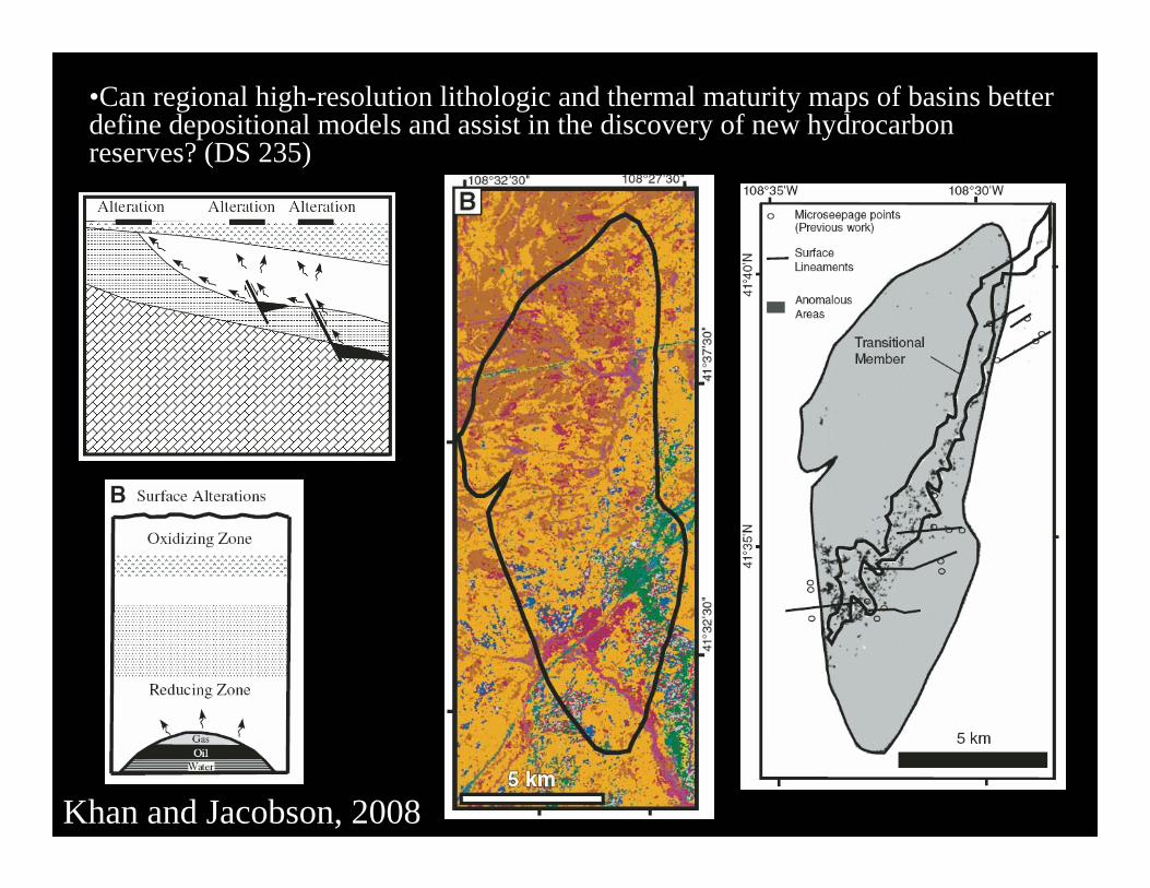
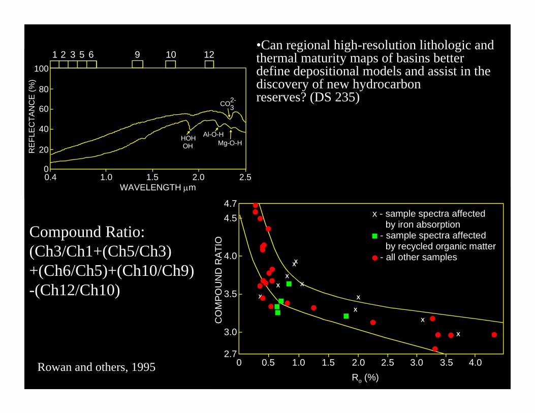
•Can regional high-resolution lithologic and thermal maturity maps of basins better define depositional models and assist in the discovery of new hydrocarbon reserves? (DS 235)
Khan and Jacobson, 2008
20
40
60
80
100
REF
LEC
TAN
CE
(%)
00.4 1.0 1.5 2.0 2.5
WAVELENGTH μm
HOH OH
Al-O-HMg-O-H
CO32-
1 2 3 5 6 9 10 12•Can regional high-resolution lithologic and thermal maturity maps of basins better define depositional models and assist in the discovery of new hydrocarbon reserves? (DS 235)
4.74.5
4.0XX
XXX
X3.5
3.0
2.70 0.5 1.0 1.5 2.0 2.5 3.0 3.5 4.0
X
X
X
X
CO
MPO
UN
D R
ATI
Ox - sample spectra affected by iron absorption - sample spectra affected by recycled organic matter - all other samples
Ro (%)Rowan and others, 1995
Compound Ratio:(Ch3/Ch1+(Ch5/Ch3)+(Ch6/Ch5)+(Ch10/Ch9)-(Ch12/Ch10)
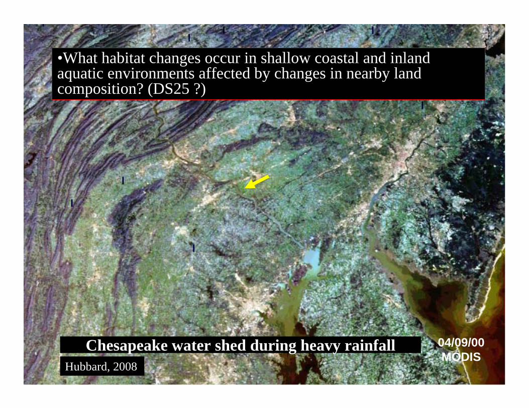
04/09/00MODIS
Chesapeake water shed during heavy rainfall
•What habitat changes occur in shallow coastal and inland aquatic environments affected by changes in nearby land composition? (DS25 ?)
Hubbard, 2008
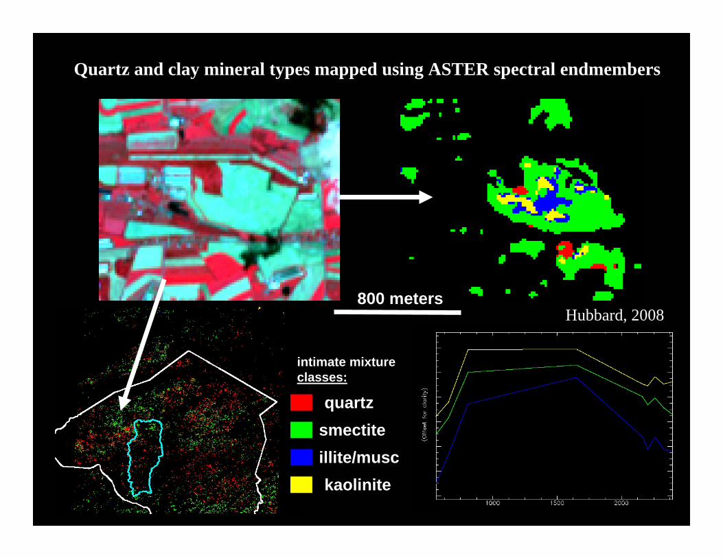
Quartz and clay mineral types mapped using ASTER spectral endmembers
800 meters
quartzsmectiteillite/musckaolinite
intimate mixtureclasses:
Hubbard, 2008
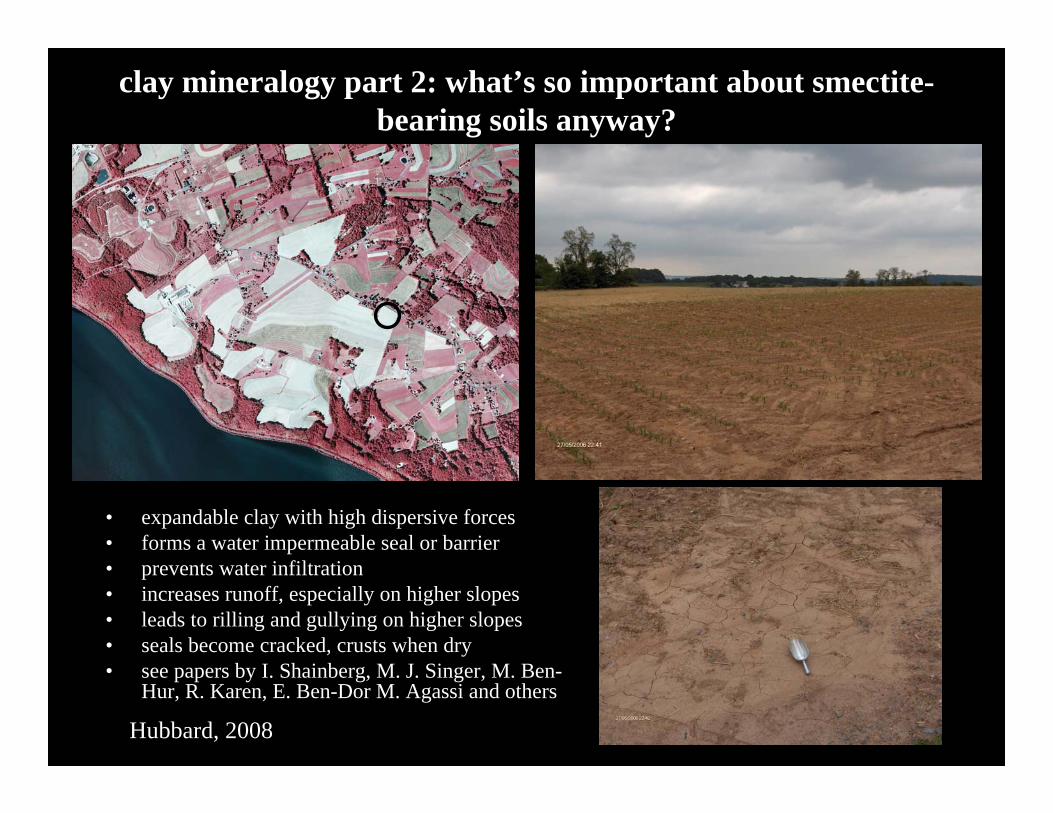
clay mineralogy part 2: what’s so important about smectite-bearing soils anyway?
• expandable clay with high dispersive forces• forms a water impermeable seal or barrier• prevents water infiltration• increases runoff, especially on higher slopes• leads to rilling and gullying on higher slopes• seals become cracked, crusts when dry• see papers by I. Shainberg, M. J. Singer, M. Ben-
Hur, R. Karen, E. Ben-Dor M. Agassi and others
Hubbard, 2008
CONCLUSIONS:
HYSPIRI WILL BE ABLE TO REGIONALLY MAP THE GREATEST VARIETY OF MINERALOGY OF ANY SPACEBORNE SENSOR IN EARTH ORBIT
HYSPIRI WILL PROVIDE TEMPORAL DATASETS TO MONITOR EARTH PROCESSES
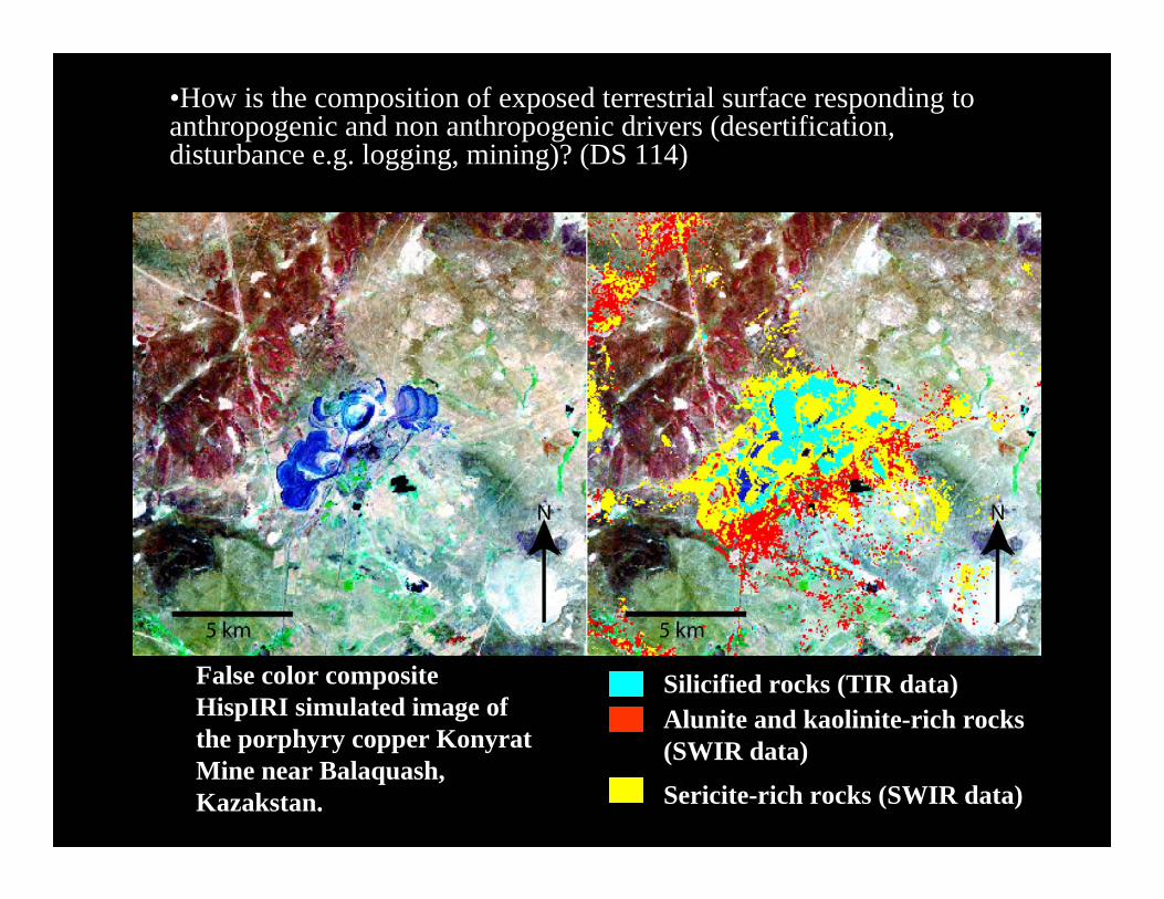
•How is the composition of exposed terrestrial surface responding to anthropogenic and non anthropogenic drivers (desertification, disturbance e.g. logging, mining)? (DS 114)
False color composite HispIRI simulated image of the porphyry copper KonyratMine near Balaquash, Kazakstan.
Alunite and kaolinite-rich rocks (SWIR data)
Sericite-rich rocks (SWIR data)
Silicified rocks (TIR data)
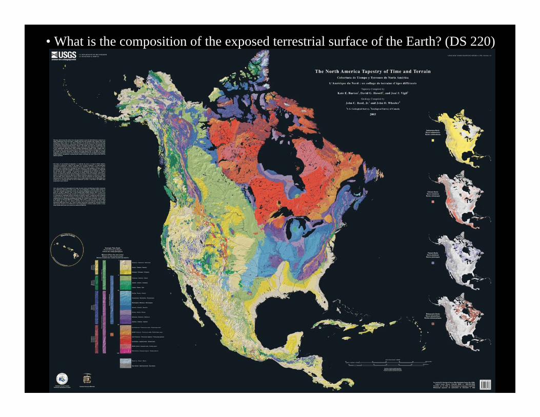
• What is the composition of the exposed terrestrial surface of the Earth? (DS 220)
Related Documents