O Hydrothermally Altered Rock and Hot- Spring Deposits at Yellowstone National Park—Characterized Using Airborne Visible- and Infrared-Spectroscopy Data By K. Eric Livo, Fred A. Kruse , Roger N. Clark, Raymond F. Kokaly, and W.C. Shanks, III Chapter O of Integrated Geoscience Studies in the Greater Yellowstone Area— Volcanic, Tectonic, and Hydrothermal Processes in the Yellowstone Geoecosystem Edited by Lisa A. Morgan U.S. Department of the Interior U.S. Geological Survey Professional Paper 1717

Welcome message from author
This document is posted to help you gain knowledge. Please leave a comment to let me know what you think about it! Share it to your friends and learn new things together.
Transcript

OHydrothermally Altered Rock and Hot-Spring Deposits at Yellowstone National Park—Characterized Using Airborne Visible- and Infrared-Spectroscopy Data
By K. Eric Livo, Fred A. Kruse , Roger N. Clark, Raymond F. Kokaly, and W.C. Shanks, III
Chapter O ofIntegrated Geoscience Studies in the Greater Yellowstone Area— Volcanic, Tectonic, and Hydrothermal Processes in the Yellowstone GeoecosystemEdited by Lisa A. Morgan
U.S. Department of the InteriorU.S. Geological Survey
Professional Paper 1717
Contents
Abstract .......................................................................................................................................................493Introduction.................................................................................................................................................493Methods.......................................................................................................................................................493Spectral Identification of Minerals .........................................................................................................493
USGS Methods ..................................................................................................................................494Analytical Imaging and Geophysics Methods .............................................................................494
Geologic Structure, Volcanic History, and Geologic Setting ..............................................................494Alteration Minerals ....................................................................................................................................494Hydrothermal Waters ................................................................................................................................494Hyperspectral Remote Sensing ...............................................................................................................495Mapping Results ........................................................................................................................................496
Upper, Midway, and Lower Geyser Basins ..................................................................................497Norris Geyser Basin .........................................................................................................................498Roaring Mountain .............................................................................................................................499Grand Canyon of the Yellowstone River ........................................................................................499Mammoth Hot Springs .....................................................................................................................506
Conclusions.................................................................................................................................................506References Cited........................................................................................................................................506
Figures 1. Schematic cross section of USGS mineral deposit model 25b .........................................495 2–3. Mineral spectra for: 2. Clay minerals, calcite, alunite, and siliceous sinter ....................................................496 3. Iron-bearing minerals .......................................................................................................497 4. 1996 AVIRIS maps .....................................................................................................................498 5–9. Mineral maps: 5. Upper Geyser Basin ..........................................................................................................500 6. Lower, Midway, and Upper Geyser Basins ...................................................................501 7. Norris Geyser Basin and Roaring Mountain .................................................................502 8. Grand Canyon of the Yellowstone River ........................................................................503 9. Mammoth Hot Springs ......................................................................................................505

AbstractThe hydrothermal system in Yellowstone National Park
has created altered rock and hot-spring deposits that were mapped using AVIRIS (airborne visible and infrared imaging spectrometer) data. The mapped minerals are indicative of the geologic processes and environments that controlled their for-mation. Ongoing volcanic activity is expressed at the surface by geothermal features, earthquakes, and geologically recent caldera formation. Precipitated minerals such as siliceous sinter and travertine on the surface are derived from chloride-rich alkaline solutions that are leaching silica and calcite from the underlying country rock. Siliceous sinter and montmoril-lonite are associated with hydrothermal systems abundant in hot water, whereas kaolinite and alunite are associated with acidic-vapor-dominated hydrothermal systems.
IntroductionRemotely sensed data are used to map hydrothermally
altered rock and hot-spring deposits in Yellowstone National Park (the Park). The airborne imaging-spectroscopy data con-tain spectra of reflected light that record absorption features that are unique to the surface materials from which sunlight is reflected. Analysis of these features permits identification of the mineralogy of some surface soils and bedrock lithologies.
Hydrothermal-water chemistry and bedrock lithologies can be inferred from the types of minerals on the land surface. Researchers have extensively studied water chemistry in Yel-lowstone National Park and the associated altered minerals that form within the hydrothermal cells. This report links the observed altered rock, identified from imaging-spectroscopy data, with the underlying geological processes, and it associ-ates mineral trends with fracture systems.
Methods
Remotely sensed data were collected using NASA’s Jet Propulsion Laboratory airborne visible and infrared imaging spectrometer (AVIRIS) in the late summer of 1996 and fall of 1998. Data were collected at a pixel-spatial resolution of 20 m in most of the Park (in 1996) and at a pixel-spatial resolution of 2×6 m at selected sites (in 1998). Both data sets have 224 continuous spectral channels ranging from 0.4 to 2.5 microm-eters (µm). Minerals were spectrally identified using the U.S. Geological Survey (USGS) Tetracorder program (Clark and others, 1990, 1991, 2003; Clark, Swayze, and Gallagher, 1993; Clark and Swayze, 1995; Rockwell and others, 1999) and methods developed by Analytical Imaging and Geophysics (AIG) (Kruse and others, 1996; Boardman, 1997, 1998; Kruse, 1998, 1999). USGS processing utilized a custom goodness-of-fit spectral-analysis routine, whereas AIG processing charac-terized “pure” spectral end-members (Kruse and others, 1993; Kruse, 1998, 1999) using the Environment for Visualizing Images (ENVI) software (Research Systems, Inc., Boulder, Colo.). Both analysis techniques use spectral libraries for initial material identification. Hyperspectral-mapping methods were then used to determine the occurrence and abundance of specific materials. These data were then field-checked to ensure correct identification.
Spectral Identification of Minerals
Spectral identification of minerals is accomplished by using diagnostic absorption features within the measured light spectrum. Every pixel in the image has a measured spectrum that can be visually or mathematically analyzed, comparing the pixel-spectral features against known mineral-spectral fea-tures. A variety of techniques exist for this analysis. We used the USGS Tetracorder method, in which the spectral features of an image pixel are compared to data from a mineral-spectral library, and we also used the AIG ENVI end-member method to identify unique spectral end-members.
Hydrothermally Altered Rock and Hot-Spring Deposits at Yellowstone National Park—Characterized Using Airborne Visible- and Infrared-Spectroscopy Data
By K. Eric Livo,1 Fred A. Kruse ,2 Roger N. Clark,1 Raymond F. Kokaly,1 and W.C. Shanks, III1
1U.S. Geological Survey, Denver Box 25046, M.S. 973, Denver Federal Center, Denver CO 80225.
2Horizon GeoImaging, LLC, 4845 Pearl East Circle, Suite 101, Boulder, CO 80301.
494 Integrated Geoscience Studies in the Greater Yellowstone Area
USGS Methods
AVIRIS data were converted from radiance to reflec-tance and then calibrated to absolute reflectance relative to ground. This two-step process is described in Clark, Swayze, Heidebrecht, and others (1993). The first step uses the atmo-spheric-removal algorithm (ATREM) (Gao and others, 1997) to remove atmospheric effects of solar irradiance, atmospheric absorption, and atmospheric scattering and then converts the data from radiance to reflectance. In the second step, residual atmospheric absorptions were removed by calibrating the data against field data measured with a hand-held spectrometer at a calibration site.
Spectral-feature analysis was then used to identify miner-als in the image. The USGS Tetracorder program (Clark and others, 2003) was used for initial processing and identification. This program tests band-absorption features from the image-pixel spectra against known mineral-absorption features from the USGS mineral library using a goodness-of-fit algorithm. Multiple (continuum-removed) absorption features for each spectrum are used concurrently to generate a weighted average for spectral goodness-of-fit, band depth, and fit × depth. Defined thresholds for each value must be exceeded. The mineral-library spectrum with the highest goodness-of-fit value is selected for initial identification for each pixel. Image pixels containing abundant vegetation are masked. Visual analysis and iterative processes that vary internal tetracorder parameters and add new mineral spectra to the spectral library are used to create the final mineral identifications (the mineral maps).
Analytical Imaging and Geophysics Method
Spectral-feature analysis using the AIG method began with calibrated AVIRIS data derived from ATREM. Artifacts were removed using the AIG program “Effort,” which per-forms a statistical running average. No field calibration was performed. ENVI software was used to derive end-member spectra using standard minimum-noise (statistical) deriva-tives. Mineral identification of the end-member spectra used mineral-library-classification routines within ENVI and visual interpretation of the end-member spectra.
Geologic Structure, Volcanic History, and Geologic Setting
The Yellowstone National Park region was the locus of three large caldera-forming volcanic eruptions during the last 2.1 million years. Widespread airborne volcanic ash and lava flows cover much of the present land surface from these and later eruptions. Volcanic activity is ongoing, and heat flow is 30 times greater than the continental average (Smith and Braile, 1993). The volcanism is associated with intensive earthquake activity (Smith and Braile, 1993) that
drives the geothermal system; it continually opens and reopens radial- and concentric-fracture systems, thus maintaining local fluid pathways.
One hypothesis is that the volcanic activity is a result of the North American crustal plate overriding a hot-spot mantle plume. The volcanic lavas and ash deposits overlie crustal sedimentary, igneous, and metamorphic rocks. Two important rock types that influence the mineral- alteration assemblages in the region are the widespread quartz-rich rhyolite flows that underlie many of the geyser basins and the limestone that underlies the terraces at Mammoth Hot Springs.
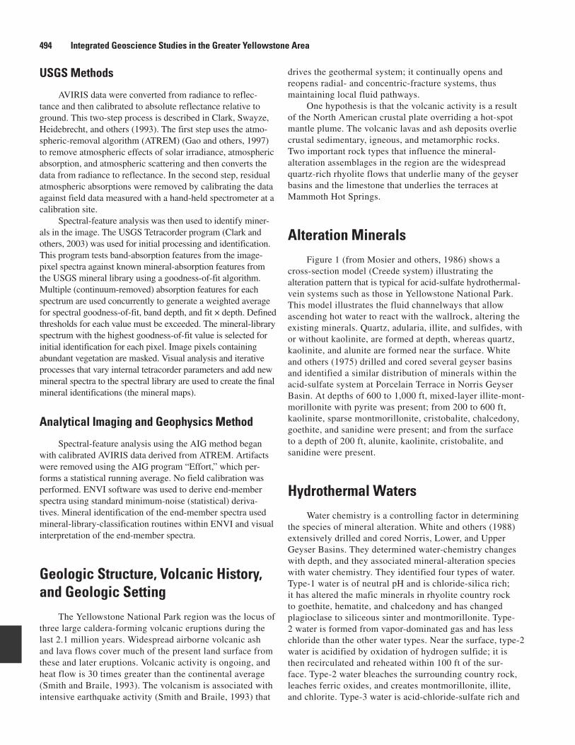
Alteration MineralsFigure 1 (from Mosier and others, 1986) shows a
cross-section model (Creede system) illustrating the alteration pattern that is typical for acid-sulfate hydrothermal- vein systems such as those in Yellowstone National Park. This model illustrates the fluid channelways that allow ascending hot water to react with the wallrock, altering the existing minerals. Quartz, adularia, illite, and sulfides, with or without kaolinite, are formed at depth, whereas quartz, kaolinite, and alunite are formed near the surface. White and others (1975) drilled and cored several geyser basins and identified a similar distribution of minerals within the acid-sulfate system at Porcelain Terrace in Norris Geyser Basin. At depths of 600 to 1,000 ft, mixed-layer illite-mont-morillonite with pyrite was present; from 200 to 600 ft, kaolinite, sparse montmorillonite, cristobalite, chalcedony, goethite, and sanidine were present; and from the surface to a depth of 200 ft, alunite, kaolinite, cristobalite, and sanidine were present.
Hydrothermal WatersWater chemistry is a controlling factor in determining
the species of mineral alteration. White and others (1988) extensively drilled and cored Norris, Lower, and Upper Geyser Basins. They determined water-chemistry changes with depth, and they associated mineral-alteration species with water chemistry. They identified four types of water. Type-1 water is of neutral pH and is chloride-silica rich; it has altered the mafic minerals in rhyolite country rock to goethite, hematite, and chalcedony and has changed plagioclase to siliceous sinter and montmorillonite. Type-2 water is formed from vapor-dominated gas and has less chloride than the other water types. Near the surface, type-2 water is acidified by oxidation of hydrogen sulfide; it is then recirculated and reheated within 100 ft of the sur-face. Type-2 water bleaches the surrounding country rock, leaches ferric oxides, and creates montmorillonite, illite, and chlorite. Type-3 water is acid-chloride-sulfate rich and
Hydrothermally Altered Rock and Hot-Spring Deposits at Yellowstone National Park 495
is generated by restricted flow of neutral pH, chloride-silica-rich water that combines with sulfur and rain and snowmelt surface water. Type-3 water bleaches the country rock, leaching all ferric oxides. Type-4 water is acid-sulfate rich, low in chloride, and is generated above a boiling water table where steam combines with hydrogen sulfide gas to yield restricted, hot, low-pH water. Type-4 water bleaches the country rock, leaches ferric oxides, and alters potassium feldspar and sanidine to kaolinite, opal, and cristobalite. Type-4 water forms mixed-layer clay minerals—montmo-rillonite is dominant at temperatures lower than 198°C; mixed-layer montmorillonite-illite is dominant between 198°C and 238°C; and illite is dominant at temperatures higher than 238°C (White and others, 1988).
Chloride-rich siliceous sinter deposited by type-1 water is widespread in Upper and Lower Geyser Basins,
on the basin floor at Norris Geyser Basin, and in the Hayden River valley. Acid-sulfate deposits are common at Roaring Mountain, in the Grand Canyon of the Yellowstone River, and at higher elevations at Norris Geyser Basin. The near-surface alunite environment was characterized by White and others (1988) and Thompson (1991) as containing chalcedony and porous opaline sinter, sulfur, and cristobalite that formed from decomposed rhyolite—all associated with sulfurous gases and aqueous vapors emitted from ground fissures.
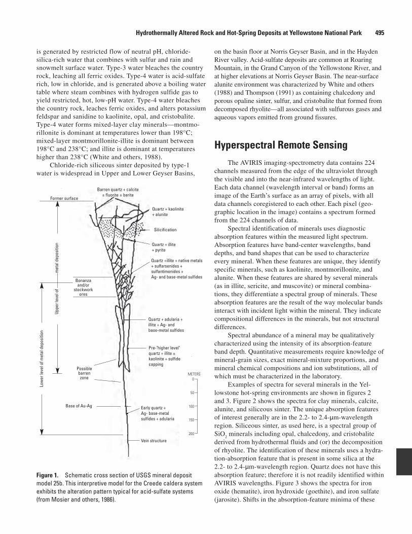
Hyperspectral Remote SensingThe AVIRIS imaging-spectrometry data contains 224
channels measured from the edge of the ultraviolet through the visible and into the near-infrared wavelengths of light. Each data channel (wavelength interval or band) forms an image of the Earth’s surface as an array of pixels, with all data channels coregistered to each other. Each pixel (geo-graphic location in the image) contains a spectrum formed from the 224 channels of data.
Spectral identification of minerals uses diagnostic absorption features within the measured light spectrum. Absorption features have band-center wavelengths, band depths, and band shapes that can be used to characterize every mineral. When these features are unique, they identify specific minerals, such as kaolinite, montmorillonite, and alunite. When these features are shared by several minerals (as in illite, sericite, and muscovite) or mineral combina-tions, they differentiate a spectral group of minerals. These absorption features are the result of the way molecular bands interact with incident light within the mineral. They indicate compositional differences in the minerals, but not structural differences.
Spectral abundance of a mineral may be qualitatively characterized using the intensity of its absorption-feature band depth. Quantitative measurements require knowledge of mineral-grain sizes, exact mineral-mixture proportions, and mineral chemical compositions and ion substitutions, all of which must be characterized in the laboratory.
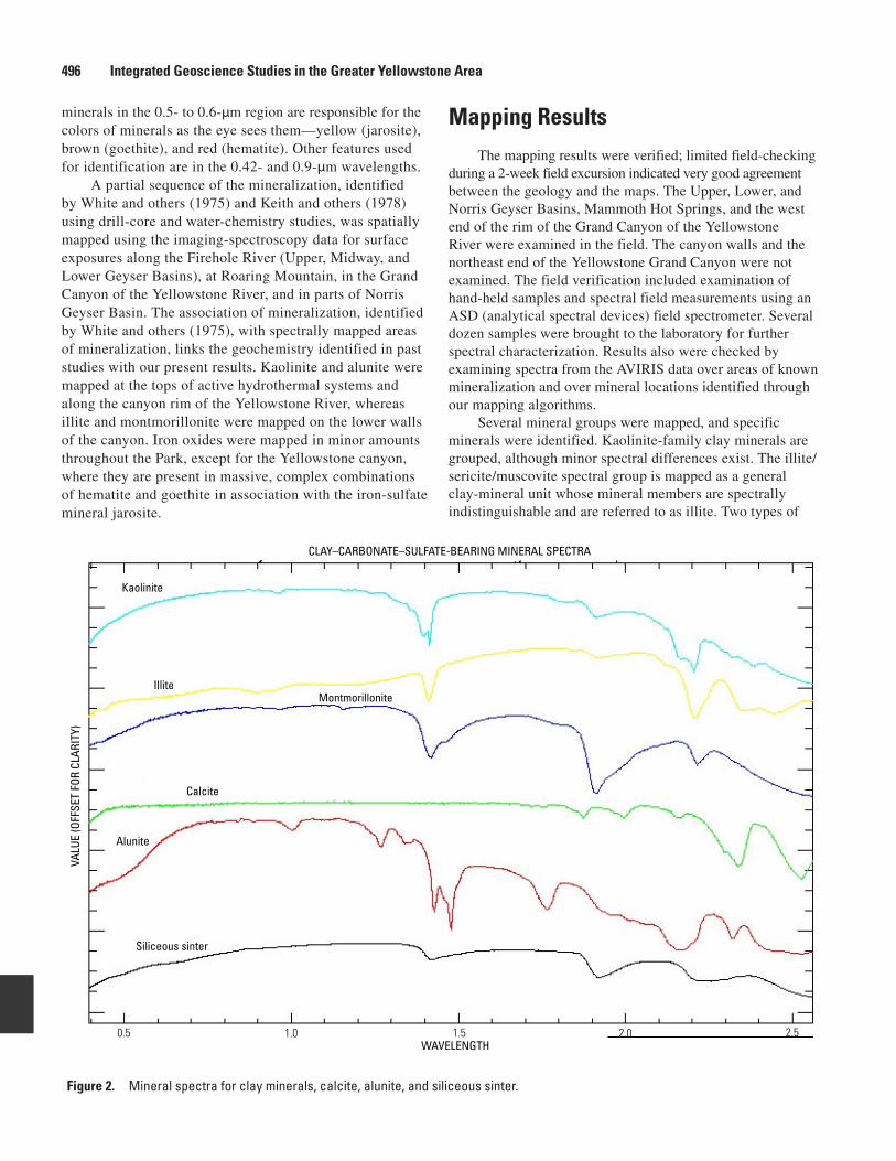
Examples of spectra for several minerals in the Yel-lowstone hot-spring environments are shown in figures 2 and 3. Figure 2 shows the spectra for clay minerals, calcite, alunite, and siliceous sinter. The unique absorption features of interest generally are in the 2.2- to 2.4-µm-wavelength region. Siliceous sinter, as used here, is a spectral group of SiO
2 minerals including opal, chalcedony, and cristobalite
derived from hydrothermal fluids and (or) the decomposition of rhyolite. The identification of these minerals uses a hydra-tion-absorption feature that is present in some silica at the 2.2- to 2.4-µm-wavelength region. Quartz does not have this absorption feature; therefore it is not readily identified within AVIRIS wavelengths. Figure 3 shows the spectra for iron oxide (hematite), iron hydroxide (goethite), and iron sulfate (jarosite). Shifts in the absorption-feature minima of these
Former surface
0
200
100
50
150
METERS
Bonanzaand/or
stockworkores
Possiblebarrenzone
Base of Au-Ag
Uppe
r lev
el o
f
m
etal
dep
ositi
on
Low
er le
vel o
f met
al d
epos
ition
Barren quartz + calcite± fluorite ± barite
Quartz + kaolinite+ alunite
Silicification
Quartz + illite+ pyrite
Quartz + adularia +illite + Ag- andbase-metal sulfides
Pre-"higher level"quartz + illite ±kaolinite + sulfidecapping
Early quartz +Ag- base-metalsulfides + adularia
Vein structure
Quartz +illite + native metals + sulfarsenides + sulfantimonides +Ag- and base-metal sulfides
Figure 1. Schematic cross section of USGS mineral deposit model 25b. This interpretive model for the Creede caldera system exhibits the alteration pattern typical for acid-sulfate systems (from Mosier and others, 1986).
496 Integrated Geoscience Studies in the Greater Yellowstone Area
minerals in the 0.5- to 0.6-µm region are responsible for the colors of minerals as the eye sees them—yellow (jarosite), brown (goethite), and red (hematite). Other features used for identification are in the 0.42- and 0.9-µm wavelengths.
A partial sequence of the mineralization, identified by White and others (1975) and Keith and others (1978) using drill-core and water-chemistry studies, was spatially mapped using the imaging-spectroscopy data for surface exposures along the Firehole River (Upper, Midway, and Lower Geyser Basins), at Roaring Mountain, in the Grand Canyon of the Yellowstone River, and in parts of Norris Geyser Basin. The association of mineralization, identified by White and others (1975), with spectrally mapped areas of mineralization, links the geochemistry identified in past studies with our present results. Kaolinite and alunite were mapped at the tops of active hydrothermal systems and along the canyon rim of the Yellowstone River, whereas illite and montmorillonite were mapped on the lower walls of the canyon. Iron oxides were mapped in minor amounts throughout the Park, except for the Yellowstone canyon, where they are present in massive, complex combinations of hematite and goethite in association with the iron-sulfate mineral jarosite.
Mapping ResultsThe mapping results were verified; limited field-checking
during a 2-week field excursion indicated very good agreement between the geology and the maps. The Upper, Lower, and Norris Geyser Basins, Mammoth Hot Springs, and the west end of the rim of the Grand Canyon of the Yellowstone River were examined in the field. The canyon walls and the northeast end of the Yellowstone Grand Canyon were not examined. The field verification included examination of hand-held samples and spectral field measurements using an ASD (analytical spectral devices) field spectrometer. Several dozen samples were brought to the laboratory for further spectral characterization. Results also were checked by examining spectra from the AVIRIS data over areas of known mineralization and over mineral locations identified through our mapping algorithms.
Several mineral groups were mapped, and specific minerals were identified. Kaolinite-family clay minerals are grouped, although minor spectral differences exist. The illite/sericite/muscovite spectral group is mapped as a general clay-mineral unit whose mineral members are spectrally indistinguishable and are referred to as illite. Two types of
CLAY–CARBONATE–SULFATE-BEARING MINERAL SPECTRA
WAVELENGTH
VALU
E (O
FFSE
T FO
R CL
ARIT
Y)
0.5 1.0 1.5 2.0 2.5
Kaolinite
IlliteMontmorillonite
Calcite
Alunite
Siliceous sinter
Figure 2. Mineral spectra for clay minerals, calcite, alunite, and siliceous sinter.

Hydrothermally Altered Rock and Hot-Spring Deposits at Yellowstone National Park 497
siliceous sinter were mapped—one is spectrally pure, and the other appears to be mixed with clay minerals. In this report, chalcedony, opaline sinter, and cristobalite are not spectrally separated; they are grouped as siliceous sinter.
Upper, Midway, and Lower Geyser Basins
Several large siliceous sinter deposits trend parallel to the Firehole River. These deposits generally are near the valley bottoms. They formed from neutral-pH chloride-rich hydro-thermal fluids (White and others, 1975; Bargar and Beeson, 1985). Figures 4A and 4B provide an overview of hot-spring activity in the vicinity of the Firehole River. The deposits mapped, using the 1996, 20-m-pixel AVIRIS data, are charac-teristic of those in alkaline, active hot-spring environments and are consistent with the known mineralogy of the systems in Yellowstone National Park. The principal mineral adjacent to the Firehole River is hydrothermal silica, which has a char-acteristic spectral signature. Kaolinite, indicating more acidic water, also is present in some areas. Biological elements of the hot-spring systems also were mapped (principally, coloring of deposits and (or) thermal waters by thermophilic algae; see Kokaly and others, this volume). Chlorophyll-rich vegetation
is shown in shades of red in figure 4A (false-color composite using AVIRIS wavelengths 0.85, 0.67, and 0.55 µm; colored red, green, and blue, respectively). In figure 4A, siliceous sinter deposits are colored white and dry grass and burnt areas are colored light green. Figure 4B (AVIRIS minerals map) provides an overview of the distribution of selected geologic materials; silica and kaolinite are colored green and red and show the locations of major geyser basins.
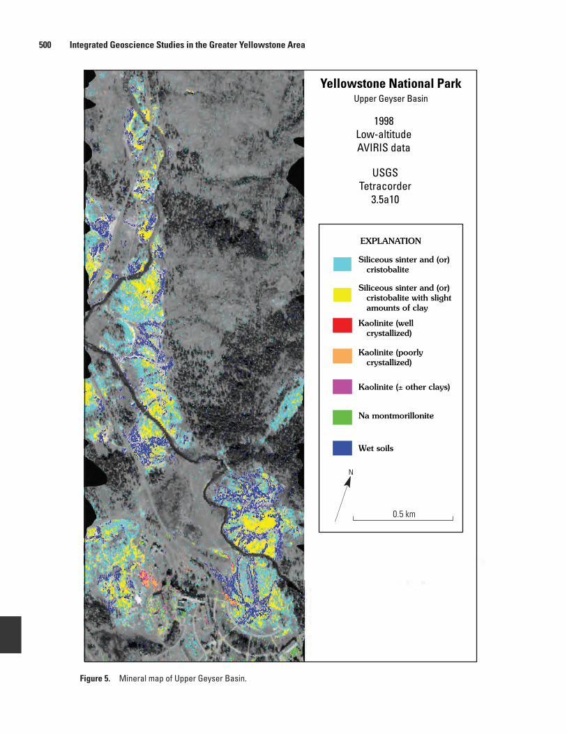
The Upper Geyser Basin sinter deposits (fig. 5; 1998, 6-m spatial-resolution image) are on a northwest linear trend (also seen at the bottom of fig. 6; 20-m resolution). The Midway Basin (sinter at the center of fig. 6) and Lower Geyser Basin (sinter at the top of fig. 6) sinter deposits appear to form a semicircular feature in the AVIRIS image. Generally, these deposits contain an inner zone of sinter mixed with minor amounts of clay minerals, whereas the outer regions are only sinter. Kaolinite deposits are scattered in and west of Old Faithful Geyser (bottom right sinter deposit with a semicircular boardwalk in fig. 5), east of Midway Geyser Basin (right center, fig. 6), and along a northeastward trend on the north side of Lower Geyser Basin (top, fig. 6). The presence of kaolinite, which is associated with acid-sulfate alteration, indicates the presence of local sulfur-rich fluids in basins that contain
IRON-BEARING MINERAL SPECTRA
WAVELENGTH
VALU
E (O
FFSE
T FO
R CL
ARIT
Y)
0.4 0.5 0.6 0.8 1.1
Jarosite
0.7 0.9 1.0
Goethite
Hematite
Figure 3. Mineral spectra for iron-bearing minerals.

498 Integrated Geoscience Studies in the Greater Yellowstone Area
methods detect statistical spectral differences in the data, and then they identify the resulting “end-member” spectra in the entire data set. USGS Tetracorder processing is rules based and statistically identifies the mineralogy of each pixel, independent of any other pixel, using a matching mineral-spectral library.
Norris Geyser Basin
Norris Geyser Basin (lower center, fig. 7) contains a complex mix of mineral-alteration suites formed by ongoing fluctuations of the underlying hydrothermal-system water chemistry. It contains four siliceous-sinter centers in the basin lowland, an alunite center on a hill to the southwest, and kaolinite encircling the basin sides. Alunite and kaolinite
A B
SilicaKaoliniteWet sinterAlgae 1
Algae 2RoadsRiversLakes
ConifersRiparian/Deciduous
neutral-pH chloride-rich water. Wet soils are widespread in the Lower Geyser Basin; they are less common in the Upper Geyser Basin. These soils are in drainage channels that lead from hot-spring vents, as seen on the 6-m resolution (low altitude) image in figure 5. Figure 5 also shows the kaolinite in the Old Faithful Geyser sinter (noted above) very near to, or within, one of the discharge channels. A minor kaolinite anomaly also is present just west of the Old Faithful Inn in a slightly raised area at the south end of the northwestward linear trend of sinter deposits. Generally, kaolinite appears to be present in drier surroundings; it is not closely associated with wet soils.
The AIG- and USGS-derived maps (figs. 4, 5, and 6) identify and locate similar mineralogy. Although both methods use the same data, the processes are significantly different. AIG
Figure 4. 1996 AVIRIS maps. A, false-color composite map. B, Derived map.

Hydrothermally Altered Rock and Hot-Spring Deposits at Yellowstone National Park 499
follow an apparent north-south linear trend on the west side of the basin. The large alunite center (Ragged Hills) is on the south end of this trend, and kaolinite and minor alunite are on the north end.
Stable isotopes of alunite collected at Ragged Hills and Roaring Mountain were studied by Pat Shanks (USGS) using hydroxyl and sulfate components. Sulfur-isotope values indicated that the alunite at Ragged Hills was derived from sulfate, that in turn, was derived from surficial oxidation of H
2S in steam. Alunite and kaolinite rimming
the geyser basin may be indicative of changes in water chemistry from neutral-pH chloride-rich water in the basin to a low-pH vapor-dominated system on the topographi-cally higher sides of the basin. The study concluded that, although the Norris Geyser Basin sulfur isotopes of alunite were similar to those of local geothermal H
2S, the sulfur
isotopes of the Roaring Mountain alunite were significantly different. This may indicate that the Roaring Mountain alu-nite is much older than the Norris Geyser Basin alunite.
Roaring Mountain
Roaring Mountain (mid-upper left, fig. 7), just north of Norris Basin, is a large acid-sulfate system with a restricted, steam-heated vapor-dominated water supply. A region of alunite-rich ground mixed with kaolinite is surrounded by areas characterized by abundant kaolinite. Sparse siliceous sinter is present west of Roaring Moun-tain, near the road. A calcite center east of the main alunite deposit at Roaring Mountain was field-checked; the calcite is Paleozoic limestone.
Preliminary field examination in Norris Geyser Basin indicates that the siliceous sinter is in down-cut, eroded, lowland sites. Alunite-kaolinite-rich deposits are resistant to erosion and become topographic highs. An understand-ing of the time of formation of the alunite and kaolinite and the mineralization-formation depth is complicated by this erosional process. Siliceous sinter presently is being deposited. In the field, we observed deposition of new ter-race deposits and deposition of sinter onto and around the wooden boardwalk.
Areas surrounding Norris Geyser Basin and Roaring Mountain contain significant mineral alteration. In figure 7, a large alteration center is at Elk Park. Elk Park (west of Norris Geyser Basin) contains a major center of kaolinite-alunite, which is bordered on the east by siliceous sinter.
Grand Canyon of the Yellowstone River
The Grand Canyon of the Yellowstone River allows a three-dimensional perspective of an acid-sulfate system in which sulfur-rich hydrothermal fluids have leached the surrounding country rock and converted feldspar miner-als to clay minerals. The clay mineralogy is dependent on temperature and pressure (White and others, 1988);
kaolinite is present near the surface, and mixed-layer illite-montmorillonite is forming at depth. Iron is leached from mafic minerals in this acidic (low pH) environ-ment and then combines with sulfur to form pyrite. Pyrite weathers to jarosite, which has been spectrally identified in the canyon. Alunite with kaolinite forms near the sur-face. Adjacent to this acid-sulfate hydrothermal system, chloride-rich alkaline water deposits siliceous sinter at the surface. Figure 8A shows the locations of mapped clay minerals, siliceous sinter, and alunite. Figure 8B shows the locations of mapped iron-bearing oxide, hydroxide, and sulfate.
In the northeastern third of the canyon, alteration minerals were mapped primarily on the north side of the canyon. Kaolinite was mapped along the canyon rim and down to the canyon bottom. Alunite is present with kaolinite; alunite and kaolinite centers are near the rim top at Sulphur Creek, and small exposures are on the north wall and near the canyon bottom. Kaolinite was differenti-ated into two spectral types: a “spectrally pure kaolinite” (colored orange in fig. 8A) and mixed kaolinite with other clay minerals (probably sericite or illite) (colored magenta in fig. 8A). The “spectrally pure kaolinite” and alunite are associated with goethite, whereas the mixed kaolinite is associated with jarosite and hematite (compare figs. 8A and 8B). The distributions of jarosite, hematite, and mixed kaolinite indicate the presence of strongly acidic condi-tions near the canyon rim (possibly quartz-sericite-pyrite alteration), whereas the distributions of goethite and alu-nite indicate the presence of a milder acidic environment north of the rim. Hot-spring deposits of siliceous sinter with montmorillonite are evident along Sulphur Creek, near the canyon bottom, and on the south rim at Moss Creek; montmorillonite is present on the canyon bottom extending to the northeast edge of the image.
In the southwestern third of the canyon, kaolinite was mapped along the rim and on the canyon walls. “Spec-trally pure kaolinite” in figure 8A is along the rim and is associated with jarosite along the upper canyon slopes. Kaolinite, mixed with other clay minerals and alunite, is on the lower slopes and is associated with goethite and goethite-jarosite mixtures. Hematite is in two centers; it is associated with both spectral classes of kaolinite. Illite is present in the lower half of the canyon, and montmoril-lonite is at the bottom; both minerals are associated with goethite.
Hot springs just south of the canyon have formed a small alunite-kaolinite-goethite center, which is sur-rounded by siliceous sinter. The sinter includes kaolinite and lesser montmorillonite, indicating a change in local water composition (at least at the surface) from the water that mineralogically altered the canyon terrain. Sulphur Springs and Violet Springs, farther south in the Hayden valley, contain siliceous-sinter cores surrounded by mont-morillonite and lesser kaolinite.
500 Integrated Geoscience Studies in the Greater Yellowstone Area
Na montmorillonite
0.5 km
N
Yellowstone National ParkUpper Geyser Basin
USGSTetracorder
3.5a10
Siliceous sinter and (or) cristobalite with slight amounts of clay
Kaolinite (± other clays)
Siliceous sinter and (or) cristobalite
EXPLANATION
1998Low-altitudeAVIRIS data
Kaolinite (poorly crystallized)
Wet soils
Kaolinite (well crystallized)
Figure 5. Mineral map of Upper Geyser Basin.

Hydrothermally Altered Rock and Hot-Spring Deposits at Yellowstone National Park 501
Yellowstone National ParkUpper Geyser Basin
USGSTetracorder
3.5a10
Siliceous sinter and (or) cristobalite with slight amounts of clay
Kaolinite (± other clays)
Siliceous sinter and (or) cristobalite
EXPLANATION
3 km
N
1996High-altitudeAVIRIS data
Kaolinite (poorly crystallized)
Wet soils
Lower GeyserBasin
Middle GeyserBasin
Upper GeyserBasin
Figure 6. Mineral map of Lower, Midway, and Upper Geyser Basins.

502 Integrated Geoscience Studies in the Greater Yellowstone Area
Yellowstone National ParkNorris Geyser Basin
and Roaring Mountain
USGSTetracorder
3.5a10
Siliceous sinter and (or) cristobalite with slight amounts of clay
Kaolinite
Kaolinite (± other clays)
Na montmorillonite
Alunite
Calcite
Siliceous sinter and (or) cristobalite
EXPLANATION
1 km
N
1996High-altitudeAVIRIS data
Roaring Mtn. GeyserBasin
Kaolinite-AluniteTrend
Norris GeyserBasin
Kaolinite-AluniteTrend
Ragged Hills
Figure 7. Mineral map of Norris Geyser Basin and Roaring Mountain.

Hydrothermally Altered Rock and Hot-Spring Deposits at Yellowstone National Park 503
Siliceous sinter and (or) cristobalite with slight amounts of clay
Kaolinite
Kaolinite (± other clays)
Alunite
Sericite/illite
Na montmorillonite
Siliceous sinter and (or) cristobalite
3 km
Northern 1/3 -Grand Canyon
of theYellowstone River
Southern 1/3 -Grand Canyon
of theYellowstone River
A
Grand Canyon of the Yellowstone
EXPLANATION
N
Figure 8A. Map of sinter, clay minerals, and sulfate minerals of the Grand Canyon of the Yellowstone River.

504 Integrated Geoscience Studies in the Greater Yellowstone Area
Nanocrystalline hematite
Jarosite
Goethite + jarosite
Goethite
Hematite
3 km
B
Northern 1/3 -Grand Canyon
of theYellowstone River
Southern 1/3 -Grand Canyon
of theYellowstone River
Grand Canyon of the Yellowstone
EXPLANATION
N
Figure 8B. Map of iron-bearing minerals of the Grand Canyon of the Yellowstone River.

Hydrothermally Altered Rock and Hot-Spring Deposits at Yellowstone National Park 505
Calcite + sericite
Alunite
Alunite + kaolinite
Kaolinite
Sericite
Montmorillonite
Pyrophillite + kaolinite
Calcite
3 km
MammothHot Springs
Terrace Mtn.
Landslide
Mammoth Hot Springs
EXPLANATION
N
1996AVIRIS data
Figure 9. Mineral map of Mammoth Hot Springs.

506 Integrated Geoscience Studies in the Greater Yellowstone Area
AVIRIS data has been used to map regional hydrother-mal-alteration assemblages in selected areas of Yellowstone National Park. Many of the areas are inaccessible or are in hazardous terrain, thus restricting ground access. Analysis of these data have identified structural trends, and mapped miner-als may indicate underlying fluid geochemistry. This study has introduced new questions about the complex mineralogic overprinting that occurs through time.
References Cited
Bargar, K.E., and Beeson, M.H., 1985, Hydrothermal altera-tion in research drill hole Y-3, Lower Geyser Basin, Yel-lowstone National Park, Wyoming: U.S. Geological Survey Professional Paper 1054-C, 23 p.
Boardman, J.W., 1997, Mineralogic and geochemical mapping at Virginia City, Nevada, using 1995 AVIRIS data, in Pro-ceedings of the twelfth thematic conference on geological remote sensing, Denver, Colo.: Ann Arbor, Environmental Research Institute of Michigan, p. 21–28.
Boardman, J.W., 1998, Leveraging the high dimensionality of AVIRIS data for improved sub-pixel target unmixing and rejection of false positives—Mixture tuned matched filter-ing, in Summaries of the seventh JPL airborne earth science workshop, v. 1, AVIRIS workshop: Jet Propulsion Labora-tory Publication 97-21, 55 p..
Clark, R.N., Gallagher, A.J., and Swayze, G.A., 1990, Mate-rial absorption band depth mapping of imaging spectrom-eter data using a complete band shape least-squares fit with library reference spectra, in Proceedings of the second airborne visible/infrared imaging spectrometer (AVIRIS) workshop: Jet Propulsion Laboratory Publication 90-54, p. 176–186.
Clark, R.N., and Swayze, G.A., 1995, Mapping minerals, amorphous materials, environmental materials, vegeta-tion, water, ice and snow, and other materials—The USGS Tricorder algorithm, in Green, R.O., ed., Summaries of the fifth annual JPL airborne earth science workshop, Janu-ary 23–26: Jet Propulsion Laboratory Publication 95-1, p. 39–40.
Clark, R.N., Swayze, G.A., and Gallagher, A.J., 1993, Mapping minerals with imaging spectroscopy, chap. N of Scott, R.W., Jr., Detra, P.S., and Berger, B.R., eds., Advances related to United States and international min-eral resources—Developing frameworks and exploration technologies: U.S. Geological Survey Bulletin 2039, p. 141–150.
Mammoth Hot Springs
Mammoth Hot Springs (fig. 9) is a large travertine deposit that was precipitated from water that percolated through underlying limestone bedrock. Mammoth Hot Springs and Terrace Mountain, an inactive travertine deposit to the southwest, have strong carbonate spectral features that map as calcite. Travertine has slid down the southeast side of Terrace Mountain, forming a well-exposed jumble of calcite. Of note is the clean appearance of the travertine; no clay minerals are mapped in the deposits. Kaolinite and alunite are mapped in a small region just west of Mammoth Hot Springs, whereas a variety of clay minerals are mapped across the river, to the northeast, in sedimentary terrain. Travertine deposits are also found north of the Lower Geyser Basin at Terrace Spring and north of Gardner, Mont. (neither area is shown on fig. 9).
Conclusions
Geochemical differences in the types of hydrothermal activity in Yellowstone National Park are inferred from min-eral distributions that were mapped using imaging spectrom-etry. Two main geochemical systems in the basins examined in this study were identified and mapped: (1) abundant neutral-pH chloride-rich water and (2) restricted acid-sulfate water. Abundant neutral-pH chloride-rich water is assumed to have a meteoric (surface-derived) origin, indicated by silica and montmorillonite mapped at Lower and Upper Geyser Basins, Mammoth Hot Springs, and in parts of Norris Geyser Basin. This water is recirculated by convective heating in the geother-mal source rock, and it leaches and transports silica and chlo-ride complexes to the surface. Restricted acid-sulfate water is postulated on the basis of the presence of alunite, kaolinite, and jarosite in parts of Norris Geyser Basin, on Roaring Mountain, and in the Grand Canyon of the Yellowstone River. The water is derived mainly from the neutral-pH chloride-rich water; it is enriched in sulfates as a result of near-surface boil-ing that concentrates steam, H
2S, and CO
2 gases that, in turn,
lower the pH of the water and form acid-sulfate minerals.Geologic structure and wallrock lithology control fluid
access to and from geothermal reservoirs and also control the fluid chemistry-wallrock reactions. Carbonate-rich bedrock lithologies yield fluids that are saturated with calcium carbon-ate, forming travertine terraces. Rhyolite volcanic beds yield fluids that are saturated in silica. Spectral mineral mapping can identify and distinguish both deposit types.
As fluid-channel locations change with time, blocking and unblocking passageways through fluid-leaching action and earthquakes, shifts in fluid chemistry change the compositions of alteration minerals. Overprinting of these alteration miner-als is present in most of the areas mapped, suggesting that chemical-compositional changes are active within the hydro-thermal systems of Yellowstone National Park.

Hydrothermally Altered Rock and Hot-Spring Deposits at Yellowstone National Park 507
Clark, R.N., Swayze, G.A., Gallagher, A.J., Gorelick, N., and Kruse, F.A., 1991, Mapping with imaging spectrometer data using the complete band shape least-squares algo-rithm simultaneously fit to multiple spectral features from multiple materials, in Proceedings of the third airborne vis-ible/infrared imaging spectrometer (AVIRIS) workshop: Jet Propulsion Laboratory Publication 91-28, p. 2–3.
Clark, R.N., Swayze, G.A., Heidebrecht, K.B., Goetz, A.F.H., and Green, R.O., 1993, Comparison of methods for calibrat-ing AVIRIS data to ground reflectance, in Summaries of the fourth annual JPL airborne geosciences workshop, Volume 1: AVIRIS Workshop, Jet Propulsion Laboratory Publica-tion 93-26, p. 31–34.
Clark, R.N., Swayze, G.A., Livo, K.E., Kokaly, R.F., Sutley, S.J., Dalton, J.B., McDougal, R.R., and Gent, C.A., 2003, Imaging spectroscopy—Earth and planetary remote sens-ing with the USGS Tetracorder and expert systems: Jour-nal of Geophysical Research, v. 108, no. E12, 5131, doi: 10.1029/2002JE001847, 44 p.
Gao, Bo-Cai, Heidebrecht, K.B., and Goetz, A.F.H., 1997, Atmosphere removal program (ATREM) Version 3.0 User’s Guide: Boulder, University of Colorado, Center for the Study of Earth From Space, 27 p.
Keith, T.E.C., White, D.E., and Beeson, M.H., 1978, Hydro-thermal alteration and self-sealing in Y-7 and Y-8 drill holes in northern part of Upper Geyser Basin, Yellowstone National Park, Wyoming: U.S. Geological Survey Profes-sional Paper 1054-A, 26 p.
Kruse, F.A., 1998, Spectral identification of image end-mem-bers determined from AVIRIS data [abs.], in Summaries of the seventh JPL airborne earth science workshop, v. 1. AVIRIS workshop: Jet Propulsion Laboratory Publication 97-21, p. 257.
Kruse, F.A., 1999, Mapping hot spring deposits with AVIRIS at Steamboat Springs, Nevada, in Summaries of the eighth JPL airborne earth science workshop: Jet Propulsion Labo-ratory Publication 99-17, p. 239–245.
Kruse, F.A., Huntington, J.H., and Green, R.O., 1996, Results from the 1995 AVIRIS geology group shoot, in Proceed-ings, second international airborne remote sensing confer-ence and exhibition: Ann Arbor, Environmental Research Institute of Michigan, v. I, p. I-211–I-220.
Kruse, F.A., Lefkoff, A.B., and Dietz, J.B., 1993, Expert system-based mineral mapping in northern Death Valley, California/Nevada, using the airborne visible/infrared imag-ing spectrometer (AVIRIS), in Remote Sensing of Environ-ment, special issue on AVIRIS, May–June 1993: Elsevier, v. 44, p. 309–336.
Mosier, D.L., Sato, Takeo, Page, N.J., Singer, D.A., and Berger, B.R., 1986, Descriptive model of Creede epithermal veins, in Cox, D.P., and Singer, D.A., eds., Mineral deposit models: U.S. Geological Survey Bulletin 1693, p. 145–149.
Rockwell, B.W., Clark, R.N., Livo, K.E., McDougal, R.R., Kokaly, R.F., and Vance, Sam, 1999, Preliminary materials mapping in the Park City region for the Utah USGS-EPA imaging spectroscopy project using both high and low altitude AVIRIS data, in Green, R.O., ed., Summaries of the eighth JPL airborne earth science workshop, Jet Propulsion Laboratory Publication 99-17, p. 365–375.
Smith, R.B., and Braile, L.W., 1993, Topographic signature, space-time evolution, and physical properties of the Yellow-stone-Snake River Plain volcanic system—The Yellowstone hotspot, in Snoke, A.W., Steidtmann, J.R., and Roberts, S.M., eds., Geology of Wyoming: Geological Survey of Wyoming Memoir 5, p. 694–754.
Thompson, A.J.B., 1991, Acid-sulfate alteration in the Marys-vale-Pioche mineral belt—A guide to gold mineralization: Utah Geological and Mineral Survey Miscellaneous Publi-cation 91-2, 29 p.
White, D.E., Fournier, R.O., Muffler, L.J.P., and Truesdell, A.H., 1975, Physical results of research drilling in thermal areas of Yellowstone National Park, Wyoming: U.S. Geo-logical Survey Professional Paper 892, 70 p.
White, D.E., Hutchinson, R.A., and Keith, T.E.C., 1988, The geology and remarkable thermal activity of Norris Geyser Basin, Yellowstone National Park, Wyoming: U.S. Geologi-cal Survey Professional Paper 1456, 84 p.
Related Documents