Environmental Impact Assessment Project Number: 49055-003 Document Stage: Draft November 2018 PAK: Hydropower Development Investment Program, Tranche 1 Main Report (Part 1) Prepared by Hagler Bailly Pakistan for the Pakhtunkhwa Energy Development Organization and the Asian Development Bank. This environmental impact assessment is a document of the borrower. The views expressed herein do not necessarily represent those of ADB's Board of Directors, Management, or staff, and may be preliminary in nature. In preparing any country program or strategy, financing any project, or by making any designation of or reference to a particular territory or geographic area in this document, the Asian Development Bank does not intend to make any judgments as to the legal or other status of any territory or area.

Welcome message from author
This document is posted to help you gain knowledge. Please leave a comment to let me know what you think about it! Share it to your friends and learn new things together.
Transcript

Environmental Impact Assessment
Project Number: 49055-003 Document Stage: Draft November 2018
PAK: Hydropower Development Investment
Program, Tranche 1
Main Report (Part 1)
Prepared by Hagler Bailly Pakistan for the Pakhtunkhwa Energy Development Organization and
the Asian Development Bank.
This environmental impact assessment is a document of the borrower. The views expressed herein do not necessarily represent those of ADB's Board of Directors, Management, or staff, and may be preliminary in nature. In preparing any country program or strategy, financing any project, or by making any designation of or reference to a particular territory or geographic area in this document, the Asian Development Bank does not intend to make any judgments as to the legal or other status of any territory or area.


EIA of Balakot Hydropower Project
Hagler Bailly Pakistan Contents
D8E03BPK: 11/23/18 ii
Contents
1. Introduction ..................................................................................... 1-1
1.1 Project Proponents ................................................................................... 1-5
1.2 Project Overview....................................................................................... 1-6
1.3 Objectives and Scope of the EIA ............................................................. 1-8
1.4 Study Areas ............................................................................................... 1-9
1.5 Study Team ............................................................................................. 1-12
1.6 Organization of the Report ..................................................................... 1-16
2. Policy, Legal, and Administrative Framework ............................. 2-1
2.1 Provincial Legislative and Regulatory Framework ................................. 2-1
2.1.1 Statutory Framework for Environment .......................................... 2-1
2.1.2 Khyber Pakhtunkhwa Environmental Protection Act 2014 ............ 2-2
2.1.3 Preparation and Submission of EIA .............................................. 2-9
2.2 Environmental Standards ........................................................................ 2-9
2.2.1 National Environmental Quality Standards ................................... 2-9
2.2.2 �✁✂✄☎ Guidelines for Project Emission ....................................... 2-10
2.3 Other Environmental Laws .................................................................... 2-10
2.3.1 Land Acquisition Act 1894 .......................................................... 2-10
2.3.2 Key Biodiversity Laws ................................................................ 2-17
2.3.3 Other Laws ................................................................................. 2-18
2.4 Federal and Provincial Conservation Strategies .................................. 2-24
2.5 Institutional Framework ......................................................................... 2-25
2.5.1 Environmental Protection Agency ............................................... 2-29
2.5.2 Environmental Protection Council ............................................... 2-29
2.6 Asian Development Bank Policies and Guidelines .............................. 2-29
2.6.1 ADB's Safeguard Policy Statement 2009.................................... 2-31
2.6.2 Social Protection Requirements ................................................. 2-34
2.6.3 Public Communications Policy 2011 ........................................... 2-34
2.6.4 Gender and Development Policy 1998 ....................................... 2-34
2.6.5 Climate Change Risk Management Framework ......................... 2-35
2.7 International Treaties and Agreements ................................................. 2-35
2.8 Guidelines ............................................................................................... 2-41
2.8.1 World Bank Group ...................................................................... 2-41

EIA of Balakot Hydropower Project
Hagler Bailly Pakistan Contents D8E03BPK: 11/23/18 iii
2.8.2 World Commission on Dams 2000 ............................................. 2-43
2.8.3 Pakistan Environmental Protection Agency ................................ 2-43
3. Project Description.......................................................................... 3-1
3.1 Main Component of the Balakot HPP ...................................................... 3-6
3.1.1 The Main Dam ............................................................................. 3-6
3.1.2 Powerhouse ................................................................................. 3-6
3.2 Project Operation ..................................................................................... 3-8
3.3 Technical Design Summary ..................................................................... 3-8
3.4 Project Requirements ............................................................................ 3-11
3.4.1 Materials .................................................................................... 3-11
3.4.2 Water ......................................................................................... 3-11
3.4.3 Land Requirement ..................................................................... 3-11
3.4.4 Spoil Disposal ............................................................................ 3-12
3.5 Access ..................................................................................................... 3-12
3.6 Regional Hydropower Developments ................................................... 3-14
3.7 Associated Facilities .............................................................................. 3-14
4. Description of the Environment ..................................................... 4-1
4.1 Physical Environment .............................................................................. 4-1
4.1.1 Scope and Methodology .............................................................. 4-1
4.1.2 Topography .................................................................................. 4-1
4.1.3 Land Use ..................................................................................... 4-1
4.1.4 Geology, Soils and Seismic Hazards ........................................... 4-9
4.1.5 Visual Character ........................................................................ 4-19
4.1.6 Climate Baseline ........................................................................ 4-23
4.1.7 Water Resources ....................................................................... 4-35
4.1.8 Ambient Air Quality .................................................................... 4-55
4.1.9 Traffic ......................................................................................... 4-58
4.1.10 Noise Levels .............................................................................. 4-65
4.2 Ecology Baseline .................................................................................... 4-70
4.2.1 Objectives and Scope ................................................................ 4-70
4.2.2 Sources of Information ............................................................... 4-71
4.2.3 Study Areas ............................................................................... 4-71
4.2.4 Methodology .............................................................................. 4-74
4.2.5 Protected Areas or Areas of Special Importance for Biodiversity 4-80
4.2.6 Aquatic Ecology ......................................................................... 4-85
4.2.7 Terrestrial Ecology ................................................................... 4-121
4.2.8 Habitat Assessment ................................................................. 4-146
4.2.9 Conclusion ............................................................................... 4-155

EIA of Balakot Hydropower Project
Hagler Bailly Pakistan Contents
D8E03BPK: 11/23/18 iv
4.3 Socioeconomic Environment ............................................................... 4-155
4.3.1 Study Area ............................................................................... 4-156
4.3.2 Methods of Data Collection ...................................................... 4-158
4.3.3 Socioeconomic Conditions in the Study Area ........................... 4-159
4.3.4 River-Dependent Socioeconomic Activities .............................. 4-178
4.3.5 Profile of the Affected Villages .................................................. 4-186
4.3.6 Socioeconomic Conditions of Affected Households .................. 4-186
4.3.7 Social Profile of the Affected Households ................................. 4-187
5. Analysis of Alternatives ................................................................. 5-1
5.1 No Project Option ..................................................................................... 5-1
5.2 Alternative Technologies and Scale for Power Generation ................... 5-2
5.3 Environmental Flow Assessment ............................................................ 5-7
5.3.1 EFlow Assessment Process ......................................................... 5-7
5.3.2 Scenarios Assessed ..................................................................... 5-7
5.3.3 Predicted Change in Fish Abundance .......................................... 5-8
5.3.3.1 Alwan Snow Trout ........................................................................ 5-8
5.3.3.2 �✁✂✄✁☎✆✝✞ ✟✠✁✡☛ ......................................................................... 5-10
5.3.3.3 Kashmir Hillstream Loach ........................................................... 5-12
5.3.4 Impact on Fish Abundance under Alternative Management and Operational Options ............................................................ 5-13
5.3.4.1 Impact of Increasing Protection Levels ....................................... 5-13
5.3.4.2 Impact of Increasing EFlow ........................................................ 5-14
5.3.4.3 Impact of Baseload vs Peaking Generation ................................ 5-15
5.3.5 Net Gain Calculations ................................................................. 5-16
5.3.6 Impact to Power Generation ....................................................... 5-18
5.3.7 Conclusions................................................................................ 5-20
6. Information Disclosure, Consultation, and Participation ........... 6-1
6.1 Regulatory Requirements ........................................................................ 6-1
6.2 ☞✌✍✎✌✏✑✒ ✓✌✔✕✖✏✌✗✌✍✘✒ ............................................................................ 6-2
6.3 Consultation Methodology ....................................................................... 6-2
6.3.1 Stakeholders Consulted ............................................................... 6-2
6.3.2 Consultations Mechanism ............................................................ 6-6
6.4 Summary of Consultations ...................................................................... 6-7
6.4.1 Community Consultation .............................................................. 6-7
6.4.2 Institutional Consultation .............................................................. 6-7
6.5 Future Consultations .............................................................................. 6-35

EIA of Balakot Hydropower Project
Hagler Bailly Pakistan Contents D8E03BPK: 11/23/18 v
7. Project Impacts and Mitigation Measures ..................................... 7-1
7.1 Introduction .............................................................................................. 7-1
7.1.1 Impact Identification and Definition ............................................... 7-1
7.1.2 Impact Significance Rating ........................................................... 7-4
7.1.3 Mitigation, Management and Good Practice Measures ................ 7-9
7.1.4 Impact Grouping ........................................................................ 7-10
7.2 Aquatic Ecology ..................................................................................... 7-10
7.2.1 Change in the Ecological Integrity of Kunhar River through Implementation of the Biodiversity Action Plan ........................... 7-11
7.2.2 Loss of Riverine Ecosystem due to Inundation by Balakot Reservoir ....................................................................... 7-13
7.2.3 Degradation of the river ecosystem in the low flow segment downstream of the Balakot dam ................................................. 7-14
7.2.4 Alteration of the River Ecosystem Downstream of the Tailrace ...................................................................................... 7-15
7.3 Terrestrial Ecology ................................................................................. 7-15
7.3.1 Terrestrial Habitat Loss .............................................................. 7-18
7.3.2 Impacts on Biodiversity due to Construction Activities ................ 7-20
7.3.3 Impacts on Terrestrial Biodiversity due to Project Operation ...... 7-22
7.4 Ambient Air Quality ................................................................................ 7-23
7.4.1.1 Emission Sources ...................................................................... 7-24
7.4.2 Identification of High Risk Areas ................................................ 7-31
7.5 Blasting and Vibration ........................................................................... 7-37
7.5.1 Vibration from Construction Activities ......................................... 7-37
7.5.2 Fly Rock from Blasting ............................................................... 7-49
7.6 Hydrology and Water Quality................................................................. 7-50
7.6.1 Changes to Groundwater Patterns ............................................. 7-51
7.6.2 Water Resource Depletion ......................................................... 7-54
7.6.3 Contamination of Surface and Groundwater from Construction Activities ................................................................ 7-55
7.7 Construction Noise ................................................................................ 7-55
7.7.1 Existing Conditions .................................................................... 7-58
7.7.2 Criteria for Determining Significance .......................................... 7-58
7.7.3 Impact Analysis .......................................................................... 7-59
7.7.4 Mitigation ................................................................................... 7-61
7.8 Soil, Topography and Land Stability ..................................................... 7-67
7.8.1 Soil Quality ................................................................................. 7-67
7.8.2 Soil Erosion ................................................................................ 7-68
7.8.3 Spoil Disposal Areas .................................................................. 7-69
7.9 Aesthetics ............................................................................................... 7-71

EIA of Balakot Hydropower Project
Hagler Bailly Pakistan Contents
D8E03BPK: 11/23/18 vi
7.9.1 Degradation of Aesthetic Value of the Area due to Construction Activities ................................................................ 7-72
7.9.2 Degradation of Aesthetic Value of the Area due to Low Flow Section ....................................................................... 7-73
7.9.3 Permanent Change in Visual Character due to Project Facilities ......................................................................... 7-75
7.10 Traffic and Roads ................................................................................... 7-79
7.10.1 Project External Roads ............................................................... 7-79
7.10.2 Project Access Roads ................................................................ 7-83
7.10.3 Impact Analysis .......................................................................... 7-86
7.11 Livelihood and Well-being ..................................................................... 7-89
7.11.1 Employment ............................................................................... 7-89
7.11.2 Training and Skill Development .................................................. 7-90
7.11.3 Enhancement of Subsistence and Recreational Fishing ............. 7-91
7.11.4 Sediment Mining ........................................................................ 7-92
7.11.5 Land Acquisition ......................................................................... 7-93
7.12 Socio-Cultural Impacts ........................................................................... 7-93
7.12.1 Pressure on Social Infrastructure and Services .......................... 7-94
7.12.2 Conflicts Due to Provision of Employment to Outsiders .............. 7-94
7.12.3 Conflicting Socio-Cultural Norms ................................................ 7-95
7.12.4 Graveyard Management ............................................................. 7-95
7.13 Cumulative Impact Assessment ............................................................ 7-99
7.13.1 Major Existing, Under Construction and Planned Hydropower Projects on the Kunhar River ................................ 7-100
7.13.2 Ecosystem Services Review .................................................... 7-103
7.13.3 Priority VECs ............................................................................ 7-105
7.13.4 Overview of Changes in Flow and Inundation of Habitats ......... 7-106
7.13.5 Impact on Fish Fauna ............................................................... 7-106
7.13.6 Overall Impact on Ecosystem Integrity ..................................... 7-113
7.13.7 Livelihoods Related to Recreation and Tourism ....................... 7-116
7.13.8 Management Strategy and Measures ....................................... 7-116
7.13.9 Institutional Arrangements for Implementation .......................... 7-119
7.13.10 Options for Financial Management ........................................... 7-119
7.13.11 Monitoring and Evaluation ........................................................ 7-120
7.13.12 Adaptive Management ............................................................. 7-120
7.14 Climate Change Risk ............................................................................ 7-120
7.14.1 Introduction and Approach ....................................................... 7-120
7.14.2 Conclusions.............................................................................. 7-121
7.14.3 Recommendations ................................................................... 7-121
7.15 Impact of Transmission Lines ............................................................. 7-122

EIA of Balakot Hydropower Project
Hagler Bailly Pakistan Contents D8E03BPK: 11/23/18 vii
8. Grievance Redress Mechanism ..................................................... 8-1
8.1 Grievance Redress Committees .............................................................. 8-1
8.2 �✁✂✄☎ ✆✝✞✟✠ ✞✡ ☛✞☞✌ .............................................................................. 8-2
8.3 Approval and Orientation of GRC Members ........................................... 8-2
8.4 Dissemination of GRCs ............................................................................ 8-3
8.5 Grievance Redress Procedure................................................................. 8-3
8.5.1 Filing of Grievances to Village GRC ............................................. 8-3
8.5.2 Hearing and Resolution of the Cases by Village GRC .................. 8-3
8.5.3 Hearing and Resolution of the Cases by Project GRC ................. 8-4
8.5.4 Maintenance and Evaluation of Data by PMU .............................. 8-5
9. Environmental Management Plan .................................................. 9-1
9.1 Introduction .............................................................................................. 9-1
9.1.1 Project Location ........................................................................... 9-1
9.1.2 Introduction to the Environmental Management Plan ................... 9-5
9.2 Environmental and Social Management System .................................... 9-5
9.2.1 Planning Elements ....................................................................... 9-6
9.2.2 Implementation (do) Elements ..................................................... 9-9
9.2.3 Check Elements ......................................................................... 9-15
9.2.4 Act Elements .............................................................................. 9-18
9.3 Stakeholder Engagement ....................................................................... 9-19
9.4 Mitigation and Management Plan .......................................................... 9-25
9.4.1 Environmental and Social Mitigation .......................................... 9-25
9.4.2 Specific Environment Management Plans .................................. 9-76
9.4.3 Frameworks for Spoil and Quarry Management Plans ............... 9-79
9.5 Implementation Plan .............................................................................. 9-86
9.5.1 Contractual Requirements.......................................................... 9-86
9.5.2 Design........................................................................................ 9-87
9.5.3 Site Specific Environmental Management Plans ........................ 9-87
9.5.4 Site Inspection ........................................................................... 9-90
9.5.5 Non-conformance and Incidents................................................. 9-90
9.5.6 Audits ......................................................................................... 9-91
9.6 Monitoring Plan ...................................................................................... 9-91
9.6.1 Specific Monitoring Plan ............................................................. 9-92
9.6.2 Documentation and Reporting .................................................... 9-92
9.7 Roles and Responsibilities of Key Staff ............................................... 9-97
9.7.1 PEDO ........................................................................................ 9-97
9.7.2 ✍✎✏✑✒✓✔ ✕✏✖✗✏✑✑✒ .................................................................... 9-101
9.7.3 Construction Contractor ........................................................... 9-101

EIA of Balakot Hydropower Project
Hagler Bailly Pakistan Contents
D8E03BPK: 11/23/18 viii
9.7.4 Sub-Contractors ....................................................................... 9-102
9.7.5 PEDO Personnel ...................................................................... 9-102
9.8 Cost Estimate ........................................................................................ 9-105
10. Conclusion and Recommendation .............................................. 10-1

EIA of Balakot Hydropower Project
Hagler Bailly Pakistan Exhibits D8E03BPK: 11/23/18 ix
Exhibits
Exhibit 1.1: Balakot Hydropower Project Location ................................................... 1-3
Exhibit 1.2: Balakot Hydropower Project Facilities Layout ....................................... 1-7
Exhibit 1.3: Study Areas ........................................................................................ 1-11
Exhibit 1.4: Study Team ........................................................................................ 1-12
Exhibit 2.1: Khyber Pakhtunkhwa Environmental Protection Act 2014..................... 2-3
Exhibit 2.2: NEQS Applicable to the Project ............................................................ 2-9
Exhibit 2.3: Key Feature of the LAA 1894 .............................................................. 2-13
Exhibit 2.4: Three Key Laws Relevant to the Project ............................................. 2-17
Exhibit 2.5: Other Laws Reviewed ......................................................................... 2-18
Exhibit 2.6: Institutional Responsibilities ................................................................ 2-27
Exhibit 2.7: International Environmental Treaties Endorsed by Pakistan ............... 2-37
Exhibit 3.1: Project Location .................................................................................... 3-3
Exhibit 3.2: Project Layout ....................................................................................... 3-5
Exhibit 3.3: Dam Layout � Rockfill ........................................................................... 3-1
Exhibit 3.4: Dam Layout � Concrete ........................................................................ 3-2
Exhibit 3.5: Rockfill Dam � Intake ............................................................................ 3-3
Exhibit 3.6: Concrete Dam � Intake ......................................................................... 3-4
Exhibit 3.7: Rockfill Dam � Sediment Bypass Tunnel .............................................. 3-5
Exhibit 3.8: Concrete Dam � Sediment Bypass Tunnel ........................................... 3-6
Exhibit 3.9: Powerhouse Area Layout ...................................................................... 3-7
Exhibit 3.10: Salient Features of the Project Design .................................................. 3-8
Exhibit 3.11: Water and Dam Levels of Balakot Dam .............................................. 3-11
Exhibit 3.12: Spoil Disposal Zones .......................................................................... 3-12
Exhibit 3.13: Access Route ..................................................................................... 3-13
Exhibit 3.14: Hydropower Projects Planned or Under Construction on the Kunhar River ....................................................................................... 3-14
Exhibit 3.15: Schematic of Transmission Line ......................................................... 3-15
Exhibit 3.16: Hydropower Projects Planned or Under Construction on the Kunhar River ....................................................................................... 3-16

EIA of Balakot Hydropower Project
Hagler Bailly Pakistan Exhibits
D8E03BPK: 11/23/18 x
Exhibit 4.1: Catchment Elevation Distribution .......................................................... 4-2
Exhibit 4.2: Topography of the Kunhar River Basin ................................................. 4-3
Exhibit 4.3: Land Use Distribution in the Study Area ................................................ 4-4
Exhibit 4.4: Land Use in the Study Area (km2) ......................................................... 4-5
Exhibit 4.5: Land Use in the Study Area (%) ............................................................ 4-5
Exhibit 4.6: Photographs of Major Land Uses in the Study Area .............................. 4-6
Exhibit 4.7: Land Use Classification Example .......................................................... 4-7
Exhibit 4.8: Major Tectonic Faults in Relation to Dam and Powerhouse ................ 4-10
Exhibit 4.9: Summary of Seismic Design Criteria (PGA in g) ................................. 4-12
Exhibit 4.10: Seismic Zones, PBC 2007 .................................................................. 4-12
Exhibit 4.11: Seismic Zone Categorization, PBC 2007 ............................................ 4-13
Exhibit 4.12: Seismic Hazard Map of Paksitan ........................................................ 4-13
Exhibit 4.13: Alternate Bedding of Sandstone and Mudstone/Shale near the Dam Axis ...................................................................................... 4-14
Exhibit 4.14: Regional Geology ............................................................................... 4-15
Exhibit 4.15: Sampling Locations for Soil Quality ..................................................... 4-16
Exhibit 4.16: Soil Sampling Locations ...................................................................... 4-17
Exhibit 4.17: Soil Quality Test Results ..................................................................... 4-18
Exhibit 4.18: Visual Survey Locations ...................................................................... 4-19
Exhibit 4.19: Visual Survey Locations ...................................................................... 4-20
Exhibit 4.20: Visual Survey Photographs ................................................................. 4-21
Exhibit 4.21: Details of Balakot Weather Station ...................................................... 4-23
Exhibit 4.22: Seasonal Variation .............................................................................. 4-25
Exhibit 4.23: Weather Parameters ........................................................................... 4-27
Exhibit 4.24: Mean Monthly Temperatures (°C) .......................................................... 4-27
Exhibit 4.25: Mean Monthly Relative Humidity (%) .................................................. 4-28
Exhibit 4.26: Mean Monthly Rainfall (mm) ............................................................... 4-28
Exhibit 4.27: Mean Number of Rainy Days .............................................................. 4-29
Exhibit 4.28: Mean Monthly Wind Speed (m/s) ........................................................ 4-29
Exhibit 4.29: Wind Frequency Distribution (%) ......................................................... 4-31
Exhibit 4.30: Temperature Extremes in the Study Area ........................................... 4-33
Exhibit 4.31: Extreme Precipitation Conditions ........................................................ 4-33
Exhibit 4.32: Comparison between Climatic Normal and Recent Data ..................... 4-34
Exhibit 4.33: Comparison of Monthly Temperatures (ºC) ......................................... 4-35
Exhibit 4.34: Comparison of Mean Monthly Rainfall (mm) ....................................... 4-35

EIA of Balakot Hydropower Project
Hagler Bailly Pakistan Exhibits D8E03BPK: 11/23/18 xi
Exhibit 4.35: Kunhar River Catchment..................................................................... 4-38
Exhibit 4.36: Kunhar River Bed Elevation ................................................................ 4-39
Exhibit 4.37: Daily Average Flow along Kunhar River .............................................. 4-39
Exhibit 4.38: Temperature Zones of Kunhar River ................................................... 4-40
Exhibit 4.39: Flow Exceedance Frequency at Dam Site .......................................... 4-41
Exhibit 4.40: Flood Frequency ................................................................................. 4-41
Exhibit 4.41: Hydrology Parameters of Ecological Importance in Low Flow Section................................................................................ 4-42
Exhibit 4.42: Hydrocensus Locations ...................................................................... 4-45
Exhibit 4.43: Photographs of Water Resource Infrastructure ................................... 4-47
Exhibit 4.44: Summary of Mountain Spring and Borehole Census Results .............. 4-47
Exhibit 4.45: Sampling Locations for Surface and Groundwater Quality .................. 4-50
Exhibit 4.46: Water Quality Sampling Locations ...................................................... 4-51
Exhibit 4.47: Water Quality Test Results ................................................................. 4-53
Exhibit 4.48: Details of Air Quality Sampling Locations ........................................... 4-55
Exhibit 4.49: Air Quality Sampling Locations ........................................................... 4-56
Exhibit 4.50: Results of Ambient Air Quality Sampling (µg/m3) ................................ 4-57
Exhibit 4.51: Traffic Count Locations ....................................................................... 4-58
Exhibit 4.52: Traffic Count Locations ....................................................................... 4-59
Exhibit 4.53: Two-Way Traffic at each Traffic Count Location ................................. 4-60
Exhibit 4.54: Two-Way Traffic at each Traffic Count Location (Non-Season)........... 4-63
Exhibit 4.55: Weekday Hourly Traffic PCU .............................................................. 4-65
Exhibit 4.56: Weekend Hourly Traffic PCU .............................................................. 4-65
Exhibit 4.57: Noise Sampling Locations .................................................................. 4-66
Exhibit 4.58: Noise Sampling Site Photographs ...................................................... 4-67
Exhibit 4.59: Noise Sampling Locations .................................................................. 4-68
Exhibit 4.60: Summary Statistics of Sound Levels during the Survey ...................... 4-69
Exhibit 4.61: Hourly Noise Levels ............................................................................ 4-69
Exhibit 4.62: Weather Parameters during Noise Sampling ...................................... 4-70
Exhibit 4.63: Aquatic Study Area ............................................................................. 4-72
Exhibit 4.64: Terrestrial Study Area ......................................................................... 4-73
Exhibit 4.65: Government Department Staff Observing Field Sampling, May 2017 Survey ................................................................................ 4-74
Exhibit 4.66: Sampling Locations for Fish, Macro-invertebrates, Periphyton and Riparian Vegetation ................................................... 4-76

EIA of Balakot Hydropower Project
Hagler Bailly Pakistan Exhibits
D8E03BPK: 11/23/18 xii
Exhibit 4.67: Justification for Selection of Sampling Locations on Main River........................................................................................... 4-77
Exhibit 4.68: List of Sampling Locations for the Tributaries ...................................... 4-77
Exhibit 4.69: Sampling Locations for Terrestrial Flora and Fauna ............................ 4-78
Exhibit 4.70: Habitat Types for the Terrestrial Sampling Locations .......................... 4-79
Exhibit 4.71: Map of Protected Areas ...................................................................... 4-81
Exhibit 4.72: Map of Important Bird Areas ............................................................... 4-82
Exhibit 4.73: List of Species Reported from the Kunhar River ................................. 4-86
Exhibit 4.74: Photographs of Field Activities ............................................................ 4-87
Exhibit 4.75: Relative Abundance Observed in main Kunhar River and Tributaries, February 2017 Survey ...................................................... 4-91
Exhibit 4.76: Species Richness Observed in main Kunhar River and Tributaries, February 2017 Survey ...................................................... 4-92
Exhibit 4.77: Relative Abundance Observed in main Kunhar River and Tributaries, May 2017 Survey ............................................................. 4-93
Exhibit 4.78: Species Richness Observed in main Kunhar River and Tributaries, May 2017 Survey ............................................................. 4-94
Exhibit 4.79: Fish Fauna Recorded from Study Area in Kunhar River and Tributaries, July 2016, February 2017 and May 2017 Survey ............. 4-95
Exhibit 4.80: Photographs of Fish Fauna Recorded from Kunhar River and Tributaries, July 2016, February 2017 and May 2017 Survey ............. 4-95
Exhibit 4.81: Fish Relative Abundance and Richness, February 2017 Survey ......... 4-97
Exhibit 4.82: Fish Relative Abundance and Richness, May 2017 Survey ................ 4-98
Exhibit 4.83: Comparison of Fish Relative Abundance, February and May 2017 Survey ................................................................................ 4-99
Exhibit 4.84: Comparison of Fish Species Richness, February and May 2017 Survey .............................................................................. 4-100
Exhibit 4.85: Relative Abundance of Fish Species of Conservation Importance, February 2017 Survey ................................................... 4-102
Exhibit 4.86: Relative Abundance of Fish Species of Conservation Importance May 2017 Survey ........................................................... 4-103
Exhibit 4.87: Catch per Unit Effort, July 2016, February 2017 and May 2017 Surveys ............................................................................ 4-105
Exhibit 4.88: Preferences for Flow Dependent Habitat, Breeding, and Movement of the Schizothorax richardsonii ....................................... 4-108
Exhibit 4.89: Annual Cycle of Breeding and Growth of the Schizothorax richardsonii .................................................................. 4-109
Exhibit 4.90: Preferences for Flow�dependent Habitat, Breeding, and Movement of the Triplophysa kashmirensis ............................... 4-109

EIA of Balakot Hydropower Project
Hagler Bailly Pakistan Exhibits D8E03BPK: 11/23/18 xiii
Exhibit 4.91: Annual Cycle of Breeding and Growth of the Triplophysa kashmirensis ................................................................. 4-110
Exhibit 4.92: Preferences for Flow Dependent Habitat, Breeding, and Movement of the Schistura nalbanti ........................................... 4-110
Exhibit 4.93: Annual Cycle of Breeding and Growth of the Schistura nalbanti ....... 4-111
Exhibit 4.94: Preferences for Flow-dependent Habitat, Breeding, and Migratory Behavior of the Rainbow Trout Oncorhynchus mykiss ...... 4-112
Exhibit 4.95: Annual Cycle of Breeding and Growth of the Rainbow Trout Oncorhynchus mykiss ............................................... 4-112
Exhibit 4.96: Threats to Fish Species .................................................................... 4-113
Exhibit 4.97: Macro-invertebrate Abundance and Richness, April 2016 Survey ............................................................................. 4-115
Exhibit 4.98: Distribution of Macro-invertebrate Abundance and Richness, May 2017 Survey ............................................................. 4-118
Exhibit 4.99: Vegetation Cover, Plant Count and Diversity in Riparian Habitat Type, May 2017 Survey .......................................... 4-119
Exhibit 4.100: Phyto-sociological Attributes of Plant Species in Habitats, May 2017 Survey .............................................................................. 4-119
Exhibit 4.101: Riparian Habitat ................................................................................ 4-120
Exhibit 4.102: Habitat Types for the Terrestrial Sampling Locations ........................ 4-122
Exhibit 4.103: Photographs of different habitat types in the Terrestrial Study Area, May 2017 Survey .......................................................... 4-123
Exhibit 4.104: Vegetation Cover, Plant Count and Diversity by Habitat type, May 2017 Survey .............................................................................. 4-124
Exhibit 4.105: Phyto-sociological Attributes of Plant Species in Habitats, May 2017 Survey .............................................................................. 4-124
Exhibit 4.106: Plant Species in Agricultural Area, May 2017 Survey ....................... 4-127
Exhibit 4.107: Plant Species in Scrub Forest, May 2017 Survey ............................. 4-128
Exhibit 4.108: Plant Species in Pine Forest, May 2017 Survey ............................... 4-130
Exhibit 4.109: Importance Value Index (IVI) ............................................................ 4-133
Exhibit 4.110: Relative Cover (C3) .......................................................................... 4-134
Exhibit 4.111: Abundance of Mammal Signs and Sightings, May 2017 Survey ....... 4-137
Exhibit 4.112: Signs/Sightings Data for Mammals (excluding Rodents) Abundance and Diversity by Habitat Type, May 2017 Survey ........... 4-139
Exhibit 4.113: Signs of Mammals, May 2017 Survey ............................................... 4-139
Exhibit 4.114: Small Mammal Trapping Locations, May 2017 Survey ..................... 4-140
Exhibit 4.115: Small Mammal Traps, May 2017 Survey .......................................... 4-140
Exhibit 4.116: Total Sightings, Density and Diversity by Habitat Type, May 2017 Survey .............................................................................. 4-140

EIA of Balakot Hydropower Project
Hagler Bailly Pakistan Exhibits
D8E03BPK: 11/23/18 xiv
Exhibit 4.117: Bird Species in the Terrestrial Study Area, May 2017 Survey ........... 4-142
Exhibit 4.118: Bird Species in Riparian Habitat, May 2017 Survey .......................... 4-144
Exhibit 4.119: Herpetofauna Abundance and Diversity by Habitat Type, May 2017 Survey .............................................................................. 4-145
Exhibit 4.120: Herpetofauna Species, May 2017 Survey ......................................... 4-145
Exhibit 4.121: Discrete Managem�✁✂ ✄✁☎✂ ✆✝✞ ✂✟� ✠✡☛☞✡✁✂✌✍ ✎✝✡✏✟ ✡✁✑ ✒✡✍✟✓☎✞
Hillstream Loach ............................................................................... 4-150
Exhibit 4.122: ✔☎✍✂✞☎☞✕✂☎✝✁ ✝✆ ✂✟� ✠✡☛☞✡✁✂✌✍ ✎✝✡✏✟ .................................................... 4-151
Exhibit 4.123: Distribution of the Kashmir Hillstream Loach ..................................... 4-152
Exhibit 4.124: Discrete Management Unit for Alwan Snow Trout ............................. 4-154
Exhibit 4.125: Socioeconomic Study Area and Zones ............................................. 4-157
Exhibit 4.126: Average Size of Surveyed Settlements by Zones.............................. 4-159
Exhibit 4.127: Average Household Size ................................................................... 4-160
Exhibit 4.128: Migration Trends and Patterns .......................................................... 4-161
Exhibit 4.129: Distribution of Population on Caste Basis ......................................... 4-161
Exhibit 4.130: Main Languages Spoken in Study Area by Zones % ......................... 4-162
Exhibit 4.131: Distribution of Enrolled Population by Education Levels by Zones .... 4-163
Exhibit 4.132: Distribution of Enrolled Population by Gender, Education Levels and Zones.............................................................................. 4-165
Exhibit 4.133: Percent of Surveyed Settlements Reporting Access to Health Facilities by Zones ................................................................. 4-167
Exhibit 4.134: Reported Incidences of Diseases %.................................................. 4-169
Exhibit 4.135: Roads in Transport Services % ......................................................... 4-171
Exhibit 4.136: Zone-wise Water Supply by Source % .............................................. 4-172
Exhibit 4.137: Type of Sanitation by Zone % ........................................................... 4-172
Exhibit 4.138: Fuel Sources by Zone % ................................................................... 4-173
Exhibit 4.139: Zone-wise Access to Communication Infrastructure %...................... 4-173
Exhibit 4.140: Provision of Police Facilities % .......................................................... 4-173
Exhibit 4.141: Access to Other Facilities % ............................................................. 4-174
Exhibit 4.142: Employment within the Study Area % ............................................... 4-174
Exhibit 4.143: Sources of Livelihood %.................................................................... 4-175
Exhibit 4.144: Household Income Levels by Zones (PKR/month)% ......................... 4-175
Exhibit 4.145: Average Land holding by Zones (Kanal) ........................................... 4-176
Exhibit 4.146: Crops Grown by Season Zone-wise .................................................. 4-176
Exhibit 4.147: Proportion Sold by Crop by Zone ...................................................... 4-177
Exhibit 4.148: Average Yield by Type of Crop by zone (Mound/Kanal) .................... 4-177

EIA of Balakot Hydropower Project
Hagler Bailly Pakistan Exhibits D8E03BPK: 11/23/18 xv
Exhibit 4.149: Distribution of Livestock by Animal Type ........................................... 4-177
Exhibit 4.150: Average Value of Livestock by Type of Animal, PKR ........................ 4-178
Exhibit 4.151: Average time Spent by Livestock by the River-side by Zone (hours/day) .......................................................................... 4-178
Exhibit 4.152: Modes of Transportation of Sediment ............................................... 4-179
Exhibit 4.153: Sand Mining Methods ....................................................................... 4-179
Exhibit 4.154: Sand Mining Statistics ...................................................................... 4-180
Exhibit 4.155: Sand Mining Intensity ....................................................................... 4-182
Exhibit 4.156: Fishing .............................................................................................. 4-183
Exhibit 4.157: Fishing Statistics ............................................................................... 4-183
Exhibit 4.158: Fishing Areas .................................................................................... 4-185
Exhibit 4.159: Village-wise Distribution of Affected Households .............................. 4-187
Exhibit 4.160: Settlement-wise Distribution of surveyed AHs and Sex Ratio ........... 4-187
Exhibit 4.161: Castes of Affected Households ......................................................... 4-187
Exhibit 4.162: Literacy Rate of Affected Population ................................................. 4-188
Exhibit 4.163: Education Level of Affected Population ............................................. 4-188
Exhibit 4.164: Land Holding Size of Affected Households ....................................... 4-189
Exhibit 4.165: Occupational Profiles of Affected Population .................................... 4-190
Exhibit 4.166: Annual Income of Affected Households ............................................ 4-190
Exhibit 4.167: Income and Expenditures of Affected Households ............................ 4-191
Exhibit 4.168: Income Level and Percentage of Affected Households Above and Below Poverty Line ......................................................... 4-191
Exhibit 4.169: Construction Type of Houses ............................................................ 4-192
Exhibit 4.170: Number of Houses by Size ............................................................... 4-192
Exhibit 4.171: Appliances Owned by Affected Households...................................... 4-193
Exhibit 4.172: Livestock Owned by Affected Households ........................................ 4-193
Exhibit 4.173: Vehicles Owned by Affected Households ......................................... 4-194
Exhibit 4.174: Fuel Sources used by Affected Households...................................... 4-194
Exhibit 4.175: Serious Illness and Outcome ............................................................ 4-195
Exhibit 4.176: Accidents and Outcome .................................................................... 4-196
Exhibit 4.177: Common Illness ................................................................................ 4-196
Exhibit 5.1: Life Cycle Average Cost of Power Generation from the Project Alternatives ............................................................................... 5-5
Exhibit 5.2: Comparison of Cost of Power Generation from the Project Alternatives ............................................................................... 5-6

EIA of Balakot Hydropower Project
Hagler Bailly Pakistan Exhibits
D8E03BPK: 11/23/18 xvi
Exhibit 5.3: Impact Assessment Scenarios and IDs ................................................. 5-8
Exhibit 5.4: Alwan Snow Trout Predicted Change in Population .............................. 5-9
Exhibit 5.5: Alwan Snow Trout Predicted Change in Population ............................ 5-10
Exhibit 5.6: �✁✂✄✁☎✆✝✞ ✟✠✁✡☛ Predicted Change in Population................................ 5-11
Exhibit 5.7: �✁✂✄✁☎✆✝✞ ✟✠✁✡☛ Predicted Change in Population................................ 5-11
Exhibit 5.8: Kashmir Hillstream Loach Predicted Change in Population ................. 5-12
Exhibit 5.9: Kashmir Hillstream Loach Predicted Change in Population ................. 5-13
Exhibit 5.10: Impact of Variation in Protection on Fish Population, Downstream of Tailrace (Baseload Generation with EFlow of 3.5 m3/s) ....................... 5-14
Exhibit 5.11: Impact of Variation in Flow on Fish Population, Downstream of Dam with High Protection .................................................................... 5-15
Exhibit 5.12: Impact of Baseload vs. Peaking Operation on Fish Population, Downstream of Tailrace ...................................................................... 5-15
Exhibit 5.13: Current Distribution of Fish between River and Tributaries ................. 5-16
Exhibit 5.14: Summary of Net Gain Calculations for Selected Scenarios ................. 5-17
Exhibit 5.15: Net Gain Against BAU Baseline for Selected Scenarios ..................... 5-17
Exhibit 5.16: Net Gain Against Low Protection Baseline for Selected Scenarios ..... 5-18
Exhibit 5.17: Power Loss Under EFlow Scenarios ................................................... 5-18
Exhibit 5.18: Power Loss vs Net Gain Against Business as Usual Baseline ............ 5-19
Exhibit 5.19: Power Loss vs Net Gain Against Low Protection Baseline .................. 5-20
Exhibit 6.1: List of Community Stakeholders Consulted ........................................... 6-3
Exhibit 6.2: Consultation Locations .......................................................................... 6-5
Exhibit 6.3: List of Institutional Stakeholders ............................................................ 6-6
Exhibit 6.4: Summary of Concerns Expressed in Community Consultations ............ 6-9
Exhibit 6.5: Photographs of Community Consultations .......................................... 6-13
Exhibit 6.6: Summary of Concerns Expressed and Management Measures Recommended ................................................................................... 6-18
Exhibit 6.7: Summary of Main Concerns Expressed by Stakeholders and Responses .......................................................................................... 6-34
Exhibit 6.8: EFlow Consultations at the PEDO Office, Peshawar ........................... 6-34
Exhibit 6.9: List of Stakeholders and their Relevance for the EIA and the Project ................................................................................................ 6-36
Exhibit 7.1: Characteristics Used to Describe Impact .............................................. 7-3
Exhibit 7.2: Method for Rating the Significance of Impacts ...................................... 7-7

EIA of Balakot Hydropower Project
Hagler Bailly Pakistan Exhibits D8E03BPK: 11/23/18 xvii
Exhibit 7.3: Impact Assessment Template ............................................................... 7-9
Exhibit 7.4: Summary of Net Gain in Abundance of Key Fish Species with Implementation of the BAP, Compared to Pre-Balakot HPP Baseline with Business-as-Usual Protection ....................................... 7-12
Exhibit 7.5: Zone of Impact and Area of Habitat Loss ............................................ 7-17
Exhibit 7.6: Inventory of Emission Sources............................................................ 7-25
Exhibit 7.7: Receptors in Risk Areas ..................................................................... 7-31
Exhibit 7.8: Zone of Impact�Dam Site .................................................................. 7-33
Exhibit 7.9: Zone of Impact�Adits ........................................................................ 7-34
Exhibit 7.10: Zone of Impact�Powerhouse Site ..................................................... 7-35
Exhibit 7.11: Zone of Impact�Waste Dumping Sites .............................................. 7-36
Exhibit 7.12: Criteria for Structural Damage Due to Vibration .................................. 7-39
Exhibit 7.13: Approximate Vibration Levels for Various Sources ............................. 7-39
Exhibit 7.14: Instantaneous Charge Weight Calculation .......................................... 7-40
Exhibit 7.15: Calculated PPV as Function of Distance from Blast Site ..................... 7-41
Exhibit 7.16: Depth Profile of the Headrace Tunnel ................................................. 7-43
Exhibit 7.17: Depth Profile of Construction Adit 1 .................................................... 7-43
Exhibit 7.18: Depth Profile of Construction Adit 2 .................................................... 7-44
Exhibit 7.19: Vibration Risk Area 1 .......................................................................... 7-46
Exhibit 7.20: Vibration Risk Area 2 .......................................................................... 7-47
Exhibit 7.21: High Risk Areas for Mountain Springs A ............................................. 7-52
Exhibit 7.22: High Risk Areas for Mountain Springs B ............................................. 7-53
Exhibit 7.23: NEQS and IFC Guidelines on Ambient Noise Levels .......................... 7-59
Exhibit 7.24: Construction Equipment Noise Ranges (dBA) .................................... 7-60
Exhibit 7.25: Predicted Noise Level for Construction Equipment (dBA) ................... 7-61
Exhibit 7.26: Mitigation Measures for Controlling Noise ........................................... 7-63
Exhibit 7.27: Land Use in Spoil Disposal Zones ...................................................... 7-71
Exhibit 7.28: Comparison of Baseline and Post Project Hydrograph in the Low Flow Section, 1960 ...................................................................... 7-73
Exhibit 7.29: Low Flow Section................................................................................ 7-74
Exhibit 7.30: Graphical Depiction of a Viewshed ..................................................... 7-75
Exhibit 7.31: Details of the Reservoir and Powerhouse ........................................... 7-76
Exhibit 7.32: Viewshed of the Reservoir and Dam ................................................... 7-77
Exhibit 7.33: Transport Route .................................................................................. 7-81
Exhibit 7.34: Construction Traffic Volume ................................................................ 7-83

EIA of Balakot Hydropower Project
Hagler Bailly Pakistan Exhibits
D8E03BPK: 11/23/18 xviii
Exhibit 7.35: Site Access Roads .............................................................................. 7-84
Exhibit 7.36: Graveyards in the Project Area ........................................................... 7-97
Exhibit 7.37: Study Steps ........................................................................................ 7-99
Exhibit 7.38: CIA Study Area ................................................................................. 7-101
Exhibit 7.39: Locations, Capacities and Status of Major Hydropower Projects on the Kunhar River ............................................................ 7-102
Exhibit 7.40: Cumulative Impact of Planned HPPs on the Population of Alwan S�✁✂ ✄☎✁✆✝✞ ✟✠✡☛✠�✝☞✌ ✍✁✠✎✏ ✠�✑ ✒✠✌✏✓✔☎ ✕✔✡✡✌✝☎✖✠✓ ✍✁✠✎✏ ............ 7-111
Exhibit 7.41: Definitions of the Present Ecological State (PES) Categories ........... 7-113
Exhibit 7.42: Predicted Ecosystem Integrity in the CIA Study Area with Sequential Implementation of Hydropower Projects ................... 7-115
Exhibit 7.43: Summary of Impacts ......................................................................... 7-125
Exhibit 8.1: Members of GRC .................................................................................. 8-2
Exhibit 9.1: Balakot Hydropower Project Location ................................................... 9-3
Exhibit 9.2: Elements of the ESMS for BAHPP ........................................................ 9-7
Exhibit 9.3: Types of Obligations Relevant to the ESMS .......................................... 9-8
Exhibit 9.4: Key Roles for Environmental and Social Management ........................ 9-10
Exhibit 9.5: General Overview of the Relationship between Stakeholder Engagement and the ESMS elements ............................. 9-20
Exhibit 9.6: Impacts Assessed during the EIA ....................................................... 9-27
Exhibit 9.7: Design Phase Mitigation Plan ............................................................. 9-29
Exhibit 9.8: Construction Phase Mitigation Plan .................................................... 9-32
Exhibit 9.9: Operation Phase Mitigation Plan ......................................................... 9-60
Exhibit 9.10: Design and Construction Planning EMP Responsibilities .................... 9-63
Exhibit 9.11: General Construction Site Manager EMP Responsibilities .................. 9-63
Exhibit 9.12: Dam Site Construction Site Manager Additional EMP Responsibilities .......................................................................... 9-65
Exhibit 9.13: Powerhouse Site Construction Site Manager Additional EMP Responsibilities .......................................................................... 9-65
Exhibit 9.14: Headrace Tunnel Construction Site Manager Additional EMP Responsibilities .......................................................................... 9-66
Exhibit 9.15: Workshop Manager EMP Responsibilities .......................................... 9-66
Exhibit 9.16: Batching Plant Manager EMP Responsibilities .................................... 9-68
Exhibit 9.17: Construction Camp Manager EMP Responsibilities ............................ 9-69

EIA of Balakot Hydropower Project
Hagler Bailly Pakistan Exhibits D8E03BPK: 11/23/18 xix
Exhibit 9.18: Spoil Disposal Site Manager EMP Responsibilities ............................. 9-69
Exhibit 9.19: Transport Fleet Manager EMP Responsibilities .................................. 9-71
Exhibit 9.20: Labor Manager EMP Responsibilities ................................................. 9-73
Exhibit 9.21: Community Liaison Officer EMP Responsibilities ................................ 9-74
Exhibit 9.22: Project Environmental Manager EMP Responsibilities ........................ 9-75
Exhibit 9.23: �✁✂✄☎✆ ✁✝� ✞✟✆✠✡☛✆☞✌☞✍☞✎☞✟✆ ............................................................ 9-75
Exhibit 9.24: ✄✏☛✟✑☎✆ ✁☛✒☞☛✟✟✑ ✁✝� ✞✟✆✠✡☛✆☞✌☞✍☞✎☞✟✆ ............................................. 9-76
Exhibit 9.25: Supporting Plans ................................................................................ 9-76
Exhibit 9.26: Environmental Monitoring Program for Construction and Operation ... 9-95
Exhibit 9.27: Organizational Setup of PEDO for EMP Implementation..................... 9-99
Exhibit 9.28: Summary of Cost Estimates for EMP (USD) to be borne by PEDO and EPC Contractor ............................................................... 9-107

EIA of Balakot Hydropower Project
Hagler Bailly Pakistan Introduction D8E03BPK: 11/23/18 1-1
1. Introduction
The Pakhtunkhwa Energy Development Organization (PEDO) intends to construct a 310 megawatt (MW) run-of-�✁✂✄� ☎✆✝�✞✟✞✠✄� ✟✡☛☞✌ ✍✌☎✄ ✎✏�✞✑✄✒✌✓ ✞� ✎✔✕✖✏✏✓✗ ☛✌Balakot, in Mansehra District of Khyber Pakhtunkhwa (KP), Pakistan. The Project site is located on the Kunhar River about 18.6 kilometer (km) upstream of the town of Balakot. Exhibit 1.1 shows the location of the Project.
✕ ✘✄☛✙✁✚✁✡✁✌✆ ✙✌✛✝✆ ✞✘ ✌☎✄ ✏�✞✑✄✒✌ ✠☛✙ ✟�✄✟☛�✄✝ ✁☞ ✜✢✣✤ ✍✌☎✄ ✎✥✦ ✜✢✣✤✓✗✧1 The Asian
Development Bank (✎ADB✓ ✞� ✌☎✄ ✎★✄☞✝✄�✙✓) is evaluating the Project for financing under its Hydropower Investment Development Program. As part of the evaluation of the Project, ADB, on advice of technical consultants, deemed the design proposed in 2013 as unfeasible and had it modified by Aqualogus. Aqualogos proposed and assessed dam site and powerhouse option alternatives and released a draft report of their findings in May 2018. Hagler Bailly Pakistan (Private) Limited (HBP) contributed to the environmental and social assessment of options. ADB has now acquired the services of HBP as Safeguard Consultants to prepare the documents required for ensuring that the project meets the environmental and social safeguards of the ADB, and also conforms to environmental legislation of KP.
The complete package of the environmental and social safeguard documents comprises the following:
1. Knowledge Summary (A brief summary of the entire report)
2. The Environment Impact Assessment (EIA) in three volumes:
a. The Main EIA Report (this Report)
b. Appendices to the Main Report
c. Supporting Studies including Environmental flow Assessment Report and Biodiversity Action Plan
3. Climate Change and Vulnerability Assessment Report (CCVA)
4. Environmental Assessment Review Framework (EARF)
5. Social and Poverty Analysis Report (SPA)
6. Summary of Poverty Reduction and Social Strategy (SPRSS)
7. Gender Analysis Report and Gender Action Plan (GAR)
8. Land Acquisition and Resettlement Plan (LARP)
9. Land Acquisition and Resettlement Framework (LARF)
1 Mirza Associates Engineering Services (Pvt.) Ltd., Feasibility Study of Balakot Hydropower Project, for
Pakhtunkhwa Energy Development Organization (PEDO), December 2013


EIA of Balakot Hydropower Project
Hagler Bailly Pakistan Introduction
D8E03BPK: 11/23/18 1-3
Exhibit 1.1: Balakot Hydropower Project Location


EIA of Balakot Hydropower Project
Hagler Bailly Pakistan Introduction
D8E03BPK: 11/23/18 1-5
1.1 Project Proponents
PEDO was established by the Government of KP in 1986 as the Small Hydel Development Organization. Its objectives included the following:
� To identify and develop hydel potential up to 5 MW.
� To construct small hydel stations for isolated load centers.
� To operate and maintain off grid small hydel stations.
In 1993, it was converted to an autonomous body and renamed the Sarhad Hydel Development Organization which was renamed Pakhtunkhwa Hydel Development Organization (PHYDO) in 2013 following change of the provinces name from Northwest Frontier Province to Khyber Pakhtunkhwa. The 18th Amendment to the Constitution of Pakistan vested full authority to the provinces to develop power projects of any capacity through the public or private sector. Consequently, the provincial assembly of Khyber Pakhtunkhwa through the Pakhtunkhwa Energy Development Organization (Amendment) Act 2014 renamed PHYDO to Pakhtunkhwa Energy Development Organization and expanded its mandate to include all types of power generation sources. The key powers and duties of PEDO under the amended Act includes:2
1. Prepare a comprehensive plan for the development and utilization of the power and energy resources of the KP.
2. Frame a scheme, or schemes, for the KP providing for the generation, transmission and distribution of power; and the construction, maintenance and operation of power houses, grids and microgrids, transmission and distribution lines specially in the remote mountainous areas of KP.
3. Act as adviser to the Government on all matters regarding issuance of licenses and joint ventures in the power sector.
4. Have control over the operation of all power houses, grids, transmission and distribution lines in KP constructed by, or transferred to, PEDO
5. Make recommendations to Government for prescribing standards for the maintenance of power houses, grids, microgrids and transmission and distribution lines of the Organization
6. Restrict or prohibit by general or special order, the clearing and breaking up of land in the catchment area of any river;
7. Establish thermal, solar, wind or other alternate renewable energy based power houses, erect test masts, collect wind and solar data for power generation, lay or cause to be laid, pipelines for supply of fuel, establish fuel supply means, engage in transmission, trading, distribution and sale of energy to industries and domestic consumers, manage demand discipline, cause setting of tariff, recover and collect charges, fees and tariffs and do all other
2 The Pakhtunkhwa Energy Development Organization Act, 1993. Khyber Pakhtunkhwa Act No. I of 1993.
http://kpcode.kp.gov.pk/homepage/lawDetails/30.

EIA of Balakot Hydropower Project
Introduction Hagler Bailly Pakistan 1-6 D8E03BPK: 11/23/18
things necessary and incidental with power produced or generated by or through the Organization;
1.2 Project Overview
The Project is a run-of-river hydropower project (Exhibit 1.2). The proposed site of the dam is 18.6 km upstream of Balakot town, whereas the underground powerhouse will be located in near the village of Barkot, 8.0 km upstream of Balakot town.
The dam will be a concrete gravity dam or a rockfill dam with a maximum height of 35 meters (m) from the river bed and dam crest length of 130 m. The dam top elevation will be 1,292 m above mean sea level (amsl). The dam will create a reservoir that will operate between the maximum operating level of 1,288 m and the minimum operating water level of 1,283 m. The reservoir volumes corresponding to the maximum and minimum operating levels are 3.6 million cubic meter (m3) and 2.4 million m3, respectively. The surface area of the reservoir will be approximately 33 hectares (ha) and it will extend 2.8 km upstream of the dam.
A headrace tunnels extending 9 km will divert water from the reservoir created by the dam to the powerhouse.
The powerhouse will be underground cavern-type powerhouse. A 2.2-km long tailrace tunnel will discharge the water back to the Kunhar River. The total distance between the dam and the outfall of the tailrace tunnel will be about 13.4 km.
A 500-kilovolt (kV) switchyard will be constructed on the banks of the river, near the powerhouse access tunnel, from where power will be evacuated to the national grid.
The total installed capacity will be 310 MW. The average annual energy generation will be 1,250 Gigawatt-hour (GWh).
The mean annual flow at the dam site is 86.8 m3/s. The design discharge is 154 m3/s.

EIA of Balakot Hydropower Project
Hagler Bailly Pakistan Introduction
D8E03BPK: 11/23/18 1-7
Exhibit 1.2: Balakot Hydropower Project Facilities Layout

EIA of Balakot Hydropower Project
Introduction Hagler Bailly Pakistan 1-8 D8E03BPK: 11/23/18
1.3 Objectives and Scope of the EIA
The overall purpose of the EIA is to identify the potential environmental and social impacts of the proposed Project and evaluate them following the process which is acceptable to regulatory authorities in Pakistan and the Project lenders. In this process, the EIA identified measures to minimize any anticipated adverse impact of the proposed Project, at least to the level that it meet the national and good international industry practice (GIIP) criteria for evaluation of environmental and social impacts.
The specific objectives of this EIA is to:
� Assess the existing environmental conditions in the Project area, including the identification of environmentally sensitive areas.
� Assess the proposed activities to identify their potential impacts, evaluate the impacts, and determine their significance.
� Propose appropriate mitigation measures that can be incorporated into the design of the proposed Project, or how it is constructed or operated, to ensure that the potential impacts of the Project are within the acceptable limits✁as defined by environmental laws, ADB safeguard policies, and GIIP✁and where feasible the impacts are further minimized.
� Assess cumulative impacts of proposed hydropower projects on Kunhar River and provide recommendations to the concerned regulators to undertake measures for protection of the environment.
� Prepare an EIA report for submittal to the KP Environmental Protection Agency (KP-EPA) and the lenders.
The scope of the EIA includes the assessment environmental and social impacts of all activities during construction and operation stages that will be undertaken to make the Project a reality. However, the scope does not include the manufacturing of the hydropower plant equipment, its transportation from the place of manufacture through ships on international water and the unloading of the same on the Karachi ports.
To evacuate power from the proposed Project, a 500 kV transmission line to be constructed by National Transmission and Despatch Company (NTDC) falls in the category of associated project.3 The length of the transmission line is not known at this stage as the interconnection point is not yet finalized.
To achieve environmental or social outcomes consistent with the KP regulatory requirements and the ADB safeguards policies, it is essential that NTDC undertake the EIA of the transmission line following the requirements stated in Section 2 of this report and develop a sound Environmental Management Plan (EMP). The scope of this EIA does not include the design, construction, and operation of the transmission line for evacuation of the power produced by the Balakot HPP, however, recognizing the potential impacts and risks associated with the transmission line, measures to ensure that
3 ✂✄☎ ✆✝✞✟✠✝✡ ☛✡✡☞✌✟☛✍✝✆ ✞☛✌✟✎✟✍✟✝✡ ☛✡ ✏✞☛✌✟✎✟✍✟✝✡ ✍✑☛✍ ☛✒✝ ✠☞✍ ✞✓✠✆✝✆ ☛✡ ✔☛✒✍ ☞✞ ✍✑✝ ✔✒☞✕✝✌✍ ☛✠✆ ✍✑☛✍ ✖☞✓✎✆ ✠☞✍
have been constructed or expanded if the project did not exist and without which the project would not be ✗✟☛✘✎✝✙

EIA of Balakot Hydropower Project
Hagler Bailly Pakistan Introduction
D8E03BPK: 11/23/18 1-9
a full EIA of the transmission line is undertaken, the EMP identifies and defines a set of management measures to be taken in the contractual arrangement with NTDC.
1.4 Study Areas
The spatial boundaries of the Study Areas for the EIA were selected to cover all areas where any measureable change to any component of the environment is likely to take place, directly or indirectly, due to any activity directly associated with the proposed Project. The selection of the Study Areas took into account the environmentally sensitive receptors4 that are most li�✁✂✄ ☎✆ ✝✁ ✞✟✠✡☛☎✁☞ ✝✄ ☎✌✁ ✍✎✆✏✁☛☎✑✒ ☞✁✓✁✂✆✠✟✁✔☎ ✡☛☎✞✓✞☎✞✁✒✕ ✖☎
also took into account the different stages of the Project specifically construction and operation. To ensure assessment of cumulative impacts, the Study Areas were selected to be large enough to allow the assessment of the Valued Ecosystem Components (VECs) that may be affected by the Project activities.
The permanent footprint of the proposed Project includes the area that will be acquired for the dam, reservoir, powerhouse, and other facilities. Temporary footprint includes the land that will be required or disturbed due to the facilities that will be developed during the construction phase in the dam, powerhouse and other infrastructure components.
The Study Areas are considerably larger than the Project footprint. The proposed Project has different types of impacts spread over relatively large area. Therefore, a single study area for all types of impacts is difficult to define.
The ecological Study Area was defined as follows:
✗ Aquatic Study Area: The part of the Kunhar River starting from Faridabad upstream of the Project to Bissian downstream of the Project. It includes tributaries in this stretch but only those with a significant perennial flow that support breeding of fish.
✗ Terrestrial Study Area: This was defined as a 1 km buffer around locations where Project-related facilities are to be located.
The socioeconomic Study Area:
✗ 500 m buffer on each side of river: along reaches that may be impacted due to the Project, and the zone where there is river dependence (either through use of drift wood, use of sediment as building materials) is a zone of 500 m of the river.
✘ All settlements with a center within the 500 m buffer is included.
✘ All settlements with more than 50% of their land area within the 500 m buffer are also included.
✗ 1 km buffer around Project facilities: for coverage of communities that will be directly impacted through either resettlement, or construction related impacts.
4 Sensitive receptors include, for example, residential areas, schools, places of worship, habitat of
threatened or vulnerable flora and fauna species, drinking water sources, wetlands, and cultural heritage sites.

EIA of Balakot Hydropower Project
Introduction Hagler Bailly Pakistan 1-10 D8E03BPK: 11/23/18
� Upstream Extent: selected as tailrace tunnel of Sukki Kinari HPP, upstream of the dam, as the dam as a barrier may affect communities reliant on ecological resources (such as fish).
� Downstream Extent: The downstream extent of the Study Area is at the start of reservoir of the Patrind HPP.
Keeping in view expected variations between rural and urban areas, impact due to the Project, flow variations along different reaches of the Kunhar River due to tributaries, as well as changes due to other hydropower projects, the Study Area is divided into different zones along the Kunhar River:
� Zone 1: Upstream of Balakot Dam (including Balakot Reservoir Area)
� Zone 2: Downstream of Balakot Dam up to Upstream of Balakot Tailrace Outlet
� Zone 3: Downstream of Balakot Tailrace Outlet up to Upstream of Balakot City
� Zone 4: Balakot City along Kunhar River
� Zone 5: Downstream of Balakot City up to the reservoir of Patrind Hydropower Project
� Zone 6: 1 km buffer around Project facilities
The Study Area used for the physical environment was the same as that for the socioeconomic environment
Exhibit 1.3 shows the Study Areas defined for this baseline study.

EIA of Balakot Hydropower Project
Hagler Bailly Pakistan Introduction
D8E03BPK: 11/23/18 1-11
Exhibit 1.3: Study Areas

EIA of Balakot Hydropower Project
Introduction Hagler Bailly Pakistan 1-12 D8E03BPK: 11/23/18
1.5 Study Team
The EIA has been developed by a team of professionals working with HBP or are associated with HBP, who are the leading experts in their respective fields in the country. In addition to HBP, a senior consultant from Southern Waters Ecological Research and Consulting (South Africa) as well as Engititan (Pvt.) Ltd. contributed to the EFlow assessment. Exhibit 1.4 shows the names of the study team members and their roles.
Exhibit 1.4: Study Team
Name Education and Experience Role and Main Activities
HBP
Hidayat Hasan
� PhD Coursework, Atmospheric Physics
� MSc Physics
� BSc Physics, Chemistry, Mathematics
� 23 years of experience in environmental and social impact assessment
� Project Team Leader
� Supervision of Compilation and standardization of the Project reports
� Technical support to the socioeconomic and LARP team
Vaqar Zakaria
� BS and MS in Chemical Engineering, MIT, USA
� 26 years of experience in environmental assessment and monitoring
� Project Supervision
� Technical Team Leader (EFlow Assessment)
� Supervision of the Biodiversity Action Plan
� Supervision of the Cumulative Impact Assessment
Anwar Fazal Ahmed
� MSc (Hons) Rural Development
� MA Economics
� 16 years of experience in resettlement planning and implementation
� Social Safeguards Expert (Land Acquisition and Resettlement)
� Household socioeconomic data collection, analysis and reporting.
Aziz Karim � MSc Biochemistry
� BSc Biochemistry, Microbiology, Chemistry
� Over 10 years of experience in environmental assessment
� Technical Team Leader (Physical Environment)
� Coordination of Physical Environment field teams
� Supervision of physical data collection (noise, air quality, traffic and visual)
� Water quality, visual and traffic analysis and reporting

EIA of Balakot Hydropower Project
Hagler Bailly Pakistan Introduction
D8E03BPK: 11/23/18 1-13
Name Education and Experience Role and Main Activities
Hassan Bukhari
� MS Natural Resources and Environment
� BS Physics
� 2 years of experience in environmental assessment
� Water quality, noise, traffic and air quality data analysis and reporting
� Physical impact assessment
� Inputs to aquatic ecology impact assessment
� Environmental Flow (EFlow) Assessment support
Saeed Nawaz � BA Journalism and Education
� FSc Physics, Chemistry, Biology
� 19 years of experience in water, wastewater and soil sample analysis
� Hydrocensus and water sample data collection
� Water physical parameters laboratory analysis
Sadia Asghar � BSc Environmental Engineering
� FSc Pre-Engineering
� 2 years of experience in environmental assessment
� Climate data review, analysis and reporting
� Physical baseline reporting
� Air quality, traffic and visual impact assessment
Kamran Minai � MSc Environmental Science and Management
� BSc Biology
� 2 years of experience in environmental assessments
� Project management activities
� Compilation and standardization of the Project reports
� Quality assurance checks
� Coordination of Terrestrial Ecology field teams
� Compilation of Ecological Baseline
� Terrestrial ecology desktop research, data collection, analysis and reporting
� Terrestrial ecology impact assessment
� Aquatic ecology impact assessment
Ahmad Shoaib
� M.Phil. Fisheries and Aquaculture
� B.S (Hons.) Applied Zoology
� B.S (Hons.) Fisheries and Aquaculture
� 3 years of experience in aquaculture and 1 year of experience in fish surveys for environmental assessments
� Aquatic ecology field investigation, data analysis and reporting
� Development of Monitoring and Evaluation Plan for the BAP.
Muhammad Usman Berches Niazi
� M.Sc. Geography
� B.A. Geography and Economics
� 4 years of experience in Geographic Information Systems (GIS)
� Socioeconomic data collection (settlement and ecosystem services), community consultations, and compilation

EIA of Balakot Hydropower Project
Introduction Hagler Bailly Pakistan 1-14 D8E03BPK: 11/23/18
Name Education and Experience Role and Main Activities
� Socioeconomic, physical and ecological report maps
Jan Muhammad
� MS Economics
� 8 years of experience in social development
� Translation of the Background Information Document (BID) into Urdu
Ghulam Murtaza
� MSc Sociology (in progress)
� BA Sociology
� FSc Pre-Engineering
� 7 years of experience in geographic information systems (GIS) and 8 years of experience in ecology field surveys
� Socioeconomic, physical and ecological report maps
Khalil Ejaz Awan
� MBA Business Administration
� Over 11 years of experience in administration and 2 years of experience in socioeconomic data collection.
� Administrative and logistic support
Imran Khalid � Certification in MS Office and Hardware
� Graduation
� 12 years of experience in formatting and designing of technical documents
� Document formatting services
Umer Jahangir
� Graduation
� 7 years of experience in formatting and designing of technical documents
� Document formatting services
HBP Associates
Dr Mohammad Rafique
� PhD Zoology
� MPhil Genetics
� MSc Zoology
� BSc
� 27 years of experience in fisheries assessments
� Biodiversity expert and lead aquatic ecologist
� Aquatic ecology field investigation, data analysis and reporting
Dr. Jamil Ahmad
� PhD Sociology
� Masters Anthropology
� Bachelor of Arts History
� 20 years of experience in socioeconomic studies and data collection
� Social Development Specialist
� Socioeconomic data collection
� Socioeconomic baseline reporting
� Socioeconomic impact assessment
Muhammad Munir Sheikh
� MS Hydrology
� MSc. Mathematics
� 30 years of experience in climate studies, assessments and authorship
� Climate change expert
� Climate change risk and vulnerability assessment

EIA of Balakot Hydropower Project
Hagler Bailly Pakistan Introduction
D8E03BPK: 11/23/18 1-15
Name Education and Experience Role and Main Activities
Rizwana Waraich
� Master in English Literature
� Master in Business Administration (Human Resource Management)
� Bachelor of Arts in Economics and Statistics
� More than 15 years of experience in socioeconomic data collection, analysis and reporting with a focus on gender issues
� Gender Expert
� Socioeconomic data collection with a focus on gender-related data
� Gender analysis and reporting
Mishkatullah � MSc (Hons) Agriculture and Entomology
� BSc (Hons) Agricultural Entomology
� FSc Pre-Engineering
� 12 years of experience in entomological studies
� Aquatic ecology field investigation (macroinvertebrates), data analysis and reporting
Rafaqat Masroor
� PhD Zoology (Herpetology)
� MSc Zoology
� BSc Zoology, Botany, Geography
� 14 years of experience in wildlife studies and conservation assessments
� Terrestrial ecology field investigation and data collection
Wajid Saghir � MSc Botany
� BSc Botany, Zoology and Psychology
� 5 years of experience in plant studies for environmental assessments
� Terrestrial and riparian vegetation data collection and reporting
Buland Akhtar Siddiqui
� Certification in Project Management Professional (PMP)
� MS Computer Science
� Diploma in Computer Applications
� BSc Mathematics and Physics
� 20 years of experience in data analysis and management, more than 10 years of experience in project management
� Ecological and socioeconomic data analysis
Mohammad Arshad
� MSc Forestry
� Over 7 years of experience in social development including Resettlement Action Plans
� Household socioeconomic data collection
Muhammad Yasir Asad
� MS Sociology
� 6 years of experience in social development
� Household socioeconomic data collection
Arslan Tariq � MS (M. Phil) Environmental Science � Household socioeconomic data collection

EIA of Balakot Hydropower Project
Introduction Hagler Bailly Pakistan 1-16 D8E03BPK: 11/23/18
Name Education and Experience Role and Main Activities
Madeha Aslam
� MA. Anthropology � Household socioeconomic data collection
Sadaf Rani � Master in Commerce ✁ Finance � Household socioeconomic data collection
HBP Consultants
Bilal Khan � BSc Geology
� BEng Environmental Engineering
� Over 10 years of experience in hydrology, geology and environmental impact assessment
� Hydrology modeling
� Climate Change Risk Assessment
Cate Brown � PhD Zoology
� MSc Zoology
� BSc (Hons), Zoology
� BSc Zoology, Biochemistry
� 26 years of experience in aquatic ecology and integrated environmental flow assessment
� EFlow Expert
� Support for EFlow Assessment
Hussain Ali � MEng Civil and Environmental Engineering
� 10 years of experience in environmental engineering
� Organization and supervision of river cross-section surveys
1.6 Organization of the Report
The EIA is organized in 10 chapters. Following this chapter, Section 1 (Introduction), there are two chapters that provide the information that put the Project into context. These are
✂ Section 2 (Policy Legal and Administrative Framework) describes the legal, policy, and requirements lenders applicable on the EIA process and the project design.
✂ Section 3 (Project Description) describes the Project facilities, its main components, the construction activities, transport route, land requirement and the technical design summary.
The impact of the Project is assessed on the existing environment. The current status of environmental conditions are discussed in the following three chapters:
✂ Section 4 (Description of the Environment) is divided into three parts:
✄ Section 4.1 (Physical Baseline) describes the geology, soils, hazards, topography, land use, climate, air quality, sound levels, visual character, and the water resources of the Study Area.

EIA of Balakot Hydropower Project
Hagler Bailly Pakistan Introduction
D8E03BPK: 11/23/18 1-17
� Section 4.2 (Ecology Baseline) describes the fish, macro-invertebrates, riparian vegetation, terrestrial flora, mammals, avifauna, and herpetofauna of the Study Area.
� Section 4.3 (Socioeconomic Baseline) provides a narrative description of the socioeconomic zones, a description of the demographics, ethnicity, religion, governance, and administrative setup, social service infrastructure, physical infrastructure, local economy household socioeconomic conditions, indigenous people, and cultural heritage of the Study Area.
✁ Section 5 (Analysis of Alternatives) identifies and the analyzes various alternatives to the Project and its design, this ✂✄☎✆✝✞✟✠ ✡✄☛ ☞✌☛✍✟☎✎✏ ☛☞✎✂☛✄✑
alternative technology and scale of power generation, alternative Project location and layout, peaking and non-peaking operation, environmental flow and management option, and options for equipment and supplies transportation.
✁ Section 6 (Information Disclosure, Consultation, and Participation) describes the scoping consultations undertaken for the Project and the results of consultations.
The impact assessment is organized in three chapters:
✁ Section 7 (Anticipated Environmental Impacts and Mitigation Measures) is the main assessment chapter that assesses the impact of the proposed Project design, construction and operation on the physical, ecological and socioeconomic environment of the area. The aspects that are covered include aquatic ecology, terrestrial ecology, air quality, hydrology and water quality, noise, soil, topography, land stability, land acquisition, livelihood and well-being, macroeconomic impacts, aesthetics and tourism, climate change, cumulative impacts, traffic and road.
✁ Section 8 (Grievance Redress Mechanism) that provides the framework for reporting, recording, and taking actions on compliants of the community.
✁ Section 9 (Environmental Management Plan) provides details on management and mitigation measures to be carried out during the design, construction and operation phases of the Project. It also categorizes these measures based on the responsibilities of various members of the Project execution team and lays out the main aspects for monitoring of the implementation of management and mitigation measures.
Finally the outcome of the impact assessment is combined to produce the following chapter:
✁ Section 10 (Conclusions and Recommendations). It brings together the salient findings of the assessment.

EIA of Balakot Hydropower Project
Hagler Bailly Pakistan Policy, Legal, and Administrative Framework D8E03BPK: 11/23/18 2-1
2. Policy, Legal, and Administrative Framework
This section provides a summary of the national and international legislation and �✁✂✄☎✆✂✝☎✞ ✟✠✡✟ ✡☛☎ ☛☎✆☎☞✡✝✟ ✟✌ ✟✠☎ ✡✞✞☎✞✞✍☎✝✟ ✌✎ ✟✠☎ ✏☛✌✑☎✒✟✓✞ ☎✝☞✂☛✌✝✍☎✝✟✡✆ ✒✌✍✔✌✝☎✝✟✞✕
The review of the legal and institutional framework and relevant laws help identify the policy directives and required procedures to investigate social responsibility, environmental accountability and financial soundness of the Project.
2.1 Provincial Legislative and Regulatory Framework
The development of statutory and other instruments for environmental protection and management has steadily gained priority in Pakistan since the late 1970s. The Pakistan Environmental Protection Ordinance 1983 was the first piece of legislation designed specifically for protection of the environment. The promulgation of this ordinance was followed in 1984 by the establishment of the Pakistan Environmental Protection Agency, the primary government institution dealing with environmental issues. Significant work on developing environmental policy was carried out in the late 1980s, which culminated in the drafting of the Pakistan National Conservation Strategy. Provincial environmental protection agencies were also established at about the same time. The National Environmental Quality Standards (NEQS) (Appendix A) were established in 1993. The enactment of the Pakistan Environmental Protection Act 1997 (PEPA 1997) conferred broad-based enforcement powers to the environmental protection agencies. Publication of the Pakistan Environmental Protection Agency Review of Initial Environmental Examination and Environmental Impact Assessment Regulations 2000 (IEE-EIA Regulations 2000) provided the necessary details on the preparation, submission, and review of ✡✝ ✖✗✗ ✡✝✄ ✗✖✘✕ ✖✝ ✡✄✄✂✟✂✌✝ ✟✌ ✟✠☎ ✏✗✏✘ ✙✚✚✛✜ ✏✡✢✂✞✟✡✝✓✞ ✞✟✡✟✁✟☎ ✣✌✌✢✞
contain a number of other laws that have clauses concerning regulation and protection of the environment.
One of the key components of the 18th Amendment to the Constitution, passed by the parliament in 2010, was devolution of power from the federal to provincial governments. Through this amendment, the concurrent legislative list of the constitution was abolished, and all legislative powers on subjects included in the concurrent legislative list, which included environmental protection, were transferred to the provinces. Thus, after the passage of the 18th amendment, the federal government lost its power to legislate on environmental protection, and only provincial governments could make laws regarding protection of the environment.
2.1.1 Statutory Framework for Environment
The key national environmental legislation was the Pakistan Environmental Protection Act (PEPA 1997). After devolution through the 18th Constitutional Amendment 2010 the pro☞✂✝✒☎✞ ✠✡☞☎ ✞✌✆☎ ✡✁✟✠✌☛✂✟✤ ✡✝✄ ☛☎✞✔✌✝✞✂✣✂✆✂✟✤ ✟✌ ✆☎�✂✞✆✡✟☎ ✌✝ ✥☎✝☞✂☛✌✝✍☎✝✟ ✡✝✄
☎✒✌✆✌�✤✓✕ ✖✝ ✟✠✂✞ ☛☎✞✔☎✒✟ ✦✠✤✣☎☛ ✏✡✢✠✟✁✝✢✠✧✡ ✗✝☞✂☛✌✝✍☎✝✟✡✆ ✏☛✌✟☎✒✟✂✌✝ ✘✒✟ ★✩✙✪ ✫✦✏
Act 2014), promulgated in 2014, is the relevant environmental act that will apply to this Project. This Act is largely based on PEPA 1997, with minor changes. Under the Act, all

EIA of Balakot Hydropower Project
Policy, Legal, and Administrative Framework Hagler Bailly Pakistan 2-2 D8E03BPK: 11/23/18
decisions made under PEPA 1997 are protected and applicable (Section 40(2)). Hence the environmental approval and conditions of approval, which were conferred before the enforcement of this act, are fully valid and applicable.
2.1.2 Khyber Pakhtunkhwa Environmental Protection Act 2014
The KP Environmental Protection Act 2014 is applicable to a broad range of issues and extends to air, water, industrial liquid effluent, and noise pollution, as well as to the handling of hazardous wastes. The articles of KP Act 2014 that have a direct bearing on the proposed Project are listed below.
The details are discussed in the following sections:
� Article 11 that deals with the KP environmental quality standards (KPEQS) and its application.
� Article 12 that deals with discharges, emissions and waste disposal.
� Article 13 that deals with IEE and EIA with review and approval process.
� Article 14 that prohibits import of hazardous waste.
� Article 15 that provides rules on handling of hazardous substances.
� Article 16 that provides regulations on motor vehicles.
� Article 17 that prohibits various acts detrimental to the environment.
The main features of the KP Act 2014 are discussed in Exhibit 2.1.

EIA of Balakot Hydropower Project
Hagler Bailly Pakistan Policy, Legal, and Administrative Framework D8E03BPK: 11/23/18 2-3
Exhibit 2.1: Khyber Pakhtunkhwa Environmental Protection Act 2014
Purpose To provide for the protection, conservation, rehabilitation and improvement of the environment, for the prevention and control of pollution, and promotion of sustainable development
Definition of Adverse Environmental Effect
pollution or impairment of, or damage to, the environment, and includes,---
i. impairment of, or damage to, human health and safety or to property or biodiversity;
ii. pollution to physical, biological, social, economic environment or to geological, hydrological resources or various land forms;
iii. damage to public comfort, aesthetic conditions, ecological balance and meteorological conditions;
iv. damage to aquifers, vegetal canopy, cultural heritage or archeological sites; and
v. any other adverse environmental effect as may be specified in the rules
Definition of Air Pollutant Any substance that causes pollution of air and includes soot, smoke, dust particles, odor, light, electro-magnetic radiation, heat, fumes, combustion exhaust, exhaust gases, noxious gases, hazardous substances and radioactive substances;
Definition of Biodiversity Or Biological Diversity
The variability among living organisms from all sources, including inter-alia terrestrial, marine and other aquatic ecosystems and the ecological complexes of which they are part, includes diversity within species, between species and of eco-systems;
Definition of Environment i. air, water and land;
ii. all layers of the atmosphere;
iii. all organic and inorganic matter and living organisms;
iv. the ecosystem or flora and fauna, and ecological relationships;
v. �✁✂✄☎✂✆✝✞✟ ✞✠✡✁☛✠✁✡☞✌✞✟ ✡✍✎☎✞✟ ✏✎☛✂✄✂✠✂☞✞✟ ✂✆✞✠✎✄✄✎✠✂✍✆✞ ✎✆☎ ✑✍✡✒✞✓
vi. all social or cultural and economic conditions and activities affecting community life; and
vii. the inter-relationships between any of the factors specified in sub-clauses (i) to (vi)
Definition of Hazardous Waste
The waste which contains hazardous substances or as may be prescribed and includes healthcare risk wastes and radioactive waste
Definition of Hazardous Substance
viii. a substance or mixture of substances, except the pesticide as defined in the Agricultural Pesticides Ordinance, 1971 (II of 1971), which, by reason of its physical, chemical or biological properties or toxic, explosive, flammable, corrosive, infectious, radioactive, persistent or having any other characteristics as may be prescribed, or is likely to cause, directly or in combination with other substances, an adverse environmental effect; and
ix. any substance which may be prescribed as a hazardous substance;

EIA of Balakot Hydropower Project
Policy, Legal, and Administrative Framework Hagler Bailly Pakistan 2-4 D8E03BPK: 11/23/18
Definition of Discharge Spilling, leaking, pumping, depositing, seeping, releasing, flowing out, pouring, emitting, emptying or dumping;
Definition of Ecosystem A dynamic complex of plant, animal and micro-organism communities and their non-living environment interacting as a functional unit;
Definition of Effluent Any material in solid, liquid or gaseous form or combination thereof being discharged from industrial activity or any other source and includes a slurry, suspension or vapour;
Definition of Industrial Activity Any operation or process for manufacturing, making, formulating, synthesizing, altering, repairing, crushing, grinding, cleaning ornamenting, finishing, packing or otherwise treating any article or substance with a view to its use, sale, transport, delivery or disposal, or for mining, for oil and gas exploration and development, or for pumping water or sewage, or for generating, transforming or transmitting power or for any other industrial or commercial purposes;
Definition of Industrial Waste Waste resulting from an industrial activity;
Definition of Pollution The contamination of air, land or water by the discharge of emission of effluent or wastes or air pollutants or noise or other matter which either directly or indirectly or in combination with other discharges or substances alters unfavorably the chemical, physical, biological, radiational, thermal or radiological or aesthetic properties of the air, land or water or which may, or is likely to make the air, land or water unclean, noxious or impure or injurious, disagreeable or detrimental to the health, safety, welfare or property of persons or harmful to biodiversity;
Definition of Noise The intensity, duration and character of sound from all sources, and includes vibration;
Definition of Sewage Liquid or semi-solid wastes and sludge from sanitary conveniences, kitchens, laundries, washing and similar activities and from any sewerage system or sewage disposal works;
Definition of Waste Substance or object or material which has been, is being or is intended to be, discarded or disposed of, and includes liquid waste, solid waste, waste gases, suspended waste, industrial waste, agricultural waste, radioactive and nuclear waste, mist, animal waste, electronic waste, municipal waste, hospital waste, pharmaceutical waste, plastic and polythene waste and residues from the incineration of all types of waste.
Definition of Climate Change A change of climate which is attributed directly or indirectly to human activity that alters the composition of the global atmosphere and which is in addition to natural climate variability observed over comparable time periods;
Definition of Emission �✁✂ ✂✄☎✂✆☎ ✝✞ ✟✝✠✠✡☎☛✆☎☞✌ ✍✎✌✏✁☛✑✒✂✌ ✟✂✑ ✡✆✎☎ ☎✎✓✂ ✝✑ ☎✁✂ ✂✄☎✂✆☎ ✝✞ ✟✝✠✠✡☎☛✆☎ ✟✂✑ ✡✆✎☎ ✔✝✠✡✓✂ ✝✞ ✒☛✌✕ ✠✎✖✡✎✍ ✝✑ vapor emitted
Definition of Factory Any premises in which industrial activity is being undertaken;
Functions of the Agency Administer and implement the provisions of this Act and the rules made there under;
Prepare, in coordination with the appropriate Government Agency or local council and in consultation with the concerned sectoral Advisory Committees where established, environmental policies for the approval of the Council

EIA of Balakot Hydropower Project
Hagler Bailly Pakistan Policy, Legal, and Administrative Framework D8E03BPK: 11/23/18 2-5
Prepare, revise and establish the Khyber Pakhtunkhwa Environmental Quality Standards with the approval of the Council: Provided that before seeking approval of the Council, the Agency shall publish the proposed Khyber Pakhtunkhwa Environmental Quality Standards for public opinion in accordance with the prescribed procedure;
Ensure enforcement of the Khyber Pakhtunkhwa Environmental Quality Standards; resources, solid waste management and water sanitation
Establish standards for the quality of the ambient air, water and land, by notification
establish different standards for discharge or emission from different sources and
for different areas and conditions as may be necessary:
Provided that-
(a) where these standards are less stringent than the Khyber Pakhtunkhwa Environmental Quality Standards prior approval of the Council shall be obtained; and
(b) list of areas, with the approval of the Council, in which any class of activities or projects shall not be carried out or shall only be carried out subject to certain specified safeguards;
Co-ordinate with other Provinces, Federal Government, National and International Organizations for the implementation of environmental policies, issues concerns and programs as may be prescribed
Co-ordinate and facilitate the Government departments, agencies, organizations and institutions in the Khyber Pakhtunkhwa in adaptation to address the impacts of climate change;
Establish systems and procedures for surveys, surveillance, monitoring, measurement, examination, investigation, research, inspection and audit to prevent and control pollution, and to estimate the costs of cleaning up pollution and rehabilitating the environment in various sectors
Carry out and conduct environmental monitoring and implementation of environmental approvals provided in this Act;
Carry out and conduct environmental audits of old industrial units in accordance with rules(Old industrial units means those established before the commencement of this Act)
Issue licenses for the consignment, handling, transport, treatment, disposal, storage, handling or otherwise dealing with hazardous substances;
Assist Government Agencies, local councils, local authorities and other persons to implement schemes for the proper disposal of wastes so as to ensure compliance with the Khyber Pakhtunkhwa Environmental Quality Standards
Provide information and guidance to the public on environmental matters

EIA of Balakot Hydropower Project
Policy, Legal, and Administrative Framework Hagler Bailly Pakistan 2-6 D8E03BPK: 11/23/18
Specify safeguards for the prevention of accidents and disasters which may cause pollution, collaborate with the concerned persons in the preparation of contingency plans for control of such accidents and disasters, and co-ordinate implementation of such plans;
Review and approve mitigation plans and give guidance and directions, where necessary, for cleanup operations ordered under this Act
Prohibition of certain discharges or emissions
(1) Subject to the provisions of this Act, rules, notifications and guidelines made thereunder
i. no person shall discharge or emit or allow the discharge or emission of any effluent or wastes or air pollutant or noise, load, concentration or level which is in excess of the Khyber Pakhtunkhwa Environmental Quality Standards or, where applicable, the standards established under sub clause (vii) and (viii) of sub-section (1) of section 6; and
ii. No person shall discharge effluents, emissions or wastes in excess of load permitted in the conditions of environmental permit or environmental approval or license.
(2) The Agency, with the approval of Government, may levy a pollution charge on any person who contravenes or fails to comply with the provisions of sub-section (1), to be calculated at such rate, and collected in accordance with such procedure as may be prescribed.
(3) Any person who pays the pollution charge levied under sub-section (2), shall not be charged with an offence with respect to that contravention or failure.
Initial Environmental Examination and Environmental Impact Assessment
1) No proponent of a project shall commence construction and operation unless he has filed with the Agency an initial environmental examination or where the project is likely to cause an adverse environmental effect, an environmental impact assessment, and has obtained from the Agency, environmental approval in respect thereof.
(2) The Agency shall
(a) review the initial environmental examination and accord its approval or require submission of an environmental impact assessment by the proponent; or
(b) review the environmental impact assessment and accord its approval subject to such conditions as it may deem fit to impose, require that the environmental impact assessment be resubmitted after such modifications as may be stipulated, or reject the project as being contrary to environmental objectives.
(3) Every review of an environmental impact assessment shall be carried out with public participation and no information will be disclosed during the course of such public participation which relates to:
(a) trade, manufacturing or business activities, processes or techniques of a proprietary nature, or financial, commercial, scientific or technical matters which the proponent has requested should remain confidential, unless for reasons to be recorded in writing, the Director-General of the Agency is of the opinion that the request for confidentiality is not well-founded

EIA of Balakot Hydropower Project
Hagler Bailly Pakistan Policy, Legal, and Administrative Framework D8E03BPK: 11/23/18 2-7
or the public interest in the disclosure outweighs the possible prejudice to the competitive position of the project or its proponent; or
(b) International relations, national security or maintenance of law and order, except with the consent of Government; or
(c) Matters covered by legal professional privilege.
(4) The Agency shall communicate its approval or otherwise within a period of four months from the date of the initial environmental examination or environmental impact assessment is filed complete in all respects in accordance with the prescribed procedure, failing which the initial environmental examination or, as the case may be, the environmental impact assessment shall be deemed to have been approved, to the extent to which it does not contravene the provisions of this Act and the rules, provided that delay is not on part of the proponent for the provision of additional information asked for during the review process or conductance of public hearing of the project.
(5) Subject to sub-section (4), Government may in a particular case extend the aforementioned period of four months if the nature of the project so warrants.
(6) The provisions of sub-sections (1), (2), (3), (4) and (5) shall apply to such categories of projects and in such manner as may be prescribed.
(7) The projects or any activity of a proponent not covered under sub-section (6), specified in guidelines shall obtain a general environmental approval in a manner prescribed in guidelines in respect thereof.
(8) The Agency shall maintain separate Registers for initial environmental examination and environmental impact assessment projects, which shall contain brief particulars of each project and a summary of decisions taken thereon, and which shall be open to inspection by the public at all reasonable hours and the disclosure of information in such Registers shall be subject to the restrictions specified in sub-section (3).
Handling of Hazardous Substances
Subject to the provisions of this Act, no person shall
generate, collect, consign, transport, treat, dispose of, store, handle, deal in and use or import any hazardous substance except---
(a) under a license issued by the Agency and in such manner as may be prescribed; or
(b) in accordance with the provisions of any other law for the time being in force, or of any International Treaty, Convention, Protocol, Code, Standard, Agreement or other instrument to which Pakistan or the Province of the Khyber Pakhtunkhwa is a party.

EIA of Balakot Hydropower Project
Policy, Legal, and Administrative Framework Hagler Bailly Pakistan 2-8 D8E03BPK: 11/23/18
Regulation of motor vehicles (1) Subject to the provisions of this Act, and the rules, notification and guidelines made thereunder, no person shall operate a motor vehicle from which air pollutants or noise are being emitted in an amount, concentration or level which is in excess of the Khyber Pakhtunkhwa Environmental Quality Standards or where applicable the standards established under clauses (vii) and (viii) of sub-section (1) of section 6.
(2) For ensuring compliance with the standards mentioned in sub-section (1), the Agency may direct that any motor vehicle or class of vehicles or locomotive shall install such pollution control devices or other equipment or use such fuels or undergo such maintenance or testing as may be prescribed.
(3) Where a direction has been issued by the Agency under sub-section (2) in respect of any motor vehicles or class of motor vehicles, or locomotives, no person shall operate any such vehicle till such direction has been complied with.

EIA of Balakot Hydropower Project
Hagler Bailly Pakistan Policy, Legal, and Administrative Framework D8E03BPK: 11/23/18 2-9
2.1.3 Preparation and Submission of EIA
�✁✂✄☎✆✝ ✞✟ ✠✡ ☛☞ �☎✂ ✌✂✍✂✝✌ ✂✎✍✂ ✏✑✠ ✒✁✠✒✠✓✝✓✂ ✠✡ ✍ ✒✁✠✔✝☎✂ ✌✎✍✆✆ ☎✠✕✕✝✓☎✝ ☎✠✓✌✂✁✖☎✂✄✠✓
and operation unless he has filed with the Agency an initial environmental examination (IEE) or where the project is likely to cause an adverse environmental effect, an environmental impact assessment (EIA), and has obtained from the Agency, ✝✓✗✄✁✠✓✕✝✓✂✍✆ ✍✒✒✁✠✗✍✆ ✄✓ ✁✝✌✒✝☎✂ ✂✎✝✁✝✠✡✘✙
Hydroelectric power generation projects with capacities greater than 50 MW require an EIA as per the categorization of the IEE-EIA Regulations 2000. The law requires that the EIA must be submitted and approved by the provincial EPA before any construction activities can commence.
2.2 Environmental Standards
2.2.1 National Environmental Quality Standards
KP EPA is yet to formulate the Khyber Pakhtunkhwa Environmental Quality Standards (KPEQS) as per Article 6 (v) of the KP Act 2014. So, the National Environmental Quality Standards (NEQS) will be applicable to the Project. Article 11(1) of the PEPA 1997 states that ✏✚✖bject to the provisions of this Act and the rules and regulations made thereunder no person shall discharge or emit or allow the discharge or emission of any effluent or waste or air pollutant or noise in an amount, concentration or level which is in excess of the ✑✍✂✄✠✓✍✆ ✛✓✗✄✁✠✓✕✝✓✂✍✆ ✜✖✍✆✄✂✢ ✚✂✍✓✣✍✁✣✌✙✘
NEQS have been established for gaseous emission, liquid effluent, ambient air quality, noise and drinking water. From the date of enforcement of the NEQS, all projects, whether in operation on the date or constructed later, are required to comply with these standards.
The Project needs to comply with all applicable standards, and Project proponents and contractors should ensure that no activity will result in the emission of pollutants and effluents exceeding limits as prescribed in the NEQS. The applicability of the NEQS to the Project is described in Exhibit 2.2. The complete set of NEQS are included in Appendix A.
Exhibit 2.2: NEQS Applicable to the Project
NEQS Applicability During Construction Applicability During Operation
Gaseous Emission All power generators Any back-up generator
Noise emission All noise sources Not applicable
Emission from motor vehicles
All project vehicles All project vehicles
Noise from motor vehicles
All project vehicles All project vehicles

EIA of Balakot Hydropower Project
Policy, Legal, and Administrative Framework Hagler Bailly Pakistan 2-10 D8E03BPK: 11/23/18
NEQS Applicability During Construction Applicability During Operation
Ambient air quality Changes in air quality of the surrounding are due to construction activities
Not applicable
Liquid effluent Sanitary waste and other liquid waste discharged to the environment
Sanitary waste and other liquid waste discharged to the environment
Drinking water Water supplied by the owners and contractors to staff
Water supplied by the owners and contractors to staff
2.2.2 �✁✂✄☎ ✆✝✞✟✠✡✞☛✠☎ ☞✌✍ ✎✍✌✏✠✑✒ ✓✔✞☎☎✞✌☛
✕✖✗ ✘✙✚ ✛✗✜✢✣✛✗✤ ✥✖✦✥ ✧✙✢✛✣★✩ ✥✖✗ ✪✗✤✣✩★✫ ✬✭★✤✥✛✢✬✥✣✭★✫ ✦★✪ ✭✮✗✛✦✥✣✭★ ✭✯ ✥✖✗ ✮✛✭✰✗✬✥ ✥✖✗
borrower/client will apply pollution prevention and control technologies and practices consistent with international good practice, as reflected in internationally recognized ✤✥✦★✪✦✛✪✤ ✤✢✬✖ ✦✤ ✥✖✗ ✱✭✛✲✪ ✚✦★✳ ✴✛✭✢✮✵✤ ✶★✷✣✛✭★✸✗★✥✫ ✹✗✦✲✥✖ ✦★✪ ✺✦✯✗✥✻ ✴✢✣✪✗✲✣★✗✤✼
These standards contain performance levels and measures that are normally acceptable and applicable to projects. When host country regulations differ from these levels and measures, the borrower/client will achieve whichever is more stringent. If less stringent levels or measures are appropriate in view of specific project circumstances, the borrower/client will provide full and detailed justification for any proposed alternatives ✥✖✦✥ ✦✛✗ ✬✭★✤✣✤✥✗★✥ ✽✣✥✖ ✥✖✗ ✛✗✜✢✣✛✗✸✗★✥✤ ✮✛✗✤✗★✥✗✪ ✣★ ✥✖✣✤ ✪✭✬✢✸✗★✥✼✾
✕✖✗ ✿❀❁✵✤ ✶✹✺ ✴✢✣✪✗✲✣★✗✤1 will be used as the basic criteria for evaluating the emissions
(gaseous, effluent, noise, etc.) from the Project. Fundamentally, the NEQS as well as the IFC EHS Guidelines will be applicable following the guidelines cited above.
2.3 Other Environmental Laws
2.3.1 Land Acquisition Act 1894
The national law governing land acquisition is the Land Acquisition Act 1894 (LAA 1894) and successive amendments to it. The LAA 1894 regulates the land acquisition process and enables the government to acquire private land for public purposes through the exercise of the right of eminent domain. Land acquisition is a provincial responsibility in Pakistan and provinces also have their own province-specific implementation rules.
The LAA 1894 and its implementation rules require that, following an impact identification and valuation exercise, land and crops are compensated in cash at the current market rate to titled landowners. In past practice land acquisition was usually based on the last 3 to 5 years average registered land❂sale rates. However, in several recent cases like Faisalabad Khanewal motorway project and the Expressway 35 project, the median rate over the past 1 year, or even the current rates have been applied. Under
1 Sustainability Overview webpage on the official website of the International Finance Corporation ❃ World
Bank Group, http://www.ifc.org/wps/wcm/connect/topics_ext_content/ifc_external_corporate_site/ifc+sustainability/our+approach/risk+management/ehsguidelines

EIA of Balakot Hydropower Project
Hagler Bailly Pakistan Policy, Legal, and Administrative Framework D8E03BPK: 11/23/18 2-11
section 23 of LAA 1894 and its amendments, in addition to the market�value of the land a sum of 15% of the amount as compulsory acquisition surcharge is also paid to the affected persons (APs), if the acquisition has been made for public purpose and a sum of 25% on such market�value if the acquisition has been made for a Company. The APs, if not satisfied, can go to the Court of Law to contest the compensation award of the LAC.
The various sections relating to the land acquisition are briefly discussed below and summarized in Exhibit 2.3.


EIA of Balakot Hydropower Project
Hagler Bailly Pakistan Policy, Legal, and Administrative Framework D8E03BPK: 11/23/18 2-13
Exhibit 2.3: Key Feature of the LAA 1894
Section Actions [Person Responsible] Purpose and Effect
4 � ✁✂✄☎✆✝✞✟✆✠✡ ✆✡ ✟☛☞ ✠✌✌✆✝✆✞☎ ✍✞✎☞✟✟☞ ✠✌ ✞ ✡✠✟✆✌✆✝✞✟✆✠✡ ✟☛✞✟ ✞ ✏☎✞✡✑ ✆✡ ✞✡✒ ☎✠✝✞☎✆✟✒
✆✓ ✡☞☞✑☞✑ ✠✔ ✆✓ ☎✆✕☞☎✒ ✟✠ ✄☞ ✡☞☞✑☞✑ ✌✠✔ ✞✡✒ ✖✂✄☎✆✝ ✖✂✔✖✠✓☞ ✠✔ ✌✠✔ ✞ ✗✠✘✖✞✡✒✙
[Collector]
� Public notice of the substance of such notification at convenient places in the said locality [Collector]
Allows preliminary investigation. In affect it demonstrates the ✆✡✟☞✔☞✓✟ ✠✌ ✟☛☞ ✍✠✚☞✔✡✘☞✡✟ ✟☛✞✟ ✟☛☞ ✏☎✞✡✑ ✆✡ ✞✡✒ ☎✠✝✞☎✆✟✒ ✆✓
needed or is likely to be needed for any public purpose or for a ✗✠✘✖✞✡✒✙
Allows the Collector to authorize persons to enter, and where necessary, clear the land to: survey the land; undertake soil and other studies for determining the suitability of the land; measure land and demarcate boundaries by placing markers.
5 and 5A
� Publication in the official gazette by the government a) the intention of the government that any particular land included in Section 4 notification is needed for public purposes or for a Company, b) the administrative location of the land, c) the purpose of land acquisition, d) its approximate area, and e) location where the development plan for the land, if required, is available for public inspection, if required, [DC, if land required for public purposes or the provincial government if land required for a Company]
� Public notice of the substance of such notification at convenient places in the said locality Collector
Notifies the intention of the government to acquire land for the particular purpose in order to give opportunity to the interested persons (persons who would be entitled to claim an interest in compensation if the land were acquired) to file an objection to the land acquisition. The objection can be filed within 30 days.
6 � The Collector, if satisfied after reviewing the report made under section 5✛A, subsection (2), will make a declaration in the official Gazette with conclusive evidence, stating that particular land is required for public/private purpose. The declaration will include the location of the land, the purpose and its approximate area.
� The declaration shall be made only after ensuring that the compensation is to be paid by the company.
Provides the declaration from the collector for the purchase of required land. Declaration is published and communicated to the public in large to notify the acquisition of land including its location, area and purpose.
7 � After declaration under Section 6 Collector, to take order for the acquisition of the land.
Official orders are given by the [Executive District Officer (Revenue)], directing the Collector, to initiate the formal land acquisition process.
8 � If the required land is not demarcated under section 4, the Collector, will give orders to mark, measure and plan out the required land.
Demarcation of required land as per the exact requirement of the project.

EIA of Balakot Hydropower Project
Policy, Legal, and Administrative Framework Hagler Bailly Pakistan 2-14 D8E03BPK: 11/23/18
Section Actions [Person Responsible] Purpose and Effect
9 � The Collector to issue public notice at convenient places on or near the land to show intentions for acquiring required land and inviting to file claims for compensation, objections to measurements etc., indicating date, time and place for all the land owners, indicating such date not earlier than 15 days.
� The Collector also to serve notice, by post, to the occupier or to the known land owners (if any), residing within the revenue district or elsewhere.
� The Collector shall also serve notice, not less than 15 days prior to the date fixed under sub✁section (2) of section 9, to the land owners about the inquiry to be held under section 11 for determination of claims and objections.
To inform the land owners and public at large, well ahead the time, about the acquisition of the demarcated land to ensure that interested persons are given sufficient time to object or claim.
10 � The collector will also require and send a notice to any other interested person (co✁proprietor, sub✁proprietor, mortgagee, tenant or otherwise) with interest/claim pertaining to the required land.
� Any person claiming any interest under this section or section 9 will be bound to do so within the meaning of section 175 and 176 of Pakistan Penal Code.
To ensure that there are no financial discrepancies left unaddressed during the process of land acquisition and every person associated with the land is duly informed and their objection/claims are appropriately addressed.
11 � On the fixed date, the Collector to enquire into the claims and objections of interested persons with regard to measurements made under section 8, value of the land (at the date of the publication of the notification under section 4, sub✁section (1) and respective claims. The Collector can make an award (under his jurisdictions) of true area of the land, compensation which in his opinion should be allowed for the land and the distribution of the compensation among all the known or believed to be interested in the land, whether they have appeared before him or not.
To determine the actual land owners and precise measurements of the required land. This section also ensures that the compensation paid is true representation of the value of land.
To ensure that the compensation is fairly distributed among all the owners of the land.
12 � ✂✄☎ ✆✝✆✞✟ ✠✡☛☎✟ ✡☞ ✌✄☎ ✍✎☛☛☎✏✌✎✞✑✒ ✎✠✠✡✏☎ ✒✄✆☛☛ ✓☎ ✟☎☎✔☎✟ ✏✎☞✏☛✕✒✡✖☎✗
whether the interested persons have appeared before the Collector or not.
� The Collector shall issue immediate notice of the award to the land owners whether they have appeared personally or by their representatives when the award is made.
To avoid potential future conflicts between the government and the owners of the land. This ensures that the decision made by the collector is final.
To convey complete information in a timely manner to the land owners. This section ensures that the land owners have complete information on the award irrespective of their ✘✞☎✒☎☞✏☎ ✡☞ ✍✎☛☛☎✏✌✎✞✑✒ ✎✠✠✡✏☎✙

EIA of Balakot Hydropower Project
Hagler Bailly Pakistan Policy, Legal, and Administrative Framework D8E03BPK: 11/23/18 2-15
Section Actions [Person Responsible] Purpose and Effect
12 �A ✁ The Collector can rectify any mistake (typographical, arithmetical errors) in the award by his own motion or on the application of any of the parties.
To ensure that there are no errors or mistakes in the award or the assessment of the land. This ensures that the measurement and valuation of the land is done justly.
13 ✁ The Collector may conduct or discontinue and reschedule the enquiry for any reason, any day/time fixed by him.
To implement check and balance on the system. This ensures sense of responsibility on the government officers.
14 ✁ The Collector is empowered by this section to call, and enforce the attendance of witnesses, including the interested parties or any of them to produce the documents by the same means, and in the same manner as provided the case of a Civil Court under the Code of Civil Procedures.
To avoid future conflicts and increase transparency in the land acquisition process.
To ensure that only the rightful legal owners who have proper documents are paid the award and no illegal claims are entertained.
15 ✁ The Collector shall be guided by section 23 and 24 in determining compensation.
16 ✁ Under this section, the collector may take possession of the land, after the compensation paid to the owner of the land or deposited in the Civil Court in his name by the acquisitioning authority and the required land, shall then be granted to the government without any further claim.
To ensure smooth transfer of land rights from the owner to the acquisitioning authority. This gives security to the acquiring authority that once the award is paid in full, the Collector will take the possession of the land.


EIA of Balakot Hydropower Project
Hagler Bailly Pakistan Policy, Legal, and Administrative Framework D8E03BPK: 11/23/18 2-17
2.3.2 Key Biodiversity Laws
There are a number of other laws in the statute books of Pakistan which have a bearing on the environmental performance of the Project. The three primary laws are described in Exhibit 2.4.
Exhibit 2.4: Three Key Laws Relevant to the Project
Law Description Applicability to the Project
The Khyber Pakhtunkhwa Forest Ordinance, 2002
This Act authorizes provincial forest departments to establish forest reserves and protected forests. The Act prohibits any person from: setting fires in the forest; quarrying stone; removal of any forest produce; or causing any damage to the forest by cutting trees or clearing areas for cultivation or any other purpose without express permission of the relevant provincial forest department.
The Project area does not include any forest reserve or protected forests established by the provincial forest department. There is limited forest cover around the Project facilities locations. Therefore, this law is not applicable to the Project.
The Khyber Pakhtunkhwa Wildlife and Biodiversity (Protection, Preservation, Conservation and Management) Act, 2015
This law was enacted to protect the �✁✂✄☎✆✝✞✟✠ ✡☎☛☞☛☎✌✞ ✁✞✠✂✍✁✝✞✠ ☞☎✁✞✝✎☛✏
and other natural resources indirectly. It classifies wildlife by degree of protection, i.e., animals that may be hunted on a permit or special license, and species that are protected and cannot be hunted under any circumstances. The Act specifies restrictions on hunting and trade in animals, trophies, or meat. The Act also defines various categories of wildlife-protected areas, i.e., National Parks, Wildlife Sanctuaries, and Game Reserves.
Parts of the Kunhar River are protected due to the presence of trout species. Furthermore, there are protected areas within the Mansehra District. If the Project and related activities is found to impact Protected Areas, this law will be applicable.
NWFP Fisheries Rules 1976
This law prohibits destruction of fish by explosives, poisoning water and the hunting of protected fish species. The law also forbids the use of net or fixed engine traps without a permit or license. The law grants power to the Director General (DG) Fisheries to issue permits to catch fish. It protects fish against 1) Destruction of fish by explosives, and 2) Destruction of fish by poisoning water.
This law was applicable to the Project as there was a possibility of catching fish as sustenance by the Project staff and also makes it obligatory to obtain a license from the fisheries department before commencing any fishing activities.

EIA of Balakot Hydropower Project
Policy, Legal, and Administrative Framework Hagler Bailly Pakistan 2-18 D8E03BPK: 11/23/18
2.3.3 Other Laws
In addition to the laws cited above, a number of other laws were reviewed for provisions that can affect the environmental and social performance of this Project. A list is provided in Exhibit 2.5. These were reviewed and the results of the review are provided in this section, in particular information about their potential to impact the Project.
Exhibit 2.5: Other Laws Reviewed
Antiquities Act, 2016 Industrial Relations Act, 2010
Delimitation of Local Councils Act, 2015 Forestry Commission Act, 1999
Environmental Protection Act, 2014 Irrigation and Drainage Authority Act, 1997
Factories Act, 2013 Kaghan Development Authority Act, 1996
Forest Ordinance, 2002 Minimum Wages Act, 2013
Industrial and Commercial Employment (Standing Orders) Act, 2013
Payment of Wages Act, 2013
Energy Development Organization Act, 1993
Rivers Protection Ordinance, 2002
Integrated Water Resources Management Board Ordinance, 2002
�✁✂✄☎✂✆✝ ✞✁✟✠☎✡✝☛☞✌✁✡ ✍✎☞✏ ✑✒✓✔
Prohibition of Employment of Children Act, 2015
The Khyber Pakhtunkhwa Local Government Act, 2013
Protection of Trees and Brushwood Act, 1949
The West Pakistan Firewood and Charcoal (Restriction) Act, 1964
Rural Drinking Water Supply Scheme Act, 1985.
Wildlife and Biodiversity (Protection, Preservation, Conservation and Management) Act, 2015
The Khyber Pakhtunkhwa Right to Information Act,2013
Energy Development Organization Act, 1993
The Pakhtunkhwa Energy Development Organization (PEDO) is granted authority by this Act to develop the energy resources in KP. Under this Act, development of hydropower is transferred to PEDO.
The Project is being developed by PEDO, which is operating under this Act. It is necessary for PEDO to comply with all regulations under this Act.
Forest Ordinance, 2002
The Forest Ordinance, 2002 has been instated to protect, conserve, manage and sustainably develop forests and other renewable natural resources. The ordinance empowers the government to declare any forest land as reserved or no longer reserved, designate reserve forests for village communities to use, declare forest land or wasteland as Protected Forests or remove protected status, control Guzara Forests, Mazri and Mazri produce, as well as timber and timber produce. Under the ordinance the government is

EIA of Balakot Hydropower Project
Hagler Bailly Pakistan Policy, Legal, and Administrative Framework D8E03BPK: 11/23/18 2-19
granted powers forest management, with authority given to forest officers. The government, through its officers, has the right to exercise penalties on violations on prohibitions as laid out in the ordinance.
Certain plant species are protected under the Act when found in reserved forests, protected forests and protected wastelands. A list of these species is provided in Schedule I of the Act.
The Project is not expected to impact Reserve Forests, Protected Forests, Village Forests or Guzara Forests. Reserved Forests are located around the Project facilities. The Project will have an impact on forested areas. It is important to ensure that Project-related activities do not encroach on any of the above-mentioned types of forests. It is also important that Project staff not engage in the collection or trade of forest produce.
Forest Development Corporation Ordinance, 1980
The Forest Development Corporation has been established under this ordinance. The �✁✂✄✁✂☎✆✝✁✞ ✟✠✞�✆✝✁✞✡ ✆✁ ☛☞☎✌✍ ✡✠✝✆☎✎✏✍ ☎✂✂☎✞✑✍☞✍✞✆✡ ✟✁✂ ✆✒✍
(i) economic and scientific exploitation of forests;
(ii) sale of forest produce;
(iii) establishment of primary wood-processing units;
(iv) regeneration in areas to be specified by Government; and
✓✔✕ ✄✍✂✟✁✂☞☎✞�✍ ✁✟ ✡✠�✒ ✁✆✒✍✂ ✟✠✞�✆✝✁✞✡ ☎✡ ☞☎✖ ✎✍ ☎✡✡✝✑✞✍✗ ✆✁ ✝✆ ✎✖ ✘✁✔✍✂✞☞✍✞✆✙✚
The Project will not be impacted by this ordinance. It should be ensured that Project staff do not engage in activities that are under the jurisdiction of this corporation for example in the trade of forest products.
Forestry Commission Act, 1999
The Act is aimed at establishing a Forestry Commission to improve the protection, management sustainable development of forests in KP. Under this Act the Commission established is empowered and entrusted to further this aim by taking steps such as giving vision and a framework for the sustainable development of forests in KP, guiding and overseeing the process of institutional and legislative reforms in the Department, advocating policies for sustainable development of forests etc. The Project will not be impacted by this Act, however, any initiatives undertaken by the Commission may be of interest to the Project for biodiversity management and mitigation.
Protection of Trees and Brushwood Act, 1949
The Act provides protection for trees and brushwood. Under this Act it is illegal to clear trees and brushwood belonging to the local government. The Project is being developed by PEDO, therefore, it is owned by the local government. Project-related activities should only be undertaken on land acquired for the Project. They should not clear trees or brushwood outside the acquired area.

EIA of Balakot Hydropower Project
Policy, Legal, and Administrative Framework Hagler Bailly Pakistan 2-20 D8E03BPK: 11/23/18
Wildlife and Biodiversity (Protection, Preservation, Conservation and Management) Act, 2015
The Act has been instated to consolidate the laws relating to protection, preservation, conservation and management of wildlife in KP. Its aims include the following:
�✁✂✄ ☎✆✝✞✟✠✆✡✞✟☛✟✠ ✆✡✞ ✂☞✌☛nistration of the organization2 to effectively manage wild animals and their habitats;
(b) to holistically manage Protected Areas in a sustainable manners for the best interest of the indigenous communities and local stakeholders;
(c) securing appropriately the goods and services produced from wild animals and their habitats at the level of local communities;
(d) fulfilling the obligations envisaged under the biodiversity related multilateral environmental agreements ratified by the Government of Pakistan;
(e) promotion of public awareness and capacity building for proper appreciation of the environmental significance and socio-economic values of wildlife; and
(f) conservation of biological diversity and realization of its intrinsic and extrinsic values thro✍✠✡ ☎✍☎✆✂☛✟✂✎✏✞ ✍☎✞ ✂✟☞ ✑✒✌✌✍✟☛✆✓ ✔✂✝✆☛✑☛✔✂✆☛✒✟✕✖
The Act empowers Wildlife Officers to enforce the laws relating to wildlife conservation and management and to use reasonable force to do so, if necessary. It places restrictions on hunting, possession and display of wildlife, trade and trafficking of wildlife or wildlife products, and protected areas. Wildlife offences and penalties for those offences are provided in the Act.
The Project and Project-related activities will be affected by the Act if there is violation of the rules pertaining to wildlife. This will be the case if staff engage in activities prohibited under the Act such as hunting, possession and display of wildlife, trade in wildlife and wildlife products, introduction of alien invasive species and so on. To ensure compliance with law, staff should report any wildlife sightings to the concerned government department.
Rivers Protection Ordinance, 2002
The ordinance has been instated to provide for the protection of aquatic ecology, water quality, economic and environmental value of rivers and their tributaries in KP. The ordinance has been instated keeping in view the increasing developments along rivers in KP and the need to maintain the quality of the rivers for public use. The rules set out will be applicable on any length of a particular river or stream or any part of a river or its tributary that has been specified by the Government. The Project is a hydropower project being developed on the main Kunhar River. If the Government of KP has designated the Kunhar River or specifically a stretch of the Kunhar River which includes the stretch to be used by the Project, then the rules set out in this ordinance will be applicable.
The rules laid out in the ordinance relate mainly to encroachment onto the river and pollution of the river. It is important that Project-related activities do not pollute the river
2 Wildlife Department, KP

EIA of Balakot Hydropower Project
Hagler Bailly Pakistan Policy, Legal, and Administrative Framework D8E03BPK: 11/23/18 2-21
and that all construction activities along the river banks be carried out within the area designated for them.
Integrated Water Resources Management Board Ordinance, 2002
The Integrated Water Resources Management Board has been established to devise and oversee the implementation of an integrated water resources management strategy aimed at sustainable economic, social and environmental returns on water resource development. Under the ordinance a Board has been established, the functions of which include conducting studies to accurately assess the various demands of water for consumptive or non-consumptive use. This includes the use of water resources for hydropower itself, as well as areas that will potentially be affected by the Project such as fisheries, water-related sports, environmental sustainability, forestry, lakes and water bodies etc. The Managing Director of PEDO is a member of the Board established under this ordinance.
The Project will be affected by this ordinance as it is impacting the flow of the Kunhar River. Any policies, rules and procedures put in place by the Board need to be complied with. In addition to this studies conducted as part of this assessment should be shared with the Board.
Rural Drinking Water Supply Scheme Act, 1985
The Act has been instated to facilitate the execution of schemes for supply of drinking water in rural areas. Project-related activities should not disrupt any schemes established under this Act. As long as Project-related activities take place within the land acquired for the Project, this law will not affect the Project.
Irrigation and Drainage Authority Act, 1997
The Act addresses the irrigation and drainage system in KP by requiring the adoption of a strategy for streamlining it. It includes the implementation of policies in the water resources sector to improve and sustainably develop supply for irrigated agriculture along with operating and maintaining irrigation, drainage, storage reservoirs and flood control infrastructure in KP. The Project will not be affected by the Act if it does not affect the irrigation system in KP. Irrigation is not expected to be impacted by the Project.
The West Pakistan Firewood and Charcoal (Restriction) Act, 1964
The Act prohibits the burning of firewood and charcoal in factories, brick-kilns, limekilns and other specified places. The Project can be considered a factory under the definition provided in the Act. The Project owner and developer should ensure that no burning of firewood and charcoal is carried out in premises under its control.
Antiquities Act, 2016
�✁✂ ✄☎✆✝✞✟✝✆✝✂✠ ✄✡✆☛ ☞✌✍✎ ✝✠ ✏✑✑✒✝✡✏✓✒✂ ✆✔ ✆✁✂ ✕✖✔✗✂✡✆✘ ✙✁✏✑✆✂✖ ✚✛☛ ✙✒✏✟✠✂ ✜✎ ✢✣✤✂✡✟✆✝✔☎
of mega pro✗✂✡✆✥ ✖✂✞✟✝✖✂✠ ✏ ✡✒✂✏✖✏☎✡✂ ✆✔ ✓✂ ✔✓✆✏✝☎✂✦ ✧✖✔★ ✆✁✂ ✩✝✖✂✡✆✔✖ ✪✏✠ ✦✂✧✝☎✂✦ ✝☎ ✆✁✂
✄✡✆✫ ✓✂✧✔✖✂ ✡✔☎✠✆✖✟✡✆✝✔☎ ✔✧ ✏ ✦✏★✘ ✙✁✏✑✆✂✖ ✛✚☛ ✙✒✏✟✠✂ ✬✌☛ ✢✭✂✮✟✒✏✆✝✔☎ ✔✧ ★✝☎✝☎✮☛
✞✟✏✖✖✯✝☎✮☛ ✂✆✡✘✥ ✮✝✰✂✠ ✆✁✂ ✩✝✖✂✡✆✔✖ ✏✟✆✁✔✖✝✆✯ ✆✔ ✑✖✔✁✝✓✝✆ ★✝☎✝☎✮☛ ✞✟✏✖✖✯✝☎✮☛ ✂✤✡✏✰✏✆✝✔☎☛
blasting and movement of heavy vehicles for the purpose of protecting or preserving any immovable antiquity.

EIA of Balakot Hydropower Project
Policy, Legal, and Administrative Framework Hagler Bailly Pakistan 2-22 D8E03BPK: 11/23/18
Factories Act, 2013
The Factories Act, 2013 provides for the regulation of labor in KP. A factory is defined �✁ ✂✄�☎✆ ✝✞✟✠✡✁✟✁☛ ✡☎☞✌✍✎✡☎✏ ✑✒✟ ✝✞✟☞✡☎☞✑✁ ✑✒ereof, whereon ten or more workers are working, or were working on any day of the preceding twelve months, and in any part of which a manufacturing process is being carried on or is ordinarily carried on with or without the aid of power, but does not include a mine, subject to the operation of the ✓✡☎✟✁ ✔☞✑☛ ✕✖✗✘ ✙✔☞✑ ✚✛✜ ✢✣ ✛✤ ✕✖✗✘✥✦✧ ★�✁✟✎ ✛☎ ✑✒✡✁ ✎✟✤✡☎✡✑✡✛☎☛ ✑✒✟ ✔☞✑ ✡✁ �✝✝✌✡☞�✩✌✟ ✑✛
the Project.
The Act regulates a range of conditions relating to labor. These include health and safety, restrictions on working hours of adults, holiday with pay, and special provisions for adolescents with children. It also provides for government inspection staff to function as directed by the government, penalties and procedures relating to violations of the Act as well as supplemental information for staff (such as display of factory notices, removal of difficulties, protection against discrimination etc.). The Project needs to comply with the requirements under these regulations.
Industrial and Commercial Employment (Standing Orders) Act, 2013
The Industrial and Commercial Employment (Standing Orders) Act, 2013 provides for the regulation of industrial and commercial employment in KP. It provides a list of standing orders for workers in the province. These include classification of workers based on types of contracts, identification of workers, the requirement for documenting terms and conditions, publications of working times, publication of wage rates, shift working, payment of wages, incentive schemes, insurance, bonuses, stoppage of work, closure of establishment, termination of employment, punishments, liability of the employer, amongst others.
The Project is required to comply with the clauses in this Act. The terms and conditions for the workers need to be published and all matters related to agreements between workers and the developer, outlined in the Act, need to be documented and adhered to.
Prohibition of Employment of Children Act, 2015
The Act has been instated to prohibit the employment of children and to regulate the employment of adolescents in KP. The Project will be impacted by the Act only if it employs children under the age of 14. The Project should not employ children or adolescents for any Project-related activities. Under the Act, staff designated by the government, can inspect the Project facilities to ensure compliance with its rules. The inspector may require the establishment to provide evidence of age of staff in case of dispute over age.
Industrial Relations Act, 2010
The Act has been instated to regulate relationships between workers and employers. It outlines the rights and responsibilities of the workers and the employer. For example, workers and employers can, without distinction, establish and join associations of their own choice. Every trad✟ ✍☎✡✛☎ �☎✎ ✟✠✝✌✛✆✟✞✪✁ �✁✁✛☞✡�✑✡✛☎ ✁✒�✌✌ ✤✞�✠✟ ✡✑✁ ✛✫☎
constitution and rules to elect its representatives.

EIA of Balakot Hydropower Project
Hagler Bailly Pakistan Policy, Legal, and Administrative Framework D8E03BPK: 11/23/18 2-23
The owners and developers of the Project need to ensure that no unfair conditions are placed on labor in terms of employment practices. The workers also must not partake in any unfair labor practices. Furthermore, under the Act, participation of workers in management is important. Under the Act the government can appoint an inspector to ensure compliance with provisions of the Act. The Act also provides for penalties in case of violations of provisions in the Act.
Minimum Wages Act, 2013
The Act provides for the regulation of minimum rates of wages and various allowances for different categories of workers employed in certain industrial and commercial undertakings and establishments. The Project needs to ensure that all workers are paid at least minimum wages. If this is ensured, the Act will not affect the Project.
Payment of Wages Act, 2013
The Act regulates the payment of wages to persons employed in factories, industrial establishments and commercial establishment in KP. The Project can be considered a factory under the definition in the Act. Therefore, it needs to comply with the provisions of the Act by ensuring payment of wages by all responsible people.
�✁✂✄☎✂✆✝ ✞✁✟✠☎✡✝☛☞✌✁✡ ✍✎☞✏ ✑✒✓✔
The Act provides for workers or their legal heirs compensation for injury or death by accident. The Project owner will be liable to provide compensation if personal injury is caused to a worker by accident during the course of his employment.
Kaghan Development Authority Act, 1996
The Act instates the development of an authority to develop Kaghan and other regions of Hazara Division. The Kaghan Development Authority is empowered by the Act for environmental upgradation and uplift of the common. The Authority is involved in development of schemes in diverse types of scheme, examples of which include education, health, agriculture and industry, forest conservation, preservation of wildlife, promotion of tourism, improvement of water supply, land slide management, sewerage and drainage etc.
The Project will have an impact on the area under the jurisdiction of the Kaghan Development Authority. The Project is being developed by PEDO, therefore, it is owned by the Government of KP. Under the Act the Authority shall discharge its functions, guided by directions from the government. This highlights the importance of PEDO to coordinate with the Kaghan Development Authority, especially as Project-related activities will place added pressure on the service infrastructure in the area, which is under the Authority. However, the Act is not binding on the Project.
The Khyber Pakhtunkhwa Local Government Act, 2013
The Act has been instated to construct and regulate local government institutions in KP and to consolidate laws relating to these institutions. The Act defines the functions and powers of various heads of local government such as District Councils, Villages, City Districts etc.

EIA of Balakot Hydropower Project
Policy, Legal, and Administrative Framework Hagler Bailly Pakistan 2-24 D8E03BPK: 11/23/18
The local government is a stakeholder with whom the Project needs to coordinate. Any changes in the organization, powers and functions of the local government, directed by the Act, can affect the Project.
Delimitation of Local Councils Act, 2015
The Act mainly concerns the defining of local councils by providing for the delimitation of village councils, neighborhood councils and territorial wards for general seats to tehsil councils, and district councils, for elections to local councils in KP. The Act may affect the Project if there is a change in the delimitation of local councils.
The Khyber Pakhtunkhwa Right to Information Act, 2013
The Act provides for ensuring transparency and access to information in KP. The Project is a public sector Project, therefore, it needs to provide information to the public and not compromise transparency under this Act.
2.4 Federal and Provincial Conservation Strategies
Pakistan National Conservation Strategy (PNCS) 3 was prepared jointly by the then federal Ministry of Environment with assistance from the International Union for the Conservation of Nature (IUCN). It was approved by the federal cabinet in 1992 as the basic policy document on environmental sustainability.
The Sarhad Provincial Conservation Strategy (SPCS)4 was prepared by the Government of KP with assistance from IUCN. It was approved by the provincial cabinet in 1996 and was considered a sustainable development action plan for the KP.
Both these documents are no longer used for planning purposes and as such are obsolete as a policy document. However, they can be used where relevant as a guideline.
National Sustainable Development Strategy, 2012 (NSDS): The NSDS envisions the evolution of a just and harmonious society via the promotion of vibrant and equitable economic growth without the over-exploitation of natural resources and the fair distribution of development dividends to all, in particular marginalized, poor, and vulnerable in society and to future generations. The strategy is aligned with the emerging �✁✂�✄☎✆ ✁✝ ✞✟✠✄✄✂ ✄�✁✂✁✡☛☞ ✌✍ ✌✂ ✌✎✆✄✠✂✌✆✄ to the Framework for Economic Growth (2011), prepared by the Planning Commission of Pakistan.
National Climate Change Policy (2012): The National Climate Change Policy, ✌☎☎✠✁✏✄✑ ✒☛ ✆✓✄ ✔✁✏✄✠✂✡✄✂✆ ✕✂ ✖✗✘✖ ✓✌✍ ✆✓✄ ✁✏✄✠✌✎✎ ✟✁✌✎ ✞✆✁ ✄✂✍✙✠✄ ✆✓✌✆ �✎✕✡✌✆✄ �✓✌✂✟✄ is mainstreamed in the economically and socially vulnerable sectors of the economy and ✆✁ ✍✆✄✄✠ ✚✌✛✕✍✆✌✂ ✆✁✜✌✠✑✍ �✎✕✡✌✆✄ ✠✄✍✕✎✕✄✂✆ ✑✄✏✄✎✁☎✡✄✂✆☞✢ ✣✂✄ ✁✝ ✆✓✄ ✡✌✤✁✠ ✁✒✤✄�✆✕✏✄✍ ✁✝
this policy is conservation of natural resources and long term sustainability further elaborated through specific measures under forestry, biodiversity, and other vulnerable ecosystems. With respect to forestry, the National Climate Change Policy (NCCP) ✁✙✆✎✕✂✄✍ ✆✓✄ ✂✄✄✑ ✆✁ ✠✄✍✆✁✠✄ ✌✂✑ ✄✂✓✌✂�✄ ✚✌✛✕✍✆✌✂☞✍ ✝✁✠✄✍✆ �✁✏✄✠ ✙✂✑✄✠ ✍✙✍✆✌✕✂✌✒✎e forest ✡✌✂✌✟✄✡✄✂✆ ✆✁ ✞✜✕✆✓✍✆✌✂✑ ☎✠✄✍✄✂✆ ✌✂✑ ☎✠✁✒✌✒✎✄ ✝✙✆✙✠✄ ✕✡☎✌�✆✍ ✁✝ �✎✕✡✌✆✄ �✓✌✂✟✄✢☞
3 The Pakistan National Conservation Strategy, 1992. 4 The Sarhad Provincial Conservation Strategy, 1996, Government of North West Frontier Province in
collaboration with IUCN✥The World Conservation Union.

EIA of Balakot Hydropower Project
Hagler Bailly Pakistan Policy, Legal, and Administrative Framework D8E03BPK: 11/23/18 2-25
Biodiversity-related policy measures include setting national biodiversity indicators and provision of requisite financial resources for implementation of the BAP (2000).
To support the Climate Change Policy, in 2013 the Government prepared a Framework for Implementation of the Climate Change Policy (2014-2030) which lists priority, short-term, medium-term and long-term actions to be implemented in various sectors including forestry.
2.5 Institutional Framework
The success of environmental assessments as a means of ensuring that development projects are environmentally sound and sustainable depends in large measure on the capability of regulatory institutions for environmental management. The institutional framework for decision-making and policy formulation in environmental and conservation issues is briefly described below.
The Khyber Pakhtunkhwa Environmental Protection Agency (KP EPA) is primarily responsible for administering the provisions of the KP Environmental Protection Act, 2014. The institutional framework for decision-making and policy formulation in environmental and conservation issues is summarized in Exhibit 2.6.


EIA of Balakot Hydropower Project
Hagler Bailly Pakistan Policy, Legal, and Administrative Framework D8E03BPK: 11/23/18 2-27
Exhibit 2.6: Institutional Responsibilities
Agency Law Functions Relevance to the Project
KP Environmental Protection Agency and KP Environmental Protection Council
KP Environmental Protection Act 2014
Enforcement of provisions of the KP Environmental Protection Act 2014 in KP
KP-EPA has the key jurisdiction in the context of environmental protection over the Project
Pakhtunkhwa Energy Development Organization (PEDO)
The Sarhad Hydel Development Organization Act, 1993
Preparation of a comprehensive plan for the development and utilization of the power and energy resources of KP, and framing of a scheme or schemes for the province for generation, transmission and distribution of power.
Being the developer, PEDO needs to ensure compliance with the requirements of the KP EPA and lender agencies.
National Electric Power Regulatory Authority (NEPRA)
Regulation of Generation, Transmission and Distribution of Electric Power Act, 1997
Regulating the provision of electric power services, specifically grant licenses for generation, transmission and distribution of electric power. The Act requires the licensee to follow performance standards laid down by the Authority for distribution and transmission of electric power, including safety, health and environmental protection instructions issued by the Authority or any Governmental agency, with the least environmentally harmful supply of electricity.
The Authority requires preparation and approval of EIA from the respective EPA as a condition of grant of generation license. Beyond this the authority has no direct role in environmental management as per current practice.
Provincial Disaster Management Authority KP
National Disaster Management Act (Amended) 2012
The Authority may: lay down policies on disaster management; lay down guidelines to be followed by government; and take such measures for the prevention of disaster or the mitigation or for preparedness and capacity building for dealing with disaster situation as it may consider necessary.
Will be the key agency in case of any natural or human-made emergency and disaster in the Project area.
Fisheries Department, KP NWFP Fisheries Rules 1976
The Fisheries Department has the authority to enforce the laws and regulations provided in the Fisheries Rules, 1976. This includes regulation of fishing methods using permits and licenses, the species that can be caught and associated penalties for violation of regulations pertaining to wild fish.
All wild fish fauna is under the jurisdiction of the Fisheries Department, therefore, they need to be informed about any impacts on fish fauna and related mitigation measures need to be agreed with them.
Forest Department, KP The Khyber Pakhtunkhwa
The Forest Department enforces the provisions of the Forest Ordinance, 2002 to meet its objectives which include protection, conservation, management and sustainable development of
All forest areas including reserved forests, village forests, protected forests, guzara forests and

EIA of Balakot Hydropower Project
Policy, Legal, and Administrative Framework Hagler Bailly Pakistan 2-28 D8E03BPK: 11/23/18
Agency Law Functions Relevance to the Project
Forest Ordinance, 2002.
Khyber Pakhtunkhwa Ordinance No. XIX of 2002.
forests by engaging the community and defining the role of the government.
wastelands, and produce from forests is under the jurisdiction of this department. They need to be informed about impacts on forests and they need to agree with related mitigation measures.
Wildlife Department, KP The Khyber Pakhtunkhwa Wildlife and Biodiversity (Protection, Preservation, Conservation and
Management) Act, 2015
The Wildlife Department enforces the provisions of the Khyber Pakhtunkhwa Wildlife and Biodiversity Act, 2015 to meet its objectives which include strengthening the administration of the organization to effectively manage wild animals and their habitats, to fulfil the obligations of the government under its commitments to managing biodiversity, and promoting public awareness for the value of wildlife and conservation.
All wildlife is under the jurisdiction of this department. The department needs to be informed of impacts on wildlife and they need to agree to related mitigation measures.
Local Governments The Khyber Pakhtunkhwa Local Government Act, 2013 Act No. XXVIII
Under this Act the local governments are established and function within the provincial framework. Local areas for local government include villages, neighborhoods, tehsils, towns, districts, and city districts. The Act foresees a role for the district government in environmental management.
The District Administration in Mansehra, if it has enacted any of the procedures for environmental management, will be involved in certain aspects of environmental management of the Project.

EIA of Balakot Hydropower Project
Hagler Bailly Pakistan Policy, Legal, and Administrative Framework D8E03BPK: 11/23/18 2-29
2.5.1 Environmental Protection Agency
The KP EPA was established in 1989. It is a monitoring and regulating agency with the following main functions:
� Administer and implement the KP Environmental Protection Act 2014, its rules and regulations.
� Review the IEE-EIA, including preparation of procedures and guidelines.
� Preparation, revision and enforcement of NEQS (industries, municipalities and vehicular emissions).
� Establish and maintain laboratories, certification of laboratories, for conducting tests and analysis.
� Assist local councils/authorities and government agencies in execution of projects.
� Establish a system for surveys, monitoring, examination and inspection to combat pollution.
� Conduct training for government functionaries and industrial management.
� Provide information and education to the public on environmental issues.
� Publish an annual state of the environment report. Survey qualitative and quantitative data on air, soil, water, industrial/municipal and traffic emissions.
� Take measures to promote environment related research and development activities.
2.5.2 Environmental Protection Council
The Pakistan Environmental Protection Council established in 1984 does not have regulatory power over KP. The KP environmental protection Act 2014 allows for a provincial level environmental protection council which has yet to be established. It will be the highest inter-ministerial statutory body in the province and will be responsible for:
� Formulating environmental policies.
� Overseeing enforcement of environmental law.
� Approval of the NEQS.
� Incorporation of environmental considerations into development plans and policies.
2.6 Asian Development Bank Policies and Guidelines
The Safeguard Policy Statement (SPS) builds upon the three previous safeguard policies on the environment, involuntary resettlement and indigenous peoples, and brings them into one single policy that enhances consistency and coherence, and more comprehensively addresses environmental and social impacts and risks. The SPS aims to promote sustainability of Project outcomes by protecting the environment and people ✁✂✄☎ ✆✂✄✝✞✟✠✡☛ ☞✄✠✞✌✠✍✎✏ ✎✑✒✞✂☛✞ ✍☎☞✎✟✠☛ ✓✔ ✎✒✄✍✑✍✌✕ ✎✑✒✞✂☛✞ ✍☎☞✎✟✠☛ ✄✁ ☞✂✄✝✞✟✠☛ ✄✌ ✠✖✞

EIA of Balakot Hydropower Project
Policy, Legal, and Administrative Framework Hagler Bailly Pakistan 2-30 D8E03BPK: 11/23/18
environment and affected people, where possible; minimizing, mitigating, and/or compensating for adverse project impacts on the environment and affected people when avoidance is not possible; and helping borrowers/clients to strengthen their safeguard systems and develop the capacity to manage environmental and social risks.
The following ADB policies and guidelines may be applicable to the proposed Project:
� ✁✂✄☎✆ ✝✞✞✟ ✠✡☛☞✌✍✡✎✏ ✑✒✓✔✕✖ ✠✗✡✗☞✘☞✙✗ ✚✠✑✠✛ ✜ Safeguards Requirement (SR) 1 on Environment, SR2 on Involuntary Resettlement (IR), and SR 3 on Indigenous Peoples (IP);
� ADB Social Protection Strategy (2001);
� ADB Gender and Development Policy (1998);
� Public Communications Policy (2011); and
� Relevant ADB Operations Manual (OM) such as OMF1 for Safeguards Policy Statement, OML3 for Public Communications, OMD10 for Non-sovereign Operations, OMC3 for Incorporation of Social Dimensions into ADB Operations, OMC2 for Gender and Development;5
� ✁✂✄☎✆ ✁✕✕✒✍✙✗✡✢✔✓✔✗✖ ✣☞✕✤✡✙✔✆✘ ✑✒✓✔✕✖ ✚✝✞✥✝✛6
✦✤☞ ✁✂✄☎✆ ☞✙✧✔✎✒✙✘☞✙✗✡✓ ★✒✓✔✕✖ ✔✆ grounded in its Poverty Reduction Strategy and its Long-Terms Strategic Framework. To ensure the reduction of poverty through ☞✙✧✔✎✒✙✘☞✙✗✡✓✓✖ ✆✍✆✗✡✔✙✡✢✓☞ ✏☞✧☞✓✒★✘☞✙✗✩ ✗✤☞ ✁✂✄☎✆ ✪✙✧✔✎✒✙✘☞✙✗ ✑✒✓✔✕✖ ✕✒✙✗✡✔✙✆ ☛✔✧☞
main elements: (i) promoting environment and natural resource management interventions to reduce poverty directly, (ii) assisting developing member countries to mainstream environmental considerations in economic growth, (iii) helping maintain global and regional life support systems that underpin future development prospects, (iv) building partnerships to maximize the impact of ADB lending and non-lending activities, and (v) integrating environmental considerations across all ADB operations.
Under the last element, the ADB pledges to address the environmental aspects of its operations through the systematic application of procedures for (i) environmental analysis for country strategy and programming; (ii) environmental assessment of project loans, program loans, sector loans, loans involving financial intermediaries, and private sector loans; (iii) monitoring and evaluation of compliance with environmental requirements of loans; and (iv) implementation of procedures for environmentally responsible procurement. In the context of policy-based lending and policy dialogue, the ADB will identify opportunities to introduce policy reforms that provide incentives to improve environmental quality and enhance the sustainability of natural resource management.
ADB classifies projects into category A (with potentially significant environmental impact); category B (with potentially less significant environmental impact); or, category
5 Asian Development Bank (ADB), September 2016, Operations Manual, Institutional Document, ADB,
Available at https://www.adb.org/documents/operations-manual 6 Asian Development Bank (ADB), 2012, Accountability Mechanism Policy, ADB
Available at https://www.adb.org/sites/default/files/institutional-document/33440/files/accountability-mechanism-policy-2012.pdf

EIA of Balakot Hydropower Project
Hagler Bailly Pakistan Policy, Legal, and Administrative Framework D8E03BPK: 11/23/18 2-31
C (unlikely to have significant environmental impact).7 An IEE is required for category B projects and an EIA, requiring greater depth of analysis, for category A projects. No environmental assessment is required for category C projects although their environmental implications nevertheless need to be reviewed. The proposed Project has been classified as a category A project for environment.
The ADB requires public consultation and access to information in the environment assessment process. It specifies the need for meaningful consultation, which involves a two-way communication between the borrower/client and the affected communities and stakeholders. It also involves the active participation of affected communities and stakeholders in various stages in the project design and implementation. The following principles are applicable to meaningful consultations:8
1. begins early and is carried out on an ongoing basis throughout the project cycle,
2. ensures timely disclosure of relevant information,
3. is free of intimidation or coercion,
4. is gender-inclusive and responsive, and tailored to the needs of disadvantaged and vulnerable groups, and
5. incorporates relevant views of affected people and other stakeholders into project design and decision-making.
The Environmental Management Plan (EMP) is a key component of the EIA. The ADB places strong emphasis on the preparation of EMPs during project processing. The EMP sets out conditions and targets to be met during project implementation. It is also required to develop procedures and plans to ensure that the mitigation measures and monitoring requirements approved during the environmental compliance review will actually be carried out in subsequent stages of the project.
The ADB, however, recognizes that the specific construction and operational activities may not be defined well enough at the feasibility stage of the project cycle to provide the details required for an effective EMP. The ADB therefore requires that the Borrower ensure that a revised EMP be prepared at the beginning of the implementation stage. The Company will be the project proponent and will be responsible for preparing the revised EMP.
2.6.1 ADB's Safeguard Policy Statement 2009
Built upon the three previous safeguard policies on the Involuntary Resettlement Policy (1995), the Policy on Indigenous Peoples (1998) and the Environment Policy (2002), the Safeguard Policy Statement was approved in 2009. The safeguard policies are operational policies that seek to avoid, minimize or mitigate adverse environmental and social
7 A fourth category, FI (credit line for subprojects through a financial intermediary, or equity investment in a
financial intermediary), requires that an appropriate environmental management system should be developed and assessment carried out.
8 Asian Development Bank (ADB), Environmental Safeguards: A Good Practice Sourcebook Draft Working Document, December 2012.

EIA of Balakot Hydropower Project
Policy, Legal, and Administrative Framework Hagler Bailly Pakistan 2-32 D8E03BPK: 11/23/18
impacts including protecting the rights of those likely to be affected or marginalized by the developmental process.
According to Section 8, Biodiversity Conservation and Sustainable Natural Resource �✁✂✁✄☎✆☎✂✝ ✞✟ ✠✡☛☞✌ ✍✁✟☎✄✎✁✏✑ ✒✞✓✔✕✖ ✍✝✁✝☎✆☎✂✝ ✗✘✘✙✚ ✛✝✜☎ ✢✞✏✏✞✣☎✏✤✕✓✔☎✂✝ ✣✔✓✓
assess the significance of project impacts and risks on biodiversity and natural resources as an integral part of the environmental assessment process. The assessment will focus on the major threats to biodiversity, which include destruction of habitat and introduction of invasive alien species, and on the use of natural resources in an unsustainable manner. The borrower/client will need to identify measures to avoid, minimize, or mitigate potentially adverse impacts and risks and, as a last resort, propose compensatory measures, such as biodiversity offsets, to achieve no net loss or a net gain of the affected ✢✔✞✑✔✥☎✏✌✔✝✖✦✧
★✏✔✝✔✕✁✓ ✩✁✢✔✝✁✝ ✔✌ ✑☎✟✔✂☎✑ ✢✖ ✠✡☛☞✌ ✍✒✍ ✗✘✘✙ ✁✌ ✟✞✓✓✞✣✌✪ ★✏✔✝✔✕✁✓ ✜✁✢✔✝✁✝ ✔✌ ✁ ✌✎✢✌☎✝ ✞✟
both natural and modified habitat that deserves particular attention. Critical habitat includes areas with high biodiversity value, including habitat required for the survival of critically endangered or endangered species; areas having special significance for endemic or restricted-range species; sites that are critical for the survival of migratory species; areas supporting globally significant concentrations or numbers of individuals of congregatory species; areas with unique assemblages of species or that are associated with key evolutionary processes or provide key ecosystem services; and areas having biodiversity of significant social, economic, or cultural importance to local communities. Critical habitats include those areas either legally protected or officially proposed for protection, such as areas that meet the criteria of the World Conservation Union classification, the Ramsar List of Wetlands of International Importance, and the United ✫✁✝✔✞✂✌ ✬✑✎✕✁✝✔✞✂✁✓✚ ✍✕✔☎✂✝✔✟✔✕✚ ✁✂✑ ★✎✓✝✎✏✁✓ ✭✏✄✁✂✔✮✁✝✔✞✂☞✌ ✣✞✏✓✑ ✂✁✝✎✏✁✓ ✜☎✏✔✝✁✄☎ ✌✔✝☎✌✦
No project activity will be implemented in areas of critical habitat unless the following requirements are met:
✯ There are no measurable adverse impacts, or likelihood of such, on the critical habitat which could impair its high biodiversity value or the ability to function.
✯ The project is not anticipated to lead to a reduction in the population of any recognized endangered or critically endangered species or a loss in area of the habitat concerned such that the persistence of a viable and representative host ecosystem be compromised.
✯ Any lesser impacts are mitigated in accordance with para. 27 (Mitigation measures will be designed to achieve at least no net loss of biodiversity. They may include a combination of actions, such as post project restoration of habitats, offset of losses through the creation or effective conservation of ecologically comparable areas that are managed for biodiversity while respecting the ongoing use of such biodiversity by Indigenous. Peoples or traditional communities, and compensation to direct users of biodiversity.
When the project involves activities in a critical habitat, the borrower/client will retain qualified and experienced external experts to assist in conducting the assessment.

EIA of Balakot Hydropower Project
Hagler Bailly Pakistan Policy, Legal, and Administrative Framework D8E03BPK: 11/23/18 2-33
ADB's safeguard policy framework consists of three operational policies on the environment, indigenous peoples and involuntary resettlement. A brief detail of all three operational policies has been mentioned below:
Environmental Safeguard: This safeguard is meant to ensure the environmental soundness and sustainability of projects and to support the integration of environmental considerations into the project decision-making process. The requirements apply to all ADB-financed and/or ADB-administered sovereign and non-sovereign projects, and their components regardless of the source of financing, including investment projects funded by a loan; and/or a grant; and/or other means, such as equity and/or guarantees (hereafter broadly referred to as projects). This policy and its requirements pertaining to environmental assessment, baseline, and impact assessment will apply to this project and the EIA will be undertaken to ensure that the Project is designed to comply with the policy.
Involuntary Resettlement Safeguard: This safeguard has been placed in order to avoid involuntary resettlement whenever possible; to minimize involuntary resettlement by exploring project and design alternatives; to enhance, or at least restore, the livelihoods of all displaced persons in real terms relative to pre- project levels; and to improve the standards of living of the displaced poor and other vulnerable groups. This policy and its requirements will apply to this project and the EIA and LARP will be undertaken to ensure that the Project is designed to comply with the policy.
Indigenous Peoples Safeguard: This safeguard looks at designing and implementing projects in a way that fosters full respect for Indigenous Peoples' identity, dignity, human rights, livelihood systems and cultural uniqueness as defined by the Indigenous Peoples themselves so that they receive culturally appropriate social and economic benefits; do not suffer adverse impacts as a result of projects; and participate actively in projects that affect them. Based on the available information no indigenous people live in the project area. However, this will be further confirmed during the study.
Information, Consultation and Disclosure: Consultation and participation are essential in achieving the safeguard policy objectives. This implies that there is a need for prior and informed consultation with affected persons and communities in the context of safeguard planning and for continued consultation during project implementation to identify and help address safeguard issues that may arise. The consultation process begins early in the project preparation stage and is carried out on an ongoing basis throughout the project cycle. It provides timely disclosure of relevant and adequate information that is understandable and readily accessible to affected people and is undertaken in an atmosphere free of intimidation or coercion. In addition, it is gender inclusive and responsive and tailored to the needs of disadvantaged and vulnerable groups and enables the incorporation of all relevant views of affected people and other stakeholders into decision making. ADB requires the borrowers/clients to engage with communities, groups or people affected by proposed projects and with civil society through information disclosure, consultation and informed participation in a manner commensurate with the risks to and impacts on affected communities. For projects with significant adverse environmental, involuntary resettlement or Indigenous Peoples impacts, ADB project teams will participate in consultation activities to understand the concerns of affected people and ensure that such concerns are addressed in project design and safeguard plans.

EIA of Balakot Hydropower Project
Policy, Legal, and Administrative Framework Hagler Bailly Pakistan 2-34 D8E03BPK: 11/23/18
2.6.2 Social Protection Requirements
ADB's Social Protection Strategy (2001 SPS) requires the Borrower to comply with applicable labor laws in relation to the Project, and take the following measures to comply with the core labor standards9 for the ADB financed portion of the Project:
� carry out its activities consistent with the intent of ensuring legally permissible equal opportunity, fair treatment and non-discrimination in relation to recruitment and hiring, compensation, working conditions and terms of employment for its workers (including prohibiting any form of discrimination against women during hiring and providing equal work for equal pay for men and women engaged by the Borrower);
� not restrict its workers from developing a legally permissible means of expressing their grievances and protecting their rights regarding working conditions and terms of employment;
� engage contractors and other providers of goods and services:
� who do not employ child labor10 or forced labor11;
� who have appropriate management systems that will allow them to operate in a manner which is consistent with the intent of (A) ensuring legally permissible equal opportunity and fair treatment and non-discrimination for their workers, and (B) not restricting their workers from developing a legally permissible means of expressing their grievances and protecting their rights regarding working conditions and terms of employment; and
� whose subcontracts contain provisions which are consistent with paragraphs (i) and (ii) above.
2.6.3 Public Communications Policy 2011
The Public Communications Policy (PCP) of ADB, originally formulated in 2005 and revised in 2011, is aimed at promoting improved access to information about ADB's operations related to funded projects. It endorses greater transparency and accountability to stakeholders involved in a project. The PCP establishes the disclosure requirements for documents and information related to projects. It mandates project-related documents normally produced during the project cycle to be posted on the web.
2.6.4 Gender and Development Policy 1998
ADB's Gender and Development Policy (1998) adopts gender mainstreaming as a key strategy for promoting gender equity, and for ensuring that women participate in and that
9 The core labor standards are the elimination of all forms of forced or compulsory labor; the abolition of
child labor; elimination of discrimination in respect of employment and occupation; and freedom of association and the effective recognition of the right to collective bargaining, as per the relevant conventions of the International Labor Organization
10 child labor means the employment of children whose age is below the statutory minimum age of employment in the relevant country, or employment of children in contravention of International Labor Organization Convention No. 138 'Minimum Age Convention" (www.ioo.org)
11 forced labor means all work or services not voluntarily performed, that is, extracted from individuals under threat of force or penalty

EIA of Balakot Hydropower Project
Hagler Bailly Pakistan Policy, Legal, and Administrative Framework D8E03BPK: 11/23/18 2-35
their needs are explicitly addressed in the decision-making process for development activities. The key elements of ADBs gender policy are: (i) Gender sensitivity, to observe how the project affects women and men differently and to take account of their different needs and perspectives in resettlement planning; (ii) Gender analysis, which refers to the systematic assessment of the project impact on men and women and on the economic and social relationships between them; (iii) Gender planning, which refers to the formulation of specific strategies to bring about equal opportunities to men and women; and (iv) Mainstreaming, to consider gender issues in all aspects of ADB operations, accompanied by efforts to encourage women's participation in the decision-making process in development activities.
The SPS and safeguards requirements also reiterate the importance of including gender issues in the preparation of safeguards documents at all stages to ensure that gender concerns are incorporated, including gender-specific consultation and information disclosure. This includes special attention to guarantee women's assets, property, and land-use rights and restoration/improvement of their living standards; and to ensure that women will receive project benefits.
2.6.5 Climate Change Risk Management Framework
The climate risk management approach of the ADB aims to reduce risks resulting from climate change to investment p�✁✂✄☎✆✝ ✞✟ ✠✝✞✡ ✡✟☛ ✆☞✄ ✌✡☎✞✍✞☎✎ ✠✏✑✒✝ ✍�✡✓✄✔✁�✕
identifies climate change risks to project performance in the early stages of project development, and incorporates adaptation measures in the design of projects at risk. ADB climate risk management framework comprises the following steps:
(i) context-sensitive climate risk screening at the concept development stage to identify projects that may be at medium or high risk;
(ii) climate change risk and vulnerability assessment during preparation of projects at risk;
(iii) technical and economic evaluation of adaptation options;
(i) identification of adaptation options in project design; and
(ii) monitoring and reporting of the level of risk and climate-proofing measures.
2.7 International Treaties and Agreements
Exhibit 2.7 lists important international environmental treaties that have been signed by Pakistan and may have relevance to the Project. They concern climate change and depletion of the ozone layer; biological diversity and trade in wild flora and fauna; desertification; waste and pollution; and cultural heritage.


EIA of Balakot Hydropower Project
Hagler Bailly Pakistan Policy, Legal, and Administrative Framework D8E03BPK: 11/23/18 2-37
Exhibit 2.7: International Environmental Treaties Endorsed by Pakistan
Topic Convention Date of Treaty Entry into Force in Pakistan
Climate change and the ozone layer
United Nations Framework Convention on Climate Change - the primary objective is the stabilization of greenhouse gas concentrations in the atmosphere at a level that would prevent dangerous anthropogenic interference with the climate system.
1992 1994
Kyoto Protocol to the United Nations Framework Convention on Climate Change - enabled by the above Convention on Climate Change. It has more powerful and legally binding measures. It sets binding targets for 37 industrialized countries and the European community for reducing greenhouse gas emissions.
1997 2005
Vienna Convention for the Protection of the Ozone Layer - acts as a framework for the international efforts to protect the ozone layer with a primary objective to protect human health and the environment against adverse effects resulting from human activities that modify or are likely to modify the ozone layer.
1985 1993
The Montreal Protocol on Substances that Deplete Ozone Layer and associated amendments - enabled by the Vienna Convention, it is designed to protect the ozone layer by phasing out the production and consumption of a number of substances believed to be responsible for ozone depletion.
1987 1993
Waste and pollution
Basel Convention on the Control of Trans Boundary Movements of Hazardous Wastes and their Disposal - regulates the trans boundary movement of hazardous waste and other waste with a stated purpose to protect human health and the environment against the adverse effects from generation and management of hazardous waste and other waste. The Convention provides for three sets of measures with binding obligations. These are: Strict control of trans boundary movement of hazardous waste; Environmentally sound management of hazardous waste; and Enforcement and implementation of the provisions of the convention at international and national levels.
1989 1994
International Convention on Oil Pollution Preparedness, Response and Co-operation 1990 1995
Stockholm Convention on Persistent Organic Pollutants - seeks to protect human health and the environment from Persistent Organic Pollutants, which are chemicals that remain intact in the environment for long periods, become widely distributed geographically and accumulate in the fatty tissue of humans and wildlife.
2001 2008

EIA of Balakot Hydropower Project
Policy, Legal, and Administrative Framework Hagler Bailly Pakistan 2-38 D8E03BPK: 11/23/18
Topic Convention Date of Treaty Entry into Force in Pakistan
International Convention for the Prevention of Pollution from Ships (MARPOL) � is the ✁✂✄☎ ✄☎✆✝✞☎✂✆✄✟☎✂✠ ✡✟☎☛✝☎✆✄✟☎ ✆☞✂✆✌✍ ✡✟☛✝✞✍ ✎✞✝☛✝☎✆✄✟☎ ✟✏ ✎✟✠✠✑✆✄✟☎ ✟✏ ✆☞✝ ✁✂✞✄☎✝
environment by ships from operational or accidental causes. The Convention includes regulations aimed at preventing and minimizing pollution from ships, both accidental pollution and that from routine operations, and currently includes six technical Annexes.
1983
Desertification International Convention to Combat Desertification � with an objective to combat desertification and mitigate the effects of drought. It is supported by international cooperation and partnership arrangements, with the aim of achieving sustainable use of land and water resources and sustainable development in affected areas.
1994 1997
Biodiversity and the protection of plants and animals
Convention on Biological Diversity � covering ecosystems, species, and genetic resources and also the field of biotechnology. The objectives are:
✒ conserve of biological diversity;
✒ sustainable use of its components; and
✒ fair and equitable sharing of benefits arising from genetic resources.
1992 1994
Cartagena Protocol on Biosafety to the Convention on Biological Diversity - addresses potential risks posed by living modified organisms resulting from modern biotechnology.
2000 2009
Bonn Convention on the Conservation of Migratory Species of Wild Animals - aims to conserve terrestrial, marine and avian migratory species throughout their range. It is concerned with the conservation of wildlife and habitats on a global scale.
1979 1987
Memorandum of Understanding concerning Conservation Measures for the Siberian Crane - parties undertakes to provide strict protection to Siberian Cranes, and identify and conserve wetland habitats essential for their survival.
1998 1999
Convention on International Trade in Endangered Species of Wild Fauna and Flora - to ensure that international trade in specimens of wild animals and plants does not threaten their survival.
1973 1976

EIA of Balakot Hydropower Project
Hagler Bailly Pakistan Policy, Legal, and Administrative Framework D8E03BPK: 11/23/18 2-39
Topic Convention Date of Treaty Entry into Force in Pakistan
International Plant Protection Convention (1997 Revised Text) - to prevent the international spread of pests and plant diseases. It requires maintenance of lists of plant pests, tracking of pest outbreaks, and coordination of technical assistance between member nations.
1951/52 1954
Agreement for the Establishment of the Near East Plant Protection Organization - to establish the Near East Plant Protection Organization (NEPPO), which promotes international co-operation with a view to implementing International Plant Protection Convention.
1993 2009
Plant Protection Agreement for the Asia and Pacific Region and amendments � establishes the Asia and Pacific Plant Protection Commission to review and promote the ✁✂✄☎✆✝✞✟ ✠✁✆✄✁✂✟✟ ☎✝ ✡☛✂ ☎☞✠✌✂☞✂✝✡✍✡☎✆✝ ✆✎ ✡☛✂ ✏✄✁✂✂☞✂✝✡✑ ✒✁✍✓✂ ☎✝ ✠✌✍✝✡✟ ✍✝✓ ✠✌✍✝✡
products are regulated by certification, prohibition, inspection, disinfection, quarantine, destruction, etc., as necessary.
1955 (amendment
1967)
1958 (amendment 1969)
Convention on Wetlands of International Importance especially as Waterfowl Habitat and associated protocols and amendments - to promote conservation and sustainable use of wetlands. The Ramsar List of Wetlands of International Importance now includes almost 1,800 sites (known as Ramsar Sites). There are currently 19 Ramsar sites in Pakistan.
1971 (amended
1987)
1976 (amended 1994)
Cultural heritage Convention concerning the Protection of the World Cultural and Natural Heritage - requires parties to adapt a general policy on the protection of the natural and cultural heritage, to set up services for such protection, to develop scientific and technical studies, to take appropriate legal, technical, scientific and administrative measures and to foster training and education for such protection.
1972 1976


EIA of Balakot Hydropower Project
Hagler Bailly Pakistan Policy, Legal, and Administrative Framework
D8E03BPK: 11/23/18 2-41
Pakistan is a party to a number of conventions in relation to biodiversity, including the Convention on the Conservation of Migratory Species of Wild Animals (CMS), the Convention on International Trade of Endangered Species of Wild Fauna and Flora (CITES), the Convention on Wetlands of International Importance (Ramsar Convention) and the United Nations Convention on Biological Diversity (CBD).
The CBD defines biodiversit� ✁✂ ✄☎✆✝ ✞✁✟✠✁✡✠☛✠☎� ✁☞✌✍✎ ☛✠✞✠✍✎ ✌✟✎✁✍✠✂☞✂ ✏✟✌☞ ✁☛☛ ✂✌✑✟✒✝✂including, inter alia, terrestrial, marine and other aquatic ecosystems and the ecological complexes of which they are part; this includes diversity within species, between species, and of ecosy✂☎✝☞✂✓✔ ✕✂ ✁ ✂✠✎✍✁☎✌✟� ✒✌✑✍☎✟�✖ ✗✁✘✠✂☎✁✍ ✆✁✂ ✁ ✟✝✂✙✌✍✂✠✡✠☛✠☎� ☎✌✚
✛ Safeguard its biodiversity.
✛ Introduce procedures requiring environmental impact assessment (EIA) for projects likely to have significant impacts on biological diversity.
✛ Introduce legislative provisions that ensure environmental policies and procedures are duly taken into account.
There are no direct bearing of these treaties on the Project. Wherever required, the federal or provincial governments have enacted laws to comply with the provisions of the treaties listed in this section. Thus the obligations of the Project are to comply with pertinent laws only.
2.8 Guidelines
2.8.1 World Bank Group
The ADB recognizes the environmental safeguards documents of the World Bank Group including the International Finance Corporation as an example of good international industry practice.
The specific requirements are as follows:
Apply pollution prevention and control technologies and practices consistent with international good practices as reflected in internationally ✟✝✒✌✎✍✠✜✝✢ ✂☎✁✍✢✁✟✢✂ ✂✑✒✆ ✁✂ ☎✆✝ ✣✌✟☛✢ ✤✁✍✘ ✥✟✌✑✙✦✂ ✧✍✞✠✟✌✍☞✝✍☎✁☛✖
★✝✁☛☎✆ ✁✍✢ ✩✁✏✝☎� ✥✑✠✢✝☛✠✍✝✂✔ ✪✔ [Page 16 of SPS 2009]
During the design, construction, and operation of the project the borrower/client will apply pollution prevention and control technologies and practices consistent with international good practice, as reflected in ✠✍☎✝✟✍✁☎✠✌✍✁☛☛� ✟✝✒✌✎✍✠✜✝✢ ✂☎✁✍✢✁✟✢✂ ✂✑✒✆ ✁✂ ☎✆✝ ✣✌✟☛✢ ✤✁✍✘ ✥✟✌✑✙✦✂
Environment, Health and Safety Guidelines. These standards contain performance levels and measures that are normally acceptable and applicable to projects. When host country regulations differ from these levels and measures, the borrower/client will achieve whichever is more stringent. If less stringent levels or measures are appropriate in view of specific project circumstances, the borrower/client will provide full and detailed justification for any proposed alternatives that are consistent with the requirements presented in this document. [Page 36 of SPS 2009]

EIA of Balakot Hydropower Project
Policy, Legal, and Administrative Framework Hagler Bailly Pakistan 2-42 D8E03BPK: 11/23/18
The borrower/client will provide workers12 with a safe and healthy working environment, taking into account risks inherent to the particular �✁✂✄☎✆ ✝✞✟ �✠✁✂✡☛✡✂ ✂☞✝��✁� ☎☛ ✌✝✍✝✆✟� ✡✞ ✄✌✁ ✎☎✆✆☎✏✁✆✑�✒✂☞✡✁✞✄✑� ✏☎✆✓
areas, including physical, chemical, biological, and radiological hazards. The borrower/client will take steps to prevent accidents, injury, and disease arising from, associated with, or occurring during the course of work by (i) identifying and minimizing, so far as reasonably practicable, the causes of potential hazards to workers; (ii) providing preventive and protective measures, including modification, substitution, or elimination of hazardous conditions or substances; (iii) providing appropriate equipment to minimize risks and requiring and enforcing its use; (iv) training workers and providing them with appropriate incentives to use and comply with health and safety procedures and protective equipment; (v) documenting and reporting occupational accidents, diseases, and incidents; and (vi) having emergency prevention, preparedness, and response arrangements in place. The borrower/client will apply preventive and protective measures consistent with international good practice, as reflected in internationally ✆✁✂☎✔✞✡✍✁✟ �✄✝✞✟✝✆✟� �✕✂✌ ✝� ✄✌✁ ✖☎✆☞✟ ✗✝✞✓ ✘✆☎✕✠✑� ✙✞✚✡✆☎✞✛✁✞✄✜
Health and Safety Guidelines. [Page 38 of SPS 2009]
✢✌✁ ✣✤✗ ✆✁✂☎✛✛✁✞✟� ✕�✡✞✔ ✄✌✁ ✥✦✧✑� ✙✞✚✡✆☎✞✛✁✞✄✝☞ ★✁✝☞✄✌ ✝✞✟ ✩✝☛✁✄✪ ✫✙★✩✬
guidelines for emission and effluent.12 ✥✄ ✝☞�☎ ✆✁☛✁✆� ✄☎ ✄✌✁ ✥✦✧✑� ✭✁✆☛☎✆✛✝✞✂✁ ✩✄✝✞✟✝✆✟ ✮✯
Resource Efficiency and Pollution Prevention, for assessment and compliance with greenhouse gas emission standards.13 There are a total of eight IFC Performance Standards which were published in April 2006 and revised in 2012. In addition to this, ✄✌✁ ✖☎✆☞✟ ✗✝✞✓ ✘✆☎✕✠✑� ✙✞✚✡✆☎✞✛✁✞✄✝☞ ✝✞✟ ✩☎✂✡✝☞ ✦✆✝✛✁✏☎✆✓ ✡✞✂☞✕✟✁� ten Environmental and Social Standards (ESS). ESS4. Community Health and Safety addresses the health, safety, and security risks and impacts on project-affected ✂☎✛✛✕✞✡✄✡✁�✰ ✣✞✞✁✱ ✲ ☎☛ ✙✩✩✳ ✴✩✝☛✁✄✪ ☎☛ ✤✝✛�✵ ✝✠✠☞✡✁� ✄☎ ✞✁✏✜ ✁✱✡�✄✡✞✔ ✝✞✟ ✕✞✟✁✆-construction dams.14 For large dams the World Bank requires:
✶ reviews by an independent panel of experts (the Panel) of the investigation, design, and construction of the dam and the start of operations;
✶ preparation and implementation of detailed plans: a plan for construction supervision and quality assurance, an instrumentation plan, an operation and maintenance plan, and an emergency preparedness plan;
✶ prequalification of bidders during procurement and bid tendering,
✶ periodic safety inspections of the dam after completion.
12 The International Finance Corporation, Environmental, Health, and Safety General Guidelines, The
World Bank Group, April 2007. 13 Asian Development Bank (ADB), Environmental Safeguards: A Good Practice Sourcebook Draft Working
Document, December 2012. 14 The World Bank Group, The Environmental and Social Framework, March 30, 2017, <
http://www.worldbank.org/en/programs/environmental-and-social-policies-for-projects/brief/the-environmental-and-social-framework-esf>, accessed May 1, 2017

EIA of Balakot Hydropower Project
Hagler Bailly Pakistan Policy, Legal, and Administrative Framework
D8E03BPK: 11/23/18 2-43
2.8.2 World Commission on Dams 2000
The World Commission on Dams (WCD) established the most comprehensive guidelines for dam building. It describes an innovative framework for planning water and energy projects that is intended to protect dam-affected people and the environment, and ensure that the benefits from dams are more equitably distributed. The WCD framework covers key areas for improved planning of dams, including the need to fully assess all available options for meeting water and energy needs; addressing outstanding social issues from existing dams before building new ones, gaining public acceptance for key decisions, and the importance of protecting healthy rivers.15 The Project is being constructed in an area with natural resources of value both in terms of ecology and socioeconomics. It is being financed by an international funding body, the ADB, therefore, international standards, guidelines and best practices need to be considered.
2.8.3 Pakistan Environmental Protection Agency
Regulation 7 of the IEE-EIA Regulations 2000 pertains to the guidelines. It states that: �✁✂✄ ☎✆✝ ✞✟✝✠✡☛ ☞✌☛ ✍✎✎✏✝ ✟✏✍✑✝✒✍✠✝✎ ✓✔✕ ✖✕✝✖✌✕✌✗✍✔✠ ✔✓ ✌✠ ✘✙✙ ✔✕ ✙✘✞ ✔✕ ✌✠
environmental checklist, including guidelines of general applicability and sectoral guidelines indicating specific assessment requirements for planning, construction and operation of projects relating to a particular sector. (2) where guidelines have been issued under sub-regulation (1), an IEE or EIA shall be prepared, to the extent practicable, in accordance therewith and the proponent shall justify in the IEE or EIA or in ✝✠✚✍✕✔✠☞✝✠✗✌✒ ✡✆✝✡✛✒✍✎✗ ✌✠☛ ✑✝✖✌✕✗✏✕✝ ✗✆✝✕✝✓✕✔☞✜✢
The relevant guidelines are the follows:
✣ Policy and Procedures for Filing, Review and Approval of Environmental
Assessments, Pakistan Environmental Protection Agency, September 1997
These guidelines define the policy context and the administrative procedures that will govern the environmental assessment process, from the project pre-feasibility stage, to the approval of the environmental report. The section on administrative procedures has been superseded by the IEE-EIA Regulations, 2000.
✣ Guidelines for the Preparation and Review of Environmental Reports, Pakistan Environmental Protection Agency, 1997
These guidelines target the project proponents and specify:
✤ The nature of the information to be included in environmental reports
✤ The minimum qualifications of the EIA conductors appointed
✤ The need to incorporate suitable mitigation measures at every stage of project implementation
✤ The need to specify monitoring procedures.
15 International Rivers, The World Commission on Dams, Available at
<https://www.internationalrivers.org/campaigns/the-world-commission-on-dams>, accessed April 18, 2017

EIA of Balakot Hydropower Project
Policy, Legal, and Administrative Framework Hagler Bailly Pakistan 2-44 D8E03BPK: 11/23/18
The terms of reference for the reports are to be prepared by the project proponents themselves. The report must contain baseline data on the project area, detailed assessment thereof, and mitigation measures.
� Guidelines for Public Consultation, Pakistan Environmental Protection Agency, May, 1997
These guidelines support the two guidelines mentioned earlier. It deals with possible approaches to public consultation and techniques for designing an effective program of consultation that reaches out to all major stakeholders and ensures the incorporation of their concerns in any impact assessment study.
� Guidelines for Sensitive and Critical Areas, Pakistan Environmental Protection Agency, October, 1997
The guidelines on sensitive areas are more specific in that they identify the officially notified protected areas in Pakistan, including critical ecosystems, archeological sites, etc., and present checklists for environmental assessment procedures to be carried out inside or in the vicinity of such sites. Environmentally sensitive areas include, among others, archeological sites, biosphere reserves and natural parks, and wildlife sanctuaries and preserves. The guidelines state that the approach recommended in the document should extend to areas in the vicinity of such sensitive and critical sites, although the term ✁✂✄☎✄✆✄✝✞✟ ✄✠ ✆✡✝ ☛☞✌✍✄☎✄✝✍✞ ✎☛✏✄✆☛✎✑

EIA of Balakot Hydropower Project
Hagler Bailly Pakistan Project Description D8E03BPK: 11/23/18 3-1
3. Project Description
This section provides a brief description of the Project. The description is based on the FS carried out for the Project in October 2013.1
The Project is a run-of-river type, located on the Kunhar River in the Khyber Pakhtunkhwa (KP) province of Pakistan, in the 12 km stretch from Paras to Sangar Village. The hydel power potential available in the 20 km stretch of the river from Paras to Sangar tributary will be utilized for the Project.
The Kunhar River originates from the glaciers above Lulusar Lake in the Kaghan Valley of KP. Glaciers of Malka Parbat and Makra Peak and the waters of Saiful Muluk Lake feed the river. It passes through Jalkhand and meets Jhelum River at Rarra. The drainage area of the river is 2,535 km2, with elevation ranging from 600 to 5,000 m.2 It is one of the biggest tributaries of the Jhelum River Basin and the only main tributary situated �✁✂✄☎�✆✝ ✄✁ ✞✟✠✄✡✂✟✁☛✡ ✂�☎☎✄✂ory. Snowmelt from the Kunhar Basin contributes 65% of the total discharge of the Kunhar River and 20-40% of the Jhelum River at Mangla.3
All parts of the Project are located on the left bank of the Kunhar River. The dam site (34° 39' 36.510" N, 73° 27' 1.340" E) is about 18.6 km upstream of the town of Balakot. The powerhouse (34° 36' 15.143" N, 73° 22' 49.943" E) is located 8 km upstream of Balakot, near Kappi Gali Village.
Exhibit 3.1 shows a map of the location of the Project. Exhibit 3.2 provides the general layout of the Project.
1 Mirza Associates Engineering Services (Pvt.) Ltd. (Lead Consultant), December 2013, Feasibility Study
of Balakot Hydropower Project, Volume I Main Report for Pakhtunkhwa Hydel Development Organization 2 Mahmood R, Jia S, Babel M. S., January 16, 2016, Potential Impacts of Climate Change on Water
Resources in the Kunhar River Basin, Water, Multidisciplinary Digital Publishing Institute, Basel, Switzerland
3 Ibid


EIA of Balakot Hydropower Project
Hagler Bailly Pakistan Project Description D8E03BPK: 11/23/18 3-3
Exhibit 3.1: Project Location


EIA of Balakot Hydropower Project
Hagler Bailly Pakistan Project Description D8E03BPK: 11/23/18 3-5
Exhibit 3.2: Project Layout

EIA of Balakot Hydropower Project
Project Description Hagler Bailly Pakistan 3-6 D8E03BPK: 11/23/18
3.1 Main Component of the Balakot HPP
3.1.1 The Main Dam
The dam area layout is shown in Exhibit 3.3 and Exhibit 3.4 for both rockfilled and concrete dams. The intakes are shown in Exhibit 3.5 and Exhibit 3.6. The sediment bypass tunnels are shown in Exhibit 3.7 and Exhibit 3.8. The layout of the powerhouse is shown in Exhibit 3.9.
The main dam will be a concrete gravity dam or a rockfill dam, with a height of 35 m from the river bed, comprising low level/flushing outlets and a gated spillway. It has been designed to pass floods of 3,500 cubic meter per second (m3/s or cumecs), with an upper gated ogee crest spillway and a low level gated spillway. This layout consists of three radial upper spillway gates having an opening of 11 meter (m) height and 10 m width as and two low level spillway sluice gates of 8 meter (m) height and 6 meter (m) width. The gates are hydraulically operated for flood discharge and are set at the crest level of 1,252.5 meters above sea level (masl).
The river diversion scheme consists of a left bank diversion tunnel which will be further converted to a sediment by-pass tunnel as well as additional openings in the dam body for the low-level spillway. An upstream coffer dam is also deliberated and will compromise of a concrete gravity solution with a crest elevation of 1274m which will be further converted into a guiding structure for sediment management.
Lateral power intake structure: This will be located on the left bank of Kunhar river and will comprise 4 bays split by three vertical piers to provide a design discharge of 154 m3/s. It will consist of a 3-bay intake structure with trash racks for passing the design discharge. A rectangular 8 m wide by 8 m high control gate equipped with upstream sealing will be provided.
Low pressure headrace tunnel: This will be a length of about 9 km and a diameter of 8 m.
3.1.2 Powerhouse
The layout of the powerhouse is shown in Exhibit 3.9.
The transformer hall cavern will have dimensions of length 64 m, width 12 m and height 15 m. It will consist of a single phase generator transformer (3 per unit, plus one spare) for a total of 10 which will be placed in a separate fire-protected enclosure. It will also consist of a transformer transfer facility through rails starting from the unloading bay to the powerhouse. Geographic Information Systems (GIS) equipment and the facility for transfer of the power cable to the cable tunnel will also be provided.

EIA of Balakot Hydropower Project
Hagler Bailly Pakistan Project Description
D8E03BPK: 11/23/18 3-1
Exhibit 3.3: Dam Layout � Rockfill
Source: Aqualogus, May 2018, Second Interim Report D2.2A ✁ Alternative Locations and Layout Analysis Study for the 300 MW Balakot Hydropwoer Project, for the Asian Development Bank and Pakhtunkhwa Energy Development Organization

EIA of Balakot Hydropower Project
Project Description Hagler Bailly Pakistan 3-2 D8E03BPK: 11/23/18
Exhibit 3.4: Dam Layout � Concrete
Source: Aqualogus, May 2018, Second Interim Report D2.2A ✁ Alternative Locations and Layout Analysis Study for the 300 MW Balakot Hydropwoer Project, for the Asian Development Bank and Pakhtunkhwa Energy Development Organization

EIA of Balakot Hydropower Project
Hagler Bailly Pakistan Project Description
D8E03BPK: 11/23/18 3-3
Exhibit 3.5: Rockfill Dam � Intake
Source: Aqualogus, May 2018, Second Interim Report D2.2A ✁ Alternative Locations and Layout Analysis Study for the 300 MW Balakot Hydropwoer Project, for the Asian Development Bank and Pakhtunkhwa Energy Development Organization

EIA of Balakot Hydropower Project
Project Description Hagler Bailly Pakistan 3-4 D8E03BPK: 11/23/18
Exhibit 3.6: Concrete Dam � Intake
Source: Aqualogus, May 2018, Second Interim Report D2.2A ✁ Alternative Locations and Layout Analysis Study for the 300 MW Balakot Hydropwoer Project, for the Asian Development Bank and Pakhtunkhwa Energy Development Organization

EIA of Balakot Hydropower Project
Hagler Bailly Pakistan Project Description
D8E03BPK: 11/23/18 3-5
Exhibit 3.7: Rockfill Dam � Sediment Bypass Tunnel
Source: Aqualogus, May 2018, Second Interim Report D2.2A ✁ Alternative Locations and Layout Analysis Study for the 300 MW Balakot Hydropwoer Project, for the Asian Development Bank and Pakhtunkhwa Energy Development Organization

EIA of Balakot Hydropower Project
Project Description Hagler Bailly Pakistan 3-6 D8E03BPK: 11/23/18
Exhibit 3.8: Concrete Dam � Sediment Bypass Tunnel
Source: Aqualogus, May 2018, Second Interim Report D2.2A ✁ Alternative Locations and Layout Analysis Study for the 300 MW Balakot Hydropwoer Project, for the Asian Development Bank and Pakhtunkhwa Energy Development Organization

EIA of Balakot Hydropower Project
Hagler Bailly Pakistan Project Description
D8E03BPK: 11/23/18 3-7
Exhibit 3.9: Powerhouse Area Layout
Source: Aqualogus, May 2018, Second Interim Report D2.2A � Alternative Locations and Layout Analysis Study for the 300 MW Balakot Hydropwoer Project, for the Asian Development Bank and Pakhtunkhwa Energy Development Organization
An underground powerhouse has been proposed comprising the following structures:
✁ Underground Powerhouse Cavern
✁ Transformer/substation Cavern
✁ Single headrace tunnel
✁ Surge shaft, pressure shaft
✁ Manifolds
✁ Tailrace structure
The powerhouse cavern will be 71 m long, 20 m wide and 33 m high from the main inlet valve floor to the arch roof crown.
Free flow tailrace tunnel: Having a length of 2200 m. It has a circular concrete lined tunnel with a diameter of 8 m.
Surge Tank: A circular surge tank, having a 18 m diameter, is proposed at the end of the low pressure headrace tunnel with a surge height of 122m.

EIA of Balakot Hydropower Project
Project Description Hagler Bailly Pakistan 3-8 D8E03BPK: 11/23/18
Access Tunnel: The access tunnel is the main point of entry to the underground powerhouse complex. It is sized to accommodate two-way dump truck traffic during construction, and to provide the space needed to transport heavy equipment on low bay loaders or multi-wheeled transformers into the cavern.
3.2 Project Operation
The maximum and minimum reservoir operating levels will be 1,288 masl and 1,283 masl, respectively. The installed capacity will be 310 MW with mean annual energy output (average 51 years) of 1,250 GWh. Sediment flushing will be carried out every year during the summer months, when discharge is above 154 cubic meters per second (cumecs). During the low flow periods, the live storage will be used to store water during off peak hours to improve the flows for power generation in peak hours. It has been estimated that 2.566 million m3 storage would provide additional flows in four peak hours.
3.3 Technical Design Summary
Exhibit 3.10 provides the technical design summary. Several of these parameters are essential for the impact assessment. It is anticipated that any change in these by the Aqualogus during the updating of the FS will be communicated to HBP at the earliest. Exhibit 3.11 shows the water levels at the dam site.
Exhibit 3.10: Salient Features of the Project Design
Design Aspect Value
Hydrology (Design Flows)
Catchment area at dam site 1,945 km2
Mean annual flows 86.8 m3/s
Design discharge 154 m3/s
Design flood (10,000 Year Flood) 3,500 m3/s
Probable maximum flood 5,000 m3/s
Maximum flood level 1,290 masl
Reservoir
Reservoir length 2,800 m
Reservoir area 0.33 km2
Max. reservoir operating level 1,288 masl
Min. reservoir operating level 1,283 masl
Reservoir capacity at 1288 masl 3.6 MCM
Reservoir capacity at 1283 masl 2.4 MCM
Dam Structure
Dam height above riverbed 35 m

EIA of Balakot Hydropower Project
Hagler Bailly Pakistan Project Description
D8E03BPK: 11/23/18 3-9
Design Aspect Value
Dam crest level 1,292 masl
River bed level 1,257 masl
Dam foundation level 1,247 masl
Dam Type Concrete gravity
Dam crest length 130 m
Flood during construction 600 m3/s
Length of diversion tunnel 650 m
Size of tunnel (W x H) 7.5 � 8 m
Spillway (Gated surface spillway)
Number of gates 3 (Three)
Gate Type Radial gate
Width of gate 11 m
Height of gate 10 m
Discharge capacity 3500 m3/s
Spillway crest / sill level 1,278.0 masl
Low Level Outlets/ Flushing Sluices
No. of outlets 2 (Two)
Gate type Sluice gate
Gate size (W x H) 6 � 8 m
Discharge capacity 1,721 m3/s
Sill level of flushing sluices 1,250.0 masl
Power Intake
Type Lateral intake
No. of gates 1 (one)
Gate size (W x H) 8 � 8 m
Deck elevation 1,291.5 masl
Sill level of intake racks 1,271.0 masl
Low Pressure Headrace Tunnel
Diameter 8.0 m
Length 9,000 m
Surge Shaft
Diameter 14.5 m
Height 122 m

EIA of Balakot Hydropower Project
Project Description Hagler Bailly Pakistan 3-10 D8E03BPK: 11/23/18
Design Aspect Value
Pressure Shaft (Steel Lined)
Diameter 5.6 m
Length 220 m
High Pressure Tunnel (Steel Lined)
Diameter 5.6 m
Length 80 m
Penstocks
No. of penstocks 3
Diameter 2.8 m
Length of each penstocks 25 m
Power Generation
Gross head 241.2 m
Rated net head 228.2 m
Plant design discharge 154.0 m3/s
Installed plant capacity 310 MW
Mean annual energy (average 51 years) 1,250 GWh
Plant factor 50% (Average year)
Turbine type Francis, 333.33 rpm
No. of units 3 (Three)
No. of generators 3 (Three)
Powerhouse type Underground cavern type
Powerhouse size (L � W � H) (71 � 20 � 33) m
Tailrace Tunnel
Diameter of tunnel 8.0 m
Length of tailrace tunnel 2,200 m

EIA of Balakot Hydropower Project
Hagler Bailly Pakistan Project Description
D8E03BPK: 11/23/18 3-11
Exhibit 3.11: Water and Dam Levels of Balakot Dam
3.4 Project Requirements
3.4.1 Materials
Materials required to carry out the construction of civil works for the Project include concrete aggregate, cement, pozzolans, various types of fill materials, construction chemicals, steel products etc.
Borrow material is expected to be insignificant. The quanitity of quarry material is estimated at approximately 250,000 m3. Sources of quarry material will be defined at a later stage, however, areas near Paras (for gravel), Naran, Kaghan and Garhi Habibullah (for sand) have been identified.
3.4.2 Water
A considerable quantity of water will be required during the construction of the Project for mixing/curing of concrete and for washing of aggregate etc. The Kunhar River at the dam site and powerhouse site will be the main sources of water that could be used during the construction of the Project. The water shall be readily available throughout the year. Other sources of water in the Project area are the perennial tributaries/nullahs and natural springs, which are mainly used for drinking and irrigation purposes.
3.4.3 Land Requirement
The total land requirement is 32.8 hectare (ha). Out of total 32.8 ha of required land 3.05 ha will be required for staff colony, 3.05 ha will be required for 2 construction

EIA of Balakot Hydropower Project
Project Description Hagler Bailly Pakistan 3-12 D8E03BPK: 11/23/18
camps, 1.32 ha will be required for access roads and 23.36 ha will be required for reservoir and dam.
3.4.4 Spoil Disposal
Due to steep topography, exceeding excavation material will have to be placed in smaller kathas and high mountain areas. This will be a significant challenge, as the potential suitable zones are minimal. Exhibit 3.12 provides a preliminary identification of possible zones which will be confirmed at a later stage.
Approximately 1.1 x 10⁶ m3 of spoil material will be generated. Based on current assessment this material cannot be used for construction.
Design of spoil areas will be done at a later stage as part of site specific conditions including orography, geology, permeability, hydrology etc.
Exhibit 3.12: Spoil Disposal Zones
3.5 Access
The main access to the Kaghan Valley from areas south of Balakot is through Abbottabad and Mansehra. Dam and powerhouse sites are accessible from Balakot town from the Balakot-Jalkhad Road. The road is constructed at a gentle gradient and is metaled throughout the way up to Jalkhad.
Exhibit 3.13 shows the access route from the port city of Karachi to the Project Area.

EIA of Balakot Hydropower Project
Hagler Bailly Pakistan Project Description
D8E03BPK: 11/23/18 3-13
Exhibit 3.13: Access Route

EIA of Balakot Hydropower Project
Project Description Hagler Bailly Pakistan 3-14 D8E03BPK: 11/23/18
3.6 Regional Hydropower Developments
The Kunhar River is a tributary of the Jhelum River. A number of hydropower projects have been planned or are under construction in the Jhelum Basin, of which five are located on the Kunhar River. None of the projects are currently operational. Exhibit 3.14 shows a list of these hydropower projects. Exhibit 3.16 shows the cascade of projects on a map.
Exhibit 3.14: Hydropower Projects Planned or Under Construction on the Kunhar River
No. Project Name Capacity (MW) Dam Height (m) Planned/Under Construction
1. Batakundi HPP 96 58 Planned
2. Naran HPP 188 74 Planned
3. Suki Kinari HPP 870 55 Planned
4. Balakot HPP 310 45 Planned
5. Patrind HPP 147 44 Under Construction
Total 1,601
3.7 Associated Facilities
To evacuate power from the proposed Project, transmission line to be constructed by NTDC falls in the category of associated project.4 Exhibit 3.15 shows a schematic diagram of the proposed transmission line. To achieve environmental or social outcomes consistent with the ADB SPS, it is essential that NTDC undertake the environmental assessment of the transmission line and develop a sound ESMS consistent with the national and provincial legal environmental requirements as well as that of the ADS SPS. �✁✂ ✄☎✆✝✂ ✆✞ ✟✆✠✄✡☛☞✌✠☞✍✄ ✌✄✄✎✏✠✑✂✠☞ ✒✆✂✄ ✠✆☞ ✎✠☎☛✡✒✂ ☞✁✂ ✂✓✌☛✡✌☞✎✆✠ ✆✞ ☞✁✂ ✒✂✄✎✏✠✔
construction, and operation of the transmission line for evacuation of the power produced by the Balakot HPP, however, recognizing the potential impacts and risks associated with the transmission line, measures to ensure that a full environmental and social assessment of the transmission line is undertaken, the EMP of this Project has identified and defined a set of management measures to be taken in the contractual arrangement with NTDC.
4 The associated facility ✕✖ ✗✘✙✕✚✘✗ ✛✖ ✜✙✛✢✕✣✕✤✕✘✖ ✤✥✛✤ ✛✦✘ ✚✧✤ ✙★✚✗✘✗ ✛✖ ✩✛✦✤ ✧✙ ✤✥✘ ✩✦✧✪✘✢✤ ✛✚✗ ✤✥✛✤ would not
have been constructed or expanded if the project did not exist and without which the project would not be ✫✕✛✬✣✘✭

EIA of Balakot Hydropower Project
Hagler Bailly Pakistan Project Description
D8E03BPK: 11/23/18 3-15
Exhibit 3.15: Schematic of Transmission Line
Source: Mirza Associates Engineering Services (Pvt.) Ltd. (Lead Consultant), December 2013, Feasibility
Study of Balakot Hydropower Project, Volume I Main Report/ Prepared for Pakhtunkhwa Hydel Development Organization

EIA of Balakot Hydropower Project
Project Description Hagler Bailly Pakistan 3-16 D8E03BPK: 11/23/18
Exhibit 3.16: Hydropower Projects Planned or Under Construction on the Kunhar River

EIA of Balakot Hydropower Project
Hagler Bailly Pakistan Description of the Environment
D8E03BPK: 11/23/18 4-1
4. Description of the Environment
4.1 Physical Environment
The physical baseline includes a description of the topography, land use, geomorphology, visual character, climate, air quality, sound levels, and water resources of the Study Area.
4.1.1 Scope and Methodology
The specific tasks covered under the physical baseline study included:
� Review of the available literature on the physical environment of the Study Area.
� Analysis of secondary information to characterize baselines, particularly topography, land-use and climate.
� Field surveys for characterization of Study Area - specifically:
✁ Soil quality
✁ Visual character
✁ Water resources (including water quality sampling and hydro census of community springs)
✁ Air quality
✁ Traffic levels
✁ Noise levels
Where relevant baseline data is compared to the NEQS and where relevant, other standards, including the IFC-EHS Guidelines, that are applicable to the Project. The physical environment survey plan is included as Appendix B.
4.1.2 Topography
The Kunhar River flows at a high altitude, with most (59%) of its catchment above 3,000 meters above mean sea level (m amsl), through narrow steep gorges for much of its length. The relief in the catchment of the BAHPP dam varies from 629 m amsl to 5,199 m amsl. The dam site is at an elevation of 1,257 m amsl and the powerhouse site at an elevation of 1,316 m amsl. A comparison of the distribution by elevation in the catchment of the Kunhar River and the catchment of the proposed BAHPP dam is given in Exhibit 4.1 and topography of the area mapped in Exhibit 4.2.
4.1.3 Land Use
Land use distribution is shown in Exhibit 4.3. Land use in the Study Area (see Section 4.1.3) is tabulated in Exhibit 4.4 and graphed in Exhibit 4.5. Photographs of major land uses are given in Exhibit 4.6. An example of the classification method is shown in Exhibit 4.7. A brief discussion of the land use categories found in the Study Area is given below.

EIA of Balakot Hydropower Project
Description of the Environment Hagler Bailly Pakistan
4-2 D8E03BPK: 11/23/18
� Agricultural fields are mostly terraced, and used to grow crops such as wheat, maize and rice. Fruit trees are also common. It is the second most dominant land use covering 26% of the Study Area. The extent of agriculture expands downstream as the valley widens with 43% of Zone 5 under agriculture, compared to only 12% of Zone 2.
� Settlements include built-up area such as homes and shops. Homes are often in the middle of agricultural fields. Balakot town is the defining feature of Zone 4 where the settlement accounts for the largest land use category at 37%. Settlements make up 10% or less of the land use in the other zones.
� Water bodies such as rivers are used for fishing and for extraction of sand and gravel. The Kunhar River is very narrow in Zones 1 to 3 accounting for between 2% to 5% of the land cover. It widens in Zones 4 and 5 where its land cover increases to 11% and 14%, respectively.
� Pine forests make a significant portion of Zones 1 to 3 ranging from 22% to 29%. Pine forests account for only 6% and 8% of Zones 4 and 5, respectively.
� Scrub forests are is the most widely spread land use, covering 40% of the Study Area.
Exhibit 4.1: Catchment Elevation Distribution
Elevation Band (m amsl) Kunhar River Catchment BAHPP Dam Catchment
<1000 3% 0%
1000-1999 16% 3%
2000 - 2999 21% 19%
3000 - 3999 34% 44%
4000 - 4999 25% 34%
5000+ 0.02% 0.03%
Min 629 1,245
Max 5,199 5,199
Average 2,907 3,210

EIA of Balakot Hydropower Project
Hagler Bailly Pakistan Description of the Environment
D8E03BPK: 11/23/18 4-3
Exhibit 4.2: Topography of the Kunhar River Basin

EIA of Balakot Hydropower Project
Description of the Environment Hagler Bailly Pakistan
4-4 D8E03BPK: 11/23/18
Exhibit 4.3: Land Use Distribution in the Study Area


EIA of Balakot Hydropower Project
Description of the Environment Hagler Bailly Pakistan
4-6 D8E03BPK: 11/23/18
Exhibit 4.6: Photographs of Major Land Uses in the Study Area
Terraced agricultural fields at Dhamdar village Terraced agricultural fields at Jalora village
Built up area next to the Kunhar River Kunhar River near Bissian village
Pine forest near BAHPP dam site Scrub forest near BAHPP dam site

EIA of Balakot Hydropower Project
Hagler Bailly Pakistan Description of the Environment
D8E03BPK: 11/23/18 4-7
Exhibit 4.7: Land Use Classification Example


EIA of Balakot Hydropower Project
Hagler Bailly Pakistan Description of the Environment
D8E03BPK: 11/23/18 4-9
4.1.4 Geology, Soils and Seismic Hazards
This section largely summarizes information from the Feasibility Study, and supplemented with additional literature reviews.
Tectonics
The Project lies along a major and active continental margin, at the confluence of Eurasian and Indian Plates that has resulted in the Himalayan orogeny. The Project area has been affected considerably by tectonics which has produced some prominent faults like the Main Boundary Thrust (MBT), the Panjal Thrust1, and the Himalayan Frontal Thrust2 (HFT). MBT passes along the right bank of the Kunhar River, while the powerhouse area and headrace tunnel run parallel on the left bank. This fault is about 2.4 km west of Kunhar River at the dam site. The maximum distance of headrace tunnel from MBT is about 4.64 km. It continues in a southern direction through the rock formation some 2 km away from the powerhouse site. Major tectonic faults are shown in Exhibit 4.8.
Being part of the seismically active Kashmir Himalayas, all the regional faults in the vicinity of the BAHPP dam, have potential for generating future earthquakes at the Project site. However, the Muzaffarabad Thrust, of Holocene age, and its northwest continuation as Indus-Kohistan seismic zone is a proven active seismic zone, which not only generated 2005 Kashmir earthquake (of magnitude 7.6), but also the 1974 Patan earthquake, 1906 Kangra earthquake, and 1555 Srinagar earthquake. Since this active fault is a northwest (NW) - southeast (SE) oriented thrust fault that dips at an angle of ~30º towards the NW, the epicenters of earthquakes associated with this fault are located along a linear belt extending from Allai-Kohistan through Paras (the BAHPP reservoir site), Neelum Valley and then further into Kashmir. This implies that regional geology and tectonics associated with this regional boundary fault is the controlling factor in seismic vulnerability of the any man-made structures in the Kaghan and Neelum Valleys.
1 In some literature, sections of the Panjal Thrust are synonymous with the Main Central Thrust (e.g. see
Robert Yeats, Active Faults of the World, 2012, Cambridge University Press) 2 This is considered part, or synonymous with the Muzaffarabad Thrust depending on the literature and
synonymous with the Balakot-Bagh Frontal Thrust

EIA of Balakot Hydropower Project
Description of the Environment Hagler Bailly Pakistan
4-10 D8E03BPK: 11/23/18
Exhibit 4.8: Major Tectonic Faults in Relation to Dam and Powerhouse
Source: Hussain, Ahmad, Robert Yeats, and MonaLisa. "Geological setting of the 8 October 2005 Kashmir earthquake." Journal of Seismology 13.3 (2009): 315-325; Notes: A.C.R., Attock�Cherat Range; K.C.R., Kala Chitta Range; M.H., Margalla Hills; B-B FLT, Balakot�Bagh fault; IKSZ, Indus Kohistan Seismic Zone; HLSZ, Hazara�Lower Seismic Zone; NGT, Nathia Gali thrust; HFT, Himalayan Front thrust; SRT, Salt Range thrust; PH, Pabbi Hills; A, Abbottabad; ZH, Zanskar Himalaya; diagonal pattern: Precambrian limestone inliers. Shaded pattern, meizoseismal zones of earthquakes with dates give; shading in main map shows the 2005 earthquake.
Earthquakes and Seismicity
Earthquakes occur very frequently in the Project area, which is within a highly seismically active area. Several regional faults, which are some of the most active faults in the Himalayas, pass through the close vicinity of the Project site. The area is known for recent seismic events including 2004 Paras Earthquake of magnitude 5.2 and 2005 Kashmir Earthquake of magnitude 7.6, which is discussed further below.
In October 2005, an earthquake of magnitude 7.6 occurred along the Muzaffarabad Thrust. This formed a surface rupture zone approximately 80 km long with an average co-seismic vertical displacement of approximately 2.8 m.3 ✁✂✄ ☎✆✝✞✆ ✁✂✟✠✞✡ ✂✝✞ ☛✄✄☞
✌✍✝✎✄✎ ✎✠✄ ✡✍ ✡✂✄ ✄✝✟✡✂✏✠✝✑✄ ✝☞✎ ✒✍✞✞✄✞✞✄✞ ✓✍☞✎✆✡✆✍☞✞ ✔✍✟ ✝ ✞✡✟✍☞✕ ✄✝✟✡✂✏✠✝✑✄ ✍✔
3 Ibid.

EIA of Balakot Hydropower Project
Hagler Bailly Pakistan Description of the Environment
D8E03BPK: 11/23/18 4-11
�✁✂✄☎✆✝✞✟ ✠✡✟☛ ☞ ✆✠ ✠✌✌✝☛✍ ☎✄ ✁✞✞☎✆☎✠✄ ✆✠ ✠✆✎✟☛ ✏✁✝✑✆✒ ☎✄✌✑✝✞☎✄✂ ✆✎✟ ✓✁✄✔✁✑ ✕✎☛✝✒✆✍ ✖✁✆✎☎✁
✗✁✑☎ ✕✎☛✝✒✆✍ ✘✝☛☛✟✟ ✕✎☛✝✒✆ ✁✄✞ ✙✎✟✑✝� ✚✁✝✑✆✛
Due to the complex seismotectonic setting described above, it was considered necessary in the Feasibility Study, 2013 to conduct a critical evaluation of seismic hazards to quantitatively determine the level of seismic hazards the proposed Project may exposed to. The guidelines of the International Commission on Large Dams [ICOLD, 1989; modified 2010] require both deterministic and probabilistic seismic hazard analyses, which result in characterization of the design ground motions for different elements of the hydropower project.
✜ Deterministic Seismic Hazard Analysis (DSHA): DSHA involves selection of a seismic source with maximum magnitude potential and minimum distance from the site of interest. Hazards are computed in terms of maximum horizontal peak-ground acceleration (PGA) using a set of selected ground-motion prediction equations. The Feasibility Study, 2013 used, two next generation attenuation equations (Boore and Atkinson, 2008 and Akkar and Bommer, 2010) for computation of seismic hazards.
✜ Probabilistic Seismic Hazard Analysis (PSHA): PSHA primarily refers to a model for seismic hazard computations originally developed by Cornell (1968) and McGuire (1976) popularly termed Cornell✢McGuire model (Klügel, 2008). The goal of PSHA is to quantify the rate (or probability) of exceeding various ground-motion levels at a site (or a map of sites) given all possible earthquakes.
Exhibit 4.9 shows a summary of the results of the above studies and the reported values briefly described below:
✜ The controlling Maximum Credible Earthquake (MCE) is the largest reasonably conceivable earthquake that appears possible along a recognized fault or within a geographically defined tectonic province, under the specific tectonic framework governing the region of interest. Inelastic behavior with associated damages and cracking is permissible under the MCE provided the water retaining integrity of the main dam body is retained. According to ICOLD (2010), MCE is estimated based on DSHA earthquake scenarios. The ground motion parameters of the MCE are taken as the 84 percentile.
✜ The maximum design earthquake (MDE) is the maximum level of ground motion for which a structure is designed. According to ICOLD (2010) guidelines, the MDE ground motion parameters are estimated based on PSHA, using the mean values of the ground motion parameters.
✜ According to ICOLD (2010) guidelines, the dam shall be capable of resisting the controlling Operation Basis Earthquake (OBE) within the elastic range, remain operational, and not require extensive repairs. All structural components, which are part of or built within the main dam body, will be designed to remain functional during and after an OBE event. The OBE is best determined by using PSHA. OBE ground motions are significantly lower than those for MCE and MDE and has return periods between 145-275 years, depending upon the local seismic conditions.

EIA of Balakot Hydropower Project
Description of the Environment Hagler Bailly Pakistan
4-12 D8E03BPK: 11/23/18
Exhibit 4.9: Summary of Seismic Design Criteria (PGA in g)
Criteria Return Period
Value (PGA in g)
Dam Site Powerhouse Site
Operation Basis Earthquake (OBE) 150 0.26 0.27
475 0.37 0.38
Maximum Design Earthquake (MDE) 1,000 0.45 0.46
2,500 0.57 0.58
10,000 0.79 0.81
Maximum Credible Earthquake (MCE) 0.71 0.79
According to the revised Building code of Pakistan with Seismic Provision (PBC, 2007) the Project location is classified under seismic Zone 4 (see Exhibit 4.10) for which the Project is required to withstand a PGA greater than 0.32g (3.2 m/s2) (see Exhibit 4.11).
Exhibit 4.10: Seismic Zones, PBC 2007

EIA of Balakot Hydropower Project
Hagler Bailly Pakistan Description of the Environment
D8E03BPK: 11/23/18 4-13
Exhibit 4.11: Seismic Zone Categorization, PBC 2007
Seismic Zone Peak Horizontal Ground Acceleration
1 0.05 to 0.08g
2A 0.08 to 0.16g
2B 0.16 to 0.24g
3 0.24 to 0.32g
4 > 0.32g
The Global Seismic Hazard Map Project (GSHAP) is shown in Exhibit 4.12. The peak ground acceleration (PGA) with 10% probability of exceedance in 50 years (475 years average return interval) is between 1.6 meter per second squared (m/s2) and 2.4 m/s2 at the Project site.
Exhibit 4.12: Seismic Hazard Map of Paksitan
Source: Adapted from Giardini, D., Grünthal, G., Shedlock, K. M. and Zhang, P.: The GSHAP Global
Seismic Hazard Map. Annali di Geofisica 42 (6), 1225-1228, 1999.

EIA of Balakot Hydropower Project
Description of the Environment Hagler Bailly Pakistan
4-14 D8E03BPK: 11/23/18
Lithology and Soils
The Project is located in rocks belonging to Murree Formations. The Murree Formation is of early Miocene age, and consists of dark red to purple and greenish grey sandstone and siltstone, purple to reddish brown shale, mudstone and lenses of conglomerates. These rocks are exposed at the dam site and consist of alternate beds of sandstone and shale as shown in Exhibit 4.13. Structurally, the formation shows a high degree of compression in the form of tight folding with repeated faulting and fracturing. At places, it shows open broad folds which have been weathered into steep ridges and valleys with a succession of cliffs and steep slopes.
The Murree Formation exposed in the Balakot area represent as last stages of Neo-Tethys and the beginning of Siwalick system in the area which is indicated by sandstone and shale deposits. The lithological units in the region, are shown in Exhibit 4.14.
Exhibit 4.13: Alternate Bedding of Sandstone and Mudstone/Shale near the Dam Axis
Source: Mirza Associates Engineering Services (Pvt.) Ltd. (Lead Consultant), December 2013, Feasibility Study of Balakot Hydropower Project, Volume I Main Report for Pakhtunkhwa Hydel Development Organization

EIA of Balakot Hydropower Project
Hagler Bailly Pakistan Description of the Environment
D8E03BPK: 11/23/18 4-15
Exhibit 4.14: Regional Geology
The soils of the Project area are composed of piedmont alluvial deposits, where upper layer of the plain/leveled land consists mostly of silty clay loam soils, rich in organic matter content. The subsurface strata is generally sandy loam with gravel. The soils of the hill slopes consist mostly of thin layered sandy loam soils, underlain by rocks or gravelly materials. The valley terraces in-between the mountains are very fertile and used for intensive cropping, while, the hill slopes are used for forest vegetative cover.
Soil samples were collected on April 13, 2017 and analyzed for establishing baseline conditions to establish soil fertility and identify any current soil contamination. A total of 4 samples were collected from locations listed in Exhibit 4.15 and shown in

EIA of Balakot Hydropower Project
Description of the Environment Hagler Bailly Pakistan
4-16 D8E03BPK: 11/23/18
Exhibit 4.16. Soil samples were analyzed in the HBP Laboratory and ALS Malaysia4. The detailed sampling methodology and lab analysis reports are provided in Appendix C.
The sampling results are summarized in Exhibit 4.17.
Exhibit 4.15: Sampling Locations for Soil Quality
ID Coordinates Description Notes and Justification
S1 34° 39' 38.16" N
73° 27' 42.32" E
Agricultural land, Paras
To check agricultural fertility and proposed location of labor camps which may lead to contamination
S2 34° 38' 49.53" N
73° 26' 28.79" E
Pine forest, Dam site Location of dam site which may lead to contamination.
S3 34° 36' 12.12" N
73° 22' 56.61" E
Scrub forest, Powerhouse site
Location of powerhouse site which may lead to contamination.
S4 34° 34' 54.90" N
73° 22' 07.70" E
Agricultural land, Sangar
To check agricultural fertility and proposed location of labor camps which may lead to contamination.
4 HBP Lab conducted pH, EC and organic matter tests, whereas the remaining were conducted at ALS
Malaysia

EIA of Balakot Hydropower Project
Hagler Bailly Pakistan Description of the Environment
D8E03BPK: 11/23/18 4-17
Exhibit 4.16: Soil Sampling Locations

EIA of Balakot Hydropower Project
Description of the Environment Hagler Bailly Pakistan
4-18 D8E03BPK: 11/23/18
Exhibit 4.17: Soil Quality Test Results
Parameter Method LOR Unit S1 S2 S3 S4
Agriculture Pine Forest
Scrube Forest
Agriculture
Physical
pH CSSS 0.1 8.1 8.1 7.9 7.9
Electrical Conductivity (EC)
CSSS 1 µS/cm 233 474 377 258
Macro-nutrients and Organics
Nitrate APHA4500-NO3-H
0.1 mg/kg 11.6 <0.1 <0.1 1.8
Phosphate APHA4500-P-F 1 mg/kg <1 <1 <1 <1
Potassium USEPA6010B 5 mg/kg 2,220 609 908 1,040
Organic Matter CSSS 0.1 % 2.86 2.69 5.46 3.72
Organic Carbon CSSS 0.05 % 1.64 1.55 3.13 2.13
Metals and Major Ions
Arsenic USEPA6010B 1 mg/kg 8 4 6 4
Barium USEPA6010B 5 mg/kg 152 54 50 61
Boron USEPA6010B 5 mg/kg <5 <5 <5 <5
Cadmium USEPA6010B 1 mg/kg <1 <1 <1 <1
Chromium USEPA6010B 1 mg/kg 43 25 56 17
Copper USEPA6010B 1 mg/kg 34 19 28 23
Iron USEPA6010B 1 mg/kg 25,100 14,200 22,600 11,000
Lead USEPA6010B 1 mg/kg 17 12 16 16
Manganese USEPA6010B 1 mg/kg 501 710 798 770
Mercury USEPA7471A 0.1 mg/kg <0.1 <0.1 <0.1 <0.1
Nickel USEPA6010B 1 mg/kg 54 37 88 20
Selenium USEPA6010B 5 mg/kg <5 <5 <5 <5
Silver USEPA6010B 1 mg/kg <1 <1 <1 <1
Zinc USEPA6010B 1 mg/kg 78 38 72 58
Note: LOR = Level of Reporting, mg/kg = milligram per kilogram, µS/cm = micro Siemen per centimeter
Key observations on the basis of the results presented in Exhibit 4.17 are as follows:
� Physical: The pH of soil samples at all sampling locations ranges between 7.9 and 8.1. The maximum pH is observed as 8.1 at S1 (agricultural land, Paras) and minimum as 7.9 at S3 (scrub forest, powerhouse site). Higher values of EC are observed under forest based land use system compared to the agricultural land. The maximum EC is observed as 474 µS/cm at S2 (pine forest, dam site).

EIA of Balakot Hydropower Project
Hagler Bailly Pakistan Description of the Environment D8E03BPK: 11/23/18 4-19
� Nutrients and Organics: ✁✂✄☎✆✝✞✟ ☎✠ ☎✡✡ ✟☎☛☞✡✝✆✄ ✡✌✞☎✠✝✌✆✟ ✍✌✆✎✠ ✏☎✂✑
significantly. The maximum organic matter and organic carbon values are observed at S3 as 5.46% and 3.13%, respectively. Phosphates were not detected at any of the sampling locations. Nitrates are only observed on agricultural land (S1 and S4) with the maximum value as 11.6 mg/kg at S1. Potassium is also high at S1 (agricultural land, Paras) and S4 (agricultural land, Sangar) with the maximum value as 2,220 mg/kg at S1. Macronutrient contents shows high fertility at S1 (agricultural land, Paras) and S4 (agricultural land, Sangar).
� Metals and Major Ions: Metal contents do not vary significantly through the area sampled, indicating absence of contamination from any industrial activity or spills. Results for Boron, Cadmium, Mercury, Selenium and Silver were below the level of reporting.
4.1.5 Visual Character
The visual baseline documents the current aesthetic and visual conditions of the proposed Project site as seen from the nearby receptors.
Methodology and Sampling Locations
To document the visual baseline a survey was conducted on May 5, 2017. Visual survey locations are listed in Exhibit 4.18 and shown in Exhibit 4.19. Exhibit 4.20 shows the views of Project facility locations from nearby receptors.
Exhibit 4.18: Visual Survey Locations
ID Coordinates Altitude (m)
Bearing of Image Center
Location Rationale
V1 34° 39' 46.6" N 73° 27' 16.6" E
1,356 Southeast Right Bank: reservoir
View towards Paras where reservoir will inundate land
V2 34° 39' 00.6" N 73° 26' 29.4" E
1,335 West Left Bank: downatream of dam site
View downstream of the dam site
V3 34° 36' 07.1" N 73° 22' 52.5" E
1,366 Northwest Left Bank: powerhouse site
View towards construction activity site near the powerhouse site
V4 34° 35' 05.2" N 73° 21' 48.7" E
1,070 Northwest Left Bank: tailrace outfall
View near the tailrace outfall

EIA of Balakot Hydropower Project
Description of the Environment Hagler Bailly Pakistan
4-20 D8E03BPK: 11/23/18
Exhibit 4.19: Visual Survey Locations

EIA of Balakot Hydropower Project
Hagler Bailly Pakistan Description of the Environment D8E03BPK: 11/23/18 4-21
Exhibit 4.20: Visual Survey Photographs
View from V1 (180 degree view, at 1356 meters elevation, centered at bearing Southeast, right bank). The village of Paras and agricultural fields can be seen in the distance.
View from V2 (180 degree view, at 1335 meters elevation, centered at bearing West, left bank). River downstream of the Dam site can be observed. Steep hills and trees hinder visibility

EIA of Balakot Hydropower Project
Description of the Environment Hagler Bailly Pakistan
4-22 D8E03BPK: 11/23/18
View from V3 (180 degree view, at 1366 meters elevation, centered at bearing Northwest, left bank). View of the Powerhouse site. Mountainous terrain hindered visibility
View from V4 (180 degree view, at 1070 meters elevation, centered at bearing Northwest, left bank). View of the Kunhar River after the tailrace outfall. The valley starts to widen as the river approaches Balakot.

EIA of Balakot Hydropower Project
Hagler Bailly Pakistan Description of the Environment D8E03BPK: 11/23/18 4-23
The following method was used for the visual survey:
� A compass was used to record the bearings, in degrees, for the photographs.
� GPS coordinates of the locations were recorded.
� A tripod was used to take the photographs.
Photographs were stitched to form 180° panoramic views in the direction of Project activities
Results and Analysis
The mountainous landscape, deep gorges and vegetation greatly restricts visibility to a maximum of 0.5 to 1.5 km at receptor locations.
4.1.6 Climate Baseline
The objective of climate baseline is to characterize the climatic conditions in the Study Area. This includes characterization of the monthly trends in weather parameters (temperature, precipitation, relative humidity, wind speed and direction) and the extreme conditions that occur in the Study Area.
Data Sources
A regional climate overview was established using available data from Balakot weather station. This is the nearest Pakistan Meteorological Department (PMD) weather station to the Project. The description of weather station is presented in Exhibit 4.21.
Exhibit 4.21: Details of Balakot Weather Station
World Meteorological Organization (WMO) Identification Number 41536
Established 1957
Location 73° 21' E, 34° 32' N
Location with respect to dam site 16 km northeast
Location with respect to powerhouse site 8 km northeast
Elevation (m amsl) 980.0
Data period used in the analysis 1961-1990 (30 Years)
Data Analysis
The climate analysis of Project area was carried out by classifying it into different seasons as below.
Summer (mid-March to mid-June)
Characterized by high temperatures, moderate rainfalls with moderate humidity and high speed-winds.

EIA of Balakot Hydropower Project
Description of the Environment Hagler Bailly Pakistan
4-24 D8E03BPK: 11/23/18
Summer Monsoon (mid-June to mid-September)
The summer monsoon, hereafter referred to as the Monsoon, is characterized by high temperatures (although milder than the summer), significantly high rainfalls with high humidity and moderate speed-winds, slightly lower than summers.
Post-Monsoon summer (mid-September to mid-November)
Characterized by moderate temperatures, low rainfalls with moderate humidity higher than summers, as the humidity again reduces after monsoon and low speed-winds.
Winter (mid-November to mid-March)
Characterized by very low temperatures, moderate rainfalls, with an increasing amount of rainfall at the end of the winter, with relative humidity greater than post-monsoon summer and moderate speed-winds.
The summary of climate analysis is presented in Exhibit 4.22. The parameters are tabulated in Exhibit 4.23 and graphed in Exhibit 4.24 to Exhibit 4.28. Wind frequency distribution is presented in Exhibit 4.29.

EIA of Balakot Hydropower Project
Hagler Bailly Pakistan Description of the Environment D8E03BPK: 11/23/18 4-25
Exhibit 4.22: Seasonal Variation
Season Temperature and Humidity Rainfall Wind
Summer
(mid-March to mid-June)
Daily maximum temperature averages between 19°C
and 35�C. Daily minimum gradually increases from 8°C in March to 21°C in June.
Morning humidity reduces from 67% in March to 54% in June. Same trend was observed in afternoon humidity that also reduces from 51% in March to 34% in June.
30% of total rainfall occur in summers with maximum amount of rainfall observed in March (189 mm).
The mean number of rainy days during this period ranges from 6 to 10 per month. Monsoon generally starts by late June.
Predominant wind direction is southwest with mean wind speed of 1.1 m/s. however, wind keeps on changing direction between southwest and northwest.
24% of the time winds were calm during this period.
Monsoon
(mid-June to mid-September)
Daily maximum temperature drops by a few degrees and averages between 30°C and 32°C. Daily minimum temperatures gradually decreases and varies between 17°C and 21°C.
Morning humidity increases to 89% in August and then reduces to 81% in September. Same trend was seen in afternoon humidity. It increases to 66% in August and then reduces to 54% in September.
45% of total rainfall occur in monsoons with maximum amount of rainfall observed in July (359 mm). In August rainfall slightly reduces to 293 mm.
The mean number of rainy days during this period are between 6 and 14 per month.
The wind speed decreases in monsoon with the mean speed of 0.6 m/s during this period. Winds are southwesterly.
30% of the time winds were calm during this period.
Post-monsoon summer
(mid-September to mid-November)
Daily maximum temperature decreases by about 3°C and averages between 21°C and 27°C. Daily minimum temperatures start decreasing and drops to 6°C by November.
Morning humidity decreases sharply to 75% in October and November. Afternoon humidity drops sharply in October to 44% and remains near 49%.
By the end of September the monsoon rainfall ends. Only about 5% of total rainfall occur in post-monsoon summer. Amount of rainfall significantly reduces to 45 mm in October.
The number of rainy days are less than 5 during these months.
Further reduction in wind speed occur during this period with the mean speed of 0.6 m/s. Winds are southwesterly.
17% of the time winds were calm during this period.
Winter
(mid-November to mid-March)
Daily maximum temperature averages between 14°C and 16°C. Daily minimum temperature averages between 2°C and 4°C.
Morning humidity again increases to 78% and then drops to 72% in February. Afternoon humidity again increases to 59% in December and then drops to 55% in February.
The amount of rainfall starts increasing with the advent of winter. About 20% of the total rainfall occurs during this season with maximum amount in February (154 mm).
The mean number of rainy days are between 5 and 8 per month.
Wind speeds tend to increase in start of January with the mean speed of 0.6 m/s during this period. Predominant wind direction is southwest however, also blows from northwest.
29% of the time winds were calm during this period.
Note: Morning measurements were made at 5:00 AM and afternoon measurements were made at 5:00 PM (Pakistan Standard Time)
A day is defined as rainy days if the total amount of rainfall for that day exceeds 2.5 mm.


EIA of Balakot Hydropower Project
Description of the Environment Hagler Bailly Pakistan
4-28 D8E03BPK: 11/23/18
Exhibit 4.25: Mean Monthly Relative Humidity (%)
Exhibit 4.26: Mean Monthly Rainfall (mm)
30
40
50
60
70
80
90
100
Jan Feb Mar Apr May Jun Jul Aug Sep Oct Nov Dec
Rela
tiv
e H
um
idit
y (
%)
5:00 AM 5:00 PM
0
50
100
150
200
250
300
350
400
Jan Feb Mar Apr May Jun Jul Aug Sep Oct Nov Dec
Am
ou
nt
of
Rain
fall (
mm
)

EIA of Balakot Hydropower Project
Hagler Bailly Pakistan Description of the Environment D8E03BPK: 11/23/18 4-29
Exhibit 4.27: Mean Number of Rainy Days
Exhibit 4.28: Mean Monthly Wind Speed (m/s)
0
2
4
6
8
10
12
14
16
Jan Feb Mar Apr May Jun Jul Aug Sep Oct Nov Dec
Nu
mb
er
of
Rain
y D
ays
0
1
2
3
4
5
6
7
Jan Feb Mar Apr May Jun Jul Aug Sep Oct Nov Dec
Win
d S
peed
(m
/s)


EIA of Balakot Hydropower Project
Hagler Bailly Pakistan Description of the Environment D8E03BPK: 11/23/18 4-31
Exhibit 4.29: Wind Frequency Distribution (%)
Month Wind Speed Ranges (m/s) Wind Direction
Calm 0.5 to 2 2 to 4 4 to 6 6 to 9 9 to 12 12 to 14 14 to 17 > 17 N NE E SE S SW W NW
Jan. 67% 27% 6% 0.2% 0% 0% 0% 0% 0% 0% 3% 0% 2% 1% 17% 0% 10%
Feb. 47% 44% 8% 0.5% 0% 0% 0% 0% 0% 1% 4% 0% 4% 0% 31% 0% 12%
Mar. 39% 43% 16% 1% 0% 0% 0% 0% 0% 0% 6% 0% 6% 1% 30% 0% 17%
Apr. 45% 39% 15% 1% 0% 0% 0% 0% 0% 0% 3% 0% 5% 1% 31% 0% 15%
May. 35% 46% 18% 1% 0% 0% 0% 0% 0% 0% 4% 0% 8% 2% 34% 0% 17%
Jun. 36% 44% 18% 2% 0.4% 0% 0% 0% 0% 1% 5% 0% 6% 2% 38% 0% 12%
Jul. 62% 28% 10% 1% 0% 0% 0% 0% 0% 0% 1% 0% 6% 1% 28% 0% 2%
Aug. 68% 28% 4% 0.2% 0% 0% 0% 0% 0% 0% 1% 0% 8% 1% 22% 0% 1%
Sep. 63% 35% 3% 0% 0% 0% 0% 0% 0% 0% 1% 0% 5% 2% 28% 0% 2%
Oct. 47% 49% 3% 1% 0% 0% 0% 0% 0% 0% 1% 0% 8% 7% 33% 0% 4%
Nov. 62% 37% 1% 0% 0% 0% 0% 0% 0% 0% 0% 0% 2% 2% 25% 0% 8%
Dec. 77% 21% 2% 0.2% 0% 0% 0% 0% 0% 0% 1% 0% 1% 0% 17% 0% 4%
Note: Calm are the winds less than 0.5 m/s. N:North S: South E: East W: West
NE: Northeast SE: Southeast SW: Southwest NW: Northwest


EIA of Balakot Hydropower Project
Hagler Bailly Pakistan Description of the Environment D8E03BPK: 11/23/18 4-33
Weather Extremes
Weather extremes for the Balakot weather station are given in Exhibit 4.30 for temperature and in Exhibit 4.31 for precipitation.
Exhibit 4.30: Temperature Extremes in the Study Area
Month Lowest Recorded Highest Recorded
Value Year Value Year
Jan. -3.0 1974 24.4 1971
Feb. -2.2 1972 25.2 1985
Mar. -1.0 1979 31.1 1971
Apr. 3.9 1989 36.0 1974
May. 8.0 1987 43.3 1988
Jun. 10.0 1979 42.1 1984
Jul. 15.0 1975 41.2 1985
Aug. 13.3 1988 39.7 1987
Sep. 10.0 1979 38.3 1962
Oct. 5.2 1982 33.9 1971
Nov. 0.6 1962 29.0 1979
Dec. -1.3 1986 24.7 1988
Exhibit 4.31: Extreme Precipitation Conditions
Month Wettest Year Heaviest Rainfall in 24 hour Driest Year
Rain (mm) Year Rain (mm) Year Rain (mm) Year
Jan 226.0 1980 67.3 1973 0.0 1966
Feb 345.1 1980 80.8 1971 22.0 1985
Mar 373.6 1980 108.5 1973 14.0 1971
Apr 277.1 1965 105.1 1979 48.0 1974
May 191.7 1982 64.7 1979 6.0 1980
Jun 283.7 1978 84.1 1977 28.6 1990
Jul 914.9 1988 213.8 1988 113.6 1983
Aug 567.2 1983 245.0 1983 148.9 1989
Sep 199.3 1977 79.0 1978 3.3 1971
Oct 241.3 1987 88.0 1987 0.0 1984
Nov 192.7 1986 103.0 1986 0.0 1968
Dec 324.2 1990 80.1 1990 0.0 1981

EIA of Balakot Hydropower Project
Description of the Environment Hagler Bailly Pakistan
4-34 D8E03BPK: 11/23/18
Comparison of Climatic Normal with Recent Data
Climatic normal data for the time period of 1961 � 1990 was compared with more recent data from 1991 � 2011 for temperature and precipitation. Climatic normal are based on 30-year period and developed by the PMD. A comparison of the datasets is shown in Exhibit 4.32 and graphed in Exhibit 4.33 to Exhibit 4.34.
The following conclusions can be drawn:
✁ Temperature: There is slight variations in temperature observed in recent data as compared to climatic normal. The increase in mean temperatures in recent years is 0.2✄C. This shows that overall temperature is increased at the Project site.
✁ Rainfall: The amount of rainfall only increased in the months of January, June and September by an amount of 1 mm, 3 mm and 29 mm, respectively. However, in the rest of the months the amount decreases. The decrease in annual amount of rainfall is 175 mm.
Possible reasons for the change in weather parameters may be because of climate change or urbanization, which can explain increased temperatures and decreased amount of rainfalls.
Exhibit 4.32: Comparison between Climatic Normal and Recent Data
Month Mean Temperature (✂C) Rainfall (mm)
1961-1990 1991-2011 1961-1990 1991-2011
Jan 8.1 8.2 94.9 95.9
Feb 9.6 9.9 153.5 152.1
Mar. 13.5 14.1 188.6 152.5
Apr 19.0 19.0 134.3 104.1
May 24.1 24.2 77.0 72.5
Jun 28.2 27.2 98.4 101.4
Jul 26.8 26.8 359.4 324.3
Aug 25.9 26.0 292.5 236.7
Sep 24.0 24.1 100.8 129.8
Oct 19.4 19.8 44.7 40.2
Nov 14.0 15.1 45.9 36.9
Dec 9.4 10.5 81.2 49.6
Annual 18.5 18.7 1,671.2 1,496.0

EIA of Balakot Hydropower Project
Hagler Bailly Pakistan Description of the Environment D8E03BPK: 11/23/18 4-35
Exhibit 4.33: Comparison of Monthly Temperatures (ºC)
Exhibit 4.34: Comparison of Mean Monthly Rainfall (mm)
4.1.7 Water Resources
Water resources in the area consist of surface water including rivers and nullahs and groundwater including springs and boreholes.
Regional Hydrology
The BAHPP Dam and Powerhouse are located on the Kunhar River. This section describes the hydrology of the Kunhar River up to its confluence with the Jhelum River.
0
5
10
15
20
25
30
Jan. Feb. Mar. Apr. May. Jun. Jul. Aug. Sep. Oct. Nov. Dec.
Tem
pera
ture
(
✄
C)
1961-1990 1991-2011
5
55
105
155
205
255
305
355
405
Jan. Feb. Mar. Apr. May. Jun. Jul. Aug. Sep. Oct. Nov. Dec.
Am
ou
nt
of
Pre
cip
itati
on
(m
m)
1961-1990 1991-2011

EIA of Balakot Hydropower Project
Description of the Environment Hagler Bailly Pakistan
4-36 D8E03BPK: 11/23/18
�✁✂ ✄☎✆✄✁✝✂✞✆ ☎✟✂☎✠ ✡☛✞✁☎✟ ☞✌✍✂✟✠ ☎✞✎ ✌✆✏✑ ✒✟✌✞✄✌✒☎✓ ✆✟✌✔☛✆☎✟✌✂✏ ☛✒ ✆✕ ✌✆✏ ✄✕✞✖✓☛✂✞✄✂ ☎✟✂
shown in Exhibit 4.35.
The Kunhar River originates from the glaciers above Lulusar Lake in the Kaghan Valley of KP. Glaciers of Malka Parbat and Makra Peak and the waters of Saiful Muluk Lake feed the river. It passes through Jalkhand, and meets Jhelum River at Rarra. The drainage area of the river is 2,535 km2, with elevation ranging from 600 to 5,000 m.5 It is one of the biggest tributaries of the Jhelum River Basin and the only main tributary situated ✂✞✆✌✟✂✓✗ ✌✞ ✘☎✙✌✏✆☎✞✑✏ ✆✂✟✟✌✆✕✟✗✚ ✛✞✕✜✝✂✓✆ ✖✟✕✝ ✆✁✂ ✡☛✞✁☎✟ ✢☎✏✌✞ ✄✕✞✆✟✌✔☛✆✂✏ ✣✤✥ ✕✖ ✆✁✂
total discharge of the Kunhar River and 20-40% of the Jhelum River at Mangla.6
Although the Kunhar River discharges into the Jhelum River, flow changes due to the BAHPP will not result in flow changes in the Jhelum River due to the near complete Patrind HPP downstream of the BAHPP.
The Kunhar River has a steep gradient and flows through narrow gorges through much of its length. The bed elevation plot of the Kunhar River, and its key tributaries are shown in Exhibit 4.36.
Flow Regime
The Kunhar River had gauging stations installed by Surface Water Hydrology Project (SWHP), WAPDA. Gauging stations in the vicinity of the Project are shown in Exhibit 4.35. Gari Habibullah (1960-1994) and Naran (1960-2005).stations were closed and moved to and Talhata in 1995 and Kaghan in 2009 respectively.
Data from the Gari Habibullah gauging station was selected as the primary source of data due to its location and long term data availability. Furthermore, data from Talhata (which is 2 km upstream from the Gari Habibullah station) was appended to the Gari Habibullah data by adopting a catchment ratio approach shown below to create a 51 year record of gauging data (from 1960 to 2010):
✦✧★✩✪✫✬✭ ✮✫✯✭✯✰✱✱✫✲ ✳ ✴✵✶✴ ✷ ✦✧★✩✸✫✱✲✫✹✫✺
In the Feasibility Study it was noted that the flow data was found missing for year 1993 and October and November 2005. Hence a relationship between Naran and Gari Habibullah was developed using the mean daily flows for years 1960 to 1992, to estimate the missing year data for the year 1993 and for October and November 2005. The relationship7 used is shown below:
QG = -0.0054QN2
+ 2.6158QN + 5.6281 R2 = 0.9798
Where QG is the flow at Gari Habibullah and QN is the flow at Naran stream gauging station. Monthly average flows at each gauging station are shown in Exhibit 4.37. As can be observed peak flows are observed during June on the river throughout the river.
5 Mahmood R, Jia S, Babel M. S., January 16, 2016, Potential Impacts of Climate Change on Water
Resources in the Kunhar River Basin, Water, Multidisciplinary Digital Publishing Institute, Basel, Switzerland
6 Ibid 7 Feasibility Study of Balakot Hydropower Project 2013

EIA of Balakot Hydropower Project
Hagler Bailly Pakistan Description of the Environment D8E03BPK: 11/23/18 4-37
Temperature Regime
The Kunhar River has two temperature regimes as illustrated in Exhibit 4.38. Upstream of Kaghan the water is cooler with average summer temperatures of 8-10 C whereas downstream of Kaghan temperatures are higher and near 12-13 C. The Jhelum River at its confluence with the Kunhar has a temperature of 16-17ºC and the cooler waters of the Kunhar have a moderating influence on the Jhelum.

EIA of Balakot Hydropower Project
Description of the Environment Hagler Bailly Pakistan
4-38 D8E03BPK: 11/23/18
Exhibit 4.35: Kunhar River Catchment
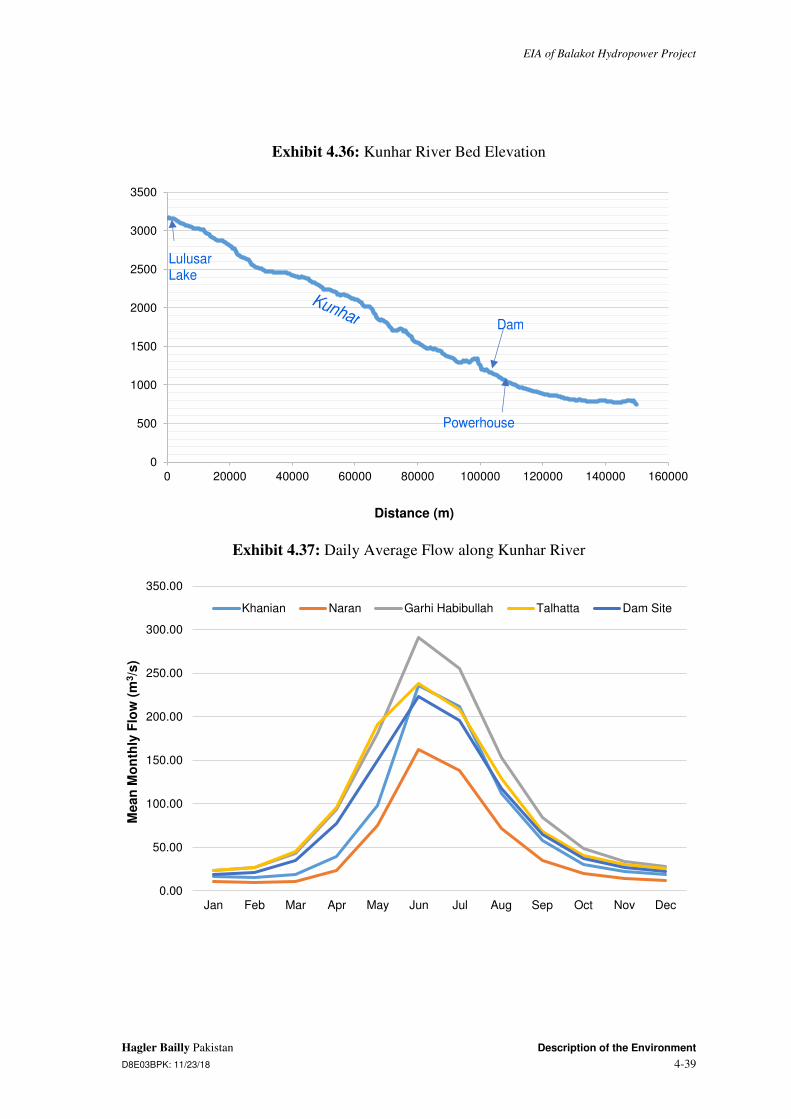
EIA of Balakot Hydropower Project
Hagler Bailly Pakistan Description of the Environment D8E03BPK: 11/23/18 4-39
Exhibit 4.36: Kunhar River Bed Elevation
Exhibit 4.37: Daily Average Flow along Kunhar River
0
500
1000
1500
2000
2500
3000
3500
0 20000 40000 60000 80000 100000 120000 140000 160000
Distance (m)
Lulusar Lake
Kunhar Dam
Powerhouse
0.00
50.00
100.00
150.00
200.00
250.00
300.00
350.00
Jan Feb Mar Apr May Jun Jul Aug Sep Oct Nov Dec
Mean
Mo
nth
ly F
low
(m
3/s
)
Khanian Naran Garhi Habibullah Talhatta Dam Site

EIA of Balakot Hydropower Project
Description of the Environment Hagler Bailly Pakistan
4-40 D8E03BPK: 11/23/18
Exhibit 4.38: Temperature Zones of Kunhar River

EIA of Balakot Hydropower Project
Hagler Bailly Pakistan Description of the Environment D8E03BPK: 11/23/18 4-41
Dam Site Hydrology
The hydrology at the dam site is typical of Himalayan rivers, characterized by peak flows in the month of June associated with melting of snow at higher elevations in the catchment, followed by declining flows in the summer supported by monsoon rainfall and continuing snowmelt in the months of July and August. The dry or low flow winter season typically extends from October through February when the flows are reduced to the order of one sixth of peak in the month of June.
The Project site hydrology based on the Feasibility Study is summarized below. The daily average flow at the dam site is shown in Exhibit 4.37. Annual run off frequencies at the dam site are summarized in Exhibit 4.39. Flood frequencies at the dam and powerhouse sites are summarized in Exhibit 4.40. Median values of hydrology parameters of ecological importance are presented in Exhibit 4.41. These are calculated via DRIFT (for details see Environmental Flow Assessment Report in Volume 2C of the EIA).
Exhibit 4.39: Flow Exceedance Frequency at Dam Site
Exceedance Time (%)
Driest Year (2001)
Wettest Year (1992)
Average Flow Year (1963)
Mean Daily Flows (1960-2010)
All Daily Flows (1960-2010)
100 11.4 18.1 16.8 19.6 6.5
90 13.7 23.5 19.1 20.9 19.4
80 16.7 30.4 23.7 23.6 23
70 20.8 55.8 28.3 28.3 27.3
60 23.8 68.2 34.1 37.1 34.3
50 31.1 108.3 41.6 50.3 48.6
40 40.1 143.5 70.5 78.3 73
30 55.4 172.2 112.8 120.6 108.4
20 73.6 218.1 150.2 171.1 154.5
10 104.7 274.4 232.1 221 215.9
� 182.3 1388.6 331.1 252.1 1388.6
Exhibit 4.40: Flood Frequency
Return Period (Years)
Floods at BAHPP Dam Site (m3/s)
Floods at BAHPP Powerhouse Site (m3/s)
2 414 447
5 752 813
10 1,060 1,146
50 1,887 2,040
100 2,280 2,466

EIA of Balakot Hydropower Project
Description of the Environment Hagler Bailly Pakistan
4-42 D8E03BPK: 11/23/18
Return Period (Years)
Floods at BAHPP Dam Site (m3/s)
Floods at BAHPP Powerhouse Site (m3/s)
500 3,263 3,529
1,000 3,714 4,016
10,000 5,312 5,745
Probable Maximum Flood 5,702
Exhibit 4.41: Hydrology Parameters of Ecological Importance in Low Flow Section
Parameter Baseline Value
Mean annual runoff (m3/s) 90.5
Dry: minimum 5-day discharge (m3/s) 17.4
Wet season: peak 5-day discharge (m3/s) 319.6
Dry season: onset (calendar week) 43
Wet season: onset (calendar week) 16
Dry season: duration (days) 175
Wet season: duration (days) 133
Community Water Supply Census
A census was carried out to map the community water resources for villages near Project facilities. A 500 m buffer around the underground headrace tunnel in the uphill direction and up till the Kunhar River in the downward direction was demarcated for the survey to account for the distance to which the impact of the tunnel on ground water might possibly extend. This area and the surveyed water resource infrastructure are shown in Exhibit 4.42. The complete census results are presented in Appendix D.
Methodology and Sampling Locations
During the census, mountain springs were documented. The location and water quality at the origin of the spring was noted. The following key information was collected at each water source:
� Spring location (village name, neighborhood (if applicable) and geographical coordinates
� Ground elevation with respect to datum (mean sea level) to the accuracy of the GPS
� Spring usage:
✁ Approximate water extraction rate
✁ Approximate number of users
✁ Water extraction method

EIA of Balakot Hydropower Project
Hagler Bailly Pakistan Description of the Environment D8E03BPK: 11/23/18 4-43
� Basic chemical parameters (measured on site): pH, electrical conductivity (EC) and temperature
� Time and date of measurement
� Pictures
Results and Analysis
A total of 70 springs were identified and characterized within the hydrocensus area. Of the 70 springs, 1 went dry completely and did not used after the 2005 earthquake.
Small tanks are typically built around springs to store water, and act as constant head for water supply pipelines, or such that communities can manually draw water from the tank. Images depicting the water infrastructure are shown in Exhibit 4.43.
A detailed summary of the results is provided in Exhibit 4.44. Based on the pH and electrical conductivity, the water is fresh and potable.
The total number of households relying on the springs within the area covered by the hydrocensus is 1,905. The springs are the sole supply for the majority of households for potable water. 50% of active water sources are used to supply drinking water to livestock as well. This is in line with the socioeconomic surveys and discussions during the surveys across the Study Area, where it was reported the drinking water supply is largely, given some exceptions, from springs, and, given some exceptions, the livestock do not typically venture close to the river to drink river water, and are therefore, also reliant on spring water.
During the 2005 earthquake, the drinking water supply infrastructure for many communities within the Study Area, largely dependent on springs, was damaged. The communities reported that some springs also dried up after the earthquake.


EIA of Balakot Hydropower Project
Hagler Bailly Pakistan Description of the Environment D8E03BPK: 11/23/18 4-45
Exhibit 4.42: Hydrocensus Locations


EIA of Balakot Hydropower Project
Hagler Bailly Pakistan Description of the Environment D8E03BPK: 11/23/18 4-47
Exhibit 4.43: Photographs of Water Resource Infrastructure
Spring outlet at S-98 Spring outlet and collection structure at S-4
Spring outlet and collection structure at S-94 Spring outlet and collection structure at S-5
Free flowing spring at S-7 Spring outlet and collection structure at S-10
Exhibit 4.44: Summary of Mountain Spring and Borehole Census Results
Parameter Group Parameter Value
Number Surveyed Mountain Springs 70
Status Active 68
Inactive 2
Elevation (m amsl) Minimum 1,126
Mean 1,413
Median 1,392

EIA of Balakot Hydropower Project
Description of the Environment Hagler Bailly Pakistan
4-48 D8E03BPK: 11/23/18
Parameter Group Parameter Value
Maximum 1,807
pH Minimum 7.3
Mean 8.0
Median 8.1
Maximum 8.5
Electrical Conductivity (µS/cm)
Minimum 222
Mean 349
Median 344
Maximum 505
�✁✂✄✁☎✆✝✞☎✁ ✟✠✡☛ Minimum 12.0
Mean 16.9
Median 17.0
Maximum 23.0
Average age of spring Pre-1950 (i.e. more than 67 years) 72%
Pre-2005 earthquake (i.e. between 67 and 12 years) 24%
Post 2005 earthquake (i.e. less than 12 years) 1%
Age not available 3%
Water use Human drinking 77%
Human other uses 66%
Livestock use 50%
Household water usage (L/day) Not counting dry springs
Minimum -
Mean 252
Median 200
Maximum 1,000
Households using water (households per spring)
Minimum -
Mean 28
Median 8
Maximum 500
Livestock water use (livestock per spring
Minimum -
Average 32
Median 6
Maximum 200
Extraction method (# of springs)
Manual 31
Pipe 44
Both Manual and with Pipe 7
Motor 0
Note: The analysis also includes springs that flow only during selected months of the year

EIA of Balakot Hydropower Project
Hagler Bailly Pakistan Description of the Environment D8E03BPK: 11/23/18 4-49
Demand for River Water for Other Uses
River water is not used for irrigation as the slopes on the river bank are steep, cost of pumping water to agricultural lands located at elevations above the river is high, and agriculture depends on rain and water available from streams flowing down the mountain slopes. There is no large or medium scale industry that depends on water, and level of industrialization is very low. River water is not suitable for drinking as it is contaminated by fecal coliform, and communities use water from springs for drinking purposes. Livestock is also mainly dependent on spring water and water from open mountain streams flowing down the slopes. River water can be turbid in seasons, and use of river water by livestock is limited to a relatively small fraction of total households that are located close to the river. These uses are insignificant in comparison to the total flow of the river. Quantification of river water use was therefore not considered to be necessary. Identifications of community sources of drinking water, mainly springs, that could be potentially impacted by the project was carried out in detail and is described in the previous section.
Water Quality
Water quality samples from Kunhar River and community springs were collected and analyzed for establishing baseline conditions for surface and groundwater.
Methodology and Sampling Locations
A total of seven samples and two quality control duplicates were collected and analyzed. Of these, four surface water samples were collected and analyzed from different sections of the Kunhar River and one from a main tributary. Two were collected from community springs located along the headrace tunnel of the Project. Exhibit 4.45 describes the sample locations and rationale for their selection. The locations are shown in Exhibit 4.46. The detailed methodology adopted for sample collection is presented in Appendix E.
Water was sampled in February and April. Samples taken in February were sent to SUPARCO Water for metals and HBP Lab for the remaining parameters, whereas samples collected in April were sent to ALS Malaysia for metals, Excel Labs Islamabad for microbiology and HBP Lab Islamabad for the remaining parameters. On-site water quality testing was also carried out with the hand-held meters for pH, conductivity, temperature and dissolved oxygen.
Results and Analysis
The results of the river water quality analysis are summarized in Exhibit 4.47. The complete results are given in Appendix E.
Key observations on the basis of the results are as follows:
� All the water quality parameters (with the exception of microbiology) are within NEQS and WHO drinking water standards.
� All river and tributary water samples were found bacteriologically contaminated and unsatisfactory for drinking due to fecal contamination. Of the two springs

EIA of Balakot Hydropower Project
Description of the Environment Hagler Bailly Pakistan
4-50 D8E03BPK: 11/23/18
tested, one contained bacteriological contamination while the other was satisfactory for drinking.
� Fifteen metals were analyzed for metal content at each sampling location. Results of the analyzed metals are found within permissible levels for drinking water NEQS. However, reported aluminum value at location W4 is highest among all samples and is exceeding both the NEQS and WHO standards. This can be attributed to higher colloidal particles in river water.
� No major differences were found within the water quality at all sampling locations.
Exhibit 4.45: Sampling Locations for Surface and Groundwater Quality
ID Coordinates Description Notes and Justification Dates of Sampling
W1 33° 39' 38.1"N
73° 28' 18.1" E
Upstream of BAHPP Dam, Kunhar River
Background river water conditions
Feb. 28, 2017
W2 34° 35' 02.3" N
73° 21 44.0" E
Near Sangar village, Kunhar River
Kunhar River before Balakot town (upstream Balakot)
Feb. 28, 2017
W3 34° 29' 12.9" N
73° 21' 20.9" E
Near Tarana village, Kunhar River
Kunhar River after Balakot town (downstream Balakot)
Feb. 28, 2017
W4 34° 26' 38.6" N
73° 21' 32.0" E
Talhatta gauging station, Kunhar River
Reported use of river water by local residents
Apr. 14, 2017
W5 34° 37' 54.0" N
73° 26' 34.1" E
Kawai Nullah Tributary water quality baseline conditions
Apr. 14, 2017
W6 33° 37' 47.6" N
73° 25' 45.8" E
Community spring near Kawai
Spring water quality along headrace tunnel
Apr. 14, 2017
W7 33° 35' 36.6" N
73° 22' 22.4" E
Community spring near Kappi Gali
Spring water quality along headrace tunnel
Apr. 14, 2017
W8 33° 37' 47.6" N
73° 25' 45.8" E
Duplicate of W6 Quality control sample Apr. 14, 2017

EIA of Balakot Hydropower Project
Hagler Bailly Pakistan Description of the Environment D8E03BPK: 11/23/18 4-51
Exhibit 4.46: Water Quality Sampling Locations


EIA of Balakot Hydropower Project
Hagler Bailly Pakistan Description of the Environment D8E03BPK: 11/23/18 4-53
Exhibit 4.47: Water Quality Test Results
Parameter Unit LOR WHO Guideline
NEQS for Drinking Water
W1 W2 W3 W4 W5 W6 W7 W8
Field Tests
Temperature oC 1 � � 7.5 8.2 9.2 14.8 14.8 14.5 18.5 14.5
DO mg/l 0.1 � � 11.2 11.5 11.5 10.7 9.6 7.6 7.8 7.6
EC µS/cm 1 � � 260 312 285 218 348 472 363 473
General Parameter
TDS mg/l 10 <1,000 <1,000 194 218 208 130 178 322 206 323
pH
0.1 6.5 � 8.5 6.0 � 8.5 8.2 8.4 8.5 8.2 8.5 7.5 8.2 7.5
TSS mg/l 4 � � � 43.5 40.5 107 15 <4 <4 <4
BOD mg/l 5 � � <5 <5 <5 5.3 5.6 <5 <5 <5
COD mg/l 5 � � <5 <5 5.3 10.4 11.8 <5 <5 <5
Turbidity NTU 0/0.01* <5 <5 1.66 4.83 4.72 15 6 4 6 4
Nitrate mg/l 0.1/0.01* 50 50 0.025 0.047 0.053 0.28 0.23 <0.1 <0.1 <0.1
Phosphate mg/l 0.1/0.02* � � <0.02 <0.02 <0.02 <0.1 <0.1 <0.1 <0.1 <0.1
Metals (Total) and Major Cations
Aluminum ✂✁✄☎ 1 200 200 37 82 95 220 74.2 18.1 3.6 18.1
Antimony ✂✁✄☎ 1 20 5 <1 <1 <1 <1 <1 <1 <1 <1
Arsenic ✂✁✄☎ 1 10 50 <1 6 5 1.2 3 <1 7.9 <1
Barium ✂✁✄☎ 1 700 700 7 15 18 27.9 87.3 38.8 300 36.8
Boron ✂✁✄☎ 1 300 300 11 19 16 <1 4.7 16.3 <1 14.7
Cadmium ✂✁✄☎ 1 3 10 <1 <1 <1 <1 <1 <1 <1 <1

EIA of Balakot Hydropower Project
Description of the Environment Hagler Bailly Pakistan
4-54 D8E03BPK: 11/23/18
Parameter Unit LOR WHO Guideline
NEQS for Drinking Water
W1 W2 W3 W4 W5 W6 W7 W8
Chromium ✂�✁✄ 1 50 50 <1 5 8 1.2 <1 <1 <1 <1
Lead ✂�✁✄ 1 10 50 <1 <1 <1 1 3.3 <1 <1 <1
Manganese ✂�✁✄ 1 500 500 <1 21 24 79.3 10.2 <1 <1 <1
Mercury ✂�✁✄ 1 1 1 <1 <1 <1 <1 <1 <1 <1 <1
Nickel ✂�✁✄ 1 20 20 <1 7 9 3.5 <1 <1 <1 <1
Silver ✂�✁✄ 1 ☎ ☎ 7 9 10 <1 <1 <1 <1 <1
Tin ✂�✁✄ 1 ☎ ☎ ☎ ☎ ☎ <1 <1 <1 <1 <1
Selenium ✂�✁✄ 1 10 10 <1 <1 <1 ☎ ☎ ☎ ☎ ☎
Zinc mg/l 0.1 3 5 ☎ ☎ ☎ <0.1 <0.1 <0.1 <0.1 <0.1
Microbiology
MPN of Coliforms: No./100 ml
☎ ☎ ☎ ☎ ☎ 18+ 1+ 18+ 1+
MPN of E.Coli No./100 ml
☎ ☎ ☎ ☎ ☎ 18+ 0 18+ 0
Note:
LOR = Level of Reporting, DO = Dissolved Oxygen, EC = Electrical Conductivity, TDS = Total Dissolved Solids
TSS = Total Suspended Solids, BOD = Biological Oxygen Demand, COD = Chemical Oxygen Demand, MPN = Most probable number
mg/l = milligram per liter, ✆✝✞✟ ✠ ✡☛☞✌✍✝✌✎✡ ✏✑✌ ✒☛✓✑✌✔ NTU = Nephelometric Turbidity Unit µS/cm = microsiemen per centimeter
✕ ✖ ✕✡✑✎✗✘ ✓✙✎✓ ✘✓✎✗✚✎✌✚✘ ✎✌✑ ✗✍✓ ✚✑✛☛✗✑✚ ✛✍✌ ✓✙☛✘ ✏✎✌✎✡✑✓✑✌ ✍✌ ✓✙✑ ✏✎✌✎✡✑✓✑✌ ✜✎✘ ✗✍✓ ✎✗✎✒✢✣✑✚✔ * First LOR is for W1, W2 and W3. Second LOR is for remaining samples

EIA of Balakot Hydropower Project
Hagler Bailly Pakistan Description of the Environment D8E03BPK: 11/23/18 4-55
4.1.8 Ambient Air Quality
This section describes the current ambient air quality in the area where Project activities are proposed.
The pollutants selected for evaluation, based on the expected emissions from the Project activities and the level of risk to human health posed by these pollutants, are as follows:
� Sulfur dioxide (SO2)
� Oxides of Nitrogen (NOX)✁Mainly Nitrogen dioxide (NO2) and Nitric oxide (NO)
� Respirable particulate matter✁Coarse (PM10)8 and Fine (PM2.5)9
Emission Sources
There are two main sources of emissions in the Study Area, which are discussed below.
1. Wood/Liquefied Petroleum Gas (LPG) burning. Wood burning and LPG are used for cooking and heating. Due to the incomplete combustion in the primitive stoves wood is a significant source of PM10, PM2.5 whereas combustion of LPG is a significant source of NOx but both sources also results in SO2 emissions.
2. Traffic. Combustion of petrol and diesel is a source of NOx and SO2 emissions with diesel burnt in heavy transport vehicles is the main source of SO2. Vehicle exhaust result in PM2.5 emissions whereas tire movement, especially on tracks and unsealed road result in dust emissions (PM10 and PM2.5).
Methodology and Sampling Locations
Air quality sampling was carried out at four different locations in the Study Area between March 19 and May 8, 2017. A description of sampling locations and the rationale of selection is given in Exhibit 4.48. The sampling locations, along with nearby settlements and roads are shown in Exhibit 4.49. The detailed methodology is provided in Appendix F.
Exhibit 4.48: Details of Air Quality Sampling Locations
Sample ID Coordinates Location Rationale for Site Selection
A1 34° 39' 41.3" N 73° 27' 39.2" E
Paras Near proposed labor camp in Paras
A2 34° 39' 01.1" N 73° 26' 30.9" E
Hariwala Nakka Near proposed dam site
A3 34° 36' 18.2" N 73° 22' 57.6" E
Nalla Near proposed powerhouse site
A4 34° 32' 57.2" N 73° 21' 17.1" E
Balakot Near proposed labor camp in Sangar
A5 34° 39' 41.3" N 73° 27' 39.2" E
Paras duplicate of A1
8 PM10 is particulate matter 10 micrometers or less in diameter 9 PM2.5 is particulate matter 2.5 micrometers or less in diameter

EIA of Balakot Hydropower Project
Description of the Environment Hagler Bailly Pakistan
4-56 D8E03BPK: 11/23/18
Exhibit 4.49: Air Quality Sampling Locations

EIA of Balakot Hydropower Project
Hagler Bailly Pakistan Description of the Environment D8E03BPK: 11/23/18 4-57
Results
The air quality sampling results are summarized in Exhibit 4.50 and the values exceeding the NEQS and IFC-EHS limits are highlighted. The complete results are produced in Appendix F.
Exhibit 4.50: Results of Ambient Air Quality Sampling (µg/m3)
Sample ID NOx NO2 NO* SO2 PM10 PM2.5
LOR 0.033 µg of NOx 0.01 µg of NO2 - 0.03 µg of S 100 µg 100 µg
A1 6.9 6.1 0.8 1.8 104.7 65.2
A2 2.0 2.1 ** <1.3 78.6 52.4
A3 5.2 3.0 2.2 1.4 117.8 65.4
A4 16.8 13.8 3.0 20.1 130.9 78.5
A5 (duplicate of A-1) 7.1 5.6 1.5 <1.2 � �
A6 (field blank) 1.5 0.4 1.1 <1.2 � �
NEQS (annual) 100*** 40 40 80 120a 15a
NEQS (24-hour) 140*** 80 40 120 150 35
IFC (annual � interim target 1)
� � � � 70a 35a
IFC (24-hour � interim target 1)
� � � 125 150 75
Note:
a: annual does not apply to particulate matter data reported above ✁✂✁ ✄☎✆✝✞ ☎✟✠✡☎☛ ✠✡☎ ☞✆✠✆ ✟✞ ✝✌✠ ✆✍✆✟✎✆✏✎☎ ✌☛ ✠✡☎ ✞✠✆✝☞✆☛☞ ✟✞ ✝✌✠ ☞☎✑✟✝☎☞✒
* NO results are derived by subtracting NO2 from NOx.
** Where nitric oxide (NO) results have not been calculated result for NOX was lower than result for NO2.
*** Standards for NOx are not defined and calculated in terms of NO2. NOx annual standard = annual standard of NO2 + 1.5 × annual standard of NO. Same is for 24-hour standards.
The following analysis of results are presented:
✓ The annual and 24-hour concentrations of SO2, NOx, NO2 and NO comply with both the NEQS and IF-EHS limits. This leaves a wide room to incorporate emissions of the proposed Project. The maximum levels of SO2, NOx, NO2 and NO are 20.1, 16.8, 13.8 and 3.0 µg/m3, respectively observed at A4 (Balakot town). This is mainly due to the high traffic in the town and concentrated use of LPG and wood for domestic purposes.
✓ The 24-hour PM10 concentration comply with both the NEQS and IFC-EHS limits at all sampling locations. The 24-hour PM2.5 concentration exceeds the NEQS at all sampling locations however, it complies with IFC-EHS interim target 1 at all locations except at A4 (Balakot town) where it exceeds both the NEQS and IFC-EHS limits. The highest readings of PM10 and PM2.5 were recorded at A4 (Balakot town) along N-15 highway.

EIA of Balakot Hydropower Project
Description of the Environment Hagler Bailly Pakistan
4-58 D8E03BPK: 11/23/18
� The concentration of all pollutants at A2 (near dam site) are lowest among all sampling locations. A2 is mainly contributed by natural sources and is dominated by forest. The nearest settlement is about 780 m away from A2.
4.1.9 Traffic
Traffic baseline is prepared to assess the current traffic conditions on the road route that will be used for the Project related transportation of services during construction and operation of the Project. The objectives of the traffic study are to document present traffic situation, identify existing road capacity, bottle necks (congestion points) and potential impacts due to the Project traffic during construction and operation.
Transportation Route
The transport route for the Project is described in Section 3. A discussion on the possible alternate routes and the reason for the selection of this route is given in Section 5
Methodology and Sampling Locations
Traffic counts were conducted at four locations listed in Exhibit 4.51 and shown in Exhibit 4.52. A team of qualified surveyors was selected and a pilot count was conducted before the actual survey. At the counting site, two people were stationed for daytime and two for nighttime to separately count the daily traffic in both directions. The traffic count was recorded over a 24-hour period on a weekday (May 4, 2017) and a weekend (May 7, 2017).
Exhibit 4.51: Traffic Count Locations
ID Coordinates Location Rationale
T1 34° 39' 39.1" N 73° 27' 57.8" E
Paras Traffic at dam and reservoir site.
T2 34° 36' 06.8" N 73° 22' 52.5" E
Sendori Traffic at powerhouse site.
T3 34° 33' 01.8" N 73° 21' 11.7" E
Balakot market Traffic in Balakot town
T4 34° 32' 42.1" N 73° 20' 55.2" E
Balakot Traffic in Balakot town

EIA of Balakot Hydropower Project
Hagler Bailly Pakistan Description of the Environment D8E03BPK: 11/23/18 4-59
Exhibit 4.52: Traffic Count Locations

EIA of Balakot Hydropower Project
Description of the Environment Hagler Bailly Pakistan
4-60 D8E03BPK: 11/23/18
Passenger Car Equivalent (PCE) or Passenger Car Unit (PCU) is a metric unit used to assess traffic-flow rate.10 PCU, is a measure of the relative space requirement of a vehicle compared to that of a passenger car under a specified set of roadway, traffic and other conditions. The value assigned to each of the classification of the vehicles may depend on a number of factors such as:
� dimensions, power, speed, acceleration and braking characteristics of the vehicle;
� road characteristics such as geometrics including gradients, curves, access controls, type of road: rural or urban, presence and the type of intersections;
� transverse and longitudinal clearances between vehicles moving on road, which in turn depends upon the speeds, driver characteristics and the classes of other moving vehicles;
� environmental and climatic conditions and;
� Traffic control methods, speed limits, and barriers.
The PCU for different classes of vehicles are not defined universally, however, the values used here are typical for Pakistani road conditions. The PCUs are calculated on the basis of traffic counts. Exhibit 4.53 shows PCU factor for each vehicle.
Exhibit 4.53: Two-Way Traffic at each Traffic Count Location
Vehicle PCU Factor
Motorcycles 0.50
Auto rickshaws 0.75
Cars (sedans) 1.00
Jeeps/Pickups 1.25
Mini Bus 1.50
Bus 2.00
Truck ✁ 2 axle 2.50
Truck ✁ 3 axle 3.00
Truck ✁ 4 axle 3.50
Truck ✁ 5 axle 4.00
Results and Analysis
The summary of the two-way traffic count at the sampling locations is presented in Exhibit 4.54. The hourly traffic volume is graphed in Exhibit 4.55 for weekday and in Exhibit 4.56 for the weekend. Detailed data is included as Appendix G. Key findings are presented below:
10 Ahuja, Amanpreet Singh (2004). Development of passenger car equivalents for freeway merging section

EIA of Balakot Hydropower Project
Hagler Bailly Pakistan Description of the Environment D8E03BPK: 11/23/18 4-61
� There was an increase in traffic on the weekends for points T1 (about 25 to 30% more vehicles) and T2 (50% increase in vehicles heading to Balakot town) as they are on the transit route to tourist locations.
� Although the morning peak (9 am) shows a significant drop on the weekends at T3 and T4 (from 700-800 vehicles to 500-600 vehicles), the traffic volumes are still generally higher on the weekend with steady flows throughout the day.
� According to the police check post near T1 the traffic increases between 20 to 25 times the measured traffic during the peak tourist season months of June and July due to transit traffic going on to Naran, Kaghan and beyond.


EIA of Balakot Hydropower Project
Hagler Bailly Pakistan Description of the Environment D8E03BPK: 11/23/18 4-63
Exhibit 4.54: Two-Way Traffic at each Traffic Count Location (Non-Season)
Summary Traffic point Day Type Bikes Cars Pick-up Buses Truck Tractor/ Trailer
Total %LTV %HTV Total PCUs
Paras to Kaghan T1 Weekday 100 647 427 18 144 2 1,338 88% 12% 1,637
Weekend 189 775 521 31 151 3 1,670 89% 11% 1,976
Kaghan to Paras T1 Weekday 98 623 384 8 133 9 1,255 88% 12% 1,538
Weekend 149 846 466 30 160 1 1,652 88% 12% 1,969
Sendori to Paras T2 Weekday 96 493 422 26 119 1 1,157 87% 13% 1,425
Weekend 149 600 389 21 96 8 1,263 90% 10% 1,478
Paras to Sendori T2 Weekday 71 479 341 10 98 8 1,007 88% 12% 1,239
Weekend 147 776 427 41 162 2 1,555 87% 13% 1,882
Balakot to Dabrian T3 Weekday 1,407 2,129 809 34 121 9 4,509 96% 4% 4,257
Weekend 1,625 2,462 1,195 57 199 29 5,567 95% 5% 5,506
Dabrian to Balakot T3 Weekday 921 1,727 529 34 99 8 3,318 96% 4% 3,197
Weekend 1,064 2,498 965 35 204 24 4,790 95% 5% 4,916
Balakot to Mansehra T4 Weekday 696 1,927 499 50 82 7 3,261 96% 4% 3,244
Weekend 753 2,549 846 60 130 12 4,350 95% 5% 4,482
Mansehra to Balakot T4 Weekday 1,209 2,195 1,044 54 93 11 4,606 97% 3% 4,498
Weekend 897 1,948 859 39 123 8 3,874 96% 4% 3,902


EIA of Balakot Hydropower Project
Description of the Environment Hagler Bailly Pakistan
4-66 D8E03BPK: 11/23/18
Noise is defined as a loud, undesired sound that interferes with normal human activities. If it affects the well-being of the surrounding community (environmental noise), it is considered a nuisance and normally has no direct health impacts. Exposure to very high noise levels (exceeding 85 dBA), particularly for prolonged period can cause hearing loss. This level of noise is usually encountered in the workplace around construction sites and is considered an occupational hazard.
In general, human sound perception is such that a change in sound level of 3 dB is just noticeable, a change of 5 dB is clearly noticeable, and an increase of 10 dB is perceived as a doubling of sound level.
The following is a brief description of terminology used in this assessment:
� Sound: A vibratory disturbance created by a vibrating object, which, when transmitted by pressure waves through a medium such as air, is capable of being detected by a receiving mechanism, such as the human ear or a microphone
� Noise: Sound that is loud, unpleasant, unexpected, or otherwise undesirable
� Decibel (dB): A unitless measure of sound on a logarithmic scale, which indicates the squared ratio of sound pressure amplitude to a reference sound pressure amplitude. The reference pressure is 20 micro-pascals
� A-Weighted Decibel (dB(A)): An overall frequency-weighted sound level in decibels, which approximates the frequency response of the human ear. The typical human ear is not equally sensitive to all frequencies of the audible sound spectrum. As a consequence, when assessing potential noise impacts on people, an electronic filter is used that de-emphasizes certain frequencies in a manner ✁✂✄✄☎✆✝✂✞✟✠✞✡ ☛✂ ☛☞☎ ☞✌✍✎✞ ☎✎✄✏✆ ✟☎✁✄☎✎✆☎✟ ✆☎✞✆✠☛✠✑✠☛✒ ☛✂ ✓✂✔ ✎✞✟ ☎✕☛✄☎✍☎✓✒ ☞✠✡☞
frequencies. All of the noise levels reported in this Section are A-weighted
� Equivalent Sound Level (Leq): The equivalent steady state sound or vibration level, which in a stated period of time, typically one hour, would contain the same acoustical or vibration energy.
Methodology and Sampling Locations
Noise measurements were taken at four locations listed in Exhibit 4.57 and shown in Exhibit 4.59.
Exhibit 4.57: Noise Sampling Locations
ID Location Coordinates Dates of Survey
Distance from River (m)
Elevation Difference from
River (m)
Description
N1 Paras 34° 39' 41.6" N 73° 27' 39.1" E
May 6 to 7, 2017
192 38 Small town, main road
N2 Powerhouse Site
34° 36' 10.1" N 73° 22' 42.7" E
May 4 to 5, 2017
576 201 Forest, main road
N3 Sangar 34° 34' 54.7" N 73° 22' 10.4" E
May 5 to 6, 2017
720 288 Small town, main road

EIA of Balakot Hydropower Project
Hagler Bailly Pakistan Description of the Environment D8E03BPK: 11/23/18 4-67
ID Location Coordinates Dates of Survey
Distance from River (m)
Elevation Difference from
River (m)
Description
N4 Balakot 34° 32' 44.3" N 73° 20' 56.0" E
May 7 to 8, 2017
210 19 Large town, main road
�✁✂ ✄☎✆✝✂ ✞✂✟✂✞✝ ✠✂✡✂ ☛✂☞✝✌✡✂✍ ✌✝✆✄✎ ✏☎✡✑☞✒✞✂ ✓✆✡✡✌✝ ✔✂✝✂☞✡✕✁ ✏✞✕✖✗✝ ✝☎✌✄✍ ✞✂✟✂✞ ☛✂✑✂✡✘
Model CR:1720. The instrument meets the International standards IEC 61672-1:2002, IEC 660651:1979, IEC 60804:2001, IEC 61260:1995, IEC 60942:1997, IEC 61252:1993, ANSI S1.4-1983, ANSI S1.11-1986, and ANSI S1.43-1997 where applicable. The instruments have a resolution of 0.1 dB.
The meter was calibrated at the start of measurement at each site, using Cirrus Research ✏✞✕✖✗✝ ☞✕☎✌✝✑✆✕ ✕☞✞✆✒✡☞✑☎✡✘ ✙☎✍✂✞✚ ✓✔✚✛✜✢✖ �✁✂ ✝☎✌✄✍ ☛✂ter and calibrator were factory calibrated on September 28, 2015. The instrument was mounted on a tripod, to avoid interference from reflecting surfaces within the immediate neighborhood, and a wind shield was used in all measurements. Photographs of the sampling equipment setup are provided in Exhibit 4.58.
Noise readings were taken for 24 hours at each site between May 4 and May 8, 2017.
Exhibit 4.58: Noise Sampling Site Photographs
Sound meter at N1 Sound meter at N3

EIA of Balakot Hydropower Project
Description of the Environment Hagler Bailly Pakistan
4-68 D8E03BPK: 11/23/18
Exhibit 4.59: Noise Sampling Locations

EIA of Balakot Hydropower Project
Hagler Bailly Pakistan Description of the Environment D8E03BPK: 11/23/18 4-69
Results
A summary of the results and NEQS are provided in Exhibit 4.60. L10 and L90 refer to percentile noise levels that are exceeded 10% and 90% of the time, respectively. The levels are calculated excluding the 10% upper and lower extreme ranges of the noise data. Hourly variations are captured in Exhibit 4.61. Weather data measured during the sampling exercise is given in Exhibit 4.62.
Exhibit 4.60: Summary Statistics of Sound Levels during the Survey
ID Location 24 hour (dBA) Daytime Nighttime
L10 L50 L90 LEQ LEQ LEQ
N1 Paras 46.0 46.6 44.8 49.5 44.4 41.6
N2 Powerhouse site 50.1 50.0 50.2 51.5 49.8 48.6
N3 Sangar 42.0 42.3 41.5 45.3 40.2 37.5
N4 Balakot 60.1 61.1 57.9 63.5 59.1 53.4
NEQS Limits 55 45
IFC Limit 55 45
Exhibit 4.61: Hourly Noise Levels
30.00
35.00
40.00
45.00
50.00
55.00
60.00
65.00
70.00
7:0
0:0
0 A
M
8:0
0:0
0 A
M
9:0
0:0
0 A
M
10:0
0:0
0 A
M
11:0
0:0
0 A
M
12:0
0:0
0 P
M
1:0
0:0
0 P
M
2:0
0:0
0 P
M
3:0
0:0
0 P
M
4:0
0:0
0 P
M
5:0
0:0
0 P
M
6:0
0:0
0 P
M
7:0
0:0
0 P
M
8:0
0:0
0 P
M
9:0
0:0
0 P
M
10:0
0:0
0 P
M
11:0
0:0
0 P
M
12:0
0:0
0 A
M
1:0
0:0
0 A
M
2:0
0:0
0 A
M
3:0
0:0
0 A
M
4:0
0:0
0 A
M
5:0
0:0
0 A
M
6:0
0:0
0 A
M
N1 N2 N3 N4 Daytime Limit Nightime Limit

EIA of Balakot Hydropower Project
Description of the Environment Hagler Bailly Pakistan
4-70 D8E03BPK: 11/23/18
Exhibit 4.62: Weather Parameters during Noise Sampling
ID
Temperature deg C
Wind Speed (m/s) Relative Humidity (%)
Barometric pressure (mb)
N1 Mean 23.6 0.2 49.4 870.6
N2 Mean 21.0 0.5 45.5 872.7
N3 Mean 21.0 0.5 45.5 872.7
N4 Mean 26.5 1.2 42.1 901.1
Small Town: Noise levels in both the small towns of Paras (N1) and Sangar (N3) are well within NEQS noise limits and within IFC-EHS limits for most hours other than early morning hours in Paras where the nightime limits are crossed.
Large Town: The noise levels at N4, which was located within the market of Balakot Town were high and exceed both daytime and nightime NEQS and IFC-EHS limits. Natural sources such as wind (of which the speed went up to 5.4 m/s during sampling) and river noise may also have contributed to the high noise levels.
Forests: Noise levels at N2 are steady throughout the day and night at around 50 dbA as there are no varying antropogenic sources of noise in the area. Constant sources of noise include noise from the river and wind.
4.2 Ecology Baseline
The ecology baseline has been prepared to present the ecological conditions in the Project area.
4.2.1 Objectives and Scope
The baseline was prepared with the following objectives:
� Qualitative and quantitative assessment of terrestrial vegetation, periphyton11, macro-invertebrates, fish, herpetofauna12, birds and mammals.
� Identification of key species, their relative abundances and their conservation status.
� Compiling reports of wildlife sightings in the Study Area by the resident communities.
� Identification of any additional habitats, and microhabitats.
� Analysis to further develop the basis for evaluating the potential impacts of Project-related activities on the biodiversity, specifically identification and evaluation of critical habitats.
11 Aquatic organisms, such as certain algae, that live attached to rocks or other surfaces 12 The reptiles and amphibians of a particular region, habitat, or geological period

EIA of Balakot Hydropower Project
Hagler Bailly Pakistan Description of the Environment D8E03BPK: 11/23/18 4-71
4.2.2 Sources of Information
Sources of information for preparation of the ecological baseline included published literature and reports, and field surveys conducted for collection of data. The following report which provides ecological information collected recently in the proximity of Project area was consulted:
� Hagler Bailly Pakistan, March 20, 2017, Environment and Social Impact Assessment for Kohala Hydropower Project, Kohala Power Company (Pvt) Ltd
� Hagler Bailly Pakistan, September 2016, Biodiversity Strategy for Jhelum-Poonch River Basin ✁ Preparatory Phase, Fish Surveys in Tributaries, for the International Finance Corporation
4.2.3 Study Areas
There are two types of ecological resources that are of concern, aquatic and terrestrial. Therefore, two types of Study Areas were defined, an Aquatic Study Area and a Terrestrial Study Area.
The Aquatic Study Area includes the stretch of the Kunhar River from Faridabad upstream of the Project to Bissian downstream of the Project. It was selected taking into consideration the maximum extent of impacts of the Project both upstream and downstream of it. The reservoir is expected to form along a stretch 2.8 km upstream of the dam. The Aquatic Study Area extends past the upstream end of the reservoir till just past Faridabad, to account for the maximum extent of the impact upstream of the reservoir. It extends downstream till Bissian, a location representative of the impacts of release from the tailrace tunnel. Approximately 10 km downstream of Bissian is the start of the reservoir of Patrind HPP, which has altered the riverine habitat and created a barrier downstream of the Project. The Aquatic Study Area also includes tributaries in this stretch but only those with a significant perennial flow that support breeding of fish are included. The Aquatic Study Area is shown in Exhibit 4.63.
The Terrestrial Study Area comprises a 1 km buffer around selected locations where Project-related facilities are to be located. Project-related activities will occur within the Project-related facilities. The flora and fauna within a 1 km radius of these activities is expected to be impacted by them. Sampling Locations were selected within all habitat types where Project facilities will be located. Sampling Locations were also selected at other sites in the Terrestrial Study Area, with representative sampling by proportion of habitat type. Scrub Forest makes up the highest percentage of the habitat in the Terrestrial Study Area followed by Pine Forest and Agriculture Area. Exhibit 4.64 shows the Terrestrial Study Area.

EIA of Balakot Hydropower Project
Description of the Environment Hagler Bailly Pakistan
4-72 D8E03BPK: 11/23/18
Exhibit 4.63: Aquatic Study Area

EIA of Balakot Hydropower Project
Hagler Bailly Pakistan Description of the Environment D8E03BPK: 11/23/18 4-73
Exhibit 4.64: Terrestrial Study Area

EIA of Balakot Hydropower Project
Description of the Environment Hagler Bailly Pakistan
4-74 D8E03BPK: 11/23/18
4.2.4 Methodology
The field survey plan for data collection is provided in Appendix H. The methodology used for each biological resource is summarized below.
Surveys
The winter survey for fish fauna was carried out between February 24, 2017 and March 1, 2017. The spring survey for fish fauna was carried out between May 13, 2017 and May 16, 2017. The survey for terrestrial ecology was carried out between May 19, 2017 and May 23, 2017.
Representatives from the Fisheries Department, KP and the Wildlife Department, KP accompanied the teams to observe sampling. Photographs of staff from the Departments observing field sampling are provided in Exhibit 4.65.
Exhibit 4.65: Government Department Staff Observing Field Sampling, May 2017 Survey
Mr Qaiser Javed from Fisheries Department, KP observing samples collected for fish fauna
Mr Sarmad Shah, Sub-Divisional Forest Officer, Balakot, Wildlife Department, KP (extreme right)
walking with the team to Sampling Location T8
Aquatic Ecology
Sampling for aquatic ecology was carried out for the following:
� Fish
� Macro-invertebrates
� Periphyton
� Riparian Vegetation

EIA of Balakot Hydropower Project
Hagler Bailly Pakistan Description of the Environment D8E03BPK: 11/23/18 4-75
Sampling Locations
Sampling Locations for fish fauna, macro-invertebrates, periphyton and riparian vegetation are shown in Exhibit 4.66. The justification for the selection of these Sampling Locations is provided in Exhibit 4.67. The list of Sampling Locations in the tributaries is provided in Exhibit 4.68.
Fish
In the February 2017 Survey, sampling was carried out at the Sampling Locations shown in Exhibit 4.66. The sampling in May 2017 was also carried out at the same Sampling Locations. The methods for data collection included the use of two different types of nets, gill nets and cast nets, as well as electrofishing. Details of the use of each method are provided in Appendix H.
Statistical analysis was carried out to determine fish community structure and species diversity. The details of the application of these statistical methods is provided in Appendix H.
Macro-invertebrates
Macro-invertebrates sampling was conducted in the May 2017 Survey at the Sampling Locations shown in Exhibit 4.66.
The methods for sampling are described in Appendix H, along with details of how the samples were processed in the laboratory.
The data collected was used to generate information on the abundance of macro-invertebrates for each taxon.
Periphyton Biomass
Periphyton could not be collected during the February 2017 Survey. Sampling for periphyton was attempted in May 2017 Survey as well, however, periphyton was again not present due to the fast flow of the river, which erodes and washes out biomass on the cobblestones. The proposed Sampling Locations for both the February 2017 Survey and May 2017 Survey are shown in Exhibit 4.66. Methods for data collection and sample analysis are described in detail in Appendix H.

EIA of Balakot Hydropower Project
Description of the Environment Hagler Bailly Pakistan
4-76 D8E03BPK: 11/23/18
Exhibit 4.66: Sampling Locations for Fish, Macro-invertebrates, Periphyton and Riparian Vegetation

EIA of Balakot Hydropower Project
Hagler Bailly Pakistan Description of the Environment D8E03BPK: 11/23/18 4-77
Exhibit 4.67: Justification for Selection of Sampling Locations on Main River
River Segment Sampling Location ID
Expected impacts from the Project
Upstream of Dam K110.6 This location is upstream of the reservoir of proposed dam and will be impacted by the barrier to migration created by the dam
Downstream of Dam K117.5 This location will be impacted by the lower flows due to the diversion of the river flow into the power generation tunnel
Downstream of Diversion Tunnel
K126.9, K139.0 Both temperature and flow of water at this location will be impacted by variations in flow.
Exhibit 4.68: List of Sampling Locations for the Tributaries
Tributary (Local Name) Sampling Location ID
Shogran Nullah SH1.7
Bhunja Nullah BH6.0
Barnialai Nullah BA4.3
Makra Nullah MA4.1
Barna Nullah BAR6.7
Shisha Nullah SH1.6
Riparian Vegetation
The methodology used for riparian vegetation is the same as that used for sampling of terrestrial flora. Sampling was carried out at the banks of all the aquatic ecology Sampling Locations (Exhibit 4.66).
Terrestrial Ecology
Sampling for terrestrial ecology included the following:
� Terrestrial Flora
� Mammals
� Avifauna
� Herpetofauna
Sampling Locations
Sampling Locations for terrestrial ecology are provided in Exhibit 4.69. The locations were determined taking into account three main habitat types identified using Google EarthTM satellite imagery. These include Agricultural Area, Scrub Forest and Pine Forest. The number of Sampling Locations were distributed between these habitat types within the Terrestrial Study Area, with 10 in the two Forest habitat types (six in Scrub Forest and four in Pine Forest) and four in Agricultural Area habitat type. Ground-truthing was carried out during sampling to determine the actual habitat at that sampling location. The habitat type of each Sampling Location, after ground-truthing, is provided in Exhibit 4.69 and Exhibit 4.70.

EIA of Balakot Hydropower Project
Description of the Environment Hagler Bailly Pakistan
4-78 D8E03BPK: 11/23/18
Exhibit 4.69: Sampling Locations for Terrestrial Flora and Fauna

EIA of Balakot Hydropower Project
Hagler Bailly Pakistan Description of the Environment D8E03BPK: 11/23/18 4-79
Exhibit 4.70: Habitat Types for the Terrestrial Sampling Locations
Sampling Locations Relative Position of Sampling Location
T2, T11 Agricultural Area
T1, T7, T8, T10, T13 Pine Forest
T3, T4, T5, T6, T9, T12 Scrub Forest
Terrestrial Flora
The methods used for sampling and analysis of terrestrial flora are described in Appendix H. The data collection and analysis on terrestrial flora was used to generate information on the following:
� Cover
� Relative Cover
� Density
� Relative Density
� Frequency
� Relative Frequency
� Importance Value Index
The results of the sampling and analysis are provided in Section 4.8.
Mammals
Mammals were sampled at the Sampling Locations shown in Exhibit 4.69. The methods used for sampling were different for small and large mammals. These methods are described in detail in Appendix H. Sampling for mammals was used to collect information about the presence, abundance and distribution of mammal species in the three habitat types, Agricultural Area, Scrub Forest and Pine Forest, within the Terrestrial Study Area.
Avifauna
Avifauna was sampled at the Sampling Locations shown in Exhibit 4.69. The methods used for sampling are described in detail in Appendix H. Sampling for birds was used to collect information about diversity, abundance and distribution of bird species within the Terrestrial Study Area. It also identified the presence of any birds of conservation importance present within the Terrestrial Study Area.
Herpetofauna
Herpetofauna was sampled at the Sampling Locations shown in Exhibit 4.69. The methods used for sampling are described in detail in Appendix H. Sampling for herpetofauna was conducted to collect information about the presence, diversity, abundance and distribution of reptile and amphibian species within the Terrestrial Study Area.

EIA of Balakot Hydropower Project
Description of the Environment Hagler Bailly Pakistan
4-80 D8E03BPK: 11/23/18
4.2.5 Protected Areas or Areas of Special Importance for Biodiversity
There are both aquatic and terrestrial areas that are either protected or of special importance to biodiversity near the Project.
The part of the Kunhar River above Balakot Bridge (Exhibit 4.71) is protected as it is stocked by the Fisheries Department, KP. This includes protected status of the river and riparian areas, however, the exact area within the terrestrial areas is not known. There are also terrestrial Protected Areas within the Mansehra District. A map showing the terrestrial Protected Areas and areas of special importance for biodiversity is provided in
Exhibit 4.71. A map showing the Important Bird Areas (IBAs) is shown in Exhibit 4.72.
Terrestrial Protected Areas
Information about the terrestrial Protected Areas, including national parks, wildlife sanctuaries and game reserves was obtained from the Wildlife Department of KP. This information is currently unpublished. The Protected Area closest to the dam site is the Manshi Wildlife Sanctuary, located 5 km away. The second closest is the Saif-ul-Maluk National Park, located 23.5 km from the dam site.
Mansehra Wildlife Division
There is a diversity of habitat types within Mansehra Wildlife Division consisting of Scrub forests, Chir pine Forests, Moist Temperate Forests, Dry Temperate Forests, Sub Alpine Forests, Alpine Pastures and Wetlands.
There are two types of wetlands found in Mansehra Wildlife Division.
� High altitude wetlands are found in upper Kaghan Valley. The most important amongst them are Saiful Maluk Lake, Lulusar Lake, Dudipat Sar Lake and Ansoo Lake etc.
� Low altitude wetlands are found in areas around Lower Kunar and Siran Rivers.

EIA of Balakot Hydropower Project
Hagler Bailly Pakistan Description of the Environment D8E03BPK: 11/23/18 4-81
Exhibit 4.71: Map of Protected Areas

EIA of Balakot Hydropower Project
Description of the Environment Hagler Bailly Pakistan
4-82 D8E03BPK: 11/23/18
Exhibit 4.72: Map of Important Bird Areas

EIA of Balakot Hydropower Project
Hagler Bailly Pakistan Description of the Environment D8E03BPK: 11/23/18 4-83
Due to diversity of habitat types there is a wide diversity of flora and fauna which makes Mansehra Wildlife Division a very important site for protection and conservation. The human population is increasing rapidly which is not only fragmenting habitat but also degrading it. Local communities are highly dependent upon natural resources which presents a challenge for conservation. Mansehra Wildlife Division maintains regular contact with the local communities to persuade them and to educate them about the importance of natural resources and to enlist their support in conservation of biodiversity. There are 12-15 communities organized to protect and manage Community Game Reserves and other protected areas in Mansehra. Similar efforts are being undertaken to organize communities living around the national parks of Kaghan Valley so that they help in protection and manage their natural resources, for example tapping into the benefits from eco-tourism. There is informal interaction with the communities of Upper Siran and Kanshian that are living around the habitat for re-introduction of Chir pheasants.
Terrestrial Protected Areas in the vicinity of the Terrestrial Study Area include ten community Game Reserves, two National Parks and one Wildlife Sanctuary. Other hot spots suitable for being declared as Protected Areas have been identified by the Wildlife Department, KP. Some of these patches of habitat are Bichla Manoor Reserve Forests, Sharhan Reserve Forests; Shogran Reserve Forests and adjoining habitat in Kaghan Valley, Hillan and Chorr in Battagram Districts. These areas are important for their biodiversity and in need of protection from habitat degradation and over exploitation. A description of each type of Protected Area is provided below.
National Parks
There are two National Parks in Mansehra Wildlife Division including the Saiful Maluk National Park and Lulusar-Dudipat National Park.
Saiful Maluk National Park
Saiful Maluk was declared a National Park on April 28, 2003. Total area of this national park is 12,026 acres. The human population around the National Park is about 20,000. Important fauna of the Park includes, Snow Leopard, Marmot, Brown Bear, Himalayan Ibex, Snow Cock, Snow Partridge and Himalayan Griffin Vulture.
Microtopographic features and morphological and physiological characteristics of the vegetation give rise to patterns which vary in size and are found intermittently. For example, Junipers is prostrate with spreading aerial parts. Its compact patches are found all over pastures, but particularly on rocky ridges. Salix occupies depressions on cooler aspects. Species of Polygonum have extensive rhizomes and several patterns are usually visible in pastures. Iris form more or less compact patches distributed all over the area, giving the impression of pure stands. Potentilla-Astragalus type vegetation is present.
The large number (63) of species indicates the richness of floral diversity. Prevailing conditions suggest that more palatable species have disappeared due to heavy grazing. Most forbs (17 species)13 have poor palatability and are therefore abundant. Some forbs have medical value, and locals use them to treat both humans and livestock. Fresh leaves
13 A forb is a family of plants that have broad leaves and herbaceous structures.

EIA of Balakot Hydropower Project
Description of the Environment Hagler Bailly Pakistan
4-84 D8E03BPK: 11/23/18
or branches of some are used as food. Woody species are a good source of fuel wood and thatch. Dry branches and stems of Juniper and Salix are collected for fuel.
An estimated 0.1 million people visit the Saiful Maluk Park area every year. Threats to the national Park are over exploitation of natural resources, ill-planned tourism, pollution, illegal fishing, modification of land for cultivation, and ill-planned construction.
Lulusar Dudipat National Park
Lulusar-Dudipat was declared National Park on April 28, 2003. The human population around it is about 15,000, mainly nomadic and semi-nomadic peoples. The important fauna of the Park includes Snow leopard, Marmot, Brown Bear, Himalayan Ibex, Snow Cock, Snow Partridge and Himalayan Griffin Vulture.
An estimated 20,000 people visit the Park area every year. Threats to this National Park are the same as for the Saiful Maluk National Park.
Wildlife Sanctuaries
There is one wildlife sanctuary located 5 km from the Project, the Manshi Wildlife Sanctuary.
Manshi Wildlife Sanctuary
This sanctuary is located in Kaghan Valley at a height of about 2,438 meters above sea level. The total area is about 2,307 hectares.
Important wildlife species found here are Common Leopard, Black Bear, Grey Goral, Musk Deer, Jungle Cat, Grey Langur, Rhesus Monkey, Kokhlas Pheasant, Chukar, Snow Partridge and Monal Pheasant.
Important flora of the sanctuary is Deodar Cedrus deodara, Fir Abies pindrows, Biar Pinus wallichiana, Kain Ulmus wallichiana, Walnut Juglans regia, Bankhor Aesculus
spp., Guch Vibernum, Jangli Gulab Rosa moschatta. Medicinal plants include Ban Khakhri Podophylum hexandrum, Mamaikh Paeonia emodi, Chita podeena Mentha
longifolia, Ratan jot Geranium wallichianum etc.
Game Reserves
There are 10 proposed Game Reserves located near the Project. These are listed below. Their locations and boundaries are not currently available. Details about them are provided in Appendix I.
� Pharana
� Behali
� Sheikh Abad
� Bhaili Ghatti
� Jallo
� Kareer
� Battal

EIA of Balakot Hydropower Project
Hagler Bailly Pakistan Description of the Environment D8E03BPK: 11/23/18 4-85
� Palsala Dhanaka
� Lassan Thukral
� Khawajgan
The likelihood of notification of these Game Reserves is currently unknown. In addition to these there is a partridge breeding center at Lasan Nawab and Dhodial Pheasantry in Dhodial.
Information about the presence of proposed Game Reserves located in the wider area of the Project is of significance because it indicates that hunting is of interest in the area and that game animals are present. Awareness of this is important to regulate any hunting activities that Project staff might engage in.
4.2.6 Aquatic Ecology
Study of aquatic ecology covered fish fauna, macro-invertebrates, periphyton and riparian vegetation. Sampling was carried out within the Aquatic Study Area to determine species diversity and abundance. The results of sampling and literature review are reported in this section.
Fish
This section provides an overview of the fish fauna present in the Aquatic Study Area along with the results of the surveys carried out for this Project.
Overview of the Fish Fauna in Kunhar River
The long distance migratory species Alwan Snow Trout Schizothorax richardsonii, as well as the Himalayan Catfish Glyptosternum reticulatum and Kashmir Hillstream Loach Triplopysa Kashmirensis are widely distributed species and found in the Kunhar River upstream and downstream of proposed Balakot Hydropower Project. The species ✁✂✄☎✂✆✝✞✟ ✠✡✂☛☞ Schistura nalbanti, Stone Barb Schistura alepidota✌ ✍✎✏✑✞✟ ✠✡✂☛☞
Shistura arifi and Flat Head Catfish Glyptothorax pectinopterus are mainly found in Kunhar River and tributaries downstream of the proposed Balakot dam but they are also recorded from few places upstream. The species Kunar Snow Trout Schizothorax
labiatus is exclusively found in Kunhar River downstream of the proposed dam site. They tend to migrate in summers towards upper parts of the river. Two introduced species Brown Trout Salmo trutta fario and Rainbow Trout Oncorhynchus mykiss are found exclusively upstream of the proposed dam. These two are cold water species and of high food value. There is an extensive raceways14 culture of Rainbow Trout in the areas upstream and downstream of the proposed dam. Alwan Snow Trout (both upstream and downstream of the dam) and Kunar Snow Trout (mostly downstream of the dam) are two other species of food value. They are not cultured but are captured from the river.
A total of ten species have been reported from the Kunhar River based on the surveys carried out in February 2017 and May 2017 as a part of this study, in July 2016 as a part
14 Raceway is based on the continuous water flowing through the culture tanks

EIA of Balakot Hydropower Project
Description of the Environment Hagler Bailly Pakistan
4-86 D8E03BPK: 11/23/18
of the Biodiversity Strategy for Jhelum Poonch River basin � Preparatory Phase,15 and advice from Dr Muhammad Rafique, a fish expert with the Pakistan Museum of Natural History (PMNH). Out of these one species is a long distance migratory species and two are endemic to the Jhelum Basin. The complete list of fish species reported from the Kunhar River is given in Exhibit 4.73, along with information about their IUCN Red List Status, endemism and whether they are long-distance migratory or not.
Exhibit 4.73: List of Species Reported from the Kunhar River
No. Scientific Name Common Name IUCN Status Endemic Migratory
1. Glyptosternum reticulatum
Himalayan Catfish Not Assessed
2. Glyptothorax pectinopterus
Flat Head Catfish Not Assessed
3. Salmo trutta fario Brown Trout Not Assessed
4. Oncorhynchus mykiss Rainbow Trout Not Assessed
5. Schistura alepidota Stone Barb Not Assessed
6. Schistura arifi ✁✂✄☎✆✝ ✞✟✠✡☛ Not Assessed
7. Schistura nalbanti Nalbant's Loach Not Assessed ☞
8. Schizothorax labiatus Kunar Snow Trout Not Assessed
9. Schizothorax richardsonii
Alwan Snow Trout Vulnerable ☞
10. Triplophysa kashmirensis
Kashmir Hillstream Loach
Not Assessed ☞
Note: All species, except the Kunar Snow Trout were observed during the surveys (July 2016, February 2017 and May 2017). In the opinion of Dr Muhammad Rafique, a fish expert with the Pakistan Museum of Natural History (PMNH), the Kunar Snow Trout is also present in the Aquatic Study Area
Results of the July 2016, February 2017 and May 2017 Surveys
Fish surveys were carried out in February 2017 and May 2017 as a part of this study and July 2016 as a part of Jhelum-Poonch Biodiversity Strategy.16 Fish sampling was carried out using cast nets, electrofishing and gill nets. The method used at each location depended on the morphology of the river or tributary, accessibility, the target fish species, and the possibility of finding the fish in a particular habitat in view of temperatures and fish activity at the time of sampling. It was not possible to apply all methods at all Sampling Locations. Exhibit 4.74 shows the photographs of field activities performed during the surveys.
15 Hagler Bailly Pakistan, September 2016. Biodiversity Strategy for Jhelum Poonch River basin ✌
Preparatory Phase, for the International Finance Corporation, Washington D.C. 16 Ibid

EIA of Balakot Hydropower Project
Hagler Bailly Pakistan Description of the Environment D8E03BPK: 11/23/18 4-87
Exhibit 4.74: Photographs of Field Activities
a) Electrofishing b) Cast netting
c) Gill Netting d) Measuring Fish Length
e) Fish Breeding Maturity Observed f) Releasing Fish Back to River
Results of the July 2016 Survey
During the July 2016 Survey, sampling was conducted at a total of three Sampling Locations in the Aquatic Study Area. All were downstream of Balakot Town.
� A total of 99 specimens of two fish species were collected from the Kunhar River.
� Maximum relative abundance (46 specimens) was observed at Sampling Location K143.9, Upstream of Banda Balola Village.
� The most abundant fish species observed in the main Kunhar River was Alwan Snow Trout. A total of 53 specimens were collected using electrofishing and cast nets.
� A total of 46 specimens of the endemic Kashmir Hillstream Loach were collected during the surveys, using electrofishing and cast nets.

EIA of Balakot Hydropower Project
Description of the Environment Hagler Bailly Pakistan
4-88 D8E03BPK: 11/23/18
Results of the February 2017 Survey
During the February 2017 Survey, sampling was conducted at a total of 10 Sampling Locations in the Aquatic Study Area. Four of these are located in the main Kunhar River while five are located in the tributaries. A total of 215 specimens of seven species were collected during the February 2017 Survey from the main Kunhar River and its tributaries, using cast nets, gill nets and electrofishing.
Main Kunhar River
� A total of 45 specimens of four fish species were collected from the main Kunhar River.
� Maximum relative abundance (28 specimens) was observed at Sampling Location K139.0, in the Kunhar River near its confluence with Shisha Nullah.
� The most abundant fish species observed was Alwan Snow Trout, with a total of 32 specimens collected, using electrofishing, gill nets and cast nets.
� The second most abundant fish species was Kashmir Hillstream Loach, with eight specimens collected. All the specimens were collected from Sampling Location K139.0.
Tributaries of Kunhar River
� A total of 170 specimens of six fish species were collected from the Kunhar River.
� Maximum relative abundance (62 specimens) was observed at Sampling Location SH1.6, located at Shisha Nullah near Bissian.
� The most abundant fish species observed from the tributaries of Kunhar River was Alwan Snow Trout. A total of 105 specimens were collected using electrofishing and cast nets.
� The second most abundant fish species was ✁✂✄☎✂✆✝✞✟ ✠✡✂☛☞✌ ✍✎✝☞ ✏✑ ✟✒✓☛✎✔✓✆✟ collected.
Results of the May 2017 Survey
During the May 2017 Survey, sampling was conducted at a total of nine Sampling Locations in the Aquatic Study Area. Four of these are located in the main Kunhar River while five are located in the tributaries. A total of 549 specimens of nine species were collected from the main Kunhar River and its tributaries.
Main Kunhar River
� A total of 194 specimens of five fish species were collected from the main Kunhar River.
� Maximum relative abundance (146 specimens) was observed at Sampling Location K139.0, in the Kunhar River near its confluence with Shisha Nullah.
� The most abundant fish species observed during the surveys was Alwan Snow Trout with a total of 134 specimens collected, using electrofishing and cast nets.

EIA of Balakot Hydropower Project
Hagler Bailly Pakistan Description of the Environment D8E03BPK: 11/23/18 4-89
� The second most abundant fish species was Kashmir Hillstream Loach, with 59 specimens collected. All the specimens were collected from Sampling Location. Kashmir Hillstream Loach was not collected from the tributaries.
Tributaries of Kunhar River
� A total of 355 specimens of eight fish species were collected from the Kunhar River.
� Maximum relative abundance (175 specimens) was observed at Sampling Location JA6.7, Jalora Nullah at the Confluence of Kunhar River, using cast nets and electrofishing.
� The most abundant fish species observed from the tributaries of Kunhar River was Alwan Snow Trout with a total of 170 specimens collected, using electrofishing and cast nets.
� The second most abundant fish species was ✁✂✄☎✂✆✝✞✟ ✠✡✂☛☞✌ ✍✎✝☞ ✏✑ specimens collected.
� The relative abundance of fish species observed during February 2017 Survey is shown in Exhibit 4.75 while species richness is shown in Exhibit 4.76. The relative abundance of fish species observed during May 2017 Survey is shown in
Exhibit 4.77 while species richness is shown in while Exhibit 4.78.
A comparatively higher relative abundance and species richness was observed during the May 2017 Survey in comparison with February 2017 Survey. A warmer temperature range (13°C-16.5°C) in May 2017 Survey in comparisons with February 2017 Survey (8°C ✒ 12°C) is the likely reason for higher relative abundance and species richness in the May 2017 Survey. The tributaries downstream of the proposed dam i.e. Jalora Nullah, Barna Nullah and Shisha Nullah are more productive and have a higher abundance of fish in comparison to the tributaries upstream of the dam site. Tributaries downstream are the ✓✔✡✕✎✆✖✆✝ ☎✔✖✖✗✎✆✘ ✘✔✡✙✆✗✟ ✚✡✔ ✕✡✟✝ ✚✎✟☞ ✟✓✖☛✎✖✟ ✎✛✖✛ ✁✂✄☎✂✆✝✞✟ ✠✡✂☛☞✌ ✜✄✍✂✆ ✢✆✡✍
✣✔✡✙✝✌ ✜✔✎✚✞✟ ✠✡ach, Stone Barb and Flat Head Catfish while comparatively lower breeding was observed in the tributaries upstream of the dam.


EIA of Balakot Hydropower Project
Hagler Bailly Pakistan Description of the Environment D8E03BPK: 11/23/18 4-91
Exhibit 4.75: Relative Abundance Observed in main Kunhar River and Tributaries, February 2017 Survey
Kunhar River
To
tal K
un
har
Riv
er
Tributaries
To
tal T
rib
uta
ries
To
tal S
urv
ey
Sampling Location K110.6 K117.5 K126.9 K139.0 BAR5.2 BA4.3 BH6.0 GH4.1 JA6.7 SH1.6
Upstr
eam
Para
s
Tow
n
Kun
har
Riv
er
ne
ar
Conflue
nce o
f B
ari
nali
Nulla
h
Kun
har
Riv
er
ne
ar
San
gar
Tow
n
Kun
har
Riv
er
ne
ar
Conflue
nce o
f S
his
ha
Nulla
h
Barn
a N
ulla
h
Barn
iali
Nulla
h n
ear
Conflue
nce o
f K
un
har
Riv
er
Bho
nja
Nu
llah N
ear
Bho
nja
Vill
ag
e
Ghano
ol N
ulla
h n
ear
Ghano
ol V
illage
Jalo
ra N
ulla
h
Shis
ha N
ulla
h n
ear
Conflue
nce o
f K
un
har
Riv
er
Scientific Name Common Name
Glyptosternum reticulatum
Himalayan Catfish
� � � 4 4 � � ✶ � � � 1 5
Salmo trutta fario Brown Trout � 1 � � 1 � � 10 � � � 10 11
Schistura alepidota Stone Barb � � � � ✁ 10 � � � � 8 18 18
Schistura arifi ✂✄☎✆✝✞ ✟✠✡☛☞ � � � � ✁ � � � � 2 � 2 2
Schistura nalbanti Nalbant's Loach � � � � ✁ 15 � � � 5 14 34 34
Schizothorax richardsonii
Alwan Snow Trout
6 4 6 16 32 35 3 3 � 24 40 105 137
Triplophysa kashmirensis
Kashmir Hillstream Loach
� � � 8 8 � � � � � � ✁ 8
Relative Abundance 6 5 6 28 45 60 3 14 ✁ 31 62 170 215

EIA of Balakot Hydropower Project
Description of the Environment Hagler Bailly Pakistan
4-92 D8E03BPK: 11/23/18
Exhibit 4.76: Species Richness Observed in main Kunhar River and Tributaries, February 2017 Survey
Kunhar River
To
tal K
un
har
Riv
er
Tributaries
To
tal T
rib
uta
ries
To
tal S
urv
ey
Sampling Location K110.6 K117.5 K126.9 K139.0 BAR5.2 BA4.3 BH6.0 GH4.1 JA6.7 SH1.6
Upstr
eam
Para
s
Tow
n
Kunha
r R
iver
near
Confluence o
f B
arin
ali
Nulla
h
Kunha
r R
iver
near
Sanga
r T
ow
n
Kunha
r R
iver
near
Confluence o
f S
his
ha N
ulla
h
Barn
a N
ulla
h
Barn
iali
Nulla
h
near
Confluence o
f K
unha
r R
iver
Bhonja
Nulla
h
Near
Bho
nja
V
illage
Ghano
ol N
ulla
h
near
Ghano
ol
Vill
age
Jalo
ra N
ulla
h
Shis
ha N
ulla
h n
ear
Confu
lence o
f K
unha
r R
iver
Scientific Name Common Name
Glyptosternum reticulatum Himalayan Catfish
� �
� ✁
✁ � � ✁ � � � ✁
✁
Salmo trutta fario Brown Trout � ✁ � � ✁ � � ✁ � � � ✂ ✁
Schistura alepidota Stone Barb � � � � ✂ ✁ � � � � ✁ ✁ ✁
Schistura arifi ✄☎✆✝✞✟ ✠✡☛☞✌ � � � � ✂ � � � � ✁ � ✁ ✁
Schistura nalbanti Nalbant's Loach
� � � � ✂ ✁ � � � ✁ ✁ ✂ ✁
Schizothorax richardsonii Alwan Snow Trout
✁ ✁ ✁ ✁ ✁ ✁ ✁ ✁
�
✁ ✁ ✂ ✁
Triplophysa kashmirensis Kashmir Hillstream Loach � � � ✁
✁ � � � � � � ✁ ✁
Richness 1 2 1 2 4 3 1 3 ✂ 3 3 6 7
Summary
Most Abundant Species Schizothorax richardsonii Highest Abundance Location SH1.6 Highest Richness SH1.6, JA6.7, BH6.0, BAR5.2
2nd Most Abundant Species Schistura nalbanti 2nd Highest Abundance Location BAR5.2 2nd Highest Richness K117.5, K139.0

EIA of Balakot Hydropower Project
Hagler Bailly Pakistan Description of the Environment D8E03BPK: 11/23/18 4-93
Exhibit 4.77: Relative Abundance Observed in main Kunhar River and Tributaries, May 2017 Survey
Kunhar River
To
tal
Ku
nh
ar
Riv
er
Tributaries
To
tal
Tri
bu
tari
es
To
tal
Su
rve
y
Sampling Location K110.6 K117.5 K126.9 K139.0 BAR5.2 BA4.3 BH6.0 GH4.1 JA6.7 SH1.6
Upstr
eam
Pa
ras T
ow
n
Ku
nh
ar
Riv
er
ne
ar
Con
flu
en
ce
of
Ba
rin
ali
Nulla
h
Ku
nh
ar
Riv
er
ne
ar
Sa
ng
ar
To
wn
Ku
nh
ar
Riv
er
ne
ar
Con
flu
en
ce
of
Sh
ish
a
Nulla
h
Ba
rna
Nu
llah
Ba
rnia
li N
ulla
h n
ea
r C
on
flu
en
ce
of
Ku
nh
ar
Riv
er
Bh
on
ja N
ulla
h N
ea
r B
ho
nja
Vill
ag
e
Gh
an
oo
l N
ulla
h n
ea
r G
ha
no
ol V
illa
ge
Ja
lora
Nu
llah
Sh
isha
Nu
llah
ne
ar
Con
fule
nce
of
Ku
nh
ar
Riv
er
Scientific Name Common Name
Glyptosternum reticulatm Himalayan Catfish � � 1 � 1 2 � 3 7 ✶✶ � 23 24
Glyptothorax pectinopterus Flat Head Catfish � � � � � 1 � � � ✲ � 1 1
Salmo trutta fario Brown Trout � � � � � � � 1 � ✲ � 1 1
Schistura alepidota Stone Barb � � � 5 5 19 � � � ✶✁ ✶✂ 51 56
Schistura arifi Arifs Loach � � � � � 3 � � � ✸ ✸ 9 9
Schistura nalbanti ✄☎✆✝☎✞✟✠✡ ☛☞☎✌✍ � � � � � 37 � � � ✸✎ ✎✶ 90 90
Schizothorax richardsonii Alwan Snow Trout 2 5 32 90 129 15 5 4 � ✶✶✎ ✸✏ 170 299
Triplophysa kashmirensis Kashmir Hillstream Loach
� � 8 51 59 � � � � � � � 59
Oncorhynchus mykiss Rainbow trout � � � � � � � 10 � � � 10 10
Relative Abundance 2 5 41 146 194 77 5 18 7 175 73 549

EIA of Balakot Hydropower Project
Description of the Environment Hagler Bailly Pakistan
4-94 D8E03BPK: 11/23/18
Exhibit 4.78: Species Richness Observed in main Kunhar River and Tributaries, May 2017 Survey
Kunhar River
To
tal
Ku
nh
ar
Riv
er
Tributaries
To
tal
Tri
bu
tari
es
To
tal
Su
rve
y
Sampling Location K110.6 K117.5 K126.9 K139.0 BAR5.2 BA4.3 BH6.0 GH4.1 JA6.7 SH1.6
Upstr
eam
Pa
ras
To
wn
Ku
nh
ar
Riv
er
ne
ar
Con
flu
en
ce
of
Ba
rin
ali
Nu
llah
Ku
nh
ar
Riv
er
ne
ar
Sa
ng
ar
To
wn
Ku
nh
ar
Riv
er
ne
ar
Con
flu
en
ce
of
Sh
isha
Nu
llah
Ba
rna
Nulla
h
Ba
rnia
li N
ulla
h n
ea
r C
on
flu
en
ce
of
Ku
nh
ar
Riv
er
Bh
on
ja N
ulla
h N
ea
r
Bh
on
ja V
illa
ge
Gh
an
oo
l N
ulla
h
ne
ar
Ghan
oo
l V
illag
e
Ja
lora
Nu
llah
Sh
isha
Nu
llah
ne
ar
Con
fule
nce
of
Ku
nh
ar
Riv
er
Scientific Name Common Name
Glyptosternum reticulatm Himalayan Catfish � � ✁ � ✁ ✁ � ✁ ✁ ✁ � ✁ ✁
Glyptothorax pectinopterus Flat Head Catfish � � � � � ✁ � � � ✲ � ✁ ✁
Salmo trutta fario Brown Trout � � � � � � � ✁ � ✲ � ✁ ✁
Schistura alepidota Stone Barb � � � ✁ ✁ ✁ � � � ✁ ✁ ✁ ✁
Schistura arifi Arifs Loach � � � � � ✁ � � � ✁ ✁ ✁ ✁
Schistura nalbanti ✂✄☎✆✄✝✞✟✠ ✡☛✄☞✌ � � � � � ✁ � � � ✁ ✁ ✁ ✁
Schizothorax richardsonii Alwan Snow Trout ✁ ✁ ✁ ✁ ✁ ✁ ✁ ✁ � ✁ ✁ ✁ ✁
Triplophysa kashmirensis Kashmir Hillstream Loach
� � ✁ ✁ ✁ � � � � � � � ✁
Oncorhynchus mykiss Rainbow trout � � � � � � � ✁ � � � ✁ ✁
Richness 1 1 3 3 4 6 1 4 1 5 4 8 9
Summary
Most Abundant Species Schizothorax richardsonii Highest Abundance Location JA6.7 Highest Richness BAR5.2
2nd Most Abundant Species Schistura nalbanti 2nd Highest Abundance Location K139.0 2nd Highest Richness JA6.7

EIA of Balakot Hydropower Project
Hagler Bailly Pakistan Description of the Environment D8E03BPK: 11/23/18 4-95
Key Observations
A list of the fish species captured is given in Exhibit 4.79, along with information on their IUCN status, endemism17 and migratory status. Of the species captured, Alwan Snow Trout Schizothorax richardsonii is listed as Vulnerable in the IUCN Red List 2017. There are two species, Nalbant's Loach Schistura nalbanti and Kashmir Hillstream Loach Triplophysa kashmirensis, which are endemic to the Jhelum Basin.
Photographs of some of the fish species observed during the surveys are given in Exhibit 4.80. A map showing relative abundance and richness observed during the February 2017 Survey is given in Exhibit 4.81. A map showing relative abundance and richness observed during the May 2017 Survey is given Exhibit 4.82. A map showing a comparison of relative abundance observed during the February and May 2017 Survey is given in Exhibit 4.83. A map showing a comparison of species richness observed during the February and May 2017 Survey Exhibit 4.84.
Exhibit 4.79: Fish Fauna Recorded from Study Area in Kunhar River and Tributaries, July 2016, February 2017 and May 2017 Survey
No Scientific Name Common Name IUCN Status Endemic Migratory
1. Glyptosternum reticulatum Himalayan Catfish Not Assessed
2. Glyptothorax pectinopterus Flat Head Catfish Not Assessed
3. Salmo trutta fario Brown Trout Not Assessed
4. Schistura alepidota Stone Barb Not Assessed
5. Schistura arifi �✁✂✄☎✆ ✝✞✟✠✡ Not Assessed
6. Schistura nalbanti Nalbant's Loach Not Assessed ☛
7. Schizothorax richardsonii Alwan Snow Trout Vulnerable ☛
8. Triplophysa kashmirensis Kashmir Hillstream Loach
Not Assessed ☛
9. Oncorhynchus mykiss Rainbow Trout Not Assessed
Exhibit 4.80: Photographs of Fish Fauna Recorded from Kunhar River and Tributaries, July 2016, February 2017 and May 2017 Survey
a) Glyptosternum reticulatum b) Schistura alepidota
17 Endemic species refers to species that are endemic to the Jhelum Basin.

EIA of Balakot Hydropower Project
Description of the Environment Hagler Bailly Pakistan
4-96 D8E03BPK: 11/23/18
c) Schistura arifi d) Schistura nalbanti
e) Oncorhynchus mykiss f) Schizothorax richardsonii
g) Glyptothorax pectinopterus h) Triplophysa kashmirensis

EIA of Balakot Hydropower Project
Hagler Bailly Pakistan Description of the Environment D8E03BPK: 11/23/18 4-97
Exhibit 4.81: Fish Relative Abundance and Richness, February 2017 Survey

EIA of Balakot Hydropower Project
Description of the Environment Hagler Bailly Pakistan
4-98 D8E03BPK: 11/23/18
Exhibit 4.82: Fish Relative Abundance and Richness, May 2017 Survey

EIA of Balakot Hydropower Project
Hagler Bailly Pakistan Description of the Environment D8E03BPK: 11/23/18 4-99
Exhibit 4.83: Comparison of Fish Relative Abundance, February and May 2017 Survey

EIA of Balakot Hydropower Project
Description of the Environment Hagler Bailly Pakistan
4-100 D8E03BPK: 11/23/18
Exhibit 4.84: Comparison of Fish Species Richness, February and May 2017 Survey

EIA of Balakot Hydropower Project
Hagler Bailly Pakistan Description of the Environment D8E03BPK: 11/23/18 4-101
Distribution of Fish of Conservation Importance
There are three species of conservation importance in the Kunhar River. These include the Alwan Snow Trout, listed as Vulnerable on the IUCN Red List and two endemic �✁✂✄☎✂�✆ ✝✞✂ ✟✠�✞✡☎☛ ☞☎✌✌�✝☛✂✠✡ ✍✎✠✄✞ ✠✏✑ ✒✠✌✓✠✏✝✔� ✍✎✠✄✞✕
During the July 2016 Survey, the highest relative abundance of the Alwan Snow Trout was observed at Sampling Location K145.4, located downstream of Banda Balola Village at Kunhar River. The highest relative abundance for the Kashmir Hillstream Loach was observed at Sampling Location K143.9, located upstream of Banda Balola Village at ✟✖✏✞✠☛ ✗☎✘✂☛✕ ✒✎ �✁✂✄☎✡✂✏� ✎✙ ✒✠✌✓✠✏✝✔� ✍✎✠✄✞ ✚✂☛✂ ✎✓�✂☛✘✂✑ ✑✖☛☎✏✛ ✝✞✂ ✜✖✌✢ ✣✤✥✦
Survey.
During the February 2017 Survey, the highest relative abundance of the Alwan Snow Trout was observed at Sampling Location SH1.6 (Shisha Nullah near the Confluence of main Kunhar River). The highest relative abundance for the Kashmir Hillstream Loach was observed at Sampling Location K139.0, located at the main Kunhar River near the confluence of Shisha Nullah. The highest relative abundance for the Na✌✓✠✏✝✔� ✍✎✠✄✞ ✚✠�
observed at Sampling Location BAR5.2, located in Barna Nullah near the confluence of main Kunhar River. Exhibit 4.85 shows the relative abundance of these three fish species observed during the February 2017 Survey.
During the May 2017 Survey, the highest relative abundance of the Alwan Snow Trout was observed at Sampling Location JA6.7 (Jalora Nullah near the Confluence of main Kunhar River). The highest relative abundance for the Kashmir Hillstream Loach was observed at Sampling Location K139.0, located at the main Kunhar River near the ✄✎✏✙✌✖✂✏✄✂ ✎✙ ✧✞☎�✞✠ ✒✖✌✌✠✞✕ ★✞✂ ✞☎✛✞✂�✝ ☛✂✌✠✝☎✘✂ ✠✓✖✏✑✠✏✄✂ ✙✎☛ ✝✞✂ ✒✠✌✓✠✏✝✔� ✍✎✠✄✞ was observed at Sampling Location BAR5.2, located in Barna Nullah near the confluence of main Kunhar River. Exhibit 4.86 shows the relative abundance of these three fish species observed during the May 2017 Survey.

EIA of Balakot Hydropower Project
Description of the Environment Hagler Bailly Pakistan
4-102 D8E03BPK: 11/23/18
Exhibit 4.85: Relative Abundance of Fish Species of Conservation Importance, February 2017 Survey

EIA of Balakot Hydropower Project
Hagler Bailly Pakistan Description of the Environment D8E03BPK: 11/23/18 4-103
Exhibit 4.86: Relative Abundance of Fish Species of Conservation Importance May 2017 Survey

EIA of Balakot Hydropower Project
Description of the Environment Hagler Bailly Pakistan
4-104 D8E03BPK: 11/23/18
Catch per Unit Effort
Catch per unit effort is number of specimens captured with a particular sampling method applied in a given time or sampling unit at a particular location. Exhibit 4.87 shows the catch per unit effort for various capture techniques used. The effort in case of cast nets (20 castings, fifteen each of two mesh sizes spread over a defined stretch of about 100 � 200 m), electrofishing (150 m2 area) and gill nets (setting at evening and taking down in the morning means over-nightly adjusted) varied. To facilitate comparison, catch per unit effort at each site on the basis of combined catch from more than one capturing method is calculated and presented in Exhibit 4.87.

EIA of Balakot Hydropower Project
Hagler Bailly Pakistan Description of the Environment D8E03BPK: 11/23/18 4-105
Exhibit 4.87: Catch per Unit Effort, July 2016, February 2017 and May 2017 Surveys
River/ Tributary
Sampling ID
Location Cast Net Gill Net Electrofishing Total
50 62.5 75
Fish Captured/
20 castings
Fish Captured/ Overnight
netting
Fish Captured/ Overnight
netting
Fish Captured/ Overnight
netting
Fish Captured/ 150 sq. m
July 2016 Survey
Kunhar River K138.9 Near Tranna Village at Kunhar River 13 N N N N 13
Kunhar River K143.9 Upstream Banda Balola Village at Kunhar River 19 N N N 27 46
Kunhar River K145.4 Downstream Banda Balola at Kunhar River 40 N N N N 40
Total 72 - - - 27 99
February 2017 Survey
Kunhar River K110.6 Upstream Paras Town � 5 - 1 � 6
Kunhar River K117.5 Kunhar River near Confluence of Barniali Nullah � 1 3 1 � 5
Kunhar River K126.9 Kunhar River near Sangar Town 3 2 1 - � 6
Kunhar River K139.0 Kunhar River near Confluence of Shisha Nullah 12 N N N 16 28
Barna Nullah BAR5.2 Barna Nullah near Confluence of Kunhar River � N N N 60 60
Barniali Nullah BA4.3 Barniali Nullah near Confluence of Kunhar River � N N N 3 3
Bhonja Nullah BH6.0 Bhonja Nullah Near Bhonja Village 2 N N N 12 14
Ghanol Nullah GH4.1 Ghanool Nullah near Ghanool Village � N N N � 0
Jalora Nullah JA6.7 Jalora Nullah � N N N 31 31
Shisha Nullah SH1.6 Shisha Nullah near Confluence of Kunhar River � N N N 62 62
Total 17 7 17 6 184 215

EIA of Balakot Hydropower Project
Description of the Environment Hagler Bailly Pakistan
4-106 D8E03BPK: 11/23/18
River/ Tributary
Sampling ID
Location Cast Net Gill Net Electrofishing Total
50 62.5 75
Fish Captured/
20 castings
Fish Captured/ Overnight
netting
Fish Captured/ Overnight
netting
Fish Captured/ Overnight
netting
Fish Captured/ 150 sq. m
May 2017 Survey
Kunhar River K110.6 Upstream Paras Town 2 N N N � ✷
Kunhar River K117.5 Kunhar River near Confluence of Barniali Nullah 5 N N N � 5
Kunhar River K126.9 Kunhar River near Sangar Town 41 N N N � 41
Kunhar River K139.0 Kunhar River near Confluence of Shisha Nullah 30 N N N 116 146
Barna Nullah BAR5.2 Barna Nullah � N N N 77 77
Barniali Nullah BA4.3 Barniali Nullah near Confluence of Kunhar River � N N N 5 5
Bhonja Nullah BH6.0 Bhonja Nullah Near Bhonja Village 9 N N N 9 18
Ghanol Nullah GH4.1 Ghanool Nullah near Ghanool Village � N N N 7 7
Jalora Nullah JA6.7 Jalora Nullah 8 N N N 167 175
Shisha Nullah SH1.6 Shisha Nullah near Confluence of Kunhar River 7 N N N 66 73
Total 102 N N N 447 549
N = Not Sampled

EIA of Balakot Hydropower Project
Hagler Bailly Pakistan Description of the Environment D8E03BPK: 11/23/18 4-107
Fish Migration and Movement Patterns
During the low flow season (December and January), the main water channel contracts, but the flow in the river remains swift due to the steep river gradient. Thus, the oxygen concentration is high in winter and hence is not a limiting factor. However, the combination of low water temperature and the fast current make the river almost unfit for the survival of most of the fish species. This forces them to migrate and the species adopt different modes of migration to cope with the severe winters in the mountainous areas.
Three types of migration take place at the onset of winter season, longitudinal, lateral and local migration. Longitudinal migration is long distance migration, shown by fish which have strong pectoral fins and streamlined bodies such as Alwan Snow Trout Schizothorax
richardsonii and Kunar Snow Trout Schizothorax labiatus. To avoid the extreme cold conditions, the Alwan Snow Trout migrate downstream in different parts of Kunhar River, side Nullahs which are comparatively warm and also take refuge in crevices and trenches in the slow moving areas of the river.
Lateral and local migration is demonstrated by fish which have no strong pectoral fins and their bodies are also not streamlined enough to cope with the flow of the river. Thus the species of the genera Schistura and Triplophysa show lateral migration as they move from the main river channel and nullah to side streams having comparatively higher temperature and slower water currents. They also occupy the crevices, boulder areas and trenches along the river bed. The species Glyptosternum reticulatm show local short migration and move to more suitable habitats occurring within the main river channel. These fish have adhesive apparatus in their thoracic region, which helps them to cling to the rock crevices and underneath large boulders where the water current is correspondingly lower.
During February � March, when the temperature of the Kunhar River starts to rise (7 °C � 9 °C), fish which have moved to side streams (lateral migration) return to the main river channel. The sub-mountainous fish fauna, that have a moderate temperature tolerance, now start their upstream migration which is of variable distances depending on their temperature preference.
During May and June, the variations that occur in water temperature becomes of primary importance in determining fish distribution within the Kunhar River. The water temperature rises up to 13-15°C. With the rise in temperature in June, the river upstream and downstream of Balakot is inhabited by Kashmir Hillstream Loach, which together with Alwan Snow Trout become amongst the most common species of the river during this season. This situation remains persistent during summer up to the advent of monsoon. With the onset of cold weather, the cool water fish fauna gradually start to migrate downstream to spend winter in suitable areas where they can find warm water habitats. However, some fish which are trapped in warmer side pools fed by springs and side streams/nullahs cannot migrate downstream and instead overwinter in these areas.
The fish species Brown Trout and Rainbow Trout (cold water species) which inhabit the upper reaches of river most of the year, also start downstream migration during end of November and start of December. The temperature at the upper reaches drops to 4-5°C and during this season these species can be found up to Balakot. They spend winter in

EIA of Balakot Hydropower Project
Description of the Environment Hagler Bailly Pakistan
4-108 D8E03BPK: 11/23/18
these areas and then they start upstream migration during early springs when temperature is 7-8°C in the main river.
Fish Indicators and their Flow�related Needs
The following four species were selected as indicators for EFlow assessment using Downstream Response to Imposed Flow Transformations (DRIFT) model.
✁ Alwan Snow Trout Schizothorax richardsonii
✁ Kashmir Hill Stream Loach Triplophysa kashmirensis
✁ ✂✄☎✆✄✝✞✟✠ ✡☛✄☞✌ Schistura nalbanti
✁ Rainbow Trout Oncorhynchus mykiss
All species selected as indicators demonstrate a comparatively higher degree of specialization in habitat preference in the Aquatic Study Area. In other words, the habitat range of these species was observed to terminate either moving upstream or downstream within the Aquatic Study Area. Changes in flow regime are therefore likely to have a comparatively higher level of impact on these species.
Alwan Snow Trout Shizothorax richardsonii
Preferences for flow dependent habitat, breeding, and migratory behavior of the Schizothorax richardsonii are summarized in Exhibit 4.88. Exhibit 4.89 summarizes the annual cycle of breeding and growth of the Schizothorax richardsonii.
Exhibit 4.88: Preferences for Flow Dependent Habitat, Breeding, and Movement of the Schizothorax richardsonii
Adults Juveniles Spawning
Depth 0. 5 ✍ 1. 5 m 0. 1 ✍ 0. 5m 0. 1 ✍ 0. 3 m
Velocity 1 ✍ 3 m/s 0 ✍ 0. 5 m/s 1 ✍ 2 m/s
Habitat Swift running water with rocky beds
Quiet parts of the streams or in the side branches of the main streams
Spawns on gravelly / stony ground or on fine pebbles with gravel size of 50-60 mm
Substrate Rocky/Cobbly/Gravely Cobble/Gravel Gravel
Temperature 14 ✍ 20 °C 14 ✍ 20 °C 18 ✍ 22 °C
Dissolved O2 6 ✍ 8 mg/l and can survive 5-6 mg/l
6 ✍ 8 mg/l 6 ✍ 8 mg/l
Food Insect larvae and eggs, Detritus
Micro-invertebrates ✍
Breeding Period and Trigger
May-June in the Flood Season. Breeding is triggered by rise in temperature after the Dry Season. Spawning in side channels in shallow waters (10-30 cm) with boulders and low currents.
Movement Pattern Shows limited movement.
Movement Timing Limited movement to side channels for spawning.

EIA of Balakot Hydropower Project
Hagler Bailly Pakistan Description of the Environment D8E03BPK: 11/23/18 4-109
Adults Juveniles Spawning
Movement Triggers
Availability of side pools with shallow waters, rise in temperature
Other Flow-related Needs
Is sensitive to pollution. Can tolerate turbidity.
Exhibit 4.89: Annual Cycle of Breeding and Growth of the Schizothorax richardsonii
Months Flow Conditions Fish Behavior
May � June Flood Season Breeding is triggered by snow melt and rise in turbidity. Fish move to breeding grounds in shallow side pools, and channels of the river with cobbles. Eggs hatch in this period, and fries and fingerlings remain in shallow waters in side channels under the cobbles.
July � October Flood Season � Transition-2 and Dry Onset
Spent fish move to areas with boulders, cobbles in its general preferred habitat ranging from a depth of 0. 5 � 1. 0 m. Fries and fingerlings remain in the side channels. Both adult and young fish feed actively in this period to gain fat for wintering.
November � March
Dry Season Fish move mainly to crevices under cobbles or in pools for overwintering. Food intake drops and also supplemented by fat reserves for survival.
April Transition-1 Fish become active, takes maximum food and move to areas where it can get maximum food.
Kashmir Hillstream Loach Triplophysa kashmirensis
Preferences for flow dependent habitat, breeding, and migratory behavior of the Triplophysa kashmirensis are summarized in Exhibit 4.90. Annual Cycle of Breeding and Growth of the Triplophysa kashmirensis is shown in the Exhibit 4.91 below.
Exhibit 4.90: Preferences for Flow✁dependent Habitat, Breeding, and Movement of the Triplophysa kashmirensis
Adults Juveniles Spawning
Depth of Water Banks, shallow riffles (<0. 75 m)
Shallow side pools (<0. 75 m)
Shallow side channels and pools (<0. 30 m)
Velocity Low to moderate (0 � 2 m/s)
Low to moderate (0 � 2 m/s)
Low to moderate (0 � 2 m/s)
Habitat Pools, riffles, glides Banks Pools, riffles
Substrate Rocky, stony Cobbles Stones, cobbles
Temperature 8 � 14 °C 10 � 12 °C 10 � 12 °C
Dissolved O2 6�8 mg/l 6�8 mg/l 6�8 mg/l

EIA of Balakot Hydropower Project
Description of the Environment Hagler Bailly Pakistan
4-110 D8E03BPK: 11/23/18
Adults Juveniles Spawning
Food Earthworms, larvae, slime
Micro�invertebrates �
Spawning Period June�August
Breeding Period and Trigger
May�August in the Flood Season. Breeding is triggered by rise in temperature after the Dry Season. Breeds both in river as well as in tributaries in suitable habitat.
Movement Pattern
Does not show any significant movement except for breeding, when it moves to shallow side pools.
Movement Triggers
Rise in water temperature, swollen river and expansion of habitat.
Other Flow�related Needs
Is sensitive to pollution.
Exhibit 4.91: Annual Cycle of Breeding and Growth of the Triplophysa kashmirensis
Months Flow Conditions
Fish Behavior
June � August
Flood Season Breeding is triggered by snow melt and rise in turbidity. Fish move to breeding grounds in shallow side pools, and channels of the river with cobbles and gravely beds. Eggs hatch in this season, and fries and fingerlings remain in shallow waters in side channels.
September � October
Transition�2 and Dry Onset
Spent fish move to banks of the mainstream. Fingerlings remain in shallow side channels. Both adult and young fish feed actively in this period.
November � March
Dry Season Fish move mainly to crevices for overwintering. Food intake drops significantly as fish is inactive and also utilizes fat reserves for survival.
April � May Transition�1 and Flood Season
Fish emerge and move to banks, avoiding fast flows, in search of food to get ready for the breeding season.
✁✂✄☎✂✆✝✞✟ ✠✡✂☛☞ Schistura nalbanti
Preferences for flow dependent habitat, breeding, and migratory behavior of the Schistura
nalbanti are summarized in Exhibit 4.92. Exhibit 4.93 summarizes annual cycle of breeding and growth of the Schistura nalbanti.
Exhibit 4.92: Preferences for Flow Dependent Habitat, Breeding, and Movement of the Schistura nalbanti
Adults Juveniles Spawning
Depth of Water Banks, shallow riffles (<0. 5 m)
Shallow side pools (<0. 5 m)
Shallow side channels and pools (<0. 30 m)
Velocity Low to moderate (0�2 m/s)
Low to moderate (0�2 m/s)
Low to moderate (0�2 m/s)

EIA of Balakot Hydropower Project
Hagler Bailly Pakistan Description of the Environment D8E03BPK: 11/23/18 4-111
Adults Juveniles Spawning
Habitat Pools, riffles, glides Banks Pools, riffles
Substrate Rocky, stony Cobbles Stones, cobbles
Temperature 8 � 20 °C 10 � 20 °C 10 � 20 °C
Dissolved O2 6 � 8 mg/l 6 � 8 mg/l 6 � 8 mg/l
Food Earthworms, larvae, slime
Micro�invertebrates �
Spawning Period June � August
Breeding Period and Trigger
May � August in the Flood Season. Breeding is triggered by rise in temperature after the Dry Season. Breeds both in river as well as in tributaries in suitable habitat.
Movement Pattern Does not show any significant movement except for breeding, when it moves to shallow side pools.
Movement Triggers Rise in water temperature, swollen river and expansion of habitat.
Other Flow�related Needs
Is sensitive to pollution.
Exhibit 4.93: Annual Cycle of Breeding and Growth of the Schistura nalbanti
Months Flow Conditions Fish Behavior
June � August
Flood Season Breeding is triggered by snow melt and rise in turbidity. Fish move to breeding grounds in shallow side pools, and channels of the river with cobbles and gravely beds. Eggs hatch in this season, and fries and fingerlings remain in shallow waters in side channels.
September � October
Transition�2 and Dry Onset
Spent fish move to banks of the mainstream. Fingerlings remain in shallow side channels. Both adult and young fish feed actively in this period.
November � March
Dry Season Fish move mainly to crevices for overwintering. Food intake drops significantly as fish is inactive and also utilizes fat reserves for survival.
April � May Transition�1 and Flood Season
Fish emerge and move to banks, avoiding fast flows, in search of food to get ready for the breeding season.
Rainbow Trout Oncorhynchus mykiss
Preferences for flow-dependent habitat, breeding, and migratory behaviour of the Rainbow Trout are summarized below in Exhibit 4.94. Exhibit 4.95 summarizes the annual cycle of breeding and growth of the Rainbow Trout.

EIA of Balakot Hydropower Project
Description of the Environment Hagler Bailly Pakistan
4-112 D8E03BPK: 11/23/18
Exhibit 4.94: Preferences for Flow-dependent Habitat, Breeding, and Migratory Behavior of the Rainbow Trout Oncorhynchus mykiss
Adults Juveniles Spawning
Depth of Water Deep (>0.75 m) Shallow (<0.75 m) Shallow (0.15 -0.75 m)
Velocity Medium to high (>2 m/s)
Low to medium (0-2 m/s)
Low to medium (0-2 m/s)
Habitat Riffles, pools, glides Closer to the banks Riffles
Substratum Cobbles, also stony to gravely beds
Stony to gravely Fine gravel
Temperature 6-12°C 6-12°C <7°C
Dissolved O2 8-10 mg/l 8-10 mg/l 10 mg/l
Food Fish (Kashmir hill stream loach, high altitude loach), invertebrates
Invertebrates �
Breeding Period and Trigger
Breeds in October through December in the Dry Season in continuous moderate flows. Breeding is triggered by drop in temperature below 6-7°C, typically in October.
Movement Pattern Migrates to tributaries and travels to suitable breeding grounds in the river to avoid competition and to find shallow clear waters suitable for breeding. Migrates back to the main river for wintering.
Movement Timings October-November for breeding, November for wintering.
Movement Triggers Change in flow pattern, reduction in turbidity, fall or rise in water temperature.
Other Flow-related Needs
Is sensitive to pollution and therefore to poorly diluted effluents.
Exhibit 4.95: Annual Cycle of Breeding and Growth of the Rainbow Trout Oncorhynchus mykiss
Months Flow Conditions
Fish Behaviour
October-December
Dry Season Breeding is triggered by a drop in temperature below 7-8 oC. The fish move to breeding sites in the main river and the tributaries to lay eggs in beds of fine gravel (redds18) in riffle flow.
January-February
Dry Season Fries emerge after about 70 days and stay in the nursery grounds, mainly in side streams and shallow water, where food is available and the current speed is low. Adult fish migrate back from tributaries into deeper water in the mainstream for survival in the Dry Season.
18 A spawning nest made by a fish, especially a salmon or trout.

EIA of Balakot Hydropower Project
Hagler Bailly Pakistan Description of the Environment D8E03BPK: 11/23/18 4-113
Months Flow Conditions
Fish Behaviour
March-April Dry Season-Transition Season 1
Fingerlings/juveniles stay in shallow waters near the banks and avoid fast flowing water.
May-July Flood Season, Snow Melt
Fish avoid turbid waters, and move to clear waters in side streams as well as tributaries.
August-September
Flood Season-Transition Season 2
Fish have relatively uniform distribution in the river and tributaries and concentrate on feeding areas
Threats to Fish Fauna
During the three surveys carried out in 2016 and 2017, a number of observations were made which were identified as threats to the fish fauna in the Aquatic Study Area. These threats were noted and have been stated for four indicators fish species (Exhibit 4.96) along with the locations at which they were observed. Data on river-dependent activities, including sand mining and fishing, within the Aquatic Study Area, was collected as part of the socioeconomic baseline for this study. The results of this are provided in Section 4.3.4, River-Dependent Socioeconomic Activities.
Exhibit 4.96: Threats to Fish Species
No. Fish Species most Threatened Locations Threat
1. �✁✂✄✁☎✆✝✞ ✟✠✁✡☛ Tributaries of Kunhar River
Lower reaches of main Kunhar River
Sand Mining
City Runoff
2. Kashmir Hillstream Loach Kunhar River
Tributaries of Kunhar River
Sand Mining
City Run-off
3. Alwan Snow Trout Kunhar River
Tributaries of Kunhar River
Sand Mining
Fishing
City Run-off
4. Himalayan Catfish Kunhar River
Tributaries of Kunhar River
Sand Mining
Fishing
City Run-off
Macro-Invertebrates
Benthic macro-invertebrates are an important part of the food chain in aquatic ecosystems, especially for fish. Many invertebrates feed on algae and bacteria, which are at the lower end of the food chain. Some shred and eat leaves and other organic matter that enters or is produced in the water. Because of their abundance and position as ☞✌✍✎✏✑✒✏✓✌✔✑✌✏✕✖ ✌✍ ✎✗✏ ✔✘✙✔✎✌✚ ✛✜✜✓ ✚✗✔✌✍✢ ✣✏✍✎✗✜✕ ✤✥✔✦✕ ✔ ✚✑✌✎✌✚✔✥ ✑✜✥✏ ✌✍ ✎✗✏ ✍✔✎✙✑✔✥ ✛✥✜✧
of energy and nutrients.19
Stream regulation by damming of rivers and ensuing impoundment are one of the most frequent causes of depletion of biological diversity of aquatic ecosystems resulting in
19 Williams D. D. and Feltmate, B. W. 1992. Aquatic Insects. CAB International Wallingford, Oxon. 360 pp.

EIA of Balakot Hydropower Project
Description of the Environment Hagler Bailly Pakistan
4-114 D8E03BPK: 11/23/18
interference with the natural process of dispersal.20,21 Some authors have described several beneficial aspects of water regulation and impoundment, but the loss of aquatic habitat and the associated species and populations cannot be underestimated. Any variation in community structure of primary producers is reflected in subsequent changes in higher components of food chain e.g., benthic macro-invertebrates and fish fauna.22
The composition of invertebrate communities varies along and between rivers, with the main influences on distribution and abundance being current velocity, water temperature, substratum type, stability of both aquatic and riparian vegetation, dissolved substances, competition, and human practices. Large, stable substrata�such as boulders and cobbles�support larger, more productive invertebrate populations than do unstable gravels and sand. On mobile bottoms, such as gravel and sand, invertebrates are readily displaced and may be at risk through mechanical damage. A decrease in substratum size results in lower macro-invertebrate diversities and production.
Aubert, 195923 reported twenty species of stoneflies (extremely pollution intolerant organisms) belonging to seven genera from Pakistan (Hindukush including Gilgit-Baltistan and Chitral; Karakorum including Neelum valley, Kaghan valley; Rawalpindi including Murree). He reported six species of stoneflies species from Neelum Jhelum area which include Nemoura (Amphinemura) mirabilis (Muzaffarabad after the confluence of the Neelum and Jhelum Rivers), Nemoura (Amphinemura) schmidi (Kel, Neelum Valley), Nemoura (Amphinemura) skardui (Rampur Neelum Valley), Nemoura
s. s. lilami (Kel, Neelum Valley), Nemoura s. s. polystigma (Lilam, Neelum Valley) and Cholroperla kishanganga (Kel, Neelum Valley).
Unpublished data collected24 indicates that the benthic macro-invertebrate families observed in the study for the ecological baseline of NJHP also occur at the outlet zones of the lakes in the Kaghan Valley (Dudipatsar Lake, Gittidas wetland complex, and Lulusar Lake) and outlets of the lakes in the Neelum Valley (Patlian Lake and Rattigali Lake).
Based on a conversation with Mishkatullah, a macro-invertebrate specialist with the Pakistan Museum of Natural History, there is no peer reviewed information on benthic invertebrates of the Kunhar River. Unpublished research by Mishkahullah indicates that most of the benthic macro-invertebrate fauna of Kunhar river is similar to that of the outlet zone of the lakes of Kunhar watershed e.g., Dudipatsar Lake, Gettidas wetland complex, Lulusar Lake, Saif-ul-Maluk Lake.
During the May 2017 Survey a total of three locations were sampled to determine the abundance and diversity of macro-invertebrate fauna in the Aquatic Study Area. These Sampling Locations are located along the main Kunhar River. They are shown in Exhibit 4.66. The abundance and species diversity is shown in Exhibit 4.97. A map of the distribution of the abundance and species diversity is shown in Exhibit 4.98.
20 Richter, B.D., Braun, D.P., Mendelson, M.A., Master, L. L. 1997. Threats to imperiled freshwater fauna.
Conservation Biology. 11, 1081-1093. 21 Zalewski, M., Janauer, G. A., Jolankai, G., 1997. Ecohydrology. IHP-V, UNESCO. 7, 7-18. 22 Ibid 23 Aubert, J. 1959: Plécoptères du Pakistan. Memoires de la Societe vaudoise des Sciences naturelles, 75,
Vol. 12, fasc. 3:65-91. 24 Personal communication with Mishkatullah, Macro-invertebrate specialist in Pakistan Museum of Natural
History

EIA of Balakot Hydropower Project
Hagler Bailly Pakistan Description of the Environment D8E03BPK: 11/23/18 4-115
Exhibit 4.97: Macro-invertebrate Abundance and Richness, April 2016 Survey
No Taxa K139.0 (Downstream of Balakot Town)
K126.9 (Upstream of Balakot Town)
K110.6 (Upstream of Paras)
Total
1 Acentrella sp. 5 3 10 18
2 Amphinemoura sp. 1 1
3 Atherix sp. 1 1 2
4 Baetis sp. 45 82 110 237
5 Belpharicera sp. 1 3 4
6 Chironomidae sp. 10 24 26 60
7 Elmidae sp. 1 2 2 5
8 Epeorus sp. 1 1
9 Heptagenia sp. 1 1 2
10 Hydropsyche sp. 2 3 5
11 Indonemoura sp. 1 6 35 42
12 Lepidostomatidae sp. 1 1 2
13 Tipulidae sp. 8 8
14 Rhithrogena sp. 52 105 65 222
15 Rhyacophila sp. 2 2
16 Simuliidae sp. 12 10 6 28
Abundance 132 246 261 639
Species Richness (No. of species per sampling location)
12 13 10


EIA of Balakot Hydropower Project
Hagler Bailly Pakistan Description of the Environment D8E03BPK: 11/23/18 4-117
Principal observations are summarized below.
1. A total of 16 macro-invertebrate taxa were identified during the May 2017 Survey. Identification was at the sub-family/family level.
2. Abundance was found to be higher at Sampling Locations upstream of Balakot Town.
3. Maximum macro-invertebrate abundance was found at Sampling Location K110.6, located upstream of Paras. Second highest abundance was observed at Sampling Location K126.9 located near Sangar, upstream of Balakot Town. Lowest abundance was observed at Sampling Location K139.0, located downstream of Balakot Town. The most abundant macro-invertebrate taxon was Baetis sp followed by and
Rhithrogena sp, both of which were much higher in abundance compared to the third most abundant taxon, Chironomidae. This is a common observation around the world as these taxa can live in variety of habitat including running and standing water. Ten pollution intolerant taxa (Rhithrogena sp., Epeorus sp., Acentrella sp.,
Rhyacophila sp., Lepidostomatidae, Belpharicera sp., Atherix sp., Elmidae,
Amphinemoura sp. and Indonemoura sp.) were observed indicating good water quality. Three of the taxa observed are moderately pollution tolerant including Hydropsyche sp., Simuliidae and Tipulidae.
4. Species richness was observed to be about the same across all Sampling Locations.
5. Maximum richness was seen at Sampling Location K126.9 located near Sangar. Based on a conversation with a macro-invertebrate expert25 the abundance of the taxa more pollution tolerant taxa, such as Chironomidae, is low because of the absence of industry discharging into this stretch as well as the fast flow of the river during the summer season. The macro-invertebrate expert also noted that during summer the habitat is more suitable for macro-invertebrates compared to in winter. During winter the flow of water is lower and more waste accumulates. This leads to less-pollution tolerant taxa being adversely affected.
25 Personal communication with Mishkatullah, Macro-invertebrate specialist in Pakistan Museum of Natural
History

EIA of Balakot Hydropower Project
Description of the Environment Hagler Bailly Pakistan
4-118 D8E03BPK: 11/23/18
Exhibit 4.98: Distribution of Macro-invertebrate Abundance and Richness, May 2017 Survey

EIA of Balakot Hydropower Project
Hagler Bailly Pakistan Description of the Environment D8E03BPK: 11/23/18 4-119
Riparian Habitat
The range of vegetation cover in the Riparian habitat type was observed to be between 1.48% and 0.52%. The average plant count was 27.50 per Sampling Location. Floral diversity in this habitat type was 3.25 species per Sampling Location. The dominant species include Parthenium hysterophorus. Conyza Canadensis and Rumex dissectus. Exceptionally high floods can cause extreme variations, with floodplain and bank vegetation completely removed, floodplains eradicated and new floodplains formed.
The vegetation cover, plant count and diversity by habitat type is provided in Exhibit 4.99. The phyto-sociological attributes are provided in Exhibit 4.100. Photographs of riparian vegetation are shown in Exhibit 4.101.
Average and maximum cover for riparian habitat type is relatively low compared to that for terrestrial habitat types. The riparian zone is generally well defined in the Study Area as the gradients along the river banks are steep, and impact of flood flow on the vegetation can be seen as a clearly defined line (see photograph at R1 in Exhibit 4.101). The riparian vegetation is naturally sparse as it is eroded by floods when the velocity of water is high. It is further degraded by extraction of wood and grazing along the banks that are easily accessible to the local community.
Exhibit 4.99: Vegetation Cover, Plant Count and Diversity in Riparian Habitat Type, May 2017 Survey
Habitat Types
Plant Cover (%) Plant Count (No. of Plants per Sampling Location)
Diversity (Average no of species per
Sampling Location) Avg Max Min Avg Max Min
Riparian 0.91% 1.48% 0.52% 27.50 58 14 3.25
Exhibit 4.100: Phyto-sociological Attributes of Plant Species in Habitats, May 2017 Survey
Species Name
D1, D
ensity
D3, R
ela
tive
Density
C1, A
vera
ge
Cover
C3, R
ela
tive
Cover
F1, F
requ
ency
F3, R
ela
tive
Fre
quency
IVI, I
mport
ance
Valu
e I
nd
ex
Riparian
Conyza canadensis 1.92 20.91 0.01 10.99 0.50 15.00 15.63
Dalbergia sissoo 0.75 8.18 0.06 21.01 0.33 10.00 13.07
Dodonaea viscosa 0.08 0.91 0.05 1.80 0.08 2.50 1.74
Ficus carica 0.33 3.64 0.03 4.97 0.25 7.50 5.37
Mentha longifolia 0.33 3.64 0.01 1.69 0.08 2.50 2.61
Parthenium hysterophorus 1.58 17.27 0.02 17.10 0.75 22.50 18.96

EIA of Balakot Hydropower Project
Description of the Environment Hagler Bailly Pakistan
4-120 D8E03BPK: 11/23/18
Species Name
D1, D
ensity
D3, R
ela
tive
Density
C1, A
vera
ge
Cover
C3, R
ela
tive
Cover
F1, F
requ
ency
F3, R
ela
tive
Fre
quency
IVI, I
mport
ance
Valu
e I
nd
ex
Phragmites karka 0.67 7.27 0.02 5.07 0.08 2.50 4.95
Ricinus communis 0.08 0.91 0.02 0.83 0.08 2.50 1.41
Rumex dissectus 1.17 12.73 0.03 14.22 0.58 17.50 14.81
Solanum surrattense 0.08 0.91 0.02 0.91 0.08 2.50 1.44
Sonchus asper 0.33 3.64 0.02 2.48 0.25 7.50 4.54
Traxicum sp. 0.17 1.82 0.01 0.96 0.17 5.00 2.59
Typha elephantina 1.67 18.18 0.02 17.99 0.08 2.50 12.89
Total 9 100 0.34 100 3.33 100 100
D1: Density
The number of individuals of a species counted on a unit area.
C1: Average cover in sq m for a single species
D3: Relative density The proportion of a density of a species to that of a stand as a whole.
C3: Relative cover The proportion of the total cover of a species to sum of the cover of all the species in area.
F1: Frequency Percentage of sampling plots in which a given species occurs.
F3: Relative frequency The proportion of the total frequency of a species to the sum of the frequency of all the plants of all species in the area.
IVI: Importance value index It can be obtained by adding the values of relative density, relative cover and relative frequency and dividing it by three will give the importance value IVI of the species
Exhibit 4.101: Riparian Habitat
Riparian Habitat at R1 (K110.6, upstream of Paras) Riparian Habitat at R2 (R2 K117.5 near Gudd Villagei)

EIA of Balakot Hydropower Project
Hagler Bailly Pakistan Description of the Environment D8E03BPK: 11/23/18 4-121
Riparian Habitat at R3 (R3 K126.9 near Sangar Village) Riparian Habitat at R4 (R4 K139.0 downstream of Balakot town)
4.2.7 Terrestrial Ecology
Sampling was carried out within the Terrestrial Study Area to determine the presence of species and habitat of importance to biodiversity within it. A literature review was also carried out to determine the biodiversity of the wider area. The results of both the surveys and the literature review are reported in this section.
Terrestrial Flora
Overview
This area is mountainous and comprises the outer ranges of the Himalayas. The elevation within the region ranges from 600 m to 4,800 m. The Terrestrial Study Area has an elevation range of 1,000 m to 1,500 m.26
There is limited research available on the flora of Balakot. However, within Mansehra District, research has been carried out on the floristic diversity as well as ethnobotany.
Mansehra District is reported to have forest cover of 25%. It consists mainly of Himalayan Moist Temperate Forest, typical of the Lower Kaghan Valley and Shogran. It is a mix of deciduous and coniferous forest and has high rainfall during monsoon season. Plants species include Quercus Quercus dilatata, Acer Acer caesium, Poplar Populus
ciliate, Taxus Taxus baccata, Kail Pinus wallichiana with under shrubs such as Berberis Berberis lyceum, Honeysuckle Lonicera alpigena, Viburnum Viburnum nervosum, Nazar Panra Skimmia laureola, as well as Fragaria, Viola and Impatiens species.27
The Himalayan forest grazing lands located within an elevation of 1,000 m to 2,000 m have a forage productivity of 200-2,000 kg/ha.28
26 Nasir, Yasin J., and Rubina A. Rafiq. "Wild flowers of Pakistan." Karachi: Oxford University Press xxxiii,
298p., 104p. of plates-illus., col. illus. ISBN195775848 (1995). 27 United Nations Development Programme, Pakistan (UNDP), Forests & Biodiversity Information/Data
Report, [not dated]. 28 Hamid Sarfraz, Ashiq Ahmad Khan, Dr. Nasim Javed, Dr. Shahid Ahmad, Dr. Inam ur Rahim & Dr. M.
Rafiq, Khyber Pakhtunkhwa Biodiversity Strategy & Action Plan, Final Draft, Deutsche Gesellschaft für Internationale Zusammenarbeit (GIZ) GmbH Registered offices, Islamabad, June 26, 2016

EIA of Balakot Hydropower Project
Description of the Environment Hagler Bailly Pakistan
4-122 D8E03BPK: 11/23/18
A study to investigate the floristic diversity in Dilbori, located 30 km northwest of Balakot Town within the Mansehra District, was carried out in 2016.29 The study reported a total of 104 species of plants belonging to 88 genera and 54 families. Of these 97 (93%) plant species belonged to angiosperms, 3 (3%) species to gymnosperms, 3 (3%) fungal species and 1 (1%) was a Pteridophytic species. None of the species are Endangered or Critically Endangered based on the IUCN Red List. One species, Plantago
lanceolata, is listed as Vulnerable and two species, Juglans regia and Lathyrus odoratus, are listed as Near Threatened.
Habitat Types in the Terrestrial Study Area
Habitat classification approaches are subjective in nature, devised to assist in the understanding of ecological systems, the functions of those systems, and the interrelationship with species. Classically, wildlife habitat is described as containing three basic components: cover, food, and water (Morrison et al 2006)30
with vegetation as the core descriptive component.
Habitats in the Terrestrial Study Area were classified relying primarily upon vegetation type. Following this classification approach, three types of habitats were defined: Scrub Forest, Pine Forest and Agricultural Land. Satellite imagery from Google EarthTM was used to initially delineate spatial distribution of habitat types within the Terrestrial Study Area and this habitat characterization was confirmed during the field surveys. The use of the term Scrub Forest for a habitat type is appropriate because Scrubland is defined as a �✁✂✄☎✆✝☎ ✞✝✝✟✆✠✡☎☛✠ ✟☞ ✄☎✌☎✠✞✠✂✟☛ ✠✍✎☎✝ ✝✏✞✆✂☛✌ ✠✏☎ ✑✟✡✡✟☛ ✎✏✍✝✂✑✞✒ ✑✏✞✆✞✑✠☎✆✂✝✠✂✑✝ ✟☞
dom✂☛✞☛✑☎ ✓✍ ✝✏✆✔✓✕✖31 Most of the Terrestrial Study Area classified as Scrub Forest
habitat type is covered by shrubs, with some herbaceous species and even fewer tree species. The relative percentages of each habitat type in the Terrestrial Study Area is provided in Exhibit 4.102. Photographs of different habitat types in the Terrestrial Study Area are shown in Exhibit 4.103.
Exhibit 4.102: Habitat Types for the Terrestrial Sampling Locations
Habitat Type Area (km2) Percentage
Agricultural Area 5.4 20
Scrub Forest 12.7 48
Pine Forest 6.7 26
River 1.4 6
Total 26.2 100
29 Junaid Ahmed, Inayat Ur Rahman1, Abbas Hussain Shah1, Farhana Ijaz, Zulfiqar Khan1, Niaz Ali, Said
Muhammad, Zeeshan Ahmed and Muhammad Afzal, First Floristic Checklist of Dilbori (Oghi), District Mansehra, KP, Pakistan, J. Appl. Environ. Biol. Sci., 7(3)41-48, 2017
30 Morrison, M.L, Marcot, B., Mannan, W. 2006. Wildlife✗Habitat Relationships: Concepts and Applications. Island Press, Washington, D.C.
31 Encyclopaedia Britannica, < https://www.britannica.com>, accessed October 27, 2016

EIA of Balakot Hydropower Project
Hagler Bailly Pakistan Description of the Environment D8E03BPK: 11/23/18 4-123
The area acquired for the Project is calculated as 75 ha. Based on Google EarthTM satellite imagery, within this acquired area, the different types of habitat present include 18 ha of Agricultural Area habitat, 48 ha of Scrub Forest habitat and 9 ha of Pine Forest habitat.
Exhibit 4.103: Photographs of different habitat types in the Terrestrial Study Area, May 2017 Survey
Agricultural Area Scrub Forest
Pine Forest
A total of 42 species of plants were observed in the Terrestrial Study Area. None of the species observed in the area around the Project site were found to be globally/nationally threatened species, endemic species or protected species, with the exception of Common Walnut Juglans regia, which is Near Threatened based on the IUCN Red List.32
The vegetation cover, plant count and diversity by habitat type is provided in Exhibit 4.104. The phyto-sociological attributes for the species in the two habitat types for the May 2017 Survey is provided in Exhibit 4.105.
32 The IUCN Red List of Threatened Species. Version 2014.3. <http://www.iucnredlist.org>. Downloaded
on 25 May 2017.

EIA of Balakot Hydropower Project
Description of the Environment Hagler Bailly Pakistan
4-124 D8E03BPK: 11/23/18
Exhibit 4.104: Vegetation Cover, Plant Count and Diversity by Habitat type, May 2017 Survey
No. Habitat Types Plant Cover (%) Plant Count Diversity
(Average no of species per Sampling Location)
Avera
ge
Maxim
um
Min
imum
Avera
ge
Maxim
um
Min
imum
1. Agricultural Area 5.3 6.6 4.0 42.50 61 24 7.50
2. Scrub Forest 6.4 10.8 4.2 49.50 81 27 4.60
3. Pine Forest 13.9 18.8 6.8 23.00 34 16 5.33
Exhibit 4.105: Phyto-sociological Attributes of Plant Species in Habitats, May 2017 Survey
Species Name
D1, D
ensity
D3, R
ela
tive
Density
C1, A
vera
ge
Cover
C3, R
ela
tive
Cover
F1, F
requ
ency
F3, R
ela
tive
Fre
quency
IVI, I
mport
ance
Valu
e I
nd
ex
Agricultural Area
Ailanthus altissima 0.33 1.18 0.76 9.60 0.33 4.17 4.98
Berberis sp. 4.33 15.29 0.10 16.19 1.33 16.67 16.05
Cannabis sativa 1.33 4.71 0.01 0.75 0.33 4.17 3.21
Carissa opaca 1.00 3.53 0.00 0.01 0.33 4.17 2.57
Conyza canadensis 0.67 2.35 0.02 0.54 0.33 4.17 2.35
Ficus carica 0.33 1.18 0.49 6.19 0.33 4.17 3.85
Fragaria vesca 5.00 17.65 0.01 2.64 0.33 4.17 8.15
Indigofera sp. 2.00 7.06 0.08 6.25 0.67 8.33 7.21
Juglans regia 0.67 2.35 1.73 43.39 0.67 8.33 18.02
Launaea procumbens 1.33 4.71 0.02 0.89 0.67 8.33 4.64
Malvastrum coromandelianum 3.33 11.76 0.00 0.54 0.33 4.17 5.49
Oxalis corniculata 4.00 14.12 0.01 0.79 0.33 4.17 6.36
Punica granatum 1.00 3.53 0.22 8.12 0.67 8.33 6.66
Rumex dantatus 1.67 5.88 0.04 2.44 1.00 12.50 6.94
Rumex dissectus 1.33 4.71 0.03 1.67 0.33 4.17 3.51
Total 28 100 3.53 100 8.00 100 100
Scrub Forest
Acacia modesta 0.47 2.36 0.37 9.04 0.27 4.82 5.41
Ailanthus altissima 0.87 4.38 0.20 9.00 0.40 7.23 6.87

EIA of Balakot Hydropower Project
Hagler Bailly Pakistan Description of the Environment D8E03BPK: 11/23/18 4-125
Species Name
D1, D
ensity
D3, R
ela
tive
Density
C1, A
vera
ge
Cover
C3, R
ela
tive
Cover
F1, F
requ
ency
F3, R
ela
tive
Fre
quency
IVI, I
mport
ance
Valu
e I
nd
ex
Asparagus sp. 0.13 0.67 0.04 0.27 0.13 2.41 1.12
Berberis sp. 1.00 5.05 0.12 6.30 0.47 8.43 6.60
Cannabis sativa 3.60 18.18 0.01 1.41 0.33 6.02 8.54
Capsella bursa-pastoris 0.20 1.01 0.02 0.22 0.13 2.41 1.21
Conyza canadensis 1.07 5.39 0.01 0.52 0.27 4.82 3.58
Convolulus arvensis 0.53 2.69 0.01 0.31 0.07 1.20 1.40
Cotinus coggyria 0.20 1.01 0.06 0.58 0.07 1.20 0.93
Daphne mucronata 0.07 0.34 0.07 0.24 0.07 1.20 0.59
Dodonaea viscosa 0.07 0.34 0.09 0.33 0.07 1.20 0.62
Ficus carica 0.40 2.02 0.89 18.55 0.20 3.61 8.06
Fragaria vesca 1.00 5.05 0.01 0.37 0.13 2.41 2.61
Indigofera sp. 0.73 3.70 0.10 3.80 0.33 6.02 4.51
Juglans regia 0.07 0.34 3.55 12.29 0.07 1.20 4.61
Justicia adhatoda 0.33 1.68 0.08 1.46 0.07 1.20 1.45
Launaea procumbens 0.07 0.34 0.01 0.03 0.07 1.20 0.52
Malva parviflora 0.27 1.35 0.01 0.08 0.13 2.41 1.28
Melia azedarach 0.13 0.67 0.48 3.32 0.13 2.41 2.13
Mentha piperita 1.33 6.73 0.01 0.36 0.07 1.20 2.77
Morus nigra 0.20 1.01 0.28 2.92 0.13 2.41 2.11
Oxalis corniculata 2.67 13.47 0.00 0.30 0.20 3.61 5.79
Olea ferruginea 0.07 0.34 0.54 1.88 0.07 1.20 1.14
Pinus roxburghii 0.20 1.01 0.38 3.89 0.13 2.41 2.44
Populus ciliata 0.33 1.68 0.54 9.37 0.13 2.41 4.49
Robinia pseudoacacia 0.53 2.69 0.11 2.98 0.40 7.23 4.30
Rumex dantatus 0.13 0.67 0.02 0.16 0.13 2.41 1.08
Rumex dissectus 2.13 10.77 0.08 9.01 0.53 9.64 9.81
Lamium album 0.53 2.69 0.01 0.30 0.07 1.20 1.40
Solanum nigrum 0.07 0.34 0.04 0.15 0.07 1.20 0.56
Sonchus asper 0.07 0.34 0.03 0.12 0.07 1.20 0.55
Traxicum sp. 0.33 1.68 0.02 0.41 0.13 2.41 1.50
Total 20 100 8.21 100 5.53 100 100

EIA of Balakot Hydropower Project
Description of the Environment Hagler Bailly Pakistan
4-126 D8E03BPK: 11/23/18
Species Name
D1, D
ensity
D3, R
ela
tive
Density
C1, A
vera
ge
Cover
C3, R
ela
tive
Cover
F1, F
requ
ency
F3, R
ela
tive
Fre
quency
IVI, I
mport
ance
Valu
e I
nd
ex
Pine Forest
Acer caesium 0.13 1.74 0.02 0.06 0.07 1.89 1.23
Ailanthus altissima 0.40 5.22 0.05 0.54 0.13 3.77 3.18
Berberis sp. 0.40 5.22 0.11 1.25 0.13 3.77 3.42
Capsella bursa-pastoris 0.07 0.87 0.03 0.06 0.07 1.89 0.94
Cedrus deodara 0.27 3.48 2.06 15.77 0.20 5.66 8.30
Conyza canadensis 0.20 2.61 0.02 0.09 0.07 1.89 1.53
Cotinus coggyria 0.07 0.87 0.21 0.40 0.07 1.89 1.05
Ficus carica 0.53 6.96 0.27 4.16 0.33 9.43 6.85
Fragaria vesca 0.33 4.35 0.02 0.15 0.07 1.89 2.13
Indigofera sp. 0.20 2.61 0.06 0.34 0.20 5.66 2.87
Launaea procumbens 0.27 3.48 0.01 0.11 0.07 1.89 1.82
Mallotus philippensis 0.07 0.87 0.43 0.83 0.07 1.89 1.20
Melia azedarach 0.13 1.74 0.89 3.42 0.13 3.77 2.98
Picea smithiana 0.07 0.87 0.64 1.23 0.07 1.89 1.33
Pinus roxburghii 0.93 12.17 1.45 38.78 0.53 15.09 22.02
Pinus wallichiana 0.47 6.09 1.83 24.44 0.27 7.55 12.69
Punica granatum 0.13 1.74 0.30 1.14 0.13 3.77 2.22
Robinia pseudoacacia 0.47 6.09 0.29 3.82 0.27 7.55 5.82
Rumex dissectus 0.93 12.17 0.08 2.01 0.27 7.55 7.24
Silybum marianum 0.20 2.61 0.02 0.13 0.07 1.89 1.54
Solanum nigrum 0.07 0.87 0.24 0.45 0.07 1.89 1.07
Sonchus asper 0.33 4.35 0.03 0.26 0.20 5.66 3.42
Urtica dioica 1.00 13.04 0.02 0.54 0.07 1.89 5.16
Total 8 100 9.06 100 3.53 100 100
D1: Density
The number of individuals of a species counted on a unit area.
C1: Average cover in sq m for a single species
D3: Relative density The proportion of a density of a species to that of a stand as a whole.
C3: Relative cover The proportion of the total cover of a species to sum of the cover of all the species in area.
F1: Frequency Percentage of sampling plots in which a given species occurs.
F3: Relative frequency The proportion of the total frequency of a species to the sum of the frequency of all the plants of all species in the area.
IVI: Importance value index It can be obtained by adding the values of relative density, relative cover and relative frequency and dividing it by three will give the importance value IVI of the species

EIA of Balakot Hydropower Project
Hagler Bailly Pakistan Description of the Environment D8E03BPK: 11/23/18 4-127
Agricultural Area
Agricultural Area habitat type constitutes 20% of the Terrestrial Study Area. The range of vegetation cover is between 6.6% and 4.0%. The average plant count is 42.50, which is the lowest of all habitat types. Floral diversity is 7.50 species per Sampling Location, which is the highest out of all habitat types.33 The dominant species in include Juglans
regia, Berberis sp., and Fragaria vesca. Photographs of some plant species found in this habitat type are shown in Exhibit 4.106.
Exhibit 4.106: Plant Species in Agricultural Area, May 2017 Survey
Indigoferra spp. at T3 Convolvulus arvensis at T3
Asparagus spp. at T3
Scrub Forest
Scrub Forest habitat type is the dominant habitat in the Terrestrial Study Area, constituting 48%. The range of vegetation cover is between 10.8% and 4.2%. The average plant count is 49.50, which is the highest out of all habitat types. The floral diversity is 4.60 species per Sampling Location, which is lower than Agricultural Area habitat but more than that of Pine Forest habitat type. The dominant species include
33 Average number of species per Sampling Location with a single Sampling Location being three 5m by
5m quadrats on a 500m transect, making it an area of 300 m2.

EIA of Balakot Hydropower Project
Description of the Environment Hagler Bailly Pakistan
4-128 D8E03BPK: 11/23/18
Rumex dissectus followed by Cannabis sativa and Ficus carica. Photographs of some plant species found in this habitat type are shown in Exhibit 4.107.
Exhibit 4.107: Plant Species in Scrub Forest, May 2017 Survey
Lamium album at T5 Populus ciliata at T5
Carissa opaca at T2 Juglans regia at T2
Rumex dissectus at T4 Daphne mucronata at T9

EIA of Balakot Hydropower Project
Hagler Bailly Pakistan Description of the Environment D8E03BPK: 11/23/18 4-129
Oxalus corniculata at T12
Cannabis sativa at T12 Justicia adhatoda at T12
Mentha piperita at T12 Morus nigra at T12

EIA of Balakot Hydropower Project
Description of the Environment Hagler Bailly Pakistan
4-130 D8E03BPK: 11/23/18
Acacia modesta at T12 Ficus carica at T12 (not in quadrat)
Pine Forest
Pine Forest habitat type constitutes 26% of the Terrestrial Study Area. The range of vegetation cover is between 18.8% and 6.8%. The average plant count is 23.00, which is the lowest out of all habitat types. The floral diversity is 5.33 species per Sampling Location, which is lower than Agricultural Area habitat but higher than that of Scrub Forest habitat type. The dominant species in this habitat type include Pinus roxburghii, Pinus wallichiana, and Cedrus deodara. Photographs of some plant species found in this habitat type are shown in Exhibit 4.108.
Exhibit 4.108: Plant Species in Pine Forest, May 2017 Survey
Pinus Wallachiana at T7 Acer caesium at T1
Urtica dioica at T1 Cotinus coggyria at T8

EIA of Balakot Hydropower Project
Hagler Bailly Pakistan Description of the Environment D8E03BPK: 11/23/18 4-131
Ailanthus altissima at T8
Discussion
The indicators, including plant cover, plant count and diversity per Sampling Location describe the floral conditions within each habitat type.
Within Pine Forest habitat the average and maximum plant cover is higher than in the other two habitat types. The plant count within Pine Forest habitat type is lower than in the other two habitat types indicating that the number of plants in this habitat type are fewer and the higher cover is provided by the more frequent presence of species with large canopies such as Pinus roxburghii and Pinus wallichiana. The species diversity per Sampling Location is highest for Agricultural Area habitat type indicating that within this habitat type there is greater species diversity as compared to the Pine Forest and Scrub Forest habitat types. The lowest species diversity is in the Pine Forest habitat type.
Invasive Species
An alien or non-native plant or animal species is one that is introduced beyond its original range of distribution. Invasive alien species are non-native species that may become invasive or spread rapidly by outcompeting other native plants and animals when they are introduced into a new habitat that lacks their controlling factors as determined by natural evolution.34
Studies have indicated that 700 alien species are found in Pakistan. Of these six are considered to have extreme invasive nature including Paper Mulberry Broussonetia papyrifera, Mesquite Prosopis juliflora, Common Water Hyacinth Eichhornia crassipes, Giant Salvinia Salvinia molesta, Parthenium Weed Parthenium hystrophorus, and Lantana Lantana camara.35
Paper Mulberry, having East Asian origin is an invasive species in the Himalayan foothills which not only threatens natural vegetation of Islamabad and South Jammu and Kashmir (JK) but has also become a prime source of pollen allergy to about 46% of
34 International Finance Corporation, 2012, Guidance Note 6 Biodiversity Conservation and Sustainable
Management of Living Natural Resources 35 Mohammad Niaz, May 4, 2009, Invasive alien species: A threat to biodiversity, Dawn News, accessed
November 8, 2016

EIA of Balakot Hydropower Project
Description of the Environment Hagler Bailly Pakistan
4-132 D8E03BPK: 11/23/18
people Islamabad.36 The species Parthenium Weed, originating in the Gulf of Mexico and Central South America, was introduced in India and later invaded Pakistan. It is an aggressive weed in wastelands, road sides, water courses, and plantations. It can thrive well in high temperature zones; global warming scenario will even favor this invader.37 The species has replaced the native vegetation and shows vigorous growth by forming thick continuous mats along the roadsides in many cities of the country where the climatic conditions are favorable. It is also one of the major weeds of the disturbed areas causing allergy.38 Other invasive species found in the northern Pakistan include Ailanthus Ailanthus altissima, Black Locust Robinia pseudoacacia and Lantana Lantana camara.39
A study conducted in District Manshera, Pakistan in 2006 identified 63 weed species belonging to 32 families as being common in agricultural areas.40 Of these 23 weeds were perennial, 37 were annual and three were parasitic. In particular, two species Cuscuta
reflexa and Viscum album were found to be major parasitic weeds on trees. Viscum album was found to be damaging the Near Threatened species Common Walnut Juglans regia while Cuscuta reflexa was found to be growing in all kinds of trees and bushes.
An analysis of invasive species in Riparian habitat and the habitat types in the Terrestrial Study Area was carried out. A total of seven invasive species were identified.
Riparian Vegetation
In the Riparian habitat a total of three invasive species were identified including Parthenium Weed Parthenium hysterophorus, Common Weed Phragmites karka and Castor Oil Plant Ricinus communis. Based on their IVI, Parthenium Weed (18.96) is the dominant species in the Riparian habitat.
Terrestrial Study Area
In the Terrestrial Study Area a total of four invasive species were identified, in all three habitat types. In the Agricultural Area habitat type, two invasive species were observed including Tree-of-heaven Ailanthus altissima, and Cannabis Cannabis sativa both with low IVIs of 4.98 and 3.21 respectively. This indicates that invasive species are not dominant in this habitat type. In Scrub Forest habitat all four invasive species were observed including Tree-of-heaven, Cannabis, Pink Cheeseweed Malva parviflora and Black Locust Robinia pseudoacacia. The species Cannabis and Tree-of-heaven have the second and fourth highest IVIs of 8.54 and 6.87 respectively in this habitat type indicating that they are dominant species in Scrub Forest habitat. The other two have lower IVIs. In Pine Forest habitat all four invasive species were observed. Both had relatively low IVI values in this habitat type with Black Locust having the sixth highest
36 Ibid 37 Ibid 38 National Environment Information Management System (NEIMS), United Nations Development
Program, May 4, 2010, Forests and Biodiversity Information/Data Report, National Environment Information Management System (NEIMS), United Nations Development Program
39 Ibid 40 Ghulam Mujtaba Shah, Mir Ajab Khan, Checklist of Noxious Weeds of Distract Mansehra, Pakistan, Pak.
J. Weed Sci. Res. 12 (3): 213-219, 2006

EIA of Balakot Hydropower Project
Hagler Bailly Pakistan Description of the Environment D8E03BPK: 11/23/18 4-133
IVI of 5.82 and Tree-of-heaven having the tenth highest IVI of 3.18. This indicates invasive species are not dominant in this habitat type.
The habitat types with the highest number of invasive species, totaling four, are Scrub Forest and Pine Forest. Two invasive species in these habitat types, Cannabis and Tree-of-heaven, are also amongst the dominant species in this plant community. In Riparian habitat, the invasive species Parthenium Weed is dominant, having the highest IVI in the plant community.
Risk Assessment
Most of the Project-related activities will take place on Scrub Forest habitat type, however, there will also be Project-related activity on Agricultural Area and Pine Forest habitat type. The invasive species already present on Scrub Forest habitat type include Tree-of-heaven, Cannabis, Pink Cheeseweed and Black Locust, of which the first two are dominant in that habitat type. Project-related activity in the Riparian habitat type will increase the risk of spread of Parthenium Weed, which is already dominant in that habitat type. Disturbance of areas covered within these habitat types increases the risk of spread of these invasive species, in particular. However, other invasive species can also spread and colonize the disturbed areas as Project-related activities such as transport of equipment and waste can facilitate their spread, along with natural modes of dispersion such as being carried on the bodies of birds and other animals, as well as through wind and water.
The risk of each species within the Terrestrial Study Area was assessed based on the following categories:
� Importance Value Index (IVI)
� Relative Cover
The invasive species were ranked based on IVI41, in Riparian habitat and all other Terrestrial Habitats combined for the Terrestrial Study Area. The habitat types in Terrestrial Habitats include Scrub Forest, Pine Forest and Agricultural Area. The ranking is presented in Exhibit 4.109.
Exhibit 4.109: Importance Value Index (IVI)
Ranking Terrestrial Habitats (Agriculture Area, Scrub Forest and
Pine Forest habitats)
Riparian Habitat
1. Cannabis Cannabis sativa Parthenium Weed Parthenium hysterophorus
2. Tree-of-heaven Ailanthus altissima Common Weed Phragmites karka
3. Black Locust Robinia pseudoacacia Castor Oil Plant Ricinus communis
4. Pink Cheeseweed Malva parviflora
41 A composite index calculated using relative frequency, density and cover

EIA of Balakot Hydropower Project
Description of the Environment Hagler Bailly Pakistan
4-134 D8E03BPK: 11/23/18
The results of the ranking show that in Riparian habitat, Parthenium Weed is dominant followed by Common Weed and Castor Oil Plant. In Terrestrial Habitats the dominant species is Cannabis followed by Tree-of-heaven, Black Locust and Pink Cheeseweed.
The ranking based on relative cover is presented in Exhibit 4.110. The overall relative cover of all invasive species compared to that of all the plant species was 7.85% in Terrestrial Habitats and 23.00% in Riparian habitat.
Exhibit 4.110: Relative Cover (C3)
Ranking Terrestrial Habitats (Agriculture Area, Scrub Forest, and Pine
Forest habitats)
Riparian Habitat
1. Tree-of-heaven Ailanthus altissima Parthenium Weed Parthenium hysterophorus
2. Black Locust Robinia pseudoacacia Common Weed Phragmites karka
3. Cannabis Cannabis sativa Castor Oil Plant Ricinus communis
4. Pink Cheeseweed Malva parviflora
The results of the ranking based on relative cover show that in Terrestrial Habitats the highest relative cover is for Tree-of-heaven followed by Black Locust, Cannabis and Pink Cheeseweed. In Riparian habitat the highest cover is for Parthernium Weed followed by Common Weed and Castor Oil Plant.
The habitat most at risk is Riparian Habitat. This is because species cover for invasive species is higher in this than in Terrestrial Habitats. The dominant species in this habitat type is Parthenium Weed (based on IVI) which spreads as a result of disturbance. This indicates that Riparian habitat type is more disturbed than other habitat types.
Ethnobotany
Ethnobotany is the systematic study of the relationships between plants and people.42 The popularity of herbal drugs is on the rise in many developed countries of the world, while in developing countries like Pakistan; medicinal plants contribute significantly to the income sources of people living in remote areas.43
Pakistan is among the top eight exporting countries of medicinal and aromatic plants in the world, exporting plants worth US$ 5.45 million per year. Over 60% of the total export originates from the Hindukush-Himalayas regions of the country.44
42 New World Encyclopedia, http://www.newworldencyclopedia.org/entry/Ethnobotany, accessed
April 13, 2017 43 Hassan Sher, Haidar Ali And Shafiqur Rehman, Identification And Conservation of Important Plant Areas
(IPAS) For The Distribution Of Medicinal, Aromatic And Economic Plants In The Hindukush-Himalaya Mountain Range, Pak. J. Bot., 44: 187-194, Special Issue May 2012
44 Hassan Sher, Haidar Ali And Shafiqur Rehman, Identification And Conservation of Important Plant Areas (IPAS) For The Distribution Of Medicinal, Aromatic And Economic Plants In The Hindukush-Himalaya Mountain Range, Pak. J. Bot., 44: 187-194, Special Issue May 2012

EIA of Balakot Hydropower Project
Hagler Bailly Pakistan Description of the Environment D8E03BPK: 11/23/18 4-135
The country on the whole has serious problem with the loss of floral richness and diversity. Deforestation, followed by heavy grazing/browsing by domestic livestock; and unsustainable uses of various forms are the major factors behind the rapid loss of floral resources.45
Studies have been carried out on the ethnobotanical value of plants in the Mansehra District. The areas selected for the studies that are closest to the Terrestrial Study Area and representative of the fauna include Siran, Shogran and Kaghan Valleys.
Studies have shown that Siran has about 123 species, while Shogran hosts 117 species having high ethno botanical and medicinal importance.46
Within Siran Valley, a study carried out in 2006 reported the ethno-medicinal uses of 80 plant species belonging to 49 families. Of these, cultivated medicinal plants consist of 21 species with the rest being wild plants.47
Within Shogran Valley 50 plant species were selected to observe their pharmacological values. The study found that the plants were used for medicinal applications in skin treatment, as diuretics, expectorant, digestive, anti-inflammatory and for respiratory disorders. The species Abies pindrow, Achillea millefolium, Cedrus deodara, Stellaria
media, Trigonella foenumgraecum and Urtica dioica have therapeutic application for treatment of variety of ailments.48
Within Kaghan Valley, studies were conducted in 2009 and 2010. These found 102 important plant species belonging to 93 genera and 61 families. Many of these plants were found to have more than one local use. These included use as fuel wood, forage/fodder, medicinal, edible, shelter making, timber wood and furniture wood.49
Mammals
The forests of the area provide habitat for mammal species including Yellow-throated Marten Martes flavigula, Giant Red Flying Squirrel Petaurista petaurista, Small Kashmir Flying Squirrel Hylopetes fimbriatus, Leopard Cat Prionailurus bergalensis. Grey Langur Semnopithecus entellus, Rhesus Macaque Macaca mulatta, Common Leopard Panthera pardus, Himalayan Black Bear Ursus thibetanus, Grey Goral Nemorhaedus
goral, Porcupine Hystrix indica. Murree Vole Hyperacrius wynnei. Turkestan Rat Rattus
45 Ibid 46 Ibid 47 Ghulam Mujtaba Shah And Mir Ajab Khan, Check List of Medicinal Plants of Siran Valley Mansehra-
Pakistan, Ethnobotanical Leaflets 10: 63-71. 2006. 48 Ume Ummara, Tasveer Zahra Bokhari, Adeela Altaf, Uzma Younis, Altaf Ahmed Dasti, Pharmacological
Study of Shogran Valley Flora, Pakistan, International Journal of Scientific & Engineering Research, Volume 4, Issue 9, September, 2013
49 Muhammad Rashid Awan, Zafar Iqbal, Syed Muqarab Shah, Zafar Jamal, Gul Jan, Muhammad Afzal, Abdul Majid and Alia Gul, Studies on traditional knowledge of economically important plants of Kaghan Valley, Mansehra District, Pakistan, Journal of Medicinal Plants Research Vol. 5(16), pp. 3958-3967, 18 August, 2011

EIA of Balakot Hydropower Project
Description of the Environment Hagler Bailly Pakistan
4-136 D8E03BPK: 11/23/18
turkestanicus, Long-tailed Field Mouse Apodemus sylvaticus. Whiskered Bat Myotis
muricola and Grey Long-eared Bat Plecotus austriacus.50,51
Some of the species reported are included in the IUCN Red List 2014.52 The Musk Deer Moschus leucogaster and Himalayan Grey Langur Semnopithecus ajaxlis are listed as Endangered, Black Bear Ursus thibetanus is listed as Vulnerable while the Common Leopard Panthera pardus and Grey Goral Naemorhedus goral are listed as Near Threatened.53
Sampling was carried out at 17 Sampling Locations during the May 2017 Survey to study the mammalian species abundance and diversity within the Terrestrial Study Area and Riparian habitat. The locations of these are shown in Exhibit 4.64. The results of the surveys, based on the sightings or signs of the mammals observed during the survey carried for this study are provided in Exhibit 4.111. A summary of the results by habitat type is provided in Exhibit 4.112 which presents data on the signs and sightings for mammals (excluding rodents), abundance and diversity for the May 2017 Survey. Photographs of the signs of the Asiatic Jackal are shown in Exhibit 4.113. An Asiatic Jackal was �✁✂✄☎✆✝ ✞✆☎✟✆✆✠ ✡☛☞✌✍✁✠✂ ✎✏✑☛☎✁✏✠ ✒✓ ☛✠✝ ✒✔✕ ☛☎ ✠✁✂✄☎ ☎✁☞✆ ✖✗✘✙✗✚✛✗✜✢✓✣✤✥
✦✗✙✜✜✛✘✔✢✧✣★✩✢
50 United Nations Development Programme, Pakistan (UNDP), Forests & Biodiversity Information/Data
Report, [not dated]. 51 Hamid Sarfraz, Ashiq Ahmad Khan, Dr. Nasim Javed, Dr. Shahid Ahmad, Dr. Inam ur Rahim & Dr. M.
Rafiq, Khyber Pakhtunkhwa Biodiversity Strategy & Action Plan, Final Draft, Deutsche Gesellschaft für Internationale Zusammenarbeit (GIZ) GmbH Registered offices, Islamabad, June 26, 2016
52 The IUCN Red List of Threatened Species. Version 2014.3. <http://www.iucnredlist.org>. Downloaded on 25 May 2017.
53 Ibid

EIA of Balakot Hydropower Project
Hagler Bailly Pakistan Description of the Environment D8E03BPK: 11/23/18 4-137
Exhibit 4.111: Abundance of Mammal Signs and Sightings, May 2017 Survey
No Scientific Name
Common Name IUCN Status54 Agricultural Area Scrub Forest Pine Forest Riparian
Sightings Signs Sightings Signs Sightings Signs Sightings Signs
Canidae
1. Canis aureus Asiatic Jackal Least Concern 2 3 1 1
2. Vulpes vulpes Red Fox Least Concern 1
Hystricidae
3. Hystrix indica Indian Crested Porcupine Least Concern 1 1
Herpestidae
4. Herpestes javanicus
Small Asian Mongoose Least Concern 1
54 The IUCN Red List of Threatened Species. Version 2014.3. <http://www.iucnredlist.org>. Downloaded on 25 May 2017.


EIA of Balakot Hydropower Project
Hagler Bailly Pakistan Description of the Environment D8E03BPK: 11/23/18 4-139
Exhibit 4.112: Signs/Sightings Data for Mammals (excluding Rodents) Abundance and Diversity by Habitat Type, May 2017 Survey
Habitat No. of Sampling Locations
Total Signs/ Sightings
Average Signs/Sightings per Sampling Locations (Density)
No. of Species
Agricultural Area 2 2 1.00 1
Scrub Forest 6 1 0.17 1
Pine Forest 5 5 1.00 3
Riparian 4 2 0.50 2
Total 17 10 0.59 4
Exhibit 4.113: Signs of Mammals, May 2017 Survey
Scat of Jackal at T11
The locals in the Terrestrial Study Area were questioned about the sighting of wildlife species in the vicinity of the Terrestrial Study Area. They stated that the Asiatic Jackal, Red Fox, Common Leopard and Wild Boar are very common in the area. They emphasized the fact that Wild Boar is damaging for crops. The mammals reported to be harmful to livestock included the Asiatic Jackal, and Common Leopard. The SFDO, Balakot, Sarmad Shah stated that the Black Bear is also common in the area.
Small Mammals
Trapping for small mammals was carried out at three Sampling Locations, one in each of the habitat types. The locations and coordinates are provided in Exhibit 4.114. Photographs of small mammal traps are shown in Exhibit 4.115. No small mammals were captured.

EIA of Balakot Hydropower Project
Description of the Environment Hagler Bailly Pakistan
4-140 D8E03BPK: 11/23/18
Exhibit 4.114: Small Mammal Trapping Locations, May 2017 Survey
Habitat Closest Sampling Location Latitude Longitude
Agricultural Area T11 34°34'54.30" 73°22'7.90"
Scrub Forest T12 34°35'20.60" 73°22'11.5"
Pine Forest T8 34°36'04.79" 73°22'54.25"
Exhibit 4.115: Small Mammal Traps, May 2017 Survey
Avifauna
Surveys for bird diversity and abundance were carried in the Terrestrial Study Area in May 2017. A total of 17 Sampling Locations were visited with 13 in terrestrial habitat types and four in Riparian habitat type. A summary of the results by habitat type including the bird abundance and diversity is provided in Exhibit 4.116. The field data is provided in Appendix J.
Exhibit 4.116: Total Sightings, Density and Diversity by Habitat Type, May 2017 Survey
Habitat No. of Sampling Points
Total Sightings
Density (Average no of species per Sampling
Location)
No. of Species
Agricultural Area 2 370 165 15
Scrub Forest 6 981 164 25
Pine Forest 5 675 135 22
Riparian 4 785 196 16
Total 17 2,771 163 48
A total of 2,771 individuals belonging to 48 species were observed. Maximum abundance was observed at Sampling Location T4, located in Scrub Forest habitat. Abundant bird species observed at this Sampling Location included the Common Chiffchaff, the Common Kestrel, and the Indian Golden Oriole.
Maximum diversity was observed at Sampling Location T13, located in Pine Forest habitat. A total of 15 bird species were observed at this Sampling Location.

EIA of Balakot Hydropower Project
Hagler Bailly Pakistan Description of the Environment D8E03BPK: 11/23/18 4-141
Abundant bird species in the Terrestrial Study Area included the Common Raven Corvus
corax, the Bank Myna Acridotheres ginginianus, the White-cheeked Bulbul Pycnonotus
leucotis, Black Drongo Dicrurus macrocercus, and Great Tit Parus major.
Of the bird species observed, none are Endangered or Critically Endangered based on the IUCN Red List of Threatened Species.55 One species, the Rufous-vented Prinia Prinia
burnesii, observed during the May 2017 Survey is listed as Near Threatened. Also, four species observed during the May 2017 Survey are listed on the CITES Species Appendices56 including the Black Kite Milvus migrans, the Common Kestrel Falco
tinnunculus, the Common Crane Grus grus and the European Honey Buzzard Pernis
apivorus, all listed on Appendix II. All four species show migratory behavior and congregatory behavior based on the IUCN Red List of Threatened Species database.57
Some of the bird species photographed within the Terrestrial Study Area and Riparian habitat are shown in Exhibit 4.117 and Exhibit 4.118, respectively.
A list of bird species reported from Terrestrial Study Area is provided in Appendix K. Information about the species listed as Near Threatened, the Rufous-vented Prinia is provided below.
The locals reported the presence of Vultures in the area, however, none were observed during the May 2017 Survey.
Rufous-vented Prinia Prinia burnesii
Adults of this species have streaked upper parts, whitish lores/eye-rings with a broad tail and rufous vent. Residents occur frequently along margins of larger rivers/lakes and especially in irrigation-barrage seepage zones. The species favors extensive tracts of reeds and cane grass.58 The global population has not been quantified but the species is described as locally numerous in the Indus floodplain in Pakistan and locally frequent in parts of India. A moderately rapid and on-going decline is suspected, owning to habitat loss and degradation.59
Pheasants and Western Tragopan
There are three pheasant species of importance reported from the Terrestrial Study Area which include the Cheer Pheasant, the Kokhlass Pheasant, and the Kalij Pheasant. The Western Tragopan is also reported from here. Of these the Cheer Pheasant and the Western Tragopan are listed as Vulnerable while the Kokhlass and Kalij are listed as Least Concern.60 None of these species were observed during the May 2017 Survey.
55 IUCN 2015. The IUCN Red List of Threatened Species. Version 2015-4. <http://www.iucnredlist.org>,
accessed May 29, 2017. 56 UNEP-WCMC. SPECIES+ CITES database. <http://www.speciesplus.net/species>, accessed
May 29, 2017 57 IUCN 2015. The IUCN Red List of Threatened Species. Version 2015-4. <http://www.iucnredlist.org>,
accessed May 29, 2017. 58 Grimmett, R., Roberts, T., and Inskipp, T. 2008. Birds of Pakistan, Yale University Press. 59 BirdLife International. 2017. Laticilla burnesii. The IUCN Red List of Threatened Species 2017:
e.T22735835A111367374. Downloaded on 01 June 2017. 60 IUCN 2015. The IUCN Red List of Threatened Species. Version 2015-4. <http://www.iucnredlist.org>,
accessed May 29, 2017.

EIA of Balakot Hydropower Project
Description of the Environment Hagler Bailly Pakistan
4-142 D8E03BPK: 11/23/18
Exhibit 4.117: Bird Species in the Terrestrial Study Area, May 2017 Survey
Jungle Myna near T2 Black Drongo at T2
Long-tailed Shrike at T3 Striated Laughing Thrush at T3
Oriental Magpie Robin at T3 Great Tit at T3

EIA of Balakot Hydropower Project
Hagler Bailly Pakistan Description of the Environment D8E03BPK: 11/23/18 4-143
Siberian Stonechat at T8
Himalayan Bulbul near T13 Long-tailed Minivet at T13
Yellow-crowned Woodpecker at T13

EIA of Balakot Hydropower Project
Description of the Environment Hagler Bailly Pakistan
4-144 D8E03BPK: 11/23/18
Exhibit 4.118: Bird Species in Riparian Habitat, May 2017 Survey
Blue Whistling Thrush at R1 Grey Bushchat near R2
Asian Black Bulbul at R2 Black Drongos at R2
White Wagtail at R3 Little Egret at R4
Herpetofauna
A total of 17 Sampling Locations were sampled during the May 2017 Survey. The locations of these Sampling Locations have been shown in Exhibit 4.64.
A summary of the Sampling Locations by habitat type, number of sightings, density and number of species is shown in Exhibit 4.119.

EIA of Balakot Hydropower Project
Hagler Bailly Pakistan Description of the Environment D8E03BPK: 11/23/18 4-145
Exhibit 4.119: Herpetofauna Abundance and Diversity by Habitat Type, May 2017 Survey
Habitat No. of Sampling Locations
Total Signs/ Sightings
Average Signs/Sightings per Sampling Location (Density)
No. of Species
Agricultural Area 2 7 3.50 3
Scrub Forest 6 23 3.83 2
Pine Forest 5 26 5.20 4
Riparian 4 7 1.75 3
Total 17 63 3.71 6
A total of 63 reptile and amphibian specimens belonging to six species were observed in the combined Terrestrial Study Area and Riparian habitat. The highest density of herpetofauna was observed in the Pine Forest habitat (average of 5.20 signs/sightings per Sampling Location). The greatest diversity was also observed in the Pine Forest habitat with a total of four species. The highest abundance was observed at Sampling Location T1 in Pine Forest habitat with 20 individuals sighted. The second highest abundance was observed at Sampling Location T4 in Scrub Forest habitat with 16 individuals sighted.
Of the species observed in May 2017 Survey none are of conservation importance based on the IUCN Red List and three are listed on the CITES Appendices. These include the Jan's Cliff Racer Platyceps rhodorachis (I), the Caspian Cobra Naja oxiana (II) and Checkered Keelback Xenochrophis piscator (III). None of the species observed are endemic. Photographs of some of reptile species observed are shown in Exhibit 4.120.
A complete list of herpetofauna species reported from the Terrestrial Study Area, based on information from Rafaqat Masroor, a herpetofauna specialist with the Pakistan Museum of Natural History (PMNH), is provided in Appendix K.
Exhibit 4.120: Herpetofauna Species, May 2017 Survey
Agrore Valley Rock Agamas Laudakia agrorensis at T1

EIA of Balakot Hydropower Project
Description of the Environment Hagler Bailly Pakistan
4-146 D8E03BPK: 11/23/18
Asian Garden Lizard Calotes versicolor and its burrows at T4
Agrore Valley Rock Agama Laudakia agrorensis at T5 Asian Garden Lizard Calotes versicolor at T12
4.2.8 Habitat Assessment
Habitats can be classified as either natural or modified; ranging from pristine, undisturbed natural habitat at one end of the scale, through different degrees of modification or disturbance, up to highly modified or degraded areas that support an artificial assemblage of plants and animals. Despite a habitat being modified, it may support valuable biodiversity, including endemic or threatened species. Subsets of these habitat types are critical habitats and legally protected areas, both of which more commonly consist of natural or slightly modified habitat.61
Natural and Modified Habitats
ADB guidelines require the classification of the Study Area into Natural and Modified Habitats based on the definitions provided below.62
Natural Habitat: Land and water areas where the biological communities are formed largely by native plant and animal species, and where human activity has not essentially �✁✂✄☎✄✆✂ ✝✞✆ ✟✠✆✟✡☛ ☞✠✄�✟✠✌ ✆✍✁✎✁✏✄✍✟✎ ☎✑✒✍✝✄✁✒☛✓
63
61 Asian Development Bank (ADB), Environment Safeguards, A Good Practice Sourcebook Draft Working
Document, December 2012. 62 Ibid 63 Ibid

EIA of Balakot Hydropower Project
Hagler Bailly Pakistan Description of the Environment D8E03BPK: 11/23/18 4-147
Modified Habitat: Natural habitat that has been altered as a result of human activities such as agricultural, forestry or urban development, or through the introduction of alien species.64
The Aquatic Study Area is considered a Modified Habitat because of the changes in environmental flows as a result of regulation of the river. This is due to development of the under-construction Sukki Kinari HPP upstream of the Project and presence of the Patrind HPP downstream of the Project.
The Terrestrial Study Area is considered Modified Habitat because human activity has modified the land use and vegetation within most of it, even at higher elevations. There are patches of forests, mainly on very steep slopes, where access by people is limited. The locals report that wild animals such as the Common Leopard and Black Bear are common in the area, especially at higher elevations.
Critical Habitat
Critical habitat is an area that has high biodiversity value and may include sites that are legally protected or officially proposed for protection e.g. areas that meet the International Union for Conservation of Nature (IUCN) classification criteria, the Ramsar List of Wetlands of International Importance, and United Nations Educational, Scientific, and Cultural Organization (UNESCO) world natural heritage sites. Critical habitat includes:65
� habitat required for the survival of critically endangered or endangered species
� areas with special significance for endemic or restricted-range species
� sites that are critical for the survival of migratory species
� areas supporting globally significant concentrations or numbers of individuals of congregatory species
� areas with unique assemblages of species that are associated with key evolutionary processes or provide key ecosystem services
� areas with biodiversity that has significant social, cultural or economic importance to local communities
✁✂✄☎✄✆✝✞ ✟✝✠✄☎✝☎ ✄✡ ✝✞✡☛ ✝ ✂☞✌✍✄✂☞✎☞✏☎ ✍✏✑☞✂ ☎✒☞ ✓✏☎☞✂✏✝☎✄☛✏✝✞ ✔✄✏✝✏✆☞ ✁☛✂✕☛✂✝☎✄☛✏✖✡ ✗✓✔✁) Performance Standards (PS).66 The IFC is financing the development of a number of HPPs in the Jhelum-Poonch Basin including the Gulpur HPP, Karot HPP, and Kohala HPP. It is also involved in a basin-wide assessment of the impact of HPP development and is planning on carrying out a Strategic Environmental Assessment (SEA) in the basin. Therefore, in order to maintain consistency with the criteria used for Critical Habitat Assessment, IFC PS6 has been applied. There is not conflict between IFC PS6
64 Ibid 65 Ibid 66 International Finance Corporation (IFC). January 2012. Policy on Social and Environmental
Sustainability, Performance Standard 6: Biodiversity Conservation and Sustainable Management of Living Natural Resources, The World Bank Group.

EIA of Balakot Hydropower Project
Description of the Environment Hagler Bailly Pakistan
4-148 D8E03BPK: 11/23/18
and ADB guidelines. The two are similar in their criteria with the IFC providing thresholds for assessment.
Critical Habitat Assessment as per IFC PS6 requires the defining of a Discrete Management Unit (DMU). This is based on the following:
�✁✂✄ ☎✄✆✝✞✄✆✟ ✠ ✝✡✄✂☛☞✡ 3, the project should determine a sensible boundary (ecological or political) which defines the area of habitat to be considered for the Critical Habitat ✌✍✍✞✍✍✎✞✏✝✑ ✒✡✆✍ ✆✍ ✓✟✔✔✞✕ ✝✡✞ �✕✆✍✓✄✞✝✞ ✎✟✏✟☞✞✎✞✏✝ ☛✏✆✝✖✗ ✟✏ ✟✄✞✟ ✘✆✝✡ ✟ ✕✞✙✆✏✟✚✔✞
boundary within which the biological communities and/or management issues have more in common with each other than they do with those in adjacent areas (adapted from the definition of discreteness by the Alliance for Zero Extinction). A discrete management unit may or may not have an actual management boundary (e.g., legally protected areas, World Heritage sites, KBAs, IBAs, community reserves) but could also be defined by some other sensible ecologically definable boundary (e.g., watershed, interfluvial zone, intact forest patch within patchy modified habitat, seagrass habitat, coral reef, concentrated upwelling area, etc.). The delineation of the management unit will depend ✂✏ ✝✡✞ ✍✛✞✓✆✞✍ ✜✟✏✕✖ ✟✝ ✝✆✎✞✍✖ ✍☛✚✍✛✞✓✆✞✍✢ ✂✙ ✓✂✏✓✞✄✏✑✗
67
DMUs has been defined for each species under consideration in Criteria 1 through 3.
The criteria for Critical Habitat Assessment based on IFC PS6 along with their application to the biodiversity within the Aquatic Study Area is provided below:
1. Habitat of significant importance to Critically Endangered and/or Endangered species:
✌✓✓✂✄✕✆✏☞ ✝✂ ✣✁☎✤✍ ✥☛✆✕✟✏✓✞ ✦✂✝✞ ✧✖ ✒✆✞✄ ✠ ✍☛✚-criteria for Criterion 1 are defined as follows68:
★ ✩✟✚✆✝✟✝ ✄✞✪☛✆✄✞✕ ✝✂ ✍☛✍✝✟✆✏ ✫ ✠✬ ✛✞✄✓✞✏✝ ✂✙ ✝✡✞ ☞✔✂✚✟✔ ✛✂✛☛✔✟✝✆✂✏ ✂✙ ✟✏ ✣✭☎✦ ✮✞✕-listed Critically Endangered (CR) or Endangered (EN) species where these are known, regular occurrences of the species and where the habitat could be considered a discrete management unit for that species.
★ Habitat with known, regular occurrences of CR or EN species where the habitat is one of 10 or fewer discrete management sites globally for that species.
Tier 2 sub-criteria for Criterion 1 are defined as follows:
★ Habitat that supports the regular occurrence of a single individual of an IUCN Red-listed CR species and/or habitat containing regionally-important concentrations of an IUCN Red-listed EN species where the habitat could be considered a discrete management unit for that species.
★ Habitat of significant importance to CR or EN species that are wide-ranging and/or whose population distribution is not well understood and where the loss of such a habitat could potentially impact the long-term survivability of the species.
67 Biodiversity Conservation and Sustainable Management of Living Natural Resources, Criterion 3,
Guidance Note 6, International Finance Corporation, 1 January 2012 68 Ibid

EIA of Balakot Hydropower Project
Hagler Bailly Pakistan Description of the Environment D8E03BPK: 11/23/18 4-149
� As appropriate, habitat containing nationally/regionally-important concentrations of an EN, CR or equivalent national/regional listing.
Species that are listed as Critically Endangered or Endangered on the IUCN Red List were not reported from the Aquatic Study Area or the Terrestrial Study Area based on the surveys carried out in July 2016, February 2017 and May 2017. Therefore, this criteria does not trigger Critical Habitat.
2. Habitat of significant importance to endemic and/or restricted-range species:
✁✂✂✄☎✆✝✞✟ ✠✄ ✡☛☞✌✍ ✎✏✑✒ ✓✝✔☎ ✕ ✍✖✗-criteria for Criterion 2 are defined as follows:
� Habitat known ✠✄ ✍✖✍✠✘✝✞ ✙ ✚✛ ✜✔☎✂✔✞✠ ✄✢ ✠he global population of an endemic or restricted-range species where that habitat could be considered a discrete management unit for that species (e.g. a single-site endemic69).
Tier 2 sub-criteria for Criterion 2 are defined as follows:
� Habitat known to su✍✠✘✝✞ ✙ ✕ ✜✔☎✂✔✞✠ ✗✖✠ ✣ ✚✛ ✜✔☎✂✔✞✠ ✄✢ ✠✤✔ ✟✥✄✗✘✥ ✜✄✜✖✥✘✠✝✄✞ ✄✢
an endemic or restricted-range species where the habitat could be considered a discrete management unit for that species, where data are available and/or based on expert judgement.
The Aquatic Study Area is of significant importance to endemic species and restricted range species. There are two endemic fish species found here including the Kashmir ✦✝✥✥✍✠☎✔✘✧ ★✄✘✂✤ ✘✞✆ ✠✤✔ ✏✘✥✗✘✞✠✌✍ ★✄✘✂✤✒ ✗✄✠✤ ✄✢ ✩✤✝✂✤ ✩✔☎✔ ☎✔✜✄☎✠✔✆ ✆✖☎✝✞✟ ✠✤✔
surveys carried out in February 2017. These species are also restricted range species, as defined by Guidance Note (GN) 670 for IFC 6. GN 6 states that for freshwater systems, a guideline for extent of occurrence is 20,000 sq km. Species in freshwater systems with an extent of occurrence less than 20,000 sq km are considered restricted range species. The ✔✪✠✔✞✠ ✄✢ ✄✂✂✖☎☎✔✞✂✔ ✢✄☎ ✠✤✔ ✫✘✍✤✧✝☎ ✦✝✥✥✍✠☎✔✘✧ ★✄✘✂✤ ✘✞✆ ✠✤✔ ✏✘✥✗✘✞✠✌✍ ★✄✘✂✤ ✝✍ ✥✔✍✍
than 20,000 sq km, therefore, each species can be considered a restricted range species. ✓✤✔ ✬✭✮ ✢✄☎ ✏✘✥✗✘✞✠✌✍ ★✄✘✂✤ ✘✞✆ ✫✘✍✤✧✝☎ ✦✝✥✥✍✠☎✔✘✧ ★✄✘✂✤ ✝✍ ✍✤✄✩✞ ✝✞
Exhibit 4.121. It has been determined based on the maximum range of the species upstream of the Project, and from there to the dam of the existing Patrind HPP. The ranges of both species extends into the Jhelum River as well, however, the presence of the dam of the Patrind HPP has created a barrier. Based on expert judgement, the habitat ✝✞ ✠✤✔ ✬✭✮ ✝✍ ✯✞✄✩✞ ✠✄ ✍✖✍✠✘✝✞ ✙ ✕ ✜✔☎✂✔✞✠ ✗✖✠ ✣ ✚✛ ✜✔☎✂✔✞✠ ✄✢ ✠✤✔ ✟✥✄✗✘✥ ✜✄✜✖✥✘✠✝✄✞ ✄✢
both species, therefore, Tier 2 sub-criteria for Criterion 2 is triggered, making this a Critical Habitat. The distributions of the two species are shown in Exhibit 4.122 and
Exhibit 4.123, along with their extent of occurrence and its area. The area for the extent ✄✢ ✄✂✂✖☎☎✔✞✂✔ ✄✢ ✠✤✔ ✏✘✥✗✘✞✠✌✍ ★✄✘✂✤ ✝✍ ✕✰✒✑✰✛ ✍✱ ✯✧ ✘✞✆ ✠✤✘✠ ✄✢ ✠✤✔ ✫✘✍✤✧✝☎ ✦✝✥✥✍✠☎✔✘✧
Loach is 13,475 sq km. No endemic and/or restricted range species were observed in the Terrestrial Study Area.
69 ✲✳ ✴✳✵✴✶✷✸ ✹✺✴✸✷✴✹ ✷✹ ✵✴✻✷✳✴✵ ✼✹ ✽✾✳✴ ✿❀✼✿ ❀✼✹ ❁ ❂❃ ✺✴❄✸✴✳✿ ✾✻ ✷✿✹ ❅❆✾❇✼❆ ❄✼✳❅✴ ✷✳✹✷✵✴ ✿❀✴ ✸✾❈✳✿❄❉ ✾❄
❄✴❅✷✾✳ ✾✻ ✼✳✼❆❉✹✷✹❊ ✼✹ ✹✿✼✿✴✵ ✷✳ ❋●❍❂ ✾✻ ❋❈✷✵✼✳✸✴ ●✾✿✴ ■❏ ❑✷✾✵✷▲✴rsity Conservation and Sustainable Management of Living Natural Resources. International Finance Corporation, January 2012
70 Biodiversity Conservation and Sustainable Management of Living Natural Resources, Guidance Note 6, International Finance Corporation, 1 January 2012

EIA of Balakot Hydropower Project
Description of the Environment Hagler Bailly Pakistan
4-150 D8E03BPK: 11/23/18
Exhibit 4.121: Discrete Management Unit for the Nalbant�s Loach and Kashmir Hillstream Loach

EIA of Balakot Hydropower Project
Hagler Bailly Pakistan Description of the Environment D8E03BPK: 11/23/18 4-151
Exhibit 4.122: Distribution of the Nalbant�s Loach

EIA of Balakot Hydropower Project
Description of the Environment Hagler Bailly Pakistan
4-152 D8E03BPK: 11/23/18
Exhibit 4.123: Distribution of the Kashmir Hillstream Loach

EIA of Balakot Hydropower Project
Hagler Bailly Pakistan Description of the Environment D8E03BPK: 11/23/18 4-153
3. Habitat supporting globally significant concentrations of migratory species and/or congregatory species:
�✁✁✂✄☎✆✝✞ ✟✂ ✠✡☛☞✌ ✍✎✏✑ ✒✆✓✄ ✔ ✌✕✖-criteria for Criterion 3 are defined as follows:
✗ Habitat known to sustain, on a cyclical or otherwise regular basis✑ ✘ ✙✚ ✂✛ ✟✜✓
global population of a migratory or congregatory species at any point of the species lifecycle where that habitat could be considered a discrete management unit for that species.
Tier 2 sub-criteria for Criterion 3 are defined as follows:
✗ Hab✆✟✢✟ ✣✝✂✤✝ ✟✂ ✌✕✌✟✢✆✝✑ ✂✝ ✢ ✁✥✁✦✆✁✢✦ ✂✄ ✂✟✜✓✄✤✆✌✓ ✄✓✞✕✦✢✄ ✖✢✌✆✌✑ ✘ ✔ ✧✓✄✁✓✝✟ ✖✕✟
< 95 percent of the global population of a migratory or congregatory species at ✢✝✥ ✧✂✆✝✟ ✂✛ ✟✜✓ ✌✧✓✁✆✓✌☞ ✦✆✛✓✁✥✁✦✓ ✢✝☎ ✤✜✓✄✓ ✟✜✢✟ ✜✢✖✆✟✢✟ ✁✂✕✦☎ ✖✓ ✁✂✝✌✆☎✓✄✓☎ ✢
discrete management unit for that species, where adequate data are available and/or based on expert judgment.
✗ ✡✂✄ ✖✆✄☎✌✑ ✜✢✖✆✟✢✟ ✟✜✢✟ ★✓✓✟✌ ✩✆✄☎✪✆✛✓ ✠✝✟✓✄✝✢✟✆✂✝✢✦☞✌ ☛✄✆✟✓✄✆✂✝ �✫ ✛✂✄
congregations and/or Ramsar Criteria 5 or 6 for Identifying Wetlands of International Importance.
✗ For species with large but clumped distributions, a provisional threshold is set at ✘✚ ✧✓✄✁✓✝✟ ✂✛ ✟✜✓ ✞✦✂✖✢✦ ✧✂✧✕✦✢✟✆✂✝ ✛✂✄ ✖✂✟✜ ✟✓✄✄✓✌✟✄✆✢✦ ✢✝☎ ★✢✄✆✝✓ ✌✧✓✁✆✓✌✬
✗ ✭✂✕✄✁✓ ✌✆✟✓✌ ✟✜✢✟ ✁✂✝✟✄✆✖✕✟✓ ✘ ✔ ✧✓✄✁✓✝✟ ✂✛ ✟✜✓ ✞✦✂✖✢✦ ✧✂✧✕✦✢✟✆✂✝ ✂✛ ✄✓✁✄✕✆✟✌✬
The Aquatic Study Area is not home to significant concentrations of migratory species and/or congregatory species. No congregatory species were reported to be present in the Aquatic Study Area. A migratory fish species, Alwan Snow Trout, was found during the February 2017 and May 2017 Surveys. The DMU for the Alwan Snow Trout is shown in Exhibit 4.124. It extends from the maximum range of the Alwan Snow Trout upstream of the Project, to the dam of the Patrind HPP. The DMU for this species has been chosen based on its distribution in the Kunhar River. The species is migratory and moves into Jhelum River as well. However, the presence of the dam of the Patrind HPP has blocked its migratory route in the Jhelum River. This species is also found in India, Nepal and Bhutan.71 Based on expert judgement, the habitat within the DMU consists of less than 1% of the global population of the species. As a result, it does not trigger Tier 1 or Tier 2 criteria, therefore, this species does not trigger Critical Habitat.
Within the Terrestrial Study Area five migratory bird species were found including the Common Chiffchaff, Common Kestrel, Laughing Dove, Little Egret, and White Wagtail. Of these two are congregatory including the Common Kestrel and Little Egret. However, all five bird species are widespread and their populations do not trigger Tier 1 or Tier 2 sub-criteria for Criterion 3. As a result, they do not trigger Critical Habitat.
71 Vishwanath, W. 2010. Schizothorax richardsonii. The IUCN Red List of Threatened Species 2010:
e.T166525A6228314. http://dx.doi.org/10.2305/IUCN.UK.2010-4.RLTS.T166525A6228314.en. Downloaded on 07 June 2017.

EIA of Balakot Hydropower Project
Description of the Environment Hagler Bailly Pakistan
4-154 D8E03BPK: 11/23/18
Exhibit 4.124: Discrete Management Unit for Alwan Snow Trout

EIA of Balakot Hydropower Project
Hagler Bailly Pakistan Description of the Environment D8E03BPK: 11/23/18 4-155
4. Highly threatened and/or unique ecosystems:
There is no information which indicates the Study Areas, or any part of them, are a highly threatened and/or unique ecosystem. Furthermore, there is no information which indicates the Study Areas are a part of a threatened or unique ecosystem.
5. Areas with unique assemblages of species or which are associated with key evolutionary processes or provide key ecosystem services:
There is no information which indicates the Study Areas, or any part of them, are associated with key evolutionary processes or provide key ecosystem services. While the species are functioning components of ecosystems, there are no unique assemblages of species or association of key evolutionary processes in the Study Areas.
�✁✂✄☎ ✆✝✞✟✠✡✞☛✠ ☞✌✍ ✎✍✞✏✞✑✒✡ ✓✒✔✞✏✒✏ �☎☎✠☎☎✕✠☛✏ ☛✌✏ ✑✌✖✠✍✠✟ ✔✗ IFC PS6
6. Areas with biodiversity that has significant social, cultural or economic importance to local communities
The last criteria provided in the ADB guidelines on Critical Habitat Assessment is not covered by the criteria under IFC PS6. The stretch of the Kunhar River within the Aquatic Study Area is part of the wider area that is important for sports fishing. Based on a conversation with Mohammad Tanvir, Assistant Director, Fisheries, District Manshera, this stretch of the Kunhar River is stocked with fish and over 100 permits, called Daily Trout Angling (DTA) licenses, are issued annually. The fishing season is from March to October after which fishing is not allowed due to the breeding season. This activity contributes to the local economy. However, data collected as part of the socioeconomic baseline indicates that sports fishing in the Aquatic Study Area is not of social, cultural or economic importance to the local communities. Therefore, this criteria does not trigger Critical Habitat.
4.2.9 Conclusion
The February 2017 and May 2017 Survey have revealed the presence of two endemic and restricted range fish species within the Aquatic Study Area which include the Kashmir ✘✙✚✚✛✜✢✣✤✥ ✦✧✤★✩ ✤✪✫ ✜✩✣ ✬✤✚✭✤✪✜✮✛ ✦✧✤★✩✯ ✰✪ ✤✫✫✙✜✙✧✪ ✜✧ ✜✩✣✛✣✱ ✤ ✚✧✪✲ ✫✙✛✜✤nce migratory fish species, the Alwan Snow Trout, has also been reported. Five bird species that are migratory have also been observed during these surveys, with two of them being congregatory. No Critically Endangered or Endangered species were observed. Based on expert judgement, it has been determined that the Aquatic Study Area is of special significance for endemic and restricted range fish species, therefore, the DMUs for these fish species, shown in Exhibit 4.124, is designated as Critical Habitat under IFC PS6. The migratory and congregatory bird species are widespread globally and their populations do not trigger Critical Habitat. This determination is consistent with the ★✢✙✜✣✢✙✤ ✳✧✢ ✴✢✙✜✙★✤✚ ✘✤✭✙✜✤✜ ✵✪✫✣✢ ✶✷✸✮✛ ✹✪✺✙✢✧✪✥✣✪✜✤✚ ✻✤✳✣✲✵✤✢✫✛✱ ✼✽✾✼✯
4.3 Socioeconomic Environment
This section provides a description of the existing socioeconomic conditions in settlements located in the socioeconomic Study Area of the Project.

EIA of Balakot Hydropower Project
Description of the Environment Hagler Bailly Pakistan
4-156 D8E03BPK: 11/23/18
4.3.1 Study Area
The Study Area is delineated using the following buffers and extents:
� 500 m buffer on each side of river: along reaches that may be impacted due to the Project, and the zone where there is river dependence (either through use of drift wood, use of sediment as building materials) is a zone of 500 m of the river.
✁ All settlements with a center within the 500 m buffer is included.
✁ All settlements with more than 50% of their land area within the 500 m buffer are also included.
� 1 km buffer around Project facilities: for coverage of communities that will be directly impacted through either resettlement, or construction related impacts. However, spoil disposal areas are not included in the study area as at the time of socioeconomic survey spoil disposal areas were not identified.
� Upstream Extent: selected as tailrace tunnel of Sukki Kinari HPP, upstream of the dam, as the dam as barrier may affect communities reliant on ecological resources (such as fish).
� Downstream Extent: The downstream extent of the Study Area is at the start of reservoir of the Patrind HPP.
Keeping in view expected variation between rural and urban areas, impact due to the Project, flow variations along different reaches of the Kunhar River due to tributaries, as well as changes due to other hydropower projects, the Study Area is divided into different zones along the Kunhar River:
� Zone 1: Upstream of Balakot Dam (including Balakot Reservoir Area)
� Zone 2: Downstream of Balakot Dam up to Upstream of Balakot Tailrace Outlet
� Zone 3: Downstream of Balakot Tailrace Outlet up to Upstream of Balakot City
� Zone 4: Balakot City along Kunhar River
� Zone 5: Downstream of Balakot City up to the reservoir of Patrind Hydropower Project
� Zone 6: 1 km buffer around Project facilities
Exhibit 4.125 shows the socioeconomic Study Area and Zones.

EIA of Balakot Hydropower Project
Hagler Bailly Pakistan Description of the Environment D8E03BPK: 11/23/18 4-157
Exhibit 4.125: Socioeconomic Study Area and Zones

EIA of Balakot Hydropower Project
Description of the Environment Hagler Bailly Pakistan
4-158 D8E03BPK: 11/23/18
4.3.2 Methods of Data Collection
Primary data was collected at the settlement level by administering settlement level questionnaires and specific questionnaires for other aspects of interest.
Socioeconomic Aspects of Interest
Socioeconomic aspects of interest include the following:
� Demography: a description of the sample population and its characteristics, such as dependency ratio, population pyramid and sex ratio.
� Infrastructure: information on existing social and physical infrastructure, such as roads, police facilities, electricity availability, water and sanitation and postal services.
� Health: information on key health issues prevailing in the area and access to health facilities.
� Education: information on educational institutions and their accessibility.
� Livelihood: information on key occupations and income sources.
� Income and poverty: discussion on incomes, use of natural resources, expenditures and debts.
� Dependence on ecosystems services: such as dependence on ecological/natural resources, including the river, of the area as source of livelihood, enjoyment or to meet day to day requirements.
� Gender: All the socioeconomic information was gathered disaggregated by gender and vulnerability.
Surveys
The settlement level survey was completed by a social development expert appointed by HBP, in view of the complex and qualitative nature of information to be obtained in a semi-literate environment. Information was obtained in discussion with a group of 4 to 5 key informants including, but not limited to, the following:
� Union Council (local government) heads
� Educated persons (with Higher School Certificate as minimum level of education attained)
� School teachers
� Local government representatives and leaders
� Community based organization active in the area
The levels at which the survey was conducted are as follows:
� Rural settlement survey: was undertaken in selected settlements within each socioeconomic zone, excluding the Balakot zone. A pilot survey was carried out prior to start of the rural settlement survey. Based on the pilot survey results, settlements for rural settlement surveys were selected based on their use of the river (fishing, sand mining, domestic uses, and irrigation) and potential impacts of

EIA of Balakot Hydropower Project
Hagler Bailly Pakistan Description of the Environment D8E03BPK: 11/23/18 4-159
the Project. Detailed interviews were conducted with key informants (male and female) to gather inf�✁✂✄☎✆�✝ �✝ ✞✟✠✟✡☎✟☛ ✞✟☎☎✠✟✂✟✝☎☞✞ ✞�✡✆✄✠ ✄✝☛ ✟✡�✝�✂✆✡ ✞✟☎✌✍
including gender issues, with focus on infrastructure and livelihoods;
✎ Business owner survey: was implemented to obtain information on the costs and benefits of the river-dependent businesses, such as sand mining;
✎ Urban focus group discussions: were implemented in Balakot city. Information on the livelihoods, incomes, household demographics and household recreational activities was obtained through discussions with local government representatives and community groups.
The socioeconomic survey plan is provided in Appendix L.
4.3.3 Socioeconomic Conditions in the Study Area
Rural Settlements
✏✑✟ ✒�✁☛ ✓✞✟☎☎✠✟✂✟✝☎✔ ✆✞ ☎✑✟ ☎✟✁✂ ✌✞✟☛ ☎� ☛✟✞✡✁✆✕✟ ☎✑✟ ✌✝✆☎ ✞☎✌☛✆✟☛ ✕✄✞✟☛ �✝ ☎✑✟
assumption that a settlement is a cluster of houses where residents share a geographic area, and commute with the resources through a cultured pattern that they have developed in due course of time for the purpose. Settlements are "a city, town, village ghost or other agglomeration of buildings where people live and work."72 The word village is usually used for similar social concepts but is intentionally avoided because it refers to a more permanent residential pattern with the major concentration of the population sharing a ✑✟✁✆☎✄✖✟ ✄✞ ✒✟✠✠ ✄✞ ✞☎✁✌✡☎✌✁✟☛ ✍✄☎☎✟✁✝ �✗ ✠✆✗✟ ✗�✁ ✠�✝✖✟✁ ✍✟✁✆�☛✞✘ ✓A village is a small settlement usually found in a rural setting. It is generally larger than a "hamlet" but smaller than a "town". Some geographers specifically define a village as having between ✙✚✚ ✄✝☛ ✛✜✙✚✚ ✆✝✑✄✕✆☎✄✝☎✞✘✔
73 Ideally a settlement usually is of 5 to 30 houses whereas a village begins when settlements are merged or create a common identity in due course of time. In this study the neighborhoods are termed settlements, to create a unit of similar size and bring homogeneity in the study unit. Exhibit 4.126 shows the average size of surveyed settlements by zones.
Exhibit 4.126: Average Size of Surveyed Settlements by Zones
Zone Number of Surveyed Settlements
Minimum Number of Households
Maximum Number of Households
Average Number of Households
1 8 8 120 46
2 7 4 75 21
3 4 3 37 23
4 0 0 0 0
5 11 17 1500 301
6 1 59 59 59
Total 31
128
72 Dutta, Biswanath; Fausto Giunchiglia; Vincenzo Maltese (2010). "A Facet-Based Methodology for Geo-
Spatial Modeling". GeoSpatial Semantics: 4th International Conference, GeoS 2011, Brest, France (PDF). p. 143
73 Accessed on June 03, 2017 2215PST and retrieved from https://www.nationalgeographic.org/encyclopedia/village/

EIA of Balakot Hydropower Project
Description of the Environment Hagler Bailly Pakistan
4-160 D8E03BPK: 11/23/18
Based on Exhibit 4.126, it can be seen that the reservoir area falling in Zone 1 is inhabited by smaller settlements with the average number of houses in a settlement as 46, ranging from 8 households at Chuntian to 120 households at Barian Paras. A common trend observed in the Study Area is that on right side of the river most settlements are small, having few houses with most settlers being recent. Zone 2, studied through 7 settlements, had a similar pattern of a minimum of four houses to a maximum of 75 households in a settlement with an average of 24 houses per settlement. Zone 3 has a settlement with only three households. The maximum number of households in any settlement of the Zone was found to be 37, making the average number of households 23 for the four settlements visited. Zone 4 includes Balakot city where a settlement survey was not conducted. However, consultation and river dependent surveys were conducted. No rural settlements were visited or found in this Zone, falling within the parameters set for the study.
Zones 5 comprises settlements downstream of Balakot city. The 11 settlements visited were inhabited by a minimum of 17 households and a maximum of 1,500 households. The settlement with 1,500 households was exceptional as it was the urban center of Balakot. In Zone 6 only one settlement was studied, where the labor colony is to be established. It is inhabited by 59 households.
Household Size
�✁✂ ✄✂☎✆ ✝✁✞✟✠✂✁✞✡☛☞ ✌✠ ✟✠✂☛ ✍✞☎ ✎ ✠✄☎✟✏✄✟☎✂ ✑✁erein one or more than one family is residing. A household in most of these cases was owned by more than one family but practically resided by single family as other owners such as siblings of the same parent were living away from the household mainly in cities for their businesses and jobs. However, they were claiming residential rights as inherited through kinship.
As provided in Exhibit 4.127, the average household size in the Study Area was 6.2 individuals, with a minimum of 3.5 and a maximum of 10. Out of all the rural settlements, Zone 5 had the highest average household size followed by Zone 3. The average household size in rural areas was found to be smaller than that in the urban area of Balakot. The reasons could be multiple as not explored yet but we can assume, the destruction of the irrigation system in 2005 earthquake is one, if not the only, cause of this shift of residential pattern.
Exhibit 4.127: Average Household Size
Zone Number of Surveyed Settlements
Minimum Household Size
Maximum Household Size
Average Household Size
1 8 5.0 7.5 6.1
2 7 3.5 8.0 6.1
3 4 3.8 10.0 6.4
4 0 - - -
5 11 4.3 10.0 6.5
6 1 5.5 5.5 5.5
Total 31
6.2
Note: Zone 4 is Balakot city. As it is an urban area, rural settlement surveys were not conducted here.

EIA of Balakot Hydropower Project
Hagler Bailly Pakistan Description of the Environment D8E03BPK: 11/23/18 4-161
Migration Trends
People in the pastoral communities within the Study Area have a trend of seasonal migration, with one home close to the river and one at higher elevations. They move their herds to the mountains for grazing.
In and out migration was observed to be insignificant over the past 7 years. The majority of out-migration took place after the earthquake in 2005 initially on a temporary basis but later with more permanent settlers.
Exhibit 4.128 shows migration trends and patterns in the Study Area. Overall out-migration was higher than in-migration. In Zone 3 in-migration is highest compared to all other zones (7.7%) followed by Zone 2 (3.0%).
Exhibit 4.128: Migration Trends and Patterns
Zone In Migration % Out Migration %
1 0.9% 0.4%
2 3.0% 0.1%
3 7.7% 0.0%
4 0.0% 0.0%
5 0.2% 1.4%
6 1.5% 0.0%
Total 0.59% 1.15%
Castes
A caste is a social group identity which individuals get through their status as close class separated from other classes by distinctions of hereditary status or profession. It is different from the open class system for the reason that in the open class system one may change identity through wealth but in a caste it is forever and hereditary. In Balakot and �✁✂✄☎✆☎✆✝ ✞✟✄✂✠✡☛ ☞✠☛☛✌✠✍✠✆☛☞✎ ☎☛ ✆✄☛ ✄✆✌✏ ✟✠✑✟✠☞✠✆☛☞ �✆ ☎✆✁☎✒☎✁✓�✌✔☞ ✕�✍☎✌☎�✌ ☛☎✠☞✎ ✖✓☛ �✌☞✄
political affiliations and social standing.
Exhibit 4.129 shows distribution of the population in the Study Area on the basis of caste. Within the Study Area Gujjars (30%) make up the highest proportion followed by Syed (12%) while other small groups comprise 29%.
Exhibit 4.129: Distribution of Population on Caste Basis
Castes Percent in Zone
1 2 3 4 5 6 Study Area
Syed 71% 1% 0% 0% 11% 0% 12%
Awan 7% 7% 0% 0% 7% 0% 6%
Gujjar 5% 87% 52% 0% 26% 57% 30%

EIA of Balakot Hydropower Project
Description of the Environment Hagler Bailly Pakistan
4-162 D8E03BPK: 11/23/18
Castes Percent in Zone
1 2 3 4 5 6 Study Area
Raja 1% 0% 0% 0% 1% 0% 1%
Mughal 4% 1% 24% 0% 6% 27% 7%
Qureshi 1% 3% 8% 0% 10% 0% 9%
Pathan 1% 0% 0% 0% 5% 16% 5%
Other 10% 1% 17% 0% 34% 0% 29%
100% 100% 100% 0% 100% 100% 100%
Languages Spoken
Exhibit 4.130 shows the main languages spoken in the Study Area by zone, as a percentage. The predominant language is Hindko, however, Gojri is also widely spoken. Urdu, the language of communication is also understood everywhere especially amongst the youth. Based on observations from consultations, the Syed families have Hindko as their primary language; the professional workers have Pashto whereas the pastoral inhabitants speak Gojri. The youth of non-Hindko opt for Urdu as secondary language.
Exhibit 4.130: Main Languages Spoken in Study Area by Zones %
Language 1 2 3 4 5 6
Primary
Urdu 0% 0% 0% 0% 4% 0%
Pashto 1% 0% 0% 0% 0% 10%
Punjabi 0% 0% 0% 0% 0% 0%
Pahari 0% 0% 0% 0% 0% 0%
Hindko 99% 27% 46% 0% 71% 30%
Gojri 0% 73% 54% 0% 25% 60%
Other 0% 0% 0% 0% 0% 0%
Secondary
Urdu 100% 45% 66% 0% 97% 60%
Pashto 0% 0% 0% 0% 0% 0%
Punjabi 0% 0% 0% 0% 0% 0%
Pahari 0% 0% 0% 0% 0% 0%
Hindko 0% 38% 34% 0% 0% 40%
Gojri 0% 17% 0% 0% 3% 0%
Other 0% 0% 0% 0% 0% 0%
Exhibit 4.131 shows the distribution of the enrolled population by education levels.

EIA of Balakot Hydropower Project
Hagler Bailly Pakistan Description of the Environment D8E03BPK: 11/23/18 4-163
Exhibit 4.131: Distribution of Enrolled Population by Education Levels by Zones
No Education Level 1 2 3 4 5 6
1 Primary (Nursery to Class V) for Boys 284 250 0 0 1,342 0
2 Primary (Nursery to Class V) for Girls or Co-Ed 203 25 68 0 250 27
3 Middle (Class VI to VIII) for Boys 126 83 6 0 898 21
4 Middle (Class VI to VIII) for Girls or Co-Ed 71 0 23 0 130 0
5 Secondary (Class IX to X) for Boys 72 50 27 0 675 15
6 Secondary (Class IX to X) for Girls 31 2 1 0 48 0
7 Intermediate College for Boys/Girls 59 56 17 0 553 3
8 Degree College for Boys 40 25 0 0 192 0
9 Degree College for Girls 32 0 0 0 105 0
10 Technical and Vocational Training Institutes for Boys
5 0 1 0 21 0
11 Technical and Vocational Training Institutes for Girls 2 0 0 0 12 0
12 Madrassah 44 16 0 0 232 0
Exhibit 4.132 shows the distribution of the enrolled population by gender, education levels and zones.


EIA of Balakot Hydropower Project
Hagler Bailly Pakistan Description of the Environment D8E03BPK: 11/23/18 4-165
Exhibit 4.132: Distribution of Enrolled Population by Gender, Education Levels and Zones
Zone 1 2 3 4 5 6
Gender Male Female Male Female Male Female Male Female Male Female Male Female
1 Primary (Nursery to Class V) for Boys 213 71 149 101 - - - - 635 707 - -
2 Primary (Nursery to Class V) for Girls or Co-Ed - 203 3 22 28 40 - - 132 118 12 15
3 Middle (Class VI to VIII) for Boys 90 36 44 39 6 - - - 414 484 8 13
4 Middle (Class VI to VIII) for Girls or Co-Ed 10 61 - - 7 16 - - 85 45 - -
5 Secondary (Class IX to X) for Boys 50 22 25 25 14 13 - - 327 348 6 9
6 Secondary (Class IX to X) for Girls 8 23 - 2 - 1 - - 10 38 - -
7 Intermediate College for Boys/Girls 36 23 30 26 12 5 - - 243 310 2 1
8 Degree College for Boys 32 8 13 12 - - - - 126 66 - -
9 Degree College for Girls - 32 - - - - - - 20 85 - -
10 Technical and Vocational Training Institutes for Boys 5 - - - 1 - - - 21 - - -
11 Technical and Vocational Training Institutes for Girls 2 - - - - - - - 12 - - -
12 Madrassah 14 30 10 6 - - - - 125 107 - -
13 Other - - - - - - - - - - - -


EIA of Balakot Hydropower Project
Hagler Bailly Pakistan Description of the Environment D8E03BPK: 11/23/18 4-167
Exhibit 4.133 shows the percent of surveyed settlements reporting access to healthcare facilities by zone.
Exhibit 4.133: Percent of Surveyed Settlements Reporting Access to Health Facilities by Zones
No Facilities 1 2 3 4 5 6
1 Dispensary 0% 14% 0% 0% 64% 0%
2 BHU 63% 57% 0% 0% 73% 0%
3 Health Center 0% 0% 0% 0% 9% 0%
4 Rural Health Center (RHC) 38% 14% 25% 0% 55% 0%
5 Hospital 75% 57% 75% 0% 55% 100%
6 Immunization (e.g. Polio drops) 25% 0% 50% 0% 55% 0%
7 LHV/LHW (Lady Health Visitors/Lady Health Workers)
25% 0% 50% 0% 55% 0%
8 Trained Midwife (dai) 0% 0% 0% 0% 18% 0%
9 Untrained Midwife (dai) 0% 0% 0% 0% 0% 0%
10 Pharmacy 50% 0% 0% 0% 45% 0%
No disease was reported as an epidemic. The most common diseases reported in the adult male and female populations included flu/fever followed by tuberculosis, diabetes and goiter. The prevalence of these is within a negligible proportion of the population. In children, ages 15 and under, the most common disease was reported as typhoid, goiter and jaundice followed by flu/fever. Typhoid was reported across all settlements among adults and children. Exhibit 4.134 shows the reported incidence of common diseases in the Study Area, as a percentage.


EIA of Balakot Hydropower Project
Hagler Bailly Pakistan Description of the Environment D8E03BPK: 11/23/18 4-169
Exhibit 4.134: Reported Incidences of Diseases %
No Zones 1 2 3 4 5 6
M F C U 15 M F C U 15 M F C U 15 M F C U 15 M F C U 15 M
1 Flu/Fever 50% 30% 70% 100% 100% 100% 25% 25% 25% 0% 0% 0% 100% 100% 100% 10%
2 Malaria 1% 1% 0% 5% 5% 8% 0% 0% 0% 0% 0% 0% 5% 3% 7% 0%
3 Chicken Pox 0% 0% 0% 0% 0% 0% 0% 0% 0% 0% 0% 0% 0% 0% 0% 0%
4 Typhoid 12% 18% 18% 12% 11% 9% 10% 10% 10% 0% 0% 0% 4% 4% 7% 0%
5 Diarrhea/ Dysentery 0% 0% 0% 0% 0% 0% 0% 0% 0% 0% 0% 0% 0% 0% 0% 0%
6 Tuberculosis 5% 8% 1% 0% 0% 0% 0% 0% 0% 0% 0% 0% 1% 0% 0% 0%
7 Goiter 5% 7% 13% 5% 5% 5% 0% 0% 0% 0% 0% 0% 0% 0% 0% 0%
8 Jaundice 6% 3% 7% 6% 3% 0% 5% 5% 0% 0% 0% 0% 5% 3% 1% 0%
9 Diabetes 5% 4% 0% 9% 4% 0% 0% 0% 0% 0% 0% 0% 14% 11% 0% 0%
10 Other 5% 5% 0% 7% 10% 0% 0% 5% 0% 0% 0% 0% 50% 50% 0% 0%


EIA of Balakot Hydropower Project
Hagler Bailly Pakistan Description of the Environment
D8E03BPK: 11/23/18 4-171
Physical Infrastructure
Presence of roads, communication networks and other infrastructure are indicators of development in a region. The survey determined that there is much scope for development in the Study Area, as access to various infrastructures is low in most parts.
Roads and Transportation
The settlements situated on the left bank of Kunhar River in the Study Area are well connected to the rest of Pakistan through the carpeted Kaghan-Balakot highway. No road is available on the right bank, however, at some points there are jeepable tracks. The communities residing on the right bank are connected to the left bank through suspension bridges and unsealed roads. In most cases, people have to walk a maximum of 2 km to reach the Kaghan-Balakot highway. Exhibit 4.135 shows the percentage of each type of road, blacktop and unsealed, by zone.
Exhibit 4.135: Roads in Transport Services %
No Nature of Facility 1 2 3 4 5 6
1 Blacktop Road 13% 29% 0% 0% 55% 100%
2 Unsealed Road 25% 14% 0% 0% 9% 100%
Water Supply Sources
All surveyed settlements in Zones 1, 2, 3, 5 and 6, reported having access to a public potable water supply system comprising of a central water storage system, where water collects from a mountain spring and is supplied to the community via a pipeline up to a central point in the community. Distances of the settlements to sources of water ranges from 500 m to 2 km.
The irrigation system collapsed in the earthquake in 2005, after which it could not be rehabilitated. Agricultural has shifted towards being rain fed. Previously the area was known for rice production.74 Most communities in all zones identified water supply infrastructure as a need especially the revival of their irrigation channels to reduce dependency on rain fed agriculture.
The dependence on the main Kunhar River for drinking is negligible in all zones. The river water is used for agriculture and feeding animals as reported in some settlements. Exhibit 4.136 shows the water supply source by zone.
74 Rice production needs flow of water in reasonable amounts and it was reported from all most all
settlements in deep valleys on river banks that they had the practice of rice production before the earthquake in 2005.

EIA of Balakot Hydropower Project
Description of the Environment Hagler Bailly Pakistan 4-172 D8E03BPK: 11/23/18
Exhibit 4.136: Zone-wise Water Supply by Source %
No Zone wise Source of Water Supply
Zone 1 Zone 2 Zone 3 Zone 4 Zone 5 Zone 6
1 Public water supply (government/municipal)
75% 29% 75% 0% 73% 100%
2 Spring/s 88% 100% 100% 0% 73% 100%
3 Well/s 0% 14% 0% 0% 55% 0%
4 Kunhar River 25% 0% 0% 0% 18% 0%
5 Tributaries of Kunhar River 0% 0% 25% 0% 0% 0%
Sanitation and Waste Disposal
The Study Area with all settlements visited reports the availability of septic tanks for disposal of human waste. Pit latrine system was available in very few settlements, especially in Zones 1 and 2. The fields in respective settlements currently serves as the ultimate drain for wastewater and contaminated seepage associated with the household water use in the area. However in Zone 1 at some points and almost all settlements in Zone 5 were observed using Kunhar River, for the purpose of drainage. This has increased contamination levels (see Section 4.1.7, Water Resources), presumably more in the winter, as the capacity of the river to flush the contaminants reduces in that season. There was no municipality sewerage system observed with proper drainage to save the river from contamination. Exhibit 4.137 shows the type of sanitation by zone, as a percentage.
Exhibit 4.137: Type of Sanitation by Zone %
No Type of Sanitation Zone 1 Zone 2 Zone 3 Zone 4 Zone 5 Zone 6
1 Pit Latrine 0% 14% 0% 0% 0% 0%
2 Pit Latrine with Slabs 50% 14% 0% 0% 0% 0%
3 Septic Tanks 50% 71% 100% 0% 91% 100%
4 Open Latrine 0% 14% 0% 0% 9% 0%
5 Municipal Sewage System 0% 0% 0% 0% 9% 0%
6 Open Drains 0% 0% 0% 0% 0% 0%
7 Other 0% 0% 0% 0% 0% 0%
Power and Fuel Source
As shown in Exhibit 4.138, the three major fuel sources in the Study Area include electricity, fuelwood and liquefied petroleum gas (LPG). Natural gas is not supplied in entire Kaghan Valley.
All settlements in the Study Area are connected to the main grid. Electricity is mainly used for lighting purposes and running household electrical appliances. For cooking and,

EIA of Balakot Hydropower Project
Hagler Bailly Pakistan Description of the Environment
D8E03BPK: 11/23/18 4-173
water and space heating purposes, fuelwood and LPG are interchangeably used, depending on the availability and whichever is more economical.
Fuelwood is commonly used as a source of fuel. Communities source fuelwood from communal forests, paying only for the transportation cost. In urban areas fuelwood comes through markets. The suppliers source it from the communal forests but charge cutting, gathering and other labor charges, in addition to transportation. In Balakot and Garhi Habibullah supply of fuelwood is monitored by the government and managed through permits, in other zones this is informal communal activity. The local government discourages collection of fuelwood from forests to prevent deforestation.
Exhibit 4.138: Fuel Sources by Zone %
No Fuel Source 1 2 3 4 5 6
1 Electricity 75% 71% 75% 0% 91% 100%
2 Fuelwood (Gathered) 100% 86% 75% 0% 27% 100%
3 Fuelwood (Market) 13% 0% 25% 0% 100% 0%
4 LPG 100% 14% 75% 0% 91% 100%
5 Kerosene 0% 0% 0% 0% 0% 0%
6 Diesel 0% 0% 0% 0% 0% 0%
7 Other (Solar) 13% 0% 25% 0% 0% 0%
Exhibit 4.139 shows access to communication infrastructure by zone, as a percentage.
Exhibit 4.139: Zone-wise Access to Communication Infrastructure %
No Types of Communication Facilities 1 2 3 4 5 6
1 Telephone 0% 0% 0% 0% 18% 0%
2 Mobile Phone Service 100% 100% 100% 0% 73% 100%
3 Post Office 33% 14% 0% 0% 73% 0%
The peaceful law and order situation in the Study Area, prevalence of law enforcement agencies and related services is poor. In all zones except Zone 5, the majority of settlements did not have access to a police facility. Police check posts are only present on main Kaghan Highway. Police check posts monitor incoming traffic to tourist areas, to determine purpose of visitors to the valley. Exhibit 4.140 shows the provision of police facilities by zone, as a percentage.
Exhibit 4.140: Provision of Police Facilities %
No Police Facility Zone 1 Zone 2 Zone 3 Zone 4 Zone 5 Zone 6
1 Police Station 38% 0% 0% 0% 73% 0%
2 Police Check post 0% 14% 0% 0% 36% 0%

EIA of Balakot Hydropower Project
Description of the Environment Hagler Bailly Pakistan 4-174 D8E03BPK: 11/23/18
Banks and markets are available mainly in Balakot city. Shops are present on main Kaghan Highway. The shops provide for the day to day needs of the local communities or to supply travelers and tourists. For major purchases all settlements in the survey area depends mainly on Balakot city, which is the hub of economic activity in the region. There were one or two shops of basic groceries found in each settlement mostly belonging to household having transportation facility or jeep owners of the respective settlement. Exhibit 4.141 shows the access to other facilities by zone, including banking and markets, as a percentage.
Exhibit 4.141: Access to Other Facilities %
No Other facility Zone 1 Zone 2 Zone 3 Zone 4 Zone 5 Zone 6
1 Bank 0% 0% 0% 0% 73% 0%
2 Market 0% 14% 25% 0% 91% 0%
Exhibit 4.142 shows the employment within the Study Area. More than 50% of the total employable population is employed while 25% are unemployed. The remaining are students, retired and others (such as labor and small business operators).
Exhibit 4.142: Employment within the Study Area %
No Employment Status 1 2 3 4 5 6 Overall
1 Employed 56% 54% 61% 0% 51% 80% 55%
2 Unemployed 19% 30% 25% 0% 26% 10% 25%
3 Student 8% 5% 10% 0% 17% 0% 11%
4 Retired 11% 10% 7% 0% 6% 10% 8%
5 Other 30% 13% 0% 0% 5% 0% 18%
Sources of Livelihood
Exhibit 4.143 shows the sources of livelihood as a percentage, by zone in the Study Area. The major source of income for the settlements in Zones 1 to 5 was dependency of its members living in major cities of the country. The local livelihood reported shows main sources are agriculture, wage labor, private and government services, and skilled workers. A number of households have more than one source of income.
Subsistence agriculture, collection of wood, sand for construction, and seasonal services in tourism based hotel industry was the major contributor to the economy. People are also engaged in wood carving, driving, and services in security agencies.

EIA of Balakot Hydropower Project
Hagler Bailly Pakistan Description of the Environment
D8E03BPK: 11/23/18 4-175
Exhibit 4.143: Sources of Livelihood %
No Livelihood Sources 1 2 3 4 5 6 Overall
1 Private Service 10% 19% 31% 0% 17% 30% 18%
2 Agriculture (Land owner) 13% 19% 8% 0% 43% 5% 25%
3 Agriculture (Wage laborer) 18% 21% 5% 0% 8% 10% 14%
4 Agriculture (Share Cropper) 11% 7% 13% 0% 7% 30% 9%
5 Fishing (Own business) 0% 0% 0% 0% 0% 0% 0%
6 Fishing (Labor) 0% 0% 0% 0% 0% 0% 0%
7 Sediment mining (wage Laborer) 8% 0% 9% 0% 4% 0% 5%
8 Other wage laborer 20% 13% 10% 0% 26% 0% 18%
9 Livestock (owner) 0% 50% 0% 0% 3% 10% 11%
10 Livestock (herder) 0% 15% 0% 0% 0% 0% 5%
11 Business (Hotel/restaurant) 9% 5% 0% 0% 7% 0% 5%
12 Trade/business 11% 5% 8% 0% 15% 5% 11%
13 Skilled workers 8% 28% 8% 0% 12% 5% 14%
14 Skilled artisans 21% 11% 10% 0% 4% 0% 10%
15 Government service (Health) 1% 2% 1% 0% 3% 0% 2%
16 Government service (Education) 7% 5% 5% 0% 7% 5% 6%
17 Government service (Other) 19% 8% 3% 0% 9% 0% 8%
18 Other 15% 0% 0% 0% 4% 0% 8%
Household income
Exhibit 4.144 show the distribution of households in surveyed settlements by level of income. More than half of the households earn less than PKR 25,000 per month but more than PKR 10,000. A slight departure is observed in Zone 6, where 50% of the households were earning up to PKR 50,000 per month.
Exhibit 4.144: Household Income Levels by Zones (PKR/month)%
No Income Level 1 2 3 4 5 6 Total average
1 Less than 10,000 17% 14% 12% 0% 17% 0% 12
2 10,000 � 25,000 57% 74% 63% 0% 36% 50% 56
3 25,000 - 50,000 19% 11% 26% 0% 20% 50% 25
4 50,000 � 75,000 5% 1% 0% 0% 19% 0% 5
5 More than 75,000 3% 1% 0% 0% 8% 0% 2

EIA of Balakot Hydropower Project
Description of the Environment Hagler Bailly Pakistan 4-176 D8E03BPK: 11/23/18
Exhibit 4.145 shows the average land holding by zone in the Study Area. The average landholding in all settlements ranges from 4 to 7 kanals per household. The urban settlements or settlements near the main Kaghan Road both in Zone 3 and 5 had an average of 3 kanals per household. The maximum landholding was reported as 7.67 kanal per household, found in Zone 2.
Exhibit 4.145: Average Land holding by Zones (Kanal)
Landholding 1 2 3 4 5 6
Average Land holding (Kanal) 3.94 6.71 3.31 - 3.23 5.00
Farming
Exhibit 4.146 shows the crops grown by season in the Study Area. The agricultural economy is purely of subsistence in nature. Almost all people own farmlands both as personal property or as share croppers, produce from which is however 100% self-consumed. Rice is produced commercially in Zone 5. The crops grown in the Study Area are season specific. The data in Exhibit 4.146 shows that maize/corn is the product of summer while wheat is cultivated in winter across the Study Area. Farming is mainly rain fed, with almost no dependence on river water for irrigation.
Exhibit 4.146: Crops Grown by Season Zone-wise
No Seasonal Crops 1 2 3 4 5 6
Summer
1 Wheat Yes No Yes No Yes No
2 Maize/Corn Yes Yes Yes No Yes Yes
3 Grass No Yes No No No No
4 Rice No No No No Yes No
5 Other (Vegetables) Yes Yes No No Yes No
Winter
1 Wheat Yes Yes Yes No Yes Yes
2 Maize/Corn Yes No Yes No No No
3 Grass No No No No No No
4 Rice No No No No No No
5 Other (Vegetables) No No No No Yes No
Exhibit 4.147 shows the proportion of crop sold in the Study Area. As discussed elsewhere, the local agricultural production is mainly for domestic consumption and only maize/corn or vegetable are reported as being sold (mostly in local market or in neighborhood).

EIA of Balakot Hydropower Project
Hagler Bailly Pakistan Description of the Environment
D8E03BPK: 11/23/18 4-177
Exhibit 4.147: Proportion Sold by Crop by Zone
No Nature of Crop 1 2 3 4 5 6
1 Wheat 0% 0% 0% 0% 0% 0%
2 Maize/Corn 9% 3% 0% 0% 8% 0%
4 Rice 0% 0% 0% 0% 0% 0%
5 Other (Vegetables) 5% 0% 0% 0% 0% 0%
Exhibit 4.148 shows the average yield by type of crop in the Study Area. Average yield is reported to be highest in Zone 1 followed by Zone 2 and Zone 5.
Exhibit 4.148: Average Yield by Type of Crop by zone (Mound/Kanal)
No Yield Type 1 2 3 4 5 6
1 Wheat 5.9 3.6 2.3 - 4.3 4.0
2 Maize/Corn 7.0 3.7 2.7 - 4.3 6.0
4 Rice - - - - 5.0 -
5 Other (Vegetables) 7.8 6.5 - - 5.0 -
Livestock Rearing
As can be seen in Exhibit 4.143, more than half of the employed population is engaged in livestock rearing. Trends in livestock rearing were found to be consistent across zones. Most of the animals owned are poultry and cattle. The average value per animal is given in Exhibit 4.149. Livestock owners engage herders to rear goats and sheep, whereas poultry, cows and buffalo are reared at home.
Exhibit 4.149: Distribution of Livestock by Animal Type
No Livestock Type 1 2 3 4 5 6 Total
1 Bullock/Buffalo 30 42 7 - 923 2 1,004
2 Cow 269 231 54 - 534 80 1,168
3 Goat 493 481 170 - 878 280 2,302
4 Sheep - 8 - - 16 - 24
5 Donkey - 1 6 - 58 - 65
6 Horse - - - - - - -
7 Camel - - - - - - -
Exhibit 4.150 shows the average value of livestock by type of animal in the Study Area.

EIA of Balakot Hydropower Project
Description of the Environment Hagler Bailly Pakistan 4-178 D8E03BPK: 11/23/18
Exhibit 4.150: Average Value of Livestock by Type of Animal, PKR
No Type of Animal 1 2 3 4 5 6 Mean
1 Bullock/Buffalo 75,714 90,000 95,000 - 131,818 80,000 102,586
2 Cow 52,000 49,286 53,750 - 60,455 65,000 55,032
3 Goat 11,500 12,857 15,500 - 14,300 18,000 13,500
4 Sheep - 12,000 - - 22,500 - 19,00
5 Donkey 13,500 13,000 120,000 - 27,500 - 33,750
6 Horse 60,000 - - - 150,000 - 105,000
Exhibit 4.151 shows the average time spent by livestock by the river-side in the Study Area. The dependency for livestock on Kunhar River was found to small, on average 1.6 hours out of 24 hours in all zones.
Exhibit 4.151: Average time Spent by Livestock by the River-side by Zone (hours/day)
1 2 3 4 5 6 Total
Average Time (Hours) 0.6 2.8 2.0 - 1.6 - 1.6
4.3.4 River-Dependent Socioeconomic Activities
Rural settlement surveys were undertaken in selected settlements with river dependence or within 1 km of Project facilities. Detailed consultations and village profiling were conducted in each settlement to collect data on livelihood and dependency on natural resources including on the Kunhar River for the settlements residing on both sides of the river. The slopes on the right side are steep and there is no access along the river especially from Zone 1 to 3. On the left bank of the river there is a road parallel to the river. This suits people to collect sediment. Even if the same is practiced on right side of �✁✂ ✄☎✆✂✄✝ �✁✂ ✞✟✠✂ ☎✞ �✄✟✡✞☛☞✄�✂✌ �✁✄☞✍✎✁ ✏☞✑✟✏ ☎✡✌☎✎✂✡☞✍✞ ✞✒✞�✂✠ ☞✓ ✔☛✍✏✏✂✒✕ �✁✄☞✍✎✁ ✟
lifter to the roadside first and then onward transportation to other settlements. River dependent socioeconomic activities are however, limited in the Study Area.
Sediment Mining
Sediment (sand, gravel and cobble) mining is carried out throughout the Study Area. The mineable sediment resource is being extracted to meet small-scale construction demand, involving construction and maintenance of local residential and commercial buildings as well as for roads. Miners in the Balakot area reported that the import of sediment varies from year-to-year depending on the status of construction industry.
The mining techniques are crude, involving use of labor for dredging. No mechanical extraction was observed anywhere in the Study Area except Jagir (Thanda Mor) where sand is extracted through an excavator. The sand and gravel is mined using shovels and spades and is loaded onto animals and vehicles, from where it is transported to the roadside.

EIA of Balakot Hydropower Project
Hagler Bailly Pakistan Description of the Environment
D8E03BPK: 11/23/18 4-179
Exhibit 4.152 shows the transportation means and their typical capacities. The sediment is then piled up along the road and sold to the trucks that are passing by to collect sand for larger supply orders or in some cases loaded on a jeep and sold in nearby villages. The cable trollies are operated by electric motor (powered by diesel electric generators) or diesel engines. Miners in most cases undertake sand mining on their own lands along the riverbank.
Exhibit 4.152: Modes of Transportation of Sediment
Means Capacity (m3/trip)
Donkey 0.03
Horse 0.14
Jeep 1.42
Mini-truck 2.83
Tractor Trolley 2.8-4.2
Truck 8.5-11
Cable trolley 0.3
Photographs of mining activities are shown in Exhibit 4.153.
Exhibit 4.153: Sand Mining Methods
Sand transportation by Jeep Transporting sand and gravel using tractor trolleys
Sand Mining Trough at Bararkot Sand mining with excavator

EIA of Balakot Hydropower Project
Description of the Environment Hagler Bailly Pakistan 4-180 D8E03BPK: 11/23/18
Sand Deposit near Jagir (Tanda Mor) Chak dam to collect sand near Jalora
The extraction operation is carried out in areas where the flow of the river is gentle, the width is wide or where due to meandering of the river, sand bars are created. The operation continues throughout the year except in the flood season.
The mining operations are of different sizes ranging from 100 m3/year to 2,080 m3/year. Small- and medium-scale operations are typically family businesses. Families from �✁✂✄☎✆ ✝✞✟✟✂✠✁✡☛ ✡✁☞-up the sediment extraction which are usually run by family members. The land on the river bank, in most of the cases, is also owned by the family. However, in some cases it is rented. In most cases the labor is hired locally but at times it is also provided by the family. In this way, earnings from sediment mining operations remain primarily within the local economy. The reported selling price of the sediment varies considerably, from as low as PKR 500/secra to as much as PKR 2,000/secra.75 To ensure even comparison, the roadside price is considered for the economic analysis.
Exhibit 4.154 summarizes the estimates for sediment mined along the main Kunhar River in the Study Area. Amounts of sediment extracted per km stretch of the river is highest in Zone 5, followed by Zone 4. Of the total sediment mined annually, the majority (98%) is extracted in Zone 5, between the stretch from Shahator Village (2.5 km downstream of Balakot Town) to Dalola Village, located at the upstream end of the reservoir of Patrind HPP.
Based on an analysis of data collected as part of the environmental and social impact assessment (ESIA) of Kohala HPP, sediment extraction is expected to increase as has been observed along other rivers in the basin, including Jhelum and Neelum Rivers, from 2013 to 2016.
Exhibit 4.154: Sand Mining Statistics
Zone 1 Zone 2 Zone 3 Zone 4 Zone 5 Total
Number of HH 548 334 161 1500 9038 11569
River stretch (km) 4.2 13.5 4.6 3.5 22.1 47.9
Estimated number of mining businesses (Nos)
20 - 5 40 221 286
Volume extracted annually per business (m3)
130 - 150 100 2,080 2,460
75 A secra or sekra is equal to 100 cubic feet or about 2.83 cubic meter.

EIA of Balakot Hydropower Project
Hagler Bailly Pakistan Description of the Environment
D8E03BPK: 11/23/18 4-181
Zone 1 Zone 2 Zone 3 Zone 4 Zone 5 Total
Total extracted annually in the zone (m3) 2,600 0 750 4,000 459,680 467,030
Sand mined m3/per km stretch of river 619 0 163 1,143 20,800 9,750
Estimated number of persons involved 20 - 15 40 444 519
Percentage of HHs involved in sand mining 4% 0% 9% 3% 5% 4%
Estimate value (million Rs) 4.2 - 1.6 6.2 156.8 168.7
Payment to labor (million Rs) - - 2.0 - 18.5 20.5
Total annual income from all sources (million Rs)
158.04 76.88 41.37 607.42 3,809.29 4,693.0
Income as percent of total income 2.63% 0.00% 3.77% 1.03% 4.12% 3.60%
The sand mining intensity map is shown in Exhibit 4.155.
Fishing
Fishing for self-consumption was observed in the Study Area. Fishing as a business was not observed in any of the six zones except in Zone 5 at Balakot. Even here it was on a small scale to meet the local restaurant clientage. The fishing season lasts between six months through the year, depending on the fish species caught. Seasonal permits for fishing using rods and cast nets are issued by the Tehsil administration or Fisheries and Wildlife Departments at Mansehra. However, most of the fish caught for self-consumption and business is caught without permits as enforcement is very weak. The most common fish species caught include the Alwan Snow Trout, Rainbow Trout and Brown Trout. Fishing activities are shown in Exhibit 4.156.
Based on the data collected for this Study, about 88% of the fish is self-consumed whereas the rest is sold commercially. As fishing is carried out illegally, i.e. without obtaining permits from the Fisheries Department, KP, fishermen are reluctant to share information on the fishing activities and volume of fish caught. The statistics presented in Exhibit 4.157 are based on the analysis of information gathered from the sampled fishermen in the Study Area. During informal discussions with locals it was observed that some people also use illegal practices like blasting and poisoning to catch fish which means fishing is higher than reported.
Based on an analysis of data collected as part of the ESIA of Kohala HPP, fishing pressure is expected to increase as has been observed along other rivers in the basin, including Jhelum and Neelum Rivers, from 2013 to 2017. An increasing trend in fishing pressure was also highlighted by Mohammad Tanvir, Assistant Director, Manshera of the Fisheries Department, KP.

EIA of Balakot Hydropower Project
Description of the Environment Hagler Bailly Pakistan 4-182 D8E03BPK: 11/23/18
Exhibit 4.155: Sand Mining Intensity

EIA of Balakot Hydropower Project
Hagler Bailly Pakistan Description of the Environment
D8E03BPK: 11/23/18 4-183
Exhibit 4.156: Fishing
Gill Netting downstream of Bissian Cast Netting upstream of Bissian
Fishing with Rod at Talhatta Fishing at Karnol
Alwan Snow Trout Caught at upstream Bissian Fishing at upstream Garhi Habibullah
Exhibit 4.157: Fishing Statistics
Zone 1 Zone 2 Zone 3 Zone 4 Zone 5 Total
Number of HH 548 334 161 1500 9038 11569
Number of fishermen 13 3 4 33 181 234
Total fish catch per year (Maund) 2 2 1 20 51 76
River stretch km 4.2 13.5 4.6 3.5 22.1 47.9
Average fish catch per year per capita, kg
0.1 0.4 0.1 0.1 0.2 0.2
Fish catch kg/per km stretch of river 19.0 5.9 4.3 228.6 92.3 63.0
Self-consumed 100% 100% 100% 80% 85% 88%

EIA of Balakot Hydropower Project
Description of the Environment Hagler Bailly Pakistan 4-184 D8E03BPK: 11/23/18
Zone 1 Zone 2 Zone 3 Zone 4 Zone 5 Total
Percentage of households engaged in fish catching (Entire Zone)
2% 1% 2% 2% 2% 2%
Percentage of households engaged in fish catching (Fishing Settlements)
9% 8% 13% 2% 5% 4%
Estimated total income from fishing (Rs)
- - - 88,000 400,400 488,400
Total annual income from all sources (million Rs)
158.04 76.88 41.37 607.42 3,809.29 4,684.6
Income as percent of total income 0.00% 0.00% 0.00% 0.01% 0.01% 0.01%
A map showing intensity of fishing on Kunhar River in the Study Area is shown in Exhibit 4.158.

EIA of Balakot Hydropower Project
Hagler Bailly Pakistan Description of the Environment
D8E03BPK: 11/23/18 4-185
Exhibit 4.158: Fishing Areas

EIA of Balakot Hydropower Project
Description of the Environment Hagler Bailly Pakistan 4-186 D8E03BPK: 11/23/18
Driftwood Used as Fuel
Fuel wood is the main source of energy for domestic cooking and heating. Respondents reported that fuel wood is collected from the farmlands and dead-fallen trees in the forests. There is limited dependence on driftwood collected from the riverbanks as source of fuel wood except in settlements at the peripheries of Balakot where the river flows through more plain areas creating room for such activities.
Tourism and Recreational Activities
Recreational dependence on the river was reportedly low in all the zones. During the survey the respondents did not cite riverside fishing, boating or picnics as a major recreational activity. However, the roadside hotel owners reported that riverside recreation was popular to certain extent among the tourists from other areas.
4.3.5 Profile of the Affected Villages
By the Project execution, four settlements of revenue village Paras; Bela Balseri, Nihan, Rahter and Dhab, one settlement Takool of revenue village Bela Sacha, one settlement Sangar of revenue village Sangar and one settlement Sendori of revenue village Kappi Gali will be affected. All the settlements are included in tehsil Balakot of district Mansehra. The socioeconomic profile is based on the survey carried out in six affected villages; five at the dam site (Bela Balseri, Nihan, Rahter and Dhab) and one at staff colony site (Sanger and Kapi Gali). Socioeconomic data collection could not be conducted in the settlement of Sendori as the ownership status of this settlement is not clear. Land records will be updated in all these settlements before land acquisition and all the affected households (AHs) will be compensated and resettled accordingly.
4.3.6 Socioeconomic Conditions of Affected Households
This section presents socioeconomic information and a profile of affected people based on a survey of all available AHs from six settlements i.e. Bela Balseri, Nihan, Dhab, Rahter, Sangar and Kappi Gali of district Mansehra.
Infrastructure in the Affected Villages
Most of the affected settlements are along the national highway N-15 and linked through unsealed roads. Electricity and communication services are available in all the affected settlements. Schools and health facilities (BHUs) are available within or along the affected villages. Sources of drinking water in all the affected villages is water springs. Communities have installed pipes to bring water to their houses. Services like hospitals, police stations and markets and banks are available in tehsil headquarter Balakot.
Distribution and Demography of Affected Households
As shown in Exhibit 4.159, of the total 165 AHs surveyed, 74 households belong to Bela Balseri village, 21 households belong to Nihan village, 5 households belong to Dhab village, 31 households belong to Rahter village, 16 households belong to Sangar village and 18 households belong to Kappi Gali village.

EIA of Balakot Hydropower Project
Hagler Bailly Pakistan Description of the Environment
D8E03BPK: 11/23/18 4-187
Exhibit 4.159: Village-wise Distribution of Affected Households
Settlement Affected Households Parentage
Bela Balseri 74 44.8%
Nihan 21 12.7%
Dhab 5 3.0%
Rahter 31 18.8%
Sangar 16 9.7%
Kappi Gali 18 10.9%
Total 165 100.0%
Source: Field Survey Mar�Apr 2017
Total population of surveyed households is 887 of which 53.2% are male and 46.8 % are female and on average, each household comprises 5.38 members (Exhibit 4.160). The female to male ratio of the AHs is 1:0.87.
Exhibit 4.160: Settlement-wise Distribution of surveyed AHs and Sex Ratio
Location Affected Households
Estimated % of AHs to total HHs
of the Village
Sex Population
Male % Female % Total Average
Bela Balseri 74 44.8% 201 53.9% 172 46.1% 373 5.04
Nihan 21 12.7% 55 45.8% 65 54.2% 120 5.71
Dhab 5 3.0% 12 41.4% 17 58.6% 29 5.80
Rahter 31 18.8% 90 54.9% 74 45.1% 164 5.29
Sangar 16 9.7% 54 55.7% 43 44.3% 97 6.06
Kappi Gali 18 10.9% 60 57.7% 44 42.3% 104 5.78
Total 165
472 53.2% 415 46.8% 887 5.38
Source: Field Survey March�April 2017
4.3.7 Social Profile of the Affected Households
The major castes of the affected households are Syed (69 %), Akhund Khel (11 %), Gujjar (7 %), Qureshi (5 %), Awan (3%) and Mughal (1 %) as presented in Exhibit 4.161.
Exhibit 4.161: Castes of Affected Households
Social Groups/Caste No. of HH Percentage
Syed 108 65.5%
Mughal 5 3.0%

EIA of Balakot Hydropower Project
Description of the Environment Hagler Bailly Pakistan 4-188 D8E03BPK: 11/23/18
Social Groups/Caste No. of HH Percentage
Gujjar 11 6.7%
Awan 3 1.8%
Raja 1 0.6%
Akund khek 25 15.2%
Bhatti 1 0.6%
Qureshi 4 2.4%
Kashmiri 6 3.6%
Surmi Khel 1 0.6%
Total 165 100.0%
Source: Field Survey March�April 2017
Educational Level and Literacy Rate
The socioeconomic survey conducted in the Project area revealed that the literacy rate among the surveyed population above the age of fifteen years is 72%, which is higher than the overall literacy rate of 50% and 59% of KP and Pakistan, respectively.76 Exhibit 4.162 further shows that the literacy rate for males is 83%, which is higher than that for females (59%).
Exhibit 4.162: Literacy Rate of Affected Population
Literacy level Total Number of Persons
Male Female Total
Illiterate 77 160 237
Literate 369 234 603
Total 446 394 840
Literacy Ratio % 83% 59% 72%
Source: Field Survey March�April 2017
As provided in Exhibit 4.163, among literate people 1% are having education from a Madrassah, 24% have studied less than primary, 22% have education up to primary level, 10% have education up to matric level, 7% have education up to intermediate level, 7% have education up to graduate level and less than 1% have other education.
Exhibit 4.163: Education Level of Affected Population
76 http://www.sciencedirect.com/science/article/pii/S2405883116300247

EIA of Balakot Hydropower Project
Hagler Bailly Pakistan Description of the Environment
D8E03BPK: 11/23/18 4-189
Education Level Total Number of Persons
Male Female Total Percentage
Illiterate 77 160 237 28.2%
Madrassah 1 7 8 1.0%
No or Less than Primary 123 76 199 23.7%
Primary (Class 5 to Class 9) 106 78 184 21.9%
Matric (Class 10) 52 33 85 10.1%
Intermediate (FA/FSc) 40 16 56 6.7%
Graduate (BA/BSc) 41 20 61 7.3%
Other 6 4 10 1.2%
Total 446 394 840 100.0%
Source: Field Survey March�April 2017
Culture, Religion, Ethnic Minority and Indigenous Structures
No minority, in terms of culture, religion, ethnicity and indigenous household is being affected by the Project.
Gender
Eleven woman-headed households will be affected by the Project. Taking into account the socioeconomic vulnerabilities of the AHs, vulnerable allowance as discussed in Entitlement Matrix (see Land Acquisition and Resettlement Plan in Volume 8) will be provided to AHs to ensure that they are not marginalized in the process of land acquisition and Project implementation.
Land Ownership and Land Holding Size
As provided in Exhibit 4.164, minimum cultivated land of a household is 0.2 kanals and maximum is 4.25 kanals with an average of 1.73 kanals per household. While, minimum uncultivated land of a household is 0.25 kanals and maximum is 5 kanals with an average of 1.33 kanals per household.
Exhibit 4.164: Land Holding Size of Affected Households
Nature of Land Minimum (Kanal) Maximum (Kanal) Average (Kanal)
Cultivated Land 0.2 4.25 1.73
Uncultivated Land 0.25 5 1.33
Source: Field Survey March�April 2017
Occupation and Production System
A majority of the working✁age population surveyed were without any gainful employment. As shown in Exhibit 4.165 of the people with gainful employment, about 41% were employed in private sector, about 24% were working as skilled and unskilled

EIA of Balakot Hydropower Project
Description of the Environment Hagler Bailly Pakistan 4-190 D8E03BPK: 11/23/18
labor, almost 18% were employed in public sector, about 24% were doing trade or involved in their own business, almost 11% were generating their income from agriculture and 5% were working as artisans. Out of the total income earning population about 9% are female and 91% are male.
Exhibit 4.165: Occupational Profiles of Affected Population
Livelihood Sector No. of Persons
Male Female Total % of Total working Population
Employed in private Sector 32 8 40 18.10
Working as skilled or unskilled laborer 81 9 90 40.72
Employed in government Sector 5 - 5 2.26
Self�Owned trade and business 52 - 52 23.53
Income generating farming 24 - 24 10.86
Self�employed, working as artisans 6 4 10 4.52
Total 200 21 221 100.00
Gender % 90.5% 9.5% 100.00
Source: Field Survey March✁April 2017
Source of Household Income
During analysis of household income earned from different sources, income from agriculture was also included. Income from fruit trees and consumed crops by the households themselves (in terms of monetary value) was included in agricultural income.
The private and Public sector (Salaried jobs) sector is the main income producing sector which accounts for 53% of the entire income followed by labor (18 %) and business (17 %). Agriculture sector is producing 8% income which also includes self✂consumed crops and fruits. While 4% income is coming from other sources like Rent, charity and livestock. The annual income of affected households is presented in Exhibit 4.166.
Exhibit 4.166: Annual Income of Affected Households
Livelihood Sector Annual Income Percentage
Salaried 29,218,000 52.6%
Labor 10,033,000 18.1%
Business 9,517,000 17.1%
Farming 4,332,000 7.8%
Other (Rent, Charity and Livestock) 2,442,400 4.4%
Total 55,542,400 100.0%
Source: Field Survey March✁April 2017

EIA of Balakot Hydropower Project
Hagler Bailly Pakistan Description of the Environment
D8E03BPK: 11/23/18 4-191
Average Income and Expenditure
As provided in Exhibit 4.167 the average income of one household is Pakistani Rupee (PKR) 372,397 per annum and average expenditures of one household are PKR 257,161 per annum. While on average one household is saving PKR 115,237 per annum.
Exhibit 4.167: Income and Expenditures of Affected Households
Income and Expenditures Income and Expenditures in PKR/Annum
Minimum Maximum Average
Income 60,000 1,560,000 372,397
Expenditures 24,800 911,000 257,161
Savings 200 1,147,200 115,237
Source: Field Survey March�April 2017
Poverty Level
Poverty is usually measured as an index of income inequality. In Pakistan poverty line is PKR 3,03077 per person per month. Of the surveyed AHs, the proportion of households living under the estimated national poverty line is 13% (19 households) while, households earning more than PKR 10,000 per person per month are also 14% (23 households), which can be considered as higher income level as given in Exhibit 4.168.
Exhibit 4.168: Income Level and Percentage of Affected Households Above and Below Poverty Line
Income Level PKR/Person/Month Number of HH Percentage
Up to 3,030 (national poverty line) 19 11.5%
3,030 to 5,000 68 41.2%
5,001 to 10,000 55 33.3%
10,001 and above 23 13.9%
Total 165 100.0%
Source: Field Survey March�April 2017
Housing
Exhibit 4.169 shows that the majority of the houses are having brick built construction with tin roof (semi✁pucca) (87%) while only one house is katcha (made of wood with mud walls) houses.
77 <http://www.dawn.com/news/1250694>

EIA of Balakot Hydropower Project
Description of the Environment Hagler Bailly Pakistan 4-192 D8E03BPK: 11/23/18
Exhibit 4.169: Construction Type of Houses
Village Construction Type (No. of Houses)
Pucca Semi Pucca Katcha Total
Bela Balseri 12 62 0 74
Nihan 0 21 0 21
Dhab 0 5 0 5
Rahter 1 29 1 31
Sangar 2 14 0 16
6 12 0 18
Total 21 143 1 165
Percentage 12.7% 86.7% 0.6% 100.0%
Source: Field Survey March�April 2017
On average, one house has four rooms, one kitchen and one bathroom. As given in Exhibit 4.170, 24% of the houses are small (less than 5 Marla), 58% of the houses are medium (5 Marla✁10 Marla) and 30% of the houses are large (more than 10 Marla).
Exhibit 4.170: Number of Houses by Size
Village No. of Houses
Small Medium Large Total
Bela Balseri 13 45 16 74
Nihan 2 13 6 21
Dhab 1 4 0 5
Rahter 12 18 1 31
Sangar 1 9 6 16
Kappi Gali 11 6 1 18
Total 40 95 30 165
Percentage 24.2% 57.6% 18.2% 100%
Source: Field Survey March�April 2017
Household Assets
Appliances
Exhibit 4.171 shows the number of households having different home appliances.

EIA of Balakot Hydropower Project
Hagler Bailly Pakistan Description of the Environment
D8E03BPK: 11/23/18 4-193
Exhibit 4.171: Appliances Owned by Affected Households
Appliances No. of Appliances No. of HH
Television 84 72
Radio 34 32
Refrigerator 29 29
Freezer 17 17
Washing Machine 103 97
Electric Iron 133 122
Electric Fan 238 50
Electric Room Heater 22 20
Electric Water Heater 47 43
Sewing Machine 74 68
Computer 20 15
Generator 4 4
Livestock
As provided in the Exhibit 4.172 type of livestock found in the Project area includes buffaloes, cows, calves, goats, sheep, oxen and chicken. More than 99% of households keep livestock for self�consumption and less than 1% of the households keep livestock for both the purposes like commercial and self�consumption. As most of the people will remain in the same area and most grazing lands will remain available for them, AHs can keep their livestock. There will be no impact on livelihood of AHs regarding livestock due to land acquisition.
Exhibit 4.172: Livestock Owned by Affected Households
Livestock No. of Livestock and Use
Self Commercial Both Total Percentage
Buffaloes 11 - - 11 2.8%
Cows 85 - 1 86 22.1%
Oxen 2 - 2 4 1.0%
Calf 10 - - 10 2.6%
Goats/Sheep 110 - - 110 28.2%
Chickens 169 ✁ ✁ 169 43.3%
Total 387 - 3 390
Percentage 99.2% 0.0% 0.8% 100.0%
Source: Field Survey March✂April 2017

EIA of Balakot Hydropower Project
Description of the Environment Hagler Bailly Pakistan 4-194 D8E03BPK: 11/23/18
Vehicles
As provided in the Exhibit 4.173 type of vehicles owned by affected households include motorcycles, cars, jeeps, buses, truck and pickup, motorcycles. Some people use cars and jeeps for personal use and some use cars and jeeps for commercial use. While bus, truck and pickups are commercially used.
Exhibit 4.173: Vehicles Owned by Affected Households
Type Number of Vehicles
Personal Commercial Both Total
Car 14 - 3 17
Motorcycle 6 - - 6
Trucks - 1 - 1
Pick-up - 1 - 1
Other 2 - - 2
Total 22 2 3 27
Source: Field Survey March�April 2017
Water and Sanitation
The main source of drinking water for affected households is the spring water. Most of the households have installed pipe line from water springs to bring water to their houses however. All the land owners rely on rain water to irrigate their lands.
There is no proper sanitation system in the Project area. Some people discharge their sewerage on the land to the agricultural fields or to the streams. In few cases, soak pits are used for sewerage discharge. All the affected 165 surveyed households have a pit latrine.
Fuel Sources
The fuel sources commonly used by AHs are electricity, fuel wood, liquefied petroleum gas (LPG) as given in Exhibit 4.174.
Exhibit 4.174: Fuel Sources used by Affected Households
Fuel Sources No. of HHs
Lighting Space heating Water heating Cooking
Electricity 150 16 35 14
Fuel Wood (Gathered) 0 22 22 22
Fuel Wood (Market) 25 94 128 131
LPG 22 11 49 87
Kerosene 1 - - -
Source: Field Survey March�April 2017

EIA of Balakot Hydropower Project
Hagler Bailly Pakistan Description of the Environment
D8E03BPK: 11/23/18 4-195
Family Health
Births and Deaths
During the last two years in the affected households 45 live births and 4 still births took place. During last two years a total of 17 persons died in the affected households. Out of total 17 died persons 4 were infants under the age of 2 years, 1 was between the age of 2 to 15 years age, 7 were between the age of 15 to 60 years and 5 persons were above the age of 60 years.
Serious illnesses
The serious illnesses in the AHs in last two years were asthma, cancer, diabetes, heart disease, hepatitis, jaundice, paralysis and tuberculosis (Exhibit 4.175). Analysis of the data shows that 47% of the persons that suffered from serious illnesses were treated while 53% were still under treatment.
Exhibit 4.175: Serious Illness and Outcome
Illness No. of Persons and Outcome
Treated Persisting Disability Lost job or occupation Death Total
Tuberculosis 2 1 - - - 3
Hepatitis - - - - - -
Asthma - 2 - - - 2
Jaundice - 1 - - - 1
Tetanus - - - - - -
Paralysis 1 - - - - 1
Diabetes 1 1 - - - 2
Cancer - 1 - - - 1
Heart disease 3 6 - - - 9
Typhoid 5 - - - - 5
Other 7 9 - - - 16
Total 19 21 0 - - 40
Percentage 47.5% 52.5% 0.0% 0.0% 0.0% 100.0%
Accidents
Exhibit 4.176 shows the type of accidents that occurred in last two years in AHs.

EIA of Balakot Hydropower Project
Description of the Environment Hagler Bailly Pakistan 4-196 D8E03BPK: 11/23/18
Exhibit 4.176: Accidents and Outcome
Type of Accident
No. of Persons and Outcome Percentage
Treated Persisting Disability Lost Job or Occupation
Death Total
Fall from height - - - - - - 0%
Snake Bite - - - - - - 0%
Road accident 2 - - - - 2 50%
Burns - - - - - - 0%
Electrocution - - - - - - 0%
Accident at work
2 - - - - 2 50%
Other - - - - - - 0%
Total 4 - - - - 4
Percentage 100% 0% 0% 0% 0% 100%
Source: Field Survey March�April 2017
Common Illnesses
As provided in the Exhibit 4.177 common illnesses reported by the surveyed households were cold and flu, stomach ache and joint aches.
Exhibit 4.177: Common Illness
Common Illness Age Group Total % of Common
Illness Adult Men Adult
Women Children (6 to 14)
Infants (0 to 5)
Cold and flu 110 117 90 72 389 64.19
Diabetes 1 - 1 - 2 0.33
Stomach diseases 9 16 - - 25 4.13
Skin diseases 22 28 4 1 55 9.08
Breathing problems 2 3 2 1 8 1.32
Joint aches 3 2 - - 5 0.83
Heart Problem 15 28 - - 43 7.10
Paralysis 7 6 - 1 14 2.31
Jaundice 1 1 - - 2 0.33
Tuberculosis 3 2 - - 5 0.83
Other - 2 - - 2 0.33
Total 190 231 98 87 606 9.24
Percentage 31.35 38.12 16.17 14.36 100.00 -
Source: Field Survey March�April 2017

EIA of Balakot Hydropower Project
Hagler Bailly Pakistan Analysis of Alternatives
D8E03BPK: 11/23/18 5-1
5. Analysis of Alternatives
A key component in the EIA process is the consideration of alternatives. Most guidelines �✁✂ ✄✂☎✆✁ ✁�✝✞ ✟✁ ✠☎✂✟✁✡☛✟☞✌✂✍✎ ✠✏☎✟✝✄✑✝✟☞✌✂✍✎ ✠✒✂✟✁✑☞✌✂✍ ✡☎ ✠✓✑✟☞✌✂✍ ✄✡ ✔✂✒✑☛✂ ✄✞✂ ☎✟☛✕✂ ✡✒
alternatives that should be considered. Essentially there are two types of alternatives:
✖ incrementally different (modifications) alternatives to the Project; and
✖ fundamentally (totally) different alternatives to the Project.
Alternatives are essentially, different ways in which the developer can feasibly meet the ✗☎✡✘✂✝✄✍✁ ✡☞jectives, for example by carrying out a different type of action, choosing an alternative location or adopting a different technology or design for the project. At the more detailed level, alternatives merge into mitigating measure where specific changes are made to the project design or to methods of construction or operation to avoid, reduce or remedy environmental effects. All EIA systems also require developers to consider mitigation (i.e. measures to avoid, reduce and remedy significant adverse effects).
Alternatives and mitigation therefore cover a spectrum ranging from a high level to very ✔✂✄✟✑✌✂✔ ✟✁✏✂✝✄✁ ✡✒ ✗☎✡✘✂✝✄ ✔✂✁✑✕☛✙ ✚✞✂ ✛✜✡ ✗☎✡✘✂✝✄✢ ✁✝✂☛✟☎✑✡ ✆�✁✄ ✟✌✁✡ ☞✂ ✝✡☛✁✑✔✂☎✂✔ ✟✁
the baseline against which the environmental effects of the Project should be considered.
This section presents an analysis of the following alternatives from the perspective of economic and environmental considerations:
1. No project option
2. Alternative options for power generation
3. Environmental flow and management alternatives
4. Options for transportation of equipment to project site
5.1 No Project Option
The No Project alternative will have the following economic and environmental consequences:
✖ KP and Pakistan are going through an acute power shortage. In KP there is a gap between supply and demand of over 2,600 MW.1 The proposed Project will contribute to the supply of much needed power to reduce the current gap. Thus in the absence of this project, the gap in power supply and demand will continue to grow.
✖ Environmentally, this Project will contribute towards improving the air quality as in the long run it will displace fossil fuels used in power generation such as coal and fuel oil which increase the concentrations of pollutants in the air in the
1 Pakhtunkhwa Energy Development Organization (PEDO), 2016, Investment Opportunities Hydropower
Projects

EIA of Balakot Hydropower Project
Analysis of Alternatives Hagler Bailly Pakistan
5-2 D8E03BPK: 11/23/18
surrounding areas. The Project will also reduce greenhouse gas emissions in the atmosphere due to this reason.
� The EFlow assessment conducted for the Project (see Volume 2C of EIA) indicates that under the Business-as-Usual (BAU) management scenario fish populations over a 31 year period are expected to reach a fraction of Present Day ✁✂✄✂✁☎ ✆✝✞✟ ✠✡✁☛✡☞✞✌☎ ✍✎✡✏✟ ✡☞✑ ✒✡☎✟✓✝✔ ✕✝✁✁☎✞✔✂✡✓ ✍✎✡✏✟ ✖✎✖✗✁✡✞✝✎☞☎ ✑✂✏✁✝☞✝☞✘
to over 50% and 70% of Present Day level, respectively even without the construction of new HPP, given the present level of pressures on the ecosystem related to economic uses of river resources.
� The Wildlife and Fisheries Departments presently have very limited numbers of watchers available to patrol the entire stretch of the river and associated tributaries.
� Illegal fishing is widely prevalent, and unregulated mining of sediment mining is on the increase. In absence of the Project and without a sustainable resource base for protection as envisioned under the Project, the ecology of the Kunhar River runs a high risk of decline corresponding to a BAU management scenario as discussed above.
� Under the BAU management scenario with poor protection as at present, the ecosystem integrity of the river will deteriorate significantly over the next 31 years (Section 7.2, Impact Assessment: Aquatic Ecology). As discussed in Section 7 of the Environmental Flow Assessment Report in Volume 2C, the ✙✔✎✚✂✏✞ ✡✝✓☎ ✞✎ ✡✏✟✝✂✄✂ ✛☞✂✞ ✘✡✝☞✌ ✜✎✔ ✠✡✁☛✡☞✞✌☎ ✍✎✡✏✟ ✡☞✑ ✒✡☎✟✓✝✔ ✕✝✁✁☎✞✔✂✡✓
Loach consistent with ADB and IFC guidelines for management of biodiversity when projects are located in Critical Habitats (Section 4.2.8, Habitat Assessment). A Biodiversity Action Plan (see Volume 2C of EIA) has been prepared and will be implemented as a part of the Project to achieve this objective.
Therefore, unless an economically and environmentally more viable option can be found, ✆✟✝✏✟ ✡✖✖✂✡✔☎ ✗☞✁✝✢✂✁✣✤ ✞✟✂ ✛☞✎ ✖✔✎✚✂✏✞✌ ✎✖✞✝✎☞ ✆✝✁✁ ✟✡✄✂ ✡ ☞✂✘✡✞✝✄✂ ✝✓✖✡✏✞ ✎☞ ✞✟✂
economy as well as on the environment in the Kunhar River.
5.2 Alternative Technologies and Scale for Power Generation
The alternatives to the proposed run-of-the-river (RoR) hydropower project include power generation from LNG/imported natural gas based combined cycle gas turbines (CCGTs), coal fired steam plants, and fuel oil based diesel engines. In addition, other technologies such as nuclear, and wind and solar renewable energy power plants could also be considered as alternatives. An analysis of the life cycle average cost of generation from the competing technologies was carried out to assess the least cost generation alternative of the project.
Exhibit 5.1 illustrates the calculation of life cycle average cost for the competing technologies for power generation in Pakistan. The analysis was carried out at the Brent crude oil price of USD 50/BBL, coal price ex mine of USD 40/ton, and delivered price of
Related Documents


