HYDROLOGY OF YUCCA MOUNTAIN, NEVADA Alan L. Flint, 1 Lorraine E. Flint, 1 Edward M. Kwicklis, 2 Gudmundur S. Bodvarsson, 3 and June M. Fabryka-Martin 2 Abstract. Yucca Mountain, located in southern Ne- vada in the Mojave Desert, is being considered as a geologic repository for high-level radioactive waste. Al- though the site is arid, previous studies indicate net infiltration rates of 5–10 mm yr 1 under current climate conditions. Unsaturated flow of water through the mountain generally is vertical and rapid through the fractures of the welded tuffs and slow through the matrix of the nonwelded tuffs. The vitric-zeolitic boundary of the nonwelded tuffs below the potential repository, where it exists, causes perching and substantial lateral flow that eventually flows through faults near the eastern edge of the potential repository and recharges the un- derlying groundwater system. Fast pathways are located where water flows relatively quickly through the unsat- urated zone to the water table. For the bulk of the water a large part of the travel time from land surface to the potential repository horizon (300 m below land sur- face) is through the interlayered, low fracture density, nonwelded tuff where flow is predominately through the matrix. The unsaturated zone at Yucca Mountain is being modeled using a three-dimensional, dual-contin- uum numerical model to predict the results of measure- ments and observations in new boreholes and excava- tions. The interaction between experimentalists and modelers is providing confidence in the conceptual model and the numerical model and is providing re- searchers with the ability to plan further testing and to evaluate the usefulness or necessity of further data col- lection. 1. INTRODUCTION In 1978 the saturated zone at Yucca Mountain, Ne- vada, United States, was first investigated as a potential geologic repository for the storage of high-level radio- active waste. In 1982, when Congress passed the Nuclear Waste Policy Act that authorized the Department of Energy (DOE) to investigate several sites for possible use as deep geologic repositories, the unsaturated zone at Yucca Mountain was proposed. Amendments to this act in 1987 limited any additional characterization of potential repositories sites to only the Yucca Mountain site, for which a comprehensive plan of characterization was written [U.S. Department of Energy, 1988]. As part of the site characterization process, the U.S. Geological Survey and several national laboratories, including Law- rence Berkeley National Laboratory and Los Alamos National Laboratory, have collected and obtained hy- drologic data from surface-based boreholes and trenches, a 12-km-long underground tunnel, the Explor- atory Studies Facility (ESF), and field observations and measurements. Information from the site and the sur- rounding region is being used to characterize present- day hydrologic processes at Yucca Mountain, including climate, net infiltration (terms in italic are defined in the glossary, after the main text), percolation through the unsaturated zone, and recharge to the regional water table. This information has been incorporated into pro- cess and site-scale numerical models of Yucca Mountain to calculate the spatial and temporal distribution of groundwater flow and transport under current and vary- ing climate scenarios. Yucca Mountain is located in southern Nevada 145 km northwest of Las Vegas (Figure 1a). The Yucca Mountain regional study area, as defined by the satu- rated zone regional-scale numerical flow model (Death Valley region [from D’Agnese et al., 1997]), covers 60,000 km 2 (Figure 1a). Within that area is the central Death Valley subregion (see Figure 1b for regional groundwater flow paths). The Yucca Mountain site study area, as defined by the unsaturated zone site-scale numerical flow model [Bodvarsson and Bandurraga, 1996], covers 40 km 2 (Figure 2). Beneath the crest of Yucca Mountain the water table is an average of 510 m below land surface. The potential repository host rock consists of the Topopah Spring Tuff of the Paintbrush Group, a densely welded and fractured tuff (Table 1); the rock is located in the unsaturated zone 300 m below land surface [Roseboom, 1983]. As part of the licensing process of a potential repos- itory, DOE must predict the performance of the repos- itory for 10,000 years, considering the full range of 1 U.S. Geological Survey, Sacramento, California, USA. 2 Los Alamos National Laboratory, Los Alamos, New Mex- ico, USA. 3 Lawrence Berkeley National Laboratory, Berkeley, Cali- fornia, USA. This paper is not subject to U.S. copyright. Reviews of Geophysics, 39, 4 / November 2001 pages 447– 470 Published in 2001 by the American Geophysical Union. Paper number 1999RG000075 ● 447 ●

Welcome message from author
This document is posted to help you gain knowledge. Please leave a comment to let me know what you think about it! Share it to your friends and learn new things together.
Transcript

HYDROLOGY OF YUCCA MOUNTAIN, NEVADA
Alan L. Flint,1 Lorraine E. Flint,1 Edward M. Kwicklis,2
Gudmundur S. Bodvarsson,3 andJune M. Fabryka-Martin2
Abstract. Yucca Mountain, located in southern Ne-vada in the Mojave Desert, is being considered as ageologic repository for high-level radioactive waste. Al-though the site is arid, previous studies indicate netinfiltration rates of 5–10 mm yr�1 under current climateconditions. Unsaturated flow of water through themountain generally is vertical and rapid through thefractures of the welded tuffs and slow through the matrixof the nonwelded tuffs. The vitric-zeolitic boundary ofthe nonwelded tuffs below the potential repository,where it exists, causes perching and substantial lateralflow that eventually flows through faults near the easternedge of the potential repository and recharges the un-derlying groundwater system. Fast pathways are locatedwhere water flows relatively quickly through the unsat-
urated zone to the water table. For the bulk of the watera large part of the travel time from land surface to thepotential repository horizon (�300 m below land sur-face) is through the interlayered, low fracture density,nonwelded tuff where flow is predominately through thematrix. The unsaturated zone at Yucca Mountain isbeing modeled using a three-dimensional, dual-contin-uum numerical model to predict the results of measure-ments and observations in new boreholes and excava-tions. The interaction between experimentalists andmodelers is providing confidence in the conceptualmodel and the numerical model and is providing re-searchers with the ability to plan further testing and toevaluate the usefulness or necessity of further data col-lection.
1. INTRODUCTION
In 1978 the saturated zone at Yucca Mountain, Ne-vada, United States, was first investigated as a potentialgeologic repository for the storage of high-level radio-active waste. In 1982, when Congress passed the NuclearWaste Policy Act that authorized the Department ofEnergy (DOE) to investigate several sites for possibleuse as deep geologic repositories, the unsaturated zoneat Yucca Mountain was proposed. Amendments to thisact in 1987 limited any additional characterization ofpotential repositories sites to only the Yucca Mountainsite, for which a comprehensive plan of characterizationwas written [U.S. Department of Energy, 1988]. As part ofthe site characterization process, the U.S. GeologicalSurvey and several national laboratories, including Law-rence Berkeley National Laboratory and Los AlamosNational Laboratory, have collected and obtained hy-drologic data from surface-based boreholes andtrenches, a 12-km-long underground tunnel, the Explor-atory Studies Facility (ESF), and field observations andmeasurements. Information from the site and the sur-rounding region is being used to characterize present-
day hydrologic processes at Yucca Mountain, includingclimate, net infiltration (terms in italic are defined in theglossary, after the main text), percolation through theunsaturated zone, and recharge to the regional watertable. This information has been incorporated into pro-cess and site-scale numerical models of Yucca Mountainto calculate the spatial and temporal distribution ofgroundwater flow and transport under current and vary-ing climate scenarios.
Yucca Mountain is located in southern Nevada �145km northwest of Las Vegas (Figure 1a). The YuccaMountain regional study area, as defined by the satu-rated zone regional-scale numerical flow model (DeathValley region [from D’Agnese et al., 1997]), covers�60,000 km2 (Figure 1a). Within that area is the centralDeath Valley subregion (see Figure 1b for regionalgroundwater flow paths). The Yucca Mountain sitestudy area, as defined by the unsaturated zone site-scalenumerical flow model [Bodvarsson and Bandurraga,1996], covers �40 km2 (Figure 2). Beneath the crest ofYucca Mountain the water table is an average of 510 mbelow land surface. The potential repository host rockconsists of the Topopah Spring Tuff of the PaintbrushGroup, a densely welded and fractured tuff (Table 1);the rock is located in the unsaturated zone �300 mbelow land surface [Roseboom, 1983].
As part of the licensing process of a potential repos-itory, DOE must predict the performance of the repos-itory for 10,000 years, considering the full range of
1U.S. Geological Survey, Sacramento, California, USA.2Los Alamos National Laboratory, Los Alamos, New Mex-
ico, USA.3Lawrence Berkeley National Laboratory, Berkeley, Cali-
fornia, USA.
This paper is not subject to U.S. copyright. Reviews of Geophysics, 39, 4 / November 2001pages 447–470
Published in 2001 by the American Geophysical Union. Paper number 1999RG000075● 447 ●

Fig
ure
1.(a
)Y
ucca
Mou
ntai
nre
gion
alst
udy
area
,loc
atio
nof
stud
ysi
te,a
ndge
ogra
phic
feat
ures
.(b)
Cen
tral
Dea
thV
alle
ysu
breg
ion,
grou
ndw
ater
basi
nbo
unda
ries
,and
subb
asin
boun
dari
esan
ddo
min
antr
egio
nalg
roun
dwat
erflo
wpa
ths
ofth
eD
eath
Val
ley
regi
onal
grou
ndw
ater
flow
syst
em.F
rom
D’A
gnes
eet
al.[
1997
].
448 ● Flint et al.: HYDROLOGY OF YUCCA MOUNTAIN 39, 4 / REVIEWS OF GEOPHYSICS

environmental conditions that may affect the repositoryduring that time [Justus and Stablein, 1989]. If a releaseof radioactive material from the waste canisters shouldoccur, radionuclides potentially could be transported ingroundwater flow in the unsaturated zone. As a result ofan analysis of the safety of Yucca Mountain as a nuclearwaste repository, Whipple [1996] concluded that the netinfiltration rate and its subsequent effect on percolationthrough the unsaturated zone are the most importantfactors in determining how long the buried canistersmight remain intact. This conclusion also was reached byGauthier and Wilson [1994], who, along with Whipple[1996], stated that it is necessary to consider climatechange and its effects on net infiltration and percolationwhen evaluating the safety and suitability of YuccaMountain as a potential storage site for nuclear waste.
The objective of this paper is to present the current(2000) conceptual model of climate, surface infiltration,and percolation processes through the unsaturated zoneand groundwater flow patterns as a framework for de-
scribing the current hydrologic conditions at YuccaMountain, with emphasis on the unsaturated zone. Flowin the saturated zone is described only briefly and only inthe vicinity of the repository.
2. CLIMATE AND PRECIPITATION
Understanding the response of a hydrologic system tocurrent climatic conditions is a prerequisite for predict-ing the response of the system to potential future cli-matic conditions [Botkin et al., 1991]. The climate in theYucca Mountain region is arid to semiarid. Weatherpatterns in the region vary seasonally. Summer precipi-tation comes primarily from the south and southeast,whereas winter precipitation comes primarily from thewest. West of Yucca Mountain the Sierra Nevada Moun-tains create a regional rain shadow to their east. South-ern Nevada is divided into deficit and excess zones ofprecipitation with an ill-defined transition zone that cov-
Figure 2. Yucca Mountain study area with site-scale model boundary and potential repository boundary.
39, 4 / REVIEWS OF GEOPHYSICS Flint et al.: HYDROLOGY OF YUCCA MOUNTAIN ● 449

ers the Nevada Test Site (Figure 1) and Yucca Mountain[French, 1983]. Stations east of Yucca Mountain gener-ally receive 1.5–2.5 times more precipitation than sta-tions west of the mountain [Winograd and Thordarson,1975]. Precipitation on the valley floors of the AmargosaDesert and Death Valley and at low-altitude basins inthe southern part of the Yucca Mountain region aver-
ages �150 mm yr�1. Average precipitation on themesas north of Yucca Mountain commonly is 200 –250mm yr�1 and greater, and in the Sheep Range andSpring Mountains (Figure 1), the highest ranges in theregion, it is as much as 500 –750 mm yr�1. The meanannual free-water-surface evaporation for the regionranges from 1250 mm in the mountains to �2500 mmin the playas [Bedinger et al., 1989]. Orographic effectscause substantial variability in average annual precip-itation at Yucca Mountain, ranging from �130 mm atthe low elevations in the south to �200 mm in thehigher elevations in the north (J. A. Hevesi, U.S.Geological Survey, written communication, 1996),with an average annual precipitation of 170 mm[Hevesi et al., 1992].
On average, winter precipitation represents thegreater part of total annual precipitation in the MojaveDesert [Hevesi and Flint, 1998]. In the southwesternUnited States (southern Great Basin and MojaveDeserts), winter precipitation, which often is in the formof snow, especially at higher altitudes (�2000 m abovesea level), tends to be lower in intensity and longer induration than summer precipitation and tends to coverlarger areas. The position of the jet stream determinesthe seasonal precipitation frequency for this area; the jetstream, in turn, depends strongly on global circulationpatterns such as the El Nino–Southern Oscillation[French, 1983]. In contrast, summer precipitation is con-trolled primarily by the southwest summer monsoonalstorms [Houghton, 1969; Pyke, 1972], which tend to behigher in intensity and shorter in duration (1–2 hours)and cover more localized areas than winter precipita-tion. Orographic influences usually cause an increase inthe frequency and amount of precipitation with an in-crease in altitude. During the summer, precipitation thatdevelops at higher altitudes often evaporates as it passesthrough hotter and drier atmospheric conditions atlower altitudes and fails to reach the ground surface ofthe deeper valleys and basins. This phenomenon, knownas virga, occurs frequently in the Yucca Mountain re-gion.
Precipitation data for selected measurement siteswere collected, each contributing to the understandingof a particular component of precipitation characteriza-tion, such as timing, spatial distribution, or intensity[Ambos et al., 1995; Flint and Davies, 1997]. These datawere used to statistically characterize precipitation forthe Yucca Mountain site and regional study areas. Prob-ability distribution functions for precipitation intensityand frequency were used to quantify and develop sto-chastic temporal models of precipitation [Hevesi andFlint, 1998]. Correlations with other parameters, such asaltitude (Figure 2) or geographic location, were analyzedand defined using statistical and geostatistical models tospatially distribute precipitation regionally and over thesite [Hevesi et al., 1992].
TABLE 1. Generalized Lithostratigraphy (Modified FromBuesch et al. [1996] and Moyer and Geslin [1995]) andCorresponding Major Units in the Unsaturated Zone[Montazer and Wilson, 1984] at Yucca Mountain, Nevada
CurrentlyUsed Nomenclature
MajorHydrogeologic
Units
Paintbrush GroupTiva Canyon Tuff (Tpc) Tiva
Canyon Tuffwelded(TCw)
Crystal-rich member (Tpcr)Vitric zone (rv)Nonlithophysal zone (rn)Lithophysal zone (rl)
Crystal-poor member (Tpcp)Upper lithophysal zone (pul)Middle nonlithophysal zone (pmn)Lower lithophysal zone (pll)Lower nonlithophysal zone (pln)Vitric zone (pv)
Moderately welded subzone (pv2)Nonwelded to partly welded
subzone (pv1)Paintbrushnonwelded(PTn)Pre-Tiva Canyon bedded tuff (Tpbt4)
Yucca Mountain Tuff (Tpy)Pre-Yucca Mountain bedded tuff
(Tpbt3)Pah Canyon Tuff (Tpp)
Pre-Pah Canyon bedded tuff (Tpbt2)Topopah Spring Tuff (Tpt)
Crystal-rich member (Tptr)Vitric zone (rv)
Nonwelded subzone (rv3)Moderately welded subzone (rv2)Densely welded subzone (rv1) Topopah
Spring TuffWelded(TSw)
Nonlithophysal zone (rn)Lithophysal zone (rl)
Crystal-poor member (Tptp)Upper lithophysal zone (pul)Middle nonlithophysal zone (pmn)Lower lithophysal zone (pll)Lower nonlithophysal zone (pln)Vitric zone (pv)
Densely welded subzone (pv3)Moderately welded subzone (pv2) Calico Hills
nonwelded(CHn)
Nonwelded subzone (pv1)Pre-Topopah Spring bedded tuff (Tpbt1)
Calico Hills Formation (Tac)Bedded tuff (Tacbt)Basal sandstone (Tacbs)
Crater Flat GroupProw Pass Tuff (Tcp)
Pre-Prow Pass bedded tuff (Tcpbt)Bullfrog Tuff (Tcb) Crater Flat
(CFu)Pre-Bullfrog basal sandstone (Tcbbs)Tram Tuff (Tct)
450 ● Flint et al.: HYDROLOGY OF YUCCA MOUNTAIN 39, 4 / REVIEWS OF GEOPHYSICS
3. HYDROGEOLOGIC SETTING
3.1. Regional HydrogeologyYucca Mountain is within the Death Valley region
(Figure 1a) of the Basin and Range physiographic prov-ince [Grayson, 1993]. The Basin and Range physiogra-phy is defined by the linear mountains and valleys of thisarea, which have a distinct north to northwest trend. Thevalleys are closed topographic basins, except for onevalley that drains to the Colorado River. The YuccaMountain regional study area ranges in altitude from86 m below sea level at Death Valley, the lowest point inthe United States, to �3600 m above sea level at MountWhitney, west of Death Valley. Altitudes of basins gen-erally are �1000 m above sea level, and the mountainsgenerally are �2400 m above sea level. The DeathValley region is primarily in the northern Mojave Desertbut extends into the Great Basin Desert; it is in the rainshadow of the Sierra Nevada Mountains.
Death Valley (Figures 1a and 1b) is the groundwaterdischarge area for a large part of the Death Valleyregion [D’Agnese et al., 1997]. It is composed largely ofclosed topographic basins that coincide with severalclosed groundwater flow systems. In these systems,groundwater is recharged by infiltration of precipitationat high altitudes and by infiltration of ephemeral runoffin the valley and is discharged largely by flow fromsprings and by evaporation and transpiration in theplayas. Discharge from the system occurs in severalintermediate areas that are geomorphically, stratigraph-ically, and structurally controlled, but, ultimately, most
groundwater flow discharges to Death Valley. The closedtopographic basins within the central Death Valley subre-gion [D’Agnese et al., 1997] are shown in Figure 1b.
The regional study area is underlain by extensivePaleozoic carbonate rock aquifers and associated con-fining beds. The carbonate rock aquifers drain the re-gion, and structural and lithologic features, such as faultsand lithologies with contrasting properties, compart-mentalize the groundwater flow. In the central DeathValley subregion, in which Yucca Mountain is located,the structural and lithologic features result in the flowbeing very complex (Figure 1b). Discharge from thesecompartmentalized units occurs in Sarcobatus Flat, inAmargosa Desert and Pahrump Valley, and ultimatelyin Death Valley. The dominant direction of drainage forsurface water and groundwater flow in this unit generallyis from north to south because of a decrease in averagetopographic elevations from north to south in the south-ern Basin and Range.
3.2. Site GeomorphologyThe hydrogeologic setting of the Yucca Mountain site
area is a direct result of its location in the northernMojave Desert with its associated climate and, morespecifically, its geologic history and resultant physiogra-phy. The outcome is a hydrologic system with a 500- to750-m-thick unsaturated zone over a saturated systemwith a relatively small gradient.
The Yucca Mountain site study area can be dividedinto five physiographic elements: (1) ridges and valleys,
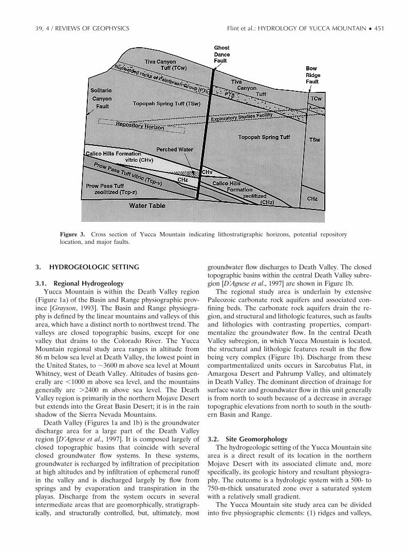
Figure 3. Cross section of Yucca Mountain indicating lithostratigraphic horizons, potential repositorylocation, and major faults.
39, 4 / REVIEWS OF GEOPHYSICS Flint et al.: HYDROLOGY OF YUCCA MOUNTAIN ● 451

(2) irregular rugged topography north of Yucca Wash,(3) piedmont slopes surrounding Yucca Mountain onthe south and east, (4) Fortymile Wash east of YuccaMountain, and (5) broad alluvial flats to the east andwest of Yucca Mountain [U.S. Geological Survey, 1984].Yucca Mountain has been influenced by an interrela-tionship between tectonism and geomorphic processes.Erosional processes on the eastern sloping ridge andalong faults and fault scarps have defined the topogra-phy of the mountain; these processes have created aseries of washes that have been down cut to varyingdegrees into different bedrock layers. The topographygenerally is controlled by the high-angle faults that tiltthe resistant volcanic strata eastward (Figure 3). Slopesare locally steep on the west facing escarpments thathave eroded along the faults and in some of the valleysthat cut into the more gentle eastward facing dip slopes.Narrow valleys and ravines have been cut into the bed-rock, and wider valleys have been covered with alluviumthat has formed terraces in which intermittent streams
have cut channels. Locally, small sandy fans extend fromthe lower slopes and spread out on the valley floors. Eastof the crest of Yucca Mountain, drainage is into For-tymile Wash; west of the crest, streams flow southwest-ward down fault-controlled canyons and discharge intoCrater Flat. For the purposes of this study the site areawas divided into two parts: an area north of Drill HoleWash and an area to the south of the wash. The washesin the southern area trend and drain eastward, arerelatively short (�2 km), and are defined by erosionalchannels that produce gently sloping side slopes. Thewashes north of Drill Hole Wash are northwest trending,are 3–4 km long, have steep side slopes, and are con-trolled by faults and drain to the southeast.
Alluvial deposits in the valley floors and washes of theYucca Mountain site study area include fluvial sedi-ments and debris flow deposits. The soil developmentand thickness of the alluvial deposits vary; the texture ofthese deposits is gravelly, and rock fragments constitutebetween 20 and 80% of the total volume of soil. The
Figure 4. Schematics of (a) surface infiltration processes and (b) percolation and recharge processes in thedeep unsaturated zone.
452 ● Flint et al.: HYDROLOGY OF YUCCA MOUNTAIN 39, 4 / REVIEWS OF GEOPHYSICS

alluvial soils range from 100 m thick in the valleys to �30m thick at the mouths of the washes. Midway up thewash most of the alluvial soils are �15 m thick, and atthe headwaters the soils are absent or are �0.5 m thick.Many of these soils have developed cemented calciumcarbonate layers [Flint and Flint, 1995]. Over most of theridges and slopes of the mountain the soils are �0.5 mthick. For the purposes of spatially distributing soil prop-erties to estimate net infiltration, preliminary maps ofsurficial deposits [Lundstrom et al., 1994, 1995a, 1995b;Lundstrom and Taylor, 1995] were combined into eightsoil taxonomic units on the basis of the descriptions ofsoil taxonomy by the U.S. Department of Agriculture[1975].
The topography at the Yucca Mountain site studyarea also can be described in terms of four generalizedtopographic positions that represent infiltration zones:ridgetop, side slope, terrace, and active channels (Figure4a). Within the area of the site-scale model boundaryarea (Figure 2) the ridgetop locations encompass 14% ofthe total area, the side slopes encompass 62%, the ter-races encompass 22%, and the active channels encom-pass 2% [Flint and Flint, 1995].
3.3. VegetationThe Yucca Mountain site study area is situated within
a broad transition area referred to as the TransitionDesert; this transition area is between the northernboundary of the Mojave Desert and the southern bound-ary of the Great Basin Desert. The northern boundary ofthe Mojave Desert generally is the northern limit of thecreosote bush [Beatley, 1976]. On Yucca Mountain, Mo-jave Desert vegetation generally grows at low elevationson alluvial slopes and in washes. Transition Desert as-sociations are situated topographically above the creo-sote ecotone on ridges and in washes. Blackbrush is thedominant species across broad areas of the TransitionDesert [Beatley, 1976]. The vegetation associations onYucca Mountain are heterogeneous, consisting of alarge diversity of shrub species. The four dominant veg-etation associations at the Yucca Mountain site studyarea are blackbrush, grayia/desert thorn, creosote/desertthorn, and creosote/bursage. They represent specificcombinations of topographic location, soil type anddepth, and aspect and slope.
Detailed information on plant distributions and char-acteristics (R. Green, EG&G Energy Measurements,written communication, 1998) supports the current esti-mates of evapotranspiration, which are based on energybalance calculations and simulations of radiation loadsfor the surface of the Yucca Mountain site study area.An intensive field program was used to provide data tocalculate actual evapotranspiration rates of 0.02–3 mmd�1 on alluvial terraces and on a side slope [Flint et al.,2000b]. At the terrace site the average measured evapo-transpiration was 0.6 mm d�1 for the years 1997–1998,with evapotranspiration being 70% of the precipitationfor those two years [Flint et al., 2000b]. North and south
facing slopes receive different amounts of solar radia-tion, which results in differences in temperature andwater availability in the habitats located on these slopes.South facing slopes tend to be warmer and drier than thenorth facing slopes. Plant species display differentialpreference or tolerance for these growing conditions.Species typical of the flora of the Great Basin areacommonly are seen on north facing slopes, and speciestypical of the flora of the warmer Mojave Desert com-monly are seen on south facing slopes.
3.4. GeologyYucca Mountain is located directly south of the
source caldera complex for the Tertiary volcanic rocksthat dominate the Yucca Mountain site study area. TheTertiary volcanic sequence varies between 1 and 3 km inthickness, and the unsaturated zone within this sequenceis �500–750 m thick [Snyder and Carr, 1982; Buesch etal., 1996]. The formations in the unsaturated zone atYucca Mountain consist primarily of pyroclastic flowdeposits. From youngest to oldest the formations are theRainier Mesa Tuff; the Tiva Canyon, Yucca Mountain,Pah Canyon, and Topopah Spring Tuffs of the Paint-brush Group; the Calico Hills Formation; and the ProwPass, Bullfrog, and Tram Tuffs of the Crater Flat Group(Table 1, Figure 5, and Plate 1) [Carr et al., 1986; Sawyeret al., 1994]. Interstratified with the formations are bed-ded tuffs that consist primarily of ashfall deposits andsmall amounts of ash flow deposits and redepositedmaterial [Moyer and Geslin, 1995; Buesch et al., 1996].The Tiva Canyon and Topopah Spring Tuffs containvitric nonwelded to densely welded tuff. The top andbottom and the interiors of these formations are thick,crystallized, moderately to densely welded, and frac-
Figure 5. Generalized stratigraphy at Yucca Mountain [fromTucci and Burkhardt, 1995].
39, 4 / REVIEWS OF GEOPHYSICS Flint et al.: HYDROLOGY OF YUCCA MOUNTAIN ● 453
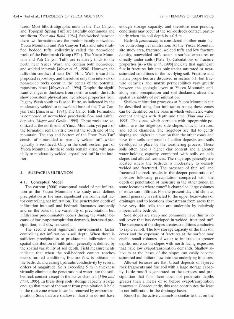
tured. Most lithostratigraphic units in the Tiva Canyonand Topopah Spring Tuff are laterally continuous andstratiform [Scott and Bonk, 1984]. Sandwiched betweenthese two formations are the predominantly nonweldedYucca Mountain and Pah Canyon Tuffs and interstrati-fied bedded tuffs, collectively called the nonweldedrocks of the Paintbrush Group (PTn). The Yucca Moun-tain and Pah Canyon Tuffs are relatively thick to thenorth near Yucca Wash and contain both nonweldedand welded intervals [Moyer et al., 1996]. However, thetuffs thin southward near Drill Hole Wash toward theproposed repository, and therefore only thin intervals ofnonwelded rocks occur in the center of the potentialrepository block [Moyer et al., 1996]. Despite the signif-icant changes in thickness from north to south, the tuffsshow consistent physical and hydrologic properties fromPagany Wash south to Busted Butte, as indicated by themoderately welded to nonwelded base of the Tiva Can-yon Tuff [Istok et al., 1994]. The Calico Hills Formationis composed of nonwelded pyroclastic flow and ashfalldeposits [Moyer and Geslin, 1995]. These rocks are ze-olitized at the north end of Yucca Mountain, yet parts ofthe formation remain vitric toward the south end of themountain. The top and bottom of the Prow Pass Tuffconsist of nonwelded to partially welded tuff, whichtypically is zeolitized. Only in the southwestern part ofYucca Mountain do these rocks remain vitric, with par-tially to moderately welded, crystallized tuff in the inte-rior.
4. SURFACE INFILTRATION
4.1. Conceptual ModelThe current (2000) conceptual model of net infiltra-
tion at the Yucca Mountain site study area definesprecipitation as the most significant environmental fac-tor controlling net infiltration. The penetration depth ofinfiltration into soil and bedrock fluctuates seasonallyand on the basis of the variability of precipitation, butinfiltration predominately occurs during the winter be-cause of low evapotranspiration demands, increased pre-cipitation, and slow snowmelt.
The second most significant environmental factorcontrolling net infiltration is soil depth. When there issufficient precipitation to produce net infiltration, thespatial distribution of infiltration generally is defined bythe spatial variability of soil depth. Field measurementsindicate that when the soil-bedrock contact reachesnear-saturated conditions, fracture flow is initiated inthe bedrock, increasing hydraulic conductivity by severalorders of magnitude. Soils exceeding 5 m in thicknessvirtually eliminate the penetration of water into the soil-bedrock contact except in the active channels [Flint andFlint, 1995]. In these deep soils, storage capacity is largeenough that most of the water from precipitation is heldin the root zone where it can be removed by evapotrans-piration. Soils that are shallower than 5 m do not have
enough storage capacity, and therefore near-pondingconditions may occur at the soil-bedrock contact, partic-ularly when the soil depth is �0.5 m.
Bedrock permeability is considered another main fac-tor controlling net infiltration. At the Yucca Mountainsite study area, fractured, welded tuffs and low fracturedensity, nonwelded tuffs occur in surface exposures ordirectly under soils (Plate 1). Calculations of fractureproperties [Kwicklis et al., 1998] indicate that significantflux in fractures initiates only under saturated or near-saturated conditions in the overlying soil. Fracture andmatrix properties are discussed in section 5.1, but frac-ture densities and matrix permeabilities vary greatlybetween the geologic layers at Yucca Mountain and,along with precipitation and soil thickness, affect thespatial variability of net infiltration.
Shallow infiltration processes at Yucca Mountain canbe described using four infiltration zones; these zonescan be identified on the basis in which volumetric watercontent changes with depth and time [Flint and Flint,1995]. The zones, which correlate with topographic po-sition, are the ridgetops, side slopes, alluvial terraces,and active channels. The ridgetops are flat to gentlysloping and higher in elevation than the other zones andhave thin soils composed of eolian deposits and soilsdeveloped in place by the weathering process. Thesesoils often have a higher clay content and a greaterwater-holding capacity compared with soils on sideslopes and alluvial terraces. The ridgetops generally arelocated where the bedrock is moderately to denselywelded and fractured. The presence of thin soil andfractured bedrock results in the deeper penetration ofmoisture following precipitation compared with thedepth of penetration of moisture in the other zones. Insome locations where runoff is channeled, large volumesof water can infiltrate. For the present-day arid climate,runoff generally is restricted to the upper headwaters ofdrainages and to locations downstream from areas thathave very thin soils that are underlain by relativelyimpermeable bedrock.
Side slopes are steep and commonly have thin to nosoil cover that has developed in welded, fractured tuff.The steepness of the slopes creates conditions conduciveto rapid runoff. The low storage capacity of the thin soilcover and the exposure of fractures at the surface mayenable small volumes of water to infiltrate to greaterdepths, more so on slopes with north facing exposuresthat have low evapotranspiration demands. Shallow al-luvium at the bases of the slopes can easily becomesaturated and initiate flow into the underlying fractures.
Alluvial terraces are flat, broad deposits of layeredrock fragments and fine soil with a large storage capac-ity. Little runoff is generated on the terraces, and pre-cipitation that falls there does not penetrate depthsgreater than a meter or so before evapotranspirationremoves it. Consequently, this zone contributes the leastto net infiltration in the drainage basin.
Runoff in the active channels is similar to that on the
454 ● Flint et al.: HYDROLOGY OF YUCCA MOUNTAIN 39, 4 / REVIEWS OF GEOPHYSICS

Plate 1. Surface exposures of bedrock geology and faults in the Yucca Mountain area, boundary of thepotential repository, and Exploratory Studies Facility. Simplified from Day et al. [1998].
39, 4 / REVIEWS OF GEOPHYSICS Flint et al.: HYDROLOGY OF YUCCA MOUNTAIN ● 455

Plate 2. Net infiltration numerically simulated using average annual precipitation resulting in an average of2.9 mm yr�1 flux over the modeling domain. Black indicates no net infiltration.
456 ● Flint et al.: HYDROLOGY OF YUCCA MOUNTAIN 39, 4 / REVIEWS OF GEOPHYSICS

terraces, but the channels can collect and concentraterunoff, which, although it occurs infrequently, can pen-etrate deeply. Although local net infiltration can be highfor some active channel locations under the present-dayarid climate, this zone is not considered to be a majorcontributor to the total volume of net infiltration atYucca Mountain because runoff is infrequent and be-cause the active channels are a very small percentage ofthe drainage basin area [Flint and Flint, 1995].
The numerical model developed to calculate net in-filtration at the Yucca Mountain site study area is in-tended to reflect the processes described in the concep-tual model of infiltration. The numerical model isdescribed in detail by Flint et al. [2000b] and was used toestimate the temporal and spatial variability of net infil-tration for the upper boundary conditions of the ground-water flow model of the unsaturated zone [Bodvarsson etal., 1998]. Modeled net infiltration at Yucca Mountainvaries temporally and spatially, averaging 2.9 mm yr�1 inthe site study area and 4.5 mm yr�1 in the potentialrepository area for the present-day climate (Plate 2).Spatial and temporal variability is the most importantfactor affecting net infiltration at Yucca Mountain. Tem-porally, no infiltration may occur for several years, andthen 10–20 mm, spatially averaged, may occur in a singleyear. Spatially, no infiltration may occur in an areawhere the soil is 5 m or greater in thickness, but �250mm may occur in an area where the soil is thin, such ason north facing slopes where evaporation is low, eleva-tion is high, and the overlying bedrock is permeable. Theamount of precipitation alone, however, does not deter-mine net infiltration; timing also must be consideredbecause more closely spaced occurrences of precipita-tion are more likely to penetrate deeper and result in netinfiltration before evapotranspiration reduces the satu-ration in the soil profile.
Because there is no precedent for estimating netinfiltration in arid environments, there is uncertainty inthe results of the assessment of net infiltration simulatedby numerical models for the different components, mostof which could not accurately be determined. Estimatesof the site-averaged values of net infiltration can besupported by comparing simulated values with estimatedvalues from the independent methods to determine ifsimulated results vary considerably with estimates fromother approaches of estimating net infiltration or re-charge for the same environment. The spatially aver-aged, modeled net infiltration rate for the current cli-mate scenario was compared with estimates of rechargeobtained from independent studies for various locationsin the southern Basin and Range Province as a methodof model comparison [Maxey and Eakin, 1950; Winograd,1981; Dettinger, 1989; Lichty and McKinley, 1995; Harrilland Prudic, 1998]. The results compared favorably [Flintet al., 2000b]. Although this method of model compari-son is useful as a qualitative assessment of model simu-lation, it cannot be used to quantify levels of confidenceor model uncertainty, in part because of the unknown
accuracy of the independent results. A comparison ofindependent results does not necessarily validate (orinvalidate) the accuracy of the model in representingthe physical processes developed in the conceptualmodel, but it does increase confidence in the results ofthe model. Small-simulation-scale process modelshave also been developed. The models were devel-oped from models based on Richards’ equation todetermine the water balance in one or more boreholesthat compared favorably with the simulated waterbalance from the infiltration model [Hevesi and Flint,1998]. Ongoing studies are addressing numerical mod-els on a watershed scale.
4.2. Supporting DataThe conceptual model of surface infiltration is con-
sistent with most of the available infiltration data col-lected for this study [Flint et al., 2000b] and with theindependent calculations of infiltration for the YuccaMountain site study area that were based on the chloridemass balance approach [Fabryka-Martin et al., 1998a].The modeled infiltration is also consistent with estimatesfrom various regional studies [Harrill and Prudic, 1998;Dettinger, 1989; Maxey and Eakin, 1950; Lichty and Mc-Kinley, 1995] and is shown by Flint et al. [2000b, Figures41 and 42]. The role of faults in near-surface infiltrationis difficult to ascertain. Evidence of deep, rapid infiltra-tion from surfaces where fractured tuffs are exposed orare covered only by shallow soils is supported by thedistribution of bomb-pulse 36Cl and 3H in both thesurficial materials and the deeper subsurface materials[Fabryka-Martin et al., 1998a]. Bomb-pulse isotopes 36Cland 3H were highly elevated in the atmosphere duringaboveground nuclear weapons testing in the PacificOcean in the early 1960s and are an indication of waterthat is �40 years old. Measurements of bomb-pulseisotopes in core and drill cuttings indicate that fractureflow, once it has been initiated under the shallow soils,can move water quickly through the Tiva Canyon Tuff,and therefore there may be no unique fast flow pathwaysthrough the shallow welded rocks. In contrast, analysisof bomb-pulse 36Cl and neutron-borehole data indicatesthat deep soils retard the penetration of water andprevent rapid movement into fractures. The fastest path-ways occur in fractured rocks beneath shallow soilswhere near-saturated conditions can develop. The rocksurrounding the exposed faults may have increased frac-ture density, which can increase the volume of waterentering the near surface but which may not necessarilyincrease the flow velocity. Evidence from bomb-pulsemeasurements from the Exploratory Studies Facility in-dicates that where faults occur within the PTn water canquickly penetrate into the underlying Topopah SpringTuff if the fault breaks the PTn under shallow soilswhere near-surface fracture flow can be initiated. Isoto-pic data indicate that faults may not increase surfaceinfiltration but may be significant in allowing water topass quickly through the PTn.
39, 4 / REVIEWS OF GEOPHYSICS Flint et al.: HYDROLOGY OF YUCCA MOUNTAIN ● 457

There may be exceptions to this generalization forwashes and other local depressions where water flowmay be concentrated because of the downslope move-ment of surface runoff or interflow along the soil-bed-rock contact. Evidence of interflow is indicated by theassociation of bomb-pulse 36Cl and depleted soil chlo-ride at downslope locations beneath apparently imper-meable calcrete layers, by visual observations of seepswhere slopes have been cut for drill-pad construction,and by local spikes in 36Cl or 3H at the soil-bedrockcontact beneath soil with background levels of theseisotopes. Concentrated flow in washes potentially cansignificantly decrease the surface soil chloride that isgenerated from cycles of precipitation and evapotrans-piration, exceeding the rates of surface chloride flux thatare calculated for precipitation and dry fallout. Thepercolation rate can be calculated using the chloridemass balance method, where infiltration/percolation isequal to the precipitation multiplied by the concentra-tion of chloride in rainwater, divided by the concentra-tion of chloride in the pore water. This calculation ofpercolation for channel environments where run-on hasbeen observed may be less than the actual percolationrate by a factor of 5 or more.
5. UNSATURATED ZONE HYDROLOGY
5.1. Properties of Major Hydrogeologic UnitsOn the basis of general volcanologic relations [Scott et
al., 1983; Buesch et al., 1996] and deterministic analyses[Rautman and Flint, 1992] several geologic processes(including magmatic evolution; volcanic eruption, trans-port, and emplacement; postemplacement cooling andalteration; and late-stage (diagenetic) alteration) pro-vide a framework within which hydrologic characteriza-tion of the system may take place. These processes canproduce a relatively predictable vertical distribution ofrock properties within simple cooling units, which sim-plifies the prediction of properties at unsampled loca-tions. Lithologic features controlling the distribution ofwater consistently have been noted in boreholes locatedin the site study area and have aided in determiningmechanisms and ongoing processes in the unsaturatedzone. A detailed vertical distribution of rock propertieswas used in a hydrologic model of the site study area toshow the importance of the vertical sequence of litho-logic features [Flint et al., 1993; Moyer et al., 1996] andallow for the characterization of hydrogeologic units[Flint, 1998].
Porosity, saturation, and particle density generally aregood indicators of lithostratigraphic boundaries. Poros-ity and saturation, as well as lithostratigraphic units, areshown in Figure 6 for samples from two deep boreholes,borehole SD-7, located at the south end of the potentialrepository boundary (Figure 6a), and borehole SD-9,located at the north end (Figure 6b). Figures 6a and 6bexemplify the vertically stratified nature of the unsatur-
ated zone at Yucca Mountain. The detailed lithostrati-graphic units are indicated by the nomenclature. Corre-sponding to Table 1, the major hydrogeologic units arethe densely welded, fractured Tiva Canyon Tuff (TCw),the nonwelded, relatively unfractured rocks of the Paint-brush Group (PTn), the densely welded, fractured Topo-pah Spring Tuff (TSw), the nonwelded Calico Hills For-mation (CHn) that has vitric rocks (CHv) and rocks thathave been altered to zeolites (CHz), and the Crater FlatGroup (CFu), which comprises compound cooling unitsand both nonwelded and welded rocks (Table 1). TheCHn, as defined by Montazer and Wilson [1984] andwhich is represented in Table 1, includes the Prow PassTuff of the CFu in the CHn hydrogeologic unit.
In general, porosity is high and saturation is low in thenonwelded rocks, except for rocks close to the watertable, and porosity is low and saturation is high in thewelded rocks. Particle density generally is high in thedevitrified rocks and low in the vitric rocks. The physicalproperties, porosity, bulk density and particle density,saturated hydraulic conductivity, and moisture retentioncharacteristics have been determined for all of the rockunits at Yucca Mountain and were used to developdetailed hydrogeologic units that are described by Flint[1998].
Fractures are prevalent in the welded rocks and arefrequent to infrequent in the nonwelded rocks. Fracturedensities and apertures are not well characterized for alllithostratigraphic units, and therefore density and aper-ture were estimated from borehole data. Properties offractures are dependent on fracture aperture and onwhether the fractures are open or are filled with calciumcarbonate or siliceous materials. Porosity and saturatedhydraulic conductivity of fractures can be calculatedusing either assumed or estimated density and aperture[Kwicklis et al., 1998]. It is assumed that at least part ofa fracture is saturated or nearly saturated for flux tooccur; therefore unsaturated flow characteristics of thefractures are not required for modeling using this ap-proach. The properties have been measured for near-surface fracture-fill materials.
5.2. Percolation in the Unsaturated ZoneThe four most important features of the current con-
ceptual model for flow of water in the unsaturated zoneat Yucca Mountain are (1) relatively high infiltrationrates which are spatially and temporally variable, (2)lack of evidence of a large-scale lateral diversion ofwater above and within the PTn, (3) pervasive percola-tion of water through fractures in densely welded tuffsdespite nonequilibrium water potential between fracturesand the adjacent matrix, and (4) vertical percolation inthe CHv and extensive lateral flow and perching of waterat the zeolitic boundary abutting faults [Flint et al.,2000a]. This simplified version of the conceptual modelis very similar to the earliest conceptual models forYucca Mountain, particularly the model developed byScott et al. [1983]. These four features basically control
458 ● Flint et al.: HYDROLOGY OF YUCCA MOUNTAIN 39, 4 / REVIEWS OF GEOPHYSICS

most of the remaining hydrologic processes representedin the schematic of the current conceptual model of flowin the unsaturated zone (Figure 4b) [Flint et al., 2000a].
5.2.1. Flow through the welded Tiva Canyon Tuffhydrogeologic unit. Most of the water that passesthrough shallow soils or through active channels intofractured bedrock, or that passes directly into fracturesor faults as net infiltration, passes quickly through thefractures of the TCw to be slowed during transition tomatrix flow in the PTn, except where faults or brokenzones disrupt the PTn, providing fast pathways for asmall component of flow. The measured high bulk per-meability of the TCw and the frequent occurrence ofbomb-pulse isotopes in the underlying PTn supportshort residence times in the TCw. A small percentage ofwater in the TCw (�0.5 mm yr�1) may be lost to theatmosphere by upward vapor flow (barometric pumping,vapor diffusion, and convective, buoyancy-driven gasflow).
5.2.2. Flow through the nonwelded Paintbrush Tuffhydrogeologic unit. The rocks at the bottom of theTiva Canyon Tuff change from devitrified to vitric andare characterized by a transition in welding and vapor-phase corrosion and thus by a transition in porosity andpermeability. This transition has caused a zone of highsaturation that consequently resulted in mineral alter-
ation, which increases gradually with depth. The alteredsection is low in permeability and typically is nearlysaturated (Figure 6). Underlying this altered section is arelatively linear contact consisting of a highly porousbedded tuff that potentially can act as a capillary barrier[Montazer and Wilson, 1984; Flint, 1998]. Neither datanor field observations corroborate the existence of lat-eral diversion caused by a barrier effect at the bottom ofthe Tiva Canyon Tuff; however, for most of the bore-holes where nearly saturated conditions abruptly declineto �50% saturation, the consistent saturation profilesupports the existence of localized barrier effects. Thetransition from high saturation to low saturation occurswhere fracture-dominated flow in the highly saturatedwelded rocks changes to matrix-dominated flow in thewater-depleted rocks of the PTn hydrogeologic unit.
The relative sparseness of fractures in the PTn, alongwith its relatively large drained porosity and matrix per-meability, indicates the importance of the PTn for ab-sorbing and redistributing water arriving through thefractures of the Tiva Canyon Tuff. In unfaulted areas thecapacity for the PTn to temporally buffer and spatiallyredistribute infiltration probably decreases toward thesouth end of Yucca Mountain, where the PTn thins to25 m. Most flow is vertical and slow through the PTnmatrix, but there possibly may be local-scale lateral
Figure 6. Saturation and porosity with depth for (a) borehole SD-7 to the south of the potential repositorylocation and (b) borehole SD-9 to the north. Depth of the water table (WT) is noted for each borehole.Nomenclature is described in Table 1.
39, 4 / REVIEWS OF GEOPHYSICS Flint et al.: HYDROLOGY OF YUCCA MOUNTAIN ● 459

diversion at linear contacts or above low-permeabilitylayers. The base of the PTn is characterized by anothertransition zone that ranges from highly porous tuffs todensely welded rocks over a short vertical distance andthat is highly saturated.
5.2.3. Flow in the welded Topopah Spring Tuffhydrogeologic unit. Relatively pervasive broken-upareas in the densely welded upper vitrophyre of the TSwprobably formed as the vitrophyre cooled; these areasprovide ready access for entry of water into the under-lying vapor-phase-corroded nonlithophysal rocks. Waterflow in the upper rocks of the TSw probably is primarilymatrix dominated, and only some of the flow is fractureflow because the rocks are low in saturation and rela-tively high in porosity, making it less likely that pervasivefracture flow can be initiated. Porosity decreases andsaturation gradually increases with depth through theupper nonlithophysal rocks and into the upper litho-physal rocks, reaching high saturations in the denselywelded and highly fractured middle nonlithophysal rocks(Figure 6). Once transitioned back into fracture flow, thewater can travel through the well-connected, highly per-meable fracture system of the TSw.
Fracture flow occurs primarily under conditions ofdisequilibrium with the surrounding matrix when aver-aged for relatively large matrix blocks, but it also mayoccur as channeling or concentrated flow. In many loca-tions, particularly in the northern parts of the YuccaMountain site study area, the densely welded basal vitro-phyre of the TSw coincides with the vitric-zeoliticboundary, which acts as a permeability barrier to verticalflow that results in perched water at this stratigraphiclocation. Where the vitric-zeolitic boundary does notextend upward to the base of the vitrophyre, highsaturations still occur but with no laterally extensiveperching.
5.2.4. Flow through nonwelded to partially weldedunits beneath the TSw. Nonwelded tuff at the base ofthe Topopah Spring Tuff that has not been altered byzeolites is highly permeable. The Calico Hills Formationand Prow Pass Tuffs are complexly stratified ashfall andash flow deposits that have been welded and altered tovarying degrees (Table 1). The degree of alterationdepends on the geographic location of the units and theextent to which partial welding and devitrification ofindividual sublayers precluded later zeolite develop-ment. The distribution of zeolite minerals (Figures 3 and7) controls the distribution of primary permeabilitywithin the lower unsaturated zone; the primary perme-ability of zeolitic rocks is many orders of magnitude lessthan that of the vitric rocks and 1–2 orders of magnitudeless than that of the devitrified rocks [Flint, 1998].Perched water exists at most locations where the uppervitric-zeolitic boundary occurs within the Calico HillsFormation and the Prow Pass Tuffs. The mechanism forperching could be a permeability barrier at the upperzeolitic boundary. However, because the zeolitized Cal-ico Hills Formation is low in permeability, nearly satu-
rated throughout its thickness, and typically underlain byhighly permeable nonwelded rocks of the Prow PassTuff, perching could be the result of an underlyingcapillary barrier.
The sloping alteration boundary promotes lateralflow within the perched layers, resulting in transportvelocities that may be quite high. Perching mechanisms
Figure 7. Zeolite distribution in the Calico Hills Formationand Prow Pass Tuff and assumed lateral flow of water at thevitric-zeolitic boundary to recharge at the water table (fromG. S. Bodvarsson and T. M. Bandurraga, Lawrence BerkeleyNational Laboratory, written communication, 1996).
460 ● Flint et al.: HYDROLOGY OF YUCCA MOUNTAIN 39, 4 / REVIEWS OF GEOPHYSICS

function similarly in the vitric and zeolitic rocks of theProw Pass Tuff. Figure 7, an isopach surface of the topof the zeolitized units, illustrates how water flowsacross the top of the zeolites and into the water tableeither directly or by way of faults (G. S. Bodvarsson,Lawrence Berkeley National Laboratory, written com-munication, 1996). The assumption of lateral flow atthe vitric-zeolitic boundary is also supported by theresults of analyses of thermal gradients in boreholes,which indicate a decreased vertical percolation ratebelow this vitric-zeolitic boundary in the Calico HillsFormation and Prow Pass Tuff (G. S. Bodvarsson,Lawrence Berkeley National Laboratory, written com-munication, 1996).
5.2.5. Distribution of fast flow pathways. Thedistribution of fast flow pathways at Yucca Mountain isan issue in repository design because under wetter cli-matic conditions, these pathways may respond quickly toincreases in infiltration and therefore potentially be-come seeps in the tunnel drifts of the repository. Airpermeability measurements indicate an extensive con-nectivity of the fracture system within the TCw and TSw,lending support for the notion that water can flowquickly through either of these hydrogeologic units. Airpermeability measurements are largely ineffective inidentifying fast paths through the matrix-dominated flowsystem of the PTn [LeCain, 1999]; these fast paths canresult in fast travel times for water passing from landsurface to the water table. The primary evidence of fastflow paths in the PTn is indicated by the subsurfacedistribution of bomb-pulse isotopes, 36Cl, 3H, or 14C,which indicate a component of water that is youngerthan the aboveground weapons testing of the early1960s. If the sampled depth is more than a few metersbelow the land surface, the presence of bomb-pulseisotopes implies a component of fracture flow or a fastpath.
Several hundred unsaturated zone samples from sur-face-based boreholes and from the Exploratory StudiesFacility (ESF) were analyzed for 3H and 36Cl, and abouta hundred pore water and gas samples were analyzed for14C. The results of the analyses indicate that bomb-pulse3H and 36Cl are present in the PTn at several locationsand in or near some fault zones in the ESF, �500 mbelow land surface. Data indicate that most of the bomb-pulse signatures are found in fractures or faults, whichsupports the conceptual model that flow penetratesquickly through the PTn [Fabryka-Martin et al., 1997].This conceptual model, however, is contrary to alternateconceptual models proposed within the project thatpreferential flow, owing to fingering instabilities or fo-cused infiltration, results in locally saturated zones withhigh conductivity, because there is no evidence of spo-radic elevated saturations in the nearly 600 samplescollected from boreholes penetrating the PTn [Flint,1998]. Measurements of 36Cl samples from the ESF areshown in Figure 8; values higher than a 36Cl/Cl ratio of�1300 � 1015 indicate bomb-pulse isotopes. As shown in
Figure 8, most of these bomb-pulse isotopes are associ-ated with faults, except for samples collected at 4400 m,where there is no fault. Few of these isotopic samples,however, were from the same location [Yang et al., 1996;Fabryka-Martin et al., 1998b]. Bomb-pulse 14C was de-tected in pore water samples from four of the six surface-based boreholes penetrating the TSw and the CHn, andbomb-pulse 3H was detected in only one borehole pen-etrating the lower part of the TSw and the CHn [Yang etal., 1996]. Among the perched water samples, postbomb3H was detected in only one borehole, and none of thesamples contained measurable bomb-pulse 36Cl or 14C[Yang et al., 1996; Fabryka-Martin et al., 1998b]. Thesedata are being used in site-scale numerical flow andtransport models of Yucca Mountain to establish thelower boundaries for infiltration rates, to estimate theage of groundwater at the water table beneath the site,and to establish bounding values for hydrologic flowparameters governing fracture transport (see section 8).
For the saturated zone the 14C age of water wassampled from the upper few meters of the saturatedzone at borehole UE-25 UZ-16 (Figure 6), which pen-etrates a fault zone. The age of the water in the sampleis relatively young (�600 years), which is consistent withthe age of the water from samples from this boreholethat have elevated 3H concentrations of as much as 105tritium units (TU) in the unsaturated matrix of theoverlying Calico Hills Formation with the moderatelyhigh 3H concentrations (�10 TU) in groundwater sam-pled from the top of the water table and in the adjacentsaturated rock matrix, in this case, Calico Hills Forma-tion. The presence of young groundwater in the top ofthe saturated zone at this highly faulted location indi-cates a mechanism for fast flow and recharge in somelocations.
Interpreting isotopic data for the unsaturated zone iscomplicated by sampling and analytical methods. Inmany cases the small quantities of pore water extractedfrom a core sample generally precluded the use of themost sensitive analytical techniques for 3H; for thesecases the threshold value for identifying bomb-pulse 3Hwas 30 TU [Yang et al., 1996]. Results of the hydrogenand oxygen isotopic analyses indicate that some of thedeep pore water samples may have been contaminatedby drilling air, which increased their 14C activities.Reaming of the surface-based boreholes released chlo-ride from the welded rock units, diluting 36Cl activities inthe welded units and possibly obscuring the presence ofbomb-pulse 36Cl. Finally, the presence of bomb-pulseisotopes identifies only a subset of the fast paths in thehydrologic system.
As a result of the multiple complications of sam-pling and analysis, the overall frequency and distribu-tion of fast paths could not be determined. Nonethe-less, the 36Cl data, particularly the data collected fromthe ESF (Figure 8), support the conceptual model forfast paths in which faults in the overlying PTn are thedominant controls on the spatial distribution of fast
39, 4 / REVIEWS OF GEOPHYSICS Flint et al.: HYDROLOGY OF YUCCA MOUNTAIN ● 461

paths to the repository horizon [Fabryka-Martin et al.,1998b]. The model requires that the following threeconditions be present to transmit bomb-pulse 36Cl tothe sampled depth within 50 years [Fabryka-Martin etal., 1998b]:
1. A continuous fracture path must extend fromland surface to the sampled depth. This condition isnecessary because travel times through the matrix ofunfractured rock are expected to exceed 50 years. Thecondition of a continuous fracture path is easily met inmost of the welded parts of the Tiva Canyon and Topo-pah Spring Tuff units. The nonwelded PTn unit, whichgenerally is relatively unfractured, is the limiting hydro-logic unit for controlling transport rates. Hence to meetthe condition of a continuous fracture pathway requiresthe presence of faults that cut the PTn unit and increaseits vertical permeability.
2. Surface-infiltration rates must be sufficiently highto initiate and sustain at least a small component offracture flow along the connected fracture path. Trans-port simulations indicate that the threshold rate may be�1–2 mm yr�1.
3. The residence time of water in the soil cover mustbe �50 years, and for this to occur, the soil thicknessmust be �3 m, which is estimated by the numericalmodel of infiltration [Flint et al., 2000b].
5.2.6. Estimates of percolation flux. Percolationflux through the unsaturated zone was estimated usingvarious methods, including borehole temperature pro-files, analyses of perched water, and chloride concentra-tions. The results from the various methods differ, butan analysis of all approaches used by project researchersto calculate percolation flux generally results in site-averaged values of �7.0 � 6.0 mm yr�1 (E. M. Kwicklis,Los Alamos National Laboratory, written communica-tion, 1999). Estimates using the site-scale numericalmodel with modeled net infiltration [Flint et al., 2000b]as the upper boundary condition resulted in percolationflux of between 5 and 10 mm yr�1 (G. S. Bodvarsson,Lawrence Berkeley National Laboratory, written com-munication, 1996). Although there are varying degreesof uncertainty in these estimates, they generally are inreasonable agreement with average net infiltration ratesof 4.5 mm yr�1 estimated by the current infiltrationmodels [Flint et al., 2000b]. Estimates of percolation fluxmade from the temperature data from various boreholesgenerally were higher; however, they were in agreementwith the spatial trends of the estimated infiltration rates,which decrease from north to south and from west toeast (G. S. Bodvarsson, Lawrence Berkeley NationalLaboratory, written communication, 1996).
Figure 8. Distribution of 36Cl/Cl measured for Exploratory Studies Facility (ESF) samples. Location ofNorth Ramp, Main Drift, and South Ramp of the ESF are shown in Plate 1. Analytical uncertainties are�10%.
462 ● Flint et al.: HYDROLOGY OF YUCCA MOUNTAIN 39, 4 / REVIEWS OF GEOPHYSICS

6. RECHARGE
We believe that a significant amount of the ground-water beneath Yucca Mountain originated as local re-charge through the mountain and that most of thisgroundwater probably recharged during transitional cli-mates near the Pleistocene-Holocene boundary. Thegroundwater chemistry of the saturated zone can beused to establish an upper limit for the areally averagedpercolation rate through Yucca Mountain for thepresent-day climate. On the basis of the results of thechloride analysis and if we assumed that all groundwaterbeneath Yucca Mountain is from percolation throughthe mountain, a maximum of only 9% of the 170 mmannual precipitation, or 15.3 mm yr�1, can be rechargedthrough Yucca Mountain (E. M. Kwicklis, Los AlamosNational Laboratory, written communication, 1999).The likelihood that the groundwater in the saturatedzone beneath Yucca Mountain is a mixture of olderwater that recharged during past wetter climates andwater that recharged at elevations lower than the areasto the north of Yucca Mountain, as well as present-daypercolation through the mountain, indicates that theactual areally averaged percolation rate at Yucca Moun-tain probably is �15.3 mm yr�1. The relatively dilutenature of the groundwater in the saturated zone com-pared with water from the matrix of the nonweldedCalico Hills Formation and Prow Pass Tuff units indi-cates that if groundwater beneath Yucca Mountain didoriginate as percolation through the overlying unsatur-ated zone, most of it reached the saturated zone throughfractures and faults or as lateral flow rather than asseepage through the matrix of these units.
7. SATURATED ZONE HYDROLOGY
The saturated zone groundwater flow system atYucca Mountain is in a sequence of fractured volcanicrocks and underlying carbonate rocks [Luckey et al.,1996]. The stratigraphic units important to the hydrologyof the saturated zone include the Topopah Spring Tuff,the Calico Hills Formation, the Crater Flat Group, theLithic Ridge Tuff (Figure 5), as well as older tuffs, lavaflows, volcanic rocks, Paleozoic rocks, and, particularly,the carbonate aquifer. Recharge to the groundwatersystem at Yucca Mountain primarily occurs in the high-er-altitude mesas north of Yucca Mountain, and dis-charge occurs primarily at Alkali Flat (Franklin LakePlaya) [D’Agnese et al., 1997]. Groundwater flow in thissubbasin generally is from north to south.
For hydrologic purposes, Yucca Mountain is dividedinto three aquifers and two confining units [Luckey et al.,1996]. The upper volcanic aquifer consists of the denselywelded section of the Topopah Spring Tuff. The tuffgenerally is saturated west, south, and east of YuccaMountain. The upper volcanic confining unit consists ofthe lower part of the Topopah Spring Tuff and the
Calico Hills Formation and the uppermost part of theCrater Flat Group. The lower volcanic aquifer consistsmostly of the Crater Flat Group. The lower volcanicconfining unit consists of the Lithic Ridge Tuff andolder tuffs, flow breccia, and lavas beneath the CraterFlat Group. Paleozoic argillites may exist beneath thevolcanic rocks, which may effectively thicken thelower volcanic confining unit. Beneath the volcanicaquifers and confining units is the carbonate aquifer,which consists mainly of Paleozoic limestones anddolomites.
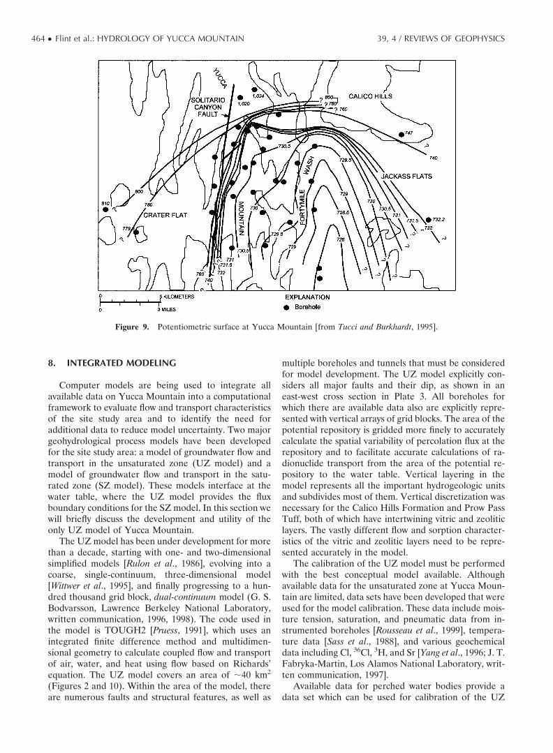
The potentiometric surface of the Yucca Mountain sitestudy area (Figure 9) was divided into three generalareas: (1) the area at the northern end of Yucca Moun-tain, where potentiometric levels exceed 1000 m abovesea level; (2) the area generally west of the SolitarioCanyon fault, where potentiometric levels are �800 mabove sea level; and (3) the site study area at YuccaMountain and to the south and east, where potentiomet-ric levels are �730 m above sea level (Figure 9) [Luckeyet al., 1996]. Within the boundary area between the firstand third areas, there is a large lateral hydraulic gradientwhere the potentiometric levels change more than 240 min less than 3 km. Within the boundary area between thesecond and third areas, there is a moderate hydraulicgradient where the potentiometric levels change �45 min 1–2 km. The third area is characterized by a smallhydraulic gradient; the potentiometric levels change only�2 m over several kilometers. One conceptual model ofthe large-gradient area at the northern end of YuccaMountain is of a semiperched system that consists of anunconfined water body, which has a high water level,above a confined water body, which has a low waterlevel, and is separated by a low-permeability zone that isfully saturated. In such a system, flow in the upper andlower more permeable zones would be predominantlyhorizontal, while flow in the low-permeability zonewould be predominantly vertical [Tucci and Burkhardt,1995].
On a larger scale, major sources of inflow to thesaturated hydrologic system at Yucca Mountain includeupgradient inflows and recharge from Fortymile Wash(Figure 2), which is a major ephemeral surface drainage.However, there is considerable uncertainty as to themagnitude of inflows from the northern and westernupgradient areas. Major sources of outflow from thehydrologic system are downgradient outflow and pump-age. Although some estimates of inflow and outflowhave been made, the estimates are not well quantified[Luckey et al., 1996]. Assuming that flow is perpendicularto the potentiometric surface contours, the general di-rection of groundwater flow immediately downgradientof Yucca Mountain is east-southeast. However, hetero-geneity and anisotropy, and the influence of fracturesand faults on groundwater flow [Tucci and Burkhardt,1995], may make this assumption invalid.
39, 4 / REVIEWS OF GEOPHYSICS Flint et al.: HYDROLOGY OF YUCCA MOUNTAIN ● 463
8. INTEGRATED MODELING
Computer models are being used to integrate allavailable data on Yucca Mountain into a computationalframework to evaluate flow and transport characteristicsof the site study area and to identify the need foradditional data to reduce model uncertainty. Two majorgeohydrological process models have been developedfor the site study area: a model of groundwater flow andtransport in the unsaturated zone (UZ model) and amodel of groundwater flow and transport in the satu-rated zone (SZ model). These models interface at thewater table, where the UZ model provides the fluxboundary conditions for the SZ model. In this section wewill briefly discuss the development and utility of theonly UZ model of Yucca Mountain.
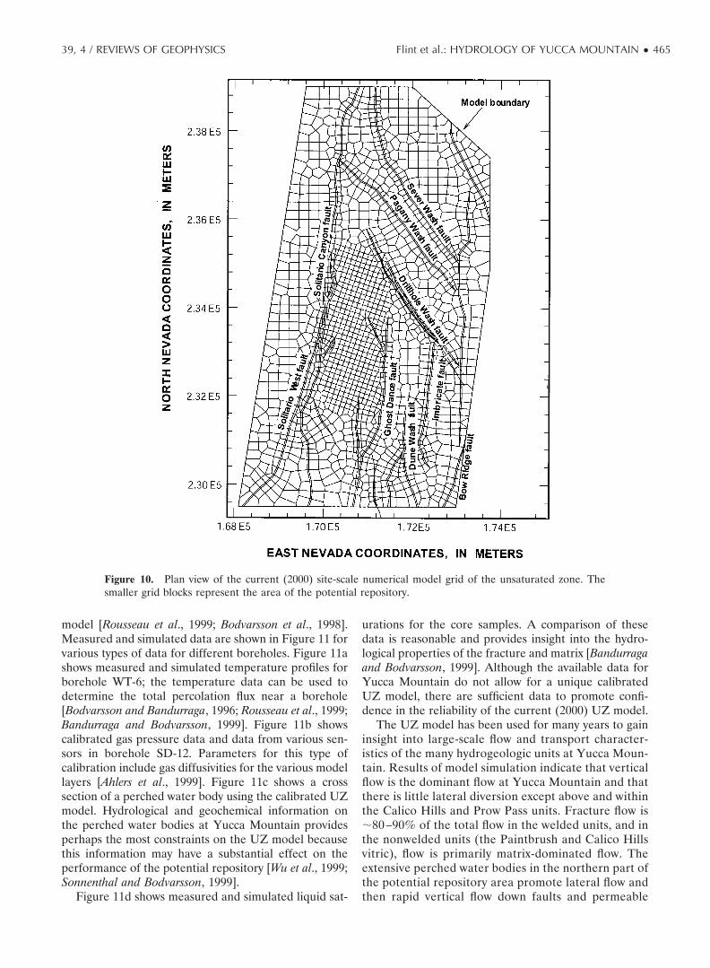
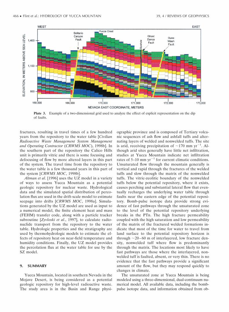
The UZ model has been under development for morethan a decade, starting with one- and two-dimensionalsimplified models [Rulon et al., 1986], evolving into acoarse, single-continuum, three-dimensional model[Wittwer et al., 1995], and finally progressing to a hun-dred thousand grid block, dual-continuum model (G. S.Bodvarsson, Lawrence Berkeley National Laboratory,written communication, 1996, 1998). The code used inthe model is TOUGH2 [Pruess, 1991], which uses anintegrated finite difference method and multidimen-sional geometry to calculate coupled flow and transportof air, water, and heat using flow based on Richards’equation. The UZ model covers an area of �40 km2
(Figures 2 and 10). Within the area of the model, thereare numerous faults and structural features, as well as
multiple boreholes and tunnels that must be consideredfor model development. The UZ model explicitly con-siders all major faults and their dip, as shown in aneast-west cross section in Plate 3. All boreholes forwhich there are available data also are explicitly repre-sented with vertical arrays of grid blocks. The area of thepotential repository is gridded more finely to accuratelycalculate the spatial variability of percolation flux at therepository and to facilitate accurate calculations of ra-dionuclide transport from the area of the potential re-pository to the water table. Vertical layering in themodel represents all the important hydrogeologic unitsand subdivides most of them. Vertical discretization wasnecessary for the Calico Hills Formation and Prow PassTuff, both of which have intertwining vitric and zeoliticlayers. The vastly different flow and sorption character-istics of the vitric and zeolitic layers need to be repre-sented accurately in the model.
The calibration of the UZ model must be performedwith the best conceptual model available. Althoughavailable data for the unsaturated zone at Yucca Moun-tain are limited, data sets have been developed that wereused for the model calibration. These data include mois-ture tension, saturation, and pneumatic data from in-strumented boreholes [Rousseau et al., 1999], tempera-ture data [Sass et al., 1988], and various geochemicaldata including Cl, 36Cl, 3H, and Sr [Yang et al., 1996; J. T.Fabryka-Martin, Los Alamos National Laboratory, writ-ten communication, 1997].
Available data for perched water bodies provide adata set which can be used for calibration of the UZ
Figure 9. Potentiometric surface at Yucca Mountain [from Tucci and Burkhardt, 1995].
464 ● Flint et al.: HYDROLOGY OF YUCCA MOUNTAIN 39, 4 / REVIEWS OF GEOPHYSICS
model [Rousseau et al., 1999; Bodvarsson et al., 1998].Measured and simulated data are shown in Figure 11 forvarious types of data for different boreholes. Figure 11ashows measured and simulated temperature profiles forborehole WT-6; the temperature data can be used todetermine the total percolation flux near a borehole[Bodvarsson and Bandurraga, 1996; Rousseau et al., 1999;Bandurraga and Bodvarsson, 1999]. Figure 11b showscalibrated gas pressure data and data from various sen-sors in borehole SD-12. Parameters for this type ofcalibration include gas diffusivities for the various modellayers [Ahlers et al., 1999]. Figure 11c shows a crosssection of a perched water body using the calibrated UZmodel. Hydrological and geochemical information onthe perched water bodies at Yucca Mountain providesperhaps the most constraints on the UZ model becausethis information may have a substantial effect on theperformance of the potential repository [Wu et al., 1999;Sonnenthal and Bodvarsson, 1999].
Figure 11d shows measured and simulated liquid sat-
urations for the core samples. A comparison of thesedata is reasonable and provides insight into the hydro-logical properties of the fracture and matrix [Bandurragaand Bodvarsson, 1999]. Although the available data forYucca Mountain do not allow for a unique calibratedUZ model, there are sufficient data to promote confi-dence in the reliability of the current (2000) UZ model.
The UZ model has been used for many years to gaininsight into large-scale flow and transport character-istics of the many hydrogeologic units at Yucca Moun-tain. Results of model simulation indicate that verticalflow is the dominant flow at Yucca Mountain and thatthere is little lateral diversion except above and withinthe Calico Hills and Prow Pass units. Fracture flow is�80 –90% of the total flow in the welded units, and inthe nonwelded units (the Paintbrush and Calico Hillsvitric), flow is primarily matrix-dominated flow. Theextensive perched water bodies in the northern part ofthe potential repository area promote lateral flow andthen rapid vertical flow down faults and permeable
Figure 10. Plan view of the current (2000) site-scale numerical model grid of the unsaturated zone. Thesmaller grid blocks represent the area of the potential repository.
39, 4 / REVIEWS OF GEOPHYSICS Flint et al.: HYDROLOGY OF YUCCA MOUNTAIN ● 465
fractures, resulting in travel times of a few hundredyears from the repository to the water table [CivilianRadioactive Waste Management System Managementand Operating Contractor (CRWMS MOC), 1998b]. Inthe southern part of the repository the Calico Hillsunit is primarily vitric and there is some focusing anddefocusing of flow by more altered layers in this partof the system. The travel time from the repository tothe water table is a few thousand years in this part ofthe system [CRWMS MOC, 1998b].
Altman et al. [1996] uses the UZ model in a varietyof ways to assess Yucca Mountain as a potentialgeologic repository for nuclear waste. Hydrologicaldata and the simulated spatial distribution of perco-lation flux are used in the drift-scale model to estimateseepage into drifts [CRWMS MOC, 1998a]. Simula-tions generated by the UZ model are used as input toa numerical model, the finite element heat and mass(FEHM) transfer code, along with a particle trackersubroutine [Zyvloski et al., 1997], to calculate radio-nuclide transport from the repository to the watertable. Hydrologic properties and the stratigraphy areused by thermohydrologic models to estimate the ef-fects of repository heat on near-field temperature andhumidity conditions. Finally, the UZ model providesthe percolation flux at the water table for use by theSZ model.
9. SUMMARY
Yucca Mountain, located in southern Nevada in theMojave Desert, is being considered as a potentialgeologic repository for high-level radioactive waste.The study area is in the Basin and Range physi-
ographic province and is composed of Tertiary volca-nic sequences of ash flow and ashfall tuffs and alter-nating layers of welded and nonwelded tuffs. The siteis arid, receiving precipitation of �170 mm yr�1. Al-though arid sites generally have little net infiltration,studies at Yucca Mountain indicate net infiltrationrates of 5–10 mm yr�1 for current climatic conditions.Unsaturated flow through the mountain generally isvertical and rapid through the fractures of the weldedtuffs and slow through the matrix of the nonweldedtuffs. The vitric-zeolitic boundary of the nonweldedtuffs below the potential repository, where it exists,causes perching and substantial lateral flow that even-tually recharges the underlying water table throughfaults near the eastern edge of the potential reposi-tory. Bomb-pulse isotope data provide strong evi-dence of fast pathways through the unsaturated zoneto the level of the potential repository underlyingbreaks in the PTn. The high fracture permeabilitycoupled with the high saturation and low permeabilityof the matrix of the fractured welded formations in-dicate that most of the time for water to travel fromland surface to the potential repository horizon isthrough �20 – 60 m of interlayered, low fracture den-sity, nonwelded tuff where flow is predominantlythrough the matrix. The locations most likely to havefast pathways are those where the interlayered, non-welded tuff is faulted, absent, or very thin. There is noevidence that the fast pathways provide a significantamount of the flow, but they may respond quickly tochanges in climate.
The unsaturated zone at Yucca Mountain is beingmodeled using a three-dimensional, dual-continuum nu-merical model. All available data, including the bomb-pulse isotope data, and information obtained from ob-
Plate 3. Example of a two-dimensional grid used to analyze the effect of explicit representation on the dipof faults.
466 ● Flint et al.: HYDROLOGY OF YUCCA MOUNTAIN 39, 4 / REVIEWS OF GEOPHYSICS

servations are being used to calibrate the model. Thecalibrated model will be used to predict the results ofmeasurements and observations in new boreholes andexcavations.
The strong interaction between the data collectionand modeling efforts is providing confidence in the con-ceptual model of hydrologic processes and in the numer-ical models. This interaction provides researchers withthe ability to plan further testing and to evaluate theusefulness or necessity of further data collection. Anunderstanding of the conceptual model of unsaturatedzone hydrology at Yucca Mountain has been evolvingfor almost 2 decades [Flint et al., 2000a], and althoughthis paper does not necessarily represent a project-wide
consensus, it reflects the current thoughts of the authorsand represents the dominantly accepted views.
ACKNOWLEDGMENTS. Tom Torgersen was the Editorresponsible for this paper. He thanks two anonymous technicalreviewers and Karl-Heinz Glassmeier for the cross-disciplinaryreview.
GLOSSARY
Bomb-pulse isotopes: Chemical species, such aschlorine-36 and tritium, that can be used to establish the
Figure 11. Calibration of the site-scale numerical model using (a) measured and simulated boreholetemperature profiles, (b) gas pressure borehole data, (c) measured locations of perched water, and (d)measured and simulated core saturation data. Hydrogeologic unit designations (Figures 11a and 11d) and lithologicunit designations (Figure 11b) are in Table 1.
39, 4 / REVIEWS OF GEOPHYSICS Flint et al.: HYDROLOGY OF YUCCA MOUNTAIN ● 467

age of water on the basis of the time of their atmosphericdeposition due to aboveground nuclear testing that oc-curred in the early 1960s.
Capillary barrier: A barrier to downward percola-tion of water at a lithologic contact imposed by thepresence of a porous medium with small pores overlyinga porous medium with large pores.
Chloride mass balance: A technique of estimatingrecharge by calculating the average concentration ofchloride in precipitation and atmospheric deposition,multiplied by the precipitation rate, and divided by theconcentration of chloride in pore water at some depthwithin the unsaturated zone.
Dual continuum: A design of the numerical flowmodel that incorporates one hydraulic property functionthat describes both the matrix and fractures for eachrock type.
Evapotranspiration: The combined processes ofsurface soil evaporation and extraction of water from thesoil by plant transpiration.
Infiltration: The flow of water across the air-soil orair-rock interface.
Lithophysal: Rocks with lithophysae, large, origi-nally spherical cavities produced from bubbles formedduring the cooling of volcanic deposits.
Net infiltration: The penetration of water belowthe zone of evapotranspiration whereby it can becomepercolation.
Percolation: The downward penetration of waterthrough the unsaturated zone.
Permeability: The property or capacity of a porousmedia for transmitting a fluid; it is a measure of therelative ease of fluid flow under a hydraulic gradient.
Potentiometric surface: An imaginary surface rep-resenting the total head of groundwater and defined bythe level to which water will rise in a well.
Recharge: The flow of water from the unsaturatedzone into the saturated zone.
Vitric: Pyroclastic material that is glassy.Water potential: The energy at which water is held
in the pores of a porous media.Zeolitic: Alteration of a vitric pyroclastic rock to a
zeolite facies; zeolites consist of hydrous aluminosili-cates and are highly porous, yet with very small poresand flow paths such that the permeability is typically verylow.
REFERENCES
Ahlers, C. F., S. Finsterle, and G. S. Bodvarsson, Character-ization and prediction of subsurface pneumatic response atYucca Mountain, Nevada, J. Contam. Hydrol., 38, 47–68,1999.
Altman, S. J., B. W. Arnold, R. W. Barnard, G. E. Barr, C. K.Ho, S. A. McKenna, and R. R. Eaton, Flow calculations forYucca Mountain groundwater travel time (GWTT-95), Rep.SAND96-0819, Sandia Natl. Lab., Albuquerque, N. M.,1996.
Ambos, D. S., J. A. Hevesi, and A. L. Flint, Precipitation datafor water years 1992 and 1993 from a network of nonre-cording gages at Yucca Mountain, Nevada, U.S. Geol. Surv.Open File Rep., 95-146, 100 pp., 1995.
Bandurraga, T. M., and G. S. Bodvarsson, Calibrating hydro-geologic parameters for the 3-D site-scale unsaturated zonemodel of Yucca Mountain, Nevada, J. Contam. Hydrol., 38,25–46, 1999.
Beatley, J. C., Vascular plants of the Nevada Test Site andcentral-southern Nevada: Ecological and geographical dis-tributions, Rep. TID-26881, U.S. Dep. of Energy, Res. andDev. Admin., 308 pp., Washington, D. C., 1976.
Bedinger, M. S., W. H. Langer, and J. E. Reed, Groundwaterhydrology, in Studies of Geology and Hydrology in the Basinand Range Province, Southwestern United States, for Isolationof High-Level Radioactive Waste—Characterization of theDeath Valley Region, Nevada and California, edited by M. S.Bedinger, K. A. Sargent, and W. H. Langer, U.S. Geol. Surv.Prof. Pap., 1370-F, 49 pp., 1989.
Bodvarsson, G. S., and T. M. Bandurraga (Eds.), Developmentand calibration of the three-dimensional site-scale unsaturat-ed-zone model of Yucca Mountain, Nevada, Rep. LBNL-39315, Lawrence Berkeley Natl. Lab., Berkeley, Calif., 1996.
Bodvarsson, G. S., E. Sonnenthal, and Y.-S. Wu (Eds.), Un-saturated zone flow and transport modeling of YuccaMountain, FY98, Milestone Rep., SP3CKJM4, LawrenceBerkeley Natl. Lab., Berkeley, Calif., 1998.
Botkin, D. B., R. A. Nisbet, S. Bicknell, C. Woodhouse, B.Bentley, and W. Ferren, Global climate change and Cali-fornia’s natural ecosystems, in Global Climate Change andCalifornia: Potential Impacts and Responses, edited by J. B.Knox and A. F. Scheuring, pp. 123–146, Univ. of Calif.Press, Berkeley, 1991.
Buesch, D. C., R. W. Spengler, T. C. Moyer, and J. K. Geslin,Proposed stratigraphic nomenclature and macroscopicidentification of lithostratigraphic units of the PaintbrushGroup exposed at Yucca Mountain, Nevada, U.S. Geol.Surv. Open File Rep., 94-469, 45 pp., 1996.
Carr, W. J., F. M. Byers Jr., and P. P. Orkild, Stratigraphic andvolcano-tectonic relations of the Crater Flat Tuff and someolder volcanic units, Nye County, Nevada, U.S. Geol. Surv.Prof. Pap., 1323, 28 pp., 1986.
Civilian Radioactive Waste Management System Managementand Operating Contractor (CRWMS MOC), Total systemperformance, in Viability Assessment of Yucca MountainRepository Site, chap. 3, pp. 302–470, Predecisional Draft,TRW Environ. Safety Syst., Las Vegas, Nev., 1998a.
Civilian Radioactive Waste Management System Managementand Operating Contractor (CRWMS MOC), Unsaturatedzone radionuclide transport, in Total System PerformanceAssessment–Viability Assessment (TSPA-VA) Analyses Tech-nical Basis Document, chap. 7, pp. 720–850, Yucca Mt. SiteCharact. Off., Las Vegas, Nev., 1998b.
D’Agnese, F. A., C. C. Faunt, A. K. Turner, and M. C. Hill,Hydrogeologic evaluation and numerical simulation of theDeath Valley regional groundwater flow system, Nevadaand California, U.S. Geol. Surv. Water Resour. Invest. Rep.,96-4300, 124 pp., 1997.
Day, W. C., C. J. Potter, D. S. Sweetkind, R. P. Dickerson, andC. J. San Juan, Bedrock geologic map of the central blockarea, Yucca Mountain, Nye County, Nevada, U.S. Geol. Surv.Misc. Invest. Map, I-2601, scale 1:6000, two plates with text,1998.
Dettinger, M. D., Reconnaissance estimates of natural re-charge to desert basins in Nevada, U.S.A., by using chlo-ride-balance calculations, J. Hydrol., 106, 55–78, 1989.
Fabryka-Martin, J. T., A. L. Flint, D. S. Sweetkind, A. V. Wolfs-berg, S. S. Levy, G. J. C. Roemer, J. L. Roach, L. E. Wolfsberg,and M. C. Duff, Evaluation of flow and transport models of
468 ● Flint et al.: HYDROLOGY OF YUCCA MOUNTAIN 39, 4 / REVIEWS OF GEOPHYSICS

Yucca Mountain, based on chlorine-36 and chloride studiesfor FY97, Yucca Mt. Proj. Milestone Rep., SP2224M3, LosAlamos Natl. Lab., Los Alamos, N. M., 1997.
Fabryka-Martin, J. T., J. L. Roach, S. T. Winters, and L. E.Wolfsberg, Using chloride to trace water movement in theunsaturated zone at Yucca Mountain, paper presented atthe 8th Annual International High-Level RadioactiveWaste Management Conference, Am. Nucl. Soc., Las Ve-gas, Nev., 1998a.
Fabryka-Martin, J. T., A. V. Wolfsberg, S. S. Levy, J. L. Roach,S. T. Winters, L. E. Wolfsberg, D. Elmore, and P. Sharma,Distribution of fast hydrologic paths in the unsaturatedzone at Yucca Mountain, paper presented at the 8th An-nual International High-Level Radioactive Waste Manage-ment Conference, Am. Nucl. Soc., Las Vegas, Nev., 1998b.
Flint, A. L., and W. J. Davies, Meteorological data for water years1988–94 from five weather stations at Yucca Mountain, Ne-vada, U.S. Geol. Surv. Open File Rep., 96-462, 10 pp., 1997.
Flint, A. L., L. E. Flint, and J. A. Hevesi, Influence of long termclimate change on net infiltration at Yucca Mountain, Ne-vada, paper presented at the 4th International High-LevelRadioactive Waste Management Conference, Am. Nucl.Soc., Las Vegas, Nev., April 25–30, 1993.
Flint, A. L., L. E. Flint, G. S. Bodvarsson, and E. M. Kwicklis,Development of the conceptual model of vadose zone hy-drology for Yucca Mountain, paper presented at the U.S.National Committee for Rock Mechanics Workshop, Natl.Res. Counc. of the Natl. Acad. of Sci., Irvine, Calif., 2000a.
Flint, A. L., L. E. Flint, J. A. Hevesi, F. A. D’Agnese, and C. C.Faunt, Estimation of recharge and travel-time through theunsaturated zone in arid climates, paper presented at theInternational Conference on Flow Through FracturedRocks in Honor of Paul A. Witherspoon, Lawrence Berke-ley Natl. Lab., Berkeley, Calif., 2000b.
Flint, L. E., Characterization of hydrogeologic units usingmatrix properties, Yucca Mountain, Nevada, U.S. Geol.Surv. Water Resour. Invest. Rep., 98-4243, 64 pp., 1998.
Flint, L. E., and A. L. Flint, Shallow infiltration processes atYucca Mountain—Neutron logging data, 1984–93, U.S.Geol. Surv. Open File Rep., 95-4035, 46 pp., 1995.
French, R. H., Precipitation in southern Nevada, J. Hydraul.Eng., 109, 1023–1036, 1983.
Gauthier, J. H., and M. L. Wilson, Infiltration and percolationrates, in Total-System Performance Assessment for YuccaMountain—SNL Second Iteration (TSPA-1993), Rep.SAND93-2675, chap. 8, pp. 8.1–8.17, Sandia Natl. Lab.,Albuquerque, N. M., 1994.
Grayson, D. K., The Desert’s Past—A Natural Prehistory of theGreat Basin, 356 pp., Smithson. Inst. Press, Washington,D. C., 1993.
Harrill, J. R., and D. E. Prudic, Aquifer systems in the GreatBasin region of Nevada, Utah and adjacent states—Sum-mary report, U.S. Geol. Surv. Prof. Pap., 1409, 66 pp., 1998.
Hevesi, J. A., and A. L. Flint, Geostatistical estimates of futurerecharge for the Death Valley Region, paper presented atthe 9th International High-Level Radioactive Waste Man-agement Conference, Am. Nucl. Soc., Las Vegas, Nev., May11–15, 1998.
Hevesi, J. A., A. L. Flint, and J. D. Istok, Precipitation estimationin mountainous terrain using multivariate geostatistics, II,Isohyetal maps, J. Appl. Meteorol., 31, 677–688, 1992.
Houghton, J. G., Characteristics of rainfall in the Great Basin,Desert Res. Inst., Univ. of Nev., Reno, 205 pp., 1969.
Istok, J. D., C. A. Rautman, L. E. Flint, and A. L. Flint, Spatialvariability in hydrologic properties of a volcanic tuff,Ground Water, 32, 751–760, 1994.
Justus, P. S., and N. K. Stablein, Geoscientists help make10,000-year decisions—U.S. Nuclear Regulatory Commis-sion, Geotimes, 14–15 Jan., 1989.
Kwicklis, E. M., F. Thamir, R. W. Healy, and D. Hampson,Numerical simulation of water- and air-flow experiments ina block of variably saturated, fractured tuff, U.S. Geol. Surv.Water Resour. Invest. Rep., 97-4274, 64 pp., 1998.
LeCain, G. D., In-situ pneumatic tests of boreholes, in Hydro-geology of the Unsaturated Zone, North Ramp Area of theExploratory Studies Facility, Yucca Mountain, Nevada, edited byJ. P. Rousseau, E. M. Kwicklis, and D. C. Gillies, U.S. Geol.Survey Water Resour. Invest. Rep., 98-4050, 63–71, 1999.
Lichty, R. W., and P. W. McKinley, Estimates of groundwaterrecharge rates for two small basins in central Nevada, U.S.Geol. Surv. Water Resour. Invest. Rep., 94-4104, 31 pp., 1995.
Luckey, R. R., P. Tucci, C. C. Faunt, E. M. Ervin, W. C.Steinkampf, F. A. D’Agnese, and G. L. Patterson, Status ofunderstanding of the saturated-zone groundwater flow sys-tem at Yucca Mountain, Nevada, as of 1995, U.S. Geol.Surv. Water Resour. Invest. Rep., 96-4077, 71 pp., 1996.
Lundstrom, S. C., and E. M. Taylor, Preliminary surficialdeposits map of the southern half of the Topopah SpringNW 7.5-minute quadrangle, U.S. Geol. Surv. Open File Rep.,95-132, scale 1:12,000, 1995.
Lundstrom, S. C., J. R. Wesling, E. M. Taylor, and J. B. Paces,Preliminary surficial deposits map of the northeast quarterof the Busted Butte 7.5-minute quadrangle, U.S. Geol. Surv.Open File Rep., 94-341, scale 1:12,000, 1994.
Lundstrom, S. C., S. A. Mahan, and J. B. Paces, Preliminarysurficial deposits map of the northwest quarter of theBusted Butte 7.5-minute quadrangle, U.S. Geol. Surv. OpenFile Rep., 95-133, scale 1:12,000, 1995a.
Lundstrom, S. C., J. W. Whitney, J. B. Paces, S. A. Mahan, andK. R. Ludwig, Preliminary surficial deposits map of thesouthern half of the Busted Butte 7.5-minute quadrangle,Nye County, Nevada, U.S. Geol. Surv. Open File Rep., 95-311, scale 1:12,000, 1995b.
Maxey, G. B., and T. E. Eakin, Ground water in White RiverValley, White Pine, Nye, and Lincoln Counties, Nevada,Nev. State Eng. Water Resour. Bull., 8, 59 pp., 1950.
Montazer, P., and W. E. Wilson, Conceptual hydrologic model offlow in the unsaturated zone, Yucca Mountain, Nevada, U.S.Geol. Surv. Water Resour. Invest. Rep., 84-4345, 55 pp., 1984.
Moyer, T. C., and J. K. Geslin, Lithostratigraphy of the CalicoHills Formation and Prow Pass Tuff (Crater Flat Group) atYucca Mountain, Nevada, U.S. Geol. Surv. Open File Rep.,94-460, 59 pp., 1995.
Moyer, T. C., J. K. Geslin, and L. E. Flint, Stratigraphicrelations and hydrologic properties of the Paintbrush Tuffnonwelded (PTn) hydrologic unit, Yucca Mountain, Ne-vada, U.S. Geol. Surv. Open File Rep., 95-397, 151 pp., 1996.
Pruess, K., TOUGH2—A general-purpose numerical simula-tion for multiphase fluid and heat flow, Rep. LBL-29400,Lawrence Berkeley Natl. Lab., Berkeley, Calif., 1991.
Pyke, C. W., Some meteorological aspects of the seasonaldistribution of precipitation in the western United Statesand Baja California, Water Resour. Cent. Contrib. 139, 205pp., Univ. of Calif., Los Angeles, Calif., 1972.
Rautman, C. A., and A. L. Flint, Deterministic processes andstochastic modeling, paper presented at the 2nd AnnualInternational High-Level Radioactive Waste ManagementConference, Am. Nucl. Soc., Las Vegas, Nev., 1992.
Roseboom, E. H., Disposal of high-level nuclear waste abovethe water table in arid regions, U.S. Geol. Surv. Circ., 903, 21pp., 1983.
Rousseau, J. P., E. M. Kwicklis, and D. C. Gillies, Hydrogeologyof the unsaturated zone, north ramp area of the ExploratoryStudies Facility, Yucca Mountain, Nevada, U.S. Geol. Surv.Water Resour. Invest. Rep., 98-4050, 244 pp., 1999.
Rulon, J., G. S. Bodvarsson, and P. Montazer, Preliminary nu-merical simulations of groundwater flow in the unsaturated
39, 4 / REVIEWS OF GEOPHYSICS Flint et al.: HYDROLOGY OF YUCCA MOUNTAIN ● 469

zone, Yucca Mountain, Nevada, Rep. LBL-20553, LawrenceBerkeley Natl. Lab., Berkeley, Calif., 91 pp., 1986.
Sass, J. H., A. H. Lachenbruch, W. W. Dudley Jr., S. S. Priest,and R. J. Munroe, Temperature, thermal conductivity andheat flow near Yucca Mountain, Nevada: Some tectonicand hydrologic implications, U.S. Geol. Surv. Open File Rep.,87-649, DE89 002697, 118 pp., 1988.
Sawyer, D. A., R. J. Fleck, M. A. Lanphere, R. G. Warren, andD. E. Broxton, Episodic volcanism in the Miocene south-west Nevada volcanic field—Stratigraphic revision, 40Ar/39Ar geochronologic framework, and implications for mag-matic evolution, Geol. Soc. Am. Bull., 106, 1304–1318, 1994.
Scott, R. B., and J. Bonk, Preliminary geologic map of YuccaMountain, Nye County, Nevada, with geologic sections, U.S.Geol. Surv. Open File Rep., 84-494, 9 pp., scale 1:12,000, 1984.
Scott, R. B., R. W. Spengler, S. Diehl, A. R. Lappin, and M. P.Chornack, Geologic character of tuffs in the unsaturated zoneat Yucca Mountain, southern Nevada, in Role of the Unsatur-ated Zone in Radioactive and Hazardous Waste Disposal, editedby J. W. Mercer, P. S. C. Rao, and I. W. Marine, pp. 289–335,Butterworth-Heinemann, Newton, Mass., 1983.
Snyder, D. B., and W. J. Carr, Preliminary results of gravityinvestigations at Yucca Mountain and vicinity, southernNye County, Nevada, U.S. Geol. Surv. Open File Rep., 82-701, 36 pp., 1982.
Sonnenthal, E. L., and G. S. Bodvarsson, Constraints on thehydrology of the unsaturated zone at Yucca Mountain, NV,from three-dimensional models of chloride and strontiumgeochemistry, J. Contam. Hydrol., 38, 107–156, 1999.
Tucci, P., and D. J. Burkhardt, Potentiometric-surface map,1993, Yucca Mountain and vicinity, Nevada, U.S. Geol.Surv. Water Resour. Invest. Rep., 95-4149, 15 pp., 1995.
U.S. Department of Agriculture, Soil Taxonomy: A Basic Sys-tem of Soil Classification, 754 pp., Agriculture Handbook 436,Washington, D. C., 1975.
U.S. Department of Energy, Yucca Mountain site character-ization plan, Rep. DOE/RW-0199, Off. of Civ. RadioactiveWaste Manage., Washington, D. C., 1988.
U.S. Geological Survey, A summary of geologic studies through
January 1, 1983, of a potential high-level radioactive wasterepository site at Yucca Mountain, southern Nye County,Nevada, U.S. Geol. Surv. Open File Rep., 84-792, 103 pp., 1984.
Whipple, C. G., Can nuclear waste be stored safely at YuccaMountain?, Sci. Am., June, 72–79, 1996.
Winograd, I. J., Radioactive waste disposal in thick unsatur-ated zones, Science, 212, 1457–1464, 1981.
Winograd, I. J., and W. Thordarson, Hydrogeologic hydro-chemical framework, south-central Great Basin, Nevada-California, with special reference to the Nevada Test Site,U.S. Geol. Surv. Prof. Pap., 712-C, 126 pp., 1975.
Wittwer, C., G. Chen, G. S. Bodvarsson, M. P. Chornack, A. L.Flint, L. E. Flint, E. M. Kwicklis, and R. W. Spengler,Preliminary development of the LBL/USGS three-dimen-sional site-scale model of Yucca Mountain, Nevada, Rep.LBL-37356, UC-814, Lawrence Berkeley Natl. Lab., Berke-ley, Calif., 67 pp., 1995.
Wu, Y. S., A. C. Ritcey, and G. S. Bodvarsson, A modelingstudy of perched water phenomena in the unsaturated zoneat Yucca Mountain, J. Contam. Hydrol., 38, 157–184, 1999.
Yang, I. C., G. W. Rattray, and P. Yu, Interpretations ofchemical and isotopic data from boreholes in the unsatur-ated zone at Yucca Mountain, Nevada, U.S. Geol. Surv.Water Resour. Invest. Rep., 96-4058, 58 pp., 1996.
Zyvloski, G. A., B. A. Robinson, Z. V. Dash, and L. L. Trease,Summary of the models and methods for FEHM applica-tion—A finite-element heat- and mass-transfer code, Rep.LA-13307-MS, Los Alamos Natl. Lab., Los Alamos, N. M.,63 pp., 1997.
G. S. Bodvarsson, 1 Cyclotron Road, Berkeley, CA 94720,USA. ([email protected])
J. M. Fabryka-Martin and E. M. Kwicklis, Los Alamos Na-tional Laboratory, 111 Valley Drive, Santa Fe, NM 87501,USA. ([email protected]; [email protected])
A. L. Flint and L. E. Flint, U.S. Geological Survey, PlacerHall, 6000 J Street, Sacramento, CA 95819-6129, USA.([email protected]; [email protected])
470 ● Flint et al.: HYDROLOGY OF YUCCA MOUNTAIN 39, 4 / REVIEWS OF GEOPHYSICS
Related Documents