29 HYDROLOGICAL PATTERN OF PAHANG RIVER BASIN AND THEIR RELATION TO FLOOD HISTORICAL EVENT (Corak Hidrologi Lembangan Sungai Pahang dan Hubungannya dengan Kejadian Banjir Lampau) Pan Ia Lun, Muhd. Barzani Gasim, Mohd. Ekhwan Toriman, Sahibin Abd. Rahim & Khairul Amri Kamaruddin ABSTRACT Pahang River is the main channel to drain off water from the inundated area of Pahang Basin to the South China Sea during wet season which is caused by the northeast monsoon. Most of the inundations of lower areas of Pahang River Basin were caused by overflowing of the Pahang River. The statistics of rainfall and hydrological factors were calculated in terms of their means for the period from 1980 to 2009 . The highest water level recorded at Sg. Yap was 45.36m and the lowest was 43.49m, whereas for Temerloh, the highest water level was 26.71m and the lowest was 24.73m. Lubuk Paku had the highest water level of 15.23m and the lowest was recorded as 12.70m. Besides that, the highest monthly total rainfall at Sg. Yap was 254.01mm and the lowest was 106.67mm. At Temerloh, the highest monthly total rainfall was 219.83mm and the lowest was 93.75mm. At Lubuk Paku, the highest monthly total rainfall was 324.57mm and the lowest was 79.81mm. The mean discharge of Pahang River (1980-2009) at Sg. Yap was 845.78m³/s, at Temerloh was 1008.50m³/s and Lubuk Paku was 1184.46m³/s. The water levels which beyond the danger level in recent three decades had also been identified. Keywords: Hydrology, Northeast Monsoon, Extreme Rainfall, Flood, Pahang River ABSTRAK Sg. Pahang merupakan sungai utama yang bertanggungjawab mengalirkan air daripada kawasan kejadian banjir ke Laut China Selatan pada musim hujan di bawah pengaruh monsun timur laut setiap tahun. Kebanyakan kawasan rendah yang dibanjiri adalah disebabkan oleh kenaikan air sungai dan masalah lari air permukaan daripada kawasan pembangunan di Lembangan Sg. Pahang. Nombor statistik yang dinyatakan bagi hujan dan faktor-faktor hidrologi adalah dalam bentuk min bagi tahun 1980 hingga 2009. Aras air yang tertinggi dan terendah di Sg. Yap telahpun dicatatkan iaitu 45.36m dan 43.49m masing- masing. Di Temerloh pula, aras air tertinggi adalah 26.71m dan terendah adalah 24.73m. Di Lubuk Paku pula, aras air tertinggi adalah 15.23m dan terendah adalah 12.70m. Begitu juga, di Sg. Yap jumlah hujan bulanan juga dicatatkan dengan yang tertinggi adalah sebanyak 254.01mm dan terendah adalah sebanyak 106.67mm. Di Temerloh pula, jumlah hujan bulanan yang tertinggi adalah sebanyak 219.83mm dan terndah adalah sebanyak 93.75mm. Bagi kawasan Lubuk Paku, jumlah hujan bulanan tertinggi adalah sebanyak 324.57mm dan yang terendah adalah sebanyak 79.81mm. Luahan air min bagi Sg. Pahang dari tahun 1980 ke 2009 adalah 845.78m³/s di Sg. Yap, di Temerlah adalah 1008.50m³/s dan di Lubuk Paku adalah 1184.46m³/s. Selain itu, aras air sungai yang melebihi paras bahaya dalam masa tiga puluh terkini telahpun ditentukan. Kata kunci: Hidrologi, Monsun Timur Laut, Hujan Ekstrem, Banjir, Sg. Pahang Volume 6, Number 1, 29-37, 2011. ISSN: 1823-884x

Welcome message from author
This document is posted to help you gain knowledge. Please leave a comment to let me know what you think about it! Share it to your friends and learn new things together.
Transcript
29
HYDROLOGICAL PATTERN OF PAHANG RIVER BASIN AND THEIR RELATION
TO FLOOD HISTORICAL EVENT
(Corak Hidrologi Lembangan Sungai Pahang dan Hubungannya dengan
Kejadian Banjir Lampau)
Pan Ia Lun, Muhd. Barzani Gasim, Mohd. Ekhwan Toriman, Sahibin Abd. Rahim & Khairul
Amri Kamaruddin
ABSTRACT
Pahang River is the main channel to drain off water from the inundated area of Pahang Basin to the South
China Sea during wet season which is caused by the northeast monsoon. Most of the inundations of lower
areas of Pahang River Basin were caused by overflowing of the Pahang River. The statistics of rainfall
and hydrological factors were calculated in terms of their means for the period from 1980 to 2009. The
highest water level recorded at Sg. Yap was 45.36m and the lowest was 43.49m, whereas for Temerloh,
the highest water level was 26.71m and the lowest was 24.73m. Lubuk Paku had the highest water level
of 15.23m and the lowest was recorded as 12.70m. Besides that, the highest monthly total rainfall at Sg.
Yap was 254.01mm and the lowest was 106.67mm. At Temerloh, the highest monthly total rainfall was
219.83mm and the lowest was 93.75mm. At Lubuk Paku, the highest monthly total rainfall was
324.57mm and the lowest was 79.81mm. The mean discharge of Pahang River (1980-2009) at Sg. Yap
was 845.78m³/s, at Temerloh was 1008.50m³/s and Lubuk Paku was 1184.46m³/s. The water levels which
beyond the danger level in recent three decades had also been identified.
Keywords: Hydrology, Northeast Monsoon, Extreme Rainfall, Flood, Pahang River
ABSTRAK
Sg. Pahang merupakan sungai utama yang bertanggungjawab mengalirkan air daripada kawasan kejadian
banjir ke Laut China Selatan pada musim hujan di bawah pengaruh monsun timur laut setiap tahun.
Kebanyakan kawasan rendah yang dibanjiri adalah disebabkan oleh kenaikan air sungai dan masalah lari
air permukaan daripada kawasan pembangunan di Lembangan Sg. Pahang. Nombor statistik yang
dinyatakan bagi hujan dan faktor-faktor hidrologi adalah dalam bentuk min bagi tahun 1980 hingga 2009.
Aras air yang tertinggi dan terendah di Sg. Yap telahpun dicatatkan iaitu 45.36m dan 43.49m masing-
masing. Di Temerloh pula, aras air tertinggi adalah 26.71m dan terendah adalah 24.73m. Di Lubuk Paku
pula, aras air tertinggi adalah 15.23m dan terendah adalah 12.70m. Begitu juga, di Sg. Yap jumlah hujan
bulanan juga dicatatkan dengan yang tertinggi adalah sebanyak 254.01mm dan terendah adalah sebanyak
106.67mm. Di Temerloh pula, jumlah hujan bulanan yang tertinggi adalah sebanyak 219.83mm dan
terndah adalah sebanyak 93.75mm. Bagi kawasan Lubuk Paku, jumlah hujan bulanan tertinggi adalah
sebanyak 324.57mm dan yang terendah adalah sebanyak 79.81mm. Luahan air min bagi Sg. Pahang dari
tahun 1980 ke 2009 adalah 845.78m³/s di Sg. Yap, di Temerlah adalah 1008.50m³/s dan di Lubuk Paku
adalah 1184.46m³/s. Selain itu, aras air sungai yang melebihi paras bahaya dalam masa tiga puluh terkini
telahpun ditentukan.
Kata kunci: Hidrologi, Monsun Timur Laut, Hujan Ekstrem, Banjir, Sg. Pahang
Volume 6, Number 1, 29-37, 2011.
ISSN: 1823-884x
30
INTRODUCTION
Pahang River plays the role as main drainage system to drain off the overflowing water resulting
from flooding event. It is the ultimate drainage system to drain the water from its upstream at
Cameron Highlands into the South China Sea. Almost every year during wet season (especially
November to December), extreme rainfall have caused overflowing of Pahang River that have
leaded to inundation of the lowland areas nearby. In this study, northeast monsoon is consider as
the extreme weather which will given great impact to the hydrodynamic changes of the Pahang
River. The Intergovernmental Panel of Climate Change, IPCC (2001) defines an extreme
weather event as “an event that is rare within its statistical reference distribution at a particular
place”. The extremely high or low rainfall or precipitation leading to flood or drought, is an
example of a substantial weather risk (Zin & Jemain, 2010). Monsoon rainfall is the main cause
of resulting to flood event at Pahang River Basin especially during northeast monsoon which
occurs from November to March every year. According to John (1987), Monsoon rainfall and
winds are the end result of heating patterns produced by the sun and the distribution between
land and ocean, monsoons are also characterized by their seasonality, geographical preference,
and their strength.
Malaysia, especially Pahang Basin has received high total rainfall during northeast
monsoon period with almost 40 percent of total rainfall annually (JMM, 2010). Extreme rainfall
which triggered by northeast monsoon is the main factor that resulted to higher river flow and
water level and finally contributed to serious flood events at Pahang River Basin (DID, 2005;
DID, 2009). The increased of river flow that is resulted by the large total rainfall is responsible
for the change of size of river channel which involved changes in width and depth. On the other
hand, due to its dynamic system, the river would involve in the process of evolution (Camporeale
et al., 2007; Robert, 2003). However, climatic condition, especially rainfall as well as human
activities in the form of exploitation of natural resources and developments are always the
external factors which affect and increase the river dynamic process. And these changes may
continue to river degradation (Jackson et al., 1995). The objective of this study is to determine
the changes of river hydrology due to rainfall factor and compares the relationships between long
term hydrological factors and rainfall which treated as the main climatic factor and have given
impact to the river.
MATERIALS AND METHODS
a. Study Area
Pahang River is the longest river in Peninsular Malaysia with the length of 459km and its
upstream is located at the Main Range of Titiwangsa. Pahang River which is located at Pahang
River Basin is the main channel responsible to drain the water from this basin to South China
Sea. Pahang River is divided into the Tembeling and Jelai Rivers and both rivers meet at a
confluence at Kuala Tembeling which is located 300km away from the estuary of Pahang River
(Kuala Pahang). The river meanders through townships such as Jerantut, Temerloh, Maran, Bera,
Pekan and lastly flows into the South China Sea which was located at the East Coastal of
Peninsular Malaysia. Annual rainfall of the Pahang River Basin is ranged from 1609mm
(Temerloh) to 2132.36mm (Lubuk Paku). Mostly, the high rainfall in this area was occurred at
the end of the year (November to March every year) and it influenced by the northeast monsoon
season.
31
b. Data Collection and Analysis
Thirty years of hydrological data (1980-2009) of the Pahang River Basin such as river flow,
water level and rainfall have been recorded by gauging stations which belonged to the
Department of Irrigation and Drainage Malaysia (DID) and were used in this analysis. The
hydrologic gauging stations which involved in this study are located at Sg. Yap (upstream),
Temerloh (middle) and Lubuk Paku (downstream). Analysis of data was carried out by using the
co-relation method to analyze the relationship between those hydrologic and climatic factors.
The water levels which beyond the danger level (proposed by DID) along with its highest
discharges have been identified.
RESULT AND DISCUSSIONS
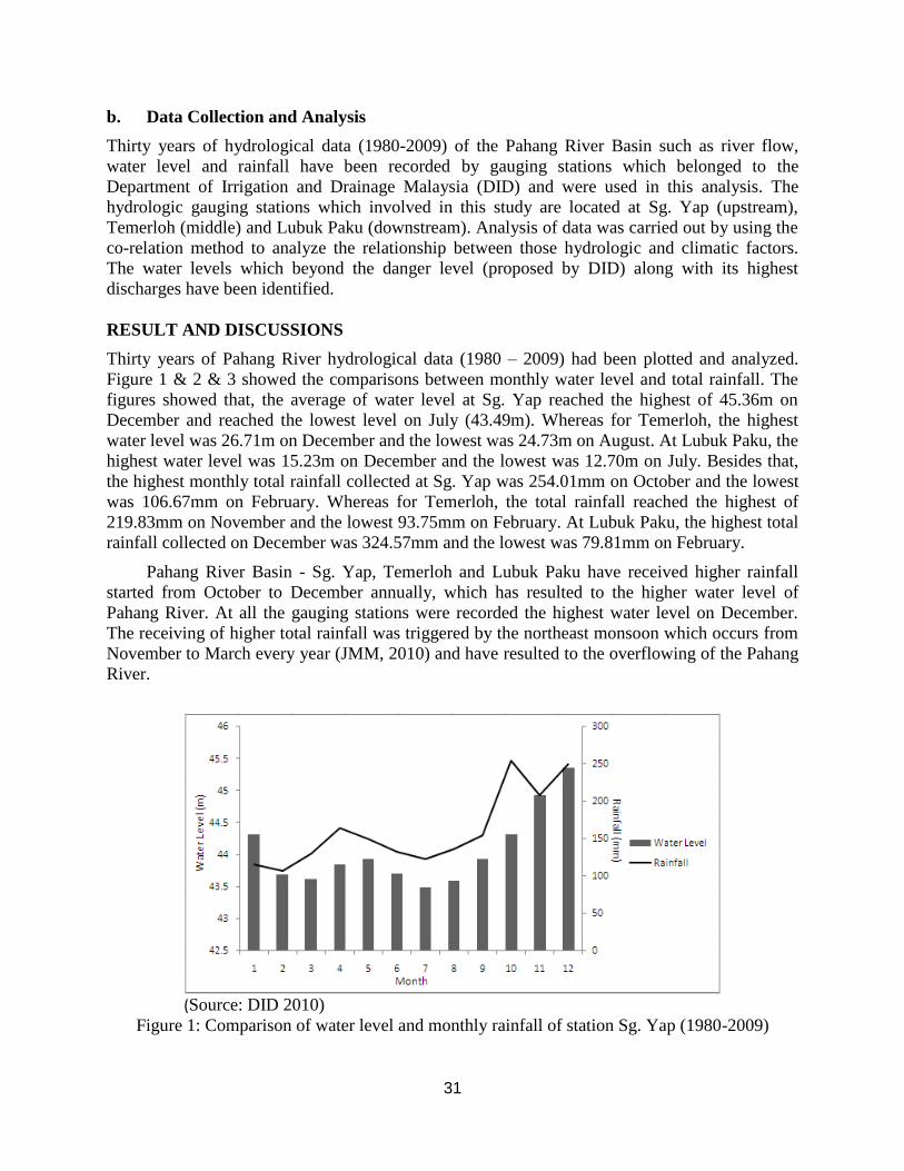
Thirty years of Pahang River hydrological data (1980 – 2009) had been plotted and analyzed.
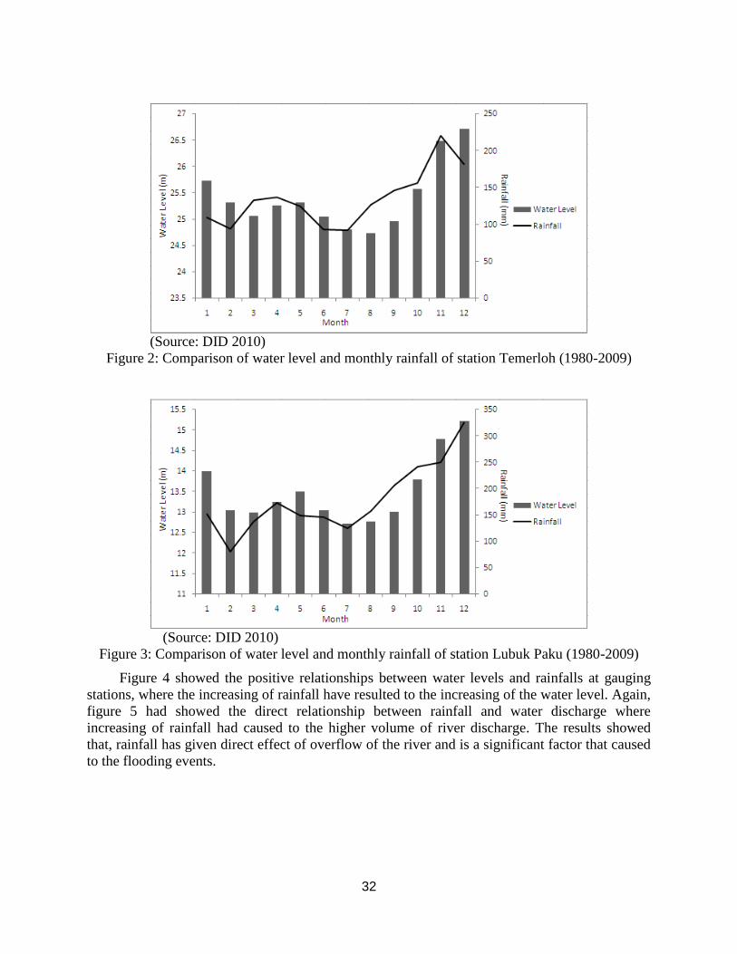
Figure 1 & 2 & 3 showed the comparisons between monthly water level and total rainfall. The
figures showed that, the average of water level at Sg. Yap reached the highest of 45.36m on
December and reached the lowest level on July (43.49m). Whereas for Temerloh, the highest
water level was 26.71m on December and the lowest was 24.73m on August. At Lubuk Paku, the
highest water level was 15.23m on December and the lowest was 12.70m on July. Besides that,
the highest monthly total rainfall collected at Sg. Yap was 254.01mm on October and the lowest
was 106.67mm on February. Whereas for Temerloh, the total rainfall reached the highest of
219.83mm on November and the lowest 93.75mm on February. At Lubuk Paku, the highest total
rainfall collected on December was 324.57mm and the lowest was 79.81mm on February.
Pahang River Basin - Sg. Yap, Temerloh and Lubuk Paku have received higher rainfall
started from October to December annually, which has resulted to the higher water level of
Pahang River. At all the gauging stations were recorded the highest water level on December.
The receiving of higher total rainfall was triggered by the northeast monsoon which occurs from
November to March every year (JMM, 2010) and have resulted to the overflowing of the Pahang
River.
(Source: DID 2010)
Figure 1: Comparison of water level and monthly rainfall of station Sg. Yap (1980-2009)
32
(Source: DID 2010)
Figure 2: Comparison of water level and monthly rainfall of station Temerloh (1980-2009)
(Source: DID 2010)
Figure 3: Comparison of water level and monthly rainfall of station Lubuk Paku (1980-2009)
Figure 4 showed the positive relationships between water levels and rainfalls at gauging
stations, where the increasing of rainfall have resulted to the increasing of the water level. Again,
figure 5 had showed the direct relationship between rainfall and water discharge where
increasing of rainfall had caused to the higher volume of river discharge. The results showed
that, rainfall has given direct effect of overflow of the river and is a significant factor that caused
to the flooding events.
33
Figure 4: Relationship between water level and rainfall for the three hydrologic gauging stations
at Pahang River
Figure 5: Relationship between river discharge and rainfall for the three hydrologic gauging
stations at Pahang River
Hydrologic Data Series
Rating curve between discharge and water level of the Sg. Yap (R²=0.851), Temerloh (R²=0.873)
and Lubok Paku (R²=0.928) areas showed that, there were significant positive relationship
(Figures 6, 7 & 8). These relationships indicated that, the increase of water level have resulted
the increase of discharge of the Pahang River. Thirty years mean discharge of Pahang River
(1980-2009) at Sg. Yap was 845.78m³/s (Figure 6). Whereas at Temerloh was 1008.50m³/s
(Figure 7) and Lubuk Paku was 1184.46m³/s (Figure 8). The highest water discharge (reached
and over the danger level proposed by DID Malaysia) had been recorded over thirty years (1980-
2009) and had been identified. At Sg. Yap gauging station (Figure 6), the water levels which
reached and over the danger level (52.0m) were recorded on 6/12/1983 with 52.12m
(3610.3m³/s), 22/11/1988 with 56.21m (6154.5m³/s), 2/12/1988 with 52.24m (3671.6m³/s),
12/12/1991 with 52.58m (3868.8m³/s), 19/12/1993 with 54.28m (4860.4m³/s), 24/12/2001 with
55.24m (5456.0m³/s) and 13/2/2006 with 52.51m (3351.6m³/s). Whereas for Temerloh (Figure
7), the water level which reached and over the danger level (33.0m) had been recorded on
24/11/1988 with 34.38m (6094.5m³/s), 26/12/1993 with 33.34m (4805.8m³/s), 26/12/2001 with
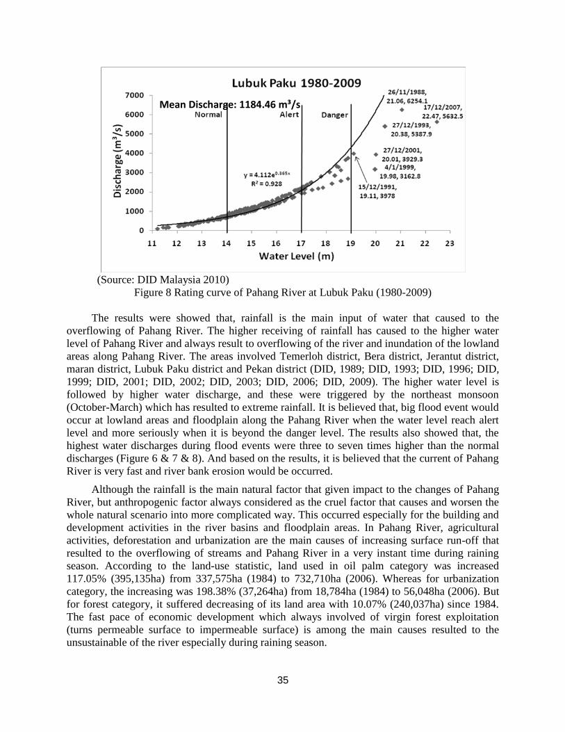
33.27m (3850.0m³/s), and 14/12/2007 with 33.89m (5366.5m³/s). At Lubuk Paku gauging station
(Figure 8), the water level which over the danger level (19.0m) occurred on 26/11/1988 with
21.06m (6254.1m³/s), 15/12/1991 with 19.11m (3978.0m³/s), 27/12/1993 with 20.38m
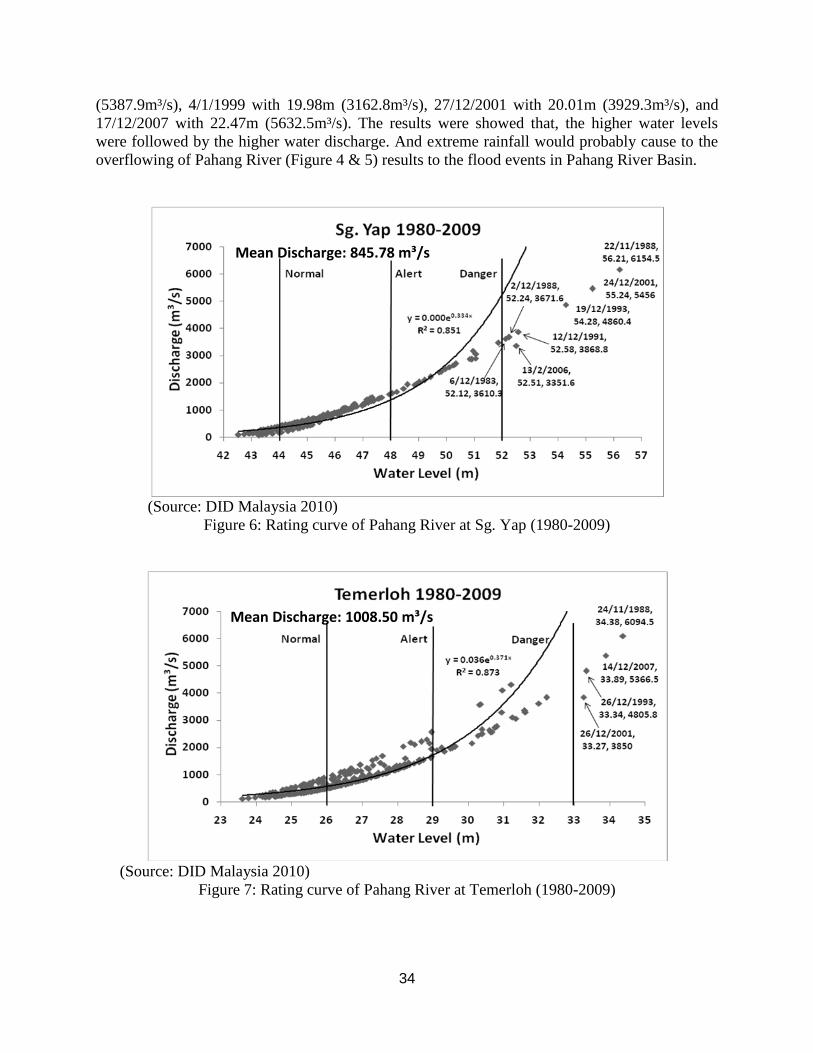
34
(5387.9m³/s), 4/1/1999 with 19.98m (3162.8m³/s), 27/12/2001 with 20.01m (3929.3m³/s), and
17/12/2007 with 22.47m (5632.5m³/s). The results were showed that, the higher water levels
were followed by the higher water discharge. And extreme rainfall would probably cause to the
overflowing of Pahang River (Figure 4 & 5) results to the flood events in Pahang River Basin.
(Source: DID Malaysia 2010)
Figure 6: Rating curve of Pahang River at Sg. Yap (1980-2009)
(Source: DID Malaysia 2010)
Figure 7: Rating curve of Pahang River at Temerloh (1980-2009)
Mean Discharge: 845.78 m³/s
Mean Discharge: 1008.50 m³/s
35
(Source: DID Malaysia 2010)
Figure 8 Rating curve of Pahang River at Lubuk Paku (1980-2009)
The results were showed that, rainfall is the main input of water that caused to the
overflowing of Pahang River. The higher receiving of rainfall has caused to the higher water
level of Pahang River and always result to overflowing of the river and inundation of the lowland
areas along Pahang River. The areas involved Temerloh district, Bera district, Jerantut district,
maran district, Lubuk Paku district and Pekan district (DID, 1989; DID, 1993; DID, 1996; DID,
1999; DID, 2001; DID, 2002; DID, 2003; DID, 2006; DID, 2009). The higher water level is
followed by higher water discharge, and these were triggered by the northeast monsoon
(October-March) which has resulted to extreme rainfall. It is believed that, big flood event would
occur at lowland areas and floodplain along the Pahang River when the water level reach alert
level and more seriously when it is beyond the danger level. The results also showed that, the
highest water discharges during flood events were three to seven times higher than the normal
discharges (Figure 6 & 7 & 8). And based on the results, it is believed that the current of Pahang
River is very fast and river bank erosion would be occurred.
Although the rainfall is the main natural factor that given impact to the changes of Pahang
River, but anthropogenic factor always considered as the cruel factor that causes and worsen the
whole natural scenario into more complicated way. This occurred especially for the building and
development activities in the river basins and floodplain areas. In Pahang River, agricultural
activities, deforestation and urbanization are the main causes of increasing surface run-off that
resulted to the overflowing of streams and Pahang River in a very instant time during raining
season. According to the land-use statistic, land used in oil palm category was increased
117.05% (395,135ha) from 337,575ha (1984) to 732,710ha (2006). Whereas for urbanization
category, the increasing was 198.38% (37,264ha) from 18,784ha (1984) to 56,048ha (2006). But
for forest category, it suffered decreasing of its land area with 10.07% (240,037ha) since 1984.
The fast pace of economic development which always involved of virgin forest exploitation
(turns permeable surface to impermeable surface) is among the main causes resulted to the
unsustainable of the river especially during raining season.
Mean Discharge: 1184.46 m³/s
36
CONCLUSIONS
Pahang is one of the areas that located at the East Coastal of Peninsular Malaysia which is
influenced by northeast monsoon annually. Occurrence of extreme rainfall during wet season has
caused overflowing of Pahang River, especially inundated the lowland and floodplain areas.
These events have resulted to the government suffered revenue loss due to the large
compensation to flooding victims and repairing after the incidents. Urban development and
anthropogenic activities that carried out especially near to the river banks or main channels
required a higher capacity of channel system in order to drain off the raining water that resulted
by surface run-off to avoid the overflowing of rivers. Over all, a well developed urban required a
more efficient drainage system in order to drain off the surface run-off water that generated from
the urban area. And also, increase the efficiency of the ultimate channel such as Pahang River is
a must in order to compensate the high input of water in a very short time to avoid the
overflowing of the river or flash flood to occur.
REFERENCES
Camporeale, C., Perona, P., Porporato, A., and Ridolfi. L.2007. The hierarchy of models for
meandering rivers and related morphodynamic processes. Reviews of Geophysics 45(1):
RG1001.
Department of Irrigation and Drainage (DID). 1989. Annual Flooding Report of Pahang State
1988/1989. Department of Irrigation and Drainage Malaysia (DID Malaysia).
Department of Irrigation and Drainage (DID). 1993. Annual Flooding Report of Pahang State
1993. Department of Irrigation and Drainage Malaysia (DID Malaysia).
Department of Irrigation and Drainage (DID). 1996. Annual Flooding Report of Pahang State
1995/1996. Department of Irrigation and Drainage Malaysia (DID Malaysia).
Department of Irrigation and Drainage (DID). 1999. Annual Flooding Report of Pahang State
1999. Department of Irrigation and Drainage Malaysia (DID Malaysia).
Department of Irrigation and Drainage (DID). 2001. Annual Flooding Report of Pahang State
2001. Department of Irrigation and Drainage Malaysia (DID Malaysia).
Department of Irrigation and Drainage (DID). 2002. Annual Flooding Report of Pahang State
2002. Department of Irrigation and Drainage Malaysia (DID Malaysia).
Department of Irrigation and Drainage (DID). 2003. Annual Flooding Report of Pahang State
2003. Department of Irrigation and Drainage Malaysia (DID Malaysia).
Department of Irrigation and Drainage (DID). 2005. Annual Flooding Report of Pahang State
2005. Department of Irrigation and Drainage Malaysia (DID Malaysia).
Department of Irrigation and Drainage (DID). 2006. Annual Flooding Report of Pahang State
2006. Department of Irrigation and Drainage Malaysia (DID Malaysia).
37
Department of Irrigation and Drainage (DID). 2009. Annual Flooding Report of Pahang State
2008/2009. Department of Irrigation and Drainage Malaysia (DID Malaysia).
Intergovernmental Panel on Climate Change (IPCC). 2001. The scientific basis. Contribution of
Working Group I to the second assessment report of the intergovernmental panel on climate
change. Cambridge University Press, New York.
Jackson, L.L., Lopoukhine, N. and Hillyard, D. 1995. Ecological restoration: A definition and
comments. Restoration Ecology 3: 71-75
Jabatan Meteorologi Malaysia (JMM). 2010. Monsun. Portal Rasmi Jabatan Meteorologi
Malaysia.http://www.met.gov.my/index.php?option=%20com_content&task=view&id=69&Item
id=160&limit=1&limitstart=0. Jabatan Meteorologi Malaysia.
John, A. Y. 1987. Physics of monsoons: The current view. In Fein, J.S. & Stephens, P.L. (
Eds.).Monsoons. New York: John Wiley & Sons. pp. 211-243.
Robert, A. 2003. River processes: An introduction to fluvial dynamics. London: Arnold.
Zin, W.Z.W., Jemain, A.A. 2010. Statistical distributions of extreme dry spell in Peninsular
Malaysia. Theoretical and Applied Climatology. pp. 1-12.
Pan Ia Lun, Muhd. Barzani Gasim & Sahibin Abd. Rahim
School of Environmental and Natural Resource Sciences (PPSSSA),
Faculty of Science and Technology,
Universiti Kebangsaan Malaysia.
Email: [email protected]
Mohd. Ekhwan Toriman & Khairul Amri Kamaruddin
School of Social, Development & Environmental Studies,
Faculty of Social Sciences and Humanities,
Universiti Kebangsaan Malaysia.
Related Documents