1 HYDROLOGICAL MONITORING AND INFORMATION SYSTEM FOR SUSTAINABLE BASIN MANAGEMENT 1 D. BASHIR and M. GARBA National Water Resources Institute, P.M.B 2309, Kaduna, Nigeria. ABSTRACT Sustainable management of water, as a resource for various developmental activities in a river basin, is dependent on adequate information that will guide towards understanding the hydrological system. This entails a comprehensive and effective hydrological monitoring system that encompasses the processes of collecting, processing, storing, manipulating and evaluating data on quantitative and qualitative characteristics of surface and subsurface waters in our basins as well as the subsequent dissemination of the information resulting from the analysis of such data. The ability to provide real-time information for planning and management purposes require the services of an automated information system that provides for efficient data handling in a way not possible manually. This paper supports the recommendations of the draft National Water Resources Management Policy on the need to use river basins as the basic units of water resources management in Nigeria. This can best be achieved by rationalizing the existing 12 River Basin Development Authorities (RBDAs), with politically demarcated boundaries, to 8 RBDAs based on the existing hydrological boundaries. The paper also recommended the establishment of a Catchment Management and Development Committee (CMDC) in each RBDA, comprising of all stakeholders and with the responsibility of resolving conflicts and harmonizing and ensuring complementarity of the activities of the stakeholders. The paper also proposes a 4-level national water resources data management structure under a suitable coordinating agency that will coordinate the rehabilitation and/or establishment as well as effective management of hydro-meteorological stations in the country. The National Water Resources Institute is recognized as the Coordinating Agency. In the short term, the institute should coordinate and standardize data collection techniques, equipments and methods for water resources data collection as well as coordinate the processes of collection, collating, analyses, storage and dissemination of hydro-meteorological data. In the long term, the paper suggested the establishment of a National Hydrometric Monitoring Network that will consist of well equipped hydrological laboratories in the RBDAs capable of continuous recording, analysis and disseminating required data and information electronically. Effective utilization of the recently launched Nigeria Sat1 will facilitate the network. Keywords: hydrological monitoring, information technology, sustainable water management, river basins, data sharing. 1 Text of Invited Paper for the First annual Conference of the Nigerian Association of Hydrological Sciences, Federal University of Technology, Yola, Adamawa State (2 nd – 4 th December, 2003).

Welcome message from author
This document is posted to help you gain knowledge. Please leave a comment to let me know what you think about it! Share it to your friends and learn new things together.
Transcript
1
HYDROLOGICAL MONITORING AND INFORMATION SYSTEM
FOR SUSTAINABLE BASIN MANAGEMENT1
D. BASHIR and M. GARBA
National Water Resources Institute, P.M.B 2309, Kaduna, Nigeria.
ABSTRACT
Sustainable management of water, as a resource for various developmental activities in a
river basin, is dependent on adequate information that will guide towards understanding
the hydrological system. This entails a comprehensive and effective hydrological
monitoring system that encompasses the processes of collecting, processing, storing,
manipulating and evaluating data on quantitative and qualitative characteristics of
surface and subsurface waters in our basins as well as the subsequent dissemination of
the information resulting from the analysis of such data. The ability to provide real-time
information for planning and management purposes require the services of an automated
information system that provides for efficient data handling in a way not possible
manually.
This paper supports the recommendations of the draft National Water Resources
Management Policy on the need to use river basins as the basic units of water resources
management in Nigeria. This can best be achieved by rationalizing the existing 12 River
Basin Development Authorities (RBDAs), with politically demarcated boundaries, to 8
RBDAs based on the existing hydrological boundaries. The paper also recommended the
establishment of a Catchment Management and Development Committee (CMDC) in
each RBDA, comprising of all stakeholders and with the responsibility of resolving
conflicts and harmonizing and ensuring complementarity of the activities of the
stakeholders.
The paper also proposes a 4-level national water resources data management structure
under a suitable coordinating agency that will coordinate the rehabilitation and/or
establishment as well as effective management of hydro-meteorological stations in the
country. The National Water Resources Institute is recognized as the Coordinating
Agency. In the short term, the institute should coordinate and standardize data collection
techniques, equipments and methods for water resources data collection as well as
coordinate the processes of collection, collating, analyses, storage and dissemination of
hydro-meteorological data. In the long term, the paper suggested the establishment of a
National Hydrometric Monitoring Network that will consist of well equipped
hydrological laboratories in the RBDAs capable of continuous recording, analysis and
disseminating required data and information electronically. Effective utilization of the
recently launched Nigeria Sat1 will facilitate the network.
Keywords: hydrological monitoring, information technology, sustainable water management,
river basins, data sharing.
1Text of Invited Paper for the First annual Conference of the Nigerian Association of Hydrological
Sciences, Federal University of Technology, Yola, Adamawa State (2nd
– 4th
December, 2003).
2
1.0 INTRODUCTION
An essential foundation for scientific water resources management is adequate information that will guide
towards understanding the hydrologic systems. This requires a satisfactory hydrological monitoring
network. The need for comprehensive data as a prerequisite for accomplishing any goal related to water
resources management has been severally discussed (Juhasz et. al, 1981; Oyebande, 1984, 1990,1992;
Duru, 1994; Garba et al., 2001).
Hydrological activities are carried out with the sole aim of providing for the understanding of quantitative
and qualitative characteristics of surface and sub-surface waters. Such activities include the processes of
data collection, data storage, data processing, data manipulation, data evaluation, and the dissemination of
results to the principal users, for sound and meaningful management of our river basins and the country as
a whole. Oyebande (1990) illustrated the importance of hydro-meteorological data as a basis for economic
and social development, and for maintenance of environmental quality. He further stressed that it is
required for quantitative and qualitative assessment of a country’s water resources, and also for planning,
designing and operation of water projects.
Data on the water resources situation in a basin is required to provide real-time information for planners
and managers to prepare against the monstrous effects of disasters, protect the ecosystem and the
subsequent evaluation of the effect and consequences of human activities on the resources. Such
information is required to provide effective and efficient services for rural and urban water supply,
agriculture, transportation, disaster monitoring and forecasting, operational activities, etc. In the present
dispensation, no nation can develop sustainably without exploiting the inherent advantages provided by
hydrological activities.
The need for regular up date and improvement in our water resources sector to meet up with the demand of
various sectors has created a continuous demand for data. The acquisition, storage, processing, analysis and
timely dissemination of the derived information from large amounts of data have placed an
uncompromising demand for the use of an automated information system. The efficiency and affordability
of the hardware and software components of the information technology would provide for the
development of comprehensive and functional basin and national level water resources data bank systems.
Better information leads to better decisions. Availability of large quantities of information creates problems
of handling, analysis, processing, storage and dissemination. This calls for a technique for capturing,
processing, evaluating and presenting decision information. Another problem is the ability to screen out the
best of all the information available and present the most useful part for decision making. Thus, the use of
conventional methods for the collection, generation, analysis, storing and dissemination of data and
information would present a lot of limitations in terms of the volume of data to be handled, errors, cost,
effectiveness, etc. These limitations can be adequately addressed with the use of the available Information
Technology (IT) systems. IT has today created an opportunity for tremendous capabilities for data
acquisition, processing, transfer, management storage and dissemination.
The use of computers and other communication resources has increased the possibility of improving
management through the use of simulations and optimization models, it provides avenue for data storage in
limited spaces which would have otherwise been not possible, ability to process bulk data which could
have been difficult or impossible manually, getting right information at the right time, ability to forecast
future conditions, evaluating the best strategy for achieving an objective, etc.
Models and hypotheses can be tested with data stored in a form ready to be digested by a computer and the
outcome can easily be summarized, reformatted and graphically displayed for use by engineers, scientists,
managers and administrators for making decisions and formulating new ideas. Tedious tasks such as data
reduction, flood routing, surface water profile calculations, complex operational linear and dynamic
programming, multivariate analyses, numerical analysis and mathematical modeling are easily executed.
3
Olofin (2003) maintained that for sustainable water resources management in Africa, there is the need for
multi-sectoral planning and execution of water projects within whole basins. This calls for the development
and effective maintenance of a functional hydro-meteorological database at the basin level with capabilities
of connectivity to the databases of other basins for effective sharing of records and information on national,
regional and global levels.
Abiodun (2002) identified reliable and sufficient geo-information as the fuel deriving the engine of growth
and sustainable development of any nation. They believed that any development plan drawn and decision
made outside the requisite geo-spatial database results in negative consequences. Abiodun (2002) reiterated
that about 80% of the right quality and quantity of data needed for sound basin planning could be derived
from satellite data.
In hydrological services, data are collected on precipitation, stream flow discharge, water level,
evaporation, runoff, temperature, groundwater level, sediment transport, catchments characteristics (such
as shape of catchments, size, orientation elongation, length of drainages, regime of rivers, land use, etc.)
wind speed and direction, biochemical quality of surface and groundwater, physiographic data, humidity,
etc.
Agunwamba (1994) identified the economic and social benefits of hydrological services to include;
sustainable water resources development, positive agriculture development, effective transportation system,
profitable tourism, efficient water supply system, poverty alleviation, relief from flood damages, functional
hydro power systems, drought relief, protection from erosion menace, safe aviation activities, etc.
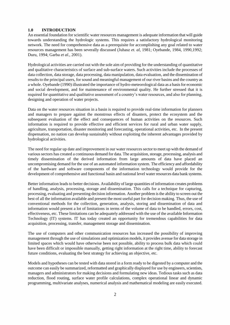
2.0 BRIEF ON NIGERIA
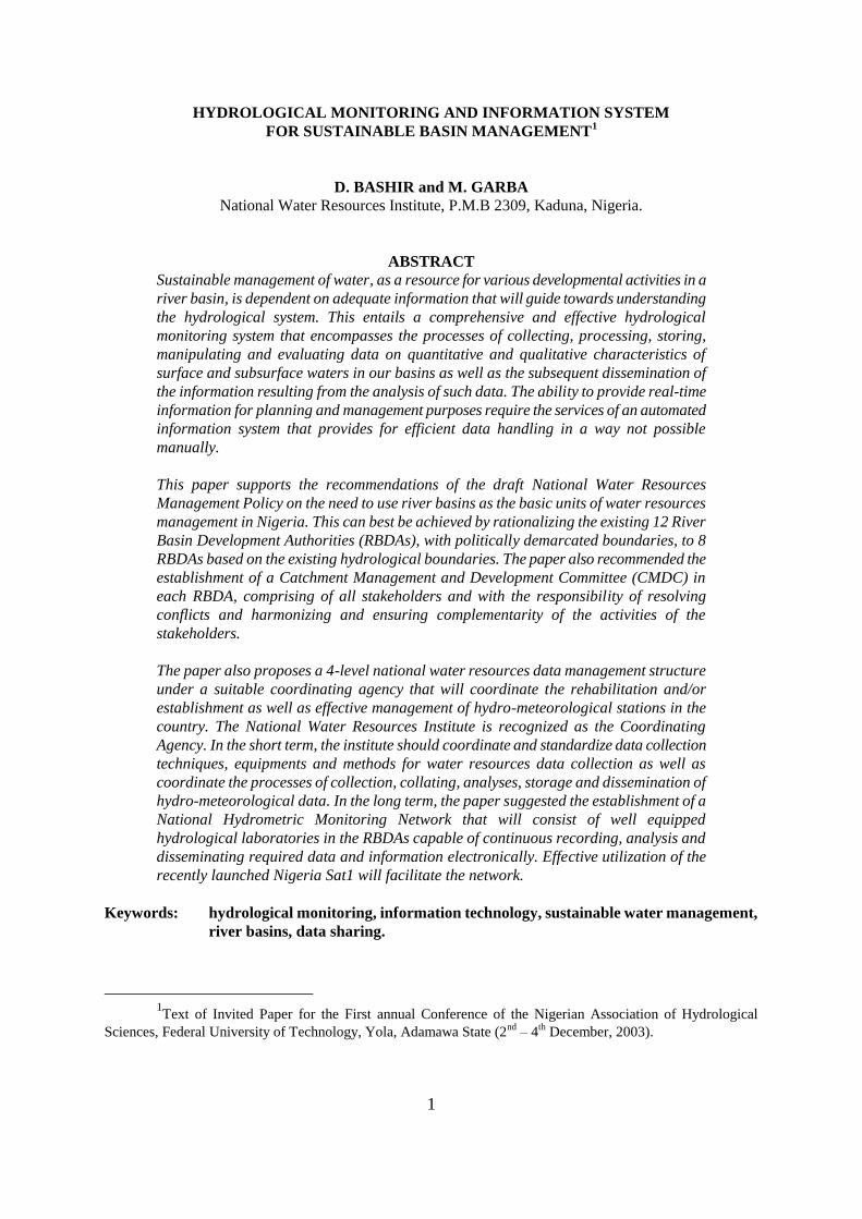
Nigeria is located between latitudes 4 and 14North of the Equator, and between longitudes 22' and
1430'East of Greenwich Meridian (Fig. 1). The country is estimated to have about 120 million people,
spread over 923,800 km2 area (JICA, 1995). Water resources in the country is influenced by the moist,
relatively cool, monsoon wind which blows from the south-west across the Atlantic Ocean towards the
country and brings rainfall, and the hot, dry, dust-laden harmattan wind which blows from the north-east
across the Sahara desert with its accompanying dry weather and dust-laden air. Mean temperature is
generally between 25and 30C, this is influenced by the sea from the coast towards the interior. Rainfall is
unevenly distributed reflecting wide variability in annual precipitation experienced across the country.
Highest annual precipitation of over 3,500 mm spreading over 10-12 months is recorded in the south-east
end of the country, at the coast of the Atlantic Ocean. This decreases, northwards, to a minimum of less
than 300 mm (within 3-4 months of rainy season) in the extreme north-east end of the country, at the
southern fringes of the Sahara desert.
Source: WS & H Electronic Library (2002)
Figure 1: Map of Nigeria showing major rivers and hydrological basins
4
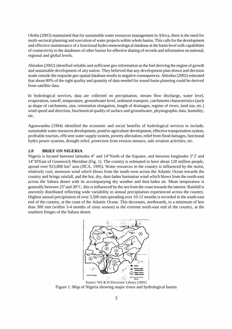
2.1 Surface Water Resources
Three major drainage systems exist in Nigeria, including:
i) the Lake Chad inland drainage system comprising of the Kano, Hadejia, Jama’are, Misau
Komadougou-Yobe, Yedserem and Ebeji Rivers;
ii) the Niger River drainage system with its major tributaries of Benue, Sokoto-Rima, Kaduna,
Gongola, Katsina-Ala, Donga, Taraba, Hawul and Anambra Rivers;
iii) the Atlantic drainage system made up of two distinct drainage sub-systems:
East littoral comprising of the Cross River, Imo, Qua Iboe and Kwa rivers,
West littoral comprising of the Ogun, Oshun, Owena and Benin Rivers.
Table 1: Drainage areas by hydrological area
HA Division
Number of Drainage Area (km2)
SHA SSHA Within Nigeria Outside Nigeria
I Niger North 14 34 131,600 461,600
II Niger Central 16 34 158,100 -
III Upper Benue 14 25 158,900 98,800
IV Lower Benue 9 29 73,000 8,300
V Niger South 5 10 53,000 -
VI West Littoral 10 18 100,500 -
VII East Littoral 7 19 59,900 13,400
VIII Lake Chad 15 33 188,000 -
Total 90 202 923,800 581,300 Source: JICA (1995)
The country is divided into eight hydrological areas (HA), each divided into smaller sub-hydrological areas
(SHA) and sub-sub-hydrological areas (SSHA) as shown in Fig. 1. The catchment area of each HA,
number of SHA and SSHA are given in Table 1. Apart from the lake Chad inland drainage system, the
remaining systems terminate in the Atlantic Ocean. The total area of inland water bodies comprising rivers,
lakes and reservoirs is estimated to be over 12 million hectares (Ita et al., 1985).
Source: WS & H Electronic Library (2002)
Figure 2: Map of the major geological formations of Nigeria
2.2 Groundwater Resources
Nigeria is underlain by two major geological formations, of almost equal proportions: the crystalline rocks
5
of the pre-Cambrian basement complex and the younger sedimentary formation. The basement complex
consists of the central northern block, the western block and the eastern block, comprising mainly of
metamorphic and igneous rocks and a fairly extensive areas of fractured schists, quartzites and
metamorphosed derivatives of ancient sediments. The sedimentary areas comprised of the central and
eastern southern blocks stretching from the Atlantic to the Benue River, and the northern block in the
north-east and the north-west (Fig. 2). While the basement complex area has water at some depths within
fractures, the sedimentary areas yield groundwater in varying quantities.
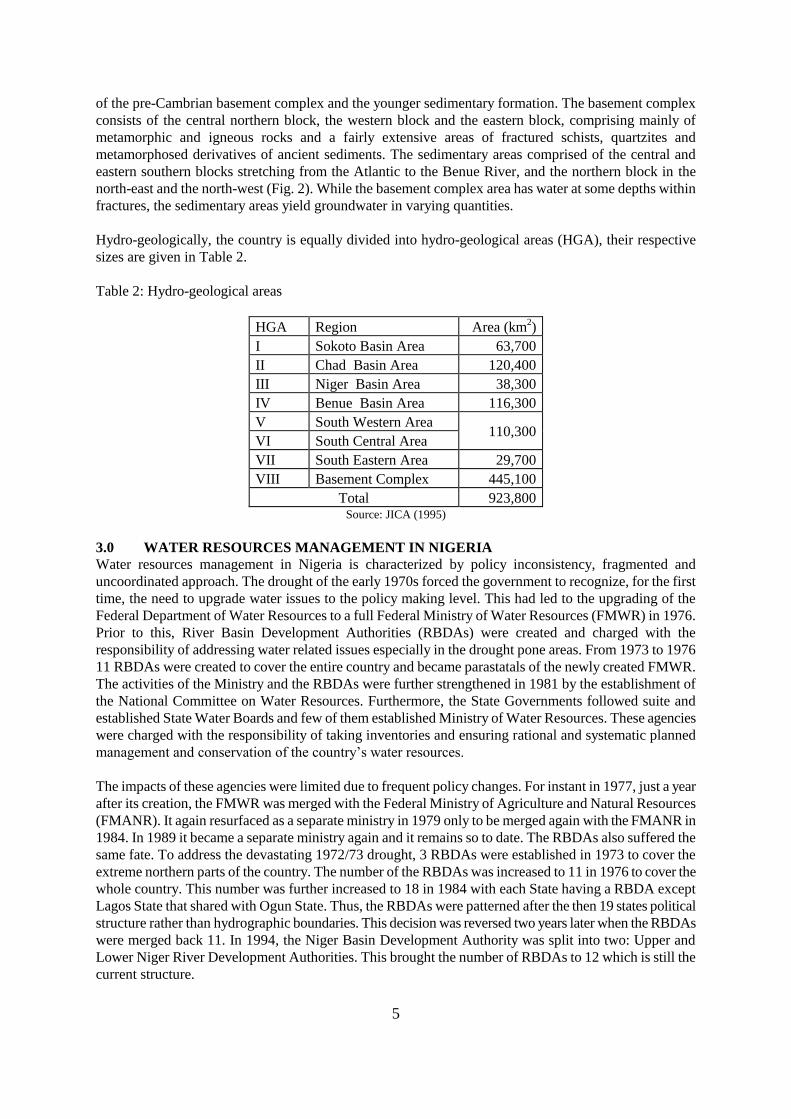
Hydro-geologically, the country is equally divided into hydro-geological areas (HGA), their respective
sizes are given in Table 2.
Table 2: Hydro-geological areas
HGA
Region
Area (km
2)
I Sokoto Basin Area
63,700
II Chad Basin Area
120,400
III Niger Basin Area
38,300
IV Benue Basin Area
116,300
V South Western Area
110,300 VI
South Central Area
VII South Eastern Area
29,700
VIII Basement Complex
445,100
Total
923,800 Source: JICA (1995)
3.0 WATER RESOURCES MANAGEMENT IN NIGERIA
Water resources management in Nigeria is characterized by policy inconsistency, fragmented and
uncoordinated approach. The drought of the early 1970s forced the government to recognize, for the first
time, the need to upgrade water issues to the policy making level. This had led to the upgrading of the
Federal Department of Water Resources to a full Federal Ministry of Water Resources (FMWR) in 1976.
Prior to this, River Basin Development Authorities (RBDAs) were created and charged with the
responsibility of addressing water related issues especially in the drought pone areas. From 1973 to 1976
11 RBDAs were created to cover the entire country and became parastatals of the newly created FMWR.
The activities of the Ministry and the RBDAs were further strengthened in 1981 by the establishment of
the National Committee on Water Resources. Furthermore, the State Governments followed suite and
established State Water Boards and few of them established Ministry of Water Resources. These agencies
were charged with the responsibility of taking inventories and ensuring rational and systematic planned
management and conservation of the country’s water resources.
The impacts of these agencies were limited due to frequent policy changes. For instant in 1977, just a year
after its creation, the FMWR was merged with the Federal Ministry of Agriculture and Natural Resources
(FMANR). It again resurfaced as a separate ministry in 1979 only to be merged again with the FMANR in
1984. In 1989 it became a separate ministry again and it remains so to date. The RBDAs also suffered the
same fate. To address the devastating 1972/73 drought, 3 RBDAs were established in 1973 to cover the
extreme northern parts of the country. The number of the RBDAs was increased to 11 in 1976 to cover the
whole country. This number was further increased to 18 in 1984 with each State having a RBDA except
Lagos State that shared with Ogun State. Thus, the RBDAs were patterned after the then 19 states political
structure rather than hydrographic boundaries. This decision was reversed two years later when the RBDAs
were merged back 11. In 1994, the Niger Basin Development Authority was split into two: Upper and
Lower Niger River Development Authorities. This brought the number of RBDAs to 12 which is still the
current structure.
6
The functions of the RBDAs were also subjected to frequent changes. At their commencement, the RBDAs
were agencies for rural development with responsibilities for water resources development (both surface
and sub-surface) and agricultural development (rainfed and irrigated, livestock and fisheries activities). In
1986, their functions were reduced to only water resources development. Two years later, in 1988, the
RBDAs were prepared for partial commercialization. This, coupled with the setting up of myriads of water
related programs and projects (such as the ADPs, SEPAs, etc.) and the absence of a comprehensive water
resources management policy, has resulted in a water sector facing a lot of problems among which include:
unnecessary duplication and overlap in organizations, structures and functions of the relevant
bodies;
ill-defined and uncoordinated roles of the various agencies responsible for water resources
development;
failure to recognize the inter-relationship between surface and ground waters and between water
resources and land use;
lack of sufficient hydro-meteorological data;
location of groundwater resources and their characteristics;
changes in hydrological regimes resulting from human activities; etc.
3.1 Rationale for Effective River Basin Management in Nigeria
One of the greatest problems facing many developing countries, especially those with large areas and
receiving intermittent and often unreliable rainfall, is the need to adequately marshal water resources to
meet the demand of their expanding needs (Siann, 1981). The rationale behind the urgent need for river
basin management in Nigeria lies in the importance of water regime fluctuation and its resulting deficits in
most part of the year for a significant portion of the country.
The river basins deserve attention because they are the natural context in which fresh water occurs, they are
being used intensively and over exploited while their capacity to meet the different needs are decreasing.
This calls for integrated approach to water resources management to address the different forms and
aspects of water resources demands and development.
The water divide constitutes a natural physical boundary for examining the interdependence between land
and water. This gives the river basin special relevance from the perspectives of integrated river basin
conservation and management. The river basin ought to be a hydrological concept, its development should
be understood in the context of the development of water resources in order to better adapt water
availability to water needs in time and space.
Learning from the experiences of the US corps of Engineers, water resources planning is a product of
decades of experience in performing both large and small studies and the collective sum of legislation,
executive orders, court decrees and inter-agency coordination (Davis, 1981). This implies that, for our river
basin management to be complete, a great deal of research and technical studies covering all aspects of the
basins must be conducted. Data must be assembled, analyzed and interpreted. Furthermore, relevant
information must be extracted, processed, documented and disseminated to the various stakeholders and
several decision making bodies before the planning task is considered complete. The role of data
management as a concept is to facilitate this process in an efficient and effective manner, by facilitating the
definition of objectives, formulating and evaluating alternatives and communicating findings in a simple
yet complete manner.
3.2 Hydrological Monitoring at River Basin Level
Shoeneich (2003) illustrated the need for hydrological monitoring for basin development policy in the river
basins of the country and concluded that Basin Development Authorities cannot accomplish the purpose
for which they were created, without knowledge of environmental resources under their jurisdiction
especially their utilizable-dynamic water resources. Thus, to be able to achieve these objectives, there is the
7
need for integrated river basin development, with boundaries of the river basins following watersheds and
not mere administrative boundaries.
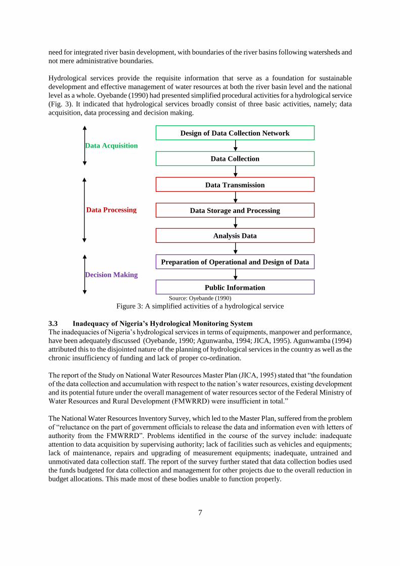
Hydrological services provide the requisite information that serve as a foundation for sustainable
development and effective management of water resources at both the river basin level and the national
level as a whole. Oyebande (1990) had presented simplified procedural activities for a hydrological service
(Fig. 3). It indicated that hydrological services broadly consist of three basic activities, namely; data
acquisition, data processing and decision making.
Source: Oyebande (1990)
Figure 3: A simplified activities of a hydrological service
3.3 Inadequacy of Nigeria’s Hydrological Monitoring System
The inadequacies of Nigeria’s hydrological services in terms of equipments, manpower and performance,
have been adequately discussed (Oyebande, 1990; Agunwanba, 1994; JICA, 1995). Agunwamba (1994)
attributed this to the disjointed nature of the planning of hydrological services in the country as well as the
chronic insufficiency of funding and lack of proper co-ordination.
The report of the Study on National Water Resources Master Plan (JICA, 1995) stated that “the foundation
of the data collection and accumulation with respect to the nation’s water resources, existing development
and its potential future under the overall management of water resources sector of the Federal Ministry of
Water Resources and Rural Development (FMWRRD) were insufficient in total.”
The National Water Resources Inventory Survey, which led to the Master Plan, suffered from the problem
of “reluctance on the part of government officials to release the data and information even with letters of
authority from the FMWRRD”. Problems identified in the course of the survey include: inadequate
attention to data acquisition by supervising authority; lack of facilities such as vehicles and equipments;
lack of maintenance, repairs and upgrading of measurement equipments; inadequate, untrained and
unmotivated data collection staff. The report of the survey further stated that data collection bodies used
the funds budgeted for data collection and management for other projects due to the overall reduction in
budget allocations. This made most of these bodies unable to function properly.
Design of Data Collection Network
Data Collection
Data Transmission
Data Storage and Processing
Analysis Data
Preparation of Operational and Design of Data
Public Information
Data Acquisition
Data Processing
Decision Making
8
The report further stated that the data gathered for the survey varied in their degree of reliability as such
confirmatory checks and site visits were necessary. The records were not up to date, the data were in their
raw state, mostly incomplete and often lack important parameters which made them inadequate for any
meaningful use. In addition, a high percentage of the data were inconsistent and unreliable.
Table 3: Number of rain gauge stations and responsible organizations
Oganizations
No. of Stations
%
State Water Boards
107
22 State Ministries
83
17
FDMS
79
16 RBDAs
62
13
Schools & Universities
39
8 Others
114
24
TOTAL
484
100 Source: JICA (1995)
JICA (1995) reported that in 1965 up to 1,058 rain gauges were in operation all over Nigeria. The situation
has been deteriorating such that by 1971 only about 300 reported reliable data in 10 continuous years, and
by 1995 only 484 stations have data of more than five years. Table 3 gives the distribution of the stations.
Out of the 484, only 46% (222) were in good condition and 24% (114) were reporting intermittent data.
The report indicated that as at 1995, there was no comprehensive inventory of hydrological monitoring
stations. Information obtained from the Federal Department of Hydrology and Hydrogeology indicated that
627 river gauging stations were listed in 1987 out of which 213 were recording river stage only. By 1995
there were only 358 river gauging stations (Table 4).
As at 1995 only 48% (173) of the 358 were in good condition, while 31% (111) had intermittent reports.
The condition is far from being normal, with a network density of 1.3 river gauging stations per 104 km
2.
The report observed a sparse network density of the basic hydrological stations, that are unevenly
distributed and non existence at some important locations.
Table 4: Number of river gauging stations and organizations maintaining them as at 1995
Oganizations
No. of Stations
%
State Water Agencies
148
41 RBDAs
89
25
FDWR
59
16 FIWD
44
12
NEPA
14
5 Others
4
1
TOTAL
358
100 Source: JICA (1995)
4.0 INFORMATION SYSTEM
Information system is defined by Anderson (1982) as a data-processing system which provides information
to management for the purpose of controlling activities and as a basis for making decisions. A complete
information system incorporates a database supporting the needs of several related functions or a major
operation of the activities as well as communication channels for interchange of information between
related sections.
Information is the result of processing data into meaningful form. For any thing to be classified as
information, it must serve a useful purpose, must be relevant to the responsibilities of managers, must be
9
current, must be of acceptable accuracy and must be real time (Anderson, 1982).
The basic requirement of an information system is a comprehensive database: this is a collection of
structured data supporting the operations of the whole or major part of an activity; it could be a centralized
data file providing the basis of a computerized management information system. Thus, a basic requirement
of a database is not merely efficient storage of data but also an effective means of retrieval.
Information system is not any different from any other system, it has all the features: input, processing,
output and feed back. It receives, as input, data and information and provide as output, information. So,
information system is a sub system specializing in processing data and information to produce new
information. It performs several functions ranging from editing and checking data files for accuracy,
updating data files and producing routine operational documents and various management reports. Richard
et. al (1986) concluded that information system uses data and information as raw materials for its
processing function and at the end produces information
A computerized information system is a necessity, it comprises of hardware, software, people, data and
manual procedures. These components must work together and be linked to a functional whole if
processing is to be effective and efficient. These resources must be integrated, managed and directed
towards the goal of providing relevant information to the right people in the right time frame and form.
4.1 Hydrological Information System
Ononiwu et. al (1994) envisaged decision making process in the following steps:
i) Defining the problem/need;
ii) Analysis of the problem/need;
iii) Development of alternative solutions;
iv) Selecting the best option; and
v) Converting decisions into action.
They concluded that none of these processes could be successful without useful information. Thus, the
objective of an information system for hydrological monitoring is to provide and disseminate information
about the conditions of water resources in order to fulfill the user defined information needs. Information
systems can be based on either hard copy paper report or on digital form in which all information and data
are stored and retrieved electronically. Considering the present technological development, it is almost
unthinkable to design an information system without making use of computers for data management and
analysis.
Information being a derivative of data cannot be superior in quality than the original data, it must inherit
the defects of the original data. This by implication means the data from which information is derived must
be accurate, complete, meaningful, etc. Managers view information system as a tool that provides them
with the information they need. The river basin activities will only be as good as their tools, so also the
managers.
4.2 Information Requirements
Good information is characterized by amount, quality, timeliness, clarity, accuracy, form frequency,
breadth, origin, relevance and completeness. When decisions must be made, the information must be
available on time or it will not be useful. The main types of data required in an information include:
a) data on all water resources on a basin;
b) data on the catchment characteristics;
c) data on human activities within the catchment.
10
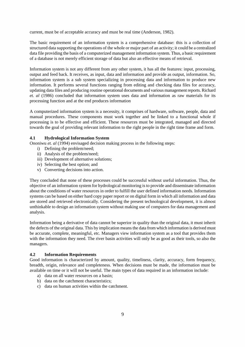
Figure 4: Information pyramid showing information system activities and
their corresponding organizational levels
4.3 Information flow in an information system
Data flow in an information system can be considered in three directions; upwards, downwards and
horizontally.
Upward flow information from lower to higher organizational structures reduces the amount of
details but enhances the information value through the interpretation of data.
Downward flow information is important for the purpose of communicating decisions in relation
to standards and policies, and also to make a feedback to those involved in data
acquisition and data-handling within the information system.
Horizontal flow information, through data sharing between organizations, is essential for
developing an integrated approach to environmental monitoring and management
and to make efficient use of data that are often collected and stored in a large
number of institutions. Figure 4 indicates that the vertical flow of information is
often seen as a three tiered system with respect to organizational levels and the
activities performed at each level. There is a large volume of data at the lowest
level of the triangle, as it reaches the highest level, the triangle tappers i.e the
volume of data reduces, but information value becomes greater.
Level I is primary data acquisition through monitoring, data validation and data storage. It is at this level
that all quality assurance and control are seriously observed, because data generated at this level
will influence the content of the second level.
Level II is data handling stage. This should be done at computational centers. Data is being converted into
information at this level. The computational centers are the users of primary data acquired at the
data acquisition level (service centres). Such centres are expected to be equipped with tools
needed for data analysis, processing, storage and presentations.
Level III are the information users. These are made up of the decision-making authorities. Information at
this level is used for checking and correcting the policies and management procedures. The final
generation and dissemination of information to various information users for effective decision
making is done at this level.
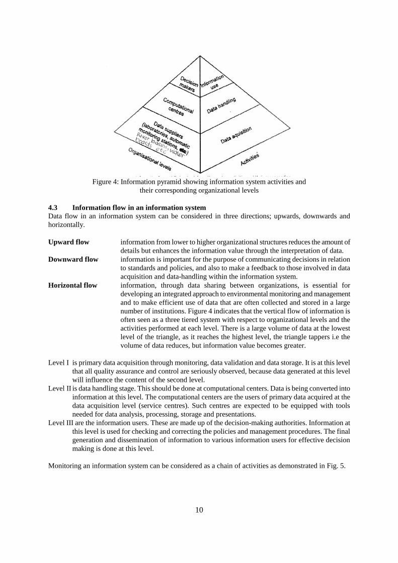
Monitoring an information system can be considered as a chain of activities as demonstrated in Fig. 5.
11
Source: WS & H Electronic Library (2000)
Figure 5: Chain of activities in a Hydrological Management Information System
4.4 Automation of Hydrological Monitoring and Information System
Automation of hydrological monitoring, involving automatic transfer of data from monitoring system into
the information system, has been very successful in many parts of the world including the Niger River
Basin. New developments in technology such as use of sensor technology and telemetry are speeding up
this process. Remote sensing has been one of these technologies where regional characteristics such as
drainage lines, land use, etc. are derivable directly from satellite imageries and are linked, processed and
utilized with other relevant information using Geographic Information System (GIS) techniques.
4.4.1 Remote Sensing
Hydrological planning is usually based on limited data and often inadequate especially in developing
countries (Farnsworth et. al, 1984). Remote sensing affords the ability to provide information about the
environment more quickly and with temporal and spatial variabilities. The application of this technology
has been utilized in Nigeria for the generation of data useful in hydrological analysis (Ononiwu, 1990;
Ananaba, 1990; Garba et al., 2001; Alayande and Bamgboye, 2003). The orbiting of weather and earth
resources satellite has permitted data to be collected over vast areas where conventional techniques failed.
Remote sensing has made scientist to see the environment under conditions not obvious to the human eye.
Remote sensing techniques have been found to be helpful by using information derived from polar orbiting
satellites to extend a short observed hydrological database (Schultz, 1984).
Selection of satellite data for a particular purpose depends on spatial and temporal resolution of the satellite
data in relevant spectral range, data availability, cost, etc. With the launching of Nigeria-Sat1, with a 32 m
resolution and 600 x 570 swaths, it is hoped that the problems encountered in the past in terms of image
acquisition will be a thing of the past.
4.4.2 Geographical Information Systems
Various level of data/information is required for hydrological analysis. Such data are required in different
units, and at different temporal and spatial scales. The computer based, GIS data analysis techniques
provide valuable tools needed for data presentation, analysis and interpretation. The techniques possess the
tool for solving complex planning and management problems by managing, manipulating, analyzing,
modelling, querying and displaying of spatial data. GIS allows for geo-referencing of data, analysis and
display of multiple layers of geographically referenced information and have proven to be very efficient in
hydrological analysis.
Thus, GIS afford simple accessibility to information at different levels. Zeug et. al., (2003) suggested that
12
to set up a continuous and accurate data collection systems, GIS technique is inevitable as it provides a
very valuable tool for planning and decision support. This is because GIS facilitates integrated
management, analysis and performance of spatial and non-spatial data within one system; a clear advantage
over mapping system, CAD or alphanumeric databases. Kufoniyi et. al., (2003) consider GIS as a critical
tool to analysis and policy formulation.
4.4.3 Data interpretation and communication
Data interpretation and communication of the result obtained is a fulfilling factor in an type of data
monitoring. An interpreted data is of no significant if they are not disseminated to the relevant bodies. Such
processed and interpreted results are expected to be communicated in a form that is readily understandable
by, and acceptable to the target audience. Proper information dissemination demands for the maximum
utilization of the provisions of information technology (IT) for better results.
5.0 SUSTAINABLE RIVER BASIN MANAGEMENT
The aim of sustainable development, as stated by the Brundtland Report, is meeting the need of the present
generation without compromising the ability of the future generations to meet theirs. Thus, sustainable
development should improve the quality of human life and at the same time support the ecosystems without
a decline in the natural capital assets. Clark et al., (1994) saw sustainability as embodying the concept of
renewability (the rate at which resources can be replaced. Consequently, sustainability is achieved by
restricting the level of use of a resource at or below the rate of replacement). Michael (1994) was of the
view that a sustainable system is one in which intensity and frequency of resource utilization is small in
relation to recovery rate. Thus, holistic approach is central to achieving sustainability, with the entire
system viewed as inter-connected, and short-term decisions are seen to have long-term direct and indirect
consequences.
For optimum development, effective management and efficient utilization of resources, the basin should be
considered the rational unit of planning and implementation of water resources management strategies.
Prasad et al. (1994) were of the view that the river catchment basin represents a closed boundary for
various hydrological processes.
The Global Water Vision (SASNET-RBO, 2000) has identified the river basin as the logical vehicle to
achieve the objectives of integrated water resources management (IWRM) and recommended among other
things, that :
the river basin is the logical bio-physical unit for the management of natural resources; hence a
river basin organization (RBO) is an appropriate institution to translate IWRM concept action;
all decisions relating to the river basin should be taken at the lowest appropriate level;
river basins should be managed through interdisciplinary approaches;
the entire drainage basin of a river should be taken into account in developing plans;
the relationship between the river basin organizations and political and administrative units should
be recognized as RBO cannot work in isolation.
In line with the concept of integrated basin development, Oyebande (1994) stated that environmental
criterion, efficiency of demand management and environmental friendliness constitute the center-piece of
sustainable development of water resources in a basin.
The draft National Water Resources Management Policy (FMWR, 2003) has recognized the need for a
well coordinated and decentralized management structure involving all stakeholders as the recipe for
sustainable water resources development and management in Nigeria. The draft policy also recognized the
river basins, based on hydrological boundaries, as the most effective units of implementing the strategies
for sustainable water resources management. Among the strategies proposed for achieving the objectives of
the policy, are the following:
1. Use the established eight hydrological areas (HA) or Catchments as the basic unit of water
13
resources management in Nigeria and rationalise the RBDAs to eight with each RBDA being
responsible for the management and development of water resources in only one hydrological area.
2. Establish a Catchment Management and Development Committee (CMDC) in each hydrological
area (HA) comprising: (i) RBDA, (ii) SWAs, (iii) SEPAs, (iv) ADPs, (v) Transport Agencies, (vi)
NEPA, (vii) NACCIMA, (viii) 2 NGOs and (ix) 2 Academic/Research Inst./NWRI. The CMDC is
charged with the following responsibilities.
resolving conflicts arising from Water Resources Management within the catchment;
harmonize and ensure complimentarity of the activities of all organisations and agencies
involved with water resources development and management in the catchment;
ensure uniformity in the enforcement of laws, rules and regulations relating to water
resources development and managment in the catchment.
The Committee shall be responsible to the National Technical Committee on Water Resources
(NTCWR), be chaired by the RBDA Managing Director, meet quarterly and having its secretariat
in the RBDA.
We concur with these provisions of the draft policy which had undergone two reviews by the stakeholders
and is due for the third and final review soon. The CMDC will be a very viable forum for the establishment
and effective management of hydro-meteorological data system. This fits well with the recommendations of
the NWRMP (JICA, 1995) on the minimum network density of some basic hydrological elements in
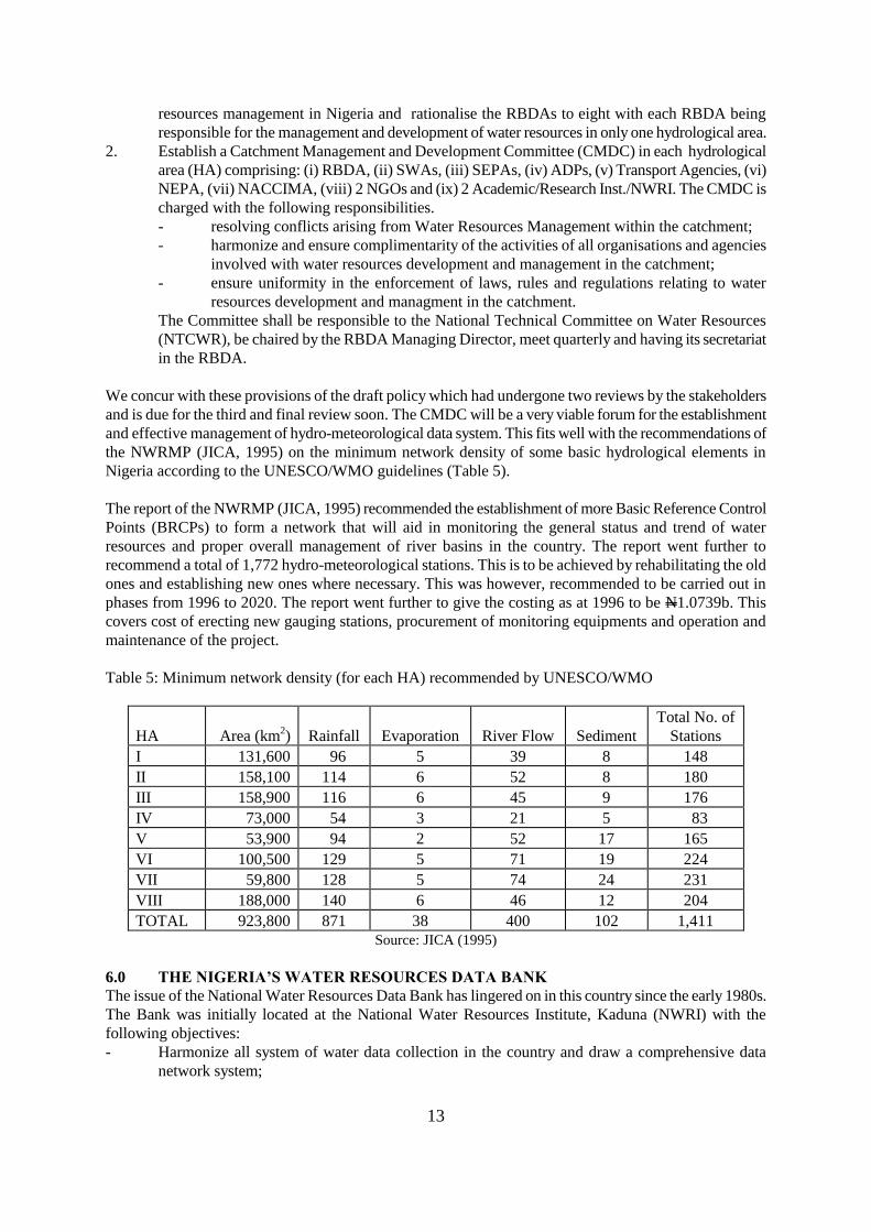
Nigeria according to the UNESCO/WMO guidelines (Table 5).
The report of the NWRMP (JICA, 1995) recommended the establishment of more Basic Reference Control
Points (BRCPs) to form a network that will aid in monitoring the general status and trend of water
resources and proper overall management of river basins in the country. The report went further to
recommend a total of 1,772 hydro-meteorological stations. This is to be achieved by rehabilitating the old
ones and establishing new ones where necessary. This was however, recommended to be carried out in
phases from 1996 to 2020. The report went further to give the costing as at 1996 to be N1.0739b. This
covers cost of erecting new gauging stations, procurement of monitoring equipments and operation and
maintenance of the project.
Table 5: Minimum network density (for each HA) recommended by UNESCO/WMO
HA
Area (km2)
Rainfall
Evaporation
River Flow
Sediment
Total No. of
Stations I
131,600
96
5
39
8
148
II
158,100
114
6
52
8
180 III
158,900
116
6
45
9
176
IV
73,000
54
3
21
5
83 V
53,900
94
2
52
17
165
VI
100,500
129
5
71
19
224 VII
59,800
128
5
74
24
231
VIII
188,000
140
6
46
12
204 TOTAL
923,800
871
38
400
102
1,411
Source: JICA (1995)
6.0 THE NIGERIA’S WATER RESOURCES DATA BANK
The issue of the National Water Resources Data Bank has lingered on in this country since the early 1980s.
The Bank was initially located at the National Water Resources Institute, Kaduna (NWRI) with the
following objectives:
Harmonize all system of water data collection in the country and draw a comprehensive data
network system;
14
Design and develop a data banking system for the water resources sector across all primary and
secondary stations in the country;
Advise all water agencies and governments on water resources distribution, usage and potentials;
Publish a bi-annual Hydrological Year Book for the country;
The NWRI, with the assistance of the UNDP, commenced the development of the Data Bank. Between
1982 and 1986, the Institute collected data from which hydrological maps covering the entire country were
produced with hydrological stations numbered. Hydro-meteorological data were collected and analysis
began when in 1986 the Federal Ministry of Water Resources decided to relocate the data bank to the
headquarters. Since then little is known about the activities of the data bank. The objectives stated above
could not be achieved till today.
7.0 THE WAY FORWARD
Records on meteorology, hydrology and hydrogeology at present are collected by a number of Federal,
State and Private agencies throughout the country. Much work still remains to be done to process and
evaluate these water resources inventories and to coordinate and standardize data collection techniques,
equipment and methods on a national basis. The ultimate goal of a National Water Resources Data Bank is
to arrive at a well defined country-wide programme of hydrological investigations which would provide
adequate coverage to meet the most urgent needs of water resources development plans and those of the
immediate future.
Effective performance of these functions requires a suitable coordinating agency. The National Water
Resources Institute, Kaduna satisfies the conditions for the establishment of the Water Resources Data
Bank than any other organization in the country. Apart from the fact that the law establishing the Institute
stipulates that data banking is one of its main functions, the NWRMP was emphatic in recommending the
Institute as the central coordinating unit of the national water resources data management system. The
infrastructural facilities required for the proper operation of the Bank have already been put in place,
though they need upgrading.
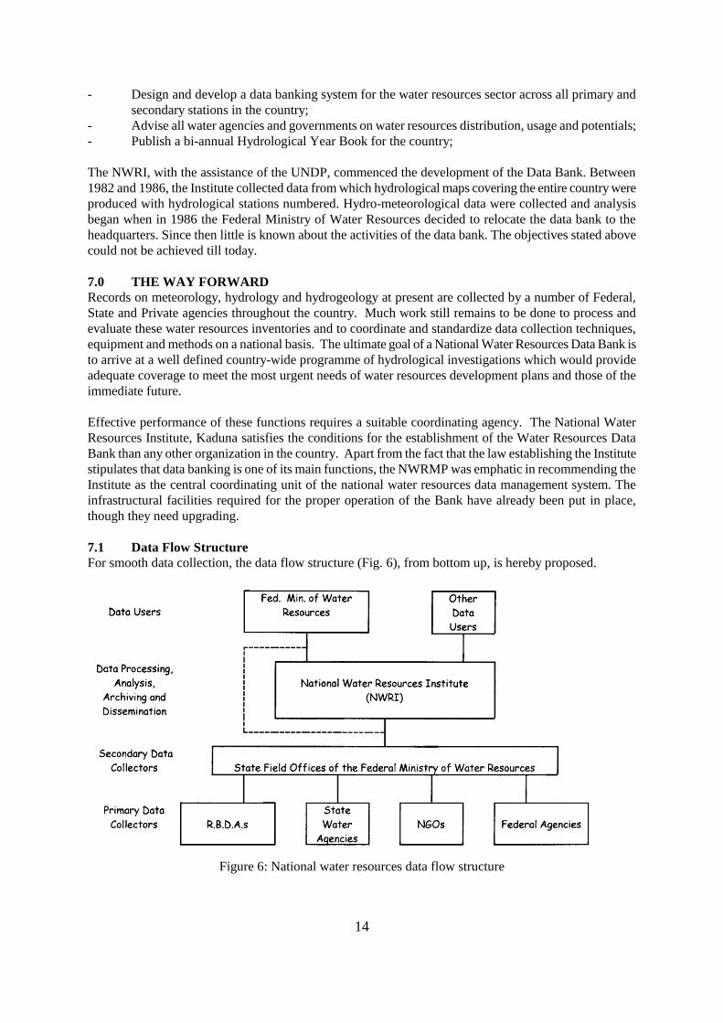
7.1 Data Flow Structure
For smooth data collection, the data flow structure (Fig. 6), from bottom up, is hereby proposed.
Figure 6: National water resources data flow structure
15
7.1.1 Primary Data Collectors
These agencies will be responsible for generating the data from the stations or sampling points as the case
may be. They include RBDA’s, State Water Boards, State Ministries of Agriculture, State Ministry of
Water Resources, State Environmental Protection Agencies, Departments of Geological Surveys,
Agricultural Development Projects, NEPA, National Inland Waterways Department, NGOs, Private
organizations, etc.
7.1.2 Secondary Data Collectors
These are the River Basin Development Authority. They will be responsible for collecting the data in their
areas of authority from the primary data collectors. With the creation of the CMDC, this function will be
transferred to the Committee.
7.1.3 Data Processing and Storage
These functions will be performed by the National Water Resources Institute, Kaduna (NWRI), where the
Water Resources Data Bank is housed. The Institute will be responsible for collecting the data from the
secondary data collectors and then process, stores and disseminate required information to users. In
addition it is responsible for coordinating the data flow network, including standardization of equipment
and measurement procedures.
7.1.4 Users
These are organizations and even individuals requiring water resources data for planning, design and
operation of water projects. They will collect the processed data from the Institute on request. The
Ministry will be part of the data users.
7.2 Data Bank Development
The development of the Data Bank will have short and long term plans. Under the short term plan, which
is required for immediate development, the facilities in the Institute should be upgraded for effective data
processing and storage. Adequate and appropriate logistics should be made available in the Institute to
enable movement of collected data between primary and secondary collector and between secondary
collectors and the Institute. During the period, the Institute will put in place a reliable computer network for
data exchange and also develop a web site. The Institute has already built a local area network linking all of
its buildings.
7.3 Funding
It is important to note that the major obstacle facing development of the Water Resources Data Bank is
funding, and as such it is important to establish a firm commitment for its funding. In this regard, it is
recommended that 10% of the Ministry’s annual budget be allocated to the Data Bank and the network of
its activities. The fund is to be shared as follows: 5% to the primary data collectors, 2% to the secondary
data collectors and 3% for the data processing and storage.
The 5% to the primary data collectors will be shared by all the primary data collectors in the country in the
ratio of stations or points they are maintaining, thus the more stations you maintain, the more money you
get. In the same way, the 2% for the Secondary data collectors will be shared in the ratio of number and
stations or points under them. Funds will only be released to data collectors who satisfactorily supplied
their data to the Water Resources Data Bank in Kaduna.
7.4 Operations of the Data Bank
7.4.1 Data Collection
This will be an ongoing activity. Data will be collected and collated to up-date the records presently in the
Institute’s computers. To start off the exercise, the nation-wide inventory survey for the Master Plan
Project will be integrated into the present data base in the Institute. The data collection will involve visits
to the data generating agencies at regular intervals by the staff of the Data Bank.
16
7.4.2 Data Validation
Data is not valuable if it is not accurate. Since the planning and operation of water resources projects
require accurate data, these data have to be checked, evaluated and validated. The validation will make use
of all the facilities available in both the remote sensing, GIS and photogrametary laboratories presently
available in the Institute. This process of data validation including model evaluation should be an ongoing
exercise.
7.4.3 Inventory of Hydro-Meteorological Stations
The first inventory carried out by the Institute was used in the development of hydrological maps. Since
then, we are aware that new stations have been established while a number of the old ones have been
discontinued. In the course of development of the National Water Resources Master Plan, JICA had
pointed out the inadequacy of the present network. It is therefore necessary to have an update of the
inventory of the stations in order to revise the hydrological maps to represent the actual situation in the
country. There is the need to correctly design an optimum network of stations for the country and establish
and adequately equip them. In addition, all the meteorological stations in the country should be
incorporated into the network of stations. Hydrological maps will include intensity- duration - area graphs,
rainfall intensity maps and other relevant maps for the planning of water resources.
7.4.4 Standardization of Stations and Equipment
Data are not very useful if they cannot be compared. It is necessary for the data from the network to be
compared and even transferred from one catchment to another. The transfer of data can only be possible if
the measuring techniques and equipment are standardized. The Institute intends to pursue with vigor the
standardization of the measuring techniques and equipment.
7.5 Water Resources Information Systems
The national hydrometric monitoring network should contain observations of all inland hydrological
parameters such as water level, river discharge, etc. The main objectives of the national network should be
monitoring and research, operative use and planning and protection of waters. The Hydrological
Information System (HIS) should be made to integrate GIS-data and handling of data transfer and
transformation. The eight RBDAs in the country should be the focus of the network, with each basin
forming the node of the network. A telemetric system similar to the existing one along the Niger Basin
should be adopted. DCPs should be installed on the major rivers while other smaller rivers and streams
should be monitored using automatic/manual gauges. With the Nigeria Sat1 in space, its facilities must be
maximally utilized for hydrologic data generation. Each of the eight RBDAs should have a hydrological
laboratory and should be equipped with remote sensing and GIS work station that will serve the purpose of
data storage, analysis, processing and archiving. The hydrological laboratory should be equipped to do the
following within its area of its jurisdiction:
i) generation of hydrological baseline data;
ii) detection and evaluation of hydrological trends;
iii) provision of early warning system;
iv) identifying and advising on critical situations;
v) identifying anthropogenic impact on hydrological systems;
vi) sophisticated means of data storage and data retrieval systems;
vii) generation of a geo-referenced database system containing both points and spatial data layers
8.0 CONCLUSION
The decentralization of water resources development and management without proper coordination in
Nigeria contributes to the present level of uncoordinated development of water resources. In order to
achieve the best of development, to correct such anomaly, the eight hydrological areas should serve as
basic unit of water resources management in the country, the federal ministry should focus its activities on
policy formulation, monitoring and sectoral evaluation.
17
Information Technology empowers both people and machines with information, which is transformed into
knowledge and intelligence. The appropriate use of this knowledge contributes to sustainable development.
It facilitates fast, cheap, equitable and resource-efficient access to information, accumulated knowledge,
learning opportunities and sharing of information.
9.0 REFERENCES
Abiodun, A.A. (2002). Space Technology and the role in Sustainable development. An invited paper
presented at the annual meeting of the British Association for the Advancement of Science,
University of Leicester, Leicester, UK.
Agunwamba, J.C. (1994) Economic and Social benefits of Hydrological services in Nigeria. A paper
presented at the IHP – UNESCO conference held at NWRI, Kaduna. 13th – 15
th November, 1994.
Alayande, A.W and Bamgboye, O.A (2003) Success and failure of existing Remote Sensing projects on
water resources Management in Nigeria: The way forward. A paper presented at the UNESCO
sponsored multi-stake holders National workshop on the application of Remote Sensing for
integrated management of ecosystem and water resources in Nigeria, held at Abdulsalami
Abubakar Youth center, Minna, Niger State. 4th September, 2003.
Andra, T (1990) Information System in Water Management in Hungary. IHP – UNESCO 1965 – 1989.
published by Ministr of Environment and Water Management and research center for water
resources. Budapest.
Ajayi, G.O. (2003). Information technology and sustainable development in Nigeria. An address delivered
at the UNESCO sponsored Multi-stake Holders National Workshop on the Application of Remote
Sensing for Integrated Management of Ecosystem and Water Resources in Nigeria. Held at
Abdulsalami Abubakar Youth Center, Minna, Niger State 4th September, 2003.
Anderson, R.G. (1982) A Dictionary of Data Processing and Computer Terms. Published by Macdonald
& Evans Ltd.
Ananaba, S.E. (1990). Mapping surface water resources in Nigeria from remote sensing data. Proceedings
of the First Biennial National Hydrology Symposium, Maiduguri, Nigeria, 26th 28
th November
1990.
Biggs, S.D. (1981). Monitoring for Re-planning Purposes: The Role of Research and Development in
River Basin Development, in River Basin Planning: Theory and Practice. Edited by Suranjit K.
Saha and Christopher J. Barrow, John Wiley and Sons Limited, 325-341.
Davis, W.D. (1981). Data management systems for water resources planning. Proceedings of the
Speciality Conference Water Forum ’81, Volume II, pp 1215-1233.
Dreher, J., Zeller, E. and Verbundplan (2000) Hydrological services-the need for a satellite-based
information system, in Preparing for the Future, Vol.10 No 2 August, 2000.
Duru, N.G. (1994). Water resources data bank in Nigeria: The past, present and the future. A paper
presented at the IHP – UNESCO Conference held in Kaduna. 13th – 15
th November 1994.
Farnsworth, R.K., Barett, B.C and Dhanju, M.S (199 ) Application of Remote Sensing to Hydrology
including Groundwater. in Technical Document in Hydrology, IHP – UNESCO.
Garba, M., Alayande, A.W and Egbulem, A.N (2001) Application of Remote Sensing and GIS in Water
Resources Management. in the Journal of Engineering Technology and Industrial Application. Vol
1 No. 4 pg 60 - 66
JICA (1995). The Study on the National Water Resources Master Plan (NWRMP): Sector Report, Part I.
Sanyu Consultants Inc. & Sumiko Consultants Co., Ltd., Japan.
Kufoniyi, O., Aliyu, Z.O., and Soumah, M. (2003). The application of remote sensing and GIS in
ecosystem and water resources management: A Regional perspectives. A paper delivered at the
UNESCO Sponsored Multi-stake Holders National Workshop on the Application of Remote
Sensing for Integrated Management of Ecosystem and Water Resources in Nigeria. Held at
Abdulsalami Abubakar Youth Center, Minna, Niger State 4th September, 2003.
Malcom, N. (1994). Sustainable Integrated development and the basin sediment: Guidannce from Fluvial
Geomorphology in Integrated River Basin Development, edited by Celia Kirby and White, W.R.
John Wiley and sons ltd. 1 – 10
18
Olofin, E.A. (2003). Sustainable management of water resources in Africa: Challenges and opportunities.
A paper delivered at the UNESCO Sponsored Multi-stake Holders National Workshop on the
Application of Remote Sensing for Integrated Management of Ecosystem and Water Resources in
Nigeria. Held at Abdulsalami Abubakar Youth Center, Minna, Niger State 4th September, 2003.
Ononiwu, N.U., O. Orji, and S. Ucheagha (1994). Efficient water resources data banking for effective
water resources development in Nigeria – A Proposal. A paper presented at the IHP – UNESCO
Conference held in Kaduna. 13th – 15
th November 1994.
Ononiwu, N.U. (1990). Effective management of river basins by use of SPOT imagery. Proceedings of the
First Biennial National Hydrology Symposium Maiduguri, Nigeria 26th 28
th November 1990 .
Oyebande, L. (1984). The role of hydrological data and technical manpower in water resources
management. Proceedings of the International Seminar on Water Resources Management
Practices, Ilorin, Nigeria. July 28th – August 4
th 1984. pp 151 – 166.
Oyebande, L. (1990). Nigeria’s hydro-meteorological networks - an assessment. Proceedings of the First
Biennial National Hydrology Symposium Maiduguri, Nigeria 26th 28
th November 1990 .
Oyebande, L (1994) Integrated and Sustainable development of the Water Resources of the Niger Basin.
In Integrated River Basin Development, edited by Celia Kirby and White, W.R H R Wallingford.
John Wiley and Sons . 23 – 33
Prasad, T., Kumar,S., Verden, A., Prakash, N., Gyawali, D., Dixit, A., Lali, N.K and Regmi, B.R (1994)
Co-operation for International river basin development: The Kobi Basin. In Integrated River
Basin Development edited by Celia Kirby and White, W.R H R Wallingford. John Wiley and Sons
. 493 – 513
Richard, W.B. and M.D. Jeffery (1986). Using Computers in an Information Age, Delmar Publishers
Incoperation. 49 – 57.
Shultz, G.A (1984). Simulation Model for Reservoir Operation under Condition of Hydrological data
inadequacy and growing water demand. In the Proceedings of International Seminar on water
resources management practices, Ilorin, Nigeria July 28th – August 4
th 1984.
Siann, J.M. (1981). Conflicting interests in river basin planning: A Nigerian case study. River Basin
Planning Theory & Practice, edited by Suranjit K. Saha and Christopher J. Barrow, John Wiley
and Sons Limited. pp 215 – 231.
Shoeneich, K. (2003). Water budget for basin development authorities. A paper presented at the 29th
WEDC International Conference, Abuja Sheraton Hotel and Towers, Nigeria, 22nd
- 26th
September 2003.
WHO (2002). A Compendium of WHO Information on Water, Sanitation and Health. WHO Electronic
Library, Geneva, Switzerland. www.who.int/water_sanitation_health/.
Whetstone, G.W. and V.J. Grigoriev (1972). Hydrologic Information Systems. A Contribution to the
Hydrological Decade UNESCO – WMO Paris Geneva.
Zeug, H., J. McGown and G. Zeug (2003). GIS utilization: an approach for water project management.
A paper presented at the 29th WEDC International Conference, Abuja Sheraton Hotel and Towers,
Nigeria, 22nd
- 26th September 2003.
Related Documents


![Hydrological Modelling in the Lake Tana Basin, Ethiopia ...ssl.tamu.edu/media/11421/49tohydj[1].pdf · Hydrological Modelling in the Lake Tana Basin, Ethiopia Using SWAT Model ...](https://static.cupdf.com/doc/110x72/5ace61e77f8b9a71028b5069/hydrological-modelling-in-the-lake-tana-basin-ethiopia-ssltamuedumedia1142149tohydj1pdfhydrological.jpg)