HYDROLOGIC AND ECOLOGIC INVENTORIES OF THE COASTAL WATERS OF WEST HAWAII Sea Grant College Program, Years 07-08 ASSOCIATE INVESTIGATORS E. Alison Kay L. Stephen Lau Edward D. Stroup Stephen J. Dollar David P. Fellows PROJECT PRINCIPAL INVESTIGATOR Reginald H.F. Young Technical Report No. 105 Sea Grant Cooperative Report UNIHI-SEAGRANT-CR-77-02 April 1977 This work is a result of research sponsored in part by NOAA Office of Sea Grant, Department of Commerce, under Grant Nos. 04-5-158-17 and 04-6-158- 44026, Project No. R/CM-09; and the County of Hawaii. The u.S. Government is authorized to produce and distribute reprints for governmental purposes notwithstanding any copyright notations that may appear hereon. S-18L 1

Welcome message from author
This document is posted to help you gain knowledge. Please leave a comment to let me know what you think about it! Share it to your friends and learn new things together.
Transcript

HYDROLOGIC AND ECOLOGIC INVENTORIESOF THE COASTAL WATERS OF WEST HAWAII
Sea Grant College Program, Years 07-08
ASSOCIATE INVESTIGATORSE. Alison Kay
L. Stephen LauEdward D. Stroup
Stephen J. DollarDavid P. Fellows
PROJECT PRINCIPAL INVESTIGATORReginald H.F. Young
Technical Report No. 105Sea Grant Cooperative Report UNIHI-SEAGRANT-CR-77-02
April 1977
This work is a result of research sponsored in part by NOAA Office of SeaGrant, Department of Commerce, under Grant Nos. 04-5-158-17 and 04-6-15844026, Project No. R/CM-09; and the County of Hawaii.
The u.S. Government is authorized to produce and distribute reprints forgovernmental purposes notwithstanding any copyright notations that mayappear hereon.
S-18L 1


iii
ABSTRACT
The goal of this projeat was to provide information to the County of
Hawaii and to the state for the inteUigent management of the marine and
aoastal resouraes of West Hawaii, partiaularly the South KohaZa and North
Kona areas. This was aaaompZished through aompilation of inventories of
biologiaal, hydrologiaal, and some oaeanographia data for four seleated
sites, Puako, Waiulua, ,Anaeho 'omalu, and K?iholo bays.
Evaluation was made of existing hydrologia, geologia, oaeanographia,
and eaologia data in order to determine the volume and infZuenae of ground
water disaharge to aoastal areas as well as the biologiaal aommunity strua
ture in the near-shore w~ters.
Researah results have yielded a alassifiaation of the bays aaaording
to wave energy and groundWater intrusion. Poor airaulation and high
groundWater intrusion result in turbid aonditions with aommunities of low
diversity-a aoastal situation suitable perhaps for a small boat harbor or
marina, but undesirable for a marine park or preseroe.
These results provide an exaellent referenae point for planning the
use or development of the study sites or areas of related hydrologia and
eaologia aonditions. The methodology and teahniques employed can be
adapted for monitoring other aoastal zone sites in the state.


CONTENTS
ABSTRACT By Reginald H.F. Young
INTRODUCTION By E. Alison Kay • • .
GENERAL DESCRIPTIONPuako Bay. . . .Wai ul ua Bay. . .'Anaeho'omalu Bay...Kiholo Bay and Wainanali'li PondLocal Geology..
HYDROLOGY . . . .Cl imate....Surfaoe Water DrainageLand Use and Water Development .Groundwa ter. .Water Qual i ty.Water FluxReferencesAppendix .
CORAL COMMUNITIES OF PUAKO, 'ANAEHO'OMALU, AND KIHOLO BAYS.By S.J. Dollar
IntroductionMethods. . .Resul ts. . . .Puako Bay. . .'Anaeho'omalu Bay.Kiholo Bay ....Discussion and Conclusions .
MOLLUSCAN ASSEMBLAGESIntroductionMethods. . .Puako Bay. . .Waiulua Bay.'Anaeho'omalu Bay.Kiholo Bay . . . .
v
iii
1
12
2
3
3
6
11
11
1414
17
21
2630
31
33
33
34
3939
4547
48
5555
55
. . 65
67
6870
;r-'jM~
~

vi
Discussion..References.
74
78
WAINANALI'I PONDIntroduction.Physical Measurements .....Observations on the BiotaMi cromo 11 us ks
79
7981
. . . . 86
87
SUMMARY .
ACKNOWLEDGMENTS. . .93
94
FIGURES
7
8
4
4
4
4
5
9
12
15
16
Puako Bay, Kona Coast . . . . . . .Puako Bay Shoreline Vegetation. . .Waiu1ua Bay, Kona Coast . . . . . . •..Calcareous Sand Beach at 'Anaeho'oma1u Bay, Kona Coast .Wainana1i'i Pond, Eastern Boundary of Kiho10 Bay•....Surface Geology of the West Hawaii Study Area from Puakoto Kl ho10 Bays. . . . . . . . . . . . . . . . . . . . • . . .Major Structural Features Indicated by Audiomagnetotelluricand Aeromagnetic Data .Lines P and R, Corresponding to Relatively High ResistivityAnomalies for the Hapuna to Puako Bay Areas ..Mean Annual Rainfall, Kona Coast.Mean Temperature, Kona Coast. . . . . . . . . .Stream-Gage Stations, Kona Coast. . .....•..Map of Water Sampling Stations and Drilled Wells,Wes t Hawaii Study Area. . . . . . . . . . . . . . . . 19Groundwater Gradient, Kawaihae to Puako Area. . . 20
Vertical Profi 1e and Transect Stations, Puako Bay . . . . • 35
Vertical Profile and Transect Stations, 'Anaeho'omalu Bay. 36
Vertical Profile and Transect Stations, Klholo Bay. .. .... 37
Coral Cover for Porites compressa and P. lobata . . . . . 38
Coral Cover for Montipora sp. and PociUopora meandrina 42
Species-Cover Diversity of Coral and Total Bottom Cover. 43
Stations in Puako Bay, Kona Coast . . . . . . • . . . • 57
7.
8.
l.
2.3.
4.5.
6.
9.
10.
ll.
12.
13.
14.
15.
16.
17.
18.
19.20.

596061
62
. . . . 63
64
7680
8183
84
21.
22.
23.24.
25.
26.27.
28.
29.
30.
3l.
32.
33.
34.
35.
Dendrograph Showing Indices of Affinity between Stationsat Puako Bay. • . . . . . . . . . . • • . . • • . • .Distribution of Standing Crop, Species Diversity, andDominant Species in the Micromolluscan Assemblages atPuako Bay . . . . . . . . . . . .' . . . •Sta ti ons in Wa i ul ua Bay, Kona Coast. . . . . . . . . .Stations in 'Anaeho'omalu Bay, Kona Coast .Dendrograph Showing Indices of Affinity between Stationsat I Anaeho' oma1u Bay. . . . . ~ . . . . . . . . . . . . .
Sta~ions in Klholo Bay, Kona Coast .Dendrograph Showing Indices of Affinity between Stationsat Klholo Bay ..............•..'Dendrograph Showing Similarity Indices for Puako,'Anaeho'omalu, and Klholo Bays .Map of Wainanali'i Pond Adjoining Kiholo Bay.
Approximate Locations of Kiholo Bay Transects OutsideWainanali1i Pond, North Kona .
Temperature during Low and High Tides, Wainanali'i PondSalinity during Low and High Tides, Wainanali'i Pond ..Dissolved Oxygen Concentration during Low and High Tides,Wainanal i 'i Pond .
Cross-Sectional and Longitudinal Transects, Wainanali'i Pond.
Genera 1i zed Cross Secti on of Wa i nana1i 'i Pond, Kiho 10, North Kona
TABLES
vii
58
85
8.7
88
1. Average Monthly and Annual Rainfall for Six Stations.....2. Wells and Drilled Holes in the Area from Puako to Kiholo Bays.
3. Mean and Range of Water Quality Parameters, October 1974 toOctober 1975. . . . . . . . . . . . . . . . .
4. Annual Groundwater Recharge for the Watershed5. Computed Basal Water Flux, Method 1 .
6. Computed Basal Water Flux, Method 2 .
7. Nitrogen and Phosphorous Fluxes .8. Coral and Noncoral Bottom Cover from Transects at Puako,
lA' d -naeho omalu, an Klholo Bays .9. Percent Coral and Noncoral Bottom Cover at Each Transect.
10. Percent Total Bottom Cover and Percent of Living CoralCover for 35 Transects .
11. Correlation Coefficients between Percent Coral Cover andSpeci es-Cover Di vers ity . . . . . . . . . . . . " . . . . . .
13
18
2328
28
29
30
40
41"
44 j!1
1.
50 i~1,
i;

viii
12.
13.
14.
15.
16.
17.
18.
19.
20.21.
Correlation Matrix for Percent Cover of Five Most AbundantCoral Species on all Transects......•........Mean Percent Cover for Porites aompressa~ P. Zobata~
PoaiZZopora meandrina, Basalt, and Limestone for All Transectsat Each Site .
Station Numbers, Depths, Dates, and Methods of Collection ..Standing Crop, Species Diversity, and Species Composition atPuako Bay, Hawaii . . . . • . . . . . . . . . . . . . .Supratidal and Intertidal Mollusks Recorded in the 1971Transects . . . . . . . . . . . . . . . . . . . . . . .Standing Crop, Species Diversity, and Species Composition ofof Micromo11usks, Waiu1ua Bay ..............•Standing Crop, Species Diversity, and Species Compositionat I Anaeho ' oma1u Bay. . . . . .. ....•..........Standing Crop, Species Diversity, and Species Compositionat Kiho10 Bay . . . . . . . . . • . . . . • . • . . .Substrates and Associated Macrobenthos of Wainana1i'i Pond.Longitudinal Distribution of Organisms in Zone II,Wainana1i ' i Pond......................•.
50
50
56
66
67
69
71
7289
90

INTRODUCTION I
The Kona (west) Coast of Hawaii Island is unique in the Hawaiian archi
pelago in that it is both a leeward coastline protected from Hawaii's domi
nating northeast trade winds by high mountains and, at the same time, a
coastline subject in prehistoric and historic times to the catastrophic ef
fects of lava flows and tsunamis. Present day interest in the Kona Coast as
a major resort and recreational area stems both from its aesthetic attrac
tions, and from its recr~ational potential, easily accessible coral communi
ties inshore, and deep sea fisheries offshore.
In this report we describe the topography, hydrology, and marine biota
of four open ocean bays along the Kona Coast, those of Puako, Waiulua,
'Anaeho'omalu, and Kiholo. Both topographic and hydrologic conditions have
determined the marine biota, a biota which was exploited in prehistoric
times as is indicated by the numerous remains of ancient Hawaiian settle
ments which fringe the coastline, and which today is vulnerable to modern
types of exploitation.
GENERAL DESCRIPTION
The Kona or west Coast of Hawaii Island extends from the district of
South Kohala in the north to Ka'u in the south. Between South Kohala and
Keahole Point in North Kona, the coastline fringes a shallow bight which is
underlain by a narrow shelf sloping from the coastline to depths of more
than 100 m within a few kilometers of the shore. The four bays surveyed are
located within the limits of this bight.
The coastline consists of a series of open ocean bays dissected from,
and lying between, relatively recent basaltic lava flows of the Mauna Loa
series. Dominant wave direction is from the north, but the coastline is
variously exposed to the effects of wave energy, ranging from minimal expo
sure on the north at Puako to maximal exposure on the south at Kiholo. The
varying exposure of the coastline to wave energy contributes to its topo
graphical diversity; rough and cliff-like benches of aa; smooth, horizontal
benches of pahoehoe; and boulder, terrigenous and calcareous sand beaches.
IE. Alison Kay, Project Associate Investigator.

2
The Kona hinterland is bleak and barren, crossed by lava flows dating
from prehistoric times to those formed by an eruption of Mauna Loa in 1950.
Between the lava flows are k~pukas, islands of vegetation. Rainfall is less
than 30 cm (12 in.) a year. There are no perennial streams, but groundwater
intrusions from subterranean wells are expressed subaerially as anchialine
pools and springs along the shoreline.
Puako Bay
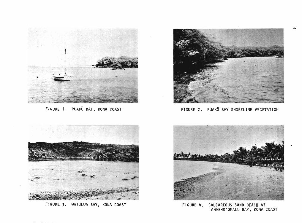
Puako, the northernmost .of the four bays, is a wide bay, some 0.65km
(0.4 mile) at its mouth (Fig. 1). Prehistoric lava flows define the north
ern and southern termini. In the north the flow is of aa, rough and cliff
like; on the south it is of pahoehoe, low and flat and infiltrated with
tidepools. 'The central section is comprised largely of terrigenous sedimen
tary beach interspersed with boulders and rubble. The beach is overhung
with kiawe, Prosopis pallida, the lower branches of which brush the surface
of the water at low tide (Fig. 2). The hinterland is dry and dusty, covered
with a secondary scrub vegetation of koa-haole, Leucaena glauca, and other
exotics. Groundwater seepage is apparent only in the southern section of
the bay where swamp-like ponds occur back of the beach and intrude into the
seaward tidepools.
The shallow, shoreward sections of the bay itself, at depths of about
1 m,are characterized by a substrate of basalt, rubble, and mixed terrige
nous sediments. In the outer bay, at depths of about 3 m, the northern part
is characterized by a series of coral-covered ridges running perpendicular
to shore; in the southern section the near-shore basaltic shelf slopes grad
ually to depths of about 9 m and coral cover is primarily of thickets of
Porites compressa.
Waiulua Bay
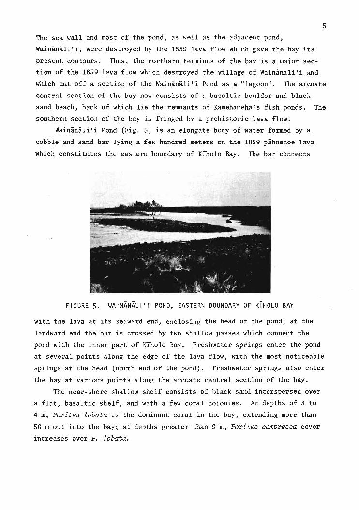
Waiulua Bay is the smallest of the four bays under study, consisting of
a shallow embayment about 0.12 km at its mouth. The shoreline consists of
the basalt of a prehistoric lava flow and is continuous seaward as a tidal
flat with a pebble and cobble floor (Fig. 3). A boulder ramp separates the
inner section from an offshore section. Beyond the rubble bar the shelf is
studded with heads of the coral Pocillopora meandrina. Both inner and outer
sections of the bay are shallow, with an average depth of about 1 m. Ground-

3
water intrusions are an especially noticeable feature of the bay, with
springs gushing from crevices along the length of the shoreline.
'Anaeho'omalu Bay
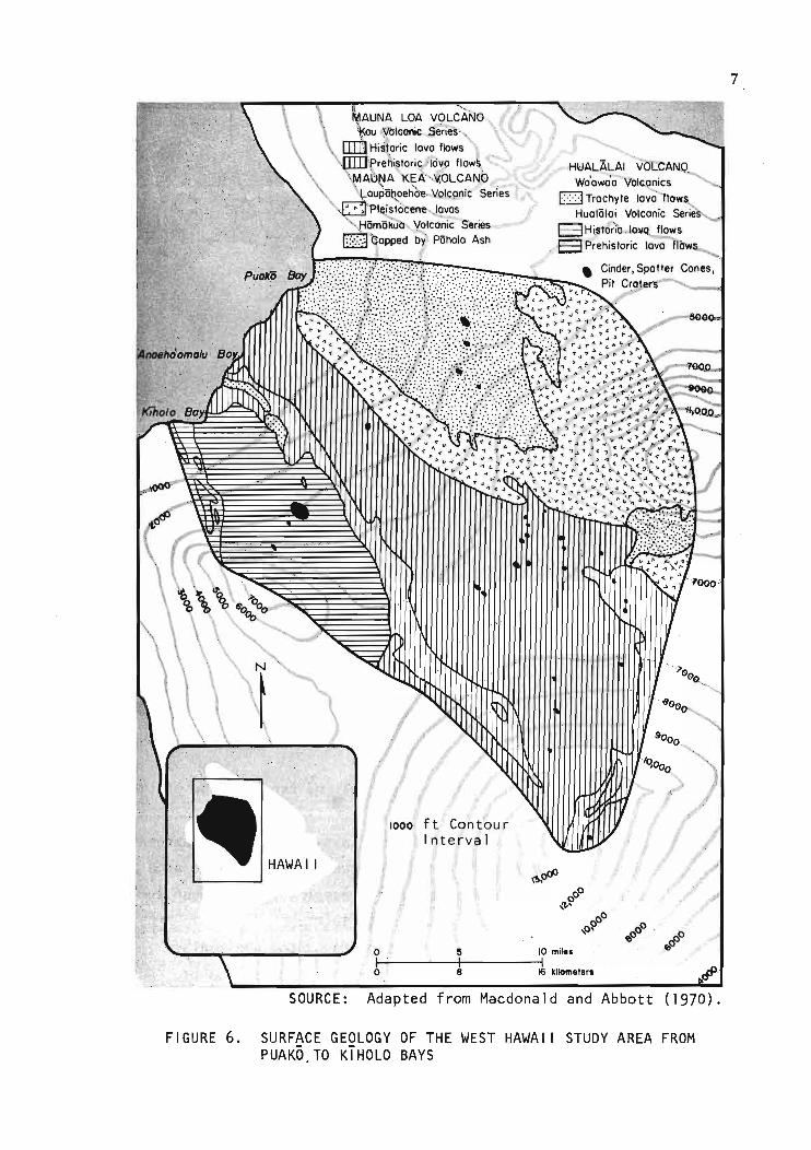
'Anaeho'omalu is one of the few areas along the coastline of Hawaii
Island with a calcareous sand beach (Fig. 4). The shoreline, like that at
Puako, is defined at the north and south by prehistoric lava flows. On the
north the Kaniku flow is composed of brittle, aa clinkers, and, where it
meets the sea, there are numerous tidepools. Shoreward the northern termi
nus is fringed by a margin of calcareous sand and a barrier of native ma
rine vegetation, consisting largely of Scaevola sericea Vahl (beach naupaka)
and Messerschmidia argentea. The hinterland back of the marine vegetation
is studded with the largest single concentration on the Kona Coast of an
chialine ponds, unique limnetic ecosystems recently described by Maciolek
(1974). The seaward basaltic bench slopes towards sea level to the east
and merges with the central calcareous beach. The crescent-shaped beach,
some 0.32 km in length, has a steep foreslope and a well-developed berm.
Beachrock found at the present beach line indicates the presence of an an
cient beach. Shoreward the sand is fortified by coconut trees. The south
ern boundary of the bay is formed by a low, smooth, pahoehoe flow.
Three fish ponds are associated with 'Anaeho'omalu Bay: two large
ponds, Ku'uali'i and Kahapapa, and a smaller pond, Kuali'i. The ponds were
partically demolished by the tsunamis of 1946 and 1960 (Kikuchi and Belshe
1970) but are still recognizable as significant bodies of brackish water.
Ku'uali'i Fishpond communicates with the bay by the makaha (sluice gate)
which protrudes between the Kaniku flow and the calcareous beach.
The floor of the bay is covered by white sand for distances of 30 to 50
m offshore, at depths of 3 to 4 m. Inshore the bay floor is studded with
large colonies of the coral, Porites lobata; 20 m offshore, at depths of 3
to 4 m, the bottom topography is a flat, basaltic shelf covered) with a lime
stone veneer.
Klholo Bay and Wainanali'i Pond
In 1823, William Ellis described Kiholo:
A small bay, perhaps half a mile across, runs inland a considerabledistance. From one end to the other of this bay, Tamehameha builta strong stone wall, six feet high in some places, and twenty feetwide, by which he had an excellent fishpond, not less than two milesin circumference.
FIGU
RE1.
PUAK
OBA
Y,KO
NACO
AST
FIGU
RE3.
WAI
ULUA
BAY,
KONA
COAS
T
FIGU
RE2.
PUAK
OBA
YSH
OREL
INE
VEGE
TATI
ON
FIGU
RE4.
CALC
AREO
USSA
NDBE
ACH
AT'A
NAEH
O·OM
ALU
BAY,
KONA
COAS
T
~
5
The sea wall and most of the pond~ as well as the adjacent pond~
Wainanali'i~ were destroyed by the 1859 lava flow which gave the bay its
present contours. Thus~ the northern terminus of the bay is a major sec
tion of the 1859 lava flow which destroyed the village of Wainanali'i and
which cut off a section of the Wainanali'i Pond as a "lagoon". The arcuate
central section of the bay now consists of a basaltic boulder and black
sand beach~ back of which lie the remnants of Kamehameha's fish ponds. The
southern section of the bay is fringed by a prehistoric lava flow.
Wainanali'i Pond (Fig. 5) is an elongate body of water formed by a
cobble and sand bar lying a few hundred meters on the 1859 pahoehoe lava
which constitutes the eastern boundary of Kiholo Bay. The bar connects
FIGURE 5. WAINANALI ' I POND, EASTERN BOUNDARY OF KIHOLO BAY
with the lava at its seaward end, enclosing the head of the pond; at the
landward end the bar is crossed by two shallow passes which connect the
pond with the inner part of Kiholo Bay. Freshwater springs enter the pond
at several points along the edge of the lava flow, with the most noticeable
springs at the head (north end of the pond). Freshwater springs also enter
the bay at various points along the arcuate central section of the bay.
The near-shore shallow shelf consists of black sand interspersed over
a flat~ basaltic shelf, and with a few coral colonies. At depths of 3 to
4 m, Porites lobata is the dominant coral in the bay, extending more than
50 m out into the bay; at depths greater than 9 m, Porites aompressa cover
increases over P. lobata.

6
Local Geologyl
The study area is underlain by lava flows from Mauna Kea, Mauna Loa, and
Hualalai. The flows are predominantly aa with some pahoehoe. The rocks are
almost completely basaltic with small areas of ash and trachyte. A map of
the surface geology of the study area is presented in Figure 6; for hydrolog
ic purposes, the study area extended to the summits of the three volcanoes.
The soil cover of the study area in the gulches, and where it occurs else
where, is generally very thin. For the most part, soil cover is practically
nonexistent.
The northern part of the study area is covered by flank flows from Mauna
Kea. The lavas of Mauna Kea are of two series: the older Hamakuavolcanic
series (capped by Pahala ash) in the north, and the younger Laupahoehoe vol
canic series in the south. The lavas of the Hamakua volcanic series, capped
by Pahala ash, are generally moderately to highly porous and permeable, and
freely yield water to wells. A narrow strip, about 3 kID (2 miles) wide, of
the Pleistocene lavas of the Laupahoehoe volcanic series, extends to within
2 kID (1.5 miles) of the coast. The lavas of the Laupahoehoe volcanic series,
extends to within 2 km (1.5 miles) of the coast. The lavas of the Laupahoehoe
volcanic series are poorly to moderately permeable and not as permeable as
the rocks of the Hamakua volcanic series, but because of their limited thick
ness and areal extent, their effect on groundwater is probably small. The
Hamakua volcanic series is covered by Pahala ash which is generally less per
meable than the lavas, but not sufficiently impermeable to produce perched
water.
South of the Mauna Kea flows are the historic and prehistoric lavas of
the Ka'u volcanic series, the yourigest lavas from Mauna Loa, which are highly
permeable, and small areas of pumice cones and trachyte lava flows which are
of minimal consequence to groundwater in this study. (A detailed geologic
description of the entire area can be found in Stearns and Macdonald (1946).
Geological controls on the seaward discharge of groundwater in the
study area are poorly known. The extension of the northeast rift of Huala
lai, which might conceivably act to channel flow into the basal groundwater
lens, was interpreted as line H in Figure 7 from data of an audiomagnetotel
luric (AMT) survey and an aeromagnetic survey (Adams et al. 1969). The
lL. Stephen Lau, Project Associate Investigator.
7
Adapted from Macdonald and Abbott ( 1970) .
1000, f t Co'n t'ou r'Interval
o 5 ~~~1-1---"---+1------11o 8 16 kilometer.
SOURCE:
FIGURE 6. SURFACE GEOLOGY OF THE WEST HAWAI I STUDY AREA FROMPUAKO,TO KIHOLO BAYS

8
N
1KAWAIHAE
BAY
-Hualalai
mil..o !I 10bl------+l---~
kilom".t.,.
FIGURE 7. MAJOR STRUCTURAL FEATURES INDICATED BY AUDIOMAGNETOTELLURIC AND AEROMAGNETIC DATA
higher, apparent resistivities occurring in the area north of line X as de
tected by the same AMT survey were attributed to the higher resistivity of
the Mauna Kea lava or to a higher water table depressing the salt-brackish
interface. It was interpreted that the rlft zones, defined by the lines H
and X, probably have 'low permeability and, therefore, funnel the basal water
into a swath between Hapuna and 'Anaeho'omalu bays. Electrical resistivity
profiles made from Puako to 'Anaeho'omalu bays narrowed anomalous apparent
resistivity to the line segments Q and R in Figure 8. However, no extensive
discharge of fresh water has been reported.
The AMT and aeromagnetic data agreed well on the position of the two
anomalies given as lines Jand K in Figure 7. Line K is the known north
west rift of Hualalai and line J is without apparent surface expression.
These two lines diverge from the possible groundwater recharge area of the
Hualalai summit. The structural controls of basal water movement are there
fore probably not significant (Adams et al. 1969).
Dikes could occur within rift zones of Mauna Loa and Hualalai, impound
ing groundwater to levels above those of the basal water bodies. No dike
outcrops or dike rock in the study areas have been observed or previously
reported; however, they could occur deep below the surface.

9
FIGURE 8. TWO LINES, P AND R, CORRESPONDING TO THE RELATIVELYHIGH APPARENT RESISTIVITYANOMALIES, ARE SHOWN FOR THEHAPUNA-PUAKO BAY AREAS.POINTS Q AND Y ARE CONSIDERED TO BE REPRESENTATIVESITES FOR LINES P AND R,RESPECTIVELY. (AFTER ADAMSET AL. 1969)
.-
01110
kilo....' ...
/
//
/./
WAIKOLOA
'ANAEHO'OMALU
---
oJ I
//
//
//
//
II
II LALAMILO
OULI
/___ I
/POINT Q /
/./
//
ILINE /
R II
//
//
//
/-,IIII
KAWAIHAE

11HYDROLOGyl
Climate
The study area is characterized by low rainfall, high to moderately
high evaporation, high temperature, and at times strong winds. A few storms
occur during the winter months bringing about areally-wide rainfall that may
account for most of the annual rainfall.
In general hydrologic data are extremely scarce and, therefore, the
totals and distributions of the hydrologic variables are difficult to de
fine. The inadequacy of data necessitated the installation of evaporation
pan stations to estimate potential water loss through evaporation and trans
piration before a water budget could be constructed. This, in general,
posed severe limitations on the degree of desired accuracy.
RAINFALL. Rainfall accounts for virtually all the precipitation for
the study area, although snow falls on the summits of Mauna Loa and Mauna
Ke'a during the winter months.
The mean annual rainfall for the area is 63 cm (21 in.) with a range
from about 102 cm (40 in.) in the uplands to less than 25 cm (10 in.) in the
coastal plains (Fig. 9). There is a gradual increase in rainfall with ele
vation to a maximum of 51 to 76 cm (20 to 30 in.) on the northern slopes of
Mauna Loa.
Rainfall controls are the high mountains of Mauna Ke'a and Mauna Loa,
both rising above 3,962 m (13,000 ft), and an atmospheric inversion generally
prevails at an elevation between 1,290 to 1,829 m (4,000 to 6,000 ft) with
high humidity below the inversion level and drier conditions above. Thus,
the tradewinds coming generally from an east-northeasterly direction are
effectively blocked and trapped and unable to reach the study area. There
is, however, some spillage of orographic rainfall over the plateau or saddle
area between the mountains, thus recharging the groundwater in the Waimea
area, which is located to the north of the study area. Still another area,
but of lesser importance, is the general area of P5hakuloa, located between
Mauna Ke'a and Mauna Loa. In both cases, the isohyetal patterns quite evi
dently reflect the effects of deflection and diversion around the mountain
passes. The sea breeze phenomenon which brings considerable rain to Kailua-
lL. Stephen Lau, Project Associate Investigator.

12
FIGURE 9. MEAN ANNUAL RAINFALL, KONA COAST

13
Kona, which is just south of the study area, is effective only in raising
humidity rather than in increasing rain.
The average monthly rainfall at the coastline of the study area, such
as Puako, reaches a low of approximately 0.6 em (0.25 in.) in June, July,
and August and a high of no more than 5 cm (2 in.) in January.
For the purpose of this study, it is essential to recognize that the
major groundwater recharge is due primarily to winter storms which bring
about moderate to high intensity rain over a large area in a period of a few
hours. Thus, screening of the already few rainfall stations with daily
rainfall records narrowed down to only 6 stations which were selected for
water budgeting in this study. Table 1 shows the average monthly and annual
rainfalls for the four individual years.
TABLE 1. AVERAGE MONTHLY AND ANNUAL RAINFALL FOR SIX STATIONS1952,1955,1958,1961
Station Name and Number
PuakoKe I amukuKamuela Pu I U Pu I uAnahulu Wa1awa'a
92. 1 192.2 96. 1 95. 1 93. 1 94. 1
Hu'ehu'e
Average MonthlyJanuaryFebruaryMarchApri 1MayJuneJulyAugustSeptemberOctoberNovemberDecember
Average Annual
---------------------------(in.)--------------------------3.51 4.11 2.52 2.25 1.62 2.402.74 3.96 1.57 0.27 2.51 2.254. 14 2.86 3.34 1. 19 2.91 3.902.78 2.81 1.34 0.11 1.62 1.463.67 1.92 0.92 O. 17 0.93 1. 195.84 1.78 0.71 0.38 1.84 2.281.55 3.62 1.08 0.79 1.96 2.001.56 3.01 0.74 0.15 0.40 0.863.54 0.64 0.50 0.41 1.45 1.211.48 1.96 0.58 0.47 0.81 1.653.12 2.67 2.59 0.63 1.99 1.622.90 2.40 1.66 0.91 1.09 1.36
36.83 32.06 17.53 7.71 19.12 22.19
NOTE: in. x 2.54 = em.
EVAPORATION. Evaporation data from which potential evapotranspiration
may be estimated for water budgeting is almost nonexistent for the study
area. The closest evaporation station, La1ami10 (191.4), is 1coated outside
the study area and is, at best, an approximation of the mid-elevation sec
tion. Transposition of data from other dry leeward regions from other is
lands, such as Lahaina, Maui, was considered a poor approximation because of
the possible evaporation-suppressing effect of the sea breeze known to be
effective in the area. It was finally decided to install temporary, simple

14
wash tub-type .evaporation pans at two locations within the study area to
obtain short-term records for both the winter months of 1975 to 1976 and the
summer months of 1976. The monthly averages are respectively 0.46 cm/day
(0.18 in./day) and 0.91 em/day (0.36 in./day), reflecting a distinct seasonal
variation.
TEMPERATURE AND WIND. The study area is characteristically sunny, dry,
and frequently windy. The mean temperature ranges from about 24°C (76°F)
near the shoreline to below 10°C (50°F) on the mountain summits (Fig. 10).
Wind data are scarce. During the course of evaporation measurements, there
were four consecutive days (23 to 26 March 1976) with average wind velocities
from 56 to 88 km/hr (35 to 55 mph).
Surface Water Drainage
There are no perennial streams in the study area. In the upland areas,
the natural drainage net is slightly developed as represented by a number of
gulches, the most extensive being 'Auwa~akeakua in Waikoloa (Fig. 11). None
of these intermittent stream gulches reaches the ocean; 'Auwaiakeakua Gulch
terminates about 2 km (1 mile) landward from Puako. There are no intermit
tent streams in Pu'uwa'awa'a, the area south of 'Anaeho'omalu because of re
cent lava flow cover (lava flow of 1859). Streamflow discharge data are
nonexistent for the study area.
Because of the highly porous and permeable surface, the absence of less
permeable materials, such as soil, and the low rainfall for the study area,
much of the remaining water is lost to infil tration and becomes unavailable to
surface runoff. However, the upper reaches of gulches carried discharge
during periods of infrequent, intense storms recorded at two gage stations
located at about the 762-m (2,500-ft) elevation level west of Mamalahoa
Highway (Hwy. 19) on the eastern slopes of Mauna Loa. Because of the sur
ficial geology, stream hydrology, and lack of direct streamflow discharge
into the ocean, surface water drainage will not constitute a part of the
water budget study.
Land Use and Water Development
For the most part, the land remains in a near natural state, i.e., arid
lava land. Cattle ranches, notably Parker and Pu'uwa'awa'a, represent most
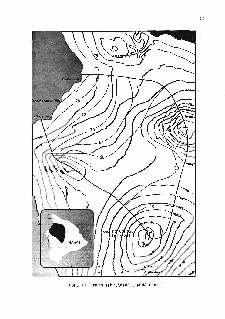
FIGURE 10. MEAN TEMPERATURE, KONA COAST
15

16
'<\""fi'P
~1
00
.... :
#~.
00
t·
,o~
!l
'/PcP
I'10 miles
0°
FIGURE
8I
fDO
11. STREAM-GAGE
16 kilom.'.,.
STATI ONS
#
, KONA COAST

17
of the present land use. The only major urban land use plan now being slowly
implemented is Waikoloa, a hotel-urban residential development complex con
trolled by Boise Cascade. At present, the development consists of a golf
course-recreational center, less than 100 houses, many miles of wide highway,
and the basic utilities for urban subdivision. A new state highway, Kaahu
manu Highway, completed and opened to public use in 1976 skirts the coast
line.
For water supply, there are three drilled wells operated by Waikoloa:
Parker Wells 4 and 5 (7 km [4.6 miles] from the coast; 365-m [1,200-ft] ap
proximate elevation), and Parker WeIll (6 km [4 miles] from the coast, 260
m [850-ft] approximate elevation). Contrary to all water wells in the Kawa
ihae and South Kohala areas, Parker Wells 4 and 5 produce fresh water of ex
ceptional quality. Parker WeIll water is expectedly brackish with a chlo
ride concentration of about 500 mg/~. Farther south is Pu'u Wa'awa'a Well
(5 kID [2.8 miles] from the coast; 275-m [900-ft] approximate elevation), the
only other producing well in the area with a chloride concentration of about
300 mg/~. Pumpage averaged 1,022 m3 /day (0.27 mgd) from Parker Wells 4 and
5 for the calendar year 1975, and 2,839 m3/day (0.75 mgd) from Parker WeIll
for the first 6-mo. period of 1976. Pu'u Wa'awa'a Well pumpage is unknown
but is believed to be af small quantity. Domestic waste water effluent from
the Waikoloa development is discharged into an injection well.
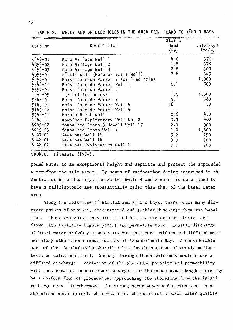
These water wells and a number of drilled holes in the study area to
gether with wells outside the study area are listed in Table 2 and located
in Figure 12.
Groundwater
The known groundwater occurrence in the study area is, for the most
part, a thin basal lens with the water level located generally only a few
feet above the sea level and with a slightly sloping water table toward the
ocean. The gradient is not determined except for the Kawaihae-Puako area
(Fig. 13) which is 0.24 km/ha (1.3 ft/mile). The lens water is slightly
brackish with increasing salinity towards the ocean.
The only exceptions to the low water level and the brackish water qual
ity are Parker Wells 4 and 5 which had a reported high water level of 5 m
(16 ft) and a low chloride concentration of less than 30 mg/~. This high
head, low-chloride anomaly is probably caused by subsurface dikes that im-
18
TABLE 2. WELLS AND DR ILLED HOLES IN THE AREA FROM PUAKO TO KTHOLO BAYS
StaticUSGS No. Description Head Chlorides
(ft) (mg/R.)
4858-01 Kona ViII age Well 1 4.0 3704858-02 Kona Village We 11 2 1.8 3784858-03 Kona Village Well 3 2.8 3004953-01 K'ihol0 We 11 (Pu'u Wa1awa'a Well ) 2.6 3455452-01 Boise Cascade Parker 7 (d r illed ho 1e) 1,0005548-01 Boise Cascade Parker Well 1 6. 1 5005552-01 Boise Cascade Parker 6to -05 (5 drilled holes) 1.5 1,500
5648-01 Boise Cascade Parker 2 5. 1 3805745-01 Boise Cascade Parker We 11 5 16 305745-02 Boise Cascade Parker Well 45948-01 Hapuna Beach Well 2.6 4306048-01 Kawaihae Exploratory Well No. 2 3.3 5006049-02 Mauna Kea Beach 3 Hawaii Well 17 2.0 9006049-03 Mauna Kea Beach Well 4 1.0 1,6006147-01 Kawa i hae We 11 16 5.2 2506148-01 Kawa i hae We 11 14 3.3 3006148-02 Kawaihae Exploratory We 11 1 3.3 300
SOURCE: Miyasato (1974) .
pound water to an exceptional height and separate and protect the impounded
water from the salt water. By means of radiocarbon dating described in the
section on Water Quality, the Parker Wells 4 and 5 water is determined to
have a radioisotopic age substantially older than that of the basal water
area.
Along the coastline of Waiulua and Kiholo bays, there occur many dis
crete points of visible, concentrated and gushing discharge from the basal
lens. These two coastlines are formed by historic or prehistoric lava
flows with typically highly porous and permeable rock. Coastal discharge
of basal water probably also occurs but in a more uniform and diffused man
ner along other shorelines, such as at 'Anaeho'omalu Bay. A considerable
part of the 'Anaeho'omalu shoreline is a beach composed of mostly medium
textured calcareous sand. Seepage through these sediments would cause a
diffused discharge. Variation of the shoreline porosity and permeability
will thus create a nonuniform discharge into the ocean even though there may
be a uniform flux of groundwater approaching the shoreline from the inland
recharge area. Furthermore, .the strong ocean waves and currents at open
shorelines would quickly obliterate any characteristic basal water quality

19
FIGURE 12. WATER SAMPLING STATIONS AND DRILLED WELLS, WESTHAWAI I STUDY AREA

20
FIGURE 13. GROUNDWATER GRADIENT. KAWAIHAE TO PUAKO AREA

21
parameters, such as low salinity and low temperature, in the coastal water.
In contrast, at both Waiulua and Kiholo bays, the basal water from these
visible concentrated spring discharge points drains into a partially en
closed embayment, rather than into open coastal waters. The discharged wa
ter floats on top of the coastal water and forms a persistent layer of water
of low salinity and low temperature, varying in thickness on the order of a
few inches and in areal extent. These were the only coastal waters in the
study area exhibiting such easily observable and measurable phenomena. A
detailed hydrographic and water quality description of the Wainanali'i Pond
at Kiholo is given in a later section.
Water Quality
Samples of groundwater. near-shore pond water, and coastal water were
collected from a net work of 11 regular sampling stations and a few selected
locations from October 1974 to October 1975. The water quality parameters
analyzed include nitrogen (total, ammonia, organic, nitrite and nitrate),
phosphorus (total, soluble), chemical oxygen demand, bacterial indicators
(total coliform, fecal coliform, and fecal streptococcus), chloride, elec
trical conductivity, turbidity, and solids (total, volatile. suspended, vol
atile, suspended, volatile suspended). Several groundwater samples were
assayed for tritium, radiocarbon, and 13C. Table 3 presents the mean and
range of the chemical parameters. The complete data are included in Appen
dix Table A.l.
CHLORIDE. The average chloride concentration in the basal water was in
the slightly brackish range (501 mg/~ at Parker WeIll) with an annual vari
ation of t50 mg/~ for a distance as far as 6 km (4 miles) inland from the
coastline. In the south at Pu'u Wa'awa'a Well, the average chloride concen
tration was slightly brackish and fresher (322 mg/~) than the Parker WeIll,
even though the Pu'u Wa'awa'a Well is closer (5 km or 2.8 miles) to the
coastline. This difference may be due to the higher rain water recharge in
the south although the pumping differential could mask the natural differen
tial.
The average chloride concentration increased seaward as expected as
greater tidal effects were felt. The average chloride concentration was
1,662 mg/~ in a shoreline pond 0.2 km (0.1 mile) from Waiulua Bay and 1,066
mg/~ in a lava tube less than 0.2 km from the shoreline at Klholo Bay. The

22
water from the two shoreline springs was more brackish: 2,653 mg/~ at Ku'
uali'i Pond and 2,922 mg/~ at Waiulua Bay. At Wainanali'i Pond at Kiholo
Bay where the sampling point was directly affected by high tides, not only
the average of concentration was high (4,611 mg/~), but also the range of
concentration varied the widest (770 to 9,450 mg/~) among all the sample
locations.
ELECTRICAL CONDUCTIVITY AND TOTAL SOLIDS. The electrical conductivity
data correlated well with the chloride concentration data as expected since
the ocean water was the only significant source in the area for both chloride
and the electrically conductive solutes. The total solids data correlated
well with the electrical conductivity data since the dissolved solids concen
tration expectedly accounted for nearly all of the total solids in the water
samples.
NITROGEN. The average nitrate nitrogen concentration in Parker Wells 4
and 5 water was 1.1 mg/~, satisfying drinking water standards and accounting
for over 90% of the total nitrogen. The highest nitrate nitrogen concentra
tion in the more inland part of the basal was respectively 0.8 mg/~ at Parker
WeIll (6 km or 4 miles from the shoreline) and 0.9 mg/~ at PUll Waawaa Well
(5 km or 2.8 miles). The nitrogen is significantly derived from nitrogen
fixation plants, such as kiawe (Prosopis pallida), which is plentiful and is
known to produce nitrate. No other known source of nitrogen exists in the
area except for the small quantity of sewage treatment effluent. Irrigation
return flow from the Waikoloa Golf Course is discounted as a source because
of the great nitrogen removal capability of the sod-soil system (Lau et al.
1975) and the small quantity of return flow. A small anomaly exists at the
Parker Well 6 where nitrate nitrogen accounts for 66%, rather than the 80% or
or more, of the total nitrogen in all other sampled waters.
The nitrate nitrogen concentration in the basal water decreased seaward
to about 0.6 mg/~ at the Waiulua Pond station and the Klholo lava tube sta
tion near the shoreline. This decrease is mostly accounted for as the effect
of salt water dilution because ocean water has a much lower concentration of
nitrate than the groundwater, and mixing with salt water by tidal effects
becomes greater towards the ocean.
The areal distribution of total phosphorus in the groundwater has a
great similarity with that of nitrogen; however, the concentrations are dif-
I. I
I

TABL
E3.
MEA
NAN
DRA
NGE
OFSE
LECT
EDW
ATER
QUAL
ITY
PARA
MET
ERS,
OCTO
BER
1974
TOOC
TOBE
R19
75
Chl
orid
eE
lec.
Cond
oT
ot.
So
l.Vo
1.S
ol.
Sus
p.S
ol.
VSS
(mg/
t)(ll
mho
s/cm
)--------------------------~(mg/t)---------------------
Mea
nR
ange
Mea
nR
ange
Mea
nR
ange
Mea
nR
ange
Mea
nR
ange
Mea
nR
ange
Par
ker
Wel
l4
2623
-26
110
6-20
116
0-12
123
.90
.6-
1.8
1.8
2548
524
210
.2
Par
ker
Wel
l5
2521
-26
517
7-20
817
0-42
20-
1.4
0.4
-2.
32.
328
455
229
643
.0
Par
ker
Wel
11
501
445-
1,31
846
0-1,
240
1,2
16-
166
163-
4.5
0.8
-8
.40-
550
1,95
01,
264
168
19.0
16.8
Par
ker
Wel
l6*
830
798-
2,21
61,
060-
1,94
41
,906
-29
727
0-47
.01
.0-
4.8
0.4
-85
03,
000
1,99
732
011
8.4
12.1
Pu'
uW
a1aw
a'a
322
310-
1,05
380
0-85
275
8-62
622.
10
.6-
0.4
0.4
350
1,40
094
65
.2
Wai
ulua
Bay
2,92
22,
322-
7,10
34,
450-
5,77
45
,172
-1,
056
970-
3.9
1.0
-2
.52
.5S
prin
gt
3,70
010
,000
6,37
61,
142
6.5
Wai
ulua
Pond
*1,
662
1,62
5-5,
350
5,20
0-3,
582
--66
466
41.
50
.4-
00
1,70
05,
500
2.6
KuIua
1iii
2,65
31,
816-
4,96
74,
000-
5,96
83,
994-
748
748
28.8
2.4
-8
.28
.2S
pri
ng
t3,
949
5,50
07:
542
76
.4
Kih
ol0
Lava
1,06
697
2-2,
690
1,80
0-2,
351
2,24
8-34
232
8-1.
10
.6-
0.3
0.3
Tub
e*1,
160
3,40
02,
502
355
1.8
Wai
nana
li'i
4,61
177
0-15
,950
9,90
0-7,
408
Pond~
9,45
022
,000
Oce
anW
ater
18,1
86--
14,0
00--
36,6
33(O
utsi
deW
aiul
uaB
ay)
.£iliU:~~.....,.-~.""",'!lt4icier.;l~
__
...."'"
"""
_..
....
.1...
..._.=
_....._=
-
N (,;:
I

TABL
E3-
-CO
NTI
NU
ED.
N ~
N02
+N
03-N
To
tal·
NT
otal
PS
ol.
PT
urb
idit
yCO
D----------------------------(mg/~)------------------------
(FTU
)(mg/~)
Mea
nR
ange
Mea
nR
ange
Mea
nR
ange
Mea
nR
ange
Mea
nR
ange
Mea
nR
ange
Par
ker
Wel
l4
1.09
90.
646-
1.16
20.
680-
0.08
90.
080-
0.07
20.
059-
1.4
0.4
-37
.84
.7-
1.51
01.
640
O.11
00.
080
2.9
79.0
Par
ker
Wel
l5
1.08
10.
467-
1.20
00.
487-
0.08
00.
063-
0.06
60.
059-
2.1
0.6
-24
.60
-1.
450
1.63
00.
100
0.08
04
.850
.0
Par
ker
Wel
l1
0.82
40.
547-
0.97
70.
567-
0.10
20.
065-
0.05
70.
040-
4.8
0.4
-65
.20
-0.
980
1.18
20.
190
0.09
016
.017
2.9
Par
ker
Wel
l6*
0.57
80.
396-
0.87
80.
630-
0.10
40.
053-
0.07
10.
050-
30.8
1.3
-7
2.0
0-
.0.6
701.
266
0.12
0O.
110
152
220
Pu'
uW
a1aw
a1a
0.86
70.
810-
0.91
90.
819-
O.11
40.
093-
0.06
20.
031-
0.6
0.2
-44
.00-
0.94
01.
020
0.15
00.
085
1.1
67.0
Wai
ulua
Bay
0.55
80.
480-
0.65
20.
480-
0.05
60.
047-
0.05
10.
038-
1.0
0.9
-64
.92
3.7
-S
prin
gt
0.67
50.
790
0.07
00.
064
1.1
106.
1
Wai
ulua
Pond
*0.
619
0.55
3-0.
724
0.71
1-0.
071
0.04
5-0.
061
0.04
5-1.
11
.0-
45.0
16
.0-
0.68
60.
737
0.09
70.
077
1.2
74.0
KuIua
1iii
0.73
10.
403-
0.86
30.
600-
0.07
70.
063-
0.07
00.
050-
11.2
0.3
-10
9.7
35
.5-
Spr
ing
t1.
274
1.28
70.
088
0.09
028
.020
0.0
Klh
ol0
Lav
a0.
603
0.37
-9-
0.70
40.
460
0.07
40.
050-
0.06
80
.04
0-
0.9
0.7
-56
.S8
.9-
Tub
e*0.
770
0.90
30.
100
0.12
01
.590
.0
Wai
nana
liI
i0.
807
0.64
4-0.
939
0.57
00.
075
·0.0
68
-0.
098
0.04
81
.21
.0-
97.5
97.5
Pond
=f1.
209
1.21
70.
083
0.17
01.
5O
cean
Wat
er*
O.16
0--
0.16
0--
----
----
.-.....
...(O
utsi
deW
aiul
uaB
ay)
*T
ide-
affe
cted
grou
ndw
ater
.tS
hore
lin
esp
rin
g.
=fC
oast
lin
ew
ater
sam
ples
,co
rres
pond
ing
toS
tati
on
X3in
Fig
ure
28.

25
ferent. The highest concentration was present in the more inland part of the
basal water: 0.102 mg/t at Parker WeIll and 0.114 mg/t at Puu Waawaa Well.
The groundwater near the shore had a lower total phosphorous concentration:
0.071 mg/t at Waiulua Pond and 0.074 mg/t at Klholo lava tube. At the shore
line discharge points, the concentration was 0.056 mg/t at Waiulua Spring and
0.077 mg/tat Ku'uali'i Spring. The soluble phosphorus accounts for nearly
all the phosphorus present in the spring water at Waiulua and at Kiholo.
The groundwater discharge into the ocean definitely supplies an impor
tant and sustained source of nitrogen for the near-shore coastal water. For
example, the average concentration at Waiulua Bay spring is over 400% higher
than that in the coastal water. Likewise, a continuous enrichment of phos
phorus in the coastal water takes place in the groundwater discharge since
the average concentration in the groundwater is about 100% higher than that
in the coastal water. However, it is less than obvious whether there is a
discernible enrichment effect on the biota in Waiulua and Kiholo bays where
the concentrated groundwater discharge takes place.
MICROBIOLOGICAL WATER QUALITY. The coliform concentration of the water
examined was low and without indication of fecal contamination. The only
possible exception was the Kiholo lava tube site which showed a moderately
low concentration of fecal coliform and fecal streptococci. These could be
caused by animal wastes.
RADIOISOTOPIC AGE. Tritium was determined for a number of groundwater
samples collected in 1975 by the Water Resources Research Center Environmen
tal Tritium Laboratory. The results listed in Appendix Table A.2 indicate a
uniformly low tritium activity level and an isotopic age of less than 50
years relative to the time since the rain water entered the ground. The re
sults for the basal water were not unexp~cted because of the known low rain
fall in the study area and, thus, the low groundwater recharge. However, the
results do not differentiate the relative age between the basal water (Parker
Well 1, Puu Waawaa Well) and the assumed dike water (Parker·Wells 4 and 5).
Three, 60-gal water samples were subsequently collected in 1976 and
assayed for radiocarbon e4 C) by the same laboratory. The results listed in
Appendix Table 2 have been adjusted for carbon 13 using chemical data ob
tained from supplementary water samples and by criteria develope4 in an Oahu
groundwater study (Hufen 1974). Theoretically speaking, a comprehensive

26
study should be made for arid regions, such as the study area, in order to
check the value of the several constants used in the computation of the ra
diocarbon age; however, the magnitude of work would be far beyond the scope
and the available resources for this study. The average adjusted radiocar
bon age for Parker Well 5 water is about 1,800 years while Parker WeIll
water is of recent age. The age differential is considered great and sup
ports the groundwater impoundment theory for the area. Further, it implies
limited capacity of the impoundment and necessary management measure for the
development of the groundwater from Parker Wells 4 and 5. A prudent measure
would be monitoring the water level and the associated pumpage from the
wells for a number of years to obtain another indication of the impoundment
and to assess the balance between recharge and pumpage.
Water FluxWater flux discharging from the land mass into the ocean is primarily
groundwater flux. The surface water contribution should be negligible. For
the purpose of water budgeting under present water and land use conditions,
the groundwater flux can be approximated by the groundwater recharge. Three
water budgets, each with increasing refinement, have been constructed, yield
ing successively improved estimates of the groundwater recharge. These es
timates were checked independently with two different hydraulics methods.
Direct field measurement of the groundwater flux was not feasible.
WATER BUDGETS. The basic equation of water budgeting is that the
groundwater recharge equals rainfall less evapotranspiration, surface run
off, and n~t extraction. The surface runoff and the net groundwater extrac
tion (pumpage minus return flow) should be negligible for the study area.
The boundary of potential recharge is assumed to coincide with the boundary
of the watershed since the aquifer is phreatic and since there are no known
geologic boundaries that would significantly invalidate the assumption.
For the first budget, the entire watershed was taken as a single unit.
The areal rainfall was taken to be the average of the mean annual rainfall
of the five rainfall stations. All four years of rain record (1952, 1955,
1958, 1961) were selected and utilized because of the concurrence and com
pleteness. Since there was a nearly total lack of evaporation data for the
area, pan evaporation data were transposed from climatically similar areas
of other Hawaiian islands to the study area. "The annual groundwater re~

27
charge was determined to be 7.1915 x 10⁶ m3 (19 bil gal) by the first budget.
This would be equivalent to a basal water flux of 7,526 m3 /day/km (~.2 mgd/
mile) of coastline.
The methodology and data base were improved in several ways for con
structing the second water budget. Daily rainfall data were used and the
watershed was divided into 6 subwatersheds,each encompassing one of the rain
stations and treated separately in water budgeting before totaling the entire
watershed. It was assumed that the daily rainfall that is less than a thresh
old value is held temporarily in a shallow zone below the surface and sub
sequently evaporates. Only the daily rainfall exceeding the threshold value,
after an estimated evapotranspiration is subtracted, is contributory to
groundwater recharge through deep percolation. The threshold value was based
on estimated values of field capacity of the rock and soil. The evapotrans
piration values were transposed from evaporation pan data from climatically
similar areas with due adjustment because of the moderate sea breeze effec
tive in the project area.
The probable value for the annual groundwater recharge for the watershed
based on the second budget was 11.355 x 10⁷ m3 (30 bi1 gal), which is equiva
lent to a basal water flux of 11,760 m3/day/km (5.0 mgd/mile) of coastline.
Probable maximum and minimum values were also obtained based on a range of
value for the assumed budget parameters. These maxima and minima represent
a rather wide range, reflecting uncertainty in the assumed values of the
several parameters.
The improvements made for the third and final water budget included
utilizing daily pan evaporation data, fragmenting the watershed into thou
sands of "cells" (average size 0.195 mile 2) for which the water budget was
made, utilizing a high-speed digital computer, and the SYMAP mapping tech
nique. These improvements enabled computed recharge values for the individ
ual cells. Summation of recharge over time (daily) and space (cells) was
made to obtain annual recharge values for the four-year study period. The
results are summarized in Table 4.
HYDRAULIC METHODS. The two hydraulics methods are different from each
other and from the water budget approach in both methodology and much of the
data base. The first hydraulics method is an approximate application after
Cooper as adopted by Mink (1975). The second hydraulics method is an approx
imate application of Darcy's law.

28
TABLE 4. ANNUAL GROUNDWATER RECHARGE FOR THE WATERSHED
Groundwater RechargeMax. Prob.Min.
Annua 1, mi 1 ga l/yr1952 90,360 59,778 38,1051955 68,4S1 31 , 150 11 ,9021958 62,036 33,041 13 ,8581961 69,634 27,866 11,206
Average Annua 1,mil gal/yr 70, 120 37,959 18,768in. 5.7 3. 1 1.5%of Ann. Rainfall 27.1 14.8 7. 1
Average Annualmgd 192 104 51mgd/mile coastline 11.8 6.4 3.2
NOTE: Bas in, a rea = 711 . l' mil es 2,Coastline length = 16.3 miles,Mean annual rainfall = 21 'in.
Under idealized conditions, where no caprock occurs, seepage from a
basal lens will be uniformly distributed across a strip of near-shore water
whose seaward width, x, depends upon the flux from the lens, hydraulic con
ductivity of the aquifer, X, and the density difference between fresh and
ocean water divided by the density of fresh water, a. The relationship is:
Q=2aXxL
where Q is the freshwater flux for 'specified length of shoreline L. In this
application, it is recognized that the project aquifer is occupied by a
brackish water lens with a zone of transition of water density rather than
a classical freshwater lens with a sharp freshwater-salt water interface.
The computed flux is presented in Table 5.as a function of seepage width and
hydraulic conductivity of the basalt; the selected range of values for these
two parameters is believed to be reasonab~y representative of the field con
ditions.
TABLE 5. COMPUTED BASAL WATER FLUX, METHOD I
Com utedSeepage Width, x
(ft)
1
2
3
Basal Water Flux, mgd/mile of CoastlineHydraulic Conductivity ft da*
1
2.57 5.33 I 7.90, ;,.. I
5. 14 : 10.66 15.80l-----------------~: 7.71 15.99 23.70

29
The second computation method involves the application of Darcy's law
as a first approximation of the seaward basal water flux across a groundwater
contour. At the 1.5-m (5-ft) groundwater contour, the gradient was 0.25 m/km
(1.3 ft/mile). The freshwater thickness could be reasonably assumed to be
that of the Ghyben-Herzberg depth plus the freshwater head (40 • 5 + 5 = 205
ft). Table 6 presents the computed basal water flux as a function of the
hydraulic conductivity.
TABLE 6. COMPUTED BASAL WATER FLUX, METHOD 2
HydraulicConductivity
(ft/day)
1,3002,7004,000
ComputedBasal Water Flux
(mgd/mile of coastline)
2.595.387.96
EVALUATION. The seaward flux of basal water, which is assumed to be
equivalent to the groundwater recharge under the existing condition on a
long-term basis, is determined to range between 27,754 and 7,526 m3/day/km
(11.8 and 3.2 mgd/mile) of coastline with the probable value being 15,052
m3/day/km (6.4 mgd/mile) or 393,640 m3/day (104 mgd) for the whole area.
The probable value is equivalent to 15% of the mean annual rainfall for the
area; this probable value is' supported by a value of 20% reported by the
Hawaii Water Resources Regional Study (1975). This probable value is larger,
but is believed to be more reliable, than those obtained by the first and
second water budgets (5.0 for the second budget and 3.2 for the first bud
get). The flux values, as determined by the two hydraulic methods, fall
within and support the above values· determined by water budgeting.
NUTRIENT FLUXES. The computed value of nitrogen and phosphorus fluxes
is based on the probable groundwater flux and the average concentration of
these water quality parameters present in the groundwater at sufficiently
inland locations. These values presented in Table 7, are intended to repre
sent the nutrient fluxes that are terrigenous with minimum dilution effects
by the transition zone water.

30
TABLE 7. NITROGEN AND PHOSPHORUS FLUXES
Average FluxFlux C • 1oncentratlon lb/day/mile Ib/day2
(mg/R.)
Total Nitrogen 0.948 45.24 737Nitrate + Nitrite Nitrogen 0.840 40.08 653Total Phosphorus 0.108 5.15 84
Soluble Phosphorus 0.060 2.86 47
SOURCE: B.Y. Kanehiro (1977, Tech. Rep. No. 110).lAverage of Parker Well I and Puu Waawaa Well.2leng th of coastal line = 16.3 miles.
References
Adams, W.M.; Peterson, F.L.; Mathur, S.P.; Lepley, L.K.; Warren, C.; and
Huber, R.D. 1969. A hydPogeophysiaal suwey from KC11J)aihae to Kailua,
Kona, HC11J)aii. Tech. Rep. No. 32, Water Resources Research Center, Uni
versity of Hawaii.
Division of Water and Land Development. 1970. An inventory of basia water
resouraes data: Island of HC11J)aii. Rep. R34, Department of Land and
Natural Resources, State of Hawaii.
Hufen, T.H. 1974. "A geohydrologic investigation of Honolulu's basal
waters based on isotopic and chemical analyses of water samples." Ph.D.
dissertation, University of Hawaii.
Kanehiro, B. 1974. "A compilation of hydrogeologic information of the
Kiholo to Puako area, Island of Hawaii."
Lau et al. 1975. ReayaZing of sewage effluent by irrigation: A field
study on Oahu, final progress report for August 197Z to June 1975. Tech.
Rep. No. 94, Water Resources Research Center, University of Hawaii.
Macdonald, G.A. 1953. Chrono-volcanological data for the Hawaiian Islands.
BuUetin Volaanologique, Sere II, Tome 13.
, and Abbott, A. 1970. Petrology of the island of Hawaii. In Geo
---7Zo-g-iaal Survey researah 1949, Professional Paper 2l4-D, U.S. Geological
Survey. Washington, D.C.: U.S. Government Printing Office.
Maciolek, J.A., and Brock, R.E. 1974. Aquatia suwey of the Kona Coast
ponds, HC11J)aii Island. UNIHI-SEAGRANT-AR-74-04 Advisory Report, Sea Grant,
University of Hawaii.
Mink, J.F. 1976. Groundwater resou,r>aes of Guam: Oaaurrenae and develop
ment. Tech. Rep. No.1, Water Resources Research Center, University of
Guam.
Miyasato, C. 1974. "A summary of data pertaining to the availability and
quality of ground water for the Puako to Kiholo area on the northwest
coast of the island of Hawaii." Unpublished report.
Stearns, H.T., and Macdonald, G.A. 1946. Geology and ground-water re
souraes of the island of Hawaii. Bull. 9, Hawaii Division of Hydrography,
Territory of Hawaii, in cooperation with the U.S. Geological Survey.

APPE
NDIX
TABL
EA
.1.
WAT
ERQU
ALIT
YDA
TAFO
RSO
UTH
KOHA
LACO
ASTA
LAR
EA,
OCTO
BER
1974
-OC
TOBE
R19
75Sa~plin9
Sta
tio
nT
otal
Vol
.Su
sp.
Ele
c.T
otal
HH
.-HH0
3+
Tot
alS
ol.
Tot
alFe
cal
Feca
lD
ate
Sol
ids
Sol
ids
Soli
dsVS
ST
urb.
Cond
oH
Org
.H
HO
z-N
PP
Cl-
COO
CoI
l.C
oli.
Str
ep.
----
----
---(
mg
/l)-
----
----
--FT
U\.l
lllho
s/cm
----
----
----
----
----
(mg/
1)--
----
----
----
----
_·--
--(n
o./lo
o..1
)---
-P
arke
rW
eII
IO
ct7"
1216
168
0.8
NO<I
1680
1.18
20.
289
0.89
30.
038
0.03
849
6.0
NO--
<3Fe
b75
1241
163
19.0
16.8
16.0
011
800.
810
0.01
00.
800
0.13
00.
060
503.
087
.123
(Mar
)<3
<3H
ay75
1264
---0.
4--
0.15
460
1.18
00.
200
0.98
00.
090
0.09
055
0.0
50.0
<3<3
<3Ju
l75
-----
I."--
6.50
--1.
150
0.25
00.
900
0.19
00.
040
510.
017
2.9
"3--
AOJ9
75--
--->
1.0
--0.
4019
500.
567
0.02
00.
5"7
0.06
50.
059
445.
016
.0--
<3O
ct75
-----
-----
-----
------
------
-----
9<3
<)
Pu
ker
Wel
l4
Feb
7524
212
1.8
1.8
1.80
192
0.90
00.
000
0.90
00.
070
0.07
027
.079
.0<3
(Mar
)<3
<3lla
y75
160
---0
.6--
0.39
106
1."3
00.
090
1.3"
00.
110
0.08
028
.030
.0<3
<3<3
Jul
75--
---10
.2--
0.43
--1.
640
0.13
01.
510
0.08
00.
080
23.0
37.6
4<3
Aug
75--
---3
.0--
2.90
485
0.68
00.
03"
0.64
60.
095
0.05
925
.04
.7--
--O
ct75
-----
-----
----
------
------
------
--<3
<3<3
Par
ker
WeI
I5
Oct
7"22
46"
3.0
--<I
240
1.58
70.
387
1.20
00.
076
0.05
824
.1NO
----
--Fe
b75
229
202.
32.
3".
80
177
0.99
00.
000
0.99
00.
080
0.07
025
.5"0
.0<
3(K
ar)
<3<3
Hay
7517
0---
D."
--0.
870
188
1.31
00.
010
1.30
00.
100
0.08
028
.050
.093
<3<
)Ju
l75
--'---
1.0
--0.
56--
1.63
00.
180
1."5
021
.030
.1>2
"000
<3Au
g75
-----
0.4
--3.
1045
50.
487
0.02
00.
467
0.06
30.
059
26.0
2.96
----
Oct
75--
------
----
-----
------
------
-----
"<3
<3P
arke
rOH
*6,
N-2
Oct
7419
2"30
09
.61.
85.
2030
000.
895
0.31
30.
582
0.05
30.
052
833.
862
."P~rker
OH*
6,
H-4
Oct
7419
4832
018
.20.
42.
6026
400.
972
0.42
90.
5"3
0.06
00.
053
813.
9NO
Par
ker
OH*
6,
N-3
Feb
7519
9727
011
8.4
12.1
152
1630
0.63
00.
000
0.63
00.
1,50
0.07
083
2.0
83.2
<3(M
ar)
<3<3
Hay
7519
06---
115.
4--
2210
600.
650
0.00
00.
650
0.12
00.
090
798.
022
0.0
"<3
<3Ju
l75
-----
19.6
--1.
30--
0.86
00.
190
0.67
00.
120
0.11
085
0.0
60.2
<3<
)
Au'.!
75--
---1
.0--
1.60
2750
1.26
60.
870
0.39
60.
120
0.05
085
0.0
5.9
----
Oct
75--
------
----
-----
------
------
-----
"<3
<3P
ar.e
rOH
*7
O.:t
7"---
379.
8--
--18
101.
260
0.88
60.
37"
0.15
00.
031
521.
1NO
--Pu
uwaa
waa
lieII
Har
7594
662
5.2
0.4
0.60
960
0.98
00.
140
0.8"
031
0.0
67.0
<3<3
<3H
.lY75
758
---0
.6--
0.18
800
0.86
00.
020
0.8"
00.
100
0.07
035
0.0
60.0
9<)
<3Ju
lIS
-----
1.6
--1.
10--
1.02
00.
080
0.9"
032
0.0
"8.9
350
<3A
ug75
-----
>1.
0--
0.70
1400
0.81
90.
009
0.81
00.
093
0.08
531
0.0
NO--
--O
ct75
-----
-----
----
------
------
---_e
.--
<3<3
<3K
uual
l'j
Spr
ing
Oct
7"39
9"7"
832
.68
.215
.00
5"00
0.73
70.
334
0."0
30.
063
0.05
818
16.0
93.6
--H
ar75
-----
-----
----
------
------
------
--23
(Mar
)<
)<3
Hol
Y75
79"2
---2.
4--
0.27
"000
0.60
00.
020
0.58
00.
080
0.05
039
"9.0
200.
023
<3<3
Jul
75--
---4
.0--
1.50
--0.
830
0.16
00.
670
---0.
090
2650
.0--
9<3
Aug
75--
---76
.4--
28.0
055
001.
287
0.01
31.
27"
0.08
80.
080
2200
.035
.5--
--O
ct75
-----
-----
----
------
------
------
--<3
<3<3
Wai
nal
i'j
lago
onO
ct74
7"08
---9.
2--
<I99
001.
030
0.38
60.
644
0.06
80.
048
3615
.997
.5--
Jul
75--
---6.
6--
1.20
--0.
570
0.00
00.
570
---0.
170
770.
0--
140
<3.
Aug
75--
---1.
8--
1.5
2200
0I.
217
0.00
81.
209
0.08
30.
077
9"50
.0--
K;h
olo
lava
Tube
Oct
7"22
"832
81.
8NO
<I33
"00.
903
0.23
60.
667
0.05
50.
055
972.
780
.7Fe
h75
2502
355
0.6
0.6
0.80
2220
0.46
00.
000
0.46
00.
050
0.0"
011
60.0
35.6
2"0(
Har
)"
6H
ay75
230"
---0
.6--
0.7"
1800
0..
"90
0.05
00.
7"0
0.10
00.
060
1100
.090
.015
0<3
"Ju
l75
-----
I."
--I.
50--
0.89
00.
120
0.77
0---
0.12
010
50.0
67.7
2"00
<3A
ug75
-----
>1.
0--
0.70
3"00
0."7
80.
099
0.37
90.
092
0.06
"10
50.0
8.9
----
Oct
75--
---_e.
----
-----
------
------
-----
400
2315
0W
aiul
uaBa
yS
prin
gO
ct7"
5172
970
".2
--<I
6860
0.79
00.
269
0.52
10.
0"7
0.03
823
22.7
106.
1..
Feb
756)
7611
"26
.52.
51.
10"4
500.
480
0.00
00.
480
0.05
00.
050
274"
.0--
Aug
75--
--->
1.0
--0.
9010
000
0.68
70.
012
0.67
50.
070
0.06
437
00.0
23.7
Wai
ulua
Pond
Oct
7"35
8266
"2
.6NO
<I52
000.
737
0.18
"0.
553
0.04
50.
045
1625
.87
".0
"A
ug75
-----
D."
--1.
2055
000.
711
0.02
50.
686
0.09
70.
077
1700
.016
.0O
c""n
Wat
ero
fflI
alul
uaBa
yFe
b75
3663
3""
4527
.61.
2".
60
1"00
00.
160
0.00
00.
160
1817
6.0
NO•
nond
etec
tabJ
e.*D
rill
edII
ole.
~ I-'
~~
.....:...~'tih!..~""l!'.
ca","
,",:;:;;&~~.;:gte;
...,
....~
....
...=
---

32
APPENDIX TABLE A.2. TRITIUM ACTIVITIES OF WELL WATERSAMPLES
Date of Tritium Con"Co llect ion tent in T.U.
Parker Well 1 02-17-75 0.0 ± 0.3Parker Well 5 02-17-75 1.1 ± 0.4Parker Well 5 05-28-75 O. 1 ± 0.2Parker Well 6 02-15-75 1.8 ± 0.5Parker We 11 6 05-28-75 0.7 ± 0.3Puu Waawaa We 11 03-24-75 0.4 ± 0.2
APPENDIX TABLE A.3. AVERAGE ISOTOPIC AND CHEMICAL DATA FORWATER FROM PARKER 5 AND PARKER 1
Source14 C 13 C Cl- HCO'3
% NBS %0 PDB mg/R. mg/R.
Parker Well 5 66.51 -14.70 23* 109*Parker Well 1 52.20 -7.74* 567* 150*
*Separate sample co 11 ected on 10-27-76.
APPENDIX TABLE A.4. RADIOCARBON AGES FOR WATER SAMPLES COLLECTED IN THESOUTH KOHALA COASTAL AREA, HAWAII
Sample CollectionDate
Lab1.0.
Parker Well 5 May 1976 76-E 63.67 -15.00 3473Parker Well 5 06-28-76 76-J 69.35 -14.39 2787ParkerWel11 07-08-76 76-K 52.20 -7.7t 5070
*For methods of calculation see T.H. Hufen (1974, pp. 66, 86, 89);Values assumed for water at time of recharge: Ar = 98.1%, 013Cr =-17.2 %0 PDB;Values assumed for sources of (radiocarbon-free) bicarbonates:Al = 1.9%, 013 C1 = -0.8%0 PDB.
tSeparate sample collected on 10-27-76.
23501300
+1700

33
CORAL COMMUNITIES OF PUAKO, TANAEHQ'OMALU, AND KIHOLO BAYSl
Introduction
Most research on coral reef ecology has been limited to qualitative des
criptions of geomorphical and biological zonation patterns; few studies have
attempted to show what factors are responsible for these patterns. Recently
open ocean coral communities have been quantitatively examined in Panama
(Porter 1972a, b, a), in the Red Sea (Loya 1972), at Fanning Island (Maragos
1974a, b), and at South Kona, Hawaii (Dollar 1975).
The purpose of this investigation is to gain an understanding of the
factors that control the composition and distribution of coral communities
in three open ocean bays on the west coast of Hawaii Island. By relating
species assemblage characteristics to gradients of environmental factors and
ecological theory, it may be possible to identify some indicator species
that may serve to quantify the degree of stress to which an environment may
be subject.
The environmental variables that seem to affect coral community struc
ture most directly are wave energy (breakage and abrasion), available light
energy (associated with photosynthetic and calcification processes), sedi
mentation, available solid substrata (associated with settling), and inter
specific competition between corals. By examining changes- in species number
relationships along depth gradients within each study site and comparing data
between the three bays that differ in bathymetry, geological structure and
origin, and current, wave and wind patterns, it may be possible to gain some
insight into exactly how the environmental variables affect community struc
ture.
Methods
All field work for this project was carried out using SCUBA equipment
during a series of dives conducted from an anchored 5-m (17-ft) skiff. Sam
ples of the benthic communities at Puako, 'Anaeho'omalu, and Kfholo bays
were surveyed using a contiguous photographic transect technique. This
method appears to be more efficient with respect to time spent underwater
and area surveyed than either a chain transect or conventional quadrat
lS.J. Dollar

34
method. In this study each transect was 30 m long at 3~ depth intervals
ranging from 3 to 18 m. Two sets of these transects were run in each of the
three bays, one in the ~orthern half and one in the southern half (Figs. 14,
15, 16). Two transects were run at each site so that within bay differ
ences, associated with factors such as wave energy and bottom topography,
could be evaluated.
The photographic transect technique involves mounting a Nikonos II cam
era (loaded with 36-exposure color slide film) and a Subsea Mark 50 elec
tronic strobe light on a supporting frame approximately 1.25 m above a 100
ern by 70-cm quadrat (Fig. 17). This entire frame and quadrat is constructed
of ~-in. brass tubing and the camera is mounted on a Plexiglas plate at
tached to the four supporting arms of the frame.
At each transect location a 30-m polypropylene line was laid across the
bottom parallel to the shoreline by two divers. The camera-quadrat frame
was then placed on the bottom so that the first meter of transect line
touched the entire length of a l-m side of the quadrat. A color slide was
taken of the I by 0.7-m area within the quadrat, and the camera frame was
moved to the second meter of transect line where another picture was taken.
This process was repeated until the entire 30m were photographed. Transect
locations and depths were written in large letters on an underwater slate
and photographed with the remaining film for later identification. Because
small and rare colonies may not show up in the transect· photographs, a diver
with a species checklist on a clipboard recorded the presence of all coral
and echinoderm· species in each quadrat of all transects.
The developed slides were projected onto a grid with the same dimen
sions as the quadrat and the abundance of corals and noncoral substrata es
timated by counting the number of cm2 occupied by each coral colony or bare
area. From these counts estimates of percent cover, colony size, and spe
cies cover diversity can be determined.
There are several drawbacks to this method. The use of horizontal cor~
al coverage to estimate abundance of corals is biased in favor of flat or
encrusting forms such as Porites~ Montipora~ and Leptastrea (Maragos 1974).
This method is also disadvantageous in areas where the bottom topography is
irregular or where corals are found growing on the dead basal parts of other
colonies. In these cases, corals may be hidden from the view of the camera
and estimates of coral cover will not be totally accurate.

Sou
rce:
S.J
.D
oll
ar,'~cology
of
Wes
tH
awai
iC
oast
a1
Wat
ers
,II
Pre
1lm
inar
yR
ep••
\>la
ter
Res
ourc
esR
esea
rch
Cen
ter.
Fig
ure
14.
PUAK
OBA
Y.DE
PTH
CONT
OURS
ALON
GSE
LECT
EDTR
ANSE
CTLI
NES
.DE
PTHS
INFE
ET
~¥,d~b~~:.:a.:.~~
........
.."':
OO
S=
=..
....
....
....~UO=
=~.4.
VI
V1

---
,/
,/
,/
,/
,/
,/
S.J
.Do
11a
r,IIE
colo
gyo
fW
est
Haw
aii
Coa
stal
Wat
ers,
1IP
rel
imin
ary
Rep
.,W
ater
Res
ourc
esR
esea
rch
Cen
ter.
FIG
URE
15.
VER
TICA
LPR
OFI
LEAN
DTR
ANSE
CTST
ATI
ON
S,'A
NAEH
O'OM
ALU
BAY
'"0\

So
urc
e:
S.J
.D
olla
r,"E
co
log
yo
fH
aw
aii
Co
asta
lW
ate
rs,1
1P
relim
ina
ryR
ep
.,W
ate
rR
eso
urc
es
Re
sea
rch
Ce
nte
r
I11'..
FIG
UR
E16
.V
ER
TIC
AL
PR
OF
ILE
AND
TRA
NS
EC
TS
TA
TIO
NS
,K
IHO
LOBA
Y
~(r
All
;L
#A
ncw
:ztS
2MC
~ -...\

38
0i--=-"":::'!'6--:!:':--!:.12:--!:.15:--:l..DEPTH (III)
100 100 100
'ANAEHO'OMALU KiHOLO
7& 75 75a:III a: a:~ ~
III
U ~U u
:.~50 ~50e50
l- I-0 l- I)III 0
III III
:>!! :>!! :>!!0 0 0
25 25 25
0 0 00 3 6 9 12 15 18 0 3 6 9 12 III 18 0 3 6 9 12 III /8
DEPTH (III) DEPTH hll) DEPTH (III)
• Po,i/.. ClI",,".'"
o Po,If.. Iobtl/a
100 100 100
SOUTH SOUTH KTHOLO'ANAEHO'OMALU
75 75 a: 75a: a: IUIII III >> > 00 0 uu u
~ 50:. :.e50 e50
l- I- I-0 0 0III III III
:>!! :>!! :>!!00 0
25 25 25
FIGURE 17. CORAL COVER FOR Porites aompl'essa AND P. lobata
39
Results
The percent of coral and noncoral bottom cover at each of the 35 tran
sects is shown in Table 8 and as mean percent cover in Table 9. Table 10
shows percent coral cover and percent total bottom cover for each species
and noncoral bottom type for all transects. Thirteen coral species were
encountered, but the 2 most abundant species, Porites aompressa and P.
Zobata, comprise 95.73% of all coral cover and 81.7% of total bottom cover.
Porites dominance is typical of many reef areas in Hawaii. Porites comprises
approximately 80% of coral cover in reef communities off South Kona, Hawaii
at depths ranging from 3 to 35 m (Dollar 1975); P. aompressa comprises an
average of 90% of coral cover in Kane'ohe Bay, Oahu (Margos 1972).
Figures 17 and 18 show plots of the percent bottom cover of the four
most abundant coral species, P. aompressa, P. Lobata, PoaiZZopora meandrina,
and Montipora spp. versus the depth on each transect. Trends in vertical
zonation of corals are apparent in these graphs.
For large collections, from which random samples can be drawn and the
number of species can be found, the Shannon-Wiener index (1948) can be used
to estimate species diversity. Diversity is equated with the amount of un
certainty that exists regarding the species of an individual (colony)
selected from a population. The Shannon-Wiener index is sensitive to both
the number of species (species richness) and to the degree of equal appor
tionment of the individuals among the species (equitability). The formulas
for this index is H'c = i~l Pi ln Pi where Pi is the proportion of cover for
the ith species in the population and s is the number of species. Figure 19
shows plots of the Shannon-Wiener diversity index versus the depth of each
transect, computed in terms of both coral cover and total bottom cover.
Puako Bay
At Puako patterns of coral abundance are strikingly different from those
at 'Anaeho'omalu and Kiholo. The shallowest transects (3-m) at both north
and south Puako are covered almost entirely with thickets of Po~ites aom
pressa (99.38% at north, 98.87% at south; Fig. 17). These dense stands of
P. aompressa appear to be growing on, and forming, a structural reef platform.
Fissures in this reef platform that open on sand patches show that this reef
is 2 to 3 m thick. Although this is not a ~ypical situation on Hawaiian
.I

~ 0
TABL
E8.
CORA
LAN
DNONCOP~L
BOTT
OMCO
VER
FROM
TRAN
SECT
SAT
PUAK
O,AN
AEHO
'OM
ANU
AND
KiHO
LOBA
YSS
ite
i:)h
P.oo
mpr
essa
P.Z
obat
aP
.m
eand
rina
N.ve
rruc
osa
M.
pa
tula
P.
vari
aM
L.p
IlI'
pW
Na
Kls
c.B
asal
tL
imes
tone
Sand
Hie
Hie
(cor
al)
(to
tal)
Nor
thPu
ako
320
8,7i
578
537
5--
--12
5--
----
-----
0.0"
260.
0"26
620
,695
1"7.
650
995
3.52
02,
850
-----
----
16.0
0516
,710
0.66
9"1.
0195
920
".25
03.
""0
95"1
077
539
0--
FS-1
50--
550
---0.
1276
0.16
2612
20",
905
1.85
053
510
052
050
----
--2.
0"0
---0.
0923
0.1"
6015
201.
820
6.1"
517
022
517
017
0--
----
1,30
0---
0.16
060.
197"
1811
0,38
083
.175
120
1.88
021
080
--FS
-65
--6,
815
7,3"
00.
7"2"
0.99
19So
uth
Puak
o3
207.
6"0
1.58
52"
085
130
320
----
----
---0.
0733
0.07
336
75.3
5510
5.22
561
51.
985
1,22
023
0--
----
13,"
"0",
930
0.80
191.
076
920
".61
54.
120
100
685
350
130
--P
St-
l00
-----
---0.
1"1
0.1"
112
187,
125
19.0
6526
01,
755
1.36
016
5--
----
280
---0.
"060
0."1
56IS
151.
"95
46,3
9540
2,52
542
0---
----
--9,
125
---0.
5527
0.77
2318
136,
880
61,0
201.
085
5.63
01.
175
3020
FS-3
0--
".18
0---
0.79
020.
8722
Nor
thA
naeh
o'-
33,
'''0
97.5
353.
990
870
6.13
550
70to
-30
32,0
1556
.685
150
0.71
"21.
"195
omal
u6
"2.4
3012
6.75
0".
190
1.70
04.
450
220
60--
3,32
011
.953
2,21
00.
8696
1.07
319
115.
92"
64.0
151.
090
2.40
05.
335
"60
----
5016
,030
---0.
8281
1.11
2312
95.1
7172
.870
1.23
51.
780
855
265
85FS
"'50
4,60
018
.625
---0.
8279
1.13
0615
167.
550
39.6
601.
220
270
620
80--
----
8.71
0---
0.53
330.
6787
Sout
hA
naeh
o'-
33"
051
.485
16.8
5590
1.61
570
--PX
-126
657.
040
115.
161
9"0
1.01
721.
"890
omal
u6
6,65
112
6,58
58.
755
1.88
72,
156
80--
PX-I
27""
13.1
2236
.315
---0.
7925
1."2
079
1"8.
480
"1.7
401,
1"0
1.20
02.
730
110
----
1.29
013
.230
---0.
663"
0.88
8712
131.
680
67,6
55.4
001.
630
1,52
018
0--
----
7.03
0---
0.7"
061.
0877
1584
.070
97.1
"062
02.
300
600
30--
PALY
-"O--
20.1
502.
000
1.09
2I.
2592
1893
.580
66.0
0041
01.
640
60---
----
--"7
.870
1.9"
00.
74"3
1.15
77N
orth
Kih
olo
39,
500
130.
565
9.21
51.
175
1.94
010
--PX
-I30
9512
,500
31.8
2018
00.
8620
I.35
856
26.9
4082
.530
5.56
03,
"00
820
60--
PALY
-20
670
89.8
6020
00.
8758
1.20
69
97.1
2288
.240
520
5.36
070
020
----
270
17.0
251.
010
0.83
881.
086
1265
,115
117.
920
360
1,84
071
513
0--
--".
750
17.5
601.
6"0
0.7"
041.
198
1511
2.00
063
.385
160
5.72
051
095
--PA
LY-lo
BO--
27.0
50--
0.83
241.
108
1810
0.53
185
.008
1.01
51.
055
"60
165
----
--18
."3"
3.33
00.
7717
1.06
9So
uth
KTh
o10
39,
565
82.1
9510
.600
265
1.26
570
050
PX-2
100
37.1
7599
.500
330
0.85
711.
440
66.
230
121.
600
14,5
"01,
530
3,52
027
0--
--26
,"70
35.5
601,
750
0.87
51.
629
98.8
2285
,185
550
2,16
532
020
--to
-20
5,82
013
,220
".01
50.
776"
I.JI
ll,12
86.3
0075
.205
580
2,95
31.
117
----
PD-"
O1.
251
It2.6
8278
50.
87lt8
1.21
315
1lt7
,I00
It7.6
35ItO
3.83
062
52l
to--
----
7.74
086
00.
6731
0.82
9518
99,6
0022
,985
160
It.89
036
065
20--
--81
1,05
079
00.
6332
1.09
03
to•
Cyp
hast
rea
oeeZ
ina.
PALY
•P
alyt
koa
sp.
PX•
Pavc
ma
ezp
lan
ula
ta.
FS•
Fu
ng
iasc
uta
ria
.PO
•P
oci1
.Zop
ora
dam
icor
nis.
PS
t·P
ori
U.
(Syn
a:J'(
U'.a
)C
OIl
llB
m.

TABL
E9.
PERC
ENT
CORA
LAN
DNO
N-CO
RAL
BOTT
OMCO
VER
ATEA
CHTR
ANSE
CTS
ite
Di:ih
P.cc
.rrrp
ress
aP.
l.ob
ata
P.m
eand
rina
M.
verJ
'UC
osa
N.pa
tul.
aP.
vari
an
sL.
ptQ
'pla
'ea
HIsc
.B
asal
tL
Imes
tone
Sand
H'c
(cor
al)
H'c
(tot
al)
N.Pu
ako
399
.38
0.37
0.18
----
0.06
----
----
--0.
0426
0.0"
26
9.85
70.3
00.
"71.
671.
35--
----
--7.
627.
950.
669
1.01
99
97.2
61.
630.
"5/t
0.19
0.36
O.IB
--FS
0.07
--0.
26--
0.12
760.
163
1297
.57
O.B
B0.
250.
050.
250.
02--
----
0.97
--0.
0923
0.1"
615
96.1
02.
920.
800.
110.
08O.
OB--
----
0.61
--0.
1606
0.19
718
52.5
639
.60
0.06
0.B
90.
100.
03--
----
3.2"
3."9
0.74
2"0.
992
S.Pu
ako
39B
.B7
0.75
0.11
0.0"
0.06
0.15
--FS
0.03
----
--0.
0733
0.07
36
35.8
850
.10
0.29
0.95
0.5B
0.11
----
--6.
"02.
3"0.
B02
1.07
69
97."
31.
960.
050.
2B0.
160.
06--
----
----
0.1"
100.
1"1
12B
9.10
9.07
0.12
0.B
30.
6/t
O.o
B--
PSC
0.05
--0.
13--
0."0
600.
"16
1572
.14
22.0
90.
011.
200.
20--
----
--".
3/t
--0.
5527
0.77
2lB
65.I
B29
.05
0.51
2.68
0.56
0.01
0.00
9FS
0.01
--1.
99--
0.79
020.
B72
N.A
naeh
o'-
31.
49..6
.....
6.66
0."1
2.92
0.02
0.03
COO
.Ol
15.2
/t26
.99
0.07
0.71
"21.
"19
omal
u6
20.2
060
.35
1.99
o.B
l2.
120.
100.
03--
1.5B
5.69
1.05
0.82
811.
129
55.2
030
."8
0.55
1.11
12.
5"0.
22--
--0.
027.
63--
0.B
966
1.07
312
"5:3
134
.70
0.59
0.B
50.
"10.
130.
0"FS
0.02
2.19
B.B
6--
0.B
279
1.13
115
79.7
8lB
.BB
0.5B
0.12
0.29
0.0"
----
--/t.
15--
0.53
30.
67B
lB--
----
----
----
----
----
----
S.A
naeh
o'-
30.
162"
.51
8.02
0.0I
t0.
760.
03--
PX6.
033.
355/
t.83
0.45
1.01
7I./
tB9
omal
u6
3.16
60.2
7".
160.
891.
020.
0"--
PX6.
066.
2/t
17.2
9--
0.79
21.
"21
970
.70
19.B
70.
5"0.
571.
300.
05--
--0.
616.
30--
0.66
30.
8897
1262
.70
32.2
t0.
190.
770.
720.
08--
----
3.3"
--0.
740
1.08
815
"0.0
3"6
.25
0.29
1.09
0.2B
0.01
--PA
LY0.
02--
9.59
0.95
1.09
21.
259
18"4
.56
31."
20.
190.
7B0.
03--
----
--22
.79
0.92
0.7.
...1.
157
N.K
ihol
o3
".52
62.1
7".
3B0.
550.
920.
00"
--PX
6.23
5.95
15.1
50.
085
0.B
621.
35B
612
.82
39.3
2.65
1.62
0.39
0.02
--PA
LY0.
090.
32"2
.79
0.09
0.B
761.
206
9"6
.2"
"2.0
10.
2"2.
550.
330.
009
----
0.13
8.10
0.4B
0.83
81.
086
1231
.00
56.1
50.
170.
870.
3"0.
06--
--2.
26B
.36
0.78
0.7/
t01.
19B
1553
.33
30.1
B0.
072.
720.
2"0.
0"--
PALY
0.51
--12
.88
--0.
832
1.10
818
47.B
7"0
.48
0."8
0.50
0.22
0.08
----
--8.
771.
5B0.
771
1.06
9S.
Kih
olo
3".
5539
.1"
5.05
0.13
0.60
0.33
0.02
PX1.
017
.70
"7.3
B0.
260.
839
1."4
06
2.96
57.9
06.
920.
731.
670.
13--
--12
.60
15.9
30.
830.
875
1.62
09
"7.0
5"0
.56
0.26
1.03
0.15
0.01
--C
OO
.009
2.n
6.29
1.91
0.77
61.
1""
1241
.00
35.8
10.
271.
"10.
53--
--PD
O.O
l0.
5920
.32
0.37
0.B
251.
213
1570
.0"
22.6
80.
011.
820.
290.
11--
----
3.68
0."0
0.67
30.
829
18"7
."2
10.9
"0.
072.
320.
170.
030.
009
----
"0.0
20.
370.
633
1.09
0HI
sc.•
cora
l s.
CO•
Cyphast~ea
oce
l.li
na
PALY
•P
alyt
hoa
sp.
PX•
Pav
ona
e:t:
plan
ul.a
taFS
•F
ungi
asc
uta
na
PO•
Poc
ill.
opor
ad
mri
cem
isPS
C•
Po
rite
s(S
ynar
aea)
C07
WB
:M.
~ I-'

42
oLL..-..L-~::!:==-:::::.Jo 3 6 9 12 15 18
DEPTH (m)
oOLj3~:6~Si;9~1~2~ld5~18DEPTH (m)
6 6 6
PUAKO KTHOLO
II: a: a:III
III 1&1~4§ 4 ~ 4
Uu
~ ·a ~~ ~l5
~
i 20
ID •"I 2 :.!! '#.2
0
o MtIfIHpot'tI Ipp.
ol---I.-_L--I.-_~":"'-J
o 3 6 9 12 15 18DEPTH (m)
69121518DEPTH (m)
°O~-l3{r:::.=6P~9!"==~12~~-dDEPTH (m)
e e e
SOUTH PUAKO SOUTH SOUTH
'ANAEHO'OMALU KTHOLO6 6 6
II: a:1&1 1&1 II:
> > 1&10 0 >u u 0
u
e4 ~ 4 a4
l5 ~ ~0 l5CD CD
~•
~ ~
2 2 2
FIGURE 18. CORAL COVER FOR Montipora sp. AND Pocillopora meandrina

43
1.6 I. 1.11
PUAKO ANAEHO'oMALU KIHOLO
1.4 1.4 1.4
• TaMl bottolll COY"
1.2o Coro' c_ H'C I. 1.2
1.0 1.0 1.0
-~O.• -;0.• -;0.•
0.6 0.6 0.6
0.4 0.4 0.4
0.2 0.2 0.2
00 0 03 • 9 12 15 18 3 6 9 12 15 "DEPTH lift) DEPTH (Ill)
1.8 1.8 1.8
SOUTH PUAK~ SOUTH SOUTH K1HOLO
I., 1.6 'ANAEHO'OMALU 1.6
1.4 1.4 1.4
I.a 1.2 1.2
I. 1.0 1.0
... ... ...-:z: -:z: -:z:
0 .• 0.8 0.8
'0.' 0.6 0.6
0 .• 0.4 0.4
0.2 0.2 0.2
'6 000 3 6 9 12 15 18 3 6 9 12 15 18 0 3 6 9 12 15 18DEPTH(m) DEPTH (m) DEPTH (Ill)
FIGURE 19. SPECIES-COVER DIVERSITY OF CORAL AND TOTAL BOTTOM COVER

44
TABLE 10. PERCENT TOTAL BOTTOM COVER AND PERCENT OF LIVINGCORAL COVER FOR 35 TRANSECTS
Species/Bottom Cover
Porites aampressaP. lobataP. (Synaraea) aonvexaPoaiUopora mearzdrinaP. damiaornisMontipora verruaosaM. patulaPavona var£ansP. explanulataLeptastrea purpureaCyphastrea oaeUinaPalythoa spp.Fungia sautariaBasaltLimestoneSand
%TotalBottom Cover
49.7532.020.0011. 370.0020.940.670.070.560.0030.0010.020.042.06
11.980.47
% livingCoral Cover
58.2037.530.0021.640.0031. 10
. 0.800.080.650.0040.0010.030.05
reefs, P. aompressa is also found dominating bottom cover in very shallow,
nearshore areas at 'Ahihi Bay, Mauiand at Kealakekua Bay, Hawai'i. As in
the innermost areas of Puako Bay, these areas appear to be well protected
from open ocean wave energy.
Several species of small encrusting corals, Montipora patula, M. verru
aosa, and Porites lobata are occasionally found in this zone, growing on
dead portions of the P. aompressa branches. PoaiUopora meandrina, the cor
al that is usually the most abundant species in near-shore Hawaiian habitats,
comprises only 0.18% and 0.11%, respectively, of the bottom cover on the
north and south 3-m transects. Diversity is lower on these transects than
on any other in this survey.
Heteroaentrotus mamni l latus is the most abundant sea urchin in the
shallow zone. Numerous Eahinametra mathaei are found within the P. aom
pressa framework and Tripneustes gratilla and Diadema pauaispinum occur oc
casionally on the reef surface.
The P. aampressa platform extends approximately 10 to 15 m seaward to
a depth of 3 to 4 m at which point bottom topography begins to grade into a
flat basaltic pavement covered with a limestone veneer of both living and
dead corals. P. aampressa abundance is greatly reduced on the 6-m transects
compared to both shallower and deeper areas (Fig. 17).

45
Porites Zobata is the dominant coral and covers from 50 to 70% of the bottom
in large, massive colonies. The other species that are found in this zone
include the braching coral, P. meandrina, and the flat encrusting species of
Montipora, Leptastrea, and Pavona. Species cover diversity is higher on the
6-m transect than at any other at Puako. The topographical structure of the
bottom and the species composition indicate that this area is absorbing most
of the wave energy to which the bay is subject. Sea urchin populations in
this zone are greatly reduced compared to shallower transects and consist
mainly of Tripneustes gratiUa on the reef surface and Eahinometra mathaei
occupying indentations in the limestone and basaltic substratum.
The reef shelf zone extends to a depth of approximately 8 m and to a
distance of approximately 40 to 50 m from shore. Seaward of this area the
bottom topography and community structure are quite different in the north
and south regions of Puako.
At depths of from 8 to 15 m in the northern half of the bay, bottom
structure is characterized by a series of coral-covered ridges that run per
pendicular to shore and are separated by broad channels of fine white sand.
These ridges may be up to 50 m long and are generally 10 to 15 m wide.
Transects at 9, 12, and 15 m were made in this ridge and channel area. When
viewed in cross section, they are dome shaped with a height of up to 5 m and
appear to be formed from accumulated coral skeletal growth. Porites aom
pressa covers the tops and upper flanks of these ridges; overlapping plate
like colonies of P. Zobata, P. (synaraea) aonvexa, and Montipora occupy the
vertical lower ridge walls. P. aompressa branches are noticeably longer and
thinner in this region compared to the shorter, thicker branches found on
the shallow nearshore platform. Tripneustes gratiZZa and Eahinothrix spp.
are the predominant echinoids found on the coral ridges, but overall urchin
abundance is reduced compared to the shallower areas.
At depths of approximately 16 m and 200 to 300 m from shore, the ridge
and channel zone grade into a flat, gently sloping shelf that is largely
covered with Porites spp. It can be seen in Figure 14 that the distribution
of P. aompressa (52.56%) and P. lobata (39.60%) is more equitable at the
l8-m transect than at any other transect, resulting in a relatively high
level of diversity. Numerous colonies of Montipora are also found in this
region, often growing up the shafts of living P. aompressa branches. Colo
nies of the small, deep water corals, Leptastrea and Cosainaraea occur on

46
scattered rubble chunks. Beyond a depth of approximately 25 m, corals and
solid bottom become increasingly rare.
The bottom topography at south Puako differs from the north in that the
ridge channel zone does not occur. Instead, the near-shore basaltic shelf
slopes gradually to a depth of 9 m, at which point the slope angle increases
sharply to approximately 30°. Coral cover on the shelf break (9-m transect)
is almost entirely P. aompressa thickets (97.4%), similar to the thickets
found on the tops of the ridges. Downslope P. aompressa dominance declines,
possibly as a result of suboptimal light conditions. P. Zobata and Monti
pora abundances increase down the slope causing diversity values to steadily
increase with depth. At a depth of approximately 20 m, the coral-covered
slope merges with a flat sandy bottom that is barren of all coral cover. As
in the deep transects at north Puako, the urchin populations consist mainly
of Tripneustes gratiZZa and Eahinometra mathaei.
'Anaeho'omalu Bay
At 'Anaeho'omalu white sand covers the bay floor for a distance of 30
to 50 m offshore and to depths of 3 to 4 m. Isolated large colonies of
Porites Zobata occur scattered across the sandy expanse and occasionally the
tops of these coral heads grow to within 0.30 m of the sea surface.
At approximately 20 m offshore and at depths of 3 to 5 m, white sand
occurs only in isolated pockets and bottom topography consists of a flat
basaltic shelf that is largely covered with a limestone veneer. It can be
seen in Figures 14 and 15 that the coral assemblages of 'Anaeho'omalu and
Klholo bays differ most from Puako in this shallow 3-m region. While P.
aompressa dominates bottom cover up to the shoreline at Puako, this species
occurs very rarely at both the north and south 3-m transects at 'Anaeho'omalu.
PoaiZZopora meandrina colonies are more abundant in this area than on any
other transect in this study, composing 6.6% of bottom cover in the north
and 8.02% in the south. Encrusting colonies of P. Zobata are the most abun
dant coral in this area, and Montipora spp., Leptastrea purpurea, Pavona
varians, and Cyphastreae oaeZZina are also found. Several large patches of
Pavona explanuZata were encountered on the 3- and 6-m transects in the south
ern sector of 'Anaeho'omalu Bay. This coral seems to be limited to shallow,
high wave stress areas on the Kona coast.

47
Urchin populations in this area consist mainly of Eahinometra mathaei
which occur in the crevices on the shelf. Heteroaentrotus mammiZZatus, Trip
neustes gratiZZa, and Eahinoth~ix spp. are also found occasionally in this
region.
Moving seaward across this gently sloping shelf coral cover increases,
due to primarily to an increase in P. aompressa cover, which peaks at 55.2%
and 70.7% of the bottom cover at the 9-m transects at north and south 'Anae
ho'omalu. P. meandrina abundance drops sharply with increasing depth, ap
parently due to this species' inability to successfully compete for availa
ble substratum with the faster growing Porites spp. in areas of low wave
stress.
It can be seen in Figure 14 that as the level of P. aompressa domina
tion increases, diversity correspondingly decreases. Montipora spp. abun
dance also decreases and colonies appear more often on the living Porites
colonies rather than on the noncoral substrata as they are at shallower
depths. Occasional patches of white sand as well as lava boulders and fis
sures occur on the reef shelf. Ata depth of approximately 10 m, the shelf
angle increases sharply in the same manner as at south Puako. It can be
seen in Figure 14 that while P. aompressa cover drops with increasing depth
on the deep slope at south 'Anaeho'omalu, the peak P. aompressa cover at
north 'Anaeho'omalu occurs at the deepest (15-m) transect. Since no corals
occurred below 15 m at this site, it may be that the bottom is too unconsol
idated to allow settlement of any corals other than P. aompressa. It may be
that an adaptive advantage of the P. aompressa lattice structure enables
these colonies to increase their range by spreading horizontally over the
sandy bottom. With time and consolidation of the substratum due to the ac
cumulation of P. aompressa fragments, other corals may be able to settle and
compete against P. aompressa for space. Very few living coral fragments oc
curred on the sandy slope, indicating that storm activity may not be an im
portant factor in expanding the range and depth limits of corals.
Urchin populations in this area are much the same as described for the
deep transects at Puako Bay.
K~holo Bay
At Kiholo Bay the nearshore shallow shelf area consists of patches of
black sand over a flat, basaltic shelf. Water turbulence appears to be high-

48
er and water clarity lower at Kiholo relative to the other two sites. While
large and apparently very old colonies of P. Zobata occurred in the sandy
shallows at 'Anaeho'omalu, very few corals occurred on the solid bottom at
Kiholo at depths of from 3 to 4 m and at a distance of 30 to 40 m from shore.
The corals that do occur are P. mearzdrina3 P. damiaornis3 P. Zobata3 and
Montipora spp. These colonies, usually very small in size and often found
in fissures in the lava shelf, are as numerous as are the sea urchin, Eahi
nometra mathaei.
At depths of 3 to 4 m, coral assemblages resemble those described ~t
'Anaeho'omalu Bay, the main difference being that the colonies are smaller
and more bare basalt is present. As at 'Anaeho'omalu, Pavona expZanuZata is
abundant in the shallow 3-m transect at both north (6.23% of bottom cover)
and south (1.0% bottom cover) Kiholo.
Porites aompressa cover increases seaward, except at the l2-m transects
which show a drop in P. aompressa cover. This drop may be due to the pres
ence of numerous lava caves, arches, and boulders that provide irregular
surfaces that may be better locations for settlement and growth of encrust
ing species rather than the branching P. aompressa. On the reef slope where
bottom structure is flat and not as consolidated, P. aompressa abundance
parks on the l5-m transect. Bare limestone on the deepest transects is con
siderably higher at the south end of Kiholo (40.02% bottom cover) than at
the northern end (8.77%), indicating that wave stress and the resulting cor~
al damage may be greater at the southern end of KIholo Bay.
Discussion and Conclusions
Hawaiian reefs may represent physically controlled communities in
which species tend to be generalists with broad niches tolerant to
relatively large ranges of physical factors, but tend also to be
relatively poor competitors unable to resist resource monopoliza
tion. (Grigg and Maragos -1974)
Because Porites aompressa and P. Zobata comprise almost 82% of bottom cover
and 96% of coral cover, these two species appear to be the best coral com
petitors on Hawaiian reefs and their relative distributions should be impor
tant in drawing conclusions on environmental effects and community structure.
The significantly negative correlations between P. aompressa cover and
diversity (Table 11) and between P. aompressa and other species' cover (Ta
ble 12) indicate that P. aompressa tends to dominate bottom cover in areas

49
where it occurs. The high values of r 2 indicate that it is not necessary to
look much beyond the percentage of P. aompressa cover to predict the diver
sity of any reef area. P. aompressa occurs as branching colonies that form
connected platforms or thickets that may stretch for hundreds of square meters.
Because branching corals effectively occupy space more quickly than massive types,
they have a distinct advantage in environments favorable to their growth
(Maragos 1972). Because of this rapid growth rate, P. aompressa successful
ly interferes with other corals by growing over them, depriving these corals
of necessary water circulation and light. Because the branching thickets
also spread rapidly in a horizontal direction, they may preempt other corals
from settling by covering available substrata. The thin branching structure,
however, causes P. aompressa thickets to be very susceptible to breakage by
strong water movement. These two characteristics of P. aompressa, competi
tive superiority and a fragile skeletal structure, appear to be very impor
tant in explaining the patterns of coral growth in the three bays in this
study and on Hawaiian reefs in general.
Because energy from wave stress appears to be on an increasing gradient
from north to south on the Kona Coast, P. aompressa may be expected to be
come increasingly more abundant at the more northern sites. Plots in Figure
14 and the mean coral cover values in Table 13 support this assumption: the
highest peak and mean of P. aompressa cover is at Puako, the least at KIho10
Bay. Dominance should decrease with greater wave stress and species cover
diversity should increase south. It can be seen in Figure 16 that, indeed,
that is the case, with diversity higher in the southern areas. It is also
apparent that there is a greater gap between total bottom cover diversity
and coral cover diversity with increasingly southern location. The widening
gap between the diversity curves may verify the increase in wave stress mov
ing south because it would be expected that greater wave action would be re
sponsible for greater amounts of noncora1 bottom cover.
With increasing wave stress at more southerly sites, it may also be ex
pected to find greater proportions of P. aompressa in the northern sectors of
the study bays relative to the southern sectors. However, this trend is not
apparent from coral abundance data. This may be due to the variations in
physical structure of the three areas. In order to quantify the differences
within the bays, it will be necessary to correlate the physical parameters
of each individual bay with the coral assemblages.

50
TABLE 11. CORRELATION COEFFICiENTS BETWEEN PERCENTCORAL COVER AND SPECIES-COVER DIVERSITY
Poail,l,opora Montiporameandrina verruaosa
Hl c (coral cover)r 2 (%)
Hlc (total cover)
r 2 (%)
Poritesaompressa
-0.794*63.04-0.916*83.90
Poritesl,obata
0.765''t58.520.813*
66.09
0.36012.960.556*
30.91
0.442*19.530.3149.85
Montiporapatul,a
0.35012.250.438*
19.18
NOTE: Hl c is the species diversity; r 2 is the percentage of variance of
diversity to its linear regression on %coral cover.
TABLE 12. CORRELATION MATRIX FOR PERCENT COVER OF FIVEMOST ABUNDANT CORAL SPECIES ON ALL TRANSECTS
Porites Porites Poai 1,l,opora Montipora Montiporaaompressa l,obata meandrina verruaosa patul,a
Porites aompressa -0.856* -0.701* -0. 171 -0.499*
P. l,obata -0.856* 0.368 0.269 0.456*
Poail,l,oporo-0.702* -0.287 0.502*meandrina 0.367
Montiporaverruaosa -0. 171 0.296 -0.287 0.051
M. patuZa -0. 499''t 0.456* 0.502* 0.051
,'tS i gn i fi cant correlation at the 0.01 1eve1.
TABLE 13. MEAN PERCENT COVER FOR Porites aompressa,P. Zobata, PoaiZZopora meandrina, BASALT,AND LIMESTONE FOR ALL TRANSECTS AT EACH SITE
Porites Porites PoaiZZoporo Basa 1t LimestoneSite aompressa Zobata meandrina
-----------------------(Mean, %}----------------------No. Puako 75.45 19.28 0.38 0.00 2. 11
So. Puako 76.43 18.83 0.18 0.00 2. 14
No. IAnaeho'omalu 40.39 38. 17 2.04 3. 17 10.66
So. IAnaeho'omalu 36.88 35.75 2.23 1. 70 19.01
No. Klhol0 32.63 45.00 1.33 1.44 16.00
So. KThol0 35.50 34.50 2.09 5.61 22.27

51
The relationship between P. aompressa cover and degree of wave stress is
apparent when each site is examined separately. . It can be seen that at Puako,
P. aompressa dominates all bottom cover except at the 6-m transect. While
Puako appears to sustain relatively low levels of wave stress, most of this
energy seems to be absorbed at the 6-m depth and not at the shoreline regions
as is the case at 'Anaeho'omalu and Kiholo bays. Since the outer reef shelf
acts as a wave absorber, conditions in the 3-m nearshore area at Puako are
both optimal and predictable with respect to wave and light conditions. In
this situation P. aompressa is able to effectively exclude other corals from
settling and growing in much the same manner that it dominates protected
shallow lagoon slopes in Kane'ohe Bay.
At the 6-m transect at Puako, breaking waves and scour cause unpredict
able and suboptimal conditions which seem to prevent resource domination and
results in the coexistence of a variety of other corals. It can be seen in
Figure 14 that P. "lobata is the most abundant of these corals. This species
is found occupying a variety of habitats in Hawai'i from very shallow areas
tQ depths of up to SO m, and is able to successfully populate almost any
area by modifying its growth form in response to the physical conditions of
the particular environment. By being such a generalist, P. "lobata can fill
any niche that P. aompressa leaves vacant. It can be seen in Table 6 that
there is a positive and significant correlation between P. "loba~a cover and
diversity, and that diversity is highly predictable with respect to P. "loba
ta cover.
Wave and possibly storm activity at shallow depths and reduced sunlight
at deeper areas may prevent P. aompressa dominance in the zones where P.
"lobata is the most abundant species. However, diversity is also relatively
high in these areas. P. "lobata does not dominate bottom cover to the point
of complete exclusion of other forms, as does P. aompressa. This may be for
several reasons. The rigorous wave conditions in shallow areas, such as the
3-m transects at 'Anaeho'omalu and Kiholo and the 6-m transect at Puako, may
constantly disrupt community succession and create new bare substrata that a
variety of encrusting corals can settle with a minimum of competition for
space. In these shallow zones there is usually an abundance of massive dead
P. "lobata skeletons that are probably the result of intense scour from storm
waves. Small colonies are often found settling on these bare surfaces so
that P. "lobata may create a complex of new settling environments as well as

52
adding to the structural deposition of the reef. The positive correlation
between both P. l,obata and diversity; and P. l,obata and P. meand:l'ina~ M.
ve~aosa~ and M. patuZa (Table 7), also indicate that more corals coexist
more equitably in the regions where P. l,obata is the dominant species.
At intermediate depths of 9 to 15 m, the environment may be both stable
with respect to wave action and optimal with respect to light •. At north
Puako the ridge channel system falls into this depth range as does the lower
reef shelf and upper reef flat at all other sites. Porites aompressa domi
nates coral growth on the ridges except on .the lower vertical ridge walls
where overlapping colonies of P. l,obata and P. (Synaraea) aonvexa are better
adapted to settle and grow. At south Puako, where the bottom is a steep
slope, it can be seen that P. aompressa cover peaks at the 9-m transect and
gradually decreases with depth. It may be that as depth increases, decreas
ing light energy may reduce P. aompressa growth rates to the point where
this species can no longer totally outcompete the plate-like growth forms
which expose the maximum amount of coral surface area to incident radiation.
Thus, P. l,obata and several specialized forms may coexist withP. compressa
on sloping bottoms, causing diversity to be higher than at intermediate
depths in flat areas. This may also be the case at the .18-m transect at
north Puako, which occurred on a sloping bottom rather than on the ridge and
channel area.
Maragos (1972) suggests that Montipora establishes itself as a major
reef component after communities have been settled by Pocil,l,opora and Pori
tes. If this is the case, it would be expected that there would be more
Montipora at Puako than at either 'Anaeho'omalu or Kiholo since Puako ap
pears to be a more stable area and may be at later stages of community suc
cession. Qualitative observations indicate that more Montipora did occur
at Puako even though transect data does not substantiate this. Much of the
Montipora at Puako occurs on the nonliving parts of the P. compressa lattice
and is, therefore, not easily visible in the transect photographs. It can
be seen in Table 12 that M. verrucosa does not correlate significantly with
any other coral indicating that competitive interference may not have a con
trolling effect on M. ve~cosa abundance. Montipora patuZa correlates pos
itively and significantly with P. Zobata and P. meandrina and negatively
with P. compressa, indicating that this species is found in areas where P.
compressa does not occur. Observations show that M. patuZa occurs mostly on

53
the near shore reef flat, where P. aompressa is restricted because of rig
orous wave action.
PoaiZZopora is a major coral on the shallow reef flats at 'Anaeho'omalu
and KIholo. It appears that P. meandrina can successfully settle and grow
in areas where strong water movement prevents attachment, or causes mortal
ity of other species. It has been suggested that P. meandPina is a fugitive
species that is the first to settle new substrata and, unless it is in areas
too harsh for other species to populate, it appears to be gradually elimi~
nated from the community by competitive interactions with other corals. The
significantly negative correlation between P. meandrina and P. aompressa in~
dicates that P. meandPina occurs predominantly in ar~as where P. aompressa
cannot dominate. The low levels of P. meandrina at Puako substantiate the
hypothesis that this area is subjected to less stress and that conditions
have not been disturbed for a relatively long time. The low levels of P.
meandPina indicate that Puako may be at a later stage of succession than the
other two bays and P. aompressa has had time to successfully eliminate this
spec~es by successful competitive interactions.


55
MOLLUSCAN ASSEMBLAGESl
Introduction
Mollusks are ubiquitous inhabitants of marine environments throughout
the Hawaiian Islands. found from the vegetation line marking the upper limit
of the littoral fringe to depths of more than 1,080 m (600 fathoms). Ih this
report, molluscan assemblages of the intertidal zone and subtidal reaches of
bays to depths of 18 m (60 ft) are described. Two types of assemblages are
distinguished: those characterized as macromollusks, that is, mollusks with
shells greater than 10 rom (3/8+ in.) in greatest dimension. and those termed
micromollusks, mollusks with shells less than 10 rnm in greatest dimension
(Kay 1973). Macromollusks are the dominant components of the intertidal
zone. micromollusks of subtidal reaches. Because micromollusks represent a
variety of trophic and spatial habits, their assemblages are assumed to re
flect the structure of the communities of which they are a part. The shells
of micromollusks are assumed to be deposited in .situ. This latter assumption
is based on observations throught the islands which indicate that distinctive
assemblages are associated with different depth regimes and different envi~
ronments (Kay 1973).
Methods
Samples for the analysis of benthic molluscan assemblages were obtained
by a variety of methods between August 1973 and March 1976. Stations, meth
ods of collection, and dates of collection are listed in Table 14, and the
sampling stations used in the quantitative analysis are shown in Figures 20,
23, 24. and 25.
The stations at Puako. 'Anaeho'omalu, and Kiholo bays include three
depth groups: shoreline stations encompassing tidepools and inshore waters
at depths of less than 1 m; mid-bay stations located on transects across the
mid-sections of each bay at depths of 3 to 15 m; and outer bay stations lo
cated on transects running across the mouths of bays at depths of 6.5 to
20 m. Sampling at Waiulua Bay was at depths of less than 1 m.
Observations on the macromollusks, those species more than 10 rnm in
greatest dimension, are qualitative, and the macromollusks observed are
IE. Alison Kay, Project Associate Investigator.

56
TABLE 14. STATION NUMBERS, DEPTHS, DATES, AND METHODS OF COLLECTION
Stat ion Coll ect ion
Numbers Depth Date Method(m)
Puako:01C-04 12-15 Mar. 1975 SCUBAInl-1n3B 3-6 Mar. 1975 SCUBAShA-C 1 Oct. 1974 Snorke 11 IngS8, SC, M2 Shoreline Mar. 1976 Shorel Ine
Waiulua Bay:Inl-3 Shoreline Mar. 1975 Snorkelllng
1-3 Shorel Ine Mar. 1975 Snorke 11 Ing'Anaeho'omalu:
01-04 7-18 Mar. 1975 SCUBA1nl-1n3 5-7 Mar. 1975 SCUBAShA-B Shoreline Oct. 1974 SnorkelllngTP Shoreline Mar. 1976 Shore1Ine
K'iholo:01-05 6-9 Oct. 1975 SCUBA1nl-3 2-5 Oct. 1975 SCUBA10.2-10.20 0.3-1 Aug. 1973 Snorkelling/
SCUBA12.20-12.2-5 Shoreline Aug. 1973 Shoreline
merely reported.
Micromollusks, those species less than 10 mm in greatest dimension, were
obtained quantitatively from sediment samples retrieved at each of the inter
tidal and subtidal stations. Sediments were washed in fresh water and air
dried in the laboratory. Micromollusks were picked from the sediments under. 3
a binocular dissecting microscope from volumes of 10 to 25 cm. Standing
crops were determined by dividing the number of shells in each sample by sed
iment volumes. Species diversity was calculated from the Shannon-Wiener di
versity function, H' = -Epilog2Pi (Pielou 1969). Species composition repre~
sents relative abundance values determined by calculating the percentage com
position of each. assemblage.
Similarity indices were computed for all sample pairs using a modified
Sorenson similarity index (Maragos 1976). The resulting similarity matrix
is reduced to dendrographs (Figs. 21, 25, 26, 27, 28), where similarity
within groups or clusters is represented as distance along the vertical
scale and distance between any two adjacent samples on the horizontal axis
is proportional to their dissimilarity.

• ••
57
~enc:e0uc:eze
• >c:eCD
10
~:::::lA..
Z
enZ0-
iii~c:e~
•II)
0N
.! La.I'E a::III :::)CI! c.!J'
... -~
......
."E,ga
CD «III
0- 0- lI!::J ::J0 0L. L.
c.!J c.!J
c: c:
c: c:0 0
... ...III III... ...II) II)
• 00 0
58
.40>,.-----------------------------------,
.50
.101-
.70
.80
II
Il
IGROUP B
I
.
.10
OUIC OS OU 04 CllA1 III .".. I N INI
DI.lld••~--r--l
.5"0
- 8. Ie • IHD lite ......
FIGURE 21. DENDROGRAPH SHOWING INDICES OF AFFINITY BETWEEN STATIONSAT PUAKO BAY

o Outer bay .tatian
A ~ b.y ltatian
o Sho,.linl ltatian
STANDING CROP SPECIES DIVERSITY5.1r-----.,,...---y--...,
59
(). 11I 2 11 4 2 11 4
Station N-S Station N-S
Bi/hUm port:um
Bilfium r,brum Billium imp,ntMns Dialidae
30 30c c i.2 0:e
i20
~
• ..0 12()'...I E E
0 0u u u
~ ~10 10
00 1 2 11 40 1 2 3 4 I 2 11 4
Statiern N-S Sfatlan N-S Statlan N- S
Rissoino mi/lorono Mere/ina pisinno Vilrici/hno mormorolo
20 20 20c iI c
.!! ~
i ..0 t ---'...I 10 :10 EIO
......,.u 0
8 u
'#- :oe ~ - '#- ~0 '"" "'"Q,...
0 0 0I 2 11 .. I 2 3 4 I 2 11 4
Station N-S Station N-S Station N-S
FIGURE 22. DISTRIBUTION OF STANDING CROP, SPECIES DIVERSITY, ANDDOMINANT SPECIES IN THE MICROMOLLUSCAN ASSEMBLAGES ATPUAKO BAY

WA IilL ilA SA Y
60
-N
o
oo
o
~__oo 1975 Transect
T2 1971 Transect
FIGURE 23. STATIONS IN WAIULUA BAY, KONA COAST
4tS
tati
on
,G
roup
A
()S
tati
on
,~roup
Bo
fsi
mil
ari
tym
atri
x
AN
AE
HO
OM
ALU
.......
......
A~B4
IB
5.....-.
.-
•-I
z:B
I
o~5~~
II
io
.25
kilo
me
ter
~B
O
FIG
URE
24.
STA
TIO
NS
IN'A
NAEH
O'OM
ALU
BAY,
KONA
COAS
T0
\ ......
~~;;::a:i.'''..
;:c:
;;;:
:tc:
:;,

62
.4
••
.1
.f
GROUP A
IGROUP B
II
04 IH2 IN5 OlA 02
GROUP A
05 TP
GROUP B
IHI SH5 SH2 SHI
Bim-~
~--.-----"""
Ri••qina anbigua ,
Pyr... ldel I Id.e
FIGURE 25. DENDROGRAPH SHOWING INDICES OF AFFINITY BETWEEN STATIONSAT 'ANAEHO'OMAlU BAY

SIM
ILA
RIT
YM
ATRI
XST
ATI
ON
•G
rou
pA
oG
rou
pB
o.2
5111
ileI
II
o.2
5I1
il_
fe,
82
KIH
OLO
BA
Y
FIG
URE
26.
STA
TIO
NS
INKI
HOLO
BAY,
KONA
COAS
TQ
\(,
M

64
GR ~PB
I I
IGRoUp A ........ :J-I
I_l-
I
"L..
ClIA 04 oa 0.. 048 os 01 IItl 1M 104 1110 II 10.. 12 14 II 14 18 10.1
Bittillll imp.wns
Vim,n.thna lIm"!lorata
Tr Ipoor! dae
OI.IIdae
Bis.oiM. mittoaona
Pyramldellidae
Bi••ostta
FIGURE 27. DENDROGRAPH SHOWING INDICES OF AFFINITY BETWEENSTATIONS AT KIHOLO BAY

65
Puako Bay
MACROMOLLUSCAN ASSEMBLAGES. The supratidal shoreline at Puako is com
prised of basalt benches which form the northern and southern termini of the
bay, and of boulders, rubble, and kiawe trees (Prosopis paZZida) on the ter
rigenous beach of the central section. On rocky substrates, the highest lev
el of tidal action is marked by a sparse growth of the crisp red alga,
AhnfeZtia; below the AnhfeZtia the substrate is encrusted by a thin cover of
the coralline alga, PoroZithon.
Three species of littorine and one species of nerite occur in the supra
tidal. The littorine, Littorina soabra, is found only on the lowest branches
of the kiawe which overhang the waters of the bay. Two other littorines,
Littorina pintado and NodiZittorina piota, and the nerite, Nerita pioea, oc~
cur on basalt substrates. No living macromollusks were found on the terri
genous beach. The macromo11usks associated with the intertidal are the gas
tropods, Hipponix grayanus, MoruZa granuZata, and Mitra Zitterata, and the
bivalve, Isognomon perna. An assemblage of brackish-water associated mol
lusks was found only in one tidepool on the south bench. The dominant
brackish-water species in the pool were the macromollusks, Theodoxus negZeo
tus and MeZania sp., and the micromollusk, EatonieZZa sp. (see betow). The
marine gastropods, Hipponix grayanus and MoruZa granuZata were also present.
MICROMOLLUSCAN ASSEMBLAGES. The micromolluscan assemblages are grouped
into two major clusters of stations in the similarity matrix (Fig. 21), one
series of stations comprising the intertidal and inshore stations, the other
composed of the mid- and outer-bay stations (Figs. 20, 21). Standing crop,
species diversity, and species composition are recorded in Table 15, and the
distribution of dominant species among stations in Figure 22.
The inshore substrates of the bay at depths of less than a meter consist
of silty, calcareous sediments studded with occasional heads of the coral
PooiUopora meandrina and stands of frondose algae, such as Padina. The dom
inant micromollusks are three species of Cerithiidae, Bittium paroum, B.
zebrum, and B. impendens; the rissoids Rissoina miZtozona and MereZina pisin
na; and the archaeogastropod Leptothyra rubriointoa. The micromollusks are
predominantly epifaunal. Standing crop averages 19.8 shel1s/cm3, and the
species diversity index H' averages 4.2. The micromolluscan assemblages
characterizing the inshore stations are distinguished from those of the mid-
a-TA
BLE
15.
STAN
DING
CRO
P,SP
ECIE
SD
IVER
SITY
,AN
DSP
ECIE
SCO
MPO
SITI
ONAT
PUAK
OBA
Y,HA
WAI
Ia-
Sta
tio
n01
C01
S02
A03
04In
1In
2In
3In
3BSB
2Sh
A.5h
BSh
CSh
DH2
SCSB
1
Dep
th,
m12
1515
1212
36
66
No.
Spec
imen
s46
035
155
147
373
526
026
139
729
535
621
219
720
3·35
812
434
552
2N
o./c
m3
4635
.155
47.3
73.5
26.0
26.1
39.7
29.5
17.8
21.2
19.7
20.3
35.8
5.0
13.8
34.8
HI3.
83.
84.
54.
24.
34.
13
.94.
33.
54.
44.
64.
24.
64.
63
.93.
63
.6P
erce
ntC
ompo
sitio
nA
rcha
eoga
stro
pods
Lep
toth
yra
rub
ria
inct
a1
53
+3
63
5+
55
710
55
23
Tri
aoZ
iava
ria
biZ
is+
42
++
+1
1+
++
++
----
--+
Ris
soid
ae33
1423
2531
2120
2826
+25
2222
215
10R
isso
ina
ambi
gua
+--
++
1--
++
+11
2+
+2
----
+R.
miZ
tozo
na15
86
1110
1510
1619
1816
1411
116
+7
Mer
eZin
ap
isin
na
+--
1--
1+
14
22
33
33
63
+V
itri
ait
hn
am~orata
124
1211
133
55
3+
+2
1+4
2+
+P
aras
hieZ
ab
eets
i1
11
+1
1+
--+
----
--+
----
++
Cer
ith
iid
ae30
3629
3029
3034
3032
331
3829
4044
26B
itti
wn
impe
nden
s29
3527
2828
2831
2932
516
2416
2011
+2
B.pa
raw
n+
++
----
++
+--
17
35
1216
2718
B•.
zebr
wn
+--
1--
+--
--+
--18
79
87
1117
'6
Dia
1ida
e16
2016
1115
106
916
--I,
65
32
+2
Cer
ithi
diw
npe
rpar
vuZw
n6
106
76
75
25
--2
24
++
+1
Dia
Zava
ria
68
85
4--
+6
11+
24
--2
2--
+T
riph
orid
ae5
28
74
23
54
+5
32
21
--1
Pyra
mid
e11
idae
+2
+--
++
--+
43
96
86
73
3Ea
ton
iell
idae
----
----
----
----
--2
----
+--
----
32
+=
amou
ntto
osm
all
tobe
coun
ted.
-------------------------------_
.

67
and outer-bay stations by the high porportion of Bittium parcum and B. zebrum
proportional to B. impendens (x = 21.4% vs. 14.6%), and the relatively higher
proportions of Leptothyra rubriainata and lesser proportions of the Dialidae
than are found in the offshore stations (Table 16).
TABLE 16. SUPRATIDAL AND INTERTIDAL MOLLUSKSRECORDED IN THE 1971 TRANSECTS
TransectSpecies 2 3
(m 2 )
Theodoxus negZeatus 886Nerita piaea 90 165 17PeasieZZa tantiZZa 29Littorina pintado 25 70 102Nerita poZita 5PZanaxis sp. 46
SOURCE: Key, Guinther, and Miller (1971).
Beginning at a distance of about 20 m from the shoreline and extending
to the outer reaches of the bay at depths of more than 30 m, the substrate
is covered with coral infiltrated with pockets of calcareous sand (see Coral
Communities). Sediment sizes vary from fine sand to coarse fragments of
HaZimeda and coral, but there is a high degree of faunal similarity among
the offshore stations, indicated by their inclusion in group A in the dendro
graph (Fig. 21). The dominant micromollusks are the cerithid Bittium impen
dens, the rissoids Rissoina miZtozona and Vitriaithna marmorata, and the
dialids Cerithidium perparvuZum and DiaZa varia (Table 16). As in the in
shore section of the bay, themicromollusks are predominantly epifaunal.
Standing crop averages 39.6 shells/cm 3 , twice that of the inshore stations,
and the species diversity index, HI, averages 4.2.
Two stations lie between the two major groups in the similarity matrix,
the tidepool station (SBl, Table 15) with the brackish-water associated gas
tropod EatonieZZa sp., and the station located in a small cove adjacent to
the pier (SC, Table 15). At this latter station, the sediments contain a
peculiar association of infaunal mollusks, the gastropod Caecum and the small
bivalve Anisodonta.
Waiulua Bay
MACROMOLLUSCAN ASSEMBLAGES. This is the smallest of the four bays sur
veyed and consists of little more than an indentation in a prehistoric lava

68
flow which meets the sea. The bay is fringed entirely by basalt, with low,
vertical benches at the northern and southern termini, a basaltic flat form
ing the central section, and a rubble bar dividing the inner section of the
bay from the outer section. There is abundant evidence of groundwater in
trusions throughout the bay, with noticeable freshets gushing from crevices
along the shoreline.
A survey of the macrofauna in 1971 (Key, Guinther, and Miller 1971) des
cribes the distribution and density of macromollusks on three transects (Fig.
22). The dominant species are supratidal and intertidal forms, Littorina~
Nepita~ and Theodoxus. These species and their densities on"each of the
transects are shown in Table 16. Two bivalves were reported at densities of
less than 250/m2, Isognomon aaZifoPniaum, associated with fresh water, and
its congener, I. pePna, which is less tolerant of fresh water. The position
of these two species on the rocks to which they are attached, one above the
other, indicates that conditions of vertical stratification with respect to
salinity are probably permanent (Key, Guinther, and Miller 1971).
MICROMOLLUSCAN ASSEMBLAGES. The substrate in Waiulua Bay is composed
of pebble and black sand in the inner and outer sections, and occasional
heads of the coral PoaiZZopopa meandPina stud the floor of the outer section.
A freshwater lens several centimeters in thickness lies across the inner sec
tion of the bay and extends into the outer section beyond the rubble bar.
Standing crop, species diversity, and species composition of the micro
molluscan assemblages are shown in Table 17. Of the 1,203 mollusks counted
in the sediment samples, 67% were associated with fresh water. The dominant
mollusks of the inner bay are Theodoxus negZeatus, which comprise about 46%
of the mollusks in the sediments, and EatonieZZa sp., found in two of the
three samples in the inner bay and comprising respectively 12% and 31% of
the samples. The outer bay sediments are dominated by the cerithids Bittium
zebPum ex = 69%) and the rissoids Rissoina ambigua and R. miZtozona. Eatoni
eZZa sp. comprised 83% of one of the outer bay samples. Standing crops av
eraged 24.4 she11s/cm 3 in the inner bay and 15.7 shel1s/cm3 in the outer bay.
The species diversity index, H', averaged 4.1 in the inner bay and 3.0 in the
the outer bay.
'Anaeho'omalu Bay
MACROMOLLUSCAN ASSEMBLAGES. The shoreline at 'Anaeho'omalu, like that

69
TABLE 17. STANDING CROP, SPECIES DIVERSITY, AND SPECIES COMPO-SITION OF MICROMOLLUSKS, WAIULUA BAY
Stat ionInl In2 In3 01 02 03
No./samp 1e 346 210 177 121 129 220No./cms 34.6 21.0 17.7 12. 1 12.9 22.0HI 2.4 1.1 2. 1 4. 1 3.7 1.3
% Species Compos it ian
ArchaegastropodsTricoZia variabiZis + 2 +Leptothyra rubricincta 4 + +
Rissoidae + 6 29 15 6Rissoina ambigua + 1 7 2 2R. miZtozona + 3 12 11 3MereZina pisinna 7Vitricithna marmorata
·Cerithiidae 13 2 12 33 30 3Bittium impendens + 3 2B. parcum + + 15 + +B. zebrum 12 2 10 17 26 +
Ea ton ie 11 idaeEatonieZZa sp. 31 12 1.1 83
NeritidaeTheodoxus negZectus 45 96 60 2
at Puako, is composed of several distinctive topographic features. The
northern and southern boundaries of the bay are defined by sea-level benches
interspersed with tidepools which are open to the ocean. The basalt boun
daries of the tidepools of the northern terminus are thickly encrusted with
the coralline alga, PoroZithon. The basaltic bench with its associated tide
pools which define this section of the shoreline slopes inland, terminates
at the makana (sluice gate) through which Ku'uali'i Fishpond empties into
the bay. The bench is intertidal, covered with a dense mat of the bivalves,
Isognomon caZifornicum and Brachidontes crebristriatus, both of which are
tolerant of fresh water. Beyond the makaha a sandy, arcuate beach is the
central feature of the bay. No living mollusks were seen on the beach, but
the ghost crab, Ocypode, burrows in the upper portion of the beach. To the
south the bay is fringed with basaltic boulders and bench. There is a sparse
population of Isognomon caZifornicum and Theodoxus negZectus in crevices of
the bench and between the boulders.
MICROMOLLUSCAN ASSEMBLAGES. As at Puako, the stations sampled for mi
cromollusks at 'Anaeho'omalu cluster in two groups in the similarity analysis

70
(Figs. 24 and 25), a shoreline and inshore series of stations which also in
cludes one station on the inner bay transect, and an offshore series of sta
tions. Standing crop, species diversity, and species composition are shown
in Table 18.
The inshore section of the bay consists of a broad, sandy flat which is
succeeded some 30 m from the shore, at depths of 3 to 4 m, by a zone of iso
lated colonies of the coral, Porites Zobata. Beyond the zone of P. Zobata,
coral cover increases and is dominated by P. compressa (see-Coral Communi
ties). Sediments of the bay floor are primarily calcareous.
The inshore stations (including the tidepools) are characterized by high
proportions of Bittium parcum and B. zebrum, and relatively high proportions
of the rissoid, Rissoina ambigua, and pyramidellids (Fig. 25, Table 19).
Standing crop averages 7.1 shells/cm 3 and the species diversity index, H',
averages 3.8.
The outer bay stations are clearly distinguished ~rom those of the shore
line stations by high proportions of Bittium impendens~ Rissoina miZtozona,
Vitriaithna m~orata, and TricoZia variabiZis. Standing crop is higher than
in the shoreline sections of the bay (x = 41.8 shells/cm 3), and the species
diversity index, H', also averages higher (4.2).
Kiholo Bay
MACROMOLLUSCAN ASSEMBLAGES. The shoreline at Kfholo, like that at Wai
ulua Bay, is formed by a continuous fringe of basalt. The northern terminus
is steep, more than 3 m above sea level and there is a short, vertical in
tertidal zone. The mid-section of the bay consists of pebble beach and
benches of smooth pahoehoe. The southern terminus is formed by a low, flat
pahoehoe bench with a broad, horizontal intertidal zone. A prominent feature
of the shoreline is Wainanali'i Pond, which intrudes into the bay on the
northeast between the northern terminus of the bay and the central pebble
beach. The pond is separated from the bay proper by a rubble shoal.
The dominant supratidal mollusks are the littorine, Littorina pintado,
the nerite, Nerita piaea~ and, on the horizontal bench, the pulmonate limpet,
Siphonaria no~aZis. The dominant mollusks of the intertidal and shallow sub
tidal waters are the gastropods, Hipponix grayanus and Peristernia chZoros
toma, and the bivalve, Isognomon perna.

TABL
E18
.ST
ANDI
NGCR
OP,
SPEC
IES
DIV
ERSI
TY,
AND
SPEC
IES
COM
POSI
TION
AT'A
NAEH
O'OM
ALU
Sta
tio
n01
A02
0304
In1
In2
In3
ShA
ShB
ShC
TP
Dep
th,
m8
88
186
58
No.
Spec
imen
s33
937
319
365
261
457
496
8087
8711
2N
o./c
m3
33.9
37.3
19.3
65.2
6.1
45.7
49.6
88
.78
.711
.2HI
4.0
4.5
4.3
4.4
3.3
4.2
4.1
4.1
Per
cent
Com
posi
tion
Arc
haeo
gast
ropo
dsL
epto
thyr
aru
bri
ain
ata
77
610
611
10--
25
3T
riao
Zia
vari
ab
iZis
105
117
17
9--
--I
3R
isso
idae
4034
2138
3336
2911
2622
Ris
soin
aam
bigu
a1
3+
113
21
27
1115
R.m
iZto
zona
2415
317
1110
137
97
12M
ereZ
ina
pis
inn
a3
6--
72
102
29
2V
itri
ait
hn
am
arm
orat
a5
59
6--
77
Par
ashi
eZa
bee
tsi
2+
32
--I
1C
erit
hi
idae
2733
2726
4232
2724
3040
Bit
tiw
nim
pend
ens
2325
2220
1122
251
61
3B.
para
um2
24
+--
I+
65
26B.
zebr
wn
22
--2
317
+16
1910
12D
ia1i
dae
+3
173
--I
13--
IC
erit
hidi
wn
perp
arvu
Zwn
++
112
--+
5--
+V
iaZa
vari
a--
+4
+--
--3
Tri
phor
idae
66
32
51
1P
yram
idel
1ida
e1
+--
I--
23
Eat
onie
11id
ae
+=
amou
ntto
osm
all
tobe
coun
ted.
~.w-
~~~---........--=-~~..........~
"_.-
'.l~

TABL
E19
.ST
ANDI
NGCR
OP,
SPEC
IES
DIV
ERSI
TY,
AND
SPEC
IES
COM
POSI
TION
ATKI
HOLO
BAY
Sta
tion
0102
A02
803
0404
805
Inl
In2
In3
10.2
A10
.410
.IIt
10.1
610
.18
10.2
012
.20
12.2
212
.2"
12.2
5
Dep
th.
m6
66
99
99
52
2No
.Sp
ecim
ens
194
585
344
541
668
359
318
135
305
228
248
640
153
9322
522
858
8712
713
1N
o./c
m'
19.4
58.5
34.4
54.1
66.8
35.9
31.8
13.5
30.5
22.8
9.9'
32.4
6.1
3·7
,,.
12.
33.
55.
1'.
2H
'4.
04.
54.
74
.,4.
24.
7".
0".
31t
.43.
7".
2It.
8It.
23.
'-,."
3.8
It.1
3.5
3.5
It.3
Perc
ent
Com
posi
tion
Arc
haeo
gast
ropo
dsL
epto
thyr
aru
bri
cin
cta
73
59
64
74
7+
63
----
----
----
--It
Tri
ao
lia
vari
ab
ilis
15II
76
1311
113
63
45
63
25
5--
3I
Ris
soid
ae22
3742
3732
3613
4333
2930
2323
3820
1733
,13
26R
iss?
ina
ambi
gua
----
32
+1
--4
,.5
14,.
,.15
23
12--
58
R.rr
rilto
zona
35
96
,.6
+15
42
113
812
21
3I
--5
Mer
elin
ap
isin
na
----
--2
44
210
9I
I,.
21
2It
2--
+2
Vit
rici
thn
am
arm
orat
a5
1415
1512
1"6
,.5
++
25
5--
--10
--+
P~shiela
bee
tsi
810
76
74
2I
1+
---.
----
----
----
2C
erlt
hiid
ae14
1116
1819
2126
213"
It628
1733
lit
162"
21t
38,.6
42B
itti
um
impe
nden
s11
812
1614
1319
1518
I--
+3
It2
+10
22--
3B.
par(
!l4ll
I+
++
I2
4I
35
139
215
66
32
10lit
B.ze
bl'!#
7l+
22
I2
3I
3.11
2312
68
38
16,
1436
24D
iali
dae
2216
109
137
93
1+
+1
+3
3+
22
++
Cer
ithi
di""
,P
erp
al'l
Jutll
ll15
107
712
68
3+
--+
+--
1--
+D
iala
vari
a+
I+
--+
----
.---
+--
+--
----
--T
rlph
orid
ae2
45
4It
56
It1
+2
+1
2+
12
2P
yram
idel
lida
e+
----
++
+--
2+
+2
,15
58
lit
221
66
Eat
onle
lIId
ae--
--+
II
.--.
--5
3--
,It
l'Itl
t13
--13
2+
+•
amou
ntto
osm
all
tobe
coun
ted.
-....J
IV

73
MICROMOLLUSCAN ASSEMBLAGES. Two assemblages of micromo11usks are iden
tified at Kiho10 in the similarity analysis (Figs. 26, 27), one associated
with a predominantly offshore cluster of stations (Group A, Fig. 27), the
other characterizing predominantly inshore and shoreline stations (Group B,
Fig. 27). Standing crop, species diversity, and species composition are
shown in Table 19.
The inshore area at Klholo is comprised largely of sediments of black
sand studded with rubble at distances to 10 m offshore and at depths of less
than 1 m. A variety of corals, such as Porites Zobata" PoaiUopora mean
drina" and Montipora verruaosa, also occurs, although coral cover in the in
shore area is sparse. A prominent freshwater lens is present along the
northeastern sector of the shoreline, from Wainanali'i Pond to the central
rubble beach, and the lens extends well into the mid-section of the bay, at
least during the early morning hours. This lens causes considerable turbid
ity and reduced visibility, resulting in a rather uninviting prospect to a
diver interested in clear water and colorful coral communities.
The dominant micromollusks of the inshore stations are Bittium paraum
and B. zebrum. Two species associated with fresh water are also prominent,
EatonieZZa sp. and PZanaxis sp., which occurred in 87% of the samples. Stand
ing crop averages 9.3 shells/cm3 , arid the diversity index, H', averages 3.7.
The dominant micromollusks of the offshore stations are Bittium impen
dens" Vitriaithna marmorata" and ParashieZa beetsi. The offshore stations
are distinguished from those at 'Anaeho'omalu and Puako by consistently lower
proportions of Rissoina miZtozona and higher proportions of ParashieZa (Table
18). Standing crops average 31. 9 shells/cm 3, and the mean of the species di
versity index, H', is 4.4.
Three inshore stations occurring in the cluster of offshore stations in
clude mollusks associated with fresh water, EatonieZZa and PZanaxis, as well
as pyramidellids which may be associated with sessil invertebrates, such as
oysters and sponges.
WAINANALI'I POND. Wainanali'i Pond is characterized by strong physico
chemical gradients in the water column. These gradients primarily affect the
fauna in the upper 0.5 m of the water column where a brackish to freshwater
lens operates in conjunction with tidal flow and selects for euryhaline or
ganisms. The dominant macromollusks in the pond are, thus, two species which
are primarily associated with fresh water, Isognomon aaZiforniaum and Ostrea
74
sandWiaensis. Details of the molluscan assemblages are described in the sec
tion on Wainanali'i Pond.
Discussion
Benthic marine communities are traditionally separated into supratidal,
intertidal, and subtidal zones on the basis of discrete faunal communities
characterized by the regular occurrence of conspicuous, usually numerically
dominant elements of the fauna within each of the zones. No community of
organisms is continuous, however, and differences in topography, depth, water
chemistry, and the presence or absence of substrates such as coral, algae,
and sediment determine the occurrence of local, specialized assemblages of
organisms. The Kona Coast of Hawaii is a case in point: in the four bays
considered here, localized assemblages of organisms appear to be the rule
rather than the exception, and although each of the bays is generally charac
terized by the traditional zonation pattern, there are also marked differ
ences in assemblages of mollusks (and other organisms) among and within the
bays.
At Puako the shoreline is one in which topographic and biotic features
are primarily determined by tides rather than wave action, arid marine condi
tions generally predominate along the shoreline. The overhanging kiawe
trees, the sparse intertidal biota restricted to a few boulders and basaltic
outcrops, and the presence of a broad, shallow inshore zone with coral growth
reaching the tide line reflect both the lack of wave energy and freshwater
intrusions in the bay. At 'Anaeho'omalu where the shoreline vegetation is
restricted to the berm shoreward of the shoreline, where a wide, calcareous
sand beach forms a central feature of the bay, and where tidepools at the
northern terminus are surrounded by boulders encrusted with a rich growth of
PopoZithon, the situation suggests that wave energy rather than tides is a
predominant determinant of the configuration of the bay. As at Puako, marine
conditions generally predominate. At Waiulua and Kiholo, the basalt shore
lines with pebble, rubble, and black sand beaches are suggestive of areas
receiving even more wave energy than is effective at 'Anaeho'omalu. Fresh
water influxes are noticeable features of the shoreline of both bays, indi
cated not only by freshets of groundwater which gush from crevices in the
basalt but by the freshwater lens present in the inshore areas of both bays.
The assemblage of macromollusks associated with the shoreline and in-

75
shore areas of the four bays reflect the conditions cited above. The most
consistently encountered assemblage of mollusks is that found in the rocky
supratidal, the assemblage characterized by Littorina pintado, Nodilittorina
piata, and Nerita piaea. This assemblage is characteristic of all rocky su
pratidal substrates in the windward Hawaiian Islands. One supratidal mol
lusk, Littorina saabra, however, is found only at Puako, on the kiawe trees
overhanging the bay. This gastropod, which is widespread throughout the
Indo-West Pacific, is unusual in the Hawaiian Islands, and found only in
protected areas such as in bays and harbors (Whipple 1967).
In the intertidal there are two assemblages of macromollusks, a marine
assemblage with Hipponix grayanus, Morula granulata, and Isognomon perna
most frequently encountered, and a freshwater-associated assemblage of Theo
doxus negleatus, Isognomon aaliforniaum, and Braahidontes arebristriatus.
At Puako Theodoxus was found only in one shoreward tidepool. At 'Anaeho'
omalu Isognomon and Braahidontes were similarly found in a single area. At
Waiulua and Kiholo the four mollusks were consistently encountered the length
of the shoreline. That the freshwater intrusions at Waiulua and Kiholo are
permanent features of the shoreline is indicated by the distinct zonation
exhibitied by these mollusks along the shoreline at Waiulua Bay and in
Wainanali'i Pond at Kiholo.
Analysis of the micromolluscan assemblages of the four bays indicates
even more subtle differences among and within the bays. Some of the differ
ences are summarized in the similarity matrix which includes all stations
sampled at Puako, 'Anaeho'omalu, and Kiholo (Fig. 28). Two major groups and
five subgroups of stations are distinguished. In one major group (Group A)
are the offshore stations of Puako, 'Anaeho'omalu, and Kiholo and the in
shore stations at Puako; in the other major group (Group B) are the shore
line stations at 'Anaeho'-omalu and Kiholo. Standing crop and the species
diversity index are generally lower at the shoreline and inshore stations
than in the offshore stations (except for the high species diversity index
calculated for the inshore stations at Puako).
The distinguishing species of the shoreline stations at 'Anaeho'omalu
and Kiholo are Rissoina ambigua, Bittium paraum, and B. zebrum. All three
species are ubiquitous shoreiine species in the Hawaiian Islands, B. paraum
associated with frondose algae, Rissoina ambigua and B. zebrum with rubble.
The Kiholo stations (subgroup B2) are distinguished from those at IAnaeho'-

76
B.40 f- A
~J~r
I 3
.50 All A2
I.60
il~.70
11.80
.90
A2
PUAKO
A3 81 12
KTHOLO
FIGURE 28. DENDROGRAPH SHOWING SIMILARITY INDICES FOR PUAKO,'ANAEHO'OMALU, AND KIHOLO BAYS

77
omalu by the occurrence of EatonieZLa sp. which is associated with fresh
water. The effect of the freshwater intrusions on the benthic marine commu
nity at distances of some 30 m from shore is also indicated at Kiholo by the
presence of EatonieZZa ?p. (and P~s) at three offshore stations where
the freshwater-associated species are admixed with marine species (Table 5).
The admixture of species associated with freshwater and typically marine
species at these stations suggests that although the freshening effect per
sists offshore, the low salinity water is mixed with the water mass of the
bay.
Differences in species composition in the subgroups of the other major
group (Group A) in the similarity matrix are more difficult to explain than
are those of the inshore waters because we know less of the habits of subti~
dal mollusks than of intertidal forms. Bittium impendens which is a domi
nant component of these assemblages is peculiarly associated with the Kona
Coast of Hawaii Island and with the leeward Hawaiian Islands of Midway, Lay
san, and the like. It is found on Kauai, Oahu, Maui, but it forms a domi
nant component of micromo11uscan assemblages only on Hawaii and in the lee
ward islands. The other dominant species include four ubiquitous subtidal
species found elsewhere in the islands at depths of 10 to 100 m; Cerithidium
perparvuZum~ DiaZa varia~ Vitriaithna maPmorata~ and ParashieZa beetsi; and
three species found from the intertidal to depths of about 50 m: Leptothyra
rubriainata~ TriaoZia variabiZis~ and Rissoina miZtozona. The Kiho10 off
shore stations (subgroup A2) are distinguished by higher proportions of
TriaoZia~ Vitriaithna~ and ParashieZa than occur at Puako or 'Anaeho'oma1u.
TriaoZia feeds and breeds on frondose algae, such as Padina (Wertzberger
1967); Vitriaithna and ParashieZa appear to be associated with substrates
which have more rubble than coral cover (although no statistically signifi
cant correlation was found). It is tempting to suggest that their dominance
at Kiho10 is associated with the lesser coral cover characteristics of this
bay than occurs in the others (see Coral Communities). The Puako inshore
stations (subgroup A2), with their admixture of deep and shallow species are
consonant with the protected calm waters of the bay and the extensive in
shore coral cover.

78
References /
Jokiel, P.L., and Maragos, J. 1976. Reef corals of Canton Atoll. II. Local distribution. In An environmental survey of Canton Atoll Lagoon, es.S.V. Smith and R.S. Henderson, pp. 71-97, TP 395, Naval Undersea Center.
Kay, E.A. 1973. Micromol1usks. In The quality of aoastal waters: Seaondannual report, Tech. Rep. No. 77, Water Resources Research Center, University of Hawaii.
Key, G.S.; Guinther, E.B.; and Miller, J.M. 1971. "Waialua Bay." Reportfor Sunn, Low, Tom &Hara. Mimeographed.
Pie1ou, E.C. 1966. An introduation to mathematiaal eaology. New York:Wiley-Interscience.
Wertzberger, J.D. 1968. "Shell polymorphism and observations on the behavior and life history of Hiloa variabiZis Pease, 1860." Master's thesis,University of Hawaii.
Whipple, J. 1966. "The comparative ecology of the Hawaiian LittorinaFerussac (Mollusca; Gastropoda)." Ph.D. dissertation, University ofHawaii.

79
WAINANALI'I POND 1
Wainanali'i Pond in Kiholo Bay represents a unique shoreline ecosystem
among the four bays studied, and perhaps in the Hawaiian Islands, and is here
described in detail.
Wainanali'i Pond (Fig. 29) is an elongate lagoon formed by a cobble-and
sand bar lying along the 1859 pahoehoe lava flow which constitutes the east
ern boundary of Kiholo Bay. The bar connects with the lava at its seaward
(northern) end, enclosing the head of the pond. At its landward end, the
bar is crossed by two shallow passes which connect the pond with the inner
part of Kiholo Bay.
The pond is roughly 457 m (1,500 ft) long by 30 m (100 ft) to 91 m (300
ft) wide, with an area of nearly 2 ha (5 acres). Detailed soundings were
not made, but observations indicate steep sides and a relatively flat bottom
at depth of 3 m (10 ft) to 4 m (12 ft). There is a partial barrier, about
halfway along the pond, formed by a submerged extension of the lava flow.
The gap between the. end of this shoal and the cobble bar is about 3 m deep,
so that while this feature restricts circulation, it does not form a sill
behind which the deep water might tend to stagnate.
The main (northern) pass has a "channel" about 6 m (20 ft) wide with a
sill depth of about 1 m (3 ft) at mean low water. The sides of the pass
shoal very gradually, so that the total width varies with the stage of the
tide between approximately 30 m (100 ft) and 61 m (200 ft). The small sec
ondary pass, in which no measurements were made, has a maximum width of about
15 m (50 ft) at high water.
Freshwater springs enter the pond at several points along the edge of
the lava flow. The most notable spring was observed at the head (northern
end) of the pond.
The measured range of tide in the pond was 0.8 m (2.5 ft) at an extreme
spring-tide maximum. More interestingly, a persistent 10- to l3-cm (4- to
5-in.) seiche, with a period of 6 to 8 min, was observed throughout the study
period. The seiche was virtually undetectable on the open shoreline, but was
easily visible within the quiet pond, and was strikingly evident in the pass
es over the bar, where the fairly strong current alternated in direction
every few minutes. The mechanics of this seiche have not been investigated,·
IEdward D. Stroup, David P. Fellows, and E. Alison Kay.

80
XI
KTHOL()
BAY
Cobble
Sand
X4 Sampling Station
i!j;~~ Cobble and Sand
N
° 2?Oft ~0,,"1-----II---~Jom, I
FIGURE 29. MAP OF WAINANALI I I POND ADJOINING KIHOLO BAY

81
but the period would suggest a reflection of wave energy between the east and
west sides of Kiholo Bay, that is, greater Kiholo Bay with a breadth of some
2.5 km. Other types of edge-wave effects may also he possible sources of
this oscillation.
Physical Measurements
Observations of temperature, electrical conductivity, and dissolved oxy
gen concentration were made at stations extending the length of the pond, on
the entrance bar, and just outside the bar, as shown in Figure 30. At each
station within the pond, measurements were made at the surface, 0.6 m (2 ft),
1.5 m (5 ft), and just above the bottom (usually about 3 m). At the station
on and outside the bar, observations were made only at the surface and bot
t~.
N
1
FIGURE 30. APPROXIMATE LOCATIONS OF KIHOLO BAYTRANSECTS OUTSIDE WAINANALI I I POND,NORTH KONA

82
The stations were occupied near low water (0815 to 0950) on 10 August
1973, and again near low water (0930 to 1030) and near high water (1500 to
1540) on 11 August 1973. Only the data from 11 August are illustrated; there
were no significant differences between the distributions at low water on
this and the previous day.
TEMPERATURE. At low tide (Fig. 3l-A) the cold, fresh (see below) out
flow from the springs extended over the whole surface of the pond. Thede
velopment of stratification was aided by calm or very light winds during the
night. The cooling seen in the deeper pond near the bar may be caused by
mixing generated at the bar by the seiche.
At high tide (Fig. 3l-B), and after some hours of a brisk sea breeze
from the WNW, the surface of the pond was 3 to 5°C warmer, with stratifica
tion very much reduced. The deeper layers have also been warmed by the sun,
especially toward the inner end of the pond" where seiche-induced mixing would
have least effect. The effect of the freshwater springs can be seen only in
the slight cooling near the surafce at the very head of the pond.
SALINITY. Again, at low tide, the freshwater layer shows up clearly
(Fig.32-A). Note that this layer mixes away rapidly as it crosses the bar
into the bay. The station outside the bar show salinity lower than the usual
oceanic value of near 35%0 in Hawaiian waters because there are many springs
entering the ocean along this coast.
Salinity in the deeper pond is 28 to 29%0 during the low tide period.
At high tide the stratification has nearly vanished, with surface salinities
sharply increased and deep salinities somewhat reduced from the earlier values.
Evidence of saltier water entering over the sill is indicated in Figure 32-B,
since the observation at Station 3 was made during the inflowing phase of the
seiche. During the outflowing phase, the bottom salinity on the bar dropped
sharply.
OXYTY. The dissolved oxygen concentration (oxyty) distribution (Fig. 33)
shows strong photosynthetic-respirational effects. In the early morning, at
low tide, the deeper pond has depleted oxyty. The stable stratification has
restricted downward mixing from the surface.
At high tide, in the late afternoon, oxyty has increased everywhere in
the deeper pond, and also increased markedly in the water outside the bar.
At the surface of the inner pond, the oxyty has decreased somewhat from the
morning values, probably by a combination of mixing with deeper water and

83
ASTATION
7 8
\
" ' ......27.1
........ ........"- ,
"-
"
18 -------------...,.
~---14----~-- ......./ "'....... 21"" -15.1--
oII Temp., C
LOW TIDE 0130 -1050 LOCAL TIME
IOft-----------r---------:::::::;III~~-~-------~,:--+----1
4 8 7 8
I/
21..
//
//
/
//
//
/27.5
//
"././
."..".--
o 200 ft
01-1--~810 III
B
10ff-------------t-----------,b".c;...-~_+___,f_------_I_-___4
HIe" TIDE 1100·11140 LOCAL TIME
NOTE. ft. 0.1041. III
FI.GURE 31. TEMPERATURE DURING LOW AND HIGH TIDES, WAINANALI'I POND

84
A
..... ---. - - - - - 15 -'"---.....-------- ........---
•
STATION
5ft
20 Salinity, %0
IOft------------+--------~~-~,..._---------+-~
LOW TIDE 0'30-1050 LOCAL TIME
B
o 200ftI ,o eo.
10 ft ------------+---------::::lI~-~----------.....,.-__t
HIGH TIDE 11100-1540 LOCAL TIME
NOTE'STATION POSITIONS SHOWN If.
FIGURE 32. SALINITY DURING LOW AND HIGH TIDES, WAINANALI ' I POND

85
STATION
,....I\
.......................
/ ......../ \
/ \\
1 oxty; rn9.,/'l,
-aft -----=."----il'------+--="-------....:...----L.------------l---I
10ft ----------+--~--....,e.:-.-....,....c...-......3l_--------_I_----.I
LOW TID! 0.50 - 1050 LOCAL TIMEI 5
B
.------~
~ft
II
0 2IOOftI ,
0 10 ..
10fl
6 7 8
HIGH TlD£ I~OO. 1540 LOCAL TIME
NOTE'STATION POSITIONS SHOWN IN FIG. I
FIGURE 33. DISSOLVED OXYGEN CONCENTRATION DURING LOW AND HIGH TIDES,WAINANALI Ii POND

86
loss to the atmosphere.
Observations on the Biota
General turbidity in the pond, coupled with extensive silt deposits over
most of the substrate surface, permitted only quantitative sampling of the
benthic community. Five cross-sectional transects (PI to P5, Fig. 34) were
sampled at random to determine the composition of communities associated with
the substrate in the pond. Based on the results obtained from the cross
sectional pond transects, a longitudinal transect was also established. This
transect ran the length of the pond approximately 1 m below the low tide mark.
Starting approximately 30 m from the pond entrance, samples were taken every
5 m for the first 100 m and thereafter at 10-m intervals. In all, 40 samples
were taken over a distance of 300 m. Depending upon substrate composition,
four double-handfulls of sand or four rocks (20- to 35-cm diameter) were ex
am1ned at each sample point and the relative abundance of each organism char
acteristic of the pond habitat was noted.
Figure 35 illustrates a generalized cross section of the pond as deter
mined by transects P2 and P5. The cross section is generally representative
of all areas in the pond except: (1) the entrance, which consists of a shal
low, predominantly cobble sill; and (2) a restricted beach area close to the
entrance where Zones I and II consist of coarse angular black sand rather
than cobble.
General substrate conditions and communities characteristic of each
zone are summarized in Table 20. The strong physicochemical gradients re
ported above appear to have little effect on the fauna except in the upper
most 1.5 m where a brackish to freshwater lens operates in conjunction with
tidal flow and strongly selects euryhaline organisms. Elsewhere, throughout
the pond, community composition appears relatively consistent within a given
substrate despite variations in water quality parameters.
The general, within-substrate faunal consistency noted above was more
critically examined in Zone II by means of the longitudinal transect. Based
upon a preliminary survey of organisms within this zone, each species encoun
tered at a given sample point was rated either common or rare relative to
its general abundance throughout the zone. The results of this survey are
shown in Table 21 by groups of five successive sample points. The relative
local abundance of each species is indicated and the number of sampling points

K7HOLO
BAY
/~
87
FIGURE 34. CROSS-SECTIONAL AND LONGITUDINAL TRANSECTS,KIHOLO, NORTH KONA
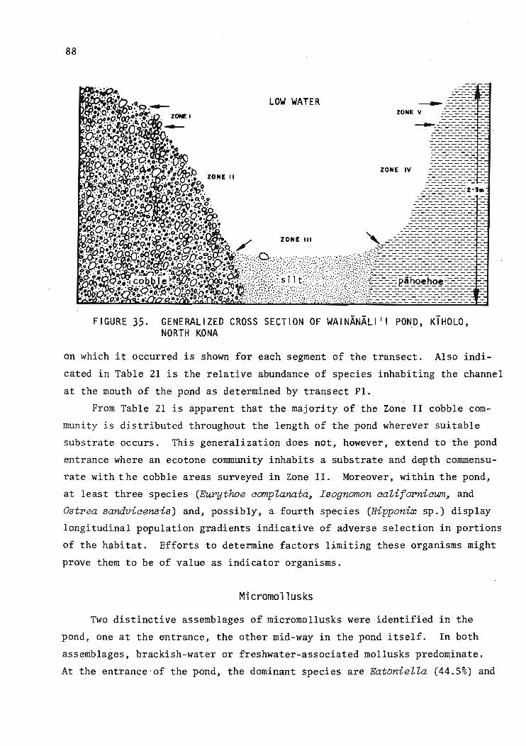
88
'. ':,.:n.. ._ _ _ _....~'.. ---- -.. ~.:~l:t2'ci~P.- LOW WATER ~ __:-:-:-:- :_. .••'o...~•. -
12th:' ZONE I ZONE V ---------- -
. ~~·Q··~·'~O··'·O··:· .- ---:::::::=:: ='-n:'o~o. .":(Po·" :o··A _:..::-:-:-:-:-: --·V'O{)···~.~~.. . :..------------ -~~~.::~~~~,••."/-tl.If.'::'- ~:::::::::=:: :
.O'Q·. "0••' .•~ ------- -· .~. '~'. ..... '. ~------------ -
~·<.'b~:9~;i··f.~···:·!:- g. -:-:::~-:-:-: -
'.' ····0·0. 'o.~A.iJ :~~ ZONE IV .---------------· .fl...... .... '. (lviQ.v ZONE II ------- -.~:~~;O,.;.. '.~.~.:' ·f!,·.f!O·O·.,.·", ::-:-:-:-=-:-: -
• -.- ~.. '0 0 0-.. Y'\' ':"'0 - - - - --:3:.·.·n:!.~·o .!:I./.-.". ------------.:2-31l1o ""'a:~. '. O· .• ~ :-'."CI!' •• -:..-----------:..: - -· '. ·..·.ri0 ..... • 0 . 00.••• 0 °0 ---------:·o.:ta.i:J~.~·:·~ ••~.(2lQ.G?j?'. -:-:-.:-:-:-:-:-=-:- :Q·',.a·~·'DDQ'il:c. ••.••!) ~.;vO =---------.:-------- -
.....Q..<oO'0;~ ..• "'o"~''''''rO --.:---------------- -.; ·9.'!O'ci:O·'·Cf'V·~ .. • ~~tl~/)..;. '.~'. ------:..------------- -
·~~o:~.·~.'!nct·..q.•.~ •. 'ol(:1.tf:.:9..•
1,¥.· --:-:-:-:-:-:~-:-:-:-: -
.'1~l.~o~;:·p'oo~~!.:O";:O:~~O~.~~. .0 /' ZONE III " _-.::-:=:::=:=:=:===:=:===:=: ='A:..~ •."O: "--O••~o ..~~., '''0' .•.~------------- -
o,~~p.·'·.· . ·;··:·:vjjJ······....·Q..,'O..•• • -.. . ....::.~--------------:..---_-:..------- -'r1.rF.·t~·Q~~ClfJ:~~foc:oao<:>0d.-)i.:::::::·.::::a. ~ : ::: ..:.. ~.::. :". -:;:::.:.:.:::.~;::.;~:::-:-=-:-:-:-:-:-:-:-:-:-:-: -~ir~~l~3;~ig~~~~~~8:~f~~\!;:t~;}~·??iI:;:;(::::.::·:·::~.<fi/:/jn~<~~~x?-t;~~=~=~===========:===~=~=~=~= ~i. ~'!.9.Qo· (co~hle"~'O'.~o~..' ·•··•· .._.s 11 t:· .. · : .' ---- pihoehoe-----:.~tQ~(j:f~~~·Q~~~!~to~~~.d,.»t.~./f:;:.:i~.::·...::::.::·::;.:/::.:..{.:~;.;:.:::,.::.:: :./.(:..:.;!:;:=:=:==---:-:-:-:-:-:-:;::;::;::=- =!. v.. ~;~~. ..~•. ,. ··.Q:....O'·~o... ·· e' .' !~...::;.~~·.::·t:·:~~·::.:·:.::··:~:~··:~:.::~.:::·:·: :..:.:=:.:.~.::.:::::~.;.:.~:.:.::.\: ..::~=:===:===:=:==:=:=:;::=:=:=:=:=_ :
FIGURE 35. GENERALIZED CROSS SECTION OF WAINANALI 'I POND, KiHOLO,NORTH KONA
on which it occurred is shown for each segment of the transect. Also indi
cated in Table 21 is the relative abundance of species inhabiting the channel
at the mouth of the pond as determined by transect Pl.
From Table 21 is apparent that the majority of the Zone II cobble com
munity is distributed throughout the length of the pond wherever suitable
substrate occurs. This generalization does not, however. extend to the pond
entrance where an ecotone community inhabits a substrate and depth commensu
rate with the cobble areas surveyed in Zone II. Moreover. within the pond.
at least three species (Eurythoe compZanatG., Isognomon caZifOT'niaum, and
Ostrea sandvicensis) and. possibly, a fourth species (Hipponix sp.) display
longitudinal population gradients indicative of adverse selection in portions
of the habitat. Efforts to determine factors limiting these organisms might
prove them to be of value as indicator organisms.
Micromollusks
Two distinctive assemblages of micromollusks were identified in the
pond, one at the entrance. the other mid-way in the pond itself. In both
assemblages. brackish-water or freshwater-associated mollusks predominate.
At the entrance'of the pond. the dominant species are EatonieZZa (44.5%) and

TABL
E20
.SU
BSTR
ATE
SAN
DA
SSO
CIA
TED
MAC
ROBE
NTHO
SOF
WA
INA
NA
LI'I
POND
Zon
e
II III IV V
Su
bst
rate
Bar
ecl
ean
cob
ble
OR
Cle
anco
arse
sand
Veg
etat
edco
bb
le,
sil
tco
nte
nt
in-
OR
Coa
rse
san
d,
sil
tco
nte
nt
incr
easi
ng
wit
hd
epth
Fin
ecla
yli
ke
sil
t
Veg
etat
ed,
lig
htl
ysi
lted
paho
ehoe
lav
a
Bar
e,cl
ean
paho
ehoe
lav
a
Com
mun
ityC
ompo
siti
on
Sp
arse
pele
cypo
d(I
sogn
omon
per
na
)an
thoz
oan
(Aip
tasi
a-l
ike)
com
mun
ity;
infr
equ
ent
smal
lco
lon
ies
of
two
spec
ies
of
dem
ospo
ngia
e
Mac
robe
ntho
sab
sen
t
Div
erse
pele
cypo
d(I
.pe
rna;
I.ca
li
forn
ieum
;B
pach
ydon
tes
aep
ebp
istP
iatu
s;O
stpe
aea
ha
wa
iien
sis)
-ga
stro
po
d(H
ip
pony
xsp
.)-a
nth
ozo
an(A
ipta
sia
-lik
e)
po
lych
aete
(Eup
ytho
eco
mpl
anat
a)-h
olo
thu
rian
(HoZ
othu
Pia
mon
ocaP
ida)
-por
if
eran
com
mun
ity
En
tero
ptn
eust
(Pty
chod
epa
fZa
va)
ann
elid
(Cip
patu
Zus
sp.)
com
mun
ity;
burr
ows
of
un
iden
tifi
edC
alli
anas
idsh
rim
pco
mm
on,
som
eo
fth
ese
occ
u
pie
dby
go
bie
s
Sim
ilar
tosa
ndy
sect
ion
of
Zon
eII,
but
Pty
chod
epa
less
com
mon
.A
cant
ho
phop
aan
dA
ipta
sia
-lik
ean
emon
eco
ver
scatt
ere
dro
cks
Ane
mon
e(A
ipta
sia
-lik
e)an
dA
cant
ho
phop
aco
ver
vir
tuall
yen
tire
surf
ace
Sca
tter
edan
emon
es(A
ipta
sia
-lik
e)o
nly
Oth
erO
bse
rvat
ion
s
En
tire
lyw
ith
inlo
wsa
lin
ity
len
sat
low
tid
e
Aca
ntho
phop
aan
dfi
la
men
tous
alg
aeco
ver
muc
hex
pose
dsu
rfac
e
Som
efi
lam
ento
us
alg
aep
rese
nt
onsa
ndsu
rfa
ce,
den
sity
in
crea
ses
wit
hd
epth
Sin
gle
spec
imen
of
gas
tro
po
d-f
eed
ing
crab
,C
aZap
pah
epa
tica
foun
d
En
tire
lyw
ith
inlo
wsa
lin
ele
ns
at
low
tid
e0
0l.O

TABL
E21
.LO
NG
ITU
DIN
AL
DIS
TRIB
UTI
ON
OFOR
GANI
SMS
INZO
NEII
,W
AINA
NAL
III
POND
,KO
NACO
AST
Spe
cies
Su
bst
rate
cobb
lesa
ndsa
ndco
bble
cobb
leco
bble
cobb
leco
bble
cobb
leD
ista
nce
from
mou
tho
fpo
nd0-
5*30
-50
55-7
580
-100
105-
125
135-
175
185-
225
235-
275
285-
325
----
----
----
----
----
----
----
----
----
(m}-
----
----
----
----
----
----
----
----
---
10 o
Po
rife
raS
peci
es1
(red
encr
ust
ing
)C
Spe
cies
2(y
ello
wbr
anch
ing)
Co
elen
tera
taA
ipta
sia
-lik
eA
nnel
ida
Cer
ratu
Zus
sp.
-C-
1E
uryt
hoe
com
pZan
ata
Mol
lusc
aP
Zan
axis
Zab
iosa
CIs
ogno
mon
pern
aR
Isog
nom
onca
Zif
orni
cnun
Bra
chyd
onte
sce
reb
rist
ria
tus
RO
stra
eaha
wai
iens
isTh
eodo
xus
negZ
ectu
sR
Hip
pony
xsp
.C
ypra
eaca
pu
tser
pen
tis
CC
ypra
eam
auri
tian
aR
Ech
inod
erm
ata
HoZ
othu
ria
mon
ocar
iaC
---
---
C-2
C-5
C~5
C-5
Act
inop
yga
mau
riti
ana
RE
chin
omet
ram
atha
eiR
Ast
erin
aan
omaZ
a-
---
---
---
R-1
R-l
R-2
En
tero
ptn
eust
aP
tych
oder
afZ
ava
-C
-5C
-5--
---
-C
-lf
C-l
fNO
TE:
See
tex
tfo
rd
eta
ils.
*Bas
edon
tran
sect
acro
ssm
outh
of
pond
.tO
nis
ola
ted
rock
at
one
stati
on
.fi
nis
ola
ted
sand
pock
etat
one
stati
on
.C
=co
mm
on.
R=
rare
.N
umbe
rsin
dic
ate
num
ber
of
sam
ple
stati
on
sin
inte
rval
inw
hich
spec
ies
occ
urr
ed.
C-3
C-5

91
Pl,anaxis and Theodoxus (10%) which are associated with brackish water, and
marine-associ.ated cerithids (J3ittiwn parawn~ B. zebrwn), rissoids (Rissoina
ambigua, R.. mil,tozonaL and :pyramidellids.. On the shoaling sill m:i:d-way
into the pond, THeodoxus and Mel,ania which are associated with fresh water
comprised 27% of the assemblages, and the remaining micromollusks consist
of dead shells of marine species such as rissoids, Tpiaol,ia, cerithids, and
the like. An interesting component of the micromolluscan assemblages in
the middle of the pond is the endemic Hawaiian capulid, Capul,us tpiaaPinatus,
which probably lives on the oyster Ostpea sandviaensis.


93
SUMMARyl
A study of the topography, hydrology, and marine biota of four open
ocean bays along the Kona coast of Hawaii, Puako, Waiulua, 'Aneho'omalu, and
Kiholo, has yielded some distinctive differences that are significant to the
future use of those waters and coastal areas.
From hydrologic evaluations, the seaward flux of groundwater is in a
range from 3.8 to 15.4 mgd/mile (8,938 to 36,221 m3/day/km) of coastline,
with a probable value of 7.3 mgd/mile (17,170 m3/dar./km) or 116 mgd (450,415
m3/day) for the entire study area (16.3 miles or 26 km of coastline). This
probable value is equivalent to about 17% of the mean annual rainfall for
the area.
Associated with this groundwater flux is the terrigenous nitrogen and
phosphorus loading. The total nitrogen load is 936 lb/day (flux of 57.4416/
day/mile) and the total phosphorus load is 106 lb/day (flux of 6.54l6/day/
mile) .
Wave energy varies from minimum exposure on the north at Puako to maxi
mum exposure at the south at Kfholo. The offshore groundwater input varies
from a minimum at Puako to maximums at Waiulua and K1holo.
The distribution and diversity of coral and micromolluscan communities
in the bays followed the trends of groundwater flux and wave energy. Porites
oompressa and Porites lobata account for almost 96% of coral cover and 82%
of all bottom cover. P. oompressa dominates coral cover in any area where
wave stress is not rigorous enough to cause breakage and abrasion and light
energy is sufficient for maximum growth rates. P. lobata appears to be able
to successfully occupy any niche left vacant by P. oompressa.
In the intertidal zones of the bays, both marine-associated and
freshwater-associated assemblages of micromollusks were found, with fewer of
the latter at Puako and 'Anaeho'omalu bays. In the subtidal zones, standing
crop and species diversity index are generally lower at the shoreline and
inshore stations than in the offshore stations. At Kiholo, freshwater
associated species were found in admixture with typically marine species at
offshore stations.
Water uses and development independent of water clarity and a "typical
ly tropical" marine biota would be favored in a situation as at Kiholo or
lReginald H.F. Young, Project Principal Investigator.

94
Waiulua bays. However, a use such as a marine park would require excellent
water clarity and diverse coral reef communities, i.e., a low wave energy,
groundwater influx situation as at Puako and 'Anaeho'omalu. These are broad
generalizations based on a study of the hydrology and communities of these
water areas but they together with the results of the study can serve as
appropriate guidelines for planning and management of the West Hawaii coast
al area. The methodology employed in this study can serve as a basis for
field evaluation of other coastal areas in the state that may be under con
sideration for development or changes in land-use designation.
ACKNOWLEDGMENTS
Invaluable assistance in providing information, access to field sites
and personnel for the field effort was given by the County of Hawaii Plan
ning Office, Waikoloa Village (Boise-Cascade), Puuwaawaa Ranch, Kona Village
Resort, and the Hawaii Department of Health. Personnel from the latter of
fice assisted in the field monitoring effort as well as in performing the
bacteriological analyses. Appreciation is extended to Dr. S. Arthur Reed,
Department of Zoology, University of Hawaii, for his assistance in the field
work.
Related Documents