Hydrogeology of Volcanic Characterization Based on Volcanic Facies, Ground Water Chemical Content, and Stable Isotope of Groundwater Mohamad Sapari Dwi Hadian 1 , Hendarmawan 2 , Nana Sulaksana 1 , and Fikri Noor Azy 1 + 1 Geology Department, Padjadjaran University, Jatinangor, Indonesia 45363 2 Postgraduate School of Geology, Padjadjaran University, Bandung, Indonesia 40132 Abstract. The geological research area are located at Salak Mountain West Java Indonesia, which are consisted of rock unit from the lower layer to top layer in the form of Laharic Breccia, Welded Tuff, pumiceous Tuff, Paleosoil, Tuff Lapillian, and Lava. The purpose of this study is: to determine the volcanic facies, groundwater facies, and groundwater regime. The results of hydrogeological data interpretation, groundwater chemical and isotopic groundwater showed that elevation of 700 masl above are belong to intermediate flow system category. While at an elevation of 500 masl is in the category of medium flow systems. It has results evidenced of subsequent analysis in which samples were taken from low elevation (499 -550 masl) in the form of ground water facies type Na+K, SO 4 2- ; Na+K, Cl- flows reflect long or far enough, while at intermediate elevations (600-720 masl) Mg, Cl- reflects the flow groundwater is relatively short, especially at elevations above 800 msl in the form of Mg, HCO 3 showed relatively shorter flow. Isotopic analysis shows that the catchment areas of recharge is the Ciburial water sources located in areas that have elevations between 800 m - 900 m above sea level, while for the water source has Babakanpari recharge area at an altitude of 700-800 m. The springs are located in a location with an altitude between 600- 900 m above sea level with the modern age has 18O isotope content of between -6.9 ‰ to -7.58 ‰. The existence of circulation shown by 18O isotope content is reinforced with a low 14C activity or old age, which is about 7800 years old. Similarly, the source Babakanpari having age between 2000 - 6000 years have 18O isotope content of -7.0‰. Based on the results, for sustainability and availability of ground water, conservation analysis need to be done in the area within an altitude of 700 m and 800 m elevation above sea level with a buffer elevation in the region between 800 to 900 msl. Keywords: volcanic facies, isotopes, groundwater 1. Introduction Mount Salak is one of the 7 A type volcano located in West Java. Volcano has several peaks, of which peak Salak I (2,211 m above sea level.), Salak II (2180 m above sea level.), and the peak of Salak III also known as Peak SUMBUL with an altitude of 1,926 m above sea level [1]. Some complex solfatara or fumarole, one large complex is Cikuluwung daughter, Salak volcano is still active volcanoes with strato type of eruption is the result of alternating between lava flows and pyroclastic deposits. Geological and stratigraphic tentative based on previous mapping [2] that the sequence of rocks and old to young rock consists of 16 units and 7 units of product rocks instead of Mount Salak. The results of the activities of Mount Salak are; the oldest is lava of Mount Salak I and the youngest is colluvium and alluvial deposits. These are the Mount Salak genetics mechanism as follows: first appear Mount Salak I, which is the body of the oldest and followed by Mount Salak II, then came Mount Sunbul, while the Queen crater is considered to be the final product of Mount Salak, Cikulung Princess crater and Hirup Crater which is still part of Kawah Ratu. Corresponding author. Tel.: + 0857-8094-1175; fax: + 62227796545. E-mail address: [email protected]. International Proceedings of Chemical, Biological and Environment Engineering Volume of IPCBEE (2016) DOI: 10.7763/IPCBEE. 2016. V94. 22 142

Welcome message from author
This document is posted to help you gain knowledge. Please leave a comment to let me know what you think about it! Share it to your friends and learn new things together.
Transcript

Hydrogeology of Volcanic Characterization Based on Volcanic Facies,
Ground Water Chemical Content, and Stable Isotope of Groundwater
Mohamad Sapari Dwi Hadian1, Hendarmawan
2, Nana Sulaksana
1, and Fikri Noor Azy
1 +
1 Geology Department, Padjadjaran University, Jatinangor, Indonesia 45363 2 Postgraduate School of Geology, Padjadjaran University, Bandung, Indonesia 40132
Abstract. The geological research area are located at Salak Mountain West Java Indonesia, which are
consisted of rock unit from the lower layer to top layer in the form of Laharic Breccia, Welded Tuff,
pumiceous Tuff, Paleosoil, Tuff Lapillian, and Lava. The purpose of this study is: to determine the volcanic
facies, groundwater facies, and groundwater regime. The results of hydrogeological data interpretation,
groundwater chemical and isotopic groundwater showed that elevation of 700 masl above are belong to
intermediate flow system category. While at an elevation of 500 masl is in the category of medium flow
systems. It has results evidenced of subsequent analysis in which samples were taken from low elevation
(499 -550 masl) in the form of ground water facies type Na+K, SO42- ; Na+K, Cl- flows reflect long or far
enough, while at intermediate elevations (600-720 masl) Mg, Cl- reflects the flow groundwater is relatively
short, especially at elevations above 800 msl in the form of Mg, HCO3 showed relatively shorter flow.
Isotopic analysis shows that the catchment areas of recharge is the Ciburial water sources located in areas
that have elevations between 800 m - 900 m above sea level, while for the water source has Babakanpari
recharge area at an altitude of 700-800 m. The springs are located in a location with an altitude between 600-
900 m above sea level with the modern age has 18O isotope content of between -6.9 ‰ to -7.58 ‰. The
existence of circulation shown by 18O isotope content is reinforced with a low 14C activity or old age, which
is about 7800 years old. Similarly, the source Babakanpari having age between 2000 - 6000 years have 18O
isotope content of -7.0‰. Based on the results, for sustainability and availability of ground water,
conservation analysis need to be done in the area within an altitude of 700 m and 800 m elevation above sea
level with a buffer elevation in the region between 800 to 900 msl.
Keywords: volcanic facies, isotopes, groundwater
1. Introduction
Mount Salak is one of the 7 A type volcano located in West Java. Volcano has several peaks, of which
peak Salak I (2,211 m above sea level.), Salak II (2180 m above sea level.), and the peak of Salak III also
known as Peak SUMBUL with an altitude of 1,926 m above sea level [1]. Some complex solfatara or
fumarole, one large complex is Cikuluwung daughter, Salak volcano is still active volcanoes with strato type
of eruption is the result of alternating between lava flows and pyroclastic deposits. Geological and
stratigraphic tentative based on previous mapping [2] that the sequence of rocks and old to young rock
consists of 16 units and 7 units of product rocks instead of Mount Salak. The results of the activities of
Mount Salak are; the oldest is lava of Mount Salak I and the youngest is colluvium and alluvial deposits.
These are the Mount Salak genetics mechanism as follows: first appear Mount Salak I, which is the body of
the oldest and followed by Mount Salak II, then came Mount Sunbul, while the Queen crater is considered to
be the final product of Mount Salak, Cikulung Princess crater and Hirup Crater which is still part of Kawah
Ratu.
Corresponding author. Tel.: + 0857-8094-1175; fax: + 62227796545.
E-mail address: [email protected].
International Proceedings of Chemical, Biological and Environment Engineering
Volume of IPCBEE (2016)
DOI: 10.7763/IPCBEE. 2016. V94. 22
142

In general, the volcanic region has a beneficial natural resources for giving the benefits of human life.
One of the natural resources contained in the region is the water resources both surface water and
groundwater. The areas in the form of very steep hills to the plains with slope value of 120% - 2% has great
position to allows as a entry point of water (recharge area) and exit point groundwater (discharge area). Such
condition makes the volcanic region has significant potential to be managed primarily as a source of
groundwater. Understanding the relationship between groundwater facies sediment volcanic from the top to
the foot of the mountain, volcanic deposits have variations aquifers different, this is because the stratigraphy
and tectonic zone of top to bottom is a complex (rocks lateral disconnected, the composition of the aquifer
heterogeneous aquifers hydrodynamic characteristic varies). The purpose of this study are: to determine the
volcanic facies, groundwater facies, and groundwater regime at Salak Mountain, West Java Indonesia.
2. Research Method
2.1. Geology and Hydrogeology Method
To determine the condition of the geological research area, geological mapping approached by traversing
or observing geological outcrops have done using Barnes and Lisle guidance [3]. This method used some
tools such as geology compass, igneous and sedimentary rock hammer, loupe and topographic maps. While
the hydrogeological investigation has been used to help stable isotopes and chemical content observation of
the water. The sampling technique carried out randomly and periodically from springs, boreholes and
rainwater every 2-3 months and specially rainwater every month.
2.2. Hydrogeochemical Method
Laboratory test requirement of natural isotopes 18O (oxygen) and 2H (deuterium) content shall not
exceed 20 mL. Water samples has been tested in the laboratory by means of a mass spectrometer instrument
to measure the ratio of 18O/16O ratio and D/H [4], [5]. At 18O and deuterium isotope analysis performed
using a standard calibration or SMOW (Standard Mean Ocean Water). During sampling, direct
measurements of physical properties (pH, conductivity, temperature and dissolved oxygen) in the field has
been done with portable equipment. Tests on a number of water samples from springs also performed
especially ionic substances are common in natural water such as Na+, K+, Ca+, Mg+, Cl, CO3-, HCO3 and SO4.
The cations and anions dominant predetermined by trilinear diagram [6], so that the facies of groundwater
produced could be used to verify the interpretation of geological and its certainty based on stable isotope
content of groundwater.
The literature study in order to assess the general/regional hydrogeological conditions are needed before
or after collect the data in the research area. These data composed of primary data collection, studio and
laboratory work. Based on the observations of springs and wells population in the field, and the surrounding
area, Kubang has a shallow depth of groundwater level which is ranged between -2 meters to -10 meters
from the ground. Dug wells population generally has a depth of between -2.8 m to -10.1 m, groundwater
temperatures range between 24.9 to 25.5 oC, electrical conductivity (EC) value between 0.055 - 0.57 μS, and
TDS value between 37-244 mg/L.
Dug wells in the study area contains groundwater in the aquifer free (unconfined aquifer) which is
located at an elevation of between 480-520 meters above sea level. Area of the foot of the mountain has
slopes ranging between 5-20% and it is relatively densely populated areas. The lapilli and tuff has been
found in major population of well.
In addition to wells, measurement of physical and chemical properties of groundwater is also made to the
springs which are numerous in the middle to upper parts of the study area. Spring system are formed due to
the extreme topographic contours, lithological contacts, and fracture system. Discharge found ranged from
0.01 to more than 86 liters/second, the amount of discharge greater than 10 liters/sec are controlled by
fracture system, with the amount of fractures or joints size ranging from 2 mm to 4 cm with a general
direction west - east (N265° E - N320° E). The springs were found to generally have a temperature between
20 to 32.9 oC, electrical conductivity (EC) value between 0.016 to 0.303 μS, and TDS value between 11-203
mg/L.
143

Meanwhile, hydraulic parameters of aquifer are determined based on pumping test at several locations
has been selected in accordance with the aquifer system that developed in the study area. In this study, a
pumping test conducted at two locations with different aquifer systems, namely the aquifer system and the
laharic breccia and pumice tuff aquifer.
Below are descriptions of field observations and laboratory description. Kubang and the surrounding
area consists of several units rocks (from bottom to top): Laharic Breccia, Wellded Tuff, Pumiceous Tuff,
Paleosoil, Lapilli Tuff and Lava.
3. Result and Discussion
3.1. Result of Groundwater Characteristic
Some physical parameters of water directly measured on the body of water, such as temperature, pH,
electrical conductivity (Electric Conductivity / EC), and Dissolved Solids (Total Dissolve Solid / TDS).
While the content of chemical elements analyzed are ion concentrations of groundwater in the form of Na +,
K +, Ca ++, Mg ++, Cl, CO3 =, HCO3 and SO4 =. The measured data and the results of laboratory analysis is
shown in the figures below.
Source: Modified from [6] Source: Modified from [6]
Fig. 1: Piper diagram Fig. 2: Durov diagram
Source: from [6]
Fig. 3: Map Of Observation Points Springs In The Study Area
144
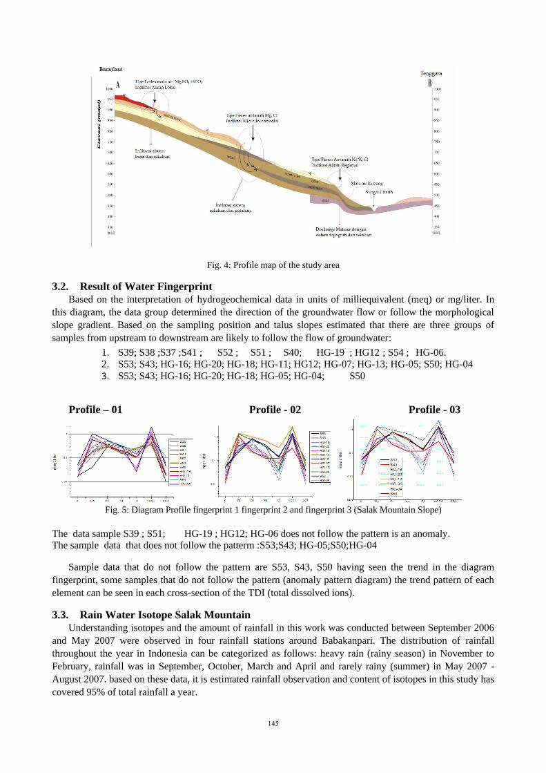
Fig. 4: Profile map of the study area
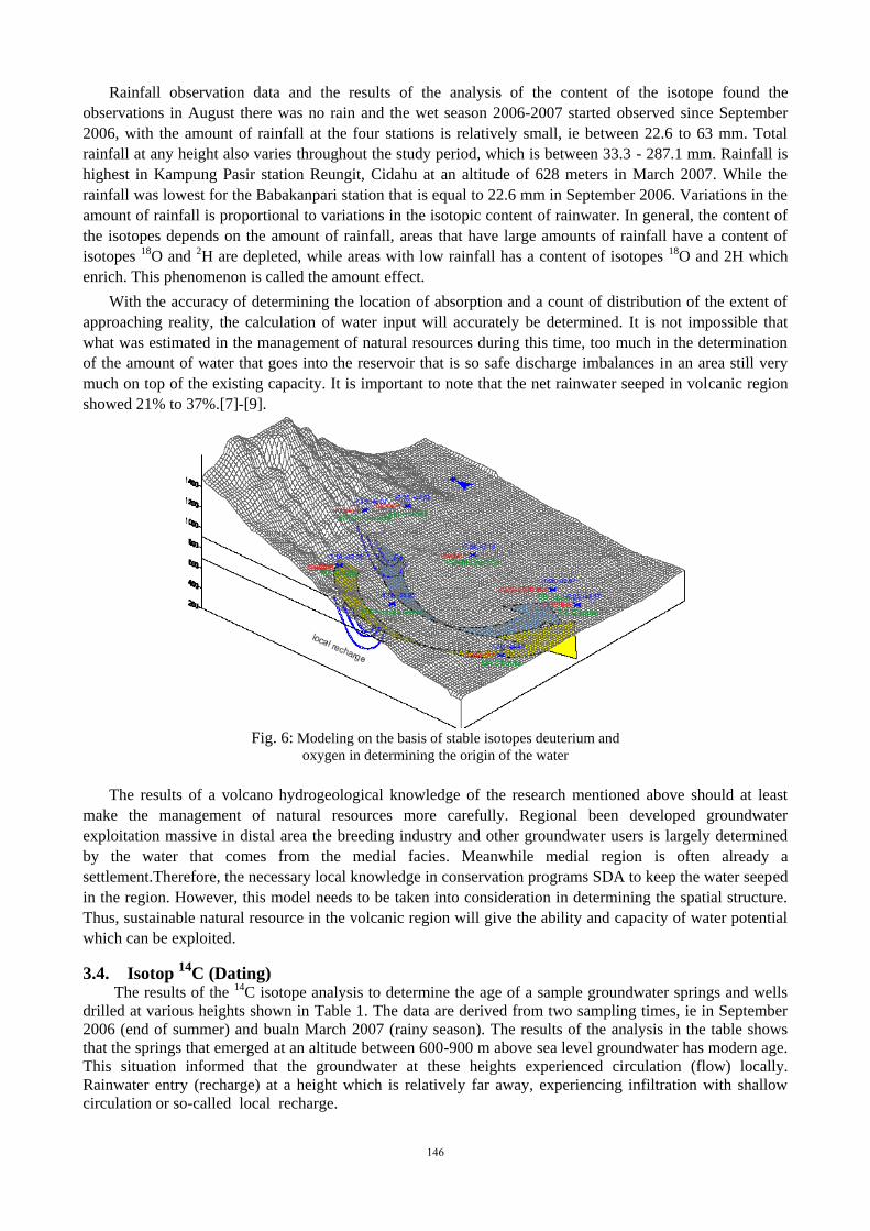
3.2. Result of Water Fingerprint
Based on the interpretation of hydrogeochemical data in units of milliequivalent (meq) or mg/liter. In
this diagram, the data group determined the direction of the groundwater flow or follow the morphological
slope gradient. Based on the sampling position and talus slopes estimated that there are three groups of
samples from upstream to downstream are likely to follow the flow of groundwater:
1. S39; S38 ;S37 ;S41 ; S52 ; S51 ; S40; HG-19 ; HG12 ; S54 ; HG-06.
2. S53; S43; HG-16; HG-20; HG-18; HG-11; HG12; HG-07; HG-13; HG-05; S50; HG-04
3. S53; S43; HG-16; HG-20; HG-18; HG-05; HG-04; S50
Profile – 01 Profile - 02 Profile - 03
Fig. 5: Diagram Profile fingerprint 1 fingerprint 2 and fingerprint 3 (Salak Mountain Slope)
The data sample S39 ; S51; HG-19 ; HG12; HG-06 does not follow the pattern is an anomaly.
The sample data that does not follow the patterm :S53;S43; HG-05;S50;HG-04
Sample data that do not follow the pattern are S53, S43, S50 having seen the trend in the diagram
fingerprint, some samples that do not follow the pattern (anomaly pattern diagram) the trend pattern of each
element can be seen in each cross-section of the TDI (total dissolved ions).
3.3. Rain Water Isotope Salak Mountain
Understanding isotopes and the amount of rainfall in this work was conducted between September 2006
and May 2007 were observed in four rainfall stations around Babakanpari. The distribution of rainfall
throughout the year in Indonesia can be categorized as follows: heavy rain (rainy season) in November to
February, rainfall was in September, October, March and April and rarely rainy (summer) in May 2007 -
August 2007. based on these data, it is estimated rainfall observation and content of isotopes in this study has
covered 95% of total rainfall a year.
145
Rainfall observation data and the results of the analysis of the content of the isotope found the
observations in August there was no rain and the wet season 2006-2007 started observed since September
2006, with the amount of rainfall at the four stations is relatively small, ie between 22.6 to 63 mm. Total
rainfall at any height also varies throughout the study period, which is between 33.3 - 287.1 mm. Rainfall is
highest in Kampung Pasir station Reungit, Cidahu at an altitude of 628 meters in March 2007. While the
rainfall was lowest for the Babakanpari station that is equal to 22.6 mm in September 2006. Variations in the
amount of rainfall is proportional to variations in the isotopic content of rainwater. In general, the content of
the isotopes depends on the amount of rainfall, areas that have large amounts of rainfall have a content of
isotopes 18O and 2H are depleted, while areas with low rainfall has a content of isotopes 18O and 2H which
enrich. This phenomenon is called the amount effect.
With the accuracy of determining the location of absorption and a count of distribution of the extent of
approaching reality, the calculation of water input will accurately be determined. It is not impossible that
what was estimated in the management of natural resources during this time, too much in the determination
of the amount of water that goes into the reservoir that is so safe discharge imbalances in an area still very
much on top of the existing capacity. It is important to note that the net rainwater seeped in volcanic region
showed 21% to 37%.[7]-[9].
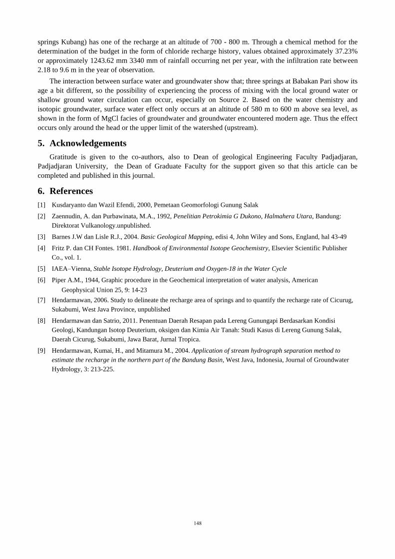
Fig. 6: Modeling on the basis of stable isotopes deuterium and
oxygen in determining the origin of the water
The results of a volcano hydrogeological knowledge of the research mentioned above should at least
make the management of natural resources more carefully. Regional been developed groundwater
exploitation massive in distal area the breeding industry and other groundwater users is largely determined
by the water that comes from the medial facies. Meanwhile medial region is often already a
settlement.Therefore, the necessary local knowledge in conservation programs SDA to keep the water seeped
in the region. However, this model needs to be taken into consideration in determining the spatial structure.
Thus, sustainable natural resource in the volcanic region will give the ability and capacity of water potential
which can be exploited.
3.4. Isotop 14
C (Dating) The results of the 14C isotope analysis to determine the age of a sample groundwater springs and wells
drilled at various heights shown in Table 1. The data are derived from two sampling times, ie in September
2006 (end of summer) and bualn March 2007 (rainy season). The results of the analysis in the table shows
that the springs that emerged at an altitude between 600-900 m above sea level groundwater has modern age.
This situation informed that the groundwater at these heights experienced circulation (flow) locally.
Rainwater entry (recharge) at a height which is relatively far away, experiencing infiltration with shallow
circulation or so-called local recharge.
146

Table 1: Analysis 14
C (Age of Groundwater)
Ciburial water springs has a very large discharge and is the oldest age, ie 7866 ± 40 years. Water
Resources Babakanpari with three wells drilled have a lifespan that is somewhat different. Water Source 2
has the oldest age, ie 6180 ± 95 years, Water Resources 3 have 4011 aged 35 years, while the Water Source
1 has the most young age is 2057 25 years. This indicates groundwater wells drilled comes from the same
source, but are likely to experience the process of mixing with the local ground water or shallow ground
water circulation, especially in Source Water 2. [9].
4. Conclusions
Based on the groundwater basin geometry shown in cross-section and block diagram form known that:
there are three approaches in this study can be concluded that the springs in the form of discharge of
groundwater at an altitude of 800-900 m above sea level comes from catchment areas at an altitude of 900-
1100 m above sea level. Meanwhile, for the springs that develop in the 650-600 masl supplied by water
infiltration at an altitude of 800-900 m above sea level. Especially water for industries at an altitude of 450-
500 m above sea level, water discharge from a height of 700-800 meters above sea level. Groundwater Basin
and the Watershed (Catchment Area) limit is where the source of the fountain Kubang are very different,
each with an area of 36.6 km2 for Groundwater Basin and 3.47 km2 to DAS. Groundwater Basin study area
are arranged from bottom to top by Breccia Laharik (Laharic Breccia), Tuff Mix (Welded Tuff), Tuf
Berbatuapung (pumiceous Tuff), Paleosoil, lapilli tuff (lapilli Tuff), and Lava. Facies rocks relatively
unchanged at short distances.
Hydrogeological approached of local flow may occur in lava aquifers, at an elevation higher than 900 m
above sea level, lapilli tuff aquifer at an elevation of 725 m above sea level to the elevation of 900 m above
sea level, as well as pumice tuff aquifer at an elevation of 550 m above sea level to 600 m above sea level. At
the elevation of 500- 550 meters above sea level, ground water is the dominant facies facies Na + K, Cl
which may reflect a long and deep groundwater flow. At an elevation of 580- 780 m above sea level, is the
dominant groundwater facies facies Mg, Cl reflecting water flow is shorter. At an elevation of 800- 1400 m
above sea level, is the dominant facies Mg, HCO3 SO4- which reflect the local flow system.
Hydro-isotope approach: Regional Water infiltration springs Ciburial (for comparison) lies in the area
having elevations between 800-900 m above sea level, while for Water source Babakan Pari (Water springs
Kubang) has a catchment area at an altitude of 700-800 m. The potential reserves of water resources is quite
good. This is demonstrated by the age of groundwater Babakan Pari included in the classification between
young age and old age. Regional infiltration (recharge zone) for Water Resources Babakan Pari, based on the
hydrogeological cross-section combined with groundwater chemistry, lies at an elevation of 600 m above sea
level and 815 m above sea interaction groundwater flow system and surface water. In particular catchment
areas (recharge) for Water springs Ciburial, as a comparison condition Water springs Kubang, located in
areas that have elevations of 800-900 m above sea level, while for Water Resources Babakan Pari (Water
No Code
Location Elevation Age (Year)
Sample (m) September 06 March 07
1. SB-1 Water source 1 Babakanpari, Cidahu 475 2264 20 2057 25
2. SB-2 Water source2 Babakanpari, Cidahu 475 6053 25 6180 95
3. SB-3 Water source 3 Babakanpari, Cidahu 475 4097 35 4011 35
4. SB-4 Water source 4 Babakanpari, Cidahu 475 - 2307 25
5. SB-5 Water springs Garuda Ds. Kutajaya Girang 760 Modern Modern
6. SB-6 Water springs Cimumutan Ds. Tenjolaya 900 Modern Modern
7. SB-7 Water springs bor Cikombo PDAM 590 Modern Modern
8. SB-8 Water springs Mt Salak 900 Modern Modern
9. SB-10 Water springs Cibuntu 520 - 2844 25
10. SB-11 Water springs Ciburial 472 - 7866 40
147
springs Kubang) has one of the recharge at an altitude of 700 - 800 m. Through a chemical method for the
determination of the budget in the form of chloride recharge history, values obtained approximately 37.23%
or approximately 1243.62 mm 3340 mm of rainfall occurring net per year, with the infiltration rate between
2.18 to 9.6 m in the year of observation.
The interaction between surface water and groundwater show that; three springs at Babakan Pari show its
age a bit different, so the possibility of experiencing the process of mixing with the local ground water or
shallow ground water circulation can occur, especially on Source 2. Based on the water chemistry and
isotopic groundwater, surface water effect only occurs at an altitude of 580 m to 600 m above sea level, as
shown in the form of MgCl facies of groundwater and groundwater encountered modern age. Thus the effect
occurs only around the head or the upper limit of the watershed (upstream).
5. Acknowledgements
Gratitude is given to the co-authors, also to Dean of geological Engineering Faculty Padjadjaran,
Padjadjaran University, the Dean of Graduate Faculty for the support given so that this article can be
completed and published in this journal.
6. References
[1] Kusdaryanto dan Wazil Efendi, 2000, Pemetaan Geomorfologi Gunung Salak
[2] Zaennudin, A. dan Purbawinata, M.A., 1992, Penelitian Petrokimia G Dukono, Halmahera Utara, Bandung:
Direktorat Vulkanology.unpublished.
[3] Barnes J.W dan Lisle R.J., 2004. Basic Geological Mapping, edisi 4, John Wiley and Sons, England, hal 43-49
[4] Fritz P. dan CH Fontes. 1981. Handbook of Environmental Isotope Geochemistry, Elsevier Scientific Publisher
Co., vol. 1.
[5] IAEA–Vienna, Stable Isotope Hydrology, Deuterium and Oxygen-18 in the Water Cycle
[6] Piper A.M., 1944, Graphic procedure in the Geochemical interpretation of water analysis, American
Geophysical Union 25, 9: 14-23
[7] Hendarmawan, 2006. Study to delineate the recharge area of springs and to quantify the recharge rate of Cicurug,
Sukabumi, West Java Province, unpublished
[8] Hendarmawan dan Satrio, 2011. Penentuan Daerah Resapan pada Lereng Gunungapi Berdasarkan Kondisi
Geologi, Kandungan Isotop Deuterium, oksigen dan Kimia Air Tanah: Studi Kasus di Lereng Gunung Salak,
Daerah Cicurug, Sukabumi, Jawa Barat, Jurnal Tropica.
[9] Hendarmawan, Kumai, H., and Mitamura M., 2004. Application of stream hydrograph separation method to
estimate the recharge in the northern part of the Bandung Basin, West Java, Indonesia, Journal of Groundwater
Hydrology, 3: 213-225.
148
Related Documents


![Notes Hydrogeology[1]](https://static.cupdf.com/doc/110x72/553cb15155034636568b4951/notes-hydrogeology1.jpg)


