36 CHAPTER - THREE HYDRO-MORPHOLOGICAL CHARACTERISTICS OF MURSHIDABAD DISTRICT 3.0 INTRODUCTION The science of hydromorphology involves the developmental of a conceptual basis for improving our understanding of the impact of human on land and water resources. Water is considered to be one of the most important attribute of earth with which human being carve upon the land according to his demand. Land is a broad, holistic concept in natural science. It involves specific surface area and therefore it is truly a geographical concept. “ A tract of land is defined geographically as a specific area of the earth’s surface; its characteristics embrace all reasonably stable, or predictably cyclic attributes of the biosphere vertically above and below this area including those of the atmosphere, the soil and underlying rocks, the topography, the water, the plants and animal population and the result of past and present human activities, to the extent that these attributes exert a significant influence on present and future uses of land by man” (Christan and Stewart in Roy et.al., 1968; Man. B and Smith, 1973). 2 Dressler et.al. (2006) had defined hydrology and morphology together as hydromorphology has issue related with structure, evolution, and dynamic morphology of hydrologic systems over years, decades and centuries. The subject Hydromorphology mainly highlighted societal challenges, growing demand of population, pervasive anthropological impact on environmental and water system. Very few water shed is natural or un-impacted hydrologic condition in this present decade. Dependence on water shed is a source of uncertainty and non- stationary. The critical use of land by human beings; through challenges in front of engineers that how to adjust water systems through modification to the landscape; water infrastructure and climate and again reshaping water system. Earlier from chapter two it is clear that fresh sweet water is nectar on Earth. It is like the blood in human body. In this work we will discuss the anthropological impact

Welcome message from author
This document is posted to help you gain knowledge. Please leave a comment to let me know what you think about it! Share it to your friends and learn new things together.
Transcript
36
CHAPTER - THREE
HYDRO-MORPHOLOGICAL CHARACTERISTICS OF
MURSHIDABAD DISTRICT
3.0 INTRODUCTION
The science of hydromorphology involves the developmental of a conceptual
basis for improving our understanding of the impact of human on land and water
resources. Water is considered to be one of the most important attribute of earth with
which human being carve upon the land according to his demand. Land is a broad,
holistic concept in natural science. It involves specific surface area and therefore it is
truly a geographical concept. “ A tract of land is defined geographically as a specific
area of the earth’s surface; its characteristics embrace all reasonably stable, or
predictably cyclic attributes of the biosphere vertically above and below this area
including those of the atmosphere, the soil and underlying rocks, the topography, the
water, the plants and animal population and the result of past and present human
activities, to the extent that these attributes exert a significant influence on present and
future uses of land by man” (Christan and Stewart in Roy et.al., 1968; Man. B and
Smith, 1973). 2 Dressler et.al. (2006) had defined hydrology and morphology together
as hydromorphology has issue related with structure, evolution, and dynamic
morphology of hydrologic systems over years, decades and centuries. The subject
Hydromorphology mainly highlighted societal challenges, growing demand of
population, pervasive anthropological impact on environmental and water system. Very
few water shed is natural or un-impacted hydrologic condition in this present decade.
Dependence on water shed is a source of uncertainty and non- stationary. The critical
use of land by human beings; through challenges in front of engineers that how to adjust
water systems through modification to the landscape; water infrastructure and climate
and again reshaping water system.
Earlier from chapter two it is clear that fresh sweet water is nectar on Earth. It is
like the blood in human body. In this work we will discuss the anthropological impact
37
on ground water and its effect on hydrology and morphology in the entire Murshidabad
district.
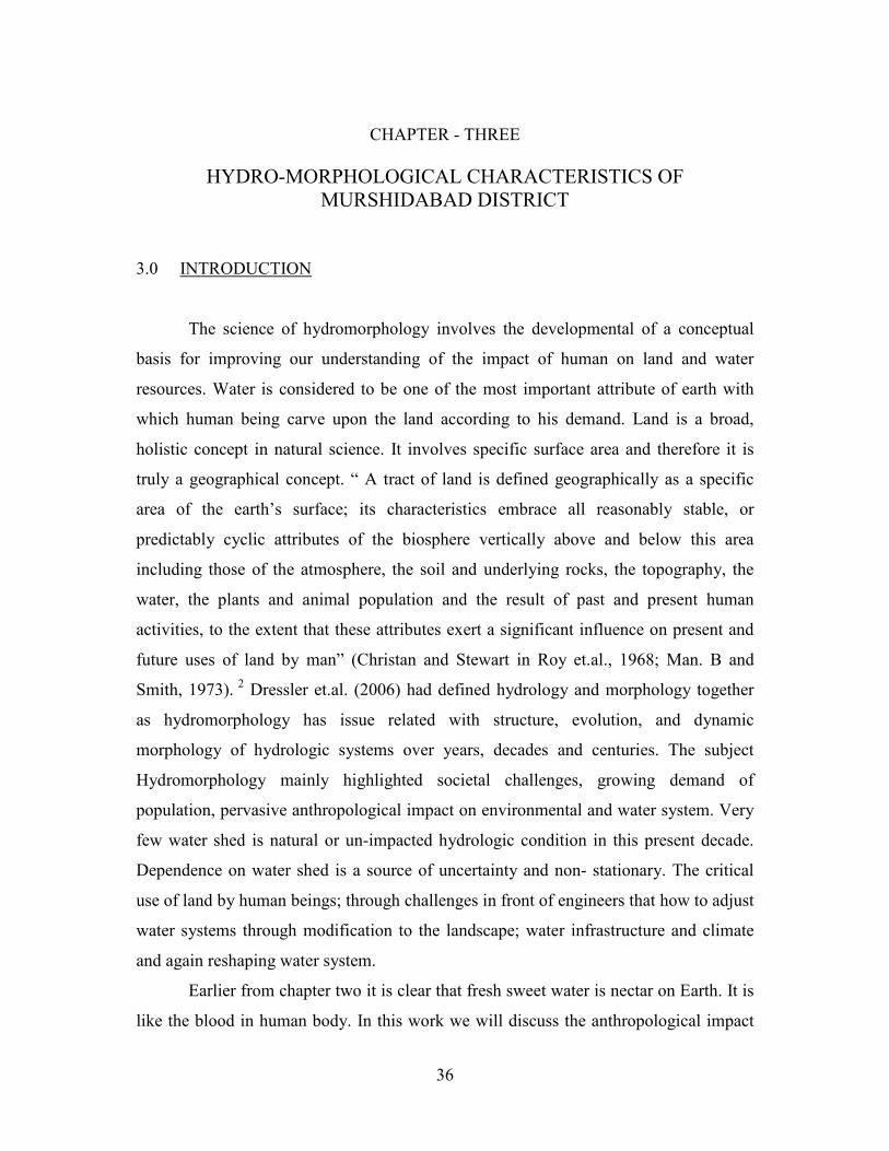
HYDROLOGY + MORPHOLOGY = HYDROMORPHOLOGY
FIELD OF STUDY
HYDROLOGY STRUCTURAL
GEOLOGY
EVOLUTION OF
LAND FORMS TIME
ANTHROPOLIGYCAL
FACTORS
DYNAMIC
LANDUSE
PHYSICAL FIELD CULTURAL FIELD
HYDROMORPHOLOGY
3.1 GEOLOGY
3A. Mitra had presented a geological classification in Gazateer of 1979.The
geological formation is broadly classified into three parts viz. a) recent alluvium, b)
Pleistocene- recent older alluvium and lateritic clay and c) Jurassic Rajmahal Trap.
a) Recent alluvium: The ‘‘bagri’’ region of the district is occupied by recent
alluvium. The soil is mainly composed of sands and clays brought by the rivers.
All types of soils are fertile and produce all kinds of crops.
b) Pleistocene- recent older alluvium and lateritic clay: A major part of the ‘‘rarh’
region that is the western part of the river Bhagirathi is occupied by older
alluvium and lateritic clay. It may be the continuation of the sub-Vindhyan
region of lateritic clay and nodular limestone. The ‘kankar’ (the beds of
limestone) are scattered at places in this western part.

38
c) Jurassic Rajmahal Trap: The northern part of the district consists of basaltic lava
which flowed with intercalated, carbonaceous shale and clays. The basalt is a
black- coloured, fine- grained amygdaloidal rock. The amygdales are filled with
chalcedony, calcite, zeolite and other secondary minerals.
Similarly, Asis Bhatacharya and S.N. Banerjee in 1979 had presented a
classification of the Ajay- Bhagirathi Valley in the Indian Journal of Earth Science
(vol.6 no.1). Their study area was divided into four surfacial geomorphic plains a)
Lateric upland, b) Older deltaic Plain, c) Younger Deltaic Plain and d) Bhagirathi
Recent Surface.
The Quaternary sediments have been classified as:
Table no: 3.i Geomorphic subdivision and its characteristics
Geological time
scale
Geomorphic
subdivision Morphological characteristics
Recent Pleistocene
Younger Deltaic Plain
formation (YDP)
• River terrace sediments
• Alluvial sediments with soil
containing soft ferruginous nodules
Older Deltaic Plain
Formation (ODP)
• Alluvial sediments with soil
containing calcareous nodules
Lateritic Formation • Hard lateritic and mottled clay with
underlying alluvial sediments
Source: Compiled by the scholar from A. Bhattacharya & S.N. Banerjee (1979).
3.2 GEOMORPHOLOGY
Hiuen Tsang’s accounted about ‘Karnasuvarna’ situated just almost twenty
kilometers away from present Berhampore sadar town, that the inhabitants were very
rich. The moist low land helped in regular farming, flowers and fruits. The climate was
39
temperate and the people were of good character and were patrons of learning
(Gazetteer, 1979; by A. Mitra, pp: 32).
Asis Bhatacharya and S.N. Banerjee in 1979 had classified the Ajay Bhagirathi
valley in to four geomorphic plain. A) Lateritic Upland or Ilambazar plain, b) Older
Deltaic Plain or Rampurhat Plain, c) Younger Deltaic Plain or Kandi Plain and d)
Bhagirathi recent surface. The District Murshidabad lies generally within the Younger
Deltaic Plain or Kandi Plain and the Bhagirathi Recent Surface.
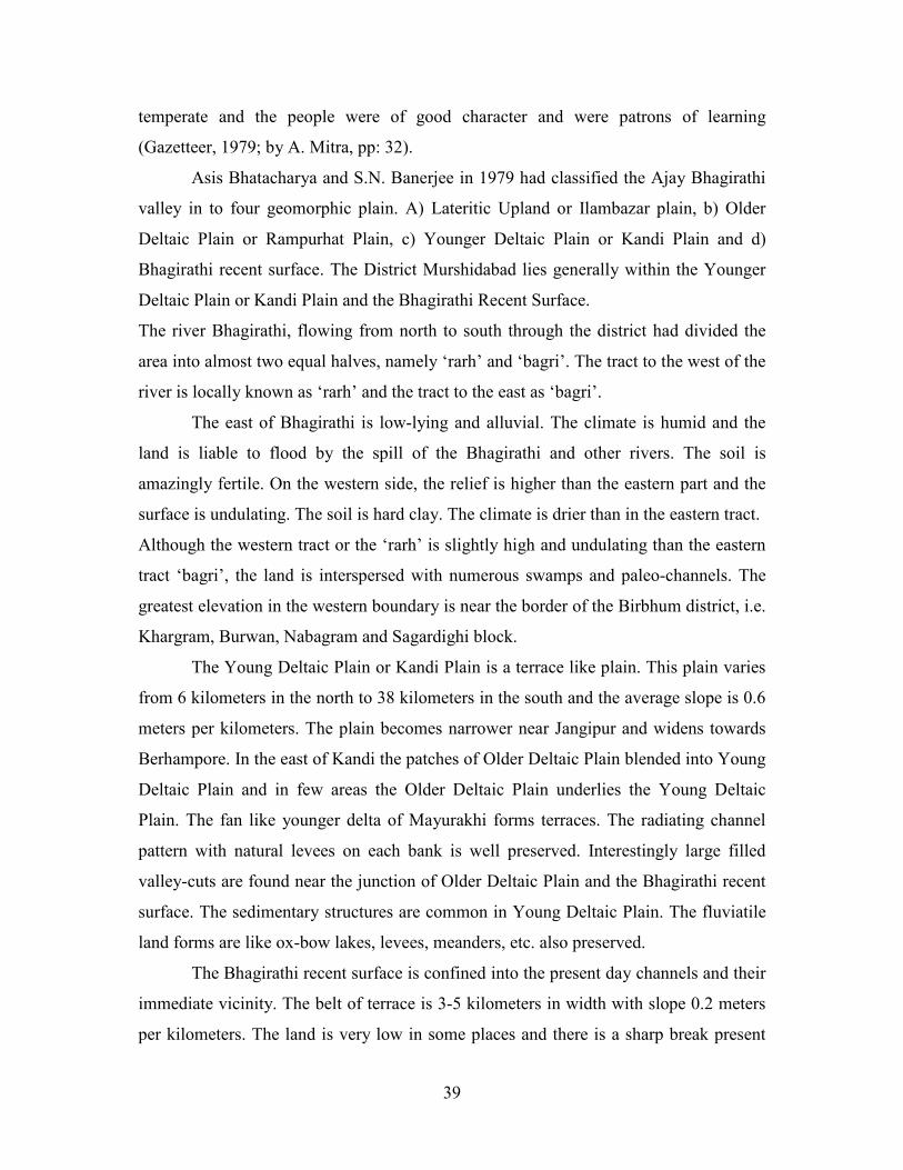
The river Bhagirathi, flowing from north to south through the district had divided the
area into almost two equal halves, namely ‘rarh’ and ‘bagri’. The tract to the west of the
river is locally known as ‘rarh’ and the tract to the east as ‘bagri’.
The east of Bhagirathi is low-lying and alluvial. The climate is humid and the
land is liable to flood by the spill of the Bhagirathi and other rivers. The soil is
amazingly fertile. On the western side, the relief is higher than the eastern part and the
surface is undulating. The soil is hard clay. The climate is drier than in the eastern tract.
Although the western tract or the ‘rarh’ is slightly high and undulating than the eastern
tract ‘bagri’, the land is interspersed with numerous swamps and paleo-channels. The
greatest elevation in the western boundary is near the border of the Birbhum district, i.e.
Khargram, Burwan, Nabagram and Sagardighi block.
The Young Deltaic Plain or Kandi Plain is a terrace like plain. This plain varies
from 6 kilometers in the north to 38 kilometers in the south and the average slope is 0.6
meters per kilometers. The plain becomes narrower near Jangipur and widens towards
Berhampore. In the east of Kandi the patches of Older Deltaic Plain blended into Young
Deltaic Plain and in few areas the Older Deltaic Plain underlies the Young Deltaic
Plain. The fan like younger delta of Mayurakhi forms terraces. The radiating channel
pattern with natural levees on each bank is well preserved. Interestingly large filled
valley-cuts are found near the junction of Older Deltaic Plain and the Bhagirathi recent
surface. The sedimentary structures are common in Young Deltaic Plain. The fluviatile
land forms are like ox-bow lakes, levees, meanders, etc. also preserved.
The Bhagirathi recent surface is confined into the present day channels and their
immediate vicinity. The belt of terrace is 3-5 kilometers in width with slope 0.2 meters
per kilometers. The land is very low in some places and there is a sharp break present
40
between Young Deltaic Plain and the Bhagirathi recent surface (e.g. flood plain
between Bhagirathi and Dwarka River). The surface is composed of loose and
completely unconsolidated sediments structures. The river Bhagirathi meanders
strongly between Jangipur and Berhampore police station. Geologist assumes that the
river is a misfit and likely to be an ancient course of the Ganges. Big meanders scars,
cut off, abandoned channels and levees are some of the examples of preservation of
landforms. Presently the river courses are oscillating frequently (blocks like Suti-I, Suti-
II, Raghunathganj-I, Lalgola and Bhagawangola-I are mainly affected).
The older landforms are exposed to erosion; therefore, the land forms of the
younger ones are better preserved. The land form near rivers are cut to produce
geomorphically younger plain which is filled by sediments of the younger plain,
through ‘tongue’ gradually close the older plain. This is how an oscillating river
maintains the sequence from oldest to youngest as Lateritic Upland -Older Deltaic
Plain-Younger Deltaic Plain- Bhagirathi recent surface.
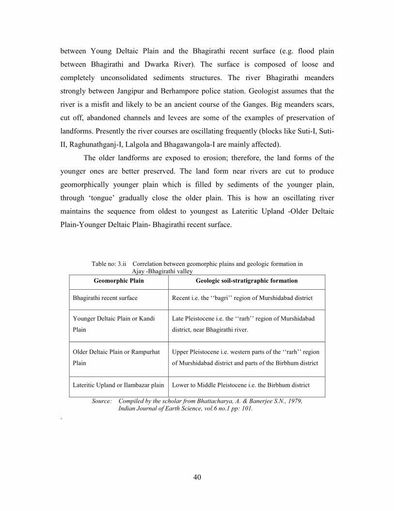
Table no: 3.ii Correlation between geomorphic plains and geologic formation in
Ajay -Bhagirathi valley
Geomorphic Plain Geologic soil-stratigraphic formation
Bhagirathi recent surface Recent i.e. the ‘‘bagri’’ region of Murshidabad district
Younger Deltaic Plain or Kandi
Plain
Late Pleistocene i.e. the ‘‘rarh’’ region of Murshidabad
district, near Bhagirathi river.
Older Deltaic Plain or Rampurhat
Plain
Upper Pleistocene i.e. western parts of the ‘‘rarh’’ region
of Murshidabad district and parts of the Birbhum district
Lateritic Upland or Ilambazar plain Lower to Middle Pleistocene i.e. the Birbhum district
Source: Compiled by the scholar from Bhattacharya, A. & Banerjee S.N., 1979,
Indian Journal of Earth Science, vol.6 no.1 pp: 101.
.
41
3.3 PHYSIOGRAPHIC DIVISION
The river Bhagirathi, flowing from north to south through the district, broadly
divides the district into two almost equal portions, which form a striking contrast in
their geology, their physical characteristics and agriculture form among each other.
Traditionally the district was divided into four tracts –
a) ‘‘rarh’’ consisting areas to the south of the Ganga and west of Bhagirathi,
b) “Barendra” lying north of the Ganga and between the Mahananda and
Karatoya rivers,
c) ‘‘bagri’’ is the south Bengal and
d) “Vanga” is the eastern Bengal.
The whole of the ‘‘rarh’’ region lies at an elevation as the range of Rajmahal
hills slopes gently down in this tract. The north of the district is an area of about 150 sq.
miles is a strip of low-lying region which becomes a vast lake in the monsoon. The
villages are like islands during this season. South of this narrow strip of land is a plain
almost tree-less at the confluence of the Mor and the Dwaraka popularly known as
‘hijal’. The ‘‘bagri’’ is low area, exposed to inundations during monsoon and is a tract
of fertile soil. Here in the south eastern corner of the district about 50 sq. miles of area
is swampy tract of dark clay and is popularly known as ‘Kalantar’. It receives the
drainage of the swampy rivers in some part of the district.
42
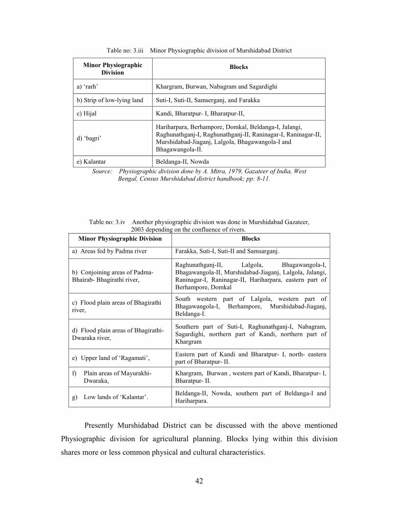
Table no: 3.iii Minor Physiographic division of Murshidabad District
Minor Physiographic
Division Blocks
a) ‘rarh’ Khargram, Burwan, Nabagram and Sagardighi
b) Strip of low-lying land Suti-I, Suti-II, Samserganj, and Farakka
c) Hijal Kandi, Bharatpur- I, Bharatpur-II,
d) ‘bagri’
Hariharpara, Berhampore, Domkal, Beldanga-I, Jalangi,
Raghunathganj-I, Raghunathganj-II, Raninagar-I, Raninagar-II,
Murshidabad-Jiaganj, Lalgola, Bhagawangola-I and
Bhagawangola-II.
e) Kalantar Beldanga-II, Nowda
Source: Physiographic division done by A. Mitra, 1979, Gazateer of India, West
Bengal, Census Murshidabad district handbook; pp: 8-11.
Table no: 3.iv Another physiographic division was done in Murshidabad Gazateer,
2003 depending on the confluence of rivers.
Minor Physiographic Division Blocks
a) Areas fed by Padma river Farakka, Suti-I, Suti-II and Samsarganj.
b) Conjoining areas of Padma-
Bhairab- Bhagirathi river,
Raghunathganj-II, Lalgola, Bhagawangola-I,
Bhagawangola-II, Murshidabad-Jiaganj, Lalgola, Jalangi,
Raninagar-I, Raninagar-II, Hariharpara, eastern part of
Berhampore, Domkal
c) Flood plain areas of Bhagirathi
river,
South western part of Lalgola, western part of
Bhagawangola-I, Berhampore, Murshidabad-Jiaganj,
Beldanga-I.
d) Flood plain areas of Bhagirathi-
Dwaraka river,
Southern part of Suti-I, Raghunathganj-I, Nabagram,
Sagardighi, northern part of Kandi, northern part of
Khargram
e) Upper land of ‘Ragamati’, Eastern part of Kandi and Bharatpur- I, north- eastern
part of Bharatpur- II.
f) Plain areas of Mayurakhi-
Dwaraka,
Khargram, Burwan , western part of Kandi, Bharatpur- I,
Bharatpur- II.
g) Low lands of ‘Kalantar’. Beldanga-II, Nowda, southern part of Beldanga-I and
Hariharpara.
Presently Murshidabad District can be discussed with the above mentioned
Physiographic division for agricultural planning. Blocks lying within this division
shares more or less common physical and cultural characteristics.
43
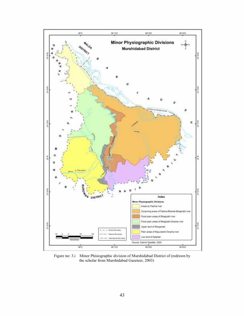
Figure no: 3.i Minor Phisiographic division of Murshidabad District of (redrawn by
the scholar from Murshidabad Gazeteer, 2003)
44
3.4 SOIL
The ‘rarh’ region is substantially a continuation of the sub- Vindhyan region of
lateritic clay and nodular ghuting. The soil is grayish or reddish mixed with lime and
iron oxide and scattered nodular lime ghutting (kankar).
The ‘bagri’ region lying in the Bhagirathi recent surface has little soil development. The
surface composed of loose and completely unconsolidated sediments exhibiting a
variety of sedimentary structures. About 1-2 meters of thick brown mottled soil with
soft and incipient ferruginous concretion develop on Younger Deltaic Plain. The soil pH
ranges from 6.7 to 7.4.
Plate no. 3.1, 3.2 and 3.3 are showing few photographs of different soil profiles
of Murshidabad District.
The NBSS & LUP (National Bureau of Soil Survey and Land Use Planning) of
the ICAR (Indian Council of Agricultural Research) prepared a map of the soils of West
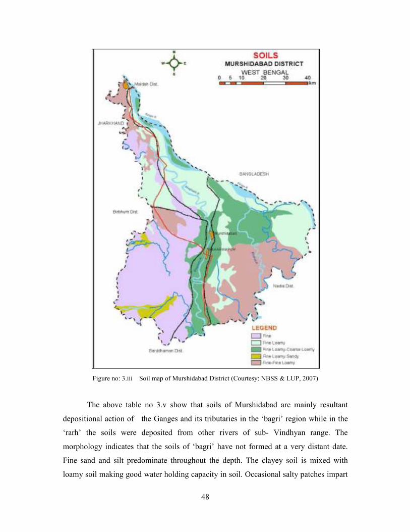
Bengal including the Murshidabad District in a scale 1:500,000 (figure no.3.iii).
The soil groups of Murshidabad district classification was done by the agricultural
department in annual action plan 1986-87.
45
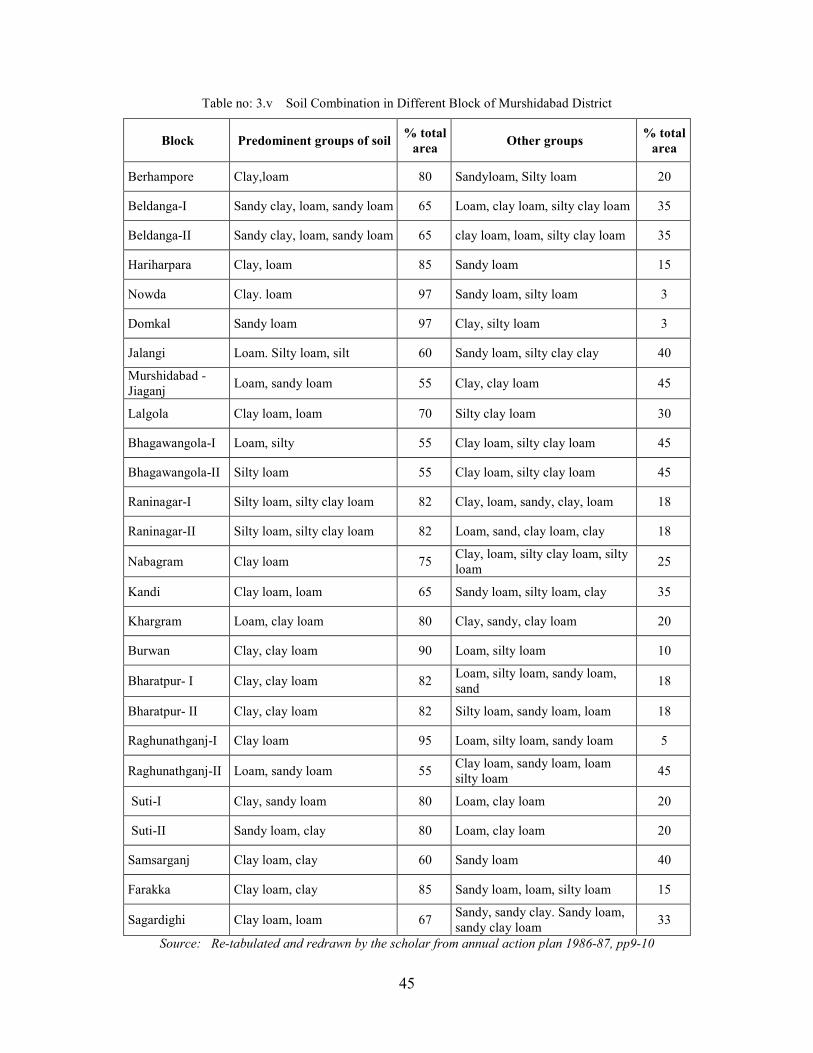
Table no: 3.v Soil Combination in Different Block of Murshidabad District
Block Predominent groups of soil % total
area Other groups
% total
area
Berhampore Clay,loam 80 Sandyloam, Silty loam 20
Beldanga-I Sandy clay, loam, sandy loam 65 Loam, clay loam, silty clay loam 35
Beldanga-II Sandy clay, loam, sandy loam 65 clay loam, loam, silty clay loam 35
Hariharpara Clay, loam 85 Sandy loam 15
Nowda Clay. loam 97 Sandy loam, silty loam 3
Domkal Sandy loam 97 Clay, silty loam 3
Jalangi Loam. Silty loam, silt 60 Sandy loam, silty clay clay 40
Murshidabad -
Jiaganj Loam, sandy loam 55 Clay, clay loam 45
Lalgola Clay loam, loam 70 Silty clay loam 30
Bhagawangola-I Loam, silty 55 Clay loam, silty clay loam 45
Bhagawangola-II Silty loam 55 Clay loam, silty clay loam 45
Raninagar-I Silty loam, silty clay loam 82 Clay, loam, sandy, clay, loam 18
Raninagar-II Silty loam, silty clay loam 82 Loam, sand, clay loam, clay 18
Nabagram Clay loam 75 Clay, loam, silty clay loam, silty
loam 25
Kandi Clay loam, loam 65 Sandy loam, silty loam, clay 35
Khargram Loam, clay loam 80 Clay, sandy, clay loam 20
Burwan Clay, clay loam 90 Loam, silty loam 10
Bharatpur- I Clay, clay loam 82 Loam, silty loam, sandy loam,
sand 18
Bharatpur- II Clay, clay loam 82 Silty loam, sandy loam, loam 18
Raghunathganj-I Clay loam 95 Loam, silty loam, sandy loam 5
Raghunathganj-II Loam, sandy loam 55 Clay loam, sandy loam, loam
silty loam 45
Suti-I Clay, sandy loam 80 Loam, clay loam 20
Suti-II Sandy loam, clay 80 Loam, clay loam 20
Samsarganj Clay loam, clay 60 Sandy loam 40
Farakka Clay loam, clay 85 Sandy loam, loam, silty loam 15
Sagardighi Clay loam, loam 67 Sandy, sandy clay. Sandy loam,
sandy clay loam 33
Source: Re-tabulated and redrawn by the scholar from annual action plan 1986-87, pp9-10

46
Plate no: 3.2 Silty loam soils, Bhagawangola-II Block, Murshidabad District
Plate no: 3.3 Clay loam soil, Barwan Block,
Murshidabad District.
Plate no: 3.1 Sandy loam soils, Domkal Block,
Murshidabad District.

47
Figure no: 3.ii Soil map of Murshidabad District (Compiled by the author from
District Annual Action Plan, Principal Agricultural Office, 1985).
1985
48
Figure no: 3.iii Soil map of Murshidabad District (Courtesy: NBSS & LUP, 2007)
The above table no 3.v show that soils of Murshidabad are mainly resultant
depositional action of the Ganges and its tributaries in the ‘bagri’ region while in the
‘rarh’ the soils were deposited from other rivers of sub- Vindhyan range. The
morphology indicates that the soils of ‘bagri’ have not formed at a very distant date.
Fine sand and silt predominate throughout the depth. The clayey soil is mixed with
loamy soil making good water holding capacity in soil. Occasional salty patches impart
49
a whitish colour to the soil. The soil contain low amount of potash and phosphate, and
poor in organic matter and nitrogen. The permeability of the soil is very high and the
soils have good drainage capacity.
4Sen, J. 1988; had proposed a soil classification of the ‘bagri’ region adopted
from the Directorate of Agriculture (1958-60) as:
a) Ganga Riverine lands (Meadow soils) – i) Inundated phase- Ganga Char lands: This
region is found in the adjacent to the banks of the Ganga- Padma River and Jalangi
River. ii) High land phase – Ganga ridges: these regions occurs beside the inundated
phase; comparatively in the highest topography.
b) Ganga Flat land: This land lies between Ganga riverine and Ganga lowland. The
nitrogen content is moderate and the buffering capacity is very high. Water
permeability and water retention capacity is very high. The percentage of sand
decreases and the percentage of clay increases with the depth of the soil.
c) Ganga Lowland: This zone is associated with heavy clay horizon followed by sub-
soils of sandy material, coarse sand and some concretions. During rainy season the
soil is sticky and during winter the soil dried up and cracks. The percentage of silt,
moisture, carbon and nitrogen decreases with the depth of the soil.
d) Ganga Uplands: The area has comparatively higher topography. The Bhagirathi
rarely swings to the right and erode the land due to the stable and stiff nature of this
soil. The soil profile is clayey in nature with the presence of lime horizon. The
sesquioxide present is immobile. In the third and fourth layer lime accumulation is
noted due to leaching of calcium carbonate from the surface layer. Phosphate and
nitrogen content is low and potash content is average.
The northern part of the Murshidabad district (blocks like Farakka, Suti-I, Suti-
II and Samsherganj) consists of basaltic lava flows with intercalated carbonaceous shale
and clays. This part of the district has very low soil fertility. This area presents a perfect
picturesque of a combination of hill, woods and water. During rainy season the area
forms a vast lake in with villages appear as an island. Basloi River and other hill
streams from the west Rajmahal hill flood the area every year (Gazetteer by A. Mitra,
1979; pp: 10, 15).
50
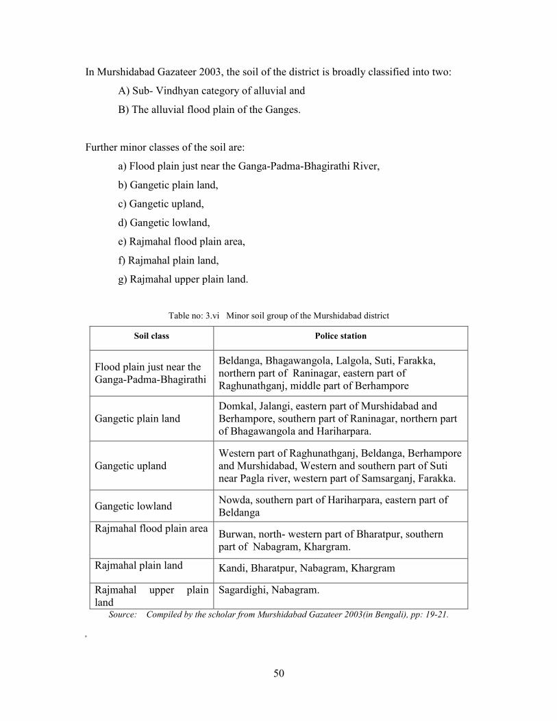
In Murshidabad Gazateer 2003, the soil of the district is broadly classified into two:
A) Sub- Vindhyan category of alluvial and
B) The alluvial flood plain of the Ganges.
Further minor classes of the soil are:
a) Flood plain just near the Ganga-Padma-Bhagirathi River,
b) Gangetic plain land,
c) Gangetic upland,
d) Gangetic lowland,
e) Rajmahal flood plain area,
f) Rajmahal plain land,
g) Rajmahal upper plain land.
Table no: 3.vi Minor soil group of the Murshidabad district
Soil class Police station
Flood plain just near the
Ganga-Padma-Bhagirathi
Beldanga, Bhagawangola, Lalgola, Suti, Farakka,
northern part of Raninagar, eastern part of
Raghunathganj, middle part of Berhampore
Gangetic plain land
Domkal, Jalangi, eastern part of Murshidabad and
Berhampore, southern part of Raninagar, northern part
of Bhagawangola and Hariharpara.
Gangetic upland
Western part of Raghunathganj, Beldanga, Berhampore
and Murshidabad, Western and southern part of Suti
near Pagla river, western part of Samsarganj, Farakka.
Gangetic lowland Nowda, southern part of Hariharpara, eastern part of
Beldanga
Rajmahal flood plain area Burwan, north- western part of Bharatpur, southern
part of Nabagram, Khargram.
Rajmahal plain land Kandi, Bharatpur, Nabagram, Khargram
Rajmahal upper plain
land
Sagardighi, Nabagram.
Source: Compiled by the scholar from Murshidabad Gazateer 2003(in Bengali), pp: 19-21.

51
From the different geological, geomorphological and soil classification it is clear
that a sharp contrast is noticed between the physical characteristics between ‘rarh’ and
‘bagri’ region of the district. The soil property of the ‘bagri’ region makes the blocks
underlying more fertile than the ‘rarh’ blocks.
3.5 CLIMATE
The rain fall of monsoon from end of June to September is well experienced.
The month of July gives the highest shower of the season; sometimes 392 millimeters of
rain fall in 1990. In September 19, 2000 the rainfall was 558.80 millimeters which
caused drastic flood in the entire district.
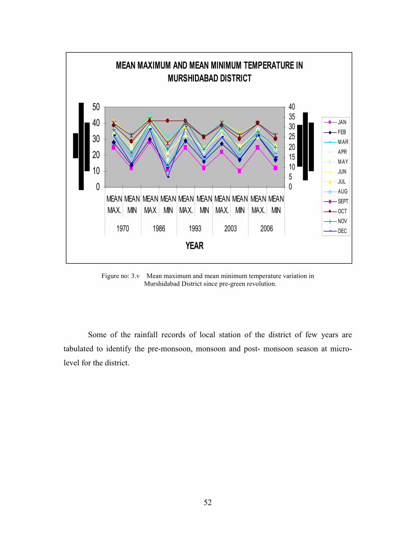
The entire district lies under perfect tropical monsoon type of climate. The
month of May has highest temperature. In 1995 the maximum temperature recorded
was 45 degree Celsius and minimum 25 degree Celsius.
Figure no: 3.iv changing monthly rainfall in Murshidabad District since pre-green revolution.
0
100
200
300
400
500
600
700
RAINFALL IN MILLIMETERS
JAN MAR MAY JUL SEPT NOV
MONTH
MONTHLY RAINFALL IN MURSHIDABAD DISTRICT
1971
1989
1991
1993
2002
2003
2004
2005
2006
NORMAL
52
Figure no: 3.v Mean maximum and mean minimum temperature variation in
Murshidabad District since pre-green revolution.
Some of the rainfall records of local station of the district of few years are
tabulated to identify the pre-monsoon, monsoon and post- monsoon season at micro-
level for the district.
MEAN MAXIMUM AND MEAN MINIMUM TEMPERATURE IN
MURSHIDABAD DISTRICT
0
10
20
30
40
50
MEAN
MAX.
MEAN
MIN
MEAN
MAX
MEAN
MIN
MEAN
MAX.
MEAN
MIN
MEAN
MAX.
MEAN
MIN
MEAN
MAX.
MEAN
MIN
1970 1986 1993 2003 2006
YEAR
0
5
10
15
20
25
30
35
40
JAN
FEB
MAR
APR
MAY
JUN
JUL
AUG
SEPT
OCT
NOV
DEC
53
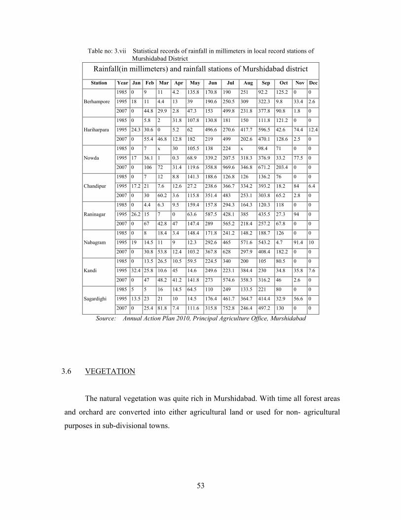
Table no: 3.vii Statistical records of rainfall in millimeters in local record stations of
Murshidabad District
Rainfall(in millimeters) and rainfall stations of Murshidabad district
Station Year Jan Feb Mar Apr May Jun Jul Aug Sep Oct Nov Dec
Berhampore
1985 0 9 11 4.2 135.8 170.8 190 251 92.2 125.2 0 0
1995 18 11 4.4 13 39 190.6 250.5 309 322.3 9.8 33.4 2.6
2007 0 44.8 29.9 2.8 47.3 153 499.8 231.8 377.8 90.8 1.8 0
Hariharpara
1985 0 5.8 2 31.8 107.8 130.8 181 150 111.8 121.2 0 0
1995 24.3 30.6 0 5.2 62 496.6 270.6 417.7 596.5 42.6 74.4 12.4
2007 0 55.4 46.8 12.8 182 219 499 202.6 470.1 128.6 2.5 0
Nowda
1985 0 7 x 30 105.5 138 224 x 98.4 71 0 0
1995 17 36.1 1 0.3 68.9 339.2 207.5 318.3 376.9 33.2 77.5 0
2007 0 106 72 31.4 119.6 358.8 969.6 346.8 671.2 203.4 0 0
Chandipur
1985 0 7 12 8.8 141.3 188.6 126.8 126 136.2 76 0 0
1995 17.2 21 7.6 12.6 27.2 238.6 366.7 334.2 393.2 18.2 84 6.4
2007 0 30 60.2 3.6 115.8 351.4 483 253.1 303.8 65.2 2.8 0
Raninagar
1985 0 4.4 6.3 9.5 159.4 157.8 294.3 164.3 120.3 118 0 0
1995 26.2 15 7 0 63.6 587.5 428.1 385 435.5 27.3 94 0
2007 0 67 42.8 47 147.4 289 565.2 218.4 257.2 67.8 0 0
Nabagram
1985 0 8 18.4 3.4 148.4 171.8 241.2 148.2 188.7 126 0 0
1995 19 14.5 11 9 12.3 292.6 465 571.6 543.2 4.7 91.4 10
2007 0 30.8 53.8 12.4 103.2 367.8 628 297.9 408.4 182.2 0 0
Kandi
1985 0 13.5 26.5 10.5 59.5 224.5 340 200 105 80.5 0 0
1995 32.4 25.8 10.6 45 14.6 249.6 223.1 384.4 230 34.8 35.8 7.6
2007 0 47 48.2 41.2 141.8 273 574.6 358.3 316.2 46 2.6 0
Sagardighi
1985 5 5 16 14.5 64.5 110 249 133.5 221 80 0 0
1995 13.5 23 21 10 14.5 176.4 461.7 364.7 414.4 32.9 56.6 0
2007 0 25.4 81.8 7.4 111.6 315.8 752.8 246.4 497.2 130 0 0
Source: Annual Action Plan 2010, Principal Agriculture Office, Murshidabad
3.6 VEGETATION
The natural vegetation was quite rich in Murshidabad. With time all forest areas
and orchard are converted into either agricultural land or used for non- agricultural
purposes in sub-divisional towns.

54
Natural Vegetation
The Murshidabad district comprises of deltaic type of flora. In the swampy areas
numerous marshy species are seen. Hycinth, algae are found in ponds and ditches.
Bamboos are scattered all over the district. Beside, orchards like mango, jackfruit,
guava, lemon and litchis are popular in the district. Segun, Sisoo, Simul, Tentul, Kul,
Banyan, Ashwatha, Coconut, Wild Date palm, ‘Sajne’, Eucalyptus etc. are common
trees of the district. Babla, Sal and Mahua, Palash are common in the ‘rarh’ region. To
check the soil erosion along the bank of the Ganges Babul (Acacia Arabica Willd) were
planted. Mulberry trees are common in Berhampore, Islampore and Beldanga for
sericulture.
Among the flowering plants Champa, Hibiscus, Bougainvilea, Jasmine, Rose
etc. are common. Parthenium, Cynodon dactylon Pers., Cyperus rotundus L., etc.
bushes are common in any waste land or road side. Jitpur forest in Dumkol block is a
notable area of natural vegetation presently under complete negligence.
Cultivated plants
The district cultivates predominantly rice (‘aus’, ‘aman’ and ‘boro’), wheat, and
few maize and barley. Common vegetables grown are potato, brinjal, parwal, bitter
gourd, bottle gourd, pumpkin, tomato, ‘puin’, raddish, carrot, beet, cauliflower,
cabbage, knol-khol, spinach and other leafy vegetables. The pulses grown are kalai,
khesari, masur, arhar,matar, gram, and mung. Oilseeds grown are Groundnut, rye,
mustard, til. Spices growm are kalajeera, dhania, haldi. Jute is an important fibre crop of
‘bagri’ region.
3.7 WATER RESOURCES
The district is rich in both surface water and groundwater. Among the surface
water bodies main two rivers channels distributes throughout the district.
A) Ganga- Padma River channel; its distributaries and
B) Mayurashki river channels; its distributaries.
55
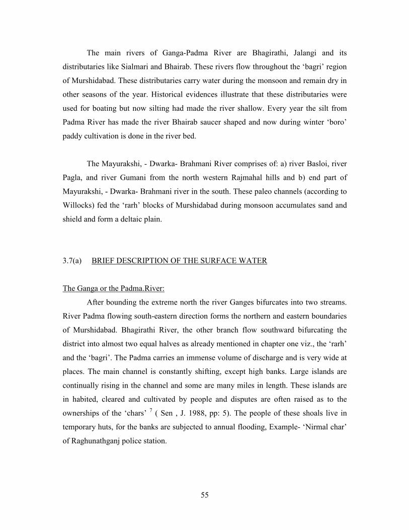
The main rivers of Ganga-Padma River are Bhagirathi, Jalangi and its
distributaries like Sialmari and Bhairab. These rivers flow throughout the ‘bagri’ region
of Murshidabad. These distributaries carry water during the monsoon and remain dry in
other seasons of the year. Historical evidences illustrate that these distributaries were
used for boating but now silting had made the river shallow. Every year the silt from
Padma River has made the river Bhairab saucer shaped and now during winter ‘boro’
paddy cultivation is done in the river bed.
The Mayurakshi, - Dwarka- Brahmani River comprises of: a) river Basloi, river
Pagla, and river Gumani from the north western Rajmahal hills and b) end part of
Mayurakshi, - Dwarka- Brahmani river in the south. These paleo channels (according to
Willocks) fed the ‘rarh’ blocks of Murshidabad during monsoon accumulates sand and
shield and form a deltaic plain.
3.7(a) BRIEF DESCRIPTION OF THE SURFACE WATER
The Ganga or the Padma.River:
After bounding the extreme north the river Ganges bifurcates into two streams.
River Padma flowing south-eastern direction forms the northern and eastern boundaries
of Murshidabad. Bhagirathi River, the other branch flow southward bifurcating the
district into almost two equal halves as already mentioned in chapter one viz., the ‘rarh’
and the ‘bagri’. The Padma carries an immense volume of discharge and is very wide at
places. The main channel is constantly shifting, except high banks. Large islands are
continually rising in the channel and some are many miles in length. These islands are
in habited, cleared and cultivated by people and disputes are often raised as to the
ownerships of the ‘chars’ 7 ( Sen , J. 1988, pp: 5). The people of these shoals live in
temporary huts, for the banks are subjected to annual flooding, Example- ‘Nirmal char’
of Raghunathganj police station.

56
The Bhagirathi:
The Bhagirathi takes off from the Ganga at Nurpur about twenty five miles
away from south Farakka. The river runs parallel to the Padma River for about two
miles and turns southward at Biswanathpur in Suti police station. It is very much
sinuous near Jangipur and Berhampore. The river finally debouch into the Bay of
Bengal after meeting the Jalangi river near Swarupganj in the Nadia district and hence
named as river Hoogly. The general flow of the river is from northwest to south east;
therefore, the channel Bhagirathi which flows from north to the south carries less
volume of water than the Padma River.
Jalangi:
The Jalangi River is one of the important rivers in the ‘‘bagri’’ region of
Murshidabad. This river is a tributary of Padma River. This river flows from the eastern
part of the district and diverts into southwestern direction and enters into the Nadia
district. Presently, silting has clogged the mouth of Jalangi from Padma. For few days
of the rainy season, when the discharge in the river Padma is abnormally high, some
freshets come down the bed of the river but with the fall of the Padma it continues to
dry up the course for about three kilometer from it’s off- take point remains dry. From
this point to its confluence with the river Sialmari, it was fed by local drainage (beel)
and underground seepage (Sen, J. 1988, pp: 6). Sialmari has become a mere closed ox
bow lake and presently surrounding areas of these streams are converted into
agricultural field.
The Bhairab:
This is a paleo- channel but for many years it is condemned. It takes off from
Ganga in Lalgola police station within this district, opposite to the place near where the
Mahananda flows into the Ganga.It is believed that before the Padma started carrying
the main flow of the Ganga, it used to be the continuation of the Mahananda.The
growing strength current along the Padma, its importance was cut off. The Mahananda
started to pour her water into the Padma are the course of Bhairab further deteriorated.
During the rainy season this river receives water from river Padma and for rest of the
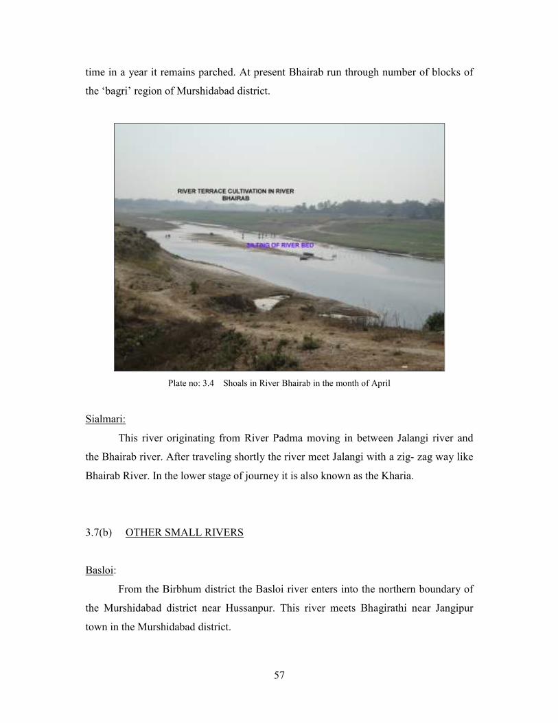
57
time in a year it remains parched. At present Bhairab run through number of blocks of
the ‘bagri’ region of Murshidabad district.
Plate no: 3.4 Shoals in River Bhairab in the month of April
Sialmari:
This river originating from River Padma moving in between Jalangi river and
the Bhairab river. After traveling shortly the river meet Jalangi with a zig- zag way like
Bhairab River. In the lower stage of journey it is also known as the Kharia.
3.7(b) OTHER SMALL RIVERS
Basloi:
From the Birbhum district the Basloi river enters into the northern boundary of
the Murshidabad district near Hussanpur. This river meets Bhagirathi near Jangipur
town in the Murshidabad district.
58
Pagla:
A little southward from Basloi River, Pagla River runs through Jangipur town
and meets Bhairab River in easterly direction.
Brahmani:
The source of this river originated from Santal Pargana of Jharkhand state and
only a part of this river lies in the Birbhum district and western part of Murshidabad
District of West Bengal. The River run through Jharkhand state and enters the Birbhum
district near Narayanpur and meets with Tripiti River originating from Santal Pargana
and finally meets with the Brahmani –Dwarka near Sakoghat in Murshidabad District.
Dwarka –Babla:
This River has many names like the Banka and the Chora Dekra and has many
distributaries.Among them the main river enters the district near Morgram from the
Birbhum district.At first it flows in an easterly direction until its waters are augmented
by those of the Brahmani at Ramchandrapur. It turns towards the south-east and joined
on its right bank by the Mor and the Kuiya, another two river flowing down from
Birbhum district. Numerous backwaters and side channels connect with the Bhagirathi
and c’aus’es many morphological confusion.The main streams also forms the eastern
boundary of the Kandi subdivision and quit the district at Raghupur.During rainy season
this river turns into rapid current and is liable to sudden flood.
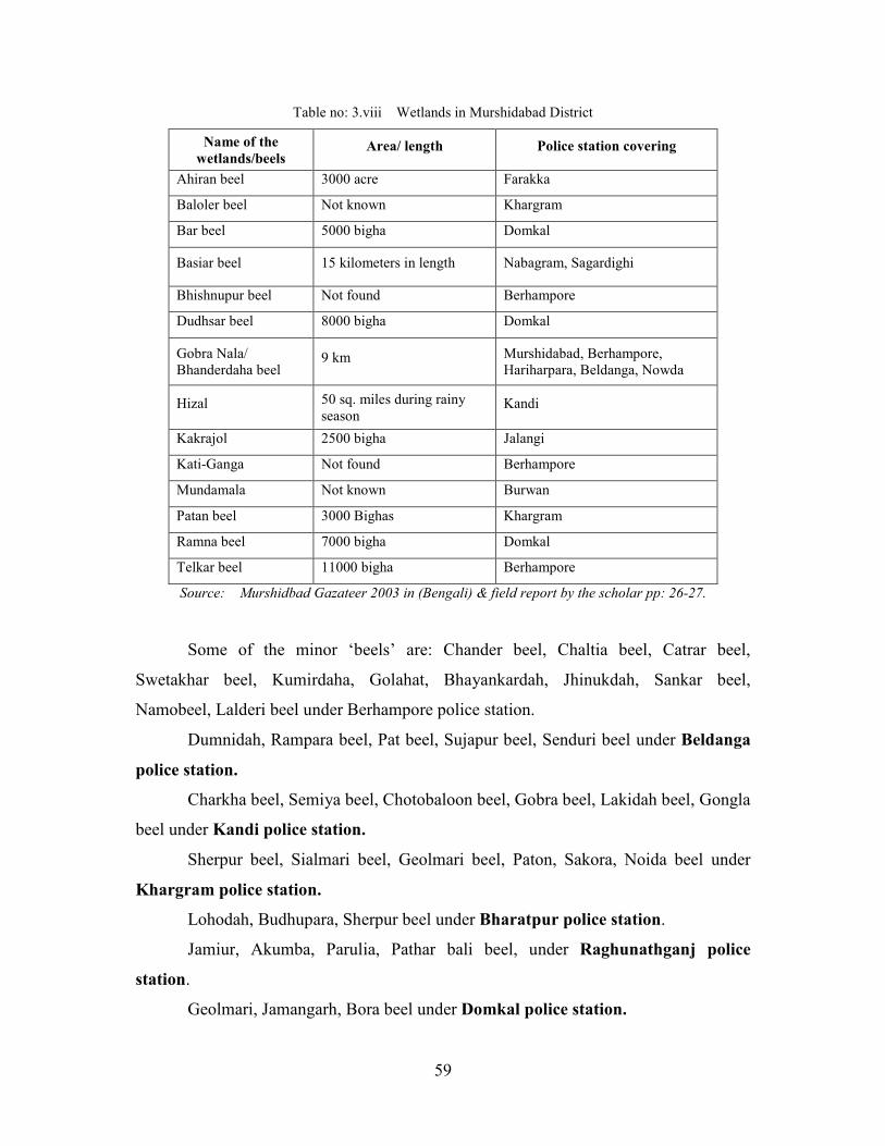
3.7(c) WETLANDS / BACKWATERS
Most of the wetlands/backwaters, cut-off from rivers locally known as ‘beels’
are now physically not found due to conversion of land into agricultural field or
settlement.
59
Table no: 3.viii Wetlands in Murshidabad District
Name of the
wetlands/beels Area/ length Police station covering
Ahiran beel 3000 acre Farakka
Baloler beel Not known Khargram
Bar beel 5000 bigha Domkal
Basiar beel 15 kilometers in length Nabagram, Sagardighi
Bhishnupur beel Not found Berhampore
Dudhsar beel 8000 bigha Domkal
Gobra Nala/
Bhanderdaha beel 9 km Murshidabad, Berhampore,
Hariharpara, Beldanga, Nowda
Hizal 50 sq. miles during rainy
season Kandi
Kakrajol 2500 bigha Jalangi
Kati-Ganga Not found Berhampore
Mundamala Not known Burwan
Patan beel 3000 Bighas Khargram
Ramna beel 7000 bigha Domkal
Telkar beel 11000 bigha Berhampore
Source: Murshidbad Gazateer 2003 in (Bengali) & field report by the scholar pp: 26-27.
Some of the minor ‘beels’ are: Chander beel, Chaltia beel, Catrar beel,
Swetakhar beel, Kumirdaha, Golahat, Bhayankardah, Jhinukdah, Sankar beel,
Namobeel, Lalderi beel under Berhampore police station.
Dumnidah, Rampara beel, Pat beel, Sujapur beel, Senduri beel under Beldanga
police station.
Charkha beel, Semiya beel, Chotobaloon beel, Gobra beel, Lakidah beel, Gongla
beel under Kandi police station.
Sherpur beel, Sialmari beel, Geolmari beel, Paton, Sakora, Noida beel under
Khargram police station.
Lohodah, Budhupara, Sherpur beel under Bharatpur police station.
Jamiur, Akumba, Parulia, Pathar bali beel, under Raghunathganj police
station.
Geolmari, Jamangarh, Bora beel under Domkal police station.

60
3.7(d) SUB-SURFACE WATER
Alluvial deposits by the river systems from unconsolidated thick zone of
saturated groundwater. The sand and gravel horizons of different textures constitute
main aquifers and occur down to 90-350 meter below ground level (mbgl).
4Nomenclatures of the hydro-geology of Bangladesh studied by Mukherjee et.al. (2007)
stated that the aquifers in the West Bengal probably belong to 1) Late Pleistocene to
Holocene Ganges Sediments, 2) Early to middle Pleistocene coastal and moribund
Ganges delta deep aquifers composed of stacked, main-channel, medium to coarse
sands at depth more than 130 m. The aquifer is highly productive, and water table
encountered within 15 mbgl. The groundwater flow system consist of shallow system
(over lateral distances of a few kilometers) between local topographic features and
intermediate to regional flows (ten to hundreds of kilometers long) between major
topographic features or basin boundaries. Groundwater movement in areas of flat
topography in the Bengal basin may be mostly vertical and lateral flow limited to local
scale (J.V. Wonderen, Sir, M, Macdonald Ltd.,2006 in Mukherjee et.al. 2007, pp: 4-5).
Surface water and groundwater interaction generally occurs within local flow system
Plate no: 3.5 Blocked Gobra nala with water hyacinth in the month of October
Plate no: 3.6 Blocked drainage beside road,
Hariharpara Block, Murshidabad District.
61
(Mukherjee et.al. 2007). Large River like Bhagirathi-Hoogly is losing its importance in
irrigating the agricultural field.
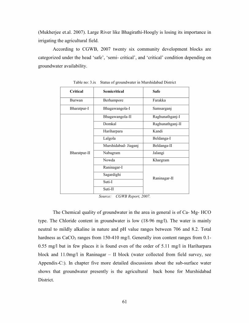
According to CGWB, 2007 twenty six community development blocks are
categorized under the head ‘safe’, ‘semi- critical’, and ‘critical’ condition depending on
groundwater availability.
Table no: 3.ix Status of groundwater in Murshidabad District
Critical Semicritical Safe
Burwan Berhampore Farakka
Bharatpur-I Bhagawangola-I Samsarganj
Bharatpur-II
Bhagawangola-II Raghunathganj-I
Domkal Raghunathganj-II
Hariharpara Kandi
Lalgola Beldanga-I
Murshidabad- Jiaganj Beldanga-II
Nabagram Jalangi
Nowda Khargram
Raninagar-I
Raninagar-II Sagardighi
Suti-I
Suti-II
Source: CGWB Report, 2007.
The Chemical quality of groundwater in the area in general is of Ca- Mg- HCO
type. The Chloride content in groundwater is low (18-96 mg/l). The water is mainly
neutral to mildly alkaline in nature and pH value ranges between 706 and 8.2. Total
hardness as CaCO3 ranges from 150-410 mg/l. Generally iron content ranges from 0.1-
0.55 mg/l but in few places it is found even of the order of 5.11 mg/l in Hariharpara
block and 11.0mg/l in Raninagar – II block (water collected from field survey, see
Appendix-C:). In chapter five more detailed discussions about the sub-surface water
shows that groundwater presently is the agricultural back bone for Murshidabad
District.

62
3.8 CONCLUSION
The natural parameter of Murshidabad encourages groundwater irrigation. Some
researchers’ support more water extraction from underground while some opposes in
doing so. In chapter four an appraisal is done about the agricultural enhancement with
Green Revolution although a little later than the western districts of India. After four
decade what is the present situation of landuse, productivity of land and
interrelationship between the irrigational facilities and water available are the main foci
of discussion.
REFERENCES:
1. Bhattacharya, A. and Banerjee, S.N. (1979): “Quarternary Geology and
Geomorphology of the Ajay- Bhagirathi Valley, Birbhum and Murshidabad district,
West Bengal.” Indian Journal of Earth Science. Vol. 6(1): pp: 91-102.
2. Dressler et.al.(2006) in “HYDROMORPHOLOGY” by Richard M. Vogel, Journal
of Water Resources Planning and Management, in Press; vol.137(2), 2011.
3. Gazetteer of India (1979), West Bengal District, census handbook, Murshidabad
district, Government of West Bengal; by A. Mitra pp: 2-20.
4. Mukherjee, A.; Fryay, A. E. ; Howell, P. D.(2007); ‘ Regional hydrostratigraphy
and groundwater medelling in the arsenic- affected areas of the western Bengal
basin, West Bengal , India’, Journal of hydrogeology, Siringer- Verlag. DOI
10.1007/s10040-007-0208-7.
5. Murshidabad district gazetteer (2003), West Bengal District Gazeteer, Government
of West Bengal pp:14-45.
6. Roychowdhury. et. al. (2002): “Arsenic and other heavy metals in soils from an
arsenic- affected area of West Bengal, India.” Chemosphere, Vol.49, pp 605-618.
7. Sen, J. (1988), “Land Utilization and Population Distribution A case study of West
Bengal 1850-1985” Daya Publishing House, Delhi, pp: vii-20
Related Documents