Hydraulic geometry in river channel networks as a method for the assessment of river condition Elizabeth Thornton 1 , Melissa Neave 2 and Scott Rayburg 3 1 Earth Tech, 3/221 Miller Street North Sydney, NSW, 2060. Email: [email protected] 2 Division of Geography, University of Sydney, NSW, 2006. Email: [email protected] 3 Riverine Landscapes Research Laboratory, University of Canberra, Belconnen, ACT, 2601 Abstract Aspects of channel morphology were examined across the stream network in the Kangaroo River catchment, NSW. Downstream hydraulic geometry relationships were analysed as appropriate methods of predicting alterations in channel morphology with increasing scale within a network context. Examining river network behaviour in this way enhances understanding of the way in which geomorphic processes behave across networks. This in turn provides scientific grounding for stream management on a network scale. A similarity between downstream and network hydraulic geometry relations was found, suggesting the potential for modelling adjustment in channel form to discharge regimes across the network. The potential for the use of network hydraulic geometry relationships in assessments of river channel condition is discussed. Keywords River assessment, stream order, scale, Kangaroo River, multivariate analysis, hydraulic geometry Introduction River assessment, or the assessment of river condition relative to some ideal state, is a concept receiving increasing attention in both geomorphology and ecology. In both of these fields, river condition is often assessed relative to a reference reach, or a reach that is known or suspected to be largely unmodified or in a natural state. However, the identification of a suitable reference reach can be very difficult in regions that have been heavily modified by humans. There are many ways in which river condition can be assessed and, consequently, numerous river assessment methods are currently in use around the world. Several river condition assessment methods have been specifically designed for Australia for example, AusRivAS (Parsons et al., 2002), the Index of Stream Condition (ISC) (Ladson & White, 1999; Ladson et al., 1999), the River Habitat Audit (Anderson, 1993) and River Styles® (Brierley & Fryirs, 2005). AusRivAS assesses ecological condition by calculating the ratio of observed to expected macroinvertebrate taxa and where the quantity and type of taxa do not meet expectations it is assumed that water quality and/or habitat conditions are limiting factors (Parsons et al., 2002). The ISC method, developed in Victoria, integrates information on hydrology, physical form, streamside zone, water quality and aquatic life to assess rivers at the reach scale (Ladson & White, 1999; Ladson et al., 1999). Sub-index ratings are derived through comparison with a reference reach and combined to create an ISC rating for each reach. The River Habitat Audit Procedure compares the extent to which the values or perceived functions of river attributes have declined from the pristine state of the river (Anderson, 1993). This assessment method utilizes the condition of subset variables to determine a condition rating for each reach and then scales those using representative sites. Ecological approaches for assessing river condition, such as AusRivAS, ISC and the River Habitat Audit Procedure, can neglect a river’s geomorphic character. However, geomorphic condition serves as the physical template on which ecological systems depend and may significantly impact on ecological health while the reverse is less common. Therefore, geomorphic condition assessments are valuable mechanisms for determining the present and future health of river systems (Maddock, 1999). In recognition of this, River Styles® (Brierley & Fryirs, 2005) provides a framework for assessing river condition using geomorphic criteria and achieves this largely by comparing the geomorphic character of reference reaches to test reaches of similar river types (Fryirs, 2003). As River Styles® involves some subjective interpretation, this study explores an additional geomorphic approach using quantitative scaling relationships between reference and Wilson, A.L., Dehaan, R.L., Watts, R.J., Page, K.J., Bowmer, K.H., & Curtis, A. (2007). Proceedings of the 5th Australian Stream Management Conference. Australian rivers: making a difference. Charles Sturt University, Thurgoona, New South Wales. 401

Welcome message from author
This document is posted to help you gain knowledge. Please leave a comment to let me know what you think about it! Share it to your friends and learn new things together.
Transcript
Hydraulic geometry in river channel networks as a method for the assessment of river condition Elizabeth Thornton1, Melissa Neave2 and Scott Rayburg3 1 Earth Tech, 3/221 Miller Street North Sydney, NSW, 2060. Email: [email protected] 2 Division of Geography, University of Sydney, NSW, 2006. Email: [email protected] 3 Riverine Landscapes Research Laboratory, University of Canberra, Belconnen, ACT, 2601 Abstract Aspects of channel morphology were examined across the stream network in the Kangaroo River catchment, NSW. Downstream hydraulic geometry relationships were analysed as appropriate methods of predicting alterations in channel morphology with increasing scale within a network context. Examining river network behaviour in this way enhances understanding of the way in which geomorphic processes behave across networks. This in turn provides scientific grounding for stream management on a network scale. A similarity between downstream and network hydraulic geometry relations was found, suggesting the potential for modelling adjustment in channel form to discharge regimes across the network. The potential for the use of network hydraulic geometry relationships in assessments of river channel condition is discussed. Keywords River assessment, stream order, scale, Kangaroo River, multivariate analysis, hydraulic geometry Introduction River assessment, or the assessment of river condition relative to some ideal state, is a concept receiving increasing attention in both geomorphology and ecology. In both of these fields, river condition is often assessed relative to a reference reach, or a reach that is known or suspected to be largely unmodified or in a natural state. However, the identification of a suitable reference reach can be very difficult in regions that have been heavily modified by humans. There are many ways in which river condition can be assessed and, consequently, numerous river assessment methods are currently in use around the world. Several river condition assessment methods have been specifically designed for Australia for example, AusRivAS (Parsons et al., 2002), the Index of Stream Condition (ISC) (Ladson & White, 1999; Ladson et al., 1999), the River Habitat Audit (Anderson, 1993) and River Styles® (Brierley & Fryirs, 2005). AusRivAS assesses ecological condition by calculating the ratio of observed to expected macroinvertebrate taxa and where the quantity and type of taxa do not meet expectations it is assumed that water quality and/or habitat conditions are limiting factors (Parsons et al., 2002). The ISC method, developed in Victoria, integrates information on hydrology, physical form, streamside zone, water quality and aquatic life to assess rivers at the reach scale (Ladson & White, 1999; Ladson et al., 1999). Sub-index ratings are derived through comparison with a reference reach and combined to create an ISC rating for each reach. The River Habitat Audit Procedure compares the extent to which the values or perceived functions of river attributes have declined from the pristine state of the river (Anderson, 1993). This assessment method utilizes the condition of subset variables to determine a condition rating for each reach and then scales those using representative sites. Ecological approaches for assessing river condition, such as AusRivAS, ISC and the River Habitat Audit Procedure, can neglect a river’s geomorphic character. However, geomorphic condition serves as the physical template on which ecological systems depend and may significantly impact on ecological health while the reverse is less common. Therefore, geomorphic condition assessments are valuable mechanisms for determining the present and future health of river systems (Maddock, 1999). In recognition of this, River Styles® (Brierley & Fryirs, 2005) provides a framework for assessing river condition using geomorphic criteria and achieves this largely by comparing the geomorphic character of reference reaches to test reaches of similar river types (Fryirs, 2003). As River Styles® involves some subjective interpretation, this study explores an additional geomorphic approach using quantitative scaling relationships between reference and
Wilson, A.L., Dehaan, R.L., Watts, R.J., Page, K.J., Bowmer, K.H., & Curtis, A. (2007). Proceedings of the 5th Australian Stream Management Conference. Australian rivers: making a difference. Charles Sturt University, Thurgoona, New South Wales.
401
test reaches to objectively determine deviations from expected morphologic conditions. For example, the concept of downstream hydraulic geometry, as originally proposed by Leopold and Maddock (1953), can be used to assess how simple fluvial parameters along a reach, such as channel width, depth and mean velocity, vary in the downstream direction. Where observed channel dimensions depart from those predicted this may indicate that the reach in question has been degraded and can have flow-on consequences for local ecological assemblages. Hydraulic geometry has been used to determine the baseline geomorphic character in stream restoration designs (e.g., Shields et al., 2003) and has recently been proposed as a preliminary method for determining in-stream flow requirements for habitat assessments (e.g., Jowett, 1998). While such applications are typically reserved to describe changes along single river channels, it is possible that the downstream hydraulic geometry relations may extend throughout river networks where climatic and geologic controls are similar. If so, this would mitigate the problem of locating reference reaches in reasonably natural condition as the potential for locating undisturbed reaches would substantially increase. Therefore, the purpose of this study is to investigate whether hydraulic geometry relations within channel networks are similar to those observed within single rivers and to consider its potential for use in assessments of river channel condition. The study was undertaken using five sites in the Kangaroo Valley, along the Kangaroo River and several of its tributaries. Site description and methods The Kangaroo River is located in the coastal ranges of southern New South Wales, Australia (Figure 1) and, at the most downstream site included in this study, drains an area of approximately 210 km2. The catchment comprises a diverse topography grading from steep valley walls along the Illawarra escarpment to a progressively widening, undulating floodplain. The riparian vegetation on the floodplain is dominated by casuarinas while native eucalypt forests occupy the steep escarpment walls and patches of eucalypt rainforest occur on top of the escarpment. The predominant land use in the Kangaroo Valley is broad acre farming. Five study sites were positioned along vegetated sections of the Kangaroo River and several of its tributaries, all of which were located downstream of the escarpment and flowed within alluvial floodplains (Figure 1). Devil’s Glen Creek (DGC) is a tributary of Sawyer’s Creek, entering between the study sites of Sawyer’s Creek 1 and 2 (SC1 and SC2, respectively). Sawyer’s Creek is a tributary of the Kangaroo River, entering between the study sites of Kangaroo River 1 and 2 (KV1 and KV2, respectively). Thus, the stream orders of the study sites increase from 2 (at DGC) to 6 (at KV2) (Table 1). In addition, the study sites were comparable in terms of their riparian vegetation (Casuarina trees and grass understories) and lithologies. As a result, the most obvious differences between sites were catchment area and stream order. To assess the morphologic character of the river channel at each of the five study sites, cross-section surveys were taken at an average spacing of one channel width. From these surveys five reach averaged morphologic parameters were calculated: bankfull width (W); average depth at bankfull (d); bankfull cross-sectional area (A); width/depth ratio (W/d); and cross-sectional asymmetry, defined as Knighton’s A* (Knighton, 1981). Scaling relationships were developed similar to those for downstream hydraulic geometry (Leopold & Maddock, 1953) by computing power relations between each of the morphologic parameters and catchment area. A similarity matrix of Gower's coefficients was then calculated using the five morphologic parameters described above in addition to the hydraulic radius (r), wetted perimeter (P) and median sediment particle size of the stream bed (D50). The morphologic character of the study sites was then represented graphically using Semi-Strong-Hybrid (SSH) Multidimensional Scaling (MDS) (Belbin, 1993). A stress level of less than 0.07 indicated that the ordination solution was not random. Relationships between different morphologic parameters and the position of samples in the multi-dimensional space were determined using Principal Axis Correlation (PCC) (Belbin, 1993) and all of the variables with the exception of W/d, and D50 had r2 values of greater than 0.80.
Wilson, A.L., Dehaan, R.L., Watts, R.J., Page, K.J., Bowmer, K.H., & Curtis, A. (2007). Proceedings of the 5th Australian Stream Management Conference. Australian rivers: making a difference. Charles Sturt University, Thurgoona, New South Wales.
402
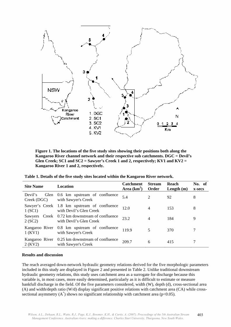
Table 1. Details of the five study sites located within the Kangaroo River network.
Site Name Location Catchment Area (km2)
Stream Order
Reach Length (m)
No. of x-secs
Devil’s Glen Creek (DGC)
0.6 km upstream of confluence with Sawyer's Creek 5.4 2 92 8
Sawyer’s Creek 1 (SC1)
1.8 km upstream of confluence with Devil’s Glen Creek 12.0 4 153 8
Sawyers Creek 2 (SC2)
0.72 km downstream of confluence with Devil’s Glen Creek 23.2 4 184 9
Kangaroo River 1 (KV1)
0.8 km upstream of confluence with Sawyer's Creek 119.9 5 370 7
Kangaroo River 2 (KV2)
0.25 km downstream of confluence with Sawyer's Creek 209.7 6 415 7
Results and discussion The reach averaged down-network hydraulic geometry relations derived for the five morphologic parameters included in this study are displayed in Figure 2 and presented in Table 2. Unlike traditional downstream hydraulic geometry relations, this study uses catchment area as a surrogate for discharge because this variable is, in most cases, more easily determined, particularly as it is difficult to estimate or measure bankfull discharge in the field. Of the five parameters considered, width (W), depth (d), cross-sectional area (A) and width/depth ratio (W/d) display significant positive relations with catchment area (CA) while cross-sectional asymmetry (A*) shows no significant relationship with catchment area (p<0.05).
Figure 1. The locations of the five study sites showing their positions both along the Kangaroo River channel network and their respective sub catchments. DGC = Devil’s Glen Creek; SC1 and SC2 = Sawyer’s Creek 1 and 2, respectively; KV1 and KV2 = Kangaroo River 1 and 2, respectively.
Wilson, A.L., Dehaan, R.L., Watts, R.J., Page, K.J., Bowmer, K.H., & Curtis, A. (2007). Proceedings of the 5th Australian Stream Management Conference. Australian rivers: making a difference. Charles Sturt University, Thurgoona, New South Wales.
403
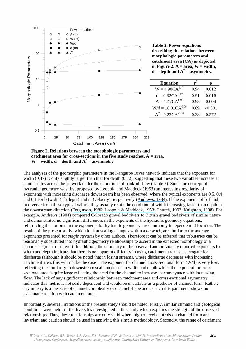
The analyses of the geomorphic parameters in the Kangaroo River network indicate that the exponent for width (0.47) is only slightly larger than that for depth (0.42), suggesting that these two variables increase at similar rates across the network under the conditions of bankfull flow (Table 2). Since the concept of hydraulic geometry was first proposed by Leopold and Maddock (1953) an interesting regularity of exponents with increasing discharge downstream has been observed, where the typical exponents are 0.5, 0.4 and 0.1 for b (width), f (depth) and m (velocity), respectively (Andrews, 1984). If the exponents of b, f and m diverge from these typical values, they usually retain the condition of width increasing faster than depth in the downstream direction (Fergurson, 1986; Leopold & Maddock, 1953; Church, 1992; Knighton, 1998). For example, Andrews (1984) compared Colorado gravel bed rivers to British gravel bed rivers of similar nature and demonstrated no significant differences in the exponents of the hydraulic geometry equations, reinforcing the notion that the exponents for hydraulic geometry are commonly independent of location. The results of the present study, which look at scaling changes within a network, are similar to the average exponents presented for single streams by other authors. Therefore it can be inferred that tributaries can be reasonably substituted into hydraulic geometry relationships to ascertain the expected morphology of a channel segment of interest. In addition, the similarity in the observed and previously reported exponents for width and depth indicate that there is no apparent difficulty in using catchment area as a surrogate for discharge (although it should be noted that in losing streams, where discharge decreases with increasing catchment area, this will not be the case). The exponent for channel cross-sectional form (W/d) is very low, reflecting the similarity in downstream scale increases in width and depth whilst the exponent for cross-sectional area is quite large reflecting the need for the channel to increase its conveyance with increasing flow. The lack of any significant relationship between catchment area and cross-sectional asymmetry indicates this metric is not scale dependent and would be unsuitable as a predictor of channel form. Rather, asymmetry is a measure of channel complexity or channel shape and as such this parameter shows no systematic relation with catchment area. Importantly, several limitations of the present study should be noted. Firstly, similar climatic and geological conditions were held for the five sites investigated in this study which explains the strength of the observed relationships. Thus, these relationships are only valid where higher level controls on channel form are invariant and caution should be used in applying this simple methodology. Secondly, the range of catchment
Table 2. Power equations describing the relations between morphologic parameters and catchment area (CA) as depicted in Figure 2. A = area, W = width, d = depth and A* = asymmetry.
Equation r2 p W = 4.98CA0.47 0.94 0.012 d = 0.32CA0.42 0.91 0.016 A = 1.47CA0.93 0.95 0.004
W/d = 16.01CA0.06 0.89 <0.001A* =0.23CA-0.08 0.38 0.572
Figure 2. Relations between the morphologic parameters and catchment area for cross-sections in the five study reaches. A = area, W = width, d = depth and A* = asymmetry.
0 25 50 75 100 125 150 175 200 225
Catchment Area (km2)
0.1
1
10
100
1000M
orph
olog
ic P
aram
eter
sPower relationsA (m2)W (m)W/dd (m)A*
Wilson, A.L., Dehaan, R.L., Watts, R.J., Page, K.J., Bowmer, K.H., & Curtis, A. (2007). Proceedings of the 5th Australian Stream Management Conference. Australian rivers: making a difference. Charles Sturt University, Thurgoona, New South Wales.
404

scales in this study is small; with a large increase in scale between the sites SC2 and KV1. Although this is representative of increases in scale within a catchment, it may reduce the predictive potential of the identified relationships over a more diverse range of scales. In addition, although the exponents reported here are similar to those observed elsewhere, these power relations are not necessarily universal. Consequently, it is suggested that if this technique is to be applied, some initial measurements are taken over a range of spatial scales to ascertain the values of the power relations relevant to the specific river system in question. Once derived, these can be used to scale up (or down) to derive expected morphologic characteristics for test reaches based on the character of undisturbed reference reaches. To further explore the scaling of channel morphology within river channel networks a multivariate approach was adopted that included a wide range of morphologic variables. This form of analysis could further be expanded to include hydraulic, ecologic or water quality variables in order to assess differences in rivers of different scales. The MDS plot (Figure 3) shows that there is clear separation between reaches and that the spatial pattern in multidimensional space reflects the pattern in catchment area. However, it can be observed that there is considerable overlap between SC1 and SC2. These two reaches have differing catchment areas but are of similar stream order (Table 2). Therefore, it appears that separation occurs where reaches are sufficiently different in size to classify as different stream orders. The variables most responsible for the separation of the reaches in multidimensional space are W, d, A and A*, all of which had r2 values above 0.95 in a principal axis correlation and all of which plot along the axis of scale variation (i.e. along the x-axis).
Conclusion Analyses of a set of simple morphologic parameters across the Kangaroo River network indicate that channel form responses with catchment area are comparable in size and direction to the downstream hydraulic geometry relations observed elsewhere. This result provides support for the use of these parameters, which include bankfull width, average depth, bankfull cross-sectional area and width/depth ratio, in river condition assessment methods and allows for the development of a simple objective method for defining the
-2
-1.5
-1
-0.5
0
0.5
1
1.5
2
-2 -1.5 -1 -0.5 0 0.5 1 1.5 2
DGCSC1SC2KV1KV2
Figure 3. Semi-Strong-Hybrid (SSH) Ordination in two dimensions of the geomorphic parameters calculated at the five study reaches. DGC = Devil’s Glen Creek; SC1 and SC2 = Sawyer’s Creek 1 and 2, respectively; KV1 and 2 = Kangaroo River 1 and 2, respectively.
Wilson, A.L., Dehaan, R.L., Watts, R.J., Page, K.J., Bowmer, K.H., & Curtis, A. (2007). Proceedings of the 5th Australian Stream Management Conference. Australian rivers: making a difference. Charles Sturt University, Thurgoona, New South Wales.
405
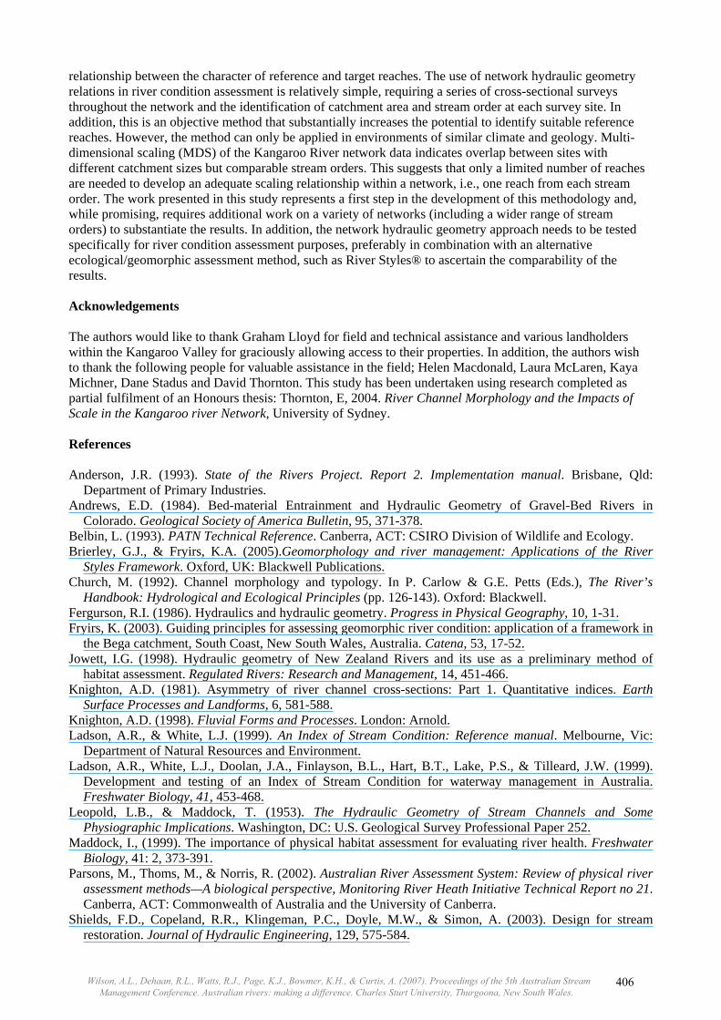
relationship between the character of reference and target reaches. The use of network hydraulic geometry relations in river condition assessment is relatively simple, requiring a series of cross-sectional surveys throughout the network and the identification of catchment area and stream order at each survey site. In addition, this is an objective method that substantially increases the potential to identify suitable reference reaches. However, the method can only be applied in environments of similar climate and geology. Multi-dimensional scaling (MDS) of the Kangaroo River network data indicates overlap between sites with different catchment sizes but comparable stream orders. This suggests that only a limited number of reaches are needed to develop an adequate scaling relationship within a network, i.e., one reach from each stream order. The work presented in this study represents a first step in the development of this methodology and, while promising, requires additional work on a variety of networks (including a wider range of stream orders) to substantiate the results. In addition, the network hydraulic geometry approach needs to be tested specifically for river condition assessment purposes, preferably in combination with an alternative ecological/geomorphic assessment method, such as River Styles® to ascertain the comparability of the results. Acknowledgements The authors would like to thank Graham Lloyd for field and technical assistance and various landholders within the Kangaroo Valley for graciously allowing access to their properties. In addition, the authors wish to thank the following people for valuable assistance in the field; Helen Macdonald, Laura McLaren, Kaya Michner, Dane Stadus and David Thornton. This study has been undertaken using research completed as partial fulfilment of an Honours thesis: Thornton, E, 2004. River Channel Morphology and the Impacts of Scale in the Kangaroo river Network, University of Sydney. References Anderson, J.R. (1993). State of the Rivers Project. Report 2. Implementation manual. Brisbane, Qld:
Department of Primary Industries. Andrews, E.D. (1984). Bed-material Entrainment and Hydraulic Geometry of Gravel-Bed Rivers in
Colorado. Geological Society of America Bulletin, 95, 371-378. Belbin, L. (1993). PATN Technical Reference. Canberra, ACT: CSIRO Division of Wildlife and Ecology. Brierley, G.J., & Fryirs, K.A. (2005).Geomorphology and river management: Applications of the River
Styles Framework. Oxford, UK: Blackwell Publications. Church, M. (1992). Channel morphology and typology. In P. Carlow & G.E. Petts (Eds.), The River’s
Handbook: Hydrological and Ecological Principles (pp. 126-143). Oxford: Blackwell. Fergurson, R.I. (1986). Hydraulics and hydraulic geometry. Progress in Physical Geography, 10, 1-31. Fryirs, K. (2003). Guiding principles for assessing geomorphic river condition: application of a framework in
the Bega catchment, South Coast, New South Wales, Australia. Catena, 53, 17-52. Jowett, I.G. (1998). Hydraulic geometry of New Zealand Rivers and its use as a preliminary method of
habitat assessment. Regulated Rivers: Research and Management, 14, 451-466. Knighton, A.D. (1981). Asymmetry of river channel cross-sections: Part 1. Quantitative indices. Earth
Surface Processes and Landforms, 6, 581-588. Knighton, A.D. (1998). Fluvial Forms and Processes. London: Arnold. Ladson, A.R., & White, L.J. (1999). An Index of Stream Condition: Reference manual. Melbourne, Vic:
Department of Natural Resources and Environment. Ladson, A.R., White, L.J., Doolan, J.A., Finlayson, B.L., Hart, B.T., Lake, P.S., & Tilleard, J.W. (1999).
Development and testing of an Index of Stream Condition for waterway management in Australia. Freshwater Biology, 41, 453-468.
Leopold, L.B., & Maddock, T. (1953). The Hydraulic Geometry of Stream Channels and Some Physiographic Implications. Washington, DC: U.S. Geological Survey Professional Paper 252.
Maddock, I., (1999). The importance of physical habitat assessment for evaluating river health. Freshwater Biology, 41: 2, 373-391.
Parsons, M., Thoms, M., & Norris, R. (2002). Australian River Assessment System: Review of physical river assessment methods—A biological perspective, Monitoring River Heath Initiative Technical Report no 21. Canberra, ACT: Commonwealth of Australia and the University of Canberra.
Shields, F.D., Copeland, R.R., Klingeman, P.C., Doyle, M.W., & Simon, A. (2003). Design for stream restoration. Journal of Hydraulic Engineering, 129, 575-584.
Wilson, A.L., Dehaan, R.L., Watts, R.J., Page, K.J., Bowmer, K.H., & Curtis, A. (2007). Proceedings of the 5th Australian Stream Management Conference. Australian rivers: making a difference. Charles Sturt University, Thurgoona, New South Wales.
406
Related Documents