Hurricane Basics For More Information Websites: NOAA - www.noaa.gov National Hurricane Center - www.nhc.noaa.gov National Hurricane Center Public Affairs (305) 229-4404 National Weather Service Public Affairs (301) 713-0622 Autumn 2005

Welcome message from author
This document is posted to help you gain knowledge. Please leave a comment to let me know what you think about it! Share it to your friends and learn new things together.
Transcript

HurricaneBasics
For More Information
Websites:NOAA - www.noaa.gov
National Hurricane Center - www.nhc.noaa.gov
National Hurricane Center Public Affairs(305) 229-4404
National Weather Service Public Affairs(301) 713-0622
Autumn 2005

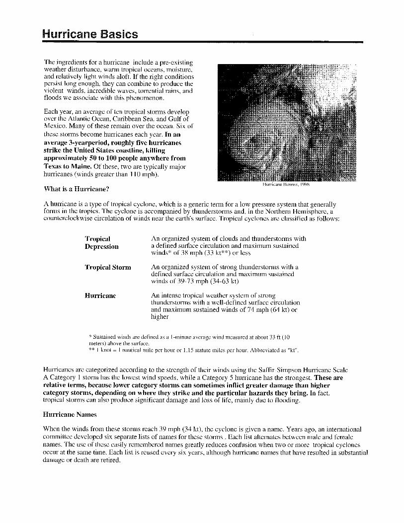
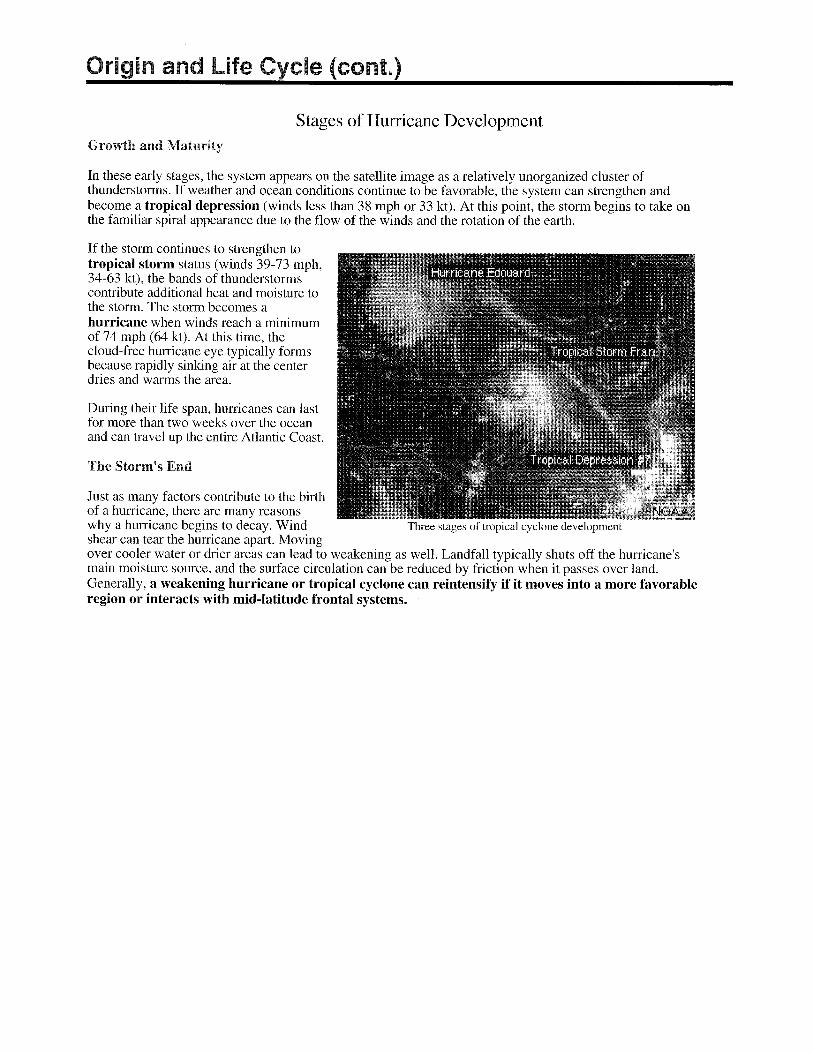
A "hurricane" is the most severe category of the meteorological phenomenon known as the "tropical cyclone."
Tropical cyclones are low pressure systems that have thunderstorm activity and rotate counterclockwise. A tropical cyclone that has winds of 38 mph (33 kt) or less is called a tropical depression. When the tropical cyclone's winds reach 39-73 mph (34-63 kt), it is called a tropical storm. When the winds exceed 74 mph (64 kt), the storm is consideredto be a hurricane.
The Saffir-Simpson Hurricane Scale defines hurricane strength by categories. A Category 1 storm is the weakest hurricane (winds 74-95 mph or 64-82 kt); a Category 5 hurricane is the strongest (winds greater than 155 mph or 135 kt).
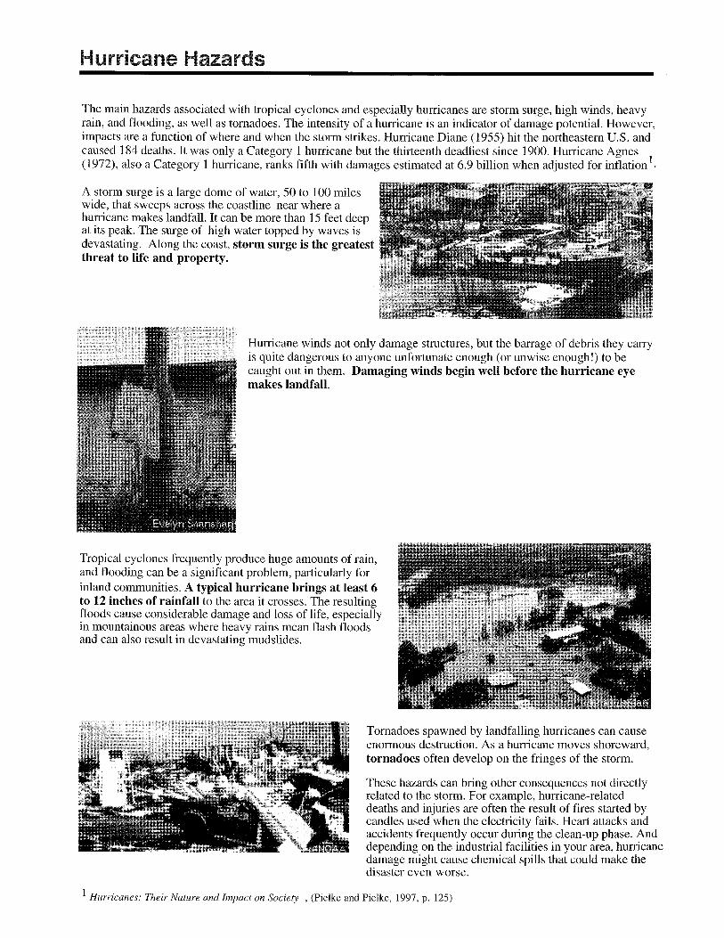
The category of the storm does not necessarily relate directly to the damage it will inflict. Lower category storms (and even tropical storms) can cause substantial damage depending on what other weather features they interact with, where they strike, and how slow they move.
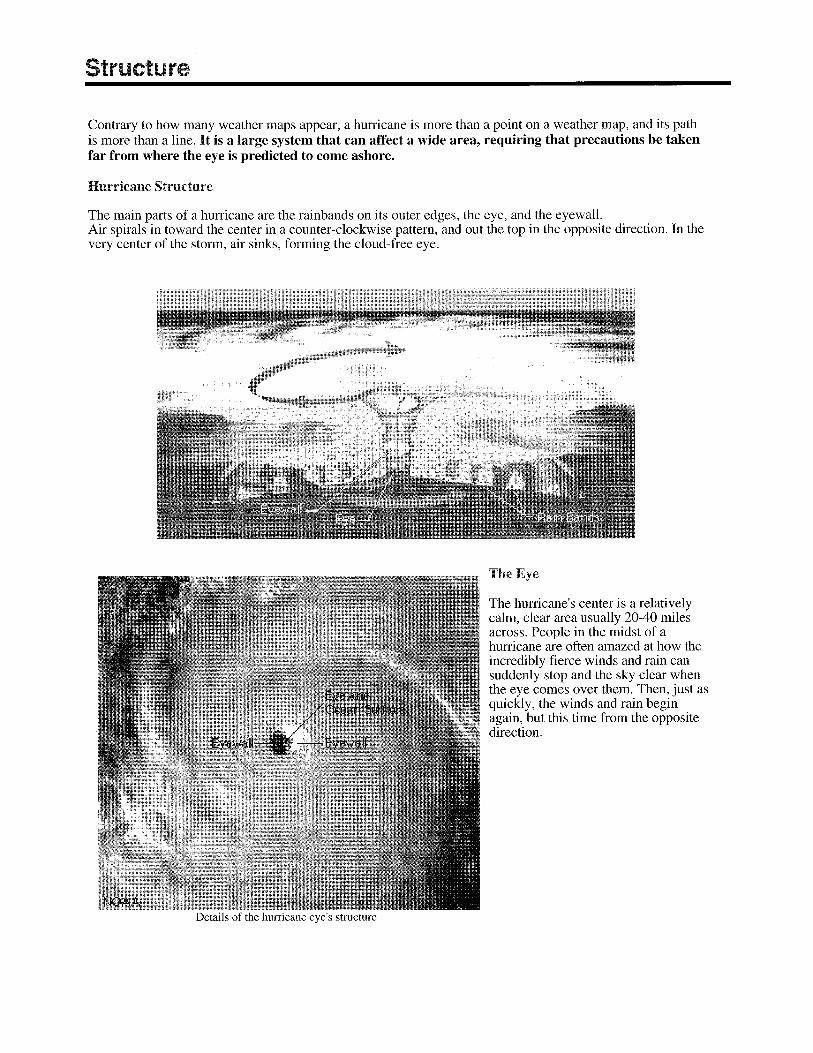
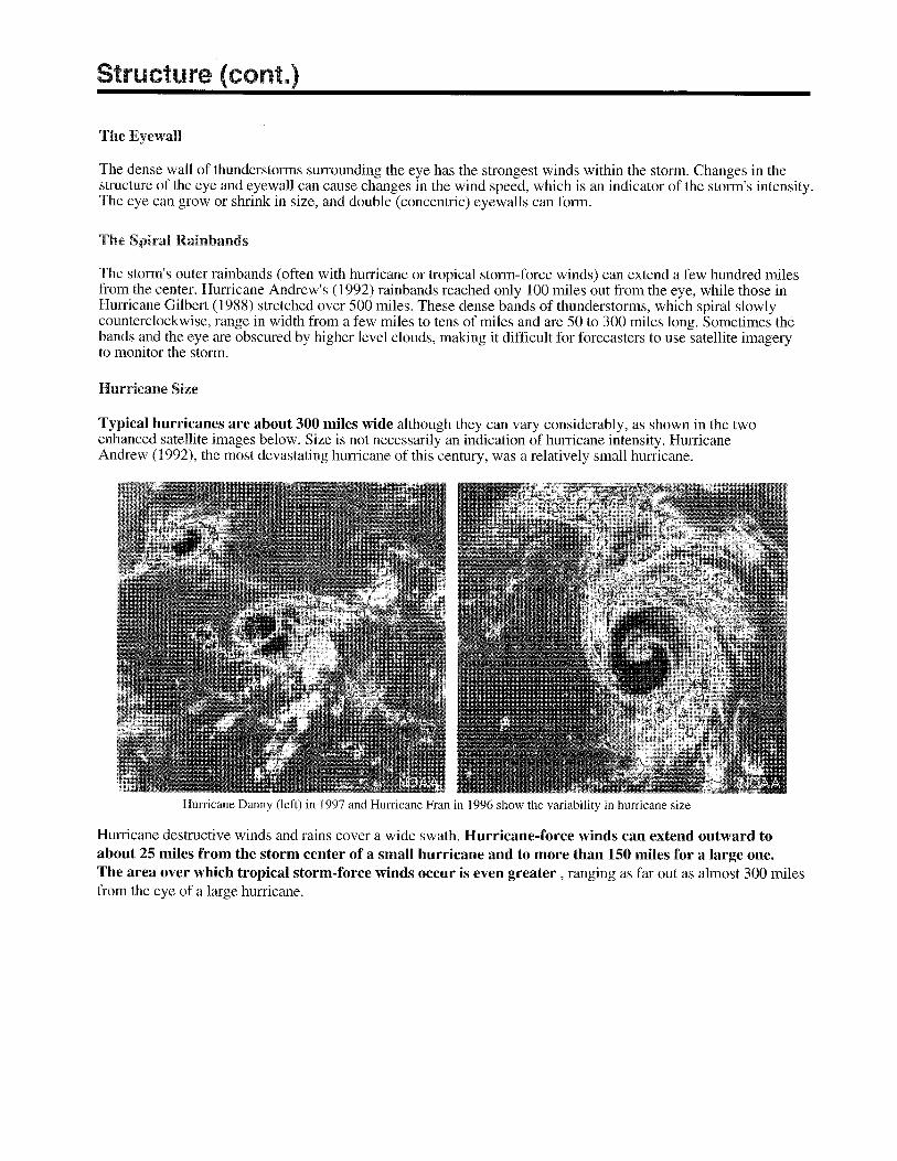
Anatomy of a HurricaneTypical hurricanes are about 300 miles wide although they can vary considerably in size.
The eye at a hurricane's center is a relatively calm, clear area approximately 20-40 miles across.
The eyewall surrounding the eye is composed of dense clouds that contain the highest winds in the storm.
The storm's outer rainbands (often with hurricane or tropical storm-force winds) are made up of dense bands of thunderstorms ranging from a few miles to tens of miles wide and 50 to 300 miles long.
Hurricane-force winds can extend outward to about 25 miles in a small hurricane and to more than 150 miles for a largeone. Tropical storm-force winds can stretch out as far as 300 miles from the center of a large hurricane.
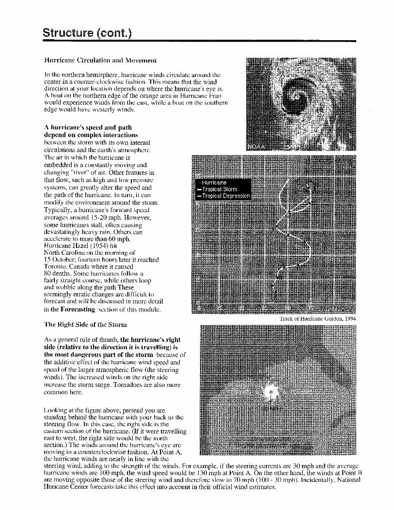
Frequently, the right side of a hurricane is the most dangerous in terms of storm surge, winds, and tornadoes.
A hurricane's speed and path depend on complex ocean and atmospheric interactions, including the presence or absence of other weather patterns. This complexity of the flow makes it very difficult to predict the speed and direction of a hurricane.
Do not focus on the eye or the track–hurricanes are immense systems that can move in complex patterns that are difficult to predict. Be prepared for changes in size, intensity, speed, and direction.
How Tropical Cyclones are Observed
http://hurricanes.noaa.govwww.nws.noaa.gov
www.noaa.gov
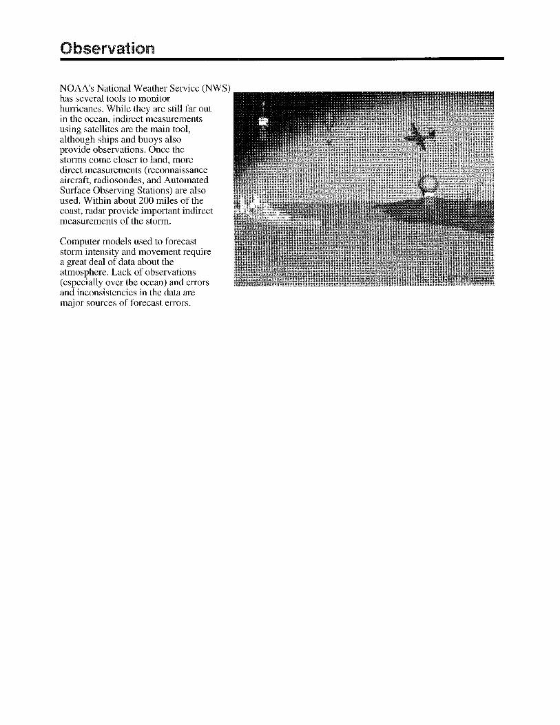
Direct measurements of tropical storm and hurricane dimensions and wind speeds are taken primarily by reconnaissance aircraft, although ships and buoys also take important measurements. Once a hurricane is near and/or on land, Automated Surface Observation Systems (ASOS) provide surface conditions, and radio sondes take upper air measurements.
Indirect observational methods include satellite imagery and Doppler radar. In particular, satellites have greatly improved our ability to monitor and understand hurricanes. Radar data are important once the storm comes close to shoreand after landfall for forecasting hurricane-related weather.
Hurricane Fast Facts
Why Hurricanes Are Named Experience shows that the use of short, distinctive given names in written as well as spoken communications is quicker and less subject to error than the older more cumbersome latitude-longitude identification methods. These advantages are especially important in exchanging detailed storm information between hundreds of widely scattered stations, airports, coastal bases, and ships at sea. The use of easily remembered names greatly reduces confusion when two or more tropical storms occur at the same time. For example, one hurricane can be moving slowly westward in the Gulf of Mexico, while at exactly the same time another hurricane can be moving rapidly northward along the Atlantic coast. In the past, confusion and false rumors have arisen when storm advisories broadcast from one radio station were mistaken for warnings concerning an entirely different storm located hundreds of miles away. Present Procedure in the North Atlantic, Caribbean, and Gulf of Mexico The Tropical Prediction Center near Miami, FL, keeps a constant watch on oceanic storm-breeding areas for tropical disturbances that may herald the formation of a hurricane. If a disturbance intensifies into a tropical storm Cwith rotary circulation and wind speeds above 39 miles per hourCthe Center will give the storm a name from one of the six lists below. The Center uses a new set of names each year beginning with the first name in the set. After the sets have all been used, they are reused. For example, TPC is reusing the 2005 set in 2010. The letters Q, U, X, Y, and Z are not included because of the scarcity of names beginning with those letters. TPC retires a name after a major land-falling storm with major economic impact. For example, Katrina will be retired this year after its devastating impact. The name lists have an international flavor because hurricanes affect other nations and are tracked by the public and weather services of many countries. Names for these lists are selected from library sources and agreed upon at international meetings of the World Meteorological Organization. The Six-Year List of Names for Atlantic Storms 2005 Arlene Bret Cindy Dennis Emily Franklin Gert Harvey Irene Jose Katrina Lee Maria Nate Ophelia Philippe Rita Stan Tammy Vince Wilma
2006 Alberto Beryl Chris Debby Ernesto Florence Gordon Helene Isaac Joyce Kirk Leslie Michael Nadine Oscar Patty Rafael Sandy Tony Valerie William
2007 Andrea Barry Chantal Dean Erin Felix Gabrielle Humberto Ingrid Jerry Karen Lorenzo Melissa Noel Olga Pablo Rebekah Sebastien Tanya Van Wendy
2008 Arthur Bertha Cristobal Dolly Edouard Fay Gustav Hanna Ike Josephine Kyle Laura Marco Nana Omar Paloma Rene Sally Teddy Vicky Wilfred
2009 Ana Bill Claudette Danny Erika Fred Grace Henri Ida Joaquin Kate Larry Mindy Nicholas Odette Peter Rose Sam Teresa Victor Wanda
2010 Alex Bonnie Colin Danielle Earl Fiona Gaston Hermine Igor Julia Karl Lisa Matthew Nicole Otto Paula Richard Shary Tomas Virginie Walter
Hurricane Hazards Summary (cont.)
Tornadoes
Tornadoes are most likely to occur in the right-front quadrant of the hurricane. However, they are also often found elsewhere in the rainbands.
Typically, the more intense a hurricane is, the greater the tornado threat.
Tornado production can occur for days after landfall.
Most tornadoes occur within 150 miles of the coast.
The National Weather Service's Doppler radar systems can provide indications of tornados from a few minutes to about 30 minutes in advance. Consequently, preparedness is critical.
Saffir-Simpson Hurricane Scale*
Category Definition—Likely Effects
ONE: Winds 74-95 mph: No real damage to building structures, Damage primarily to unanchored mobile homes, shrubbery, and trees. Also, some coastal road flooding and minor pier damage.
TWO: Winds 96-110 mph: Some roofing material, door, and window damage to buildings. Considerable damage to vegetation, mobile homes, and piers. Small craft in unprotected anchorages break moorings.
THREE: Winds 111-130 mph: Some structural damage to small residences and utility buildings with a minor amount of curtainwall failures, Mobile homes are destroyed. Flooding near the coast destroys smaller structures with larger structures damaged by floating debris. Terrain may be flooded well inland.
FOUR: Winds 131-155 mph: More extensive curtainwall failures with some complete roof structure failure on small residences. Major erosion of beach areas. Major damage to lower floors of structures near the shore Terrain may be flooded well inland.
FIVE: Winds greater than 155 mph: Complete roof failure on many residences and industrial buildings. Some complete building failures with small utility buildings blown over or away. Major damage to lower floors of all structures located near the shoreline. Massive evacuation of residential areas may be required.
*In operational use, the scale corresponds to the 1-minute average sustained wind speed as opposed to gusts which could be 20 percent higher or more.
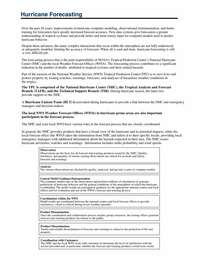
Hurricane Forecasting
Over the past 20 years, improvements in hurricane computer modeling, observational instrumentation, and better training for forecasters have greatly increased forecast accuracy. New data systems give forecasters a greater understanding of tropical cyclones and provide better and more timely input for computer models used to predicthurricane behavior.
Despite these advances, the many complex interactions that occur within the atmosphere are not fully understood or adequately modeled, limiting the accuracy of forecasts. When all is said and done, hurricane forecasting is still a very difficult job.
The forecasting process that is the joint responsibility of NOAA's Tropical Prediction Center’s National HurricaneCenter (NHC) and the local Weather Forecast Offices (WFOs). The forecasting process contributes to a significant reduction in the number of deaths attributed to tropical cyclones and their related hazards.
Part of the mission of the National Weather Service (NWS) Tropical Prediction Center (TPC) is to save lives andprotect property by issuing watches, warnings, forecasts, and analyses of hazardous weather conditions inthe tropics.
The TPC is comprised of the National Hurricane Center (NHC), the Tropical Analysis and ForecastBranch (TAFB), and the Technical Support Branch (TSB). During hurricane season, the latter twoprovide support to the NHC.
A Hurricane Liaison Team (HLT) is activiated during hurricanes to provide a link between the NHC and emergency managers and decision makers.
The local NWS Weather Forecast Offices (WFOs) in hurricane-prone areas are also importantparticipants in the forecast process.
The NHC and your local WFO have various roles in the forecast process that are closely coordinated.
In general, the NHC provides products that have a broad view of the hurricane and its potential impacts, while the local forecast office (the WFO) takes the information from NHC and tailors it to their specific locale, providing local emergency managers with additional information about the hazards expected in their area. The NHC issueshurricane advisories, watches and warinings. Information includes strike probability and wind speeds.
ObservationObservations are the basis for all forecast and warning products issued by the NHC. Quality, timeliness, and quantity of remote sensing observations are critical for accurate and timely forecasts and warnings.
AnalysisThe various observations are checked for quality, analyzed, and put into a suite of computer models
Central Model Guidance/InterpretationThe computer models take in the observations and perform millions of calculations to generatepredictions of hurricane behavior and the general conditions of the atmosphere in which the hurricaneis embedded. The model results are packaged as guidance for the appropriate national centers and localoffices and for evaluation and use in the NWS’s forecast and warning process.
Coordination within the NWS
Product Dissemination
Model results are coordinated between the national centers and local forecast offices to provideconsistency, which is critical during severe weather episodes.
Once the coordination and collaboration process reaches group consensus, the issuing offices generateforecast and warning products for release to the public.
Product DisseminationTimely and reliable dissemination of forecasts and warnings is critical to the protection of life andproperty.
Coordination with CustomersThe NHC and the local WFO work with customers to determine the level of satisfaction with theservice provided and, in particular, whether the forecast and warning products issued were useful.

Local Level: The Weather Forecast Office (WFO)
All of the National Weather Service Forecast Offices are staffed 24 hours a day and produce:
Watches and warnings for severe local storms, floods, flash floods, as well as local and zonepublic forecasts Local aviation forecasts, watches, and warnings Marine warnings and forecasts for coastal areas Hydrologic services such as support for flood and run-off forecasts
Offices affected by hurricanes analyze the products created by the NHC and fine tune them for their ownlocale in order to provide local officials with the necessary information to make timely and efficient decisions.The WFOs produce local weather statements to inform the public about current and anticipated storm effects intheir area and to augment NHC advisories and releases. The local statements are highly specific and aredesigned to keep the media, local decision makers, and the public current on present and anticipated stormeffects.
Local forecasters initiate or participate in inter-site coordination between NHC and other local WFOs to ensureforecast and warning consistency. Following product delivery, the local office coordinates with local officials,the media, and the emergency management community. These coordination calls focus on the pendingweather threat and what implications the forecast or warning has for the local area. Following the storm, thelocal Warning Coordination Meteorologist evaluates the service with the forecast users.
Summary
Who Produces Hurricane ForecastsNOAA's National Hurricane Center is responsible for providing information on the current status of the storm and future forecasts of its behavior.Local NOAA Weather Forecast Offices fine tune NHC status reports and forecasts for their particular area.
Forecast Information
Tropical cyclone public advisories (issued every 6 hours) are intended for the general public in areas threatened by atropical storm or hurricane.
Intermediate public tropical cyclone advisories are issued every 3 hours once a watch or warning has been issued andevery 2 hours once a reliable center appears on radar. Hourly radar position estimates are issued between the 2-hourly public advisories. They are similar to the 6-hour product.Tropical cyclone forecast/advisories (issued every 6 hours) are intended mainly for ships at sea and other marine interests, but also very useful to emergency managers because they contain wind field forecasts.
Tropical cyclone discussions (issued every 6 hours) explain the rationale for the current forecast level of confidence.
Tropical cyclone strike probability forecasts (issued every 6 hours) give the percentage chance that the center of a tropical cyclone will pass within 65 NM (75 mi) of specific locations within 72 hours.
Hurricane local statements are issued by the local WFO to keep the media, local decision makers, and the public currenton present and anticipated storm effects in their specific area. They include any actions declared by localemergency managers.
Inland high wind watches and warnings are issued when hurricane-force winds are expected to occurbeyond coastal areas.


Credits:
University Corporation for Atmospheric ResearchNational Oceanic and Atmospheric Administration (NOAA)
Federal Emergency Management Agency (FEMA)
Related Documents