www.coastadapt.com.au 1 How to choose an appropriate spatial scale for coastal hazard mapping www.coastadapt.com.au Regional and local government decision makers require a range of mapping products and other tools for coastal adaptation planning. The level of modelling and other detailed assessments that underpin the different spatial scales (also referred to as geographic scales) of mapping varies considerably. The guide is intended to help coastal planners and managers identify whether a mapping product is fit for purpose, understand the limitations of available mapping products, and determine when certain adaptation planning decisions may require a more detailed assessment and mapping approach. The focus of this guide is on the different spatial scales of coastal hazard and risk mapping products. Issues concerning the selection of an appropriate temporal scale for coastal hazard and risk assessment are beyond the scope of this guide. How to use this guide This guide has been prepared by coastal planning and engineering consultants with experience in the preparation and application of coastal hazard mapping products. This guide describes: • Different approaches to coastal hazard assessment and the varying spatial scales of coastal hazard mapping products that consider coastal inundation and/or coastal erosion • The physical processes that may not be sufficiently resolved or represented in the different levels of assessments and therefore not captured in the mapping • Level of assessment and mapping resolution required for different adaptation planning decisions Matthew Barnes, BMT WBM

Welcome message from author
This document is posted to help you gain knowledge. Please leave a comment to let me know what you think about it! Share it to your friends and learn new things together.
Transcript
www.coastadapt.com.au
1
How to choose an appropriate spatial scale for coastal hazard mapping
www.coastadapt.com.au
Regional and local government decision makers require a range of mapping products and other tools for coastal adaptation planning.
The level of modelling and other detailed assessments that underpin the different spatial scales (also referred to as geographic scales) of mapping varies considerably.
The guide is intended to help coastal planners and managers identify whether a mapping product is fit for purpose, understand the limitations of available mapping products, and determine when certain adaptation planning decisions may require a more detailed assessment and mapping approach.
The focus of this guide is on the different spatial scales of coastal hazard and risk mapping products. Issues concerning the selection of an appropriate temporal scale for coastal hazard and risk assessment are beyond the scope of this guide.
How to use this guideThis guide has been prepared by coastal planning and engineering consultants with experience in the preparation and application of coastal hazard mapping products.
This guide describes:
• Different approaches to coastal hazard assessment and the varying spatial scales of coastal hazard mapping products that consider coastal inundation and/or coastal erosion
• The physical processes that may not be sufficiently resolved or represented in the different levels of assessments and therefore not captured in the mapping
• Level of assessment and mapping resolution required for different adaptation planning decisions
Matthew Barnes, BMT WBM

www.coastadapt.com.au
2
The requirements and intended outcomes of coastal hazard and planning studies are generally set by State and Territory policy and/or guideline documents. CoastAdapt provides a summary of the laws and policy relevant to coastal planning in Australia. The context, objectives, performance indicators and targets need to be tailored to the relevant policy and/or guidelines and in consultation between local government, key stakeholders and the community.
1 Approaches and geographic scales for coastal hazard assessments
The appropriate coastal hazard assessment methodology, and associated mapping effort for a given study area, is typically proportionate to the perceived risk to coastal assets and values. For example, the approach to assess the vulnerability of a densely populated urban area is likely to differ to the approach adopted for sections of undeveloped coastline.
Mapping products and other tools for coastal adaptation planning, include:
1 National and state-level datasets and mapping for high-level strategic planning, particularly for low-risk decisions that may influence a number of local government areas or a broader region. This mapping also helps to identify knowledge gaps and prioritise and frame necessary finer scale assessments.
2 Local government area scale assessment and mapping for strategic planning and development of coastal hazard overlays for planning schemes.
3 Coastal compartment scale assessment and mapping for decisions that may influence an individual coastal compartment or estuary.
4 Site-based assessment and mapping at lot scale for decisions that are relevant to a specific development application (typically prepared by the applicant) or for evaluating specific adaptation options.
The level of modelling and other detailed assessments that underpin the different scales of mapping varies considerably. It is therefore important that coastal planners and managers understand the limitations of the available mapping products and when certain decisions may require a more detailed assessment and mapping approach. Often a preferred or recommended approach will require an investment in data collection and/or numerical modelling with significant time and cost implications. Mapping at smaller scales or a higher resolution will typically have greater minimum data and modelling requirements.
With a focus on sea-level rise impact assessment, Eliot (2013) proposed a ‘geomorphic framework’ approach as a means to identify the appropriate level of modelling and mapping effort. The report describes a number of relevant concepts and presents Western Australian case studies that may be of interest to users of this guide. Figure 1, adapted from Eliot (2013), illustrates the hazard mapping scales, associated level of data and modelling effort discussed in this guide.

www.coastadapt.com.au
3
In the context of this guide, it is important that the distinction between hazard assessment and risk assessment is clearly understood:
• The hazard assessment and associated mapping should seek to estimate the likelihood or probability of the coastal hazard occurring
• The risk assessment considers both the likelihood of the hazard and the consequence to defined built, social or natural values. The tolerance to a particular hazard will vary throughout a local government area or region and also needs careful consideration during the risk assessment process.
This guide deals exclusively with coastal hazard assessment and mapping – not the assessment of risks to assets or values within the hazard areas identified by the mapping. The hazards discussed in this guide include coastal inundation and coastal erosion.
Other modules within CoastAdapt provide information on assessing coastal climate risks. This includes guidance on first-pass risk screening, second-pass risk assessment and third-pass risk assessment which generally follow the concepts described by Sharples et al. (2008). Where relevant, this guide references ways to incorporate hazard assessment and
Mapping spatial scaleor resolution
Data requirements & modelling effort
Planning decisionor study area
Tens of metres
Metres Site Based
First PassHazard Screening
Second-pass risk assessment for coastal communities and high
value areasThird-pass risk assessment for
undeveloped areas
Third-pass risk assessment for urban areas and other locations with signi�cant natural, economic and social value
Minimum requirement for cost bene�t analysis of generic adaptation measures
Third-pass risk assessment for key existing assets and critical infrastructure or trade-o�s between proposed adaptation measures and coastal valuesRequired to support cost bene�t analysis of speci�c adaptation actions
Hundredsof metres
Hundreds to tensof metres
National and State
Local Government Area
Coastal Compartment
Figure 1: Coastal hazard mapping scale and level of data and modelling effort (adapted from Eliot, 2013).
www.coastadapt.com.au
4
mapping in these risk assessment processes. For more information about the application of the Australian Standard for Risk Management (AS/NZS ISO31000:2009) to coastal management and climate adaptation refer also to Fisk and Kay (2010), Rollason et al. (2010a) and Rollason and Haines (2011).
1.1 National and state-level assessments and mapping
National and state-level coastal hazard mapping and visualisation products generally provide an overview of the relative vulnerability across a region and may provide sufficient detail for high-level decision making. CoastAdapt provides links to a number of national coastal hazard mapping and visualisation products and tools that are useful for a first-pass assessment, including:
• National Coastal Risk Assessment
• Coastal Risk Australia
• Smartline
CoastAdapt also provides summaries and links to various other national and state datasets to assist with coastal adaptation planning:
• Data and datasets for coastal adaptation – Information Manual 3
• CoastAdapt Datasets 1: Shoreline Explorer – present-day coastal sensitivity to flooding and erosion
• CoastAdapt Datasets 2: Future sea-level rise and its effects on coastal inundation
National and state-level assessment and mapping are generally suitable for first-pass risk screening, and in some instances second-pass risk assessment, and can assist in identifying knowledge gaps and prioritise
and frame necessary finer scale assessments. While the resolution of the underlying data to create the maps (such as the land digital elevation models) may be of a relatively high resolution, the assessments are generally based on regional-scale assumptions with regard to coastal processes where nearshore bathymetry, hydrodynamics and shoreline dynamics (for example) are not accurately represented. National and state-level hazard mapping is not typically suitable for detailed risk assessments since key physical processes and potential adaptation measures that may mitigate the risk (such as a seawall or levee bank) are not sufficiently resolved.
1.2 Local government area assessments and mapping
Local government planning schemes that cover coastal regions are typically required to include coastal hazard area overlay mapping. This scale of hazard mapping is also often used as the basis for second-pass risk assessment and in some instances third-pass risk assessment and adaptation planning studies, noting that some key coastal compartments or communities may require higher-resolution hazard assessment and mapping to support detailed risk assessment and coastal adaptation planning decisions.
In this section the level of assessment and the key physical processes represented by local government area scale coastal hazard studies is described. The resolution of local government area hazard assessment and mapping may be in the order of tens to hundreds of metres. This level of assessment and mapping is typically needed in order to proceed to the more detailed methods described in the subsequent sections.
www.coastadapt.com.au
5
1.2.1 Coastal inundation hazardLocal government area scale storm tide hazard and mapping studies are typically based on extensive data analysis, numerical and parametric modelling of meteorological conditions and coastal processes, and statistical or probabilistic methods. The assessments to derive offshore water level statistics or ‘design water levels’ require representation of the following key physical processes:
• Regional climatology analysis and atmospheric pressure and wind field modelling (used to force hydrodynamic and wave models)
• Bathymetry variation at sufficient resolution to resolve key features (particularly in the nearshore areas where depths are less than approximately 20 m)
• Tidal variation along the coastline and within estuaries
• Surge development and propagation
• Wave growth and nearshore wave conditions that may contribute to the extreme water level (particularly for open coasts with breaking waves).
The key objective of a local government area storm tide study is to derive offshore water level statistics at number of locations along the study area coastline and within estuaries. The assessments typically consider both current climate and future climate conditions. The offshore water levels are then used as the basis for developing coastal inundation hazard maps by extrapolating the offshore water levels over land following the so-called ‘bathtub’ or ‘bucket-fill’ mapping approach. This provides a consistent mapping product that covers the
entire local government area which may serve as a planning scheme coastal inundation hazard overlay. Such maps are often used to inform strategic and land use planning decisions or as the basis for second-pass risk assessment. Local government area scale coastal inundation mapping is also often used to guide appropriate planning levels for development works, noting that site-based assessments and mapping are generally required to support decisions related to development applications or key existing assets (this is discussed further in Section 1.4).
While the bathtub mapping approach is simple and relatively easy to implement (and therefore attractive) it is important to recognise its limitations, including:
• Inundation may be shown in some locations that are not hydraulically connected to the sea but fall below the criteria design water level
• The approach assumes that there is sufficient time and water available to fill overland areas up to the criteria design water level
• The coincident effect of lower river and creek flows combined with coastal inundation is not resolved
• The method only provides information on inundation extent and depth; overland flow velocity is not resolved and may be an important component of the hazard (particularly with regard to consequence and tolerance)
• Intermittent wave run-up and the overtopping of coastal barriers is not resolved and may influence the pattern of inundation and hazard definition for locations close to the shoreline
www.coastadapt.com.au
6
• A static shoreline and beach profile is assumed; rapid changes during short term storm events or long term changes due to gradual sea level rise are not resolved.
At some key locations additional coastal processes may be important, overland flow velocity may be needed to support a risk assessment study, and/or higher resolution mapping may be desirable. In these instances, the outputs from the storm tide study can be used as input to more sophisticated and higher resolution numerical models to support a detailed mapping exercise for selected coastal compartments or communities. This is discussed further in Section 1.3.
1.2.2 Coastal erosion hazardLocal government area coastal erosion hazard assessments typically seek to:
• Describe the local coastal geology and evolution
• Identify and map coastal compartments based on physical attributes, such as wave exposure, geological framework, sediment availability and aspect
• Understand the contemporary coastal processes, including:
• Sediment supply and transport pathways
• Historical trends in shoreline position
• Design water level and wave conditions (usually informed by a local government area storm tide hazard study)
• Provide erosion hazard assessments at key locations or coastal communities, including consideration to:
• Long term trends due to gradients in sediment transport between coastal compartments
• Storm erosion potential modelling to estimate current climate hazard areas
• The potential for further loses of land due to sand dune slumping or coastal landslip
• The shoreline response to sea level rise
• Map the erosion hazard area likelihood for specific planning periods of interest.
Local government area scale coastal erosion hazard mapping will typically provide sufficient detail for second-pass risk assessment. For undeveloped areas and/or locations with low economic, social and natural values the local government area scale mapping may also be sufficient for third-pass risk assessment.
Densely populated coastlines and areas with significant values are likely to require more detailed coastal erosion hazard assessments to support sound adaptation planning decisions. Site-based assessments and mapping of the erosion potential and mitigation measures may also be required to support decisions related to development applications or critical infrastructure. These approaches are discussed further in Section 1.3 and Section 1.4.
www.coastadapt.com.au
7
1.3 Coastal compartment assessments and mapping
The identification of coastal compartments provides a robust framework to target assessment of the coastal hazards and risks, and the development of coastal adaptation pathways tailored to the local conditions. Coastal compartments are recognised as a hierarchical system with ‘nested’ tertiary, secondary and primary elements. CoastAdapt provides information on the key characteristics and susceptibility to change of 359 compartments around the Australian coast which may support first-pass risk screening and in some instances second-pass risk assessment.
Refined coastal compartment scale hazard mapping, often underpinned by calibrated and validated numerical model output, is typically needed to support third-pass risk assessment for urban areas and locations with significant economic, social and natural value.
Coastal compartment scale assessments for key locations would typically build upon existing national, state and local government scale assessment results. The hazard assessment and mapping approach would be of a higher resolution (in the order of tens of metres) and aim to represent additional coastal features and physical processes, including:
• The geology throughout the coastal compartment, possibly informed by geotechnical survey
• Coastal inundation flow velocity (as opposed to just depth and extent which is a key limitation of the bathtub mapping approach)
• The overtopping of coastal barriers due to wave processes
• Coincident catchment flooding and coastal inundation hazard assessment
• Short term shoreline erosion potential due to storm events
• Long term erosion trends due to gradients in sediment supply
• Changes in shoreline position and beach profile due to sea level rise
• The cyclic behaviour of river entrance and/or channel migration (where appropriate).
This level of assessment and mapping is generally required when undertaking ‘residual risk’ or ‘risk treatment’ assessments of proposed adaptation options that influence and entire coastal compartment. Examples may include a large-scale beach nourishment program, a large seawall or the implementation of land use controls. Residual risk assessments are typically used in conjunction with other decision making tools, such as multi-criteria analysis and/or cost benefit analysis, to identify the preferred adaptation option for a given location or asset.

www.coastadapt.com.au
8
1.4 Site-based assessments and mapping
Site-based assessment and mapping is often required to evaluate the current and future hazard vulnerability of key existing assets and critical infrastructure, understand how the risk-profile may change over time, and develop a plan for the appropriate adaptation response.
Site-based investigation of coastal hazards, risk mitigation options and mapping is also often required to assist the assessment of proposed development on land within the local government coastal hazard overlay. These technical studies are usually commissioned by the applicant and assessed by local government and other regulatory agencies.
A site-based coastal hazard assessment and mapping study would typically consider the key physical processes discussed in the previous sections at lot scale (resolution in the order of metres). This level of detail is typically beyond that required for most local government strategic planning, risk assessment and adaptation planning decisions. The exception may be for evaluating specific adaptation options where detailed site-based hazard and risk assessment would form part of a broader design process or where the trade-offs between proposed adaptation measures and coastal values requires further consideration.
2 Data and modelling needs for mapping and different scales
As a general guide, Table 1 provides a summary of the data inputs and modelling effort required to develop the different scales of mapping discussed in this guide. The applicability of certain modelling approaches depends on the availability of important datasets for model forcing and calibration/validation.
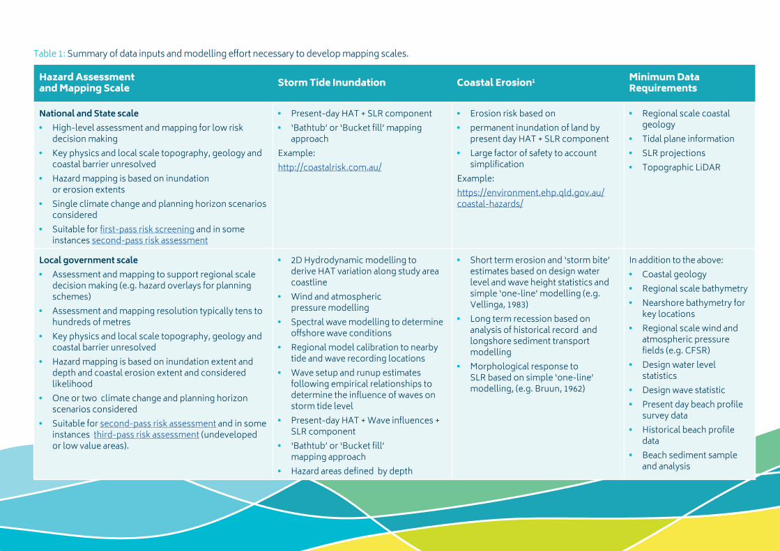
Hazard Assessment and Mapping Scale Storm Tide Inundation Coastal Erosion1 Minimum Data
Requirements
National and State scale • High-level assessment and mapping for low risk
decision making• Key physics and local scale topography, geology and
coastal barrier unresolved• Hazard mapping is based on inundation
or erosion extents• Single climate change and planning horizon scenarios
considered• Suitable for first-pass risk screening and in some
instances second-pass risk assessment
• Present-day HAT + SLR component• ‘Bathtub’ or ‘Bucket fill’ mapping
approach Example: http://coastalrisk.com.au/
• Erosion risk based on• permanent inundation of land by
present day HAT + SLR component• Large factor of safety to account
simplificationExample:https://environment.ehp.qld.gov.au/coastal-hazards/
• Regional scale coastal geology
• Tidal plane information• SLR projections• Topographic LiDAR
Local government scale• Assessment and mapping to support regional scale
decision making (e.g. hazard overlays for planning schemes)
• Assessment and mapping resolution typically tens to hundreds of metres
• Key physics and local scale topography, geology and coastal barrier unresolved
• Hazard mapping is based on inundation extent and depth and coastal erosion extent and considered likelihood
• One or two climate change and planning horizon scenarios considered
• Suitable for second-pass risk assessment and in some instances third-pass risk assessment (undeveloped or low value areas).
• 2D Hydrodynamic modelling to derive HAT variation along study area coastline
• Wind and atmospheric pressure modelling
• Spectral wave modelling to determine offshore wave conditions
• Regional model calibration to nearby tide and wave recording locations
• Wave setup and runup estimates following empirical relationships to determine the influence of waves on storm tide level
• Present-day HAT + Wave influences + SLR component
• ‘Bathtub’ or ‘Bucket fill’ mapping approach
• Hazard areas defined by depth
• Short term erosion and ‘storm bite’ estimates based on design water level and wave height statistics and simple ‘one-line’ modelling (e.g. Vellinga, 1983)
• Long term recession based on analysis of historical record and longshore sediment transport modelling
• Morphological response to SLR based on simple ‘one-line’ modelling, (e.g. Bruun, 1962)
In addition to the above:• Coastal geology• Regional scale bathymetry• Nearshore bathymetry for
key locations• Regional scale wind and
atmospheric pressure fields (e.g. CFSR)
• Design water level statistics
• Design wave statistic• Present day beach profile
survey data• Historical beach profile
data• Beach sediment sample
and analysis
Table 1: Summary of data inputs and modelling effort necessary to develop mapping scales.
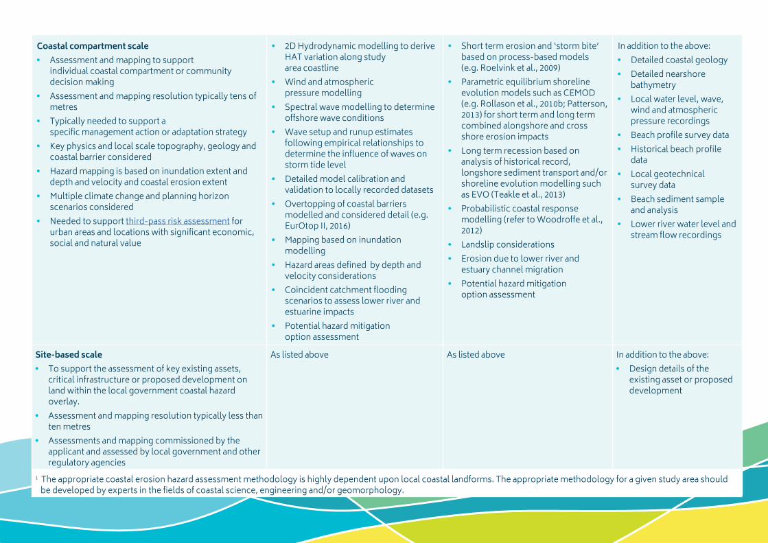
Coastal compartment scale• Assessment and mapping to support
individual coastal compartment or community decision making
• Assessment and mapping resolution typically tens of metres
• Typically needed to support a specific management action or adaptation strategy
• Key physics and local scale topography, geology and coastal barrier considered
• Hazard mapping is based on inundation extent and depth and velocity and coastal erosion extent
• Multiple climate change and planning horizon scenarios considered
• Needed to support third-pass risk assessment for urban areas and locations with significant economic, social and natural value
• 2D Hydrodynamic modelling to derive HAT variation along study area coastline
• Wind and atmospheric pressure modelling
• Spectral wave modelling to determine offshore wave conditions
• Wave setup and runup estimates following empirical relationships to determine the influence of waves on storm tide level
• Detailed model calibration and validation to locally recorded datasets
• Overtopping of coastal barriers modelled and considered detail (e.g. EurOtop II, 2016)
• Mapping based on inundation modelling
• Hazard areas defined by depth and velocity considerations
• Coincident catchment flooding scenarios to assess lower river and estuarine impacts
• Potential hazard mitigation option assessment
• Short term erosion and ‘storm bite’ based on process-based models (e.g. Roelvink et al., 2009)
• Parametric equilibrium shoreline evolution models such as CEMOD (e.g. Rollason et al., 2010b; Patterson, 2013) for short term and long term combined alongshore and cross shore erosion impacts
• Long term recession based on analysis of historical record, longshore sediment transport and/or shoreline evolution modelling such as EVO (Teakle et al., 2013)
• Probabilistic coastal response modelling (refer to Woodroffe et al., 2012)
• Landslip considerations• Erosion due to lower river and
estuary channel migration• Potential hazard mitigation
option assessment
In addition to the above:• Detailed coastal geology• Detailed nearshore
bathymetry• Local water level, wave,
wind and atmospheric pressure recordings
• Beach profile survey data• Historical beach profile
data• Local geotechnical
survey data• Beach sediment sample
and analysis• Lower river water level and
stream flow recordings
Site-based scale• To support the assessment of key existing assets,
critical infrastructure or proposed development on land within the local government coastal hazard overlay.
• Assessment and mapping resolution typically less than ten metres
• Assessments and mapping commissioned by the applicant and assessed by local government and other regulatory agencies
As listed above As listed above In addition to the above:• Design details of the
existing asset or proposed development
1 The appropriate coastal erosion hazard assessment methodology is highly dependent upon local coastal landforms. The appropriate methodology for a given study area should be developed by experts in the fields of coastal science, engineering and/or geomorphology.
www.coastadapt.com.au
11
3 ReferencesBruun, P., 1962: Sea level rise as a cause of shoreline erosion. Journal of Waterways and Harbors Division, American Society Civil Engineering, 88, 117-130.
Eliot, M., 2013: Application of Geomorphic Frameworks to Sea-level Rise Impact Assessment. Report 193-01-Rev 0. Prepared for Geoscience Australia, 80 pp. [Available online at http://www.environment.gov.au/climate-change/adaptation/publications/geomorphic-frameworks].
Fisk, G. and R. Kay, 2010: Dealing with uncertainty in climate change adaptation planning and developing triggers for future action. Climate Change 2010: Practical Responses to Climate Change, 554-563.
Patterson, D.C., 2013: Modelling as an aid to understand the evolution of Australia’s central east coast in response to late Pleistocene-Holocene and future sea level change, PhD Thesis, School of Civil Engineering, The University of Queensland, 342 pp. [Available online at http://espace.library.uq.edu.au/view/UQ:298090].
Roelvink, R., A. Reniers, A. van Dongeren, J. van Thiel de Vries, R. McCall, and J. Lescinski, 2009: Modelling storm impacts on beaches, dunes and barrier islands, Coastal Engineering, 56, 1133-1152. [Available online at https://oss.deltares.nl/documents/48999/59759/Roelvink_2009.pdf].
Rollason, V., G. Fisk and P. Haines, 2010a: Applying the ISO 31000 risk assessment framework to coastal zone management. 19th NSW Coastal Conference 2010, Bateman’s Bay, NSW, 16 pp. [Available online at http://www.coastalconference.com/2010/papers2010/Verity%20Rollason%20full%20paper%202.pdf].
Rollason, V., D. Patterson and C. Huxley, 2010b: Assessing shoreline response to sea level risk: an alternative to the Bruun Rule. 19th NSW Coastal Conference 2010, Bateman’s Bay, NSW, 20 pp. [Available online at http://www.coastalconference.com/2010/papers2010/Verity%20Rollason%20full%20paper.pdf].
Rollason, V., G. Fisk and P. Haines, 2011: Outcomes from the Application of ISO 31000 Risk Management Principles to Coastal Zone Management. 20th NSW Coastal Conference 2011, Tweed Heads, NSW, 15 pp. [Available online at http://www.coastalconference.com/2011/papers2011/Verity%20Rollason%20Full%20Paper.pdf].
Sharples, C., C. Attwater, and J. Carley, 2008: Three Pass Approach to Coastal Risk Assessment, Institute of Public Works Engineering Australasia (IPWEA) National Conference on Climate Change 2008, Coffs Harbour, NSW, 9 pp. [Available online at https://higherlogicdownload.s3.amazonaws.com/IPWEA/68838c32-065d-4d08-9818-2ffb1a96c24b/UploadedImages/PDFS/Impacts%20&%20Risk%20Assessment%20I/Sharples_ThreePassAssessmentApproach.pdf].
Teakle, I., C. Huxley, D. Patterson, J. Nielsen, and H. Mirfenderesk, 2013: Gold Coast shoreline process modelling. Coasts and Ports 2013: 21st Australasian Coastal and Ocean Engineering Conference and the 14th Australasian Port and Harbour Conference, Engineers Australia, Manly, NSW, 751-756. [Available online at https://search.informit.com.au/documentSummary;d-n=830790845038578;res=IELENG].

www.coastadapt.com.au
12
van der Meer, J.W., N.W.H. Allsop, T. Bruce, J. De Rouck, A. Kortenhaus, T. Pullen, H. Schüt-trumpf, P. Troch and B. Zanuttigh, 2016: Manual on wave overtopping of sea defences and related structures: an overtopping manual largely based on European research, but for worldwide appli-cation. Second Edition, Prepared for EurOtop, 264 pp. [Available online at http://www.overtop-ping-manual.com/manual.html].
Vellinga, P., 1983: Predictive computation model for beach and dune erosion during storm surges. Delft Hydraulics Laboratory, Publication No. 294, 28 pp.
Woodroffe, C.D., P.J. Cowell, D.P. Callaghan, R. Ranasinghe, R. Jongejan, D.J. Wainwright, S.J. Barry, K. Rogers and A.J. Dougherty, 2012: Approaches to risk assessment on Australian coasts: A model framework for assessing risk and adaptation to climate change on Australian coasts, National Climate Change Adaptation Research Facility, Gold Coast, 205 pp. [Available online at https://www.nccarf.edu.au/sites/de-fault/files/attached_files_publications/Woodrof-fe_2012_Approaches_risk_assessment.pdf].
AcknowledgmentThis guide was developed with funding from the Australian Government through the Department of the Environment and Energy.
This information sheet was prepared by Matthew Barnes from BMT WBM. Please cite as: Barnes, M. 2017: How to Choose an Appropriate Coastal Hazard Mapping Spatial Scale. Report prepared by BMT WBM for CoastAdapt. National Climate Change Adaptation Research Facility, Gold Coast.
Related Documents