How Much Green Infrastructure? Example of the Boston Region Yaser Abunnasr Assistant Professor, American University of Beirut PhD Candidate in Regional planning, University of Massachusetts Amherst Resilient Cities 2012-Session H2-Bonn, Germany May 12-15, 2012

Welcome message from author
This document is posted to help you gain knowledge. Please leave a comment to let me know what you think about it! Share it to your friends and learn new things together.
Transcript

How Much Green Infrastructure? Example of the Boston Region
Yaser Abunnasr Assistant Professor, American University of Beirut
PhD Candidate in Regional planning, University of Massachusetts Amherst
Resilient Cities 2012-Session H2-Bonn, Germany
May 12-15, 2012

• Green Infrastructure (GI) as a spatial planning tool • Provides ecosystem services and benefits,
network of spatial elements, multi-functional, multiple scales, multi-disciplinary, natural and engineered natural systems .
• Complementarity • GI Characteristics fulfill adaptation needs • Rethink infrastructural solutions • No-regrets policy
• GI as an infrastructural system • A ‘living system’ infrastructure • Surface infrastructure • Multiple benefits versus single benefit • No direct monitory valuation
Green Infrastructure
Neighborhood
Urban
Street
Region
Infrastructure System

Green Infrastructure and adaptation
• Explicit Adaptation Focus of GI
• Risk Exposure: Potential reduction
• Inherent vulnerability: A ‘living infrastructure’
• Current and future conditions: Operation & function
• Targeted planning: specific ecosystem benefits to respond to context specific CC impacts
• Increase benefits: Increase surface areas & intensify GI
• Regional network strategy & local implementation policies
• Space: Potential conflict with mitigation

Measure why and what?
• Why?
• Infrastructure: understand capacities • An effective adaptation planning tool (local, urban &
regional scales)
• Limitations and opportunities • How much services? • Alternative and parallel policies
• Set strategy: where to increase and intensify GI • Scenarios of ecosystem services delivery: current and
future conditions • Provides priority of GI planning based on contextual
considerations • Cross-jurisdictional coordination

Measure why and what? Ecosystem Benefits
•Run-off reduction • Improve water
quality •Reduces flooding •Reduce energy use •Reduces CO2
•Reduces UHI •Urban agriculture • Improves habitat
• Environment Engineering • Ecologists • Earth
Scientists •Biologists
Quantification Method
IMPPERVIOUS AREAS
VEGETATED/ PERVIOUS
AREAS
Common Unit of Measure
Primary Indicator of adaptive capacity –GI Application
• Environmental Engineering • Ecologists • Earth Scientists •Biologists
Urban Context
CONTEXTUAL CC
IMPACTS
Reduce & control if /when Possible
Transform
PRESERVE &
INCREASE AREA
INTENSIFY GI SPATIAL
TYPOLOGIES
•Street Trees •Green Roofs •Green Facades •Private Yards •Urban Forests •Parks •Habitat
Connectivity

CC Impacts
• Projected Climate Impacts •Temperature + 4 to 7⁰C •Sea level rise + 25 to 60cm •Precipitation + by 20%-30% •Snow Less snow days •Events More Sever/flooding
Massachusetts / USA
Sea level Impact : change in 100 yr flood (Union of concerned Scientists, 2008)
Hardiness Migration (Union of concerned Scientists, 2008)
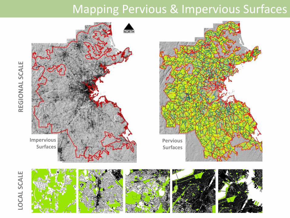
Mapping Pervious & Impervious Surfaces
Impervious Surfaces
Pervious Surfaces
LOC
AL
SCA
LE
REG
ION
AL
SCA
LE

GI Benefits: Where people are
Population distribution impervious surfaces Potential increase of GI surface area

Town Scale

Concluding Remarks
• So How much GI do we plan for? • Difficult to put a generalized figure number: urban region
context specific • Aim for maximum possible: current and future conditions • Variable GI policies and combinations with other measures
(urban matrix context: urban center, sub-urban, peri-urban)
• Variable GI Stand alone solutions or with other policies • Depends on community and regional climatic projections • Dependent on climatic and geographic conditions • Implement (locally) but coordinate (regionally)
• Constraints • Jurisdictional and political barriers • Socio-political context – will of people and politicians

Yaser Abunnasr Assistant Professor, American University of Beirut
PhD Candidate in Regional planning, University of Massachusetts Amherst [email protected] & [email protected]
Resilient Cities 2012-Session H2-Bonn, Germany
May 12-15, 2012
How Much Green Infrastructure? Example of the Boston Region
Related Documents


![Vegetating Green Infrastructure - michigan.gov€¦Vegetating Green Infrastructure. Outline [ green infrastructure vegetation needs to ... [ bioswales ] the myth of sheet flow protecting](https://static.cupdf.com/doc/110x72/5af1d6177f8b9a572b9143f3/vegetating-green-infrastructure-vegetating-green-infrastructure-outline-green.jpg)


![The role of strategic green infrastructure in reducing ...€¦ · and green infrastructure is not ‘always good for air quality’] Strategic green infrastructure can much reduce](https://static.cupdf.com/doc/110x72/5f1ea3a8600836153855d4d8/the-role-of-strategic-green-infrastructure-in-reducing-and-green-infrastructure.jpg)