Horticultural Crop Assessment using Satellite Data (Coordinated Horticulture Assessment and Management using geo-informatics: CHAMAN) 1 Mahalanobis National Crop Forecast Centre. DAC&FW, New Delhi 2 Space Applications Centre, ISRO, Ahmedabad, 3 Natinal Remote Sensing Centre and RRSCs,ISRO, Bengaluru 4 National Horticulture development Foundation, Nasik 5 North eastern Space Application Centre ,ISRO, Shillong 6 Department of Agriculture , cooperation and Farmers welfare S. Mamatha 1 , B. K. Bhattacharya 2 , Uday Raj 3 , H P Sharma 4 , B K Handique 5 , Mamta Saxena 6 & S S Ray 1 Email: [email protected]

Welcome message from author
This document is posted to help you gain knowledge. Please leave a comment to let me know what you think about it! Share it to your friends and learn new things together.
Transcript

Horticultural Crop Assessment using Satellite Data(Coordinated Horticulture Assessment and Management using geo-informatics: CHAMAN)
1Mahalanobis National Crop Forecast Centre. DAC&FW, New Delhi2Space Applications Centre, ISRO, Ahmedabad,3Natinal Remote Sensing Centre and RRSCs,ISRO, Bengaluru4National Horticulture development Foundation, Nasik5North eastern Space Application Centre ,ISRO, Shillong6Department of Agriculture , cooperation and Farmers welfare
S. Mamatha1, B. K. Bhattacharya2, Uday Raj3, H P Sharma4, B K Handique5, Mamta Saxena6 & S S Ray1
Email: [email protected]

Overview of CHAMAN Project
• Area assessment and production forecasting of 7 major horticulturalcrops in selected districts of major states.
• Geospatial Applications for Horticultural Development andManagement Planning.
• Detailed scientific field level studies for developing technology for cropidentification, yield modelling and disease assessment
Objectives

Objective 1. Crop Inventory
Crop type
Crop States
Fruit Banana AP, Gujarat, Karnataka, Maharashtra, TN
Mango AP, Bihar, Gujarat, Karnataka, Telangana, UP
Citrus AP, Gujarat, Punjab, Maharashtra, MP, Telangana
Vegetables Potato Bihar, Gujarat, Punjab, UP, WB
Onion Gujarat, Karnataka, Maharashtra, MP Tomato AP, Bihar, Karnataka, MP, Odisha,
Telangana, WB Spices Chilli AP, Karnataka, MP, Odisha, Telangana,
WB
Only major crop growing districts of these states are considered
Total 185 Districts

Satellite Data Used for Crop Inventory
Satellite Sensor Resolution
Spectral Bands used
Sets of data required at a time
Crops
Resourcesat-2
AWIFS 56m NIR and Red Single date/ Multi-Date Potato.56m NDVI product Fortnightly Potato
LISSIII 23.5m NIR, Red and Green
Single date/ Multi-Date Potato, Onion, Banana
LISSIV 5.8m NIR, Red and Green
Single date/ Multi-Date Onion, Chili, Tomato, Mango, Citrus
IRS-P5 Cartosat 1 2.5m PAN Single date Mango, Citrus Landsat 8 OLI 30m SWIR, NIR, Red,
Green and BlueSingle date/ Multi-Date Potato, Onion
Sentinel-2A MSI 10m NIR, Red, Green and Blue
Single date/ Multi-Date Potato, Onion, Chili, Tomato

• Pre Processing of satellite data• Ground truth data collection• Satellite Image Classification • Post-classification analysis • Quality evaluation and Accuracy assessment• Area Estimation• Map Preparation • Bhuvan Interface
General Methodology
ClassificationTechniques
Characteristics Classifiers Crop
Pixel – basedtechniques
Each pixel isassumed pure andtypically labeled asa single land useland cover type
Unsupervised (e.g. K-means, ISODATA);Supervised (e.g.Maximum Likelihood-MXL)
Onion, Chili, Potato and Banana
Object BasedTechniques
Geographicalobjects, instead ofindividual pixels arecompared to thebasic unit
Image segmentation anobject based imageanalysis techniques (e.g.E-cognition, ArcGIS/Imagine Objective)
Mango,Citrus andBanana
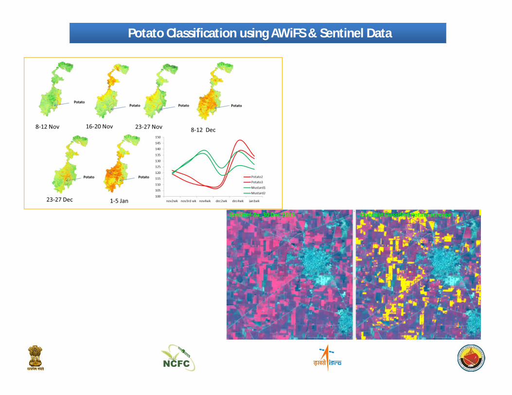
Potato Classification using AWiFS & Sentinel Data

Onion Classification using Sentinel Data
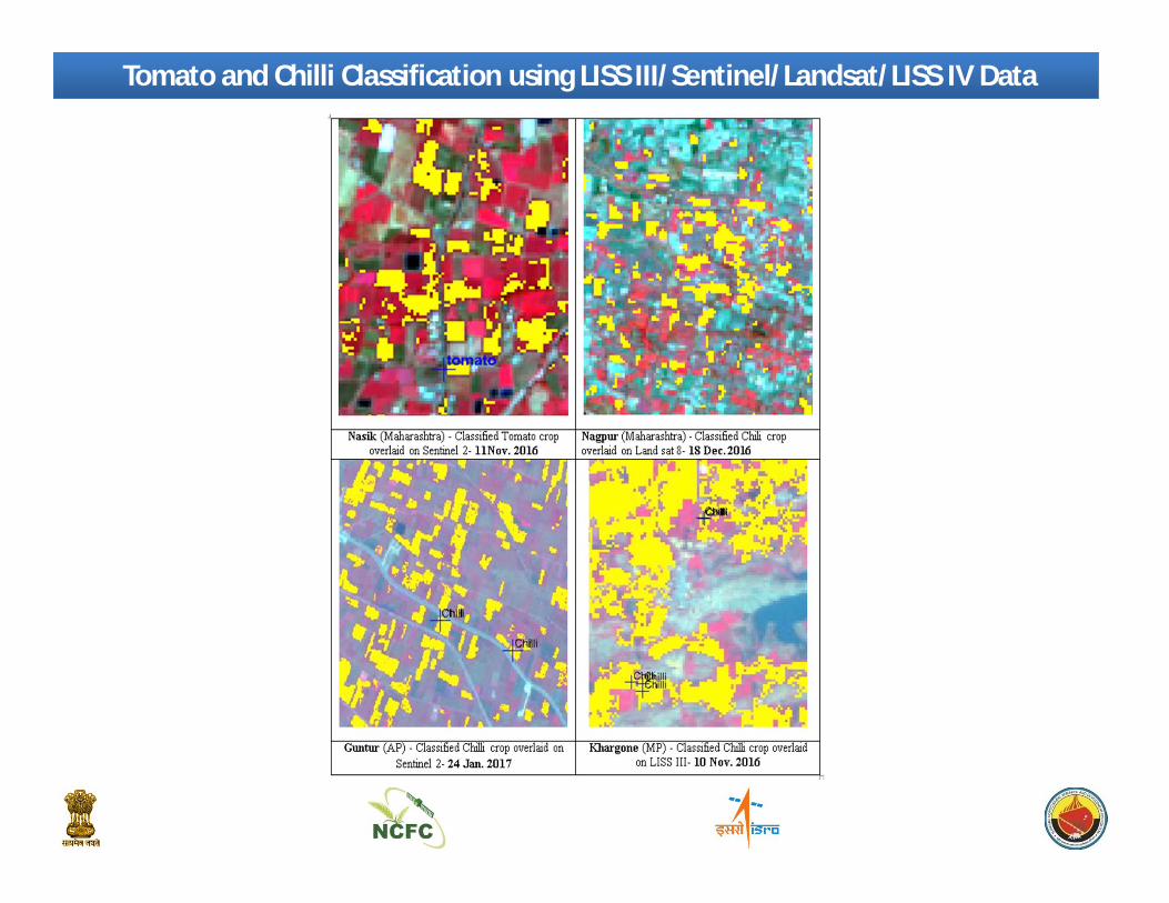
Tomato and Chilli Classification using LISS III/Sentinel/Landsat/LISS IV Data

Citrus orchards in LISS IV data in Hoshiyarpur, Punjab
Citrus orchards in LISS IV +Cartosat merged data in Bijapur, Karnataka
Mango orchards in LISS IV + Cartosat merged data in Saharanpur District, UP
Mango Orchards in LISS IV + Cartosat merged data in Sitapur, UP
Orchard Mapping using LISS IV/ LISS IV + Cartosat Data

Final Mango Orchards mapped for entire Sitapur district derived Mango Orchard area= 15440 ha
Classification Method
Derivedarea (ha)
*Reference area (ha)
Pixel based 12117
15389Object based 15387
BHUVAN Updated
15440
99_52_B_15 April 2013, LISS 4 FCC with Ground Truth points
Classified Mango orchards overlaid on LISS 4 FCC with Ground Truth points
IRS R-2 LISS-IV, Pixel based Classified output
IRS R-2 LISS-IV, Object based Classified output
Refined Classified Output by manual editing over BHUVAN image as a Basemap
MANGO ORCHARD – Sitapur district of Uttar Pradesh

CHAMAN in BHUVAN Geoportal
http://bhuvan-staging.nrsc.gov.in/projects/moa_chaman/

Mango Orchard of Sitapur District, Bhuvan-CHAMAN Portal
Scale: 1:5000
Scale: 1:15000

Deviation Analysis of Crop Statistics
CropsMBE ('000 ha)
RMSE ('000 ha)
IA (unit less)
ME (unit less)
r2 Number of data points
Citrus -2.64 4.64 0.92 0.76 0.87 9Mango -2.10 4.89 0.97 0.90 0.94 26Banana -3.56 7.26 0.84 0.61 0.82 9Onion -14.98 25.75 0.84 0.52 0.75 15Potato -0.06 6.47 0.98 0.91 0.91 44

Horticultural Development using Geospatial Technology
S.N. Component Activity
1 Site Suitability Introduction/expansion of Horticulture development activities inNorth Eastern States (One district in each state)
2 Post-HarvestInfrastructure
Assessing the potential for new cold storage sites for in Bihar andUP State
3Crop Intensification Understanding the scope of improving crop intensity through
horticulture in selected districts of Haryana and Madhya Pradesh
4 GIS database creation Characterization of orchards and GIS database creation ofvarious layers and uploading on Bhuvan platform
5 Orchard Rejuvenation Identifying plantations /orchards that needs Rejuvenation in oneDistrict in UP and One district of Karnataka/Gujarat/WB usingremote Sensing data
6 Aqua-horticulture Developing plans for promoting aqua-horticulture in 1 –2 districtsin Bihar and Odisha state

Perspective view of Jhum land clusters
Land Suitability Analysis for Mango Plantation in Nuzvid mandal, AP
Site Suitability Analysis for Horticulture Expansion in NER -States
Sl No State District Crop1 Arunachal
PradeshPapumpare Orange
2 Assam Goalpara Banana3 Manipur Senapati Pineapple4 Meghalaya Jaintia Hills Turmeric5 Mizoram Champhai Grape6 Nagaland Dimapur Pineapple7 Sikkim West Sikkim Cardamom8 Tripura West Tripura Banana

Geospatial Applications: Post-Harvest Infrastructure
Existing
Proposed

Geospatial Applications: Aqua-Horticulture
Category Area (Ha) Number
Area under Foxnut cultivation
339.6 109
Ponds under priority 1 99.0 47
Ponds under priority 2 102.9 33
LegendRoads
Railways
!( Priority1 Villages
# Priority2 Villages
Major Towns
District Boundary
Potential Wetlands Priority 2
Potential Wetlands Priority 1
Makhana Ponds
Not Potential Zones

Geospatial Applications: Orchard Rejuvenation
Potential Area Identification
Based on NDVI Change Based on Orchard Structure

Fallow Period 2015 Full Seasonal Fallow 2015
Number of monthsArea(ha)
2015 Rabi 2015 Kharif 2015 Summer1 month 82231 134075 768502 month 11412 36543 2342193 month 1637 6231 864254 month 24700
LegendAnnual Fallow
Built_up
Water
Taluk Boundary
Geospatial Applications: Crop Intensification, Bhiwani, Haryana

Precision Farming Study
Study Area: Karsul Village, Niphad Taluk, NasikData Collected: Ground Spectral, UAV, High Resolution Satellite, Crop and Soil ParametersActivity: Phenology Mapping, Variability Assessment, Crop and Soil Parameter Retrieval

120
130
140
150
160
170
180N
orm
alize
d D
iffer
ence
Veg
etat
ion
Inde
x (N
DVI)
Dates
Temporal NDVI Profiles of Grapes with Varying Vigour Grape-Nov Fruit Pruning Low Vigour Grape-Nov Fruit pruning High Vigour
Figure 5: Temporal spectral profile of grapes with varying vigour identified by stacking monthly NDVI Landsat imagery of 2013-14, 2014-15 and 2015-16 for Karsul village, Niphad block, Nasik district
120
130
140
150
160
170
180
Nor
mal
ized
Diff
eren
ce V
eget
atio
n In
dex
(NDV
I)
Dates
Temporal NDVI Profiles of Grapes with Varying Phenology Grape Young Orchard Grape-Sept Fruit Pruning Low Vigour
Grape-Oct Fruit pruning High Vigour Grape-Nov Fruit pruning High Vigour
Oct Fruit PruningSept Fruit
Pruning
Nov Fruit PruningOct
Fruit PruningSept
Fruit Pruning
Nov Fruit Pruning
Figure 7: Temporal spectral profile of grapes with varying phenology identified by stacking monthly NDVI Landsat imagery of 2013-14, 2014-15 and 2015-16 for Karsul village, Niphad block, Nasik district

Summary
• For crops like Potato, Mango, Citrus and Banana use of remote sensing data forassessment have been feasible, but for other crops accuracy is still an issue, due toscattered and small fields, mixed cropping, multiple seasons and short duration.
• Yield estimation for horticultural crops, especially fruit crops, is a problem due tomultiple picking.
• However use of satellite data and geospatial tools has shown a great promise forhorticultural development, especially for infrastructure development andhorticultural expansion.

Acknowledgment
• Indian Space Research Organization (SAC, NRSC, NESAC)• Department of Agriculture, Cooperation & Farmers’ Welfare (Hort Div)• National Horticultural Research & Development Foundation• India Meteorological Department• State Horticulture Departments• ICAR:NRCG
Team Members1. M M Kimothi2. Seema Sehgal3. Shreya Roy4. Aditi Srivastava5. Niti Singh6. Gargi Upadhyay7. Moreshwar Karale
Thank you
Related Documents