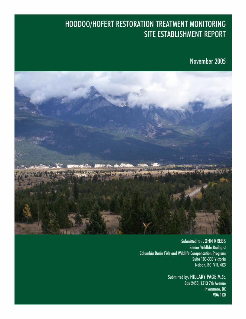
HOODOO/HOFERT RESTORATION TREATMENT MONITORING SITE ESTABLISHMENT REPORT November 2005 Submitted to: JOHN KREBS Senior Wildlife Biologist Columbia Basin Fish and Wildlife Compensation Program Suite 103-333 Victoria Nelson, BC V1L 4K3 Submitted by: HILLARY PAGE M.Sc. Box 2455, 1313 7th Avenue Invermere, BC V0A 1K0

Welcome message from author
This document is posted to help you gain knowledge. Please leave a comment to let me know what you think about it! Share it to your friends and learn new things together.
Transcript
HOODOO/HOFERT RESTORATION TREATMENT MONITORINGSITE ESTABLISHMENT REPORT
November 2005
Submitted to: JOHN KREBSSenior Wildlife Biologist
Columbia Basin Fish and Wildlife Compensation ProgramSuite 103-333 Victoria
Nelson, BC V1L 4K3
Submitted by: HILLARY PAGE M.Sc.Box 2455, 1313 7th Avenue
Invermere, BC V0A 1K0

Hoodoo/Hofert Restoration Treatment Monitoring – Site Establishment Report
November 2005 i
Summary
In July 2005, the Columbia Basin Fish and Wildlife Compensation Program (CBFWCP) initiated year one
of a multi-year field study designed to monitor the effects of dry forest ecosystem restoration treatments
on overstory and understory vegetation characteristics. This report summarizes activities associated with
year one (2005), sample plot establishment and pre-treatment monitoring at two sites, both located on the
Nature Trust Hoodoo/Hofert property.
Monitoring sites were established at Hawke Road (IDFun/IDfdm2) and at the Hoodoo restoration site
(IDFdm2(03)/PPdh2(02b)). Fifteen plots were permanently located and systematically sampled at each
site, according to general methods outlined in Machmer et al. (2002). Understory sampling (% cover by
species, species composition and richness) was conducted from August 1 - 15, 2005. Overstory sampling
(% crown closure, and tree density by species, diameter, and decay class in nested fixed radius plots) and
forage production assessments were completed from September 15-30, 2005. The data were entered
into EXCEL spreadsheets for easy import into an ACCESS relational database. A summary of post-
treatment vegetation conditions is provided for each site.
Dense sapling layers at Hawke Road and mature layers at the Hoodoo site have resulted in poor stand
structure for these open forest habitats. Production and cover of the understory was relatively high at both
sites, but monitoring results are tempered by high precipitation in spring 2005. Both sites have low non-
native species presence, but are highly susceptible to disturbance and to non-native species invasion.
Post-treatment monitoring should focus on targets outlined in the stand prescriptions for species and plant
communities of interest (e.g. red and blue listed species). Treatments should be monitored (implementation
monitoring) to accurately assess the effect of the treatment on the post-treatment plant community.
Acknowledgements
The author would like to thank John Krebs of the Columbia Basin Fish and Wildlife Compensation Program
for initiating and administering this contract. Beth Woodbridge provided valuable administrative support.
Amy Waterhouse (CBFWCP) prepared the maps included in this report. The author would like to thank the
following individuals for their assistance with this project: Rob Neil, Richard Klafki, Anne Skinner, Bob Gray,
Christian Zehnder and Victoria Page.
Hoodoo/Hofert Restoration Treatment Monitoring – Site Establishment Report
November 2005 ii
Table of Contents
1. Introduction ..................................................................................................................................................................... 1 2. Methods ......................................................................................................................................................................... 3 2.1 Study area.................................................................................................................................................................. 4 2.2 Restoration objective monitoring ............................................................................................................................ 8 2.2.1 Restoration objective 1 .......................................................................................................................................... 8 2.2.2 Restoration objective 2 .......................................................................................................................................... 8 2.2.3 Restoration objective 3 .......................................................................................................................................... 9 2.2.4 Restoration objective 4 .......................................................................................................................................... 9 2.2.5 Fire behaviour monitoring...................................................................................................................................... 9 2.3 Data entry.................................................................................................................................................................10 2.4 Data summary and analysis ..................................................................................................................................10 3. Results and observations...........................................................................................................................................10 3.1 General site descriptions .......................................................................................................................................10 3.1.1 Hawke Road site description ..............................................................................................................................11 3.1.2 Hoodoo site description .......................................................................................................................................12 3.2 Overstory characteristics........................................................................................................................................13 3.2.1 Hawke Road overstory structure........................................................................................................................13 3.2.2 Hoodoo overstory structure.................................................................................................................................16 3.3 Understory characteristics......................................................................................................................................18 3.3.1 Hawke Road understory structure......................................................................................................................18 3.3.2 Hoodoo understory structure...............................................................................................................................19 4. Recommendations.......................................................................................................................................................20 4.1 Hawke Road.............................................................................................................................................................20 4.2 Hoodoo......................................................................................................................................................................21 4.4 General recommendations ....................................................................................................................................22 5. Literature Cited ..........................................................................................................................................................23
Hoodoo/Hofert Restoration Treatment Monitoring – Site Establishment Report
November 2005 iii
List of Tables
Table 1. Layer descriptions used for overstory management ................................................................................. 8 Table 2. Summary of pre-treatment understory ecosystem characteristics at two restoration sites on the
Hoodoo/Hofert property as sampled in 2005. ..............................................................................................12 Table 3. Summary of pre-treatment densities (sph) of layer 1, 2 and 31 trees (total trees and dead trees
only) at two restoration sites sampled in 2005. ..............................................................................................15 Table 4. Summary of pre-treatment understory cover characteristics by functional/descriptive group at
two restoration sites on the Hoodoo/Hofert property as sampled in 2005. ............................................19
List of Figures
Figure 1. Restoration monitoring plot layout at the Hawke Road site................................................................... 4 Figure 2. Restoration monitoring plot layout at the Hoodoo restoration site. ...................................................... 6 Figure 3. Layout of overstory (a) and understory (b) sampling plots adapted from DeLong et al. (2001).. 7 Figure 4. Pinegrass, soopolallie, rough fescue plant community located at the Hawke Road site. ...............11 Figure 5. Stem diameter distributions for pre-treatment layers 1a, 1, 2 and 3 sampled at Hawke Road in 2005...................................................................................................................................................................................13 Figure 6. Standing dead veteran sampled at Hawke Road in 2005..................................................................14 Figure 7. Young aspen mortality at Hawke Road. ..................................................................................................16 Figure 8. Stem diameter distributions for pre-treatment layers 1a, 1, 2 and 3 sampled at the Hoodoo restoration site in 2005. .................................................................................................................................................17 Figure 9. Summary of pre-treatment understory production (kg/ha) characteristics by functional/descriptive group at two restoration sites on the Hoodoo/Hofert property as sampled in 2005..............................................................................................................................................................................................20
List of Appendices
Appendix 1. List of EXCEL raw data files and their descriptions (RW-CD format). .........................................25 Appendix 2. Scanned photos (RW-CD format).......................................................................................................25 Appendix 3. Names and descriptions of EXCEL spreadsheets in the “Summary Data” file (RW-CD format).
...................................................................................................................................................................................25
Hoodoo/Hofert Restoration Treatment Monitoring – Site Establishment Report
November 2005 1
1. Introduction
Ecosystems can be characterized by their natural disturbance regime. For the purposes of setting
biodiversity objectives in British Columbia (BC), five Natural Disturbance Types (NDTs) are recognized in
the Province. Disturbance types range from NDT1, systems with rare stand-initiating events to NDT5
systems (alpine tundra and subalpine parkland) (Province of BC 1995). NDT4 systems of the southern
interior of BC are comprised of the interior Douglas-fir, ponderosa pine and bunchgrass zones of the
Cariboo, Kamloops, and Nelson forest regions (Gayton 2001a). There are approximately 4.5 million ha
of NDT4 in the Province, roughly 60% occurring on crown land (Gayton 2001a) NDT4 systems are
characterized as shrublands mixed with open stands of ponderosa pine (Pinus ponderosa Douglas ex
Lawson & Lawson var. ponderosa) and interior Douglas-fir [Pseudotsuga menziesii var. glauca (Beissn.)
Franco]. The conventional assumption is that NDT4 systems historically experienced frequent (every 7 – 50
years), low intensity fires which limited encroachment by most conifer species and shrubs (Province of BC
1995), although there is little empirical data to back this assumption. Although NDT4 systems have been
characterized as having a low-frequency fire regime, there is general agreement that BC’s NDT4 was
probably subjected to a ‘mixed fire regime’, meaning frequent low-intensity fires with an occasional,
randomly occurring stand-replacement fires (Gayton 2001a). However, it can be assumed that the mean
fire-return interval was normally distributed, with very short and long intervals being uncommon (Gayton
2001a). Regardless, these dry plant communities have undergone dramatic changes in structure and losses
in diversity hypothesized to be due to forest ingrowth and encroachment brought about with fire
suppression policies introduced by the BC Ministry of Forests in the 1940’s (Daigle 1996).
Conifer encroachment has contributed to the rapid disappearance of grassland ranges and open forests in
BC (Strang and Parminter 1980, Gayton 1997, Bai et al. 2001). Gayton (1997) estimated, that over 50
– 60 years, 1% of grassland and open forest is lost annually in NDT4 systems of the Rocky Mountain
Trench due to forest ingrowth or encroachment. This is equivalent to a loss of 3000 ha. This rate is similar
to estimates made in other areas of BC that exhibit similar ecosystem changes (Bai et al. 2001). Extensive
forest ingrowth and encroachment within NDT4 ecosystems of the southern interior of BC has resulted in a
loss of wildlife habitat as well as in decreased timber and forage production (Powell et al. 1998). The
result of this conversion is that domestic livestock and native ungulates are exerting increased pressure on a
declining land base as they compete for forage. Remaining grassland habitats are being further
degraded by noxious weeds which out-compete native vegetation and reduce residual forage quantity
and quality. Densely stocked stands are prone to severe insect outbreaks and to catastrophic crown fires
(Powell et al. 1998; Rocky Mountain Trench Ecosystem Restoration Steering Committee 2000). The loss of
grassland habitat is also of concern for the 30% of the species at risk in BC that occur in grassland areas
(GCC 2005).

Hoodoo/Hofert Restoration Treatment Monitoring – Site Establishment Report
November 2005 2
Conservation of historic grassland and of NDT4 habitats is of primary concern to the Nature Trust of British
Columbia. The Nature Trust is a non-profit land conservation organization with a mandate to protect BC’s
natural diversity of wildlife, plants and critical habitat through the acquisition and management of
ecologically significant land. Land acquisition is based on the biogeoclimatic classification (BEC) system
with some BEC zones taking higher priority than others based upon the ecological diversity value of the
zone. Bunchgrass, Coastal Douglas fir and Ponderosa Pine zones are ranked as exceptional and high in
value. In order to fulfill its mandate, the Nature Trust, with several conservation partners, including the
Columbia Basin Fish and Wildlife Compensation Program (CBFWCP), purchased the 4037 ha
Hoodoo/Hofert Property in 2003. Located in the East Kootenay Valley, between Fairmont Hot Springs
and Invermere, the property features internationally significant wetlands, forests, extensive grasslands,
and hoodoo formations on the southern edge. The Hoodoo/Hofert property contains habitat for several
red and blue listed species (e.g. badger, Lewis’s woodpecker) and is a vital wildlife corridor. The size of
the property allows for habitat management on a landscape level.
The vision statement for the Hoodoo/Hofert property is, “to maintain, restore and enhance the ecological
integrity of the Hoodoo/Hofert property in order to ensure the property’s biodiversity values are
maintained in perpetuity.” (Nature Trust 2004). In order to maintain biodiversity values a priority
management issue must be the restoration and enhancement of ecosystems that have been adversely
affected by forest ingrowth and encroachment. Land management agencies (Columbia Basin Fish and
Wildlife Compensation Program, Ministry of Forests, Ministry of Environment) as well as agriculture and
conservation stakeholders throughout the East Kootenay Valley have adopted ecosystem restoration or
habitat enhancement programs intended to restore the required ecological processes of fire-maintained
systems in the Rocky Mountain Trench (Rocky Mountain Trench Ecosystem Restoration Steering Committee
2000). The primary objective of the Trench ecosystem restoration program is to remove excess immature
and understory trees from NDT4 communities over the next several decades to create an ecologically
appropriate mosaic of NDT4 habitats on Crown land. The mosaic is intended in order to mimic the
historical landscape under natural conditions when fire was an integral part of the ecosystem (Rocky
Mountain Trench Ecosystem Restoration Steering Committee 2000). The Trench Restoration Program is the
largest, longest running terrestrial initiative underway in the Province of BC (Machmer et al. 2002).
Ecosystem restoration is designed to achieve a number of different objectives. One of the primary
objectives is the maintenance or enhancement of habitat diversity and associated wildlife species. This is
generally accomplished through the reduction of litter layer depths/slash accumulations that restrict forb
and grass production, thereby increasing the percentage area or production of target grassland species
coverage (e.g. bluebunch wheatgrass and rough fescue). Maintenance and enhancement of wildlife
habitat also requires that existing overstory veterans and wildlife trees throughout the site be protected
and maintained. These objectives and requirements of ecosystem restoration require different
Hoodoo/Hofert Restoration Treatment Monitoring – Site Establishment Report
November 2005 3
prescriptions for each site, depending on pre-treatment conditions. The main tools of dry forest ecosystem
restoration are tree removal (harvesting, spacing) and or periodic prescribed burning to kill tree seedlings
and smaller undesirable trees.
An integral component of a restoration plan is a detailed and thorough monitoring plan. Long-term
monitoring of vegetation, of a particular species of interest, or of a key physical parameter is the only
way to determine the success of a restoration effort (Gayton 2001b). Monitoring must focus on the
recovery of vegetation structure, on species diversity and on ecosystem processes to ensure that the
ecosystem will persist in a stable state (Ruiz-Jean and Aide in press). Desired goals should be identified to
provide markers by which success will be measured. Monitoring will aid in the development of future
plans, plans that contain an understanding of the ecological processes that link overstory management to
understory dynamics and diversity (Naumberg and DeWald 1999). Ruiz-Jean and Aide (in press) state
that vegetation structure, species diversity, and ecosystem processes are essential components for the long-
term persistence of the ecosystem, and as such, should be monitored to determine the success of restoration.
The objectives outlined in the East Kootenay Trench Effectiveness Monitoring Plan (EMP) (Machmer et al.
2002) are to assess characteristics related to overstory structure and to forest and ecosystem health. They
are also to assess characteristics associated with forage production, species diversity and with the
maintenance of open forest habitat and associated plant species
This project is in response to a Request for Proposals (RFP) from the Columbia Basin Fish & Wildlife
Compensation Program (CBFWCP). Specific objectives of the project were to (1) establish two permanent
monitoring sites on the Nature Trust Hoodoo-Hofert Property, and (2) collect data on pre-treatment
vegetation overstory and understory conditions at each site using the trench EMP methodology. Post-
treatment re-assessments are planned for each site under separate contracts.
2. Methods
Methods are based on those described in trench EMP (Machmer et al. 2002), with modifications based on
discussions with John Krebs (CBFWCP). The following four restoration objectives outlined in the EMP were
chosen for monitoring purposes:
Restoration Objective 1: To reduce tree density, increase tree size, and achieve a tree species composition that falls within the historical range of variability for treated areas (based on aspect, slope, topography, moisture).
Restoration Objective 2: To maintain or increase fire-adapted native understory vegetation in treated areas.
Restoration Objective 3: To minimize the establishment and spread of non-native plant species, particularly noxious species, in treated areas.
Hoodoo/Hofert Restoration Treatment Monitoring – Site Establishment Report
November 2005 4
Restoration Objective 4: To maintain or increase forage production in treated areas.
In addition to objectives outlined in the Trench EMP, methods to monitor fire behaviour were considered
during site establishment.
2.1 Study area
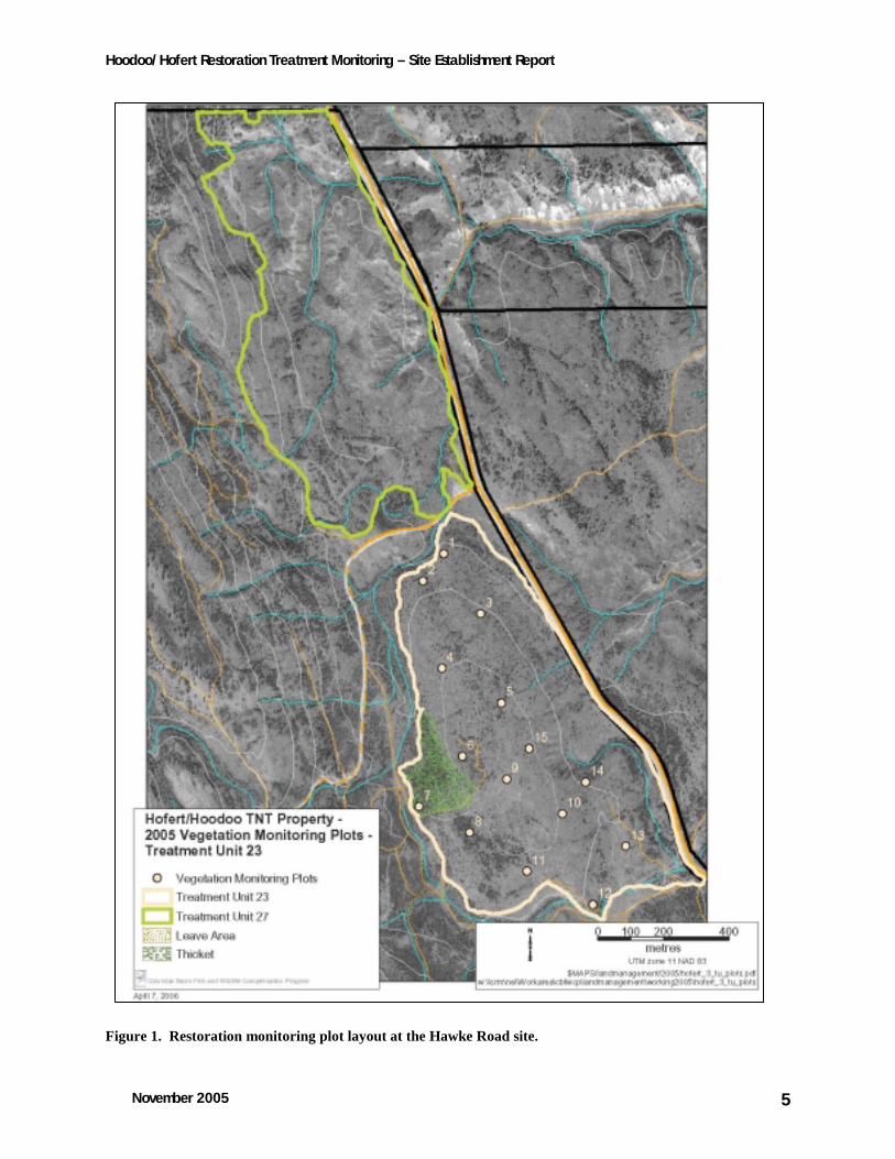
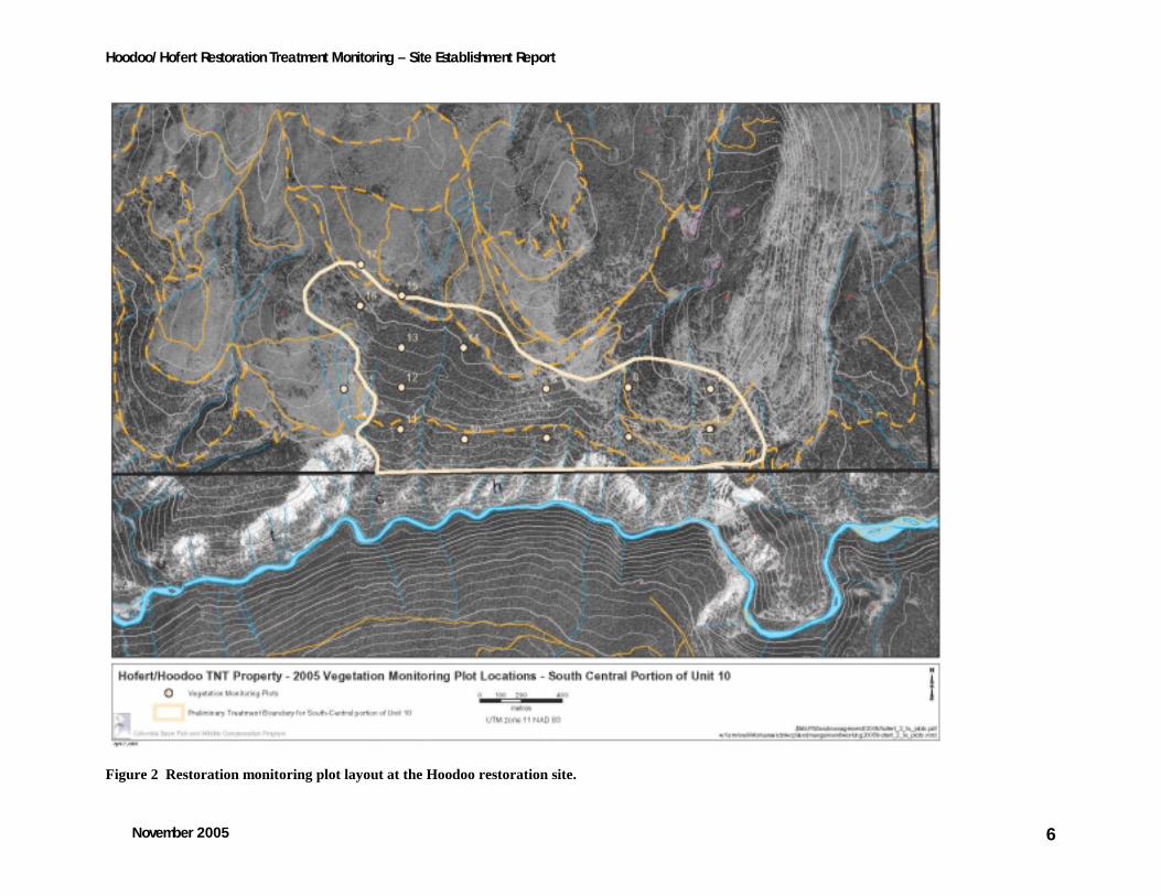
Two sites were established for the project:
(1) Hawke Road [located in the northern portion of the Nature Trust Hoodoo-Hofert Property Forest
District; IDFun/IDFdm2(01-03) Unit 23] (Fig. 1);
(2) Hoodoo Block (located in the southern portion of the Nature Trsut Hoodoo-Hofert property;
[IDFdm2(03) with minor components of PPDh2(01) Unit 10] (Fig. 2).
Fifteen plots were systematically established at each of the two sites, avoiding areas that were heavily
disturbed or unrepresentative of the rest of the block. Plots were established at Hawke Rd. using a hip
chain and compass and at the Hoodoo site using a Global Positioning System (GPS). Plots at Hawke Rd
were established on a 200˚-40˚ grid and on a north-south grid at the Hoodoo site. Plots at the Hoodoo
site were frequently offset 50m to avoid multiple skid trails running through the site. Plot locations were
recorded using a GPS, plot locations (UTMs) are provided in Appendix 1.
Plot centres were permanently marked using 12” (1”diameter) electrical conduit and a 12” galvanized
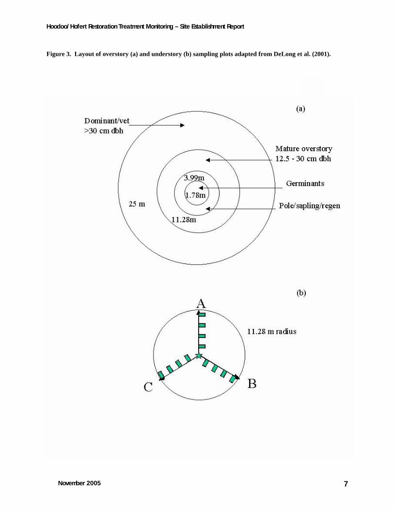
spike (with washer) in the centre of the conduit. Three 11.28 m transects (Fig. 3b) were established
radiating out from each plot center to form a spoke separated by 120o. The first bearing was randomly
selected, with subsequent bearings determined by adding 120° and 240°, respectively. The second and
third transects followed in a clockwise position (from plot center, facing north) to complete the spoke. All
bearings were recorded and entered into a database (Appendix 1). Four Daubenmire frame locations
were permanently marked on each transect (4 frames/transect = 12 total/plot) using an 8” galvanized
spike and washer. Daubenmire frames were located on the left hand side of the transect at meters 3, 5, 7
and 9. The left hand corner located on the transect was marked with an 8” galvanized spike. Each spike
was flagged and numbered.
Hoodoo/Hofert Restoration Treatment Monitoring – Site Establishment Report
November 2005 5
Figure 1. Restoration monitoring plot layout at the Hawke Road site.
Hoodoo/Hofert Restoration Treatment Monitoring – Site Establishment Report
November 2005 6
Figure 2 Restoration monitoring plot layout at the Hoodoo restoration site.
Hoodoo/Hofert Restoration Treatment Monitoring – Site Establishment Report
November 2005 7
Figure 3. Layout of overstory (a) and understory (b) sampling plots adapted from DeLong et al. (2001).
Hoodoo/Hofert Restoration Treatment Monitoring – Site Establishment Report
November 2005 8
2.2 Restoration objective monitoring
2.2.1 Restoration objective 1
Objective: To reduce tree density, increase tree size, and achieve a tree species composition that falls
within the historical range of variability for treated areas (based on aspect, slope, topography, moisture,
etc.) (Machmer et al. 2001).
Response Variables: Crown closure, tree density, diameter and species composition.
Overstory plot layout conformed to methods developed by the BC Forest Service Permanent Sample Plot
procedures (BCMOF 2000) and DeLong et al. (2001), with some modifications, to ensure that large trees
and snags were adequately sampled. Fifteen nested, fixed-radius plots (Figure 3a) were established to
sample each layer as follows: layer 1 (1.78 m radius), layer 2, 3 and 4 (3.99 m radius), layer 1 mature
(11.28 m radius), and layer 1 dominant/veteran (25 m radius) (Table 1). Tree species, diameter (diameter
at breast height in cm), decay class, and evidence of insects or diseases were recorded for each tree in
layers 1, 2 and 3. A tally was made by species (live/dead) for layer 4. A spherical densiometer was
used to measure percent crown closure at plot center.
Table 1. Layer descriptions used for overstory management
Layer number Layer name Layer description 1 dominant/veteran >30 cm dbh 1 mature 12.5 – 30 cm dbh 2 pole 7.5 – 12.49 cm dbh 3 sapling 1.3 m height and < 7.5 cm dbh 4 regeneration < 1.3 m height 4 germinant seedlings < 2 years old
2.2.2 Restoration objective 2
Objective: To maintain or increase fire-adapted native vegetation (grass, herb, shrub) in treated areas.
Response Variables: Grass, herb and shrub cover by species, species richness and composition.
Understory plot layout conformed to methods developed by DeLong et al. (2001) and Powell et al.
(1998), with modifications made based on the specific goals of this project. Three 11.28 m transects (Fig.
3b) were established radiating out from each plot center to form a spoke separated by 120°. Understory
vegetation cover and composition data were collected in 12 Daubenmire frames (Daubenmire 1959). In
each frame, percent herb, grass and shrub cover was recorded by species. Species with less than 1%
cover were recorded as 0.1%. Percent cover of bare soil, rock, dead wood (>1cm diameter), bryophytes,
feces and cryptogamic crust was recorded in the Daubenmire frames as well. Percent shrub cover was
estimated in one 5.64m radius plot, using the restoration plot centre. Species richness and diversity was
Hoodoo/Hofert Restoration Treatment Monitoring – Site Establishment Report
November 2005 9
recorded and summarized for each plot. Species diversity was calculated using the Shannon-Weiner
diversity index (H=-Pilog[PI]) (Bonham 1983).
To assess plant vigor, flowering culm counts were conducted for bunchgrasses in the Daubenmire quadrats
(see Page 2002). Bunchgrasses chosen for monitoring are species considered historically common in NDT4
stands and include: rough fescue (Festuca campestris Rydb.), Idaho fescue (Festuca idahoensis Elmer),
bluebunch wheatgrass (Pseudoroegneria spicata (Pursh) A. Löve), Junegrass (Koeleria macrantha (Ledeb. J.A.
Schultes f.), Richardson’s needlegrass (Stipa richardsonii Link.), needle-and-thread grass (Stipa comata
Trin.&Rupr.), and stiff needlegrass (Stipa occidentalis Thurb. ex S. Wats. var. pubescens Maze, Tayor and
MacBryde).
2.2.3 Restoration objective 3
Objective: To minimize the establishment and spread of non-native plant species, particularly noxious
species, in treated areas.
Response variables: Number of species, cover, and noxious weed density (if cover <5%).
Non-native vegetation cover by species was estimated in the 12 Daubenmire frames (Fig 3a). If weed
cover (noxious and nuisance weeds) was less than 5%, individual plants in the Daubenmire frames were
counted to provide a density measure.
2.2.4 Restoration objective 4
Objective: To maintain or increase forage production in treated areas.
Response variables: Total production, utilization (caged versus uncaged).
Fifteen clip plots (1 each per plot) were established to estimate production at each plot. Total annual
forage production was measured in a 0.5 m2 (70.7 cm x 70.7 cm) quadrat, located on the right hand side
of meter four on the first transect, in each of the 15 permanently marked plots per site. Production
quadrats will be rotated among transects in subsequent years to avoid the confounding effects of
destructive sampling. Herbaceous vegetation and current annual growth of shrubs was clipped to ground
level in mid-September, after peak growth was reached. Kinninick (bearberry) [Arctostaphylos uva-ursi (L.)
Spreng.] was not clipped, as it is not of direct interest for ecosystem restoration. Samples were separated
into bunchgrass, ‘other grass’, forb, weed, sedge (Carex spp.) and stored in paper bags. They were air-
dried and then oven-dried at 70°C for 48 hours to a constant mass, and weighed to the nearest 0.1 mg.
2.2.5 Fire behaviour monitoring
It is possible that one or both of the restoration sites on the Hoodoo/Hofert property will be subject to a
prescribed burn. Twelve depth of duff pins were established at each plot so duff consumption can be
Hoodoo/Hofert Restoration Treatment Monitoring – Site Establishment Report
November 2005 10
measured immediately post-burn. Fuel moisture measurements (made the day of burning) and duff
consumption will be combined to provide a measure of burn intensity. Other burn objectives will be
measured (e.g. rate of spread, flame length etc.) at the time of burning.
2.3 Data entry
Raw data were entered into EXCEL spreadsheets (Appendix 1) in a format that permits easy import into
ACCESS or JMP (Sall et al. 2005). Species codes and life-form identifications used were provided by the
Ministry of Forests Research Branch. Raw data file names and descriptions are provided in Appendix 1 of
this document.
2.4 Data summary and analysis
Data were summarized in EXCEL spreadsheets (Appendix 3) and summary statistics were calculated using
JMP IN software (2005). Data were summarized by species and by functional/descriptive group (e.g.,
shrubs, forbs, grasses, etc.). Due to inherent variability at sites sampled, understory cover data had very
large variances (Appendix 3) and these data will require transformation (arcsine or square root) prior to
undertaking inter-year comparisons using ANOVA.
3. Results and observations 3.1 General site descriptions
Both sites have representative IDFdm2 biogeoclimatic subzones (Kootenay dry mild interior Douglas-fir
variant; Braumandl and Curran 1992). Zonal IDFdm2 sites have climax stands of Douglas-fir with an
understory dominated by pinegrass and shrubs. Common shrubs include birch-leaved spiraea (Spiraea
betulifolia Pall. ssp. lucida (Dougl. ex Greene) Taylor & MacBryde), common juniper (Juniperus communis L.),
soopolallie (Shepherdia canadensis (L.) Nutt.), Saskatoon (Amelanchier alnifolia Nutt.), and common
snowberry (Symphoricarpos albus (L.) Blake). There are components of IDFun biogeoclimatic subzone
(Undifferentiated Interior Douglas fir at the Hawke Road site and minor components of PPdh2 (Kootenay
dry hot ponderosa pine variant) on the southern perimeter of Hoodoo site (Fig. 2). Zonal IDFun sites have
open stands of Douglas fir, with bluebunch wheatgrass and junegrass being the dominant understory
species. PPdh2 sites have open stands of Douglas fir and ponderosa pine with a predominantly bluebunch
wheatgrass understory. Soils at both sites are classified as Orthic Eutric Brunisols (Lacelle 1990). Eutric
Brunisols are strongly calcareous and low in organic matter (National Research Council of Canada 1998).
Consideration of the 2005 monitoring results should be tempered by above average precipitation levels in
the spring.

Hoodoo/Hofert Restoration Treatment Monitoring – Site Establishment Report
November 2005 11
3.1.1 Hawke Road site description
Hawke Road is located approximately 20km south of Invermere on the west side of Westside Road (Fig
1). The block has east-facing moderate slopes to the height of land and a moderate west facing slope on
the west side of the site. Hawke Road is drier and more open to the south and west side of the block. The
northeast side of the block is characterized by aspen-dominated depressions, gullies and rolling terrain.
Upland plant communities on the east-facing slopes are dominated by pinegrass, soopolallie and rough
fescue (Fig 4). These areas are characterized by sapling aspen, Douglas fir and mature lodgepole pine.
Figure 4. Pinegrass, soopolallie, rough fescue plant community located at the Hawke Road site.
The height of land, south and west sides of the block are characterized by drier plant communities and an
open, mature Douglas fir overstory. Dominant understory species include Richardson’s needlegrass,
common yarrow (Achillea millefolium L.), Canada bluegrass (Poa compressa L.) and bluebunch wheatgrass.
Soils in these plant communities are particularly susceptible to disturbance due to the prominent
cryptogamic crust that forms a significant portion of ground cover at this site (Table 2). A cryptogamic
crust is an element of healthy open grasslands at lower elevations. The crust is a layer of lichens, mosses,
Hoodoo/Hofert Restoration Treatment Monitoring – Site Establishment Report
November 2005 12
liverworts and cyanobacteria that covers the ground between widely spaced bunchgrasses (GCC 2005).
The crust forms a protective cover for the soil, helps retain soil moisture, and prevents weedy species from
becoming established. The crust is highly susceptible to disturbance, particularly mechanical.
Open areas of this site have been used for open range cattle grazing for the past 40 years. Cattle
grazing was excluded from this site in 2003. Litter cover is low (Table 2), likely due to historic livestock
grazing. Low litter cover, caused by overgrazing, can exacerbate the effects of drought on the plant
community.
Hawke Road was harvested for railway ties in the late 1950’s and several times after this. This area was
subject to a wildfire in 1971.
Table 2. Summary of pre-treatment understory ecosystem characteristics at two restoration sites on the Hoodoo/Hofert property as sampled in 2005.
Percent Cover (%) Hawke Road Hoodoo mean stdev mean stdev Litter 55 28 73 27 Cryptogamic crust 16 23 1 7 Bryophytes 3 10 4 13 Dead Wood 10 15 5 10 Soil 9 21 6 14 Rock 1 0.7 7 16
3.1.2 Hoodoo site description
The Hoodoo restoration site is a south facing slope located on the north side of Dutch Creek (Fig. 2). The
north half of the block is primarily composed of the IDFdm2(03), pinegrass and bluebunch wheatgrass are
dominant understory species. The southernmost portions of the site, just prior to the slope break to Dutch
Creek, are characterized by open ponderosa pine and bluebunch wheatgrass, falling into the PPdh2(02b)
site series. The Hoodoo area is characterized by a sub-mesic to sub-xeric moisture regime. Fine, clay soils
on steep south facing slopes are prone to erosion and disturbance. This is further evidenced by the
hoodoo formations that border the block. Hoodoos generally occur in arid areas with erodable soil. They
occur adjacent to steep slopes, representing the remnants of those slopes.
This site has been used for cattle grazing for the last 40 years, although steep slopes have limited the
impact of grazing over much the area (i.e. cattle due not use steep slopes for grazing). Where slopes are
moderate, past evidence of cattle grazing is more apparent e.g. higher litter levels (Table 2).
Moderate slopes in this area have been harvested several times in the last 50 years.. Larger diameter
trees on level ground were harvested to produce railway ties in the late 1950’s. This site was subject to a
wildfire in 1971.
Hoodoo/Hofert Restoration Treatment Monitoring – Site Establishment Report
November 2005 13
0
2
4
6
8
10
12
14
16
<3 <8 <13 <18 <23 <28 <33 >38
Diameter (dbh in cm)
# o
f ste
ms
3.2 Overstory characteristics
3.2.1 Hawke Road overstory structure
The overstory structure at Hawke Road was characterized by small and moderate diameter Douglas fir,
lodgepole pine (sapling and mature layers), interspersed with sapling and mature aspen that occurred in
depressions and gullies. There was a lack of a functional veteran layer, with only 2 trees over 30cm dbh
found on-site (Fig 6). The overstory structure reveals a remnant mature layer and the growth an extensive
pole layer. Ingrowth of lodgepole pine and sapling Douglas fir was more apparent in the north and east
areas of Hawke Road.
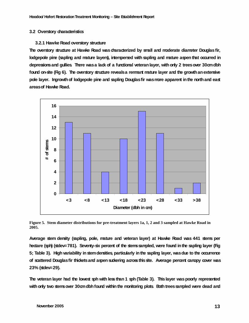
Figure 5. Stem diameter distributions for pre-treatment layers 1a, 1, 2 and 3 sampled at Hawke Road in 2005.
Average stem density (sapling, pole, mature and veteran layer) at Hawke Road was 441 stems per
hectare (sph) (stdev=781). Seventy-six percent of the stems sampled, were found in the sapling layer (Fig
5; Table 3). High variability in stem densities, particularly in the sapling layer, was due to the occurrence
of scattered Douglas fir thickets and aspen suckering across this site. Average percent canopy cover was
23% (stdev=29).
The veteran layer had the lowest sph with less than 1 sph (Table 3). This layer was poorly represented
with only two stems over 30cm dbh found within the monitoring plots. Both trees sampled were dead and

Hoodoo/Hofert Restoration Treatment Monitoring – Site Establishment Report
November 2005 14
subject to feeding (Fig 6). The lack of a veteran layer at this site is likely due to past harvesting activities,
most notably railway tie production.
The mature layer was uniformly distributed with moderate stem densities (71sph; stdev=71). The mature
layer was comprised of 59% Douglas fir, 16% lodgepole pine, 10% aspen and 13% unknown species (all
unknown species were dead trees). There was significant mortality in the mature layer (33% mortality;
Table 3). Most of the dead stems in this layer were killed by past wildfires. The mature layer was used
extensively by cavity feeders, with 20% of the dead stems subject to feeding. There were minor
occurrences of yellowing needles on the tips of the branches (1% of stems in the mature layer), which is a
potential indicator of Armillaria root disease. Drought stress at this site could have potentially triggered
the root disease. Armillaria is an indication that the site is exceeding carrying capacity for Douglas fir
(Emile Begin, Forest Health Officer, Invermere Forest District, per. comm., 2005).
Figure 6. Standing dead veteran sampled at Hawke Road in 2005.

Hoodoo/Hofert Restoration Treatment Monitoring – Site Establishment Report
November 2005 15
The pole layer (7.5-12.5cm dbh) did not contribute to stand structure at this site. Stem densities were low
(31 sph; stdev=72). Species composition was 50% Douglas fir and 50% unknown species (likely Douglas
fir).
Table 3. Summary of pre-treatment densities (sph) of layer 1, 2 and 31 trees (total trees and dead trees only) at two restoration sites sampled in 2005.
Hawke Rd Hoodoo mean stdev mean stdev layer 1 (dom/vets) live 0 0 15 21 layer 1 (dom/vets) dead 1 2 2 4 layer 1 (mature) live 69 75 325 249 layer 1 (mature) dead 23 35 5 11 layer 2 (pole) live 15 53 126 186 layer 2 (pole) dead 15 53 0 0 layer 3 (sapling) live 338 750 215 289 layer 3 (sapling) dead 0 0 0 0
1 Layers as defined in Table1.
The greatest sph were found in the sapling layer (Table 3; Fig 5). Plot to plot variation was high. Four
plots had a sapling layer with sph ranging from 400 sph to 2800 sph. There was no mortality in this layer.
Species composition was 68% Douglas fir, 18% rocky mountain juniper ((Juniperus scopulorum Sarg.) and
14% aspen. Plots with a well-developed Douglas fir and aspen sapling layer occurred in the northern
portion of the restoration site, in more mesic areas.
Average sph in the regeneration layer was 2461 SPH (stdev=4161). The regeneration layer was largely
composed of aspen (85%) (Douglas fir-11%and lodgepole pine-8% made up the rest of the layer).
Variation in means was high due to three plots having significant amounts of aspen regeneration. There
was a fair amount of mortality in the aspen regeneration layer. Twenty-eight percent of all aspen stems in
layer 4 were dead. High mortality in the young aspen layers is indicative of heavy use of this species for
browsing. Although partially due to wildlife pressure, it is likely that the recent exclusion of livestock
grazing will lead to a decrease in aspen mortality in the short to mid-term.
Stem densities at this site (441 sph) just exceed the target for open forest (76 – 400 sph), although the
stand/site level management objectives stated by the East Kootenay Ungulate Winter Range Committee
(2003) recommend 150 sph for open forest (76 sph minimum). Although stem densities are not high
(relative to other restoration sites), the well-formed sapling layer and the lack of a veteran layer indicates
the need for overstory manipulation in order to re-create historic stand structures.
Hoodoo/Hofert Restoration Treatment Monitoring – Site Establishment Report
November 2005 16
Figure 7. Young aspen mortality at Hawke Road.
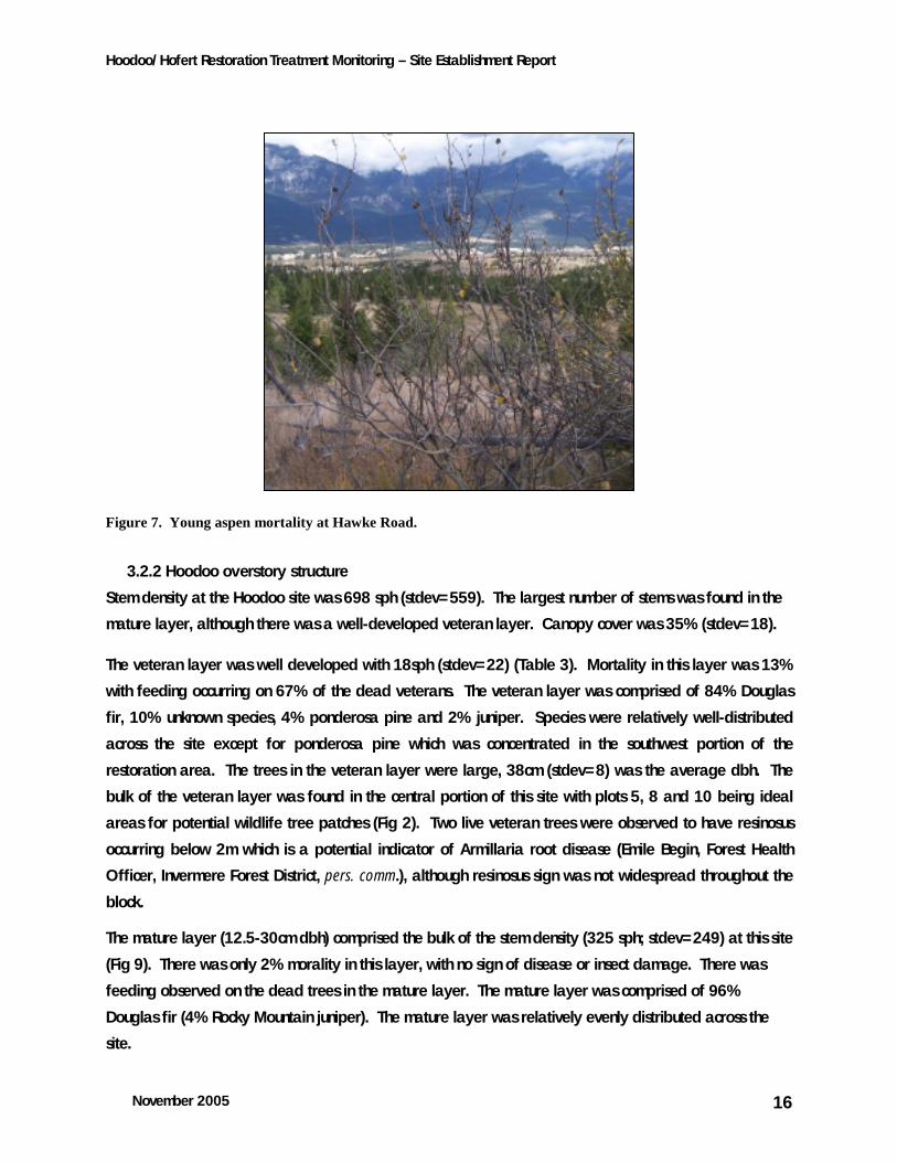
3.2.2 Hoodoo overstory structure
Stem density at the Hoodoo site was 698 sph (stdev=559). The largest number of stems was found in the
mature layer, although there was a well-developed veteran layer. Canopy cover was 35% (stdev=18).
The veteran layer was well developed with 18sph (stdev=22) (Table 3). Mortality in this layer was 13%
with feeding occurring on 67% of the dead veterans. The veteran layer was comprised of 84% Douglas
fir, 10% unknown species, 4% ponderosa pine and 2% juniper. Species were relatively well-distributed
across the site except for ponderosa pine which was concentrated in the southwest portion of the
restoration area. The trees in the veteran layer were large, 38cm (stdev=8) was the average dbh. The
bulk of the veteran layer was found in the central portion of this site with plots 5, 8 and 10 being ideal
areas for potential wildlife tree patches (Fig 2). Two live veteran trees were observed to have resinosus
occurring below 2m which is a potential indicator of Armillaria root disease (Emile Begin, Forest Health
Officer, Invermere Forest District, pers. comm.), although resinosus sign was not widespread throughout the
block.
The mature layer (12.5-30cm dbh) comprised the bulk of the stem density (325 sph; stdev=249) at this site
(Fig 9). There was only 2% morality in this layer, with no sign of disease or insect damage. There was
feeding observed on the dead trees in the mature layer. The mature layer was comprised of 96%
Douglas fir (4% Rocky Mountain juniper). The mature layer was relatively evenly distributed across the
site.
Hoodoo/Hofert Restoration Treatment Monitoring – Site Establishment Report
November 2005 17
0
20
40
60
80
100
120
<3 <8 <13 <18 <23 <28 <33 >38
Diameter (dbh in cm)
# o
f st
ems
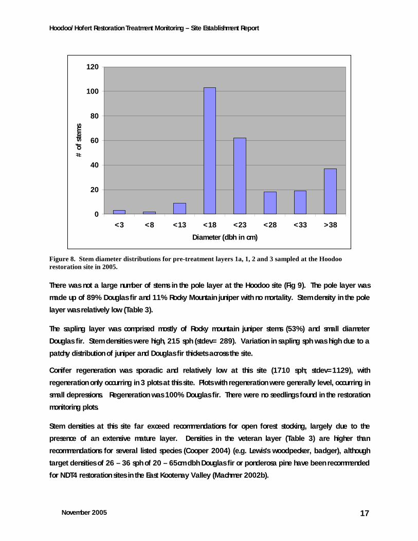
Figure 8. Stem diameter distributions for pre-treatment layers 1a, 1, 2 and 3 sampled at the Hoodoo restoration site in 2005.
There was not a large number of stems in the pole layer at the Hoodoo site (Fig 9). The pole layer was
made up of 89% Douglas fir and 11% Rocky Mountain juniper with no mortality. Stem density in the pole
layer was relatively low (Table 3).
The sapling layer was comprised mostly of Rocky mountain juniper stems (53%) and small diameter
Douglas fir. Stem densities were high, 215 sph (stdev= 289). Variation in sapling sph was high due to a
patchy distribution of juniper and Douglas fir thickets across the site.
Conifer regeneration was sporadic and relatively low at this site (1710 sph; stdev=1129), with
regeneration only occurring in 3 plots at this site. Plots with regeneration were generally level, occurring in
small depressions. Regeneration was 100% Douglas fir. There were no seedlings found in the restoration
monitoring plots.
Stem densities at this site far exceed recommendations for open forest stocking, largely due to the
presence of an extensive mature layer. Densities in the veteran layer (Table 3) are higher than
recommendations for several listed species (Cooper 2004) (e.g. Lewis’s woodpecker, badger), although
target densities of 26 – 36 sph of 20 – 65cm dbh Douglas fir or ponderosa pine have been recommended
for NDT4 restoration sites in the East Kootenay Valley (Machmer 2002b).

Hoodoo/Hofert Restoration Treatment Monitoring – Site Establishment Report
November 2005 18
3.3 Understory characteristics
3.3.1 Hawke Road understory structure
The B2 (<2m) shrub layer had the highest percent cover at Hawke Road (Table 4). Soopolallie cover was
approximately 6% (stdev=10) cover followed by Douglas fir (2%; stdev=6) and then Saskatoon (2%;
stdev=2). Shrub cover in the B1 layer (Table 4) (>2m) was largely comprised of Douglas fir (10%;
stdev=16) with minor components of trembling aspen (3%; stdev=7). Shrub production was variable but
high (Table 5).
Forb cover at the Hawke Road Site was approximately 6% (Table 5). Common yarrow (0.8%), umber
pussytoes (Antennaria umbrinella Rydb.) (0.6) and lemonweed (Lithospermum ruderale Dougl. Ex Lehm.)
(0.6%) had the highest cover at this site, although there was no single dominant species. Common yarrow
and umber pussytoes are early successional species and are resistant to grazing. Yarrow tends to increase
rapidly in disturbed areas or on overgrazed rangelands, replacing more valuable forage species and
crops (Johnson 1970). It is often an indicator of past overstocking and excessive utilization (Stickney
1989). Forb species at this site did not have high production levels relative to the cover values, i.e. cover
was high but production was low (Table 5).
Bunchgrass cover had moderate cover levels at this site (Table 4). Bunchgrass cover was largely
comprised of Richardson’s needlegrass (1.5%), junegrass (1%) and bluebunch wheatgrass (1%).
Needlegrass species and junegrass will form stable grasslands under a moderate disturbance regime, but
will decrease with prolonged intensive disturbance (Looman 1969, Biondini 1985). Both species are
important components of western fescue grasslands. Rough fescue cover is just under 1% (0.6%). Rough
fescue is a late-successional species adapted to dormant season grazing. However summer grazing and
prolonged heavy grazing leads to replacement by weedy species such as fringed sagebrush (Artemisia
frigida), locoweed (Oxtropis campestris), pussytoes (Antennaria spp.), dandelion (Taraxacum officinale),
and rubber rabbitbrush (Chrysothamnus nauseosus) (Dormaar 1990). Bunchgrass cover at this site was high
(Table 5) relative to other sites in the Trench (Page and Machmer 2003; Gayton1997). Higher than
average precipitation levels in the spring likely contributed to high production levels at this site.
Additionally, in contrast to the forb layer, the bunchgrass layer has high production relative to the cover,
largely due to the tufted growth habit of bunchgrasses.
There was relatively high cover of bluegrasses (Poa sp.) Although Poa species provide forage, they are a
common species of overgrazed grasslands (Van Dyne 1964). High cover at this site is indicative of historic
overgrazing. Poa species have a rhizomatous growth habit and naturally low production levels (Table 5).
Although Poa species are not native, they are considered ‘naturalized’ and were not considered as weed
species. Non-native species cover at this site was low (Table 4). Black medic (Medicago lupulina L.), a
non-native legume, formed the largest component of this cover (0.5%) Black medic is easily transported
Hoodoo/Hofert Restoration Treatment Monitoring – Site Establishment Report
November 2005 19
by livestock. Black medic is considered a nuisance weeds in some areas; its ability to colonize undisturbed
habitat is related to the amount of disturbed area (including roads) adjacent to habitat and the amount of
light penetrating to the understory (Forcella and Harvey 1983). Prescribed fire may increase germination
of black medic seeds, due to scarification.
Table 4. Summary of pre-treatment understory cover characteristics by functional/descriptive group at two restoration sites on the Hoodoo/Hofert property as sampled in 2005.
Hawke Road Hoodoo Understory component mean stdev mean stdev
Bunchgrass cover1 5 8 4 6 Pinegrass cover 9 11 6 10
Grass Cover2 3 5 0.6 2.3
Forb Cover 6 7 4 6
Carex Cover 0.2 1.1 0.5 2
Shrub Cover (B1) 13 18 8 8
Shrub cover (B2) 16 11 5 5
Exotics species cover 0.7 3.3 0.1 0.5 1 Includes native bunchgrasses considered historically common. 2 Includes any native or naturalized grass that is not classified as a bunchgrass.
3.3.2 Hoodoo understory structure
Vegetation cover and production is relatively low at this site, aspect and moisture have limited highly
productive plant communities.
Shrub cover in the B1 layer is relatively high (Table 4), but is largely made up of young Douglas fir (5%;
stdev=7). Shrub cover in the B2 layer is composed of rocky mountain juniper and Douglas fir.
Bunchgrass cover at the Hoodoo site makes up just under 5% of the cover (Table 4). Bluebunch wheatgrass
(2%; stdev=5) and rough fescue (1%; stdev=4) are the two most common bunchgrass species. The
dominance of these two species in the grass layer indicates a later-seral stage and a relatively stable
plant community. There are minor occurrences, in the southwestern portions of this site, of the red-listed
bluebunch wheatgrass-junegrass plant community (CDC 2005), although they are not widespread. There is
restoration potential for this plant community at this site. Pinegrass forms the largest component of the
grass layer in this plant community (Table 4).
Forb cover is approximately 5% (Table 4). Only showy aster (Aster conspicuus Lindl.) makes up greater
than 1% (stdev=3.2) of the cover. Showy aster provides valuable forage to ungulates (Steele and Geier-
Hayes 1993), but is susceptible to overgrazing (Tisdale and McClean 1957).
Hoodoo/Hofert Restoration Treatment Monitoring – Site Establishment Report
November 2005 20
‘Other’ grass cover (0.6%; stdev=2.3) (i.e. not pinegrass or bunchgrass) is negligible at this site as is non-
native species cover(0.1%; stdev=0.5).
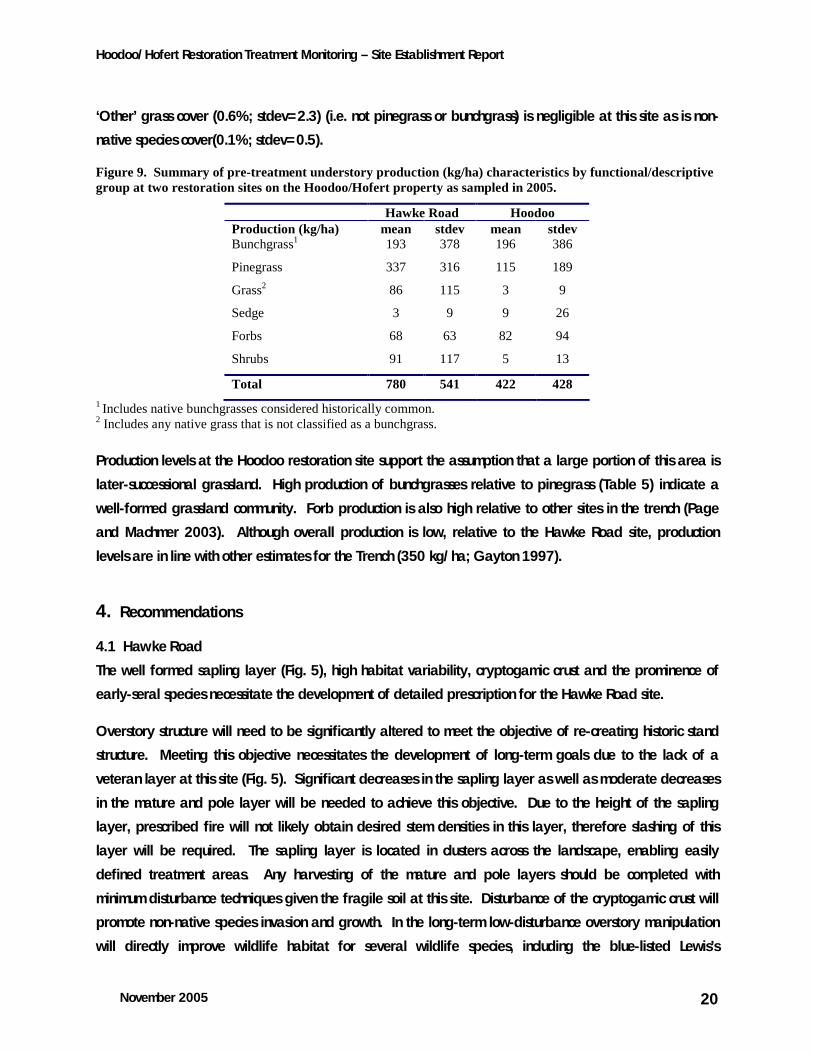
Figure 9. Summary of pre-treatment understory production (kg/ha) characteristics by functional/descriptive group at two restoration sites on the Hoodoo/Hofert property as sampled in 2005.
Hawke Road Hoodoo Production (kg/ha) mean stdev mean stdev Bunchgrass1 193 378 196 386 Pinegrass 337 316 115 189
Grass2 86 115 3 9 Sedge 3 9 9 26
Forbs 68 63 82 94 Shrubs 91 117 5 13 Total 780 541 422 428
1 Includes native bunchgrasses considered historically common. 2 Includes any native grass that is not classified as a bunchgrass.
Production levels at the Hoodoo restoration site support the assumption that a large portion of this area is
later-successional grassland. High production of bunchgrasses relative to pinegrass (Table 5) indicate a
well-formed grassland community. Forb production is also high relative to other sites in the trench (Page
and Machmer 2003). Although overall production is low, relative to the Hawke Road site, production
levels are in line with other estimates for the Trench (350 kg/ha; Gayton 1997).
4. Recommendations
4.1 Hawke Road
The well formed sapling layer (Fig. 5), high habitat variability, cryptogamic crust and the prominence of
early-seral species necessitate the development of detailed prescription for the Hawke Road site.
Overstory structure will need to be significantly altered to meet the objective of re-creating historic stand
structure. Meeting this objective necessitates the development of long-term goals due to the lack of a
veteran layer at this site (Fig. 5). Significant decreases in the sapling layer as well as moderate decreases
in the mature and pole layer will be needed to achieve this objective. Due to the height of the sapling
layer, prescribed fire will not likely obtain desired stem densities in this layer, therefore slashing of this
layer will be required. The sapling layer is located in clusters across the landscape, enabling easily
defined treatment areas. Any harvesting of the mature and pole layers should be completed with
minimum disturbance techniques given the fragile soil at this site. Disturbance of the cryptogamic crust will
promote non-native species invasion and growth. In the long-term low-disturbance overstory manipulation
will directly improve wildlife habitat for several wildlife species, including the blue-listed Lewis’s
Hoodoo/Hofert Restoration Treatment Monitoring – Site Establishment Report
November 2005 21
woodpecker (Melanerpes lewis). Mature and pole recruitment stems for the veteran layer should be
carefully selected to provide optimal wildlife habitat for species of interest.
Opening pockets of closed understory at this site will also improve understory habitat by increasing light
and decreasing the moisture balance. There is potential in the south and upper western slopes of this block
for open grassland habitats mixed in with open forest and aspen gullies and depressions, providing
valuable habitat composition for several species. Overstory manipulation, cessation of livestock grazing
and minimizing disturbance will encourage the growth of late-seral plant communities. Promotion of late-
seral plant communities may lead to the development of the red-listed bluebunch wheatgrass-junegrass in
drier areas of this site (CDC 2005. Habitat attributes of this plant community include less than 10% tree
cover, less than 10% shrub cover and greater than 33% cover of herbs (Cooper et al. 2004). Reduction in
the overstory, particularly sapling pockets, and slashing of certain shrubs (B2 and B1Douglas fir, juniper)
should result in these desired habitat conditions on-site. This type of stand manipulation will also improve
habitat for badgers (Taxidea taxus).
Priority at this site should be treatment of the sapling layer and tall shrub layer, moderate decreases in the
mature and pole layer with an emphasis on minimizing disturbance. Conifer regeneration is relatively low
(270 sph) implying a prescribed burn may not be immediately necessary. If fire is prescribed, fuel
loading and moisture should be carefully monitored to ensure the fire is not too severe. This site is
recovering from wildfire, repeated harvesting and sustained livestock grazing. The present successional
plant communities have potential for late-seral desirable plant communities, but are susceptible to
disturbance and retrogression. Any restoration activities should focus on the further development and
enhancement of late-seral, native plant communities.
4.2 Hoodoo
Unlike the Hawke Road site, understory plant communities at the Hoodoo Restoration site already resemble
desired plant communities. Topography and location of this site have likely limited historic disturbances
enabling the development of late-successional plant communities, despite the development of a
moderately-dense mature forest. The lack of non-native or early seral species and remnants of a historic
stand structure will facilitate restoration success in the short-term.
A reduction in the mature, pole and sapling overstory layer should result in a stand structure consistent with
historic stand models. Veteran recruitment trees should be selected to achieve a desirable post-treatment
density in the veteran layer. Most listed species and plant communities of interest (Cooper et al. 2004)
have low stem density targets (0 – 25 sph). The veteran layer currently has 18 sph. A post-harvest
prescribed burn would ideally eliminate the conifer regeneration layer (1720 sph) and limit deep litter
layers, preventing further negative ingrowth and encroachment impacts. Harvesting and burning at this
Hoodoo/Hofert Restoration Treatment Monitoring – Site Establishment Report
November 2005 22
site must minimize disturbance on the steep slopes to prevent an increase in bare soil and increase in non-
native species.
There is high potential for the creation and enhancement of the bluebunch wheatgrass-junegrass red-listed
plant community. There are existing pockets of this habitat type on the west end of this block and in the
southern PPdh2(02b) areas. Overstory density in these areas should target the low end of the scale (0-5
sph).
Restoration of these habitat types and a reduction in the overstory will improve the vigor of existing plant
communities (e.g. increased cover, production) resulting in improved habitat for several red and blue listed
species.
The Hoodoo site is a unique representative of dry open forest communities in the upper East Kootenay
Valley. Occurrences of the PPdh2(02) site series are rare north of Skookumchuck. Restoration should strive
to maintain the integrity of these plant communities while restoring more open stand structures. The biggest
threat to these plant communities is non-native species invasion. Restoration prescriptions need to prevent
the possibility of non-native species increases at this site.
4.4 General recommendations
Both sites (Hawke Road and Hoodoo) will benefit from well-implemented restoration activities. Minimizing
disturbance is paramount at both sites to ensure sites both site benefit from restoration activities.
Post-treatment monitoring should focus on seral stage, functional group (lifeform) response to treatment
and presence of non-native species. Observation of target species will aid in determining success. Stand
prescriptions should state clear goals related to the monitoring by which to measure success.
Ideally, control blocks should be located to avoid the confounding effects of local weather and climate.
Control areas will serve to improve results and conclusions based on the monitoring.
It is essential the implementation of the stand prescription be monitored. Quantifying overstory removal,
fire behaviour, fuel moisture and fuel consumption will be key to determining the effect of the restoration
activity on the plant community.
Hoodoo/Hofert Restoration Treatment Monitoring – Site Establishment Report
November 2005 23
5. Literature Cited Bai, Y, N. Walsworth, B. Roddan, D.A. Hill and D. Thompson. 2001. Quantifying tree encroachment in
rangelands using image classification and pattern detection. Poster presentation. Society for Range Management 54th Annual Meeting, Kona-Kailua, Hawaii. February 17 – 23, 2001.
Biondini, M.E.; Bonham, C.D.; Redente, E.F. 1985. Secondary successional patterns in a sagebrush
(Artemisia tridentata) community as they relate to disturbance and soil biological activity. Vegetatio 60: 25-36.
Bonham, C. 1983. Measurements for Terrestrial Vegetation. John Wiley & Sons. New York, NY. 338p. Braumandl, T.F. and M.P. Curran. 1992. A field guide for site identification and interpretation for the
Nelson Forest Region. B.C. Ministry of Forests, Research Branch, Land Management Handbook Number 20, Victoria, B.C. 311p.
British Columbia Conservation Data Centre. 2005. BC Species and Ecosystems Explorer. BC Ministry of Environment. Victoria, BC. Available: http://srmapps.gov.bc.ca/apps/eswp/ (accessed [Jan 6, 2005])
British Columbia Ministry of Forests. 2000. Resources Inventory Committee – Growth and Yield – Standards
and Procedures. B.C. Ministry of Forests, Victoria, B.C. Cooper, J.M., C. Steeger, S.M. Beauchesne, M. Machmer, L. Atwood, E.T. Manning. 2004. Habitat
Attribute Targets for Red and Blue Listed Wildlife Species and Plant Community Conservation. Report prepared for the Columbia Basin Fish and Wildlife Compensation Program. Nelson, BC.
Daigle, P. 1996. Fire in the dry interior of British Columbia. Extension Note 8. B.C. Ministry of Forests
Research Program. Victoria, B.C. Daubenmire, R. 1959. A canopy-coverage method of vegetational Analysis. Northwest Science 33: 43–
64. Delong, D. 2001. Old growth restoration monitoring in the Interior Douglas-fir zone. Terrestrial Ecosystem
Restoration Program Application for Funding, Fiscal Year 2001-2002. Dormaar, J.F.; Willms, W.D. 1990. Sustainable production from the rough fescue prairie. Journal of Soil
and Water Conservation 45: 137-140. Forcella, F. and S.J. Harvey. 1983. Eurasian weed infestation in western Montana in relation to vegetation and disturbance. Madrono 30: 102-109. Gayton, D. 1997. Preliminary calculation of excess ingrowth and resulting forage impact in the Rocky
Mountain Trench. BC Ministry of Forests, Nelson Region, Mimeo. 5p. Gayton, D (ed and compiler). 2001a. Summaries and Observations from Three-Partnership sponsored
NDT4 Events. Southern Interior Forest Extension Research Partnership. Kamloops, BC. 32p. Gayton, D.V. 2001b. Ground Work: Basic Concepts of Ecological Restoration in British Columbia.
Southern Interior Forest Extension and Research Partnership, Kamloops, BC SIFERP Series 3.
Hoodoo/Hofert Restoration Treatment Monitoring – Site Establishment Report
November 2005 24
Grasslands Conservation Council. 2005. Introduction to Grasslands. http://www.bcgrasslands.org/grasslands/introductiontograsslands.htm accessed: November, 2005.
Johnson, J.R.; Nichols, J.T. 1970. Plants of South Dakota grasslands: A photographic study. Bull. 566.
Brookings, SD: South Dakota State University, Agricultural Experiment Station. 163p. Looman, J. 1969. The fescue grasslands of western Canada. Vegetatio 19: 128-145. Machmer, M., H.N. Page and C. Steeger. 2002. East Kootenay Trench Restoration Effectiveness
Monitoring Plan. Submitted to: Habitat Branch, Ministry of Water, Land and Air Protection. Forest Renewal British Columbia Terrestrial Ecosystem Restoration Program. Pandion Ecological Research. Nelson, BC. 50p.
Machmer, M.. 2002b. Effects of ecosystem restoration treatments on cavity nesting birds habitat and their
insectivorous prey in fire-maintained ecosystems of southeastern British Columbia. United States Department of Agriculture. Forest Service. General Technical Report PSW-GTR-181.
Page, H.N. 2002. Monitoring Restoration Effectiveness in Fire-Maintained Ecosystems of the East
Kootenay. M.Sc. Thesis, Dept. of Rangeland and Wildlife Management, University of Alberta, Edmonton, AB. 136p.
Powell, G.W., D. White, D. Smith, B. Nyberg. 1998. Monitoring Restoration of Fire-Maintained Ecosystems
in the Invermere Forest District. Interim Working Plan. B.C. Ministry of Forests, Research Branch. Province of British Columbia. 1995. Biodiversity Guidebook. Forest Practices Code of BC Act. Strategic
Planning Regulations. Operational Planning Regulation. BC Ministry of Forests. Victoria, BC. Rocky Mountain Trench Ecosystem Restoration Steering Committee. 2000. Fire-Maintained Ecosystem
Restoration in the Rocky Mountain Trench. “A Blueprint For Action” 16p. Ruiz-Jean, M.C. and T.M. Aide. 2005. Vegetation structure, species diversity, and ecosystem processes as
measures of restoration success. Forest Ecology and Management in press. 15p. Sall, J., L. Creighton and A. Lehman. 2005. JMP Start Statistics. Third Ed. A Guide to Statistics and Data
Analysis Using JMP® and JMP IN® Software. SAS Institute Inc. Belmont, CA. USA. Steele, R; Geier-Hayes, K. 1993. The Douglas-fir/pinegrass habitat type in central Idaho: succession and
management. Gen. Tech.Rep. INT-298. Ogden, UT: U.S. Department of Agriculture, Forest Service, Intermountain Research Station. 83 p.
Stickney, Peter F. 1989. Seral origin of species originating in northern Rocky Mountain forests. Unpublished
draft on file at: U.S. Department of Agriculture, Forest Service, Intermountain Research Station, Fire Sciences Laboratory, Missoula, MT; RWU 4403 files. 10 p.
Strang, R.M. and J.V. Parminter. 1980. Conifer encroachment on the Chilcotin grasslands of British
Columbia. Forestry Chronicle 56: 13 – 18. Tisdale, E. W.; McLean, A. 1957. The douglas-fir zone of southern interior British Columbia. Ecological
Monographs 27(3): 247-266. Van Dyne, George M.; Payne, Gene F., compilers. 1964. Grazing responses of western range plants.
Bozeman, MT: Montana State College, Department of Animal and Range Sciences. 69 p.
Hoodoo/Hofert Restoration Treatment Monitoring – Site Establishment Report
November 2005 25
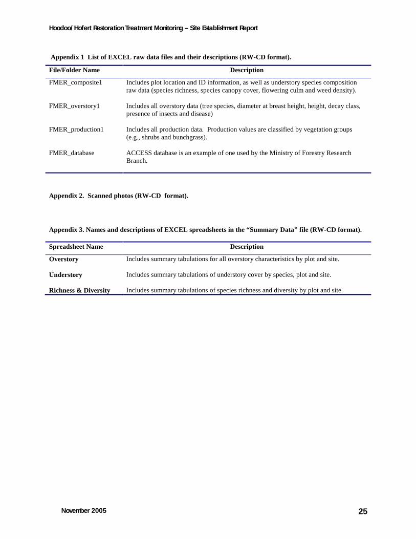
Appendix 1 List of EXCEL raw data files and their descriptions (RW-CD format).
File/Folder Name Description
FMER_composite1 Includes plot location and ID information, as well as understory species composition raw data (species richness, species canopy cover, flowering culm and weed density).
FMER_overstory1 Includes all overstory data (tree species, diameter at breast height, height, decay class, presence of insects and disease)
FMER_production1 Includes all production data. Production values are classified by vegetation groups (e.g., shrubs and bunchgrass).
FMER_database ACCESS database is an example of one used by the Ministry of Forestry Research Branch.
Appendix 2. Scanned photos (RW-CD format).
Appendix 3. Names and descriptions of EXCEL spreadsheets in the “Summary Data” file (RW-CD format).
Spreadsheet Name Description
Overstory Includes summary tabulations for all overstory characteristics by plot and site.
Understory Includes summary tabulations of understory cover by species, plot and site.
Richness & Diversity Includes summary tabulations of species richness and diversity by plot and site.
Related Documents