TORRES STRAIT CLIMATE CHANGE STRATEGY 2014-2018 BUILDING COMMUNITY ADAPTIVE CAPACITY AND RESILIENCE

Welcome message from author
This document is posted to help you gain knowledge. Please leave a comment to let me know what you think about it! Share it to your friends and learn new things together.
Transcript
TORRES STRAIT
CLIMATE CHANGE STRATEGY 2014-2018
BUILDING COMMUNITY ADAPTIVE CAPACITY AND RESILIENCE
2

2 i
ForewordThe message from the scientific community is clear that climate change poses one of the most significant threats to humanity and the planet’s natural systems over the years and decades ahead. The unique cultures and environments of the Torres Strait that have weathered change over many millennia, now face a very uncertain future. Our island communities, ecosystems, infrastructure, livelihoods, wellbeing, culture and identity are all threatened by the many impacts of climate change.
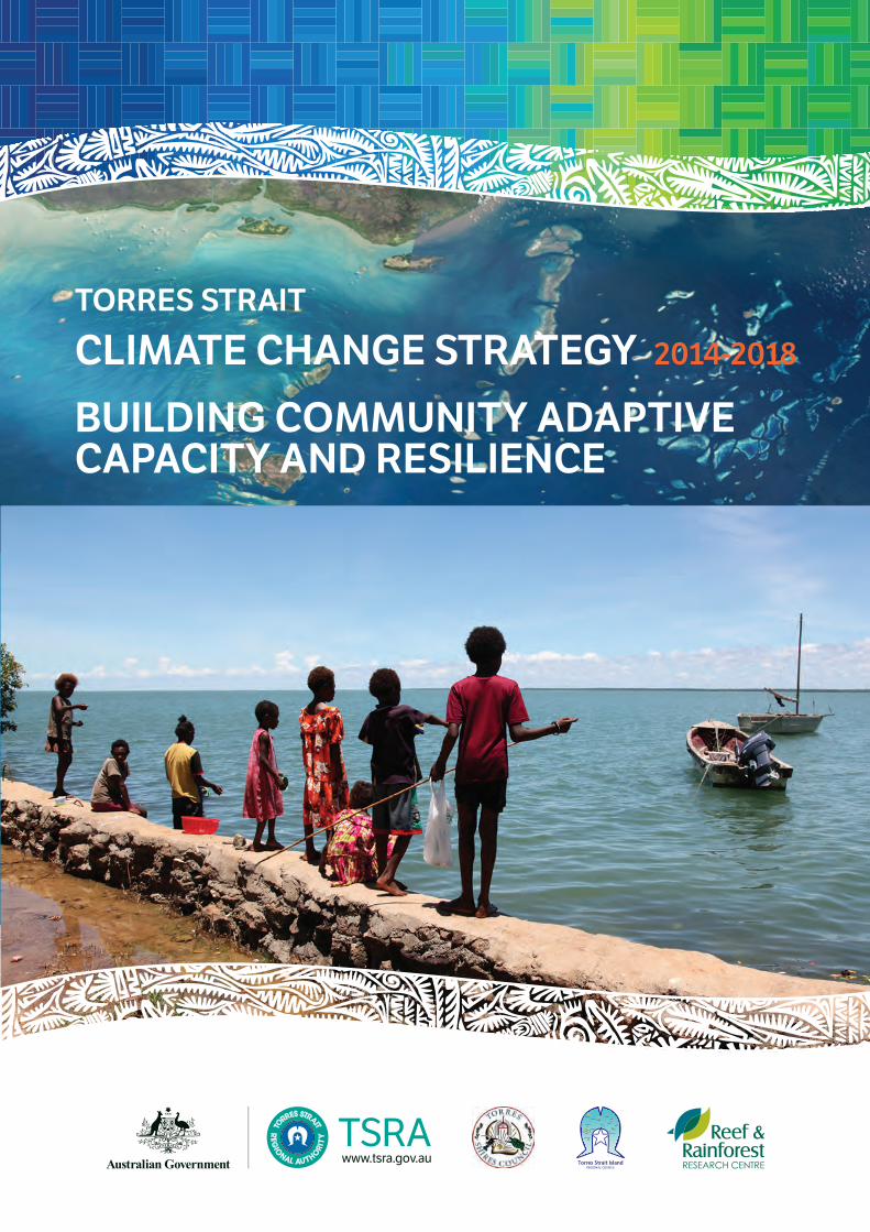
Our low-lying island communities are already experiencing the direct impacts of sea level rise. Every year during Spring tides these islands suffer inundation from the seas that surround them, a tidal event that is increasingly exacerbated as sea levels march steadily upwards. The resultant flooding and erosion, particularly around ancestral burial sites, is a source of significant community distress.
Despite these challenges we are pleased to reflect on the progress that has been made in implementing the actions identified in the first (2010–2013) edition of the Strategy. Significant progress has been made in securing the knowledge and information needed to inform future decisions and actions. Through constructive collaboration between local, state and federal governments, communities and research partners, the Torres Strait now has a much clearer understanding of local climate change projections, sea level rise and associated inundation and erosion risks as well as a growing body of baseline information on key species and ecosystems.
The next phase of the Strategy implementation is to identify and take appropriate adaptation actions that will help to reduce climate change risks and build regional and community resilience. This will require even greater collaboration across all agencies and sectors given the complex and multi-faceted nature of climate change impacts. In parallel we will need to keep monitoring the changes around us and continue to build our understanding to inform a flexible and adaptive approach for responding to future uncertainties.
In this updated version of the Strategy, we have built on the solid foundations of the first version, updated the climate change projections and action plan, and included specific sections on monitoring within the action plan.
As ever, it is our hope that we can work with the Australian and Queensland Governments to implement this Strategy in a spirit of collaboration and determination to achieve the best outcomes for current and future generations. Torres Strait Islander and Aboriginal people of our region are here for the long term, and will continue to demonstrate our capacity to respond to whatever challenges we face. Climate change will test our determination, ingenuity and capacity to work as one for a common purpose; there is too much at stake for us not to rise to the challenge.
Chairperson Joseph Elu Mayor Fred Gela Mayor Pedro StephenTorres Strait Torres Strait Island Torres Shire CouncilRegional Authority Regional Council

ii
AcknowledgementsThis Strategy was developed with the input of members of the Torres Strait Coastal Management Committee, the Land and Sea Management Unit of the Torres Strait Regional Authority (TSRA), and external experts.
This document should be referenced as: TSRA (2014) Torres Strait Climate Change Strategy 2014–2018. Report prepared by the Land and Sea Management Unit, Torres Strait Regional Authority, July 2014, 36p. Printed on EcoStar 100% recycled paper.
Photographic CreditsFront Cover: Community built seawall, Saibai Island – J. Rainbird (TSRA)
Inside front cover: Saibai during king tide – Zoe Reynolds (www.zoerey.com)
Inside back cover: Saibai elder Mebai Warusam – Zone Reynolds
Page 5 (Figure 4): Real-time weather and marine monitoring station – AIMS
All other images – J. Rainbird (TSRA)
ii iii
Executive SummaryWarming of the climate system is unequivocal, with impacts already being observed in societies and ecosystems around the world. It is extremely likely that human influence has been the dominant cause of the observed warming since the mid 20th centuryi. The extent of the predicted effects of climate change in the Torres Strait region, along with the geographic, ecological, social and cultural characteristics make Torres Strait communities amongst the most vulnerable in Australia.
The effects of climate change threaten the islands themselves as well as marine and coastal ecosystems and resources, and therefore the life, livelihoods and unique culture of Torres Strait Islanders.
Indigenous communities are more vulnerable to climate change because of the social and economic disadvantages they already face. If strong action is not taken to address these threats, there is the potential for climate change impacts in Torres Strait to create a human rights crisisii.
The degree of vulnerability of Torres Strait communities to climate change, and sea level rise in particular, needs to be fully appreciated by governments and policy makers. Even small increases in sea level due to climate change will have an immense impact on Torres Strait communities, potentially threatening their viability. Large increases would result in several Torres Strait islands being completely inundated and uninhabitable.
To date, the Torres Strait Regional Authority (TSRA), in partnership with relevant local Councils, Queensland and Australian Government departments and several research organisations, has undertaken a number of activities to support Torres Strait Islanders to make informed decisions about adaptation to sea level rise and other climate change impacts in implementing the 2010–2013 Strategy. However, much of this effort will be lost if funding does not support continued implementation of the strategic priorities identified in this 2014-2018 Strategy.
This Torres Strait Climate Change Strategy (Strategy) outlines some of the observed and potential future impacts of climate change on Torres Strait ecosystems and communities, and identifies priority responses through an Action Plan. The Action Plan incorporates and builds on existing efforts under the 2010–2013 Strategy, focused around appropriate adaptation and management solutions. Key research and monitoring gaps to support effective adaptation are also identified.
The Strategy recognises that the complex and multifaceted nature of climate change means that individual studies or measures cannot address all potential climate change challenges. The approach adopted by this Strategy involves the application of specialist assessments integrated across sectors using existing knowledge frameworks and management practices where possible. The Strategy is intended to guide whole-of-government efforts to manage the impacts of climate change, and facilitate adaptation to future change. It is also designed to support grass-roots, community-based planning and local decision-making, enabling communities to respond to these challenges in the most culturally appropriate and locale-specific way.
Implementation of the Action Plan will depend on the commitment of government agencies, the research sector and the international community to support, resource and further develop the approaches put forward in this Strategy. These actions will also depend on consultation with and commitment by Torres Strait Islander communities.
The causes of climate change, the resultant impacts and required mitigation actions are beyond the capacity of agencies and people in the Torres Strait region to manage along; they are also not the sole responsibility of the region. Strong political will, sufficient funding, technical support, and coordinated, collective effort will be required in the immediate future to effectively deliver this Strategy and minimise the potential impact of climate change on Torres Strait communities and ecosystems.
“ Many impacts on small islands are generated from processes well beyond the borders of an individual nation or island and generally they have negative effects.” United Nations IPCC, AR5, 2013
iIntergovernmental Panel on Climate Change (2013) Climate Change 2013: The Physical Science Basis. Working Group I Contribution to the IPCC 5th Assessment Report – Changes to the underlying Scientific/Technical Assessment. IPCC Secretariat, Geneva, Switzerland.iiAustralian Human Rights Commission (2008) Native Title Report, Aboriginal and Torres Strait Islander Social Justice Commissioner Report No. 2/2009.
iv
Fig
ure
1: T
he T
orre
s St
rait
Reg
ion
Saib
ai
Erub
Mer
Uga
r
Poru
ma
Mas
ig
Bad
u
Moa
Mab
uiagBoi
gu
Dau
an
Iam
a
Ham
mon
dTh
ursd
ay
Hor
n
Cap
e Yo
rk
Prin
ce o
f Wal
esPapu
a N
ew G
uine
a
War
rabe
r
iv v
ContentsIntroduction ................................................................................................................................................................... 1
Context ............................................................................................................................................................................ 3
Setting ......................................................................................................................................................................... 3
Culture (Ailan Kastom) .............................................................................................................................................. 4
Existing management arrangements ...................................................................................................................... 4
Complexity of the area ............................................................................................................................................... 5
Ecological diversity ................................................................................................................................................... 5
General management principles .............................................................................................................................. 6
Current Climate Trends ............................................................................................................................................... 7
Climate dynamics....................................................................................................................................................... 7
Projected climate change ......................................................................................................................................... 8
Climate Change Impacts, Risk and Vulnerability ............................................................................................... 10
Uncertainty ............................................................................................................................................................... 10
Impacts ..................................................................................................................................................................... 10
Risks (Exposure & Sensitivity)................................................................................................................................ 14
Vulnerability .............................................................................................................................................................. 17
Adaptation and resilience ....................................................................................................................................... 18
Traditional Knowledge and Climate Change ...................................................................................................... 20
Action Plan.................................................................................................................................................................... 21
Progress since 2010 ................................................................................................................................................ 21
Culture and Traditional Knowledge ....................................................................................................................... 22
Environment and Ecosystems ................................................................................................................................ 23
Settlements and Infrastructure ............................................................................................................................... 24
People and Communities ........................................................................................................................................ 26
Communication and capacity building ................................................................................................................. 27
References.................................................................................................................................................................... 28
Acronyms ...................................................................................................................................................................... 29
vivi
List of FiguresFigure 1: The Torres Strait region ......................................................................................................................... iv
Figure 2: Real-time weather and marine monitoring station .............................................................................. 5
Figure 3: Enhanced Greenhouse Effect – human activity such as burning fossil fuels (coal, oil and natural gas) and land clearing is creating more greenhouse gases that trap more heat, heating the earth ..................................................................................................................................... 7
Figure 4: Mean maximum temperature and rainfall, and projected changes for Torres Strait; demonstrated effect of rising sea level and storm surge on coastal communities; projected global mean sea level rise (Source: IPCC AR5) .................................................................. 8
Figure 5: Ocean acidification threatens reef-building corals as well as other marine animals that build calcium carbonate skeletons, such as crustaceans)................................................................. 9
Figure 6: Tropical cyclone and storm impacts on the coasts and communities of small islands showing the potential impacts on different sectors and implications for livelihoods and economies (in red) (IPCC WGIIAR5 Chapter 29, in press) ............................................................... 11
Figure 7: Framework for assessing vulnerability to climate change (adapted from Schroter et al. 200414, Schneider et al. 200715); examples of factors that combine to determine the level of vulnerability of coastal communities to sea-level rise and inundation (adapted from Johnson and Welch 201016); representation of coastal communities with varying vulnerability to sea-level rise and inundation ................................................................................................................................. 17
Figure 8: Adaptation process diagram to support regional and local communities in proactively addressing the unavoidable consequences of climate change (Adapted from the California Adaptation Planning Guide 201217) ........................................................................................................ 19
Figure 9: Erub island seasonal calendar ............................................................................................................ 20
vi 1
Torres Strait Climate Change Strategy 2014-2018
vi
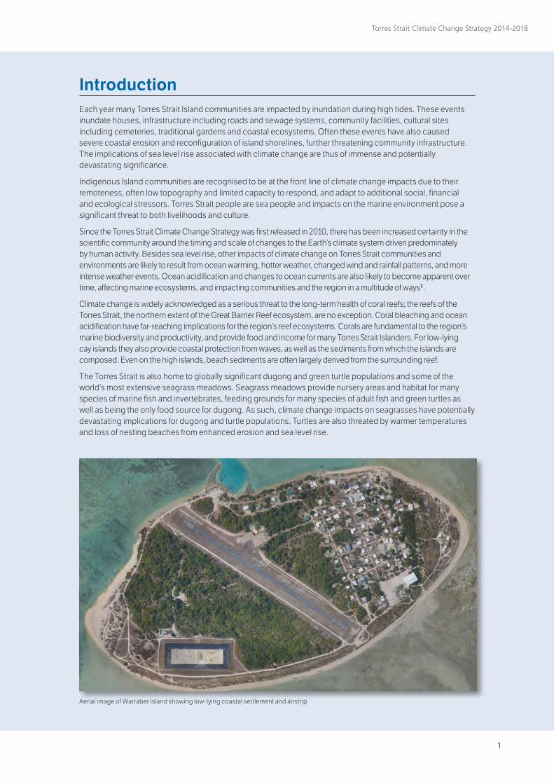
Introduction Each year many Torres Strait Island communities are impacted by inundation during high tides. These events inundate houses, infrastructure including roads and sewage systems, community facilities, cultural sites including cemeteries, traditional gardens and coastal ecosystems. Often these events have also caused severe coastal erosion and reconfiguration of island shorelines, further threatening community infrastructure. The implications of sea level rise associated with climate change are thus of immense and potentially devastating significance.
Indigenous Island communities are recognised to be at the front line of climate change impacts due to their remoteness, often low topography and limited capacity to respond, and adapt to additional social, financial and ecological stressors. Torres Strait people are sea people and impacts on the marine environment pose a significant threat to both livelihoods and culture.
Since the Torres Strait Climate Change Strategy was first released in 2010, there has been increased certainty in the scientific community around the timing and scale of changes to the Earth’s climate system driven predominately by human activity. Besides sea level rise, other impacts of climate change on Torres Strait communities and environments are likely to result from ocean warming, hotter weather, changed wind and rainfall patterns, and more intense weather events. Ocean acidification and changes to ocean currents are also likely to become apparent over time, affecting marine ecosystems, and impacting communities and the region in a multitude of ways1.
Climate change is widely acknowledged as a serious threat to the long-term health of coral reefs; the reefs of the Torres Strait, the northern extent of the Great Barrier Reef ecosystem, are no exception. Coral bleaching and ocean acidification have far-reaching implications for the region’s reef ecosystems. Corals are fundamental to the region’s marine biodiversity and productivity, and provide food and income for many Torres Strait Islanders. For low-lying cay islands they also provide coastal protection from waves, as well as the sediments from which the islands are composed. Even on the high islands, beach sediments are often largely derived from the surrounding reef.
The Torres Strait is also home to globally significant dugong and green turtle populations and some of the world’s most extensive seagrass meadows. Seagrass meadows provide nursery areas and habitat for many species of marine fish and invertebrates, feeding grounds for many species of adult fish and green turtles as well as being the only food source for dugong. As such, climate change impacts on seagrasses have potentially devastating implications for dugong and turtle populations. Turtles are also threated by warmer temperatures and loss of nesting beaches from enhanced erosion and sea level rise.
Aerial image of Warraber Island showing low-lying coastal settlement and airstrip
2
Torres Strait Climate Change Strategy 2014-2018
Besides the direct impacts of climate change (e.g. extreme weather impacts on ecosystems, health and wellbeing), there are likely to be a multitude of indirect or flow on impacts (e.g. consequential impacts upon traditional hunting and cultural practices due to changes in ecosystems and marine species).
Combined, these impacts will present significant social, cultural and economic challenges, such as loss of access to traditional land and sea country and loss of, or changes to, cultural practices; impacts on infrastructure, housing, land-based food production systems and marine industries; and health issues such as increased disease and heat-related illness.
Other less direct but nonetheless significant impacts of climate change may be felt by communities through carbon price mechanisms and other external drivers, such as increasing costs of fuel and transporting goods and services from the mainland. Already, fuel costs have significantly raised the cost of living and impacted heavily on the lower-than-average standard of living for the majority of the Indigenous community. Without the introduction of alternative power sources such as wind, solar or tidal energy, increasing diesel fuel costs are likely to impact on the local economy and directly impact the capacity of communities to adapt to climate change.
Broader regional and international border issues also have the potential to significantly affect Torres Strait communities as health and food security in the wider region are impacted. Much of the Western Province of Papua New Guinea experiences significant inundation issues, and is likely to be significantly affected as sea levels rise, impacting communities and their capacity to maintain food production. The result could be increased reliance on resources in the Torres Strait.
The close proximity of Torres Strait to adjacent tropical regions, and the potential for the transfer of malaria, dengue fever and other water and vector borne diseases more prevalent in hotter and wetter conditions, are also of concern.
The need to properly and thoroughly consider the potential impacts of climate change, the associated risks to communities, as well as ways of adapting to this change is fundamental to the intent of this Strategy.
The Strategy is accompanied by an Action Plan for responding to climate change. This has been divided into the following elements:
○ Culture and Traditional knowledge;
○ Environment and Ecosystems;
○ Settlements and Infrastructure;
○ People and Communities;
○ Communication and Capacity Building.
These elements take into consideration the regional context including existing management and governance arrangements, Ailan Kastom and the physical complexity of the area. They also encompass uncertainty and accepted management principles.
2 3
Torres Strait Climate Change Strategy 2014-2018
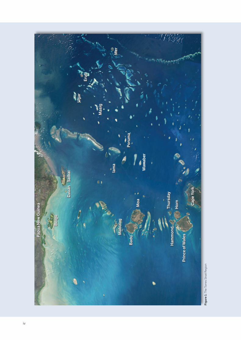
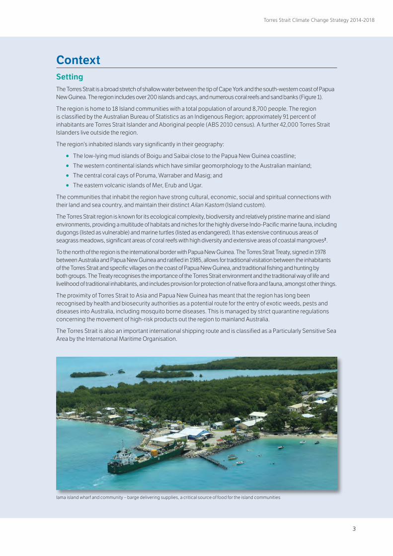
Context SettingThe Torres Strait is a broad stretch of shallow water between the tip of Cape York and the south-western coast of Papua New Guinea. The region includes over 200 islands and cays, and numerous coral reefs and sand banks (Figure 1).
The region is home to 18 Island communities with a total population of around 8,700 people. The region is classified by the Australian Bureau of Statistics as an Indigenous Region; approximately 91 percent of inhabitants are Torres Strait Islander and Aboriginal people (ABS 2010 census). A further 42,000 Torres Strait Islanders live outside the region.
The region’s inhabited islands vary significantly in their geography:
○ The low-lying mud islands of Boigu and Saibai close to the Papua New Guinea coastline;
○ The western continental islands which have similar geomorphology to the Australian mainland;
○ The central coral cays of Poruma, Warraber and Masig; and
○ The eastern volcanic islands of Mer, Erub and Ugar.
The communities that inhabit the region have strong cultural, economic, social and spiritual connections with their land and sea country, and maintain their distinct Ailan Kastom (Island custom).
The Torres Strait region is known for its ecological complexity, biodiversity and relatively pristine marine and island environments, providing a multitude of habitats and niches for the highly diverse Indo-Pacific marine fauna, including dugongs (listed as vulnerable) and marine turtles (listed as endangered). It has extensive continuous areas of seagrass meadows, significant areas of coral reefs with high diversity and extensive areas of coastal mangroves2.
To the north of the region is the international border with Papua New Guinea. The Torres Strait Treaty, signed in 1978 between Australia and Papua New Guinea and ratified in 1985, allows for traditional visitation between the inhabitants of the Torres Strait and specific villages on the coast of Papua New Guinea, and traditional fishing and hunting by both groups. The Treaty recognises the importance of the Torres Strait environment and the traditional way of life and livelihood of traditional inhabitants, and includes provision for protection of native flora and fauna, amongst other things.
The proximity of Torres Strait to Asia and Papua New Guinea has meant that the region has long been recognised by health and biosecurity authorities as a potential route for the entry of exotic weeds, pests and diseases into Australia, including mosquito borne diseases. This is managed by strict quarantine regulations concerning the movement of high-risk products out the region to mainland Australia.
The Torres Strait is also an important international shipping route and is classified as a Particularly Sensitive Sea Area by the International Maritime Organisation.
Iama island wharf and community – barge delivering supplies, a critical source of food for the island communities
4
Torres Strait Climate Change Strategy 2014-2018
Culture (Ailan Kastom)The Indigenous peoples of the Torres Strait have a distinct culture
that includes influences from Papua New Guinea, Indigenous Australia and Austronesian elements. Traditionally, islanders are
seafaring people who rely heavily on local marine resources, island gardens and trade with Papua New Guinea villages. There are two main languages groups, Kala Lagaw Ya of the western,
southwestern, central and northern island groups, and Miriam Mir of the eastern islands. The Kaurareg are the traditional
owners of the southern islands of Waiben, Ngurapai, Muralug and Kirriri. Torres Strait islanders also have distinctive dance and arts practices.
The 5 island groups include:
○ Northern Division (Boigu, Dauan, Saibai);
○ Eastern Division (Erub, Mer, Ugar);
○ Western Division (St. Pauls, Kubin, Badu, Mabuiag);
○ Central Division (Masig, Poruma, Warraber, Iama); and
○ Southern Division (Thursday, Horn, Prince of Wales & Hammond Islands, NPA).
Mer Island in the Torres Strait was also the first place in Australia to secure Native Title recognition.
Existing management arrangementsMore than 25 government agencies and departments are represented in the Torres Strait because of its unique political features and strategic location for defence, surveillance and monitoring. These agencies are primarily based on Thursday Island, the administrative centre for the region.
Local government authorities in the region include the Torres Strait Island Regional Council (TSIRC), Torres Shire Council (TSC) and Northern Peninsula Area Regional Council (NPARC). The Queensland Government also has a key role in funding and delivering other services in the region, such as policing, health care, housing and infrastructure supply and maintenance.
The TSRA is a Commonwealth statutory authority that provides regional coordination of policies and programs of benefit to Torres Strait Islander and Aboriginal people living in the region. This is the only such regional Indige-nous body in Australia. The TSRA consists of an elected arm and an administrative arm. The elected arm is comprised of 20 elected representatives who are Torres Strait Islander and Aboriginal people living in the Torres Strait region3. The TSRA is administered by a Chief Executive Officer and staff who implement and manage TSRA programs . The TSRA Land and Sea Management Unit is the Regional Natural Resource Management (NRM) body for the Torres Strait and delivers the TSRA’s Environmental Management Program.
The TSIRC was established in 2008, in line with the Queensland Government’s amalgamation of Community Councils direction. The TSIRC is the entity responsible for fulfilling local government service delivery requirements for the 15 Torres Strait outer islands. The TSC operates under the Local Government Act 2009 to deliver local government services to the inner islands, including Thursday (Waiben), Horn (Nurupai) and Prince of Wales (Muralug) Islands. Torres Shire Council local government boundaries encompass the whole Torres Strait from northern Cape York to the PNG border.
The NPARC operates under the Local Government Act 1993 to deliver local government services to five mainland communities including the two Torres Strait Islander communities of Bamaga and Seisia which had previously been administered within the Torres Strait jurisdictional boundary.
Coastal management and climate changes issues in the Torres Strait are managed through the Torres Strait Coastal Management Committee, which was established by the TSRA in 2006. The TSRA Chairperson is the chair for the committee with secretarial supports provided by the LSMU. This Committee comprises representatives from the communities worst affected by coastal erosion and inundation, including Boigu, Saibai, Iama, Warraber, Masig and Poruma, as well as local, State and Australian government agencies and various research institutions. From time to time, other communities are represented. The Committee aims to enable a whole-of-government, coordinated response and policy advice to coastal and climate change issues in the Torres Strait region.
4 5
Torres Strait Climate Change Strategy 2014-2018
Work undertaken by the Torres Strait Coastal Management Committee has to date focused on coastal erosion issues and, to a lesser extent, sea level rise. The Committee has noted that inundation and other climate change impacts are also very significant issues for Torres Strait communities and has expanded its focus to take on these priority areas, including the development and implementation of regional and local adaptation and resilience planning.
Studies undertaken for the Committee include the Queensland Department of Environment coastal erosion assessments for Boigu, Saibai, Warraber, Masig, Iama and Poruma, research by James Cook University on erosion and inundation across the region, downscaled climate change modeling by CSIRO and extreme water level modeling by Systems Engineering Australia. Reports on erosion and mitigation costs and options for Boigu, Saibai, Iama and Poruma have also been undertaken by AECOM. These studies have been conducted in full collaboration with communities to identify preferred management strategies, including protection works, for several island communities.
Complexity of the areaAdministration
The jurisdictional and administrative arrangements over the Torres Strait environment are extremely complex, involving two countries, Local, Queensland and Commonwealth governments and multiple agencies. There are also many island communities, each with their own distinct languages and customs, and different priorities and concerns for community development and environmental management2.
Weather patterns, currents, tidal data and dynamics
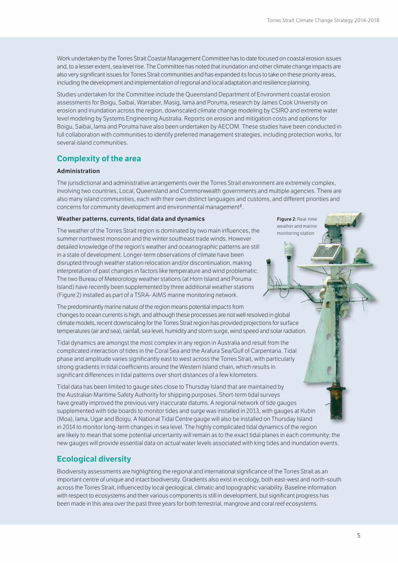
The weather of the Torres Strait region is dominated by two main influences, the summer northwest monsoon and the winter southeast trade winds. However detailed knowledge of the region’s weather and oceanographic patterns are still in a state of development. Longer-term observations of climate have been disrupted through weather station relocation and/or discontinuation, making interpretation of past changes in factors like temperature and wind problematic. The two Bureau of Meteorology weather stations (at Horn Island and Poruma Island) have recently been supplemented by three additional weather stations (Figure 2) installed as part of a TSRA- AIMS marine monitoring network.
The predominantly marine nature of the region means potential impacts from changes to ocean currents is high, and although these processes are not well resolved in global climate models, recent downscaling for the Torres Strait region has provided projections for surface temperatures (air and sea), rainfall, sea level, humidity and storm surge, wind speed and solar radiation.
Tidal dynamics are amongst the most complex in any region in Australia and result from the complicated interaction of tides in the Coral Sea and the Arafura Sea/Gulf of Carpentaria. Tidal phase and amplitude varies significantly east to west across the Torres Strait, with particularly strong gradients in tidal coefficients around the Western Island chain, which results in significant differences in tidal patterns over short distances of a few kilometers.
Tidal data has been limited to gauge sites close to Thursday Island that are maintained by the Australian Maritime Safety Authority for shipping purposes. Short-term tidal surveys have greatly improved the previous very inaccurate datums. A regional network of tide gauges supplemented with tide boards to monitor tides and surge was installed in 2013, with gauges at Kubin (Moa), Iama, Ugar and Boigu. A National Tidal Centre gauge will also be installed on Thursday Island in 2014 to monitor long-term changes in sea level. The highly complicated tidal dynamics of the region are likely to mean that some potential uncertainty will remain as to the exact tidal planes in each community; the new gauges will provide essential data on actual water levels associated with king tides and inundation events.
Ecological diversityBiodiversity assessments are highlighting the regional and international significance of the Torres Strait as an important centre of unique and intact biodiversity. Gradients also exist in ecology, both east-west and north-south across the Torres Strait, influenced by local geological, climatic and topographic variability. Baseline information with respect to ecosystems and their various components is still in development, but significant progress has been made in this area over the past three years for both terrestrial, mangrove and coral reef ecosystems.
Figure 2: Real-time weather and marine monitoring station
6
Torres Strait Climate Change Strategy 2014-2018
General management principlesThe management of the potential effects of climate change involves the management of risk, for which there is a generally accepted management approach.
AS/NZS 4360 Risk Management 4 provides a generic framework for risk management. The framework specifies a process for supporting better decisions and providing greater insight into risks and their consequences. The framework involves systematically identifying, analysing, evaluating, treating, monitoring and communicating risks.
In adopting such an approach, it is essential that all possible foreseeable impacts of climate change are assessed. For example, it is not sufficient to simply consider that impacts will be limited to a conservative sea level rise scenario.
The general approach adopted in the application of this Strategy is one of risk management, with the following principles used to guide decision-making in relation to specific impacts of climate change, acceptable levels of risk and treatment options:
○ The Torres Strait is a special place: the unique characteristics of the region and its people should be explicitly recognised and protected. Adaptation options should be culturally appropriate;
○ Sustainable: Adaptation responses should support the development of ecologically, socially and financially sustainable communities in the Torres Strait;
○ Holistic outlook: management of climate change is complex, multi-faceted and needs to address complex inter-relationships between physical, biophysical, socio-economic and cultural factors. The interactions between climate and non-climate stressors also need to be considered;
○ Local decision-making: Torres Strait Islander and Aboriginal peoples as Traditional Owners of the region have an inherent right to self-determination including deciding upon the acceptability of potential risks;
○ Short and long term thinking: management needs to consider both immediate, medium and long term implications, and should serve the needs of both current and future generations;
○ Robust and adaptive management (flexibility): it is preferable to adopt robust solutions that allow for potential uncertainties (‘no regrets’) together with adaptive approaches that involve monitoring and review as circumstances, conditions and knowledge change (the ‘precautionary principle’);
○ Natural limits: management actions should consider critical thresholds (e.g. regarding survival of coral reef ecosystems);
○ Responsiveness to local conditions: management actions should take into account local variations in the physical, ecological, social and economic characteristics of specific communities;
○ Participatory planning: objectives and actions should reflect community and stakeholder opinions and values with appropriate investment in awareness, education, consultation and mediation;
○ Multi-faceted solutions: the most effective response to any one problem will often involve a combination of possible actions;
○ Relocation as a last resort: Island communities do not want to leave their ancestral homelands as the islands and the sea that surround them are an inseparable part of their physical and spiritual identity;
○ Traditional Owner input and ownership: Traditional Owners are familiar with seasonal weather patterns, variations and historic climate and sea level events, and have much to contribute to the process of planning for climate change and building community resilience; and
○ Evidence-based: adaptation options should make full use of the latest research, data and practical experience so that decision-making is well supported and informed.
The complex and multi-faceted nature of the climate change issue means that no one study or solution will address climate change impacts. The approach adopted in this Strategy involves the application of specialist assessments within different sectors and integration of these with existing policies and management practice where possible.
6 7
Torres Strait Climate Change Strategy 2014-2018
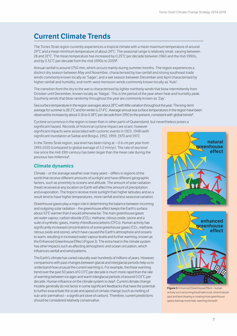
Current Climate Trends The Torres Strait region currently experiences a tropical climate with a mean maximum temperature of around 29°C and a mean minimum temperature of about 24°C. The seasonal range is relatively small, varying between 28 and 31°C. The mean temperature has increased by 0.25°C per decade between 1960 and the mid-1990s, and by 0.51°C per decade from the mid-1990s to 20091.
Annual rainfall is around 1750 mm, which occurs mainly during summer months. The region experiences a distinct dry season between May and November, characterised by low rainfall and strong southeast trade winds commonly known locally as ‘Sager’, and a wet season between December and April characterised by higher rainfall and humidity, and north-west monsoon winds commonly known locally as ‘Kuki’.
The transition from the dry to the wet is characterised by lighter northerly winds that blow intermittently from October until December, known locally as ‘Naigai’. This is the period of the year when heat and humidity peak. Southerly winds that blow randomly throughout the year are commonly known as ‘Zay’.
Sea surface temperature in the region averages about 28°C with little variation throughout the year. The long-term average for summer is 28.3°C and for winter is 27.4°C. Average annual sea surface temperatures in the region have been observed to increase by about 0.16 to 0.18°C per decade from 1950 to the present, consistent with global trends1.
Cyclone occurrence in the region is lower than in other parts of Queensland, but nevertheless poses a significant hazard. Records of historical cyclone impact are scant; however significant impacts were associated with cyclonic events in 1923, 1948 (with significant inundation at Saibai and Boigu), 1952, 1959, 1970 and 1972.
In the Torres Strait region, sea level has been rising at ~0.6 cm per year from 1993-2010 (compared to global average of 3.2 mm/yr). The rate of sea level rise since the mid-19th century has been larger than the mean rate during the previous two millennia1.
Climate dynamicsClimate – or the average weather over many years – differs in regions of the world that receive different amounts of sunlight and have different geographic factors, such as proximity to oceans and altitude. The amount of solar radiation (heat) received at any location on Earth will affect the amount of precipitation and evaporation. The tropics receive more sunlight than higher latitudes and as a result tend to have higher temperatures, more rainfall and less seasonal variation.
Greenhouse gases play a major role in determining the balance between incoming and outgoing solar radiation – the greenhouse effect keeps the Earth’s surface about 33°C warmer than it would otherwise be. The main greenhouse gases are water vapour, carbon dioxide (CO2), methane, nitrous oxide, ozone and a suite of synthetic gases, mainly chlorofluorocarbons (CFCs). Human activity has significantly increased concentrations of some greenhouse gases (CO2, methane, nitrous oxide and ozone), which have caused the Earth’s atmosphere and oceans to warm, resulting in increased water vapour levels and further warming, known as the Enhanced Greenhouse Effect (Figure 3). The extra heat in the climate system has other impacts such as affecting atmospheric and ocean circulation, which influences rainfall and wind patterns.
The Earth’s climate has varied naturally over hundreds of millions of years. However, comparisons with past changes between glacial and interglacial periods help us to understand how unusual the current warming is. For example, the linear warming trend over the past 50 years of 0.13°C per decade is much more rapid than the rate of warming between ice ages and warm interglacial periods of around 0.01°C per decade. Human influence on the climate system is cleari. Current climate change models generally do not factor in some significant feedbacks that have the potential to further exacerbate the scale and speed of climate change (such as melting of sub-artic permafrost – a significant store of carbon). Therefore, current predictions should be considered relatively conservative.
natural greenhouse
effect
enhanced greenhouse
effect
Figure 3: Enhanced Greenhouse Effect – human activity such as burning fossil fuels (coal, oil and natural gas) and land clearing is creating more greenhouse gases that trap more heat, warming the earth
8
Torres Strait Climate Change Strategy 2014-2018
Projected climate change
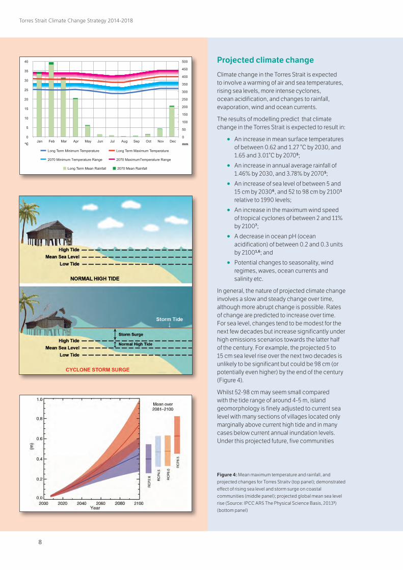
Climate change in the Torres Strait is expected to involve a warming of air and sea temperatures, rising sea levels, more intense cyclones, ocean acidification, and changes to rainfall, evaporation, wind and ocean currents.
The results of modelling predict that climate change in the Torres Strait is expected to result in:
○ An increase in mean surface temperatures of between 0.62 and 1.27 °C by 2030, and 1.65 and 3.01°C by 20705;
○ An increase in annual average rainfall of 1.46% by 2030, and 3.78% by 20705;
○ An increase of sea level of between 5 and 15 cm by 20306, and 52 to 98 cm by 21001 relative to 1990 levels;
○ An increase in the maximum wind speed of tropical cyclones of between 2 and 11% by 21007;
○ A decrease in ocean pH (ocean acidification) of between 0.2 and 0.3 units by 21001,6; and
○ Potential changes to seasonality, wind regimes, waves, ocean currents and salinity etc.
In general, the nature of projected climate change involves a slow and steady change over time, although more abrupt change is possible. Rates of change are predicted to increase over time. For sea level, changes tend to be modest for the next few decades but increase significantly under high emissions scenarios towards the latter half of the century. For example, the projected 5 to 15 cm sea level rise over the next two decades is unlikely to be significant but could be 98 cm (or potentially even higher) by the end of the century (Figure 4).
Whilst 52-98 cm may seem small compared with the tide range of around 4-5 m, island geomorphology is finely adjusted to current sea level with many sections of villages located only marginally above current high tide and in many cases below current annual inundation levels. Under this projected future, five communities
Figure 4: Mean maximum temperature and rainfall, and projected changes for Torres Straitv (top panel); demonstrated effect of rising sea level and storm surge on coastal communities (middle panel); projected global mean sea level rise (Source: IPCC AR5 The Physical Science Basis, 20131)(bottom panel)
8 9
Torres Strait Climate Change Strategy 2014-2018
“ Continued emissions of greenhouse gases will cause further warming and changes in all components of the climate system.” United Nations IPCC, AR5, 2013
that are already regularly affected by seawater inundation – Saibai, Boigu, Masig, Warraber and Iama – will be more severely impacted by sea level rise, and increased flooding and erosion will be issues for Poruma, Erub, Mer and Mabuiag communities8,9.
IPCC modelling and the inherent time lags in the climate system suggest that global mean sea level will continue to rise during the 21st century and the rate of rise will very likely exceed that observed during 1971–2010 due to increased ocean warming and increased melting of glaciers and ice sheets1.
In the long term, ongoing sea level rise is inevitable over the coming centuries, irrespective of the success of emission reduction strategies. As the IPCC 2013 Physical Science Basis says, “Most aspects of climate change will persist for many centuries even if emissions of CO2 are stopped. This represents a substantial multi-century climate change commitment created by past, present and future emissions of CO2”1. This indicates that management and adaptive responses need to address both the short- and long-term impacts, and give serious consideration to strategies that best manage longer term inevitable impacts.
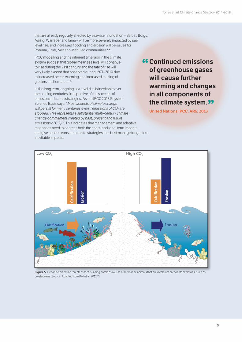
Figure 5: Ocean acidification threatens reef-building corals as well as other marine animals that build calcium carbonate skeletons, such as crustaceans (Source: Adapted from Bell et al. 201110)
Eros
ion
Calc
ific
atio
n
Low CO2
Calc
ific
atio
n
Eros
ion
High CO2
CO2
ErosionCalcification
CO2 + H
2O HCO
3- + H+
H+ + CO3
2- HCO3
-
CaCO3 Ca2+ + CO
32-
(coral)
10
Torres Strait Climate Change Strategy 2014-2018
Climate Change Impacts, Risk and Vulnerability Uncertainty
These complexities generate considerable uncertainty as to the exact nature and extent of the potential changes to climate as well as their impacts on the Torres Strait. This is further compounded by the general uncertainty concerning future emissions, and the lack of resolution about key processes (e.g. ocean currents, cyclones etc.) in global climate models. However, overall climate change predictions are getting increasingly more refined, narrowing the range of uncertainty associated with expected changes to key meteorological variables such as temperature. In dealing with risk it is prudent to consider legitimate worst-case scenarios to ensure mitigation strategies are capable of responding to the suite of potential impacts. Dealing with uncertainty is a key management consideration, for which standard risk management practice is well established.
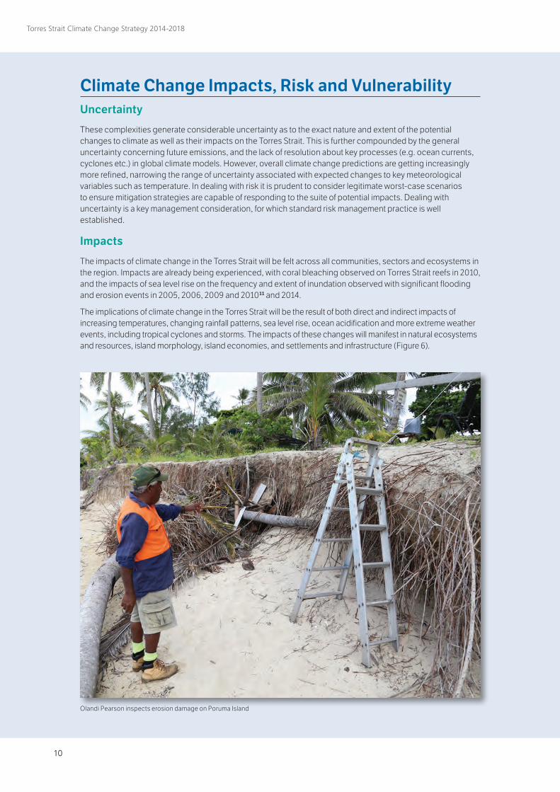
Impacts
The impacts of climate change in the Torres Strait will be felt across all communities, sectors and ecosystems in the region. Impacts are already being experienced, with coral bleaching observed on Torres Strait reefs in 2010, and the impacts of sea level rise on the frequency and extent of inundation observed with significant flooding and erosion events in 2005, 2006, 2009 and 201011 and 2014.
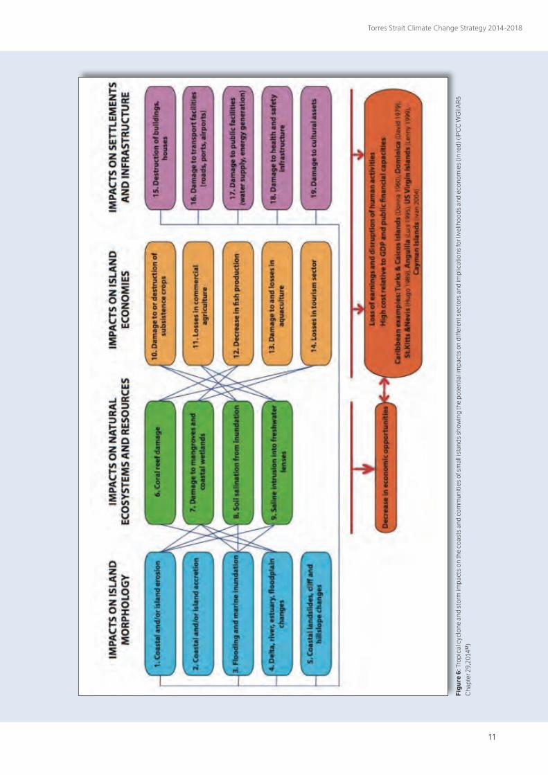
The implications of climate change in the Torres Strait will be the result of both direct and indirect impacts of increasing temperatures, changing rainfall patterns, sea level rise, ocean acidification and more extreme weather events, including tropical cyclones and storms. The impacts of these changes will manifest in natural ecosystems and resources, island morphology, island economies, and settlements and infrastructure (Figure 6).
Olandi Pearson inspects erosion damage on Poruma Island
10 11
Torres Strait Climate Change Strategy 2014-2018
Fig
ure
6: T
ropi
cal c
yclo
ne a
nd s
torm
impa
cts
on th
e co
asts
and
com
mun
ities
of s
mal
l isl
ands
sho
win
g th
e po
tent
ial i
mpa
cts
on d
iffer
ent s
ecto
rs a
nd im
plic
atio
ns fo
r liv
elih
oods
and
eco
nom
ies
(in re
d) (I
PC
C W
GIIA
R5
Cha
pter
29,
2014
12)
12
Torres Strait Climate Change Strategy 2014-2018
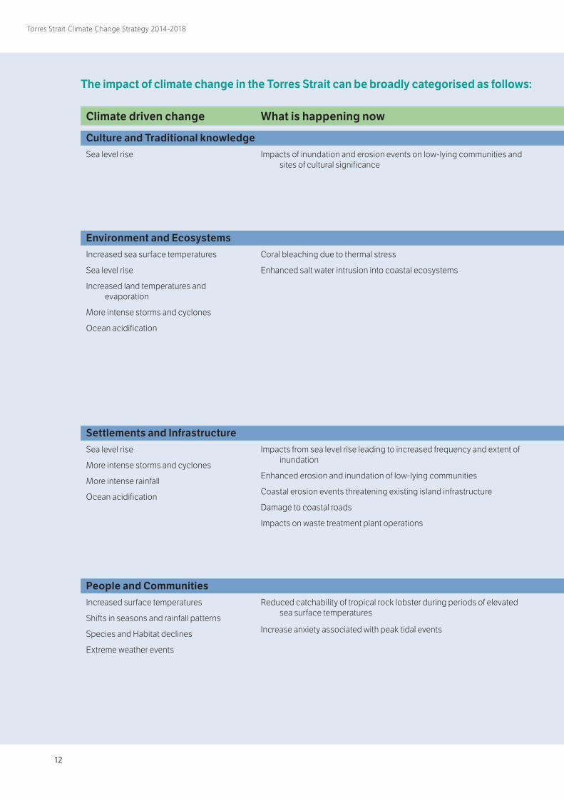
The impact of climate change in the Torres Strait can be broadly categorised as follows:
Climate driven change
Culture and Traditional knowledgeSea level rise
Environment and EcosystemsIncreased sea surface temperatures
Sea level rise
Increased land temperatures and evaporation
More intense storms and cyclones
Ocean acidification
Settlements and InfrastructureSea level rise
More intense storms and cyclones
More intense rainfall
Ocean acidification
People and CommunitiesIncreased surface temperatures
Shifts in seasons and rainfall patterns
Species and Habitat declines
Extreme weather events
What is happening now
Impacts of inundation and erosion events on low-lying communities and sites of cultural significance
Coral bleaching due to thermal stress
Enhanced salt water intrusion into coastal ecosystems
Impacts from sea level rise leading to increased frequency and extent of inundation
Enhanced erosion and inundation of low-lying communities
Coastal erosion events threatening existing island infrastructure
Damage to coastal roads
Impacts on waste treatment plant operations
Reduced catchability of tropical rock lobster during periods of elevated sea surface temperatures
Increase anxiety associated with peak tidal events
12 13
Torres Strait Climate Change Strategy 2014-2018
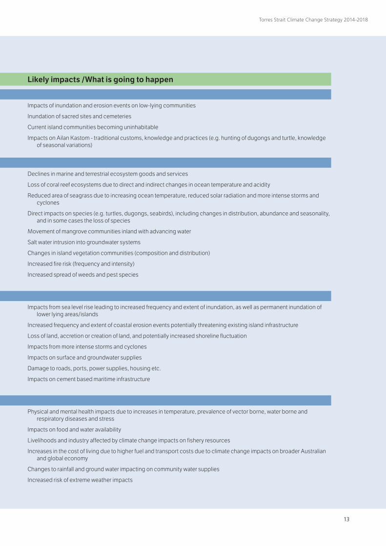
The impact of climate change in the Torres Strait can be broadly categorised as follows:
Likely impacts /What is going to happen
Impacts of inundation and erosion events on low-lying communities
Inundation of sacred sites and cemeteries
Current island communities becoming uninhabitable
Impacts on Ailan Kastom - traditional customs, knowledge and practices (e.g. hunting of dugongs and turtle, knowledge of seasonal variations)
Declines in marine and terrestrial ecosystem goods and services
Loss of coral reef ecosystems due to direct and indirect changes in ocean temperature and acidity
Reduced area of seagrass due to increasing ocean temperature, reduced solar radiation and more intense storms and cyclones
Direct impacts on species (e.g. turtles, dugongs, seabirds), including changes in distribution, abundance and seasonality, and in some cases the loss of species
Movement of mangrove communities inland with advancing water
Salt water intrusion into groundwater systems
Changes in island vegetation communities (composition and distribution)
Increased fire risk (frequency and intensity)
Increased spread of weeds and pest species
Impacts from sea level rise leading to increased frequency and extent of inundation, as well as permanent inundation of lower lying areas/islands
Increased frequency and extent of coastal erosion events potentially threatening existing island infrastructure
Loss of land, accretion or creation of land, and potentially increased shoreline fluctuation
Impacts from more intense storms and cyclones
Impacts on surface and groundwater supplies
Damage to roads, ports, power supplies, housing etc.
Impacts on cement based maritime infrastructure
Physical and mental health impacts due to increases in temperature, prevalence of vector borne, water borne and respiratory diseases and stress
Impacts on food and water availability
Livelihoods and industry affected by climate change impacts on fishery resources
Increases in the cost of living due to higher fuel and transport costs due to climate change impacts on broader Australian and global economy
Changes to rainfall and ground water impacting on community water supplies
Increased risk of extreme weather impacts
14
Torres Strait Climate Change Strategy 2014-2018
The nature of these impacts and their onset is likely to vary significantly, with potential for very rapid change – particularly to ecological systems – when critical thresholds are breached. Therefore, a small change in climate or ecosystem condition, could lead to significant impacts if a critical threshold is passed. Some impacts are very direct (e.g. impacts of inundation and extreme events, and impacts on ecosystems), while others are likely to be the consequence of complex interactions between physical, ecological and social systems, both locally and regionally. These indirect but still significant impacts could include, for example, effects from increased fuel cost on the costs of goods and services from the mainland, and increasing demand from neighbouring countries for health and food resources as the broader region is impacted.
Risk (Exposure & Sensitivity)
Communities in the Torres Strait are already subject to significant coastal hazards associated with erosion and inundation that directly threaten housing, infrastructure (including roads, water supply systems, power stations, and community facilities), cultural sites, cemeteries, traditional gardens, ecosystems, industries and food security.
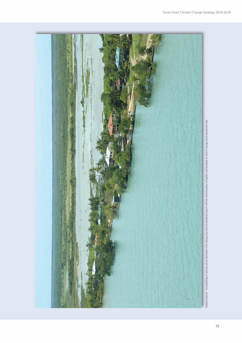
Given the low-lying nature of several islands, and the extent of current inundation problems, communities are highly exposed to the impacts of sea level rise. This is particularly so for Boigu and Saibai, but also for the central coral cay islands and several other communities located on low-lying coastal flats.
Even small increases in sea level due to climate change are likely to result in increasing frequency and extent of inundation in these communities; although for the coral cay islands there is some potential, under lower sea level scenarios at least, for the islands to build up as this occurs. The process of overtopping to create island growth would however be very difficult to live with and this sediment may be exhausted in the longer term.
Studies of extreme seawater inundation in Torres Strait at present show that based on a 5-year return period five communities are particularly vulnerable to inundation – Saibai, Boigu, Masig, Warraber and
Iamavii. Future sea level rise will exacerbate this existing issue, with inundation events likely to occur more frequently and the
possibility that several Torres Strait islands are completely inundated. Whilst it remains unclear what level
of inundation will be tolerable for communities over the longer term, the probable worst-case
scenario is the relocation of several communities, incurring considerable cultural,
spiritual and economic costs.
Other potential impacts of climate change, including more intense storms that will increase island erosion, changes to rainfall patterns, hotter weather, spread of diseases, and changes to ecosystems,
are also expected to significantly affect Torres Strait Island communities, whose
culture, subsistence and livelihoods involve traditional and commercial fishing, hunting
and gardening.
It is clear that climate change presents a significant and potentially devastating threat to Torres Strait
communities. However a comprehensive understanding of the nature and extent of this risk is lacking due to
inadequate knowledge of key climatic, oceanographic and ecological processes. One of the objectives of the Action Plan delivered as a part of this Strategy is to provide a more comprehensive understanding of climate risk to enable appropriate adaptation options to be considered. This will be undertaken through the Torres Strait Adaptation and Resilience Project. Understanding the risks and vulnerability of communities and ecosystems to climate change over various time horizons will inform the development of adaptation and resilience strategies.
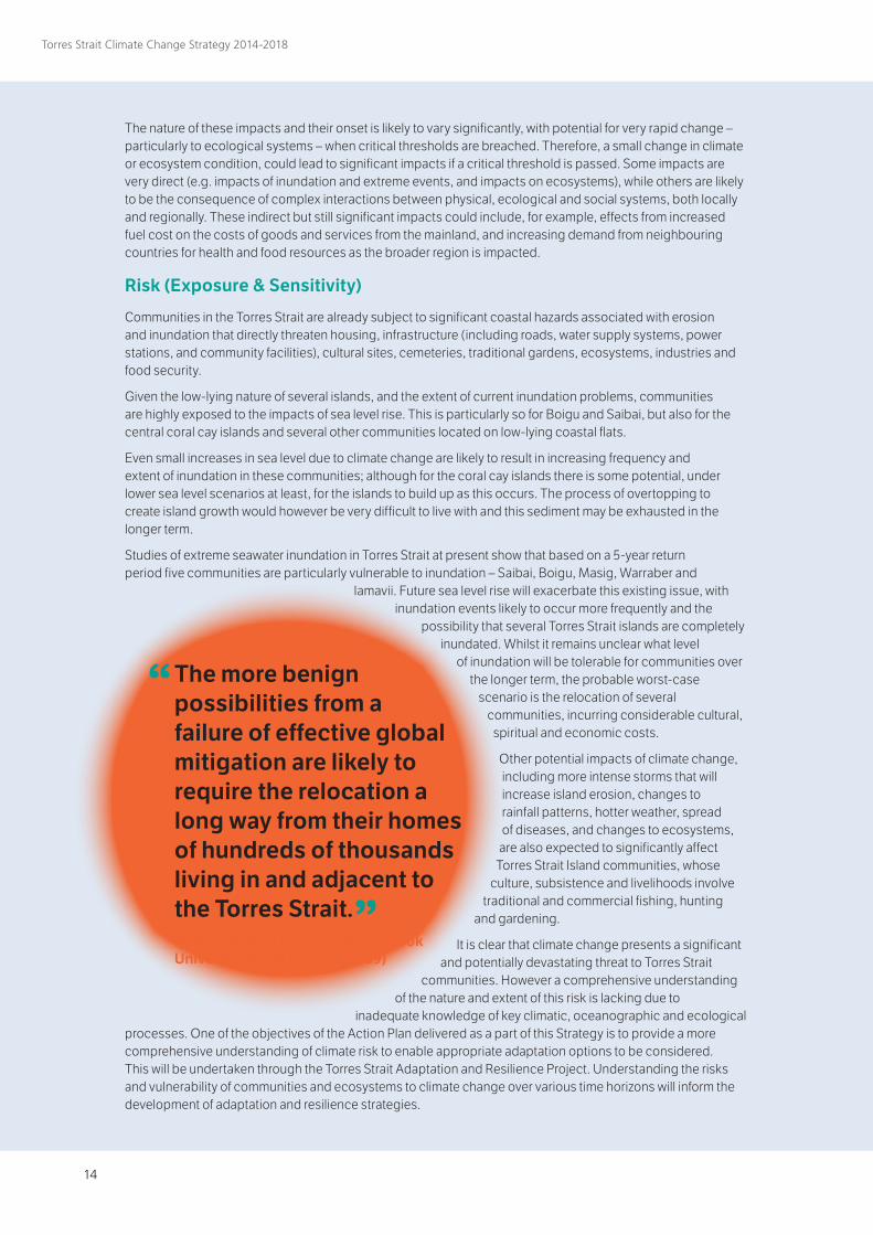
“ The more benign possibilities from a failure of effective global mitigation are likely to require the relocation a long way from their homes of hundreds of thousands living in and adjacent to the Torres Strait.” Professor Ross Garnaut, James Cook University Mabo Lecture, 2009)
14 15
Torres Strait Climate Change Strategy 2014-2018
Saib
ai Is
land
– s
trad
dlin
g a
narr
ow s
trip
bet
wee
n th
e ris
ing
sea
and
a w
etla
nd m
uch
of th
e co
mm
unity
is h
ighl
y vu
lner
able
to s
torm
sur
ge a
nd s
ea le
vel r
ise
16
Torres Strait Climate Change Strategy 2014-2018
Vulnerability
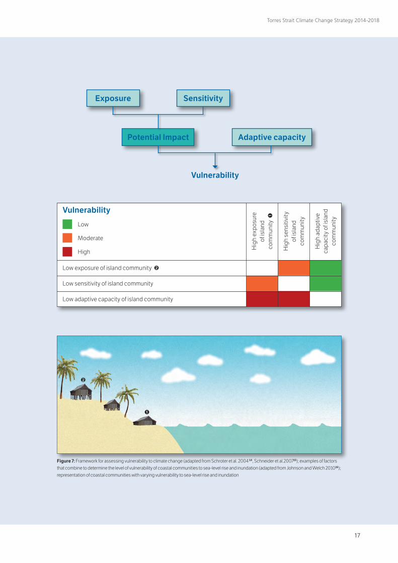
The potential impacts of climate change are a product of both how exposed individuals, communities or ecosystems are to the impacts of climate change, as well as the individual’s or community’s response to those impacts (sensitivity). Existing social and economic disadvantages of Indigenous peoples tends to heighten their sensitivity (Figure 7). The capacity of communities and ecosystems to adapt to these potential impacts can temper the extent of vulnerability, however the geographic, social, cultural and spiritual factors of the region combine to make Torres Strait communities amongst the most vulnerable in Australia to climate change. These factors, combined with the nature of the connections between island life, culture and customs, the islands and surrounding sea country, means Torres Strait Islanders are likely to be particularly affected by climate change.
The interconnection between Ailan Kastom (Island custom) and healthy land and sea are integral to spiritual and cultural identity, making the potential threat of climate change to both the islands and the surrounding ecosystems all the more significant to the region’s traditional inhabitants.
The extent of vulnerability of the region and its peoples to climate change together with the human rights implications are highlighted in the 2008 Native Title Report by the Aboriginal and Torres Strait Islander Social Justice Commissioner13 which, along with submissions to Senate and House of Representatives inquiries by the TSRA, emphasise the need for immediate and comprehensive action to address climate change concerns in the region.
Social and economic disadvantage further reduces the capacity to adapt to rapid environmental change; this problem is compounded on many of the islands that lack adequate infrastructure, health services and employment opportunities. On the positive side, island culture and community cohesion are still strong in the Torres Strait and the region has some of the most intact ecosystems in the world with comparatively few anthropogenic stressors.
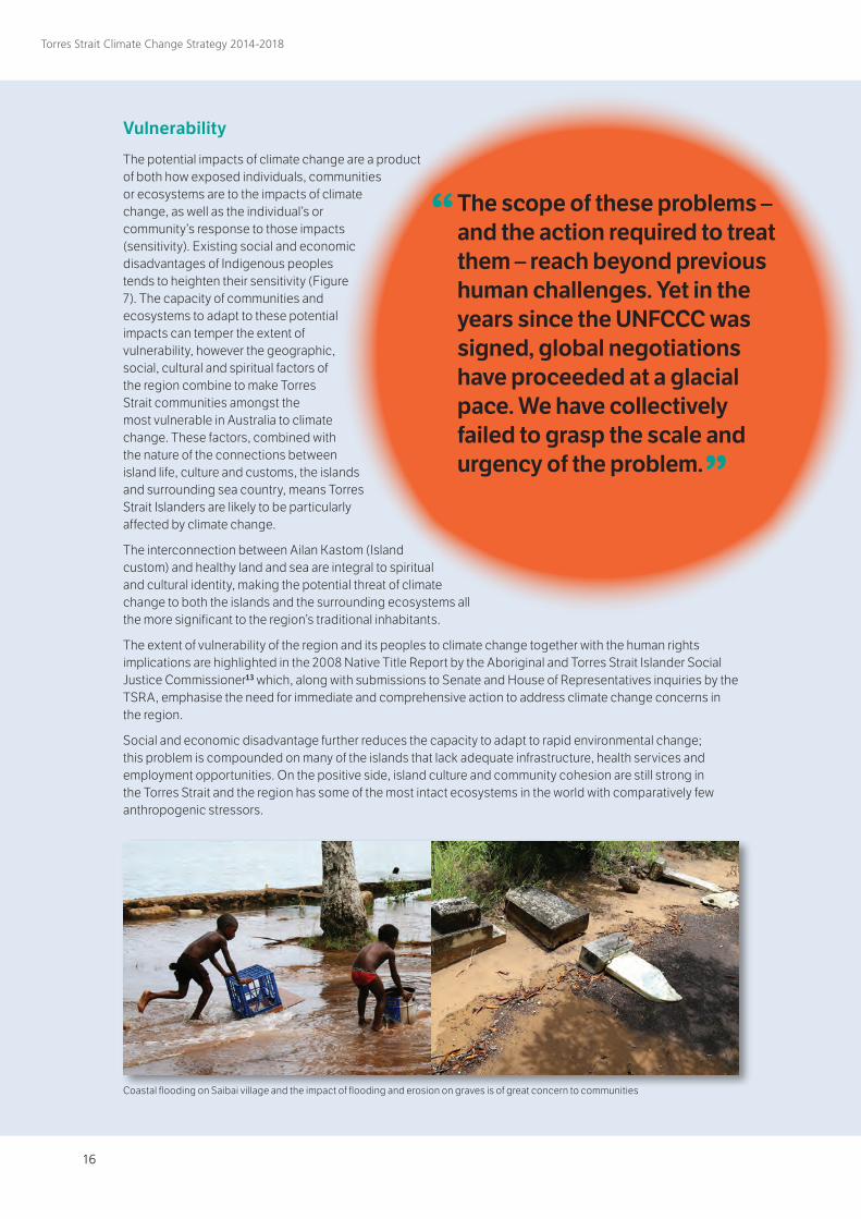
“ The scope of these problems – and the action required to treat them – reach beyond previous human challenges. Yet in the years since the UNFCCC was signed, global negotiations have proceeded at a glacial pace. We have collectively failed to grasp the scale and urgency of the problem.” Mary Robinson, former UN High Commissioner for Human Rights (International Council for Human Rights Policy, 2008)
Coastal flooding on Saibai village and the impact of flooding and erosion on graves is of great concern to communities
16 17
Torres Strait Climate Change Strategy 2014-2018
Exposure
Potential Impact
Sensitivity
Adaptive capacity
Vulnerability
Low exposure of island community ➋ ️
Low sensitivity of island community
Low adaptive capacity of island community
Hig
h ex
posu
re
of is
land
co
mm
unity
➊
Hig
h se
nsiti
vity
of
isla
nd
com
mun
ity
Hig
h ad
aptiv
e ca
paci
ty o
f isl
and
co
mm
unity
Vulnerability
Low
Moderate
High
Figure 7: Framework for assessing vulnerability to climate change (adapted from Schroter et al. 2004 14, Schneider et al.200715); examples of factors that combine to determine the level of vulnerability of coastal communities to sea-level rise and inundation (adapted from Johnson and Welch 201016); representation of coastal communities with varying vulnerability to sea-level rise and inundation
18
Torres Strait Climate Change Strategy 2014-2018
Adaptation & resilience
Adaptation to the effects of climate change will require a broad array of activities and actions to both minimise the impacts on communities and to build resilience to deal with inevitable change.
Adaptation, as broadly defined by the Intergovernmental Panel on Climate Change, is an adjustment in natural or human systems in response to actual or expected climatic changes or their effects, which moderates harm or exploits beneficial opportunities. Adaptive capacity is the capacity of species, ecosystem or people to adapt to the consequences of change (including climate change). Due to the cross-cutting nature of climate change across sectors, development of adaptation strategies requires a high level of collaboration between agencies, communities and researchers to ensure strategies are appropriate, not mal-adaptive (i.e. further exacerbate climate change), effective and achievable.
Resilience is the amount of change a species, ecosystem or society can withstand without fundamental alteration or loss. For example, the resilience of an ecosystem is its capacity to absorb shocks and to then regenerate and re-organise to maintain key functions, without undergoing a ‘phase shift’ (moving into another state controlled by different processes). By considering the attributes of resilient systems and applying them to local communities, local resilience to negative impacts can be considerably enhanced.
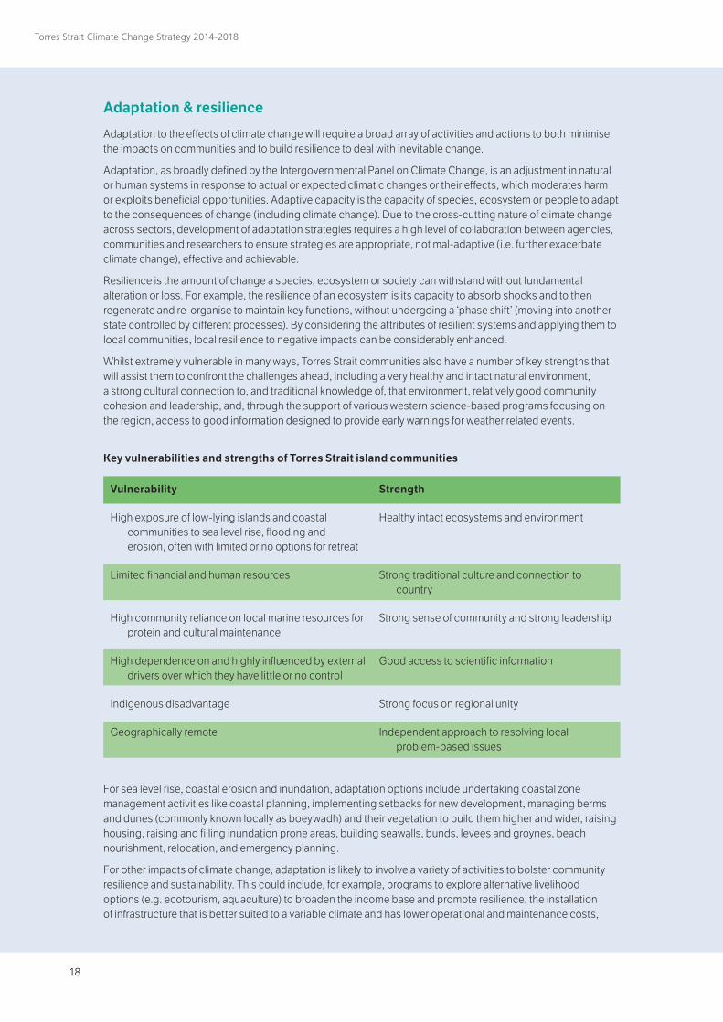
Whilst extremely vulnerable in many ways, Torres Strait communities also have a number of key strengths that will assist them to confront the challenges ahead, including a very healthy and intact natural environment, a strong cultural connection to, and traditional knowledge of, that environment, relatively good community cohesion and leadership, and, through the support of various western science-based programs focusing on the region, access to good information designed to provide early warnings for weather related events.
For sea level rise, coastal erosion and inundation, adaptation options include undertaking coastal zone management activities like coastal planning, implementing setbacks for new development, managing berms and dunes (commonly known locally as boeywadh) and their vegetation to build them higher and wider, raising housing, raising and filling inundation prone areas, building seawalls, bunds, levees and groynes, beach nourishment, relocation, and emergency planning.
For other impacts of climate change, adaptation is likely to involve a variety of activities to bolster community resilience and sustainability. This could include, for example, programs to explore alternative livelihood options (e.g. ecotourism, aquaculture) to broaden the income base and promote resilience, the installation of infrastructure that is better suited to a variable climate and has lower operational and maintenance costs,
Vulnerability
High exposure of low-lying islands and coastal communities to sea level rise, flooding and erosion, often with limited or no options for retreat
Limited financial and human resources
High community reliance on local marine resources for protein and cultural maintenance
High dependence on and highly influenced by external drivers over which they have little or no control
Indigenous disadvantage
Geographically remote
Strength
Healthy intact ecosystems and environment
Strong traditional culture and connection to country
Strong sense of community and strong leadership
Good access to scientific information
Strong focus on regional unity
Independent approach to resolving local problem-based issues
Key vulnerabilities and strengths of Torres Strait island communities
18 19
Torres Strait Climate Change Strategy 2014-2018
the revival of traditional management strategies for natural resources, as well as the enhancement of existing programs for health and management of vector borne diseases.
Identification of appropriate coastal management options is well progressed for some communities and implementation of options identified to date is a priority, along with emergency planning and completion of land use planning currently underway. For other communities, management options to deal with inundation and sea level rise are yet to be assessed and will require detailed modelling. For the low-lying communities, consideration of contingency planning for worst case sea level rise scenarios and how to best manage the effects on communities, culture and identity is required.
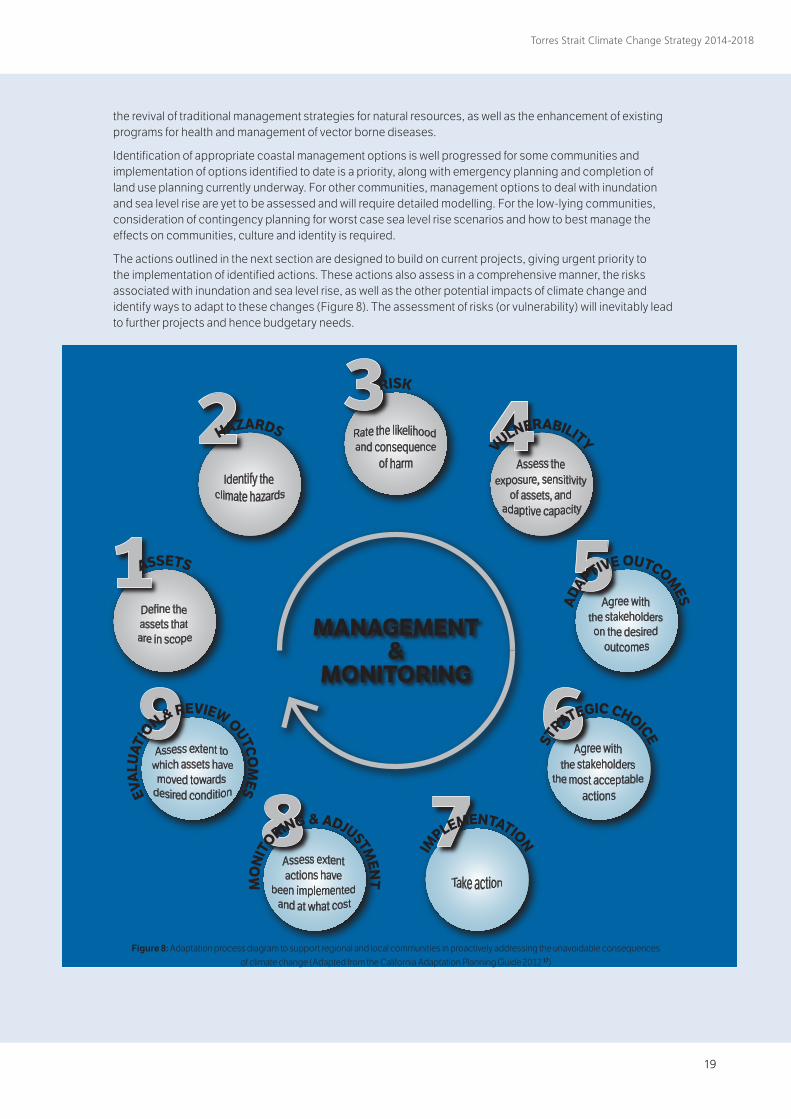
The actions outlined in the next section are designed to build on current projects, giving urgent priority to the implementation of identified actions. These actions also assess in a comprehensive manner, the risks associated with inundation and sea level rise, as well as the other potential impacts of climate change and identify ways to adapt to these changes (Figure 8). The assessment of risks (or vulnerability) will inevitably lead to further projects and hence budgetary needs.
MANAGEMENT&
MONITORING
HAZARDS
RISK
VULNERABILITY
ADAPTIVE OUTCOM
ES
ST
RATEGIC CHOICE
IM
PLEMENTATIONM
ON
ITORING & ADJUSTM
ENT
EVA
LUAT
IO
N & REVIEW OUTCOM
ES
ASSETS
Figure 8: Adaptation process diagram to support regional and local communities in proactively addressing the unavoidable consequences of climate change (Adapted from the California Adaptation Planning Guide 2012 17)
20
Torres Strait Climate Change Strategy 2014-2018
Traditional Knowledge and Climate Change There has been increasing recognition in recent years of the significance of Indigenous traditional ecological knowledge and observations as a key source of information about historic climate systems, seasonal weather patterns and events. Torres Strait Islanders have an intimate knowledge of their islands and sea country that is vitally important in allowing them to maintain their culture and livelihoods. Traditional knowledge of seasonal variations, climatic events and natural cycles, built upon over many generations, allows for appropriate decision-making about hunting and harvesting of natural resources to ensure sustainability .
Already islanders are noticing changes in the timing of seasons, rainfall, temperatures and in the behaviour of key species18. The capacity of Indigenous people to adapt to historic changes in weather patterns (including extreme events and sea level rise) and environmental change associated with natural causes is reasonably well documented. Many communities have a seasonal calendar that maps key climate, cultural and resource events. More recently, the application of ancestral and local knowledge in the context of dealing with anthropogenic change has been recognised as a key element in national and international climate change policy development. Traditional knowledge informs community understanding of environmental change, use of natural resources and their worldview, all of which play an important role in how communities adapt to climate change . Incorporation of Indigenous knowledge in climate change adaptation strategies can lead to more cost-effective, locally relevant, sustainable approaches being identified, and increased Indigenous ownership and engagement in culturally appropriate adaptation planning processes and outcomes.
A Traditional Ecological Knowledge (TEK) project is being facilitated by TSRA to support community members and Rangers to record and manage local cultural information. The project will give Rangers the capability to record TEK about climate change in the Torres Strait, including seasonal variations, weather patterns and changes in resource distribution and abundance. The database system will potentially allow for contemporary environmental research and monitoring data for Torres Strait to be depicted geospatially, and considered alongside cultural and historic datasets, providing an additional tool to assist in adaptive planning. The TEK project and the Torres Strait E-Atlas will both improve communities’ access to relevant environmental information and data in a user friendly format to support community-based management and adaptive planning.
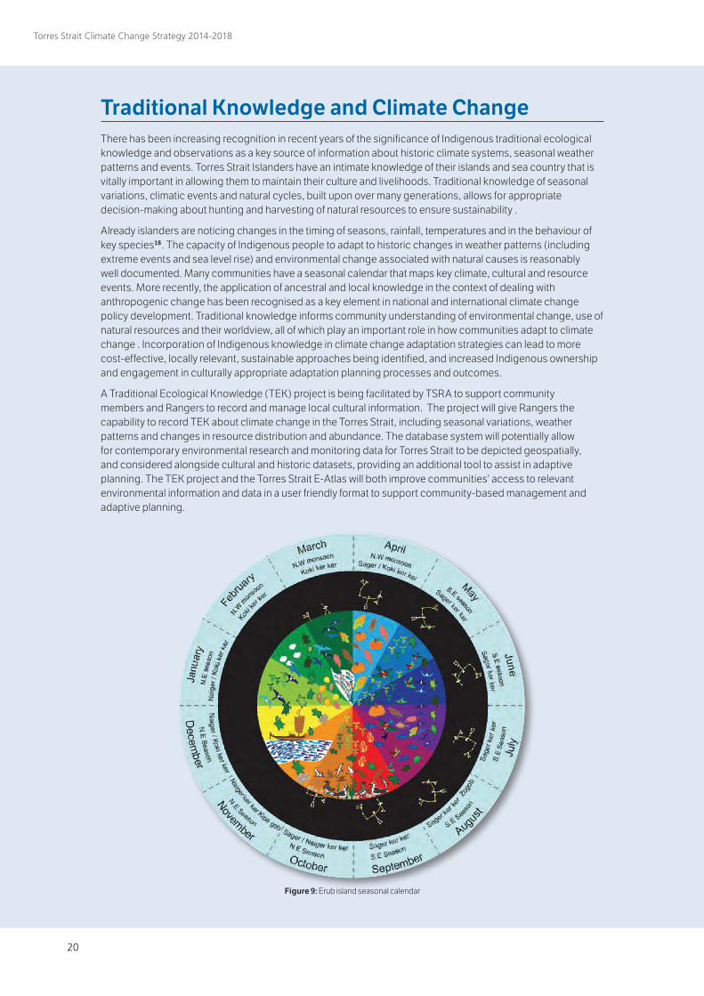
Figure 9: Erub island seasonal calendar
20 21
Torres Strait Climate Change Strategy 2014-2018
Action Plan This action plan provides a systematic and coordinated pathway for responding to climate change in the Torres Strait region over the next five years. It identifies general and targeted actions for adapting to and mitigating climate change impacts, under five key themes: Culture and Traditional Knowledge, Environment and Ecosystems, Settlements and Infrastructure, People and Communities, with suggested monitoring actions where applicable. There is also a section that identifies supporting communication and capacity building tasks to facilitate effective engagement and delivery of information to communities and stakeholders that can inform decision-making.
The Action Plan complements and builds on existing adaptation and mitigation efforts lead by the TSRA, Councils, Queensland Government and other partners under the previous 2010–2013 Strategy. It captures those actions that require further progress and identifies important information gaps that need to be filled to inform decision-making.
Progress since 2010
The focus since the Strategy was launched in 2010 has been on procuring critical research and modelling to inform coastal works prioritisation and to progress urgent coastal works. In addition, progress has been made on completing key research required to identify climate risks and to inform adaptation options. Achievements over this period include:
○ Funding secured for Torres Strait Major Coastal Works program to build coastal defences for priority low-lying communities;
○ Down-scaled climate change modelling for the Torres Strait region18;
○ Torres Strait Extreme Sea Level Study that provides detailed information on extreme sea levels in the region, factoring in storm surge and climate change9;
○ An assessment of renewable energy options and the carbon footprint of the Torres Strait region21;
○ Coastal erosion and inundation research on all islands in the Torres Strait, also including flood hazard mapping8;
○ Establishment of a regional sea surface temperature monitoring program and coral reef monitoring program (funded through the National Environmental Research Program www.nerptropical.edu.au);
○ Sand nourishment works at Warraber and Masig Islands;
○ Installation of two real-time meteorological and marine monitoring stations with real-time data available remotely (Australian Institute of Marine Science www.aims.gov.au);
○ Detailed coastal engineering studies for key communities identify by the coastal works program22,23;
○ Assessment of the vulnerability of key fisheries to future climate change24;
○ Various research projects investigating climate change impacts on green turtles and seagrass (JCU);
○ Adaptation and resilience workshops in Cairns, Masig and Erub (funded through the National Environmental Research Program www.nerptropical.ed.au);
○ Torres Strait ocean circulation model developed25;
○ Mapping and assessment of cumulative impacts on marine and coastal habitats26; and
○ A study into the limits to climate change adaptation for two lying island communities19.
22
Torres Strait Climate Change Strategy 2014-2018
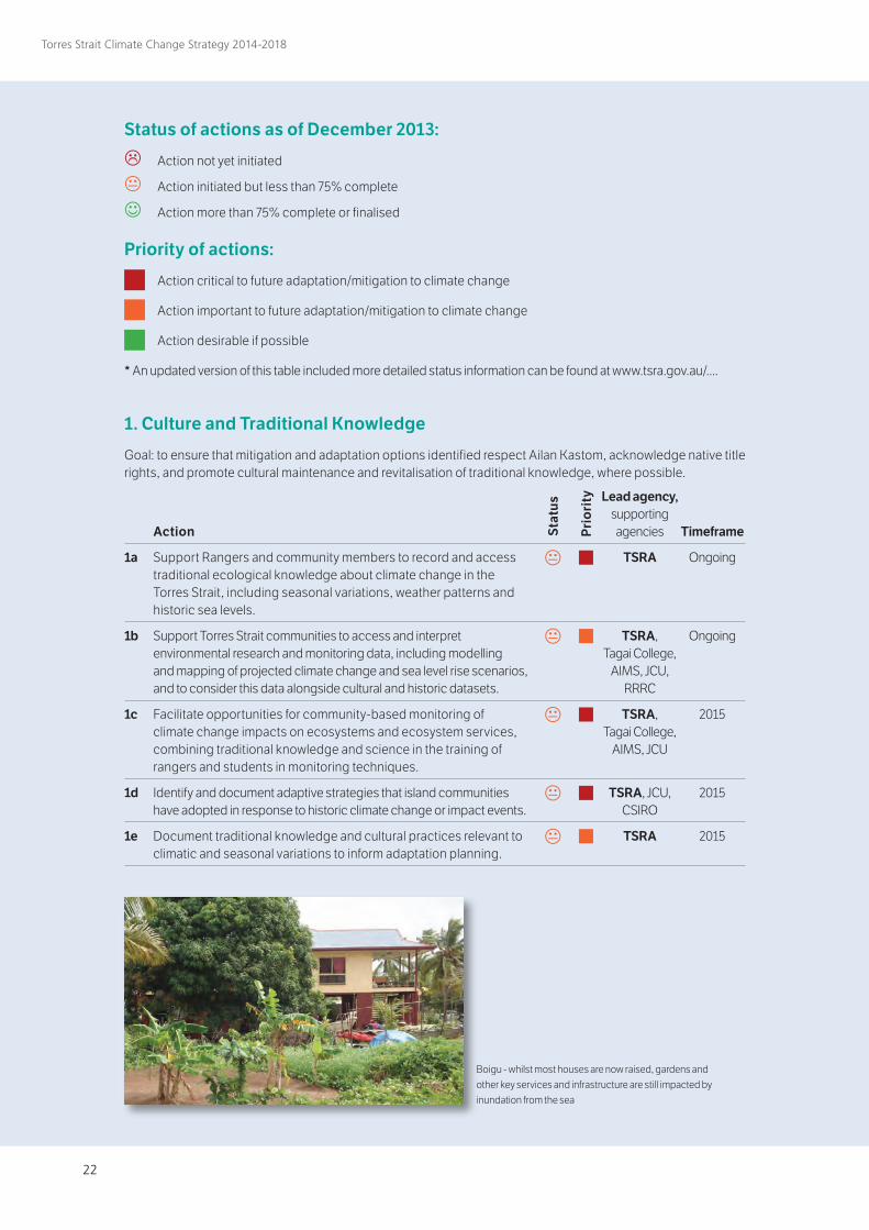
Status of actions as of December 2013:
Action not yet initiated
Action initiated but less than 75% complete
Action more than 75% complete or finalised
Priority of actions:
Action critical to future adaptation/mitigation to climate change
Action important to future adaptation/mitigation to climate change
Action desirable if possible
* An updated version of this table included more detailed status information can be found at www.tsra.gov.au/....
Action
1a Support Rangers and community members to record and access traditional ecological knowledge about climate change in the Torres Strait, including seasonal variations, weather patterns and historic sea levels.
1b Support Torres Strait communities to access and interpret environmental research and monitoring data, including modelling and mapping of projected climate change and sea level rise scenarios, and to consider this data alongside cultural and historic datasets.
1c Facilitate opportunities for community-based monitoring of climate change impacts on ecosystems and ecosystem services, combining traditional knowledge and science in the training of rangers and students in monitoring techniques.
1d Identify and document adaptive strategies that island communities have adopted in response to historic climate change or impact events.
1e Document traditional knowledge and cultural practices relevant to climatic and seasonal variations to inform adaptation planning.
Timeframe
Ongoing
Ongoing
2015
2015
2015
1. Culture and Traditional Knowledge
Goal: to ensure that mitigation and adaptation options identified respect Ailan Kastom, acknowledge native title rights, and promote cultural maintenance and revitalisation of traditional knowledge, where possible.
Lead agency, supporting agencies
TSRA
TSRA, Tagai College,
AIMS, JCU, RRRC
TSRA, Tagai College,
AIMS, JCU
TSRA, JCU, CSIRO
TSRA
e
e
e
e e
Stat
us
Pri
ori
ty
Boigu - whilst most houses are now raised, gardens and other key services and infrastructure are still impacted by inundation from the sea
22 23
Torres Strait Climate Change Strategy 2014-2018
2.1 Environment and EcosystemsGoal: to protect the unique natural resources and processes of the Torres Strait region and provide for future generations of Islanders to enjoy and sustainably utilise their environmental assets.
Action
2.1a Identify threatening processes forced by climate change and map areas at risk and timing of risk, biogeographic characteristics and areas of high value to prioritise investment and management effort (e.g. identify and protect refugia for thermally tolerant coral species that will provide genetic stock for recovery).
2.1b Identify key marine species and ecosystems at risk from climate change, and potential shifts in community composition and distribution.
2.1c Identify key terrestrial species (flora and fauna) at risk from climate change, potential shifts in community composition and distribution, and bush fire risk.
2.1d Identify potential climate change impacts on coastal systems, including geophysical changes to island profiles due to erosion and sea level rise (in particular coral cays) and develop models of change to inform decision making (eg shoreface and coral cay evolution models).
2.1e Research institutions and partners coordinate research projects that target species vulnerable to climate change (e.g. corals, fishes, crayfish, marine turtles, dugongs, seagrasses, pelagic foragers) to optimise the effectiveness of resilience-based management.
2.1f Synthesise emerging scientific and traditional knowledge to underpin effective management decisions and improve capacity to adapt to climate impacts.
2.1g Identify thresholds beyond which climate change causes irreversible damage to vulnerable species (e.g. seabirds, marine turtles, dugongs, corals, fishes and plankton), habitats (e.g. seagrasses, mangroves and pelagic) and processes (e.g. productivity and connectivity).
2.1h Assess and document implications of climate change for terrestrial weeds and feral animal distribution and abundance.
2.1i Implement strategies that ensure local fishing and hunting is undertaken in a sustainable way that takes into account the vulnerability of fisheries to climate change and future resource changes.
2.1j Assess synergies between climate and non-climate stressors on critical processes (such as productivity, connectivity, calcification and recovery potential) and synthesize results as the basis for revising management policies and targets.
2.1k Develop local coastal management plans, including management of boeywadh (berms/dunes) and their vegetation, to reduce possible community impacts and build coastal resilience.
2.1l Investigate the feasibility of utilising a dredge for accessing offshore sand resources for beach re-nourishment.
Timeframe
Dec 2015
Dec 2014
2015
2015
2016
2016
June 2015
2016
Dec 2014
2018
2015
2016
Lead agency, supporting agencies
TSRA, JCU, AIMS
AIMS, TSRA, JCU, AFMA
JCU, CSIRO, TSRA
TSRA, JCU, DSITIA
RRRC, AFMA, AIMS, JCU,
CSIRO, TSRA
TSRA, RRRC
TSRA, AFMA, AIMS, JCU,
RRRC, CSIRO, DITSIA,
DoE
DNRM, TSRA, JCU
AFMA, QDAFF, DoE TSRA, PNG
DEC
TSRA, AFMA, AIMS, JCU,
RRRC, CSIRO, DITSIA
TSRA, TSC, TSIRC
QTMR, TSRA, TSIRC, TSC
e
e e
e
e
e
e
e e
e
e
e
Stat
us
Pri
ori
ty
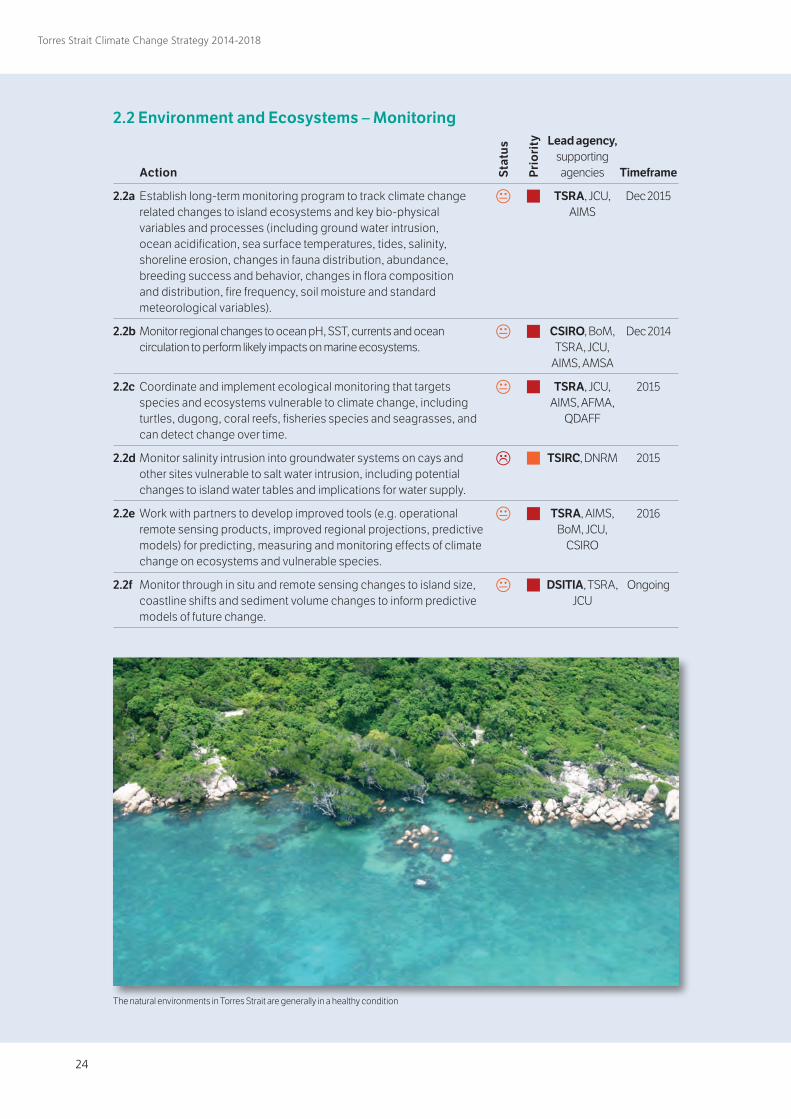
24
Torres Strait Climate Change Strategy 2014-2018
2.2 Environment and Ecosystems – Monitoring Action
2.2a Establish long-term monitoring program to track climate change related changes to island ecosystems and key bio-physical variables and processes (including ground water intrusion, ocean acidification, sea surface temperatures, tides, salinity, shoreline erosion, changes in fauna distribution, abundance, breeding success and behavior, changes in flora composition and distribution, fire frequency, soil moisture and standard meteorological variables).
2.2b Monitor regional changes to ocean pH, SST, currents and ocean circulation to perform likely impacts on marine ecosystems.
2.2c Coordinate and implement ecological monitoring that targets species and ecosystems vulnerable to climate change, including turtles, dugong, coral reefs, fisheries species and seagrasses, and can detect change over time.
2.2d Monitor salinity intrusion into groundwater systems on cays and other sites vulnerable to salt water intrusion, including potential changes to island water tables and implications for water supply.
2.2e Work with partners to develop improved tools (e.g. operational remote sensing products, improved regional projections, predictive models) for predicting, measuring and monitoring effects of climate change on ecosystems and vulnerable species.
2.2f Monitor through in situ and remote sensing changes to island size, coastline shifts and sediment volume changes to inform predictive models of future change.
Timeframe
Dec 2015
Dec 2014
2015
2015
2016
Ongoing
Lead agency, supporting agencies
TSRA, JCU, AIMS
CSIRO, BoM, TSRA, JCU,
AIMS, AMSA
TSRA, JCU, AIMS, AFMA,
QDAFF
TSIRC, DNRM
TSRA, AIMS, BoM, JCU,
CSIRO
DSITIA, TSRA, JCU
e
e
e
e
e
e
Stat
us
Pri
ori
ty
The natural environments in Torres Strait are generally in a healthy condition
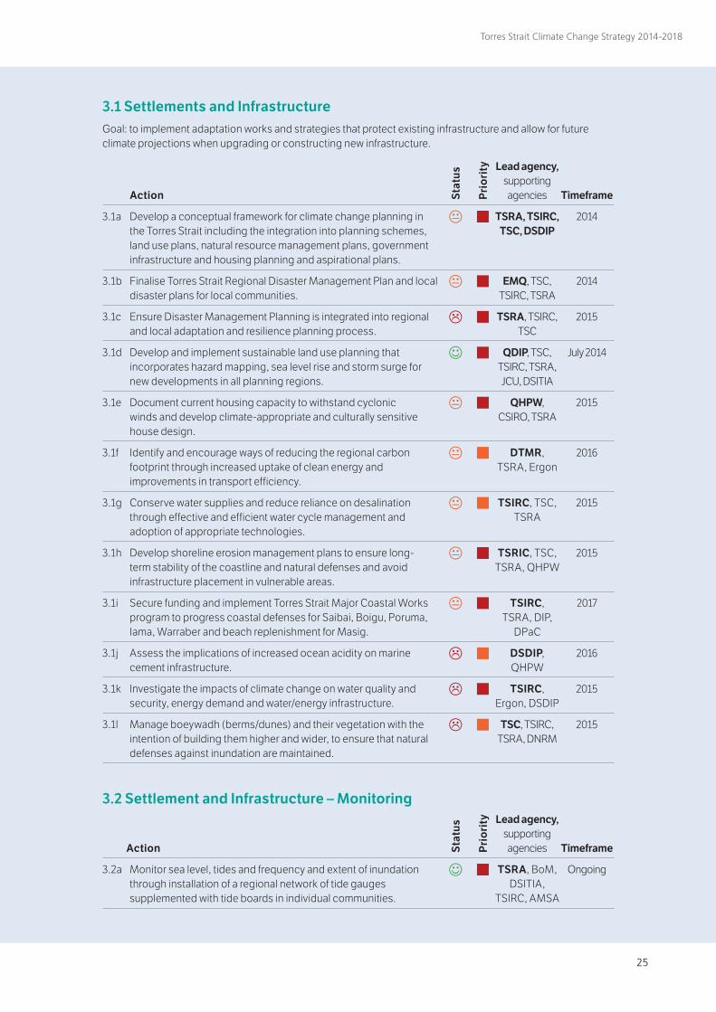
24 25
Torres Strait Climate Change Strategy 2014-2018
Action
3.1a Develop a conceptual framework for climate change planning in the Torres Strait including the integration into planning schemes, land use plans, natural resource management plans, government infrastructure and housing planning and aspirational plans.
3.1b Finalise Torres Strait Regional Disaster Management Plan and local disaster plans for local communities.
3.1c Ensure Disaster Management Planning is integrated into regional and local adaptation and resilience planning process.
3.1d Develop and implement sustainable land use planning that incorporates hazard mapping, sea level rise and storm surge for new developments in all planning regions.
3.1e Document current housing capacity to withstand cyclonic winds and develop climate-appropriate and culturally sensitive house design.
3.1f Identify and encourage ways of reducing the regional carbon footprint through increased uptake of clean energy and improvements in transport efficiency.
3.1g Conserve water supplies and reduce reliance on desalination through effective and efficient water cycle management and adoption of appropriate technologies.
3.1h Develop shoreline erosion management plans to ensure long-term stability of the coastline and natural defenses and avoid infrastructure placement in vulnerable areas.
3.1i Secure funding and implement Torres Strait Major Coastal Works program to progress coastal defenses for Saibai, Boigu, Poruma, Iama, Warraber and beach replenishment for Masig.
3.1j Assess the implications of increased ocean acidity on marine cement infrastructure.
3.1k Investigate the impacts of climate change on water quality and security, energy demand and water/energy infrastructure.
3.1l Manage boeywadh (berms/dunes) and their vegetation with the intention of building them higher and wider, to ensure that natural defenses against inundation are maintained.
3.1 Settlements and InfrastructureGoal: to implement adaptation works and strategies that protect existing infrastructure and allow for future climate projections when upgrading or constructing new infrastructure.
Timeframe
2014
2014
2015
July 2014
2015
2016
2015
2015
2017
2016
2015
2015
Lead agency, supporting agencies
TSRA, TSIRC, TSC, DSDIP
EMQ, TSC, TSIRC, TSRA
TSRA, TSIRC, TSC
QDIP, TSC, TSIRC, TSRA, JCU, DSITIA
QHPW, CSIRO, TSRA
DTMR, TSRA, Ergon
TSIRC, TSC, TSRA
TSRIC, TSC, TSRA, QHPW
TSIRC, TSRA, DIP,
DPaC
DSDIP, QHPW
TSIRC, Ergon, DSDIP
TSC, TSIRC, TSRA, DNRM
e
e e e e
e
e
e
e
e e
e
3.2 Settlement and Infrastructure – Monitoring Action
3.2a Monitor sea level, tides and frequency and extent of inundation through installation of a regional network of tide gauges supplemented with tide boards in individual communities.
Timeframe
Ongoing
Lead agency, supporting agencies
TSRA, BoM, DSITIA,
TSIRC, AMSA
e
Stat
us
Pri
ori
ty
Stat
us
Pri
ori
ty
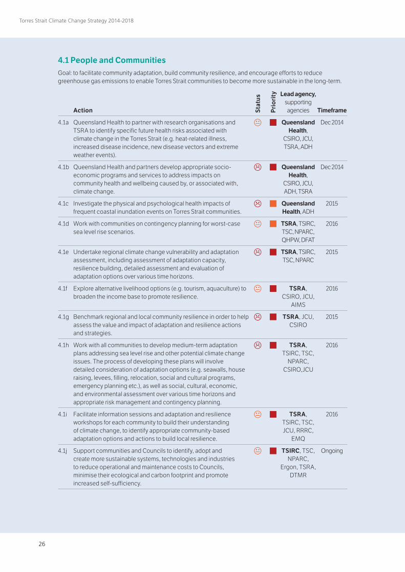
26
Torres Strait Climate Change Strategy 2014-2018
4.1 People and CommunitiesGoal: to facilitate community adaptation, build community resilience, and encourage efforts to reduce greenhouse gas emissions to enable Torres Strait communities to become more sustainable in the long-term.
Action
4.1a Queensland Health to partner with research organisations and TSRA to identify specific future health risks associated with climate change in the Torres Strait (e.g. heat-related illness, increased disease incidence, new disease vectors and extreme weather events).
4.1b Queensland Health and partners develop appropriate socio-economic programs and services to address impacts on community health and wellbeing caused by, or associated with, climate change.
4.1c Investigate the physical and psychological health impacts of frequent coastal inundation events on Torres Strait communities.
4.1d Work with communities on contingency planning for worst-case sea level rise scenarios.
4.1e Undertake regional climate change vulnerability and adaptation assessment, including assessment of adaptation capacity, resilience building, detailed assessment and evaluation of adaptation options over various time horizons.
4.1f Explore alternative livelihood options (e.g. tourism, aquaculture) to broaden the income base to promote resilience.
4.1g Benchmark regional and local community resilience in order to help assess the value and impact of adaptation and resilience actions and strategies.
4.1h Work with all communities to develop medium-term adaptation plans addressing sea level rise and other potential climate change issues. The process of developing these plans will involve detailed consideration of adaptation options (e.g. seawalls, house raising, levees, filling, relocation, social and cultural programs, emergency planning etc.), as well as social, cultural, economic, and environmental assessment over various time horizons and appropriate risk management and contingency planning.
4.1i Facilitate information sessions and adaptation and resilience workshops for each community to build their understanding of climate change, to identify appropriate community-based adaptation options and actions to build local resilience.
4.1j Support communities and Councils to identify, adopt and create more sustainable systems, technologies and industries to reduce operational and maintenance costs to Councils, minimise their ecological and carbon footprint and promote increased self-sufficiency.
Timeframe
Dec 2014
Dec 2014
2015
2016
2015
2016
2015
2016
2016
Ongoing
Lead agency, supporting agencies
Queensland Health,
CSIRO, JCU, TSRA, ADH
Queensland Health,
CSIRO, JCU, ADH, TSRA
Queensland Health, ADH
TSRA, TSIRC, TSC, NPARC, QHPW, DFAT
TSRA, TSIRC, TSC, NPARC
TSRA, CSIRO, JCU,
AIMS
TSRA, JCU, CSIRO
TSRA, TSIRC, TSC,
NPARC, CSIRO,JCU
TSRA, TSIRC, TSC, JCU, RRRC,
EMQ
TSIRC, TSC, NPARC,
Ergon, TSRA, DTMR
e
e
e e e
e
e
e
e
e
Stat
us
Pri
ori
ty
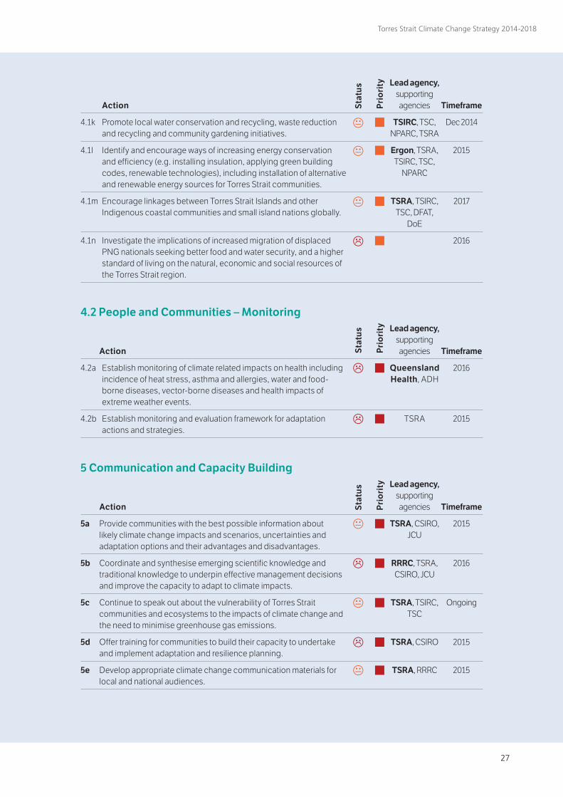
26 27
Torres Strait Climate Change Strategy 2014-2018
Action
4.1k Promote local water conservation and recycling, waste reduction and recycling and community gardening initiatives.
4.1l Identify and encourage ways of increasing energy conservation and efficiency (e.g. installing insulation, applying green building codes, renewable technologies), including installation of alternative and renewable energy sources for Torres Strait communities.
4.1m Encourage linkages between Torres Strait Islands and other Indigenous coastal communities and small island nations globally.
4.1n Investigate the implications of increased migration of displaced PNG nationals seeking better food and water security, and a higher standard of living on the natural, economic and social resources of the Torres Strait region.
Timeframe
Dec 2014
2015
2017
2016
Lead agency, supporting agencies
TSIRC, TSC, NPARC, TSRA
Ergon, TSRA, TSIRC, TSC,
NPARC
TSRA, TSIRC, TSC, DFAT,
DoE
e e
e
e
5 Communication and Capacity Building Action
5a Provide communities with the best possible information about likely climate change impacts and scenarios, uncertainties and adaptation options and their advantages and disadvantages.
5b Coordinate and synthesise emerging scientific knowledge and traditional knowledge to underpin effective management decisions and improve the capacity to adapt to climate impacts.
5c Continue to speak out about the vulnerability of Torres Strait communities and ecosystems to the impacts of climate change and the need to minimise greenhouse gas emissions.
5d Offer training for communities to build their capacity to undertake and implement adaptation and resilience planning.
5e Develop appropriate climate change communication materials for local and national audiences.
Timeframe
2015
2016
Ongoing
2015
2015
Lead agency, supporting agencies
TSRA, CSIRO, JCU
RRRC, TSRA, CSIRO, JCU
TSRA, TSIRC, TSC
TSRA, CSIRO
TSRA, RRRC
e
e
e
e e
4.2 People and Communities – Monitoring Action
4.2a Establish monitoring of climate related impacts on health including incidence of heat stress, asthma and allergies, water and food-borne diseases, vector-borne diseases and health impacts of extreme weather events.
4.2b Establish monitoring and evaluation framework for adaptation actions and strategies.
Timeframe
2016
2015
Lead agency, supporting agencies
Queensland Health, ADH
TSRA
e
e
Stat
us
Pri
ori
ty
Stat
us
Pri
ori
ty
Stat
us
Pri
ori
ty
28
Torres Strait Climate Change Strategy 2014-2018
References1 IPCC [Intergovernmental Panel on Climate Change] (2013) Climate Change 2013: The Physical Science Basis. Working Group I Contribution to the IPCC 5th Assessment Report – Changes to the underlying Scientific/Technical Assessment (eds Solomon, S. et al.) Cambridge Uni Press, Cambridge, UK, and New York.2 Torres Strait NRM Reference Group (2005) Land and Sea Management Strategy for Torres Strait. www.tsra.gov.au.3 Torres Strait Regional Authority (2009) Torres Strait Development Plan 2009-2013. www.tsra.gov.au.4 Standards Australia (2004) Risk Management AS/NZS 4360.5 Suppiah, R., Bathols, J., Collier, M., Kent, D. and O’Grady, J. (2010) Observed and future climates of the Torres Strait region. CSIRO report for the Torres Strait Regional Authority. www.tsra.gov.au.6 [Australian] Bureau of Meteorology and CSIRO (2011) Climate Change in the Pacific: Scientific Assessment and New Research. Volume 1: Regional Overview. Volume 2: Country Reports, 273 p.7 Knutson, T.R., McBride, J.L., Chan, J., Emanuel, K., Holland, G., Landsea, C., Held, I., Kossin, J.P., Srivastava, A.K. and Sugi, M. (2010) Tropical cyclones and climate change. Nature Geoscience, 21: 157-163.8 Parnell, K.E., Smithers, S.G. and Ischenko, L. (2012) Understanding climate change driven coastal erosion and inundation impacts on Torres Strait communities and the development of adaptation options. Report for the Department of Climate Change and Energy Efficiency, Australia.9 Harper, B. 2011. Torres Strait Extreme Water Level Study. Systems Engineering Australia. www.tsra.gov.au.10 Bell, J.D., Johnson, J.E. and Hobday, A.J. (editors) (2011) Vulnerability of tropical Pacific fisheries and aquaculture to climate change, Secretariat of the Pacific Community, Noumea, New Caledonia.11 Climate Commission Secretariat (2013) The Critical Decade: Extreme Weather. Department of Climate Change and Energy Efficiency, Australian Government, Canberra, 12 p.12 Awaiting confirmation.13 Australian Human Rights Commission (2008) Native Title Report, Aboriginal and Torres Strait Islander Social Justice Commissioner Report No 2/2009.14 Schroter and the ATEAM consortium (2004) Global Change Vulnerability – Assessing the European Human-Environment System. Potsdam Institute for Climate Impact Research, Potsdam, Germany.15 Schneider, S.H., Semenov, S., Patwardhan, A., Burton, I., Magadza, C.H.D., Oppenheimer, M., Pittock, A.B., Rahman, A., Smith, J.B., Suarez, A. and Yamin, F. (2007) Assessing key vulnerabilities and the risk from climate change. p 779–810. In: Climate Change 2007: Impacts, Adaptation and Vulnerability.Contribution of Working Group II to the Fourth Assessment Report of the Intergovernmental Panel on Climate Change. M.L. Parry, O.F. Canziani, J.P. Palutikof, P.J. van der Linden and C.E. Hanson (Eds) Cambridge University Press, Cambridge, UK.16 Johnson, J.E. and Welch, D.J. (2010) Marine fisheries management in a changing climate: a review of vulnerability. Reviews in Fisheries Science, Vol 18(1), 106-124.17 California Adaptation Planning Guide 2012, http://resources.ca.gov/climate_adaptation/docs/1APG_Planning_for_Adaptive_Communities.pdf.18 Green, D., Alexander, L., McInnes, K., Church, J., Nicholls, N. and White, N. (2010) An assessment of climate change impacts and adaptation for the Torres Strait Islands, Australia. Climatic Change, 102: 405-433.19 McNamara, K.E., Smithers, S.G., Westoby, R. and Parnell, K. 2011. Limits to climate change adaptation for low-lying communities in the Torres Strait. Final report to the National Climate Change Adaptation Research Facility.20 Leonard, S., Parsons, M., Olawsky, K. and Kofo, F., The role of culture and traditional knowledge in climate change adaptation: Insights from East Kimberly, Australia. Global Environmental Change, 23 (2013) 623-632.21 Centre for Appropriate Technology, 2012. Torres Strait - Options to Reduce Regional Carbon Footprint. www.tsra.gov.au.22 AECOM, 2012, Inundation Management on Saibai, Boigu and Iama Islands – Drainage and Seawalls. www.tsra.gov.au.23 AECOM, 2011, Poruma Seawall Feasibility Study. www.tsra.gov.au.24 Welch, D and Johnson, J., 2013. Assessing the vulnerability of Torres Strait fisheries and supporting habitats to climate change. www.afma.gov.au.25 Wolanski, E., Lambrechts, J., Thomas, C., Deleersnijder, E., 2013. The net water circulation through Torres Strait. Continental Shelf Research 64 (2013) 66-74.26 Grech A, Chartrand-Miller K, Erftemeijer P, Fonseca M, McKenzie L, Rasheed M, Taylor H, Coles R (2012) A comparison of threats, vulnerabilities and management approaches in global seagrass bioregions. Environmental Research Letters, 7, 024006. doi:10.1088/1748-9326/7/2/024006.

28 29
Torres Strait Climate Change Strategy 2014-2018
Acronyms ADH Australian Department of Health
AFMA Australian Fisheries Management Authority
AIMS Australian Institute of Marine Science
AMSA Australian Maritime Safety Authority
BoM [Australian] Bureau of Meteorology
CSIRO Commonwealth Scientific and Industrial Research Organisation
DoE [Australian] Department of Environment
DEHP [Queensland] Department of Environment and Heritage Protection
DFAT [Australian] Department of Foreign Affairs and Trade
DNRM [Queensland] Department of Natural Resources and Mines
DSDIP [Queensland] Department of State Development, Infrastructure and Planning
DSITIA [Queensland] Department of Science, Information Technology, Innovation and the Arts
EMQ Emergency Management Queensland
EMS Environmental Management System
IPCC Intergovernmental Panel on Climate Change
JCU James Cook University
LSMU [TSRA] Land and Sea Management Unit
MTSRF Marine and Tropical Sciences Research Facility
NCCARF National Climate Change Adaptation Research Facility
NPARC Northern Peninsula Area Regional Council
PNG DEC Papua New Guinea Department of Environment and Conservation
QDAFF Queensland Department of Agriculture, Fisheries and Forestry
QHPW Queensland Department of Housing and Public Works
QTMR Queensland Department of Transport and Main Roads
RRRC Reef and Rainforest Research Centre
TEK Traditional Ecological Knowledge
TSC Torres Shire Council
TSIRC Torres Strait Island Regional Council
TSRA Torres Strait Regional Authority
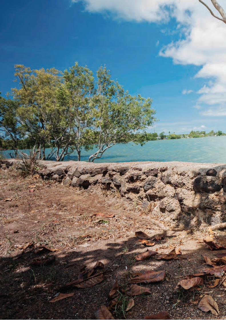

Related Documents