SECTION Section 1 Continental Drift 259 Summarize Wegener’s hypothesis of continental drift. Describe the process of sea-floor spreading. Identify how paleomagnetism provides support for the idea of sea-floor spreading. Explain how sea-floor spreading provides a mechanism for continental drift. continental drift mid-ocean ridge sea-floor spreading paleomagnetism Evidence for continental drift was found in Earth’s natural magnetism. This magnetism not only supports scientists’ hypo- theses, it also protects us all from the dangers of solar radiation. Key Ideas Key Terms Why It Matters s Key Terms Why It Matters Continental Drift 1 One of the most exciting theories in Earth science began with observations made more than 400 years ago. As early explorers sailed the oceans of the world, they brought back information about new continents and their coastlines. Mapmakers used this information to chart the new discoveries and to make the first reli- able world maps. As people studied the maps, they were impressed by the simi- larity of the continental coastlines on either side of the Atlantic Ocean. The continents looked as though they would fit together like parts of a giant jigsaw puzzle. The east coast of South America, for example, seemed to fit perfectly into the west coast of Africa, as shown in Figure 1. Wegener’s Hypothesis In 1912, a German scientist named Alfred Wegener (VAY guh nuhr) proposed a hypothesis that is now called continental drift. continental drift. Wegener hypothesized that the continents once formed part of a single landmass called a supercontinent. According to Wegener, this supercon- tinent began breaking up into smaller continents during the Mesozoic Era (about 200 million years ago). Over millions of years, these continents drifted to their present locations. Wegener speculated that the crum- pling of the crust in places may have produced mountain ranges such as the Andes on the western coast of South America. Figure 1 Early explorers noticed that the coastlines of Africa and South America could fit together like puzzle pieces. Can you identify any other continents that could fit together like puzzle pieces? continental drift the hypothesis that a single large landmass broke up into smaller landmasses to form the continents, which then drifted to their present locations

Welcome message from author
This document is posted to help you gain knowledge. Please leave a comment to let me know what you think about it! Share it to your friends and learn new things together.
Transcript
SECTION
Section 1 Continental Drift 259
! Summarize Wegener’s hypothesis of continental drift.
! Describe the process of sea-floor spreading.
! Identify how paleomagnetism provides support for the idea of sea-floor spreading.
! Explain how sea-floor spreading provides a mechanism for continental drift.
continental driftmid-ocean ridgesea-floor spreadingpaleomagnetism
Evidence for continental drift was found in Earth’s natural magnetism. This magnetism not only supports scientists’ hypo-theses, it also protects us all from the dangers of solar radiation.
Key Ideas Key Terms Why It Matterss Key Terms Why It Matters
Continental Drift1
One of the most exciting theories in Earth science began with observations made more than 400 years ago. As early explorers sailed the oceans of the world, they brought back information about new continents and their coastlines. Mapmakers used this information to chart the new discoveries and to make the first reli-able world maps.
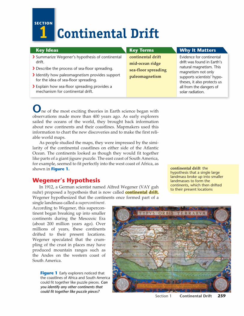
As people studied the maps, they were impressed by the simi-larity of the continental coastlines on either side of the Atlantic Ocean. The continents looked as though they would fit together like parts of a giant jigsaw puzzle. The east coast of South America, for example, seemed to fit perfectly into the west coast of Africa, as shown in Figure 1.
Wegener’s HypothesisIn 1912, a German scientist named Alfred Wegener (VAY guh
nuhr) proposed a hypothesis that is now called continental drift.continental drift. Wegener hypothesized that the continents once formed part of a single landmass called a supercontinent. According to Wegener, this supercon-tinent began breaking up into smaller continents during the Mesozoic Era (about 200 million years ago). Over millions of years, these continents drifted to their present locations. Wegener speculated that the crum-pling of the crust in places may have produced mountain ranges such as the Andes on the western coast of South America.
Figure 1 Early explorers noticed that the coastlines of Africa and South America could fit together like puzzle pieces. Can you identify any other continents that could fit together like puzzle pieces?
continental drift the hypothesis that a single large landmass broke up into smaller landmasses to form the continents, which then drifted to their present locations
hq10sena_tecsec1.indd 259hq10sena_tecsec1.indd 259 8/21/08 8:34:47 AM8/21/08 8:34:47 AMDF

260 Chapter 10 Plate Tectonics
Fossil EvidenceIn addition to seeing the similarities in the coastlines of the
continents, Wegener found other evidence to support his hypoth-esis. He reasoned that if the continents had once been joined, fossils of the same plants and animals should be found in areas that had once been connected. Wegener knew that identical fossils of Mesosaurus, a small, extinct land reptile, had been found in both South America and western Africa. Mesosaurus, a fossil of which is shown in Figure 2, lived 270 million years ago (during the Paleozoic Era). Wegener knew that it was unlikely these reptiles had swum across the Atlantic Ocean. He also saw no evidence that land bridges had once connected the continents. So, he con-cluded that South America and Africa had been joined at one time in the past.
Evidence from Rock FormationsGeologic evidence also supported Wegener’s hypothesis of
continental drift. The ages and types of rocks in the coastal regions of widely separated areas, such as western Africa and eastern South America, matched closely. Mountain chains that ended at the coastline of one continent seemed to continue on other conti-nents across the ocean, as shown in Figure 2. The Appalachian Mountains, for example, extend northward along the eastern coast of North America, and mountains of similar age and structure are found in Greenland, Scotland, and northern Europe. If the conti-nents are assembled into a model supercontinent, the mountains of similar age fit together in continuous chains.
www.scilinks.orgTopic: Continental Drift Code: HQX0351
ATLANTICOCEAN
INDIANOCEANPACIFIC
OCEAN
AFRICA
NORTHAMERICA
SOUTHAMERICA
EUROPE
ASIA
Figure 2 Fossils of Mesosaurus, such as the one shown below, were found in both South America and western Africa. Mountain chains of similar ages also exist on different conti-nents, as shown in the map at right.
PAPPO
AME
hq10sena_tecsec1.indd 260hq10sena_tecsec1.indd 260 7/31/08 8:55:56 AM7/31/08 8:55:56 AMDF
Section 1 Continental Drift 261
Climatic EvidenceChanges in climatic patterns provided more evidence that the
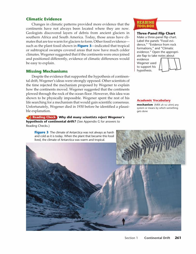
continents have not always been located where they are now. Geologists discovered layers of debris from ancient glaciers in southern Africa and South America. Today, those areas have cli-mates that are too warm for glaciers to form. Other fossil evidence—such as the plant fossil shown in Figure 3—indicated that tropical or subtropical swamps covered areas that now have much colder climates. Wegener suggested that if the continents were once joined and positioned differently, evidence of climatic differences would be easy to explain.
Missing MechanismsDespite the evidence that supported the hypothesis of continen-
tal drift, Wegener’s ideas were strongly opposed. Other scientists of the time rejected the mechanism proposed by Wegener to explain how the continents moved. Wegener suggested that the continents plowed through the rock of the ocean floor. However, this idea was shown to be physically impossible. Wegener spent the rest of his life searching for a mechanism that would gain scientific consensus. Unfortunately, Wegener died in 1930 before he identified a plausi-ble explanation.
Why did many scientists reject Wegener’s hypothesis of continental drift? (See Appendix G for answers to Reading Checks.)
Figure 3 The climate of Antarctica was not always as harsh and cold as it is today. When the plant that became this fossil lived, the climate of Antarctica was warm and tropical.
Three-Panel Flip ChartMake a three-panel flip chart. Label the panels “Fossil evi-dence,” “Evidence from rock formations,” and “Climatic evidence.” Open the appropri-ate flap to take notes about evidence Wegener used to support his hypothesis.
Academic Vocabularymechanism (MEK uh NIZ uhm) any system or means by which something gets done
hq10sena_tecsec1.indd 261hq10sena_tecsec1.indd 261 7/31/08 8:56:08 AM7/31/08 8:56:08 AMDF
Rift
Magma
Mid-ocean ridge
LITHOSPHERE
Oceanic crust
ASTHENOSPHERE
Sediment
262 Chapter 10 Plate Tectonics
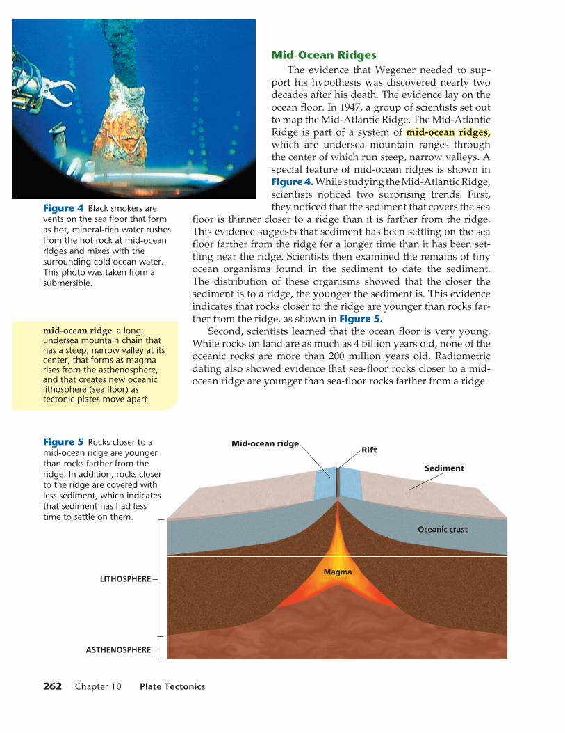
Mid-Ocean RidgesThe evidence that Wegener needed to sup-
port his hypothesis was discovered nearly two decades after his death. The evidence lay on the ocean floor. In 1947, a group of scientists set out to map the Mid-Atlantic Ridge. The Mid-Atlantic Ridge is part of a system of mid-ocean ridges,mid-ocean ridges, which are undersea mountain ranges through the center of which run steep, narrow valleys. A special feature of mid-ocean ridges is shown in Figure 4. While studying the Mid-Atlantic Ridge, scientists noticed two surprising trends. First, they noticed that the sediment that covers the sea
floor is thinner closer to a ridge than it is farther from the ridge.This evidence suggests that sediment has been settling on the sea floor farther from the ridge for a longer time than it has been set-tling near the ridge. Scientists then examined the remains of tiny ocean organisms found in the sediment to date the sediment. The distribution of these organisms showed that the closer the sediment is to a ridge, the younger the sediment is. This evidence indicates that rocks closer to the ridge are younger than rocks far-ther from the ridge, as shown in Figure 5.
Second, scientists learned that the ocean floor is very young. While rocks on land are as much as 4 billion years old, none of the oceanic rocks are more than 200 million years old. Radiometric dating also showed evidence that sea-floor rocks closer to a mid-ocean ridge are younger than sea-floor rocks farther from a ridge.
Figure 4 Black smokers are vents on the sea floor that form as hot, mineral-rich water rushes from the hot rock at mid-ocean ridges and mixes with the surrounding cold ocean water. This photo was taken from a submersible.
Figure 5 Rocks closer to a mid-ocean ridge are younger than rocks farther from the ridge. In addition, rocks closer to the ridge are covered with less sediment, which indicates that sediment has had less time to settle on them.
mid-ocean ridge a long, undersea mountain chain that has a steep, narrow valley at its center, that forms as magma rises from the asthenosphere, and that creates new oceanic lithosphere (sea floor) as tectonic plates move apart
hq10sena_tecsec1.indd 262hq10sena_tecsec1.indd 262 2/23/09 9:00:20 AM2/23/09 9:00:20 AM
Newest lithosphere
Newly formed oceanic lithosphere
Oldest lithosphere
Newest lithosphere
Oldest lithosphere
Older lithosphere
Section 1 Continental Drift 263
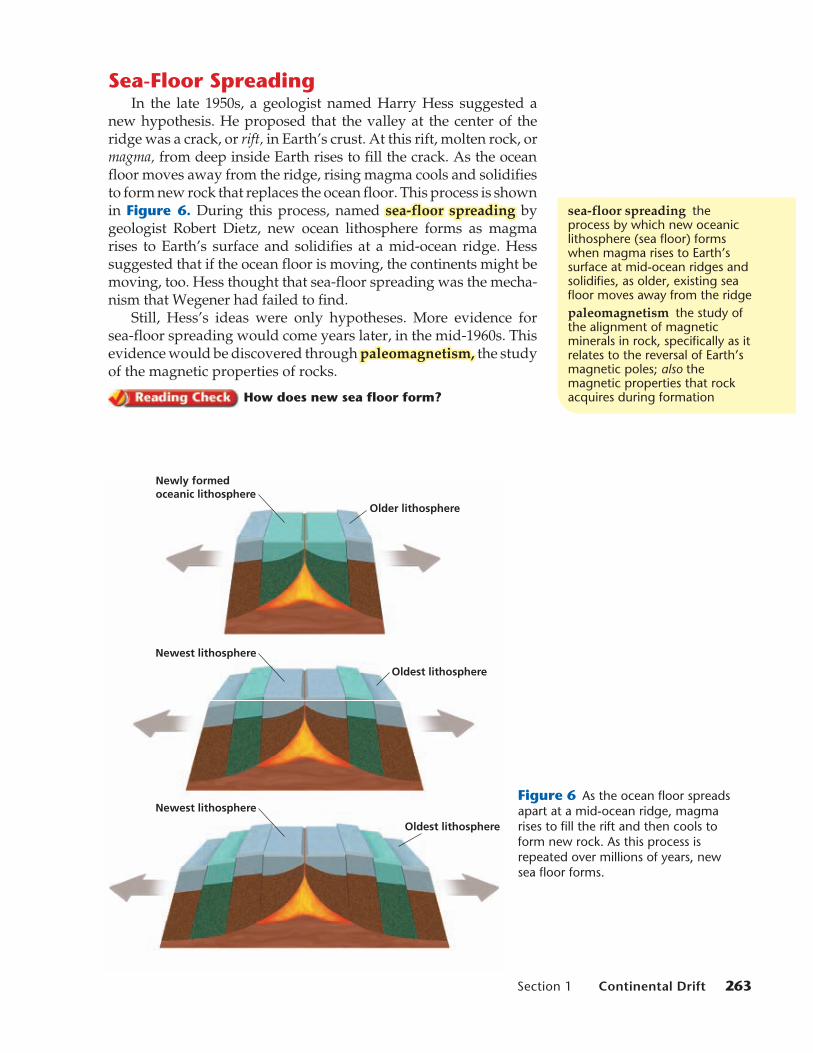
Sea-Floor SpreadingIn the late 1950s, a geologist named Harry Hess suggested a
new hypothesis. He proposed that the valley at the center of the ridge was a crack, or rift, in Earth’s crust. At this rift, molten rock, or magma, from deep inside Earth rises to fill the crack. As the ocean floor moves away from the ridge, rising magma cools and solidifies to form new rock that replaces the ocean floor. This process is shown in Figure 6. During this process, named sea-floor spreadingsea-floor spreading by geologist Robert Dietz, new ocean lithosphere forms as magma rises to Earth’s surface and solidifies at a mid-ocean ridge. Hess suggested that if the ocean floor is moving, the continents might be moving, too. Hess thought that sea-floor spreading was the mecha-nism that Wegener had failed to find.
Still, Hess’s ideas were only hypotheses. More evidence for sea-floor spreading would come years later, in the mid-1960s. This evidence would be discovered through paleomagnetism,paleomagnetism, the study of the magnetic properties of rocks.
How does new sea floor form?
sea-floor spreading the process by which new oceanic lithosphere (sea floor) forms when magma rises to Earth’s surface at mid-ocean ridges and solidifies, as older, existing sea floor moves away from the ridgepaleomagnetism the study of the alignment of magnetic minerals in rock, specifically as it relates to the reversal of Earth’s magnetic poles; also the magnetic properties that rock acquires during formation
Figure 6 As the ocean floor spreads apart at a mid-ocean ridge, magma rises to fill the rift and then cools to form new rock. As this process is repeated over millions of years, new sea floor forms.
hq10sena_tecsec1.indd 263hq10sena_tecsec1.indd 263 7/31/08 8:56:19 AM7/31/08 8:56:19 AMDF

North geographic pole
North geomagnetic
pole
Magneticfield lines
PaleomagnetismIf you have ever used a compass to determine direc-
tion, you know that Earth acts as a giant magnet. Earth has north and south geomagnetic poles, as shown in Figure 7. The compass needle aligns with the field of magnetic force that extends from one pole to the other.
As magma solidifies to form rock, iron-rich minerals in the magma align with Earth’s magnetic field in the same way that a compass needle does. When the rock hardens, the magnetic orientation of the minerals becomes permanent. This residual magnetism of rock is called paleomagnetism.
Magnetic ReversalsGeologic evidence shows that Earth’s magnetic field has
not always pointed north, as it does now. Scientists have discovered rocks whose magnetic orientations point opposite to Earth’s current magnetic field. Scientists have dated rocks of different magnetic polarities. All rocks with magnetic fields that point north, or normal polarity, are classified in the same time intervals. All rocks with magnetic fields that point south, or reversed polarity, also fall into specific time intervals. When scientists placed these periods of normal and reverse polarity in chronological order, they discovered a pattern of alternating normal and reversed polarity in the rocks. Scientists used this pattern to create the geomagnetic reversal time scale.
Figure 7 Earth acts as a giant magnet because of currents in Earth’s core.
UNDERSTANDING CONCEPTSWhat could happen to our atmosphere if Earth had no magnetic field?
The solar wind moves along Earth’s magnetic field toward the poles, so auroras are commonly seen at high latitudes.
Earth’s magnetic field is not just an interesting topic for scientists. It makes life on Earth possible. Earth’s magnetic field acts like a giant space shield, protecting our planet from the solar wind — electrically charged particles that stream away from the sun in all directions. Even with Earth’s magnetic field in place, temporary increases in the strength of the solar wind can disrupt telecommunications systems and disable electric power grids. Without the magnetic field, Earth’s atmosphere would be gradually swept away into the depths of space.
Our Own Space ShieldWhy It Matters
Auroras, commonly known as the northern and southern lights, are a sign that Earth’s protective space shield is working.
Akasisp
The solar wind moves along
264
hq10sena_tecsec1.indd 264hq10sena_tecsec1.indd 264 7/31/08 8:56:21 AM7/31/08 8:56:21 AMDF
RiftReversed polarity
Normal polarity
4 3 2 1 0 1 2 3 4
Age of sea floor (in millions of years)
Section 1 Continental Drift 265
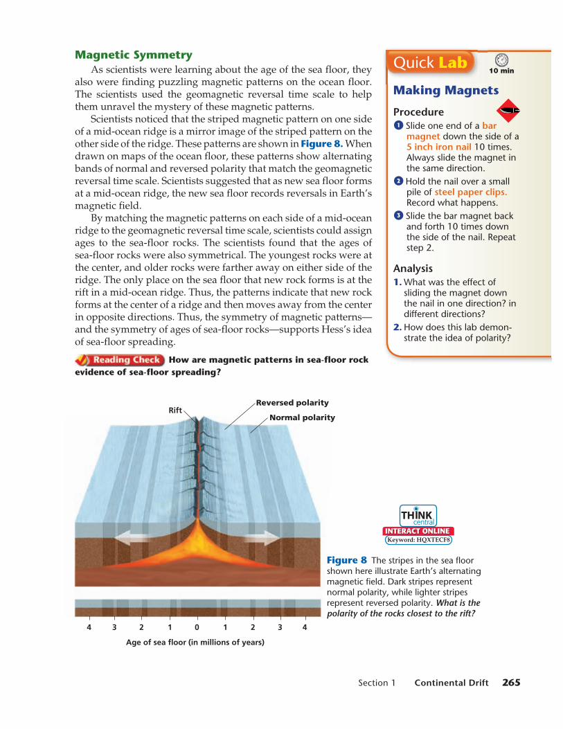
Magnetic SymmetryAs scientists were learning about the age of the sea floor, they
also were finding puzzling magnetic patterns on the ocean floor. The scientists used the geomagnetic reversal time scale to help them unravel the mystery of these magnetic patterns.
Scientists noticed that the striped magnetic pattern on one side of a mid-ocean ridge is a mirror image of the striped pattern on the other side of the ridge. These patterns are shown in Figure 8. When drawn on maps of the ocean floor, these patterns show alternating bands of normal and reversed polarity that match the geomagnetic reversal time scale. Scientists suggested that as new sea floor forms at a mid-ocean ridge, the new sea floor records reversals in Earth’s magnetic field.
By matching the magnetic patterns on each side of a mid-ocean ridge to the geomagnetic reversal time scale, scientists could assign ages to the sea-floor rocks. The scientists found that the ages of sea-floor rocks were also symmetrical. The youngest rocks were at the center, and older rocks were farther away on either side of the ridge. The only place on the sea floor that new rock forms is at the rift in a mid-ocean ridge. Thus, the patterns indicate that new rock forms at the center of a ridge and then moves away from the center in opposite directions. Thus, the symmetry of magnetic patterns—and the symmetry of ages of sea-floor rocks—supports Hess’s idea of sea-floor spreading.
How are magnetic patterns in sea-floor rock evidence of sea-floor spreading?
Figure 8 The stripes in the sea floor shown here illustrate Earth’s alternating magnetic field. Dark stripes represent normal polarity, while lighter stripes represent reversed polarity. What is the polarity of the rocks closest to the rift?
Quick Lab
Making Magnets
Procedure1 Slide one end of a bar
magnet down the side of a 5 inch iron nail 10 times. Always slide the magnet in the same direction.
2 Hold the nail over a small pile of steel paper clips. Record what happens.
3 Slide the bar magnet back and forth 10 times down the side of the nail. Repeat step 2.
Analysis1. What was the effect of
sliding the magnet down the nail in one direction? in different directions?
2. How does this lab demon-strate the idea of polarity?
10 min
Keyword: HQXTECF8
hq10sena_tecsec1.indd 265hq10sena_tecsec1.indd 265 7/31/08 8:56:44 AM7/31/08 8:56:44 AMDF

266 Chapter 10 Plate Tectonics
Key Ideas1. Describe the observation that first led to
Wegener’s hypothesis of continental drift.
2. Summarize the evidence that supports Wegener’s hypothesis.
3. Compare sea-floor spreading with the formation of mid-ocean ridges.
4. Explain how scientists know that Earth’s mag-netic poles have reversed many times during Earth’s history.
5. Identify how magnetic symmetry can be used as evidence of sea-floor spreading.
6. Explain how scientists date sea-floor rocks.
Critical Thinking 7. Making Inferences How does evidence that
rocks farther from a ridge are older than rocks closer to the ridge support the idea of spreading?
8. Analyzing Ideas Explain how sea-floor spread-ing provides an explanation for how continents move over Earth’s surface.
Concept Mapping 9. Use the following terms to create a concept
map: continental drift, paleomagnetism, fossils, climate, sea-floor spreading, geologic evidence, supercontinent, and mid-ocean ridge.
Key Ideas
Section 1 Review
Wegener RedeemedAnother group of scientists discovered that the reversal pat-
terns seen in rocks on the sea floor also appeared in rocks on land, such as those shown in Figure 9. The reversals in the land rocks matched the geomagnetic reversal time scale. Because the same pattern occurs in rocks of the same ages on both land and the sea floor, scientists became confident that magnetic patterns show changes over time. Thus, the idea of sea-floor spreading gained further favor in the scientific community.
Scientists reasoned that sea-floor spreading provides a way for the continents to move over Earth’s surface. Continents are carried by the widening sea floor in much the same way that objects are carried by a conveyor belt. The molten rock from a rift cools, hard-ens, and then moves away in opposite directions on both sides of the ridge. Here, at last, was the mechanism that verified Wegener’s hypothesis of continental drift.
Figure 9 Scientists collected samples of these sedimentary rocks in California and used the mag-netic properties of the samples to date the rocks by using the geomagnetic reversal time scale.
hq10sena_tecsec1.indd 266hq10sena_tecsec1.indd 266 7/31/08 8:56:47 AM7/31/08 8:56:47 AMDF
Related Documents