Holocene soil-geomorphic surfaces influence the role of salmon-derived nutrients in the coastal temperate rainforest of Southeast Alaska David V. D'Amore a, ⁎, Nicholas S. Bonzey b , Jacob Berkowitz c , Janine Rüegg d , Scott Bridgham e a Forest Service, U.S. Department of Agriculture, Pacific Northwest Research Station, Juneau, AK 99801, USA b Virginia Polytechnic Institute and State University, Department of Forest Resources and Environmental Conservation, Blacksburg, VA, 24601 USA c Environmental Research and Development Center, U.S. Army Corps of Engineers, Vicksburg, MS, USA d University of Notre Dame, Department of Biological Sciences, Notre Dame, IN 46556, USA e University of Oregon, Center for Ecology and Evolutionary Biology and Environmental Studies Program, Eugene, OR 05405, USA abstract article info Article history: Received 8 May 2009 Received in revised form 16 March 2010 Accepted 25 April 2010 Available online 8 May 2010 Keywords: Soils Alluvial terrace Pedology Salmon-derived nutrients Nitrogen isotopes The influence of salmon-derived nutrients (SDN) is widely accepted as a potential factor in the maintenance of aquatic and terrestrial productivity in North American Coastal rainforests. Holocene alluvial landforms are intimately connected with the return of anadromous salmon, but the influence of the soils that occupy these landforms and support this important terrestrial–aquatic ecological coupling have not been examined in SDN studies. We used paleo-ecologic information, soil resource inventories and measurements of soil morphology to construct a soil-geomorphic model for alluvial landforms along salmon spawning channels on Prince of Wales Island, Southeast Alaska, USA. Post-glacial sea-level rise, crustal uplift and subsidence combined with Holocene sediment deposition have formed alluvial terraces and floodplains along rivers on Prince of Wales Island. These alluvial landforms have soils that are mapped as Entisols (Tonowek soil series) and Spodosols (Tuxekan soil series). We propose a soil-geomorphic model where the Spodosols located on terraces are estimated to derive from sediments deposited after the stabilization of landscape approximately 8 kybp to 6 kybp. The stability of these soils is reflected through mature soil development with organic matter accumulation and podzolization. Our model identifies Entisols on floodplains developed from alluvial deposition in the latter Holocene that have soil morphologic features consistent with recent deposition and limited soil development. We used this soil-geomorphic model to test the hypothesis that the terrestrial end- member value commonly used to quantify nitrogen (N) loading on soils through stable isotope analysis differs by soil type and found that the two soil types had significantly different N isotopic (δ 15 N) values more consistent with soil development than SDN loading. The use of a soil-geomorphic model provides a means to stratify alluvial landforms and constrain the natural variability encountered in studies of riparian nutrient cycles associated with the feedbacks between SDN and terrestrial ecosystems to improve estimates of the fate of SDN in soils and vegetation. Published by Elsevier B.V. 1. Introduction The influence of salmon-derived nutrients (SDN) is widely accepted as a potential factor in the maintenance of aquatic and terrestrial productivity in nutrient-limited forests of the North American Pacific Coastal rainforests (Ben-David et al., 1998; Bilby et al., 1998; Willson et al., 1998; Wipfli et al., 1998; Naiman et al., 2002). The biogeomorphological interaction among alluvial land- forms, riparian vegetation and stream channels provides spawning habitat for salmon, and the nutrients from salmon promote the growth and maintenance of trees that perpetuate stream channel attributes conducive to the successful rearing of young salmon (Naiman et al., 2002). Understanding the specific mechanisms related to the biogeomorphic feedback associated with SDN is complicated by soil heterogeneity and the potential for vastly different cycling and storage of nutrients in the terrestrial system. Post-glacial chronose- quences of soils and ecosystems have provided a model for soil- geomorphic development in glacially derived soils in post-glacial valleys of the North Pacific Coastal rainforests (Crocker and Major, 1955; Ugolini, 1968; Chapin et al., 1994), but we have not found any studies that provide a model for Holocene soil geomorphology and alluvial landforms connected with the return of anadromous salmon. The mass spawning of chum (Oncorhynchus keta) and pink salmon (O. gorbuscha) occurs in low-gradient river systems that can be Geomorphology 126 (2011) 377–386 ⁎ Corresponding author. Tel.: + 1 907 586 7955; fax: + 1 907 586 7848. E-mail addresses: [email protected] (D.V. D'Amore), [email protected] (N.S. Bonzey), [email protected] (J. Berkowitz), [email protected] (J. Rüegg), [email protected] (S. Bridgham). 0169-555X/$ – see front matter. Published by Elsevier B.V. doi:10.1016/j.geomorph.2010.04.014 Contents lists available at ScienceDirect Geomorphology journal homepage: www.elsevier.com/locate/geomorph

Welcome message from author
This document is posted to help you gain knowledge. Please leave a comment to let me know what you think about it! Share it to your friends and learn new things together.
Transcript
Geomorphology 126 (2011) 377–386
Contents lists available at ScienceDirect
Geomorphology
j ourna l homepage: www.e lsev ie r.com/ locate /geomorph
Holocene soil-geomorphic surfaces influence the role of salmon-derived nutrients inthe coastal temperate rainforest of Southeast Alaska
David V. D'Amore a,⁎, Nicholas S. Bonzey b, Jacob Berkowitz c, Janine Rüegg d, Scott Bridgham e
a Forest Service, U.S. Department of Agriculture, Pacific Northwest Research Station, Juneau, AK 99801, USAb Virginia Polytechnic Institute and State University, Department of Forest Resources and Environmental Conservation, Blacksburg, VA, 24601 USAc Environmental Research and Development Center, U.S. Army Corps of Engineers, Vicksburg, MS, USAd University of Notre Dame, Department of Biological Sciences, Notre Dame, IN 46556, USAe University of Oregon, Center for Ecology and Evolutionary Biology and Environmental Studies Program, Eugene, OR 05405, USA
⁎ Corresponding author. Tel.: +1 907 586 7955; fax:E-mail addresses: [email protected] (D.V. D'Amore)
(N.S. Bonzey), [email protected] (J. Berk(J. Rüegg), [email protected] (S. Bridgham).
0169-555X/$ – see front matter. Published by Elsevierdoi:10.1016/j.geomorph.2010.04.014
a b s t r a c t
a r t i c l e i n f oArticle history:Received 8 May 2009Received in revised form 16 March 2010Accepted 25 April 2010Available online 8 May 2010
Keywords:SoilsAlluvial terracePedologySalmon-derived nutrientsNitrogen isotopes
The influence of salmon-derived nutrients (SDN) is widely accepted as a potential factor in the maintenanceof aquatic and terrestrial productivity in North American Coastal rainforests. Holocene alluvial landforms areintimately connected with the return of anadromous salmon, but the influence of the soils that occupy theselandforms and support this important terrestrial–aquatic ecological coupling have not been examined in SDNstudies. We used paleo-ecologic information, soil resource inventories and measurements of soil morphologyto construct a soil-geomorphic model for alluvial landforms along salmon spawning channels on Prince ofWales Island, Southeast Alaska, USA. Post-glacial sea-level rise, crustal uplift and subsidence combined withHolocene sediment deposition have formed alluvial terraces and floodplains along rivers on Prince of WalesIsland. These alluvial landforms have soils that are mapped as Entisols (Tonowek soil series) and Spodosols(Tuxekan soil series). We propose a soil-geomorphic model where the Spodosols located on terraces areestimated to derive from sediments deposited after the stabilization of landscape approximately 8 kybp to6 kybp. The stability of these soils is reflected through mature soil development with organic matteraccumulation and podzolization. Our model identifies Entisols on floodplains developed from alluvialdeposition in the latter Holocene that have soil morphologic features consistent with recent deposition andlimited soil development. We used this soil-geomorphic model to test the hypothesis that the terrestrial end-member value commonly used to quantify nitrogen (N) loading on soils through stable isotope analysisdiffers by soil type and found that the two soil types had significantly different N isotopic (δ15N) values moreconsistent with soil development than SDN loading. The use of a soil-geomorphic model provides a means tostratify alluvial landforms and constrain the natural variability encountered in studies of riparian nutrientcycles associated with the feedbacks between SDN and terrestrial ecosystems to improve estimates of thefate of SDN in soils and vegetation.
+1 907 586 7848., [email protected]), [email protected]
B.V.
Published by Elsevier B.V.
1. Introduction
The influence of salmon-derived nutrients (SDN) is widelyaccepted as a potential factor in the maintenance of aquatic andterrestrial productivity in nutrient-limited forests of the NorthAmerican Pacific Coastal rainforests (Ben-David et al., 1998; Bilbyet al., 1998; Willson et al., 1998; Wipfli et al., 1998; Naiman et al.,2002). The biogeomorphological interaction among alluvial land-forms, riparian vegetation and stream channels provides spawning
habitat for salmon, and the nutrients from salmon promote thegrowth and maintenance of trees that perpetuate stream channelattributes conducive to the successful rearing of young salmon(Naiman et al., 2002). Understanding the specific mechanisms relatedto the biogeomorphic feedback associated with SDN is complicated bysoil heterogeneity and the potential for vastly different cycling andstorage of nutrients in the terrestrial system. Post-glacial chronose-quences of soils and ecosystems have provided a model for soil-geomorphic development in glacially derived soils in post-glacialvalleys of the North Pacific Coastal rainforests (Crocker and Major,1955; Ugolini, 1968; Chapin et al., 1994), but we have not found anystudies that provide a model for Holocene soil geomorphology andalluvial landforms connected with the return of anadromous salmon.
The mass spawning of chum (Oncorhynchus keta) and pink salmon(O. gorbuscha) occurs in low-gradient river systems that can be
378 D.V. D'Amore et al. / Geomorphology 126 (2011) 377–386
identified by geomorphic, soil, and vegetation attributes (Naimanet al., 2005). The SDN from thesemass spawning salmon is transferredfrom the aquatic to the terrestrial ecosystem via multiple pathwaysincluding bears (Quinn et al., 2009) and other piscivores (Merz andMoyle, 2006), as well as floods (Ben-David et al., 1998; Fellman et al.,2008). The SDN can be directly applied to the soil through thedeposition of carcasses, or indirectly through feces and urine of pi-scivorous animals. The consumption of carcasses by insects andsubsequent re-distribution through multiple trophic pathways canalso spread SDN in the terrestrial ecosystem (Reimchen et al., 2003).Therefore, SDN are distributed on soils in irregular patterns withvarying amounts of material and nutrient concentration. The mostconsistent patterns associated with SDN are concentration plumesthat are greatest at the stream edge near the spawning salmon anddecrease in a perpendicular direction away from the stream (Ben-David et al., 1998).
Quantifying the impact of the SDN nutrient subsidy on plant growthuses several approaches that either directly or indirectly measure someaspect of soils. The ‘Riparian zone’ is often invoked as a homogeneoussoil-geomorphic surface associated with alluvial landforms. However,homogeneity in terrestrial plant communities often masks soilvariability on alluvial landforms (Merrill and Benning, 2006). Referencereaches above barriers to salmon migration (e.g., waterfalls) are alsoused as ‘control’ reaches, thus allowing a comparison of stream reacheswith and without the influence of SDN. However, natural barriers tosalmon migration, such as waterfalls, reflect distinct geomorphicchanges that influence soil and vegetation communities that canconfound SDN studies. In zones above barriers, the classic floodplain isoften limited by the physiography of steep valley sides and constrainedchannels (Montgomery, 1997). Greater growth rates of trees have beennoted in salmon reaches compared to non-salmon-bearing reachesabove a barrier (Helfield and Naiman, 2001). However, these growthrates may have been related to differences in vegetation communitiesrather than the presence of SDN (Kirchhoff, 2003) and subsequentspeculation noted that vegetation differences and growth rates aboveand below the salmon barrier may have been due to geomorphologicand soil factors, not necessarily the presence of salmon (Naiman et al.,2002). Higher N concentrations were found in a non-salmon-bearingreach compared to a salmon-bearing reach, contrary to the hypothe-sized influence of SDN (Bartz and Naiman, 2005). However, thepotential influence of specific soil types was not investigated that mayhave impacted the N variability in the riparian zone.
Transects that extend perpendicular to the stream channel capturethe diffusion of SDN distribution, but can cross various soil types (Ben-David et al., 1998; Bilby et al., 2003; Bartz and Naiman, 2005).Nitrogen concentrations varied with distance from the stream acrossfour landform categories in one SDN study, but there was noidentification of soil type or evaluation of nutrient concentrationsrelated to soil factors (Bilby et al., 2003). Soil map units identified inregional soil surveys have not provided the resolution for partitioningspecific soil types for field studies (see Bartz and Naiman, 2005 use ofReiger et al., 1979). The only study we have encountered with aspecific soil type identified and isolated as an experimental unithighlighted how soil heterogeneity in texture, pH, and cationexchange capacity may have influenced SDN cycling (Drake et al.,2005).
The δ15N natural abundance method is commonly used in SDNresearch as a tracer to determine the source and sinks of N in riparianzones (Drake et al., 2006; Gende et al., 2007). However, variable soil-geomorphic features associated with the cycling of nitrogen canconfound the use of tracers such as δ15N. Nitrogen has two stable(i.e. non-radioactive) isotopes, 14N and 15N, with the vast majoritybeing 14N. Because of the relatively small difference in the proportionof 15N/14N relative to a standard, N isotopes can be effective tracers inecological studies (Rundel et al., 1989; Lajtha and Michener, 1994).The δ15N source is assumed to be provided by the salmon, while the
sinks for δ15N are assumed to be vegetation, microbial communities,and soil surfaces. A mixing model can determine the amount of Nprovided by SDN through a mathematical expression with knownvalues of the δ15N for the marine and terrestrial end-members(adapted from Kline et al., 1990, 1993):
%SDN =SAM−TEMMEM−TEM
× 100%
Where the %SDN is the percentage of salmon-derived N in thesample of vegetation or soil, SAM is the δ15N of a representativesample of vegetation or soil, TEM is the δ15N of the terrestrial end-member (assumed to be a sample that has obtained 100% of its N fromterrestrial sources), and MEM is the δ15N of the marine end-member(assumed to be a sample that has obtained 100% of its N from marinesources). The N loading rate provided by SDN is calculated frommeasured or estimated values for the end-members.
Natural fractionation through nitrification, denitrification andNH4
+ volatilization influence the isotopic fractionation of δ15N andcause problems in determining augmentation of N by salmon in soilsand vegetation with the δ15N method (Högberg, 1997). Högberg(1997) notes that δ15N is not a “conservative, unchanging tracer” andthe texture, moisture conditions and abundant carbon substrate inriparian soils lead to intense, sustained nitrogen cycling (Bedard-Haughn et al., 2003; Pinay et al., 2003; Luxhøi et al., 2004) that causesa pronounced fractionation of N (Naiman et al., 2005). Trees maydiscriminate against the heavier δ15N isotope when forest growth isnot N-limited, such as riparian zones (Nadelhofer and Fry, 1994)leaving an enriched δ15N signature. Therefore, both vegetation andsoil processes lead to fractionation and concentration of δ15N, whichdiminishes the isotopic ratio and can render the δ15N natural abun-dance method ineffective in determining N loading through SDN.
Recent attempts have been made to link the ecological aspects ofecosystems, such as stream systems, to geomorphology (Renschleret al., 2007). The study of eco-geomorphology describes the integra-tion of physical, chemical, and biological components of ecosystems(Thoms and Parsons, 2002). The related field of soil geomorphologyhas emerged as an important study of the linkage between soils andlandforms (Birkeland, 1999; Wysocki et al., 2000) and the soil-geomorphic approach provides a means to build models that canaddress the confounding influence of soil variability in studies of SDN.Soil geomorphology combines landform arrangement and differenti-ation with the process of soil formation and provides a means toconstrain the variability in ecological function related to soils (Danielsand Hammer, 1992; Gerrard, 1992). While soil state-factor theory(Jenny, 1941; Amundson and Jenny, 1997) can be applied to alluvialsoils in riparian zones in order to understand ecological function (VanCleve et al., 1991), the soil geomorphological template can link thebiological feedbackmechanisms to the paleo-environmental templateof Holocene landscape evolution. The eco-geomorphological feedbackbetween SDN and terrestrial ecosystems can be improved through anunderstanding of alluvial soil geomorphology.
This studywas designed to address the need for integrating alluvialsoil geomorphology with the deposition of SDN on terrestrialecosystems in North Pacific coastal rainforests. Our goal was toestablish a model for soil geomorphology of Holocene alluviallandforms in salmon spawning streams of Southeast Alaska. Weestablished relationships between soil attributes and landformsthrough replicated descriptions and characterization of several soilsin Holocene alluvial deposits along salmon spawning streams onPrince of Wales, Island, Southeast Alaska, USA. We then used thesealluvial soil types to test the hypothesis that the concentration ofisotopic nitrogen (δ15N), commonly used as a tracer of SDN, wasrelated to alluvial soil type.
379D.V. D'Amore et al. / Geomorphology 126 (2011) 377–386
2. Methods
2.1. Site selection and description
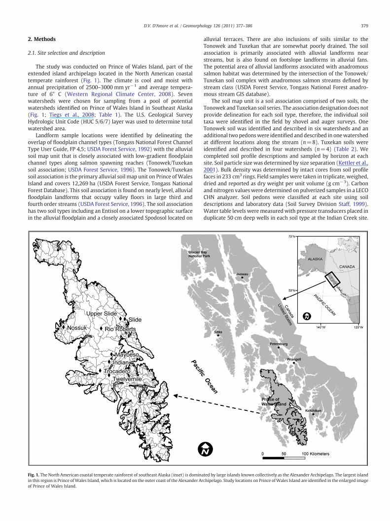
The study was conducted on Prince of Wales Island, part of theextended island archipelago located in the North American coastaltemperate rainforest (Fig. 1). The climate is cool and moist withannual precipitation of 2500–3000 mm yr−1 and average tempera-ture of 6° C (Western Regional Climate Center, 2008). Sevenwatersheds were chosen for sampling from a pool of potentialwatersheds identified on Prince of Wales Island in Southeast Alaska(Fig. 1; Tiegs et al., 2008; Table 1). The U.S. Geological SurveyHydrologic Unit Code (HUC 5/6/7) layer was used to determine totalwatershed area.
Landform sample locations were identified by delineating theoverlap of floodplain channel types (Tongass National Forest ChannelType User Guide, FP 4,5; USDA Forest Service, 1992) with the alluvialsoil map unit that is closely associated with low-gradient floodplainchannel types along salmon spawning reaches (Tonowek/Tuxekansoil association; USDA Forest Service, 1996). The Tonowek/Tuxekansoil association is the primary alluvial soil map unit on Prince ofWalesIsland and covers 12,269 ha (USDA Forest Service, Tongass NationalForest Database). This soil association is found on nearly level, alluvialfloodplain landforms that occupy valley floors in large third andfourth order streams (USDA Forest Service, 1996). The soil associationhas two soil types including an Entisol on a lower topographic surfacein the alluvial floodplain and a closely associated Spodosol located on
Fig. 1. The North American coastal temperate rainforest of southeast Alaska (inset) is dominain this region is Prince ofWales Island, which is located on the outer coast of the Alexander Arof Prince of Wales Island.
alluvial terraces. There are also inclusions of soils similar to theTonowek and Tuxekan that are somewhat poorly drained. The soilassociation is primarily associated with alluvial landforms nearstreams, but is also found on footslope landforms in alluvial fans.The potential area of alluvial landforms associated with anadromoussalmon habitat was determined by the intersection of the Tonowek/Tuxekan soil complex with anadromous salmon streams defined bystream class (USDA Forest Service, Tongass National Forest anadro-mous stream GIS database).
The soil map unit is a soil association comprised of two soils, theTonowek and Tuxekan soil series. The association designation does notprovide delineation for each soil type, therefore, the individual soiltaxa were identified in the field by shovel and auger surveys. OneTonowek soil was identified and described in six watersheds and anadditional two pedonswere identified and described in onewatershedat different locations along the stream (n=8). Tuxekan soils wereidentified and described in four watersheds (n=4) (Table 2). Wecompleted soil profile descriptions and sampled by horizon at eachsite. Soil particle size was determined by size separation (Kettler et al.,2001). Bulk density was determined by intact cores from soil profilefaces in 233 cm3 rings. Field sampleswere taken in triplicate, weighed,dried and reported as dry weight per unit volume (g cm−3). Carbonand nitrogen valueswere determined on pulverized samples in a LECOCHN analyzer. Soil pedons were classified at each site using soildescriptions and laboratory data (Soil Survey Division Staff, 1999).Water table levels weremeasuredwith pressure transducers placed induplicate 50 cm deep wells in each soil type at the Indian Creek site.
ted by large islands known collectively as the Alexander Archipelago. The largest islandchipelago. Study locations on Prince ofWales Island are identified in the enlarged image
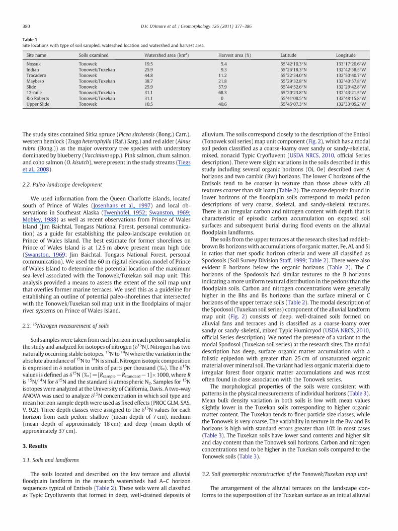
Table 1Site locations with type of soil sampled, watershed location and watershed and harvest area.
Site name Soils examined Watershed area (km2) Harvest area (%) Latitude Longitude
Nossuk Tonowek 19.5 5.4 55°42′10.3″N 133°17′20.6″WIndian Tonowek/Tuxekan 25.9 9.3 55°26′18.3″N 132°42′58.5″WTrocadero Tonowek 44.8 11.2 55°22′34.0″N 132°50′40.7″WMaybeso Tonowek/Tuxekan 38.7 21.8 55°29′32.8″N 132°40′57.8″WSlide Tonowek 25.9 57.9 55°44′52.6″N 132°29′42.8″W12-mile Tonowek/Tuxekan 31.1 68.3 55°20′23.8″N 132°43′21.5″WRio Roberts Tonowek/Tuxekan 31.1 0 55°41′08.5″N 132°48′15.8″WUpper Slide Tonowek 10.5 40.6 55°45′07.3″N 132°33′05.2″W
380 D.V. D'Amore et al. / Geomorphology 126 (2011) 377–386
The study sites contained Sitka spruce (Picea sitchensis (Bong.) Carr.),western hemlock (Tsuga heterophylla (Raf.) Sarg.) and red alder (Alnusrubra (Bong.)) as the major overstory tree species with understorydominated by blueberry (Vaccinium spp.). Pink salmon, chum salmon,and coho salmon (O. kisutch), were present in the study streams (Tiegset al., 2008).
2.2. Paleo-landscape development
We used information from the Queen Charlotte islands, locatedsouth of Prince of Wales (Josenhans et al., 1997) and local ob-servations in Southeast Alaska (Twenhofel, 1952; Swanston, 1969;Mobley, 1988) as well as recent observations from Prince of WalesIsland (Jim Baichtal, Tongass National Forest, personal communica-tion) as a guide for establishing the paleo-landscape evolution onPrince of Wales Island. The best estimate for former shorelines onPrince of Wales Island is at 12.5 m above present mean high tide(Swanston, 1969; Jim Baichtal, Tongass National Forest, personalcommunication). We used the 60 m digital elevation model of Princeof Wales Island to determine the potential location of the maximumsea-level associated with the Tonowek/Tuxekan soil map unit. Thisanalysis provided a means to assess the extent of the soil map unitthat overlies former marine terraces. We used this as a guideline forestablishing an outline of potential paleo-shorelines that intersectedwith the Tonowek/Tuxekan soil map unit in the floodplains of majorriver systems on Prince of Wales Island.
2.3. 15Nitrogen measurement of soils
Soil sampleswere taken fromeachhorizon in eachpedon sampled inthe study and analyzed for isotopes of nitrogen (δ15N). Nitrogen has twonaturally occurring stable isotopes, 15N to 14Nwhere the variation in theabsolute abundanceof 15N to 14N is small. Nitrogen isotopic compositionis expressed in δ notation in units of parts per thousand (‰). The δ15Nvalues is defined as δ15N (‰)=[Rsample−Rstandard−1]×1000, where Ris 15N/14N for δ15N and the standard is atmospheric N2. Samples for 15Nisotopeswere analyzed at the University of California, Davis. A two-wayANOVA was used to analyze δ15N concentration in which soil type andmean horizon sample depthwere used as fixed effects (PROCGLM, SAS,V. 9.2). Three depth classes were assigned to the δ15N values for eachhorizon from each pedon: shallow (mean depth of 7 cm), medium(mean depth of approximately 18 cm) and deep (mean depth ofapproximately 37 cm).
3. Results
3.1. Soils and landforms
The soils located and described on the low terrace and alluvialfloodplain landform in the research watersheds had A–C horizonsequences typical of Entisols (Table 2). These soils were all classifiedas Typic Cryofluvents that formed in deep, well-drained deposits of
alluvium. The soils correspond closely to the description of the Entisol(Tonowek soil series)map unit component (Fig. 2), which has amodalsoil pedon classified as a coarse-loamy over sandy or sandy-skeletal,mixed, nonacid Typic Cryofluvent (USDA NRCS, 2010, official Seriesdescription). There were slight variations in the soils described in thisstudy including several organic horizons (Oi, Oe) described over Ahorizons and two cambic (Bw) horizons. The lower C horizons of theEntisols tend to be coarser in texture than those above with alltextures coarser than silt loam (Table 2). The coarse deposits found inlower horizons of the floodplain soils correspond to modal pedondescriptions of very coarse, skeletal, and sandy-skeletal textures.There is an irregular carbon and nitrogen content with depth that ischaracteristic of episodic carbon accumulation on exposed soilsurfaces and subsequent burial during flood events on the alluvialfloodplain landforms.
The soils from the upper terraces at the research sites had reddish-brown Bs horizons with accumulations of organic matter, Fe, Al, and Siin ratios that met spodic horizon criteria and were all classified asSpodosols (Soil Survey Division Staff, 1999; Table 2). There were alsoevident E horizons below the organic horizons (Table 2). The Chorizons of the Spodosols had similar textures to the B horizonsindicating a more uniform textural distribution in the pedons than thefloodplain soils. Carbon and nitrogen concentrations were generallyhigher in the Bhs and Bs horizons than the surface mineral or Chorizons of the upper terrace soils (Table 2). The modal description ofthe Spodosol (Tuxekan soil series) component of the alluvial landformmap unit (Fig. 2) consists of deep, well-drained soils formed onalluvial fans and terraces and is classified as a coarse-loamy oversandy or sandy-skeletal, mixed Typic Humicryod (USDA NRCS, 2010,official Series description). We noted the presence of a variant to themodal Spodosol (Tuxekan soil series) at the research sites. The modaldescription has deep, surface organic matter accumulation with afolistic epipedon with greater than 25 cm of unsaturated organicmaterial overmineral soil. The variant had less organicmaterial due toirregular forest floor organic matter accumulations and was mostoften found in close association with the Tonowek series.
The morphological properties of the soils were consistent withpatterns in the physical measurements of individual horizons (Table 3).Mean bulk density variation in both soils is low with mean valuesslightly lower in the Tuxekan soils corresponding to higher organicmatter content. The Tuxekan tends to finer particle size classes, whilethe Tonowek is very coarse. The variability in texture in the Bw and Bshorizons is high with standard errors greater than 10% in most cases(Table 3). The Tuxekan soils have lower sand contents and higher siltand clay content than the Tonowek soil horizons. Carbon and nitrogenconcentrations tend to be higher in the Tuxekan soils compared to theTonowek soils (Table 3).
3.2. Soil geomorphic reconstruction of the Tonowek/Tuxekan map unit
The arrangement of the alluvial terraces on the landscape con-forms to the superposition of the Tuxekan surface as an initial alluvial
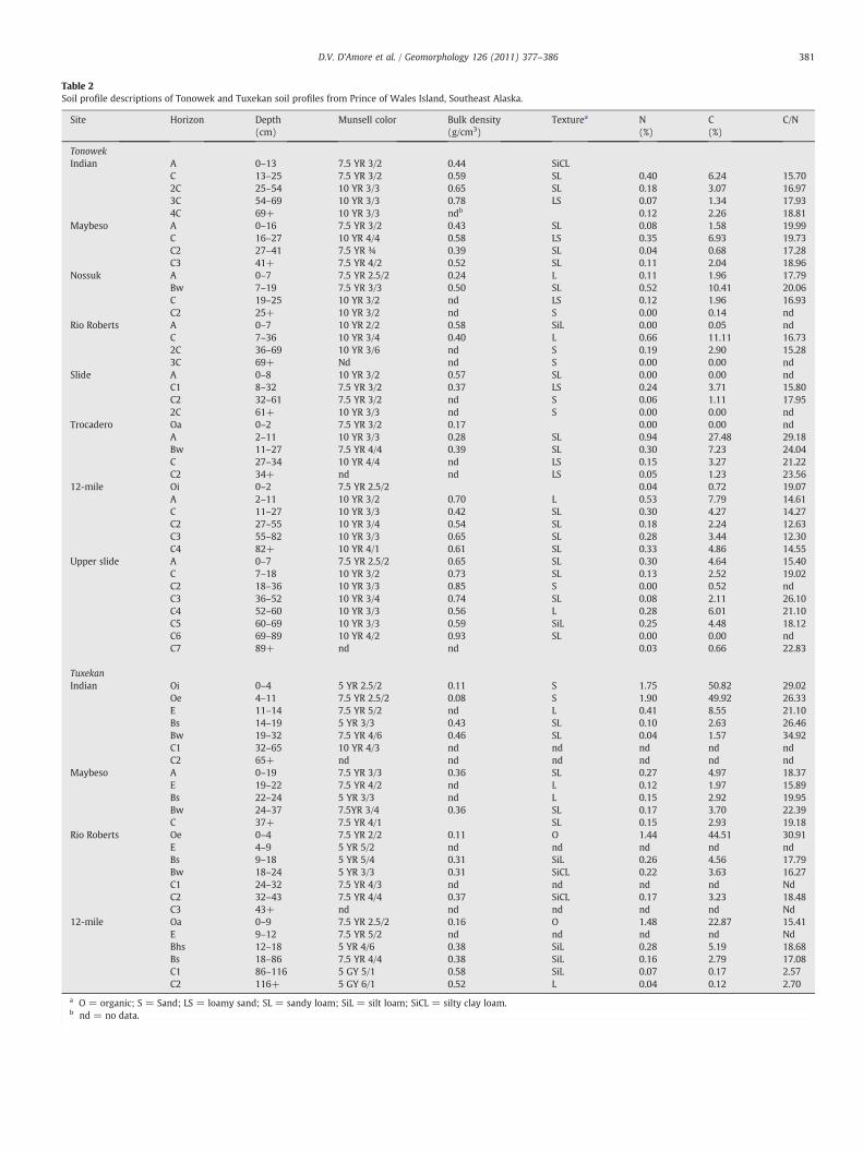
Table 2Soil profile descriptions of Tonowek and Tuxekan soil profiles from Prince of Wales Island, Southeast Alaska.
Site Horizon Depth(cm)
Munsell color Bulk density(g/cm3)
Texturea N(%)
C(%)
C/N
TonowekIndian A 0–13 7.5 YR 3/2 0.44 SiCL
C 13–25 7.5 YR 3/2 0.59 SL 0.40 6.24 15.702C 25–54 10 YR 3/3 0.65 SL 0.18 3.07 16.973C 54–69 10 YR 3/3 0.78 LS 0.07 1.34 17.934C 69+ 10 YR 3/3 ndb 0.12 2.26 18.81
Maybeso A 0–16 7.5 YR 3/2 0.43 SL 0.08 1.58 19.99C 16–27 10 YR 4/4 0.58 LS 0.35 6.93 19.73C2 27–41 7.5 YR ¾ 0.39 SL 0.04 0.68 17.28C3 41+ 7.5 YR 4/2 0.52 SL 0.11 2.04 18.96
Nossuk A 0–7 7.5 YR 2.5/2 0.24 L 0.11 1.96 17.79Bw 7–19 7.5 YR 3/3 0.50 SL 0.52 10.41 20.06C 19–25 10 YR 3/2 nd LS 0.12 1.96 16.93C2 25+ 10 YR 3/2 nd S 0.00 0.14 nd
Rio Roberts A 0–7 10 YR 2/2 0.58 SiL 0.00 0.05 ndC 7–36 10 YR 3/4 0.40 L 0.66 11.11 16.732C 36–69 10 YR 3/6 nd S 0.19 2.90 15.283C 69+ Nd nd S 0.00 0.00 nd
Slide A 0–8 10 YR 3/2 0.57 SL 0.00 0.00 ndC1 8–32 7.5 YR 3/2 0.37 LS 0.24 3.71 15.80C2 32–61 7.5 YR 3/2 nd S 0.06 1.11 17.952C 61+ 10 YR 3/3 nd S 0.00 0.00 nd
Trocadero Oa 0–2 7.5 YR 3/2 0.17 0.00 0.00 ndA 2–11 10 YR 3/3 0.28 SL 0.94 27.48 29.18Bw 11–27 7.5 YR 4/4 0.39 SL 0.30 7.23 24.04C 27–34 10 YR 4/4 nd LS 0.15 3.27 21.22C2 34+ nd nd LS 0.05 1.23 23.56
12-mile Oi 0–2 7.5 YR 2.5/2 0.04 0.72 19.07A 2–11 10 YR 3/2 0.70 L 0.53 7.79 14.61C 11–27 10 YR 3/3 0.42 SL 0.30 4.27 14.27C2 27–55 10 YR 3/4 0.54 SL 0.18 2.24 12.63C3 55–82 10 YR 3/3 0.65 SL 0.28 3.44 12.30C4 82+ 10 YR 4/1 0.61 SL 0.33 4.86 14.55
Upper slide A 0–7 7.5 YR 2.5/2 0.65 SL 0.30 4.64 15.40C 7–18 10 YR 3/2 0.73 SL 0.13 2.52 19.02C2 18–36 10 YR 3/3 0.85 S 0.00 0.52 ndC3 36–52 10 YR 3/4 0.74 SL 0.08 2.11 26.10C4 52–60 10 YR 3/3 0.56 L 0.28 6.01 21.10C5 60–69 10 YR 3/3 0.59 SiL 0.25 4.48 18.12C6 69–89 10 YR 4/2 0.93 SL 0.00 0.00 ndC7 89+ nd nd 0.03 0.66 22.83
TuxekanIndian Oi 0–4 5 YR 2.5/2 0.11 S 1.75 50.82 29.02
Oe 4–11 7.5 YR 2.5/2 0.08 S 1.90 49.92 26.33E 11–14 7.5 YR 5/2 nd L 0.41 8.55 21.10Bs 14–19 5 YR 3/3 0.43 SL 0.10 2.63 26.46Bw 19–32 7.5 YR 4/6 0.46 SL 0.04 1.57 34.92C1 32–65 10 YR 4/3 nd nd nd nd ndC2 65+ nd nd nd nd nd nd
Maybeso A 0–19 7.5 YR 3/3 0.36 SL 0.27 4.97 18.37E 19–22 7.5 YR 4/2 nd L 0.12 1.97 15.89Bs 22–24 5 YR 3/3 nd L 0.15 2.92 19.95Bw 24–37 7.5YR 3/4 0.36 SL 0.17 3.70 22.39C 37+ 7.5 YR 4/1 SL 0.15 2.93 19.18
Rio Roberts Oe 0–4 7.5 YR 2/2 0.11 O 1.44 44.51 30.91E 4–9 5 YR 5/2 nd nd nd nd ndBs 9–18 5 YR 5/4 0.31 SiL 0.26 4.56 17.79Bw 18–24 5 YR 3/3 0.31 SiCL 0.22 3.63 16.27C1 24–32 7.5 YR 4/3 nd nd nd nd NdC2 32–43 7.5 YR 4/4 0.37 SiCL 0.17 3.23 18.48C3 43+ nd nd nd nd nd Nd
12-mile Oa 0–9 7.5 YR 2.5/2 0.16 O 1.48 22.87 15.41E 9–12 7.5 YR 5/2 nd nd nd nd NdBhs 12–18 5 YR 4/6 0.38 SiL 0.28 5.19 18.68Bs 18–86 7.5 YR 4/4 0.38 SiL 0.16 2.79 17.08C1 86–116 5 GY 5/1 0.58 SiL 0.07 0.17 2.57C2 116+ 5 GY 6/1 0.52 L 0.04 0.12 2.70
a O = organic; S = Sand; LS = loamy sand; SL = sandy loam; SiL = silt loam; SiCL = silty clay loam.b nd = no data.
381D.V. D'Amore et al. / Geomorphology 126 (2011) 377–386
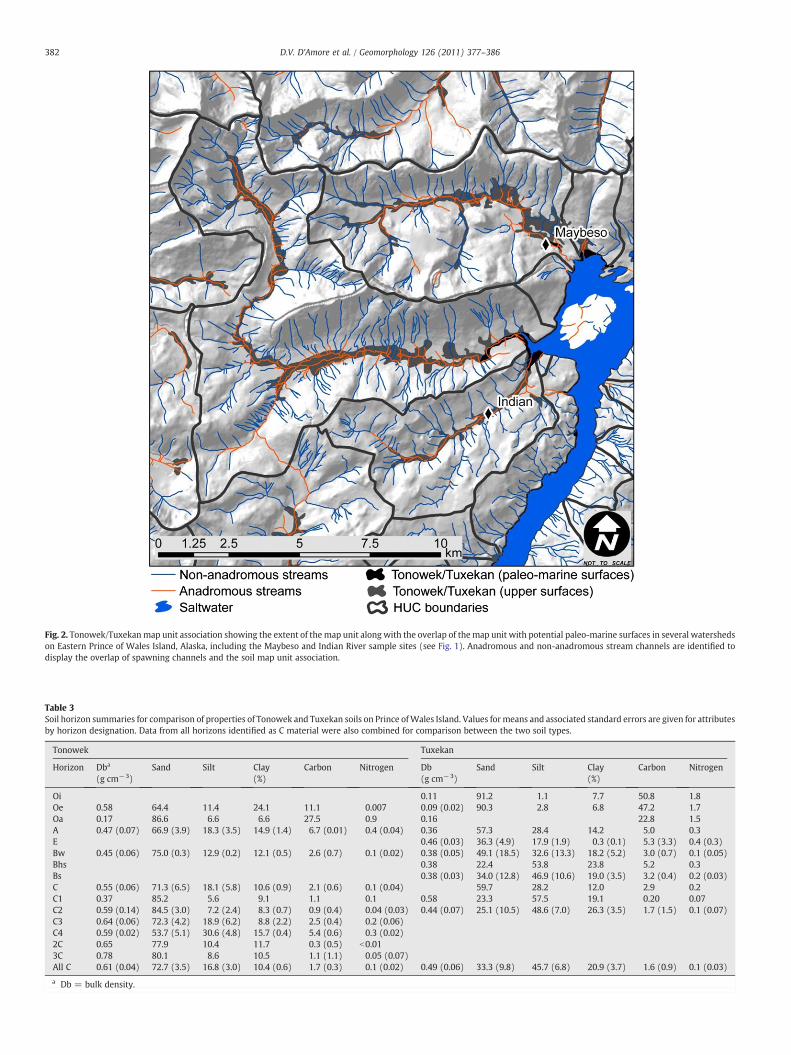
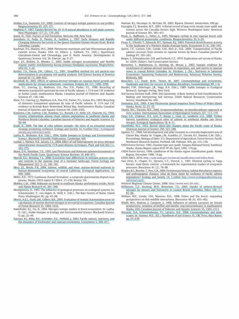
Fig. 2. Tonowek/Tuxekanmap unit association showing the extent of the map unit along with the overlap of themap unit with potential paleo-marine surfaces in several watershedson Eastern Prince of Wales Island, Alaska, including the Maybeso and Indian River sample sites (see Fig. 1). Anadromous and non-anadromous stream channels are identified todisplay the overlap of spawning channels and the soil map unit association.
Table 3Soil horizon summaries for comparison of properties of Tonowek and Tuxekan soils on Prince ofWales Island. Values formeans and associated standard errors are given for attributesby horizon designation. Data from all horizons identified as C material were also combined for comparison between the two soil types.
Tonowek Tuxekan
Horizon Dba
(g cm−3)Sand Silt Clay
(%)Carbon Nitrogen Db
(g cm−3)Sand Silt Clay
(%)Carbon Nitrogen
Oi 0.11 91.2 1.1 7.7 50.8 1.8Oe 0.58 64.4 11.4 24.1 11.1 0.007 0.09 (0.02) 90.3 2.8 6.8 47.2 1.7Oa 0.17 86.6 6.6 6.6 27.5 0.9 0.16 22.8 1.5A 0.47 (0.07) 66.9 (3.9) 18.3 (3.5) 14.9 (1.4) 6.7 (0.01) 0.4 (0.04) 0.36 57.3 28.4 14.2 5.0 0.3E 0.46 (0.03) 36.3 (4.9) 17.9 (1.9) 0.3 (0.1) 5.3 (3.3) 0.4 (0.3)Bw 0.45 (0.06) 75.0 (0.3) 12.9 (0.2) 12.1 (0.5) 2.6 (0.7) 0.1 (0.02) 0.38 (0.05) 49.1 (18.5) 32.6 (13.3) 18.2 (5.2) 3.0 (0.7) 0.1 (0.05)Bhs 0.38 22.4 53.8 23.8 5.2 0.3Bs 0.38 (0.03) 34.0 (12.8) 46.9 (10.6) 19.0 (3.5) 3.2 (0.4) 0.2 (0.03)C 0.55 (0.06) 71.3 (6.5) 18.1 (5.8) 10.6 (0.9) 2.1 (0.6) 0.1 (0.04) 59.7 28.2 12.0 2.9 0.2C1 0.37 85.2 5.6 9.1 1.1 0.1 0.58 23.3 57.5 19.1 0.20 0.07C2 0.59 (0.14) 84.5 (3.0) 7.2 (2.4) 8.3 (0.7) 0.9 (0.4) 0.04 (0.03) 0.44 (0.07) 25.1 (10.5) 48.6 (7.0) 26.3 (3.5) 1.7 (1.5) 0.1 (0.07)C3 0.64 (0.06) 72.3 (4.2) 18.9 (6.2) 8.8 (2.2) 2.5 (0.4) 0.2 (0.06)C4 0.59 (0.02) 53.7 (5.1) 30.6 (4.8) 15.7 (0.4) 5.4 (0.6) 0.3 (0.02)2C 0.65 77.9 10.4 11.7 0.3 (0.5) b0.013C 0.78 80.1 8.6 10.5 1.1 (1.1) 0.05 (0.07)All C 0.61 (0.04) 72.7 (3.5) 16.8 (3.0) 10.4 (0.6) 1.7 (0.3) 0.1 (0.02) 0.49 (0.06) 33.3 (9.8) 45.7 (6.8) 20.9 (3.7) 1.6 (0.9) 0.1 (0.03)
a Db = bulk density.
382 D.V. D'Amore et al. / Geomorphology 126 (2011) 377–386
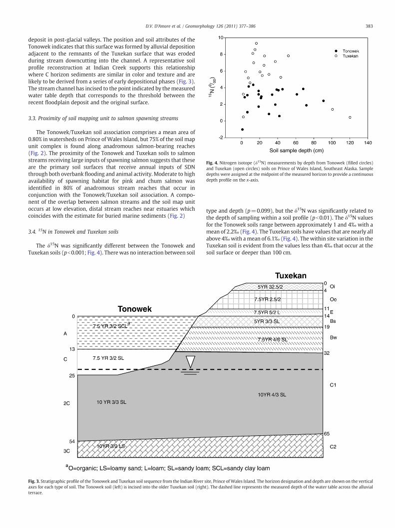
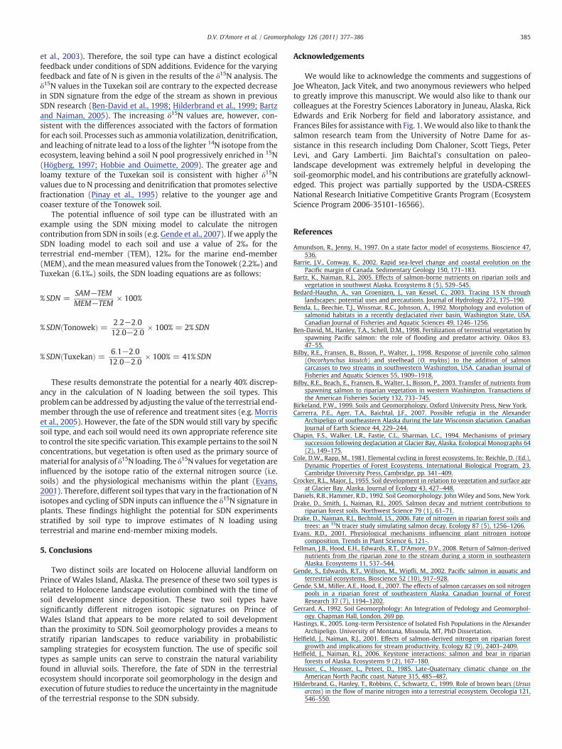
Fig. 4. Nitrogen isotope (δ15N) measurements by depth from Tonowek (filled circles)and Tuxekan (open circles) soils on Prince of Wales Island, Southeast Alaska. Sampledepths were assigned at the midpoint of the measured horizon to provide a continuousdepth profile on the x-axis.
383D.V. D'Amore et al. / Geomorphology 126 (2011) 377–386
deposit in post-glacial valleys. The position and soil attributes of theTonowek indicates that this surface was formed by alluvial depositionadjacent to the remnants of the Tuxekan surface that was erodedduring stream downcutting into the channel. A representative soilprofile reconstruction at Indian Creek supports this relationshipwhere C horizon sediments are similar in color and texture and arelikely to be derived from a series of early depositional phases (Fig. 3).The stream channel has incised to the point indicated by themeasuredwater table depth that corresponds to the threshold between therecent floodplain deposit and the original surface.
3.3. Proximity of soil mapping unit to salmon spawning streams
The Tonowek/Tuxekan soil association comprises a mean area of0.80% in watersheds on Prince ofWales Island, but 75% of the soil mapunit complex is found along anadromous salmon-bearing reaches(Fig. 2). The proximity of the Tonowek and Tuxekan soils to salmonstreams receiving large inputs of spawning salmon suggests that theseare the primary soil surfaces that receive annual inputs of SDNthrough both overbank flooding and animal activity. Moderate to highavailability of spawning habitat for pink and chum salmon wasidentified in 80% of anadromous stream reaches that occur inconjunction with the Tonowek/Tuxekan soil association. A compo-nent of the overlap between salmon streams and the soil map unitoccurs at low elevation, distal stream reaches near estuaries whichcoincides with the estimate for buried marine sediments (Fig. 2)
3.4. 15N in Tonowek and Tuxekan soils
The δ15N was significantly different between the Tonowek andTuxekan soils (pb0.001; Fig. 4). Therewas no interaction between soil
Fig. 3. Stratigraphic profile of the Tonowek and Tuxekan soil sequence from the Indian River saxes for each type of soil. The Tonowek soil (left) is incised into the older Tuxekan soil (righterrace.
type and depth (p=0.099), but the δ15N was significantly related tothe depth of sampling within a soil profile (pb0.01). The δ15N valuesfor the Tonowek soils range between approximately 1 and 4‰ with amean of 2.2‰ (Fig. 4). The Tuxekan soils have values that are nearly allabove 4‰with amean of 6.1‰ (Fig. 4). Thewithin site variation in theTuxekan soil is evident from the values less than 4‰ that occur at thesoil surface or deeper than 100 cm.
ite, Prince ofWales Island. The horizon designation and depth are shown on the verticalt). The dashed line represents the measured depth of the water table across the alluvial

384 D.V. D'Amore et al. / Geomorphology 126 (2011) 377–386
4. Discussion
4.1. A soil geomorphic model for Holocene alluvial landforms
A preliminary soil geomorphic model of alluvial landforms on Princeof Wales Island can be derived from paleo-landscape research fromSoutheast Alaska, British Columbia andWashington State. The landscapeposition and description of the Tonowek and Tuxekan soils is similar tothe Holocene terraces in Washington State, which formed through acombination of tectonic and erosional forces during the Pleistocene andHolocene (Pazzaglia and Brandon, 2001; Benda et al., 1992). TheNorthern Pacific Coast, including the mainland fringe and islandarchipelago of Southeast Alaska and British Columbia, was subject tolarge continental ice-sheets that extended from the mainland to theouter coastal islands (Mann and Hamilton, 1995). The retreat of glacialice in Southeast Alaskawas rapid in the late-Pleistocene, andmost of thePrince of Wales Island was ice-free as early as 12,000 14C years beforepresent (ybp) (Mann and Hamilton, 1995; Carrerra et al., 2007). Thedeposition of alluvium along low-gradient stream channels driven byerosion and transport of sediment from high-gradient streams likelyformed the primary alluvial terrace in the HUC 5, 6, and 7 classwatersheds onPrince ofWales Island. TheTuxekansoils are composedofsilt-loam material over gravelly sands and most likely formed in thedeposits from early Holocene alluvial deposition.
We speculate that the Tuxekan soils located on the upper terracestabilized approximately 6500 14C ybp due to evidence from paleo-shoreline reconstructions of post-glacial isostatic adjustment andequilibrium with sea level. Evidence from shell bed deposits in fjordsand uplifted estuaries has calibrated the maximum post-glacial sea-level rise at approximately 8500 14C ybp on Prince of Wales Island(Swanston, 1969; Josenhans et al., 1997; Hastings, 2005). Sea-levelrise equilibrated with uplift approximately 6500 14C ybp leading tostable river and estuarine systems on Prince of Wales Island(Josenhans et al., 1997; Hastings, 2005). The major rivers of PrinceofWales Islandmost likely began a period of downcutting through theprimary alluvial surface (Tuxekan) and established a new alluvialsurface (Tonowek) after 6500 14C ybp. Cooler conditions, snowaccumulation and increased rainfall in the mid-Holocene (Heusseret al., 1985) promoted a period of less vigorous erosion and sed-imentation that formed the low terraces and floodplains (Tonoweksoils) during themid to late Holocene. Therefore, we conclude that theTuxekan surface has been stable for approximately 6000 years, whilethe Tonowek surface has been subject to channel altering forces suchas flooding and debris jams from the mid- to late Holocene. Theseconclusions are supported by the degree of soil development in theTuxekan soils compared to the Tonowek soils. The accumulation oforganic material and podzolization in the Tuxekan soils would nothave been possible unless the alluvial landform was stable. Further,the lack of evidence for soils on multiple terraces confirms that thelandscape stabilized shortly after the Tuxekan terrace was abandoned.
4.2. Evidence and rationale for a paleo-estuary landform designation
There is evidence for a potential distinction in alluvial landformslocatednear estuaries that formed over glacio-marine deposits in paleo-estuaries fromalluvial surfaces created furtherupstream.Coastal refugiawere formed due to the upward crustal displacement on the easternpart of Prince ofWales due to crustal depression of the western portionof Prince of Wales similar to the process documented for the QueenCharlotte Islands (Josenhans et al., 1997). Potential coastal refugia havebeen identified on the outer margins of the Alexander archipelago,including Prince of Wales Island, through reconstruction of ice sheetroutes (Josenhans et al., 1997; Kaufman and Manley, 2004; Carrerraet al., 2007). Paleo-estuaries were formed when isostatic rebound wasoutpaced by glacialmeltwater after glacial retreat and lower portions ofthe landscape were inundated from approximately 9700–8500 14C ybp
(Mobley, 1988; Josenhans et al., 1997; Barrie and Conway, 2002). Thepaleo-shoreline associatedwith themaximum sea-level inundation hasbeen calculated to be approximately 12.5 m above the present tide linefor Prince ofWales Island (Jim Baichtal, Forest Service, Tongass NationalForest, unpublished; Hastings, 2005). The presence of seawater in theseestuaries probably deposited glacio-marine sediment similar to theGastineau formation near Juneau, Alaska (Miller, 1973). Glacio-marinesediments form the base level formany stream reaches near estuaries inwatersheds on Prince of Wales Island and other areas throughoutSoutheast Alaska. Isostatic rebound continued from 8500–6500 14C ybpleading to the emergence of the land surface and deposition of alluvialsediment along the lower reaches of the rivers over the glacio-marinesediments. The Tonowek/Tuxekanmapunit overlaps the zones of paleo-estuaries that are now freshwater alluvial stream terraces in manylocations (Fig. 2).
The presence of the paleo-estuarine geomorphic feature presentsthe potential for interaction with the ecological development of thepost-glacial landscape. The Holocene was one of the most dramatictimes of change over the course of salmonid evolution (Waples et al.,2009). Salmon are adapted to systems subject to rapid change, and thevarious modes of stream geomorphic development provided a varietyof habitats for post-glacial stream colonization. The diversity ingeomorphic development of streams and estuaries provided areas forniche differentiation in the post-glacial environment on Prince ofWales Island and paleo-estuaries may have played a role in thedevelopment of salmon populations that are believed to use estuariesas part of their life-history strategy (Koski, 2009). Competition mayalso have been a factor, given the presence of endemic chum salmonthat may have persisted in coastal refugia during the Pleistocene(Kondzela et al., 1994). The use of soil geomorphic methods in thisstudy provides an approach to sub-divide the landscape into discreteunits in order to adequately test the feedback mechanisms that mayhave contributed to the diversity of salmon species that presentlyoccupy watersheds of Prince of Wales Island.
4.3. Use of the soil geomorphorphic template in watershed research
The proposed alluvial soil geomorphicmodel can be used to addressthe soil variability encountered in measurements of terrestrial nutrientcycling associatedwith the deposition of SDN. The natural deposition ofsalmon cannot be easily controlled in observations of SDN nutrientcycles. Spawning salmon are most abundant along floodplain channelswhere salmon biomass is distributed by flooding and bears, but bearsalso feed on salmon at specific locations that may be located several ortens ofmeters beyond the stream edge (Hilderbrand et al., 1999; Gendeet al., 2002; Helfield andNaiman, 2006) creating a high degree of spatialvariability in the deposition of salmon in the riparian zone (Wilkinsonet al., 2005). Identification and delineation of soil types can be used inexperiments and observational studies in riparian zones. Experimentscan be designed to manipulate the application rate of SDN stratifiedacross the Tonowek and Tuxekan soils to determine the fate of nutrientsin both soils and vegetation. Surveys of riparian zones should includesoil delineations that can control sources of natural variation in soilnutrient concentrations and cycling. The varying ages and modes offormation can also be used to potentially calculate loading rates withmore specific studies of soil age. The stable Tuxekan surface hasprovided a template for the distribution and accumulation of SDN overthe latter half of the Holocene, while the Tonowek soil has been subjectto frequent disturbance.
4.4. Soil geomorphic feedbacks to SDN: A specific example using δ15N
Internal N cycling dynamics within an ecosystem can have equal orgreater effects on the stable isotope signature of N in soils and plants.Moreover, the size and composition of various soil N pools changesover time periods of ecosystem succession (Cole and Rapp, 1981; Kaye
385D.V. D'Amore et al. / Geomorphology 126 (2011) 377–386
et al., 2003). Therefore, the soil type can have a distinct ecologicalfeedback under conditions of SDN additions. Evidence for the varyingfeedback and fate of N is given in the results of the δ15N analysis. Theδ15N values in the Tuxekan soil are contrary to the expected decreasein SDN signature from the edge of the stream as shown in previousSDN research (Ben-David et al., 1998; Hilderbrand et al., 1999; Bartzand Naiman, 2005). The increasing δ15N values are, however, con-sistent with the differences associated with the factors of formationfor each soil. Processes such as ammonia volatilization, denitrification,and leaching of nitrate lead to a loss of the lighter 14N isotope from theecosystem, leaving behind a soil N pool progressively enriched in 15N(Högberg, 1997; Hobbie and Ouimette, 2009). The greater age andloamy texture of the Tuxekan soil is consistent with higher δ15Nvalues due to N processing and denitrification that promotes selectivefractionation (Pinay et al., 1995) relative to the younger age andcoaser texture of the Tonowek soil.
The potential influence of soil type can be illustrated with anexample using the SDN mixing model to calculate the nitrogencontribution from SDN in soils (e.g. Gende et al., 2007). If we apply theSDN loading model to each soil and use a value of 2‰ for theterrestrial end-member (TEM), 12‰ for the marine end-member(MEM), and themeanmeasured values from the Tonowek (2.2‰) andTuxekan (6.1‰) soils, the SDN loading equations are as follows:
% SDN =SAM−TEMMEM−TEM
× 100%
% SDN Tonowekð Þ = 2:2−2:012:0−2:0
× 100% = 2% SDN
% SDN Tuxekanð Þ = 6:1−2:012:0−2:0
× 100% = 41% SDN
These results demonstrate the potential for a nearly 40% discrep-ancy in the calculation of N loading between the soil types. Thisproblem can be addressed by adjusting the value of the terrestrial end-member through the use of reference and treatment sites (e.g. Morriset al., 2005). However, the fate of the SDN would still vary by specificsoil type, and each soil would need its own appropriate reference siteto control the site specific variation. This example pertains to the soil Nconcentrations, but vegetation is often used as the primary source ofmaterial for analysis of δ15N loading. The δ15N values for vegetation areinfluenced by the isotope ratio of the external nitrogen source (i.e.soils) and the physiological mechanisms within the plant (Evans,2001). Therefore, different soil types that vary in the fractionation of Nisotopes and cycling of SDN inputs can influence the δ15N signature inplants. These findings highlight the potential for SDN experimentsstratified by soil type to improve estimates of N loading usingterrestrial and marine end-member mixing models.
5. Conclusions
Two distinct soils are located on Holocene alluvial landform onPrince of Wales Island, Alaska. The presence of these two soil types isrelated to Holocene landscape evolution combined with the time ofsoil development since deposition. These two soil types havesignificantly different nitrogen isotopic signatures on Prince ofWales Island that appears to be more related to soil developmentthan the proximity to SDN. Soil geomorphology provides a means tostratify riparian landscapes to reduce variability in probabilisticsampling strategies for ecosystem function. The use of specific soiltypes as sample units can serve to constrain the natural variabilityfound in alluvial soils. Therefore, the fate of SDN in the terrestrialecosystem should incorporate soil geomorphology in the design andexecution of future studies to reduce the uncertainty in themagnitudeof the terrestrial response to the SDN subsidy.
Acknowledgements
We would like to acknowledge the comments and suggestions ofJoe Wheaton, Jack Vitek, and two anonymous reviewers who helpedto greatly improve this manuscript. We would also like to thank ourcolleagues at the Forestry Sciences Laboratory in Juneau, Alaska, RickEdwards and Erik Norberg for field and laboratory assistance, andFrances Biles for assistancewith Fig. 1. Wewould also like to thank thesalmon research team from the University of Notre Dame for as-sistance in this research including Dom Chaloner, Scott Tiegs, PeterLevi, and Gary Lamberti. Jim Baichtal's consultation on paleo-landscape development was extremely helpful in developing thesoil-geomorphic model, and his contributions are gratefully acknowl-edged. This project was partially supported by the USDA-CSREESNational Research Initiative Competitive Grants Program (EcosystemScience Program 2006-35101-16566).
References
Amundson, R., Jenny, H., 1997. On a state factor model of ecosystems. Bioscience 47,536.
Barrie, J.V., Conway, K., 2002. Rapid sea-level change and coastal evolution on thePacific margin of Canada. Sedimentary Geology 150, 171–183.
Bartz, K., Naiman, R.J., 2005. Effects of salmon-borne nutrients on riparian soils andvegetation in southwest Alaska. Ecosystems 8 (5), 529–545.
Bedard-Haughn, A., van Groenigen, J., van Kessel, C., 2003. Tracing 15 N throughlandscapes: potential uses and precautions. Journal of Hydrology 272, 175–190.
Benda, L., Beechie, T.J., Wissmar, R.C., Johnson, A., 1992. Morphology and evolution ofsalmonid habitats in a recently deglaciated river basin, Washington State, USA.Canadian Journal of Fisheries and Aquatic Sciences 49, 1246–1256.
Ben-David, M., Hanley, T.A., Schell, D.M., 1998. Fertilization of terrestrial vegetation byspawning Pacific salmon: the role of flooding and predator activity. Oikos 83,47–55.
Bilby, R.E., Fransen, B., Bisson, P., Walter, J., 1998. Response of juvenile coho salmon(Oncorhynchus kisutch) and steelhead (O. mykiss) to the addition of salmoncarcasses to two streams in southwestern Washington, USA. Canadian Journal ofFisheries and Aquatic Sciences 55, 1909–1918.
Bilby, R.E., Beach, E., Fransen, B., Walter, J., Bisson, P., 2003. Transfer of nutrients fromspawning salmon to riparian vegetation in western Washington. Transactions ofthe American Fisheries Society 132, 733–745.
Birkeland, P.W., 1999. Soils and Geomorphology. Oxford University Press, New York.Carrerra, P.E., Ager, T.A., Baichtal, J.F., 2007. Possible refugia in the Alexander
Archipeligo of southeastern Alaska during the late Wisconsin glaciation. CanadianJournal of Earth Science 44, 229–244.
Chapin, F.S., Walker, L.R., Fastie, C.L., Sharman, L.C., 1994. Mechanisms of primarysuccession following deglaciation at Glacier Bay, Alaska. Ecological Monographs 64(2), 149–175.
Cole, D.W., Rapp, M., 1981. Elemental cycling in forest ecosystems. In: Reichle, D. (Ed.),Dynamic Properties of Forest Ecosystems. International Biological Program, 23.Cambridge University Press, Cambridge, pp. 341–409.
Crocker, R.L., Major, J., 1955. Soil development in relation to vegetation and surface ageat Glacier Bay. Alaska. Journal of Ecology 43, 427–448.
Daniels, R.B., Hammer, R.D., 1992. Soil Geomorphology. JohnWiley and Sons, New York.Drake, D., Smith, J., Naiman, R.J., 2005. Salmon decay and nutrient contributions to
riparian forest soils. Northwest Science 79 (1), 61–71.Drake, D., Naiman, R.J., Bechtold, J.S., 2006. Fate of nitrogen in riparian forest soils and
trees: an 15N tracer study simulating salmon decay. Ecology 87 (5), 1256–1266.Evans, R.D., 2001. Physiological mechanisms influencing plant nitrogen isotope
composition. Trends in Plant Science 6, 121-.Fellman, J.B., Hood, E.H., Edwards, R.T., D'Amore, D.V., 2008. Return of Salmon-derived
nutrients from the riparian zone to the stream during a storm in southeasternAlaska. Ecosystems 11, 537–544.
Gende, S., Edwards, R.T., Willson, M., Wipfli, M., 2002. Pacific salmon in aquatic andterrestrial ecosystems. Bioscience 52 (10), 917–928.
Gende, S.M., Miller, A.E., Hood, E., 2007. The effects of salmon carcasses on soil nitrogenpools in a riparian forest of southeastern Alaska. Canadian Journal of ForestResearch 37 (7), 1194–1202.
Gerrard, A., 1992. Soil Geomorphology: An Integration of Pedology and Geomorphol-ogy. Chapman Hall, London. 269 pp.
Hastings, K., 2005. Long-term Persistence of Isolated Fish Populations in the AlexanderArchipeligo. University of Montana, Missoula, MT, PhD Dissertation.
Helfield, J., Naiman, R.J., 2001. Effects of salmon-derived nitrogen on riparian forestgrowth and implications for stream productivity. Ecology 82 (9), 2403–2409.
Helfield, J., Naiman, R.J., 2006. Keystone interactions: salmon and bear in riparianforests of Alaska. Ecosystems 9 (2), 167–180.
Heusser, C., Heusser, L., Peteet, D., 1985. Late-Quaternary climatic change on theAmerican North Pacific coast. Nature 315, 485–487.
Hilderbrand, G., Hanley, T., Robbins, C., Schwartz, C., 1999. Role of brown bears (Ursusarctos) in the flow of marine nitrogen into a terrestrial ecosystem. Oecologia 121,546–550.
386 D.V. D'Amore et al. / Geomorphology 126 (2011) 377–386
Hobbie, E.A., Ouimette, A.P., 2009. Controls of nitrogen isotope patterns in soil profiles.Biogeochemistry 95, 355–371.
Högberg, P., 1997. Tansley Review No. 95 15 N natural abundance in soil-plant systems.New Phytologist 137 (2), 179–203.
Jenny, H., 1941. Factors of Soil Formation. McGraw-Hill, New York.Josenhans, H., Fedje, D., Pienitz, R., Southon, J., 1997. Early Humans and Rapidly
Changing Holocene Sea Levels in the Queen Charlotte Islands-Hecate Strait. BritishColumbia, Canada.
Kaufman, D.S., Manley, W.F., 2004. Pleistocene maximum and late Wisconsinan glacierextents across Alaska, USA. In: Ehlers, J., Gibbard, P.L. (Eds.), QuartenaryGlaciations-Extent and Chronology, part II, North America: Developments inQuaternary Science, Vol. 2b. Elsevier, pp. 9–27.
Kaye, J.P., Binkley, D., Rhodes, C., 2003. Stable nitrogen accumulation and flexibleorganic matter stoichiometry during primary floodplain succession. Biogeochem-istry 63, 1–22.
Kettler, T.A., Doran, J.W., Gilbert, T.L., 2001. Simplified method for soil particle-sizedetermination to accompany soil-quality analyses. Soil Science Society of AmericaJournal 65 (3), 849–852.
Kirchhoff, M., 2003. Effects of salmon-derived nitrogen on riparian forest growth andimplications for stream productivity: comment. Ecology 84 (12), 3396–3399.
Kline, T.C., Goering, J.J., Mathisen, O.A., Poe, P.H., Parker, P.L., 1990. Recycling ofelements transported upstream by runs of Pacific salmon: I. 15 N and 13C evidencein Sashin Creek, southeastern Alaska. Canadian Journal of Fisheries and AquaticSciences 47, 136–144.
Kline, T.C., Goering, J.J., Mathisen, O.A., Poe, P.H., Parker, P.L., Scalan, R.S., 1993. Recyclingof elements transported upstream by runs of Pacific salmon: II. 15 N and 13Cevidence in Kvichak River Watershed, Bristol Bay, Southwestern Alaska. CanadianJournal of Fisheries and Aquatic Sciences 50, 2350–2365.
Kondzela, C.M., Guthrie, C.M., Hawkins, S.L., Russell, C.D., Helle, J.H., Gharrett, A.J., 1994.Genetic relationships among chum salmon populations in southeast Alaska andNorthern British Columbia. Canadian Journal of Fisheries and Aquatic Sciences 51,50–64.
Koski, K., 2009. The fate of coho salmon nomads: the story of an estuarine-rearingstrategy promoting resilience. Ecology and Society 14, 4 online http://ecologyandsociety.org/vol14/iss1/art4/.
Lajtha, K., Michener, R.H. (Eds.), 1994. Stable Isotopes in Ecology and EnvironmentalScience. Blackwell Scientific Publications, Cambridge, MA.
Luxhøi, J., Nielsen, N.E., Jensen, L.S., 2004. Effect of soil heterogeneity on gross nitrogenmineralization measured by 15 N-pool dilution techniques. Plant and Soil 262 (1),263–275.
Mann, D.H., Hamilton, T.D., 1995. Late Pleistocene and Holocene paleoenvioronments ofthe North Pacific Coast. Quaternary Science Reviews 14, 449–471.
Merrill, A.G., Benning, T.L., 2006. Ecosystem type differences in nitrogen process ratesand controls in the riparian zone of a montane landscape. Forest Ecology andManagement 222 (1–3), 145–161.
Merz, J.E., Moyle, P.B., 2006. Salmon, wildlife, and wine: marine-derived nutrients inhuman-dominated ecosystems of central California. Ecological Applications 16,999–1009.
Miller, R.D., 1973. Gastineau channel formation: a composite glaciomarine deposit nearJuneau, Alaska. USGS report B 1394-C. C1-C20, Reston, VA.
Mobley, C.M., 1988. Holocene sea levels in southeast Alaska: preliminary results. Arcticand Alpine Research 41, 261–266.
Montgomery, D., 1997. The influence of geological processes on ecological systems. In:Schoonmaker, P., von Hagen, B., Wolf, E. (Eds.), The Rain Forests of Home. IslandPress, Washington DC, pp. 43–68.
Morris, A.E.L., Stark, J.M., Gilbert, B.K., 2005. Evaluation of isotopic fractionation error oncalculations of marine-derived nitrogen in terrestrial ecosystems. Canadian Journalof Forest Research 35, 1604–1616.
Nadelhofer, K.J., Fry, B., 1994. Nitrogen isotope studies in forest ecosystems. In: Lajtha,K. (Ed.), Stable Isotopes in Ecology and Environmental Science. Blackwell Science,O, pp. 22–44.
Naiman, R.J., Bilby, R.E., Schindler, D.E., Helfield, J., 2002. Pacific salmon, nutrients, andthe dynamics of freshwater and riparian ecosystems. Ecosystems 5, 399–417.
Naiman, R.J., Decamps, H., McClain, M., 2005. Riparia. Elsevier, Amsterdam. 430 pp.Pazzaglia, F.J., Brandon, M.T., 2001. A fluvial record of long-term steady-state uplift and
erosion across the Cascadia forearc high, Western Washington State. AmericanJournal of Science 301, 385–431.
Pinay, G., Ruffinoni, C., Fabre, A., 1995. Nitrogen cycling in two riparian forest soilsunder different geomorphic conditions. Biogeochemistry 30, 9–29.
Pinay, G., O'keefe, T., Edwards, R.T., Naiman, R.J., 2003. Potential denitrification activityin the landscape of a Western Alaska drainage basin. Ecosystems 6 (4), 336–343.
Quinn, T.P., Carlson, S.M., Gende, S.M., Rich Jr., H.B., 2009. Transportation of Pacificsalmon carcasses from streams to riparian forests by bears. Canadian Journal ofZoology 87, 195–203.
Reiger, S., Schoephorster, D.B. and Furbush, C.E., 1979. Exploratory soil survey of Alaska.In: USDA (Editor). Soil Conservation Service.
Reimchen, T., Mathewson, D., Hocking, M., Moran, J., 2003. Isotopic evidence forenrichment of salmon-derived nutrients in vegetation, soil, and insects in riparianzones in coastal British Columbia. In: Stockner, J. (Ed.), Nutrients in SalmonidEcosystems: Sustaining Production and Biodiversity. American Fisheries Society,Bethesda, MD.
Renschler, C.S., Doyle, M.W., Thoms, M., 2007. Geomorphology and ecosystems:challenges and keys for success in bridging disciplines. Geomorphology 89, 1–8.
Rundel, P.W., Ehleringer, J.R., Nagy, K.A. (Eds.), 1989. Stable Isotopes in EcologicalResearch. Springer-Verlag, New York.
Soil Survey Division Staff, 1999. Soil Taxonomy: A Basic System of Soil Classification forMaking and Interpreting Soil Surveys. USDA Natural Resources ConservationService, Handbook No. 436.
Swanston, D.N., 1969. A late-Pleistocene glacial sequence from Prince of Wales Island,Alaska. Arctic 22, 25–33.
Thoms, M.C., Parsons, M.E., 2002. Ecogeomorphology: an interdisciplinary approach toriver science. International Association of Hydrological Sciences 227, 113–119.
Tiegs, S.D., Chaloner, D.T., Levi, P., Ruegg, J., Tank, J.L., Lamberti, G.A., 2008. Timberharvest transforms ecological roles of salmon in southeast Alaska rain foreststreams. Ecological Applications 18, 4–11.
Twenhofel, W.S., 1952. Recent shore-line changes along the Pacific coast of Alaska.American Journal of Science 250, 523–548.
Ugolini, F.C., 1968. Soil development and alder invasion in a recently deglaciated area ofGlacier Bay, Alaska. In: Trappe, J.M., Franklin, J.F., Tarrant, R.F., Hansen, G.M. (Eds.),Proceedings, Biology of Alder. U.S. Department of Agriculture, Forest Service, PacificNorthwest Research Station, Portland, OR, Pullman, WA, pp. 115–139.
USDA Forest Service, 1992. Channel type user guide, Tongass National Forest, SoutheastAlaska. Alaska Region report R10-TP-26, April, 1992. 179 pp.
USDA Forest Service, 1996. Landforms of the Alaska region classification guide. AlaskaRegion, December 1996. 74 pp.
USDA NRCS, 2010. http://soils.usda.gov/technical/classification/osd/index.html.Van Cleve, K., Chapin, F.I., Dyrness, C.T., Viereck, L., 1991. Element cycling in Taiga
forests: state-factor control; a framework for experimental studies of ecosystemprocesses. Bioscience 41 (2), 78–88.
Waples, R.S., Beechie, T., Pess, G.R., 2009. Evolutionaryhistory, habitatdisturbance regimes,and anthropogenic changes: what do these mean for resilience of Pacific salmonpopulations? Ecology and Society 14, 3 online http://www.ecologyandsociety.org/vol14/iss1/art3/.
Western Regional Climate Center, 2008. http://www.wrcc.dri.edu/.Wilkinson, C.E., Hocking, M.D., Reimchen, T.E., 2005. Uptake of salmon-derived
nitrogen by mosses and liverworts in coastal British Columbia. Oikos 108 (1),85–98.
Willson, M.F., Gende, S.M., Marston, B.H., 1998. Fishes and the forest: expandingperspectives on fish-wildlife interactions. Bioscience 48 (6), 455–462.
Wipfli, M.S., Hudson, J., Caouette, J., 1998. Influence of salmon carcasses on streamproductivity: response of biofilm and benthic macroinvertebrates in southeasternAlaska, USA. Canadian Journal of Fisheries and Aquatic Sciences 55, 1503–1511.
Wysocki, D.A., Schoenenberger, P.J., LaGarry, H.E., 2000. Geomorphology and land-scapes. In: Sumner, M.E. (Ed.), Handbook of Soil Science. FL, CRC Press, Boca Raton,pp. E5–E39.
Related Documents