Hodgens Engineering Service “Treating others the way we like to be treated” Monday, October 06, 2014 Via email: [email protected] Ms. Amy Koenig Corporate Counsel; Black Hills Corporation PO Box 1400 Rapid City, SD 57709-1400 RE: EL14-061 BHP 230kV Transmission Line; Hodgens comments and previous communications; BHP Definition of "Final Route" 1. Please accept my apologies for my comments dated 10/2/2014 regarding BHP response to Ms Leonard with proposed alignment renditions. My observations appear to have been incorrect, in part. The provided renditions failed to include an area map showing the proposed alignments: I did not understand their location correctly. An interested party has responded to my email and provided the following figure. It indicates that except for the incorrect depiction of trees to be removed in the right of way, the renditions do appear to accurately locate poles along the proposed alignment. The renditions still fail to reflect tree removal that would result from both proposed alignments. (Please note that even though the Route Modification in Figure 1 has a label similar to that used in my suggested alignment ("J"), it is not the alignment I suggested, nor one which has been demonstrated to be acceptable to me.) Figure 1 - Public Meeting handout showing proposed alignments dated 6-27-2014 (Not found in PUC public records.) 1112 Wild Life Rd, Rapid City, SD 57702 "Treating others the way we would like to be treated."

Hodgens Engineering Service...Hodgens Engineering Service “Treating others the way we like to be treated” Three page email to: [email protected]
Dec 03, 2020
Welcome message from author
This document is posted to help you gain knowledge. Please leave a comment to let me know what you think about it! Share it to your friends and learn new things together.
Transcript
Hodgens Engineering Service “Treating others the way we like to be treated”
Monday, October 06, 2014
Via email: [email protected] Ms. Amy Koenig Corporate Counsel; Black Hills Corporation PO Box 1400 Rapid City, SD 57709-1400 RE: EL14-061 BHP 230kV Transmission Line; Hodgens comments and previous communications;
BHP Definition of "Final Route"
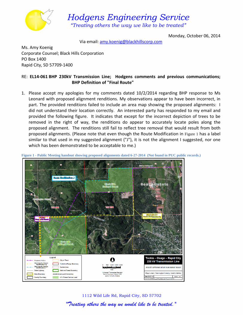
1. Please accept my apologies for my comments dated 10/2/2014 regarding BHP response to Ms Leonard with proposed alignment renditions. My observations appear to have been incorrect, in part. The provided renditions failed to include an area map showing the proposed alignments: I did not understand their location correctly. An interested party has responded to my email and provided the following figure. It indicates that except for the incorrect depiction of trees to be removed in the right of way, the renditions do appear to accurately locate poles along the proposed alignment. The renditions still fail to reflect tree removal that would result from both proposed alignments. (Please note that even though the Route Modification in Figure 1 has a label similar to that used in my suggested alignment ("J"), it is not the alignment I suggested, nor one which has been demonstrated to be acceptable to me.)
Figure 1 - Public Meeting handout showing proposed alignments dated 6-27-2014 (Not found in PUC public records.)
1112 Wild Life Rd, Rapid City, SD 57702
"Treating others the way we would like to be treated."

Comments on BHP Responses 10/6/2014
2. The BHP response to PUC First Data Request Dated 8-21-2014, Attachment 18 Page 2 Proposed centerline dated 9-5-2014 conflicts with alignment depicted in Attachment 5.4 identified as "Final Route" dated 10-3-2014. [Note that the transmittal of Attachment 5.4 references SDPUC Request No. 5. It may be the case that this was intended to be Request No. 1, Item 5?]
3. PUC First Data Request Dated 8-21-2014 Item 28 requests "Please provide a list of any known private landowner concerns and the Applicant’s plan to address those concerns."
Response to SDPUC Request No. 28 dated 9-17-2014: "Black Hills Power has identified several primary areas of concern.
"Sun Ridge Road area: proximity to homes, values, noise, health. Several alternative routes have been analyzed in this location in an effort to alleviate those concerns. While every effort is being made to minimize potential impacts to landowners in this location, it is not possible to completely avoid impacts to private property. Black Hills Power will continue to work with these landowners to define a route that will minimize impacts."
To date, I have not received any direct communication from BHP on my comments offered regarding impacts and proposed alternative alignments dated 8-19-2014 and 5-9-2014. I now see that as of 10-2-2014, posted to the PUC site, is a "Final Route" that is unresponsive to my comments and has not attempted to address those concerns. See Figure 2.
Figure 2 - Excerpt from 10-1-2014 Final Route Page 2/15
BHP represents that they will continue to define a route that will minimize impacts. In light of the absence of communications, I do not believe this to be an accurate representation.
[email protected] 1112 Wild Life Rd, Rapid City, SD 57702 605-350-4367
"Treating others the way we would like to be treated."

Comments on BHP Responses 10/6/2014
As my comments do not appear to be found on the PUC Filed Documents list, I have attached comments dated 8-19-2014 and 5-9-2014 for the record.
Not previously identified in my comments is the fact that one of the main considerations in the purchase of our home in Ponderosa Pines Subdivision is its proximity to Black Hills National Forest. While the proposed alignments do not cross my personal property, they impact the property that I own as a citizen of the United States: Black Hills National Forest. The National Forest location adjacent to our subdivision permits unfettered hiking access to the Forest at its point closest to Rapid City. This proximity permits hiking to the Forest from my doorstep via a short hike up the public road. This, and other considerations, made this home unique in the Rapid City housing market. The presence of a transmission line, in an area where even domestic electric service wires are not overhead, is a significant impact. Absence of overhead service wires in the subdivision figured in the decision to purchase this home as well.
The proposed "Final Route" alignment will still denude the woods proximate to Sun Ridge Road and the National Forest to the tune of 100-125 feet for right of way clearance. This most recent "Final Route" crosses a public road, which while not having a direct affect on taxable assessment of the public conveyance, does adversely impact views, function and enjoyment of the woods to all persons using the road. This also does have an adverse, though difficult to measure, impact on adjacent property values.
While it may be successfully argued that any 100 foot wide swath of tree removal from a National Forest obviously is a serious injury to the environment (SDCL 49-41B-22) and grounds for permit denial, I acknowledge the potential public benefit to be realized by the transmission line. It still is appropriate that the use and enjoyment of the National Forest be preserved. Proposed alignments that have the Transmission Line exiting the National Forest at the public access point are unacceptable. In fact, for this one section of Forest, I consider it to be a significant compromise that the line cross the Forest at all. Siting criteria could reasonably be understood to require the transmission line to stay on the western edge of Section 36 to limit its impact on the Forest (See dashed orange line in Figure 1).
I request BHP specifically respond to the items in my three comment letters.
In closing, the latest alignment crosses the center of two small building lots in the SE corner of Section 25. This may effectively remove the two residential building parcels from residential taxable rolls. While I realize that BHP would pay taxes for these two lots should they purchase/condemn them, I would assume that their rate of taxation is less than that for residential property. Assuming owners would be unwilling to suffer the loss of natural views for industrial transmission lines, the use of residential lots for industrial purpose in the immediate vicinity of a large city poses a loss to the entire community, not just the lot owners. Even if the owners of the lots were willing to site residences under/near the utility lines; the adverse effect on the community is only lessened by the difference in tax rates: the utility lines still needlessly cross a public road adjacent to the National Forest.
At your service, truly,
James S. Hodgens
Attachment: JSH comments dated 8-19-2014 and 5-9-2014
[email protected] 1112 Wild Life Rd, Rapid City, SD 57702 605-350-4367
"Treating others the way we would like to be treated."

Hodgens Engineering Service “Treating others the way we like to be treated”
Three page email to: [email protected] May 9, 2014
Ruth Esperance, District Ranger Mystic Ranger District 8221 South Highway 16 Rapid City, SD 57702 RE: Teckla-Osage-Rapid City Transmission Line - Revised comments concerning Hidden Valley Alternative
I would like to supplement the comments offered in my 4-14 letter to define rationale for a proposed alternative alignment to the Hidden Valley alignment. While my April comments suggested an alignment that veers away from Ponderosa Ridge, the following alignment replaces my former suggestion on alternative alignment.
The Hidden Valley alternative alignment creates an unacceptably large visual impact to proximate residences in Ponderosa Ridge subdivision and adjoining properties. The following proposed alternative alignment, called "Jay Way" for clarity, is presented as a red line in Figure 1. It also contains a sub alternative that, while creating less environmental impact, bisects private property. These alternatives are believed to pose significantly less environmental impact and public opposition than the defined Hidden Valley alternative. Hidden Valley Road is shown in Figure 1 in yellow. Figure 4 shows the thinned forest density along the property line.
Figure 1 - Transmission Line Alignments1
Generally, Jay Way is to be preferred over Hidden Valley as it significantly increases distances to existing residential populations, occurs along less challenging terrain, parallels existing public roads and most importantly, presents less visual pollution. Consideration of the two alternatives are presented in Table 1.
1 * View of woods taken from this perspective shown in Figure 4
"Jay Way"
JW Alternate
*
1112 Wild Life Rd, Rapid City, SD 57702
"Treating others the way we would like to be treated."

HES Transmission Line Supplemental DEIS Comments 5/9/2014
Table 1 - Consideration of Two Alternative Alignments
Consideration "Hidden Valley" "Jay Way"Forest Density (tree loss) dense thined forest
Terrain (severity affecting constr/maint) steep canyon predom. ridge lines and flatsProximity to residence within 150' over 350'
Accessibility (construction/maintenance) inaccessible canyon (by foot) existing public road (in part)
Alignmentsection lines/crossing private
propertyhalf section lines (cross private
property alternative)Number of adjoining residences (size) 13 (1 acre + in size) 2 (40 acre parcels)
Residential visual impact extremely high minor to noneSize of adjoining residential lots under 3 acres over 10 acres
Construction/ Maintenance impacts greater lesserProximity to public roads Along Private N/S Haul Road Along Count Arterial: HV Rd
Because the audience for these comments are understood to be technically versed, no elaboration on the table comments in narrative form is deemed necessary.
The main benefit of adding JW Alternate alignment (shown as dotted line in Figure 1) is that it does not bisect a canyon and continuous forest growth. Introduction of a clear cut through the forest for the Transmission Line will significantly alter wildlife habit, travel and patterns from natural conditions. Further benefits for this (sub-) alternative include elimination of a 90 degree Transmission Line direction change (lesser structural requirements) and shorter distance.
It is understood that one of the main rationales for the Hidden Valley alignment is to avoid impacts to mining operations along the E-W Section 30 half section line. Existing Hills Material mining is proposed to be matched by mining be Pete Lien and Sons, or as stated in the Section 30 Limestone Mining Project FEIS on page 103, "removing the strip adjacent to the Hills Materials Company quarry" as an option. This would appear to be the impetus for not locating a Transmission Line along the strip. If so, the small area in green in Figure 2 may be staged as the first quarry operations, and the quarrying may be complete by the time Transmission Line construction in this area is required. As such, this portion of the original alignment might be appropriate.
Unfortunately, the FEIS does not appear to comment on proposed quarry progress along the Hidden Valley right of way located within the National Forest. Page 23 states "High walls would also exist along the boundary with Hidden Valley Road, Quarry Road, and along the boundary with the Hills Materials Company quarry operation in the SE ¼ of Section 30." Though as noted above, this latter quarry boundary strip might be removed, making it uncertain if the Hidden Valley Road vertical alignment would remain unchanged. Regardless, contrary to the FEIS Figure 2-3 presented as Figure 2 below, mining may not occur on the Hidden Valley Road Right of way. Co-location of the Transmission Line on Hidden Valley Road in the Forest would then seem possible without impacting quarry operation. Hidden Valley Road is shown in blue in Figure 2 - Mining Direction Map.
Figure 1 shows Hidden Valley Road in yellow. It is longer than the blue Road shown in Figure 2. This may be that the Figure 1 representation also includes a private drive. Regardless, just south of the common property line, in the National Forest is an improved trail that parallels this portion of the yellow route, all the way to the corner of the Forest. They have similar alignment and elevation. Either, or both could serve as a construction and maintenance roads. This Trail is more visible in Figure 5.
Also of import is that Hidden Valley Road is a proposed major arterial as defined in the County 20 year transportation plan (Sturgis Road and South Canyon Road are existing arterials). Shown in Figure 3 is the Rapid City area major street plan with enlarged inset for area of concern. It is a 20 year plan for the roads in the metropolitan area approved by the Rapid City Council. Proximity of a Transmission Line to such a major road would increase its security and reduce future impacts to sensitive sloped wooded areas in maintaining the utility. Hidden Valley Road is the blue dotted line in Section 30 in Figure 3.
[email protected] 1112 Wild Life Rd, Rapid City, SD 57702 605-350-4367 Page 2 of 4

HES Transmission Line Supplemental DEIS Comments 5/9/2014
If no quarry operations are to occur north of Hidden Valley Road in the Forest, the Transmission Line could be moved to north to further separation from the quarry. If quarry operations are to occur, co-location of the transmission line along Hidden Valley right of way would then lessen impacts to adjoiners.
Figure 2 - Mining Direction Map
Figure 3 - Rapid City Area Road Plan
[email protected] 1112 Wild Life Rd, Rapid City, SD 57702 605-350-4367 Page 3 of 4

HES Transmission Line Supplemental DEIS Comments 5/9/2014
Figure 4 - Looking East from NW corner Forest Service Land Sect. 30
Figure 5 shows an enlargement of the alignment. The red line is offset a minor amount from the property lines to provide clarity.
Figure 5 - Rapid Maps 2012 1 Meter Aerial Photo Enlargement with Alignment and Properties
Lastly, there currently exists a three phase overhead power line north of Hidden Valley Road (believed to serve a private residence in the SW ¼ of Section 24). The placement of another overhead utility in the vicinity will not pose as stark a contrast and alter the environment as placement adjacent to a subdivision with buried electric service.
Thank you for your consideration, truly,
James S. (Jay) Hodgens, PE
"Jay Way"
JW Alternate
[email protected] 1112 Wild Life Rd, Rapid City, SD 57702 605-350-4367 Page 4 of 4

Hodgens Engineering Service “Treating others the way we like to be treated”
Tuesday, August 19, 2014
Ruth Esperance, Mystic District Ranger USDA Forest Service 8221 South Highway 16 Rapid City, SD 57702
Mark Carda, Project manager
Black Hills Power Teckla Osaage Rapid City Line
RE: Teckla Osage Rapid City Transmission Line Supplemental Comments
In response to comments solicited in the ongoing review process for the referenced project, and in preparation for the PUC Hearing, I would like to offer refined comments based on the latest proposal.
My prior comments were mainly directed at aesthetic and property value concerns for the neighbors in the "Hidden Valley" reach of the project. The comments appear to have been incorporated in part in the latest proposal.
The most current proposal, shown in blue on the following page raises additional concerns. Justifications for certain choices are desired. The newly raised concerns center on loss of forest and building lots.
Developable level land is limited in this portion of the Black Hills, especially proximate to Rapid City. The blue alignment appears to traverse three lots that have been subdivided for residential development: shown as 1, 2 & 3. This compares unfavorably to the other recently proposed yellow alignment, and my previous suggestions (in red) where no building lots are crossed and alignment follows existing property lines (excepting dashed red which cross undivided land). The societal loss of these lots does not appear to have been considered. In addition to crossing lots, it traverses a residential road, as opposed to red alignments that are located in undeveloped areas.
The region is fighting an ongoing loss of vegetation due to infestation. This area is also on the edge of the Westbury Trails fire from 1988 as shown in red in the lower left of the next page. Black Hills forest preservation in this area is extremely important because of these two impacts. The table identifies the length of dense forest that each of the red and blue lines impact between points C and D. Also, for comparison is the total length of forest that appeared to be considered economically developable along alignment yellow. The red/red dash alignment impacts less than half the valuable woods that blue would impact. Also evident, but not quantified is the less sever topography that red/dash offers compared to blue.
While it is realized that economic pressures impact development and the red/dash suggestions are longer than the blue option, they are approximately the same length or less than what was formerly offered in the yellow alignment.
The red dashed suggestion is shorter than yellow, has the least wooded land to cut, traverses more gradual terrain, avoids crossing residentially subdivided building lots and roads and is more remote to existing development in the area. It is desired to know why these considerations appear to have been neglected.
Truly,
Jay Hodgens
1112 Wild Life Rd, Rapid City, SD 57702 [email protected] 605-350-4367
Jay
jsh

Hodgens Engineering Service “Treating others the way we like to be treated”
A
B
1 2
3
C
D
LENGTH (ft) LOTS FOREST (ft) between C/D for blue and red
purple 14450 3+ - Original proposal
yellow 15600 0 7283 Modification to avoid mining
red 15775 0 2747 DEIS public comment proposal
red dash 15050 1? 1622 DEIS public comment proposal alternative
blue 14700 3 3529 7-1-2014 Response to public comment
1112 Wild Life Rd, Rapid City, SD 57702 [email protected] 605-350-4367 Page 2 of 2
Related Documents


![Conifer expansion [Chapter M.] - fs.fed.us](https://static.cupdf.com/doc/110x72/61cace1c98ffe14ced450e01/conifer-expansion-chapter-m-fsfedus.jpg)


