THE CITY OF SAN DIEGO REPORT TO THE HEARING OFFICER DATE ISSUED: AT TENTION: SUBJ ECT : OWNER/ APPLICANT: SUMMARY August 19, 2015 REPORT NO. H0-15- 112 Hearing Agenda of Augus t 26, 2015 INDIANA STREET APARTMENTS - PROJ ECT NO. 396980. PROCESS 3. Indian a Street Apartments #1, LLC (Attachment 11). lssue(s): Should the Hear.ing Officer approve a project to vacate a pmiion of a drain easement, preserve two existing dwelling units designated historic resource listed as HRB Site #1141, relocate three residences and two detached garages offsite and construct twenty-one apartments with deviations in the Greater North Park Community Plan area? S taff Recommend ation (s): I. Adopt the Mitigated Negative Declaration No. 396980 and Adopt the Mitigation Monitoring and Reporting Program; and 2. Approve Site Development Permit No. 1433238, Neighborhood Development Permit No. 1433237 and Easement Vacation No. 1433239. C ommunity Planning Group Recommend ation - The North Park Planning Committee voted, on April 21,2015, 10:0:0 to recommend approval ofthe project. Envir onmental Review- A Mitigated Negative Declaration No. 3969800 has been prepared for the project in accordance with State of California Environmental Quality Act (CEQA) Guidelines. A Mitigation, Monitoring and Repmiing Program has been prepared and will be implemented to reduce, to a level below significance, all potential impacts identified in the environmental review process. Fiscal Imp a ct Statement- None. All costs associated with processing this application are recovered through a deposit account funded by the applicant. Code Enf orcement Impact- None.

Welcome message from author
This document is posted to help you gain knowledge. Please leave a comment to let me know what you think about it! Share it to your friends and learn new things together.
Transcript
THE CITY O F SAN DIEGO
REPORT TO THE HEARING OFFICER
DAT E ISSUED:
ATTENTION:
SUBJ ECT:
OWNER/ APPLICANT:
SUMMARY
August 19, 2015 REPORT NO. H0-15-112
Hearing Officer~ Agenda of Augus t 26, 2015
INDIANA STREET APARTMENTS - PROJECT NO. 396980. PROCESS 3.
Indiana Str eet Apartments #1, LLC (Attachment 11).
lssue(s): Should the Hear.ing Officer approve a project to vacate a pmiion of a drain easement, preserve two existing dwelling units designated historic resource listed as HRB Site #1141 , relocate three residences and two detached garages offsite and construct twenty-one apartments with deviations in the Greater North Park Community Plan area?
Staff Recommendation(s) :
I . Adopt the Mitigated Negative Declaration No. 396980 and Adopt the Mitigation Monitoring and Reporting Program; and
2. Approve Site Development Permit No. 1433238, Neighborhood Development Permit No. 1433237 and Easement Vacation No. 1433239.
Community Planning Group Recommendation - The North Park Planning Committee voted, on April 21,2015, 10:0:0 to recommend approval ofthe project.
Envir onmental Review- A Mitigated Negative Declaration No. 3969800 has been prepared for the project in accordance with State of California Environmental Quality Act (CEQA) Guidelines. A Mitigation, Monitoring and Repmiing Program has been prepared and will be implemented to reduce, to a level below significance, all potential impacts identified in the environmental review process.
Fiscal Impact Statement- None. All costs associated with processing this application are recovered through a deposit account funded by the applicant.
Code Enforcement Impact- None.
Housing Impact Statement- The Greater North Park Community Plan designates the 0.56-acre project site for Medium High Residential uses at a density range of 30-45 dwelling units per acre. Based on the area of the project site 17 to 25 dwelling units would be allowed. The proposed project would include the development of 21 apartment rental units, the preservation of two existing designated historic dwelling units on site, and the removal of two existing dwelling units and two garages which will be relocated
·and reconstructed as affordable housing units elsewhere. The applicant would pay an affordable housing fee pursuant to the City's Inclusionary Housing Ordinance.
BACKGROUND
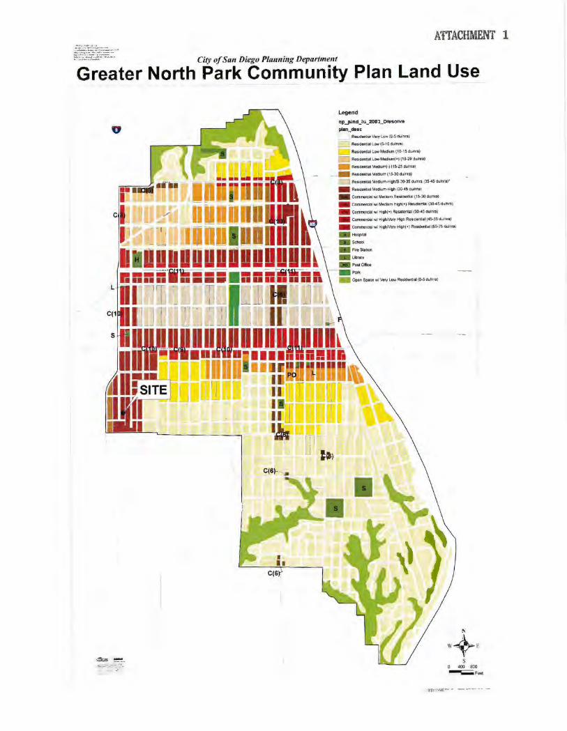
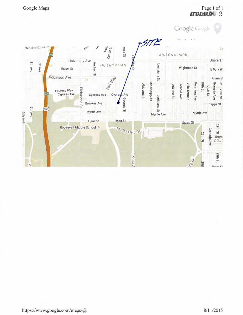
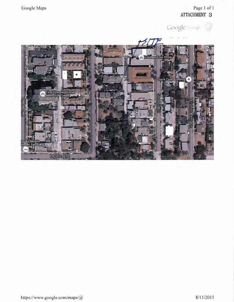
The Greater North Park Community Plan Land Use map identifies the site for Medium High Residential use at a density range of 30-45 dwelling units per acre (Attachment 1 ). The site is located at 3537- 3547 Indiana Street in an urbanized neighborhood of Greater North Park (Attachment 2). The surrounding neighborhood is developed with residential uses and Balboa Park is located two block south of the project site (Attachment 3).
DISCUSSION
Project Description
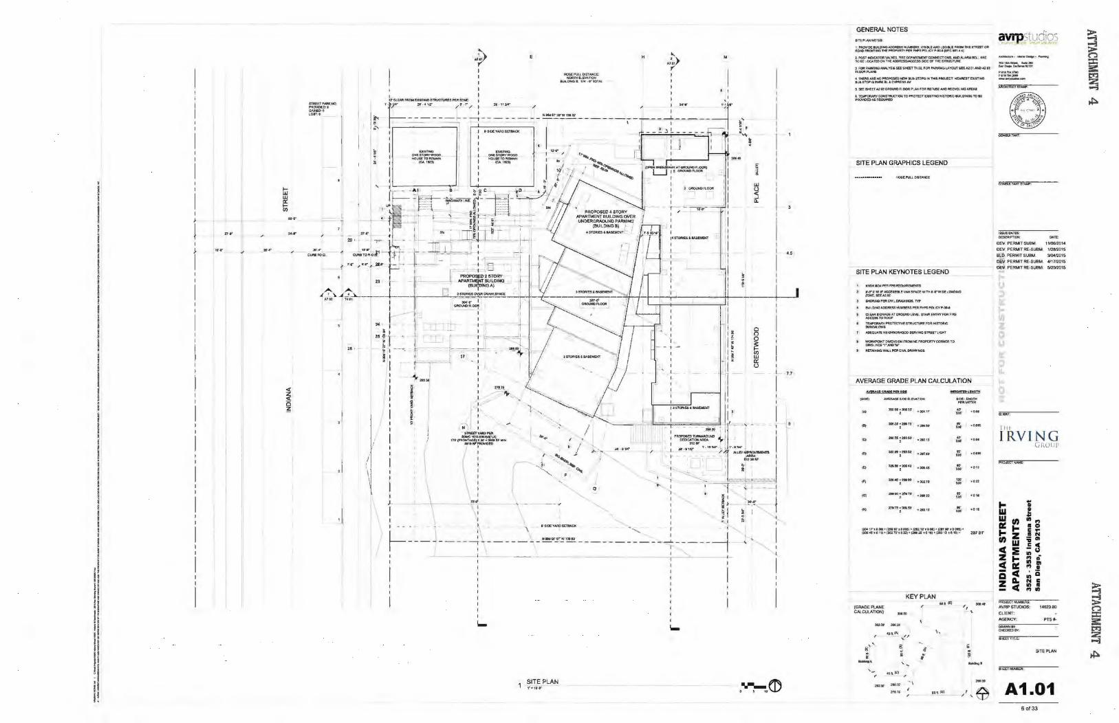
The Indiana Street Apartments project (Project) proposes to create twenty-three residential apartments by preserving the two existing historic bungalows, remove and relocate three buildings and two garages offsite and build twenty-one new apartments with deviations (Attachment 4). The Project would build three new apartments in one building and eighteen new apartments in a second building.
Required Approvals
The Project requires three actions for approval; a Site Development Permit for development within the Mid-Cities Communities Planned District in compliance with San Diego Municipal Code Sections 1512.0203(b)(2) and 1512.0203(b)(4). The site contains sensitive vegetation yet is not impacting that vegetation and no mitigation is required. A Neighborhood Development Permit is required to allow tandem parking and for development of a retaining wall in the alley, and an Easement Vacation is required to vacate a portion of a storm drain easement. ·
Deviations
The Mid-Cities Communities Planned District, through the Site Development Permit procedures, provides applicants proposing deviations to request greater flexibility from the strict application of the regulations than would be allowed provided specific additional findings can be supported. Further, the Site Development Permit process may allow deviations for projects which include· sustainable "green" building technologies. The intent is to encourage imaginative and innovative planning and to assure development would materially assist in reducing impacts associated with fossil fuel energy use by utilizing alternative energy resources, self-generation and other renewable technologies (e.g. photovoltaic, wind, and/or fuel cells) to generate electricity needed
- 2-
by the building and its occupants, would be consistent with the purpose of the underlying zone and the deviation(s) are appropriate for the location and would result in a more desirable project than would be achieved if designed in strict confonnance with the development regulations of the applicable zone.
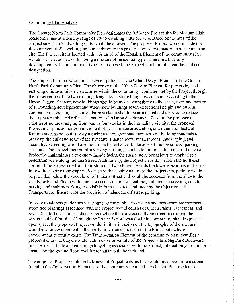
The Project requires six deviations from the SDMC requirements of the MCCPD-MR-1000 Zone, specifically described as:
Deviation • Overall building height • Side setbacks above second story • Rear setbacks above the second story • Pedestrian entries • Architectural features • Retaining wall height in rear setback
Sustainable Project Features
MR -1 000 Zone 40' & 50' 3' per story to 15' max. 7' per story to 14' max. 3 5 of 10 required 6 feet
Proposed 43' & 54' 1 '-8" None 1 2 provided 12 feet
The Project proposes the following features to achieve specific goals of the City's General Plan Conservation Element. All the features below are listed on the plans for the project and would become part of the Exhibit "A" should the project be approved. These features are:
• Existing structures to be relocated for site would be re-purposed for low income housing rather than demolished and taken to the landfill, Roof-mounted photovoltaic system consisting of solar panels sufficient to generate at least 50 percent of the Project's projected energy consumption in accordance with Council Policy 900-14,
• All units would have natural ventilation to reduce cooling loads, • Openings would be properly shaded to reduce heat gain during the summer and allow
maximum daylight during the winter, • A thermal chimney is proposed for natural ventilation of the parking garage, • Without applying for LEED certification, the proposed buildings would be constructed to
LEED Silver standards, • CFC refrigerants would not be used, • Low or zero VOC products would be selected when possible to improve indoor air quality, • When possible, materials with high recycled content would be selected, • On site space would be provided for refuse and recycling storage exceeding SDMC
requirements, • Low water plant species would be used for site landscaping, • A white, single-ply roof membrane would be used to minimize the urban heat island effect, • Biologically sensitive areas would largely be avoided, • Low water use plumbing fixtures would be used throughout, • Manual diming lighting within units would be provided to reduce power consumption.
- 3-
Community Plan Analysis
The Greater North Park Community Plan designates the 0.56-acre Project site for Medium High Residential use at a density range of 30-45 dwelling units per acre. Based on the area of the Project site 17 to 25 dwelling units would be allowed. The proposed Project would include the development of 21 dwelling units in addition to the preservation of two historic housing units on site. The Project site is located within Area 16 of the Housing Element of the community plan which is characterized with having a mixture of residential types where multi-family development is the predominant type. As proposed, the Project would implement the land use designation.
The proposed Project would meet several policies of the Urban Design Element of the Greater North Park Community Plan. The objective of the Urban Design Element for preserving and restoring unique or historic structures within the community would be met by the Project through the preservation of the two existing designated historic bungalows on site. According to the Urban Design Element, new buildings should be made sympathetic to the scale, form and texture of surrounding development and where new buildings reach exceptional height and bulk in comparison to existing structures, large surfaces should be articulated and textured to reduce their apparent size and reflect the pattern of existing development. Despite the presence of existing structures ranging from one to four stories in the immediate vicinity, the proposed Project incorporates horizontal vertical offsets, surface articulation, and other architectural features such as balconies, varying window arrangements, textures, and building materials to break up the bulk and scale of the structure. Planted metal mesh screens, landscaping, and decorative screening would also be utilized to enhance the facades of the lower level parking structure. The Project incorporates varying buildings heights to diminish the scale of the overall Project by maintaining a two-story fa<;ade facing the single-story bungalows to emphasize a pedestrian scale along Indiana Street. Additionally, the Project steps down from the northeast comer of the Project site from four-stories to two-stories towards the lower elevations of the site follow the sloping topography. Because of the sloping nature of the Project site, parking would be provided below the street level of Indiana Street and would be accessed from the alley to the east (Crestwood Place) within an enclosed structure to meet the guideline of screening on-site parking and making parking less visible from the street and meeting the objective in the Transportation Element for the provision of adequate off-street parking.
In order to address guidelines for enhancing the public streetscape and pedestrian environment, street tree plantings associated with the Project would consist of Queen Palms, Jacarandas, and Sweet Shade Trees along Indiana Street where there are currently no street trees along the western side of the site. Although the Project is not located within community plan designated open space, the proposed Project would limit its intrusion on the topography of the site, and would cluster development at the northern less steep portion of the Project site where development currently exists. The Transportation Element of the community plan identifies a proposed Class III bicycle route within close proximity of the Project site along Park Boulevard. In order to facilitate and encourage bicycling associated with the Project, internal bicycle storage located on the ground floor level for tenants would be included.
The proposed Project would include several Project features that would meet recommendations found in the Conservation Elements of the community plan and the General Plan related to
- 4-

sustainable development. The Project would meet the recommendation of employing sustainable or green building techniques that would achieve greater energy efficiency and employ self generation of energy using renewable technology by incorporating a rooftop photo-voltaic system that would generate 50 percent of the electrical design load of the development; designing each dwelling unit to allow natural ventilation and cross ventilation with properly shaded openings to reduce heat gain and allow maximum day-lighting; and incorporating a thermal chimney as part of the design of the Project to provide ventilation for the underground parking. In order to implement the recommendation of reducing construction and demolition waste, the Project would preserve two existing designated historic bungalows on site and relocate three existing housing structures and two garages from the Project site to be reconstructed as affordable housing offsite. Additionally, the Project would meet recommendations for sustainable landscape design by incorporating low-water plant species and for reducing the heat island effect by incorporating a white, single-ply membrane to reduce the contribution of heat build-up.
Several deviations are requested as part of the development proposal related to upper-story setbacks, overall building height, retaining wall height, pedestrian entries, architectural features and retaining walls. The North Park Community Plan does not provide specific recommendations regarding these particular development requirements, except for encouraging upper-story setbacks to assist in addressing transitions and scale between new and existing development. The Project would include a 1 '- 8"upper-story setback along side yard at the north elevation to allow for development of an elevator shaft and stairwell. The east elevation at the rear yard does not provide a stepback, but provides offsets, balconies, window awnings, an open staircase and changes in wall color to brea,k up the perceived mass of the wall and as a way to transition the building height from the development across the alley.
The deviation request for the proposed Project related to building height relates to the screening of mechanical equipment and the provision of photo-voltaic equipment. Along with the deviation request to the upper story setback, the height deviation request allows the project to cluster development to the north while preserving portions of the existing slope and undeveloped areas to the south. Consequently, allowing this deviation would enable the proposed Project to meet policies for screening rooftop equipment and encouraging sustainable development contained in the General Plan. Because of the topography of the site and the Project's proposal to cluster development on the developed/level portions of the property, pedestrian access is limited to one entry along Indiana Street. Although there is only a single pedestrian entry through the northwest portion of the Project, the entrance still provides a direct pedestrian access through a courtyard design to where the residences of the Project would be clustered. The community plan does not dictate the use of specific architectural features. As proposed the Project would incorporate horizontal vertical offsets, surface articulation, and other architectural features such as balconies, varying window arrangements, textures, and building materials to be compatible with the context of the surrounding neighborhood. Despite these deviations, as proposed, the Project would be consistent with the policies of North Park Community Plan, as well as with applicable Conservation Element policies contained in the General Plan, and therefore would not adversely impact the applicable land use plans.
- 5-

Conclusion
Staffhas reviewed the proposed Project and all issues identified through the review process have been resolved in conformance w ith adopted City Council policies and regulations of the Land Development Code. Staff has provided draft findings to support approval of the Project (Attachments 5. 6 and 7) and draft conditions of approval (Attachments 8). Staff recommends the Hearing Officer approve the Project as proposed.
ALTERNATIVES
1. Approve Site Development Permit No. 1433238, Neighborhood Development Pennit No. 1433237 and Easement Vacation No. 1433239, with modifications.
2. Deny Site Development Pennit No. 1433238, Neighborhood Development Pennit No. 1433237 and Easement Vacation No. 1433239, if the frndings required to approve the project cannot be affrrmed.
Respectfully submitted,
er D velopment Project Manager Development Services Department
Attachments:
I . Community Plan Land Use Map 2. Project Location Map 3. Aetial Photograph 4. Project Site Plan 5. Draft Environmental Resolution with MMRP 6. Draft Permit Resolution with Findings 7. Draft Easement Vacation Resolution 8. Draft Pennit with Conditions 9. Remaining Project Plans I 0. Community Planning Group Recommendation I 1 . Ownership Disclosure Statement
- 6-
ATTACHMENT 1
City of San Diego Plunning Department
Greater North Park Community Plan Land Use
Legend
np_plnd_lu_2003_01ss.olve
ptan_d&sc
R..CeniaiLOWCS.10dulore)
.. RGS~Low.t.t.ec~A.Im(10·1Sduinra}
Ill Resldeft.Jfl I.~JUrr)(•) (10·20 :tWnra)
- Ros--..m(·JCIS-25......-n) _ .. R~tla1Mecrum(ts..30dumra)
Ros!Oen~ MC'dl.lm-High/B l0-35 $hn (3$<4$ 001nrar
.. Re~tiel MedAJm-HI;h (30-45 cll,llflt•)
.. Com'l•~wiMedlumReSJCttt'Jil (IS.30doJ!nra)
~ COm.:'IWel.-.1 wl MfiiC!ium Hl(ll'l(•) ~$4ftn!t"'l t30-4S du.M)
- commorcialwtHigll(·JR•....,""(30-45<1U'M>'J .. CornmtfCIII w/ HI\)NV'ery Hign Ru Cltnlllll (45-55 <1\lfnlaJ
.. C«n!htA:ill w/ H~tWery High( • ) Resdental (5.5-75 duo'rr•l . ......... - Sd>ool ..... Sla,.,.
-lii:<Wy
- -Cftloe
::.,;-;-..... ;::-- ------
Google Maps
(}q; ~ $.:J u .0
(j~ a;·
z (.)
~
University Ave I (I)
a~
THE EG'rPTIAf
-.,J
:r )> < (I)
CP OJ_
Essex St
c,ypress Way Cypress Ave
::1J c;· ;;r 3 Cypress Ave 0 :J o.. Brookes Ave (/) -
Myrtle Ave
Upas St
Roosevelt Middle School ~
https://www.google.com/maps/@
Upas St
M, Or!ey Field Ot
Page 1 of 1 ATTACHMENT 2
ARIZONA PARK
r-0 c u;· iii' ::> (),)
~ Myrtle Ave
~ N. 0 ::> (),)
~
Universit
Wightman St N ParkW;
Gunn Sl
;,S -o N G) N )> (I) 2? ;;; 3 iii ;;; -::7 c or ::> 0
~ =r ~ (),) N
c: ::;· =r a. 10 (),) :r <0 ~ )> ;;; )> )> < 0 < ~ (I) < (I) (I) (I)
Capps St
Myrtle Ave
Upas St N
G) :e =r
N ;;;
~ ::l CX> (),) :r a. Thorn ~
(),) cou )> < (I)
N 10
<$' :r
N ~ ·~0, ~ n .... l.-- C"+
811112015
Google Maps
https://vvww.google.com/maps/@
Page 1 of 1
ATTACHMENT 3
8111/2015
I f
~ 21'.f'
I ). .... _,
I
10' ...
24'..8'
.. ..
ITAUT I'AAXI~ PRO\IIotD: I .......... LOS'T:e
/
'
E H
··~ M
' I I
'· r·:llt'
...... ,.,,. I I 1111$
""'
-N~ ~ ....... ...,,..,. I~S(tR;:~::=~~N
I
I
"'·· I
... ~ 1
0
I " I
• · I I
""''
I ) .
~~ I ~I ----~-- p -
I, . : I ~ I I ~I
• - ~: .-- - ...,. S'S'DEYARO:sETBAGI( I - j 1---------~--------~ ... ~;:!·~ ------ -----~----- --4 I : I
I l i I
I-
SlTEPLAN t"•llr-cl"
GENERAL NOTES
am:PVr.H..c>Tt...-1 MOY« IU\.O!~AOOilUS NU\eERS, V$IUi NIDt.fD·k£ J1tOW »>E ~OFt I'OAD FJtQNliNG THE ~TYPER FM'SPCII CV......,... (U'C •t_••J 1- I"'S'T ~TORVAI,\IU,FIRE OEPARl'WENTCOHHECnOHS.AICI Al.AAMI!Itl.J..AA! l01it.OCATEDONTlC~SIOEMTl1£SflltUCTUR(
3 FQa:P.o\Ri(lHONW.Y$!SSU$t«TTt02,ttolt~INOI.AY'OIIT&I:EA:tOIIIHOA2h
"""""""' .. THSt£AA£NI)"ft::OI'()$(()1l[Wti.I$$TOf'$1N'M$11'1t0JCCT HCM£ST()QST1NQ 8!,.155TOPISP~Il 4CVI"M.$$AV
$ Sl:t.Sto4lll A202~0UNO"lOOA PJ.NJ'OA WUSfANOMC't'(:l_!NGAIIfAS
f ~COHSTflVC'TIJON TOPROTtt:T £)Q$'TIN3HC'TOA::Ct4ll.Ot'NMTOte ~tbAS At«NNff
SITE PLAN GRAPHICS LEGEND
SITE PLAN KEYNOTES LEGEND
IO.OXIIOXPStF'P8~
¥.U X 11"4' AtefSSlkl VAH SPACfWlTH f' VWoOl i..OMchiO ZOHt.SO:Al-02
$HOIIUNO l'6t CJYn. t::llt.AW!NG$. TVP
SU.:..£»fGNJOia=:SS M.IMllfAS PIRA1PS POLICYP•fl0.4
Q.IWl SCNAOE ATCRQUNP levEl. ITA.« Ori'T'RY fOR F!RE M:CESSTOROOF
~""''t£cn\'t&.l'R\.ICTUM:F'OA~STOfiJC
"""""'"". AOEOIM.Tii kEQH8JC')P,H()c)( SVMNCSTPiftTLQ«
l • WOfU<I'OMDIM"...HS:ONI"RelMNEPROf'Eit'TY~f«RlO GltiO..INE& "1" N<IOV
t • A!TAI"'!t<oi~W'.tUHJtCI'\4.0ft.AW!NG5
AVERAGE GRADE PLAN CALCULATION
Adl6!ilti!W!Iti!IS!I MIOHTID~Mmtf
"'""' A\I£RAGE SO(Q.EVAnott ...,.,.....,. ,... _ _..,. 1 .. 30QOI'•3062S' • )04\'t <3 .... • .,..
... 3062$•1:t01$' ...... "' . .... • ·~ ICt 210'ff•H3&11
·~u .,.
• ... ,., l02.0t'•2'«150' 110' .....
' ,,..
·~ l06$0'•XIf60" • *.4'
... • OH • ,,..
"' 304~·-00 .. .,, ,,.. ....
' .,..
IOl 29tOO•nt7t' ...... " •011 . ,,..
'"' 27t7~·3055Cf .. ,, - •o•• . ,,..
pot rr~oot)• 12M w aOOM) • 12t2 U' • OOil • (2t7tct •DO•l • P0146' ' ' 111• C10tW•o..n:!• net%5'•0 111• atJ ~, •O ttl• 29791'
(GRADE PLANE CAI.CVLATlON)
...... ,,
a: ; ....... ,_
/
.....
KEY PLAN ... .., ...... "'" ,...,.
...... .('
i ., ~ ~ ..
l! .. ~ !!
'~ -· """' / ..... Uft(OI
avrpstudios __ ..._~.,.......
'-'~a.&. ..... a..o-..c..---lltt01 ~~> •tt1'0t21'10 '".lM.lUf __ _,....._
I$SUI"OA.TU: OESCAIPTIOfot Dr4Tl':
OEV. PERMIT SUBM. 1 1106.12014 OEV. PERWT RE·SUBM 112812015 OlD PERMIT SU8M. 310<1201$ OEV. PERMIT RE.SU8M. 4117/201$ 0£11. PERMIT RE·SUBM. 51201201$
CL•lHT:
T IIF
IRVING (iRUlll
... .. • w ! w ..
U) VI 1'1 a= ... .. 0 ... c ... z .. N U) ;; Gl w .s c c :IE Ill
u z =
1'1 0
~ Ill Ill 1'1 •
Q c Ill Ci z P. N c
c Ill .. - 1'1 VI
PiiCiiEGT..uW AVRP STUDIOS: 1402300
CLIENT: AGENCY: PTSII-........... CtECICEDI~
SHE£~-nn..e
SITE PI.AN
A1.01 6 of33
~ i=; = I ~
Attachment 5
RESOLUTION NUMBER R-____ _
ADOPTED ON ____ _
WHEREAS, on January 28, 2015, INDIANA STREET APARTMENTS #1, LLC
submitted an application to Development Services Department for a Site Development Permit,
Neighborhood Development Pennit and Easement Vacation forthe Indiana Street Apartments
(Project); and
WHEREAS, the matter was set of a public hearing to be cC!t\~ucted by the Hearing
Officer of the City of San Diego; and
WHEREAS, the issue was heard by the H~irlJ;J,g Of:ficet::,an August 26; ~015; and
WHEREAS, the Hearing Officer.GOJi!Sidered theis~-u~s discussed in Mitigated Negative ~·· .. ,
Declaration No. 396980 (Declaration) ptepa;~J:·rdr~4i~ Proj~6i; NOW THEREFORE,
BE IT RESOLVED; by.t4e Hearing (tifficer thl:!1it1s certified that the Declaration has .,, ... , ·, ···' .·"·'·.,,···',>'-' . .-.·:'!··-'':'··
been completed in compii;mce withthe Califofliia~~vironmen~~l Quality Act of 1970 (CEQA) ·: · .. , ,.\··· ·.,, .. ,·,
(Public Re.s!!>Urces Qode Sect1on2JOOO etseq.), as~~ended, and the State CEQA Guidelines / ' ' ••• ·. ' . >,· ' •. ' ,. '~ •
, ··'.,·, ····· ;,
thereto(Califomia Code<C>fRegufatiol.'ls, Title 14, Chapter 3, Section15000 et seq.), that the
Declaration r~flt:)cts the indepetldent judgment of the City of San Diego as Lead Agency and that
the information cont!;lined in saipJ)eclaration, together with any comments received during the
public review process, ht=~.s beepreviewed and considered by the Hearing Officer in connection
with the approval of the Project.
BE IT FURTHER RESOLVED, that the Hearing Officer finds on the basis ofthe entire
record that project revisions now mitigate potentially significant effects on the environment
previously identified in the Initial Study, that there is no substantial evidence that the Project will
-PAGE 1 OF 22-
Attachment 5
have a significant effect on the environment, and therefore, that said Declaration is hereby
adopted.
BE IT FURTHER RESOLVED, that pursuant to CEQA Section 21081.6, the Hearing
Officer hereby adopts the Mitigation Monitoring and Reporting Program, or alterations to
implement the changes to the Project as required by this Hearing Officer in order to mitigate or
avoid significant effects on the environment, which is attache4''b.~reto as Exhibit A. '::;,·, _:./>':',~:-:
BE IT FURTHER RESOLVED, that the DeclUf~#~n ~hdpther documents constituting
the record of proceedings upon which the approv:l:(lisbased are avaii.111?le to the public at the ;'; :': :·_, 'i.:< :· ~ . .,,:,' -_.,,:
office ofthe Development Services Departmehti\1'222 First Avenue, S~rlPiego, CA 92101.
BE IT FURTHER
to file aN otice of Determination
San Diego regarding the Project. ~- ,·_:_ : .· /'"··-·.
By: -·,·,~<·i·'.>. -~'
J o~;$/~1~b.~r....... · ··•• ·, i. c {•·· i···· .. Develbplileilt':PrPject M~~E~:g;er
··--··- ·.·
that Developfn.~.nt $~p\Yices Departm~hf$taff is directed
ATTACifMENT(S): Exhibiff\, Mitiiation Monitoring and Reporting Program
-PAGE 2 OF 22-
Attachment 5
EXHIBIT A
MITIGATION MONITORING AND REPORTING PROGRAM
Site Development Permit No. 1433238, Neighborhood Development Permit No. 1433237 and
Easement Vacation No. No. 1433239 PROJECT NO. 396980
This Mitigation Monitoring and Reporting Program is designed Jo ensure compliance with Public Resources Code Section 21081.6 during implementation of mitigation measures. This program identifies at a minimum: the department responsible for th~ Il16tiitoring, what is to be monitored, how the monitoring shall be accomplished, the monitoril),~\~J;I~l·eporting schedule, and completion requirements. A record of the Mitigation l\{9pitoriiJ~and Reporting Program will be maintained at the offices of the Entitlements Divisio11, 1222 FirstAyenue, Fifth Floor, San Diego, CA, 92101. All mitigation measures cont(l,i#~d in the Mitig~t,~<i Negative Declaration No. 396980 shall be made conditions of Site D~;y~lppment Permit Nm'J~33238, Neighborhood Development Pennit No. 1433237 and Easem@p,t'Vacation No. 1433239aE;maybe further described below.
A.
·-·; ._,_,···< .. ,
.'.·:_· .. ·.·.·.·:;-.:,_-,:', .... ,. .,.··.,···' .. ·,: .. ' ..... ·,.'.-'' ... '.····' ---.--,,i\.::· .. :·.·,' .... ·'.·.' ..... '.'.
GENERAL REQUIR:£]\II:JjNTS - PARTipJall. Check Phase (pri()~ to permit issuance)
1.
_,: ·'· .
~ ': ': -_:- .' - - ' : -._· . ;,_ ··'·-·_"_·.·.-.:_, ,--:
Prio,~ to the issuaii¢~ ~f aNq~i~~,·ro Proce~}i (NTP) for a subdivision, or ~r:~9]1_9~ction per~its, sucl1\,~S,R~Folitio11,Grading or Building, or ~~ginrimg,~y constrti§t~?l:l_ r.~lflted aqt~~it,y on-site, the Development
is.e ... r .. v .. ices Dep·· .... q:rtment (D$Q.),,IJirector's Environmental Designee (ED) shall rev~~yvand~p~rove all C~ij~truction Documents (CD), (plans, specific,il~~'~{'4~ta,ils,etc.) to,~B,sure the MMRP requirements are
.. ,.. it1qorpor~t~,4 into thed~sign.',.,· ·.
---~-:',-,'/' ,---·>.\ '"<'i::i:,_:,.·,_:':·_';:_._·,, ------~
In ad4xf:.ion, the.EP shall verify that the MMRP Conditions/Notes that apply OJ>f:L Y to the construction phases of this project are included VERBATX"N:f, under the heading, "ENVIRONMENTAL/MITIGATION REQUIR~l\!JENTS."
3. Thes~p()tes must be shown within the first three (3) sheets of the construction documents in the format specified for engineering construction document templates as shown on the City website: http:/ /www.sandiego.gov /development-services/industry I stand temp .shtml
4. The TITLE INDEX SHEET must also show on which pages the "Environmental/Mitigation Requirements" notes are provided.
-PAGE 3 OF 22-
Attachment 5
5. SURETY AND COST RECOVERY- The Development Services Director or City Manager may require appropriate surety instruments or bonds from private Permit Holders to ensure the long term performance or implementation of required mitigation measures or programs. The City is authorized to recover its cost to offset the salary, overhead, and expenses for City personnel and programs to monitor qualifying projects.
B. GENERAL REQUIREMENTS -PART II Post Plan Check (After permit issuance/Prior to start of construction)
1. PRE CONSTRUCTION MEETINGIS REQUIRED TEN (10)
WORKING DAYS PRIOR TO JlEQINNING ANY WORK ON THIS PROJECT. The PERMIT HOLDER/OWNERis responsible to arrange and perform this meeting by cpnt.;;tcting the CITY RESIDENT ENGINEER (RE) of the Field Engineeringcph!ision and City staff fro111 MITIGATION MONITORING COORDI'f;JATION (MMC). Attend~es must also include the Permit holder's Represen:tative(s)rJob. Site Superintendent and the following cOIJSUltants:
· · Qtt~lified Biologipt
Quali~~ed Archaeologist · .·· .. Qualifi~dMativc Am~hcan Monitor
Q1,1aUfie~'Paleqntologist
Note; Failuf:¢.of all respotj~ible Permit Holder's representatives and con~ultants ·to aitend shall fequire an additional meeting with all pe1rties pr~s¢nt. ··· · ·
CONTACT INFORMATION: a)
b)
The PRIMARY POINT OF CONTACT is theRE at the Field t,'' <
Ettgineering Division - 858-627-3200
FotC:larification of ENVIRONMENTAL REQUIREMENTS, ~pphcant tis also required to call RE and MMC at 858-627-3360
2. MMRP COMPLIANCE: This Project, Project Tracking System (PTS) Number 396980 and/or Environmental Document Number 396980, shall conform to the mitigation requirements contained in the associated Environmental Document and implemented to the satisfaction of the DSD' s Environmental Designee (MMC) and the City Engineer (RE). The requirements may not be reduced or changed but may be annotated (i.e. to explain when and how compliance is being met and location of verifying proof, etc.). Additional clarifying information may also be
-PAGE 4 OF 22-
Attachment 5
added to other relevant plan sheets and/or specifications as appropriate (i.e., specific locations, times of monitoring, methodology, etc.
Note: Permit Holder's Representatives must alert RE and MMC if there are any discrepancies in the plans or notes, or any changes due to field conditions. All conflicts must be approved by RE and MMC BEFORE the work is performed.
3. OTHER AGENCY REQUIREMENTS: Eyidence of compliance with all other agency requirements or permit~ ~~~~!be submitted to the RE and MMC for review and acceptance p[:~9#~0 the beginning of work or within one week of the Permit Holder 9~~,~#Ur1g/~ocumentation of those permits or requirements. Evidence sh~~ ifl:dude coJ?~~~of permits, letters of resolution or other docU1llf2!JJtcltion issued bytbf3!,responsible agency: Not Applicable
4. MONITORING EXHIBITS: ,~1,1 co~f~lf.ants are reqttjj;~q.to submit, to RE and MMC"~monitoring exl1ibit<?~allx17 reduction of the appropriate col}~~li;~~g~ plan, sttch_ ~~,. ~ite plan, grading, landscape, etc., marked to clearly.·~po\~:,~~~specific ar~~;.,including the LIMIT OF wo~~' scope of fii~tdis~ipllf\~',~ :vork, lll}~,,notes indicating when in the cp~s1;k¥,~~i?n schedu1ethat w~r¥t\;~l,l~e perf9tmed. When necessary for
. ?l~J·rflcatiop,,,~ detailedimethp~ology,,pfh_?w the work will be performed . ~.h_all be inclgded. .. · .· .
1,·_,_,,_->-.~>_ :_' , -'-' '; ::,~ ·-;_-'-!_.y-.' <'·- _;:-, ":'-' _,_ ,_,,
No;~;·,.§~~t§i~nd,Cf?~rRe~dy~·R'- When deemed necessary by the J?e~eldpn:t~~t Service~~irector or City Manager, additional surety in~~,W,ments?rbonds from the private Permit Holder may be required to en~11re the lol'l.g term performance or implementation of required mitigatiC)'jl measure~, or programs. The City is authorized to recover its cost to otf$~t the salary, overhead, and expenses for City personnel and programsJo monitor qualifying projects.
5. OTHERSUBMITTALS AND INSPECTIONS: The Permit ,-. __ '
Holder/Owner's representative shall submit all required documentation, verification letters, and requests for all associated inspections to the RE and MMC for approval per the following schedule:
DOCUMENT SUBMITTAL/INSPECTION CHECKLIST
Issue Area Document Submittal Associated Inspection/ Approvals/Notes
General Consultant Qualification Letters Prior to Preconstruction Meeting
-PAGE 5 OF 22-
Attachment 5
General Consultant Construction
Prior to or at Preconstruction Meeting Monitoring Exhibits
Biology Biologist Limit of Work Verification Limit of Work Inspection
Paleontology Paleontology Reports Paleontology Site Observation
Historical Resources Archaeology Reports Archaeology/Historic Site Observation
Bond Release Request for Bond Release Letter Final MMRP Inspections Prior to Bond Release Letter
C. SPECIFIC MMRP ISSUE AREA CONDITIONS/REQtJIREMENTS
BIOLOGICAL RESOURCES (RESOURCE PROTECTION.lJtJRING CONSTRUCTION)
To be utilized in conjunction with BiologicalR.~~ource~;(General Bird) MMRP
I. Prior to Construction A. Biologist Verification: The owner/permittee shall provide a letter to the
City's Mitigation Monitoring Cootdinati9:rl(MMC) sectioristating that a Project Biologist (Q:galified Biologist). afi.•d~fined in the City ofSan Diego's Biological Guidel~¢8 (2012), has beert r~t<;1ined to implement the project's biological monitorii\gprogl;i;lp;l. The lettei; s{mll include the names and contact information ~fall persons .involvedtrt the biological monitoring of the proj~ct. , ..
B. Prec6iistrudion Meeting: /the qualified .Biologist shall attend the pi~~~nstruction.!peeting, disc.U,~s the project's biological monitoring program, and arrange to perform any follow up mitigation measures and reporting ipcludhlg~i~~~~pecifibmonitoring, restoration or revegetation, and additional
.· f~1l~a/floras:grveys/salvag·~, . C. Bio16g~c\ll Doctlfl,:lents: The Qualified Biologist shall submit all required
documep{C;Itjon tcfK:'J:MC verifying that any special mitigation reports including b(Lt pot limited to, maps, plans, surveys, survey timelines, or
.buffers are cqmpleted or scheduled per City Biology Guidelines, Multiple Species Conservation Program (MSCP), Environmentally Sensitive Lands Ordinance (E$L), project permit conditions; California Environmental Quality Ad (CEQA); endangered species acts (ESAs); and/or other local, state or federal requirements.
D. Biological Construction Mitigation/Monitoring Exhibit: The Qualified Biologist shall present a Biological Construction Mitigation/Monitoring Exhibit (BCME) which includes the biological documents in C above. In addition, include: restoration/revegetation plans, plant salvage/relocation requirements (e.g., coastal cactus wren plant salvage, burrowing owl exclusions, etc.), avian or other wildlife surveys/survey schedules (including general avian nesting and USFWS protocol), timing of surveys, wetland buffers, avian construction avoidance areas/noise buffers/ barriers, other
-PAGE 6 OF 22-

Attachment 5
impact avoidance areas, and any subsequent requirements determined by the Qualified Biologist and the City ADD/MMC. The BCME shall include a site
.. plan, written and graphic depiction of the project's biological mitigation/monitoring program, and a schedule. The BCME shall be approved by MMC and referenced in the construction documents.
E. Avian Protection Requirements: To avoid any direct impacts to raptors and/or any native/migratory birds, removal of habitat that supports active nests in the proposed area of disturbance should occur outside of the breeding season for these species (February lto September 15). If removal of habitat in the proposed area of disturban.f~:·§,tist occur during the breeding season, the Qualified Biologist shall COl(l~B~fa pre-construction survey to determine the presence or absence of~~stiQs;pirds on the proposed area of disturbance. The pre-constructi~p.srlrvey shall~~ .conducted within 10 calendar days prior to the starf>qf¢onstruction aqP:)Wies (including removal of vegetation). The applicar,l.}.sii~ll submit the res~lt~.9f.the pre-construction survey to City DSD for reviE!i~\af:l.d approv~lprior to :irti~FJ.ting any . construction activities. If nesting]J~ds .ar~%7tected, a letter;7port or mitigation plan ill sqpformance wi~t10~ Gity' s Biology Guid~lines and applicable State an~::~%~~:1 Law (i.e. a~vropriate follow up surveys, monitoring scheduh~?1 cCn§i:J;llftion anci'hpi~ebarriers/buffers, etc.) shall be
preparedand include-prpposed~.~~~ures to,},~.~plemented to ensure that take.of··~r,~~~or eggs or di~'turbanc~:?fb~:edingf1Ctivities is avoided. The re~p,rtor mitigf\tion plan $J.if\ll p~$pbmitt~~t() the City for review and app~?Yal and imr:lementedtp,;~he satisfaction of the City. The City's MMC Section,. Jr,RE, a,w.~ Biologist sh~pverify and approve that all measures
.. i~entified,.ipJh~.;report.or mitiga,,#on plan are in place prior to and/or during .· .. ·.. cBhstructioi\t. >,:·· · ···.•.... \. •.....•.... ··.··.·.•·.· .•. ·•·
F. R~~bh.tg~. Delih~e~ion: P~ic)~·fQ:ctonstruction activities, the Qualified Biologist shall supe1:yise thepJ.~fement of orange construction fencing or equivalent along the liiXI.its of dis:t:qrbance adjacent to sensitive biological habitats and :yerify compliance with any other project conditions as shown on the BCME. J'his phase shall include flagging plant specimens and delimiting buffers to protect sensitive biological resources (e.g., habitats/flora & fauna species, includipg nesting birds) during construction. Appropriate steps/care should be takeri to minimize attraction of nest predators to the site.
G. Education: Prior to commencement of construction activities, the Qualified Biologist shall meet with the owner/permittee or designee and the construction crew and conduct an on-site educational session regarding the need to avoid impacts outside of the approved construction area and to protect sensitive flora and fauna (e.g., explain the avian and wetland buffers, flag system for removal of invasive species or retention of sensitive plants, and clarify acceptable access routes/methods and staging areas; etc.).
-PAGE 7 OF 22-
Attachment 5
II. During Construction A. Monitoring: All construction (including access/staging areas) shall be
restricted to areas previously identified, proposed for development/staging, or previously disturbed as shown on "Exhibit A" and/or the BCME. The Qualified Biologist shall monitor construction activities as needed to ensure that construction activities do not encroach into biologically sensitive areas, or cause other similar damage, and that the work plan has been amended to accommodate any sensitive species located during the pre-construction surveys. In addition, the Qualified Biologist shall document field activity via the Consultant Site Visit Record (CSVR). Jhe CSVR shall bee-mailed to MMC on the 1st day of monitoring, the;!M' .. week of each month, the last day of monitoring, and immediately in the case ofa:p_y undocumented condition or discovery.
B. Subsequent Resource Identi(i¢<1#6n: The Qualitt~d Biologist shall note/act to prevent any new disturbancE;l~td habitat, flora, and/otfauna onsite (e.g., flag plant specimens for avoidance quring access, etc). If active nests or other previously unknown sensitive resources ate .detected, all pr()ject activities that directly impact .the resource sh~U. J?e delayed until species specific local, state or federal regl:[latipns have beel1d~terrnined and applied by the Qualified Biologist.
\', ',.1
III. Post Constttt.ction Measur~s A. In the ~Vent th~timpact~·e,X<:eeq previously aU owed amounts, additional
impfl.C~s shall be mitigated it\ accordance vJitil City Biology Guidelines, ESL and Mq(J', Stat~ C:EQA, and <:J:ther applicable local, state and federal law. The Qualifi~.cl~iologist.shall suhwit a final BCME/report to the satisfaction of · th¢.<;ity ADD/MMC within 30 days of construction completion.
BidLOGICAL RESOURCES (]lAPTORS /GENERAL BIRDS)
To avoid any direct ilnpacts to raptors and/or any native/migratory birds, removal of habitanhat supports actiVe nests ili the proposed area of disturbance should occur outside of the breeding season for these species (February 1 to September 15). If removal of habit~t in the, proposed area of disturbance must occur during the breeding season, the Qualified I:h6logist shall conduct a pre-construction survey to determine the presence or absence' of nesting birds on the proposed area of disturbance. The preconstruction (precon) survey shall be conducted within 10 calendar days prior to the start of construction activities (including removal of vegetation). The applicant shall submit the results of the precon survey to City DSD for review and approval prior to initiating any construction activities. If nesting birds are detected, a letter report or mitigation plan in conformance with the City's Biology Guidelines and applicable State and Federal Law (i.e. appropriate follow up surveys, monitoring schedules, construction and noise barriers/buffers, etc.) shall be prepared and include proposed measures to be implemented to ensure that take of birds or eggs or disturbance of breeding activities is
-PAGE 8 OF 22-

Attachment 5
avoided. The report or mitigation plan shall be submitted to the City DSD for review and approval and implemented to the satisfaction of the City. The City's MMC Section or RE, and Biologist shall verify and approve that all measures identified in the report or mitigation plan are in place prior to and/or during construction. If nesting birds are not detected during the precon survey, no further mitigation is required.
HISTORICAL RESOURCES (ARCHAEOLOGY)
I. Prior to Permit Issuance A. Entitlements Plan Check
1. Prior to issuance of any constr1.1cUon permits, including but not limited to, the first Gradin~ P.~t-frtit, Demolition Plans/Permits and Building Plans/Permits ota_Ndtiq; to Proceed for Subdivisions, but prior to the first p;reconstruction meeting, whichever is applicable, the As~ist~.ht Deputy Director( ADD) Environmental designee shall v~~ifythat the requirementsfor Archaeological Monitoring and Nitive American monitoring have been noted on the applicable construction domgnents through th~ plan check process.
B. Letters of Qualifiration have been supmitted to ADD 1. The appHcantshaU submit a letter of verification to Mitigation
Monitoring Coordinati~~ (MMC) identifying the Principal Investigator (PI) for the project m<d the names of all persons il1V<:)lved in th~ arch~eol6gicalh;lonitoring program, as defined in the City of San Dfe,go Historical Resources Guidelines (HRG). If applic(;lble, individ.tulls involved in the archaeological monitoring prp~J:am iJ;lust have~or:npleted the 40-hour HAZWOPER training with certification.documentation.
2. MMQ will provid€taletter to the applicant confirming the qualifications of the PI and all persons involved in the ar(Jhaeolog1~al monitoring of the project meet the qualifications established in the HRG.
3. Prior to the start of work, the applicant must obtain written approval from MMC for any personnel changes associated with the 'monitoring program.
II. Prior to Start of Construction A. Verification of Records Search
1. The PI shall provide verification to MMC that a site specific records search (1/4 mile radius) has been completed. Verification includes, but is not limited to a copy of a confirmation letter from South Coastal Information Center, or, if the search was in-house, a letter of verification from the PI stating that the search was completed.
-PAGE 9 OF 22-
Attachment 5
2. The letter shall introduce any pertinent information concerning expectations and probabilities of discovery during trenching and/or grading activities.
3. The PI may submit a detailed letter to MMC requesting a reduction to the % mile radius.
B. PI Shall Attend Precon Meetings 1. Prior to beginning any work that requires monitoring; the
Applicant shall arrange a Precon Meeting that shall include the PI, Native American consultant/monitor (where Native American resources may be impacted), Co~struction Manager (CM) and/or Grading Contractor, Resider-t Engineer (RE), Building Inspector (BI), if appropriate, and MMC The qualified Archaeologist and Native American Monitor shall att~nd any grading/excavation related Precon Me~~gs to make comm~nts and/or suggestions concerning the Art]taeological Monito:dng program with the Construction Manag~r and/or Grading Cohg('tctor. a. If the PI is ll:ttaple to at~erid the Precoil M~~ting, the
Applicant shallscf:t~dul~ a focused Precon Meeting with J\,tl\1n the PI, RE, GM. or BI, if appropriate, prior to the st~.rt6fany\Vork that requires monitoring.
2. Identify Ar~q..s to be 1ylqnitored .' . Prior!t(>_the start 6fary work.~at requires monitoring, the PI shalf,submira.n A:t'ch9:eological Monitoring Exhibit .(AME) (With~~rificationthat the AME has been reviewed and approv~<i by the Native American consultant/monitor yyhe~.Native.American resources may be impacted) based on the'ftppropiiate construction documents (reduced to .11x17) toMMC identifying the areas to be monitored ihcluding the delineation of grading/excavation limits.
b. The AME shall be based on the results of a site specific records search as well as information regarding existing known soil conditions (native or formation).
3. . Wh~n Monitoring Will Occur a.· Prior to the start of any work, the PI shall also submit a
construction schedule to MMC through the RE indicating when and where monitoring will occur.
b. The PI may submit a detailed letter to MMC prior to the start of work or during construction requesting a modification to the monitoring program. This request shall be based on relevant information such as review of final construction documents which indicate site conditions such as depth of excavation and/or site graded to bedrock,
-PAGE 10 OF 22-

Attachment 5
etc., which may reduce or increase the potential for resources to be present.
III. During Construction A. Monitor(s) Shall be Present During Grading/Excavation/Trenching
1. The Archaeological Monitor shall be present full-time during all soil disturbing and grading/excavation/trenching activities which could result in impacts to archaeologica,I resources as identified on the AME. The Construction .Manager is responsible for notifying the RE, PI; ~1:lit MMC of changes to any construction activit~~s sli.ch as in the case of a potential safety concer.J;l within th~ #ea being monitored. In certain circum~hmces OSHAs~Jety requirements may necessitate modification of theAME.
2. The Native:t;\111erican consultant/mb11~tor shall determine the extent of tl:u~ir presenc~ during soildisturbing and grading/excavation{trettching activities based on the AME and pr~'ride that i:rtf()n:;nation to the PI and MMC. If pre]1isU&hi'c resources· ai~ encountered during the Native Am~rican consultant/monitor's absence, work shall stop andthcDiscovery 1\J otification: Process detailed in Section III.B-Ca,nd IY.f\:-D shall cp,mmence.
· .·.·.The PI may slibmit a detailed letter to MMC during
constructiottrequesting a modification to the monitoring prbgra,~ when a field condition such as modem disfutb~n~~ p6st-dating the previous grading/trenching
· activities,pte.sence of fossil formations, or when native s.oils are encountered that may reduce or increase the pot~ntial for resources to be present.
4;· The archaeological and Native American consultant/monitor shall document field activity via the Consultant Site Visit Record (CSVR). The CSVR's shall be faxed by the CM to the RE the first day of monitoring, the last day of monitoring, monthly (Notification of Monitoring Completion), ar:d in the case of ANY discoveries. The RE shall forward copies to MMC.
B. Discovery Notification Process 1. In the event of a discovery, the Archaeological Monitor
shall direct the contractor to temporarily divert all soil disturbing activities, including but not limited to digging, trenching, excavating or grading activities in the area of discovery and in the area reasonably suspected to overlay
-PAGE 11 OF 22-
·Attachment 5
adjacent resources and immediately notify theRE or BI, as appropriate.
2. The Monitor shall immediately notify the PI (unless Monitor is the PI) of the discovery.
3. The PI shall immediately notify MMC by phone of the discovery, and shall also submit written documentation to MMC within 24 hours by fax or email with photos of the resource in context, if possible.
4. No soil shall be exported <=!££-site until a determination can be made regarding the §igi:lificance of the resource specifically if NativeA~etican resources are encountered.
C. Determination of Signific®se 1. The PI and Native American .consultant/monitor, where
Native Am~f:ioi,l,rt resources are discovered shall evaluate the signifie~h~e of the resource. It !-luman Remains are involved,fo~low protocol in SectioniVbelow. a. The r-t·shall immediately notify MMC by phone to
discuss si~ific~nce determination and shall also submit a lettetto MMC indicating whether iid(iitional mitig~tion is required.
b. . If the: resource is si~!lificant, the PI shall submit an .. Archae6l(_)gical Data Recovery Program (ADRP)
.. which h,~s beel1:rev;iewed by the Native American
c6~811ltant/monHor, and obtain written approval fron,_ MMC. Impacts to significant resources must
be mitis.ated before ground disturbing activities in the area of discovery will be allowed to resume. Note: If a unique archaeological site is also an historical resource as defined in CEQA, then the limits on the amount(s) that a project applicant may be required to pay to cover mitigation costs as indicated in CEQA Section 21083.2 shall not apply.
c. If the resource is not significant, the PI shall submit a letter to MMC indicating that artifacts will be collected, curated, and documented in the Final Monitoring Report. The letter shall also indicate that that no further work is required.
IV. Discovery of Human Remains- If human remains are discovered, work shall halt in that area and no soil shall be exported off-site until a determination can be made regarding the provenance of the human remains; and the following procedures as set forth in CEQA Section
-PAGE 12 OF 22-
Attachment 5
15064.5(e), the California Public Resources Code (Sec. 5097.98) and State
Health and Safety Code (Sec. 7050.5) shall be undertaken: A. Notification
1. Archaeological Monitor shall notify the RE or BI as appropriate, MMC, and the PI, if the Monitor is not qualified as a PI. MMC will notify the appropriate Senior Planner in the Environmental Analysis Section (EAS) of the Development Services Department to assist with the discovery notification process.
2. The PI shall notify the M~~ical Examiner after consultation with the RE, either iJ:l p¢rs'i:m or via telephone.
B. Isolate discovery site 1. Work shall be dir~~ted awayfrom the location of the
discovery Ct,Q.c,t any nearby areai'e,~sonably suspected to overlay ~dj~tent human remains tptil a determination can be made b)!the Medical Examiner iri qqnsultation with the
PI concernir1.g the provE!nance of the r~1:f\ains. 2. The Medical Examiner, in consultation with the PI, will
• det~:r:mine the need for a field examination to determine
t~ept6v'~na_nce. 3. If a £i:ld eX:aJWn3?on is not ~arran ted, the Medical
Exariih:ter willc1et~r:p:line witl} input from the PI, if the remams a,re():r:~re mo$f]jkely to be of Native American origin.
C. If Hqll1an Remains ..;\RE determined to be Native American
.1. fhe,Medicaf13X:aminer will notify the Native American Herita~e(orr{fuission (NAHC) within 24 hours. By law,
ONLY the Medical Examiner can make this call. 2. N_AHC will immediately identify the person or persons
det~:r:mined to be the Most Likely Descendent (MLD) and
provide contact information. 3. The MLD will contact the PI within 24 hours or sooner
after the Medical Examiner has completed coordination, to begin the consultation process in accordance with CEQA
Section 15064.5(e), the California Public Resources and Health & Safety Codes.
4. The MLD will have 48 hours to make recommendations to . the property owner or representative, for the treatment or disposition with proper dignity, of the human remains and associated grave goods.
5. Disposition of Native American Human Remains will be determined between the MLD and the PI, and, if:
-PAGE 13 OF 22-

Attachment 5
a. The NAHC is unable to identify the MLD, OR the MLD failed to make a recommendation within 48
hours after being notified by the Commission; OR;
b. The landowner or authorized representative rejects the recommendation of the MLD and mediation in accordance with PRC 5097.94 (k) by the NAHC fails to provide measures acceptable to the landowner, THEN,
c. In order to protectthese sites, the Landowner shall do one or more.ofilie following: (1) Record The site with the NAHC; (2) R~cor:d an. open space or conservation
eas~fuent ()nthe site; (3) .Record a dociu~ent with the County.
d. Upon the discovery of multiple Native American hlil:p.?J.n remains during a gropnd disturbing land devel<Ypwent activity, the landowner may agree that additiqnFifccrnferral with desc~ndants is .necessary to co~sider culturally appropriate
· tref'l.tment of mriltiple Native American human remalll:s~ Culturally appropriate treatment of such a ·discovetyrnaybe as~ettained from review of the ~ite utilizmg ~ultural and archaeological standards. Wh~:ethe parties ate unable to agree on the apptbpriate treatment measures the human remains and items associated and buried with Native American human remains shall be remterred with appropriate dignity, pursuant to Section S.c., above.
D. IfBuman ~~1llains are NOT Native American The PI shall contact the Medical Examiner and notify them of the historic era context of the burial.
2. The Medical Examiner will determine the appropriate course of action with the PI and City staff (PRC 5097.98).
3. If the remains are of historic origin, they shall be appropriately removed and conveyed to the San Diego Museum of Man for analysis. The decision for internment of the human remains shall be made in consultation with MMC, EAS, the applicant/landowner, any known descendant group, and the San Diego Museum of Man.
V. Night and/or Weekend Work A. If night and/or weekend work is included in the contract
-PAGE 14 OF 22-
Attachment 5
1. When night and/or weekend work is included in the contract package, the extent and timing shall be presented and discussed at the precon meeting.
2. The following procedures shall be followed. a. No Discoveries- In the event that no discoveries
were encountered during night and/or weekend work, the PI shall record the information on the CSVR and submit to MMC via fax by SAM of the next business day.
b. Discoveries- All discoveries shall be processed and documented :Y.~irtg the existing procedures detailed in Section$ ~II ,. Dl.lring Construction, and IVDiscov~rybfHuman.Remains. Discovery of human remam$ shall alwaysbetreated as a significant
di~~9V~ry. c. Pof.~i:\tially Significant Discoveries - If the PI
deter!Dines that a potentially significant discovery has beeri ij:l~cie,'the procedures detq:iled under
. Section III -During Construction and IV-Discovery · of Human Remains shall be followed.
The P!.$b,all immediately contact MMC, or by SAM ()f the n~~tbusiness day to report and discuss the findings as iridiqated in Section III-B, unless other sp~~i£ic.arrangements have been made.
B. If nigh~ and/or weel{end work becomes necessary during the course ·.6£ construction. i~ The C6~$tr?ctlbrt Manager shall notify the RE, or BI, as
appropriat:e;a minimum of 24 hours before the work is to begin.
2~. TheRE, or BI, as appropriate, shall notify MMC immediately.
C. All other procedures described above shall apply, as appropriate.
VI. Post Construction A. Preparation and Submittal of Draft Monitoring Report
1. The PI shall submit two copies of the Draft Monitoring Report (even if negative), prepared in accordance with the Historical Resources Guidelines (Appendix C/D) which describes the results, analysis, and conclusions of all phases of the Archaeological Monitoring Program (with appropriate graphics) to MMC for review and approval within 90 days following the completion of monitoring. It should be noted that if the PI is unable to submit the
-PAGE 15 OF 22-

Attachment 5
Draft Monitoring Report within the allotted 90-day timeframe resulting from delays with analysis, special study results or other complex issues, a schedule shall be submitted to MMC establishing agreed due dates and the provision for submittal of monthly status reports until this measure can be met. a. For significant archaeological resources
encountered during monitoring, the Archaeological Data Recovery Program shall be included in the Draft Monitoring Report.
b. Recording Sites with State of California Departm)pfof Patl<s and Recreation The PLshall be respbf!,sible for recording (on the appropriate State of California Department of Park a~'dR~creation forms-DPR 523 A/B) any significant of p()tentially significant resql,l;:rc:es encountered durhlgthe Archaeplogical Motutoring Program in accordaricewitlfthe City's Historical Resources Guidelines, and submittal of such forms to the South Coastal Information Center with the Final
~'.' ·, ';· ' i' '
MoriH9ring Report ·. 2. MMC '~0all retlitri.the DraffM<;>nitoring Report to the PI
for revistqn o.itfor prep~:rc:Jtion of the Final Report. 3. The PI sh<lllsubmit revi~ed Draft Monitoring Report to
, MMC for approval. . 4. · · MMC shall provide written verification to the PI of the
apptovecl,;r~port.
5 .. · MMC shall notify the RE or BI, as appropriate, of receipt of ~Hpraft Monitoring Report submittals and approvals.
B.· Hqndling of Artifacts L The PI shall be responsible for ensuring that all cultural
remains collected are cleaned qnd catalogued 2. The PI shall be responsible for ensuring that all artifacts
are analyzed to identify function and chronology as they relate to the history of the area; that faunal material is identified as to species; and that specialty studies are completed, as appropriate.
3. The cost for curation is the responsibility of the property owner.
C. Curation of artifacts: Accession Agreement and Acceptance Verification 1. The PI shall be responsible for ensuring that all artifacts
associated with the survey, testing and/or data recovery
-PAGE 16 OF 22-
Attachment 5
for this project are permanently curated with an appropriate institution. This shall be completed in consultation with MMC and the Native American representative, as applicable.
2. The PI shall include the Acceptance Verification from the curation institution in the Final Monitoring Report submitted to the RE or BI and MMC.
3. When applicable to the situation, the PI shall include written verification from the Native American
consultant/monitor indic~bng that Native American resources were trea~yd)ri accordance with state law and/or applicable agreeU1eJ1t~; If the resources were reinterred, verification sha11 be provided to show what protective measures w~fe.taken to ensur~;.no further disturbance occurs ii} t;LCcordance with Secti6il)V - Discovery of Human Rert;tains, Subsection 5.
D. Final Monitoring Rep~tt(s) . 1. The PI shall submit olje.copy of the approv¢d Final
MGnitoring Report.to .the RE or BI as appropriate, and one copy tO M¥C (even if negative), within 90 days after notification tto])l MMC that. the draft report has been approv~d.
2;. The REsball, in.no ca$€1 issue the Notice of Completion and/;r rel~~~e of the Perf6rmance Bond for grading until receiving a ~qpy of the approved Final Monitoring Report fron: ~MC which includes the Acceptance Verification from{]).~ (Cyration institution.
PALEONTOLOGICAL RESOURCES
I. Prior to PermiUssuance · A. Entitlements Plan Check
c
1. Pript to issuance of any construction permits, including but not limited to, the first Grading Permit, Demolition Plans/Permits and Building Plans/Permits or a Notice to Proceed for Subdivisions, but prior to the first preconstruction meeting, whichever is applicableL the Assistant Deputy Director (ADD) Environmental designee shall verify that the requirements for Paleontological Monitoring have been noted on the appropriate construction documents.
B. Letters of Qualification have been submitted to ADD 1. The applicant shall submit a letter of verification to Mitigation
Monitoring Coordination (MMC) identifying the Principal Investigator (PI) for the project and the names of all persons
-PAGE 17 OF 22-

II.
Attachment 5
involved in the paleontological monitoring program, as defined in the City of San Diego Paleontology Guidelines.
2. MMC will provide a letter to the applicant confirming the qualifications of the PI and all persons involved in the paleontological monitoring of the project.
3. Prior to the start of work, the applicant shall obtain approval from MMC for any personnel changes associated with the monitoring program.
Prior to Start of Construction A. Verification of Records Search
B.
1. The PI shall provide verifiti.~ticn)>tpMMC that a site specific records search has be~IlCOinpletecl.i,.Xerification includes, but is not limited to a co:p~~.Pfa confirmatidiJ:l~tter from San Diego Natural History:J'1us~um, other institutio:ttor, if the search was inhouse, a letter of'\!;~J:ification from the PI stat~g that the search
was completed. · .. ,·, .. ·'·············· .. ··.·· .. ,·.·.·•············.·· .•.•..•. ,... . \, The lett~F ~hall introduc~ 'il~J'pettinent informatioti concerning expecta~~+lP,~~~ probabilitle$of discovery during trenching
2.
and/or gr~~ing~s~xities. PI Shall Attend Prec9~ MeePI;9~ . .. . ... · .. ·.·,· 1. f>ri~r to beg~~g anY.V\[8Ff that reqiures monitoring; the
Ap:pl;icant shall.~g~9¢a Preco~.:J'1eeting that shall include the PI, ConsVUction M~.~9er (CM) and/or Grading Contractor, Resident
2.
3.
· .. ·. Eng~¢er(RE), BuiJ~ipg Inspector (BI), if appropriate, and MMC. · ··.··1'hyqua~£i~dpaleontologist shall attend any grading/excavation
,.,,~:-·_·t.~.:: :·>_< __ ._-,,,-~-' ._':':_',:,'._'.·.~-,-,"_:,_;,: .. - -- '·.'_':_ .. ,'_:_·'.
t¢.l~~ed Precon~~~~ingsto make comments and/or suggestions cmi:c~xzyng the P<ll~qntological Monitoring program with the Consttu5t~~:m Manager and/or Grading Contractor.
If the PI is unable to attend the Precon Meeting, the Applicant shall schedule a focused Precon Meeting with MMC, the PI, RE, CM or Bt if appropriate, prior to the start of any work that requires monitoring.
Igehtify Areas to be Monitored- Prior to the start of any work that requires monitoring, the PI shall submit a Paleontological Monitoring Exhibit (PME) based on the appropriate construction documents (reduced to 11x17) to MMC identifying the areas to be monitored including the delineation of grading/excavation limits. The PME shall be based on the results of a site specific records search as well as information regarding existing known soil conditions (native or formation). When Monitoring Will Occur
-PAGE 18 OF 22-

Attachment 5
a. Prior to the start of any work, the PI shall also submit a construction schedule to MMC through the RE indicating when and where monitoring will occur.
b. The PI may submit a detailed letter to MMC prior to the start of work or during construction requesting a modification to the monitoring program. This request shall be based on relevant information such as review of final construction documents which indicate conditions such as depth of excavation and/or site graded to bedrock, presence or absence of foss1hesources, etc., which may
<'i ,,,,,:,I
reduce or increase tf).ep9tential for resources to be present.
III. During Construction . A. Monitor Shall be Present Duimg Grading/Ex¢.a,y~tion/Trenching
1. The monitor sha1lbe present full-time dming grading/excavatiofi/t;renching activities as id:e.npfied on the PME that could result in impiacts to fon;nations with high and moderate resom;ce sensitivity. Th~ ~~Construction Manager is responsible for notifying the RE, PI, arid~l\1MC of changes to any construtV?nactJyities such ~sin the case of a potential safety concern wifb,in the ar~a being monitored. In certain circumstanc~s OSHA.safety requitements may necessitate
. moiqification o~~th~ I'ME. 2 .. · The EI·may subrhit~ detailed letter to MMC during construction
requ,E!~ting a modificiltion to the monitoring program when a field <:onditiqn~u,chas trenching activities that do not encounter forfuationai~<)p.~ 1as previously assumed, and/or when unique/unusual fossils are encountered, which may reduce or increase the potential for resources to be present.
3. The monitqr shall document field activity via the Consultant Site Visit Record (CSVR). The CSVR' s shall be faxed by the CM to the RE the first day of monitoring, the last day of monitoring, monthly (Notification of Monitoring Completion), and in the case of ANY discoveries. The RE shall forward copies to MMC.
B. Discovery Notification Process 1. In the event of a discovery, the Paleontological Monitor shall
direct the contractor to temporarily divert trenching activities in the area of discovery and immediately notify theRE or BI, as appropriate.
2. The Monitor shall immediately notify the PI (unless Monitor is the PI) of the discovery.
3. The PI shall immediately notify MMC by phone of the discovery, and shall also submit written documentation to MMC within 24
-PAGE 19 OF 22-

Attachment 5
hours by fax or email with photos of the resource in context, if possible.
C. Determination of Significance 1. The PI shall evaluate the significance of the resource.
a. The PI shall immediately notify MMC by phone to discuss significance determination and shall also submit a letter to MMC indicating whether additional mitigation is required. The determination of significance for fossil discoveries shall be at the discretion ofthe PI.
b. If the resource is sigt;ri£iqant, the PI shall submit a Paleontological ~e6oyery:Program (PRP) and obtain written approvalftom MM<;:. Jmpacts to significant resources m:ustbe mitigated betqre ground- disturbing activitie~ ifithe area of discovery 'will be allowed to resume. '
c. If resource is rtbt significa.rtt (e.g., small pieces of broken common shell fr~gme!lts·or other scattered ~ommon fossils~ the PI shall notify theRE, or BIas appropriate, that a rtbn-'sigrtificant discovery has been made. The Pale()ptologist shall continue to monitor the area without notific~tion to }\1MC unlessa. significant resource is encounf~red ..
d. The PI shalFsubmit a lettet to MMC indicating that fossil resources wW be collected, curated, and documented in the Final Monitoring Report. The letter shall also indicate that hq f¥Ithet Wbrk is required.
IV. Night and/or W.eekertd'Work A If night .and/or wee~end work is included in the contract
1. When nighfi:!md/or weekend work is included in the contract pa¢kage, the extent and timing shall be presented and discussed at the precon meeting.
2. · · The following procedures shall be followed. a. No Discoveries- In the event that no discoveries were
encountered during night and/or weekend work, The PI shall record the information on the CSVR and submit to MMC via fax by SAM on the next business day.
b. Discoveries- All discoveries shall be processed and documented using the existing procedures detailed in Sections III - During Construction.
c. Potentially Significant Discoveries- If the PI determines that a potentially significant discovery has been made, the
-PAGE 20 OF 22-
Attachment 5
procedures detailed under Section III - During Construction shall be followed.
d. The PI shall immediately contact MMC, or by SAM on the next business day to report and discuss the findings as indicated in Section III-B, unless other specific arrangements have been made.
B. If night work becomes necessary during the course of construction 1. The Construction Manager shall notify the RE, or BI, as
appropriate, a minimum of 24 hours before the work is to begin. 2. TheRE, or BI, as appropriate, shall notify MMC immediately.
C. All other procedures described aboy:El1?hall apply, as appropriate.
V. Post Construction A Preparation and Submittal of Draft Monitoring .Report
1. The PI shall sub®ttwo copies of the Draft Monitoring Report (even if negative)/prepared in accordance with the Paleontological Guid~lines which describes the. results, analysis, and cop\=Jpsions of all phases ofthe PaleontologicaJMonitoring Progr3.m (whh ~ppropriate 9raphics) to MMC for review and approva1 wit:hiri:90 days following the completion of monitoring, a. Fof 'Significal)t paleontologi\=al resources encountered
duri:hg~onito:dng;the Paleontological Recovery Program shall be mclU,d~d in the :Draft Monitoring Report.
b. Recording Sites with the S~ Diego Natural History Museum - The PI shall be responsible for recording (on ·the. appropriate forms) any significant or potentially sigriific~:Qtfossilresources encountered during the
.·· .. Paleontological Monitoring Program in accordance with th.eCity's Paleontological Guidelines, and submittal of such forms to the San Diego Natural History Museum with the Final Monitoring Report.
2. MMC shall return the Draft Monitoring Report to the PI for revision or, for preparation of the Final Report.
3. The PI shall submit revised Draft Monitoring Report to MMC for approval.
4. MMC shall provide written verification to the PI of the approved report.
5. MMC shall notify theRE or BI, as appropriate, of receipt of all Draft Monitoring Report submittals and approvals.
B. Handling of Fossil Remains 1. The PI shall be responsible for ensuring that all fossil remains
collected are cleaned and catalogued.
-PAGE 21 OF 22-
Attachment 5
2. The PI shall be responsible for ensuring that all fossil remains are analyzed to identify function and chronology as they relate to the geologic history of the area; that faunal material is identified as to species; and that specialty studies are completed, as appropriate
C. Curation of fossil remains: Deed of Gift and Acceptance Verification 1. The PI shall be responsible for ensuring that all fossil remains
associated with the monitoring for this project are permanently curated with an appropriate institution.
2. The PI shall include the Acceptance Verification from the curation institution in the Final Monitoring Report submitted to the RE or BiandMMC.
D. Final Monitoring Report(s) 1. The PI shall submit two copies of the Final Monitoring Report to
MMC (even if neg;:;t:tive), within 90 days after notification from MMC that the dr~ftteport has been approv~d.
2. TheRE shall, in :iu:~·~Z<lSe, issue the Notice cif\=Pfllpletion until receiving a copy of th~approved Final Monitoting Report from MMC vvhich includes the Acceptance Verification from the curatioit ms:titution.
The above mitigation monitoring and r~~~niingprQ$fam will require additional fees and/or deposits to be collected prior to the issuance ofbuildingpermits, certificates of occupancy and/or final maps to ensure the su.c.cessful completion of the 11lonitoring program.
-PAGE 22 OF 22-
Attachment 6
HEARING OFFICER RESOLUTION NO. HO-XXXX SITE DEVELOPMENT PERMIT NO. 1433238 and
NEIGHBORHOOD DEVELOPMENT PERMIT NO. 1433237 INDIANA STREET APARTMENTS PROJECT NO. 396980- [MMRP]
WHEREAS, INDIANA STREET APARTMENTS #1, LLC, Owner/Permittee, filed an application with the City of San Diego for a permit to vacate a portion of a drainage easement, preserve designated historic resource listed as HRB Site #1141, relocate three residences and two detached garages offsite and construct twenty-one residential apartment units, with deviations (as described in and by reference to the approved Exhibits "A" and corresponding conditiqns of approval for the associated Permit Nos. 1433238 and 1433237) and associated improvement§}Ptr a 0.56 acre site;
WHEREAS, the project site is located at 3537- 354?~ntlianaStreet in the MR-1000 zone in the Mid-City Communities Planned District in the GreaterNorth Park Cofuwunity Plan area;
,,~- ,:. _,·' .. ·.:'_.··,':·.··.··,'··.>·· '::< ;;·;,-,'.;·-·.
WHEREAS, the project site is legally descfigedas all of Lot 15 aridJg~ north thirteen feet of Lot 16, Block 251 ofUniversityHeights, according toarii¢lnded Map thereofmadeby G.A. D'Hemecourt, in Book 8, Page 36 et seq. of Lis Pendens in the Office 6riheSanDie~o County R.~~C>r.~er and the south twelve feet of Lot 16, and all of Lots 17 tllrp~gh 21, Block2? .. ~ o[University Height~,iaccording to amended Map thereof made by G.A. D'Hyrti~9():Urt, in Book8,].?age 36 et seq. of Lis Pendens in the Office ofthe San Diego County Recorder;·
WHEREAS, on Augus.t3('), 2015, theHe~ring 0-ffic~rof the City of San Diego considered Site Development Pennit No. 143fZ38.andNeighborhoodDev~lopl11~.!ltPermit No. 1433237 pursuant to the Land Development Code pfthe City of~an Diego;N()W, THERf!:f.QRE,
'-<··,_.·:-:,·_:'· -,_ -:>_·-:,-:·!:::.. ·-.-.·:_:;_ .. ·.:-·.-.. -.':.-···'.'
BE IT RESOLVEDby)h~ Hea,ritrgOfficer ofthe City of San Diego as follows: ,'.· ....... ·.··.•. · .... ··. ·.----.- ' ... · ·.·· · .. · .... •.· ... ·.·. ·.· ·.··.· ·. . ·.·.. - ''- :_- '-.·.·._:_' .. •··.• .. ·· .. ·.· ·.· .. ·.·. ·.•.,' .. •.·.·.· .... · ·•··.••·.·.·.• .. ·. ' :_' ,: ~
That the Heari1lgotfi~er (ldopts the fO:Uowing wqtten Fil\tlings, dated August 26, 2015.
FINDINGS:
·.
1. The proposed developmentWill not adversely affect the applicable land use plan. The Indiana Street Apartments project{Ptoject) proposes to create twenty-three residential apartments by preserving the two existing histo,ric bungalows, remove and relocate three buildings and two garages offsiteand build twenty-one newapartments with deviations. The Project will build three new apartments in one building and eighteen new apartments in a second building.
The Greater North Park Community Plan designates the 0.56 acre site for Medium High Residential use at a density range of30-45 dwelling units per acre. Based on the area ofthe site 17 to 25 dwelling units would be allowed and the proposed density is within this range. The proposed Project will include the development of 21 rental units in addition to the preservation of two designated historic housing units on site. The site is located within Area 16 ofthe Housing Element of the community plan which is characterized with having a mixture of residential types where multi-family development is the predominant type. As proposed, the Project will implement the land use designation.
Page 1 of 11

Attachment 6
The objective of the Urban Design Element for preserving and restoring unique or historic structures within the community will be met by the Project through the preservation of the two existing designated historic bungalows on site. In accordance with the Urban Design Element, the new buildings will be sympathetic to· the scale, form and texture of surrounding development and will not be of an exceptional height and bulk in comparison to existing structures. The buildings will be articulated and textured to reduce their apparent size and reflect the patterri of existing development.
The proposed Project will meet several policies of the Urban Design Element of the Greater North Park Community Plan by incorporating horizontal and vertical offsets, surface articulation, and other architectural features such as balconies, varying window arrangemyll~.S, textures, and building materials to break up the perceived bulk and scale of the structure. Plante4ffietaJ mesh screens, landscaping, and decorative screening will also be utilized to enhance the fac~pe~q;the lower level parking structure. The Project incorporates varying buildings heights to help dimipi,slj.thep,~~ceived scale of the overall Project and will maintain a two-story fa<;:ade facing at street leve~,adjacent tot~~, ~xi sting single-story bungalows to emphasize a pedestrian scale along Indiana Street: ~.dditionally, the Prpj~ct steps down from the northeast comer of the Project site from four-storiy~tptwo-stories towardsth:elower elevations of the site, which follows the sloping topography.
,-,' ;': _-,~-_'.;':'·: - ·,-_:_'
In order to address guidelines for enhancipg; the public sb:!e¢t~.capeand pedestrian etnrironment, street tree plantings associated with the Project wilf,cpnsistof Queen Pal,11fs, Jacarandas, and Sweet Shade Trees along Indiana Street where there are curre~ttyhQ$tryet trees albpgthe western side of the site. Although the Project is not located within communitypl~n deSi~~~ed opeifs~~pe, the proposed Project utilizes the existing topography of the sit~b)'t~rracing thep1Jildings;?l1il)imizingpr~ding and clustering development in order to presyrvethe,steeper portions ofthesiteto the south as open space.
,,._,>''· ·-_.".· "--,_- -__ :':_·._-- ~.-;·-_,,\,:-·.::_" .,,,-,:·--_.·::-·;:>'-:-.--.::' - ,_ -_':: .. :-.::":_:- .'.'
The Transportation Ele~~hr?Jthe co~unity plarti~~rttifies a pr~p~sed Class III bicycle route within close proximity of the Proje6t!$}tyalot1.~~~rkBoulevar~. In order to facilitate and encourage bicycling associated withJ~e P.r?Jyct, intem~l pipycle stol'~g;e locaJ~d on the ground floor level for tenants will be included. P~f¥i11gwillbep~oyideclbelqw the streetleyelofindiana Street and will be accessed from the alley to the:e~st (CrestwoodPY.t~e) witltin an enclosedstructure to meet the guideline of screening on-site parking and mak.ing parking less yisible £ro111 the street and meeting the objective in the Transportation Element for the prqyision of adeqljate off-st1'¢et parking.
-~~ > ' ' ,' -: _-, _-' '.' ' --; ~ - ', :' '' -·:_ ',' _:'''
The proposed Proje~f'~ill include s~~eral Project features that will meet recommendations found in the Conservation Elements ofthe community plan and the General Plan related to sustainable development. The Project will meet the rec;m-nrllepdation of employing sustainable or green building techniques that will achieve greater energy efficiency and employ self-generation of energy using renewable technology by incorporating a rooftop photo-voltaic system that will generate 50 percent of the electrical design load of the development; designing each dwelling unit to allow natural ventilation and cross ventilation with properly shaded openings to reduce heat gain and allow maximum day-lighting; and incorporating a thermal chimney as part of the design of the Project to provide ventilation for the underground parking. In order to implement the recommendation of reducing construction and demolition waste, the Project will preserve two designated historic bungalows on site and relocate three existing housing structures and two garages from the Project site to be reconstructed as affordable housing offsite. Additionally, the Project will meet recommendations for sustainable landscape design by incorporating low-water plant species and for reducing the heat island effect by incorporating a white, single-ply membrane to reduce the contribution of heat build-up.
Page 2 of 11

Attachment 6
Several deviations are requested as part of the development proposal related to upper-story setbacks, overall building height, retaining wall height, pedestrian entries, and architectural features. The North Park Community Plan does not provide specific recommendations regarding these particular development requirements, except for encouraging upper-story setbacks to assist in addressing transitions and scale between new and existing development. The Project will include upper-story setbacks as a way to transition the building height and add interest to the roof line. The deviation request for the proposed Project related to building height relates to the screening of mechanical equipment and the provision of photo-voltaic equipment. Consequently, allowing the deviations will enable the proposed Project to meet policies for screening rooftop equipment and encouraging sustainable development contained in the General Plan. Because of the steep topography on portions of the site.and the Project's proposal to cluster development on the more level portions of the property, pedestriF~:!). access is limited to one entry along Indiana Street. Although there is only a single pedestrian entlytbfpugh the northwest portion ofthe Project, the entrance will provide a direct pedestrian acces$t1ll::ol1gli:~courtyard design to the residences. As proposed the Project will incorporate horizontal and vertital offsets.; surface articulation, and other architectural features such as balconies, varying wingow.a:rrangements;t~Xjures, and building materials to be compatible with the context of the surroundit1gheighborhood. Becm.isb.ofthe steep topography on portions of the site and the Project's proposal to clu$t~r. development on the mqrelevel portions of the property, a deviation for the retaining wall in the rear yaxd setback is required at twelve feet where six feet is the maximum. The over-height retaining wall is n~c.essaryto 'facilitate the relo.cation of the storm drain, to provide a tum-around at the end of th{1alley and is necessary to complete the project. The retaining wall will not be readily visible fro,ru ne\ghboring propt!Ji:ies or the public right-of-way and will be screened by landscaping. Despite these deviations; a:s proposed;th,e Project will be consistent with the policies of North Park Commux~it;x Plan, as well as with·applj.cable Conservation Element policies contained in the General Plan;.and.th~refore willrtot adverselY:impact the applicable land use plans.
2. The proposed deve,l()pment wi.ll not be def:r~mental to the public health, safety, and welfare. The proposed Project has been,. dt!signecl.tq conform with the City of San Diego's codes, policies, and regulations whqseprima:ry focusis the protection ofthe.public's health, safety and welfare. The Project is consistentw1ththeGreaterNortliPark Community Plan; the California Environmental Quality Act and the City's environmental regulations,\landscaping and brush management requirements, the Fire Department's fire protection pblicies, water and sewer study recommendations and the City's affordable housing policies and regulations. In addition, prior to construction on the Project site, construction permit drawings will be reviewed to achieve conformance with all applicable construction codes to assure that structural, mechanical, electrical, plumbing, and access components ofthe project are designed to protect the public's health, safety and welfare. The Project will not be detrimental to public health, safety and welfare in that the permit controllingthe development and continued use of the project for this site contains specific conditions addressing the project compliance with the City's codes, policies, regulations and other regional, state, and federal regulations to prevent detrimental impacts to the health, safety and general welfare of persons residing and/ or working in the area. Conditions of approval require compliance with several operational constraints and development controls, the review of all construction plans by professional staff to determine construction will comply with all regulations and the inspection of construction to assure construction permits are implemented in accordance with the approved plans and the final construction will comply with all regulations. These requirements will assure the continued health, safety and general welfare of persons residing or working in the area. Therefore, the proposed development will not be detrimental to the public health, safety, and welfare.
Page 3 of 11

Attachment 6
3. The proposed development will comply with the applicable regulations of the Land Development Code, including any allowable deviations pursuant to the Land Development Code. While the Project complies with the majority ofthe development regulations of the applicable zone there are requested deviations relative to overall building height, side yard setbacks above the second story, rear yard setbacks above the second story, pedestrian entries, architectural features, and retaining wall height in the rear setback. The deviations are consistent with the purpose and intent ofthe Mid-Cities Community Planned District and Site Development Permit regulations and will allow a project design that is consistent with the existing developed character of the community than a project which might be required to strictly adhere to zoning regulations of the zone. More specifically the deviations are as follows:
The Project requires the approval of six deviations from the devt;lopllient regulations of the MR -1 000 Zone ofthe Mid-Cities Community Planned District. These dt;V'ia,tibns are as follows:
Deviation • Overall building height • Side setbacks above second story • Rear setbacks above the second story • Pedestrian entries • Architectural features • Retaining wall height in rear setback .
MR.::lOOO Zone .. 40' & 50'
3' per storytq l,o' max. 7' perstoryto 14' max. 3 :; of 10 requirt;d
·. 6tbe.t
Proposed 4.3' & 54' 1 '~8" None 1 2 provided 12 feet
The deviation request to building heig]ft relates to the ~creertingoftp.echanical equipment, the provision of roof-top photo-voltaic equipment, arid to accommodate for grade changes. Along with the deviation request to the upper story sethf!<;:k, the height deviati~n1request allows the project to cluster development to the north while preserving portions ofthe existing sl()pe and undeveloped areas to the south. The majority of the building will obsetvethe maxi:tnum allow~ble height.
The 1 '- 8"tipper-story setbacka.long thes1de yard at the north elevation allows for development of an elevator shaft a,nd stairwell. The d~viation o<;:curs for a narrow portion of the building, while the remainder of the building and the two existing structures comply with the requirement. The east elevation at the rear yard does 1l()t provide a step back. The east and north elevations meet the intent of the setback requirement by providing offsets, balconies, window awnings, an open staircase and changes in wall color to break up the perceived mass of the wall and as a way to transition the building height from the development across the alley.
Because of the topography of the site and the Project's proposal to cluster development on the developed/level portions of the property, pedestrian access is limited to one entry along Indiana Street. Although there is only a single pedestrian entry through the northwest portion of the Project, the entrance will provide a direct pedestrian access through a courtyard design to the residences.
In regards to the Mid-City PDO architectural requirements, the project doesn't provide 5 of the required contemporary features, but has instead relied on architectural features the promote the intent, such as using vertical offsets instead of multiple pitched roofs, full height windows instead of clerestories, and entry door with integral glazing instead of a transom. The project also incorporates horizontal vertical offsets, surface articulation, and other architectural features such as balconies, varying window
Page 4 of 11
Attachment 6
arrangements, textures, and building materials to be compatible with the context of the surrounding neighborhood. Therefore, the proposed development will comply with the applicable regulations of the Land Development Code, including any allowable deviations pursuant to the Land Development Code. For additional information, refer to SDP Finding #2 above.
Supplemental Findings--Environmentally Sensitive Lands
1. The site is physically suitable for the design and siting of the proposed development and the development will result in minimum disturbance to environmentally sensitive lands. The Indiana Street Apartments project (Project) proposes to create twenty-three residential apartments by preserving the two existing historic bungalows, remove and relocate three buiJd~~gs and two garages offsite and build twenty-one new apartments with deviations. The Project 'Yil~::brtild three new apartments in one building and eighteen new apartments in a second building. T¥~~I'f:?ject avoids developing in the steepest areas of the site where the predominance of sensitive veget~;J,tlop is p;resent.
,,,,,. ---· '.,,
With the incorporation of the mitigation measures, t~.~.str~tegic use ofi~t~~11ing walls, and planting of slopes with native and drought tolerant plant mater;ia,1~jthe Project will not:r~s111t in the disturbance of environmentally sensitive lands and will not advers&Jyaffect environmentally$e11sitive lands. The conclusions of all the technical reports submitted by th~.~BplicaJ:l_t,'s,Qonsultants fi~<:Jthe site is physically suitable for the type and density of the p~9posed develop11le~t.The0wner/Permitteenas agreed to all conditions in the Mitigation Monitoringtwq'E}FBorting Progr~trrand the City will monitor compliance with these conditions. Therefore, the site isp)iysi(fally suitablefo:t··the type and density of the development.
,_··-::-··. <-,-... _---'1.'_· - ':-.-':'.>.'·,-,·_··- .. - "<:•·· ,:.,-_ :, . ·-· _:,~
2. The proposed devel~pl1.11~~t~illminimil:~the ~~terati~~·~fnailiralland forms and will not result in undue risk fro~ geologic a11:~ erosimial.:·r~r¢~s, flood hf1zards, or fire hazards. The Indiana Street Apartments project(frpject) prop(_jses to cre~t~twenty-three residential apartments by preserving the two existing historic bunga,lo~s, r~@OYF and relo¢~tF three buildings and two garages offsite and build twenty-onen~we+p~rtmentsyYithgeviation~.The·f:roject will build three new apartments in one building an~ ei~hteetrrte~ ap~rtments in a second p~ilding. The Project avoids developing in the steepest areas ofthe.~ite where the pr~qpminartce pf sensitivevegetation is present.
The conclusiorts.Of~ll the technic~lxeportsst1bmitted by the applicant's consultants find the site is physically suitable·forthe type and,g~nsity ofthe proposed development. All impacts created by the Project will be mitigatedat the apprqpriate ratios in accordance with the City's adopted Biology Guidelines. The conceptuaLgradingdesign will avoid impacts to the steepest areas of the site and develop those areas previously dist1lrb.ed 1Jy¢onstruction activities. The grading design will minimize the alteration of natural lands foriri.$,. The landscape erosion control required for grading the site will protect the slopes from erosion. The geotechnical consultant will have input in the final grading design and construction to assure undue risks from geologic conditions will not exist. The risk from fire hazards will be reduced by the implementation of a brush management program and the requirements of the California Building Code Section 7 A. All drainage will be directed to storm drains in a proper manner according to standards for civil engineering. Therefore, the proposed development will minimize the alteration of natural land forms and will not result in undue risk from geologic and erosional forces, flood hazards, or fire hazards.
3. The proposed development will be sited and designed to prevent adverse impacts on any adjacent environmentally sensitive lands. The Indiana Street Apartments project (Project) proposes to
Page 5 ofll

Attachment 6
create twenty-three residential apartments by preserving the two existing designated historic bungalows, remove and relocate three buildings and two garages offsite and build twenty-one new apartments with deviations. The Project will build three new apartments in one building and eighteen new apartments in a second building. The Project avoids developing in the steepest areas of the site where the predominance of sensitive vegetation is present.
4. The proposed development will be consistent with the City of San Diego's Multiple Species Conservation Program (MSCP) Subarea Plan. The Indiana Street Apartments project (Project) proposes to create twenty-three residential apartments by preserving the two existing historic bungalows, remove and relocate three buildings and two garages offsite and build twenty-one new apartments with deviations. The Project avoids developing in the steepest areas of the site where the predominance of sensitive vegetation is present. The site is not located within or adjqcent to the MSCP Subarea Plan Multi-Habitat Planning Area. Therefore, the proposed development will be consistent with the City of San Diego's Multiple Species Conservation Program (MSGP)Subarea Plan.
,,, ' <
5. The proposed development will not contrib~t¢ td'the erosion of,pt;tblic beaches or adversely impact local shoreline sand supply. All stonnwater·tlliwff from the site after development and during construction will be contained in storm water faciliti~s designed to convey st6rtnwater runoff at velocities low enough to avoid scouring impacts downstream. None of this runoff, which IIl'l:Y contain some sediments or rock debris, will be at a velocity capable of''creati!lg erosion of public beaches or adversely impact local shoreline sand supplies due :to <the, fact that there ,#e no public beaches within seven miles of the site and San Diego bay is approximately foti{miles away. Therefore, the proposed development will not contribute to the erosion of public beaches or adversely impact local shoreline sand supply.
6. The nature and extentofnlitigation required asa condition of the permit is reasonably related to, and calculat~d,to alleviate~ negativehnpacts'created by the proposed development. The Indiana Street Apartments project (Project) proposes to create twenty-three residential apartments by preserving the two existing histor.ic bungalows, rem~v:~ ,and relocate three buildings and two garages offsite and build twenty-one new ~p~ctments with deviations. The Mitigation Monitoring and Reporting Program req:uires monitoring during construction for Biological Resources, Archaeology and PaleontologiCal Resources. The biologicct.lresources mitigation is required to address the potential for birds and raptors. The requirements of the Mitigation Monitoring and Reporting Program are based on technical reports submitted specifi<:; to this site by the applicant's consultants which identified the presence or potential presence of raptor birds or native/migratory birds and the presence or potential of Archaeological or Pai~ontological resources. The nature and extent of mitigation required as a condition of the permit is reasonably related to, and calculated to alleviate, negative impacts created by or which has the potential to be created by the proposed development.
Supplemental Findings--Deviations for Affordable/In-Fill Housing Projects and Sustainable Buildings.
1. The proposed development will materially assist in accomplishing the goal of providing affordable housing opportunities in economically balanced communities throughout the City, and/or the proposed development will materially assist in reducing impacts associated with fossil fuel energy use by utilizing alternative energy resources, self-generation and other renewable technologies (e.g. photovoltaic, wind, and/or fuel cells) to generate electricity needed by the building and its occupants. The Indiana Street Apartments project (Project) proposes to create twentythree residential apartments by preserving the two existing historic bungalows, remove and relocate three
Page 6 ofll
Attachment 6
buildings and two garages offsite and build twenty-one new apartments with deviations. The Project will include a roof-mounted photovoltaic system consisting of solar panels sufficient to generate at least 50 percent of the project's projected energy consumption in accordance with Council Policy 900-14. In addition to the on-site electrical generation system, the Project will include several sustainable building and operational features to achieve specific goals of the City's General Plan Conservation Element, as described in detail on the Exhibit "A" drawings.
2. The development will not be inconsistent with the purpose of the underlying zone. The Indiana Street Apartments project (Project) proposes to create twenty-three residential apartments by preserving the two existing historic bungalows, remove and relocate three buildings and two garages offsite and build twenty-one new apartments with deviations. While the Projec;t,complies with the majority of the development regulations ofthe applicable zone there are request~q deviations relative to overall building height, side yard setbacks above the second story, rear yard setpa(}}<:s above the second story, pedestrian entreis, architectural features, and retaining wall height in the tear setback. The deviations are consistent with the purpose and intent of the Site Development Pen,nittegulations and will allow a project design that is consistent with the existing developed character of the community,~gan a project which might be required to strictly adhere to zoning regulations oft1i¢zone. The proposedcl~velopment will comply with the applicable regulations of the Land DevelopmenfCode, including any allow~ple deviations pursuant to the Land Development Code and will not be inconsist~nt withthe,purpose ofthe,Hnderlying MR-1000 zone in the Mid-City Communities Pla1111edDistrict whichis to allow and provide fo~ the development of multi-family development in keeping witgtl;m purpose and il1fe:nt ofthe Mid-City Communities Planned District. For additional information, see SDP Finqin,gs #1, #2 aJ:lq #3 above.
3. Any proposed deviations are appropriate for this location and will result in a more desirable project than will be achieved ifdesigned in strict conformance, with the development regulations of the applicable zone. While,the Project complies withthemajority\)fthe development regulations of the applicable zone there are teq1.:1ested deviations relativ¢to overall building height, side yard setbacks above the second story, rear yard setbac;ks ,above thesecond story, pedestrian entries, architectural features, and retaiJJ.in~ wall heightin't~e rear setback. The deviations are consistent with the purpose and intent of the Site Dev~lopment Permit regulations and will allow a project design that is consistent with the existing developed character of the community than a project which might be required to strictly adhere to zoning regulations ofthezone. The proposed deviations are appropriate for this location and will result in a mqre desirable project than will be achieved if designed in strict conformance with the development regult\Hons of the applicable zone. For additional information, see SDP Finding #3 above.
1. The proposed develop.trien,t will not adversely affect the applicable land use plan. The Indiana Street Apartments project (Project) proposes to create twenty-three residential apartments by preserving the two existing historic bungalows, remove and relocate three buildings and two garages offsite and build twenty-one new apartments with deviations. The Project will build three new apartments in one building and eighteen new apartments in a second building.
The Greater North Park Community Plan designates the 0.55-acre site for Medium High Residential use at a density range of30-45 dwelling units per acre. Based on the area of the site 17 to 25 dwelling units will be allowed. The proposed Project will include the development of21 rental units in addition to the preservation oftwo historic housing units on site. The site is located within Area 16 ofthe Housing Element of the community plan which is characterized with having a mixture of residential types where
Page 7 of 11

Attachment 6
multi-family development is the predominant type. As proposed the, Project will implement the land use designation. Therefore, the proposed development will not adversely affect the applicable land use plan. For additional information, see SDP Finding #1 above.
2. The proposed development will not be detrimental to the public health, safety, and welfare. The Indiana Street Apartments project (Project) proposes to create twenty-three residential apartments by preserving the two existing historic bungalows, remove and relocate three buildings and two garages offsite and build twenty-one new apartments with deviations. The Project will build three new apartments in one building and eighteen new apartments in a second building. Therefore, the proposed development will not be detrimental to the public health, safety, and welfare. For additional information, see SDP Finding #2 above.
3. The proposed development will comply with the appl~~~ple regulations of the Land Development Code, including any allowable deviati()BS put,Suant to the Land Development Code. While the Project complies with the majority oftp~developni'~p,tregulations of the applicable zone there are requested deviations relative to overallbujlding height, sid.eyard setbacks above the second story, rear yard setbacks above the second .storY', pedestrian entries, a::rchitectural features, and retaining wall height in the rear setback. The devia:ti<)psare consistent with thepgrpose and intent of the Site Development Permit regulations and will allow a PF?ject desi~.that is consiS,~~llt with the existing developed character ofthe community thm1a project whichmig;hthe required to strictly adhere to zoning regulations of the zone. Therefore, the ptqpp~~ddevelopment.will comply with the applicable regulations of the Land Development Code, including•a;nyall8J\'able deviations pursuant to the Land Development Code. For additional information, see SDP Einding#3~gove.
'_ .. __ ' -_:-·- - ''·.' .. -_ --·<: i·. ·_-·- :,·::-
Findings for Mid-City Co.n:lmulli.ties Development Perriii.tApprovaF- Section 1512.0204
;.\::::_\---- -,.,-~-,: __ :·- -:_-_- __ -_,---':_ ''·'"· · __ ·:·:_·_·_:_·~- -··-:::_,:-._-.:-_· __ -·- -, '',,\:._::·',::·,'/
1. Conformance with Qqn;1munity.(>lan and D~,Sign Manuals. The proposed use and project design meet the purpose aridilltent ?f.t~e Mid-City fommunities Planned District (Section 1512.0101), a~~Jt~gf?ll?wingdqc~~ellts;• a,S },lpplicableto the site: the Mid-City Community Plan, the Greater Nprth. Park ~()Jllmunitr Plan, the.~t~t.e University Community Plan, the Uptown Communi~ Plan, the Mid.:.~:~!?'nesig'fltlan (Ca]if~rnia State Polytechnic University, Pomona; Graduate stu~~~s in Landscap.~ A.rchitg~!.llre; June, 1983), Design Manual for the Normal Heights Demonstration·A.,-ea and the City Heights.D~monstration Area (HCH Associates and Gary Coad; April, 1984), The D~sign Study fo,Vthe Commercial Revitalization of El Cajon Boulevard (Land Studio, Rob Quigley,'[(athleen Mc¢ormick), The North Park Design Study, Volume 1, Design Concept and Volume 2; Qesign M~11ual (The Jerde Partnership, Inc. and Lawrence Reed Moline, Ltd.), Sears Site Developfu.eJ1t Pr(,lgtam (Gerald Gast and Williams-Kuebelbeck and Assoc.; 1987) and will not adversely affect the Greater North Park Community Plan, the Uptown Community Plan or the General Plan of the City of San Diego. The Greater North Park Community Plan designates the 0.56 acre site for Medium High Residential use at a density range of 30-45 dwelling units per acre. Based on the area ofthe site 17 to 25 dwelling units will be allowed. The proposed Project will include the development of 21 rental units in addition to the preservation of two designated historic housing units on site. The site is located within Area 16 of the Housing Element of the community plan which is characterized with having a mixture of residential types where multi-family development is the predominant type. As proposed, the Project will implement the land use designation.
The proposed Project will meet several policies of the Urban Design Element of the Greater North Park Community Plan. The objective ofthe Urban Design Element for preserving and restoring unique or
Page 8 of 11

Attachment 6
historic structures within the community will be met by the Project through the preservation of the two existing designated historic bungalows on site. The new buildings will be sympathetic to the scale, form and texture of surrounding development and the new buildings will not reach exceptional height and bulk in comparison to existing structures, large surfaces will be articulated and textured to reduce their apparent size and reflect the pattern of existing development. The Project will be consistent with the policies of Greater North Park Community Plan, as well as with applicable Conservation Element policies contained in the General Plan, and therefore will not adversely impact the applicable land use plans. For additional information, see SDP Findings #1 above.
2. Compatibility with surrounding development. The proposed development will be compatible with existing and planned land use on adjoining properties and,.·~Jll not constitute a disruptive element to the neighborhood and community. In addition, a.rch:i~~ctural harmony with the surrounding neighborhood and community will be achievfd,(l.~far as practicable. The Project is an infill development in an established neighborhood which i§p1arl.t1edfor and developed with multi-family and single family uses. The single family uses are typi9ally older hcnn~s developed prior to the current land use designation of Medium High Residential byt1reCi'reater North'P.~tfCommunity Plan. The Project will preserve two designated historic struct}ll;~~ ~n the site. The newp-gildings will be sympathetic to the scale, form and texture of surroui}Q.i~g development and tli~ ~~.::V buildings will not reach exceptional height and bulk in comparison to exi~~itig struG~res, large suf:fa~.e.s will be articulated and textured to reduce their apparent size a,]1d reflect the patter]1pfexisting developm~nt. As such, the Project will not constitute a disruptive ele~et1tto the neighbot~obd and community. tn addition, architectural harmony with the surroundinggeig1I"bof~ood and cQ1JlFunity will be achieved to the greatest extent possible. For additional infori;rl(l#on, $¢§ SDP Findit1g§ #1 above.
:-,,c :-,,_,::, .- -,·>- .-.
3. No Detriment to He~~t}i}Safetyand W~i~a..re. Th~p*fip:()s~d'j·s,~~because of conditions that have been applied to it,·will not be'detrimentalto tl1ehealth, safety and general welfare of persons residing or working in th~.Juea, and~ill not ad~¢rs~ly affect other property in the vicinity. The proposed Project has beeh,d.~signeqJ9,conform ~iFlr the City of San Diego's codes, policies, and regulations w~9se'Pliplar~focusisth~.protec;tionofthe1Jll;blic's health, safety and welfare. The Project is consistent{V~ththe GreaterNorthP:a~k CommunityPlan; the California Environmental Quality Act and the City's e11yinmmental regulations, landscaping and brush management requirements, the Fire Department's<:fire protection policies, water and sewer study recommendations and the City's affordable housing policies·~):ld regulations. I):l.additiOn, prior to construction on the Project site, construction permit drawings will be reviewed to achiev.e,confof1Ilance with all applicable construction codes to assure that structural, mechanicaJ;electrical, plumbing, and access components of the project are designed to protect the public's health, safetyand welfare. The Project will not be detrimental to public health, safety and welfare in that the permit COntrolling the development and continued use of the project for this site contains specific conditions add.tessing the project compliance with the City's codes, policies, regulations and other regional, state, and federal regulations to prevent detrimental impacts to the health, safety and general welfare of persons residing and/ or working in the area. Conditions of approval require compliance with several operational constraints and development controls, the review of all construction plans by professional staff to determine construction will comply with all regulations and the inspection of construction to assure construction permits are implemented in accordance with the approved plans and the final construction will comply with all regulations. For additional information, see SDP Findings #2 above.
4. Adequate Public Facilities. For residential and mixed residential/commercial projects within the park-deficient neighborhoods shown on Map Number B-4104 that are not exempted by Section
Page 9 of 11
Attachment 6
1512.0203(b)(l)(A) or (B), the proposed development provides a minimum of 750 square feet of onsite usable recreational open space area per dwelling unit. The on-site usable recreational open space area shall not be located within any area of the site used for vehicle parking, or ingress and egress, and shall be configured to have a minimum of 10 feet in each dimension. The area will be landscaped and may also include hardscape and recreational facilities. The proposed Project is located at 3537- 3547 Indiana Street which is less than 600 feet north of Balboa Park. According to SDMC Section 1512.0203.(b )(1)(B) if a site is within 600 feet of a public park the requirement of useable recreational open space area per dwelling unit is met. Therefore, the proposed Project meets the required finding for adequate public facilities.
5. Adequate Lighting. In the absence of a street light within 1:50Jeet of the property, adequate neighborhood-serving security lighting consistent with the Mtip~cipal Code is provided on-site. The existing neighborhood does not have any street lights witbinlSO feet of the property and the Project will provide adequate neighborhood-serving security lighting gonsistent with the regulations of the San Diego Municipal Code. The plans submitted by the applkantindicate adequate neighborhood-serving security lighting will be installed with the constructi(}q ofthe building dq~est to Indiana Street.
6. The proposed use will comply with the relevari,t>regulations in the San Diego Municipal Code. While the Project complies with the majority of the developmentregulations ofthe.applicable zone there are requested deviations relative to overall building height;sideyard setbacks above the second story, rear yard setbacks above the second story, pedestrian entries, atghitectural features, and retaining wall height in the rear setback. The deviations are ,col)~istent with the p}lrpose and intent of the Mid-Cities Community Planned District and Site Devel6~1pent Peffilit regulations and will allow a project design that is consistent with the existil1g developed character ofthe community than a project which might be required to strictly adhereto.zo:riingregulations ofthe zonf Therefore, the proposed development will comply with the applicabl~tegulation§ qf the Land p~yelopment Code, including any allowable deviations pursuant to the I:;~gd Developf.nent Code; 'fbr additional information, refer to SDP Finding #3 above. ·
. • ... BE ITFTJRTHERRESOLVE,Dthat, b&segon the findings hereinbefore adopted by the Hearing
Officer, SiteDeyelopment PernttNo. 1433238 and Neighborhood Development Permit No. 1433237 is
hereby GRANTElYby the Hearing()fficer to the referenced Owner/Permittee, in the form, exhibits,
terms and conditions as set forth in Permit Nos. 1433238 and 1433237, a copy of which is attached
hereto and made a part hereof.
JohnS. Fisher Development Project Manager Development Services
Adopted on: August 26, 2015
PagelOofll

Attaclunent 6
SAP No. 24005309
Page 11 of 11

Attachment 7
HEARING OFFICER RESOLUTION NUMBER HO------DATE OF FINAL PASSAGE AUGUST 26,2015
DRAINAGE EASEMENT VACATION NO. 1433239 A RESOLUTION SUMMARILY VACATING A PORTION OF A DRAINAGE EASEMENT. PROJECT NO. 396980.
WHEREAS, California Streets and Highways Code section 8311 et seq. and San Diego
Municipal Code section 125.1001 et seq. provide a procedureJ()r the vacation of public service
easements; and
WHEREAS, it is proposed that Drainage Basement No. 1433239,a portion of the
easement granted per Document recorded July 20; 1927 in Bqqf 1355, Page163 of deeds lying
within lots 21 and 22, be vacated; an;ci
WHEREAS, the easement will be supersedecl by relocat~.o11 and there will be no other
public facilities locatedwithin,the easement; ard
. . WHEREAS, the ~~§ement will not contain active public utility facilities that would be
affected bythe vacation; and
WHEREAS, the matter was set for public hearing on August 26, 2015, testimony having
been heard, evidence having been submitted, and the Hearing Officer having fully considered the
matter and being fully advised co]1ceming the same; NOW, THEREFORE,
BE IT RESOLVED, by the Hearing Officer of the City of San Diego, that with respect to
a drainage easement located at the tenninus of Crestwood Place, a named alley, south of
Robinson A venue, the Hearing Officer finds that:
-PAGE 1 OF 4-
Attachment 7
(a) There is no present or prospective public use for the easement, either for the
facility or purpose for which it was originally acquired, or for any other public use of a like
nature that can be anticipated.
The easement was created to facilitate installation of a drain pipe to safely convey storm water runoff. However, as conditioned by this Resolution, prior to the recordation of the vacation, a new drainage easement will be dedicated to the City, and a new storm drain will be constructed. Once the new drainage facility is constructed withi1lthe new easement to the satisfaction of the City Engineer, the existing easement will. hav~ no prospective public use either for the facility or purpose for which it was originally acq~i~ed, or for any other public use of a like nature that can be anticipated and may be vacated: · .
(b) The public will benefit from t4~, ~ction through imp~~ved utilization of the
land made available by the vacation.
The vacation of an unnecessary s~orrp. drain easemef}t after relocation of the existing storm drain in a new easement and locct'tioiitbth~ satisfaction of the City Engineer will then facilitate the development oftwenty-one apartnien,ts. The development of twenty-one apartments will provide additional housingopportunl.ti.es in the community and the City. The public will benefit from the developmento[these new apartm~rtfl.mits made possible by the relocation and construction of a new$form draihtb.the satisf~ctiqf}~dfthe CitY Engineer. The increase of housing units in the coln;ruunity will help peoplyto' find necessary housing, will increase the property taxes collected from this rrroperty which1ntum will support the services the City and County of ,San I)ieg;o provides to the pliblic. Therefore, the public will benefit from the action through ii1:J.]J;i:t:r\1ed utilization ofthe land made (lyailable by the vacation.
(c) . The vacation is consistent with any applicable land use plan.
The Greate:rNorth Park Community Plan Land Use map identifies the site for Medium High Residential use at a density range of 30-45 dwelling units per acre. The site is within the Mid-Cities Communities Plan11edDistrict and is zoned MCCPD-MR-1 000 for multi-family development. The proposed Project will meet several policies of the Urban Design Element of the Greater North Park Community Plan. To cite a few of these policies, the objective of the Urban Design Element for preserving and restoring unique or historic structures within the community will be met by the Project through the preservation of the two existing historic bungalows on site and further, according to the Urban Design Element, new buildings should be made sympathetic to the scale, fonn and texture of surrounding development. While the vacation of the storm drain easement will not create the project, it will facilitate the project as proposed and the project as proposed cannot move forward without the vacation of the easement. In that the project is consistent with many policies contained in the Greater North Park Community
-PAGE 2 OF 4-
Attachment 7
Plan, the vacation of an easement which will be replaced in a new alignment and location to the satisfaction of the City Engineer is consistent with any applicable land use plan.
(d) The public facility or purpose for which the easement was originally
acquired will not be detrimentally affected by the vacation or the purpose for which the
easement was acquired no longer exists.
The easement was created to facilitate installation of a drain pipe to safely convey storm water runoff. The project will relocate the existing storm <;lr~~ri in a new easement and location to the satisfaction of the City Engineer. Once the drainage facility iE> constructed within the new easement to the satisfaction ofthe City Engineer, tht;: existing eilst::lflent will have no prospective public use either for the facility or purpose for which .it was originally.acquired, or for any other public use of a like nature that can be anticipat~.¢ .. ahd may be vacated~iJ'pyrefore, the public facility or purpose for which the easement was Q;tjginally acquired will nqtbe detrimentally affected by the vacation or the purpose for whicht}ie easeme11twas acquiredno longer exists.
BE IT FURTHER RESOLVER,>·fh.at.the drainage ¢(l,sement located within Crestwood
Place, a named alley, south ofRobinson~venueinconnection.with Neighborhood Development
Permit No. 1433237 and ~me l)ey~lopmentEermit:No.l433~38, as more particularly described ..
<.-' ''; '), ,
in the legal description U1a.rked as Exhibit "A,'' @dshown on D~awing No. 38461-B, marked as
Exhibit "B,'' which are by this refeteliceincorporatedherein and made a part hereof, is ordered ' ' ' ',·' ,> • ' <
vacated; · ·
BE IT ]=i'lJRTHER RESQLVED, tha.t said easement vacation is conditioned upon the
relocation of the storm drain and <;ledication of a new easement, to the satisfaction of the City
Engineer. In the event this .c011dition is not completed within three years following the adoption
of this resolution, then this resolution shall become void and be of no further force or effect.
-PAGE 3 OF 4-

Attachment 7
BE IT FURTHER RESOLVED, that the Development Services Department shall record
a certified copy of this resolution with attached exhibits in the office of the County Recorder.
By JohnS. Fisher Development Project Manager
-PAGE4 OF 4-
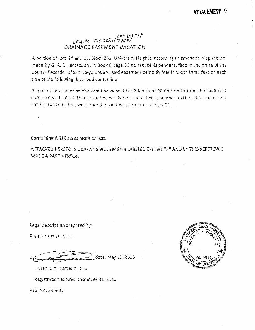
Exhibit L!!!t$AL DE'S.CIVPI!ON
DRAINAGE EASEiviENT VACATiON
ATTACHMENT 7
A portion of Lots 20 and 21, Bk;ck 251, University Heights, according to amended Map th
made by G. A. D'Hemecourt, in Book 8 page et. seq. of lis pendens, filed in the office of the
County Recorder of San Diego County, said easement being six feet in width three feet on each
side of the following described center line:
Beginning at a point on the east line of said 20, distant 20 feet north from the southeast
corner of said Lot 20; thence southwesterly on a direct line to a point on the south line of said
Lot 21, distant 60 feet west from the southeast corner of said Lot 21.
Ccmtaining 0.010 acres more or less.
ATTACHED HERETO IS OR11\.WlNG NO. 38461·8 L~BHEO EXHIBIT "S" AND BY THIS REFERENCE
MADE A PART HEREOF.
Legal description prepared by:
Kappa Surveying] Inc.
--~~-aG ~.:~_date: IV1ay 15, 2015
Allen R. A. Turner Ill, PLS
Registration expires Decemb2r 31, 2016
PTS. No. 396980
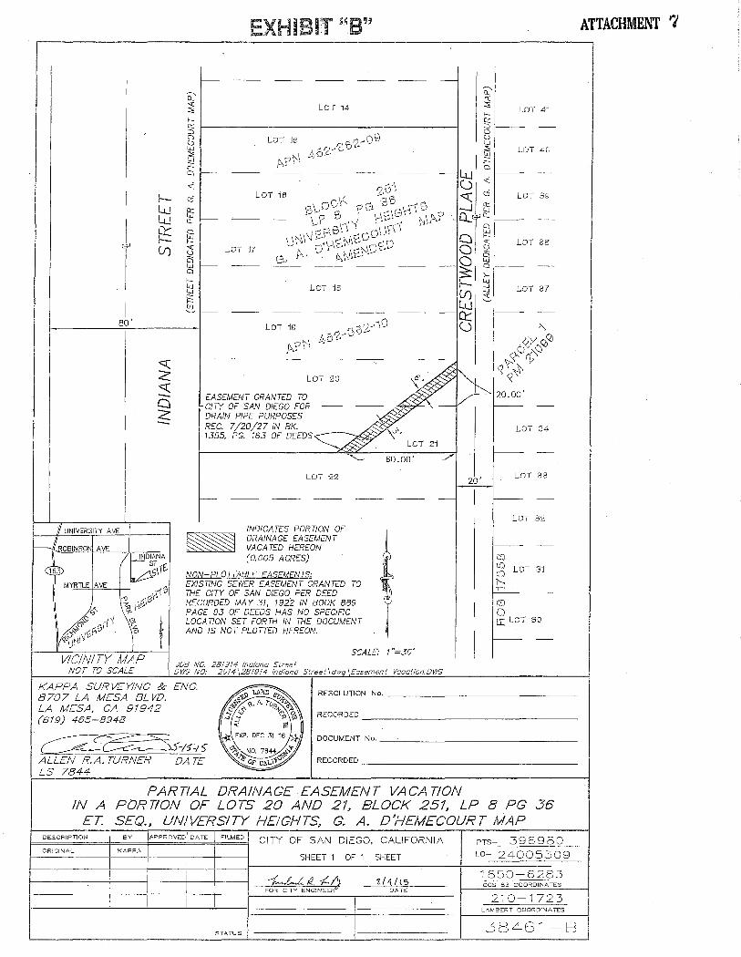
I
I
l
I 80'
I UNIVERSITY AVE
WROBINSON AVE
~
VICINITY MAP
Q <( :::;; f-.-Q:: ::::J 0
td 23 .::c Cl
..:
EXHIBIT "8"
1------
LOJ -J4
f-----
LOT -Js
---
LOT 20
E:ASE:ME:NT GRANTE:D TO CITY OF SAN DIE:GO FOR DRAIN PIPE PURPOSES REG. 7/20/27 IN BK. 1355, PG. 163 OF DEEDS
LOT 22
---
60.00'
------------
INDICATES PORTION OF DRAINAGE EASEMENT VACA TE:D HE:RE:ON (0.005 ACRES)
NON-PLOTTABLE EASE:ME:NTS: EXISTING SEWE:R EASEMENT GRANTED TO THE CITY OF SAN DIEGO PE:R DEED RECORDED MAY 31, 1922 IN BOOK 889 PAGE 93 OF DEE:DS HAS NO SPE:CIFIC LOCATION SET FORTH IN THE DOCUMENT AND IS NOT PLOTTED HE:RE:ON.
SCALE: 1"=30'
JOB NO. 28191f, Indiana Street NOT TO SCALE DWG NO: 2014j281914 Indiana Street \dwg \Easement Vacation.DWG
KAPPA SURVEYING & ENG. -=
LOT 40
LOT 37
LOT 34
r-- -
20' LOT 83
I I-- -
LOT 32
r-- -r::o tO LOT 3-J ~Q j'--.,
,_:r=._ -
I lD 0 CC LoT 30
I - -
I //") ~ J,lu'IJJ ,S, 8707 LA MESA BL vu. ·-~""~ A r ~~-
RESOLUTION No.---------------
LA MESA, CA 91942 /f•,.;,. "-· . uo-'~-~ <r>,.o
~ ~ v '1:> RECORDED
(619) 465-8948 ...,:;; ~'\"'\\
~ :11: EXP. DEC 3116 *}} DOCUMENT No. _______________ _
( ~~"'\5-/5-/::;- ~NO. 7844;z.">"
ALLEN R.A. TURNER DATE ~oF c.~.,,~· RECORDED -----------------LS 7844 -==-
PARTIAL DRAINAGE EASEMENT VACATION IN A PORTION OF LOTS 20 AND 21, BLOCK 251, LP 8 PG 36
ET. SEQ., UNIVERSITY HEIGHT~ G. A. D'HEMECOURT MAP ' Dt:..SCRIP 1 ION BY APPROVED DATE FILMED
ORIGit'·IAL KAPPA
STATUS
CITY OF SAN DIEGO, CALIFORNIA
SHEET 1 OF 1 SHEET
~~--;(..{) FOR CITY ENGINEE ~ DATE
PTS- 396980 1.0- 24005309
1850-6283 CCS 83 COOROINP.. 1 t:..S
210-1723 L . .<\MBERT COORDINATES
38461-B
ATTACHMENT 7
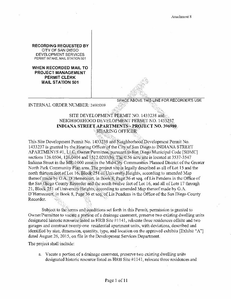
RECORDING REQUESTED BY CITY OF SAN DIEGO
DEVELOPMENT SERVICES PERMIT INTAKE, MAIL STATION 501
WHEN RECORDED MAIL TO PROJECT MANAGEMENT
PERMIT CLERK MAIL STATION 501
Attachment 8
SPA:CE ABOVE Tf-'IIS LINE FOR RECORDER'S USE ' '
INTERNAL ORDER NUMBER: 24005309
SITE DEVELOPMENTPERMIT NO. 1433238 ah<;I NEIGHBORHOOD DEVELOPME~T PERMIT NO. 1433237
INDIANA STREET AP ARTMENTSi'" PROJECT NO. 396980. HEARING OFFICER
This Site Development Permit No. 1433i·p8 arldN~ighborhoodPevelopment Permit No. 1433237 is granted by th~J--IeFiring Officeno.fthe Cityo:fSan Diego to INDIANA STREET APARTMENTS #1, LLCiO:Wp;er/Permittee, pursuantto San Diego Municipal Code [SDMC] sections 126.0504, 126:6404 andl512.0203(b).·Th~O.S6 acre site is located at 3537-3547 Indiana Street in the MR~lOOO zone in the Mid~City Communities Planned District ofthe Greater North Park CommunityPlan area.Jhe project sit~is legally described as all of Lot 15 and the north thirteenfeetoJLot 16, ]?lock251 ofl)niversifyHeights, according to amended Map thereohnadeby G.A.l).'Hemecourt, in Book 8, Pager36 et seq. of Lis Pendens in the Office of the San Diego CountyRe.cprder and .the south twelve feet of Lot 16, and all of Lots 17 through 21, Block 251 ofUniversityHeights, 3:ccording to amended Map thereof made by G.A. D'Hemecourt, in Book 8, Page'36 et seq:,ofLis Pendens in the Office ofthe San Diego County Recorder.
Subject to the/terms and. conditions set forth in this Permit, permission is granted to Owner/Permittee to vacate a portion of a drainage easement, preserve two existing dwelling units designated historic resourcelisted as HRB Site #1141, relocate three residences offsite and two garages and construct twenty-one residential apartment units, with deviations, described and identified by size, dimension, quantity, type, and location on the approved exhibits [Exhibit "A"] dated August 26, 2015, on file in the Development Services Department.
The project shall include:
a. Vacate a portion of a drainage easement, preserve two existing dwelling units designated historic resource listed as HRB Site #1141, relocate three residences and
Page 1 of 11

Attachment 8
two detached garages offsite and construct twenty-one residential apartment units, with six deviations;
b. The Project requires six deviations from the SDMC requirements ofthe MCCPD-MR-1 000 Zone, specifically described as:
Deviation • Overall building height • Side setbacks above second story • Rear setbacks above the second story • Pedestrian entries • Architectural features • Retaining wall height in rear setback
MR -1 000 Zone 40' & 50' 3' per story to 15' max. 7' per story ~o 14' max. 3 5 of10 required
6f~~t
Proposed 43' & 54' 1 '-8" None 1 2 provided 12 feet
c. Landscaping (planting, irrigation andl:;tiJ-dscape related imprpv,ements);
d. Off-street parking; and
e. A roof-mounted photovolt.;t:ic sy~tem consisting of .solar panels sufficieritto generate at least 50 percent ofthe project's projected energy consumption in accordance with Council Policy 900-14; and
f. Public and private accessory improvements dete:t;mined by the Development Services Departmentto be corisi$lent with th¢Jand u~e 'and dey.elopment standards for this site in accordance witl:l the adop~eg commun,ity.pl~m, the California Environmental Quality Act [ CEQA] ahd the CEQA Guidelines, the City Engineer's requirements, zoning regulations, comHt1o11s oftbis P~rmit, and any other applicable regulations of the Sl)IyiC, ,, ....
STANllAl~D REQUIREMENTS:
1. This petmit ;must be utilized within thirty-six (3 6) months after the date on which all rights of appeal have expired. Ifthis petmit is not utilized in accordance with Chapter 12, Article 6, Division 1 of the SDM.C within the 36 month period, this permit shall be void unless an Extension of Time has.been granted. Any such Extension of Time must meet all SDMC requirements and applicable guidelines in effect at the time the extension is considered by the appropriate decision maker. This permit must be utilized by September 11, 2018.
2. No permit for the construction, occupancy, or operation of any facility or improvement described herein shall be granted, nor shall any activity authorized by this Permit be conducted on the premises until:
a. The Owner/Pennittee sign and return the Permit to the Development Services Department; and
Page 2 of 11

Attachment 8
b. The Pennit is recorded in the Office of the San Diego County Recorder.
3. While this Permit is in effect, the subject property shall be used only for the purposes and under the tenns and conditions set forth in this Pennit unless otherwise authorized by the appropriate City decision maker.
4. This Permit is a covenant running with the subject property and all of the requirements and conditions of this Permit and related documents shall be binding upon the Owner/Permittee and any successor(s) in interest.
5. The continued use of this Permit shall be subject to ther.egulations of this and any other applicable governmental agency. ·
6. Issuance of this Permit by the City of San Di~go does not authorize the Owner/Permittee for this Permit to violate any Federal, State or City Jaws, ordinances; regulations or policies including, but not limited to, the Endangered Species Act of 1973 [ESA]and any amendments thereto (16 U.S.C. § 1531 et seq.). ..
7. The Owner/Permittee shall secvw. all necessary bllilqhtg permits. The Owner/Permittee is informed that to secure these permits, s"llbstaptial buildi!lg:plodifications and site improvements may be required to comply with appliCable building, fire, mechanical, and plumbing codes, and State and Federal disability access laws. ·
8. Construction plans sha11 be in substandalconfohnityto Exhibit "A." Changes, modifications, or alterations to the ponstructio1;lp~ans are prohib~ted. unless appropriate application(s) or amendment(s) to this Permit havebeen granted.
9. All ofthe conditions contai11ed iii this Pennit have been considered and were determined-necessaryto make the findings required for approval of this Permit. The Permit holder is requireg tqcomply with each andeyery condition in order to maintain the entitlements that are granted by this Permit.
If any conditionofthis Permit, on a legal challenge by the Owner/Permittee ofthis Pennit, is found or held by a co:qrt of competent jurisdiction to be invalid, unenforceable, or unreasonable, this Permit shall be void. However, in such an event, the Owner/Permittee shall have the right, by paying applicable processing fees, to bring a request for a new permit without the "invalid" conditions(s) back to the discretionary body which approved the Permit for a determination by that body as to whether all of the findings necessary for the issuance of the proposed permit can still be made in the absence of the "invalid" condition(s). Such hearing shall be a hearing de novo, and the discretionary body shall have the absolute right to approve, disapprove, or modify the proposed permit and the condition(s) contained therein.
10. The Owner/Permittee shall defend, indemnify, and hold hannless the City, its agents, officers, and employees from any and all claims, actions, proceedings, damages, judgments, or costs, including attorney's fees, against the City or its agents, officers, or employees, relating to the issuance of this pennit including, but not limited to, any action to attack, set aside, void,
Page 3 of 11

Attachment 8
challenge, or annul this development approval and any environmental document or decision. The City will promptly notify Owner/Permittee of any claim, action, or proceeding and, if the City should fail to cooperate fully in the defense, the Owner/Permittee shall not thereafter be responsible to defend, indemnify, and hold harmless the City or its agents, officers, and employees. The City may elect to conduct its own defense, participate in its own defense, or obtain independent legal counsel in defense of any claim related to this indemnification. In the event of such election, Owner/Permittee shall pay all of the costs related thereto, including without limitation reasonable attorney's fees and costs. In the event of a disagreement between the City and Owner/Permittee regarding litigation issues, the City shall have the authority to control the litigation and make litigation related decisions, includi1;1g, but not limited to, settlement or other disposition of the matter. However, the ()wner/Permittee shall not be required to pay or perform any settlement unless such settlement is app;toved by Owner/Permittee.
-', ,, 1'1'',
ENVIRONMENTAL/MITIGATION REQUIREMENTS:
11. Mitigation requirements in the Mitigation, Monitoring, and Reporting Program [MMRP] shall apply to this Permit. These MMRP condit-ions are hereby incorponited.into this Permit by reference.
12. The mitigation measures specifi~d,J!l the MMRP arid 9utlined in Mitigated Negative Declaration No. 396980, shall be note& on tn~ construction plans and specifications under the heading ENVIRONMENTAL MITIGATIONRE~UIREMENJ'S.
13. The Owner/Pefll}ittee dhallcomply with the1-f~}{i> a'§~pecified in Mitigated Negative Declaration No. 3969SQ/to the satisfaction ofthe bevelopment'Services Department and the City Engineer. Prior t(Y{$suance of any construc.don permit, all conditions of the MMRP shall be adhered to, to the satisfaCtion of the CityEngineer. All mitigation measures described in the MMRP shall he itnplemented for the following issue areas:
H"'l H~Qgy .. , HistOri~al Resources (Archeaology) Paleont()logical Resour~es
14. Prior to the issuance of ~ny building permits, the Owner/Permittee shall comply with the affordable housing requirements of the City's Inclusionary Affordable Housing Regulations (SDMC § 142.1301 et seq.).
AIRPORT REQUIREMENT:
15. Prior to the issuance of any building permits, the Owner/Permittee shall provide a copy of the signed agreement [DS-503] and show certification on the building plans verifying that the structures do not require Federal Aviation Administration [FAA] notice for Determination ofNo Hazard to Air Navigation, or provide an FAA Determination of No Hazard to Air Navigation as specified in Infonnation Bulletin 520
Page 4 of 11
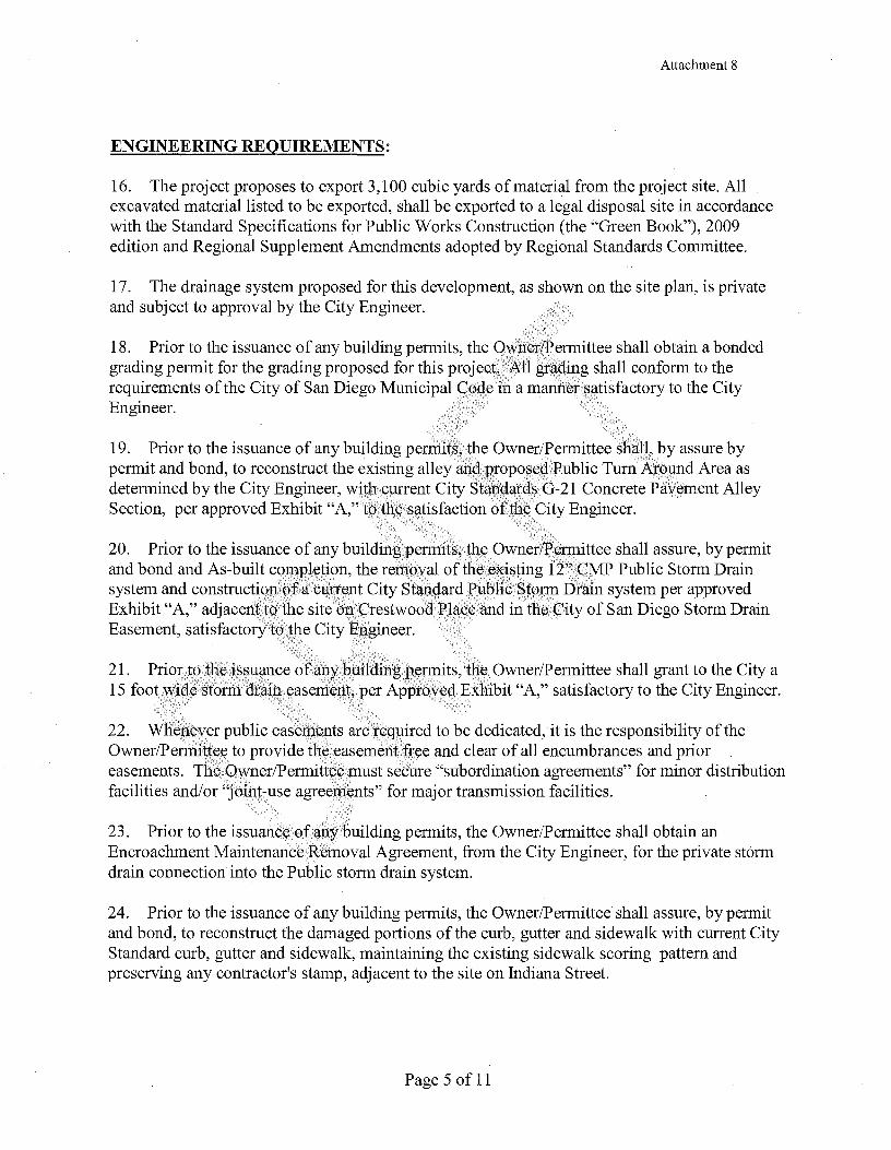
Attachment 8
ENGINEERING REQUIREMENTS:
16. The project proposes to export 3,100 cubic yards of material from the project site. All excavated material listed to be exported, shall be exported to a legal disposal site in accordance with the Standard Specifications for Public Works Construction (the "Green Book"), 2009 edition and Regional Supplement Amendments adopted by Regional Standards Committee.
1 7. The drainage system proposed for this development, as shown on the site plan, is private and subject to approval by the City Engineer.
18. Prior to the issuance of any building permits, the ()~rie~/Permittee shall obtain a bonded grading permit for the grading proposed for this project;¥\.il grad,i]1g shall conform to the requirements of the City of San Diego Municipal iri a manriGt ~{!tis factory to the City Engineer.
19. Prior to the issuance of any building perniits,,~he Owner/~ermittee sh~ll, by assure by permit and bond, to reconstruct the existing alley andpfoP?§~q,;Public Turn Arp~nd Area as determined by the City Engineer, wit~ C1Jffent City Stand,,a,t~~ G-21 Concrete P~yement Alley Section, per approved Exhibit "A," tp th(.'(;:~a,tisfaction of~h~, City Engineer.
!'.<";-·:·'.; ____ .. ,_-,._-__ >.·:,: __ ; ,; '->.--_-_..·:'
20. Prior to the issuance of any buildi.rlgpennits;t~e,?wner/Pennittee shall assure, by permit and bond and As-built c?~BI~tign, the removal of the (.?X~sting 12" CMP Public Storm Drain system and constructi?.lJ()ffii C1J,ff~~t City Sta_IH:lard]l\Jb}lic,~tplJll Drain system per approved Exhibit "A," adjacenl~?,the site <tn.srestwood]llf!.ceand in the(:::ity of San Diego Storm Drain Easement, satisfactoryto;the City Engineer.
21. Priort?tlie}s~l1Cll1ce 6rany'bhildingp.el1nits, th~Owner/Permittee shall grant to the City a 15 footW:~tl(.'( storm: dr~~l;l yasemeJ1t, per Approved Exhibit "A," satisfactory to the City Engineer.
:::·.··.,·:.:· '·':·_';',_::··_'.:·-_,:_··.:··-.-:,: · .. ·.,-_:\.'
22. Wherieyer public easements are ie~uired to be dedicated, it is the responsibility of the Owner/Penni~te,eto provide thy;easementfrye and clear of all encumbrances and prior easements. TheOwner/Permitteemust secure "subordination agreements" for minor distribution facilities and/or "joint-use agree:ni~nts" for major transmission facilities.
23. Prior to the issuanceofall.ybuilding permits, the Owner/Permittee shall obtain an Encroachment Maintenance Removal Agreement, from the City Engineer, for the private storm drain connection into the Public storm drain system.
24. Prior to the issuance of any building permits, the Owner/Permittee shall assure, by permit and bond, to reconstruct the damaged portions of the curb, gutter and sidewalk with current City Standard curb, gutter and sidewalk, maintaining the existing sidewalk scoring pattern and preserving any contractor's stamp, adjacent to the site on Indiana Street.
Page 5 of 11
Attachment 8
25. Prior to the issuance of any construction permit, the Owner/Permittee shall enter into a Maintenance Agreement for the ongoing permanent BMP maintenance, satisfactory to the City Engineer.
26. Prior to the issuance of any construction permit, the Owner/Permittee shall incorporate any construction Best Management Practices necessary to comply with Chapter 14, Article 2, Division 1 (Grading Regulations) of the San Diego Municipal Code, into the construction plans or specifications.
2 7. Prior to the issuance of any construction permit the OwnY:r'i.BY:rmittee shall submit a Water Pollution Control Plan (WPCP). The WPCP shall be preparY;g{n'accordance with the guidelines in Appendix E of the City's Storm Water Standards.
," '' '- --: ~
,, •• , ___ ,, '·<
28. Prior to the issuance of any construction pe~,itJh~Owner/P~r:rittee shall incorporate and show the type and location of all post-construc~~9~~est Management"flractices on the final construction drawings, consistent with the appro¥ed Water Quality Technical Report.
LANDSCAPE REQUIREMENTS:
29. Prior to issuance of any engineel"i~g~,Y:~its for gtadi~g, the Owner/Pennittee shall submit complete construction documents for tliY:rev~get~tion and hyqroseeding of all disturbed land in accordance with the City of San Diego L~pdscape~t~I1dardsafl.d~tormwater Design Manual, to the satisfaction of the D~yelopwent Servicy~,Deparfiily111·f\ll plaiJ.Ejshall be, in substantial conformance to this PY:npit(irtcll5(g~ng EnvitQllll1ent(;\l.'cbl1<:1Hi()11S) and Exhibit "A."
,:,· ,.-.· ·--., "''
30. Prior to issuance orEtpY engin~~ring pemiit$Jor right-of-way improvements, the Owner/Permitee shall submit cowRle~e,,~~ndscape 9?nstruction documents for right-of-way improvet~y~tsto thr,pevelbpl}:lY:]lfServiC~spepartri:t~nt for approval. Improvement plans shall show, l~b$hartd clitn.e11Si9~ a fort~,~quare fo6t,\~f~l;\at6und each tree which is unencumbered by utilities. I)riveways, utiliti,vE;, drai11$;,water and sewer laterals shall be designed so as not to prohibit the placement of stre# trees.
31. Prior to issg~nce of any construction permits for structm;es, the Owner/Permittee shall submit complete landscape and irrigation construction documents consistent with the Landscape Standards to the Development ~e:rvices Department for approval. The construction documents shall be in substantial conformance with Exhibit "A." Construction plans shall provide a forty square foot area around eaclitree that is unencumbered by hardscape and utilities unless otherwise approved per LDC 142.0403(b)5.
32. In the event a foundation only permit is requested by the Owner/Permittee, a site plan or staking layout plan shall be submitted to the Development Services Department identifying all landscape areas consistent with Exhibit "A." These landscape areas shall be clearly identified with a distinct symbol, noted with dimensions and labeled as 'landscaping area.'
33. The Owner/Permittee shall be responsible for the maintenance of all landscape improvements shown on the approved plans, including in the right-of-way, consistent with the
Page 6 of 11
Attachment 8
Landscape Standards unless long-term maintenance of said landscaping will be the responsibility of a Landscape Maintenance District or other approved entity.
34. All required landscape shall be maintained in a disease, weed and litter free condition at all times. Severe pruning or "topping" of trees is not permitted unless specifically noted in this Permit.
35. If any required landscape, including existing or new plantings, hardscape, landscape features, et cetera, indicated on the approved construction document plans is damaged or removed during demolition or construction, the Owner/Permitt~~ .E;hall repair and/or replace in kind and· equivalent size per the approved documents to th~ satisfaction of the Development Services Department within thirty days of damage or Certificate of Occupancy.
BRUSH MANAGEMENT PROGRAM REQUIREMENTS:
36. The Brush Management Program shall be based on a standard Zon~ One of 35 feet and Zone Two of 65 feet consistent with the Brush Mimagement Regulations of the Land Development Code section 142.0412. Zone One shail~xtendout from the structure towards the native/naturalized vegetation for a dist~~ce of 35 feefwith (corresponding Zone Two varying in width from 13 feet to 42 feet to the si¢l.e·.a:nci/or rear propeti:ylines. The balance of Zone Two shall be provided on adjacent propert:lesin coiljJinction with existing development and shall be the responsibility of the adjacent property owner.
3 7. Prior to issuance .9f any engineering pe~-nits fm ~tading, landscape construction documents required for the engirie¢ring permit shall be sug!pitted showing the brush management zones on the property in substanhal.ponformance with Exhfbit "A."
3 8. Prior .to i~suance of any:~uilcling pennits, a complete set of Brush Management Plans shall be submitted for approyal to the .Development ~ervices Department. The construction documents shall be in substantial conformance W:ith Exhibif"A" and shall comply with the Landscape Standards and Brush Management Regulations as set forth under Land Development Code Section 142:0412.
39. Within Zone O:ne, combustible accessory structures, including, but not limited to decks, trellises, gazebos, etcetera, shall I1ot be permitted while accessory structures of non-combustible, one-hour fire-rated, and/or heavy timber construction may be approved within the designated Zone One area subject to Fire Marshal's approval.
40. The following note shall be provided on the Brush Management Construction Documents: ''It shall be the responsibility of the Owner/Pennittee to schedule a pre-construction meeting on site with the contractor and the Development Services Department to discuss and outline the implementation ofthe Brush Management Program."
41. Prior to final inspection and issuance of any Certificate of Occupancy, the approved Brush Management Program shall be implemented.
Page 7 of 11

Attachment 8
42. The Brush Management Program shall be maintained at all times in accordance with the City of San Diego's Landscape Standards.
PLANNING/DESIGN REQUIREMENTS:
43. A topographical survey conforming to the provisions of the SDMC may be required if it is determined, during construction, that there may be a conflict between the building(s) under construction and a condition of this Permit or a regulation of the underlying zone. The cost of any such survey shall be borne by the Owner/Permittee.
44. All signs associated with this development shall be consistent with sign criteria established by the City-wide sign regulations. .. ·
45. All private outdoor lighting shall be shaded ap.q ~djusted to fall. on the same premises where such lights are located and in accordance.witijthe applicable r13gulations in the SDMC.
TRANSPORTATION REQUIREMENTS: ' ':'·.,··.·,·.~'·'' >''I· :,">
46. The Owner/Pennittee shall maintain a minimurit ()f,116fewer than 28 parking spaces, including one accessible space, two ri19t()rc~ple spaces anclf~n bicycle spaces on the property at all times in the approximate locations shqw11 OlJ. .E;xhibit "A'j .1\,ll on-site parking stalls and aisle widths shall be in compliance with requir~]llents p.fthe City's L~Bd Development Code and shall not be converted and/or utili:z:.e,q for any otlj:~r purpose,ull1~ss otlie,rwise authorized in writing by the Development Servi¢e~ Dej:)~tt:ment. · · ·
·-:, ,; : ":'::·_:>'::<,,.: '. '< .,_,._ <-_: '-:-·.,-.· ':,,~:1·, ... ·,_:'
47. Prior to issuanct!of,,~!lY build±pp pennit, th~iOwner/Permitee shall dedicate and assure by permit and bo~~ constructipjJ. ?fa.Jt.Jt)l~r,gund areq(approximately 26 feet by 13 feet) south of the garage en~r~~?~~nsl.'"Y~st ofth~p.?rthlsouth~lJey, pl11simproving the alley for additional10 feet south of,it,~nd in~tall{ng,Fity statJ,~[lfd barncf.tqt~ and signage at the south end of the alley in the approximate locations shQW.ll on E%Jiibit "A," satisfactory to the City Engineer.
MAPPINGREQUIREMEN~S:
48. Prior to theezc.pifation of this permit, a Drainage Easement is to be granted and portions of the Drainage Easement grantedp~r Document recorded July 20, 1927 in Book 1355, Page 163 of deeds lying within lots 21 and22 are to be vacated.
49. Prior to recordation of the Quitclaim Deed for the vacation of the Drainage Easement, a new Drainage Easement is to be granted to the City of San Diego, satisfactory to the City Engineer.
50. Prior to recordation of the Quitclaim Deed for the vacation ofthe Drainage Easement granted per Document recorded July 20, 1927 in Book 1355, Page 163 of deeds, all facilities in the existing easement must be removed and relocated satisfactory to the City Engineer.
GEOLOGY REQUIREMENTS:
Page 8 of 11

Attachment 8
51. The Owner/Permittee shall submit a geotechnical investigation report or update letter that specifically addresses the proposed constmction plans. The geotechnical investigation report or update letter shall be reviewed for adequacy by the Geology Section of the Development Services Department prior to issuance of any constmction permits.
52. The Owner/Pennittee shall submit an as-graded geotechnical report prepared in accordance with the City's "Guidelines for Geotechnical Reports" following completion of the grading. The as-graded geotechnical report shall be reviewed for adequacy by the Geology Section of the Development Services Department prior to exoneration of the pqnd and completion of the grading permit.
PUBLIC UTILITIES REQUIREMENTS:
53. Prior to the issuance of any building permits, the Owner/Permitt.e~ shall assure, by permit and bond, the design and constmction of new Water and sewer service(s)outside of any driveway or drive aisle and the abandonment of any existing unused water and sewer S~rvices within the right-of-way adjacent to the project site, in a manner satisfact9:ry. to the Public Utilities Director and the City Engineer. · · · · ·
54. Prior to the issuance of any building permits, the Owner/Pennittee shall apply for a plumbing permit for the installation of appropriate. private back flow prevention device(s), on each water service (dom~stic, fire and irrigation), ina manner satisfactory to the Public Utilities Director and the City ~ngineer.Back flow preventiop. <fevices shall be located above ground on private property, in lil)e.with the seryice and immediately adja(;ept to the right-of-way.
55. No trees or shrubs exc.eedingthree feet in hei~ht at maturity shall be installed within ten feet of any sewer facilities ang4};vefeet o:f any waterfacilities.
56. 'tb(Owner/Permitte¢ shall design and constmct all proposed public water and sewer facilities, inaccordance withestablished criteria in the current edition ofthe City of San Diego Water and Sewer Facility Design Guidelines and City regulations, standards and practices.
INFORMATION ONLY:
• The issuance of this discretionary use permit alone does not allow the immediate commencement or continued operation of the proposed use on site. The operation allowed by this discretionary use permit may only begin or recommence after all conditions listed on this permit are fully completed and all required ministerial permits have been issued and received final inspection.
• Any party on whom fees, dedications, reservations, or other exactions have been imposed as conditions of approval of this Permit, may protest the imposition within ninety days of the approval of this development permit by filing a written protest with the City Clerk pursuant to California Government Code-section 66020.
Page 9 of 11
Attachment 8
• This development may be subject to impact fees at the time of construction pennit Issuance.
APPROVED by the Hearing Officer of the City of San Diego on August 26, 2015 by [A roved Resolution Number].
Page 10 of 11

Attachment 8
Neighborhood Development Permit No. 1433237 Site Development Permit No. 1433238 Date of Approval: August 26, 2015
AUTHENTICATED BY THE CITY OF SAN DIEGO DEVELOPMENT SERVICES DEPARTMENT
JohnS. Fisher Development Project Manager
NOTE: Notary acknowledgment must be attached per Civil Code section 1189 et seq.
The undersigned Owner/Permittee, by,execution hereof, agrees to each and every condition of this Permit and promises to perform each and evecy.obligationofOwner/Permittee hereunder.
NOTE: Notary acknowledgments must be attached per Civil Code section 1189 et seq.
INUlANA STREET APARTMENTS #1, LLC Owner/Permittee
By __________________________ __ Tim Wright General Partner
INDIANA STREET APARTMENTS #1, LLC Owner/Permittee
By __________________________ _ Craig Irving General Partner
Page 11 of 11
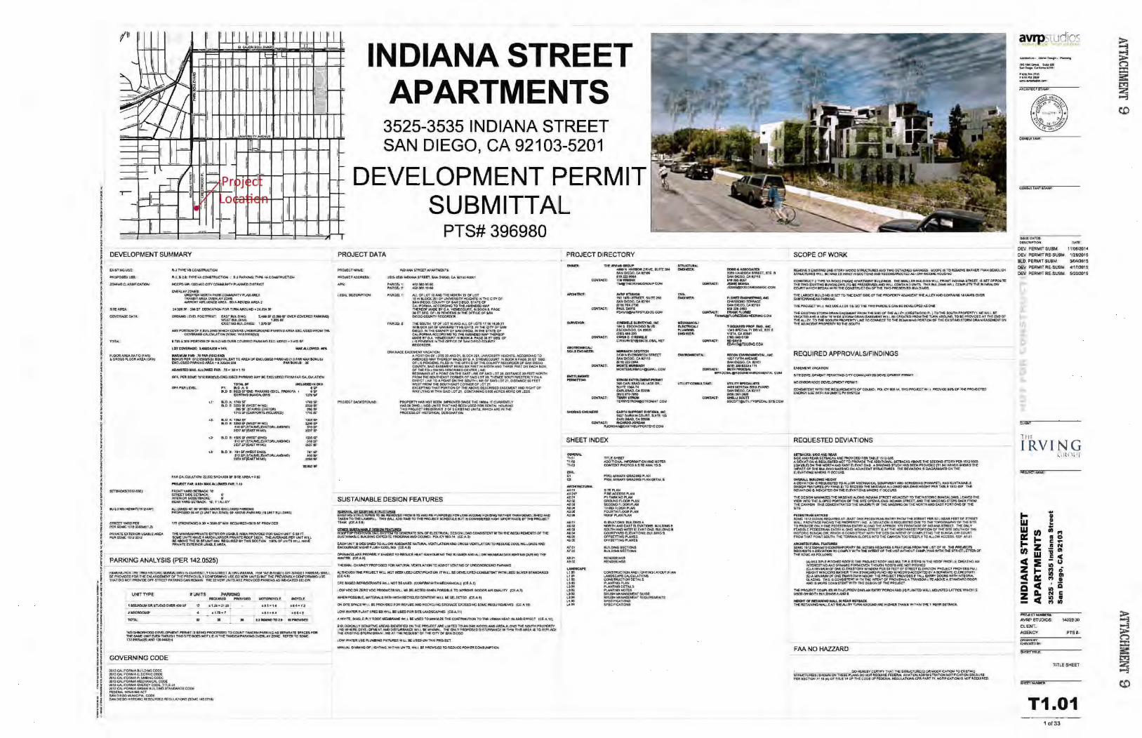
DEVELOPMENT SUMMARY
I I 1 I lr I li I 11 l '_I I i I ._ a~eoo..~MR~ f
INDIANA STREET -
lOT"'- II' PJ: kD/\.0
IHCUCliD fN 01 A ... ... llO 1: tUO Sf£Ht. 'AIOOHOfEXtL FROM fA I --- "''"' ,,..Sf ...... ..... 111.5$1
UttSf
""'"' S10$F
""" ISO$ SF S!OSf ,.,,.,
........
APARTMENTS
1-
3525-3535 INDIANA STREET SAN DIEGO, CA 92103-5201
-DEVELOPMENT PERMIT
SUBMITTAL ..,-I
PROJECT DATA
PTS# 396980
1'-0AWA sntttT APNtt\19lTS
i:J.S~~STMn, &Noi0£00, CA. SZUUJWOOI
I'AACB.Z.
,.,.,.,...... • »4a 10,.00
N..lOFLOT 1.$NfOTliENOfit'TN 1~0f.lOT 1f 1NIIl.OCIC2510#'~~Ifrln4:Cfl"t'O# SA. ... OIEOO.CClUW'fVOF~O.E<lO.ITAT£0' CA.l·~~NCT01Hf.AMEJC)mtlfltll ~WoOllY CA. 1o£toECOU tl, IN toOk .. PAC€ l6 ET SEQ OF US POCitNS IN TtC OfFICE ()Ill SAN OIEOO COUNTY 1\ECOROEJt
nESOIJTW 1t OF lOT 16.\NDAU.OFLOT$ t7.11,1t.20,ll .W .OCI( 251 Of UNNER$fl'YHE:CHT$, 1N nt! OlYOF SAH OtEOO,HTHE~TYOF~~.INl'HEITATEOf ~ACCORDING TOnE AMEJC)EO......,. TH(Rf<)F IMDEIYOA 'HaliEcotmTIJIIIIOCJI(t, PAOe af(T$EO. OF US PEWDI:HliH1M£0f:ACE OF s.AHa£00COiMTY
"""""" .. OAAJJWJ£~VACA1'Mlfrt
AI'OROONM' LOTS NNIOZl. aOCK 251, t.INYERSftYHEIOHTS, ACCOfiDONG TO No!END£D W#l'H£MOF MADE-fNO A. OltEUECOURT, IN lOOKS Pt.a! lS ET S£0 OILJS PEWtEH5,. P'UiD IN nE OFFICE OF THE COUH"1'V JW:OROEROFSAN Dlr.oo COUNlV.MO~I£.HGSIXfEETNWID1l1ANOTMREI1FU-t~t.ACH&O£. 01 niffOLLOW<NGOESCIWEO C!NT!R l iN£: 11Ec.'W4NIHO AT A IJ04NT ON M. EASTUM! 01 S.A101.0T 20, OISTAHC! 20 FUT 1+011\YH flltOM~IO.ITMEAST~Of SAIOLOT20;nlb«:f~V~A Ol~lLIHI!:TOAf!OUrfTONTHfSO!Jno4LINI!CWSAIOL01'li.Oi:Sl~IOJ'(£f WUT~M~CORNER!WlOf~ fXCU'TING THAT PORTIOfol t:l1 MAaavf ~ lA5f.J,jDrlf NIOROHT Of WAVL'f'INOW!ThiNSAC>t.OTl1 COHTANNGOOO&ACflt!SMOR£01\LUS .
SUSTAINABLE DESIGN FEATURES
~f~J:."'rul:a~RD~ FAOU &ll AHD RE-i'URPOSa) FOA\.OW~~41NC fiiAnlfllt~OVoiOUIHEO~ TAQM TOTHELANDR.l. THISWIJ. AOOTM.TOTltEPROJECT SDIEDU.£111115~ HIQHMJIORTANCfii'VntiPROJlCT 't~(CE.A&,IJ
-OOERATE~Df'EI.EC"ntiCAI..DESGNI.OADCOf«SI$TDJTWlMTHER.Ultl~OFlHE aJSlNMAII..EIIUl.O!HG EXJI'EDflE~N<IC~ POUCYtoo.\• (C:E·Al~
!ACH UHrt i&DU GNEO TO ALL ON ADmUATt: ~'TUJtAI.. YenUTlONAHOCAOS.S VBrll"U.TlON10R:EOUCE COOlHG 1.0AOS/IN'.J ~H.GtftF;.USHCOCli.!NO ~S)
Of"iHINGSAA! PAOI'ERl.Y5lWlii!O lOREOlU HEAl GAIN OUR t,,G ftE. SUMt.Eit N.DAU. r:HI ~ OA'IUOHT....O DU.R•NG THE Wi!NTEflttE•Af•
~ CHl~EV PROf'OUD I'~ NAl\.fW. WHlllAtlONf O .US.ST~TKi 01' UHO£RGROUND PAAKINO
Aln.oucJII THf fttroJI!CTWU NOl aiEC: \.t'!Dcti\T~f"OH IT WILL bt ON!l.OI'!.Oc.oto:a1Vtl'W!lMLUO M..W." ITAHOAAD3 teo.•• CfC: 8A£C) R!,RiGOWITS WW.l NOT 81! USED (CONI"'AM WITH IIJECKAHICAI.,) tce<A r)
l OW YOCOM mAOVOC PltOOUCTt WU II a&!.fCT!O W,.,.. POS$'8!.( TO'folf'!Rovt IHDOOR AIM Ol.W..IfV iCf AJ)
'M«H~kE.W.TERW.$W!lHHIGHMCYa..!OCONT1JrfTWUN&nEctt0 (U,.\.1.
ON Sll'i ~IEWU. II MOVIO£D fOflC ACRJSl NfOk(CYCUHGSTORAGLEXcUO<NG~fltOU R£MEHfS (Cl..A101
lOW·WA'lVI.II'I.NlfSPf.trUW&.LifUS(D ~ ltlri\.AAOSCAP'>HO tCE.A t ' )
A. WWft;. SINCli.~YftOOf ~ W1U. II( US(D TO '*lrtM.rzt ~COHlll!IIJT\OH TOnE UAaAH H£AT 1SLAHD (Fnef IC(_ A 12)
I 'O!..OOCA.u Y SEHSfTMJIII;bS IDOinfllD ON TIC flftO.IfCT AAt utMTtO TONIOA.K WOOOI..AfrrC)AAJ!AAI.ONO ntE sount P~ ~-W~OMLONoiDlfNC~WU I( ~IML Tt«!ON..VPROPOU'D~'CEWifto'NTHIINtbtlllOIIt£JI\..IoCl Tliti EXIS'Tit4110ft\otDRAIN~INE~T-ntii\EQUEITOf-n€Cn'VOf &AAD!fOO
LON·WATVI ust:Pl~fUrl\MD WiU ill USfDQflh$11"RO..IECT
JM..o.tUN. 0 16lNCOF tQflWO. W!THNW1t'.J.W1U I(~ fORfDUCEfi'OWIM~
PROJECT DIRECTORY
nEIRYINOGltOUf" 4MO H HAA:80R 0AAE. $UfTE Z\Ciot 8AH 01(00, CA 12106 61.l22110t' l UIWRIGtfT ,...nif!RYINOOROUP COlo!
SHEET INDEX
-TI,PI T101. TW
""' 01
"' ~At01 At.01F ...,_ .. ,.,., "'-" .._ .. "'-" ...,_,. .... ..... .... .... ...... .... "'" "'" M ,Dl .... ."" l tOJ
"" u oo Uot
"·"' "·" "" .. .. ......
PRELIUINAAV OAAOINO P..AN Pft&.I ... ~VOAADINOPV.NOUAil•
........... F1Rf.t.CCESSI"\A._, P1 PARit'NO P\AN ....... """" ....... SEtoN0 R OOR 'VoN THRDf\,OORP\.AH f<lORTHMORPI.AOI .................. EiEVATIOHS:kii.DINGA NOknt AND EAST R£'VATQCS: aiJtt.DIHG I 801.10tNQWDTB.EVA'ttONS:eU-t.O!KG B ocutTVNIOf.LEVAT\ON&: 8llfLDINGI ,_ ....... ~Uim'!NGII'l.ANU
IULC\lNGSI!CTlOHS IUI.O'.HGS!C'TlONS
..,., ..... ............
U'T!UlYOOJGLLTN(f:
SCOPE OF WORK
REMO'IIe 'El0$1l~ C»«-$T~VWOOO smt.ICl'URESioND 'fifO OE'TACtEOGAIUQES sc:of'1: 1$ TORBOrti£Mnet 1W.H OQIOus;f. S'TRUCTVRfSWU. IIE.I1NA.fDitWAYif'fSK'Tl0!4A-~RfCOHSlRUCTEDA$lo.Y~HOll$:f«J
CO..OCSTRUCT2lYPEVAWOOOr~Wo'eN'AA'l\ENT~ The-SMN.~ERtlM.D'NGWUFRON'fNJ'N¥.6T'Ml!t,G$!1~ iH1ii TWO eQS'nNOIIJNCW.OWS (TOle: ~I,_,WU COWT-"N.l UNO'$ TH::S eu.t>HOWILi. ~ ne_ IWUNGAL.O.V COlln'WI-t(:HHOAHwmtntlCOMSlllUC'flON OF THE 'TWOPRDeRv£0 IBIAD.HGS
'THE I.AADER SIJILD!NQ IS SOlO T11E EAST S~ Of TtCEPAOPt:RTY /llJJIII1Nt nc.AU.tt loXOCOH'TAJ;,as 1t WTSOVVt ......................... lHEPRO.IECTW<I,L IHOUOEAI.Ol T•E $0-ntE TWOI"NU::a.S CAHe!~OPEOASOfC.
1'Hf.' QGs'TlNQ ~ DfiA!rrfEASa.ENJ" moM THt s;..,(J# n.!l N.l£Y('CA£$1WOOO ,..._) TOll4l.IOUTN HI:~ l iN£ W't.I.IE VA.CA1'mAHOAHE.W 1S'WIOES10AMOMIH~Wl.l.fJtelt£AT[Or:JI;Ot.llWit'\.IIN~TOIEI'A(Nl0EOATfHliM)Of THlAUEY. TO THI:&OOt.t'I'WPtlOPUn"'tUJ<e TO eoNNtCT TO ntr: AO.IA~POtmONOf-THffX_:sTIHQSTa.IM ORAINfAIIfMD(f OM TtCN:l.IACfNT~rrfOMsatmt
REQUIRED APPROVALS/FINDINGS
EA$6IENl Vi\C!Al!OW
SITEO&e.Of'l,Etlt PfR,IoiJTA40·CITV~uta1QOf:Y£lQPl.EWT PSU•:t;
~~PEJlVo'T'
COHSI$Talf WJl'H 'flE.R£QUIROEJon·s ""c:o.JtlCL PQ.IC"'' 100•\4, tkS PROA:Cf ·WIU. P'RO'w"'Df~ CJII' M.~C'TI!O fNSlGV~ WrJ'HAH(INSrrt,., 8'!'S'l'tM
REQUESTED DEVIATIONS
~:&DIAHOAI!Nt $1c..!AHO M!AAMmW.UAMi HIOVIDal PDt TAtiJ ~12.0.X AO!VIAnoN ISILOUUTt.O*>T TOJI'JtOY'\Oe nt1 ADDmOtW.UTIACI<SMOIE 1')4f $ECIONOST~ P(R 15110l01l
f~~~~~T~~o:,.;~~E~~~~~SHOWS!l;~ B.fVAnoMS~liTOCCORS
OYDtAIJ. .. U*O HIIOHf A DEVIATION OS REOUEST'EOTOAI.LOW ~.eN. ~ClU!PMiiNT AHO sat£ai-"G (PIJW'ET). MOSUSTAINA.llf DESJCNF£AT\MfS(f"'PJ\H&_.t)TQ DC£ED114(~.UN.L.OWEOI!IIA.DMiHBGHTP£ATASI.E:U1141lf l lil OE'<M~ .SINOICAltOO!fN a.£V~TQ.IS WHER£ IT OCCl.M$
TW1 OESiGM-..NMlllST'HlW.SS:!HQAlOiro:O oNOIAH,t.STR££T ACUACetT TO THEHSTORIC MJNGAI.OW&,. l !AVE.S TWI! VleN INTO lHESI.OPED JIIOA'OOH Of' THE. Silt. Of'DIAI.Oflo'Q.:NOWM ST1tE£T, IMJ n£ w.ss:HG STEPS~ ntOtol THE CAN'I"'H l'HISCOHCEHl'IAT£S THE~1VOF THEw.ssll«iot.;THENORTHAHO£AS1 PORTIONS OF 1ltf !OTE
I'£DESTIIWI """'" SOMe 1S1t.030l(II•RfawtES AT l EAST OHEI'eDfS.iltlAN ENTRYfROU TI1E S1RUT ,.l:R SOUNI!o\K I'!!TOf'.ITN!IT WNJ fROI<ITAQEFACINCTHEPROPStlYLIHE ADEVAnoNlSREOLIESTEPDUETOnETOPOGfW'H'...CI,f'HIItft_ rOJ'ROIW)EOM.Y~PEDUTRlAN EH'nn'AC.ONG 1lEAPf'ROlC 1N'fAOHTAGE~ f«)IA."'o\IMEl ntEOM.Y FEASIBLE PEDESTRIAH ENTWV Al.ONG !loiOWCA S'tREn r.s AT THENORTW-NUli"'RJ'IOHOI-1'H!' SIT! IOIJJHOF , ... HISlOR:CeuNQALOW,WHICHISCONS!STt.lrlfwmtlH!DEI.!GHIMTVnOfl~nt!lkMGo\..OWCOUA;T Rt0to1 THA.T POiiT SOI.tTM, T11! TERJUr.:H SlOPES ttno THI CAH'tON TOO&'T!UlY TOAU.Oft AC:C0S. MJJ At.01
_,.,....""~
~-~~~~~~~=:r~~T~~~~~ROf THI!Sl>tr.CASI'~
W MlllllPI.l fiiTOED ROOF I : Ttll ~C1 ROOf HI\& ..,Ul T!Pl@ SlV'SW'n1f. fiOOfl PROf!_£ ~lWG ~ ~ESTlNGAND OVNAMC FORMEV!H 'nfOUGH IU)()f$AR£ HOT,.TCHfD (C)AMINIWiroiOF CHI[ ClOtUTOI\YW~ KA SO FtET Of' ~Wa£\l ... nott PMOJICT PftO\I!OUf\M HeOtnWJtDCJWIM~TlWV.ITAHC:Wml'\lfiCIII:OYI',.HOOW!ACCEHTtDOVAXP~TCQ..CRt310RY (ltA .~!#ON! l'Jf.ANSOM Wlf«))W: Tl€ PROJICt Pf~KWC)U .. TAU. £NnltY I)()C)ft$WITWINTIOAAI. GlAZING 1l11StSCONSIST'EffTWfntl'HE!N'l'OITOF'~Al~LI~,t\I()'II'GA$TNCWIOOOO"\ N«>t5 ....::wtE COHSISltNTWll\of; ~I!DOIGH()f l)1[ I'R().J(CT
n.! I"AAJCCT COW'L!I£5 WIJH~f)PRO~.OtloiGAA f.~POI!ICHAAO IHt~WAU. ~V.n'ICe:WttCHIS" US£DON IOnliU't.DmSANOI
..OWT 01 MIAIN~ W.o\U. ltl MAR &El"IAQt Tl111U!'TA1N!I«JWAU.SAT H~LfV'nlftNAROUICIAAE H.OttEM Tl'IAN .. ~-Nlt'C. 1' RtAA ~
FAA NO HAZZARD
avrpstudJO' ~· _.o....-. ........... .,.,1 ........ ,. ~o.,..e._...u_,
tl trtJOIJ?oO.
""'""~ --
CONSUliA.NfilWI:
tUUfOATU; DeSCiUPTlOM; ~tt..
OEV, PERMIT SUBM 11,10812014
DEV, PERMIT RE'SU8M 1/2812015 8LD. PERMIT SU8M De\'. PERMIT RE.SUSM. 411712015
DEV. PERMIT RE-SU'BM.. 512012015
CUM
1111
I RVING
... w w, a: ... t-z fnw C:E ZtCa: -c a a.. zc
lolt< )II[
-...a..-... A\JRP STUDIOS: 1402.3 00
CUEI<T< AGENCY~ PTS 1--
SHEET nnl:.
TfTlESHEET
T1 .01 I ol33
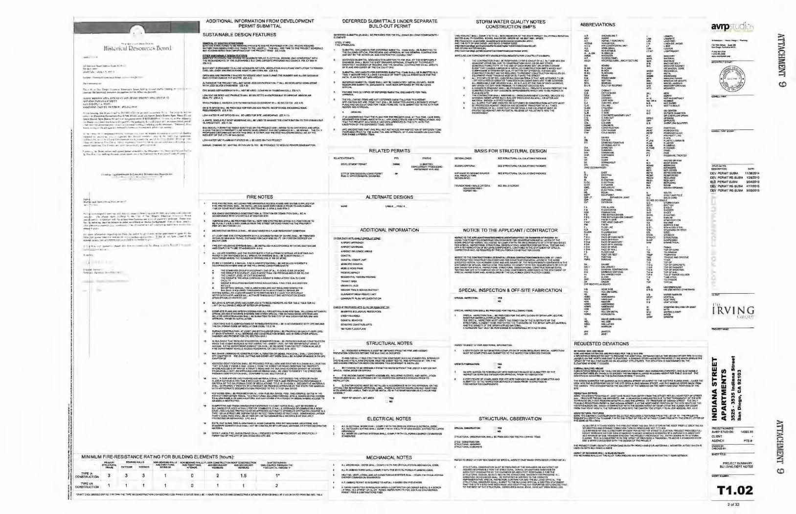
• I J • I t
r l 1
! I I I ~
i i I l
i t • i • i J ; j
i 1 J i t I ! r i i ' ! ! i i I
i I f t t
I II fi d H ·~ p
r~ 1'' 1 ~ II- 1 ,._._, + "'- CI'WI4 ~
. •- lr•"""'••~l{'f"' ,.._ ~.-.,_.n. ' V\lll. .. • f'h on
1'-...._,1, Olllt\\1\:)l'lt.fl()l.., , 1 \M'IJ,"U IIUC."'"' VI.~ 1111t:-1 _, ~j'\..,!-jrtf:'il)l\" '-"' 1 "' ' .,. !'!;\.\ Ol t-00,1 \<~!I ll)
\~sr.~np 1'.\IJt • l '"" \Tlh-fo+ -.•:.J~., ... ~~~
ljoll+l I ~~~,.I.~--~~~~ .. ~- 1•1+1 "' ,,,...IIJI!""'I + ' • •• "
. •"• .
ADOinONAL INFORMATlON FROM DEVELOPMENT PERMIT SUBMITIAL
SUSTAINABLE DESIGN FEATURES
~&~'fs~FROU~~RE-f'\JI'.f'IIONDFM\.OiY·(~HOV$NO AATNEitllWI~ANDTNCENTO"tMEI.ANDF.\l 'I'HIIW"-.ADOlllr.EJOTHif'~ref$Ctllf.N.f MIT II CONSIDERED HIGI11....0RTNICE IV TI-E I'ROJ~ T TEAM fet-A a..t)
0Jl@JUUA!M8t.E DES!QHfJATYSEI ROOF'lOI" PHOTO\'CM. TNt: $YSTEfol, lOGOft!AAlt 5ml. OfE..£CTRtc.At. OESIW.I lCMD C0HSiS"J9JTWITH THE REOI.AREN£Nr6 OF THESIJSTo\liWILEo .UilDING ~E PROGft.AMN-10 C:OUNC!t POl iCY 000.1~ (CE·A~
£AC~ UHrt IS DESlGH£0 to .-,a011 ot.OEOUAlE:.NATUitAi. vanu,fk)!( AND C:ROi>S VEWA'Il0fo/10REDUC:t COOI.INQI.OADSNIC EHCOUR.I,GUtOHTFlUSI1 COOI.II(G (C&.A$)
OfiENlHG&~ PROfi"EkY&tW)ED TO~HEAT GAIN OUIII.IIfG -nE..I!ItJw.E;t AND H.J,QIH MAX>MUM OJ\Y\.!GmtNO~G1'H!W.~ ~,!.J
N..llO.IOHfTH! '[email protected] Wl.l. ..Ot &tat L£f.OCERt~TIOH.I'i WU. IEOEVaonDCOHS--6'1"EHT WITHLS£D.$L\IER&1'/WCWl~ (CE:'t'\1)
CI'CIA££DA!IfOOO!AANTSWU NO?I!IEU8tD lCOHr!JO,I,WifU~!CAI.) tc£>-'1J
I..OW voc-e.. ZUI.OVOC~OOUClS WJ.l tEI&..£CTEOWMI!W"'SS!IIlE 10 """OW I~AIN OVN,.J \"f (~7_)
WHEH~I&.E,~ltl~tl!!..$wt~ t-tGH!U:cYCUDCO!lfOftW\J.IiSS.B:-'fEO (C(l,tl
ONIITfSPACE:WU BEPRO'II!D£0 rORMS:VI!Hi-O~SfOAAOl [)tCUJ).!HOaoNe REOAR&DlTI •CEo-' Hit
I..OWW"TERftt.l+t(fSPfC!UWJUiiWED~JO't'l~ tCE-... 111
A wwrlLSINOl(-.f'l. YROOfi~'IWfEWIU 8f l.lsaD TOM!toi!Mll.E nil COifTRIIUT!Otf'TO nil URMHf1f'At I$V.HD i7FECf fC£·A 121
~~~~~J:~~NO~~:~~~~v PROPO$UID!S1'J~W.-pi..,n.s:MiAI$TOfl'(P+...M::IlTME~S'fOR~OitN .. LW£,.flh( R~l.IES7 ts' ~ CIT'V CJII< SAN QlEOO
I...QW•W"tliRUii f'l.l/!oelt.lGF JCT\,I!\£S ifi1U Bf U\S'~TlUf'ftOJ(C.T
~ OtW)M-.HCi Ol' . &rrt40, WI114N\.N'l$.\IVIII IIEPf!(MOEDTO ~UCfPQ>N~·~nQ~
,.
"
"
FIRE NOTES FtRE f'RO~'nON, INQ.UDINO AR£NIPM.AlVS I.CCES6ROID-$N#OWAT£R SlJPJI\JUFOft FIRE i'k'On:;Cnotrf, !iHN..I.!IEM1'.qi.ED,t,WO IMDEI:ERV:CEA!Ilf>PRIOR fa AHODURINQ "TME:Of C:OHS'tiWCflON Pal CFC !ECno.GIOI l , 1'10tl.ANO •r04l
8tACWGi UNDERGOING CO*->IRUCTION..N..TUATIOHOfi DEMOI.IN)N ~ IIEM ACOOfii!JrNCI!W!TH CSCNmQ..!. f1 5EC1'10H 1101
ADOittS& SHALl 1ft PROVIOED toM ALL tE!N AND EX\S'nNG IIIJILO.:NGS IN A POS!Tiot-1 AS TO lef'I.A),._ V YSI~£ NCl£GIBLE FROM fHtSfliEET OR ROM rROHTING tHE PROP:ERT't' 'fl' tfC H'CfiON iCitA •
DU'XIAAliY! W.t:fAIA!.a. 8.w.L 8E WMTNHmttAFI.AMl!.Nt/INlltHf CON!lmOH
Afi. EAIT C*l ~ ElO"HGUisH(!Il W•tH A .... JoiiNiriAAftNO at 1A101!1C-SHAU. IIERROVIOE.D Wr11,. K't.WCI!ANlllA.YI!l. O!$TAI'fC€F'()ftEACHIOOO SO, n, Oft F'a.moH tHER!;OFOfrt fACHfii.OOfl
f'ltE fXTI~UISti...C~TtUSStw.l. U: llrfSTN..llD!I'fACCOfiMHCEWirH C:8C S€GT!OH 1104 AHOCOMI'\. YWmt Ult $1"""0NUlS.14 10:
H.l VJ\I.Vf.S QON1ltOlUtl() ll1iWAfff\ ll.lf'll\ V FC« MIT~liC t~!NIQ fll&VSTf.lo&I.AHD WA,l'Df Jt.OW SWITOE$0H ~l P'lt!NQ.ff(~t .. w.t I( El.IC11UJ~tCH.l V ~fl'OftEO'M"IERE TlifNUM!SEJtOf' JMit«lelt$'1$' 1000R ,WJfi£
P').a? 1~ GRouP & A W;.\HUA,l FI~~S\'STEU $IW.l. IE.fti1/IU.E.O !N QAOUP I OOCIJPANC!ESwttERE~OflliE f'OU..OW...O COf.IDfTJOtlS VO$T$r
A. TlECOMBINWCRQUP80CQJF.V(fl0ADOflou.fLOI)ft$t$'50eOfl~ 8 THEOitOUP80CCI..o1PAJr«t...OA.OI$~"1't'W'I100PE.III0,~SA80'»'tOI'tll!t-OW
THE LOWEST I.(IIU OF EX1T OIISCti'ROE pEGR~BRREA.~C~40AOIJPJAMBVI.A10RY~ltfGAA£ FACILITY GROUP B CICCUPAAC:IES COHTA'II!NO EDUC.A noNI.t fACII..ITTE$. Sf( .SECJlQ"' tol--2ll
£ EXCEPT'ION;w.N>.»L RRE AL.AAWBOXESAR!; ~TREOViRSIWH~ mE 1\.t!..DCNG •& I!OU.f'Pfll ~ WITHN4 AUTot.IATlC SPRINIQ.ER
S'f'STE!.I. Oi&TAU.IO IN ACCORDNJcE 'M'Jl18EC'nCik IOJ S 1 1 AN0 l'H£ OCCL.JpN(l' N0ll'.CA1\0N~ WILL ACT'NAtt lWMJUGHOUT TlE ~T!FlCA-TfOH ZOtO IPOH.$fl'fiiNIIUFIWAT'fJtR.DW
tuii.OIN911$~NKIDI!D -.Ht1 00to~Pl!E.SWtn4fl.laUIRBErmi: AS t'EA T~.at.E 1l'Jsl FO.R,, t.IMITONAI..l(ftNMl.~NtEA.OfJEXTUIIOitOI>~
COMI"l£ft PUHS AAOIPECIACA'hONS FORH.l F'IRE.ESTINGIUWHG SYS'TtMS., I~OING..urOJAATIC S:P7i:!NIIl.lll N«)SfANOell"f.lmtiM&AHD Oll*JI &PECW. FIR~ EXTINOV.SH:HG !inl'UiBNtO REl.AlEbAn'VM~CflstW.liiESU!WinEOtOJHEOTYOF!Wo!OEGOFOftA£\IIl'WNIIJ ~fNAI- "ftOA l'OIHSTNJ.A'noH
l-OCo\TlONS ANO cu.tltfiCA.TlOHS O' !lCJIWGI.ASI!tiltl..w..l. 1£ !H ACCCJRON,!CE WITH CR:. »SliM) T"'-CA:.!FO..NIACOOE Oil llfGULATIONS (CC.R). M\.S: tP.
OtJ!II,W Cct4TRIJCTJCm "' l.tASTONEEl(TINGa&HIUf 9W..L IE PAOY!OEDOH i!ACH A.OOil~ a.T~$TAIRWAY,(,:H.lat~o\NOCO."SlJtUCT\OH.a..eDS.N«JWH0£0JMt'JtP!<;W._ I1AZAAD$ AAE.P!Wift41PEA CfC U:Cl!Ofr,l U1S 1
-.. tu\.0~ tw-1 flfOV RiSTNCIPIPC$., $T~.NDPIPCt~l*l i'ROYIOED OI.M-..'«>oCONStRUO'nOW W~HI'EIOHTftEAQtfS"'FEITI+8t:Nlll1l1.CINElTlevfl.OfMi~MT~T\'!lHIC;.e 1\CCE;$$, Af.'REOfi'MT'J,IIfHT CONNECTION S.W.t. IE""' MOfl£ n Wf 100 F1!1!1' P,_DMAVA\.AS..e fi~ 0£:PMU€Hl WHlClf ACCESSRI»J::r¥AV$,QCSCC110HSXI10,331l
....__O>Mll lft«<tlitOOINO c::ot4TRUCT!ON.N.TEAA'll0e-l OR tJIMOlltKIN 5tW.l £1-w..t. eot#'OitM TO Cf'CO-wr!UtU WD.D!trfO.QITllfo."ON4)0MFlttOT WDf~Jt~lD&f~CONJ.IlfUMHCE'WffKOf.C
"""""'"' i.DOIWIS IDEJrfllRC4110W $1WJ.Ii PROY!OiD fORo\L\. NEW JoJC> EXI$1YrtG IUit.O!HOIIN ALOCo\notf THAT•8Pl.AIN,V\'I:SIS81.~/.HO t.EOIIII..Eflr<M4TlCS~OJt~fMOtfflr.IOTIEPROI'Om' W'HE'REACCUSI$ BVWAVOf' APRNATI. ROAONJO THf IU\Dff!IG_.r.DOIIt[,SICAHI-IOfK '-"'W£0 FAOtt!A.PU8l.!CWAV,~ APJ"f'OVED~Oit~$HAU N.VS£0. TOeDmfV Tf1Ci $rRUCT\JM£ l'fi;OlS!S'iOEHTW'CA.TlON SHALL OONfOfiM TO C8C.fiECTlOt.l501.:t
WAU.,.A-OORAHOc::EII.IHOFIN!Sl-4£$~01AA.lV!fJ.AlS ·$HAu~r£l(caDll«lllf'P:!Oft~ a.ASa!FlCA.'T\O!..IS-.IC8ClASllltol•ANO·SNAU.~A.AMf-..o~~~F~ ~CWTHECALJfOIVMC00£0f~'JX)H3', Tin.£ \t , OM.$10N1 ~TW£1Mtoei.LS SliiiU.BEPFtOP'Eft..'t'TMATEDB"t,..I'R.OOUOTORPJ«)(::$~D'YTHf:JlAlti,.lt£MA.AStwWr'n-l ~l'! DOClAI£M"Af~PftOVIDED TO ntE' CITYC#.$AH ()I {GO
tCEV 80Xa: sW11J. BE P!'lO'WltDf'OR AU, I1IGH tt5E &1.1<-.DHGa, POO,._aQ.Of$UREI; Gl.lU ,._ T.,.P.A.f)40~ FWttJ'IGH'TSl tRA\Ie. 10 S'ql\IC1'\IAU,SECIJR£D PNt«!HHt t\ltl.S.OOORS ~ 1-teUS fOo\t.AAMPAJ,Ie..&ORNH.NeiATM.S..A..W/IH'tontEA&TA:LIC'ruRf:SOR.i.ft€AS;W11@E~TO ANAR!AI$A:!S'l\Cl't1l
OU~ ..,.,~OONikHERI EXCEmiNO ~ 5 CUI:IIC 'rAA'O$-SHAcJ. IIIQl tll:$T~ ~ li.At.D"6SOA Pl.ACf_D~5ea'J 0' COWIIU$TlBIEWN.l S.Of'Oa.GI1JRCOteu$Tl81l.l ROOf d.YI!:U~V~I'ROf'EC1Ul8'rAH~AU'TOW.TlC~~or.l.l.lCAniD"''A T¥P! I~I>A~SEP'AAATm8V,Gf'UiTFROMOT'HfJ\S'llWC1'\.Ifi£S COfiT~I.Ait-OEJt rf1N.l 1-C\.IIIIC. YAAOSiciAU UOf-~Oft\'Wl'ED>COI.BUI!Illiii..E JMfVI!fA._S~ S!,~'l' PAOTB:TEDCJIIt:&iJ'NtAn:D- ~OliM..l
O(oTS.~SIGI4,~NJ#oAP~I-IO!LCA&.~ME£XTtf«iU.s-eltOCAf!ON$,NIO ·S'fN-.clPiii'!.CO..IfC'r!OI4&~ NOT"N: COHCE.At EDtrYCl.fllr.~ MIAAOR.SORon£1" OE~TM. W.1'£11lA<.
ON"*•<.AM£.S.~<t~:E~08~ OHAIJ. PIWMSU!.!i-PIRoMerrebEXCU"l AS SPEOIF!C4"-' PfJt~ ln"TWB CITY~ SAHOI£00 IHD ~ aca..
,I ~ ~ •j ,, MINIMUM FIRE-RESISTANCE RATING FOR BUILDING ELE~ENTS ~ours):
'. i I! T/PEI• ~II CONSTRUCTION
lYl'E VA ~~ CONSTRUCTION
if !,
3 j• 3 3 0 2 1.5
0 2
DEFERRED SUBMITIALS UNDER SEPARATE BUILD-OUT PERMIT
ClU'tAAE.Il WW'TT~&I&HAU !IEI"'«MDUD FO~ TME•HIO.OWMGBU.LOIHO COWOC*ENT&i B.£w£Nrs. .,...., .....
J';Rf9'ft1HIIl.VI$
.l\let.!ffl,AO. COtUI.ENfJ fOROEf"OU(U)ItJI!MrfTA JTEMS-RW.!IIE,suet.tll£0 TO -n-.IU.JI(HQOf'nCM4f'ORft£W.W NfON"!*ROYAl,ln'lHIE G'£NEJW. COHTl'tACTOR NIO trfO"P IV' TI1EINOMOU.U JUI CO+ITJVtt'TOK l c;oN:St.!t. TAHT
OE.f't'JtMO SViiMilTA.l CXJC:uMDli&IN A.CY.JJ1'tON TO T'Hi Sf.AlOf' ~ RESPOU&IIIIlE ENOINffR~Lif.ARTI1fiHOPDAAWIHO~Al.ST~~'n-lt~ AAQ11TECT, 9!Qif.IEUfOf lllfCORD,AWD TMFGEHE..CW CtW~~O"'N.l.a«:£TS 0'-P'l»>S Ale> CIOYER D' Tt1l CAL CULAllOf.llli
.su8MITTN. OOCUENT$ RlfltDU'E-'UtfDSUIMITTAL tfEYi-llw..t. 111:-IUIM"''TtD IN A 'T1'4l.V~~1li"TAI.l0W$;AM:HIWMOf1lMf'l'r,:tO)CH..DC.vlOA.Ylf-Oft. l'HE ftTlA:..Ii'\.AW~"f\.-t~NO
ouarnD~tte4SI'N..LNUTM rA~AJCAtto; !NSTIIUCDUHl\l. ~a!\ OE$!GN_.,~.so£MTTAI.(.'II)C.\.lU(N' HA'Riffti,.,'«W!D8Y1WE~
"""""'-~TWO ('4 OCW'Ia t:if'Da'fAAEP 04JIM!TIH. DOc:\IKtifS FOR f'lrW,. ,.,..,_.._ nt£HUOW!NG~AA(NOTOU'£Ailfl'I MMIIT.._,,Oft~IP6f,Wf N"P'UC:AT'IDf.l: auT ANl fnMS' TMAJ .$~\ALL Bl SUewmt.D UlfOER o\ .(I(PNJA TE ffittr,t(t' Pt.ANSMC)Co't.CIMTIONS~TI1ESE'ITWS~TOI£~l1)'ll1£'CTV~ ASV!M AA"'~OVAI..
~
l1$~000"""'ll'l-t£PUN.SFOR--nEI"ROJECfw_vt,ATfttSTl~-tAV£eEVj
~~~~~~~~~=~~1\NO' EXC9"hoNOF-~DEnRRED fT&G LtStEll
WI! ~S1-.MJ ~l tN+I£WU H'Ol AIJTI<l.R2EANVWSPrcno.H OF 0~0 f1&l$ PQolloa.Q)~OIIl10'T!1£SUI!Wl'tAI..ftH:)~OfP'.NGAHDIO'lCNCMTlO'G A:llllnGE:D::J':~IT'EMS
RELATED PERMITS
-
ALTERNATE DESIGNS
ADDITIONAL INFORMATION
Ql!CCKtAQ'!~
"~'~ A'JIU"'O{f~Oill.S
o\~f•Nf\.U~AAS.J+.&
COASTM. HQGHf ..M'T
$E:HS1T\VE eoMTAl
Wlli £HOM£PARK
PAAK•NG I\IPACT
RE.$!0iHTW..1'~,_,AA!I»iG ,..,..,,_ lillPANV!lv.oE
~1~s~oa,.~o~cr
~N't~t!!.IG"f{l.Molfl
t:lO'o'UUNiTY""'"~AT!ON
~~.IP ~~-eurrt!§D!lPR AJU.qm..20:.
~SJTMi 110\.~RESOURCU
51UPH&UiOU
CQ.J.$fAllf.ACHU
S£Nei'T'1VE CO.UT.t4,1:.UfiF$
100~ Fl..oom.A!H
STRUCTURAL NOTES
1 NJ. f'EQI.AR£DAPPH.OVJ4.i.t.IUSTEoe.TA.INEDFROMTHEARf.AHOtw'.AA0 ~ SERYJCES5a'OAE THE SU!lO'NGIIS OCCI.I"'ED
l P\JrHSf:ORNJ. ~)(S)FIAEPROTEC.noNEOIJtPMEfrflSUCHASBfMIOI'Ir"'""£S. sPMitacl.EJI SVStt)IIS,t\o!ro!OA"!~S'I'STEMS.WS'l8E 5.Ul.l.tnl'OTD,~~6V lW('FIItf »>IMAlNI;O~umoN 5£RV~C:ESIY<Jfl£ 1lfS EG!.IIPMEHJ ts !NS'TALLEO
) l!»'fOOOR&."!08£~!FR!*ittEI\IUIOfwmiOUTTI11EIJ'SEOfAICEYOA~ S"'t.C'.A.l.I()IOWt.!:OG! OR EFrORT
• riA£ NIDIOM ~ ~ ASSO.tll!E.&.INQ..UDWG 5\.ttiiD, AAO INSTA£.,...AfiQH ""9Cf:OUHU$tw.,t IS!fN>I'ROYED !1"(1HI! MPEC'f!OHS.(IMO:S DMS-OH~ TO .....,AL.\A"nOK
S 9.1i!VATot.OOORS~8£!NSTN..lEO!toiACCOIU:IIilo..lr!CfW"ftHfHEAPJlW:N~ OHlME ~~Mf!U,__q;l~~l.A8.El.Woti'REEI.IN'"'T~000~5M£NQf!OBfflfJED Wfl'HI\Pfi!RtwED i.AIQ.S.1lti£V .YUnK!ftSTH.lB>~ THE&AIIEMANNERMA:Z HOUR-FU\E ..._,._.
ELECTRJCAL NOTES
MECHANICAL NOTES
AllME~WO!'UC SMH..lt'.:10tJA..VW!tWM81!1t.At.J~INoMK:Iw••CA!.COO£
"Ltf\UiAIIM)WORKSH.+.U.CO&II\.V~THIS~IO~OI\N~PllNB'M:ic.co(
..... TINe. \lt'lfV,TICW.ANO~RCOij()t'ne)NiNGI'I'IfQ1!1 t!iw.t.. CO...r!ti.V'Win.CA:.II'blt""' WE.Rrlt~$$01$TANDAAD&
A PI \Ae!HQ I!'(AMTII REQUIRED n~.;wTN.t ~lWN'\CW ~'f'!R
A TOI(&j~CTfON l"J REQI.IItt€n~A OQH1R.leroR Oft (JII(N(JiitJ,ST~L& AltWlfl oATfAA. !.W"$TRUtOR AUEV T()I((NWSP5CJIOH(J)C) Ff£. -UJPl\JS£Mii._EmMl P~IKI fEU l cotiTRACTQii:S FEU
STORM WATER QUALITY NOTES CONSTRUCTION BMP'S
T~~fCJJNi.l ~YWI'ttiAU.R£ouiAEioEIITSOf1'HE'STA,tt~f. C,At1R)fUotA~ WA'TtftOl.WJTV~ .QMI).&MiClt:OO,QA:DI1r.., #lsZISf.oc.tl, Nf'QI£5,
=·-=-~~~--) ()tltl~_....,~'i>I.QI~pdf) AM)SlOfWWATEJt~
l'*~~~....-.·~-~
NOTE.SIJ~OW REPRfS£Htf/:LVM-Iill)oiJMit~fOIICOiN$'J'!Il\.ICNflloi,..S
C:UEN~U~ OJ' AU...Slt.T AHa .....c:J OJrrf VDfCI.f..$0fti.J.Hcm-II!R
OftiCO,..'f. OJi....nmA6f'tlit~ GOHS'I'Ri.IC'TloNIMPSM!IC~HIM~ AU'f:STite£T(t! A S'TAa•liUO
CONIHRUCTIOH E))l /IM'fH. AEQUIR£0 Tl)II'RBielt eototm\JC"rroHV!li>Cl!S 01\ E~TF~TRACI(WC;I VUDORSU Otril'OTHlSTR6ET N a iTOC!CPiiElOf'iO:t~UOWO U FT FOR A PatDO Ga.f.Atf:R nw.l seiEH A.!.l RUIOVA.BtE 6UP DEV!CD»Wl l£* MVWHENFI\IEOAVRNNI'ROtlNIIIJTYfC*E
=::.~HOUJ.Mic"""'o.;c' , .. ,;;"""""'"",-I;.;;RCM:
lHE CONTRACTOR SIW.L R!STOR£ All fROSIOHI:&ED-.WIEMf C01nRcA. OEVICU TO WOfUCINQ ORDtR N"Tal fACtt RU».oFF PROOUCINQRAINMU. OR/IlFTER ~ lrMlat:oAI~IN£FfEQTIVENF.SS NJ. 5t.~ THAT AAE ~ttD ORDtiNRIED BVGQNS.JRUCTJDN ACTMlY WtT Bl:.Pfrolt:tl'El)~Wf ~JOMAN05ED:t.en f'AANS~T At All Tlt.IU THI! liOAA&t: OF AU. COHS1RUCitiDHAMTf'AW.SNfO EOUtPMEHl '-"'T lE PROT£CilDAOAI~ Nl'lf'OnH'TW. ftEI.fA6EOf PQ.LUTNml ~ THl
""""'""""
BASIS FOR STRUCTURAL DESIGN
NOTICE TO THE APPLICANT I CONTRACTOR - -
SPECIAL INSPECTION & OFF·SITE FABRICATION
&PECIM. !~DN.$HAU. 8lJIROYIOBl f'CWt-nii. FOr.la.wtO fT£MS:
SPECW. I~NSt~Al48f ffi0'.111)8)f-OIIItft1f~t~l'IC*Of SPW\V""'"'l !IO ME
~~~:~..,:,ftE-c:or4D!TlOHOFM$\JISTit.J.l£0fTHf ~~~O~==;r~OOQ$0FM$PAA'f"""-i£D~l'Dtll'& A CO~ON TE&Tt.IU'STBEPERFMMEOIH~Wm-II+STW ao5
1\SUTOSHE£TS1FORA®IPDH.t,l, HR)fi!JAAT!ON
A c&en!lfC.a.n!:C#- ~'Tllf'AC.lORVCOl.IP..EfiON OFW~Kfi£QU:Mt00 'f'K;W. ~~ I!U>TIE~AADSUB.I!tnE'OT01'HE~ Sfk\1\CESDMSX»>
~"~l!Oirt ' vu .. AHNIP~ICA'T'I(:lt{TO Pt'llf'CAU OJ~StT£ ,.AIIR.CAl\ON W<!St &! soeiMni!O 'TO tli! I~SfftV,c::QaMS~F.Oiftl+l'fWI'o'H.IIR!ORTOI'...aA:.cATlOf.l
"-~l1FICA-n:'Of~PQROFf4tft:~flOti""'"D£COIII'l.CA:Ot\HO SU8~T0"1E~.saMCUDI'tl~lllftlOiitlOflft.C1lOHOF PRS'~Tf.O~I-
STRUCTURAL OBSERVATION
S1lWCltiRAt 08SeJWAT .... !IH.tw.ll!.S"«<V.ot.D FOft 'n1E FOU.OWINO IT(W;
STEE ootaTRUellQH 'STAUCl\II'W. ~ -sTRVCTUfW.CO~Eft-
ABBREVIATIONS
~· ""' ~· AGtAJ> •cu ~· N>J Al . Ao.UM -.. """" .. IIJOQ .... .... ... .... .. , ... .,. ..... tl, ttM ... to tJ 0:0.0
"'"" co,o
""'""" to
""' coo. o:oooe
"""'' """' tw
l ~~ !L "-" ao:v Elltl ... "' "'" ""'" ""' "" ,. ro ,.,. FE FEC
" FHt .... " "" """" FO fOG .. , ..... ••• ••• FOW .. fT. FlO ....... .. ""V cc 00 ., 0. .... ""
AHC:Hol\eall ....... ~T(;(JKC'Jifff ACOUSTCAL AJRCOiaf!O",NG\HT ........... ADJU&TA&lG' N. U..._.,UW -M:C<SS ..... e. AAtttTtC'N!'W.iAACtt'ftC'MtE ..... "'""""' "'""" ""'"""" ..... """"'"""' """"" ......... lua t~ KOCW'HO .,.,_, CA.TCH&A!iiN
"""""" -· ,....,...,. Co.mtO\.JOHT ....... tAIUOHG o>.osiT CU'AA Cot¢Rm~' U,..T Q,(II,<(Wf'
""""' t<>.IAN CCIO<CIE!t
"""""""""" ............. r..ot..DW~lf,.R
""" ""''""' """' ll£Vo\1'ICJII< lllotml""-fl.fNATOft ..... ...,. El..f.CTRI~pNJQ._
"'""" EOU•Pt.1811 f)('IIAN$i()fo.JCW(f -f.l(TfR<lll
J'..A&:Al:AAM F'lOOilOAAIN FOUIOO.AliON FIR£~UI$HER R.RE EXTWC:IUI.''>HER tniNET Ff,ISHR,OOR Hte HOSE CABINfT ,.,..,.. """'""' """" R.U001£SC91l r.a"' IN.:t at COHCRETl ti+CEOFAN.:SH PN1 01 W.SONAV FJ.CEOf:'P'-~000 FACI:OfSTUO rN:.EOFw.ALt. A.OOfl$1NK 'OOTOilmT -----..... v ...... --· ............. .,... G"4VA.~IR0~ ........ ....... -G•P 80 G'n'St.lilol 8CWtD .. >IOSEBU
H.C .IOU.OWCO!tE ... ,....., ..... .....,..... ..... .....,,""" - """"" ..... """""""" -· !:"" -... Hou..a.vw£Yiol - HOACZON't'Al .•. IN'SICE~ oNCe ,..,...,. ....... oNCIAAT.,..
"" I~JO'l•
"" ...... .... ..,.,
REQUESTED DEVIATIONS
I ,...,, ""'
,_..,, IAV t.A,Vt.TD'n' , .• t.•..V.OMC. JHEAA tT ,,...,. '"" """"" n wr '""""''""" .... -y ""n """""" - --... """""'IIOI.T •• "'EIXIIECAI'JET -- Oft \I~ COM;
"'"""""" MET """ - -.. ,. ........"""""" - ~OR. I.e~ ..,., ~ •o tM.SC:Nrt'OPBI.NG
""' -· ~) ~ HlC ~o,--.,. eotmtAet
""'""' ........ "" HOTJV.lm ... ~T TOICAI..l
"c """"""' OD -.......... oA O'VERfUIW ()lt ..... - OP ...... ... """""" .. ovtJ1SUlW ..., ......
PAAT I'AATTT!ON - .....,..l'El) - .... ..,.,.CIAAI< . , ......,.,.u ... " 'V>lt
"""' IVoa'OO~W.rt ...... .... TfJ<
""'· .......... """' "'""""" ,.., ....... "" ...... " ~iMAm>
R .....,. ...... AO RCOI'D...,.. ...... AI'DWOOD ..., R<CESIED ..,
"""""'" """ ---..... "'""""""' A EO'O REOIJp;(eD
""" RY!UlHf .., An~w.NG ... """" ... ........-
T mEAD lC TOI'Of'CURl "'- ,..,...,., """ .........., 143 l"'t«Jut..U.C OAOOV!: ""' mco< 10 TOf'OI' 'f'O.C.. TOIIOf'~ 'T OP T'Of'OIP~+Pt~Jlfl ttl.6 TOt'OfSJ«AT!ijO l oW 'f'O'IOFV.Ali-r.PH TOU1'~HOlOes-U TU8ft1'Ul. lV Tal!\ASOH
"" '"""""" UB- ~DOtOJtOVND UNO \.NlESS~n.DOTHI;RWIIE
VI VA'I"'tA IWWfJt IJEII:f VERN'.Al VP Vf:N'rPIII!r-VJ \ltNTCTIICI(
W WA.SiotlfGt.iA.CHIHE ORM.tl WI Will' we W,.TVi.ct~
""' """" - WKlON
AO~SIOEAMOIEAR ii0EA.NOJ19ASET6ACIC8ARE,-ROY!DED Pat TAJII.E t5-t2.(!'Sl, .\~ltONtS flmi.J'£8'fm NOT TO MCMDE 11-i£~sn8AOCS.uoyt n1! .stc.QI«< STOI\YfttR i51tlllOJ t•)t•}fli.EJOfl<inE ~AN) IJIS1' B.£VATI01o&S A ~..0 S1'UOV"'-$6(£N.I'AOVIOlO(T't U.t) Wl-•04 ~Vs'lMl W'ACTOF-n£8UI.O!NO"""-S$!NOOHAO.JI,CEJ(f~ T+£~l'lONISDIAG~~~ &!VA'f$WHOI:Etl~
O'IUIAU.IW!LDIWGteGHT '-.DEY!A.Tlc.liSA.EOliEBT£D T0-"4r:/tV~.c.AI. £QIJ~N«) SQI:'f£NINGt"AIW'n).N40SUST~ DOIGNitA'TUft£$ (PVPANEI.SITO!XCEEDllEMAll!hiJUH.\O'Nm I!JI..lU)~H(JOtlf Pin\ TAS!..t 1S1;t.Q)It '0< D£\ll~~tSHDICi'.tm ON THE B.EVAll~WI-«ME IT ~S
l'Htot~W.N~t.•ZI.SnE~~GltONJASTREEI'~TO"l'HE>'11>llOftc.~oW&. teA...o-THE: '-'IW !liTO ,.-$.0P£D PQA1'l~Of'I'IE~OP£HAI ONG~ &'TR£Et.AHD THt W.SS:!NG&t9'S IW:KrAOU 'T'H&CNIWON l'HIS~'IUMIM..IOAm"OF-'n-IE~IlO~TH!~MOW'fi'OflTIQrlo$:fSf'lo4(. ~ --IO'oe Ul"t030)(h) RCCIIJI:R&SA.l t EiUT owl! KD6~~TRVI"'t<* TiCST'IW'iT P£Ji 10\...i.lfAlol JUl Of STRE£1 WAlt fltONTAOEFAON:lll*PJitOP'fRTY t iNf: Aot\MflON tsR!OIJ(ST!ODIJfiOYMlTO~O'"l't£1ift f'1)MOVClfi ~'(at.lf PED~t:HlltVAI..OiiiG'n«N'f'AOX.l71'Pli:ONTAOC!CtfiMM.'W\t111t£t niEONlY ~f'tCOE$TMINfO.'TRVAt.Cih10 INDINIA51111UT IS,.fM ~ IIORTl()N Ofll-lfSlf'tS()Un;(lf' THE HI&TOR.CttJ~CWI.~4CONSIS1'0ltWITK't"tt.Of.SIGN •i-IT'Dlf~CO.~mNGnE~fiNOOUfJ Rt~nv,T JIO<tll SOUT'H. 'THf. tOIWNSloHSWTO nECAHYOHlOO ~VTON..IAI/ ACCEQ. Rff A1 01
~RAT\JW: SOt.CU:il~l(tj(~st:.E;Clm)'t£l:)IJIR!S!ir:EAJUit£&'ltOMTHE.;.Cl0f10 n-I(P:ROJE'o-"'T'i JtfOUfiTtA OEV\ATION TOc:ot.P .. YW•"'llTI-11 llf9{T Ot'THEUSTWITHOUTCOUil't.~Wm; lltlf SflltCllD'TOtOF n-IE&DMtA..\FOU.OW~
~ .t.U._ttPI E M QllD ROOrS' 1'11E PfiO.IQ:TAOOJ HAS t.U_flllt.( S'llJISiH ~flOQF PROFU.:CREo\TiNONf liTERUTINO ANC CMtAMC FOftt.ttvfN THOUGH ROOfl 1<11£ "'f PITCHED
~~~~~~=~';?~':~~-~~=· ~~~.c:~~~~r:~~~~=:~;::~ NiD lf""*Ec::ot-f$tS'I'OITWt~THfD£:SICWOfi YHiif'JIOM:Cl
fHEPAQ,IfiCJ:T('.O~EIWIT\1f')I'AOY\Otf.IGJW~l'l'h'POACHIH)·t-Q"-No1'fDWAll ~~An!Ct:WHCt4 t5 USEDOHIIQ'n-lWi!OiNG.\AioHOI
~ M IUTAIMHD. WAlliN UM IETIAdC fHE:RETNMNilWNJ.liAT THiAli..EVTVftH"-"'Ut«)AA5H046'1 ~~wmuNn1: f REAA~IC
avrpstudiu, ~· ............. ~·~ 10l1IIVI~ s--. s..,...,c.......,.,"~'
... ~~?Git1Dt ,n.,. ... ---
:SSUEOAlU: Oe.scl'lf>nott'
DEV PERMIT SUBM. DEV PERMIT RE-SUBM. B~O. PERMIT SUBM. oey, PERM<T f\E.$UB>ol. OEV PERMIT RE·SUBM
cufHT
lin
.. .,., tl/0612014 !/2812015 3/11•12015 4117(2015 ~~015
1 RVl N G l•l\1.\111
t-.. • Ill • ::
Ill in Ill 1"1 at= t- Ill 0
t- c .. z Ill N U) ;; m
Ill .5 c c :E 1ft u
z t- 1"1 0 c at= 1ft m I') Gl - c i5 a 1ft
z D. N c c 1ft Ill - C'l Ill
PfU)JI;C.fNU • ..utS /ft,VRP STUDIOS: 14023..QO
CliENl: AGEKCY' PTS II-
DRAWNn; tt«CC<ttn
SftUtTm.e-
PROJECT SUMMARY, BUILDiNG DEPT NOTES
s~-tm~·
T1.02 2of3J
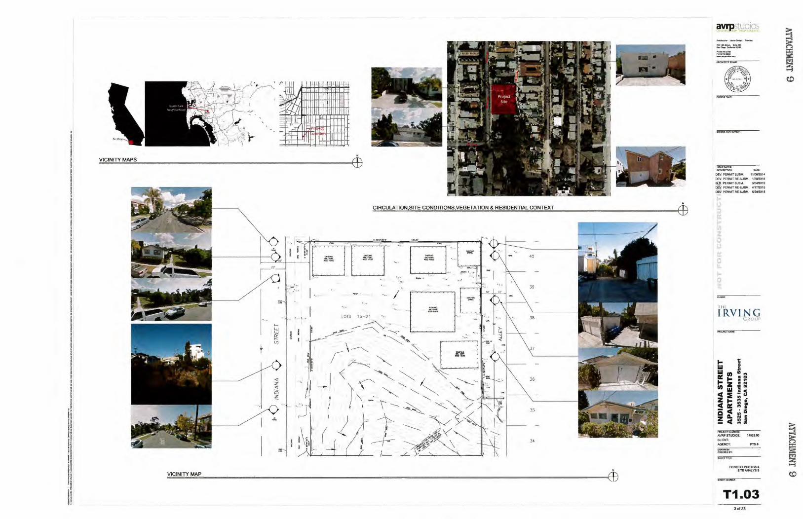
'
N
VICINITY MAPS (])
• CIRCULATION,SITE CONDITIONS,VEGETATION & RESIDENTIAL CONTEXT (])
40
39
34
\
VICINITY MAP
avrpstudios ----·-~· ,.,... 70)1-&hM.. ..... &..~.c;.:,.,.n'tl
Pltt10U7ot fi •IU04-211iM
-~.-
CO,.,.,..TAifTSfMP:
!SSU£0...TES: OCSCRlPTIOI< .. ,.,
OEV. PERMIT SVBM. 11/0612014
OEV. PER.MJT RE.SUBM. 112812015
BlO. PERMIT SUBM. 310412015 OEV. PERMIT RE.SUBM. 411712015 OEV. PERMlT RE.SUBM. $/2M015
T ilE
IRVING
... w WU) ~~~::.., t-z U)w
C:t ZtCD: -c QA. !c
.. ~
(jJlOI I T'
w.., • Cl c..•N =ijCII
=~ :!: 0 ., Ill .., . .;,a N C ., . 1"1 111
PM().IECTNUMSUIS:
AVRP STUotOS: 14023.00
CLIENT: AGENCY: PTS f.
CONroO' PHOTOS & SJTE ANALYSIS
T1.03 3 of 33
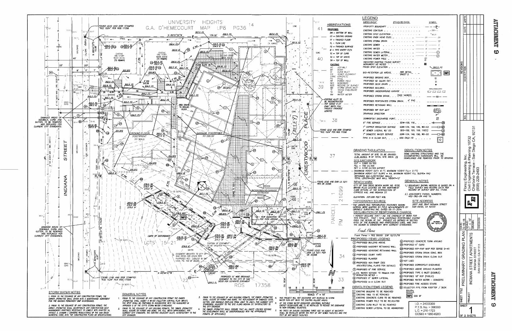
I "
40'
20'
U1 i DAMAGED AREAS DF-.+--I--HI:::J-'~-i-.,-7-l----!111j(
SIDEWALK, CURB, AND GUTTER, TO BE REMOVED
AND REPLACED PER CURRENT CITY STANDARDS.
, I
I " I
~1~ "1
~I~ i " r jl I' " ] l ·"' I ·I "
I
;II I 1 \) i
DAMAGED AREAS OF SIDEWALK, CURB, AND
GUTTER, TO BE REMOVED AND REPLACED PER
CURRENT CITY STANDARDS.
l' I
I " "' I
11 i I " "' . I
.. 1- >;·• UJ I ·~ UJ v;·
~ ·u 4·~
(/)
: .1o:e=lL.i ~·
I i
UNIVE ITY G.A. D'HEMECOURT
\ LOTs\
\ I \
\ \ \
\ - N 89-56'57"W
1"4 i "FOUND LEAD AND DISk STAMPED "R(lE 1534" PER ROSf 17358 \
...• 1 I ~ STORM WATER NOTES 1. PRIOR TO THE ISSUANCE OF ANY CONSTRUCTION PEl/MIT, THE Ol'fNE/1 /PEIIMITTEE SHALL £loiTER INTO A MAINTENANCE AGREEMEJo/T FOR 1HE ONGOING PERMANEJo/T BMP MAINTENANCE.
2. PRIOR TO THE ISSUANCE OF ANY CONSTRUCTION PERMIT, THE Ol'fNE/1 /PEIIMITTEE SHALL INCORPORATE ANY CONSTRUCnON BEST MANAGEMEJo/T PRACTICES NECESSARY TO COMPLY 11/TH CHAPTER 14, ARTICLE 2, DIVISION 1 (GRADING REGULATIONS) OF 1HE SAN DIEGO MUNICIPAL COD£; INTO THE CONSTRUCnON PLANS OR SPEC/RCA TIONS.
""- E; SLOPE .J..... I •.,. \ GENERAL NOTES PRIOR TO THE ISSUANCE OF ANY CONSTRUCTION PERMIT THE Ol'fNE/1 /PERMITTEE SHALL SUBMIT A WATER POLLUTION CONTROL PLAN (lli'CP). THE lli'CI' SHALL BE PREPARED IN ACCORDANCE 11/TH 1HE GUIOEUNES IN APPENDIX G OF THE CITY'S STORM WATER STANDARDS.
2. PRIOR TO THE ISSUANCE OF ANY BUIWING PERMITS, THE Ol'fNER /PERMITTEE SHALL ASSURE BY PERMIT AND BOND, THE FULL IIIDTH IMPRO'Ifi!ENT. PER CURRENT CITY STANDARD, 1HE EXISTING ADJACENT ALLEY. SATISFACTORY TO THE CITY EJo/G!NEER.
HEIGHTS MAP LP8 PG36
ROS
14
"'-.,
358 10
41
40
ABBREVIATIONS
~
BW = BOTTOM OF WALL
EG = EXISTING GROUND
FF = FINISHED FLOOR
FL = FLOW LINE
FS = FINISHED SURFACE
IE = PIPE INVERT ELEV.
TC = TOP OF CURB
TG = TOP OF GRATE
TW = TOP OF WALL
EXIS.:DNll. AC ASPHALT BK BOOk C/ CURB INLET CO SEWER CLE:ANOUT GONG CONCRETE PG PAGE PP POWER POLE REC RECORDED ROS RECORD OF SURV[Y SOl STORM DRAIN INLET TE TRASH ENCLOSURE TR TREE WM WATER METER
'X/STING ALLEY TO BE RECONSTI?UCTEO
LEGEND IMPROVEMENT STANDARD DWGS.
PROPERTY BOUNDARY
EXISTING CONTOUR • •
EXISTING SPOT ELEVATION _ EXISTING OVER HEAD ELEC. _
EX/STING STORM DRAIN
EX/STING SEWE:R
EX/STING WATER
EX/STING SEWE:R LATERAL _ EX/STING WATER METER • .
EX/STING POWE:R POLE • .
INDICATES EXISTING FOUND SURVEY MONUMENT AS NOTED • • FINISH SPOT ELEVATION • .
BID-RETENTION LID AREAS.
PROPOSED BROOKS BOX • •
PROPOSED SO CLEAN OUT •
PROPOSED DECK DRAIN • .
PROPOSED BUILDING • . . .
PER DETAIL SHEET 2 -
PROPOSED UNDERGROUND GARAGE •
PROPOSED STORM DRAIN. . . (SI~E VARIES)_
PROPOSED PERFORATED STORM DRAIN. 4" PV~
-- -1(-
w ' ---0
PP !!
1111
----®
'.355.5 FS
11::~::11 ~ 0
0
•
=-=== --so--
-PER SORSO G-21 -PROPOSED RETAINING WALL {HALF WIDTH FULL
PROJECT FRONTAGE LENGTH)
38
37
__j
w u cr:: <( o_
()) ())
0
34
PROPOSED RIP RAP MAT
DRAINAGE DIRECTION
DOWNSPOUT DISCHARGE POINT.
6" FIRE SERVICE • . • . . •
1" COPPER IRRIGATION SERVICE
6" SEWE:R LATERAL W/ CO
1" DOMESTIC WATER SERVICE
TYPE A-4 CLEAN OUT. • . •
GRADING TABULATION
SDW-105, 118_ ..
SDW-134, 148, 150, WS-03
SOS-102, 105, 108, 110(C)
SDW-134, 148, 150, WS-03
SDG-D9,D-10 _ . . . . _
DEMOLITION NOTES
-
TOTAL AMOUNT OF SITE TO BE GRADED: ~. :1r OF TOTAL SITE AREA: Z2
SOME EX/STING STRUCTURES AND THE ACCOMPANYING HARDSCAPE 1\?LL BE DEMOLISHED AND REMOVED PRIOR TO GRADING.
SITE EARTHWORK CUT = .3, BOO CU. YDS FILL = 700 CU. YDS NET = .3,100 CU. YDS EXPORT
- (MAXIMUM HEIGHT CUT= 9 FT, MAXIMUM HEIGHT FILL= 5 FT) (MAXIMUM HEIGHT CUT SLOPE = NA, MAXIMUM HEIGHT FILL SLOPE= NA) RETAINING WALLS/KEYSTONE WALLS: TOTAL LENGTH=220' MAX WALL HE/GHT=/2'
BENCH MARK GENERAL NOTES CITY OF SAN DIEGO BENCH MARK NO. 6156, BRASS PLUG LOCATED ON THE NORTHWE:ST CURB RETURN AT THE INTERSECTION OF CYPRESS AVE. AND INDIANA ST.
ELEVATION: 307.096 FEET MSL
TOPOGRAPHY SOURCE
1.) BOUNDARY SHOWN HEREON /S BASED ON A FIELD SURVEY AND RECORD DATA PER RECORD OF SURVEY MAP NO. 17358.
2.) ASSESSOR'S PARCEL NUMBERS: 452-362-09 AND 10.
SITE ADDRESS -THE: UNDERLYING TOPOGRAPHIC FEATURES SHOWN 3537 AND 3547 INDIANA STREET
HEREON WE:RE MAPPED BY FIELD MEASUREMENTS BY SAN DIEGO, CA 92103 CIREMELE SURVEYING INC. DATED 05-11-2014. DECLARATION OF RESPONSIBLE CHARGE I HEREBY DECLARE THAT I AM THE ENGINEER OF WORK FOR THIS PROJECT, THAT I HAVE EXERCISED RESPONSIBLE CHARGE OVER THE DESIGN OF THE PROJECT AS DEFINED IN SECTION 6703 OF THE BUS/NESS AND PROFESSIONS CODE, AND THAT THE DESIGN /S CONSISTENT 1\?TH CURRENT STANDARDS.
Frank Florez - RCE 55555 EXP 12/31/16
PROPOSED ITEMS LEGEND @ PROPOSED CONCRETE TURN AROUND
@ PROPOSED 6" CURB CD PROPOSED BUILDING ABOVE
@PROPOSED MASONRY RETAINING WAUL
@ PROPOSED KEYSTONE RETAINING WALL
@ PROPOSED COURT YARD
@ PROPOSED PLANTIER
@ PROPOSED ADA RAMP (SEE ARCHITECTURAL PLANS FOR DETAILS)
G) PROPOSED 6" FIRE SERVICE
@PROPOSED RIP-RAP MAP PER SDRSD D-40
@ PROPOSED STORM DRAIN CONC. BOX
@ PROPOSED STORM DRAIN CLEAN OUT
@J NOT USED
- ---
@ PROPOSED DOWNSPOUT DISCHARGE
@J PROPOSED ABOVE GROUND PLANTIER
@ PROPOSED TYPE G INLET (DOUBLE)
@PROPOSED 18" RCP (PUBLIC)
33
20 30
@ ~~IG~"n~~ ~~'iE~E-TO REMAIN FOR
@ PROPOSED 6" SEWER LATERAL
@ PROPOSED A-4 CLEAN OUT
DEMOLITION ITEMS LEGEND
[!} EXISTING BUILDING TO BE REMOVED @] EXISTING TREE TO BE REMOVED
@J PROPOSED WATIER METER - DOMESTIC
@PROPOSED FIRE ACCESS STAIRS
@COLLECTOR PIPE FROM ROOFTOP / DECK
BMPs
J. PRIOR TO THE ISSUANCE OF ANY BU/WING PERMITS, 1HE Ol'fNER /PERMITTEE 5. THIS PRO£CT IIILL NOT DISCHARGE ANY INCREASE IN SlDRM WATER RUN-OFF ONTO THE EXISTING HILLSIDE AREAS.
@] EXISTING CONCRETE CURB TO BE REMOVED
(I] EXISTING POWER POLE TO BE RELOCATED
@) EXISTING CURB INLET TO BE REMOVED
~ 550 SF
SHALL ASSURE BY PERMIT AND BOND, THE REPLACEMEJo/T OF DAMAGED CURB,
~¥lfft;,R~~D ~~f~t~ }~EPriff~rt~rr)/;~~MfN~01;p. /:,~'if,.~~'J:l T~TY 6· AT THE STORM WATER DISCHARGE LOCATIONS. SUITABLE EJo/ERGY 0/SS/PA TERS ARE TO BE INSTALLED TO REDUCE THE DISCHARGE TO NON-ERODIBLE VELOCITIES. THE CITY ENGINEER.
4. THE Ol'fNER /PERMITTEE SHALL ENSURE 1HAT ALL ONSITE UTIUnES SERVING 1HE DEVELOPMENT SHALL BE UNDERGROUNDED 1111H THE APPROPRIATE PERMITS. (IF APPLICABLE)
7. NO TREES OR SHRUBS EXCffiJING 1HREE FEET IN HEIGHT AT MA IURITY SHALL BE INSTALLED IIITHIN TEN FITT OF ANY SEI!fR FACILITIES AND FIVE FEET OF ANY WATER FAG/LinES.
I]] EXISTING SEWER LATIERAL TO BE ABANDONED
1.0. = 24005309 P.T.S. No.= 396980 L.C. = 210-1723 CCS83 = 1850-6283
0 b..
~ 0.. <(
1:! ;! <( n 0
:X: rs: 1:::1 -~
co (/) z 0 (ij~ CiF a:: a..
0:: (,) (/) w 0
d z
~
("') ~
N (J)
N <(-("') t-- u 0 0 ~
Ol Ol CJ.) c 0 ·c:
c.S c c ro ro
-= 0:: ({)
oioll ' CJ.) c Ol (.)
~' -~ c ~ ("') ~
CJ.) '§3 (J) '" -~
CJ.) '<!' ~ CJ.) 1- N Ol c m c '6J 0 ~ UJ c N c 0 N ~ N UJ .0 P.5
~ ..... co ·:;; ro "' 0 ..c L[) ~
u::: (5 u ~ G ?::.
" ~~
!3 ' ~
0 ~
~ ~ " < oc ~
10 0 0 ;;) w ?t .. I w-~ "' ~ 1:!~ ;;;ill<( (,) w ~ <CI u~ c::::: I
DIO Ul-D (,) >
z 2 ({) ~ <( 1-
-' z CL w ·!? (!) :2: 7
z 1- ;: ~ 0
a: 1- " <( w o; ~ <( 0... w
"" <( 0:: <(
B a: 1- ll (!) 1- (f)
c5 UJ <( (.i
>- w z (.') W: a: a: <( w ~
<( 1- i5 i5 z: z ({) ~ z ~
<( "' ::2:
<( (f)
~ z ~
::J <( 5
UJ i3 s ~ a: ~ ~ CL t":l
~ ~ :I:
~ !5:: F 1- l:f'J 1--
(.)
~ w h!5 ~ w 0 ~ I 0::
Ul 0..
SHEET ~ tO
1 1'1 '~
OF 2 SHEETS ~
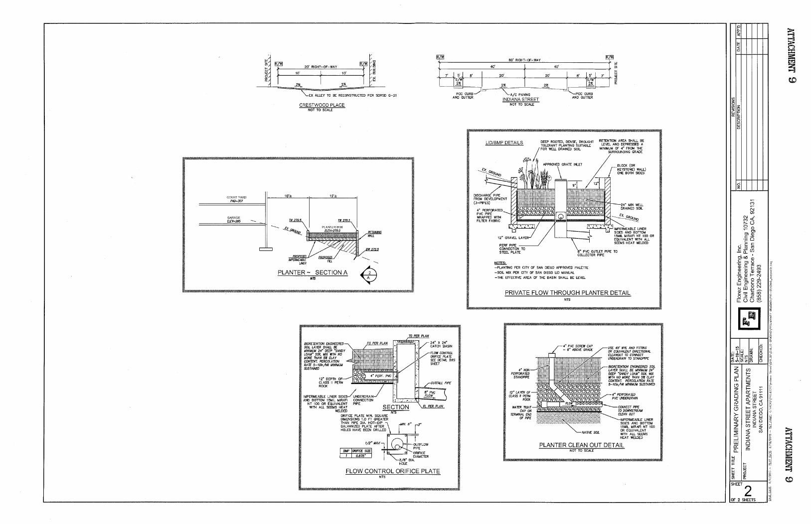
COURTYARD PAD=J07
GARAGE El£V=295
~ Ui .... ~ 6 "' "-
~ Ui
~ ~ "' z 20' RIGHT-OF-WAY g
~ 80' RIGHT-OF-WAY Wi
40' 40' ....
~ "' "-:r f
10' ~ 10' 5 []J
1 x w
~ .]!!_
H5·.1 8' I 20' 20' I 8' I 5' I 7'
S/~r I .I W~J 2% 2% 2%
10'±
EX ALLEY TO BE RECONSTRUCTED PER SDRSD G-21
CRESTWOOD PLACE NOT TO SCALE
12'±
PLANTER- SECTION A NTS
12" DEPTIH OF CLASS II PERM ROCK
IMPERMEABLE LINER SIDES~NDERDRAIN AND BOTIOM 15MIL MIRAFI CONNECTION
NT 100 OR EQUIVALENT PIPE WlllH ALL SEEMS HEAT
WELOED SECTION
ORIFICE PLATE MIN. SQUARE DIMENSIONS 1.0 FT GREATER llHAN PIPE DIA. HOT-DIP GALVANIZED PLATE AFTER HOLES HAVE BEEN DRILLED
1/2"MAX
NTS
FL PER PLAN
OUTFLOW PIPE
FLOW CONTROL ORIFICE PLATE NTS
= PCC CURB _)-S
AND GUmR "-A/C PAVING
INDIANA STREET NOT TO SCALE
= ~PCC CURB
AND GUmR
LID/BMP DETAILS
4" PERFORATED PVC PIPE WRAPPED v.1llH FILTER FABRIC
RETENTION AREA SHALL BE LEVEL AND DEPRESSED A
MINIMUM OF 4" FROM llHE SURROUNDING GRADE
DEEP ROOTED, DENSE, DROUGHT TOLERANT PLANTING SUITABLE
~ FOR WELL DRAINED SOIL
~ BLOCK (OR KEYSTONE) WALL) ONE 80llH SIDES
24" MIN WELL DRAINED SOIL
PERF PIPE ___ _;
IMPERMEABLE LINER SIDES AND BOTIOM 15MIL MIRAFJ NT 100 OR EQUIVALENT v.1llH ALL SEEMS HEAT WELDED
CONNECTION TO STEEL PLATE
~
8" PVC OUTLET PIPE TO COLLECTOR PIPE
-PLANTING PER CITY OF SAN DIEGO APPROVED PALEm
-SOIL MIX PER CITY OF SAN DIEGO LID MANUAL
-llHE EFFECTIVE AREA OF llHE BASIN SHALL BE LEVEL
PRIVATE FLOW THROUGH PLANTER DETAIL NTS
SOIL
45' WY£ AND F1111NG OR EQUIVALENT DIRECTIONAL CLEANOUT TO CONNECT UNDERDRAIN TO STANDPIPE
BIORETENTION ENGINEERED SOIL LAYER SHALL BE MINIMUM 24" DEEP "SANDY LOAM" SOIL MIX 117TII NO MORE TIIAN 51'1 CLAY CONTENT. PERCOLATION RATE 5-101n/11R MINIMUM SUSTAINED
PLANTER CLEAN OUT DETAIL NOT TO SCALE
Cl b. ~ Q_ <(
f=' i! <( n Cl = :5:
~ 2 "'""3
w (I) z 0 (7)~ 51= ~~
"' () (I) w Cl
d z
""' (")
c:::i (j)
N <( (") 1'- (.) 0 0 ""' Ol Ol Q)
·"" 0 c Li c c
co co E 0::: (J)
cii~ ' Q) c Ol (.)
-~ c ~ (") <
Q) ·;:::
(ij (j) ~
c Q) "<t ~ ·a, Q) f- N c 0 6 ~ c ·a, w c N c 0 N Q N w .0
00 15 1!! ·- ro t 0 > .s::. L{)
u:: G (.) ~ ~
~-ffi ,. ~
z
n 5§
~ ~ ~ B
0 0
It)
~ ~ w ~ .. "j' "' q.
f='~ ()
<((I) <( w ~ <I () f- "' J: CliO (I) z Cl 0 >
z ~ (f) f,
<( f- ;7; _J z § (L w 'g (.9 ::2: f z f-
0 a: 1- ~ <( w o; ;?.
<( [1_ w
~ <( JY <{ a: 1- ()
(.9 f- (f) ci w <{ 0
>- w z (j
~ a: a: <{ w <( f- 0 0 Zj
z (f) ~ z ~ <{
~ ::2: <( (f) z " ::::i <( ~ i! w 0 a: ~ ;:, n
(L ~ =
~ '·1 =: tii 1:'1::1
I= f- iil 2 0 f- w o-3 w .., w 0
~ J: "' (I) Q_ ;;, co SHEET
2 "''
~ OF 2 SHEETS

2 ~~~~NT LOCATION
1 I I
1-w w a: 1-U)
CI.Jft910Cl
' ~
~'27'.r t. 20 • - r-
.,. .... J cuR'a'foft0-~1
{- r ...
26
.I
·I
M
..
: . , 55~ , .. ~:r!f::"l I ~I I "I : • I'SID£VAA:O~CK • : I
~--------~-- ------~··!".!''" ... --------- - ~ _:_ -------i I
1 "
I
I
I I I l I I
1-
FIRE ACCESS PLAN , • • 1!r.c'
GENERAL NOTES
SIO'IP\.ANNOTE$.
1 PRCMOE IUil.DING NlORf$$ MJMIEJt$.. Vl$8i.E !H) LEO<IlE FROM ll'!IE STREET OR Ro.-.DFROH'flHC 'OE I'R()I>fRTYPUI; RiP$ PQ..ICVP.oo.&(UI'C'"" • C)
1. PO$T INOICATOR V"'-. YES, fftE OEPNtn.£HT QCINNIECflO!rrf$. AHO AI.ARM 8EU. ARE TO BE ~()(;Ala) ()Nlt*AOOM.$SI~ SC>E Of' TlE STRUCTURE
) FOR PARI<lNGAWAI..V'SIS S£i SME£TT1 &to FOft PARKINGLAYOVf UI.A2.0t ANO AZ-1» F\CICOI'\AN$
4 n<AEJoMNOP1tOf:to&;S)NEWBUSS'tOf'SIH1liiSPA0JtCT ~UTIDI:I$TING BUS STOP fS PA.RlC 81.. & C'YI'fWi,S A.V
$ St£SHE£1~020AOUN)F\OORPI,IoMfOARfA.&SfNtOR!C'YCU~AftfAS
6 TDIPOIWt'VCIONsTRucnoHfO ~Ttef £xi51tHG ti!CTORIC ti.RLDI~ TON. PACMOEDAS R£0Wt£D
SITE PLAN GRAPHICS LEGEND
SITE PLAN KEYNOTES LEGEND
IOK>X lOX POt Ff'l REOUIREMEN'T'S
8'.VX11'4'~EVAHSPACf.Wf'Ott'·O"W!DE...oADINO ZON£.SEIA.t02
SHOftlfr<,Q PER CIY!I. ORA WINGS. T'I'P
8UII.O:NG~$$ MltoiiEA$ PfAftlf'$ POIJ(;V '-*' Clt:AA S~A'rGIWt.N)l.&e_ Sto\IA &n'RY F0A ~ ACCESSTOI!tOCIP
' ' TtMPOAAR"''PftOltCJM$TRUCT\IItE,~H~lC 8VNOA1.0W$
AOEQtJAT£ NE.OHeOftHOOO $EJMNG STRttT I.IGHT
WefWI'oltlfOIM£Ns!ON ~ ~ PAOKfCTVCOANCA TO CftOWN£5 . ,. NlO v
RET~WALl PERCMl 01\AW'WoiO$
KEY PLAN
-· ........
ayrp~udios
I«<IMIIh·-o.tn·~
?~\C-~~-s-,a... .. ~al01
""'~'ll'to ,..,.,.._... ---
1$M_DATES: DE~ DAn!:
OEV. PERMIT SUBM 11106/2014 OEV. PERMIT I<E·SUBM 112812015 BiD. PERMIT SUBM. 310412()15 OEV. PERMIT RE·SUBM~ 4117/2015
OEV. PERMIT RE.SUBM 512012015
I ill
IRVING G lltllll
... .. • w ! w ..
Cl) It)
"' A:: ... II 0 ... c .. z II N Cl) :; ., w .: c cC :e Ill
u z t= "' 0
:! Ill Ill
"' • Q cC Ill iii z A. N c
cC Ill Ill - "' It)
PR<iiclMJ\4!!EitS:" AVRP STlJCMOS: 1402300
ClJENT: AGENCY: PTSII-
DRAWN BY: Q£CICB)8Y:
StEETTITLE!
FlRE ACCESS PlAN
.....,.......,.
~ A1.01F 7 of33
~ ~ n ::r: == ~ ~
c.o
... ~.
MOl S
20
21
22
AUt t 23
E G H J J.2 .,~ L 2 L.6 M .... I I I I ,- / / 28'-5.)1(" ,..•· 11~''1 r-syr / 1o-...- _,.S'.o"J·•O~·O:.
~ ------ --- ---~----------------------- ------:------ --~pr ~'
I I III'SIDEYAfUlS£'11W:K I I ~ " 1 1 z I ' I \. \.
I I
I fXISnNG £Xm1NO ' I ~
f-1
I
~~ ~~~ ro...=H JOJ~ ~
"' ' 1
~ § l ~
I C D
M .Ol
I r..--,-.-,-- ---------_, II I I I
I I
CR.t.Wl ·SP'ACEI
10
.. .. - '
'
:
:
~
' <1>#,
~
'
'
' 0 . ~~ ,. ... DfllM!AIS!.I!
/
:: '
b ..
7
lt'-0"
J•
,, :y- . 0
12
/ l••cr ..
P'O_!O
I ,,. I I
1--I
sl .I
I
~
STORMI£
~
J UT'
" Jl
12
., ••
l: ll .,
+ I I
lb:;:=~~ , l ' ....
1SIU,t2{0)AM.N!t.IU..,.Of 10'1 CUSICFUTCWSE~ STO!W)e SPACE$ A.CCaS:BlE f'RCNAc:oMMQN OIRO.V.'T'IOM loMAOR GARAGE AND NOTPAAT Of A HMITA.at £ AAEA, SIW,.l. II£ f'ROYlOEO PER DWt1,L WG I.Nl
FiF'J'UN(tS)&iORA.Ge AAEAS AAEIIRO....o!DtN S10AAG£Pt04
3 ~~~~~~~ AMAt. SHOWNOHAZ-02 FORA ToTAL 0# 21 Sf()RN)EMEA.S ~HGT01SU03U(O)
I
A-----------~- ----.QOJ I
•
I I ------------.------- '''"
---~-~------------- -----~--~-----L-- --_____ _., _ _ ~ - I
._,: __________ _ j
'
25
26
17
N
I II I
o u , ~~ · a '- ll'·71111!"
~ - : 16
' ' .... ·11' 0" - b '! -
~ : ,.
_, .....
........ ...
p
I
' t I
' 11'1\lt'
I I I
"""'"" I ;!O'Iio
11 l!S/1,6-
"
-~----" . I
:J
77
' - 8
- 9
...
.,_ --=...:i==== Q
I I
~M I I : 1 I I I 1
L------------~------- ---------- -----------_:_-- -----J I I I I I I
~ .~~ ~ LEVEL P1 119" •1' 0"
GENERAL NOTES t AU. W000 FRAMED WALL$ ARE. DiMENSIONeD FROM1Aa: Of' STUD U N 0 UA$0NRYWAl.l S ARE OfloEHSIONED FROM FACE Of' CIIIU UN 0 C!P CONCR£1E WAI.lSICtJR8SAAE D:tMENStONEO FROM FAJ::E. OF W..u.IC\JM U NO.
2 INS'TAL\. W' 'TY1'£ X' GYPSUM aoAAO ON N..L IHTERIOR WALI,S A CEILINGS U,NO~ RU WALL TYPE.SAHDULAS&£lr.48l8.
l RAT£DWALL ASUM&l!£S 8EHIHO 1\JU & SHOW£R EICLOSVI\C.S TO 8( t.WNTAIN£0 AS Of:'TAil.£0 1\DDfTKWo'ol.LAVE,_ 0P G~IJM OOA.RO 1$. A!:OUIRED. R£, WAH TVf'ES
• INSTALl CAULK!~T loT f<l_l J~NTS & PENETRATION$. RV OE"TM.S
5 fllf.F 11 h SERrUORAWINGS FORADOft'tOfW. tNFORMAll~ RfCAAI)INC AATtD o\SSEMil Y PCNI!TRATION 0£TAIL.$
t I~TAi.l8lOCI<.!NGtNWA.U,$FOR.SECVRE A.11"o\C!HUEWTQf"CA81NET$, tWC>Ml$, SHEI.\f\t>IG, .. FUl\IRfi ORA8 eAA$ N1 AEQVtAfO, ReF T3 o, AI4J
1 F\IRMEOOOWN CEll. INca ARE 8e.CIN RATED FlOOR C(l~l!NG A$$EM8t. V t1f1Gtfl AS tNDI(;ATfD REFER TO PARTillON l"t'J'E$
I !t<ISTAI,I. WASM!NG lrMI;HtHERECESS.ED CONNECTION BOX 48" A F F BOXES IHSTAU.£t) IN FIFI£RATB>A$SEMBllES T08E METAL VERIFY MOUNriNG 1-ElGHT WI MAMJf'ACT\JRER
• INSTAL\. ORV'ER EXAAUST 800Sn:R FAHSAS REQUIRED CONAAM REQUtREM£Hl$ OF ~AI. RUNS wiORVER MAHUFAC1VR£RS
10 !~TAU COM9£NED SMCIK£ 6 CARBON M()N()»CJE OET't~TORS PUt l~ CQOES AND OROI~RU IEl.ECTRtCAL6 FlftE PFlOTECnoN
11 RB'E'R l'O ACCU&k/TY OETAI~ stiel:"tS AHb 210t3 CDC CHAPTER 1\A FOA AOOIT!ONAL INklri'W.ATIONREGAAOING ACCESSIRTY R£0VtREM£NTS
12 MOISTllftE FI£&STAHT TVi"E X GVJI'SW llo.AAD TO &E IN$TAU.EO AT AU ~~ I<J-IOAT Kfl'C•I£NS fJCHIND $1M< AHO OISI-NIASI1flA, RO: WAU.
n &f'PSIA\&OA.ROFINISHTO 8£"1.E'Ya 4 $1.400TH' IJ.OH
,. ICt.!YNOT't$ 0"' nuc S6-!EET& ME ANACCUMUV.TION Of" ITEMS fOUNO ON THE I'LAHS, fl.IEVATION$ AAD SECTION$ HOT Al.L ITEM$AAf_ FOUND ON EACH ....... 1~ PAINT£0GA4.VAMZEOOEC<lftA1"111£ fiAIVACY UfiTAL SCREEN li"'EN IN £LEVA"'0N TO l'!llON 8UILO NG TO liE: SEEN Bsnvt
SYMBOL LEGEND
... 1
51
KEYNOTES
u 3.1 .. l ,l ,. ... . .. ., .. ., u SA .. ... " .. .. $,10
'·' " " " .. .. .. . .. '" 111
"' '·' " •.. ... '" ... ,., ,,
W-'L.l fAO(REF A11 01 FORAtl0f'T10fW. ~noHl
STC:RAllHG SPE<:W.JVUSE ( If .wv) nt .. c~e.ss IN e.ICHE$ AND BaTHs( ... /.., WAHCA.l'£GO«Y f.'IRE.RAllNG IN I-O.IRS
"""" 101 ROOMTA.G
~LilY Q.<AIW<CI!_ ~·rw. 41'l06'ATWC.
SPOTE..iVA.T\OH
IEKilf'I'Al!li:WE ~A..IJO'tL.E\19. .4BSO.,~tU\'AflON
KEY PLAN
-· 9
avrpstudios A.-. ._~. """"""'
10J1 ... $ ........... &~oo....,CioMtlfflitn"'
Ptl!t10112100 ··ll~lbt ---
4SUE.OA.lf$:; Dtsc:RIP'llCIH, t».TE:
DEV PERMIT SUBM. 111061Z014 DEV. PERMIT RE·SUBM. 1128/2015 !ltD. PERMIT SUBM. :1104/2015 DEV. PERMIT RE·SUBM. 411712015 DEV. PERMIT RE-SUBM. 512012015
CUEHT•
1111
IRV I NG (; [(( lllf'
t-... • w • ..
w ... fl) Ill I')
~ t- II 0
t- c ... z II N
fl) :; Ill w .5 c C( :E Ill u
z t- I') ,; C( ~
Ill Ill I') • - C( a Cl Ill
z a. N c C( Ill II
I') Ill
f'R()JfC'Tt-~IJ~
AVRP sruo:os: 1402300
CLIENT: AG£NCV: PTSI'
llAAWHIIY Ctt[CIC£DtY·
SHEll Tffi.6
PI PARKING FtOOR PlAN
"""" ....... "'
A2.01 8of33
~ ~ C"':l ::r: :5: tr.l 2: ---3
tO
23 •
~----------: _____ r ___ _ Mil
2A
:zs ,
. I I
I
<XlsnNG OHI! STORYWOOO HOUSE TO MlWN
(CA 11231
0--:---•U
N
I ~
1\ ~ I I I I I I
I I I
........ OH[STORVWOOO HOU'SElO~
teA lt'D)
E • G ....
I !p
'I t>f
1W7<>
:; ,, ~.
1 ..
·; tW7!" ....
0
.....
H I J L 2 L8 M
'
: IL.I
I
1walo
I ,, % I
~ .I
"' ~- · I STORAG! AAJ!As
· ' ' "
""""""' "'"
" % CIS.21)~NG T0 1612o.Jl2(d)
t • ~ ' I P107
I tt % ; I
t "
;.
I tl '
5 '
vtHIClES I.U.\11"'4 n« <:'IAAAGf e UNOesmvcTED
'
.• 1~~ VIS'k!N.,_.J}HJR
I Jl. ... ~ 1."'-"""' I 'l -
......IJ~==pi~~x::=::ld~~ .• Tj ~' ' ·' ~ 'I WAI,.LAl \I!SI ... IlYUCWiCU:
!$()YBt-S0%()PEH, REJ'MO)
. I I
I 11
· t . I
I
L_ ---------__ [ ___ ----- --------- --- ---- ___ __ : __ ---- -_J I I
'--
GROUND FLOOR PLAN
I
'--
GENERAL NOTES 1 H.l WOOO RV.MED WNJ..$AAJ! O:MEHS!a..IED FROM f~ OF STUO IJ N 0 IMSONRVWJIU.S ARE OIMENSIONEO ~0... ~ACE Q j; CUV U N 0 CIP CONCaETE WN.LSICURa.s ANi D&ollf>I$IONEO FROU f'A,CE OF W~VCUA8 V~ 0
2 IN$ TAU. $1&• TYPE X" CYPSUM IOA.RO ~AU. tN'f£RIOR WA&,I,.$ & CE.It,INGS V N.O, RE,- WA.U. 1YPe$ Ate) lA. ASSEM&t..•e.#
3 R,All;DWH..L ASSa.'BI.._E$ 86HIHO 1\18 6 5tiOWER ENCLOSlJA£& 'TO K MA#t~TAANED AS DETAILED AOOmoNAJ,. 1 AVER OF GYPSUM OOAAOA$ REQUIRED, REf' WAU TYPES
4 INSTAUCAlJI.)ONOISEAI.ANTATAUJOWTSAPa<IETAATlOHS,AU OCTAA.$
S REF. t 1 1x $ERIE$ ORA.WINGS FORADOIT!~ •kl"'R..MTION A£GAAOING AA~O~Y~~O~~
6 INS'lAU. 8t.OCI(JNG INWAU . .SfiOR&ee\.IIU! ATTACHMENT OF CABINET$. ~DAAit$, &:H!l.VING,. a RlrufU! GIWIBARS A.5 R!"OI.AR!.O. R'E" n..:w..~
7 FURA£t.l ()()'M.I c:Q:.INGS ME B£t.OH AA.T£0 f.\oo.A ct.IUNG ...SSEMBl V HEGtl" A$ tNOtCAl£0 A!I£A TO P.vmt'ION TYPES
a 1N$TAU WMtitNG \MCHINS AECESUD CONNeCTION &OX 41" A F F BOXeS 1'-'S'TAUJ!DPol R R[ litATEOA$$£.Mei..4£$ TO&£ ~!~:VAL \I£RIFV t.IOUNflNO HflQHf WiM.NUFA.C.'nJRVl
e tNSTAI.,LOR'VotElOWJST&OOSTCFtf~A.&RfOVlA£0. CONFIRM l:t:!~EME.,.I OF HORIZONTAL R1JNS WI ORVEA MANUfAClVRt:RS
,fi ~$TAU. COUIINED SMOI<£ f. CARlON MONOXIO£ DETECTORS PliR l.OCAI. COOUAHO ORCINAHCf.S, REF" O.E~ & ARE PI\OTEC"'ON
n REFER TO ~CCE$$!8tLI'N DETAil SHEET$ANO 2013 C8C CI-W"TER 11A FOR ADOrrfOWol. 4NFOR..-.A TION REOAAOING ACCUS\Bil TV Reouii\EM£NTS
t2_ ~ISTURERiSISTAN'T TYPE X GVJtSUU~TOBE !NSTAU!OAT AU 8ATHROOMSANOAT KtTCiitNS &EH"HD $INK M'D P!SHWASHER. REFWN..l m><S
\). GVP$1JM 1KMRD F!N!$H TO BE '-E\/El,._ 4 $WOOTH' IJ.O,N.
J4 I<EVNOTES ON THE$£ SHEETS AAE AN ACCVMUI.ATlON Of lfb.&S f OVNOC»> THE 1'\.AHS, Ei,EVATIC»tSANDSECTION'$. NOT ALl ITEMISARE fiOUNO ON EACH .... ET
15 PAIIrfTED~V.AAIIZEOOECORATlVE PRN ACYMETAL SCR££N 1-fotN ... B.EVAT*DH TO ALLON8UILD(NO TO 8E ~ 8ETTER
SYMBOL LEGEND
~A..\0 WAll. TAOtltCJAHOIFOR~INFORMAT.QNI
A.1
5 I
~IM A101
.. ..... P n.n»
KEYNOTES
,, " 12
" ,. .. " " ., $l
" •.. •• ... " .. .. $10
'·' .. " •• .. ... .. 810
'" ... " ' " " •.. '" '" '" .. , 22.1
S'ICAA'f\H(; SPB:W...YVOSE(l"NI'f) niiCIC).'I!$S!NIHC:HitS A__ijb OOTH$(~1..., WALLCA"f'EGGftV ~ltfftA'IlJ.'CWH~
iO' 10111'
SPOTD.EYATlOH
l-iEIGPrr AfNMl GA~ F:I.OC>ft Lf'IIEi. AIISOUJTE.fl!V,l'IOH
KEY PLAN
aut-. a
~
avrpstud1os ~· ....... ~·~
.,.,, ..... s-JOt ,.,.Oioo$oO.-...t?.101
··"~ 1'1«1 JUII'IM.aet ---
SSUI!~lU: O(SCR.tP'flOM: o.re
DEV. PERMrT SUBM. 1 tf06120t4 DEV, PERM~T RE.SU8t.4, 112812015
BlD. PERMrr Sl/81.4 31041201$
DEV PER.t.41T RE-SU8t.4. _,1712015
DEV Pffil,\lT RE·SU8t.4. 5/2012015
Tllf
IRVING G 1\l..lll f'
... .. • w ! w ..
U) Ill 1'1 Ill: ... • Cl ... c .. z .! N U) i.LI
, Ill
= c c ::i Ill u
z .... 1'1 0 ! Ill:
Ill Ill 1'1 •
Q c Ill a z A. N c
c Ill • 1'1 Ill
PROJECT NVMIIER& AVRP ST\JOlOS: t4023.00 CUeNT:
AGENCY: PT$jl.
OAAWNOY
""""""""' S11E~nn.t1
GROUND R.OOR PlAN
>HUT-
A2.02 9of33
~ ~ 0 ...... iS: t'r.l 2 -3
co
MOl I
20
21
22 •
}.jO' 1 23 •
2A
25 ·
26
E G .... I ?'-4" f'..)' »·&.S~t• 4'•1ln2'4 1/a• r.s,W 10"..&- 3'4"3'·tOW7..0" I t / '''I /, '/ 1.---=-=- --- - --- r-----------------------------:--------~n~ \
f t'$0EVAADSVIACK • t
' ' l ... ~:;.,.,., .... ~~~000 - '"} ! i ·-~~"' NO\I~T~:.'(""" 1 <NO I i "
I 0
~
i ~
--- a--
I
I I I I I
c
_,__L __ __ 1_,_ __ _
D
! 13 '
• ' I i it ;..u(> I
I• "'" I I , I
'·
10 tWW" fo~sf!_
UNIT ·"""
I
==;-;:::!11"'~ I
~.'1" , ~ I I
I '
==,!!:"'I' I ! ~ 2 MOl
I ~ ~ : -
4,5
... I
1=~;:::;:;:;::;:;:;::=':#-=::::;:=!li~·~-- ---- - - --- - --- J l .. ' I
I
i"''
0'----u 17 • <
:I .. -~I ,; " l
I )
I
~
N ....
p
I a 1
I I
l I
~ """
MOl 1 I I I
I I l I I I I I
L __ -- -------- ~ --------------------------- -_:_ ------_J I I I I I I I I I I ..... .....
SECOND Fk OOR PLAN ,....,.It"
!!
~
'-.-
!
" !<'
''
.,,,
71
8 '
GENERAL NOTES t AU. WOOD FAA.Vm W~LS ARE O>MENSIONEO FROU FACE OF STUD V ~.0 ~WAIJ.SAR£ OiMENSI'*EOFR.OM FACE OF OMUU~ 0 CIP~E WALl$.1CUR8SAR1i 0+~~ FROM F~OI'WNIICURS UNO
1 INSTALl. W" 'TYPE )C GYPSUM BOAAD ON Al..liN'TER.IORWAI.l.S & CE!l!HG&: U N 0 _ R£F WAll-TV1'£S AND Ul AS.SEMBI.IES
1 RA'TEDW,li,.L AS6EMBU£$ BEKI'IO rue&. SHCJW'ER 9ict..OSUR£& TO 8( W.!lrffiJM:D AS OETM.ED AOOIT!Cit<W.I.AYE:R or GYPSUM llel.MOA:S RfOU!REO. REF WALl. NPE&
• !HSTAU. CAUU<;~.ANT AT ALl. JOINT'& • P!NnAATIOHS. FlU OfTMS
5 REF l l,7J.$ER!E5 DAAW: NGS FOR ADDmOHIIL ~,-OfUAAflON Rr.GMtD\~ RATED MS&ti!Q.Y PEHfTRATION Ol'lAli.S
I . INSTALL Bt<>CKIINO !NW~ ,:()A S£CIAU A1TACHMCNTorCAIINElS, HAAOAA.'LS, SHQ'I;lNO, &. I'U~ G~ 6ARS AS AUIUIA£0, RCF T3v , ANO
r AIMtO DO'Mf Cmut;OSMf ta.OW RATED f::LOOI\CWJ!IO ASSEMII. Y ~GKf ,\$. ftiOI~TEO RUCM: TOPAATI'T'K* 'NP'ES
t !NI$TAU. WASHIWO MACHI!« RECESSED CO!+Jr'fCT)OH BOX c.r AF,F BOXC$ IN$TAUf0 IN ftRf RATEI>~!ES TO 86.MET.-.&. \l'fRifY ~G HeOf1T <14w.NV"ACTVAER.
t !H:STAI.l DRYER f)IXAU$T 800$"'"ER fAH$ A$ AEQVtREO CONftRM ,_COU!R.EMOlf$ Of' HOFtlZOtiT A.1. ~UH$ 'wl ~'fER tAANUfo\C:T\JR.ERS
10 IN$TAlliCOMB!Nl.D$MOKE J. CAA110N UONOXIDti DETECTORS PER l OCA.COO£$ NJI)OftOINANCE$. ~EF El.iCTR!~ & fiRE PRO~Ttc:IN
11 REf:'Ot TOAC~SS$1t..fTYO£TAit, SHEUS AND20t3 C:BC OioV"TER HA FOR. AOO(flDNALINFORMATKlN REQARDINGACCESSIBL\.TY REOU11'1.0dENfS
1~ MOI$1lJRE REStS'TNlf 'TYPE X. GYPSVM BOARD JO BE INSTALL{D A1 ~l 8A~Io4$ AND AT KITCHENS BEHIND S!NKAHO OISHWASIER, REF WIIU ,.,.... 13 CiYPSUlo! BOAAO ANISH TO BE~. SMOO'T'H" U 0 M
14 KEYNOTES ON niESE. &!fEnS AAE AN~~ 01 tfEM&: r:OUND ON 1lE P1.ANS. a.£\IATrONS 1\NC S£e1"10NS NoT AU IT(MS 1\Afl FotiNO ON~ REFt
1S PAJH'l"'mGAlVA.NlZCODCCIOf\A.TlV!.HtNAcVWTAI.$CJt(fH ~N>fNiN £l£VATioN TO N..t OW' 8UIU)1HQ TO IE $ £&18ETTVt
SYMBOL LEGEND
======== ~WHL !c.41MO WAl..l TAG(ft£FA1101F()RAOl)fTIONAi,.!NFOtUMllOH)
A.1
5.1
... :<8>: ... ~~
A tOt
.,. ~.crf1SI
KEYNOTES
u ,. " " ,. ,. .. " .. 52 .. .. ..• .. ., ... .. ... "' .. .. " " .. .. ... ... ... ... ... " " "' ... "' ,., tt1
trrC:R.AT..O SPE<:;W.. TVVSEt•F ~ TKCI<.NES$ IN INCtiES AND EIOO,S (4·718, W.-LI.CA~ FlR£11\ATN)!JriHOURS
.SPQT llLVAliOH
Hvatrr ~OROUM) FlOOR.li\'E. A8$01.\ITEEI,.EVA.TION
KEY PLAN
.........
~
~·-~·~ IOliM'""'-._400 a.~U ...... Uitt
• • tt rot210t , .. , •• aM ----
!l$uEO..lU: OE&CAIP"Jl()H-. CM.m
DEV. PERMIT SUBM 1110612014 0EV PERMIT RE·SUBM. 1/28/2015 BLD. PERMIT SUBM. 310412015 OEV PERMIT RE-SUBM. 411712015 Del. PERMIT RE-SUBM. 512012015
I Ill
IRVING GRtlllr
~ .. • w ! w en Ill
"' a= ~ • 0
~ r:: .. z • N
en ;; "' w .E 4 c :& Ill u z ~ "' 0 c a= Ill "' "' • - c a Cl Ill
z D. N c c Ill • - "' Ill
l'ftOJECJMJYM.R~
AVRP STUDIOS: 140'23.00
ct.IENn AGENCY: PTSI-
ORA.WNIY; CHECttOD'Y:
SHfii'Tfill.l:
LEVEL 2 FLOOR PLAN
..mNU ....
A2.03 10 of33
~ ~ C"':l ::t: ~
~ -3
tO
20
21
22
E f • G H I J K · l • LZ L 8 M
/ .... 4t·11SS2'..J\18" 1".6111r
/ / ,.. / .....
,---------------------------- - - -------- ~---- -------~ I r '"" ~!1,...
li'810EVAADS!T9ACI( ~----~--- ~" 1
I
" -... , ) I
I
'
''
10
do-=-=. =rl : .. rl ~----"'~ ""'
.,. , 18E01BAnt
-- - -fMF Aioi) - -- .-. 8 c 0
"'~ I
t I~~~":' ·--~IE<';ONOR-OOR
I I
II
11
; I I
12 I ( "'1 !o
,;
' ~·I l! ·~ I
I ·- 45 ~
I ' : _ J;] ll ;
~01 t 23 _ I ji l 14 !t \ ' , MOll
"'~--- - - ------ --- -r~ -----,~ ---- -----:-------.--- -~~- ---- :.·
25
1 11 - ·~
I ~_,- F "l---1
I
I' ~ •&2111rRO .f- • 'I ,_ _______ ,,
-~ ... _,.". -• ... -J-'\1• N _,....,.
N.1 N2 •
N.3 N.4
N,S•
....
Q
~ ' I
I
1 .... I ! I -
$ !
====,I ~ 1t1 A - '.1 - - - - - ~ ' .... ~•I 7.f01
!r=El!o:o:;r~ ~!J
,, a . ., ..
L _____ ___ --------------------------------________ __ j
THIRD FLOOR PLAN 1it" • 1' ff'
GENERAL NOTES 1 ALL WOOO FAAMEOWAot..U: AA1i OMCNSIOHtD F'R0'-4 FACE OF STUO U.H 0 tAA.&ONRVWAa.lS AAf O!MfNSIOHED FROM FACE OF CMU \J N 0 CIP <XlHCitiT£ WAU..SICUMSAA£ Ol~!cmfD FF«>M FACF>OF WA.I..t.IOUR&U ~ 0.
2 iN$TAU,._ 5lt' 'TYPE X' ~M IOAAO Of./ AU . tNTfR.IOR W,M.UJ .. ca,!HOS U.NO., R£1" WAU 1'VPE$ AHOIAAS$EMEII....If:$
, AATED ~l ASSEMiiUES \iet!NO TU8 & SHOWER ENCLOS~ES TOM w.tmAINEDAS OET~ED AOOiflONAi. \.AVER Of' OYPSUM 80ARO AS REOU!A.EO. ~Ef WAU. 1Y1"U
.. ll'f$TAll ~.C:INQISEAI.ANT A'l/oU JOP(TS & P&4£TRATlCIN5, REF Dt!TMS
5 RU 11, 7ii SER!e:&ORA.VflNGSFORADOmOHN. tNFORMAT\oNit£0NtDIHO AAT'EOASSEMILVPEHETAATlON DETA.Il.S
f INSTALL ~OCIONG!toiW-.u,..siOA:SECUMATTACHU£Hf~CA8<NI!"I'$, f'tAHOIWlS, sH£1.\IINQ.& 'VlVRE OfV.8 8AASA5ftEOU!RlO, kU T3-JIX,AN0
7 FlARED~ a:IUNGSAR~ BQOWRAftO 1'\00A 00UNGA$$EM8l'l' HEIGHT A& INOICAT!D. R.£A!R TO PAA'TmOH T'Yit£$
a ...s'i'H.t. WMI4!NG ......C.IH! R:f!.CESSfO CONNECTioN 80"X ..... Af F BOXE$ INS'TAU .. £0 1N FIR! AAT!O AoSSEM8UU TO BE 14'TAL \IVtiN MOVPIT!NG HEICWT wt!AANUFACTUIU!R
• tUSTAlt. ORVOt EXHAUSliOOST!R t.v.IS A$ AEOUIR1!D ~lfW lltEOUfMMfHTS Of' HOI't!ZOHTAl RtiNS wl ()RVER MANUfAC'TUitfR$
It» IHST.-.u COMI!NfDSMOI<i.&CAR&ONMON())C)()60ETECTOit$P6Rl OCAL COO£S ~t.NC O~E$. AV' S..ECTR:Cit.l- & FIR£ PROlliCTION
n REFER TOACCES$!&1UTY IXTNI. SHEET$ AND 2013 C&C CI-W'TER 11A FOR AOO~ INfORt.'AT~ Rt:GAAOUI/O lt.CCE$SI81l TV REQU..REMaiTS
t1 MOISTU'RE RUISTANTTVPE X OVPSUM 8Ch\RD TO 8£ INSTAU.EO AT AU. 8A1'Hf\OOMSAHOATIOTCt1Et.'$80tlNDS¥M< ANO OISHWASHEI'\. REI' WALl ...... I) GVPSVM acwtD Fl~ TO BE "\.E\IU.. 4 SMQOTW" U 0 N
\4 )(EYNOTES ON THUESMEETSAREAN .A.CCUMIJl,AnoN Of' rTEI,I$ fOUNDQ<ol ~l Pl.ANS. ELEVATIONS ~0 &eenD.NS HOT A1..L IT'EMSAAE FOUND OHE.ACK .....,. 15 PAi~O GAI..VNAZ£0 OECOAATl\IE PR.VN:.Y METAl. SCRf:UI H!O!f.N IN El EVAllON TO Al.I.OW8Uil0 NO TO BE SUH ecn-E.R
SYMBOL LEGEND
======== """""'w"-' ~04J.WO WH-l TAGPt[fMI Ol F~AOOmOHAI.Jl$01\W.nc:lH}
A. 1
5.1
... l<0! ... ~M
A101
KEYNOTES
2S
'·' u ... .. .. ., " " .. ., •.. .. .. ., .. .. S.11t
" " " .. .. .. " ... '" .,, '" " " .. ,., 1S, ,., ,., ,,
SfCRAT!NG SKew. TV USE (!I AW) fHQ()CSS IN IHCHESNJO LGTH$ t4•7A1 WAU CATIGORY 'W! AATWOWHIXM$
SPOl El.t'l/lt.TlON
HI!ICKT A80V! CIIOUJC~in.~(£Va A8SO..VTt:tlCVAT()N
KEY PLAN
-· ~
avrpstud1os ,___. . ....... ~.,....... mt6111,.,._, s-• ..... Ooego.~tl101
l" fl&11011trto , ,,._,.._.. ---
!sstU:OATf.S: Of~: Do\Ti:
OEV PERMIT SUBM. 11106/2014 DEV. PERMIT RE·SUBM 1128/2015 BLD. PERMIT SUBM. 310<12015 DEV PERMIT RE-SUBM 4/1712015 DEV. PERMIT RE-SUBM 512012015
Iii t
IRVING GROll I'
... .. • ILl • .. ILl
... U) !II I')
~ ... • Cl ... c .. z .! N U)
ILl , Cll
= 4( c ::E !II u
z ... I') 0 c ~ !II Cll I') • - c E a !II
z A. N c: c !II " I') !II
~CJ~
AVRP STUDIOS: 14023,00
CliENT: AGENCY: PTS.,_
OAAWNIIYi CHECI(f08V;
SHeUmtti!
lEVEl3 flOOR PlAN
""" ..........
A2.04 11 of 33
?4 ~ n :c a:: rz:s 2 o-3
co

MOt 5
20
21
Mit 1
26
~ G tl l J J .2 .... K
' , ~~ ~) AJ; A1('
L.2 L.8 M
t / N' f'4' :/ 2f',, ,..- ,«'·H~-l,~" r..af IOJ.f" ,~.(/'l•l064J~ I.- ----- -- - -- - ~-------------- -- - --- ---------:------ --~Dr
f' S!O(. VAAO l£nW:K I ~ ~ ', 1 I : fiF:!:::::==n:=ilc;=';=;=:=;::=:;=;:==;
"'
I I
I o I
£XI$T!NG OH!.STOR'VWOOO HOUH. TO IWM.'H
((;.A.ttz3J
0
1 j------ ~
I ____ JJL
I I
' I 17
N •
fc I <0 ,, ,, I )
I I I )
N1 I "42
I I I I I I I I I I I I I I I
N-3 .,. N.S •
10
I \
11
-6liii"RO .~~~- '"".J ....
p
Q
....
" I
I
I I I I
L------------ ~- - --------------------------_i_-------J I I I I I I I I
'- '-FOURTH FLOOR PLAN 1flt' •1'.0'
'
''
'
4,5
• ' .MOl
'
7.7
'
GENERAL NOTES I AU. WOOOFAA.MED WAU..SAAI: O!ME:N$10NEO FROM AAO£ OF sruo UN 0 ~ WIIUSAAE: 01'~0FR0"" FACEQF'CWU N:O QP CONCIII:£Tt_ WAlLIJCU!UtS Alti OIMEN$~0 F"A~ FA(;{ 06 WAU)CUR8 tJ ~ 0
Z tHSTioLI.. $'1""lYPE lt OVPS~ SOA.RO ON AU. INT$RIOA WAlLS 6 c:o...N0S UN 0 , RfF WAll lYf"U AHO lA. AQtJ,oet tES
) ~reD WAU. ASSEUBI.IU BEHINOl\.18 & SHOWDt ENCI..OSVI\8 TON. MNNT~ASDETAII.ED ADOfTION~ t.AVI!ROFGVPS~&OM:DA& ftf_(Mm£0, REF WkL TYPES
-' tf4TN..l CAUtto.NGIS£AU.NT AT AU. JOtHTS & PENe'TMTI~ RlF DCTM.$
5 RfF t'7•$E:AtUOIU.WtNGSf':OftADOmC»W..tN~t1()NqG!VtOINO R.t,TEDASSOoiiLV PfHE'TlltAl'OH O!TNl$
ll. -.sr.-.u,. fll.OCIC!NG INWAU.S t:OR SECURE' An~"" OJ CAI!WETS, KoWDRAtLS, &Mfl V\NC,.6 #\ITVA:f_ GRA.eiAAS AS ftfOIJIRfO. REF T110t..ANO
1 F\lftRI!D ~ COLINOS ARt &!LOW AAT!D 1'\.00ft CEtLIHO MSE~ro'litl V HSGM"T AS lf'I!C)ICATEO RUER TO PARTiTl~ NPES
I INSTAll W...sH!NG "'ACK.:HE A:ECu.s.tO ~fCTION 80)( 4r A F F IK)XE$ IN.sTAU.£0 ~FIR£ RATfO ASSEM8UES TO 86 Mel'Ai.. vattFY UOUtfflNG HE!GHf wla.w.\.II'ACTVRfJl
0 ~ST 1\Ll OR'tER f.)(HMJS;T 800S1'£R F AHS A$ Rt.QU!R£0 CONFI:RM MOUIAfMEHTS Of ttOR!ZONTH. RUNS w1 DRYER t.Wfl.lf'ACTUREA$
tO fNSTAlL C~ St.O<E A CARSON M~D£ OEf!CTORS f'!lllloeltl. COOf.S NolO ORDiNANCES, REf" £l.ECTRICN. A FlRE PROTEcnoH
'' .REFER TOAOCESSI81lrrY DETM. st£1ET5 AND 2013 C8c.CHoV"UA 1 \A~ AOOITIONAI..lNFtlAW.TION RE~NO ACCESSIR.TV MOUtUWJHTS
12. 1oo$01STVRE RE&STANT TYPE XGVP'WM ac».AO to a! IHSTAlllO Al All MTHROOMS.V.OAT )(Jl'CHENS aatH0 SJNK ANO OIIR-MASHIER, A!ll' WAU. moos I) O"tPSS..M SOARD FlMSK TO eE "LEV£\. • SMOOfH" U 0 .N
14 ICEYNOTE$ ON TH£&e RiEETs AA£ ~ACClA4l.A.Al)Ot,j Of JTD.tJ f01Jt4) Cltl T'HE PlANS. El£VAT10HSNO s.£CTtOHS. ftrl()f AU ITEMSARI $"QUNO Ott liAC" ...... 15 PA!NTt.O CW.YAA'"UDO[~l!V( PR!YACV ME"rH. .scJtfEN ~KIEN '"' e EVATION TO .AU OW 8UILC)N0 TO II.$EEH IE'f'Vt
SYMBOL LEGEND
===== ITOO. STUDWA-1 ==== WOOOmtMEDWAI.~ 1011MO WAU.1....01JIUA11ttfOIII~DmOIW. t~~
A.1
51
... ' .,., ...
STCIV.l'IHO ~TVUKf)fANVt THICIC)IESSIN INCHUAHOEIOTHS(4-1J•1 W.tU.tATt:OQII(Y FlRI.IV.TIWC)INH()UfW
Alii\ f1.UtRDCe
~&~ ... /.'-:.M
A101
KEYNOTES
ts ,. >.2
" ~· !t " .. ., ., .. •• .. " .. .. ... TO .. IT
" .. .. .. ... "' "' "' .. u .. ... ,,, "' ... ...
SPOTI!'ltw.'nCI'4
i'€1GrlJA80'11£~ROOft lEVB ANOWlli £!.EVA noN
KEY PLAN
........ ........
9
avrpstudlos ~·-~· ,.,...,.
.,.,, ...... a.100 c-o..,e~•l01
,..,.'POtV.O JJI'tl':MlPf _......,...._*""
CONStiUINi ifOiiiC¥.
<UU(OI\ffC: OESCRI,.....
DEY. PERMIT SUBM. DEY PERMIT RE.SUBM. BLD. PERMfl SUBM Df.V. PERMlT RE·SUBM
.. ~ 1110612014
IIW20\5 310412015 .t/17120t5
OEV. PERMIT RE·SUBM 512M015
I Ill
lRVI NG (in( •IH'
t- .. • Ul ! Ul
.. Cl) Ill 1'1
1:11: t- • 0
t- c .. z • N Cl) ;; Ill
cc Ul = • :& II) u
z t- 1'1 ,;
~ 1:11: II) Ill 1'1 •
Q cc II) a z a. N c
cc II) • 1'1 Ill
PROJUTNIJMeERS
AVRP STUDIOS: 1402300
CUENT: AGENCY: PTSIJ-
VRA\\'N&'Y' QI[CI(fDlY:.
Sit!:fllllf;
LEVEl 4 FLOOR PlAN
SAifu'NIJiOiiVt
A2.05 12of33
~ ;; n :r:: == t'rJ
~ cc

~ ~
~ CJ 0
(F)ti'P Dt•S
~
BUILDING A NORTH ELEVATION 111'•1'·0"
2 ~~~;;>lNG A WEST ELEVATION
• > ..
5 ;~~y ARBOR & FENCE ELEVATION
00 TOP~~~ ..
ROOF~~?~ ..
% SECOND FLOOO
sri~ ..
GROUND FLOOR SDG A • ·2' 6 • •
<8> G~-~~ ..
...._ ... .
T.OP ~-~ ..
ROOF e,r;?.' t ..
~~· SECOND FLOOR
BOG. A . 7 · 10 • •
GROUND FlOOR
~~:. ..
...._
T,O,P BDG, A • u - o· .,
ROOF~~~~ ..
SECOND FLOOR SOG. A . 7·10" •
GROUND FLOOR
8.~:. ..
,,
IM.lCNJI.i ~nm 8lRUCfURE Hl:iiGHT HJl &AN DIEGO COOI1 T ~JOlll)
0£\1\A TlOH R£0UE.S:TW fOR WX 8W.OHG HDGK'f AT JHE SIMU N!EAIOOIC.\m>
3 BUILDING A SOUTH ELEVATION
b •
4 ~~1,tf1NG A EAST ELEVATION
' .... 6 FENCE AND ARBOR SEQTION
...
TO.P BOG A. 22' ~ 0" ' .
ROOF81~~:. ...
GROUND F\OOR
~·6~ ..
;{}._(.)> 'Vi-,. GRADE 1"\.ANE •
·9'- 1 3/32• •
...._ •
TOP.S~~~ ..
RQOF~~ ..
SECOND FLOOR
ap;t ..
~ ~~ .. ------~G=R~OU~ND FLOOR
a.~:. .. EOSTINOOAADe
A,. GRA~~ ~~2~ ... ,.,.,
~~.W36~01'Vf IJ!£R.$0&1C1.21»10(C~I
tl(ll»ma4 ~· Of'fH TO l iC»re US U-S"I$t$"•3$%Cif'Di
7 ~;~FENCE CALCULATION
GENERAL NOTES
1 GAGI..Nf..S,_ MEAJ\JW)l()fHEOU'fSIIDe()r STRUC:~AT EXT£AJORWAJ.I 5
t IICEVNOTESONlHE$E.SH£ETSNI£AHACClAIU.ATIOHOf'~FOUHDONn«: 'VJ.I$. £ifYAT!Qtr.ISANOsecnoH3 HOT A!,A fTEMSNtfFOIJOOON EACHSHE£l
a OIMEHSIOHS~ AR! T'n'ICAI. Of'-TK$ &HEn ON!. V, U.._,ES.S NOlEOOTHER'N.s£
4 REFERTOOVI. DfWVINGSfORGfWioNGltw~flOH
5 REFf.A: 'fOSl'"-'Cl\MN.fORAI)OinotW !N,OMMAflON
S RfF£R TOlAWDSIC»£AARIGA'llQHI'ORAtJOinOMAL t,.,-ONMllOflf
1 RERRTOU£0WfCA!... a!CT'RlCAt. /IHJ f'LUM&..NG DRAWINGS FOR~
-""'' t IW'f!JtTOW"-l.NtO n.OOR 'M't$(Atl OIJ I"'OfUN$U.ATIOHft.V~UI!$
f H i. MOORt«)TOitQ.ASS'A' nRf.AAT£0
lO '!l1ePftMCTSI'W.Ltot.f'I.Ywmtltteoour.tlYOf!WfDclCOl.!Gtm'tG~
11 ~l~WH.t.$108EHtH ONE-t!OU'tflltfRAf!D
11 ~TU; 1'€11>0 OF ll1i IU!lOINOtl TWf VfRf!CN_ O!STAHCf J;~ ORAOi P\.NE. TO Tt1EA~ti60tfl'"~lHE!'10€ST!tOOt$UftFA.CE.(C8C 5¢tl)
1) ACTVA:.IUk.DtmlteOHTWSTNEOIJA.LTOOI\l U$niA,t,j ' At;.J'IJN.,.&UII.OHO Hl»ffl$_ '
ELEVATION KEYNOTES: .. .. , 33 H .. " ., .. " ., .. .. •• •• .. .. .., " .. " .. .. .. .. "' . .. t\2 ... .. " .. '" \51 tLI
"' ,.,
ARCHITECTURAL FEATURES: SOMC 1SIZ.030.(b)(l) tAJ ~llf\E l'fTCHEOitOOFS~EWonoNReOUEST'ED, Rf.F T1 01)
tC) ,t, Ul,.-.t.l.lt.l Of' OM; Q_£RE$l0RVW:Ni:IOW PVt&t!OF STM:E'T EU'VA'TWH fOE"M.TIOHRroi.IE$~RU TIOit
(!;lA t.IJ.Iluw.tOf':ONE fAAHSOMWWOOW(DEW.NJNAtoUEsTt.D, RE:F T1 01.
.,.. 11>4 ENTI'CYPORCH
(H)I"'.AHTtDWAll. MOUtrntnV.rrU
BUILDING !OLEVATION FINISH LEGEND:
-· WINOOW~1 fiN~TO~TCHN'JVAALIII.\MI"W .... VI$!0HCAAS$ 1 ClEAA.INSUI.A TED GlASS
..... CBtiSNT"'-MlDli I,OL~ ccx.cm WHrTE.St«llTTif'l~ .... , ce.etr f\.MltA 1 AtCE:tn COlOR TN4$...oQltlf\N$!1
Pr·• PA.WT 1, TRQ.l(S£$ 'lfl"tll'E l"O IIA1Q1Q>·I
PR PNHll.'-'<~WO.WIIQlW .. O<)()R~D€'VU.$ $1l~~OR-rQ~~W,NOO.V~l!ON$ .,. PNtlT S, EHTRYOOOitS [email protected]!Iri-Wll.lt~ fl'/fSQ$.,-RI~~
PAJtll4,£HTRVOOORS OR,.IrHGE{80D.-SM£RYI'Ifoi·W"-UAMS SW 6U3 "RAUCOUS ORANGE") .,. PA.foll 5, EN'IRY DOORS ff£0 IB 0 0 SHER'itW<WILUAMS SWMOS"AAYeREirt
~· ...... o.IIJI·~
1111•Sitlol4 "*'"* Swo~,C......f210'
Pf,t1JO't7ot
""'~ ---
1Sst.ED4T£S: ., .. ,, . ..,_ DEli PERMIT SUBM.
DEV PERMIT RE.SUBM. llt.D. PERMIT SUBM.
"'"'' 11106120 14
M1812015 l/0412015
DEV. PERMIT RE.SUBM. 4/1712015 DEV. PERMIT RE-SUBM 512<l/201S
Tt!l
IRVING lilhllll
PMOJkfiWi:
... ~ II
w ! w ...
(I) II) 1'1 Ill: ~ II 0
~ c ... z II N
(I) ~ Cll w .5 C(
cC ~ ., u z ~ 1'1 0
~ Ill: .,
Cll 1'1 •
a cC ., Q
z D. N ~ cC ., 1'1 II)
PROJtCtNJiliiilliii AIIRJ>STUDIOS: 14023.00
CliENT: AGENCY: PTSII-
DAAWNIIV, CH£CKE0Il"''r
SHat nTLt:.
BUILDING A EXTERIOR El.EVATIO.NS
..ar.._,.
A6.01 14 ol33
~ ~ ~ ::r:: a= tf'l 2 ---3
co
y
I I
I I I
t I I !
I l f I
i • i • i !
I ! i i I ~ I i ' ! ! l I
- t ! t
I I j 1
I I
j li _, 1' fl I I II I! !I ~~ H H p ~~ ' i! if
'
2 ~r~lrlfiNG BEAST ELEVATION
POT'frrtlW_~T OE'IIViTIOtol fOR pV I'NCI.$
~1111\HGtiEIOtflTIO
.. ..
" l <
I i I i
il0$1>WO
""""'
BULDING B NORTH ELEVATION "'i"Wc 1'-0"
"0' ~·· ""j .. !.7 .. ~· 11 0,1 v
,, tt:P·f .. . ..
,,, ~ I
..
...._ •
i ~ §
..... ~ .,
~"
' ~·· .. ,,~ " ..
SECOND FlOOR .. - UY - 4* •
/, .. /7.V I' •. .,. /
! i i r 0
~ ~ ! 2 s
" ! " ~ " . .. ~
ll.l!lbiNO~OGKt Qf;\'•AnoN
ROOF .t1 4 1' • &'" •
I
I FOURTH FLOOR .t1
' 31' . [)" • I
I "tHIRD~~; ~ I
smA<>< ..,,._ SE~ONO 'io9~ ~
I
I A.o~ ~
s I ;!
' G[WJ,E_~:. ~ 1 1 >~·1 " . I ~i-~~ ..
GENERAL NOTES
\ OftOJNEBAA£M~T01'HEOtJT$ID£0f-s'I'NJCT\.IREA1'~W~t.
2 ~TEl OH"'THESESHETSIIR£ANACaJUli.AbONOinDG ,O(.INDON ftll' fi\.N'$,ElFVATlONSNlOstc'hOMS NOfN.LITDASAAC~~fACtt$HCI!T
' QIMEUJIOHSSHOWNM£TVPICAtM't'HI&SH«TONlY,~!&$NOTEOO~!IE
A JI.US!tTOC.\Il.'tJJIV,_W\NGS,.:QIItGIW)HCI~T.c)ij
5 ~fO~FOI'tAOOIT~!~TION
S ttS"VV:fO~ARIGA'TiONFO'I:ADDI~ NFOfUN.TIOH
) fi!IVtT'OI.EOW&.~.ElfC'TIItiCALNJOI\._~NQ()R.\WM$f~~~~ --• RfNll TOWAll lri«Jfl.OORT'I"PE$C-'' ' Ol)fOR!NSUIATM;INR.VAIUE$
t AU.AOOFINGTOKCI.A$$'A' flRE:AAllD
14 "N PROJECl 8 tio\U, COlofl. YW!Ttt THECOUtnV 01' &AN DIEGO l iG*mHG ~C(
I t ,tr,U fXT£RIORW,t,i.I..$TOB.e~ QNE.HOIJ~FlR£AAt'ED
tl ~ll::HllGWTOFTHESUL.DINOlSllEVERTltALCMTAHCEfAOMGAADE~TO -ntEAVIi~HelGHfOFntE.HOHE.slROOF~Aa!: (C8C- 502 1J
~ ~D!NGHE!GKl WST I EECJlML TOORl tss 1'HA.N _. N:.TVAI, lkk,O'NC
ELEVATION KEYNOTES:
u " H
" ,. " .. ., .. " " .. .. .. .. .. .. ... " " " .. .. .. .. I -tO ... "1
'·" " " .. '" '" "' '" ,.,
ARCHITECTURAL FEATURES: SDI!C 1512.030<(b)(1) 1NtotA.nPI.tPflcHB>ROOfS(D£W.f'IONR£00Bl'tO,AY l t .tH)
jqA 1,!~ 01 ONEQ..lll!.sTORVw-.tiXJW PQIIIOf $nt£tT l!lEVAT\Oftl (Ol'INI.1>0HIU:ioUUT£D, W 1"t01l
IIJ4\0I!~O'-ONETJW\I~WMION~TlOHN:OIJEST£O. IitiF f101)
I')AAomt'l'"~
j~I)I"'.AN'''!!WioU.MOUNTtDI.AnT<:t:
BUILDING ELEVATION FINISH LEGEND:
Wl.l-1 WNXIWI.I.Al0"1 f-INI$HTOa.M.TCHtM.TUAAI.AI.WNIN
\/G-1 \I'.$10HGI,.AS$ 1 CUAA IN$1A.AlW<l.A$$
CM CE\IIENTPtMTER:t,~CO..OR WHITE. 5lMX)Tlt I'IN"SH
CP-4. ~~2,ACCf.Hlcot.DR TA.~.&t.IOOTMF<N lUi
Pr·1 PAINT t rR:El.liSES WHITETOlMTCHCP-1
Pf.: PAINT 2, AA.IJHG, WNXJW ~ OOOftSHADINO 0£\IICU !OtVERCOI..OR1"0 IMTCHWIHOON t.UA ON$
Pf,) PA.INTJ. 9lt"RVDOOftS
~r~~~WI..!.IoU.G
114 PA»tf •t DmtV DOOitS CIAANGE.{I 00 StiERwlHWl.UAMS PIMU "fiAIJCOUJOfW«::E."l
PT• PAU<trJ, otnWDOOftS ~(0(8100 IH{RWIH.VII.ll..l.J,A,M$ INIMOI""'-Vf;III:(D")
avrpstudlos ~· I,__.,.....~
"10)10 sn.l. ... . a-0'80~Pt0\
Pttt10U101: f"I117DI-----
I$$U(t»,TU;
~ """' DEV. PERMIT SUBM. 11106/2014 DEV PERMITRE·SUBM. 11231201~
stb. PERMiT SUSM. 310412015 OEV PERMITRE.SUBM. 411712015
OEV. PERMIT R&.sUBM. 5/2012015
a.IEN'f·
rw IRVI NG
GnlHII•
... .. • w • .t w en Ill ..,
a: ... II 0 ... c .. z II N en ;; ., w = c c :E Ill
u z ... .., 0 c a: Ill ., ..,
Gl - c a Q Ill
z A. N c c Ill II .., Ill
~THUWII:JUi,
AVRP STUDIOS: 1402:3.00
CI.IENT: AGENCY: PTSjo..
....... IV"
"""""""" SHffTnThf:
BLDG B NORTH AND EAST EL.EVA110NS
Sltf[T"'MKJI ·
A6.02 15of33
~ ~ . , '{' '{'
'
BUILDING B SOUTH ELEVATION
"
101
2 ~;!I,L;'ING B WEST ELEVATION
CP·I
I' .,. .. I
I
I~
:1?~; .. 1Ml(_....,..f'ERl411Tf0 $TRUCl'\IAf HeCrlT P(R ~AI.(;C)Of:11)0VO
FOURTH~; .. _, ....
'" ' "' THIRD FlOOR ..
-·· -CP-) 20'-a-
' ' ...... '~) SECOND ":-.??:. ..
·~,.,...,
GROUND FlOOR A . u._._...,~;!: .,
:.~ .. FOURTH FlOOR •
31'· 0" •
SECOND';-~?; ..
GENERAL NOTES
1 GlbOIIHESAFI~~lOTHEOU'T$'DEOf-SlRUCll..IMAJEXT£litiOAWAU.$
l ICEYNOTUONTHESE SHflET$/oMAAACClJtM.UTlOHOJ IT'Et.CSFOUt.oOH M ~.ElEVATIONSAKJS£.CrON$ HOT ,liU. n94JoltEFOUM:I OH£A¢H MET
S Ollo.EHSIONS SHOWN All£ l"n''CAL OF THIS »CrT ON\. Y, ~ NOTtD O'n~
4 RU~ TO CIYL DfVoWWGS fOR G#t.ADING fNf:OR.W.TIOH
s RUEAfo&'TRUCTVJtALIOA~INrofttrAAT\ON
a IUt9tTOI..AHO$CA.PfllfltAICATl()Hf.OIII.~INFOIUMTlOH
1 fitE1CATOM!CtWACAL,a..tt~CAL.N4;)ft\.~OAA'N.HO&FCllltAOOfllOioW.
""""""'""" • WtltTOWAll/IH:JF\.CO*'TVJIES(A1101) FOR~llONR-VAlUES
a ,._llltOOtWCTOIIE:ClASSA'J.It:f.~Ttl)
10 THt ~CTSHAr..l. (;()i,fi\VWITH THE QOUNT'I'OF IAN O.EOOiJGHnNOORDINA....CE
11 Atl fX'fVtiORWiolLil08E torH OHE-HOORRRERA.tED
12 t.IOreHEIOHfOI' 1lE IUot.OINOtS THt.'VV!ncAI. 0151ANCtFROMOAAOeJII..ANt TO THEi o\\'£RAO( H()OHf ~ THf, ..a.HQT ROOf SURFACE fC8C 5Cl I)
~~ ";'LO NO!eGHTWST 8E EOUN,. TOOR LESS~ ... _. ACTl.IALI!IULDING
ELEVATION KEYNOTES:
u
" " " ,. " .. .. " " " .. " .. 51 .. " '" 11 .. " " .. .. .. "' t.n
'" "' .. " .. '" "' '" ... ... ARCHITECTURAL FEATURES: S DMC 1512.030<(1>)(1} Wt.M.llPll MCI'EO.ROOFStDf\1\ATlOHftEOt.IUU:O, RU Tt ot)
IC)A WIJl,U,I OFOHti Q.ERESTORVWa.IXlW PEA WOf STR££T B..£1/Anotf (OEV\ATIQNR~AI:F ll 01)
Cl}AMNIMlN:OfOWE ~'V!NOOH(DIE'\MllONitEOUtSTUt,W Tl01/
(F)~ emf'/ PORCH
{H'Jf'I,AHT£DWAU.Io40UHl'mt.AlTU
BUILDING ELEVATION FINISH LEGEND:
.... , WH:Jii:JI;' toU.UONI RNsHTOWt.TOIW\~..tU'-4~
""' V:$10fr1Gt.A$$t CleM!~TIDGl.A$$
"'' cseiTfll.A!TBt I.GIEHEfW COI.Oft WWT!.&MOOTHnN'SH
Cl'•2: C64DIT IV4TEit t.loCCOIT CO.. OR l M1, $l.lOOtl1F!Nl$H
""" PAII'ft 1, f'RfU.f$ES W..l1: TO ...... TCHCP· I
.... , I'AII'If 'l, lltMJNG, WNX1H & QOOiil; Sii'WiiNO DEVICES St..llilteoi.OR TO Mo\f'CHW-HOOWUIA-\JOf'o'S
...,,, I'AINf).omtYDOQq OCHRECJO_O SHERWM-WUW.CS , .... _,.,..,
,.,. PNM .t ENTRY DOORS OR.ANQE(800 SHER'WIN·Wti..IAAAS sw ...., 'RAUOOIJS ORANGF)
..... PAINT$, ENTRY DOORS A£0 II 0 D SMEAW'IN WI.LWot$ '!N/feOI'RAV(R£01
avrpstudios ~-· .... ~· """-' 7U16 ...... a.2'110 S...O.,.. C..,_UtOt
..... 11)1~ ,.,.~._...,......._
IS$UEOA"TU: DC~: DA-TE::
DEV. PERMITSV8M. 11~141
OEV. PERMIT R6-SUSM 112812015
BlD. PERMIT SUBM.. 310412015 OEV PERMrTRE..SUBM. <C/1712015 OEV-PERMITRE-Sl/BM. 51'2012015
IIH
IRVING LtllOU I
.. 1- • w e w ..
U) Ill 1'1 ~ 1- • 0
1- c ... z • N U) :; Cll w = c c( :E Ill
u z 1- 1'1 0 c( ~
Ill Cll 1'1 • - c( a Q Ill
z D. N c: c( Ill • 1'1 Ill
Plto.A:CTNJ~S:
AVRP STUDIOS: 1402:3.00 ClJEH'T! AGENCY: PTS #-
ORA.WN8¥-_..., SHU!Tl'lne.
SLOG 8 SOliTH. AND WEST ELEV ... T!ONS
......,.......,._
A6.03 16 of 33
~ ~ Q ;s: ~ 2'! -:1
co

( u
~ ~ ""' "
1 . BUILDING B COURTYARD EAST ELEVATION , ••• ,-0"
[JJ
~ '5 ~ tt. ~ ~; .... ~·
2 ~--~~.L__oiNG B COURTYARD WEST ELEVATION
IIJ
" ~ 47· ~- ~ I'T}-
CP·I
}10 .,
•.z.., ,,
c:::::::J
[0
' ~"- •• ~.7 ~
"
••
u u
-~~
. ,
I r
THIRD F~"?; ...
SECOND fLOOR /I; 10'- 4- r
__ GROUND Flc??~ ...
I
~E-~~ ..... LEVB.PI •
-12' · t1' •
FOURTH"}1~ ...
GROUNDFL~ ...
GENERAL NOTES
' GltJQt,INESAR£ t.E.ASUREDlOTHE~~ S"mUCTVIt!AT OO!AIOAW/Itla
2. <l'(NOTUON TME&lSHEETs~Nl AC:aAU.AnoH ~ tTOa ~ON ne; PVH5. a.t'IAT'IONSANO ~'$ H01 N.l rT(...U: Alt! ~ON fACH SH(£1'
) ~S~IOWHAM~O#THI$SHtCT~Y,~NOltDO~
• ~TO CNI. MAWNM ~OIIt GIWltHO tt<WOIUM'nON
~ !WVtlOsntiJC::~FOR"OO'll()tW._d'OIJIW.TlON
• liiUlJit TO LANDSCAP£11RitiG4TlON FO!It ADO~ NORWOnot.!
f IIOVttOI.EC~CAL~ANOP\.V\tii~OMW'INGSfORAtlOfTlOIW. !N'OfUM,ll()H
t II'LJ'fAlOWH.I.. AHOFl.OCIRT"'PU~\1 Olj FOAIN$\h.ATlONIWAU.EJi
t AUR()(lf!N(Jf08EC4ASS'A'ffiERAT'EO
tO TIC. ~T SXALL GOIW\. YWITHT!1e toultt'Y<W UliOII!:OO t.IOHTWOOfiiDIIW!iCE
tt All EXTERI~WIIJ 15 TO liE ldH ONE-HOUR FOR! RAT£0
12_ NOte HEIGKfOJ' THEMM.DINGtS tHE~ OIS'JAHCI! f'lttOloi;GfW)(! P\.AA(, TO THe A~RAGE HEJ(;H'T Of 1l1E KGHUT ROOF SUV'ACE (C8C, !lOlli
13 ACTUAL 8Ul.DIHG HElOHT WSTI!E (OUo\L TO a.-Lts& nWrf ACTUH-IUILOINO tEIGtfll$_ .
ELEVATION KEYNOTES:
,. " H u
" " " ., " .. .. .. .. .. " •• .. ... .. .. " " u .. .. ... ... ... ... .. .., u ... '" '" ,., "-'
ARCHITECTURAL FEATURES: SOMC 1512.0304(bK1) W WO..l!fll.i ~TCHED ROOf'S (Of\MTIOH RfOUESTED flU lt 01)
~A""""""" 0¥ ONeClfRESTORVWt'«XPWf'ER !ill Of STREET 8.EVAnoN (Ce\Mf'IOH REQUUTEO. fitS' T1 Ot )
If) A Wf!MUM OF 0015 TltAHSOM W!NOOW(DE'IMT!OH ~EDUESTED.ktF f t Ot)
(F)Aiff)lllWPORCH
(H)Pv.HTmWA.U. MOUN'Tmi.ArncE
BUILDING ELEVATION FINISH LEGEND:
WIJ..1 WIHOOW MlUJON 1 F1,.,1SHfOIMTCK* TIAIWN..WMN
VO.t Y.SIONGt.A$$ 1 Ct.!AA INSUI.ATEDGtASS
Cf....,.I'I..A&f!Ul t, G€MEAALCOLC* WwT!. SMOOntNtSH
Cl'ol C(t.«N'fP\.AS~2.Iti:I(.;£Hlt.chO'-fAH.$3.100TW~
Pf l P,A.INT t , TMI.LtSGS W"'TtTOtAATCHCP-1
I'T-2 PAM 2. AAILWG, WHXM 4 DOOR SkA.DI'OO OfYICU SI.VIRCOLQI!tlO~TCttW~'fUI.L()f4
,.., f"'AtNJ). f:H'nltVO()()M OCHRE~O.O~W~ ~MS$"1~
PT-.1 PNHT ._IHJJtY OOOR$ OfW4GEI'IOD Sti£RW.H-WU.IMAS SW ... 3'AAJJCOUS~
!'f.S P.A4NT '-emtV DOOM ff£0 18 0 0 SHtRWlN·Wlll tAMS SWtoOI~~Io4:JJ"J
avrp"lturlioc. ~. -o....,..,.._.,.
mt ... ....., .... S.Oi.OI>CII..,.UtOI
~•ttl042700 f&.JMliMI ---
IS$VI! QA'TU: oesatn1C)!f;- Ml!!:
OEV. PERMfl SUBM 11f0612014 DEV PERMIT RE.SUBM. 11251'2015 lllD PERMIT SUBM. 310012015 DEV PERMITRE.SUBM. 4/1712015 DEV. PERMil RE.SUBM. 51'2M015
Tilt
IRVING loll\ )I 'I'
1-.. • Ill • ..
Ill ..
en U)l')
II: 1- II CI
1- c .-z li N en iilll
Ill c Cll 4 :E -u
U) z ~ I') 0
~ II) Ill I') •
Q 4 II) a z D. N c
4 II) II I') U)
Pl-to.ilCTMJ~
AVRP STUOIOS: 140'13.00 Ct.IENT:
AGENCY: PTSII-
OAAWN~
""""""'"" SKEfrrnt!
BLDG B COURTYARD ElEVATlONS
SHEET-·
A6.04 17 of33
~ ~ n ::z:: == t'l:l 2 ...., w
• I t
i 1 { I I I l
i • !
I l
i i • I I
i
20
BUILDING A WEST OFFSETTING ELEVATION
21 22 23 24 25 26
T.O.P. BOG. A • 22" · 0' ,
ROOF~~ .. :. ...
SECOND FLOOR BOG. A . 1' · 10 • •
BUILDING A WEST ELEVATION PLANE LEGEND:
~~---------------------------------------------------------------------------------------------------------------+~~~==~~~~~==~
I• BUILDING 8 WEST ELEVAT10NPLANE LEGEND:
~ I • J i I I
i I
' : i I l t
f t I y
I ! £
1 t ·l
!' . ' p fr l' •I H il h }: li H H p -I !I ti I. 2 ?,,~I,';>ING B WEST OFFSETTING ELEVATION
10 II 12 13
TOTN..AAOHTAO!~I!AI<2.tDM$1
14 15 16 17
THIRD ~a'!?:. ...
SECOND Ffo'??f, ...
GROUND Fl~?:. ...
.·
avrpstudios Mr-...• ...... OIIItl' . ......
'"*"...._ s.-. ,..O.,.,~t:210\
ll'llll\M~ ,.,.l'CM .... ---
tSSUED4T£Jt ~: Q,f.Tf:
OEV. PERMIT SUSM. 11/0612014 OEV. PERMITRE.SUBM 112812015
BLD. PERMIT SUBM._ 310412015
OEV. PERMITRE·SU8M .Uil/2015 DEN. PERMIT RE·SUBM 612012015
! Il l
IRVING CR\.11lP
... .. • w e w ..
U) ., .., a= ... • 0 ... c ... z • N
U) i Cll w .5 c ~ :E Ill
u
~ ... .., 0 a= Ill 1111 .., •
Q ~ Ill a z A. N c ~ Ill • .., .,
PR~-AVRP Sl\JOIOS: 1402300 CUENT:
AGENCY: PTS ...
......... ., CHBXEOBV;
$11UTT!n.t!
OFFSETTING WEST PlANE DIAGRAM
.....,........,._
A6.05 18of33
~ ~ @ ;s:: I:TJ
~ tO

• I
i • I
i I I
i i I I • I I I
0 c 8
r
NORTH OFFSET PLANE ELEVATION-BULDING A
TOP 8~; ...
ROOF&1~:. ...
rrrorrocr;rer~'""
srO"SEntt•; ,,,.
M l l l21 l
NORTH OFFSET PLANE ELEVATION-BULDING B 2
H G E
1-
lOTAl.FROH'TAGEI4CA•~-- II
r~tS.S#J t~
I"OFF$t'Vll1lWI~"
•-rOI'F$COu•r.,'.,.
THIRD~~ ..
SECOND F~~~:. ...
a-w~ • .,, ,.,.
!----------------------------------------~E----------------------------t---------------------------------------------------------------------------------------------------1 I t i
I I
I t ' i ! t
I ' 1 r
f '
1 i li j• rl t' •I I' i I II I!
I i 'I '• L
A I A.1 8
3 ~~~JH ELEVATION-BUILDING A
c 0 '
TO P w; .. ROOFe:::~ ...
0 H J J2 l 1l2 L IM
4 ~~~JH ELEVATION-BUILDING B
SECOtiO R.OOR • 10' · 4· •
fi"~IHIIfJ tt'S •r.rOftMU,.,.J tJY.
u..rOff-KTJ• t~-•s "
n"-FOHWOJ1S PIU'A
avrpstudios ........ -.,.,.... ....... ........... 1111110.,..~~ ...... ,.,.. ···-----
e&A:TXHfilU
!IM O"Ta. .. .....,.,.. . OEV. PERMIT SUBM OEV PERMIT RE·SU&M BLD PERMIT SUBM DEV PERMIT RE·SUBM 0EV PERMIT RE.SUBM
fill
.. ,. . 111'0112014 lfll/201 5 31041201$ 411712015
512M015
l RVI NG l• Rc llll
t- .. • w e .. w U) • 1"1 a= t- • 0
t- c ... z • N U) ;; .,.
w .s c cC ::E Ill
u z t- 1"1 & Ill
~ a= 1"1 • Q cC Ill a
Ita N c z cC Ill • - 1"1 • M61AtfMIWU AVRPSTUDIOS 14023 00 QJENT.
AD£NCY I'TS .. _ .. _ .. ltilffinL
OFFSEmNG NORlli PLANE DIAGRAM
itUTWA
A6.06 19ol33
~ ~ ("':) ::c
== 1::1:1 2 ~
co
~ ~ n = a: ~ 2 ~
(.0
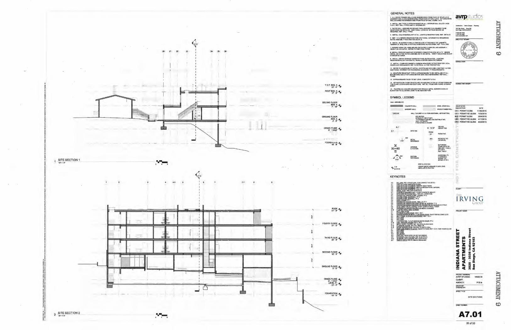
SITE SECTION 1
'
D.
i II I
==I = I=~
1- l ,. ~ .
I ~r--I~ I
I ~ · i • •
i ~ · ~ ~
I~J :::3 -
- iiii!j,
~
- -
2 ~~:~SECTION 2
J '~.
-I _ -t
-I '-
-,
I
I t-1
I
...... ' • r
. '
(ij ~ ""~ ~
[il liJ ·~ ~
(ti .~ <r. "7
_.,_ --
- -
4,5
I I
I I
I I
----I
I
' J '
~ -I
I
I I
' I I
I l
t l I
I
l o l
I
I I I I
-r-I I I
I
...J
24
I":-'
-§ --~
~
~,R §i
0 --
1.1
1-
!-
-
- --
_ji~ _
f
i I'
i '
--
-
~
' • ~
' ;
'
~
' ~
'
~
.__
TOP~~t- -'\.
ROO~~G-:. ...
SECOND FlOOR
~.t- .....
GRADE PLANE • ·9' · 13132' •
FOURTH~$?; ...
SECOND~~:. ...
FOLINOAWN A · 19' - 6" 'II
GENERAL NOTES t AU. WOOO FMMEO W-'US /IR£0!Mt::;NS10fii(D F'ROM rt-.u 01' atu0 UN 0 w.sot4RY WAllSARf: OiME:NStOMEO FROM,~ Of CMU U .N 0 C11" ~ WN.LSIClJRU ARt DIMEHS!ONEO FROM FACE Of W.UUCU!Itl UN 0
1 INSTALl .. ,. "TYP£ X GVJISW ec:wtO CJt,l ALl !NTotiOA W"-l.lS .. CQ.JHO$ UNO ,fltU WAll. 1YPESAICIA.ASSEMiltU
l RAf£0 WAU ASStMkJIES IOU.O T\11 . SMOWUt 04Q.OII.IIU TO IE W...NT~DMD£fAit.£0 AOOm~V.VfAOfOVPS..,._.IOAA:OAS R!OUIIIte:O. Re. WAU n?U
4 INlTN.l CAUI.KI;HCISEAI..Nlf AT A.t..l JC)IN'TS 6 P'f.NirfRATIOHS, REF DETAilS
t 1\9 U tl(sa\lf$ ~WI~ FOR AOO+TlOt<W. INf'QAMA,TIOH R~GARDIHG Ro\Tf.DA$$EMel.YP£HETRATtOHOETNI..S
f tNSTAU.II..QO(JNGIHWA.llS FOR SEC\.~Rl'ATT~N'TOF CA8tNE'TS. tWIORAA.S, SHELVINC). £. FVTVR:E GAA8 BARS A$ REOIAA.EO, AU' n IlK. AND
1 FVAAED DOWN CEAINOS ARe Ba.CYN RATED F\OOR CEll.. tHO ASS€MfJl Y HEICW'T A$ tHDI'CATEO MFEA TO PARTmOH TYPES
f !NSf AU. WASHINO MACH-HE RECESSEO CONNECTION lOX 4r AJ. ~ l()l(£$ tNS1'~EO IN FlRE RA-n'DASSEWBVE:S 1'0 BE METAl- \ltR!IlY UOUNTING ti!IGHT wl t.IANUF"ACT\JR.ER
I +NS'TAUDfn'EREX!oW.I&'T800STERFANSASA£0UR£D CC)t¥llltJ,I R(OUtRaiENIS OF HORIZONTAL R~wl OftYf:R IMHt.WAC'TURVlS
10 INSTo\LL COM&IH£0 ~ 6 CA.R8oN M()NO.)()C)£ OET'KTOR$ I'ER LOCAl COCES AHO OAO'MAHCES. RU EliE~ 6 I' !Itt PROTlCTlON
II ~ TOACCt$$111UT'W'oeTM.&H!!TSAH02013cec CioW'T£R 11AFOA AOOn'!OtW. INf:'~noH AECAR.OIHG N::CU:SIIlll TV REOUI!A:EMENT'S
12 ~Jit!SISTNlf TYPt XOYP$UU~O TO 8E INSTAUED A.T AU. GATl«<OM$ liMO AT I'QTCtiEHS etl4nO $1118<' AHO OCStfNMHe:R. REF WN..L ........ 13 GY'PSVIoleo.AOI"II>I•StiTOat"I..!Vft..4SMOOTH"UOH
14 IOJ\.-NOT£$ OHThESE 04EFfSNtEI>HACCI.MAAnoN Of ITI;;MS fOIA-IDOH THE'"lAHS.ElEVA.TlON'SWO$ECnoNS NOTAL! ITEN$AAE.IOUNOONEACH ... ..,. 1$ PAIHTEDOA4.VAHIZEDOE~TM;MtVAC':'tt.ET~ SCREE'HHIDEN~ nEVATfOW TOAU..OW8Vll0!NOT08E$EEN8ET'TER
SYMBOL LEGEND
WA.I.lASSDIIIW.IU.
==== STULS'l\JDWAU.
---- WOOOf!W.ECWN.J.
1047A.-«< WALl TNJ(Rtl A11.01 FOIItA.DOmOfW_ ~ORMo\Tl)trO
,.,, 51
... ~<e>l ...
...
STCRATWG sP£CW..1Y USE (IF' NM THICIO$SS ltrliNCHES AHO 9G nG ( .. 7..., Wlti.l CATlGORV f R£ RAlWG IN HOliRS
' ..,..._ A101 R£FE1tEHCE
""'""'" El_(V ... TIQN
~~w AIO'
KEYNOTES
u
" " ll ,. ,. .. u
" u u •.. .. .. n u .. ... " .. u u .. .. u ... '" lit
'" ,, u .. '" "' '" ... u•
SPOTEI.iVA.TlON HBGH1 ASO¥E GACIUhO A.CJOiit l.t'\lf1. ~EI.tV ... TlOH
avrpstudios ~·~~.,__,
*'IIIIS..... S..;lOt s.,,...c..r......W1b1
""'~rn.o ,.,"~ --
COHS1.ATANlSi~
ISSUEO...Ttt OUCRLPTJOfrrl' ~»:m
OEV. PERMIT SUBM. \110$12014
OEV. PERMIT RE.SUBM 112B12015
atD. PERMIT SUBM. 310412015 DEV. PERMIT RE-SUBM. 411712015
DEY- PERMIT RE.SUBM . 5120/201$
cuon:
Till.
IRVING GRt•lll'
... .. • w • ... w .. , Ill 1"1 a: ... • 0 ... c ... z II N en :; Gl w E c c :t Ill
u z ... 1"1 & Ill
~ a: "' • a c Ill a z A. N c
c Ill " 1"1 Ill
"""-E'H•-RS< AVRP STUDIOS: 1402:300
CUENT: AGENCY': PTS,_.
QAAWNI'f' CHECJW)tV:
""fiflllle
SITE SECTIONS
_.._
A7.01 20 of33
~ ~ ("::! = ::::: ~
~ co
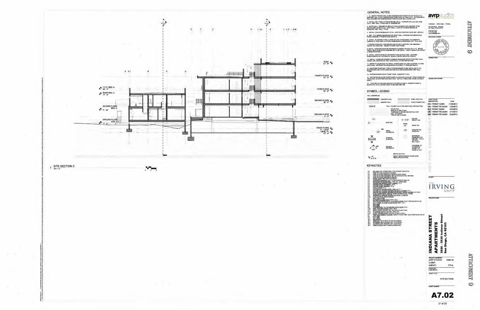
• I ! I ' I i I I I f
I • I l
i I i I
i I
l ! i i ; I r f
I i ' I ~ l I t t
I I I r
I . i ·t !• . ! p r' ll I l
I! if t. l r II H p !f il H
SITE SECTION 3
a. T O.P BOG. A ,.- 2l · O'
a. ROOFBDG. A ,.- 1T · 9"
.a T·10"'
8
...._ • •
G
c 0
H J 0.2 K
I I
L...
L l ll L ! M
SECOP<D"l'~:. ..
GROUNO Fl::~ ..
G~E-~f .. lEVELP1 A
~12' 4 0'" •
GENERAL NOTES 1 Al.l WOOD F~EO WALLS ARE Dlt.IE:NSIQNEO F"II:Ofol ' liCE Of. IT\JO UN 0 iMSONRY WMJ.S ARE DIMENSIONED FROM ,N:.~ 01 CMU UN 0 CIP' COHCN1'£ WAU.SI'CUASS AAt [f.Jr.IENSlOHED FR<:IU '"'~ CW WAl.LICU!Itl U to! 0
, INSTALL .W"1YPE. X" GYP$UM eoAA0 0H ~ INTt.ftiOR WALLS f. CQ.INO$ UHO. ft£1 WAI.ll"n't!SAHO\Aofo.S.SO!IkJU
3 AA1t:O WALL A.SIEMIIUEIIIH!NO T\11 & SHOWfR O.O..OIURO TO K t.WNTN:NI!OASOElAtl.fD A.OO(TTOfW. V.Vf..A~CV,.UU IOoi\RDA$ kEXn-'R£0, 11tEJI. WALL TYPE$,
.t twSTAUCA.UI..<I~ATN,.l.IOWTI&PENliTRA"llONS, REf DEtAil S
I Rfl t11~~:SER.!UOAA~GSFOR.AD01TlONAllfrriFORI4«\TlONAE.Q.ARD<...a Jf.ATEDAS$DikVPENIETRAn(INO£TAU,.$
6 ltoiSTALI. tr..OCI<.ING t!IWA:J..$ FOft SECI.IflE ATrACH\otEHT Of' CABtNE'TS. t~l$. SHe.V\00. lo FVTVRE GAA1 e.AA$ A$ R.EQVIREO, REF n a,. AND
1 I"U'tRt.O OOWMCEIUNO.SARf eEl, OW RATa) R OOR CEIUHO ASS£M8l V HEIOWT A$ ltOCAn;D REFtR TO PAAJtnON TYPES
t lfoi$TAU WAS1-4 tNCUAAC:H1N£ Rfe£$SEO CO~ECTION l OX <~r "-' f 80Xl$ INSTAU.El)IN FIRE RATED ~IES f O 8E MEl' AI... WAifY MOUNTING tifiGKr VII MA.HUFACThftER
I tHSlAI.I. OR'V'EA EXMMJSl IJ()().S"f£R FAHSAS REQUifU:l) CONI"'Rt.l ftEQ~NTS Of HOfl'lZONTAL RIJHS WI OAY9t t.~tA.NUf'AC'T'\.IR2.AS
tO IHSlAU C()toii8.:!NED St«))(E 6 CNWON WOHCOOOI! OET£CTOftl: "fR l OCAl.. CQOESNIO OAtil~. Jtl'F nECT'RlCA.l & tl~e PJtO'T(~
11 Ra':Ut TOACCU&aUTYOETAll~Ai«»20t3CiiCctw'Tflll 11~ FOR AOOI'J'IOrtW. tNf'OfUMTIOH R£0AAOIHG ACCESSl8.1. TV,_£QUIR.fJ4N'f$
t2 MOISY\.IIItl! M$i$TANT "rYJtt! X~ tcWUJ TO &l INST.IrUED Al AU IATHAOOMSAHO A1' K:ITCHOIS UHI, S!NI(-""'~!) OISt-MIASHfR. ftf' W~ l'OU
t) CVSO$Ut.4 !IOAAD FW!SH TO IE "L£'11R 4 ~T'H" UO N:
t• lcLVNOTU ON1"tootSt SHEETS AAI.AN A.CCU~noN OF ITt~ FOI,.t.ID OH rHl ~S. El.E\IAnoNS AND SECTIOtOS NOT AU. ITEM$ AA£ FOUND ON EACH ........
SYMBOL LEGEND
==== $TUI.$TUOWAU
~WOOOFAA...;DWN,t
t047A-40 WAll TAGI;RI:FA.t101FOR-IIOOIT!CitW INFORW.fJOlll)
... . 51
KEYNOTES
" .. .. ., •.. " .. .. .. .. ., .. .. .. ., .. .. ... '·' .. .. .. .. .. •• ... ... ... ... .. u .. "' .•. ... "' 'ttl
STCRAnNG Sf'tCIH..TV\JISE(IFAH\') niCJICNESB IN cNCHQAJC) EIDT)Gt474") W.lrt1 L. CATEGORY FlReRAnNGINI'OUft$
lc IOVZ' CEJLIIIO HElOHTlAG
SPOT E!.EVATIOH I«<Iff'fNtOYE~R..OOf\I.£Ya. ANQ..LJT£ Ei.f\JA'f'ION
avrpstudios __,... ,-o-~po..,...,.,.
~ , .... s...t ..... ...,a.p.~ttm
~llll!MV• ,..,.,.. .... __ ..,.....,.._
ISSVEDM~S: OfSCR!PnON; DATE:.
DEV. PERMIT SUBM. 11/06f2014 OEV. PERMIT RE-SUBM. 1n812C)15 BlD.PERMITSUBM. 310412015 DEll PERMIT RE-SVBM 41171201$
DEll PERMIT RE.SVBM. $12012015
[llf
IRVIN G uRl'l'r
1-.. • w • ..
w .. U) Ill
"' a: 1- • 0
1- c .. z • N U) ;; ., w .5 c c :E Ill
u z 1- "' 0 c a: Ill Ill
"' • - c a a Ill
z D. N C c Ill •
1'1111
PftO.IECTM.IMRRS:
AVf!P STUDIOS: 1402300 cttEN'T; AGENCY: PTS ..
DAAWNIY C>C:o<!DII'<
Sl!tl.'fllltf:
SITE SECTIONS
Sl4ttT)oii.M50t
A7.02 21 of33
~ ~ ~ :J:: 3:: tr:l 2. ~
co
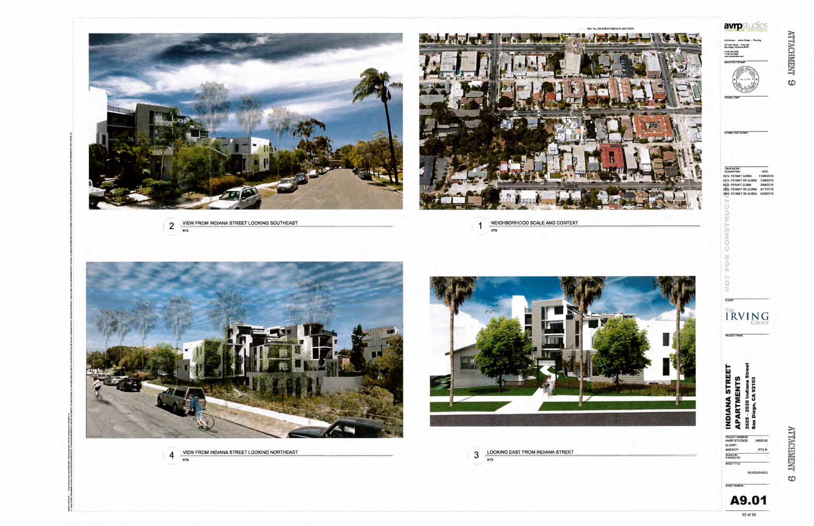
y
I I
i t I I I
i I i f
I • i i
i I • • J • i !
I I i i I I f
I i ' ' ! l I : t
I I ! y
I t
.I II ~ I l' rl II
d II il I, I t II t i !I It !· 'i L
2 VIEW FROM INDIANA STREET LOOKING SOUTHEAST
NTS
4 VIEW FROM INDIANA STREET LOOKING NORTHEAST
NTS
1 NEIGHBORHOOD SCALE AND CONTEXT
NTS
3 LOOKING EAST FROM INDIANA STREET
NTS
a"'P.studios ........_ ....... OMillfl• .........
JOli.6UISirMc,S..2liO .... o.e.,e.-...... ttto•
tt lltti04VIO HttJtt_~ ---
i&SUEO"TES: OE$CfVTlCH: DATE:
OEV. PERMIT SUBM. 1110612014
OEV. PERMIT RE-SUBM. 112812015 BlD. PERMIT SU8M. 3/0412015 OEV. PERMIT RE-SUBM. <117/2015 OEV. PERMIT RE.SUBM. 512012015
OJ(Jtf;
T1 1~
IRVING GR(llJf'
... .. • w ! w ..
rn Ill I')
Ill: ... • 0 ... c ... z • N rn ;; Ill
cC w .5 c ::E 11'1 u
z t I') 0 :! ttl Ill
I') • Q cC 11'1 iS z D. N c
cC 11'1 II - I') Ill
PROJECtMJW AVRP STUDIOS: 1402300 CliENT: AGENCY: PTSIO-
OAAWN8'1': CHEO(EOIY':
S><UTtme
RENDERINGS
$HOET....eat.
A9.01 22of33
~ ~ n :::t: a: t'rJ 2 ""'i
co

y
I I
I I I I
I I I I
I • ; I • I i • i • i l a
i I ! • J i I I f
I i ! ! f l J l I i
I I
f I • ~
t f ·I ,, . I l' f i ll li H ·f If I' 1f i I f! l~ ~~ I
i I If
2 VIEW FROM COURTYARD TOWARDS INDIANA STREET
.ns 1 LOOKING EAST FROM INDIANA STREET
NTS
avtpstudios -.... t ....... o..lln•"""""'
,.,, .. ~ ..... -&.IOO.,., CtlifM!iiiUIO'I
l't lt 'Ool%100 ,_.,,,.,._lAO ---
!SSUI!OATEI: OESCRPTlON: 0-'lt::;
DEY. PERMIT SUBM, 1 H0612014 DEV. PERMIT RE·SUBM. 1/2812015 BlD. PERMIT SUBM. 310412015 DEV. PERMIT RE·SUBM. 411712015 DEV. PERMIT RE.SUBI.I. 512012015
CUtNT;
r11~
IRVING GROll!'
1-.. • w !
w .. en en
"' Ill: ... II 0 ... c ... z II N en ;; ., w = c c :IE Ill u
z ~ "' 0
! Ill ., "' • Cl c Ill
Q z A. N c
c Ill II - "' en
PRO.<E<OtNU"""" AVRP STUDIOS: 1402300
CUE>lf: AGENCY: PTS tc
CIRA.WNI'Y! Ct€Cl<El>IY:
$HUTnn.e
RENDERINGS
.....,_
A9.02 23 ol33
~ ~ n ::t: a: ~ 2 ~
co
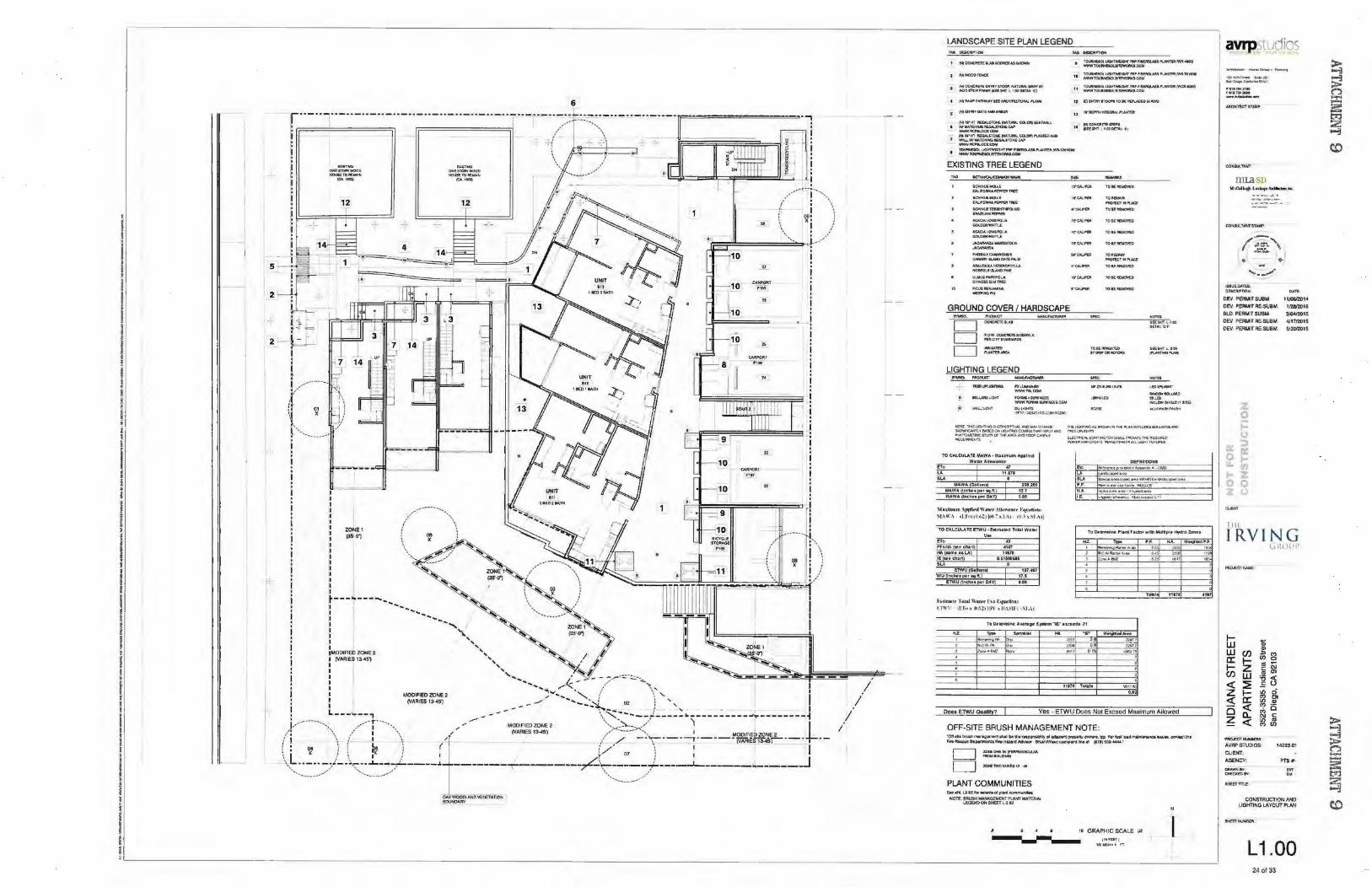
' f !
I i l
! I I ~
i • • i I
i I ' l • i ~
I i I • I
I I I
i j : l l ~
I f I t
I i r
' ~ I I
i i
I I
I I
i I j
/---- ·---, ___ \
~ 03 :
t--- ~----...... .... \ ~X~ /
I ........ _ ' ~· : ....................... .. ................. ~
I -...... ZONE~~ I '\. 135'.()') ~ : ', ' ~ :MOOIAE~ZONE2 ',, ~ : (VARIES 13-45') ',, ~ ~ ~
: ',.... ' ~'- - __ .. :.:-.::;.., I ... ...,..., ~- / "' <.:::,"' I ""'""\ / ' / \ ' I MODtFIEOZONE2 .,.. ........... ' f \ '-,
.. . I . / __ .. ,--j- .... , __
/ i \ : 09• : • X • • • I '
rr==;:p===\=\·,~- :::2-j_ __ __.i
"
. ni!===:=:::======~~~· !
CAAI'OOT P1~7
:I
: (VAAJES13-4S') -"' """"--~"-..! 02 l , I --- I " - - - - I j, .. ------.. ,~---~~-:-t-·-.,, _, ' _. -- MODIAEOZONE2 \~~~._:?.:----- "'~ -----------..--------+-i
/ ' \ / 1 •, / (VARIES 13-451 ,/ ', I ~OOtAEO ZON£ 2 :' j \ I_ J \ 1 / / -·'\'·-·-,--·-·iiiAAI~Si3...S1 ___ --: • 04 ' : l ... ~ ( :'/ i \ I I ~ • X: f : ~ : 1 l.. 01 l t
\~~-~~-~~/- ·\.::~_~;_::,L----.1 --------,----------:rL-~====-;.f----_J_------ .. ------J
OAKWOODlANDvt.OETAnoH 90U.JDAA\"
/ /
I /
LANDSCAPE SITE PLAN LEGEND
TOi.MWtiOl~'fll'.-.ti'JOI.AS$1"1.Nif(R(W"..oQ~ WWW~I1tWOfUt5CO~
I~UCIHTWE'OHf FJIP F.eEJQJ.SSI'I..AHTStfo'il'-12'W! 1/NM fOtiiiHESO'..IITe¥0ftQ cow TOUIINESOt. t10HTW£0ion fN'I:8£AQV.SS I'\..AHTSI twefl.tOOCit
,, WtiNITOI.IIIhiE80!..f1'EWC)fl6001.1,
5 =~=~toc.QfiJ6t'AlWAU 14 ::rc:..~m.S:l. AJ HWWt IIOON.STOt*g.Ml\IIWCOl.Ciflll'lAimJIND
'1 WIIU. W! '4o\J~ I£G'UTONE CAP WNN~COM
• !:N..~~l191B.ASSI'V.Nmi(Wfl.-1201-
EXISTING TREE L.EGEND
&ct4NU& WOU.E (:AIJ'OIIfoMP&t'lJIITIWt.
&04'NUS~ ~~m>PtA1AO
SCHNU!ITBUII~ .~ .. PIW'(R
N:./JOAl~FOUA OClOEN 'NAm.:£
ACN;IAI.O!'OfOUA GOlDENWiorn.J:
JIICioAAif)A,IIol~ JloCI>NMOA
~)f~'S ~·SlAHOD.a.Tf ,.A!.M
~-"""" NOM<:JtiC ISU.-'DPelf U!J,tV$,......,'01.1A C>t.NUE 8.M fiU:f
Aeu$~~ ,.,.,.,.. ..
.r.....- TOIItK -WCJYG
, ......... '""""' "'Ortc'I'>HI'VoCE
•""'"" TON~
or~ roN~ .. ,..._ ICI"tAI.li'UI 1'0 8l REWOVEO
1011EIMW MOm:T~"VU
•l"C.WPOI l0'8E~
TOIEfi~O
GROUND COVER I HARDSCAPE
D D D
A.OW~810£WitU(
f'ER OTY I TAN!WIOS
, ..... ,., """""'""'
LIGHTING LEGEND
f)(fJ.M~
""""'"""" FO#IM$+ .... ACES
<EDUPUOHf
ll~tO.tNIO
lltWW I'OIIMI~IUIIIACU OOtot '"'" wt.I,OWSH:a,tlj1SOQ
"""""' fm"' •~!fl$C0Mf!QOO-"LU'>'IHV'Ifll~
TO CAlCULATE' MAWA • M~rlmuft\ Appflitd WlllefAlkJW.an«
no •1 lA U ,l-18 .... .
MAWA(G.all~
MA,WA lac..botper S!J.rL)
t.tAWA(Inc:h~ttpef DAY)
234.201 J2.1 o.os
•' 1•dn .. un \J,Pkotl \\ii lt•r .\tllt"lliK'f' l~:(jllllri"ll:
MI\WA •I I<UtOitlii(Uh. I\J fll h " IMI
TO c:A\.IWI.ATe f'TWU • blln»liltd lol.lll W111tr ..... no PnHA •·~ns HA a m• uu.
.. . .., ttl78
IE snch.atl 0.11$0058$ SLA
ETWU (GIIJon VIU (lnc'hu .,.., tct.lll
ElWU ftiKI'IU Jloef OAY)
121,40'1'
"·' o.o~
. .... th nll l t- 1'otnJ \\'• tvr n~ ~JW~lio•:
r 1"'\\1 1 (Ct.n O.l,Z)IlN- x IIA)1 F) · S I.. .. \ f
HZ. - S.,_ltr
"' Do lll0¥1"" ~-z-•M -
...
'"'~rroHOAS9oo..,-..~toM~•.a.uot.6tl(1..lNQ..,..,
<'Ott"''""" !.UCI JI~QCWJ...CfOJI~i>fiCMCll. ntf:MOUN:O J'Of>VIA~I.OCJortTRAASt~Eq"'-l~I RnUIIE..S
"" '"'
... LA $ P.F. H. • • I,E
omNtnOHs ,_,.,_c ""-'"""'*"""' ,. QI,G -~lllt!cll.ebCitoO• .. ~-~..,.-
ll'lwol ... ,."""'~......a.m ~~•et_..,._. • JI'O,;.O..,,.
·~••11-,t.l.o.I••"IIMIOn
HZ.. P.F. H.A.. We ~~~~, ... llQ.WAinltr-/lrl.. O.U 2ti l.o-Aet.V. 0 Mi1
Tobl 11&7
-rv WeigN.MN••
•• m11
•• """ ., _,. •
Yes - ETWU Does Not Exceed Maximum Allowed
OFF-SITE BRUSH MANAGEMENT NOTE: 'Oifaltlbn.Wirnaru~Qomtnl.ti\IIIUtll'"'-~lYOI~~OWtlei'S.f)'P Fotlli•Ho.dftiOI~.wa..,._COI'lld!Nt FbltNcr.ie~tllll~AIMHt· ~MdtomplainliN;~~ fSI,.S33~'
II ZI»LOHE»~ ~ fiiiOM8LLD!Nil)
D lOI>f1WOV'-'tfS.IJ 4 '
PLANT COMMUNITIES See« l.l.02 lllf m«r.:Jol.:.'i¥11~ HOT'E!&~~PlAN'TJ,AATERIAl
I.EGel400t4SHttlW02
II GRAPHIC SCALE l2
' L-----------------------------------------------------------------------------------------------------------------------------------------------~
aV~pstudjos
............... -.~-·-~ ~,..,.$0-.......... 190 f"oiJ~.~IIlQ\
PltfJ9oU100 , ,tf10'2Mt ---
ISSUE OATts: OC$CitPT'IOM: OAlt':-
OEV PeRMIT SUBM 11/0612014
OEV PERMIT RE.SUBM 1/2er.t015
SLD. PERMIT SUBM 3/04n015 DEV PERMIT RE·SUBM. 4/17/2015 0EV PERUIT RE.SUBM. 5120/2015
z 0
I IlL
lRVING ~d\lH I'
ti:i o; UJ en ~ (')
a: 1- (/) 0 Ill 1\j 1- z :ii en en UJ '6 <
<{ ~ E u z 1- It> 0 <{ a: (') Ol
It> .. iS <{ ~ i5
a.. N c: z <{ It> Ill (') (/)
rAOJECTNIM8ERS:
AVRP STUDIOS: 14023.01
CI.JENT: AGENCY: PTS#· OAAwtti'V: "" QiECiCEOfN .. SHEEJT!l\e
CONSTRUCTION AND UGHTING tAYO\fT PVoN
.............
L1.00 24 of33
~ -3 > (""!) ::::::: ;s'! tTl 2 -:1
c.o
' I !
I I i I I I
I • !
I i • I ' i I
i !
j I I • J J I t I i ' I f I !
' I i ' i I I
I I 4
' i !
I I
i I ! i !
i I i •
I I I I
I
I I I
I I I
t--------,, '• ........ .._ .. .... ........ '• ........ ., ........ ""' I I ' :: ',, I I ' :. ',, II ' :: ',, :: ................. /"-u ............ .. II .,. ...... ..., ' :: _, ........ ... :. :L------, I I I I .-1 I /
- - l I ' I I ( '
L __ j ________ 1_ ________ ~------------------/- /
""""". JT~l ....
""""""' .... "
/ /
/ /
LANDSCAPE CALCULATIONS 8lltUTTMUlfrt ,.U8UC RIG.H'TOf'WA'f ~otS1tw«f:~9 Stft!CIT..-.~ su ... r .. , PIO',<*t
STRUTVAitO(M.LlOJr'£Sl l'QI!.-AtCIII ~,., .. q~ ~.VMPI'O'-»d
PWfl Nft a K.t·O$c.w PW!IPolmR~I«< Pt.arii~II$PI~I
Pofllt At~""! n ..
R£MAI'0NO YMO Plart1J19AIW~I!IOS .. Citlr~~«~ht'f!l PlafC~~P!tWOrdffi';OiqOA.U~c:l SlledV.,rl) P\eJ't Pot,h~!GOJlOirt• ~ ~~Bt•c•h·RN t .,.....f'antt.~
~Ac~-''"'-"'(•) tbgslkM\, !~ Z.C·oc. !4131r'DIIf ~oftAI!kt19-(Et•l•fiiJII'lJP~~ """tbeol1c~~~-~,... d!b't.d:IO()ch.J ~beroiT!eeS.~
DISnNOTRHS rCiGW!h~WIIlh~~.s.u lttftiORe,..., rree~ololllRllno.t'CI
AREA CALCULATION LEGEND ~ ~
STMETVARO
CJ """"''NG """" .....
~
1.120tf
'·"'"'
H3lf
• .. \ ,5315f
""" \~l$F"
O$' ,. ,., ,., Sf
r416?sr 300 , .. "" s 1$JCXS
" "' • '
,. GRAPHIC SCALE 11 ( IHfUT)
1111NCH •t "
avrpstudios ,_,.....•""'-10""0'1· .........
m1 ... ---. ...,_, $Moe.,...QI....,.tzt01
,..1t100'10t ft11 rD4'* ---
./'::."' . I ~:.: '-,.. 'I' ---·~t ... ,....,.,~
........ ...., 0£5CIIIII'TION: Dlo.Tl
DEV Pelt.fl SVBM. 1110612014 DEV. P£Rt.fT RE·SUBM" 1/2812015 Bt.O. PERMIT SUBM. 3104/2015 DEV. PERt.fl RE-SUBM. 4/17/2015 DEV. PER...-t RE·SUBM 5120(2015
IH L
IRVING li R• H•r
...... a; w w en : "' a: ...... en 0
"' §] ...... z c en w «1 '0 <
<{ ~ £ (.)
z ...... ..., 0 "' 0> <{ a: ..., Q)
i3 <{ ~ i:5 a.. (\j c z <{
..., "' "' en
"""'""'""""""' AVRP STUDi-OS: 1402301
CUEI'II': AGaiCV: PTS'· OAAWN' I'V:. lYT O<ECICQ)O'< ... SHEE'll nL
lANDSCAPE CALCUlATIONS
S>«T-L 1.01 25of33
~ ~ C":l ::X: ~ M 2 ~
<:0
~
I !
i I r
I I I !
I I I
i ~ I I • • I • i !
i i i i I I ~
i i j I i I 1
I I I I i • ~
! i l s t
i l I i
' j ' l ~
i I i
CONSTRUCTION NOTES ' · VISIT THE SITE PRJOR TO SltBMITT1NG BIDS. 2. SUBMil A UNIT COST FOR IMPORT Sotl IN·Pi.ACE AND BE DOMJ>tETEL V AWAAE OF TliE AMOUNT OF SOIL
NECESSARY TO REACH THE SATISFACTORY GROUND LEVEL S VERIFY All PROPER TV LINES-OR OTHER LIMIT OF WORK LINES PRIOR fO COMMENCING WORK. 4 , REMOVE All DEMOUTION ITEMS FROM THE PRO,ECT SITE AND DISPOSE Of IN ACCORDANCE WITii APPliCWIU:
COPES ANO REGULA n ONS, 00 NOT OURY Rli8&SH OR DEOR!S ON SITE 5 R.EPI\IR OR REPlACE /W'I DAMAGE TO ADJACENT PROPERTIES. CIJR6S. WAU(S Pl.ANTlNG, W~LLS, ETC 1\T NO
ADOITtONAL COST TO THE OWNER. & VERIFY All EXISTING CONDJTIDNS. DIMENSIONS AOID ELEVATIONS BEFORE PROCEEDING WITH THE WORk NOTIFY
LANDSCAPE ARCHITECT I~EOIATEL y SHOUl D FIELD CONDITIONS liAR~ FROM THOSE SHOWN ON PLAN 7 REPORT OISCREPAI'IC<ES fN THE DRAWINGS OR BETWEEN THE ORAWIOOS ,yjl) ACTUAl FIElD Cot<OffiDNS TO M
LANDSCAPE .O.RCHITE.CT. CORRECTE.O DRAWINGS OR INSTRUCTIONS SI1All BE FlJI.l RESPONSIBILITV FOR ALL NECESSARY CORRECflONS DUE-TO FAILURE TO REPORT KNOWN OISCREPANDES
6, LOCATE All EXISTING UnLITlES WHETHER SHOWN KEREON OR NOT AND PROTECT THEM FROM DAMAGE NO'IlFY OWNER IMMEDlATELY IF DAMAGE. OCCURS ANO ASSUME FUlL RESPO~SIBil.ITY FOR EX~ENSE OF REPAIR OR REP~CEMENT.
9 COMPL ~ WITH Al_L PROVISIONS OF THE LATE&T 8UILDING CODE ANO WITH OTHER CURRENT RULES. REGU~ TIONS AND OROlNANC£S GOVERMI'fG ll-IE PLACE Of: THE WORit BUILDING CODE REQUIREMENTS TA)(E PRECEDENCE OVER THE DRAWINGS AND IT SHAI..l BE THE RESPONSIB!LITV OF A~ONE SUPPLYING WOR OR MATERiAlS 00 BOTH TO BRING TO THE ATIENTION OF THE ARCHITECT AJIV OtSCREPANCtES OR CONFLICTS BE1WEEN THE REQU!REMEf'IT'S OF THE CODE AND TliE ORAWlNGS.
10 LOCATIONS OF N I C CONSTRUCTION ELEMeNTS SUCH AS LIGHTS. SIGNS. VENTS. HVDRANTS. TRANSfORMERS. EfC,, ARE APPROXIMATE. NOTIFY THE LANDSCAPE ARCHflECT ltAMEOIATEl Y SHOULO TME LOCATION OF THESE ITEMS II"TERFERE WJTH THE P'IOPER EXECUTION OF WORK
\ 1, VERIFY AU PAVING AND HAROSCAPE C()t.ISTRUCTION ORAW'INGS WITH SOil ENGINEER'S REPOR,'T Wff'H REGARD TO SASE PREPARATION AND FOOTING REQUIREMENTS, NOTIFY OWNER IMMEDIATELY IF SOILS REPOIRT RECOMMENDATlO'IS DIFFER FROM DRAWINGS. THE SOl'S REPORT RECOMME'IOAT!ONS. IF MORE. STRINGE!'T THAN THE DRAWINGS. SHALL TAKE PREeeoENCE
12. BE REsJ>ONSIIllE FOR COORDINATION BE.TVIEEN SUBCONTRACTORS FOR PRO?ER AND TIMELV PLACE.MENT OF SlEEVtNG, P1PING A.NOIOR CONDUIT INSTAL.LATlON lAIOER OR THROUGJilANOSCAPE B.EMENTS
13, DO NOT SCALE DRAWINGS, 14. SEE CIVIl ENGINEER'S PLAH FOfl PREC\SE GRAOI.,G AND DRAINAGE INFORMAfiON, IS, PRO\IIDE A REPR.ES£>1TAT111E SAMPLE OF EActl PAINTED OR STAINED ELEAEHT TO THE OWNEil FOR REIIIEW /\NO
APPROIIAL PRIOR TO APPL VIN<l FINlSH, IW'ER TOOETAILS AND SPE.C<FICA.TIONS FOR SPECIFIC SUBMITTAl REQUIREMENTS.
16. PROIIIDE A 4' X 4 SAMPLE Of' EACH PAlliNG TYPE IN LOCATION SPECIF•ED BY OWNER'S REPRESENTATIVE RlR REVIEW AND APPROVAl BY OWNER'S REPRE$EHTA1Y\IE Pf.tlOR TO INSTALLA.OON. REFER TO SPECIFlCAn ONS.
17. WHERE PAVING AND AN!SH GRADE MEET, DEPRESS FINISH GRADE 1' IN TURF AREAS MID > 112" fl'l GROUND COVER AREAS UNlESS OTHERWISE INDICATED.
19. 00 NO EXCEED 3:1 SLOPE IN TURF AAEAS 1B FOR PROJ~CT WAl~S DO NOT EXCEE.O .0. stOPE OF ~:1 (514 GRAOIENTl UNCESS OTHERWISE INDIOATED 2.0. 00 NOT EXCE.EO 2~1 SlOPE IN Pt..ANTEO AREAS. 21 HOtO FINISH GRADE A MINIMUM OFf' BELOW FINISH FLOOR UNLESS OTHERWISE NOTED 22. CO"STRUCT All CURVE TO CURVE AND CURVE TO TANGENT LINES TO BE NE.A T, TRIM, SMOOTH AND UNIFORM 23 CONSTRUCT Al l DONCR~ Willi A MINIMIIM COMPRESSNE STRENGTH OF 3 000 PSI @ 28 DAYS 24. PROVIDE OWNER WITH ALL WARIWITIES. GUARANTEES. ANO INSTRUCilON MANUALS FOR EQUIPMENT.
APPt.IANCES. FIXTURES. ETC, AS DE"SCRIBEO l t4 'THE SPEciFICAllONS.
ol
~ . , .
... LEGEND: t CO~AETEPAV!INO A£1-l::ATOCOHfmLI~tiPi.AH FDf\
COlOf\NIO FINISH ~ • 3AEBAAAT1r0 C, £ACHWA.V,CfN'l'£R£DW SLAB :l~GAAOE A COM,ACTEO Sli&GI\ADE P£A 6QIUS ~ERS fi£POftf S ! ,hi" TOOlED RADIJS t. DPAHSIONJOIHl l&(£COH'OtO{:J0t~DETMt 7 ~ HAI\OSON"£Pa\ PVoH
NOTES: "- fY..v,}¥l TH~. BASE PREPAAA110N "ND JU3iNFORCIHG
NI£$10WN FOA 810 PURPOSES 0 "-l.Y Vf.1tFVREOV~ Of Tl1E-SOit.t AEPORf AHO COMf'I.Y
0 •"-Otl"lOE AN!&<! ~l.E ~~~~ SPOOifllCAllON!J
c- EIO'~JO.Hf&:SIWJ.D£WSTAU,£DA,TAU..lJtellotti
~lS~SJ~:;~~t.~~~~~~~s 0 il lf;tftEDESTAIIJI USE CONC11ETE
! 1~ A\ITOMOel.E USEco;.ICAE'TE
CONCRETEPAVlNG I N"T&
' . ' LEGEND: 1. !/r~S£DQ£ t PAVING FNSH SUfiFACE fi£JI PI.MI
J_ 4 ' ... :S f. ~. JCOITFUEAPQ.S;Itf,CIIf')CA'MN6
. .._ .....
' v
4 Y.~ROO~SPfC!f!O.\noNS i lWGPAI'rf~~S/!.AU.Hr
PER SPtofl\.AnoNS G 117Dl-. X12"LONOSTmoowae
R4'0 C, ~AI'S\WIW' OHJ; EM)
NOTES:
ccoo~
I'! £XPAH&()t.;JOINT$SHAU.BE1HST~* S>ATAI.I.AAJCT!QNS WITH~ 5UfiFoJa"S WAI..l$, W I'I8S. SttPS. BUILDlNO WAU..i. ETC A~O HJ. AREAS AS INDtCATfD ONlHEI'tNts
·. 8 !i£Ai.Notf COlOR lO W.TCH AOJACENT PA'NIO
* 31_.. ff' PA.V\~ ~ ntAH N THCIC. l'JF PAVING ., lltOCOflOAfA"'EJI
CONCRHE JOINTS DETAIL
LOCEND: l SA.WCUTAJ40~QfJ) tf2"X1~'t'lt'EfH ¥ffW, WTW1111
M NSf:TMORTAA -a. v•· 0\AMCNo oowa svs;w 4t•r o c ! ~~~~~-=P•V•~Ol!JMJ
METALSlAlP fJV CAE$AR Cf:RMAIC_. "t.e1itn\6fR!U ~A :r::1~~0UM); AVAllABU: THROUOH &;THOMA&
NT£
HIDDEN EXrANSION JOIN I W/ MEl AL FMBID ~
00
" ....... .....
LEGEND 0 r W!O,fltFlECTN£. NON SliP S'JMIP, AMS.:<:ANSAFUV lliEAO co .. r.NC; , ""'Etc, 00\.o~ lO 8t 8t.ACK,!N$TAU P'tft '-'FG'S Qt.C
l- q FtmAA 1ij fiACH ~NOSE, ~IOi..D 1' M.tl FJitO.M OUl'Dt SURfACE
3 lti'II" IU.DIIJ!
'* EXPANSION.IOIHf '4 AEBAA,. CI(M1:l tt' t.OHG WI itEEV£' 'IIUC.
5 OONCPD! I't£P.FIN!Sti &C0..0Rf'Uf'i.AH 1 • 'J REBAR l2."0.0- E.W ~ CO~PAOTED WltCUY.OE OAUStiED SfoHE
A I CONCR.ffi STEPS
LECENJ? 1 7 WID£ RCFtE'CTTVE. HIQN.WP I~+P,
.. ~ER.CM~ ~ 'rA.£AO eo. ~tJC. "Mro 1•. COlOR 10 BE I!.AC!l ~STAU PlA t.!Al"S-A~. Cl REOA.RIH EACt-tSTEr NOSC.. •10l0 \' ~fN f'ROM~~AU
~ ~&" IVIOIVS
4 l»'~SjDNJoiNt
s. •4 f\fBAA oowa t2.'lDWGIH.' st.EM:
""" 8 ~'S'TtP.FINISHAOO.Df\PER~
~ flfDAA 11' o.c. e.w. 1. MCO~PirCTtD SU&GI\AM • Cfi,VSt1t'DS10~
,0 IWUWG PEF1 AACHilECTVRAt P~
0 1'A -l r
0 0
B coNCR.ffiSTAIR.S wm J RAJUNG
. .. ,,.... ,;
00 ."'- .d -
I .I I
.j
...
0
~ (!) G) •l'I'N - I 0 ''-
b---~ ·:-:Cil..A --- -,-.,-_1_..;"_,M'_'_(!) .... • "' r--------
1 '~ l£CEND
c I EJ,Illt y STOOP
!-~OTt.S: AU. roon-.BiAWACENT TO ILOI"ES StiAU. ISE D£UDifD TO _.,.EfT 1 T'O DAV\.IG+ft' f.OM AU. PAAn OF FOOnHB ....
~i
1 TYPICAl STEP NOSING DEl AIL
0 TYPICAl S~ TREAD SmtPIHG DETAIL
f NTS
• ·------------------------------------------------------------------------------------------------------------------------------------------------------------------------------------------------~
avrpstucJ 1 .;~ ~· -~ .. ...__.. ""'"' ....... "*:1111 con~e...._n\ct t
IOI!I ?Ooi.:m•
'""'104~ ---
ISSLIEO,.tt:s: .. .,, .. I_ OE\1, PERMIT SU8M DEll PERMIT RE·SVBI.\. SLO. Pai.MIT SUBM. ~15
OEV. PERMit RE.SUBM. 4/17/2015 DEll PERMIT RE.SUBM. S/2012015
c
1•1[
l RVr NG ~I \•.1\. I
~ Qj w "' w (/) Q g a: ~ (/) ., c;; ~ z c:
(/) w ., a> iJ <(
~ ~ E 0
z ~ 10 0 ~ a: (') 0>
10 "' ~ (') i5 0 "' a.. (\1 c: z ~ 10 "' (') (/)
~T,AJI.IISDik
AVRP STUOIOS' 1402.101
CUENT: AGENCY: PTS # ·
""""""" lVf o«iimll\'; ... Mi'rrrrt.e-
CO'ISTI\UCJION DETAILS
St+a!THIJ~Be\
L1 .02 26 of33
~ ~ n
~ ~ co

' I I
i ! I I I (
f
I • • i I
i ~
' i .
l i I • ,, I I I ~
I i • f I f I I f
~ i I I t
I ! I I { t
i ! • l 1
r··-··-··-··-··-··-··- ··-··-··-··-·· - ··-
I
O i I I
I I I I I I I I I t--------,, I ............ I ............ I ,, I ,,...._
I ' I ' I ',
I ' I ', 1 ' I ',
I ' I ,,
I ................ I , ,
I -...,...., "
..
"""""" .... "
"""""'' . ...
"""""'' ,.,., "
. ..,
-i g
L I ,, .
I __., ..........
L ______ 1 , ...- -,~"~--------:~)------------------- ~ : ,... / ------~-------------~--
: : ( /. I I I I j , I
--L .. --·-··-.. - · . ..L..--------.1.------------------~------------'---------------J
PlANT MATERIAL LEGEND
3
SYMBOL
I<P 56
AB !lS
AD
AS 16
AV• 29
OT 29
PX 16
AI 21
SYMBOL OlY.
990SOFT
G«<SOFT
97SOFT
400$0 FT
480SO FT
487SSOFT
1225CU, VAAOS
SYMBOL
1?2
210
203
SYMBOL
SOfiEEN AND CANOPY TREES
$YAGRUS ROMANZOFRANUM QUEEN PALM
HVME"OSPO~Utll FLAVUM SWEET SHADE 'ffiEE
PISTACIA CHINEN~S CKlNE.SE PISTAOO
POOOCARPUS HENIIEUI LONG LEAFED YaLOW·WOOO
ACCENT I COURlYARO TREES
lAGERS'ffiOEMIA HYBRIDS TONTO TONTO CRAPE IAYRTl.E
OAACAIENA MARGINATA MADAGASCAR DRAGON TREE
CITRUS UMON ~S I~VED IMPROVED MEYERS LEUON
SCHEFFLERA ACTINOP>mLA UMBRELLA TREE
EVERGREEN ACCgNT SHRU~
ANIG02ANTl<OS 'BIG REil' REO KANGAROO PAW
AGAVE'8WEGI.OW SLUE GLOW AGAVE
AGAVE OESMEl!ANA VAAIEGAT~ VI\REGATED SMOOTH AGAVE
ALOE STRIATA COAALALOE
ALOE VERA
OIANELLA TASMANICA TASt.IANFW<Ul V
PHILODENDRON )(ANAOU PlliLDOE.:ORON
ROSA ICEBERG ICEBERG ROSE (WHITE)
SIZE
36" BOX
12'BTH
2~' BOX
31>BOX
24'BOX
SIZE
2<' BOX
24' 80X
24. BOX
IS GAL
s~
SGALLON
lSGAU.ON
15GAU.ON
5GAU.ON
IS GALLON
SGALLON
SGAUON
IS GALLON
MAINT. KT ..
REMARKS WUOOlS
S11l, ...
N/A
sro
SlO
S11l M
REMARKS WUCOLS
sm. Mil
N/A
NJA M
NIA M
REMARKS WUCOLS
N/A
N/A
N/A
N/A
NIA
N/A
N/A M
SHRUB FORM
EVERGREEN SHRUB SPACING SIZE REMARKS WUCOLS
UGUS'ffiUM .lld'OitCUM 'TEXANUM' 42" t<T,. 24• O.C. lSGAI. SCREEN'lNG l1EDGE M TEXAS PIIIVET
RUSSEUA EOUISETIFORMIS CORAl. FQUNfAIN
VINCA MAJOR PERIWINKlE
HESPERALOE PAAVIFOUA RED YUCCA
PeiNISE"NM ALOPECIJROIOES UTilE BUNNY FOUNTAIN GRASS
WilDFLOWER H'YOAOSEEO Ml)( S£ESHT, L-3 03
UULCH :!'DEPTH
BIQ.RETENT10N PLANTS
CAAfX PAAEGAACIUS CALIFOA"IA FIELD SEDGE
MUHLENBEAGJA CAPIUAAIS 'lENCA' REGAL MIST PINK M\JHL V
JUNCUS EFF\JSUS OUAATZ CREEK: QUARTZ CIIEE< SQfl RUSH
EVERGREEN VINES
OISTICTUS BUCCINATORIA BLOOO.AEO'ffiUMPET VINE
ACUS PUMJ~
CREEPING A()
38-48~KT., 48'0C. 5GAI.
1Z.24'HT ,uro.c, I GAL TOCASCADE M WHEN APPI.ICASLE
36-48" HT , 24' O.C 5GAL
6-12'" HT . 12'" O.C I GAL
N/A NIA
NJA NJA
MAINT. HT,, SPACING SIZE REMARKS
10.12' HT,. 10' 0 C. PLUGS SPREADING S.EDGE
36·411' HT .. 24' O,C, SGALLON N/A
24-36" HT. 18" D.C. 5GAI.LON NIA
" GRAPHIC SCALE » jllf'Ut) .... ..,..., ..,.
M
M
..
avrp\tud1o~ ~· ww..~ . ...._. mw.,--. S~ao,Hf .... ~~tr101
P•tt10U1M F11tl0ollftf ----AACHITECT SlAM!";-
IS~ GATES; ........., ... DEV PS\Mrr SUBM OEV PEIIMIT RE-SUBM, BLD. P"ERMfT SUBM OEV PERMIT RE..SlJBM.. OEV PEAMYf RE•SUSM
D
..,., 11/06/2014
112612015 3/l)ol/2015
C/1712015 5120/2015
IHt
IRV ING t'11\lll I'
1- a; UJ UJ (/'J ~ "' ex: 1- 0
"' 1\i 1- z a 01 (/'J UJ '6 <! <{ ~ £ (.)
z 1- it) 0 <{ ex: "' OJ it) (I)
5 <{ "' a ~ Cl. "' ~ z <{ it)
"' (/)
L3.00 27 of33
~ ~ (j ::t: s= tr.1
~ co

w
I • i i i I I I • r I ~
I I • j J
I I I • l
I i r I
I i ; ! r ~ f
I I I
' i t
i t I
! i I
i I !
i I
LEGEND: 1 TREE~<·EO\JIOISTAN'Tf'ROMBOTH f ~001'1W.1.
fM)$ Of ROOT &r.\RRIER 1 CVR80/TTER jlYP) ~ FINISH GRADE
t EOOEOfPAVIIG'IIDEWN.JCI'l"P~ I! P't.A&llC AOOT tAARIERi it.~i-f ~+N
O£JI'ffiAO.I, ToCURMiARf)S(;AP£ • fllASTIC N)C)T IAA.A:J£A..t ,a.INr.;t; MW,_
DEJJT)iAilJ TOSIOEWALK I IMOW'-L MOC
' - ,,,. ·;, ~1#' '
NOTES:
0 @ @ ... 0
~ROOT IARR!Eit StW.l H IH$TAlU.D IN A t iHfAA AA$HIOH PARAUJ! l TO £DOl. Of! HAAOSCA.PE CNOT EHCiftQ.ING ROOTIAU.. 2ft FEET U!N l.!HG"Tk ~ TR£E ROOT aAAAI£.R$ ARE OHI.V NU0ED WHEN m£! 1$ O.OSEA l}~ 1VTOAN'(HARO$CAP'E EDGE
I) TOPOl' ROOT CONTROL aAARI£Jt SHAll IE ~J'«:H A.&OYE F•NISH ORAD£ fM N)
C)IWOT 8ARRSER flW.l 8£ •~mAI..UDYm'HAA.StD ROOT DN~Tt.A$ f!AOING fr:NlAD THE- TR£E R001'1.M,.L
G I ftOOT CONTftOL BARRIER. (l"YI'.)
PLANVlEW
I Nl5
®
' ' '
(
0 I TREE PLAN11NG (36" DOX AND LARGER)
' _. '
\ LI'.CEND: , ~RimOWAU...:SCREWEVEFORWOOO
EXPAHCWJt E AHCHOR IN ¥A.SOHI\V , 1:SCJAIJGEGALVIN!ZEDWIR:E MJMBEftAS
R£0.1 ftfD TO COVB\ WAU J Fl.OJBI.EnE lAPE11EctlRINGV!NETOW!RE 4 F'lr-NH SUMF~E
NOTF:
\ \
0
~P\.AN'TINOSEvERAI..v.NanNONEW.-,ll Wilt£ lMWSSHN.i BECONT~IJ$
VJNEDEfAJL
'
0
r I rALM PLA"'llNG
I H.U
LEGEND: t PAI..M TRUNK TO 8£ PlUMB (\I£Rllt:h.) 1 •• WAT'E:A8A$'tf l 4'W,\lERDASIN 4 8ACKAt.l100"4WASUEDIV.Sr£1la...N05 ~!PACT[D SU&G!tAD£ I I' BACKFill 1 ROOliAU.. 'Ah'!H~DE-t ll"'Q.~
10, Rf.FER TO 1l.AHJ lA1 fOM ~IGHT
NOTE: A..liACKF!ll TO.e'WATERJEnl!D OUR!NO f'I.Air{f!HG FOR MA.'tll~ $iALt_rt'V
I NTS
~ StlftiASIGRCIUNDCOI/Eft StWJ. BE PI.ANTED AT £OUAt. $PA,CI;.,o (TRWo.A,AA) UtolE$$ 0TtERWI$f !NOICAlt.O ON fllt.AHS SEE l EQEM) fOR SPACING RfOt.MfME'Hli
A SHRUBIGftOUND COVER SPACING
LEGEND: 1 CROWN OF PV.HT TO fJE PV.N'TEO 1ll' 1• MOVE Ft~oAADE , ....
2. fiii.A.IITTA.k£TSPPSPEOf'IC:AnO~ • Tftr.IPOftA.RYEI-RTttBiftlot S BACICFU. MlliCPERAPEC:FCATIONS' i NATIVESOit
NOTI'S: A._ f DR litEOU<REO PI.NlT!HG i!!ElHOOS RU~ TO
SI"£CIFICI<TlONI (NOT£ $PECW. 1'R£ATMEHT) 8 FOR Sl.OfliE Pt.AJ.ITlMJ S~ $rW'£ UPMLl
SlOE or Pt.loHT Pfl fOR SMOOTH. COHT!MJOUS nv.NSitON TO FINISH QIW)fi ('211 MAX]
B I SHitUB PI.AJ'-'llNG
I.ECENO: 1 CfHTER TREE 1H aA.IIN,.$El CROWN
t• ABOVE GRADE 1 I!V.SIN, ~ctfP!RSI'EciF!CAl10N$ 3 TX10'&TNC£1P£RSP£CIFICA110HS A lR£E lU JI'EA.51'£C:If)CATIONS S TEMPORARY .1'1~ 6 PI..ANl T~ETS PEA SPECIFK:Al'f()NS 7 BACJU'U ~ SPEC!ACI\T!OfrC$ I ....w.ENOED NAli\IE SOit. SAOICFill
FlftMEDTO$\IpP()fiTf"'..Nrf t ROOTIAU 10 SCAAI~ EDGES Of. PlNit I'1T 11 ARBOR OUAAO ll llOOT AfMTtONl\.llle- · l I'll\ TJI{ff. ... DIA
PERF£R.\TED N'>E WRAPPED ttl Fll. TU PABRM:,. WiTH ~S PV$tlC QAAJJI<,j CAP
NOll'S: A REMOV! STM! WHICH COMES WIT._.
111\ANT~ROM~ 8 PlACEPNW.l S. TO CURB OR
WAU< WHERE POSSIBlE C ONSI..OP£$PVtCEST~SOJ.4
BnEA SIDE Of TRUNK Al SNrolf. ElEVA,ON
0 tN n.A"T AREA$, PI.AC( STAI<£5 OH £1"0£R StDE OF llUJ~ PAAAU.EL 10 JIREYAJL!HG WINDS
£ lkEES P!.AN'T!D 1H Tl.IRr:' SHAll. !'fAYE"-Z W!OEQ!lQ..ECl£AAOf .... ~ANOf" l (O WITH MUlCH AAOUNO nu-.-.c
HTa
1 NTS.
~~-TREE PLANTING rR.~UNG WIND
NU
~~----------------------------------------------------------------------------------------------------------------------------------------~
avrp:tUUIOS ~ ....................... .,...,..."""" S...200 ... QI.et,~ftt01
• .,.to(tp~ Pni"Nic)ett _ .............. _
,. ..
tt:suc:o.-.m: ll<SCIWI>c""
DEV P~ITSUBM.
DEV PERMIT IU>SUBM. BlD PERMIT SUSM DEV PEJU.t/T AE·SUBI,l. OEV PERMIT R'E·SUBM.
z 0 -
I I t
..... 1U0612014
112412015 3/0A/®15 4/11/2015 S/20/2015
IRVING l ; lldlll'
1- a; w w C/) ~ <')
a: 1-(ij 0
"' C>i 1- z a 0) C/) w '5 <(
<( ~ E (.)
z 1- ., ci <( a: <') Cl ., .. 0 <( <') i5 cl> a.. N c: z <(
., ., <') C/)
_.._.."""' AVfli'SllJOIOS: 140230t
CUENT: AGENCV: PTS If . _..,
M .....,.,.,.., .. SHEErm:e-
PUWTING DETAilS
5HEET ~IollfleR
L3.01 28 of33
~ ~ Q ;s: f'l'.l ~ ""'i
co

•
I I I I
l I
i f
i l I
i J • 1 • I i I j
' I l • l :
i ~ I !
I I e i i I J • I I
I I I
i I i i j I i
BRUSH MANAGEMENT ZONES PLANTING LEGEND
"!!!!!! ~ ~MIUW!;~(QEAM. . , ~fA!roti.UFOU~ .. Cl.NOOAAMO~ .. COWNBfA 1-if.TEROPH'tUA ,, ~CA/JfOAN"Co'' .. G!liACA.MAlA DO. au.'"""""" .. l.A~ PVI"TVGI.OS~ 00 LIHUM l EWiSI ,. l.~.,._~MIJ;SIAOf'U.S
~ I..LIPJNUSSOCCUt.fNl\.IS .. M!UUWS AUfV,NlW;US ,UNIC.WS
"' N!i""Pf>UI OMCIIU\To\ .. H5ACPttLAM!HZIW - PHACel..IACAMfi#.NVl.AAIA ·-~ "COtNmr ~~ WOODFI8£R' "ECQDOYeomAIJt5-""lf 8 ~ l!J 15 " FDmtJZtlll.•
SE.ED Mt)( oNI eE 09l'A1Nt;O ll*\OUGtt $'4$ SEEUS JlO DO)( lt1S
CAAP'ttrfTEA'o\.Co\hOI""1m "';105.88AC>&36 FAX! IIM ... .l._
.. "" .. "" .. ... .. "" .. '"' .. , .. .. ... .. , .. .. "" .. , .. ., Ito .. ,, .. ,,. .. 100
• •A lllilm.JflE 01' ANNUAL .U.0 flfnfNNIAl WILDFLOWVIS ' NAl\Vf ~RUes IJAY Be VU0 fOA~ltO Ofl HON4111RI~Tm SI1U. 'nitS MiX WU A.~ MOST OF THl VUA Wti£ff PACn'£AI. 'i ff\NOA.TED OAOWS: Z·l 'lAI..L. SHIUSS ~TO •· 'I'A!..L- ~~'V ~ ~'/'lV'f: SI'WJBSNIE AVNl.AISlE TO.tQO TO lltl ~ F SO DEIMED
PLANT COMMUNITIES
OPI'IItwill a-~, V..WiilofiGcrMiliiWIItiM.,.~llil-trpe• ~ 0 ~W~1111
- 0.al"**t.liiiiC
RECOt-J
U _ YIA(lAT!CHtUMIWIIil'nUAI'OI.Atclc.o\IUil"fl'A
FIGURE& Elo:IIIOOO fl,o4ogeel RHOWooe
fH£ vaJlrrA'rl(lN c;oMMtJNmas AND I.A~ OOV£lt 7YPilS OII!UV1!D wrnttN nn! SI.IM VI!.V .UV. All.& OA~ W'OODl.hl'lD t\).10 DIS'TUQl.D I.Atm (FIO\JlUl '>, ii<&Ll' 1 SltOY.'$ 11-IJi: AORP.AOU OYntHE. \'!'JJET.\nON OOt.CMlJ)m'IU.AJ(D L\HD t'OVEII. rvm n&Al OCC'tJt ON nre tlt:OJKT SlTE.~"''SPI!CJF.l08lUVl'llAUPUm.'T'I!I)INAlTACIDn .. \.TI.
TA.ILf I ,-u n;uno,s M'n t..oru CO\U nrts
~A:nc»>MICWoiO(Oo.ltll'M'f:t111t~~llfC<J'I'lJifeEG~'W.s:ffOTALO>I
OM*OOCh.MCI.Al'lP l ~Ari.HI(•nt~~O'IitNO.!CIOS~,OI::Ct.aSJ...ot.;QTIC'~ JO~OJ1Jtl~*'1'tA1ntltl)'OOI.!(WT!111101Jr""AOHQ~NI()~·Ht.ttOr11COot.tt tM 0MC f~~~jpHOIOti'W't'i ~~ "'!»ttN"kON( W0t10tAMJ fl A HNtlw:MCM"'YOH~TIIl CQ~l04i.AI'OIOt""""-ote4H'I'rWS¥alUI$0\A'Io+~TIC~&fl( T ... OMIMXIOV. .... ~AIO Ol'lN~WI'nl.fOO'fflUrt.t_....lAI)oloG~IM'O'*-UOANc;.f.H'I'l)H nu-vtGI&TAT!OIO~Hl'V oc:t:V"'EEJ ctlACIIEO'MEPitOJf:CI'Iit1E
DIITUMEOI.AMO,A TlUI ftl KUOA'f UICltlllntf ClfV Of'64H&EGOS..acf'-. 'Mti:M CIOI:liM::If.A:ACRt.COIIIISTI. OFntE~M.Ii:oamAl.ILM.OoHCINfO_IoiOI.Jn;.f~atOf'lCOffll'liNOM~.Al.~~
~~~~~~~::!.~~~ ~ n.~loL'-"'DIIION'*f'YtVEOf'TAl"'>l!&OOMJI,o,TmW~VIa:JI"-JJ(fjCWII"CCMQJWI tllU4'l.~~ntBtKHMJA~•~ ~---.-,KII:O.Uf.tCPfiMJI~IiAJ.-OUM
=:=~===~"'::'~::r=r~~~.vn~~
PLANTING NOTES MEfl:R. 10 PI.AfrffiNG SPEC(FlCA.noHSNofD OEiTNU FlHt SOil t'REPAAAltOf.l, f;€AJ\.<tATlO!oi. MULCH!OO AND O'OEA ,lA~ •NIORNATION
HOTIFV OWHflltS AJJTliOf\iZEO ~ATM 4JI HOURI PftiOR 10 COINENC~ OF WOIV( TO G~TI fqQJ6Ct IHSl"fCT~ iCUEDUU.S.
\1m PV All EXJ&~ 00NomoNS1 OWf~SIONS N40 EI.E'/AnoJ.i5 BEFORE: PAOCaDIHQ 'MTH THE WORII. NOTlrY LAH06CN'£ ARCoHCTi:CT ~~~.\1\tEl'f st10t.A.D Af.l.D coNorfiOI.I$ VJ.fW FROM Tt105e ~' oPJ
""'" RE:POit'f Dt$C~~OES' I~ ll1E DRAWINGS OA 1El'NE£,ff rtE O~WINCS AND ACTUAL F!ElO COHOITIONS 10 fifE lANOSCAP~ ARCI«TEC1 CORRECTED DAAW!NG! OR INI'flWCllON SI'W.l &E iSSU!D PRIOR ro '0-IE I;OHT!""""TION OF l'HfS WONt AS:SUW rut.l. RUPorfSIII!l-ll'V FOR .lilt NECESSARV OORRECTIOtfS ~ TO FAILURE TO REPORT IUfOWH OIICREPAHC-<ES
.._OCATE All. EXIS'nNG UT1Lm£S WHElH!R SHOW~rr~! HEREOH OR HOT NCJ PROtECT TMEM FROM OA.MAae. Ho'nfY 0~1 RfP~lT-.'IiV£ IMiro!EDIATEl. V /<NO AsSUio4E RA.L RESPtlNfMiln'V FOA. ~ aF REPA!" OR ft!PlACSMeHT !N COH.AJNcmoN WITH OAMAGI!O UTtlftle
_QIC.\fiON Of N I C CON&lR\JCTION ElWEtJTS SUCH AS LIGHfS. SIO#IIS. VEHl l HVOfWrllS. lltANSfORMERS. ElC ARE AJ~f»ROX!MATE-. NOlJN ThE t.AND$CNIE AAC:i11T~Ct IMMEDf.ATU.'f GHo!AD lHE: I..OCI\i!ON CW. l iftS£ ITEMSfNTIJU'ER£ WITH T'HE PROPflt EXEc.ullnN Of WQAI(_
08T"-""f AU. 50!l R)A. ~ ~1l!WG AA£A$ OR a£.Rj,j£ FI\Qlr4 OH-$1TE E)(CAVAl\Otf&: SHOI.A.O IMPONt SOil IE NEOE'S&ARY. 5U8Wt IMPOAf !Oit. TBfiHG RESVl T1 FOR APPROVAL. PRl()ft 10 lwPOR'Tft110H SOL &:tW,L ll SAHO"( l OA.M COWfAIUINil NO TaloO ~5 011\ B.LMfHliWH.CH W.V IHH!If'l OR METAAD "iiRMofr,j. ~T 0M0WTH
AFlfJit ROI.JOH GRADES HAVE lEE~ EJTAIIUSH@' ~ PLNIT!~AM-Aa, KAVE $0111.. ~Pt...U l~ Al n..- I.OCAliOH& 1Ht:M:A1ED BV CSSIOHAllnH • HAV£ ~E.S TESTEO B'r A CEfll\fiED MiROHOM.C -SO! ~I"lUliNti tA8. "DP SOl\ J!ltl'li'TV. ACI\QII.TU!Vr.l. &UITAIIII.JTV f!ST AND 501l PRUAAAflON RECOMM£1WA~S l NC! 1WO &At.IPlts AT I?ACH
~:~~ =~ ~.:coo~fa~r~rc;/~~~o:-LA&~: PEA lOCATIOH »0 DEPTH INSTAU. 50'Il Pkf:PAAATION AND BACK 'IU. htJlt lO COHFOfU,I TO rnfs.! R£~-no~ ~y UPON f'£CEtPT Ofl WltJn£N OIAHGE ORDER FROU OWWEJL SIJIM!T SOil REP'Oftt TO NC>SCAI'£ ARCHITECT PR10A TO Jl'tAHTIHG rF toeA-noNS f'Ofl SOILS T£11
/I.R£ MJ1 f'W)o!O Otoi: ~ IllS THE R.E$POH$lliUTV OF- THE CON'T'RAClOfl TO CONTAGt nE lNIOSCAPE ARCHITECT FOR ~D l OCAnoto'S' PRIOR: TO at:G:HN!NG /IHV WOJU(. FOR 810 PURPOSES, PROVJ)£ SCla,. PMPAAAl!OH Nit)~ S:O ~oN $011,$ R!COM!roEU~"'f''O,_ ~ PfUWI'OfD .,..,._ QJ. MID A!MO\IE. AU !:IClSTING WEEDS FROM -SIT!. AAeA5 IIEM sP6CIFICATfOW-J
ASSUIU!: f'OS!TNf!: OIWN.Ioce' IN -'l. l l'lANTIWO AREAS, ,._ M>MMUM
~o.OCA'r£ NolO lAO AU. PlNI1 tMn.RI.\1.. ~n:R•.N. f!W.L It( ,,_, C~t W\"'l4 Pt.AHTiiNO ·PI.AH OOCRIPTIO~ AND &:PECIFICATION6 N.l. PI.AH1 W.TEAIN.. i.S ttU!U£C.f 10 REVIEW NIO N'PP.CNAL PRIOR tO ttlSTHl.AllON PROVIDE PHOtOS OF RtPRES!N'fA'TN'£ ElWriP\.ts OF EACI1 TAGG€1J 8LOOJt TO ~ ARCHiTECT ~N'UVU lt OAV$ IIB="~l AH1'ICIPAT!D Dfl.IVtRV PHOTOS SHALl iHCLVD€ A PERSON FOR SCf.~E P\JRPo5ES I.MOSCAPE AACHI'ftCT W.V OPT TO R!V £W 'M~ o\1 ~OWWQ ~V W..TfRIAL Da!\/ER£0 TO THE PTE MAV 8£ lte:JE:CTEO ~SED Qt.! UNHI!Al Tl1FUl APPfARAt.:cl. ~ HON COHFOftJ.W«:E Wlltl $PEc:IFICi.TIONS EV&l ~~ Pru!ViOUSL Y ~I!Vi[IA"£Q 8Y 'tit! I»>ISCN'f AR()*tE.CfOR<l'NNEl\.
AU. mEESWffJWrr;. SPEC1ESStW.t.I4AV'E MATC..ItmFOR:M
flkoi'L LOCAT!Of,! OF ,,u. PI.AHT !MltRI.AU. 51-W.L SE GUBJEC'J TO 'P'{E. APMtN/IL CW THE: Q!NNEit$ AlJrnclAtlED RfPftESiNTATTVE
P\.NIT!NG OUAAmTl£5 ARE ON9J FOR. CO'~ 9.C£ (lfll Y N.Nlt SVJrol80l.l ~ SPEOFIED SPAQNQ ~HALl TAiCi: PMCEOENCE.
-'l EDGE.6 OF- PVNftliG AREAS. THE c:ent:JlL•NE ()lr"tl4 ~T ~OW G~ -sHRIAJS AHI)I()R GROUND CO\ItR !51-W.~ liE \.OCAlED NO fAAT!iER mOM n1E EDGE~ OfoiE.tW.ffl:SE SPECtf''U.D 0~ SPAC!tfO
IHSTA.ll QR<MJNO COVEll ,l,NOIOf( lU1Rt.lel Woast:S Willi lft1AAOUI,Nt SP~ U)l_.r,ss OTMEPW!S£ IWDtC'!n;D..
PMCMO£ F£Rltl!Z£R TMLETS FOR EACI-' COHtNN!R GROWN PtAHI 1 CMlLCI"'/'t.NOV.ROER Pf'P 51'E.Ofi~1WN$
AI.). CUJl'l/l To t;t.HWE ANO CUIW'E TO TA.HGEm liNEa'~ 81: NEAT, 1ll•M. .MOOlMAHD UNifOIW
ltbiiOW ~ NURUA_Y -&TMU ~ ESPAUEA: RAOK."J iMMEDeATtl.V N'TBt INSfAl~liOH IJPONPAo\IIOIHG SUPR)Rf PER PU.H
l !Sf ~ T'HE' PLA.Hl "-'lBtiAl OWJCANrEE All EXISTINO TR.E£8 IHAI HA.VE HAOWORJt PEKFOAM£OWinttN I' OF lRUHI(
DUftiNQ me lEHGTH OJ THl Q.UAAA.NtEE PERIOO fiE RESPOHiUil E FOR fl!ROf'(k SlMIHG AHD!'OR GIJVIHQ: Of TREES 10 Q.IS~ SlADIUTY
W.CH All I.AN05CAPE AAEAS (EXCI.U~HG ~ ~~G I ESS THAH 1·1 -SI.OI'E WtTt4 A)" 0E£f' lAYER 0£MEOIUM GRIH08AAI(W>ctt
TREE PROTECTION NOTES l..ARCA! Ei.arstl& !,JIG TRRSJlla'.: &t.oW TO AOJUI'f TO 01-!At~GU: ~ neR aMRONMen TVPic;Ai.J..Y fHE MO$'fQAMI4'f¥j IWIAC'Te l'O 1"RUS AR.f FROM LOU Of. ROOU. REDUCED WAtt:R /WNI.JIJJIUTV N<tD ~t-.;SO...Lt\ftl.MGIIWJL TI1UECHANG£S:A£5U..-' !.N"o\St.CM 0£ct.IHEOF lME£5 HEAlTH OV'£M MNftl \'tAFt$ N40 OFlEH $ cRR!VfRS1at.E If A ROOT OR TREI COHf'\fCT OCCURS THE l.ANOSC4PE .AAC'HITtCTlotUtl 1!11! c.otlri\Cf!D &0 'mAl ~AT! AOTlON 15 fAKENTOR&IOlVE n.e: OONA.ICr
COfo.-rAUCTION !MI"ACT& ARE oaruw+V AS FOlbOWS:
COMP.ACT!CIN · IO'Il ~st 1SE POROu'SlO Ai.( oWW"Ta. ~DAllt fO ~ AVA!l.Ait..E TO ROOTI' COMPACTa:! &<K. W.tlE REQUIRED FOR smUCTIJJW. IIUI.DCHG DOES KEDIJrCE Oft m.IM.HATE 1lt£ ROOT GROW'JH RfQUIRfihtEffl'S Of AJ4 EFFSrf!V&R0011~AREA.
OAAIMA.G£ -SOli. MOISTl.Jfl£ CAH BE AFFECTED 8Y ALTERED OrAAifrUtOE PAlTEJWS: 'fOo MUCH ~ TOO l!n\.IE .$0'\. t.OtS'1\AE. CAH tv-V£ " OEm!UE.HTAl iFF£CT ON TREE ROOT QJtQYIT)4 MID TREE ANCHORACtE MW!U ASlM!IE. HlAI.. n. GAA0e ct-W«;tS AODIHQ ~. OVEJII EXISTiJSG ROOT$' OF TReES IS oeTRIMIEWTAL TO lHflR ttf:AL 1lt M..OVINC ~ AND ll1C ROOts rr C<»>TNNS l$ N.$0 onJt!~Al TO lR£E HEAl TW THE TRE££ IMJ.J DECUWE AND DE 0\IER A PERIOO OF YEARS PAll PRACnGESWITH fREE: ~U.S AHO lR£E ISIJJ40S ~VE HOl Pf«W£H UfECltvE AS A TREE PRESERVAtn~ METlUI
rR£E ROOT DAM/o.GE rRE.E ROOT IMIAAGE US\J~U.'Y R£SUl TS: fROM btAY-'1IH0. $0.1. 'TlW.ICHtNO AND GIW)(i ~OU WI--~ ROOTS AM elCOVHTERfO THEY SHOUlD HOT Bf PW.EO OR T~ OUT IF lHl'V AN£ AnACH!D lO A PR£8ERVBJ lltEE. MOOTll CW£M 1 WCH ttf OIAM£TIR ~N .. IUD!IJ$ OF' a ~ ~ A PRO'tl:CfEO 'TREE Wt.l. Rrowut Ot$CUS5IOHWITH THf I.AHDSC:N"( AAOfTECT tO 0£TEAMIIE IMPACt CW LOSS WHEN ROOT PRIMHG IS RlOUtRfiD, ROOr& St1Al.t8E SQUARE CUT \~ .. PROPER~ TO ;.vo.o FAA 'ltD ENOS. THIS R£0UC£S D~lf AND ;!ROMOl£5 f"ASTER Cl.OSt.t"t. AHil RE-OROWnC WOUND DRG.\INO W.T£1tiAl IS HOT R£001RfD DURliNG t!AAOSCAPE, W-"L..<WA'Y&. ETC REMOVAl,.. PI f:".AS! AltRAUOI: ,Oft A. LANDSCAPE ARCHITECT TO 8£ PAUENT tO EHiVAE lliAT ANY ~T R6MOYAl DOE.5 NOT CREAl\: U~ IMPACT Of fREE! TO BEPRU£fNED
TREE Pr«$1CAI INJVI;V- nt0 oc:c;uR£ FAOM DI~T EC:M»'MEHT IMPACT NolO CIA. TVIW. cttAWGES TO SOIL MQ!ST\JR( ~ CHE.-.Co\i I PEfiW\. C()tlf.r.I,U ... TION TO~ MAINTAIN!~ SI.JF~ ClENtAJ,Ia! NNAV FROM TUE TREE: WIU. RSXU 1tiE ClRECt WAC1 ~ eli.WMlNf II' OV£RHEAD ClEAAAHCE JS RfOI.h"RB) cotrrrA.Cl TI-lE ~ ~TFORRESOl.lmON
nE fOl.LOWIHO OVIDa.lhE.I ME ~ TO PROTECt ~ OUR;~ CONS'TRUeliO~ JIROJECTI:
A) A ROOT PAOTa:l'r!ON 10M. SW.U. Bl: DEi•~ IJY A f'oUR·f001 .. !OH TWO IV F'Ollf\ IA.RRIER CONSTRUCtED AAOUND AHY POrEHTWJ. V IMPACT!O TRU TI-ltS. IAA:Fti!R ~liE AT n.tl [)q!P lJ..-e. ~AT 1o CUf.-.NCE' F"R,O'-f 1l--E f'Rl.AHIIC EQI.W_ To 5 t~ r.M f!AOi I~ OF fRtJ,_ DII..METEA, 4 112 FEET ABOVE 1l£ CRO~~ w; OilS MtfHOO DU'IN£S A t.ARG:EA Mf.A
&..) 5HOULD 17 aE NECEJSAA.V TO lltENCW wm.t» THE I FT RADIUS OF TR££ 'BEHCUES SHAU.. H •WolD DUG NO fi001S t.NtG£R lk.\H ONE liNCH SHAlL 8£ all UN..£5$ "'0 OllER Ai..lt~llVE. IS Fo.ste~£ AU. SW.U.iR JWOT5 'T'HAT MIJ.ST" 8E CUT SHAll aE SAW CUT (NO TRlHCM!A$) A.USH 'MTk THE.smf OF~ TRt:NCH 1,-- Al /~MY llM! 25 PERcENT OF it1E AAU v.mtJN lHE. ROOT fi'\OTECT~ lO~ CiS BEI!«li£PARATOJ fiWM nlf TR££S BV A TRENCH, niE UH£SH.\l.L 8E LOCiiT6D 8'( &OAIH"G OR M ALTERMTIV£ t 0CAT10)1 fl)ft n1E TRENCH UTMUSIEO TH£ W41..MIJM CI...EAAAHOE GE'TWEEN ~ OPEN TRENCH AND A SfRiET TRfE 9W.l BE ONE (1) FOOT, OR stX fl) ~H!S RlA EACH INCH Of' fR!JtljK DW.f!TER Mf.A!.UREO A.T 4 5 fEET A.9CN£ £lO.STlrWO GRADE elF Tlfl$ Ml!n-IOC O!F!Nts A t.ARGm DtSTAHC£. TME MA.Xtlro!I.IM ClfARANCt: PiAl\ BE TEH (10) FEET ~ COHTltAC'fOR 811ALl CONR:IRM TO TttESE I'RO'J'IS!Oft:S UHt.£S$ Ol'Htf\Wi5l OI~C'lEb OTtQw!SE..
C-J A.T HO TIME -IHALL AJIV EOUIPMEtfl, MA~ALS, SIA'PllfS OR fill at= AU.DWl:D wm11N: ruE' PJI£5CitJ881 1\00T Pf!IOTECTION ZO~ UN!.EiS OTHERWISE Oi~EClED TUE HOOJ PROliCTION ZONE 1.5 DEfiNED A.S ntE l.AAGER Of 111E DRIP l.!HE Of llE 1lt:EE OR Tt--IE Oi~T.ANCE F~Ot.t ll-IE TFtUJ-4k fOU~ TO S~ (C) ~Jet.P mtl eACH~~ OF TRIJHI( 0-'AMe'l'e"R Mf'.ASUR£0 AT 4 5 FeF.T A80Vf. E)tiSliHG GRAD£
0) WHeJ OEAI.Jh\G Wtftl CO.,IJMNAR TRU SPEOU THif CA'P lim: NJO ROOT'PROltCnGN lONE- IS !NADlau.t.TE A.HD U\JS.f 8'£ M)JUStEOiO Rifl£CT A ftOOT rctOTECTlON' RADIUI CW ICI'Itt OF ~ 0\'E~ U{£E ~
WATER CONSERVATION STATEMENT ~ R~OIJ OJ WAfERMI A lQ,41ftD A~ IN 10t11ti£RH CAl.~~ "THE FOl10W..HG '-'IA.SURCS WILl IIE.UWDERTMDITO RfDUCE- nitS PfiO.IfCTSDfJMHD 0...111E01Y OF IAN O:mQ"$A.VA.\AIIU. WAi"'\..SUP'PI.Y: I 1l4: (MIQA'n()ij sVstfM Will ftE AUT OVA TiC AhO WU. llt«::fiiPOI\AJ'Ii LC:W \IOl.UWE 'S""'Y iMrTTERS 111'-'110
COWENllOtW. lOll ANGLE SfMY HUoDi DfU¥ IMGAllOH SVSTOoiS W.Y 8E DIII\DV!D ~ ~OIJW) TO BE QT[tm'Y£1\HO FV.sll!lt.lf\ftOATIOfiiVA.i...\'EI~ eE~tED T'O AU. OW~ 1W SY&'T!M OI'OIAltoli!U ft~ to O~AllON .V~ EXJIOSU~
Z 1\lW WU IE fliEITJIICTfl) TO H!ati. T YlllDlf. ~TREE~' FAON't AA£1.$ ~o.cA MEA$ WtfOt ltoiAV A£:C8J£ ~~Yf AMOUNTI OJ liSE AND E~ 8V llE GUEST'S 1lfE9ECI~ED ~w.u_ HAVE REl.At!VB Y laNWAta\AHO Mkllft:HANCeAEOI.MlEMENT!
3 PI.Airr WATI!hw. Wi l liE SH.OAEO INCON:Sabma:noN OF NOATH. sottrH. fASl. ANOWesT EJIPOSUfiES
4 1i011. W!U.. Of AMErtOED AH0 PREPARBJ TO PftCWIDE: tiEAI.f'HV PvJIJ GROWTll AND Cd'le:AAGE ~0 fO ,.I!IQY()f "OIII IAA'J~WM MO!STU\E RETOITION .v,ID PEACOl.AnoN fl'lANTVIILEOS WIU. Ill MUi.CtiEO TO ft.E'TA.IH lOll MOI5TIJ" E N«l RtDIJC£ £VAPOTMH:SI"IAATIOU FAOM 111E fiOUT:l:OUE:S
t 4N IMGUIDH 5'Wt'i:.loll SHALLBEftAO\IIDlOAS"'&lU.A£0 F'OA 1Wl PROI"EAI IAJIIJUATION,. Oeva,ONe._'l AHO MAIWI'!HAHC! 011\1f. vtGETAl!OH tHE OUIGHOf' ThE Mtal S!ii\U I'ACMDf A.OEOWITI lt.f"PC~f!TOF n-.t 't"'al£TAllON llf.l.fCTED
~ ANIIVlGA.noHJY!rltMJtW IMJ'f\CMDmASieMA..A£0 ,ORTHEPAOI"ERI, 1Mil4Tl0H.~ "'-lliiO W.Wl'OW4CE. OF 1l1e VE<iETAl!Otf THE O£S;Gf'l Of ni£ $V$1"EM P"'--J. PFIOWJI: ~T£ ~OF 1lt£ VE0nATl0Nsa£ClEO
ROOT BARRIER NOTE
DISTURBED AREA NOTE Ali GM[)£0, DeSlUNIED 0~ £AOOEO MEA$ TJ/1.1 IMU.. ,ijQT liE: PERMAftiDittY PAV£0 OA 00\16:REO fJY 6TlWCT\.'ila 5HAt4. 8£ PE!WANEHTLV RE-VEQETAtm AW !AfiiiG<\T!D J.S SHOWN IN TAIL£ 141 0o1r liMO IN ~EWITI1 THESTNtOM06!"THELAHO~~(l&l0t'lWI
MAINTENANCE RESPONSIBILITY .-u ~RED ~SCAli£.~ s~ 8f Wo!HTAI~ W'l "M' O"WNE.A. "*-~ AIIEAS &H.All 8E WoiKfAINCD IN A flllf£ Of llRIQ AHD UTTU. MiD AU. P\.AHT MATtAW.. &tWl. fiE: MN~TAINED IH A HEALfKV GI'IOWINC COHOITIO~ O!lEASED OA OEAO PV.NT MATEFUAl..IMAU 8E SA.flSFACTOfW.l fREAfB) OR~ ~ rtt; CO~O(HONS Of n--115 PER~i
PLANT MATERIAL NEAR SEWER LINES NO TfllfEOAStiftVB iltCfQ)ti'IQ' l~tE!Otff $tAU M ~W\'TMiN 10 OF"4'lri~SEWEA '"cx..mt.s UTILITY SCREENING AU.WATEA.iE'WtR.AWOOASU~~BE EJRCnvtlYfoCA!fJCfl)WIJHI'\AHl .. VIIm.Al A1TI£TIMEOF JI\AHTIIHSTN.l.ATtO,.
MULCHING NOTE A.u.. AfOtliREU Pl.AUTINO ARCAS IHAU. BE COVfflfO WITH MVLQ1 TO A Mlt*~UM OEf"Tl1 Of 2 tloi~E$. FJ(CLIJbl~ Sl.DPES AEOUIAINO ~GET~Ttcm IJIO AR£:AS ~I.A~D WITH OAOUNOCOVD\ AU. EXPOS£D 501. ASIEAS WITHOliT VEG8TAl1DNIK'Cl H..IO liE MUlC:t1ED TO 11'15 M!ltMUM OfJtl11
PUBLIC RIGHT OF WAY NIVElOITINO~ST,AMN:O~Dit:T'NGI\OW ~ETEIHAU..iE II'AE5EJfVB)IHP\JoCf. AHV Hf!H OR ~EHT OF &IOBVAU( W.U. .WNTA!N THE IAMEWWlH, T'EXT\Ifle. .scoRIHG 'Am,.,_, COU>It .AHD IMTEJkA.L Of 1liE ElQSJ-.GUJEWAt.KOR M !f.' JUDil.A.'-'IMI..~OI'WNQ. Will-I n-E l-tiSTQIIl.C OI!Siotl Of 5to,EWAUC$0f'ADJACQI'r~TO
GENERAL NOTE .-a t...v:Dst.V£ 1MO IA~lK)~ stw.L COHFOfiM lO ThE CfTV·'N«' LAHDSCN'E REGIAA~, VtNb OEVa.O~ ~ ,,.A.'>!P$CA.Pt: $TAAI~. ~ }tJJ. Gnf£111 I.ANb~E Pl!t.AT£0 cnv AND fliQIONAl .... .....,. EXISTING TREE MAINTENANCE NOTE Co\Af-$t--VII.l &Et.ISED DIJRINO llfE OEJ.tDU~ AHO CONnR.W'I'lOt-'t PI¥JC£$5 10 SNsiJAE ,_....,. EXISfltiQ mu5 TO~AA!:~Y~~AINm G~lkAUINSTAll TBoiPOI\A.R\"CONSnu:TIOHFENClNO AAOUND EACH ~NO mrt lO ~H lliU3 5tW.I liE ~"--Y lA"'!». 1m ~lfrl A H£N.:Tlrt OAOWJt1 CXl>!OITJOII
ADDITIONAL NOTES AU ~EAHOt.RlWf\11Qr.l $t\N.l COW'\Y WITh lHiE Ol'r"t O' !iAN DI£Gd6I.Mtl D!V&QP~ COO£; 1-MGSC.An Jtf'OUI.A'OON.$; ~'....AND DE'IS.OfJM~T UANlMl, l.ANID3CM'£;SfANOAAD5, MID Al.L on1£R: QfY AA'O REG.OHAL SlAHDIIAOS
i ~l l.AM>SOAPE A"I;EAI NOT CONTAINING TMEIItW.L lofAVE A MiNIMIUM RHl,..eD Dtld{HSION O~l F'EeJ tw OTH)t.E.A.SUR£0 ,_,_OM 1-'HE !HilDE Fw:.E. UP PAV!~l
l EACH 1Ra SHAll IE fll»Jfl:D IN AH AIR AHO WA1SI.J'P~ A..Airt1!HG· AA£A Qf Af t.fA$1 43 SOUAAE FUT WITH A ~N!.MUM R Nl&t£0 OIIIEH$ICIH (WlDll-'-'1. Of S fUT t4ASURfD fR4* 1liE 1,.,.-~E 4,c~ Of: PA'I&£)(f n.EPI.A"-''T'\t«l~~8.!tJa.I~!AE08V\JT\UT1U
.J N.l IRRIGII.TION DE&ON NfO IIHST~TIOH 8HN.L cw.lf'ORM WITH fHf. ~ SfMW0' IT iS T'M£ MSPO~IIIlll'YOf Ttl£ OESION!A TO BE FAAJt.IAA WtlH Nftl !M~ THE'l.N>IOICAPE UANOAROS
.t J<,N't awtOES TO THE .SrT£ ~ I.ANOSCAPE ~ Si-W.t IE: S\leMlTTED TO THF C•TY t.Al-'«J&'CI.PE PLM~It FOft AEV!tw 'JJD APNt-OV.\L I'AIOR TO PROCEED NO
.SAN<~ DIS'cR!PAN!CVORCO,~'I.!Cl$ ~ Di~NS, \,MO&CAPt.Aifb OI(W.T£fJIN. Slo4AU. I!JE fiRO\JOHT TO lliE ATtEHTION OF M CiT¥ V.m>3CAPE. ~THE OWNER$; IINO THt CE51GNEill ARCHrl'£0.7 PAIOft TO NST~~flON
1-mEES REWRSJ IV ms DIVISION SAA.U. SE 5£.1-_~flt«! WOOOV f:'IANTI 'MTH Af t.EAS1 Crf.l6 'N£LL))EflHED 1lWHIC AHO StWJ. NORtMU. \' ATTA.-.,., AIMTVi"E Hlill#ttr N10 .s.PR£AQ D,__ M i..O..&T Ql fYn WIT~' -nAAS M !VJrnNG
11l1E IRR~'TtON SYSTEMSHN..l EI.E tNSTAlt.EDwmtA fV.tN sHtJJ..OfF D€.VIC(.
I GAA~ DISTURUO, OR EAOOE'D AR£U TO BE TR!Altb WITH NOH iAAIOIIfED HVORfJUSJ ~ --SI'W.l ~ 1-JI WTEltfN ~AtCIC)FIFft I<$ NEEOEO &£TWEEN APF\t 2i<!O .V.ID "IJGUS7 11&'T FOft Dtl&TIEROSION COiffROl WllW SUISEOUEPIT APPWCAllON OF THE HYOROSE.60 MIX 0\JRIHO fHL JWHY SEASON 9£TWEfN OClOI!ER 151 Altro N"Ril 1Sf $1."""-a.E...-TAl )MMJIIJ. IR~G.<\notl ~ll 6 £tMP\.~ I" Off MEa NECEsMRY 8\' mE. ~OJECT $o0,.0C).'S'f -ANDtiO~ T~ Ol"WLOPMENl st.RV.CU DEPARTMENt AND UAV t,ijQ_IJO£ tiMID WATERING OR Ut:&.IZATitJN Of A WA1ER TRUQ( If USEO. SUPPI..EM!HlAl WAf!R NO FR£QIIEHOiUWOUI.O M!MIC tt'oruRAl AAI!ttlfAU. CYClES
MiN!MlHII lUE:IEJI"AAATJOW CWITAHU
Ml.N*\MI Dii:TA»CC. TO ITI!I'EET TRU 20f!££T --5 f£eT (10 fOR !iEWE-~1 10miT 00Ft:£T .... u 10F"EET
CO~ SHM.b qe,FAIR AHO REPlACE ALl SXISTl~ l ANDScAPE, IAA!GATI()N,.I\.NO Aif'f l'll(ISTJ;.C IMP~ Ok$PI.Aa:DOR ~A$/Iilii.ESIA. TOil' P£RF<m...-.UO THEWDAX Of ll4ll CONI'RAC7 Al H0 AOO!TlOfrW COSl fO TH( OWH!A !XIsnHG I ANOSCAPE /tHJIRRIGA110N-SKA,U i S EXl"£;NOIOD IN-I(IM) lf-'11'0 ARV.S'l£n VN'.N'T IV DfMO\JTlONAT ,.,;t~~ COST 'TO ni£0'MWl
~· -0...,.. · "'""""" 1ft' ·~ ....... ...... .., __..._~ .......... ..,~, :::~~ -~-
mta s11 Mco.lblfli...W.~t£.
,...,. ..... oe;ci11~ 0-'lE-
DfN. PERMIT SIJBM 11/1)1!/:W" D!N PERMIT RE.SUB"l 11>8(2015 81.0 PERM•TSUBM """""''S ~ PEAUIT RE-SIJSM <11712J)1S OE.V PERMIT RE-SUBM 512DI20l5
ftll·
IRVING (, ,, ,)\11
1- Gi w w (j) g M a: 1- (J) 0 .. C\i 1- z c:
(j) w .. 0)
'5 <(
<! ~ .E ()
z 1- tn 0 <{ a: fZ 0) ., 0 <{ M 0 6 a.. "' c: z <{ tn Ill
~ M (J)
I'I'M)Jf;f~&eRJ s ~VRP 5-TVDIOS: 1w.301
CUENT: C"'::: ~GENCV. PTS I · :r. ....,..., M a: """""""" ... ~ ...mm« ~
PLANTING NOTES co
~Hii"411U\
L3.02 29 of33
i
I l
I f I
! I I f !
I • J
j I ; i • i • i l ' I l I • I I • ! I t
I ) I ! I i I
I '. I I I I
~ I
I ! I t
i f !
I • i ! I
i I
1 141.~-'11 Urtu,-. Mll~taJ..'t:flft•t
:::::
tlnl>h mlotl:if"''nlml '""·'l~~t~n."d 'm .1! bJ!t!tl~"!n '"' f'lblt~"b tltr'fh•lk'l) ~flt'i1 ,.,...,.,. .. ._ UWIII f/1/N ~lilt!! ltll) fed 111 .._ ~l,..,.dA<~• ~ltd, .. """*' 11."!11\t 101 !OIIIIIrllll...._-d '~'(CDhhtl
IIU flnrih n•~o~roMI'"llldi~ll) 1\ ~"tlllitl:r,l~~ollh;.. ~-;r,~,;lfl t"'tliflh /i;No/1 (();~'l'f'll if• ,.,•t/.JJtol'.jltul ill'tlt~i~:;~i('d~lt)to" I {WI (M o+hllt'.,\111••• ,;p.,t'""!liloilo\'~~t"IOIIIt'\rt'l-f.ilJt!ll)tc•11, J"""' '":I~wtlt!t t ~~~~llmf<ll• m11~ brn.~lrt)MI IIotlhl'ik1~ttwot1#1f~<"1fflllt~iKU'tcbm...:"'IUI
~~lint\ I"J Olltl\lok"l'\' IIW I )f\' ( htt:l'~"' ~~~ tiiM'IU('elltt"l fiC'«\.\ilt1 11 .Xt\hbftu\loij,. ~""" I.&" UA!~h \\'l~«¢1'1f'v~..-u~~;ll .... l{,, .. ;,
~ ~ JCI.-.m:tl tllcW\~ ~ lhc J lr~r ( fl jd, tL,tl hont~h lllitll""'i'L'm~'YII .a~ll\tll otM:tlll\ f61 t~tt r\~:"•l'lllun wt•lt:rtk' I!M>i!1•1!~"~.:f+l..l11) S.C.•'>Itlw I -aolih fhj;••l tVIJ!I.-.'ia:t tt"' I.&\!'IP!ljl.'ll,l)
tkl f1too .. ,\1illh~IVtM/n11&') \\"-."'Cho.t~fi~C'I'tl(tlll'lh ... lllr'"J, .t C\lnlllf~Vc ~I'I!!OtiAilbC'Itn~'I\IN !h3l«"Jik'blin•b:.nnl• 11U4tl\tl4i"'t'll""' l ')ri\I\J.IIflt•trftccti\C'tiNbfi.•-.J.bi>1"n'I'IIII\INIIII"'' ~-.ltwQIIpi!\1*\ un.~ ol NU~C' n1 """+l'lliiMI tt'tdditC.. l'hn rift' lltt..t lott.JII
\llt\01~1 ~fi~Od.lli'~ t..v1h tf!W\.~~ !Mr--a.••'lllkJ .. /IJ(tci)AC~ iti\11 .,IM '""" ~~~"'"''1\fltnlHIIJI<IIIt H.!-t.UI
(II 1\w,JI "QI~Itllll /o.ifr,t 0 11C' f,j llv .1\1"0:.: tio,IJ;h;rntlo\ dl( 'U\""lll'(,. flulf ~ k2.~ tlWY~miltllt:. iltld ,ftall l)f'"''llliJ w•N3t u(pa\~k'111 ~ fll:ntl•IIICI•t} I"'K-~nlun•no:t~~:tl ,,bun+nlf Btw.~ n.:t>lilf'.1+tc::M 7..,.,.._ i~l)l' \1111ll nc• k..- t~lll'll'>,-d oo"l''f'o.~ ~U:b £rallkll4 tp.;t~-cr •"-• J •llol t..ori/\lllttl\fcutl\ I \~ftkJII (l'l.othwthliw"f!t~ ft>.~H"ift !Wo_i,,
""'l'"'f''loo•"'n\l«fc'J"" Nt•ocmlln I\ IW'~. u,~"'"· "'ithtnlhet roaGa1 thai.-, II"''C'It'#oUHii•~riflt;,;oflfi\Jull N-sulljtMtl1thc' ..,. '\.,. ~;..,.;,, liml~l.i»f-.1.11\'ll'tl!l~t Scca~• l.U,OI.Uwt~•·•f !hr '' ""'~l'll:rtl.ltlb ~~line libhR"-'1.111\tklll~
t ll Ut\bll~mt."'I F~I\IoYtltl~t•M\'!It~•"'tft/.o"Wtl'l\nttl~.lt; «'Q'ni iQUI'(' IIII~Qta!rofii"'IJ H"~lillll aft" ~I"'C''ll) fom.i\0 O.l
!hlf!Wio.•d. n.dh~ l't"lllllltluo!J 1141" "'!~tO:~"UU~"'
il) tft.r"ldl.llufi·IJit''"'"'.ndJ'utw ,..,,,~lll'\otl r.\UC"J 1110 f«'!atioh~ll l'llt\'1 !tll:¥oklth ~'lfiCIII$1!t ltelf tJ:..tUH\ll'flo.o..i'IIUi.lit\ciJ~'d.-..1 \"'\1\h+li oon.hl"lfl~ pt.-,IDII~ 14t »11ton i4Z t ... l~iilan6tl'lc f..:t11mn~tr
' ' ' fbc:C'Witllllolltl't\V!tl'ofllfltotbfl')otU~IC.'IIt/I"IM'f.()nc.W 1'!1\lf.'ol'~+ Ja...,~,·~~ti'lfwolt 1o.r~~ ••;~ Wl~"f'C'Cilirflbn l•l ind..,ll:,ol! C'ICIIJ\ C ~·-... 11111! 1-'f ~ll.lctlln.Jiko,ijpl ft:~I U..._-.. W tlll"'otbt: ltnplll;b l(i
'tf'Ut~llifto<J fiJI!' t \C'~IIIiOI\ l'vllt lO!W 0nt Mit f!OIK' r~;,'l il\ltll t-C' pn~~"w (on l1'"" -ttlb;.in:~ PN'rnf> ""k""·"",. m1~ r..W>:mlmt•• Jo"ntnwJ b} 1111 .Jitilll.""c pn•pc") •~'>''~ ~· tk tf\\tl.:l't •fclt.: .wtoj.:n '"'11"'11~ u• C~t.INI\hundntailll.)inlhc ttljUil\'dllnt,:h~"'entll'lll<l•!IM\IhO:
.-.l\li..'\'Mf"".f'\"11) ltlpnflt'fll"il) •
PI \\ktn:l·~ IW() e~looi;alt:J\Ioifllol\('-l~·"l'~lr~.a~QI.tl! ... >l• I tot') ..f1,.,1 NIC'\mii~'\Jicu;.'"Vf'LIMc\\H~! \c.-.:llootlfl)tllr.tlJ"'MII l\' ~ ~-lltl\~;iT!K''nC n\11\'11) . b.v; ~~~ bfu'lll ~mtml h n.\1
fl(tntii 'Cd Itt ('!1~ ""''IOd nt"C'n \j'\al:(: f,,, ·~ .kw.t.op~~~; Pl'lf'kWi'l'"ICif'rl\~~ Ill tli...•(,..NiiiJ•M~/OO<, a(JJI•-.ONII f~lf\fltMI) lvt fk."ff '"""'"f•ll..V o~r.: l•lo.tnor.l \a ~ci~on tJ!.f»l~ fn).
1tdtltr 1U·I~II
U.rt;\-11 \1''1'\.~t-"11'11! ~ \\'Will ~ljl!l0'1Pt'tl•
+t.h tttud\ llllti.I.I.:UI~ a..:thrt~ .u~· pvttlbb~.-J \\ltllln roan:tl wp: ..:ntlt. nlo'ill"ttinw \1"""\"U\e-tlt t+oCNI\ lltloll.'I)Mt;ll ~~.chPpniTo~l lut)h;~l$ (11-'ftl "IMt:"ll I
,,,~ 1\upw U.o.Ctfll 0\i~dUC'UI!k'lllltd ... ~ \.'lljt.f¥1ion or,~ ltl~ \ l~il"v tt~;~t 11~ thiMI"f ""'WIJ I:'C «:~blt'tiC •1til rofld[lioo!'l.<or "P\1:\h ~·•.nil~ tk.oi~ In I be~ ~~~ pfSlWit~·, MS(I• Sullitl~ f'bn
tl'l !f.1\.:rc 1\>A<(~"ktlbt\tO.l!,lif<\1-.IJliCM~&rtthr.• \/J/1'1fl'lr •••hin\ltc ~ ·~0\11\l.oil 0\-a~ /01~ oU\)' tl) th~ (,~kW, '"" motfilj.'"ulittM h) IIM~Itlrol~ •f\:wt;.llllll)t•r tlll! l u•to!l ll,::\~l!tt"'~l'•vhrut\l.lithC.nhlll!l..,.larlltl
OcW~I(l!t'll.'l"ff \tfiWII411«'J''ftlllt!oedtf\IWXo"VI'\Ifto.-lbc ~Na_oo.: in'!llldtl\.
(II lllot ~tlit:cd '""" ,,.,..,..,,..,~wo._ .... •"'' lk IW!Il '''lOt""'*} f..: ~·tJ h)'
"''· 111 <\ .,l.k,...,..llll41!11».) bc l'fimMtll<."'tftomtmc\hk'ul thrt•,;Mt..
~.~., .... q~ Jl!tol ,,~ "'tlol"!lllft ~··lnut ;oilll/;.,· ,,,., .. ,; ... ,, .... ~.~~~
I><"""'"'"' If""" (3) flltti"'""'IJ "'ltt<i!nl.ill\~~ ~!lnl!~(ft/jrr,$1tt-.,;;..,,..,~.,tdt •lllf!~
t\'.J~«cd Jna.-..:or..IMK'.c-""1'1 IN !•lfn11)o,.q;n ~.wili <1(\~ l11M lk'\~J,•po• or~tl \IM~\Inl
H't 1 1~/''lfk" ,,.,,~to .. lhlf\11~ ~d«r~l.f~ 1' : !«11\lr""--t• I f.O(If ·lfln~rn~ !In IA~t~c'lnc "•llltl"rla•m•Hirn<~m R'\li.!L-1ir'lflll JO(Ct>Sur/.ool.'l"'" 'o\Jiilt•
I t) I"" • ~,.,,.,....,, l'l~· ('hi(' "Ai411t ""-11 k rtt\\IJo.•;l ~IYoo:.:" tmlt~ I''" N1,1ltllli~~:".d \o.'J(L.«~ .aiJ ""\ '1'111 lt.J1r.l!t4 ~IJJI f\..~tDCQt.U(o«< l'roftl lt-.o ~·llld"'-lf f'•flltl: 'tlrw'1~ ttl ltlf: \ll~~t.
t~l /..vfi(U!W ool.-lhvoll.tlfl 1111 ~IIMik ,t,._t~·~"" •~<•<~1'1no th•l 1t1t:
... ~tr41l) ~•..ct.w k•tl.~~tl~..n~;.-~~'~"'" .... .-Mm UHn~...n.te ¥\I" .... UC'Itlt! t"-I""'''Nlto\ 4 11otll"l\ II• UIII!~I .. Oti.l\rt IUII\t ~a'tiJt ·~'f¥1'1• ~,.,,~rf•o411.11 .. /t'fttf"o,.-llth,p;~l.ic'P•.rllit)~"'lft'),_ .nJ .... Al;aftll.oflkl!4~llllll.a~•' .. "-;ICl'\l "'tlhlntiN'*"':.'~"'-,' /t•IIC ... \JI.ll\lxuf "'"""''r!IIIU\Iihlr lo.fllttiJU!o:lllllt
~~~ t•jam. .. Y. tlhm /lllf!c4Jftc' flt•lll>cprlmM•~ M>·~~o ,~\tl_., ..u\<11 ft<-1110\n; fn'til\l+cillf~~t•~ ·•1tllll.: c.'H'tl!hurt .. lti?C.' ,.,_,,nt .. ...at.111tlch~<t~·f~~:l., .. r"t-rt'lkl!' tr
~~~ I I'\<U'I\tlllittl"uc(),..,..J~o~lllot"t.t(>llrJ:t.,., .. ) '"""\"""'IN~•\"',. "''"""un'IJit~;~o~~~,.;.,rlf)(,.'tlf')l'le:t<it~,.•'Jf"""rJI.t'',...,~.., ,,..,
J"'fl l!.)t-0C11'..:trwlll11lllflln\) tt ·li\.~o-41td.Jnooo ll. idl !he l..,fl(l•~o.t~Jt,· St.1Miltn.k. ••I im· I ,,nJ I ~t.i.~lk'fll f\hf{ltAS
''' t-anutl\tiiiR"! .. ._uN•b.~~lrt'J tot •llrflll"'ltnt!-1\1\'W'"I\I.'II•Ion\· • ~~~ C't\'l.:rf 1\~lh.~··
I;\ I Wttt~f'l.laii!W,-M'"'""~nfot~l) ~IC• l~ ltu~t:fl•llo 1itUrtlh,...'l4irlthoo.m~t '""
t li1 \\}lcnpl.-!11~11~'""'"-'"1-fl~"'ll\t'"~·ni>IN..._~
lb.tf "'~'"Mil ..w .. llln-dtwtl~l111..1lwH~.I!«<IO.hiiWIYI~td.ol'll r,,., .. , .... "">"r~u .. "'Z"•Itd~c.•
1•1 14'Wfli:Oik"Wfl!41-li.>~ltoln'I'J"UJ ~~~~~~f) ... .Jt'""br•ll'-""t\.'\IIIM'' ~~""""" l!f.~u·t tlllllh' hr fMMtnht ... "4 1 .,~1nlttnl
•71 /~iJnt".ruiiN tn, ... llttl~vt~ tl rqwl•~·~ m•tll\~...., tl•ttan\fl$ rt~n. '~''""''Ut~w \11,(\.~ .. "~~'~~ ~nl.W\-'1\!J tfft;Aicou ,~.,,~,..~.
-~~ lh~'~!Kl"i!hltiJC I \lot! W~lh \l"'lli'('j.lll l.k.Jftdw~·~-n /.J~0.'t' IIP)d lhC WH!i~IJIN\1, t\o\41\ ~ "'rlliUif:!PINd '~•kill -.tt\lil )h.lll ~· , ... .., ... ,, .. ~"1 f11tt~l '''" cJrc f+f'lfKfe ex-~ dwt•• ~;,nJ"" .. ' from 11.,.. ~l>il .wr
II'Ni'INI"ttl't IU 1ho1!1,.'\lt.r ttl ... tdi'\IMtl'--.;1 \~~11tl00
I 1) \\ tdtilj /1!1". f "'"'• .~I fll'l~'\.'f'll ~ thoc• t•1·+1~\ 0>\<'r .!4 )t"'"'-:c•lfll IWt~!lt .t~•ll 1\. ("'•tJ~k!lf\:.J t~~hcigtltuft+f~•<"
'.A' '\\•dlltl ,.,"'.,. f't'u,Jlt!flbtlh~"" ... tk-1 ~· re~~\'IL-.Jii(C\lin ~~.:f'4 "lt111l tll,•f'f'.incd lo'l r\."\lll« ft!L"' 1.-..ltJ!S.III*''<.I!I\f..,\'\! \'lf\tf rill! I~Stalldatd\U'Ieht:l..aid.[).:o•dl~\1~ ~, ... ,..,_..i\t t•lii"•'-'• •JfNI'f\lllo.'CI:Nf\n"'ll\cr'llllOMtl"f\llk."'
Ill 1'-MIIt"''"l!.;.,'~""-11 ~t"<il:\lo~b•~~,:T....,,,,\iotMiaA:;\ ~'~hr\..,J,d•t l'*'lto(iftJI/J,"'*"lm('1¥1a~t.h ·"·'..,~h ""~li'lflc"ltt-'1~1c'd.,Wtrlf!!C¥1tl!.i!l!l'l:.c.'O."'"Io.':ldi'(.._,• .. ,.rn,~i),Uftr_thttht: '" tllll.,l't)ifi.'IJ \~I.'UIIOII!I
AI AI! nr.~ rWot~ru~t .. 'ft,tl fl..,j,.""' .. hot• "'••M k-IWM, ~·f\1.::1. .,J litOt·mhl"i\ 1: :<t• lltllfi·Q,;,I/'1• P'"''' "*'""' fl~ t .... r 1MIIN ••• I<N"!t '""'' cl41\u I!W~o((t.! ,1w \till'-' ur '" 11\r t'nas&;~llh1.-tlt~ 1t'flo.' <..li t~W~I'II~' ""'~(lf!l.otlt"""lt'~lul ... , /'t.!Oti,..._~J,,,J
lnl .S~'\1 f!IJI'Ituli>MI 6-: ,,,\\ t~t!IJ: \\ tlh in!i~tfflllil\ ~~~IIUl "~tJt"> "'lit "'clt\c:s ~lltfk,.:!b!ltM:IbUtf\r..:"!ti\1~\11 tl:iiiiVI; '""" lkl.J llt.c ((If"' ~flittf ~~~ <:'•<~.J t,h.j, hmtJitllo'!ll •1 ~~ M\1' "'~1\'\llu n~t.IIM'I'IC th.m..'"C urt~hlllllllllfli ""' (1'1110 .. ;)lhC Ill II#IWI\IIil!,"\.1 W)!,lo'llli iUII Ill ful.,.abk llr,\10/tr\'\ .,.., i( ·~,·em~;~~ \li~!V'« ttft\Oo«f\ '""' """'~ t~l'lllldle$ l'lr\Jto~ ,,...c, <PI Uwr lvp vi~,,._ pl.-b-Ill\: lllotel.' timo.~UV: lk"'l~l Yl 1)1, tdJ•.._,.,, p1Mtlt\ "' ~"IC\' tloc: ., ....... llrf1n• IJm' ... tV"h ll..tlln 1\Jdlfl.
I~ I .\II , .. -v. b•oe. 1"'(' t,bnunJ;. .. olwJI•mfr .. ~'Cito::t~lr'nri~ 11"111 ~bh•~c.J u. 1llc ...ut~Jori oftJtc('IQ. ~ta~ .. c• t>t•~· ~~' · I'"~ .l!"wl·;o•ll•"ot .... ·"' 'J'r-o ~~~-..~~~~~ k\ow<l m T~ r....._i, lhO~I"II:Irot•'lltiiii\IO'Itt ..... lmpllltr~tl\;tliMI!IitJitl tf(tlwo•
lt"tlfd~'N~()tl'lt\,\lo!IIJI'Iilol'lllitw:.l\o:~k,_.
I Cl'llP-"of<l~ hl!~ltlf't ~).1-lt'lm ~~~~~ fJc 11:tllt\1\c:d \lp!lll ,l(lllfO•~ Ol.fhlitoi!"IO. ttl \Ill;; J~ll!lli~~ ~~ J~.iliWl it M
.,~"''.:_J,!\Id'h.' '"''"
·------------------------------------------------------------------------------------------------------------------------------~
~·-o.illll·,.......
mw......, *** .... .,..,..~.~ l"ltt'IO'nto ,,,,.,..,... ---
~; ~:::,
l .i.i-1: ~-.. .. . '4,..1A/
IISUtDt\l'E.$'" -O£V. PERMIT S1.18M OEV. PERMIT RE.SUBM BLD. PERMIT SUBM.
""" 1tl06/201~
1/2812015 :110<12015
oev. PERMITRE-SUBM 411712015 0£V PERMIT RF:-SUBM, 5/20121)15
0
"-""
IIH
IRVING Gln ll I'
1- a; w w (J) ~
M a: 1- U5 0 ., (;j 1- z c: (J) w ., 0>
'6 < <( ~ s (.)
z 1- "' 0
~ a: M Cl
"' Q)
0 <( ~ 0 z Q.. C\1 c:
<( "' "' M Cfl
rAO.*T~ ~- S'nJOIOS: 14~01
CUENT: ~GeiCY PT& #
01'111.,.,.. ••• ... a.f:CICIDIY, u• .....,.nrut
BRUSH MA~GEMENT GUIDE
~MN80l.
L3.03 30 of33
~ ~ n ::r.: ;s: rr.l 2 -i
co
I
! t • ' i
' z I i I l f
i I l I i • I = I I
i I
! i . I
I I l l
l i I I f c I I
I I ; I I
r I
i ~ I • ! I l
I I ~
' I I
e.RUW ~1.AN"AG01£toiiT R£00JROI~(SD~1C Scctio• I.U.INilJ
An)' pt'CIPett)' Nlli\A~ • MWIIMt ~Ill\! lad .. ll\lo \n tW~ icpullon •• ~It: pro'f'llko 100 tied or Mu.h ~ 1111 ._o ... incl l'OCifli z.c 1 ud :o.--1. Sl"'(:ill ft'qlllnmcdllo may "AAlY ~f-e:. pi'C>-1~ ~\>~k'tf.'mmll 0.«1. .. ltb r..-..~ • r OSn bf:[nno )IMI ~~ bfllth lllatlll~lbf.lloi.lfllllr\.
tsn:t.h i\llll•emtftt 7AIW' i ''llit•IJ\ t\1recb .lS teet our ri'MI the. kabhallk: st.n.ttu.n. tii'~>M.uh lhmmabllt' 'l(tt'tatllMl- •od oce•n Oil lilt tn.S Jlllrtltio c.f • p~nJ.
1At~C I muJot ~ maitta~flll:d "" • "'!Mar t.h by lllnm.tnJ and ~itlt Ina od J!~ ootraolti'li~aor.IIQ&nuUa.CIJirn,.lilllla~. :-.'a 1-.llbltablr .~~tnEtAilll> ~ ~ !<.r:w ~Cill (l~ races... ~~>'a&. ~t..pu. P'-l ~.~ anddo;lo)mUJI be nmorom~ihk 11ot;l1ae- hlt'4al'lllllinrlt f..fMII litf ~ qsq Pft~ycoortlnrJ,ew: ~ (h:plly ~fii'\«W>cmlirr.x) •Y,_,.o~lbc)o~~t~IC'•4ift&lc:tcilll$ft10Uf,or~y rlu:~t. W:luld: &c- poimuil)' .,_.,..,._"1111 (leu !No 4 hi 111 ~pr)l lo"'·fucl .C b n:Aili~.
All~atafln"C1.odrc' ... *f.r'WIIk.w!tK:tt~...uhinl.tii[M;Of.I~Of~ (l(lrktO(Ill'f~o .ID\I,QkQIIblck.
lJnt~ID~~rm"d~u-;ybail!flqJ: "*"~hue rtf dod wocd. HMrandtain~ffllllthttr.~lolleji,~~Citkrdalr.d'otp:Wlvef""""1b.
""'"" !\ha-vawu z.nt.l k dM rr ... w.,. 61 fm U~l nc-..d, bl')'nd Z.M l. u~,.a, ~prUcd &I' •lid~ -v~ a• • ti!Op• ·••"Jm te u "UtM bill~l moc.rn rndedin•'-~ l miA-l be mat~ ,_ a nptu t.il' by CA'IUSI'Ollirar wn-dt and mtsn\ine ''"-.w ~(Sec- bid: oflWlktf" llfldc:t ~ltl(mll: rnf~1nalim, )
Sd«t1'c 'hmmnc 1111.1 pnmiq orneU~~~e ..a ooiM!ali\c plub a; l'Oijum:.lt 1111 tt'lltn lht fr:tiICIMI. Do fiOTI pr:lc llf and• ~li"C f11¥lui;, rt~rilll"' Mb1uu. "Xwoallm pblltl. riii.S.IM: f11\IIICid bdOre IIJifW planb,. Su ~td ·~ twvWcd ..._ .. ~ Uta1kDn. Vt!ltaor. ""' t. t~rolbl:- for ~U~unm~~nand alllllt;Jlti«a ftMib ~ u~t:-elrk. Dnash ~ .nl'--rl)' b-twl4 tU(Mio(d Ma.r'\:h I tbroct&b A\ipu& IS Ill~ ... ~ -~ ~ Knib. t1J (QIUiaJ '-'F-ttopm.l h21bbalf1 an!M ae ab!J!Iklo U ~,,,,.,,_ ... !100 sct\!Cn.n 0( pat!WXIIl .... Gn ....... ~in: lone 1. A~lln:oq~IQ~~Iotcwm.~.Bn.r.tl)t.,.....t.one2.fail~nV~ obuin rllc ttqo.ftd pcmu. could~ 111 cos&!)' comd»\'t acQcn
A Tlum:mw Uld fl'n.ariJII, N1hYCINihnlucd V~CWl tSDMC ti~Uiotl2(6_). <I) 8 (~).. ~ s~ t3.Z~2JW, ll-3CIIJ - r-.~o ~., ~ Ur ~ • flr.t. am ~UC"~M:IdiM'<Il'lll:mild)'b)'tbt ~of tilt ;1unmablc ,...~
{lli!M!fta) ~ ndtlc:li.'ws '*' a.tl lo.t by a~Rms Old dad .od uta~ ~"' or lbt nati"~e-ao:tunliud ·~ {pnm"'t), f'taatl loJ be mAlMd Mlov:ld be clJV.itftll "'~ the ~owabk CMw.£i!. munnat .and ~ I'Oicim!l in l.hc: BntJb M~ llq\lt•Dom «lid f.be l..loclric~pr Sutlldlrdl. ~'U' pomDir. _. pctSOCL tcowlod;~lt ~ 111~ ~ •l'ld Cllt'llllm:ltlct or UJ\~ r.Jati" \baald t.. ocuu.~ '0 o~ lhr sdtt-ti~ thlnsu.ns,acadpM~S~~CI'Ltbae.pbstta. ~pttajp"l':dtooofwui~(lfOCIIIId •'olto'Wtt• lll'nl'llmck."Gdpll&IJ,1)1J\m 01•1 ~ ~I II"CUt.l)tbtn:qulu-d C'Cn'm&e. l) pnll¥ n:mun•na pliant~,. ·n d~ or mcld1 dtbnf ar¥1 trimrnrw , aftll SJ ma!SILA~t~ZmeOac.oo•>'W"•ollrJd~Zoar:r_,c:;~•~bub. N~,~~~elb1.!bru.at Jl;Wl:lJI_cmtG1.ecth·lrino ore probjbitcxt ,.i\lda ~ .._.. f!C'I\Ib,awitimc N«ulCN lie:Nb, •14 ~ lllq!, .. ~ ~ ~~ ... M.lrd! ' ~ "~ ! Sc, SM.'Ifll vr:f.vn 4ocu:mcnlcdW•lhtNusr~Wti.:<JrQ~Ma)'Or'•~Wt lhc~....wldbc cca,;i\1011 wlfh CO!IItilicu. u( ~iCJ ~"~ dom.td \fl the City ~Sal Dic:,o'• I>ISCI'-..oPC...
I) rhil:lftinl - nru ~. ~"" noqlcltu !dlmdl'ii.'M.IlUI ul fhc JWih•elnllh••lbotd ~"and •famUWirywiihtbrirvancK~t~IIK'Ir•~akptll,rocttotds. ~'}',o '11-e:iJ &~~t 111d~ ~•lu&. 'Thltud.ot lhollldbepr1Mti.udu fmlttwr. I) irw.;t''C OOD·~i~ JI(ICClQ wilt! tlil( awp:~m~ of ~I"M 1m:11 i:n l:ua.lypc:us Wood.JiiOd Cealr, :)1100-ROICh~ lptc!fto )j tlamaaablc- IUU•'e ~ 4l Mti~ ~ lrn1.!) ~P.:..Itf ..ma.twc tp.~. AU 'rqdalaon IbM ~- to bemoo\lb.1 doums lllc~mtia6tbm:ni1tf ~OQicl be fiOI«i\lf fb;p_gd. The rmumllll)£ rlaltf wtidi!Ue 001 ur he: •\~ dlould hr ~.,, 11h fnebo aba\-c lbt p!lltlld "'ll!JOCd plllt1t,11 «ot~~
fr..r Et.QJ)plu!t W•IOdlaftd ~oM d~at fall wftJ),III Zone- Two al'\0!1 M•A~I., ,1111
ttccs) 'llt'W or kl• 1ft dl~cr It bt~ ttriaJM (cllb) •MU bc~cd wlsb dtc acCpUon of ii:Kf~ ~Qti\IC IQC!d~ The RmO'VITI o! tM:- t•r.tlldt7-"'~' ~trtoawd':3 ~dl*, WlllldiJT!IJyooc:ur-
")-.bc:n!Y.'edel!kJ~~deadlt'O!$ b)tp-.cbk.....:t:c:d~ vmin l tccr.ain:mc:n"1 c) wbtzc dcetnc6 a ~fk li;@D;.y or rm JafctY ~rd by W: Fi~ Chlrl'; or d) Oil pri\'ltt prone:!)' ~tlto adbrrilrjt to l.bo bori~nW fi»Cirll crm~ ibolrft in
lhe:Tfft' A Shrubitwtd1111 Cl..n Ul'dn S«bon V IA
CcntJa IAIJVO pUrlLt. tue:h ll\. tbolr: fo.ll.oind fQ COK!Oi .. ~tCntb. ~IJ tit: 1!\11 bad lit whb~n 11 *"-or rhc nllll ~ AI~ 1111! ••cmwtll •.:.car, thc!c pl'"IA can bf n.uwin.:d a k.w, AIO:itltt~l~t~Uuf"dt F.n.snp:a. indlllk ~ a.h(~
ceaarom11 ~·· Sa)v)a mctttrcr. CDitct Saf:e-}. ~ -~,Will t~) .....a Eh111Qnum r~-w.wrn(RIIdN.tat)
!'i Ptw1111- Afto 11'111111111~ t1f l.bt lldh~ w--~tbW• • ._, hid ltwt •huould bo> ~ mt11Ut4 br rnUar 1llt- f!aau taw havt oot bml rcCIIO¥Cd. Whlk ptQiln' mdi\-idual plcra lA Nl rc:asibk"' ~~ ..... ll:f'llb, i( u ·~ crf~:trw (dl' nwty bud c:lupM~I ".JICOO' ~ o Ctu~otlwf (WilcJ Litle), HeiftomL'b {Tuyon)1 AAur. CL-lkn)\ S-. ..., -~~.lledbm)·~ lloeoe.,..o C*l lk ~ 1100 llt1rll.'!l-"1:, (m- ll&k ~mtiU by pttllliOllkiWI •nd C'Jol'diu\ciJ l'Nit)U' WftWI}l Thtt fiJIM't befnw ill\li'ltUI:S pn.nine af 11811'\'C dtnitK. J\c• t!QII U!t IW"etbt ~lllo_c the JIUW'IIl t~aw btte. mno\ed, ead ttat a 1 ... 'lt'llumt:.oi~N.tmal b» 'ocx:rl tlkco th:o the~- Tbt limb. &bat ~n ~be' rbo:tie wflb fOI.l'IS. \'U'UIUU'o~
n. Thb•ltins; """ rl'llmltl;o Tn.<a 11~ s~an~ p,J.s,OJ, lAS} ~ lit( ~~.u.,..,U~~ wtrbla ~ :ldhu.lbk -":!ffOC. jqYIIic.d ~ hofUillhllli and \1:1ititlll$u.;.t ~·ec.a ~ &114 ~ mt$fol!St:on;!pll!b"Wrctlftqll~ ~ fot ~-~.- tpjlftlltbowftUI * followfi.llf" ,, .. ~ll'l(l_Sitn.b~na,OIIII'I:
r~· · "'« ..
...._
...... Jmi _.,, .J-w ""'""..,u-~-.!a. I d-.uiiW dw...W._,
.~.,.wnk.lifH~._ ... II{w ... w..._",_...,.._~ _J -·~.Jd...-{b.J,-..t'...,.ll ~e!o
• l._~C..)~ .. ioo:-'111,--IQ~;'II"V.........,_•~t.•~-...,th,.e~m~lri:II...Ct~l
• ~IIIIM'II!IC1TIOIL-.UIICV11>f'ihoriM~~'IW..-uy -
Vtru.:.ll dat'&.IICiehftweftt~n~d~b\ edl bC' Clf'Uled b) ptllti'U,uprbt!I'\"6QIIIIp} fCldw"'' Micbt of lbe: abn,rbt;, Of • ~ecion amor Canorla or n:IAliiJ Cft'CJ dlW o;tend ro widd~ to tm of.,y ltotNclUfti.UIAIJ be pmiNSI WJm~ln~o • mltnimum botVQI'IIIel W \cniml clcanact or 10 fert. PoroocJ oftlfteti)!Jpla lha1 wroct wtlklo HI~ ueu..
outl« o4 • dlboc)' •IMIJ bo l'ftiMd: .o 11111Naaa • ~mU~~~Um ~ llad 'emc.t d'*"'QC of'Utfm.
c.. ~ (~ s~ U.2·l,t14,l0tJ - ~pan.t orr-4f'tl~urw.lutd PQK'I
~~)bt-M&u~Mr.21Rt1~UinhdPliC!f'*"'tbemtoflbo~'llt:fCtollooAIIII April "'Ma~. lic•no. wiKn ~ grw;m (IOI;'l;ir in OJG,IjiiKolilm lfll'ldl QOI.It.l ~ )CI'U~ maritimt- wccu.lca. ~. ed tati-111 -~bel~. the) lbfiWO tM:- all pdor Ut ~Web l ffl4llfiii!U ne«mJ)'Uttf "'UIIlllU ~-pe..~~~~JKtndlefi rn tlellitlt.. ~ that lDifmckltl ~hcmpa of llUt ud athn broad-bred he-m- m.ty bt' cuai~ttincd )Citl.,.. nwlld Uf! IO 1.4 ~tt~:l'.l,et l.u h~l wltm thry ttfl i'll\l*ll Uwn uCla ~irclf where lltttJiillr)' 1t1 .mbilbr.tbti!Oil&lldprew;,~ttn)il11,Jn
!>. Fuel LA-d M•llkl R.cpor;tSDMC t l4l.0412(i)IJ-'Thc- Fudl.A»d:Modd Rq100 rdnmclll:d irl tbe 8~ MJDa~ Re1Witiona I' ~d IXIfy 1r1 WwcsnN .. 11M! tbttt t. •m;uett 10 c:\cced diro ~ bn¥b ~~ ~ l1 tblll DOl 0e tl*ldalcd for modfficatMO.• ur al\ematille ~ Ilia& a!YII ad!l~-c a~t t"fU'''•J,:,sl tern ol rn>pc~Wlt:'IJOII. • the •I.Uidlrd ttq_WM!Idlb..
I;. Umlu o( 8neib Mallp:meul R~lbUII) tSOMC" ti-42J.MI2lbJ2(c)J In ~ ca-. ~bi)KyfiJtthc~loj~ ~~~$1110htOMfCII~.tlllt$t:~\CU.-Jicr"C
~·Ad~ s;rropcnca: Owl -m 'QOI. bcil:tc ~ rpaiclaintd .w1 be .ut;ocr w • 110tiee of ,-,o~,rion lnutd b)- dltt F"lf&oR~ DtJ-rt~W.n~tbft4b lilt Ffft tlaDt'd Ad\'i.of at (619) SlJ..4.444, ~fw t~twc!U.. '*'~ ..qj&Ml! prorcrt)' '-' prrvWI)' -~ bW pnmanl)' U!ldcvd\IP('d ot lolij.c-cu ptq~en.) b. t;ltyo(M• ~« ~ El •Ill El below.) Dllprm VtE-1 & F.-2 Ul~U~U&It t1Pfo.1llltmitJ. of~ ~lnlml ~ibiti'Y a~ld wflc:ftl fiiKJCZ!IIfVIIIIIhon \\ooollol ~ II>~I!IS"n a4jJCaN ~~PC'~)
'~------------------------------------------------------------------------------------------------------------------------------------------------------------------------------~
avrpS1 JOjus
~· ...... 0.0.0 · .......... POll .......... . -a..-.c:..-....w,l" .... ,..2'01 f5*M-... ---
• • 55Uf04TU: ...... ........
OEV. PEIIMIT SUBM OEV. P€1\."llT FI£-SUBM.
"'"" 11/06/2014 1128120\5
BlO, PERMIT SUBM. 0~15
OEV. PeRMIT FI£-SUBM. 4/1712015 OEV. PeRMIT RE·SUBM S/2012015
0
1111
lRVlNG lollltllf
1- Qi w w en i "' 0::: 1- 0
"' C\j 1- z c: en w .!!! "' '0 5 <( ~ E z 1- U') 0 <( 0::: "' 01 U') ., i5 <( "? 0
a.. "' c: z N <( U') .,
"' en --AVRP STIJOIOS• 1402).01 CUEHT: AGENCY: PTS # .
OIU.WNln': M
"""""'"' ... ·-~
BRUSH MANAGEMENT REQUiREMENTS
.JH-"_£f NIJMO[R •
L3.04 31 of 33
~ ~ c:"':: :::I: ;s: ~ o-3
co
~
I I
I l
l I I ! !
i • ! I ~
I I
i I
I I I I l I f
I l I I
I I
I I I I w
! !
i l l ! i i ; • p
! J { l i
t !
I l i
GENERAL REQUIREMENTS A CONlAACTOR'S OUTtE&~
t EXCE~T "'-$ SPECSFfON..LV WlED. PROV!DE ... ,_lO PA.Y FOR: 11 lABOR, MA lE'RIAlS AND EOU1PMENT b TOOLS. CONSTRVCflON EOUtPMarT AHD MACHlNE.RV • WA-. HEAT AND UTiliWi_S R.EOUU<eP FOR CONSTIIUCITION o Oll-iE~ FACILITIES A'ID 5ER'IICES NEOIOSMRV FOR PROPER EliE.cUnON #10
COMP1..EllOH Of WORK. .1 PAY l£GAlL V AEOUtAEO 51-LE.S. CON.Sllt.AER. ANO USE TA.Xei l SECURE AND rAV FOR. AS N<CESSARY FOR rROI'ER EX£CUTlON /oMJ COMf'I.EllON Of
WORK ANO AS APPt.ICA8l.E AT l1ME OF RECEIPT OF 91~ a PERMITS bGDVERNMENHW c~Uc£Nses,
4 GNE REQUIRED HOTtCE! ~ COMPL V Willi COPU. Oo1PINANCEs. RULES. REGUI.ATlONS. ORO Ell& .<UD OtHEJ> lEGAJ.
REQUIREMENTll OF PIIBliC AIJTHoruTIES. WH1Ctl BEAR Off I'ERFORMANCE Of WORK HOTHtNG I'N THESE DRAWIHGS OR Sfo'EClRCAllOtfS tS 10 BE COHS'TRliEP TO P!AMIT WORK NOT CONfORMING TO ll-iESE COOES.
6 ~":i: 0~~~~~~ :oo~.~~~:.,~ ~~ r".:= THAt ~JO NOn CE IS PAOVIDEO, C()f4fHACTOR SHAll ASSUME RE.Sf,l()NSIBILJTY FOft AJIV -PERFORMED T!I/<.T IS CON!RARY TO SUCH REOUIRfMEWJS.
B. CONTRI\CTLfMITa. ll-CESE OOC\JMOITS ARE. NOT fNTENDED lO SET U MilS BEtWEEN TAAOts U~£55 SPECWIC"'-l Y SO 5TA.TED THE OWNEfi WILL DETERMINE WHAT WORK Will BE DONE A.N0 BYMiOM.
C VEFUAC:ATtON: ll-l_l: OWNER AND lliE CONTRACTORS .SHALL V!St'f A.NO ~N&~EC1 TliE 6!TE A)fO f~Mlli.AA)Z£ ll1EM!IELVES WITH SITE CONOinONS. AND STIIOY Uif.SE DOCUMENTS M LY Sfi'ORE AQRWNG 10 weAK ON lliE PROJECT floEIR AGREEMENT TO WORK ON ThE- J08 CONSTITUTES ~JfJCAT!ON THAftiAS SO STUO.EO TliE SJtE ~0 """E DOCUMENtS
0 OOCUM£NT5: 1 nE' DRAwtNGS ARE H~tSSAR!L.It- SCHEMATIC AN'O 00 NOT PURPORT TO SHOW
COMPLOE SrTUAT10NS,. M OAAWINr~, SfJECtF'i,CATIONS, AND ADOE.NOA ARE COMPLEMENlAAV: ~T 15 CJII.• ED FOil 6V ONE l!t AS CAUBI FOR 9Y .... l THE DRAwtNGS, 5P£CIF1CATl0Nfl. NID ADD~NbA M\JS"t AL WAVS at l OGETHEfl
2 00 NOT SCAlE FROM DAAWINGS. E. ERRORS. O~NS, D~A.,EPANGI(.S, OR ldlVE!tSE CONOITI0n5"
1 WHEW ERAOltS, oMISSIONS OR OlSOREPANGIES 1H 11£ DOcUMENTS} DR ADVERSE JoD CONDfJtOHS ·eeCOME APPAREHT1 IM.MEDV>. TELY 8RjNG llEM fO THE-ATTENTION OF f'HE OWNER
2 !>IE OWNER !l'iAU. I ..... EPI~TaY. AND IN WRmtiG. BRING TO lliE ATTENTION OF "!liE LANOSCAPE AACtitTECT AWl ADVERSE JOB OR Sf'f'f CONDITIONS\ OR ANf E-RROf\S OMISSIONS. C$ O!SCREPANClES !U 'THE: OOCUM9/T5 OR 011:4ER lANn&CA.PE AR~rTECTIIRAJ. GE~>VICES ll10SE NOT SO REI'ORTED REMAIN THE IIESPO>tii&~!TV Of 1WE OYfflER ll1E LANDSCAPE ARCWTECF ~ HOT KECl:SSAR!t.Y RESfi!ONS181..E FOR THOSE" THAT AAE NOl REPORTED.
f:: QiANGES: lliEc OW~EJt SHAll ~OTif'Y THE lANDSCAPE ARCHil EDT OF C~GES IN THE.. JOB AlfO PI',Y AH fXTRA f:EE FOR THE lANDSCAPE. ARCHffECT'S ANALYSIS OF "TtiE: CHANGES ANOIOR FOR ~NG THE OOCUMEHTS
G MANUF'ACTVRER1S'OJRECnONS; FAllOW MAJ.IUFAC7UR<ER·S PRIHTEb OIREC'llONS AND OETAil£0 ORAW1NGS !H AU .. CASE_S WHE.RE ~ MANIJFACTUA,E,. OF- AAT.'Cl£S USED tN ntE WORK fUJ\N!S..U:S 01HECTLOWS COVER> NO POIWS NOT S><OWN f!l THE-ORA .. W;GS OR OESC111BED IN THE SPECII'tC,A;T10NS
H SUBSllTUTtOks MA.1EA•&S NOT SHOWN OR SPECIFifP l-IE/tEIN 51-W.l BE AS SPECIAEO 8V 'THE OWNER SU8STITtlfiONS loiUST 81' \190JF1ED IN w~nNG BY TilE OWN<~
I, MATERiAlS ANO TH£ W<lRK: t STORE tr.tATER!AlS TO PR~ VAHI>Al!SM OR OETEfUORAnON ,\NO 1\S OIFcECTEO 8V
THE OWNER
2 PRoTECT IAAl'fRIALS BE'FOR~ OUfUNQ~/\NDAFTER INS1At.tJ.nOH, J Cl.£ANI~:
EActl CONTRACT<JR $1-\AlL ClEAN HIS WORK. ADJACENT WORI< AFFECTED BV 11111 ACTiONS, MO lli5 WDIIK AAEA 'S ll!RECTEO AND TO THE' 5A TlSfAC'IlON 04' THE OWNER
l N AOOffiON iO ll1ESE" OOCUM9/rS. C0tet Y WtlH cMl Nf!JI~ STRUC11JRAI. ENGIHE"ERIHG OOC\IMEJrrriTS lNctVOIHG l)1E SOil S REPORT 1 AS DIRECTED 8Y 1'HE OWNER • pOST:
MOISTEI< SURFACES TO CONl'IOt OUST fO THE OW~R'Il SAllS<Aemo~ 8 fiNjSij ~DING:
1. TOLERANCES: 0. 1 FOOT OP-THe INDICATED GRAOI:. 2 1M!(£ FINISH GRADE SMOOTH. U""FORM. A~D FRU Of ASRUPT GRADE CHAliCES mO
OEPRESSIDHS 10 INSURE SURFACE ORAINAGE 3 SlOPE. GRADES AWAY F:ROM 8Uil.OINGS AT 1:AII·Z~) M!NIMUM ~OPE FOft AT l EAST FNE
FEET Fl\OM BUilOINGS
02441 LANDSCAPE IRRIGATION SYSTEM A EXPl.NlATIOH OF ORAvllMG!k
DUE TO 1'HE SCALE: OF- 1"H£ ORA'MNGS, ,,. IS NO POSStBI..£ TO ~NOICAtt. AU OFJ;S~ FlniNGS, Q.EEVES AND O~EJl ~PONet.ITS. WH!Cf'l MA,V 6£ REOU!f:t£0 CAR.EFIA.L.V \N\IES11GATE THE STR'UC-T\J~ ANO ANlstt CONomOHS AFFECTING THE WO~ ANO ptAN WORK ACCOROlNGL, V F1WSH SUCH ~ITnNGS AHD COMPONENtS AS UAV BE A.E:OUI'RED 't'O MEET SUOH CONDITIONS.
DRAWINGS AAE GENEAA.ll Y OIAGAAMW.nc AND INDICATIVE OF THE V.'ORIC ro 8E INSTALl ED IN.BTAL.l THE VIO«J( ltl SUCI-C A JMN.NER "5 TO AVOIO CONf'lJCTS BE'T'NE~ IRRIGATiON SV!ITEMS. PlAN~INO, ANtl ARCH TECTURAL FEATURES EQUIPMENT SHOWN IN PAVE'D AREAS !S FOR OESIGW ~ARIFICA"'nOH ONLY lf'«STAL&. ·SUCH EQU•PMENT WYTkiN PtANT£D MEA,~ POSSIBlE.
DO HC:Il WILLFUU.. V INS TAll. .tAAIOAr!ON: S'fS'fEM As sHOWN ON tHE OAAW)'NGS WHEN IT IS ODVtOVS IN THE FIElD THAT \JNKN'OWN OBS'mUCJlONS. GAADE DIF'FE.RENCES OR DISCREI'ANCI~S IN THE ~lij;'. OI'IENSIONS EXIst ,,...,T M Glil NOT AAVE SEEN CON5!0EREO IN ENGINEER!~
8 RECORD AND A,S.BI.Jql T OAAWl.N05_ PROVtDE! OWNER wtnt A 1\.EPROOOd:SLE 6E'T OF 'o\S·&Ut ... T MAWrt~
c OIJIIRANI'Ee GUA.AAJrrtrEf TtE !..ANOSCA.PE JlAJGAJl()H SVSTEM FaA A P.EAJOO OF ONE VEAR. PROW)E 'WRITTEN 5._T£MEN'T 01' GUARAI<re.6 TO INl:ltiOE,A~ A M>III~M:
1 IAAtGAnOt4 S'VSTSM "'-tRNiSHEO AJIO JNS1'AU.ED IS FA:f.£ FROM DeFECTS-IN MA TER!&S AHO W0Rt<.fi.V\NSH1P, AN.O Tt-ff; WO~ . HAVE . BEE» CO.~PUTeO !N .1\CCO~C£ Wil11 THf ORAWINO >.NO SPfoFrCATlON$. ORI>IN~ 'I'I£AA A>IO TEAR !WD lii'USI!Al ABUSE. OR NEGLECT EXPECTED
1 AGfE£' 10 ftepA!I; OR AEPLACf" All'{ DEFECTS IN MAnniAJ, OR WOR.Kw.NSttiP~ WHICH MAY OEVaOP OlffliNO Tt1E PERIDD OF OHE VEAA Fl\OM THE D~TE OF ACCEP1ANCE AHlJ ALSO TO REPAIR OR REPlACE AWf ONM.G€ R~ llHG FRON THf REPNRlNG OR REPL\CIUG OPSUCH DEFECTS Al HO ADOmONAl COST TO ntE OWNE~
) IMI<E SUO, REPNfl$ OR Rfl'W:EMENT W!THIN A R.EJII;ONABI.E T1ME AFTER REOOPT 01' WRITTEN NOT!CE F'ROM il1E OWNER. lF tJHI\Bt£ TO MA.~E SLICto! REPA~S OR REP'i.ACEMENT SAIO "EAS~BLE T1UE. AtfTM>RlZE n1E OWNEit TO PltOCE'ED tO HAVE SAID REPAtR& OR Rf:P-lAI:UtENT.S ~fi AT M OONtRACTOR'"$ £XK,NS.f_ CONTRACTOR 10 PAY'1'WE COST AND CHARGES t i1E'.RErORE UPO~ DEMAND
(). USE AU. MEANS NECESSARY TO PROTECT •RRIGA110H SVSTW ~l£RIAlS SEFOA£. DURJ.NC) ANO AFTER 1N5TAUATION. >,NO PR<m:C1 TH<INST~LlED WORJ< Nltl MAJ.ERW.S Of .-.. OTHER lRAOES IN 1lie" EVEI{T OF DAMAGE iMMEJ>IATB. Y MME All REPAIR$ AHD f'EPLACEMEHTS ~ECE:SSARV, TO THE APJ;~RCIVAI. OF n-tE OWNER ANO AT ~ APD'fliOt!A.t. COST TO ll't£ QWNell.
E \-W~!MUf.4 REQU RE'MENTS FOR P~l~ A~ FlrnOOS. \ ASB£sl'OS CaiEHT': ClASS t60, AWNA C4DO 1 CAST-IRON ~mi.NGSFORACP;AHSI11 10An1AWtNfi,C11C > GAlVNl<ZB>S'l'lEl..SCttroUlf 40, 0-'LVANilEOMilDSTEEI.SCI>EWEll PIPE 4. GAL.V.M~ZE'O MAt.t..E.A.fl1..f! tltOH Ffl'TINQS; IIHS! 61 t6 J 5 HII.RO DRAWN COPPER l\'JIE K: ANSI 8l6 1 ANO ASTM &sa 6 Wl\OUGHT COPPER OR 8ROfjZF SOlDER FJTTING&: ANSI 8-1& 21 Sot.OER 50150 llNII.EAO 7 PVC CONSTANT PRESSUFtE MAIN. UNE PIPING 2 !NCWES AND l ARGER. Rt..I88~·RWG JOINT, PVC ClASS 160; SOl VENT WELO JOINT, PVC ClASS 315
! BVC CONS'tAN'f P~URE MAI.~l LINE ~Pl.,IG 1.~ INCHEG AA0 S1ML.l £R 50l VEt-IT W£).0 JOinT. PVC CLASS 200. 9C>1EOVL.E 40 WHERe li'ID1CAfEO
9 PVC !Nl"ERMITffHT PRESSURe LATE~ '-IN€ PIPtNG; SOLV'Dff WB..O JOINT. PVC '200, SCt1EDUl£ 40 wtte.Ft£ INCKCA TEO
10 Pile RTTI~G$: PVC SOJ'IEOUi.E <0 SOLI{fW WEI.O #ID F.\CTI)R• MAIIiiFAC'I\JREO OR sctl.EDU'LE •o Wrtli RUBOE:R RfNG JO!HT
F PVCP'{PING-f !NSTA,Lt. P".IC PURf\...£ ~nc PIPE. ,\NO RTnNGS 8El0W GRADE ~ P.VC PIPE: NFs·APPROVeb l"\'n ~. GRADE: I COJ.'.i'OUI'iO COHr ORM!NG TO ASTM 0 1784 3 PVC SCHEDULE 40 AND SCt·fEDULE eo P!P£! ASTM D 2.(56 A PVC CLAS-s 160;Ct.AS$ 2QO, ,AND CI,.\SS 315 SOlVEt'IT WEJ.O ,o\ND f\ING-TilE PIPE! ~611¥4 0 2241,
5, PVC SCK v'EHf CEMENT: ASTM 0 2584 6. U\lR.PVC- WHER£ CAU,EO F'OR. ON GRACE PIPE SHA!J. 8E lNR·PVC PIPE .ANCHOREP Q
10 fEET IWIERVAL& INSTAll I\$ PER MA»>JFACTVRI'R'S RECOI'OIEHOATIONS G GAT'E VAL. 'VES AND V/IJ. VE BOXES
\ USE GATe VALVES Of:' "THE SAME. S~zt AS THE PIPE l!UES IN W'foi!CH THEY ARE lt~TA1.~
l. F~SaES2l~HE:sNfOSMAI.l.E'R ' lSOf>OVH!l SATl.iRATmSTEAW RATEb;SAAss BOO\' ASTM 9 62r SCREW JOti>IT~ NON-RISII«3 SJE~; SCREWED BONNET,· SOliD 0~ MA!.LEABI.E 111Df' 'TU' HAND(£ OR HAND WHEEL.
l F04t SlZES 2·112 INCHES AND I.ARGEtt: 200 PoUND 0 tN 0 : !ROJJ BODY ASTM A 126 ClASs 9; R.AH.GEO JO!NJ·S:· NON~ISIOO 3TEM· _SOl TED BONHET: DOUBLE DlSC TYPE: EOUtPPED ~Tt4 SQUARE OPEAAftNG N'UT
4. PROVI.DE TWO OPERAT1NO KEVS FOR VAlVES BURIED IOlNCiiES OR DEEPER, S 'VH.VE BOX£& l OCIC I..ID TYPE. AOJUS-TA.Sl.E II INCHES I" O, CONCRETe St.EE-VE' WITH CAST !RON UO IN PAVE,D AJIEAS PURPLE PU\Sl'1C W.Tfi BOlf DOWN LID tN Pl.AN1'EO MtEA$ AU SI'-'I.L BE IMRIIEil WITWPRV', 'f<VC'. OR "GV' RESPECJlVElY, Willi CONT'IOl S.lATlON NI.JMSERS FOR COHtRO.. VAJ. 'V£S STENOI.ED IN WHITE ON1l1E VN.. VE COVER
H IIACIC:ROW PRMHT.oN: 1 US!: 'TVPE ->\5 LNPoCA'Tell ON THE DRAWING$ l loll P1P1NG BETWEEN POINT OF CONNECT'ION N#O IW:I<f\.OW PREV'El<lloN liNIT To BE OFMATERJALAS REOfJIREO BY lOCAl COOE ANOOR COUNTY HEAI..THOE.f'ARTMEHT
I CHECK VALVES: A>ITI·ORAI~ v .... VE$ ISIW.L ~ Of I<EAVV ·OVTV V1ROtN Pile OA 8MSS CONSTRUCTION WO'k F,l,P 1J1REAO !N).ET AND 0\11\Ef INTERNAl PARTS Sll.A.tl BE F'IElD AOJUSJEO AGAINST DRAIN OLn- FROM 5 iO 40 FEET OF t-lEAD. THE AHThORAIN VAJ...VE, WHERE NQ.c.<ITEO OH Pl.<US. s><AU HAVE >,N EXCESS FlC1W FE!ATUI\E. Wi-110>< •IITOMI\Tlc.<u V
.STOP THE rlr1N' OF- WATCR WtEN rr EXCEEDS n<£ GPM PRESET BY ThE MAH!Jf'AClUREA'. THE ANll-CIIWN VALVE.StiAU. AUTOMA1'1CAUY RESEr ITs&.t: ~EH lHE WATEII PRESSUII,E IS RaiEVED Al<fl·DRAI~ #10 EXCESS FlOW V .... VE SHAU 81' 41MILAR TO VAL CON A[)V .. )($, At\ltiBaRO .SM· 1, Oft APPROVED £.QUAL.
J COHTROI. WIRING~ 1 USE Ol'tECT BUIVAL COPPER WIRE AWG.U 1=- 800 VOL1 FQR OONNECTIQNS BEJWE~
THi' ~VlOMA T!CCONTIIOU.ER AND M El.ECT'IiC COIITI\0< vN..VES NO WIRE S..l£ CESS 1liAN •1• USE Bt.AQC C<X.OR WIRE FOR P«..OT, WHITE FOR COMMON.
1 tlOVOt.TWIRE Srw.i BE PEF'i.lOCAl COOE AS TO'('VPE ANDOUAU1Y 3 !NST,A.U WiRING ~ONG 5M4.E R.OVlE AS PRESSURE SUPPl V Of't LATERAl Ut-JE&
WHEREVER POSSI9L£ <1 'IMEREMORE THAN ONE W!I~E 19PLACEDlN A lRENCii. tAAE WIRI~G f0GE'Tl1~ A1 lEN 'f'OOl tNlU\V"'-5
$ rROIIiOE AN OO>ANSIOII CURL WmliN lll~EE FttT OF EACH WIRE CO.~Nl!.cmON 6 MAY.f SP' .. ICES Wffii SCOfCH.I.OC.C ~511 CONNECTOR SEALING PACKS OR P~nTE WI'RE CONNEC~ USE" ONE SPLICE PeR C~ti~TOR SEN,.!~ PACK. f!U,D SPLICES Wl'Ll NOT BE PEJU.•tTTED
I( SP~!Nkt.ER ..._EAOS! I lJS.E SPRINlQ.EA HEAOS OF THE SAME St2E, 'TYPe. ~D 5,\ME fiATt OF flftECIPl'IAT!ON Wlll1 TH~ DIA~TER (OIIIWIIIJS) OF THROW. PRESSUR.e. AND DI&CHARGF 'S SHOWtl 011 lt1E ORAWINM
2. ALL..SPRlNKl E'R HEAOS OF-THE SAME T'fPE TO BE~ TH£ SAME MMIUFACTURER. J INSTAll Ill THE ~i&ER N•PPl E 0~ EAOH IMPACT SPRINKLER ONE LINE ~ltED VAL C<IM 1/N>v A)ITJ.i>!<AIR vN-VE.
1.. WAiER SuPPI..Y; t SVSfBM ($5.fGN IS BASED ON MJ.I.!MUU OPERAt\.NO P1t£S;SUR£ SHOW~ A'f EActl POI.HT ~ CONN£.CTION IMXIMUM GPM DEMAND SPS:<F1EO vERIFY ALL PRESSU!I£ 0<1 S1T'E PRIOR TO COHSTRUCTtoN
M ElECT'RCAL SUPPl V: t 1>0 \lOll EU:CT!I!CAI. POWER 0\fnEl FOR I\IITOMIITIC CONTTIOUER TO Be PROVIDED S"Y OT"HEAs )MI(E REOlJtRe'b CONNEC:mo« OF AV10tMT1C COHTRO..lER Olm.ET
N tUSTA.t.LATIOfll· 1 PRIOR TO N.J. WO~K !iF THIS sscno~ OAAEFU<l V INSPECT THE INSTAllED WOR~ OF AU. OTHERS TRAOU. AND V'EA.tFY THAT AU S1JcH WORK .S COMPlETE fO lHE POlHl WHERE l'H\S lNSTALI.ATION MAV PROPERlY COMMDICE
i VEffiN THAi t;E. tAJUG.ATION SYSTEM Will BE f~STN.,&..E_O ~~STRICT ~CE WITH All PERl1NEPIT CODES· ANO RECUU.TiONl. THE ORIGINAL OESION. THE ~ENCEO STANDARDS. NcO THE MI\NUFAC'TURER'S RECOMMENOATIOHS
3 VERIFY All l=tELD CONOI'nO~ INCtl.JttNG PROPERTY UNE'S, AJGriTS OF WA.V, TAAC't BOUNO_,.IJ'$, EASEMENTll. t.NO ANV 0~ LEG.\l OR PHYGICAl aEMENT AS REOUIRED FOR THE SUCCESSF\t .. COMPI..EllON OF THE .PROJECT
C TRENCHNG • PRO\IIOE t. MIN.MVM Of ElGHTEEN INCHES COVER FOR AJ...L PIIEOSURE SUPPLY
liNEa. b PROVtOE A MINt MUM Of 'TWELVE fNCHlS COVEl\ FOR AU !NTEAMrTTEN'f PRESSURE
l.A.THW..lllltES c.. PRCMDE A MH41MUM OF EIGHTEEN IN~ES COVE A f OR AU CON tROt. WIRING d DO NOT BACKF'fll TRENCHE.S I.Jtffil AU REQUIRED lt.,STS ARE PERFOR.MEO e CA.REflJll V ~ICFill T~HES WITH ~PROV£D tMreR'W.. UN!iUO I\8LE
MATERW.. INClUDiNG ClODS "NO ROCJ<S t:NEJ1 Z W Ill Sill!. SHAlL BE Re.10VEO f'ROM lloiE PREW!SES AND o•SPOSED OF t.EGALL. V 1 AT'~ r.OST TO THE OWNER
! ll'~H ~G IJJO 8ACI<F!l l UNOER PAV\NG; o ALl riPE UI<DER PAllED AA2M TO BE PVC SChEDU<E ;o 1NSTAU.B> rR10R TO
PAVlHG. b IN AOOIT!ON TO CONTROl WtAE SLE£VE.S SHQW!l ON 1~E. DAAWINGS,I.NSTALL WI'R£ ~ES OF 5UF'f1CIEN'T 51lE. UNDER All P~VED AAEAS PRIOR TO P~VTNG.
c. GAOkFIU rRE~Io!U WlTH SIX I'HCkEs OF SAND BELO'W PI~E' AND fHAE6 I~ES ABOVFPIPe' AND COMPACT IN LAYE"RS TO .2$'/. Aet.A"ltvE COMPACTION
d P~S$UitE TE.ST Al..l. PI~NG t.INOE'R PAV!t"G PRfOA TO P ... VImt WOAA e P!PfNO RECUtRED UNDEFI: EXISTING PAVEMENT St(AU 8£ INS.TAL.lED SV JACKING,
DORING. OR HVOAAUiJC ORIVIHG EXCEPT THAT NO HYOAALA.C ORIV!~ W\l l BE PE:RM!ITTED tl~OER ASPHAl nG CO~ PA'VEMEHT'
f WHER.E evrntM3 M GREAKiNG Of Ekl~ TJNG PA.t.IOENT ~ N~SSA.RY -SEOU.RE PERMSSION FROM 1l{e 0\\1otEfC BEFORE CUTIING OR BREAKING llfE PAVEMENT NolO 1MEH MAKE All N£CE5SAA.V ~AIRS Ab1D R£pLACJ;:Mel15 TO ~E AWROVAL OF THE owti.ER ANO AT NOT r.DQmON .... COST TO ll1E OWIER
ti . I"' ADOITIOH TO CONTROl. WtRE S\..EEVES SliOWH ON THE DRAWtHG. INSTAU. \YIRE SlEEVES Of SUF'~tEN'r Sa£ UNOEA AU. PAVEDA.REAS PRoOR 1'0 PAVING
7 EI€Cll!ICCOm'ROL VAlVES' a !HSTMl V/.L.VES AS SM~ IN THE ORA'MNGS. WHEN GROUPED TOGETHER,
AllOW A,- LEASl1WaVE INCHES C121 BE't'WE£N VALVES, MINfMUM SIX 1Nct4ES (&") FROM»¥'( WA$..1( OR STRlJVT\IRE
b INSTALL EACH Vo\t.VE JN A SEPAAAtt VAL.VC BOX. VN.VE BOXEs INSTALl ED NEAR WALK$;, CURBS, HEAOER BOARDS, OR PAVED A.R.EAS SHAU- ABOUT ~0 SEl FlUSH WI1'H Tl1E TOP OF n-tf:Sf SURFA.Cf;.S
e Q~ COUPliNG VAL>YES S}W.L BE: S:El ~PROXlMAT'ElY TWElVE' I'*Ct1ES (12") FROM WAl.KS1 CURBS. HEADER BOAAOS, OR PAVEO AREAS, WHERE APPLICABl.E
1. F.LUS)i !fWG:A.T10N SYSTEM PfPING PRI<lft TO I!~ST"'-J..A T10N OF &PRINKlEM tieADS 1 INST ..... ll1E SPRiNKLER HEADS AS OES>GNEO ON lhE DRAWINGS. 00 NOT EXCEED tMXIMUM SPACING OF HEAOS IN'DIC'ATEO ON QN\WINGS AND IH NO CASE EXCUO ntE UA)(IMU~ I'EC.OMMEWDED 8V lHE MNIU~A_CT\JJtm
0 F1et.P OUA.aJTY CONT'ROL: 1 FUJSH ANO AOAIST AU. SPR~'IU..ER HEADS fOk OPTIMUM P£RR)RMANf:E AHD TO PREVE/fT OVER SPRA..V ONTO WALKS, WOAOWAYS, I;JO BUilDINGS A,& MUCt1 M ~OSSIOl E SE1 ECT NE 8~ DEGREE. OF' ARC. fQ F'll EXCITt~G 9lE CONO!noNS
2. SEr AU. SPRIHin.eRS HfADS PERPEN[.)ICUI.AR TO FINISHED GRADES UM ESS Oll1EJtWiSE OlStGNAlEO ON lME DRAW!»GS
l TfSTING OF IR.AtGAl!ONSYSrEM: • 9EI=OOE TESTING, Flll lH.E tiNE wrtH WATER F'OR A PERJOO OJ Ai l~T lA
HOURS o PERFORM C:OVERAG"' TEST 1N nlE PRESS.C£ 04' THE lAHOSCAP£ ARC>IITEC'f TO
V!..RJFY If llE: WATER COVERA<K: FO~ PlANtiNG AREAS IS COMPLEiE AHO .\DEOUA.TE,
, TEST o\LL PR.ESS\JAE LINES UNDER HVI>ROSTAllC PRESSURE Of 1 .. PDUHOS PER SQUARE' IN~, AND PRQ\1£ WATER)1GI<l SlJSTAIN PRUS\JRE ll< UNES FOR NOl l ESS "r'kAN 12) HOURs IF" lEAI(S GEVELOPt, Rfpt,\C;E JOINT'S AN0 ~PEA1 lf.S'T utm< ENnRE &V&TEM IS PROVEN W'TERllQI<T
d PRESSURE ll'st Atl. ~PING VHDER PAVED "RQS- UNDE'R HVOROSTA11C P,RESSURE OF 150 POUNDS PER SOU.t.Rl.l~H, AND PROVE WAl'EA'nGHT, PRlOR TO P>.lll~G
e N..L H"t''A02TATUC:: -n:sTS SHAL.L B.E MADE ONLY IN THE PRESENCE OF ll'IE t.ANDSCAPE ARCHITECT OR OTHEA DUlY AVTHORIZED REPRESENTATIVE 0,: lt'!E OWNE.R 00 NOT PlACE et.C~F!U U11Til ll;ST5 AAVE BEEN ~PPROVEO.
I FVRNtSH HEC~RY f'<JACf PUMP AHIJ AL-L. Oll1EA TEST EOU!PMI:NT 0 UPON COMPUJ'!ON OF EAOi PHASE OF WOR!f, TeST AHO AOJUSl ENTIRE $YSTEM
TO I'EET !liTE REOUII'WE>IlS ' 1ttE etlTIRE SPRU.fiC.l-ER IRfi ~G.A.TtON SV.STEM SHAll 9E UNDER FIA.l A.UTOMATIC
OPE'AA110H FOR A PERIOD OF SEVEN (1) CAYS. PRIOR 10 ~G ll1E l.ANOSCAPE ARCH:TE.CT RESERVES THE J\IG)if 'TO WAri/E O'l St<IORTEN THE OPERA noN PE.RloO
02950 LANDSCAPE PLANTING A. SOil SUITA81l i'TY AAD Ff.RTII.fTV ANAl V$ES RErDI>T.
1. IN AI)O(tnON TO ll{ES€ 00CUMEH1S~ COMP\..Y WfTH THE RECOMMEl4DATIONS OF ThE SOIL SllrTASiliTV AND FEltflUTV ANAl "(SES R£.PORT, AS DIRECTED 8Y 't11E OWNER
2 YMERE NO SOII.S Rj:PQR.T IS AVA!~ 09Tt\IN /4N ~OM!C GO!l TEST AFTER ROUGH GRADING HAS BECH COMP.\..UE.o SO;t- lEST SHA.U BE MAD£ BY THE Bt.I'T'LER"S '-of!I.LS IHC SA.N ~EGO CA ttnt) i,SHUU Al"THE OWNE~ EXPENSE. SENOOOPY Of! tHE S01LS R.EPOAT AND RECO~ENOATlOfoJS TO TI'E LANOSCAP£ ~ffECT ~POOl
$'WL fl'CL.UOE WECIFIC RECOMiiE:HDAllONS FOR: • SOilAMtHO~·ll FE..Rnuzm ANO Ct(EMICAl CONDITIONER APPt.ICA~S RAT'ES
'FOR SOOL PREPARATIQH b, f'I.ANT PIT B/la<FIIJ. M<X c, AUGER HOI.E A>OU{Rl:MSNTS (WHERe 1\Pl'\ICABLE) d POSf·Pl.AHTING MAINTENANCE FEJmUZA~
8 OUI\UTY ASSIIRANCE: J FliAHISH PLAN't MATER.IAI.S CERnFI£0 BY STA(E Oft FEoeR.foi DEPARTMeNT OF
AGRICUl.T\JRE TO 8E-fREE FROM HAZARDOUS INSECTS ORAPPAA.ENTOISEASE. 2. FUFDi1SJ1 Pl.JWT MATfRJAlS 1N$PEC'l'B) BY LANDSCAPE AACtflTEc;T "-T lHf oabWJHG
SJTE AND TAO Get! OR OTME"RWISE 1\PPftiNSJ F'Oit DaiVERY. tN5PEC.l1ot'4 AT GROWING sm: OOE.S NOT P:'Ree:uJOE FUGHT OF AE.IEC'!TION AT OONSTRUCnON' 9tTE
C 5U8MjnALS! ; . SUBMIT DaiVERV SUPS FOR IMTERIALS TO TN~ OWNER TO VERIFY ""ECifiEtl
OUAHTtltES OF SOil AM~DM£WTS1 FeRTll.tZERS1 MUlCH OR ANV OTHeR ftUtK' OEU\IERIES
~ ~ MIICTUR!i: •VIWI5H DeAlER'S 0\J,IYWITEE Sl~T'EMEII1 OF COMPOSITIO~ Mi)(T\.)RE1 PtJRt1Y AMD GERMINATtON,
0 PRODUcT DEUVEAY, STORAGE AM) HAHDUNG 1 DB.tv'EA F'ER'llltZ£}1 10 SITE IN QtlGINAl UtK>PENeD OCH(rA!NC~ 8~100
MANUFAoll.R\ER$ GUAAAJ.ITEEO CHEM!CA.L MIAI..YSIS NAME. TRADelMRIC AND CONFORMANCE TO STATE t.AW
~ ~~~~~~~=:~~~g"~~~ fOPREV~TCWMGE TO RooT BALl OR 0£S£CRATIOH OF lEAVES
-4 ,.WN'TAtN AND PR01'£Cf Pl.ANf MATERiAL HOl 8E PLANTED wn'KN FOUR HOIJIW 0,. DELJVE;RY
S REMO\I~ VNACo£PTA9lE PI.ANT 1M TER!AL FROM JoG SITE IMMEIJU<TEI. Y E JOO OOND!nONS:
1 PERfO.RM ACTUAl ~ANn"K> oNl,V WHEN WEAlhe.R 1\ND SOt CONOITfON$ AAE. 5UITABI.E IN ACC0111>ANCt WITlllooAl.LY ~CCEFlABl.E PRACnCE
F si/6S'TllUTlONS• 1 SVS.STITlJTE Pl.A,Nt MAieAt.'l FOR n-tE INO)CATED PI.ANT iMTEfUAL Will NOT 8E
PERMIITEO UNLESS SPEOIFICAJ.J. V APPROVEO IN WRinNG BY THE <.<UOSc.oPE AACH!'TE:CT
G ~~TEE'BO)(J;O N<O F.at> G1WWN TREES TO '\.M' NIO GROW" IN liN ·~EI"TABlE. UPRIGHT POSmON" FOR A P~IOO OF 011£ YEAR AN'Eft OOMPI..EnOH Of 111E SPE'CinED MAII>ITEH.ANCE. PERIOD AND ANAL ACCepTANCE 0Ef1NITION Of: 'UVE: A.ioolO GlfOW AND •AccEPTABlE, UPRiG.Ht PQSITIOW SI-W..L M,EAN l l'tA.'T THE mft. ..,UST, DURING THE GUARANTEE P£RIOO, SUS'TA!N A liEAlnil' AHO VtGOROlJS APPEAAANCE tF" 1HE TRE'E, OVRtNG TI1!S GUAAAHTEE PERIOD, DOES NOT SUS TAm tF11S APPfARANC~ REMOVE AWO RE.PLAC£ IT Vlffloi A TREE EQUAl tO n-E: ORIGINAL SPEQ.FtCATIOt$ R.EPJ..ACE' Oft RePAIR ANY ONMGE TO COHTIG1JOU& f?t.ANT!NG~ Sl'RUCTU¥9. UGtfflNG OA IAAtOATION S'YSTf:MS OIJI.tiHG REPI.ACEt.tEHT OPE:RA TtO..S
l. GUAAAHT£1: AU. Cl/TT!NGS SOD AND CON'T'AJNER Pl.A~T fMlfRW. U~ 1'0 AND INCLUDING 15-0ALl<l'l SOlE AS TO G~OI'Ill< NIO ~TH F'OR Pffi\00 OF flO OAYS AFTER ntE. COMPlETION OF ltE SPECtFi\:D ~(:£ Pf:R10D Af,IO FiNAL MX:EPTAHCE
3 REUOVE .vm REPLACE All GUNbVJ~E' P\.»>f MA T£.RJ.Al.S FOft WH!C'W FOfl Ntf R£A&ON FAJl TO ~EET THE RECli!!REMEHTS OF lli£ GUAAAHTEE 'MTH!H 1S: DAYS OF WRnTEH HOTIFICA"llOH BY lt4'E ~ER REPlACE W!'Th PLANT Mt\lt:RIAL. ORtmNALLY Sf'EOFIED AJ>IO PROVrO£ ORIGINAL. GUAIWIIiEE
,. PV.NT £&1A8lJSHMEUT PEfUOO: M\NfMVM 90 cAl£NOA.R OAVs TO 8E COMPI.ETElJ BeFORE ThE LANDSCAPE ARCHfTECf WilL RECOMMENO 1\CC-EPTAA'CE bY fHE 0\-.,E'Jl
1 TOPSOIL• 1 lJ.sE. NAltl~ Ff't.IAB\.E sOil Of" REGtON·1 f:REE .FROM LUMPS, CV.V, TOXIC SUISTAHCSS
S}\CKS~ DE8RJS1 VEGETA"l'tON. stONES OVER ONE ~CH JN MJN!Mt/M OtMEN.SION ~0 CONtAINING NO DISCOMPOSE STONE, W,f$, ~L.IL\\.1, HERBCtDES OR~~ WEEDS
2 &ilT PLUS CLAY CONTENT NOT ~0 EXCEED 15% 8V W&GHT !I ·aORON COfrff'ENT NOT TO EXCEED l PPM AS MEASUR(D 8Y lt'IE SAT\.nt.\l'tON EX"''RACf. .t 500tUM ABSOR.,T;ON RATIO (&AR) NOT TO EXCEED SIX A/110 El.eC'TRIC.A.I. CONOUCTl'VJTV
OF THE o.\TUAAT!ON EXTRACT >lOT TO EXCEED 3.0 MILUMOlES PER cENTIMETER AT 75 I>EGREES CE>iTlGRADE
5 lfMORf'TOPSO'L: FUANJSH AND ~NSIAU. PEA. ~J.iENOA Tf0N3 OF SOil REPORT J Off.G.A.Ni'C~eNDMe;Nl:
I NffAOGEN 5TABICIUQ: • 0 4l0 0 54 N RASED ON ORV WE.IGH1 FOR. REOWOOO SA,\YOUST b 0 56l00~ N 8ASfDOOORV'I/E!GWT fOR FtRORCEOAA5"WOUST. c, 0.6 TO 1.:1% N 9AS~O ON: otn' WfJGiiT FOR ~R OR PINE 81\RK
2 PNmCI..ESW? a .9S.tl)($ P~NG ~J.SMM U/4}STANOARD StEVE 0. O<>tOO%rASSINOZ381oiM~ I , OMsSI1)SlMI!WIDSIE'IIE. e 040~ PASSING SQO MICRON (NO :t5 32: MUH) ~ANOARD SIEVE.
! SOL\JB~ SALTS: • MAJ<IU\JM 3.5 Ui.LUMOlESICE>tT•Io1ETER 0 •s 0£011EES CENT1GRADIO M
DETERMINED 8V THE SATURATlON EXTRACTION METHOO K OA~!C SCML CONOinON£RWI TH FERnliZEft
1 USE GRQ.f'OWER.PLIJS M MAMifACM\EO ~y SOUTHERN OAI.IFOAI<!A OIIGANIC F:'ERTiL.IZE:RCO .213)2-.C&·y&g
l COMME.ACJ'-L F'EAlllllER: 1 UOE COI'MERCI~l FEJm.JZER. UNIFORI! IN COMPOSIT!O~ FRE6 A.OW•IIG,
CONFORM.NG TO SlAT£ ~0 F'EOSRAl t.AW~ ~D SUITA&l: f;QR APPL !CA.TIOH WITh EOVlPMENT O&StGNEO FOR lliA T PURPOSE. t&,.lt· 12iJNlE5S OTf<ERWtS_E i.NDCAUD
2. W>lERE tNOICATEO, V5E ~GRIFORiol PLANt TAaS ~.1 .. 5. 21 GRAM TABLETS AT RATE PRE.$CRf9E'O IN tM.NUf-AC'f\J.RER'S 'WRITTEN ~peCJF!cATtON
M. P!.AHT MA TER!AI,: l . USE PlANTS OF VARlET'~ AN,D SIZE AS iNOlC~Tal ON OAA.W!PIGS 2 lAG ON!< EACH OF EAC/1 OUHDtE OR lOT WITH lKE PLANT ~ME IN ACCOADANC:E Wn'H
n4 RE'COMMENDAnONS Of THE' AMERICAN ASSOCIAllON OF NURSERYMEN J LIS£ PLANT'S THAf HAVE A HABIT 0~ GROY/rn THAT •s .:OIWAl lO THE SPECIES, Ntf SOU~D. HEAI.ll1V. V!'GOtiOUS 1\NO FII,EE FROM INSEnl PESTS, EV.NT DISEASES, SUN SCALDS. FRESH ~AAS'ONS OF Tl:(E BAAif EXCESSIVE ABRASIONS OR OJ'HEA 08JECT IONAi. ~SAGUROtENTS l'AEE 'TYIUHitS TO 8£ S1U®Y .-..m WELl HARDEXED OFF
• USE PLA~ WH'CII HAVE NORMALlY WELL OEYElOPEo BRANCH SY&T'EMS 00 VIGOROuS AND FJBROUS AOOl 5'1'-S'TEMS WHICH ARE HOT ROOT OR POT801it4D
N ffifE STAKES (REfER TO ORAW!NGSFOR A?PFcOPRiA'fE TVP€1CONCX1~0N) 1 COPPER NAPI-ITHANJ.TE GREEN COLOR \MPREG~ TEO l ODGE POl E PINE:
• 10 f'E£T L0f'4G fOR 5 OAU.OH AND 1$ GAllO~ b \2 FEET LONG FOk l4 80l( AND lAAGER
l. STEE\,.P.PESTAXES', • 7.p~• O.D.I&ci!EOUI.E40 BA~.v.o.NIZEl!STEEL PIPE. 0 HJ.i' I-ONGW!niCAP PAINTfl.AT81.AC4C
3 TREE TIE5L • S*NGLE5T..VCE: CI·NC».T!EA.S~~8YV!,T COMP,tJ.tV D. OOUBlfSTAKE!TWiST8RACEAS MA.H'UFACTVREDBYV I,T COMPANY
0 VINEJJES.: I ClEAII PWTIC Ol&a Willi EYE TO RECE1VE GREEN PV\SJIG CO'(f.~a> Vi>IE fiES
SECURE DISe TO SURFACE WITH APAAD\I£D f.DHESlvE P HE.R8!CIOES:
l PRE"·EMEI\GEm-ANDIO~ CONTACt HEA:BtC\DES'TO BE PROVIDED AND AP"Pt.IEU ONLY AS PEfHHE I>ECOMMEliPAnoNS OF A ( ICEN5EO PEST ~~~Ol AGENT
0 ORAVE\.SVMPS, ' · 1<·TO'' 01AMET£R~ CltUSHEDMOCKGIV.VEl
Ft. SOn .. ~&AM T)ON MIX: 1 FOR AU TURF AND GROUND COVER ARiA~ CEXQ.VDING SlOPES OVER :ll J 1 li1X1\JRE PEA 1000 SF-,
• 6 CU816 YAROS N_fTftOGEn .sTA!!ItllfO OAGAN\0 AMENDMENT b 15POt.INOS 12.·tl-t10QMM:6Rr~ FERnt.IZER. c. l'OO PQu.NDS AG~ctl TURALBVPSW
S I!AtKFIU.SOil MIX: l l OPiO!L- (USE IMPORT TOPSOil 'NH6N REOOlRED 9V SOILS REPOR'T) 6 PARTS 8V
VOl liME t ORGI\NlCi'>MENDMSitt• •PARTSBVIIOlVME l MJRIFOAM ~TtUZER TABI-ElS!
a PEREA~15GAlLONPLANT ·-4TA8lE1'S • "'10 EACH 5 <W.LOI' rLANT 311\lllETS e ~EACH , OAllON PI..ANl t 1A&.£T d BOX TREES - t T A8LE1 PER ~ TRUNilt CAUPER
'1" AAEPAAA'nON.• I lleJ<JN -T FINAL (;!W>ES HAv'E B£EN ES~Alll1St<Etl ~RIOR fO BEGII-0<1/iG rLANnflG
OPERAllO>tS l. 00 NOT WORK Sal wt4E;,a MOlSTUI\£ CONTENT lS' SO GREAT THAT E}(CESSIV'E CO~I\CTION' W'all OCotiR NO~ WHEN IT IG SO DIW lHA.T O.V&T WlL.l fORM •N Tl-IE AIR Of{ "THAT CLODS Wtll HOT BREAK R~t.V 1-PPlY WATER Ail R~OUif~EO TO PROVIDE IDEAL IM)lSfVA.E FOR AlUNG AIID F"OR Pl.AHTINQ.
3 fiaiOVE NHJ D!S.P05E 0~ A0. WeEDS .\ND 6VR1EO D€8RJ5 FOUND UPON At('f EXCAVATION TO ANYCO>MNiOO l EON. OU<.IP DR Of1'S1T'E I OCATIOH AT NO OO>l:NSE lOnE OWN~
.4 ~AKE AU. SOIL AA£AS SMOOTH At4D eYf,N WITH FINtsti ORADE.S 1• BELOW THE StmFAC~ OF w .... ~S. PAVED ~>/!£AS mD CURI>S NIO Sl!G<flt Y <E$$ THAN A.U$11 WITH C..TCH BAStNS, MANHOLES~Ct.EANOUTS. VA.t.VE'SOKESAHD S4Mil.AR ~Tl.JRES
5 CVl 't!VAT£ ALL AR£..\6 TO BE P.LAtlT~D (EXCEPT S!.OPE.6 ~~TEF( ~ 3:1) to A DEPT~ OF M <.EAST&-$0 TWIT THE SOL IS <OOSE /\NO f'RIASlE I'OR THE TOP T OF SOli. IN AU. dJt. TIYATW AAEAS1 REMOW At.l STOHES. f«))iS, AND Ollii!R OELBEJtlOUS ~nER. YJ)tiCH ~I(Jtfl 8E tf!NMANCE TO PLANnNG· AKO MAIN~E
a FOI< <Ui'llNG ~~. VNIFORNJ. Y BROI\DCAS'J AND THOROUGHl V I"CQ;opQRATE fo A DEPTH tw' _.-SOIL AMf"OM~NTS 8Y \4Eiu4S OF ROTOTlLlE'R OR ACCEPTED BlUAL.
u f'lAHTitiG' ' 00 ..OT OOMM!NCE F\.»ll\NG UNT\L ~ CON81'RUC1TON ~ Gf:W>!N(;. SOIL
IMI'ROIIEMEWJS AND fRR10AnON SYSTEMS IN!If~lA110N HAVE BEEN COMPlETED 2 Wl-IEW PLANT MATERIAl iS SPACE IN ROWS, V'EFUFY THE: TOTAl O.MENSIOH AND SPACE
PI.AHl'S EQUAlt.YWM'!oiiN THE QESIG~TED AREA. INHE,tlE PLANT MA'iERIAL IS SrtOWf'J IN /!.. FtA~OO..., PATTERN1 .SPACE THE IMTER'l.AL i.S -$HOYIN tN l1'1E DAAW•NGS ~0 ;..s DIREcTED ~V THE LANO ARCf.t"TECT SPI\c6 GROI,/HD COV'l:R. PL..N4TING AS. !~teArED ~~ A AANOOM P:A-n'ERN AND NOl IN STRNGHT RO'."IS.
-3 eJCCAVAT'E: PlANT PITS AS IN~CA 'fa) ON DRAWINGS .t PRO\!iDE ORA'VS. F'IU.Eb AUGER ORilLEO OAAJ~G£ sV-.1PS FOR AU. l'ttE£8' AS
!HOJCATf..O ON lHE OAAWlt<oiGS. SEE PlANT DETAilS F'OR HUM&fR ANO S~ZE & 5ET P\,AHTS IN PUNT P't1'$ $0 lWo.T n-IEY SEAA; 1H.E SAME ha,.t.l'ON TO ~l lEVEJ.._
WHe4 PlANTED As THEV DID WHEN tN c:ONTAIN!R CENtt'R PLAtlf IN PIT 6 9ACI(f1Ll P\.ANT PtT WITH SPECIFIED MIX SAC:ICAL,l PIT WfTW SOli.. MfX 10 HAt.F O'S
DEPTH ANO WA 1"ER memo~ Y. BAOCJ=<U.l fWM!Nt>E.R Of:' Pf1 WITH 500. M<X.. !=trw OOWIH.IJMIIIAl1NG AU ~IR POCKETS 00 NOT P..cl( FORM 1\ 5i'W.l0W BMIP<'II'OIJO;O Yt1E PvUif TO I'Q.I) ENOUGM WATe'R TO SATURATE i)oj£ A.OO'T IW..I. AND BACI(Ru. WATER PI.ANTS lN \MMEDtA.T'El. Y AFTER. PLAN'fiNG
7 FlU All Pt.A>ITERti WITH BACKF~l &OJL MIX TO WITHIN 2' OF TOP 8 IMMEIMAT'El Y A.fl'E:R PU.kT'!NG OPE!UitD«S AAE COM~ erE. AI.J. BEAO!I AND Pt'T$
SHAll BE DRESSED SO AS TO ACHIEVE A NEAT A.NO PRESENTA8LE 1\PPEMANCE V 5TAK.ING OF TREES.
1.51NGI.ESIAKE: a S'{N<~ lREf.S OESIGNAT£0 TO ee STAKE. AS PER DETAil., wrrH STME ON
WINOWAAQ &JOE 10 TREE b SET mEE.SIN P1.AN1 PIT. DII<VE ON!' TR.EEGT'V(E 311" lO Fl.RM SOil ~>~EXT lO ~DOl iAU.~ ~Atl PIT WI'Tl1 ~R.fPAREO SO:t. ~!X.
c; S£CURE TR£E TO STAKe 'MTH fiNO 'CINCH-1\ES: P!R MAH!JFACTUAER"S RECO!oAMENDAll~.
1 OOUBlESlAICE: a SET TREES lN Pt.AHT Pff. ORJVE ONE lOOG-5POLE TREE ST'RAI<E lO ARM SOU •. NEXT
TO THE ROOT BAll ON e.\cti SlOE 1\ND BA.O(Rll Pl1' Wfft4 PREPARED &Oil Ml)( b, SfiCVR.E TREE ;o STAI<fS W!Tfl "TWIST·8Mce' i'E~ MI\IIUF.O.CTURE'RS
RECOMMENDAnoH W PRUNING;
I P~VNE PlANl5 ONL V AT THE TI!IC OF f'\MITING ~0 ~CCOIU>ING TO STIINOIJU> HORTlCUL'nJFW. PAACnce TO PRESERVE il1E NAlVRAl CHARACIER OF niE PlAUT fi1'UNING TO BE CONE UNDER 6UPEFMS'0N 01=- lt:'E. LA,NOSCAPE AFICt1fTECT REMOVE DEAD WOOD, SUCKERS mD 8ROKflil OR IWil Y BR>JISED BfW!CI<ES TR£ES. WHICH HAVE DAMAGE DR CROOI(e;p t.£AO£As, Wlt.ESS SI'ECIFIEO. S!WL BE REJECTED LISE ~'f Q.EAH, SHARP TOOtS. I'N.NT CUTS OVER W OIAM~ COVE"RING EXPOSED AREAS WTlH TREE P<\II'T
10li .......... )QI S..Oooioo~·a.• o•
IIJI'f'*~O$
"l"l9t----
m.La ll Mt~lctlf!l ...... ~u..
"""""'"" -OEY. PERMIT si/OM. DEY. PERMIT RI>5\JSM. OLD. PEll!MstJBM DEY. PfAMfT -VBM OEY PEI'~li\I>SUBM
t:i G)
L1J en e "' a: 1- iii 0
1- z ., (\j ~ 0> (/) L1J '6 c(
<( ~ E u z 1- U"l ci
"" :? <( a: U"l
C5 <( '? i5 "" a.. C\J c: z <( U"l ., "" til
"liO.JE(';r~·
11/06/201411 lne/201& -· '117/2015
S/~IS
AVRP S'TVOtOS; 1402301
CUENT: AG91C-., 1'TS•· ~VfWS"f; "" <>EOOSI"' .. . JHU"''nl\i'
5PE(;jf1CAJlOI<S
""""\ ........
L4.00 32 of 33
~ -J ~ ::::: ~ f:':l 2 ""3
w
y
I I • I I
I I I I
I I ! I I
I i • l , i i I I i 1 ; ; I I I
' l
i I j
t i • t t t ! i f
I • I • ~
i I i
I i
02499 PLANT ESTABLISHMENT AND MAINTENANCE A. l't.AUt E5TA_11..fS~EHf.
t 'ftiE Pl»>f E8TA81JSHMEHT PEIUOD 51-W..l BE FOR A. M !KIMUM PEAfOO Of'l" 90 CAL.ENOM DAV8- AND ~ BEC~ETB:I BEFORE1He lANOSCAPEAACHilti:TWILl REI!:OMMEHOACCEPfAHCf'O,- ftiE CONS'lRUCnOH CON1RAC1' BV 1'ME OWNER
' PUHT SSto\8lls.KMiSHT PERK)() WJII BE EXTOtD£0 Bi"VOM> THE SPE~FI£0 PE.RtOO WtffN PVNnHGS ko\VE HOT Af:A0£0 UTNN.I~NT 1H ~HCE Wflll ll*- SPEGtACAnOfiJ Nl'r OU:ISIOH! REGARDING 4D£0U/\CV or PLAUT ESTI\fhlSHtt.ENT S!'WA BE OFtl!R~NSJ BY '01f l AHDSCA.PE ARCHITECT
I PR\OR ro CCWWt..ET\ON OF "lML E.S1'ABL.!StW£NT PE'R,OD. GROUND OCWER:$ AHJ T\IRF- ORM$E$ S'~ t:~NS!Sf Of A VttF-oRM- oQV'E';q ~E"At- .., u.•loc~ ~ ~ DfDt:fVT nJ: n.l( ,~;FR.) GERMtNATION P£RcEHfAaE C~ 8Yl\1E SEe:O SIJPPlJER 4As-GE.h"'!NArEDIJJD PR£S£)!ll'S A HEAt Tlff, VIGOROIJ5 OOLOR: NolO SkN.L. EXt{!BtT OROWlli TO Alrii'JN!~UM OF ~E ~tb ltl H.fl.CKT
ot OROUNO COV£R$' P't.AN'TEO ~OM fii\.A.U A.HD ROOT'E,O o.mvms- SHAll Neil ~!BIT .QlE-&CK 1\T eot.'JilOlON ~ Tl£ ES1'Aal.ISHM(~f PEitlOO
6 TREfS ~D $11'UJ8$ AT COMPI..El'tONOF T11E ES'lMUS,_.I.IENi PeRIOO Bi-W.l NOT IHOWOIE;!V.Ck e A){!( SEEOUJ ,AR.EA. \IIHCH HAS NOT OEVaOPED AGCEf''lABLV IN JtiDG-'EHt OF tHE t.AHDSCA.-e
N.lCHITEC"f, Stw.L DE RESEEDED BV fHE CQNTRACTOM HO COMPE..,...1lOH SHAlL BE MADE ,.OR ftESEEOI*!AAEAS WHERE SEED HAS NOT GERMWAi"EO AHO GROYIH
1 SHRUBS AND fREES,~ AR£ OEAO ON SHOW EV\06HCE. OP DU~ .. 8A(:K S.tWJ. BE REPt.ACE 8Y TltE CQNTAACTOA W.TH NEW. VtGOKOU$ AND HEAL t"HV PI.ANlS
1\ WMITENAHC:e 1 niE COHlRACl\JAl IMIHTENANCE PERIOD StW.L EXTEND R>R 90 CAI.ENOAA oAVs f'ROM THE DATI:
OF" ACCE'P'TANC:E OF ttte CONS1AUCT10H COHTJ(ACTIV mE-OWNER :1 OUAlHG "TME SP€Cifl£0 ~NTENN«:E P£R)OO Tiif PRoJEcT WILL 8E MAD£ AVAJ~ ~Oft ntE
Owtel•S IJS£. ThE COHTRAc:TOA StW.l CONDUC'T H 5 W.t~~e OPE'AAT~ ~~SUCH ,._ t.v.....::R A810 ~-fl'iZE IHCOfNEHIEHCE: TO 111( OW:N[Q
) IT IS 1liE fN'T£J(T OF MS SecTIDfrl 10 f'ROViDf: A \.EVe. Of \IA+tm;NA.NCE ~1 Y\'lll ~$E)If A, PL.£A.5tprfa N4D DEl~£ o\PPEA.AANCE AT Jl.U THE T\MES
" rv~f MA.WTCNAHCE: e MOW A.i.A TU~ A/teAS WEEt(t V. 01\ ,4$ NE£0(0 TO tAAIJlfAJN Tt* HE!OiiT A& Sf'EGIFIEO ntE
OOROERS $.HAL\ Of f'JE.\l\.V E.DGE0 1WM JVRF AAOUNO SPRINKLER NU.D3 A6 Nf£DEO fO MAX!a.lttt WAtER C~ A£MO\IE AU CUT'TlN06'
b MOW T\ftiF- TO THE F'Otl~~JG MJNIMIN IEJGHTS:. I 1.l/ ... toGT'08E'A ~GH MAY) 1 "'2-.1/11.' tJt;t41liRQLGH SEPTE;MBER)
._IRAHilo\Tt: TVRP 1\8 NECEIIMY TO lit.._!HlMf p,qQPfiR c;qQWTJi AAfi ~ OPTlMIIY APPEAAAHCE.
rS MAINT~ f\JR,- A.REA$ IN A 11\'EEO-f REE CONCMTJOH APPLY 1\ f'AE>;EMERGEHf CAABGRA" COtfTROl TO AU l\IRf AREAS BETWEEN FI!II.Rt.N\RY 1!1 AHO I<PR!\. 15 IJEFORf: SOL EXC£'.E:os •s_.t OEGREES. F !Wftl,lt,T~ CHEMICAl COHTROl (II: BROADt.tA.F' WEEDS As RE.QIJJR£0 TO M/\INT.t.JN A Yt'£e.D<FREE T1Jftf OOHOtl"'If4
e- ADh$T WATER N'PL"li:A.llON TO ~Tt FaA-~ ~~ THE wtAn.ER ~ yriU. BE ~N'$B1.E- FGR lJN..IAG'E;s- oc::ctl~l~ J)U£ TO ll+«JEfl WMat!~ OR OVE.R WATER!NGI
1 N.J._ FtO'tACEMEtiTS' $tW,t. EIE Y..AO;E: Wl1li ORIGJM!.. TV'PE W.TfJbAL OR o\1. T'EJ1HATIVES -A,PPR;Qiff.P 8V t..Aia:tsCAPE !<RC ... TECT
D A.EPAIA Ofl A!;PV.C.Et.-ENl Of ~ 01\MAGED 45 A RESULT OF" l~E COtoitltAC10in lil£0i I~NOE-SMA.l,l. BE fUiPORT'ED PlltOto'PTL V TO 'fHE OWNER.
f\ .AU S'(ZTDAS ~ BE OfleRAJlO~ V OHECJ{B) 8'+' THE COHTAACfOR A ~IN!MIJM OF Ol.fCE A WEEK
f ~ll~ ~ BE ,lt,CCOMPOSHEO e£1WEEH 10 F M AHO 1 AM IRRI~llOH SC"EOUI.E Af OTMetTili4E'S SH"l.l SE' M18.1tt'l' TO APP'ROVAl IIV THE t A>f!lSCI\PE ARCHITECT
$ GENERAl W.INfEJrW«:E; • VEGETAT10N, ElllER HOW OR PREVKMJSa. Y EXlsi'!NG. SAALL 6£ Pm.IN£0 OR Tkt~ TO
PREVENT OV£kt-w.IGING S!OEWN,.KS AT L!AST sevEN FE.ET IN HE.,Gt'(l DR ~T ROMi'fiA'f-S ~T LES$ nwt FOURTEEN FEET !N: HEIGKT,
b N.J.. OPERATiotiS StiAt.L Bf' COt40UC'tlb SO ASTOPRWlOE t.lM!WM SAF'ETY TO 04&. PU!ll~IC ~ UAYf.i. PAPf:lt. ~ .t.Ho I!Jf'( Ol't1£Ft OE&I\l$ SJ'W.L e£ r:tEMCW!O r:RO~ lANDSCAPE .AREAl~:
AND DISPOSED 01 OFF-.Jtll. 8Y ll1E. CON,..,.CTOA 0. ClOW'I'AACfOA M.1 OlEA~ $\f)fW~. A.o;.tJWAV5. >\NO /tJrf OT't'E~ ARV.S AFF'ECttD 8V HIS ~~~OP"fR.t.1•0NS
0! OOTI" c,\'f)ON OI'"II! L "r;f'EOfU,T'f 'M'r IMitnE.ti/IMCE-OfiEMTtOt:6 mw.b BE GIV£11 iO 'fliiE OWfo!EA, .tA "(OURS PRJO«. TO EACH OF TME OPERAtlONS BY fHE COHlAACTOR SPEOAllY ME" MNiftENAHCE OPERATlC'»..S ARE OO!NEO I>.St FtR'nUZAOON, PRB£MtMG£Nl APPLK,Al10NS OJ HERB.C..DES. TVHF' .AC:RA'TlON. nJA'" OETACHIH~ PM£VEHTWE AWl teA liON Of TURF" FUHGIC:IOE Am> AN,_.UAL TVP£ 8EDOCNG PLNff REIVtCE\IiNTS
f WHEHeVEK HEABIC.OEB AAE USED. COJriTR,It,CfQR S~ 1\PPt. Y THEM WHEH AIR CURR£NT8 1\Rf: S1'1ll, lO PREV£HT pe&nc~oe OAln CWTO A JO!NTIHQ PRDPER:TV NfD N.tJH.lAAC.ifT'EO Pl.NffiHO AND TO PAEV£NT Nl'f T"OXrt EXPOSURE "10 PeRSON3 ~OR Not~ ~Rl. fN OROHlliE.PftOF"ERTY
v COH'Tl\1\CTOR StW..L COI!Wil E /.HO WJNTAJH "AS·BlhL T DRAWINGS Of Au. WORM. 1NClt.GNG IRRtGAnON SVS'fElot.i AND lh'ClUDtNO ACCUAA"Jt: t.OOATI~ AND SE~IN. NU~BE;RS OF .A.:J.. w.JOR COMPOtrfEfoiTS A CO...,.~.E'I'f- -5£1 OF ·~D\Jit. r DAAWN !N ~ ON A ~OOU.CI.Blf WE'.b!W SI'W.L BE Da1VER.£D TO ruE L.AOOSCAPE AACHITECT 8Et::Oit£. ACCEPTANCE Of WE PROJECT ' A.$-&Uil r s;WJ.. 8E CONPt ETE .W0 ACCUIIIATE l'O TttE .MNF4CTlON OF' "TtiE LAND~MCIOITECT
" OllAi~G ~ C0)1f'RAC;l PE:RlOO FOI\ C0'i'!inlUCfl00 AHD MAINl~ t ilE CONTRACTOR S~ PAY Jl"E. COST OF .toll WATER~ 8.EC'm1tnY RfQU!Rf]) PaiMIT6 F'OR WA1ER ANP ElECm::t.ll'V &W.l BE ~ELD tH 1'lE NAioiE Of TttE OONlHACTOR DURING THE OONSflUICTtON .\NO W.!NTENANCi PeRiOD AT COMPLETJON OF' tHE )AA!Nf E"fU.NCE: PEAIOO, U11U1'V 811 liNGS SJW.l 8E: TRAHSrERRED TO THE NAME OF 'THE OWNS. AHO AN\' P.ROPOFffiOHATE MOH'lli."V UT!UTY 00\.UNGS SHAtl BE PAO-Mf'£0 BASED ON MIIT£R REAOtNGS
03000 CONCRETE PAYING A MINIMUM l!iATER\Al. FIEOU!FJEJ.4E,~S.
1 CEM€NH A£Tt.l C.1S0.734., TVPEli iF"l0WAutAU'1E51£0, 6VtTVFEVIFSUI.'F'"A.lE"CO+m::Nt0F.S()tl GREATER1}1AN03
2 'SmeJont.• Z.'iOO PSI A"T ~ OAVS ) . MA.X!MIJM ell _LIMP ,.._ t A~ ASfM.6'!1-72, GAAOE •o. )0 DIM4Et11A IN'S !N COf<ICRErE. WB:O Wffii LOW 1-fYORCIGEH
"""' S' AGGRE!GAlE:-ASlM C-33 Sl2f. ANO GM.DED AS REOVIRED FOR DE'S!GHE.D MJ)t P. CONCRFTE COVEM·
\ r WHERE F-ORMB>. Ut.ltr fROM ro:P AND aonOM OF SlA&S" 2. M!H!MUM r Qti.jEiRWf'C.
C fOOTING BEARltfG; J ~A WAN.. oA.COMPA.Cteb SOil 1\S CERTIF!f.D DV SOli...&-E~~Ul
3 P'ORT\.,MP C'E.Mf)tT, AGGil.EGo\TU 4ND fW.tiFOA'c.E.t.IENT3J EXCEPT A5 ti.OOIFtEo HEREJt.!, CO!IfiUCTOfl StWI,. COtJF-OiilM TO Att APPt.ICA&lf R£00.A£MENtS OF TtiE $TI\NOAAD S~TlONS
a P~ CEMEHT!. CO)~f'ORM lO A~TM C150. Nfo;E U ,_OW AU(Alt lUTED". TYPICAi • TVPf V 11-SUt.JIW. TE CON'lEHT oP Sn.(_ lSSS fi-Wf 0 2%.
b. COARSE AGGR£Q,It,TE; I AGGHEG,6,1E 1-'0A AEGUI.AA we1Gtff C()HCAETE StW.,i. 8E ..wtO, DtJAABL-E. UNCOA1f'.D, WASHED
OR:AOEO, ClEANED AHO 8CRl£HE0. CRUSH£D ROCK OR GRAVEl. CONFORM'MG 10 Ai~ CJJ II THE MAAIMUM S!ZE AGGRE~TE AU OWED Stw.t. NOr BE 1.ARGER ~ ot4i-fffTH Of TI1E
NARROWEST OIMEHSlON ·BE'TWE£H &DES Of R>RiotS Of ll{E ~UER FOR WttC~ fl1E COHCRETE IS WOT TO DE USEb, f«) LAAGER mAH lliftH-OUA.P.f'ERS MIN hftM Cf..fAA. $P~ BElWI.EH Ret4fORCING 8/.RS> ~~BE 1\GORE~TE FOil' .$1-W l NOl ElC~fO )!(. IUO~
c.. FIN£AOQREo.\re I ct.F.AH.twto N«J ~Blf .S~HO f/Ytft1 ~T£0 QRA!NS' f'll£(- F'J\0,.. !~RtOt/S AAIQIJhjf& OF
$LT LO.i\M CV.Y'OI\OTHE~OE.I.HER!otJStMmlt o:»lmRMT'O~MC-33
' · OftADJNCk P.fAC(Nl PMS!UG SJEVE: $1Zf t>tOO t • IP~ t 10' 1S..)Q • 60 Ql-418 t tOO
C1 REINfOACEMC.NfS. ~OVtet:: G£fC1WtW Wll TE5l AEPORt S Of THE CttEM!CAl AND PHYSICAl.. PROF'SAll" Of- R&NFORCitiG QN\1 !~tiD Wlol.Qg)WIRi FNH\"C.
I RE'lNF'OACIHO BAAS. DEFORMED BillET .st£1B BARS OONf-OAMIHG TO /\8TM AlilS, OAAOE .tO OR OAAOf 101 ~e F'RfJM RUST, SCAL..E. ~ CCM,T\tfG THI\'{'Wil.l. REDUcE BOND.
I WE\.CEO W!RE F"A.BRI~ COHFORM TO AS'TM A.tl5 TAGS OE5tllNA1lNG WfRf SfiE AN0 SPAco:t«i s:kN.l 9EI6Jt~
2 WAllR owtER stw.l PRO\IK)E GLEAN. POT~lt-. cor.ICREfE MI)(LM:I W"TtR mEf FROM !N JURIOIJS. ~ OF .SN. Tl, OILS. ~OS.. AI.J(AI.IJ. Of\Gio\N!C ~1t~l/r4..-fi Ofl O'lltf;R 0Et$1'En!OUS .... mR
t ~S; F'~NBi!.L£:l.S1'U\. BAA$CO'*Of\MjNGTO~A61S c, COI.OAING AGENTS! AS MA.NtJFA.CnJRED ay 1 1..4 SCOf!.ELO, on: AP?ROVED E·OUM. COLOR A.S sptt;!p!El:) ON DRAWINGS
S I':XPAtGjeti JOHITS~ a.. PREMO:!. DEb JCX~ Fl\ LE1L ~ON-EX'il'UOINO A.ND RESUJEH'T F!tlER (BHlMINOUS 'NPE)
CONFMM!NG lOAAN Dt1St II ..o:m SEAlNIT':: SOHOV.S1W: 8£AlANf fWO.t'AAY" MA.HUFo\CTUR£0 I!V SONHEBORH..coNl£01,
BUIU)fNG· PR()OUCT O(V\StON CONT'E.Cii INC OR APPROVED EQUAL 80f.ID BREMEI\ TAP'£ TO BE AS RfCOMMENO!.O 8V seAIAHT MAHUF~E C:OUlR S~l ~lett O~ETE.
! !'RECAST CONCRET£: 11 PRE.C\ST C~ SHA.lt 8E tJSBl wtiERE rf\IO!CAlED ON TliE. OAAW!NGS AND Mo\Y 8E IJSEO
E\SEWHI!ICE 'NITH APP'f«'NN. OF l.AHDSCAPE AActirl£CT PR£CA.Sl QO~T\ '-f.U$T EQUAL DR EXC&:.EO nE: Sfi'ECiFl~llOHS FOR~ M -S1A'fEO Htf(e!~ PftECAST CC)il.tCREfE V~G .SHIIJ.l BE. f'~CAltD U: A R£M'AE1k£ MNoiL.iFA.ct\iM' WHO &ttAIJ, SUQMIT CQf.Q.USNE EV!OENcE Of Slt:C{$$F\Il OOMPt..ETI~ OF 5lw.,AR WORK. .AND WHO l-iAS TtiE SlCilJ,. ~If' IV:fO EOUr~Tt)FIJlL'I~.P\'IWiJM niE QIV.WrtJGSNIO SPEOFlCAOO~S
lt $Ua.tf SliOP DAA.W!~ FOft HJ P~ CONcRETE ~. MID SUfW!!T SAMPlES AS .SPfCirtfD FOR CCINCR~ ~N
c. 114 f'fl~t COt~CilflE fl'516 l'Wo,_T f.Bot/T Of\ ME IAIACEN'T TO C:i\Cl IH PV!C&: CONCRI.,., .SI1N.l MAtCH 1'JE CASTJtN.pjj.CE CONCRETE LN COlOR AHa 1£XTVItE. AFltR THE CURING PEJUOD UNLESS O'Tl1ERWlSE' NOTEG lHE CONtRACTOR l\I'W.l All OW MIPi£ 11ME FOR COOHOIAATTON WORK. SUBMISSION AHO APPROVAl OF &US. SO n 1AT SUfl'A8LE UN.rORMITY oF' CON:CRETI! ~K IS. OBfHNED CH!PPEI:I OR OM\o\GED PRECAST UNITS W!U HOT 8E Ar4.EPtEO
l EXECti"Of.t-t COHCAEI'E MUtES:
a PROPORTIONING NfD MIXING Of CEMEHT, ... a~Eo.\i£, ADM~ ANO WATEJt fO ATI4'N R.EOUIRED PV.5!nctTY o\t4D STRfl.fllTH S~ 8E Iff .\CCC~ W1111 ~ ACI MA.lo\IA.i Of CONCRfTE M!XT\i~EI:
t coNOREl'E' MllrCTLIAES ~ 8E. OE$tONEO 8Y AA APPJWVED cot.jM~ l'E!IT\HG \.ASOIV!TQ(I;V 1\f NO £Jci>ENS£- TO T};j( OW'N.EA U&.f; AJ'P~OVeD MA1'E.ItiN.5 FlJR-"o!!SRED &Y n-IE GONl'JW:TOA TO Qfff,A.Jt.l ,._ .. il\liMUU CO\VJMMNE SnrtEHCTH Of.: 2500 P31 AT 18 fJAV5 Of' AOE
c. A.f!.1.IJV t-Q .coNCRE'JE SHAI.J_ BE. ~OU A A:ECOGMZED COMMERCiAl READV.tr.n PlAU1 ~ltORM'OO fO A&TM ctS
l. !ME: AND GRADE! a AU. CONCfE7E WO~ S4W.1. BE 1RUE TO U~ AND GltAOE AS tiiiOir.ATEO OH TH~ DRAWINGS.
COmRAC'lOR SAAU. BE KEsPONSKULE. FOfl PROPER DRAtNAOE ON Ai.L CONCRETE PAVING StmFAVES, /4N't OI~E.PANCIES DR 0Ji.11$$10NS ON OAAW!MGS AND CONDffiOHs ON THE f'rlfj WHICH Will ~EV'f.Ht f'NO~EA OAAIHAGE StWJ.- BE llf<D\1Gl1f TO ll1E A lTENllOf' Of THEOWNER OR THE OWNER'S fU:PRES.EWTATIYE EIT'H£R vt:RBAt.t.V, OM WRmNG, fOR ~E.ertoti OR P.Euef: BEFORE 'hORK PROCE£0S
t1J F.lN!$<!EO PA~G SURFI\CU SHN.l HOT VARV MORE l'HAJ4 1& WcH MEAS\IRED WllltA ; .. FOOt .,._!:TAl STRAIGWTn)G£. E.Xtl::PT AT GRADE CHANOCS NO •a!-RGS, BA'I'H$" OR Oll1fq. SURFACE' JRREGIA ARmES TO WE Sltl)SF~OO of THE 0~ QON$'f~IJC;l10~ ftEP~SEi¥1:.\lM.
'l, 8UOORAOC ~Cl:t'AAATiOif: :nJOOI'WJ( Of ~U OC: GMQOTII. Tnvc- TO l ~ne NID OIU.Df 4»0 lE6'ren FOfi ~-REb COMPAcnOff PRtOR TO .$TAI\T Ofl PLACING TNE eot.IC,I'J:tE. Do\MfiEN 5\JBGAADE 7.4 .HO\IA.S 6Ef01\f fi\ACEM"E~ ~\!ROll A$ AEQULIIII!O. 10 $4tOQTW, liARD: E\191 stJRfACJ_ OF JO'!I; COMf~l'lON WET F~ TO 'f$.GHf"aJ QUrc.Q- CONFORM 10 All '1\ECOMM~OATIONS' oP THE :SOIA (NO• "faR REPORT\ If AV~ 4110 TO JME S"E'CtACA TtO~S ltt~DER eAA'TH'.\'ORK
A H)fU.t.Y~K. • FORU& StW.l BE CON5'T'Rl.IC'TRl ACCtiRA7El V TO OCMENStOm'~ f\.W8 AH0 ?qtje 10 l~ AHD
GRADE fORMS SliAU liE 5UBSTNmAl, MORTAR TtGHT. ISAACS) loHO TtE.O liO AS fO MAAH'fAIN fi'O&mON AND ~PE DURING PlACING OF NEIN~ORC!NG o\HO CONCRETE
b WAW StJRFACES AND BIA.GEO WAll S OR 8lAS SURFACES. REStATING FROM SVf1 EMENT OR SPfi!HOtNO OF FOHMWORIC SM.AU. BE R£JECl£·D
c AECUSEI': PRD\1!0( All AEOU!AED R£teSSE.S 1\NO OPDKHGS" AS 5MO\YN> ON "lkE DAAYMtoS OR AS M4Y BE DCRECT!D BY THE 0\VHER'S REPRESENTAli\1£',
o DETAil WORit: CARE ~l8E tAKEN IN 4l.t. OETAII..S OF FORWNG. ieTflNoAND ~CiiOF«;::~ EX-C£f'f W'1ERE lOOlED CORHEAS ARE-. fN~TEO. 1\ll EXPOSeD CO"'~[TJ; ~~\$H WOftJ( HA.VE -SMOOTH, iVEN SURf'AC€5 OF DE~st COI\ICRE'iE WlT\i O.ENI, St-WlP ~ A\40 OUTSIDE C0RNER!1
e ENmi Fd.RMS: EARl» FORMs W.V 8E- U~ '"Oil FOOTtt'GS Orfl. "t WH!ft£ SO.. 1'5' FIRM AND STAal.( AH0 C.ONC:AE'Tl WIIJ. ~T IE' OJIQ$EX), £X,CAVAT10#S $11M.\. BE CVl NEAT W(TH AcCUAATE 4il£$. -,lt. ~OS8t ~TE ~L ~14 FOrws EXTENDING"' l EMl i tt-.'Ctles B.hOW ~).6:11 G~AO.t-
1 1\CCI.Jrw::'(:. FOftltt& !t~U. BE ~EF\Jt l Y \IERIF•EO N)O C~ ,.OR A.liG~...-enr AND t EVU MTH£WORP<P~
g COO'Wt~TIQN .. AFTER FORMS- HAVE 9EDI ~AND APF'f{O\IEO. COHT"AAC'tOH SI-W.L S€E ntA 1 .\lt. OTiiER mAOES HA~ 8~ fiROPE.AL V tolD TIRED N«> AAE Gt\IEH Stlf'FICIEHT TIME 1'0 COMPlEtE t.NS't .\lLAJIOO OF t}-(EJR WOIOC PlACING- OF NEJNFORCINGI $TiEl. St-W.l PRoctEO ll'fJIOOftEMNI!'LY WITH WOitK Of' OTI'It'M l'IWX.! AHO tAOH ~HAl.i ARFUV.af THilR .!ICIIEOUkES 50 AS iO AVOID OUiTUA81NG OR MOVING WORK Ai.-AEAOV ltd:fl\l.LED BY Ot;E TAAO£ TO ADMit OF ANO'niEil EACH TRADf ,5~1. BE OffiR€1. Y RESPONSIBLE FOR F"RRPER IN"STA.I.i.AllON. AA·o SISCU"tHG OF-THE WOAA OORJNG Pt.AC!NG OF COHC'RaE
t1 FOOONGS: BOTIC>Mf OF EXCAVI\TIOKS. FOR FOOTINGS OR F-OIJHDATIONS .SWIU ~ UNO!S1\IRBE.O EARTH, FREE OF WAliJl PROPERtY CI..EAN£0 P~Fl tt~EW$ Of' AC! 9t/l,D:HG CODE DO HOl Pl.ACE CO'HCRETf_ ON \INCOWACT£0 f lu._
t. TIME JN Pt.ACE FO«MS ~\.L RD.tAIN JN "-ACE' l.OHG EHoUaH TO Al.l..OW eDNCf~£~1 TO $ET PROPER&. Y fH NOM CASE -StW1 iUP'POR.''f~ f.QRM$ OA: $HOA:WG &E 1\CMU'•i(O lltlt!!. COHCP.ETE HAS S\JIT1C!E""l $1'~.(NO(i1TO CAflR'rfTG t:JNN\YE!G!ff AMl Ol'H.ER l 0f\05 UPQij 1f
l FIBNf"ORQE:MENTS: .a ACCURA.TEt't ('.HfJ $~V F'A$1EfJ OR 5\tPPOI\T RE!W'O"-CEMVJTS fO PR!VEHt Ol5~MEWf 8EFO~ OR CMAIM twt: POtJJaWG Kt.NG F0011NG ai\RS FROM FORMS $UPPOit'T W!'Jt£ ME$~ W(m St.KT'Aal£ t.4nAi ~AD\.ES
e CLEAN, 8£JA AH'D Puo.CE R£1N,-Oile£MDIT ••J AOCOIIDANCE Willi AQ MANUAl Of' CO~E piRACT'lC£-
e llt&NFORCEJ.tENTS SPUOES: WB.OEO WIRE FA8RJC • ONf ME5•i M N!M'UM NELNmACEMEN"f MRS • 30 BAA OIAMETER MIN! MUM, EXCEPT AS O'f'H£RW15E NO'reD
il" AnCHoR F\.ATESIINs:Efn'~ ~HOR PLATES, INSERTS ANO 0T)l(N l tt::MS EM !IEDOEO tH CONCFdiTE SW..U. BE ACOURATE\ V SECURS) SO fHAf THEY W.\.L H01' BE DISPlACED DUR!NG PLACING OF CONCRETE
• CONDUit- 00 HOf EJABU') PtPWrfG1 OfHE:R r HAH Et.EClRICAL. COMDllff IN l rRUCTURAl. COio/CRltfE l OCAtE CONDUIT TO W.'NTAIN tlif STRENGfH OF STRUCT\IRE.$ AT WM MUM YERIFY sQ.E, t.EMGTli M'O -.OCAtiOH Of Et,EC'TR,CAi. QlitCUIT
S CONVeYING COHC:Re'T£'
02515 PORTLAND CEMENT CONCRETE PAVING A REQU!RatfHf$ Of R!GUt.A TOk'f AOEHCIES,
ALt- WORK AND MM'ERIAC.S ·Sf'W..l BE IN rlJ"l ACCORONC£. W.lti JHe: \AlE$t~UlE$ANO REGUlAllONS Of 8AFETY ORDERS OF ON\iiOH OR l~ot.JJn\00- SAFETY AND AU. OTHER APPVC/\81.E lAWS NIIO REGIA.AllONS Of'Tl-IE- QO\I€AH•NG AIR\SDICltON
B APPLICMLESTANDAROS: N('( fle:fERE~ TO 1l1E ~sT#<IDAA.O .liP£CF'l~'T.ONS", ·ASTW", OR. ·AU MANIJNS &tW.l MlAN ll1E aJ.-r 0~ lATEST EOl~ON$ \ G'li-NOAAD SPE"ei,.ICA'nONS~ S'TMIDAAD SPECr~oNS F"Oft PUBUC'5 WORKS CON.S:11'IJC'OON ~ &'T ANOA.RP$!
• .t..!'f'A . ~lllr.A~ !'.nr.IFTV (')I; TF~ 4Kil ...._TF'AIIJ S-b. ACf, AMER!.~ CO~ElE INS:ttruTE W.NU>\L OFCONCitETS PAACliCE
C ~Pf:CTION OF THE SITe EXI\JANE lfELAtt:D W~ A~ 5URFACtS BEFORE STAATUCG WORK IN THIS SEC'TlOH REPOR'T lO fttE OWf.o'EI\, VE~BAU. v, SITE: CONDtnOH_S WHICH WU P'RE\IENT "n£ MOPER MOinS.ONS Of- THIS WOI\K !EG:IHN,HG THE \YOR.tt IH Tl118 UC1lOH Wm·KllrT Rf'PORlLW UH.StnA.BlE CONDITIONS TO ThE owtlf.R COHST!ll.lftS ACC.£PfAHCE 0~ $TEl COHOI llOHS !tV lME COHTRAClOR Nlf R:EOU!REO REMOV~ RePAIR OR REPt.ACie'MOO OF llit$ WO(()( CJ.US£0 !IV tJNSUITAB<..E CONDC110HS Sf-Wi '*DONE 1\T HO A.DDfflOMA.I.. eOGT TO THE OWNER
0 PROTECTlON Of' ElOSll~ CONOrT!OHSo CONTRAC'TOR SAAU ~UNWT l:f!M:iQJ- WITH N.l. $!'1£ CONDntO#.S HE-~l l~ HECESSAAY Pt:tECN.mON$ TO PROTECT ~1\NG 1fT£' COfo'QmONS S.HOULO DIJMGE BE' ~1:_0, THIS COm'AACTOPl $W.l Rtp.vp D~E TO ll'S OIUGINAI. CON!lMON OR F~"' AND §NS't~ EQIJ-.t R.£Pt.J,CEMf.Wl ~1 HIS OWN EXPEWSE. TO ltfE' SATISF"~TIOH OF Tl4;0WN£1l
£' COOAI:r~TIOM:: 1 COOROtNAT'E ANO COOPERATE v.m4 OTHER CO~fR.ACTO!t$ TO EHAQlE THE WORK fO f>AOCEEO AA RAP!DL Y AAID M EFF"ICLEUll V A.5 POWIA.E:
Z COOROL.NATE WITH GENERAl CONfRACfOitS fl'EMS Of OfHf.R TRADE-S TO 8E fURNtsHEO AND SE't !N PlAt£ 1WCH PORTION OF EMBEDOED, BWLT•!N. AfTA..Cti!"D Tb. sOpPQRT60 SV lHE WORK SI'W.l !It: EXECUTE'D BYlHEM IINNI.Pl£ TW£ THAT PROGRESS OF l1* WORK I! HOT CEI.AYEO /4H't CU111NG OR PATC!CftG Y.ADf. ~SSAA'r 1'0 COMP\..Y 'Nm1 THtS 1H JUHCllOH SHAtl .BE OOHE AT ntE-COHfRACTOft$ EXP'ENSE
f APPROVA.t.. WHElfEVER 1l1E TERMS 'APPfCoVF, •A.f'PROVAl', ~ •APPRO\IED' AAE USED tN rnF ~P:i_<:tnt:6T•OI6, T}!Ji'f ~~· app8._t;Wf-L QJ" "'~tiE O'lloifJ~[A DJ;AAI!$£+.JUT~
VERBN..LV10RfHWWTING 0 5\.rB\tiiTN...I:
AT l-EAST 10 OA.V$ o\FT'ER AWitNJ Q,- CO~ct. CONTR.ACJTOR stW..I.- SUBWT FOR ~}.). &\£$ N.rHCKl loWJJFACllJREJt&- l.IJ'Q"f CATAlDO CUT$ AND $1'EO~Co\TIO~ OP Ttte F.\ll.OW\NG FlOOR TO 8EOAJNWNG W~ .A.PPROV£.0 MMPU!& $W 1. 8£ ST_A.NDARDS FOtt COMPlETNl WOR'l 1 (t) 'I' X2'X2'SAM~f<Of\~TVPEOFCONCfiflEFIN~HAl'tlEJ08SIU: l. COLOA.So\,MPI.ES-FO;t EXPA.NSIO~ JOlNTCOMP031TIONS 3 All 5\18MJTTAL DATA IHAU BE FORWARDED IN A £INGlE PACKAGE TO T'kE OWHER WUHIN 15 OAVS Of tHE. AWAHD OF fHE COH"fR,,t,t."T IJHI.ESS OT .. ERWISE APPROVBl8Y Tt<EOWNEJI
H SUN1TfUl'tr)N$; t sPEC-fRC REFEREHCE TO MA.N\!FACT\tRGt'S HAMD N¥) PRODUCT$ 5PEOA£D !H 1l-tl8' SECflON ARE \Jsm "~ .8TAN"DAAOS! TII:S 1\tPl lEi: NO ~~OHT fO SlJBSftJ\ff'E OT\iat MATERIAl OR ME'lli005 WHlWLrr 1l1E ;.;>pw::JvN. sV 1* ~ AND ¥1\TWOVT AODJTIOHI\I.. COS'!' TO 1K ewt.ER
2. tNSTAii.,ATlOH Of Nff N'P~avrb !iJIASTfl\triON$ <1$ CO~ 't~O~•B.olfi'V /IH'f CHo\HG£5 AtOU!A£0 FOR IN!n'~t.AT!ON OF ANV ~0 .st/MlrntllON tAJM BE ~£TO lWE-&t.n&FAcmON ~ ~ OWWfR .v..ID ~l~ ADD!liOHAl caST TO nee
""""'~ t ~W.YQSOf~t,.\F'\.£$1\NO~S: 1 Ttt£ OWNER SHAll s.ELECT A OUALIF'IED TES'nNG lA&OAAJORY 10 TAICE SAMPlE$ POR
f'E:S'TlNG Ol.lfil~ 111E COURSE OF WORII: AS COHSIOEAED H£C£SSAA'I, COS1' O'P SUCH lEST Will 8E- FlAID FO~ BV T)o(E OWNEI\. CQ~ITRACTOA SHAll COOPERATE fN '-WCLNO f£ST ~ 51-CALl BE RE£PON5ml.E rcA fiiO'OA'ING lHf 0€11GHATBJ lABOR.AfORV"" SIJFflC"Hr TlMl TO N..kDW 1'NUtiGi Of' SN.tf'"" A1 Tlt.'...i ~ PO\IR ~ &HOUI D TEST SHOW Tkl\f CONCRETE I& ftEl.OW SPE,C!FIED STREtvr;J"H, CONTRACtoR SHN.J. RF440VE Al.l1Wet1 COHCR~ fROM lliE BITE J;IJU. COSla- Of R1MDVAl OF REJECTID CONCRETE, ITS FtEPl.I\CEMENT WITH COt-!~ Of' SPEOF'!.EO S1'A:ENGTH. AHP RElES'f !£; !:tWJ ~ GV l'Hi CON'TAACT<:Mt
JWI<J<rwtf"': IH ADDftiOH 10 MANYfAC'f\JAE" OV. .. AA.N'Tt:(.$ 0A WAAA.A.Nfe(&. t.l..\ WOAA ~ 81! WAR!Wrrt'D F'~ 0tE Y~ FROM ntE' DATE OF F\NAL ACC£Plo\NCE AOAl...S'T DEF£CTS iN IMTEJ!tiAI $ AND WORkM~I1!P tJV CONTRACTOR ~ S.HA.t.,l ALSO COVEA' ftEPAIR OR DAMAGE TO »>V PAAl ~OI{CEM0051 OF lH..E Pf\Et.USES RESU.lt»G FROM DEFECTS IN M4TER.IAI..S ~0 WQRi(,I,.W45HIP TO ~E-SATI&fACflOH OF THE OWNER
IC W.TE.RIAl.S': • OEPOS1T CONCREf£ GONtst:_UOU3l V IN LAVERS OF .SUC:ti M CICNES$ Tt4Al NO
COHCRETt. WIU. 8E PLACED OH CO~AE'tE VMCH HAS HAROEHEiO SUF"FlCIEHT\,Y TO CAU.Sf! F'OR.MAfiON Of' SEAMS OR PI.AAES OF WEAKHUS wtTH' N THE !ECllfJH
b IF" SECfl<'m CAHHOt I!E P\.ACEO CON'TU .. l)OiJSI. Y f'ROV'l'Q.E CON5TRUC-f!~ JO!p.(f.J AS SPECIFIED MlRErH
c P€Rf.ORM CONCRETE PlACiNG 1\T SUCH A AATE 'TW.'J COJ«lRElt, WH"Cf'+ JS' UEHG IHTEGRA.f£0. W11l1 FREStl CONCRETE IS Sllt.l PI.,I.SllC
c1 DEPO&T CONCRETE M HEARl. V M PAAO'rlCAl. 114 ITi F!PlA.L l O:CAliO_fll $0 A$ TO AVO!O SEGREOATlON Otf£ R~DllNG NCO FloW!t~ 00 fJOT .SVe.JE-eT CO~erutfE 1'0 A.H"f PROC£DURE. WHICH WILL CAUSE G~EGA.'NIN
o 00 NOT VSE. CONCRETE-, wttJCH &ECOMU NO~Pu.Sl"C At40 \JfNJ~Lf, Oft OQES ~J ~El ~OUfRE,D QU~1V CO#'TROl L IIJtl'$0 OR HAS 6ffN COtfTAM!NAll:D av roREJ~W\TOJIJAlA
~ COfo'S~(WJOftiTS: " GGORE JOI~ITts: JOlNiG &HI\ll BE M &fiEC\f'\ED ON DMW,HGI, FORM IH Fftiiltt
CONCRETE IJSING A ,fOitiTER 10 CUT THE G-ROVE 10 A SMOOtH. UN!FOAM !MPRE,SSIOH F!NI5H .IO!Ni'S SHAll BE ~() W!DE.M ~ l/8 INCH 'MTH %" .. ICH COR.NER~.
0 EXPAHSION AND KEYEO JCMNTS: I PROVIDE JOIHf$ Al 1.0t:AtlOHI AND IHTERvN.$ SHOWN OH THE: PlANs-/\NO wtre:RE
CONCRETE PAVING A8UlS IUII.DIHGS, CUR·os, OR 01l'ER SlRIJCTUftES ~ JOINT MATERIAl£ SHAll BE P\.AC£0 MTH TOP ElKlt ~ ttf01 iElOW PA'YE.D
SURFACE SECURELY HOlD (N P'I.AC€ 10 PREV00 MOVEME.NI • JOIHTS N40 0111ER EDOES S}t.\ll 8.E I'DRMED ~of'~ 1'lE. fRESH O()NtRETE IJSING AN ~DGitiGAAO }OJNllNO 1001. TO PROV!OE A sMOOTH UNIFORM IMPRE&Srtlf\1,
1W ~ Tl"'E CURING PQ\100. DPAKSION JOftn"$$1-\&.L DE' CW{tAJI.]. Y CI..EANm N~ ~LEo wrru JcW.~T COM.PoUNo 'M{EAE_ au~tJllD AND ~o.P"'JcABtS To ~ ~~ ta.OW H:UACEtlT P.-'YfP &U~E:. A.VO~ .S"1U.I~ ~ P4VE'O S1..1RFACE.5 OR 0~--~JC>Nl
\ ~~!St*Ji;; o CO~PACT NJ0 TAM., CO,NCRETE AS SPfriiFED H~SN (UNl£:$8 RETARDAN'f RNISH
ISSPEC•FlED SEf'"F!NtSH.W, TO BliiJNGM' INCH OF MORTAR 10 SURFACE.,. R.OAl WtTH WOO!J SCR.EEOS AHO F'lOATS ONLV1 AND APPl'+' FOU.OW!NG FINISH($ AF'TtR SURfA~ WATER ,!(AS OIS4PPEAJ;;EO. REMOVE A'HV EXCESS WATEA 8ROUGHT lO SUiV'ACE BV FlOATING 00 NOl USE StEEl OR 1\HV PV$11C SCREEOS Ft.O .. fS. OR ~SHO FOM $N1liAL F\.OATIHG AHO SCREE'DfHG OPfltAtiOHS
0 ~ l CONCRE'TE FINSU£S SHI\U 9E t ' ST£0 OH ni£ OM WING& I AOUGt-4 TAOWU. SWJU. f1N!~ PRO\IfOt ROUGH TROWEl. SURFACE Fr,..ISH 10 Sl.A&
SURFACES AF'TfA PtAOHG ~ABS, CO..SOli DA.TE .SURFACE B'f ~n~ fO "'
II ~~=n;;~:.;:r:ru~. rLOAT fiNIOII, Cl<OtrT 1'()1rOft .. l'\rli<. TROWE.liHG wmt CIRCU.AA ~liON MO il(GI-ff t 1'1\NG OF TROWEl l O 9ROOUCE 1\ UN!fORMl. Y tt:X"T\\Rt2£D NOit..Sll" f(f#.lt\
ll SCRATctl ANfSJi PROVIDE scAATCH fiN!Sli TO k.A8 5UI\fA.CES lHA,T AAE TO R£0E.M ~TAA $rE'11'\NO Dtos F04l nlE AS NOTEO Ot~ P~~$
hl,aAND FiN!Ga ~tJB OOIAAETE- $tJru!'ACE' WJ--rn 0/o.MP ~ AAD Mt.1D OR Wl1l4 SRISlll. 0RtJSM All() fLOOD -SURF~ SO ~0 lS" EXPO~ SUGtill V AND R!.'Sl.\ TA.tn' SUR,-ACE IS SIM!\..N\ TO MEOW!W! GA:if SMIQPAPEil
v &T.Ef\ mow:a. FrNtfiH; 4FTEA, SUI'U'ACE WitTER D\SAPPEARS AND FlOAifD ~ACE: c$ 5Uf'I"ICIENJt Y HAROEt~D. STEa AND R.EfROWU. TO SMOOTH; OE:NSL twUJ F"tNIS'i, .vttA CONCRETE.. MAS SEl ENOUOH. RETROWU. 10 A SMOOnt IP.tF.DIUA FlN!SH FREE 01' TROW'B. M.Vf!(S OM O'I'HER flt EMSIES AVOID EJCC£SStvE tR(}WE!.foiG THAT ~ BURN(O ANEA$
¥tS£EDEO AGGNWATt ~MSH:- iM....SOIM'a V AFTEit THe $t.A.8 MS BEEN SCREEOEO AND. MNL V sPREAD ~GME~T£. SE.EO AND TAMP INTO CONCRETE SC NOT MORE lliAN 1/15 INCH OF STONE DPOSED o\FTER THE ClONrCRETE ~ AL.MO$T
~OV~l~s::E·~=.=e~==~~~: flN~H OF
f'tSAlT F1N\!:H! lti.MBDlATEl."ti\Fll!R CONCR'ETE tV.S BEEN m.owaEO J!JIIJ .JOMS PV\VE i!iEIEH roRMEO. SPREAD ROOI( &AJ..l "T A AATE Of'~ POOtlO OF QWST~ PER 10 SOUAAE fEET 01> ~-SURF.\C£ T~P d\l5T.ALS tNTO PlACE. TO THlbEPTH REQU!Rflt 1'0 OBTAIN AND ACCB>lADlf rEXTV!tt AT lKE: PR,OI'£R ~ HOSE DOWH$1.A8 fOP£).400fE~OO(OCit'f$1N.$
vii MNOBlA5T f'INI~Ij_ "1 AU. SHAll GOIIiFORM lO APflliliCAmJ!: O.~.AAHO EPA STANDARDS 2: COHTMACTOfC SHAU. stHEUUI F. TKS V\'ORII. TO RE EXf-CU'TEJ) Wrnt M l tiTlE
CONFliCT WitH Ol~ fRAOES M f'OSSIBI.E If" +ECf..SSAAY, coH'TRACTOA 5~ I:J t MESPONSIRL£ FOR lltE PftOTECn'* OR t.'ASKlNGot N).JAC~( ~fACES
!! Tt:ST AREAS f:OR SM4Pt,ES 0£ el MTING WLL HaT l fFf E)c'.P0$1;0 I AUDSCA.PE ARCHITECT -StW.l 8E ffi£.$EHT ~TI~ 01-SAMPt..Ei elAS'tiNG -UID APPfl,OVE Of DUStRE.Sfl'H!Sfrrl
4 CAAE ltW.l DE T~ TO M.OTEdT AU AOAC9Jl &l..IRFACES FROM OAMAGE; WtfiCti ARE NOt ~lcEMHG $,MI.nav.s'n''ICt
-S ~fttG.S.~ BE AGOO ... PUSi"fD USltH1 O!JMJfiEO WOftJ(W;N f!AMIUAA WITH THE PRQP(R. l"ea~iOUE
$: $~(1tlA(Tiln) Wt\RJit A.UI '- AF RV TWI< 011'1'~ MF.THOO. Ut tUllNG A~OOPRt.\TE eo_u~~EHT AND AOEOUAlE Pf'£$SUJ4E MAAS!VE5 SHio.t.l BE W/&1E.D $1l!C4 $Mill,~ FAQM SALT, CI.AV OR OllER FOReiGN 1M1ERIN.S NOZZlE t'OSil'IO» OUft<NG THE Of>EAAnON SKI\U. I!E AS DETERMINED {f.t 1l1E MAM!NO OF l HE APPROVED &\MPl£,5
7 All~ AREAS REQUJ~NG P,~t,lt:H!HG StW.l. 116 P~TCHiO. WfT1i N..L ROI.JGM SPOtS N#O UKMHNESS CH COHCRETE SUftFACE GROIJI'O Sho'OOfl-1 IE FORE 1H£ 5AND91.ASllHG OPC:RAllOH IS iEGVN
If WASH DOWN COHCAETE SAHDALASTED SURFJiee'S f"RRMP'T\. Y fO ~ GAttO ~0 DUST. VPOf.l COM~ETlDH1 REMO~ MOM -8fTE Au. SVR'P\.V$ ;J;Q WASTE MATERIALS FROM T't«S WORK-
II( STAMPED cotfCRFrE ~ ~Stt ' COCIRDU~~TtOft n;E UCOist: CONT'ftACTOI\ AAO On«:A 1"AADES. WtiOSE WOR~ ~ IT UEC:us:AA't ~ Tl'lE.'-4 fO COOPatATE SHAll COCMIOI~ATE THeA <Nomt &0 /It$ NOT IWJ:Meu. VM"H EAC>t on£R
l. Po\mfQ'G: THE PAT'l"UtN SIQi,l. 6E M NOTED ON n:(f DI\A!oYINGS" , PlACING. litiS CONTRACTOR SMAll FURNISH A.N"D PLAr.E 1lE PATTERNED
CONCflETE AND ALL WORK H£0ESSARV FOR. WJ<ING. FIN SHING CURih O. EXPAHSION ANDIOA COWTAA.cnoN JOjNfS AHO $1'R!PPING FORMS
I A:ETAADAHT fiNlStt \ COHCAE1E MIX D£81Git AN EJCT'MEM£L V COARSE lrltJI COHTA!JrC!fa lliE OAtATQ' ~Blf' PS'te61TAG.E OF 311 IHt.H lOP $ ZE AGOR~TF NfD A M.MMVM AMOUNT Of:" MllClNG WATl'R StQJlD !E~ED
2. J'RDARATORV WOFUt: lliE COHCRETE SNOt.A..o a~ PI.ACED .AAIO CONSOVQ.\TEO SO A& TO COUP! ETEl Y f'II.L ALl $Pi~ IH nil FOil~. T~W"iNG \\1U. HOT 15E PiR.'.fTf'Q 8iCA~i THi' ~OO~Ii.Ol'.Ti ~tnT 0(\AAI~ ~tAA 'N.! IC.liR~Ats FOA lAT£R DPOSIJRE. APPLYAWOODA.OAfF"~t-1. WH!!et1WllL P2.RWT!("t~ Of' AGGR.Eo.I\Th DCPOS\J'RL
-J APf't.JCAT!OH Of RETARDEft M 600N As THE PA!.~OWING teAS BEEN COMPLE1E,O_. APf'\.Y M RE"t~l\ MID '\.lftroTEX" GY UA SCORELO. (V3) 12:.$-1t1l_ PEA .scoFlB.D' .,,..,_1CA.l10H INST'RUC'TION TM3 !» ~c;e_ T»E RRARD£11 HAS' 8E£H NlPt.iED. CO\IEA: ~ SWlFACE \\\ni PU.ST1C !!HEET!Nii 0A- CUMING. P'APE:A TO i.ctuvE DffPER ~GA l'EREVEAL
c AOG!lEGIITE EXPOSURf: TME RETARDER iHOlA.O BE REMOvED eEl\'\•EEH EIGHT !J~O 1W£NT't' ~OURS AFTER PlACOt.4EJn 8Y SAHOBLASTIHG OR WCTH A GOAA'SE-A8E.RED OA RUSt ft£:5tSfANf WIA~ &CR4IR BRIJSM AHO .JET 0( WA~. A tlEAH SEALER 51"'--'Ll BE: Af'Pl.!lO SO THAT THe SU'RFACf: ~11AU Ill: COVJltE.O AFTEA AGGNE~TE EXPOSIIRe wmt HEW, H()H.$TAIHING PI\~
S !WAf'ACE SEAI.E.ft· IFEFA.OR£SCENCE OOJ.UI".AU 81~oANIHOII EViD&I'I' ~ltt£ COHCAE'Tt •N CURED, t !Giffi 'f wASH ll£ A~G.\11: S4JRFAU WITH A MU..D WR~nt ACID sotunOtl (USI.INJ.Y A 10' ' 0(\.VTiONl T,....,T MA.S BEEN lWOROUGiil V" R!HSCO ~ WATER AN1J et.EMO!O Wffti ~\/T£:0 l,.f~HOME: R..OOR Cl i.AAER" 8'1 L.. '-4 SCOFIELD Oft' (QIJ"Iu. Jll!NSE .AGAI~ AND OOIV THOROUGHL 'f AFlffi fife A.GOAEGATE w.&" W AE.D At LWT OtiE MQttnt. TKE RETARDECI .SURFAC;E. st'W..l 8( Y'HOROUG~Y W~HEO WfTH FAESH. OlEAH W"T(Q '-"£~CONCReTE. I$ moROUOHt YOAtEO APPl V OM: COAT 01' AQUA·WIX P~NE'mATJNOs.:eALEA (714) ~:SAT THE AA,TEOF ZOOSff'fM OAU ON N..l.OW 2c t10UIU 8tfm\f .APPLVING W"lER TO VERIFY W"f EJ; BEAD& !F NOT,~ Y A I..IGHl SECOND ~1 REFDl fO AQtJMAl_x .SPfCIFICATIONS FOR eot.tPlETE !~sm\Jr:noN.
II I!IOOOM 1-,NISK 14t\4EOlATElY . ..sTE:R SVo9 HAS SEEN seRe.EDED AAD Fl CMl"EO, Tli! 61/Rf'ACOii I~ 15 BAOOf,,;O !tll>"'\5itf10H I'JiO O~~:tW M ·~r;.a'ti9 OIJ DRAWINGS WITH A SfiF'F 8A!ItTt.E BR()()M .. ~~~~~~=!A~t.~=~v.a~,.o=~~~:~N~ c'!'a~ MOTION 1\HD .St.M4HT LJrnHG Of TRowS TO P'R,OI)IJC'.t. ,_, ~rF<lR)./1\.V l!:Xl\JRED HO SUP FINISH
¥- ~ora;nQH AND CUR!NO! l. PROTECT coNCRETE AOA•t451 RA,P!O DRVI!-Ki AND ~E fN AAIH. KE£.r MOtST
f'OR AT \.EAST 1 DAY$ ,AR'EA. PI.AC!•lG 1-HJJ PROl'EC1 DV WEt BURLAP• CANVAS ClOVEAt~<Ci c.- LJQUjO-Q)rru~ CO\IPOV~ DUI\ING l)IIS PERIOD1 MA!NfAIN CONCiREl£ ABOVE YO DEGnEEt>f'F~AT lEAST ilOAVS1 OR ABOVE' SO OEGAEESF f'=ORo\T .LEA$1 !OA.VS
2. C(WCRET'! rqoM V.'HIICH FOI\I.tS AA£- RfMOVW WITHIH 1 ClAYS AFTE.ft POUR!HG .SI'iAi,l 6E ~VED DUI\ING TN£ Ctlfti._'O P£R100 AS FREOUENn. Y /4£ DrR'YfAjG Cll'»[email protected] MAY R:EOUIA:E CONCRETE COVERING StW.l eE A TYPE lW!.fWU..NOT 3TA!N OJl 0\SGOLOA ANISHEO CONCK£2K SURFACES
1 CCJRe COHCAF'I'E IN ACCDNDAHCE Wffi-1 TlE REO\JtltEMEHl'S Of Tlf"e NA ~ OF CONCMle PRACTl'CE
H PA1t:HiNQ· All ROCK P<Y...KE'TS. ·HOHEVCOMft.S.~. i.MO OTKtA HOlE$ AntA.nNO FI\OM Ra,ov..-.:. OF NAil..&. TlES AND SPttEA.b£RS.. AND u K.E. ITEMS. W'mf -..oiUAA FOR.U€0 OF CEMl:HT ot'NO AHE AI3M£~1'E: tN llE PJWPOR110N USED \N C0NCRET£ MIX. CH.IP AWA"'f DEFECTNE AAfAS TO $0t.ID CONCRE'TE. Foru4 NO PERPENOICIJlAA OR .st.uM11\ Y UN'DEi\OIIT tPGU MAf~f-&!AIROUND:I~G CO,NC~ 5UAF~ IN COlOR. ...OTIOOIJR£
0 CIJJMjUf': \Jr'ON COMrli!T\PN Of' WO~ UN~A 'TKfi 8£CTtQN1 CQHTAN;lOR IM,.._L p.fiMOVi ~OM lHE PR&41SES All SUA,Pt.US MAT'ERI.tU~ tOOlS. EO\JIPMEHT. RU89!SH AND QfBfttS RESUl ntiG fROM i HE WORK. A1 HIS OWH EJCPEHSl-
04000 MASONRY 1\ MOHTAA'
1 USe TYPE ·s• wmf A MIH!MUM COMfJN:S&V£ SfflEHGTH AT2AI DAYS OF't(IOO PI\ 2. FR~SHlVPRG'AREO.v.;OUN.FO~"Yt4J(EO(f.f rHE RA't!O &YVOI..UMES:
• I PARTPORl\AND CEM·err 1i M PART lilliE. PiJnY t. ).112PAATS &Al4b 0 rF Pt.AS'f!C TYPE. CBI!WT\isflll, OM.fT \JME. PIJTTY ·-· 1F\.lliD~
t 1\A."'f\08'(\I'OlUM£5• o, ' PAATPM.:n.NK) C~ D )p~J'S'&.V.O
a 'f>AAT POft=ti.ANO Ct.~r t JPA,RTS 5AHO c J PAMS P£A GAAVQ.
C. CONCAQt£ UNA MA.SONRV, GFW)E A CONFORMING ASTM CIOAND O!~NASiHo~ ON OiUW1NG6
0. SUSM!T REPRE&EN'TATIVE SI\W'\E Of Elo.OH TYPE .of UNtl MAS(INA.V 01\ $TOt£ fOR AOCS'fANC£1 '\' 0~ PRIOR lO W!lfAL.LAtlON
~ ----------------------------------------------------------------------------------------------------------------------------------------------------------~
................ -~.~ ,., , ........ .._._,..
...~~~~~··' ..., . .,..~ ,.,..~,.. ---
• +
!i&UE-M~
D'itCil"l!!O<
OEV. PEI\MIT SIJBM OEV. PEAo.fl RE>SVBM BLD PEflMIT &UBM
DEV. PERMIT RE·SU~
OEV. PERI>'IT RE·&U~
II,
11/CJ$1201«
1-15 :W0/201~
'11712015 $J2012nlS
iRVING (, l.l )I
tu iii LU C/) ~
t')
a: t- Vi 0 ., c;; t- z ~ "' CJ) LU 15 <l: <( ~ E u z t- "' 6 <( a: t') Ol
"' Cl>
i5 <( <? i5 t')
z a.. C\1 ~ <( "' t') C/)
f'fiO,.Fp~ AVRP STlJDIOS: ,.,02301
CUENT! ,O,GENCYt P'TS • •
OMwtlt'r, "" .. ..._ .. ... $Hf!lfl'f\.E
SI'ECIRC.O.TlON&
..,..,..,_,.
L4.01 33 of33
~ s;! Q -~ co
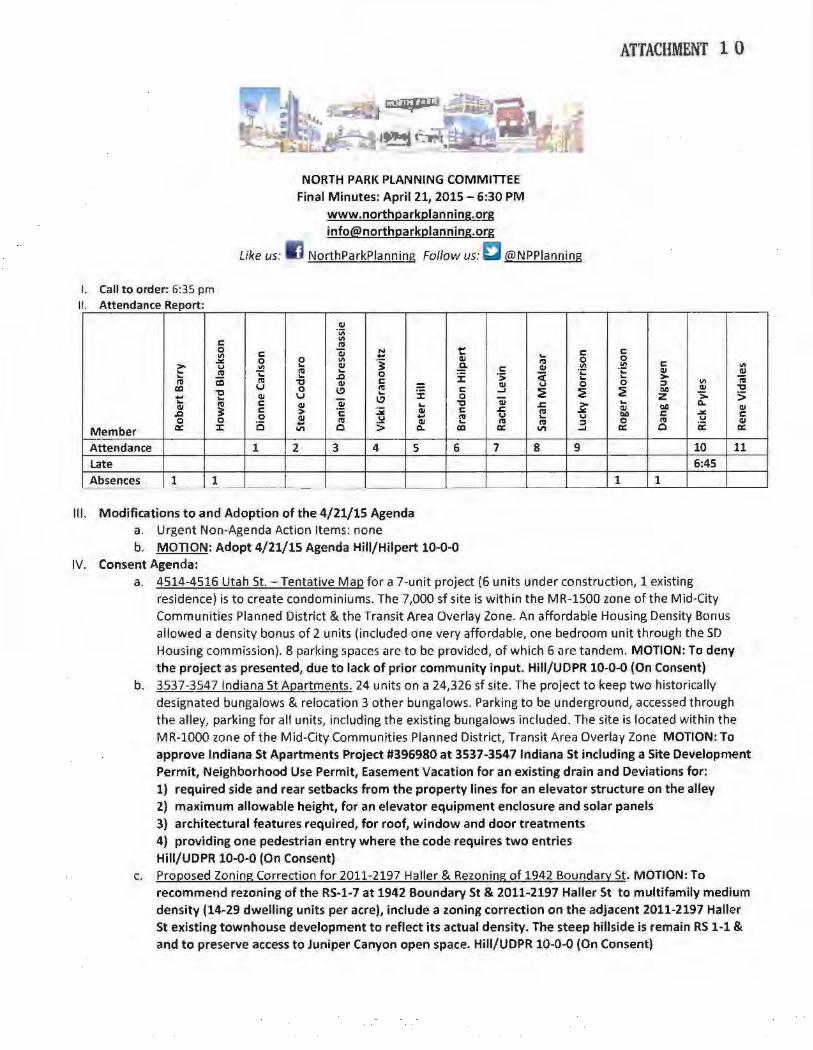
Like us:
NORTH PARK PLANNING COMMITIEE Final Minutes: April 21, 2015- 6:30 PM
www.northparkplanning.org [email protected]
NorthParkPianning Follow us: £'l @NPPianning
ATTACHMENT 1 0
I. Call to order: 6:35 pm II Attendance Report·
Ql ·v;
c: Ill ns
0 c: Qi N t c: c: Ill ...
Cll ... 0 ~ 0 0 "' .j ns 0
> .... "' ... Cll g Cll "' .!:!! c: Ill ... ;: ns ... c: ·.::: ... Ql Cll ns 0 ·;; ~ ... ai
... ..c J: ... ... > ~ ns ns "0 Cll c: Cll 0 0 :l "' cc u 0 (.!' ns i: c: ..... :!! ~ ~ Q.O Cll "0
"0 Cll u ... 0 z > 5 t ... (.!' Qi ns c Cll Qi .. "0 .s::. > ... Q.
Cll 3 c > ·c: :.¥ Cll c .s::. ns ~ Cll Q.O Cll ..c Q.O c: ~ c: 0 Cll .... ... ns .... ... .... .... 0 0 ... ns Cll ... ns ns :l 0 ns Cll
Member cr: ::t: 0 II\ 0 5 Q. cc cr: II\ ..... cr: 0 ii: cr:
Attendance 1 2 3 4 5 6 7 8 9 10 11
Late 6:45 Absences 1 1 1 1 ---
Ill. Modifications to and Adoption of the 4/21/15 Agenda a. Urgent Non-Agenda Action Items: none b. MOTION: Adopt 4/21/15 Agenda Hiii/Hilpert 10-0-0
IV. Consent Agenda: a. 4514-4516 Utah St.- Tentative Map for a 7-unit project {6 units under construction, 1 existing
residence) is to create condominiums. The 7,000 sf site is within the MR-1500 zone of the Mid·City Communities Planned District & the Transit Area Overlay Zone. An affordable Housing Density Bonus allowed a density bonus of 2 units {included one very affordable, one bedroom unit through the SO Housing commission). 8 parking spaces are to be provided, of which 6 are tandem. MOTION: To deny the project as presented, due to lack of prior community input. Hiii/UDPR 10-0-0 (On Consent)
b. 3537-3547 Indiana St Apartments. 24 units on a 24,326 sf site. The project to keep two historically designated bungalows & relocation 3 other bungalows. Parking to be underground, accessed through the alley, parking for all units, including the existing bungalows included. The site is located within the MR-1000 zone of the Mid-City Communities Planned District, Transit Area Overlay Zone MOTION: To approve Indiana St Apartments Project #396980 at 3537-3547 Indiana St including a Site Development Permit, Neighborhood Use Permit, Easement Vacation for an existing drain and Deviations for: 1) required side and rear setbacks from the property lines for an elevator structure on the alley 2) maximum allowable height, for an elevator equipment enclosure and solar panels 3) architectural features required, for roof, window and door treatments 4) providing one pedestrian entry where the code requires two entries Hiii/UDPR 10-0-0 {On Consent)
c. Proposed Zoning Correction for 2011-2197 Haller & Rezoning of 1942 Boundary St. MOTION: To recommend rezoning of the RS-1-7 at 1942 Boundary St & 2011-2197 Haller St to multifamily medium density (14-29 dwelling units per acre), include a zoning correction on the adjacent 2011-2197 Halter St existing townhouse development to reflect its actual density. The steep hillside is remain RS 1-1 & and to preserve access to Juniper Canyon open space. Hiii/UDPR 10-0-0 (On Consent)
City of San Diego Development Services 1222 First Ave., MS-302 San Diego, CA 92101
THE C>TY OF SAN D•<oo (619) 446-5000
ATTACHMENT 11
Ownership Disclosure Statement
Approval Type: Check appropriate box for type of approval (s) requested: r Neighborhood Use Permit ["coastal Development Permit
Neighborhood Development Permit LSite Development Permit L Planned Development Permit Cconditional Use Permit cvariance rrentative Map c Vesting Tentative Map r Map Waiver r Land Use Plan Amendment • COther
Project Title Project No. For City Use Only
INDIANA STREET APARTMENTS Project Address:
3537-3547 INDIANA ST SAN DIEGO, CA 92103-5201
Pg1rt} .ST~~.e. (!1 ..... · , ·/.~~·"!··~.~!~'! p[.~P~rty.j§t:l~ld:.~Y-;i•J?!Y,'f .... '~l(s) ..• •.······· ... ··•·••·•.··•• ;;······t~ _ •....•. ·.c .• z h'?{,;'SJ.•'·•···············(:.·•·· .•... · ?J: •• · ;•·•·)' 5•.••·L.}.)i .;< ;I Bll signing the Ownership Disclosure Statement, the owner(s) acknowledge that an application for a permit, map or other matter, as identified above, will be filed with the Cilll of San Diego on the subject propertl[, with the intent to record an encumbrance against the grogertl[. Please list below the owner(s) and tenant(s) (if applicable) of the above referenced property. The list must include the names and addresses of all persons who have an interest in the property, recorded or otherwise, and state the type of property interest (e.g., tenants who will benefit from the permit, all individuals who own the property). A signature is reguired of at least one of the propertl[ owners. Attach additional pages if needed. A signature from the Assistant Executive Director of the San Diego Redevelopment Agency shall be required for all project parcels for which a Disposition and Development Agreement (DDA) has been approved I executed by the City Council. Note: The applicant is responsible for notifying the Project Manager of any changes in ownership during the time the application is being processed or considered. Changes in ownership are to be given to the Project Manager at least thirty days prior to any public hearing on the subject property. Failure to provide accurate and current ownership information could result in a delay in the hearing process.
Additional pages attached Yes 18" No
1\lame or lna1v1aual (!ype or pnntj: 1\lame ot lna!VIdual (type or pnn!):
[]owner 0Tenant/Lessee C] Redevelopment Agency [JOwner []Tenant/Lessee C Redevelopment Agency
Street Address: Street Adaress:
City/State/Zip: City/State/Zip:
Phone No: Fax No: Phone No: Fax No:
Signature: Date: Signature: Da1e:
Name of Individual (type or print): Name of Individual (type or print):
cowner CTenant/Lessee C:Redevelopment Agency rowner C'r enant/Lessee L Redevelopment Agency
Street Address: Street Address:
City/State/Zip: City/State/Zip:
Phone No: Fax No: Phone No: Fax No:
Signature: Date: Signature: Date:
Printed on recycled paper. Visit our web site at www.sandiego.gov/development-seNices Upon request, this information is available in alternative formats for persons with disabilities.
DS-3i 8 (5-05)
ATTACHMENT 11
Project Title: INDIANA STREET APARTMENTS
I Project No. (For City Use Only)
II Part il /T:O:Ha cornplet~d \Vhen property is held by a corporatipnorpartnership
Legal Status (please check):
[""corporation !5{ Limited Liability -or- l General) What State? ___ Corporate Identification No. ______ _
rPartnership
By signing the Ownership Disclosure Statement. the owner(s) acknowledge that an application for a permit. map or other matter. as identified above. will be filed with the City of San Diego on the subject property with the intent to record an encumbrance against the property .. Please list below the names, titles and addresses of all persons who have an interest in the property, recorded or otherwise, and state the type of property interest (e.g., tenants who will benefit from the permit, all corporate officers, and all partners in a partnership who own the property). A signature is required of at least one of the corporate officers or partners who own the property. Attach additional pages if needed. Note: The applicant is responsible for notifying the Project Manager of any changes in ownership during the time the application is being processed or considered. Changes in ownership are to be given to the Project Manager at least thirty days prior to any public hearing on the subject property. Failure to provide accurate and current ownership information could result in a delay in the hearing process. Additional pages attached rYes IX No
·--""'- '""·--·-
Corporate/Partnership Name (type or print): Corporate/Partnership Name (type or print): Indiana Street Apartments #1, LLC Indiana Street Apartments #1, LLC
j& Owner r TenanVLessee IX Owner C TenanVLessee
Street Address: Street Address: 4980 N. Harbor Drive, Suite 204 4980 N. Harbor Drive, Suite 204 City/State/Zip: San Diego, CA 92106
City/State/Zip: San Diego, CA 92106
Phone No: Fax No: Phone No: Fax No: (619) 222-8084 (000) 000-0000 (619) 222-8084 (000) 000-0000
Name of Corporate Officer/Partner (type or print): Name of Corporate Officer/Partner (type or print): Tim Wright Craig Irving
Title (type or print): Title (type or print): General Partner General Partner
Date: j j i I S. ILl
Signature : Date:
Corporate/Partnership Name (type or print): Corporate/Partnership Name (type or print):
["' Owner L TenanVLessee [j Owner [] TenanVLessee
Street Address: Street Address:
City/State/Zip: City/State/Zip:
Phone No: Fax No: Phone No: Fax No:
Name of Corporate Officer/Partner (type or print): Name of Corporate Officer/Partner (type or print):
Title (type or print): Title (type or print):
Signature: Date: Signature : Date:
Corporate/Partnership Name (type or pnnt): Corporate/Partnership Name (type or print):
r Owner j TenanVLessee Cowner r TenanVLessee
Street Address: Street Address:
City/State/Zip: City/State/Zip:
Phone No: Fax No: Phone No: Fax No:
Name of Corporate Officer/Partner (type or pnnt): Name of Corporate Officer/Partner (type or print):
Title (type or print): Title (type or print):
Signature: Date: Signature: Date:
I
Related Documents