HNV farming in England and Wales – findings from three local projects

Welcome message from author
This document is posted to help you gain knowledge. Please leave a comment to let me know what you think about it! Share it to your friends and learn new things together.
Transcript

HNV farming in England and Wales – findings from three local projects

ISBN: 978-1-902855-01-1
Authors Guy Beaufoy and Gwyn Jones (EFNCP)
EFNCP is grateful to Stapledon Memorial Trust, Wye Valley AONBand European Commission DG Environment for their support inproducing this brochure, and to all those who contributedfunding and time to the local projects (see below). The viewsexpressed in this brochure do not necessarily reflect those of thefunders.
Special thanks to Jerry Tallowin for reviewing the draft texts andto all the farmers and other project participants who gave theirtime for visits and interviews.
For more information visithttp://www.efncp.org/projects/united-kingdom/
Organisations contributing to one or more of the case studies:Countryside Council for WalesNatural EnglandDevon County CouncilDevon Wildlife Trust
Published by EFNCP The Pines, 1 Woodpark, Portree IV51 9HQ
HNV farming in England and Wales–findings from three local projects
Blackdown Hills AONBSouth Devon AONBWye Valley AONB
This project has been supported by the Sustainable Development Fund, a Defra initiative in the Wye Valley Area of Outstanding Natural Beauty (AONB)
Cover photograph: English Longhorn cattle restoring herb-richpasture in the Neroche Forest, Blackdown Hills AONB (G. Saunders)
3
4 Glossary
4 Summary
7 Introduction
8 HNV farming in EU policies
10 HNV farmland typology
12 HNV farming in the UK
14 HNV farming in national policies in England and Wales
16 The project areas in England and Wales andtheir HNV farming characteristics
HNV farming in England and Wales – findings from three local projects
22 What the projects did
23 How can HNV farming be identified using existing orproposed data sets?
28 What are the challenges faced by HNV farmland inthe project areas?
32 Are current policies effective in maintaining HNVfarmland?
37 What specific policy improvements and innovativeapproaches can be proposed for addressing HNVfarmland?
41 Conclusions and ways forward

4
Glossary
AES Agri-environment Scheme
AONB Area of Outstanding Natural Beauty
BAP Biodiversity Action Plan
CAP Common Agricultural Policy
CCW Countryside Council for Wales
CMEF Common Monitoring and Evaluation Framework
CWS County Wildlife Site
DWT Devon Wildlife Trust
EFNCP European Forum on Nature Conservation andPastoralism
EIA Environmental Impact Assessment
ELS Entry Level Stewardship
ESA Environmentally Sensitive Areas (agri-environment scheme)
EU European Union
FBI Farm Business Income
HAT Holding Assessment Toolkit
HIW Habitat Inventory Wales
HLS Higher Level Stewardship
HNV High Nature Value
IACS Integrated Administration and Control System
LCM Land Cover Map
LFA Less Favoured Area
LPIS Land Parcel Identification System
LU Livestock Unit
NVC National Vegetation Classification
NE Natural England
RDP Rural Development Programme
RLR Rural Land Register
RSPB Royal Society for the Protection of Birds
SAC Special Area of Conservation (Natura 2000 site)
SDA Severely Disadvantaged Area (of the LFA)
SPS Single Payment Scheme
SSSI Site of Special Scientific Interest
UAA Utilised Agricultural Area
Summary Landscapes that contain a significant proportion offarmland in a semi-natural condition, such as unimprovedpastures and hay-meadows or traditional orchards, areinherently of high biological richness, and have becomeknown as High Nature Value (HNV) farmland. These are thetypes of farmland that harbour our most valued habitatsand wildlife species. If we are serious about haltingbiodiversity decline across Europe, we need to look closelyat what is happening to this farmland.
This brochure presents the findings of a set of local projectsin England and Wales that aimed to do precisely this – tolook closely at what types of farmland and farming are ofhigh nature value, what is happening to them, and whatneeds to be done through public policies for farming andrural development to prevent their on-going decline. Thebrochure is aimed at anyone involved in or interested inthese policies and in their success in supporting natureconservation and wider ecosystem services on farmland.
Identifying, supporting and monitoring HNV farmland andfarming systems have been priorities for EU ruraldevelopment policy since 2005. Putting these priorities intopractice at a country level means recognising:
• that farmland and farming landscapes which are largelysemi-natural are of particular value for biodiversity
• that although this land makes up a large part of existingdesignations such as Natura 2000, SSSI and county sites,in some regions it also extends far beyond them into the“wider countryside”
• that this land faces particular economic and practicalchallenges for its continued use and maintenance, andoften is found outwith mainstream farming
These key themes of HNV farmland chime very clearly withthe findings of recent reports such as the NationalEcosystem Assessment1 (semi-natural grasslands chapterled by James M. Bullock), Making Space for Nature: a review of England’s wildlife sites and ecological network2
(the Lawton report to DEFRA), and Nature’s Tapestry3
(Grassland Trust).

5
issues that need to be addressed, from the basic design ofmainstream CAP payments, to consistent RDP funding forlocal initiatives. The following are key recommendationsemerging from the projects:
• Undertake an assessment at national level of what isHNV farmland and farming, what is the currentsituation, what are the main trends, threats andopportunities. A lot can be drawn from existing nationaland local data and studies.
• Establish a HNV farmland monitoring system as requiredby the EU, through a combination of remote sensing andsample survey. The UK countries are well placed to dothis, as Countryside Survey could provide an excellentbasis, and the Habitat Inventory Wales is shown to be aneffective remote sensing tool in the Carmarthenshireproject presented here.
• Adapt mainstream CAP (Pillar 1) to the needs of HNVfarmland, so that the payments are effective inpreventing abandonment, and the regulations effectivein preventing intensification. The current CAP reformprocess provides an excellent opportunity, but thereneeds to be a robust UK stance with the EC on cross-compliance, “greening” and eligibility issues, especiallyconcerning permanent pastures. A more environmentallyefficient CAP also depends on making the LPIS/IACStools fit for purpose.
• The new RDPs in England and Wales from 2014 shouldgive explicit recognition in their ex-ante analyses to theprocesses of abandonment and intensification occurringon semi-natural farmland outside nationally designatedsites; and should aim to prevent further loss of HNVfarmland to abandonment, agricultural intensificationand development.
• AES should be developed further to achieve a completecoverage of HNV farmland. This means reducing
So what should happen to our semi-natural farmland? The economic benefits to society of ploughing and reseedingthe few remaining small areas with significant productivepotential have to be weighed against the losses ofecosystem services and biodiversity. Abandonment or treeplanting will result in similar losses, and give rise to closedlandscapes, less accessible for recreation and enjoyment.
Keeping this land in use for low-intensity livestockproduction would seem to be the best option for society,but can this be achieved? Can ways be found of ensuringthe socio-economic viability of active farming on this landin a way that maintains its nature values, particularly on alandscape scale? Do existing policies (agricultural, ruraldevelopment, nature conservation) provide the means toachieve this goal in their current form? These are some ofthe questions the HNV farming approach tries to answer.
To date, neither England nor Wales can claim to be fulfillingthe requirements of EU policy as it refers to HNV farming,partly due to a lack of clarity about where to start. Therehas been some preliminary work on mapping, but nocomprehensive assessment of what is HNV farmland andfarming, or of what is happening to it, and very littledialogue has been promoted on the subject. Monitoringsystems for HNV farmland have not been established.
In practice, a lot is being done in both countries to maintainHNV farmland, mainly through agri-environment schemes(AES), and this is to be applauded. But current policies arefalling short – large parts of HNV farmland and itsassociated issues are not being addressed adequately bythe existing schemes, as the local projects in this brochuremake clear.
Fully implementing a strategy for HNV farmland does notmean a wholesale reshaping of policies for farmlandbiodiversity, but it does imply some refocusing andadaptation. The projects presented here reveal a web of
1 http://uknea.unep-wcmc.org/Resources/tabid/82/Default.aspx 2 http://archive.defra.gov.uk/environment/biodiversity/documents/201009space-for-nature.pdf3 http://www.grasslands-trust.org/project.php?projectid=7
6
administrative complexity and improving delivery, withsufficient human resources available on the ground tofacilitate and encourage up-take of measures and createa critical mass of activity at the landscape scale. Practicalchallenges to grassland management need to berecognised, e.g. through automatic higher payments forsmaller fields. Grant schemes need to reach beyondmainstream farming, particularly for capitalinvestments in grazing infrastructure.
• Grant schemes should encourage the development offarm business activities based on HNV farmland. Thisrequires more integration across RDP measures, so thatsemi-natural farmland is not automatically hived off as a“habitat” separate from the main farming activity andunder dictated “management prescriptions”. Wherepossible, support should be provided for using this landwithin a farming business, e.g. grant aid for businessesthat “valorise” HNV farmland, alongside AES incentivesfor managing this land. The new rural developmentregulation proposed by the EC already encourages moreintegrated approaches.
• In areas where a large part of HNV farmland is found onamateur holdings and is thus largely beyond the reachof mainstream policy, conserving this land in activemanagement depends very much on local communityprojects and small grant schemes. There is a wealth ofsuch projects around the country, but typically thesedepend on insecure funding sources, with consequentlack of continuity. RDPs should include a facility forfunding local projects that provide co-ordinated,proactive approaches to HNV farmland maintenancewithin a landscape area. An excellent opportunity isavailable under the new EU regulation for RDPs in theform of grants for Co-operation Projects, including“collective approaches to environmental projects andongoing environmental practices”.
The projects presented in this brochure provide someinsights and suggestions as to how effective systems couldbe established for identifying, monitoring and supportingHNV farmland. The projects are not exhaustive, andcertainly are not the last word on HNV farming and rural
development policy. But there is no reason to think that theissues they identify, both problems and opportunities, arenot replicated across large areas of England and Wales, andindeed Scotland and Northern Ireland.
Figure 1. Although sometimes seen as positive for nature, land abandonmenttends to occur on land that is already of biodiversity value. (G. Jones)
7
valuable ecosystem services of semi-natural farmland, aswell as its continued decline. They also highlight the keyissue, especially into the future, of under-use due to thelack of economic viability of the low-intensity and low-productivity farming systems that use this land.
So what should happen to our remaining semi-naturalfarmland? The economic benefits to society of ploughingand reseeding the few remaining small areas withsignificant productive potential have to be weighed againstthe losses of ecosystem services and biodiversity, not leastfor the priority habitats and species that depend on thisland. On land with less productive potential, abandonmentor tree planting will result in similar losses of biodiversity,and will give rise to closed landscapes, less accessible forrecreation and enjoyment. Keeping this land in use for low-intensity livestock production would seem to be thebest option for society, but can this be achieved?
The HNV farming concept looks for answers to thisquestion. Semi-natural pastures, meadows and orchardsare the core of HNV farmland and are seen not as wildlifehabitats separate from farming, but as a part of afunctioning landscape where semi-improved grassland andlow-intensity cropping, and features such as thick hedgesand patches of scrub and woodland, complement thebiodiversity values of the semi-natural farmland.
IntroductionLandscapes that contain a significant proportion offarmland in a semi-natural condition, such as unimprovedpastures and hay-meadows or traditional orchards, areinherently of high biological richness, and have becomeknown as High Nature Value (HNV) farmland. These are the types of farmland that harbour our most valuedhabitats and wildlife species, in the UK and across the EU. If we are serious about halting biodiversity decline inEurope, we need to look closely at what is happening tothis farmland.
Semi-natural farmland has declined in area over manyyears, due to a parallel process of agriculturalintensification on land with more production potential, andabandonment of land with production limitations. At oneextreme, this process can be seen today at the scale ofentire landscapes, for example in some areas of southernand eastern Europe. In lowland England and Wales themore typical pattern is at the scale of individual fields,although in the uplands there is a real possibility oflandscape-scale abandonment.
Recent reports such as the National Ecosystem Assessment4
(semi-natural grasslands chapter led by James M. Bullock),Making Space for Nature: a review of England’s wildlife sitesand ecological network5 (the Lawton report to DEFRA), andNature’s Tapestry6 (Grassland Trust) have emphasised the
Figure 2. The Twrch valley in eastCarmarthenshire illustrates upland andpoorly-drained lowland grassland types of HNV farmland in the area (G. Jones).
8
According to the HNV farming approach, it is unrealistic toexpect to conserve our remaining semi-natural farmlandresource entirely by protected areas and “conservationgrazing” projects separated from mainstream farming. Socan ways be found of ensuring the socio-economic viabilityof active farming on this land in a way that maintains itsnature values, particularly on a landscape scale? Do existingpolicies (agricultural, rural development, natureconservation) provide the means to achieve this goal intheir current form? If not, what improvements are needed?Answering these questions is central to the HNV farmingapproach.
Identifying, supporting and monitoring HNV farmland andfarming systems has been a priority for EU ruraldevelopment policy since 2005, and the European Forumon Nature Conservation and Pastoralism (EFNCP) has beenclosely involved in the development of suitable approachesto these tasks at European, national and local levels.Exploring how this should work through real examples atlocal level is an essential complement to national and EUdesk studies.
In 2010, EFNCP joined up with local partners to run a seriesof projects to explore HNV farming at a local level inEngland, Wales, Ireland and France. These projects aim toexplore how HNV farmland and farming systems can beidentified and their socio-economic needs assessed, as thebasis for developing strategies for their effective long-termsupport. This brochure summarises the findings of threeprojects undertaken in England and Wales in 2010 and2011, in Devon, the Wye Valley, and east Carmarthenshire.
HNV farming in EU policiesUnder the EU Biodiversity Strategy, the Commissionemphasised in 1998 that biodiversity cannot be conservedsolely through the Natura 2000 network. A widerenvironment favourable to biodiversity is essential, and keyactions highlighted for maintaining this wider environmentinclude preventing intensification or abandonment of HNVfarmland, by making better use of available measuresunder the CAP.
In the new Biodiversity Strategy 2020, HNV farmland is notreferred to explicitly, but there is a strong focus onmaintaining ecosystems and green infrastructure outwiththe Natura 2000 network. Clearly a large proportion ofthese ecosystems and green infrastructure will coincidewith HNV farmland. Moreover, 20% of the habitats onAnnex 1 of the Habitats Directive are pastures andmeadows dependent to a greater or lesser extent onlivestock farming.
The EU has also adopted HNV farming as one of threepriorities for Axis 2 of Rural Development Programmes(RDPs) from 2006 with the introduction of the followingwording into the Strategic Guidelines7 on ruraldevelopment:
“To protect and enhance the EU’s natural resources andlandscapes in rural areas, the resources devoted to Axis 2should contribute to three EU-level priority areas: biodiversityand the preservation and development of high naturevalue farming and forestry systems and traditionalagricultural landscapes (…)” (bold added)
At the same time, HNV farming and forestry indicators wereestablished as part of the Common Monitoring andEvaluation Framework (CMEF) for RDPs. These indicators areapplied to assess the results and impacts of RDPs in allcountries. Member States are required to devise a system of“impact indicators” for measuring tendencies in the extentand condition of HNV farmland and forestry. They shouldalso establish “results indicators” for assessing the extent ofland under successful land management contributing to:
• biodiversity and high nature value farming/forestry• avoidance of marginalisation and land abandonment
4 http://uknea.unep-wcmc.org/Resources/tabid/82/Default.aspx 5 http://archive.defra.gov.uk/environment/biodiversity/documents/
201009space-for-nature.pdf 6 http://www.grasslands-trust.org/project.php?projectid=7 7 Council decision 2006/144 on Community strategic guidelines for rural
development (programming period 2007 to 2013)
9
dependent on agriculture and forestry”. There is strongemphasis in the proposed rural development regulation11
on the need for RDPs to show a robust analysis, in relationto each priority, of the challenges existing on the ground.
So putting these various policy elements together, therequirements established at EU level for all Member Statesto take forward can be summarised as:
• To determine what is HNV farmland and how to identifyits extent and approximate location (there are no EUrules for this, there is national flexibility within broad EUguidance).
• To assess the challenges to maintaining HNV farmland.
• To develop and implement effective policy measures forsupporting the farming systems and practices thatmaintain HNV farmland.
• To establish a system of indicators for monitoringtendencies in HNV farmland and assessing theeffectiveness of RDPs in achieving positive tendencies.
At the time when these new requirements were introducedinto EU policy, there was little information available toauthorities on how to identify HNV farming, or how todevise suitable indicators and monitoring systems.Subsequently, the European Evaluation Network for RuralDevelopment (EENRD) Help Desk produced guidelines forthe application of HNV indicators8, that are intended tohelp Member States to assess the baseline situation of HNVfarming and to monitor how it evolves over time.
In 2010, the Help Desk organised a Thematic WorkingGroup of experts to develop guidance on the application ofall CMEF indicators, including the HNV indicators. Thereport of this group adds further practical detail andexamples of current practice to the 2009 guidance9.
Under the Commission’s proposals for CAP reform releasedin October 201110, HNV farming continues to be included asa priority for rural development policy, now appearingalongside Natura 2000 under a broader theme of“restoring, preserving and enhancing ecosystems
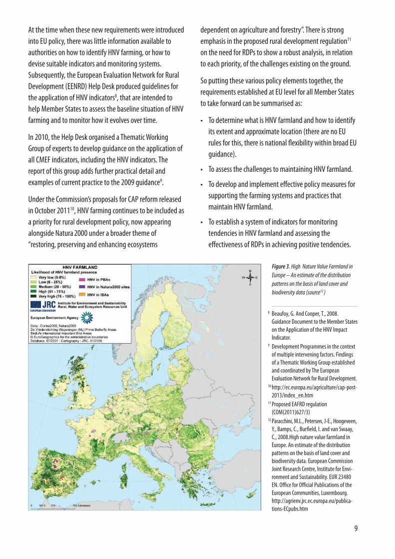
Figure 3. High Nature Value Farmland inEurope – An estimate of the distributionpatterns on the basis of land cover andbiodiversity data (source12 )
8 Beaufoy, G. And Cooper, T., 2008.Guidance Document to the Member Stateson the Application of the HNV ImpactIndicator.
9 Development Programmes in the contextof multiple intervening factors. Findingsof a Thematic Working Group establishedand coordinated by The EuropeanEvaluation Network for Rural Development.
10 http://ec.europa.eu/agriculture/cap-post-2013/index_en.htm
11 Proposed EAFRD regulation(COM(2011)627/3)
12 Paracchini, M.L., Petersen, J-E., Hoogeveen,Y., Bamps, C., Burfield, I. and van Swaay,C., 2008.High nature value farmland inEurope. An estimate of the distributionpatterns on the basis of land cover andbiodiversity data. European CommissionJoint Research Centre, Institute for Envi-ronment and Sustainability. EUR 23480EN. Office for Official Publications of theEuropean Communities, Luxembourg.http://agrienv.jrc.ec.europa.eu/publica-tions-ECpubs.htm

10
HNV farmland typologyThe broad types and characteristics of HNV farmland have been clarified through various European studies13.Landscapes consisting predominantly of semi-naturalfarmland have been labelled “Type 1” HNV farmland; theseare a relatively clear-cut case, and are widespread and quiteeasily identified in the more marginal regions of Europe.
High nature values may also be present in landscapeswhere a smaller but still significant proportion of farmlandis in a semi-natural state, especially when found in amosaic with semi-improved grassland and/or low-intensityarable cropping. In this situation of fragmented semi-natural farmland, landscape elements such as hedges andcopses can make a particularly important contribution. This has been labelled “Type 2” HNV farmland.
Biodiversity decreases with increased intensity of farmmanagement - landscapes dominated by intensifiedfarmland are usually devoid of significant biodiversity.Wildlife habitats are reduced to fragments divorced fromthe farming system (hedges, ponds, small woods).However, some of the species which survive can be ofconservation concern. In most cases, these are birds, whichare better able than other forms of wildlife to adapt tomore intensively farmed landscapes. Intensive farmlandwith minimal or no semi-natural component sometimessupports significant populations of such species at certaintimes of year – wintering geese are one example. This hasbeen labelled “Type 3” HNV farmland.
There is no hard line between Type 1 and Type 2 HNVfarmland. Whereas predominantly semi-natural landscapesare relatively easy to identify and determine as HNVfarmland, the Type 2 situation is less clear cut – at somepoint, the proportion of semi-natural habitat becomes sosmall that opportunities for wildlife fall away, butdetermining this point is something of a value judgment.See Box 1.
How much land should be in a semi-natural state for alandscape to be considered of High Nature Value? This willof course depend on local conditions, on the species thatare of conservation interest in the landscape in question,
It is important to distinguish between tools for targetingpolicy measures (such as payments) on HNV farmland, andtools for monitoring tendencies in HNV farmland (e.g.extent, condition). Although there may be an overlap in thedata and methods used, there are significant differences inthe practical requirements. Effective targeting of policymeasures requires quite precise information at the farm oreven field level; whereas monitoring of tendencies onfarmland at the regional or national level may be achievedto some extent through sample surveys (such as theCountryside Survey), and/or through national data sets(such as farm census).
But before trying to tackle the challenges of both targetingand monitoring HNV farmland, there needs to be someexploration of what HNV farmland is in a given region,where it is, and what are its broad characteristics andtendencies. Authorities in many Member States, and theEuropean Environment Agency at EU level, have exploredthe possibilities for mapping HNV farmland, as a first stepin this assessment exercise. In many cases the results arefound to be unsuitable for targeting payments, or formonitoring tendencies, at anything other than a very crudelevel; but they have served to give a broad picture of HNVfarmland distribution, and to improve understanding ofwhat existing data sets can tell us, and cannot tell us (see Fig. 3).
Figure 4: Scrub, gorse and grassland mosaic, South Devon
© Copyright Derek Harper and licensed for reuse under the Creative CommonsAttribution-Share Alike 2.0 Generic license.
11
13 Andersen, E., Baldock, D., Bennett, H., Beaufoy, G., Bignal, E., Brouwer, F., Elbersen, B., Eiden, G., Godeschalk, F., Jones, G., McCracken, D.I., Nieuwenhuizen, W., van Eupen, M., Hennekens, S. & Zervas, G. (2003). Developing a high nature value indicator. Report for the European Environment Agency, Copenhagen.
14 Tscharntke, T. et al. (2005) Landscape perspectives on agricultural intensification and biodiversity – ecosystem service management. Ecol. Lett. 8, 857–87415 Le Roux, X., Barbault, R., Baudry, J., F. Burel, F., Doussan, I., Garnier, E., Herzog, F., Lavorel, S., Lifran, R., Roger-Estrade, J., Sarthou, J.P. and Trommetter, M. (eds),
2008. Agriculture et biodiversité : valoriser les synergies. Expertise scientifique collective, synthèse du rapport, INRA (France).16 R. Nigel Stringer, A History of Waxcap recording in Carmarthenshire. http://www.aber.ac.uk/waxcap/downloads/stringer-historywaxcapreccarms09.pdf
HNV farming landscapes and semi-natural vegetation
BOX 1
and on their particular ecological requirements. Crucially, italso depends on the nature of the non-semi-natural land inthe matrix. An area of semi-improved grasslandsurrounding or adjacent to semi-natural grassland can actas a buffer from nitrogen and biocides, as well as allowingcolonisation from the semi-natural seed sources. A field ofmaize, for example, does not provide these complementarybenefits. Arable fields under low-intensity use, and withcharacteristics such as winter stubbles, can also contributeto the nature value of Type 2 HNV farmland. Otherconsiderations include the size of semi-natural patches, andthe distance between them; and the presence of landscapefeatures such as large hedges and patches of woodland.
The proportion of semi-natural vegetation onfarmland is critical to its biodiversity value, and canvary greatly from one landscape to another. Tscharntkeet al. (2005)15 refer to landscapes with less than 2%semi-natural habitats as “cleared” landscapes, wherethe effectiveness of conservation is limited by the basic absence of species sources. Landscapes with 2-20% semi-natural habitat in the matrix are referred to as “structurally simple” landscapes, where speciessources are still present and conservation initiativescan achieve good results. In “complex” landscapes
with more than 20% semi-natural habitats, theproductive area is continually colonised by speciesfrom the surrounding species-rich landscape.
Le Roux et al., 200815 consider 20% to be the minimumthreshold for maintaining significant biodiversity onfarmland. They found that in areas of more intensivearable cropping in France (grandes cultures), semi-natural cover can fall to well below 10% of theUtilised Agricultural Area (UAA), while in somepredominantly grassland areas, it can be over 50%.
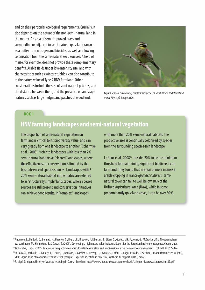
Figure 5: Male cirl bunting, emblematic species of South Devon HNV farmland (Andy Hay, rspb-images.com)
12
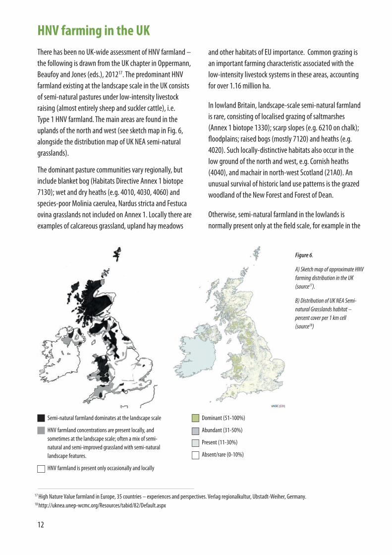
HNV farming in the UKThere has been no UK-wide assessment of HNV farmland –the following is drawn from the UK chapter in Oppermann,Beaufoy and Jones (eds.), 201217. The predominant HNVfarmland existing at the landscape scale in the UK consistsof semi-natural pastures under low-intensity livestockraising (almost entirely sheep and suckler cattle), i.e. Type 1 HNV farmland. The main areas are found in theuplands of the north and west (see sketch map in Fig. 6,alongside the distribution map of UK NEA semi-naturalgrasslands).
The dominant pasture communities vary regionally, butinclude blanket bog (Habitats Directive Annex 1 biotope7130); wet and dry heaths (e.g. 4010, 4030, 4060) andspecies-poor Molinia caerulea, Nardus stricta and Festucaovina grasslands not included on Annex 1. Locally there areexamples of calcareous grassland, upland hay meadows
Semi-natural farmland dominates at the landscape scale
HNV farmland concentrations are present locally, andsometimes at the landscape scale; often a mix of semi-natural and semi-improved grassland with semi-naturallandscape features.
HNV farmland is present only occasionally and locally
Dominant (51-100%)
Abundant (31-50%)
Present (11-30%)
Absent/rare (0-10%)
Figure 6.
A) Sketch map of approximate HNVfarming distribution in the UK(source17).
B) Distribution of UK NEA Semi-natural Grasslands habitat –percent cover per 1 km cell(source18)
and other habitats of EU importance. Common grazing isan important farming characteristic associated with thelow-intensity livestock systems in these areas, accountingfor over 1.16 million ha.
In lowland Britain, landscape-scale semi-natural farmlandis rare, consisting of localised grazing of saltmarshes(Annex 1 biotope 1330); scarp slopes (e.g. 6210 on chalk);floodplains; raised bogs (mostly 7120) and heaths (e.g.4020). Such locally-distinctive habitats also occur in thelow ground of the north and west, e.g. Cornish heaths(4040), and machair in north-west Scotland (21A0). Anunusual survival of historic land use patterns is the grazedwoodland of the New Forest and Forest of Dean.
Otherwise, semi-natural farmland in the lowlands isnormally present only at the field scale, for example in the
17 High Nature Value farmland in Europe, 35 countries – experiences and perspectives. Verlag regionalkultur, Ubstadt-Weiher, Germany.18 http://uknea.unep-wcmc.org/Resources/tabid/82/Default.aspx

13
form of fragmented remnants of semi-natural grasslandand traditional orchards. This land may be grazed by sheepor suckler cattle, often under conservation grazing projects,or sometimes by horses on “hobby” or “amateur” landholdings. In these areas, field boundaries (hedges, dry-stone walls, earth banks) and road verges are significantseed sources, as well as habitats in their own right.
In the grey areas shown in Fig. 6, mainly in the westernparts of the UK, the physical limitations to arable croppingmean that the predominant farmland is permanentgrassland, with a wide spectrum of intensity of use fromhighly intensive to semi-natural. Locally there aresignificant areas of semi-improved grassland in smallerfield patterns, often associated with smaller patches ofsemi-natural grassland, and with a high presence oflandscape features, such as large hedges – potentially HNVfarmland. Generally these patterns have avoided wholesaleintensification due to physical limitations, such as steepslopes, or in some cases also where early industrialisationor the proximity of cities reduced the interest in developingfarming. Examples of this are found in the south Wales andwest-central Scottish coalfields.
Distinguishing HNV from non-HNV farmland in thesegrassland regions is a difficult judgement, particularly inthe case of semi-improved grassland. In some cases,grasslands that have been ploughed and improved severaldecades ago have reverted to a broadly semi-naturalcondition after a long period of low-intensity use (forexample, < 25 kg fertilizer N ha-1 per year, cutting for hay,grazing at < 1 LU ha-1). On the other hand, grasslands thathave never been ploughed and reseeded may lose most oftheir higher plant species diversity simply as a result ofrepeated manuring, whether by the application of fertiliseror by intensive grazing.
Conservation policy has tended to identify prioritygrassland in terms of the botanical species they support.But grassland types that do not meet Biodiversity ActionPlan (BAP) criteria as priority habitats, or are notdesignated as prime sites, are often an important part of alandscape matrix that is rich in wildlife. Semi-improvedgrassland can play an important role in buffering remnantsof semi-natural grassland and allowing for recolonisation
from these remnants. Many species of birds, butterflies andbats depend partly on semi-improved, tussocky, insect-richgrasslands that are not necessarily botanically rich, butprovide valuable foraging habitat. An area of poorlydrained yet species-poor grassland may be surrounded bytall hedges and hedgerow trees; the ecologicaljuxtaposition of these two habitats is far greater than thesum of their parts. They provide an ecotone rich ininvertebrates and bird life.
A long history of relatively intensive grazing producespastures which are floristically poor from a higher plantperspective, but may support diverse populations ofinvertebrates, soil organisms, and fungi including waxcaps(see Fig. 7). In a mosaic of habitats grasslands have a rolethat is more complex than just their species diversity; theirstructure is also crucially important (as illustrated by Fig. 8).Structure includes the height and architectural complexityof the canopy comprising leaves, stems, flowers, seedheads, and senescent and dead plant parts, all of whichprovide micro-habitats for different invertebrate guilds,such as stem borers and leaf miners, and predators such asspiders. These considerations should be recognised withinthe concept of HNV farmland.
Low-intensity arable cropping survives in certain very
Figure 7. Waxcap communities are dependant on grasslands with very lownutrient levels and with grazing by sheep, cattle or other livestock. No correlationhas been found between waxcap diversity and sites with high plant diversity. Infact, higher waxcap diversity seems to occur most often in semi-improved andbotanically mundane grasslands (those not considered for SSSI selection).16
Photograph: © Rosemary Winnall. Image licensed under the Creative CommonsAttribution-Share Alike 2.5 Generic license.

14
HNV farming in nationalpolicies in England and WalesEngland
At the time when the 2007-13 Rural DevelopmentProgramme for England (RDPE) was developed, there wasconsiderable uncertainty about the definition andmeasurement of the HNV farming indicator. Chapter 3 ofthe RDPE includes a map of HNV farming, compiled using anational interpretation of Type 1 and Type 2 HNV.
The approach relied on mapping the occurrence of semi-natural habitats and of groups of species characteristic ofhigh nature value farmed land onto a base map ofutilisable agricultural land, using a geographic informationsystem. The rationale behind this decision is set out inChapter 12 of the Programme Document.
Careful examination of the map produced by this approachshowed some counter-intuitive results, suggesting that atthe very least the groups of species used to identify highnature value farming needed further refinement. The RDPEtext stresses that this is work in progress and that itrequires further development, through both nationalconsultation and subsequent regional refinement, beforean operationally useful map can be produced. The Devonproject (see below) seems to confirm that the approachused for the RDPE is not a reliable reflection of HNVfarmland reality on the ground, at least for the case-studyareas.
The RDPE asserts that the condition of SSSIs and offarmland Priority Habitats gives an indication of the overallstatus of HNV farmland in England. In the absence of a fullydeveloped baseline, the area of SSSIs in target condition isbeing used as an impact indicator. However, theseassertions are questionable, as the Devon project illustrates– in some areas a large proportion of HNV farmland is notwithin SSSIs and is not identified on existing inventories ofPriority Habitats, and so does not get any “specialattention” from policy measures such as agri-environment.Monitoring prime sites and habitats is not the same asmonitoring the wider spectrum of HNV farmland.
specific locations in the UK, as part of a HNV mosaic. Aparticular case is the mosaic of cropping with machairgrasslands in parts of the Western Isles of Scotland, wherefallow survives as an integral part of the system.Otherwise, low-intensity arable cropping supportingtraditional weed species occurs only occasionally and at avery local level, for example on some organic farms orwhere particular practices are maintained by agri-environment schemes (AES).
Some small areas of arable land are managed for springcereals with reduced pesticide use and weedy winterstubbles, within a landscape mosaic of thick hedges andpatches of dense scrub and semi-improved grasslands.These areas are important for the population of certain birdspecies, for example cirl bunting (Emberiza cirlus) in southDevon and other more widespread buntings across thecountry, but as the Devon project shows (below) theselandscapes are also of wider biodiversity value.
Intensively-managed farmland supporting particularspecies of conservation concern can be found at a local levelin all zones, including the areas coloured white and grey onFig 6. As in several other parts of Europe, the main speciesof this Type 3 HNV farmland are wintering birds, such asbarnacle goose, white-fronted geese and whooper andBewick’s swans that use this land for feeding.
Figure 8. Some of the species supported by HNV farmland are overlooked byinventories that focus on higher-plant communities: anthills at Porthyrhyd,Carmarthenshire (R. Carmichael).
15
Wales
The Wales RDP 2007-13 makes very few references to HNVfarmland, mentioning that the HNV indicator isundeveloped. In the absence of progress in developing HNVindicators, the Countryside Council for Wales (CCW)undertook a small “look-see” exercise, following a patternfollowed in other countries. Semi-natural vegetation wastaken as an indicator of Type 1 HNV and, completelyseparately, land cover diversity was taken as an indicator ofType 2 (overlooking the “managed at low-intensity”element of the definition). Some species data were alsoinvestigated. The approach is an interesting start, and itwould be worth considering further whether the mapsproduced would make viable monitoring tools, or wouldpossibly be more useful for targeting or for broad-scaleevaluation of resource allocation by Government.
As a separate exercise, the Welsh Government (WG)commissioned a comprehensive monitoring and evaluationprogramme covering all impact indicators across all Axis 2RDP schemes in January 2009, including that for HNV
© Cr
aig Jo
nes
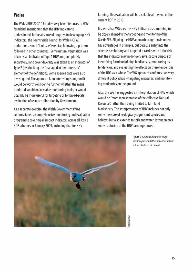
Figure 9. Barn owls hunt over rough,tussocky grasslands that may be of limitedbotanical interest. (C. Jones).
farming. This evaluation will be available at the end of thecurrent RDP in 2013.
It seems that WG sees the HNV indicator as something to be closely aligned to the targeting and monitoring of the Glastir AES. Aligning the HNV approach to agri-environmenthas advantages in principle, but because entry into thescheme is voluntary and targeted it carries with it the riskthat the indicator may no longer serve its core purpose ofidentifying farmland of high biodiversity, monitoring itstendencies, and evaluating the effects on these tendenciesof the RDP as a whole. The WG approach conflates two verydifferent policy ideas – targeting measures, and monitor-ing tendencies on the ground.
Also, the WG has suggested an interpretation of HNV whichwould be “more representative of the collective NaturalResource”, rather than being limited to farmlandbiodiversity. This interpretation of HNV includes not onlysome measure of ecologically significant species andhabitats but also extends to soils and water. It thus createssome confusion of the HNV farming concept.
16
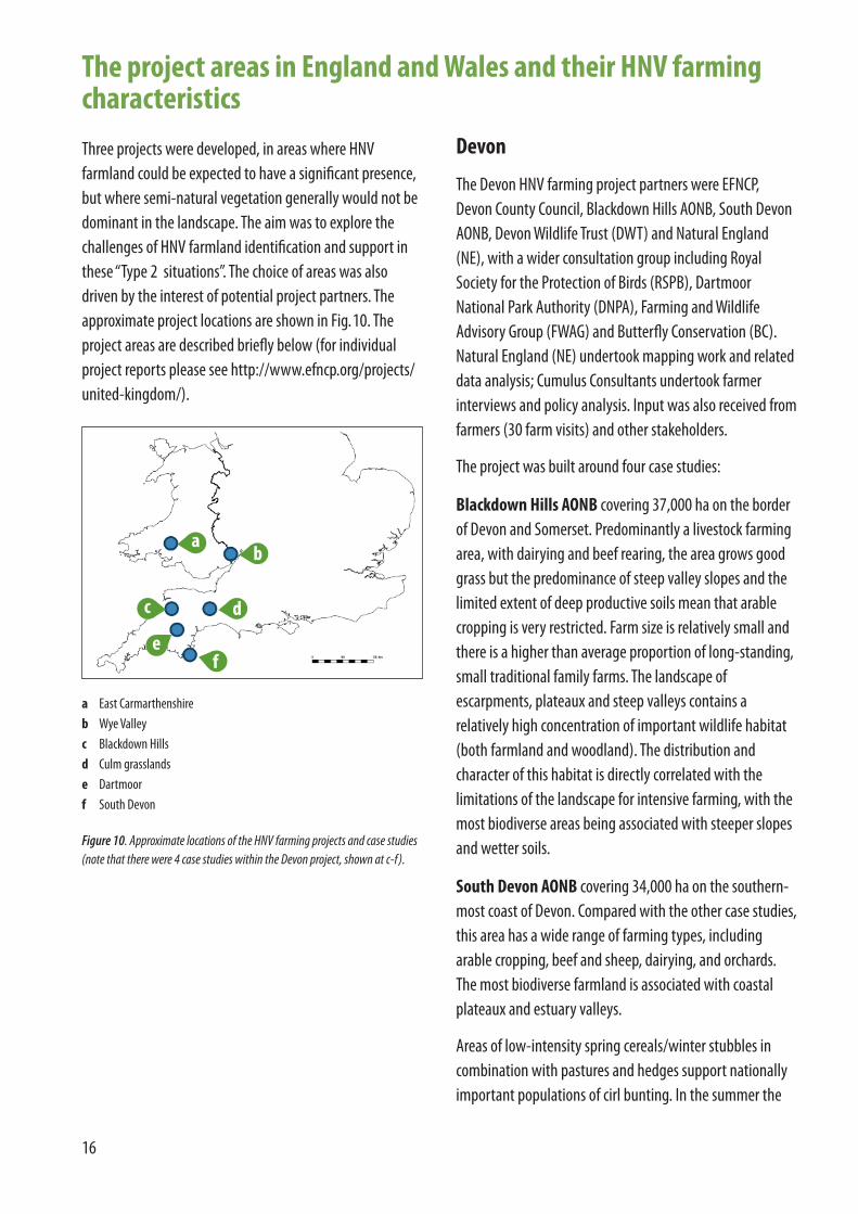
Three projects were developed, in areas where HNVfarmland could be expected to have a significant presence,but where semi-natural vegetation generally would not bedominant in the landscape. The aim was to explore thechallenges of HNV farmland identification and support inthese “Type 2 situations”. The choice of areas was alsodriven by the interest of potential project partners. Theapproximate project locations are shown in Fig.10. Theproject areas are described briefly below (for individualproject reports please see http://www.efncp.org/projects/united-kingdom/).
Devon
The Devon HNV farming project partners were EFNCP,Devon County Council, Blackdown Hills AONB, South DevonAONB, Devon Wildlife Trust (DWT) and Natural England(NE), with a wider consultation group including RoyalSociety for the Protection of Birds (RSPB), DartmoorNational Park Authority (DNPA), Farming and WildlifeAdvisory Group (FWAG) and Butterfly Conservation (BC).Natural England (NE) undertook mapping work and relateddata analysis; Cumulus Consultants undertook farmerinterviews and policy analysis. Input was also received fromfarmers (30 farm visits) and other stakeholders.
The project was built around four case studies:
Blackdown Hills AONB covering 37,000 ha on the borderof Devon and Somerset. Predominantly a livestock farmingarea, with dairying and beef rearing, the area grows goodgrass but the predominance of steep valley slopes and thelimited extent of deep productive soils mean that arablecropping is very restricted. Farm size is relatively small andthere is a higher than average proportion of long-standing,small traditional family farms. The landscape ofescarpments, plateaux and steep valleys contains arelatively high concentration of important wildlife habitat(both farmland and woodland). The distribution andcharacter of this habitat is directly correlated with thelimitations of the landscape for intensive farming, with themost biodiverse areas being associated with steeper slopesand wetter soils.
South Devon AONB covering 34,000 ha on the southern-most coast of Devon. Compared with the other case studies,this area has a wide range of farming types, includingarable cropping, beef and sheep, dairying, and orchards.The most biodiverse farmland is associated with coastalplateaux and estuary valleys.
Areas of low-intensity spring cereals/winter stubbles incombination with pastures and hedges support nationallyimportant populations of cirl bunting. In the summer the
a
c
b
d
fe
a East Carmarthenshireb Wye Valleyc Blackdown Hillsd Culm grasslandse Dartmoorf South Devon
Figure 10. Approximate locations of the HNV farming projects and case studies(note that there were 4 case studies within the Devon project, shown at c-f).
The project areas in England and Wales and their HNV farmingcharacteristics

17
natural food of cirl bunting consists of invertebrates (e.g.grasshoppers and crickets) to feed their chicks. In the winterthey feed on small seeds from over-wintered stubbles, fallowland and the over-winter feeding of stock with grain or hay.Cirl buntings nest within dense cover such as that providedby thick hedgerows and scrub. Therefore the ideal farm-land habitat for cirl bunting is a mixture of grass and arablefields, divided by thick hedgerows with pockets of densescrub, a landscape matrix that is also valuable for manyother species, including greater horseshoe bat, great greenbush-cricket, hornet robberfly, small pearl-bordered fritil-lary and brown hare. So although the cirl bunting is themost emblematic species of the area, and has given rise toagri-environment measures that are largely responsible formaintaining the HNV farming pattern, this is not “single-species” HNV farmland.
Culm grasslands – two case-study areas covering a totalof 41,000 ha in north Devon, where the Devon Wildlife Trust(DWT) Working Wetlands19 project is active – the Torridgeand Tamar headwaters; and Knowstone and Witheridge.The open, rolling ridges of the Culm are separated byvalleys with characteristic landscapes of small fields withhedges, intersected by streams. The heavy clayey soils andclimate combine on the Culm to produce good conditionsfor growing grass and make arable cropping difficult. Thesewet soils have long been the focus of improvement effortand lend themselves well to livestock production, theDevon Red (or Ruby Red) being the beef cattle breed nativeto the area. The better land tends to be occupied by dairycattle, whilst beef and sheep production are found on theheavier more difficult land to farm.
The term Culm grassland is used to describe the agricultur-ally unimproved wet pastures of the region. Culm grasslandencompasses a broad range of habitats including dampneutral meadow, fen meadow, tall-herb fen, wet flush,swamp, species-rich rush pasture and wet heath, and includes the purple moor-grass and rush pasture priorityhabitat of the UK’s Biodiversity Action Plan (also known asrhos pastures). In fact it is mosaics of these different grassland types that are characteristic and unique. Culmgrassland is present in many differing landscapes from networks of densely hedged small field systems, to large
unenclosed moors, and is also commonly associated withscrub and wet woodland. Farmland in the Culm supportssignificant invertebrate interest with nationally importantpopulations of butterflies including the marsh fritillary,small pearl-bordered fritillary, wood white and brown hair-streak.
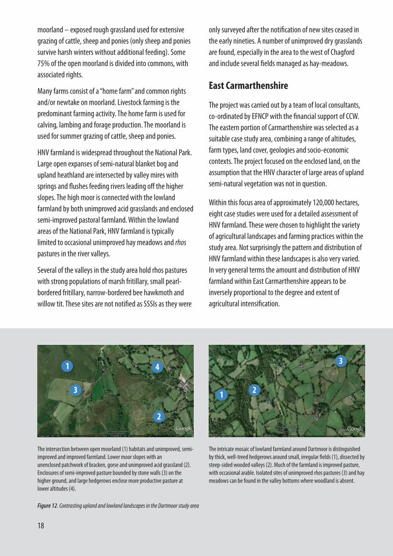
Dartmoor – a study area of 7,903 ha (8.3% of the totalNational Park area), consisting of the parishes of Chagford,Throwleigh, Gidleigh and North Bovey, chosen to reflect arange of farmland and habitats including the high moor,the transitional edge between moorland and lowland andlowland valleys adjacent to the moor.
There are three main types of farmland on Dartmoor:moorland, “newtakes” and in-bye land. The newtakes aremainly enclosed areas of moorland, adjacent to thecommons belonging to individual farms. Some of thesehave been agriculturally improved but remain marginal interms of production. The in-bye land comprises apatchwork of improved and enclosed fields, suitable forforage production or grazing lambing sheep or cattle withcalves. Around the edges of Dartmoor the farmland istypically enclosed. But the majority of Dartmoor is
Figure 11. These fields (left and right) in South Devon have been a CountyWildlife Site since 1992, but fell out of livestock use several years ago and arein non-farming private ownership (and not in AES). The owners maintainthem by occasional mowing, but the fields have been threatened recently withbuilding development.
19 http://www.devonwildlifetrust.org/working-wetlands/
18
moorland – exposed rough grassland used for extensivegrazing of cattle, sheep and ponies (only sheep and poniessurvive harsh winters without additional feeding). Some75% of the open moorland is divided into commons, withassociated rights.
Many farms consist of a “home farm” and common rightsand/or newtake on moorland. Livestock farming is thepredominant farming activity. The home farm is used forcalving, lambing and forage production. The moorland isused for summer grazing of cattle, sheep and ponies.
HNV farmland is widespread throughout the National Park.Large open expanses of semi-natural blanket bog andupland heathland are intersected by valley mires withsprings and flushes feeding rivers leading off the higherslopes. The high moor is connected with the lowlandfarmland by both unimproved acid grasslands and enclosedsemi-improved pastoral farmland. Within the lowlandareas of the National Park, HNV farmland is typicallylimited to occasional unimproved hay meadows and rhospastures in the river valleys.
Several of the valleys in the study area hold rhos pastureswith strong populations of marsh fritillary, small pearl-bordered fritillary, narrow-bordered bee hawkmoth andwillow tit. These sites are not notified as SSSIs as they were
only surveyed after the notification of new sites ceased inthe early nineties. A number of unimproved dry grasslandsare found, especially in the area to the west of Chagfordand include several fields managed as hay-meadows.
East Carmarthenshire
The project was carried out by a team of local consultants,co-ordinated by EFNCP with the financial support of CCW.The eastern portion of Carmarthenshire was selected as asuitable case study area, combining a range of altitudes,farm types, land cover, geologies and socio-economiccontexts. The project focused on the enclosed land, on theassumption that the HNV character of large areas of uplandsemi-natural vegetation was not in question.
Within this focus area of approximately 120,000 hectares,eight case studies were used for a detailed assessment ofHNV farmland. These were chosen to highlight the varietyof agricultural landscapes and farming practices within thestudy area. Not surprisingly the pattern and distribution ofHNV farmland within these landscapes is also very varied.In very general terms the amount and distribution of HNVfarmland within East Carmarthenshire appears to beinversely proportional to the degree and extent ofagricultural intensification.
Figure 12. Contrasting upland and lowland landscapes in the Dartmoor study area
The intersection between open moorland (1) habitats and unimproved, semi-improved and improved farmland. Lower moor slopes with an unenclosed patchwork of bracken, gorse and unimproved acid grassland (2). Enclosures of semi-improved pasture bounded by stone walls (3) on thehigher ground, and large hedgerows enclose more productive pasture atlower altitudes (4).
The intricate mosaic of lowland farmland around Dartmoor is distinguishedby thick, well-treed hedgerows around small, irregular fields (1), dissected bysteep-sided wooded valleys (2). Much of the farmland is improved pasture,with occasional arable. Isolated sites of unimproved rhos pastures (3) and haymeadows can be found in the valley bottoms where woodland is absent.
1
3
4
2
21
3
19
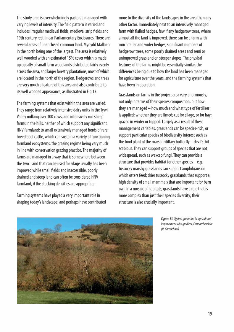
The study area is overwhelmingly pastoral, managed withvarying levels of intensity. The field pattern is varied and includes irregular medieval fields, medieval strip fields and19th century rectilinear Parliamentary Enclosures. There areseveral areas of unenclosed common land, Mynydd Mallaenin the north being one of the largest. The area is relativelywell wooded with an estimated 15% cover which is madeup equally of small farm woodlands distributed fairly evenlyacross the area, and larger forestry plantations, most of whichare located in the north of the region. Hedgerows and treesare very much a feature of this area and also contribute toits well wooded appearance, as illustrated in Fig.13.
The farming systems that exist within the area are varied.They range from relatively intensive dairy units in the TywiValley milking over 300 cows, and intensively run sheepfarms in the hills, neither of which support any significantHNV farmland; to small extensively managed herds of rarebreed beef cattle, which can sustain a variety of functioningfarmland ecosystems, the grazing regime being very muchin line with conservation grazing practice. The majority offarms are managed in a way that is somewhere betweenthe two. Land that can be used for silage usually has beenimproved while small fields and inaccessible, poorlydrained and steep land can often be considered HNVfarmland, if the stocking densities are appropriate.
Farming systems have played a very important role inshaping today’s landscape, and perhaps have contributed
more to the diversity of the landscapes in the area than anyother factor. Immediately next to an intensively managedfarm with flailed hedges, few if any hedgerow trees, wherealmost all the land is improved, there can be a farm withmuch taller and wider hedges, significant numbers ofhedgerow trees, some poorly drained areas and semi orunimproved grassland on steeper slopes. The physicalfeatures of the farms might be essentially similar, thedifferences being due to how the land has been managedfor agriculture over the years, and the farming systems thathave been in operation.
Grasslands on farms in the project area vary enormously,not only in terms of their species composition, but howthey are managed – how much and what type of fertiliseris applied; whether they are limed; cut for silage, or for hay;grazed in winter or topped. Largely as a result of thesemanagement variables, grasslands can be species-rich, orsupport particular species of biodiversity interest such asthe food plant of the marsh fritillary butterfly – devil’s-bitscabious. They can support groups of species that are notwidespread, such as waxcap fungi. They can provide astructure that provides habitat for other species – e.g.tussocky marshy grasslands can support amphibians onwhich otters feed; drier tussocky grasslands that support ahigh density of small mammals that are important for barnowl. In a mosaic of habitats, grasslands have a role that ismore complex than just their species diversity; theirstructure is also crucially important.
Figure 13. Typical gradation in agriculturalimprovement with gradient, Carmarthenshire(R. Carmichael)
20
Wye Valley
The Wye Valley HNV farming project was carried out jointlyby EFNCP and Wye Valley AONB, with input from localecologists (George Peterken and Stephanie Tyler) and stake-holders, and from Cumulus Consultants and Border Ecology.
The Wye Valley AONB covers an area of 32,600 ha, andincludes parts of the counties of Hereford and Gloucester(England), and Monmouth (Wales). The river Wye forms theborder between England and Wales in the lower reaches ofits course, cutting a path through a low plateau. On bothsides of the river historical and geographical factors havecombined to allow the survival of significant areas ofspecies-rich grasslands, largely in bocage landscapes ofvery small, hedged fields.
The area is interesting for a number of reasons. Thesimilarity of the areas on both sides of the river makes it anideal place to compare any difference in approach betweenNatural England and Defra on the east bank and theCountryside Council for Wales and Welsh Government onthe west.
In addition, both sides of the river have generated theirown community-led grasslands projects: the ParishGrasslands Initiative in the Hudnalls (lower Wye Valley,Gloucestershire) and the Monmouthshire Meadows project(Wales), raising interesting questions of how to“mainstream” such activity into major policies, especiallyRural Development Programmes. The areas covered bythese two initiatives were the main focus of the HNVfarming project. In the northern part of the AONB thelandscape tends to be more gentle with broad meandersand more open farmland over the Herefordshire lowlands.
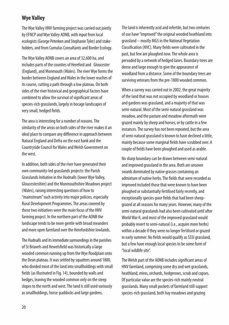
The Hudnalls and its immediate surroundings in the parishesof St Briavels and Hewelsfield was historically a largewooded common running up from the Wye floodplain ontothe Dean plateau. It was settled by squatters around 1800,who divided most of the land into smallholdings with smallfields (as illustrated in Fig. 14), bounded by walls andhedges, leaving the wooded common only on the steepslopes to the north and west. The land is still used variouslyas smallholdings, horse-paddocks and large gardens.
The land is inherently acid and infertile, but two centuriesof use have “improved” the original wooded heathland intograssland – mostly MG5 in the National VegetationClassification (NVC). Many fields were cultivated in thepast, but few are ploughed now. The whole area ispervaded by a network of hedged lanes. Boundary trees aredense and large enough to give the appearance ofwoodland from a distance. Some of the boundary trees aresurviving veterans from the pre-1800 wooded common.
When a survey was carried out in 2002, the great majorityof the land that was not occupied by woodland or housesand gardens was grassland, and a majority of that wassemi-natural. Most of the semi-natural grassland wasmeadow, and the pasture and meadow aftermath weregrazed mainly by sheep and horses, or by cattle in a fewinstances. The survey has not been repeated, but the areaof semi-natural grassland is known to have declined a little,mainly because some marginal fields have scrubbed over. Acouple of fields have been ploughed and used as arable.
No sharp boundary can be drawn between semi-naturaland improved grassland in the area. Both are unsownswards dominated by native grasses containing anadmixture of native herbs. The fields that were recorded asimproved included those that were known to have beenploughed or substantially fertilised fairly recently, andexceptionally species-poor fields that had been sheep-grazed at all seasons for many years. However, many of thesemi-natural grasslands had also been cultivated until afterWorld War II, and most of the improved grassland wouldprobably revert to semi-natural (i.e., acquire more herbs)within a decade if they were no longer fertilised or grazedin early summer. No fields would qualify as SSSI grassland,but a few have enough local species to be some form of“local wildlife site”.
The Welsh part of the AONB includes significant areas ofHNV farmland, comprising some dry and wet grasslands,heathland, mires, orchards, hedgerows, scrub and copses.Of particular value are the species-rich mainly neutralgrasslands. Many small pockets of farmland still supportspecies-rich grassland, both hay meadows and grazing

21
pastures, particularly where the fields are of small size andwhere there are access difficulties, for example on steepsides of valleys. Many of these species-rich grasslandpockets are less than half an acre in size and are nowattached to houses and not farmed as such.
Orchards in the AONB often have unimproved MG5 semi-natural grassland below the trees and even where thegrassland is of limited value, the orchard itself is animportant habitat. The fruit trees support lichens andmistletoe and many rare insects are associated with oldfruit trees. Holes in trees are used by roosting bats andbreeding birds such as tits, redstart and woodpeckers.
In NVC terms, MG5 and U4 grassland is of high natureconservation value as it supports a wide range of plantspecies, many butterflies, beetles, bees, grasshoppers andother invertebrates and provides a rich food source forsmall mammals and seed-eating birds such as goldfinchesor species such as green woodpecker which feeds largely onyellow meadow ants that thrive in the large mounds insome pastures.
Some farmland with MG6 or MG7 still has small fields with,for the main part, good quality, species-rich hedgerows or
old wall boundaries, and often there are patches of scrub,copses and/or ponds. Most hedgerows in the AONB arequite species-rich, consisting of hazel, hawthorn,blackthorn, maple, often holly, spindle and dogwood. Oftenthere are mature trees within the hedges. Many bats suchas lesser horseshoe bat, an important species in the AONB,need hedges or tree lines along which to move from onesite to another. Dry-stone walls are an important landscapefeature of the AONB and they too have high conservationvalue supporting many higher plants as well as mosses,liverworts and lichens. Walls are used by small mammalsfor moving from one area to another, for shelter or hunting.Reptiles such as slow worms and amphibians such ascommon toads also find refuge in walls.
Apart from the large extent of woodland and managedforest, most of the remainder of the Wye Valley AONB isfarmland with arable fields or agriculturally improved fields(NVC type MG6 and 7) of rather low conservation value.However, some MG6 grassland has developed someinterest, for example a range of grasses and even spottedorchids Dactylorhiza fuchsii appearing in the sward.Unfortunately, all too often when it reaches this stage, it is ploughed and reseeded with a rye-grass ley.
Figure 14. Aerial view of Hudnalls small-scalefield pattern. Survey data shows the biggestcontiguous block of semi-natural grassland tobe in the larger fields just above the centre of thephotograph (Google earth)

22
The overall aim of the projects was to address the followingquestions:
What is HNV farmland in the local area?
• What types of farmland are considered the mostvaluable from a wildlife perspective, and therefore canbe considered HNV farmland?
• Do existing databases and inventories show the fullextent and location of these types of farmland? If notthen what types of farmland are missing?
• What are the potential ways (now or in the future) inwhich the extent and location of this HNV farmland canbe identified, through existing or future data sets suchas UK Land Cover Map20, IACS21, etc.?
• Can a “baseline” area of HNV farmland be identified inthe project areas?
What type of farming uses the HNV farmland andhow are these farming types evolving?
• Can we characterise the different farming systems orfarm types that currently use HNV farmland in theproject areas (e.g. in terms of production sector,production systems, management practices, farm size,ownership, etc.)?
• How are these farming systems or types likely to evolvein future e.g. intensification, abandonment, change ofland use?
• What are main factors influential in maintaining HNVfarmland, especially policy and socio-economic trends,but also e.g. hobby farmers, tourism, personalmotivation of certain farmers?
How can HNV farmland be maintained?
• What are the key issues that need to be addressed onthe ground, in order for HNV farmland to bemaintained? This includes social and economicquestions, but also practical issues such as availability of
livestock to graze small, awkward fields, and how suchactivities can be organised and continued.
• To what extent does the current package of policymeasures ensure the maintenance of HNV farmland e.g.Pillars 1 and 2 of CAP, RDPs, BAP, etc.? If not, what ismissing, what needs to be improved?
The emphasis of the local projects varied, depending on thefocus of the partners involved.
The Carmarthenshire project focused primarily on theidentification of HNV farmland using existing data sets,including innovative remote sensing tools that are moreadvanced in Wales than in England.
The Devon project focused on analysis of the situation ofHNV farming, including trends affecting HNV farmingaccording to farmer and stakeholder interviews, and thepolicy response especially through RDPE.
The Wye Valley project focused on practical approaches tomaintaining HNV farmland in landscapes of small, amateurlandholdings and on the development of a project modelfor local action.
20 LCM2000 and LCM2007 produced by Centre for Ecology and Hydrology aspart of the Countryside Survey
21Integrated Administration and Control System through which CAP paymentsare managed
What the projects did

23
The projects considered different approaches to identifyingHNV farmland, based on experience at national and EUlevels and on the guidance produced by the EuropeanEvaluation Network for Rural Development Help Desk.There are three broad approaches, which can besummarised as:
• The land-cover approach - identifying types andpatterns of land cover that can be expected to supporthigh nature values.
• The habitats and species approach - mapping thelocation or concentrations of habitats and/or species ofconservation concern.
• The farming systems approach - identifying andmapping farm types than have characteristics normallyassociated with high nature values, such as low livestockdensities.
These approaches were explored in the Carmarthenshireand Devon projects. Important differences were found inthe data sets of the two countries – in Wales, it seems thatquite effective identification of HNV farmland can beundertaken with available data sets; in England this wasnot the case at the time of the project, but aerial photointerpretation was found to provide a practical alternativeat least at the local level.
Species data as currently available seem not to give enoughcertainty to make an initial selection of HNV farmland.However, it may be useful as a follow-up to otherapproaches (aerial photography, satellite imagery etc). Asa final step in HNV farmland identification, detailed speciesdistribution data (where available) may allow theidentification of farmland that does not have the semi-natural content or land cover patterns normally associatedwith HNV, but that nevertheless supports certain species ofconservation concern – Type 3 HNV farmland.
Identifying HNV farmland in Devon
In Devon, the project partners found that reliable HNVfarmland identification in the case study areas was notpossible using existing databases. There are various reasonsfor this:
• Land Cover Map 2000 (LCM2000) is not produced atsufficiently high resolution to distinguish semi-naturalfields from more intensively farmed grassland; LCM2007is much higher resolution but was not available at thetime of the project.
• Habitat inventories include only BAP priority habitats.There was a consensus among the project partners thatsuch inventories do not represent the total extent ofsemi-natural farmland in its wider sense, and that thedata are often quite old.
• Species data are not sufficiently consistent eithergeographically or across taxa; the spatial resolution isalso too crude in most cases and often records onlypresence/absence.
• Data on farming characteristics are not readily availableat a sufficient spatial resolution and would need to betested against an initial interpretation of which areas offarmland can be considered HNV on ecological grounds.
The Devon project therefore turned to the expert interpre-tation of aerial photos to see if this would allow the identification of a wider spectrum of HNV farmland. The answer seems to be that it can, as the unimproved andsemi-improved farmland has a distinct “rough” appearanceon the photos. Local knowledge confirmed that the areasapparent from this visual interpretation of the photos correspond with farmland areas considered of most naturevalue, suggesting that a computerised expert system couldbe taught to carry out the same task in future. It was notedalso that the semi-improved habitats linked many of theBAP priority habitat areas and/or were located in the samelandscape units (see Fig.15)
DWT has applied a similar method for biodiversity surveysin Culm parishes and produced apparently sound results.
How can HNV farming be identified using existing or proposed data sets?

24
In this case the aerial photography interpretation tended tounderestimate the area of farmland of biodiversity interest– subsequent additions were made on the basis of fieldsurveys. Interestingly, the same tendency to slightlyunderestimate the HNV area emerged from the remotesensing work in east Carmarthenshire (see below)
In the case of South Devon mixed farming landscapes, theHNV areas were identified on the basis of County WildlifeSites (CWS) designated for their populations of cirlbuntings.
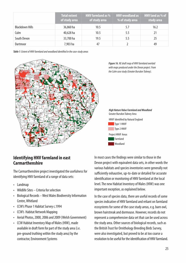
The Devon project partners decided to produce indicativemaps of HNV farmland for the case study areas on the basisof visual interpretation of aerial photos. These indicativemaps aim to capture a contiguous area of HNV farmland foreach of the Devon case study areas. The project was thussuccessful in establishing for these areas a “baseline” ofHNV farmland, as intended under the EU indicator formonitoring rural development programmes. Theproportion of farmland identified as HNV ranged from10.5% in the Blackdown Hills to 47% in the Dartmoor casestudy area (4 selected parishes). See Table 1.
The HNV farmland maps produced under the Devon projectwere checked against maps produced under a nationalapproach trialled by Natural England (NE) at the time thecurrent RDPE (2007-13) was being prepared. The results ofthe comparison suggest that the approach trialled atnational level does not produce robust results at the locallevel. In the case-study areas, the HNV farmland identifiedthrough the NE national approach is only a very limitedpart of the area identified by this project, and in some casesdoes not coincide well with farmland of biodiversity value.See Fig.16 for an example.
Figure 15. Example from Blackdown Hills – BAP priority habitats(right – shaded grey/green) sitting within a wider matrix ofbroadly semi-natural farmland (left)
Approach to mapping HNVfarmland under the DevonprojectThe first stage in identifying HNV farmland was todigitise those OS Mastermap polygons which areco-located with Sites of Special Scientific Interest(SSSIs) and County Wildlife Sites (CWS).
The next stage was to work systematically acrossthe area and digitise every instance of what appeared to be farmed semi-natural habitats(scrub, rough grazing, ponds etc.).
Another set of criteria for selection into the HNVlayer were agglomerations of small fields (highdensity of hedgerows), areas of orchard, small farmwoodlands (broadleaved or mixed only – pure coniferplantation was excluded) in some cases with largerarable or grassland fields as part of the matrix.
Finally, semi-natural woodlands were marked as aseparate layer of High Nature Value forestry, as thisis also included in the EU policy context.
Difficulties with this approach:
Semi/unimproved grasslands with even swards thatare not identified as SSSI or CWS are almost impos-sible to pick out from aerial photography (whereasrough/scrubby grassland is quite obvious).
Aerial photos from different times of same year can give very different impressions of “semi-naturalness”.
BOX 2
25
Identifying HNV farmland in eastCarmarthenshire
The Carmarthenshire project investigated the usefulness foridentifying HNV farmland of a range of data sets:
• Landmap• Wildlife Sites – Criteria for selection• Biological Records – West Wales Biodiversity Information
Centre, Whitland• CCW’s Phase 1 Habitat Survey c.1994• CCW’s Habitat Network Mapping • Aerial Photos, 2000, 2006 and 2009 (Welsh Government) • CCW Habitat Inventory Map of Wales (HIW), made
available in draft form for part of the study area (i.e. pre-ground truthing within the study area) by thecontractor, Environment Systems
Total extent of study area
HNV farmland as % of study area
HNV woodland as % of study area
HNV land as % ofstudy area
Blackdown Hills 36,860 ha 10.5 5.7 16.2
Culm 40,628 ha 10.5 5.5 21
South Devon 33,700 ha 19.5 5.5 25
Dartmoor 7,903 ha 47 2 49
Table 1: Extent of HNV farmland and woodland identified in the case-study areas
High Nature Value Farmland and WoodlandGreater Bursdon Tubney Area
HNVF Identified by Natural England
Project HNVF Areas
Type 1 HNVF
Type 2 HNVF
Farmland
Woodland
Figure 16. NE draft map of HNV farmland overlaidwith maps produced under the Devon project. Fromthe Culm case study (Greater Bursdon Tubney).
In most cases the findings were similar to those in theDevon project with equivalent data sets, in other words thevarious habitats and species inventories were generally notsufficiently exhaustive, up-to-date or detailed for accurateidentification or monitoring of HNV farmland at the locallevel. The new Habitat Inventory of Wales (HIW) was oneimportant exception, as explained below.
In the case of species data, there are useful records of somespecies indicative of HNV farmland and reliant on farmlandecosystems for some of the case study areas, e.g. barn owl,brown hairstreak and dormouse. However, records do notrepresent a comprehensive data set that can be used acrossthe study area. Other sources of biological records, such asthe British Trust for Ornithology Breeding Birds Survey,were also investigated, but proved to be at too coarse aresolution to be useful for the identification of HNV farmland.
26
However, the HIW was found to be potentially of sufficientaccuracy for both identifying and monitoring HNV farm-land, which is a very significant finding. The HIW is a newmapping project developed by Environment Systems forCCW. It aims to produce detailed habitat maps of Walesthrough the use of aerial photography and satellite remotesensing data ‘to help monitor landscape-scale biodiversity,habitat connectivity, ecosystem function and the green infrastructure of Wales. A key principle is to maintain continuity with traditional field-based survey methodswhile allowing future use of the enormous power of satellite-based measurements of productivity, habitat structure, soilmoisture, biomass and seasonal patterns in phenology’.22
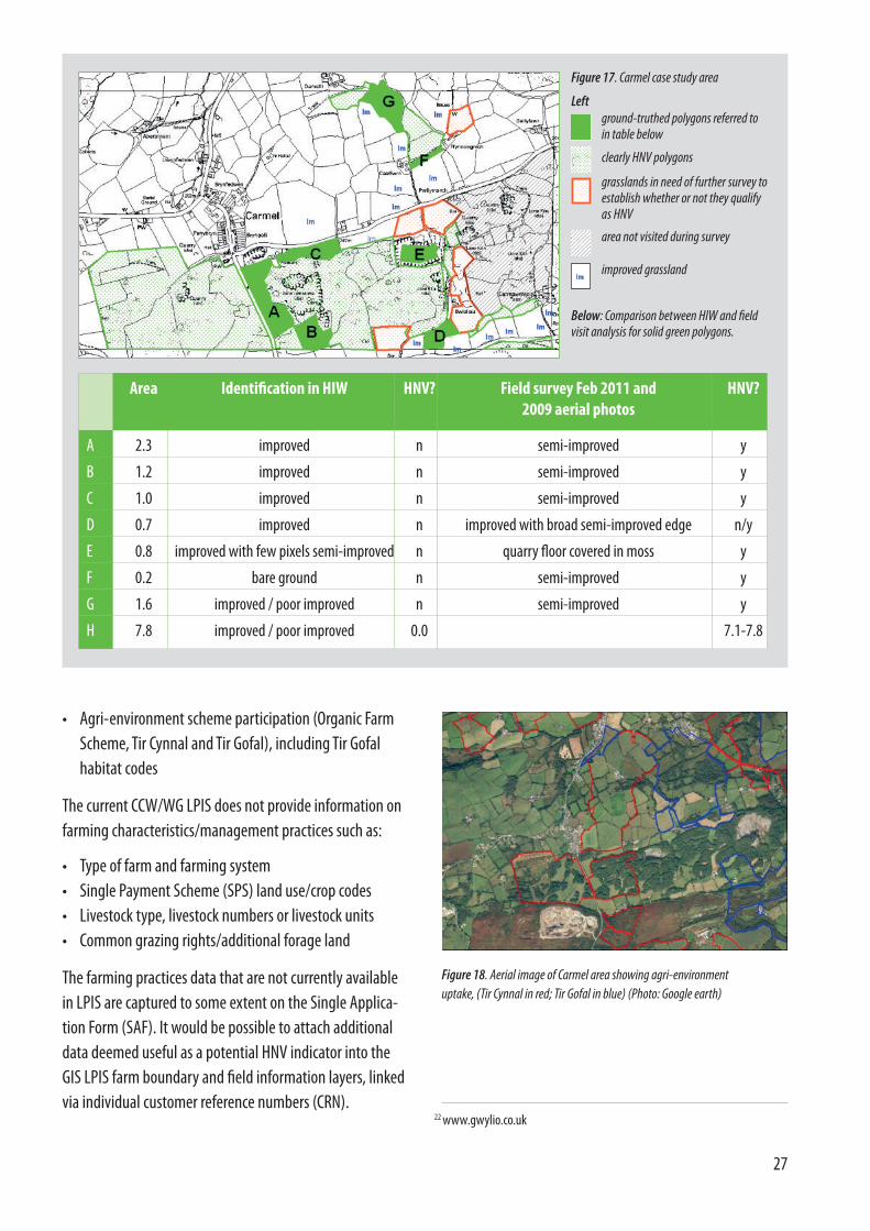
Within the East Carmarthenshire study the usefulness ofthe HIW in identifying HNV farmland was assessed byground-truthing within the eight sample areas, all exceptone of which consisted of at least two, usually adjacent,1km squares. Through site visits, fields were assessed as towhether or not they might qualify as HNV, and theconclusions were compared with the HIW classification,and with aerial photos taken in summer 2009. Fields whichcould not be surveyed were marked as such. All the “non-improved” habitats recognised by the HIW were taken toqualify as HNV; the only habitat where there may be somedoubt is “poor improved grassland”.
While some shortcomings were identified, HIW was able toidentify at least 84% of the semi-natural farmed vegetationwithin six of these samples areas. A specific problem occurswith hedgerows and woodland edges whose width can beover- or under-estimated, due to the shadow cast or lost(depending on the time of day the aerial photograph wastaken). The extent of adjacent grassland is then over- ormore frequently, under-estimated. Some small fields havebeen mostly or entirely mapped as woodland.
No instances were identified where HIW identified an areaas being semi-natural when it did not appear so on theground or on aerial photos, which is a very significantpositive attribute of HIW. In some cases polygons identifiedas “improved grassland” on HIW were found through fieldvisits to be semi-improved and probably HNV. See Figs.17and 18 for an example of this (Carmel case study).
Revised editions of HIW will be available in 2012 and themaps will continue to be improved as more data becomeavailable. With the revisions and improvements that areexpected, HIW could provide a key tool for identifying HNV farmland in East Carmarthenshire, and across Wales, in association with aerial photographs. Similarly the twopotentially could be used for monitoring the extent of HNV farmland.
While accurate mapping of plant communities withinindividual fields will continue to rely on field survey, HIWwill provide useful information as to where HNV is likely tooccur and where to target further field survey. Paymentschemes that rely on HIW for identifying habitats shouldalso include ground-truthing of an agreed sample of sites,firstly to ensure accuracy, secondly to continue to improvethe accuracy of the HIW, and thirdly to monitor changes inHNV farmland at the field level.
The Carmarthenshire project also explored the possibilitiesfor integrating HNV farmland information with the LandParcel Information System (LPIS) and IntegratedAdministration and Control System (IACS) through whichall CAP payments are administered. This is a very desirablestep, which has been undertaken already by some MemberStates (e.g. Bulgaria and Slovakia).
The LPIS data held in CCW’s Geographical InformationSystem was interrogated to enable an analysis of theinformation held within it to be carried out. The WG’s GISteam was consulted to confirm what, if any, additional farmpractice data was linked into their LPIS. The WG’s SingleApplication Form was used to ascertain what informationcaptured in IACS could be useful to link to the LPIS FarmBoundary and Field Information layers in GIS in order betterto identify HNV farmland.
Consideration was given as to whether it would be possibledevelop the LPIS/IACS databases further to incorporateHNV variables. It was found that the LPIS used by CCW andWG provides information on:
• Farm boundaries• Size of parcel• Less Favoured Areas (LFA)/non-LFA
27
• Agri-environment scheme participation (Organic FarmScheme, Tir Cynnal and Tir Gofal), including Tir Gofalhabitat codes
The current CCW/WG LPIS does not provide information onfarming characteristics/management practices such as:
• Type of farm and farming system• Single Payment Scheme (SPS) land use/crop codes • Livestock type, livestock numbers or livestock units• Common grazing rights/additional forage land
The farming practices data that are not currently availablein LPIS are captured to some extent on the Single Applica-tion Form (SAF). It would be possible to attach additionaldata deemed useful as a potential HNV indicator into theGIS LPIS farm boundary and field information layers, linkedvia individual customer reference numbers (CRN).
22 www.gwylio.co.uk
Figure 17. Carmel case study area
Left
Below: Comparison between HIW and field visit analysis for solid green polygons.
Area Identification in HIW HNV? Field survey Feb 2011 and 2009 aerial photos
HNV?
A 2.3 improved n semi-improved y
B 1.2 improved n semi-improved y
C 1.0 improved n semi-improved y
D 0.7 improved n improved with broad semi-improved edge n/y
E 0.8 improved with few pixels semi-improved n quarry floor covered in moss y
F 0.2 bare ground n semi-improved y
G 1.6 improved / poor improved n semi-improved y
H 7.8 improved / poor improved 0.0 7.1-7.8
Figure 18. Aerial image of Carmel area showing agri-environmentuptake, (Tir Cynnal in red; Tir Gofal in blue) (Photo: Google earth)
ground-truthed polygons referred to in table below
clearly HNV polygons
grasslands in need of further survey toestablish whether or not they qualify as HNV
area not visited during survey
improved grassland
What are the challenges facedby HNV farmland in the projectareas?The challenges faced by HNV farmland were assessedthrough a combination of literature review, data analysisand interviews with farmers and other stakeholders. Theprojects reveal some quite complex pictures, but also somevery clear common threads across the project areas.
HNV farmland in all of the project areas is almostexclusively on lower-grade agricultural land, typically landwhich has limited production potential due to factors suchas steep slopes, soils with impeded drainage, shallow stonysoils, and sometimes very small field size. The physicaldisadvantages of this land for farming are very real, are amajor reason for much of it remaining in a largely“unimproved” state for production, and for it being underthreat of abandonment.
Given that unimproved and semi-improved grassland arethe core of HNV farmland, the relevant farming types are bydefinition predominantly livestock or mixed farmingoperating at low intensity. Beef cattle and/or sheep arelikely to have a major presence, although not to theexclusion of grazing by other livestock (dairy cattle, horses,ponies). An exception is South Devon, where arablecropping of spring cereals with associated winter stubblesis an important part of the HNV farmland mosaic.
The studies found HNV farmland to be present in aspectrum of farming situations, from very small amateurholdings with a high proportion of HNV land, through tolarger commercial holdings normally with only a small partcomprising HNV land. On some farms the main productionactivity is based on the HNV farmland, in which case beefand/or sheep are usually the main production system. Atthe other extreme were cases in Devon of large dairyholdings with most land under intensive use and a smallpatch of HNV farmland that may be grazed with the rest ofthe land, or may be fenced off and in a process ofabandonment.
Farm business incomes in the project areas tend to behighly dependent on the CAP single farm payment (Single
28
Current land use codes do not distinguish semi-naturalfarmland, but have potential to do so. For example, thepermanent grassland code GR2 is used for unimproved,semi-improved or improved grassland that has not beenploughed or reseeded for over five years. It would be usefulto develop the SAF to include additional codes to separateout semi-natural forage at the parcel level i.e.distinguishing it from grassland that has been heavilyfertilized. This could be quite simple, for example, alllandowners claiming SPS would declare GR3 semi-improved/unimproved pasture and GR4 semi-improved/unimproved hay meadow on their SAF, which could belinked to LPIS to indicate HNV farmland. For land to beentered under the semi-improved/unimproved land usecodes it could be specified that the parcels would not havebeen ploughed, reseeded or had inorganic fertilizers orbiocides applied for the previous five years, removing theneed for the landowner to be able to identify specificgrassland habitats.
Such additional land use codes for semi-natural habitatsmay also help when cross checking land declared on theSAF with agri-environment schemes, with cross-compliance and with Environmental Impact Assessments.Further refinement of the land use codes and theirdefinitions would be an important consideration, to enabledata to be captured in LPIS/IACS that reflected theappropriate management of semi-natural farmland.
Farm features that make a significant contribution to HNVare not included in LPIS/IACS at present. This will need tobe addressed in order to implement the EuropeanCommission’s proposed “greening” mechanism for the CAP,under which farms claiming support will be required tomaintain a minimum of “ecological focus area” on the farm.Simple questions could be asked on the SAF to includethese features, for example, the length of hedgerows onthe holding managed traditionally each year.

29
Low incomes within extensive systems lead to lack ofsuccession within family farms, with children from hill andupland farms tending to work elsewhere or train in otherfields. Ageing of the farming population is leading to thepotential loss of knowledge of how to manage extensivesystems.
There is also increased pressure to adapt, to deepen andbroaden the farming system in order to stay viable e.g.organic farming, shortening links between production andconsumption by selling at local farmers markets or toorganic box schemes, agri-tourism; environmental andlandscape management though participation in agri-environmental schemes; and diversification – fruit andvegetable production.
In the Herefordshire area of the Wye Valley AONB, themanagement of semi-improved grassland under anextensive pastoral system is in competition with thedemand for land for high-value crops (potatoes, soft fruit,and asparagus). Farmers see the soils as “too good to begrowing pasture”, although some farms include a seed leyin the rotation to increase organic matter.
HNV farmland is seen by many commercial farmers assecondary/peripheral to their farming enterprise. However,there are also many instances where it is valued, either due
Payment Scheme – SPS). Figures from south-west Englandshow this dependence to be considerably greater thanaverage in the case of farms raising beef cattle and/orsheep, on which a large proportion of HNV farmlanddepends for its maintenance. These farms also have farlower farm business incomes, on average, than cereal anddairy farms. Beef and sheep holdings, and especially LFAfarms, also tend to depend on agri-environment paymentsfor a significant part of their income. See table 2.
In fact for many farms, agri-environment schemes (AES)provide an important part of the economic activity on HNVfarmland, rewarding low-intensity and/or conservationmanagement on grassland. In the case of South Devon, thesystem of spring cereals with arable stubbles and othermanagement central to the value of farmland for cirlbuntings are maintained almost exclusively as a result ofAES. On the other hand, there are examples of HNVfarmland simply being maintained as rough grazingwithout AES support.
In Carmarthenshire, concerns were expressed about thepressure to intensify, with high fixed costs, in order to com-pete in a global market, particularly in the dairy sector. Further rationalisation in the dairy sector was also pre-dicted in Devon, including a rationalisation of land use withpotential threats to remaining patches of HNV farmland.
Sources of income
Agriculture % Agri-environment
payments
% Diversification % Single PaymentScheme
% Farm Business Income
%
Cereal -£430 -1% £7,596 14% £13,256 24% £34,871 63% £55,294 100%
Dairy £52,005 68% £2,630 3% £400 1% £21,382 28% £76,417 100%
Cattle and Sheep £1,832(Lowland)
-10% £3,174 18% £3,502 20% £12,823 73% £17,668 100%
Cattle and Sheep -£2,387(LFA)
-11% £7,377 33% £1,063 5% £16,548 73% £22,601 100%
Mixed -£3,186 -12% £4,806 19% £2,129 8% £22,201 86% £25,950 100%
All Farms £8,146 21% £4,953 13% £5,364 14% £20,696 53% £39,082 100%
Table 2: Overview of farm business incomes in south-west England
Source: Farm Business Survey 2008. Adapted from Lobley et al (2009) by Cumulus Consultants (2011).

30
to personal interest/motivation, to the economic benefitsavailable from higher-level agri-environment schemes, andin certain cases where the farm business is using it as thebasis for a specific enterprise such as traditional beef breedsplus value-added in marketing its produce (meat boxschemes, on-farm tourism). Personal motivation was astrong factor for the maintenance of the HNV farming insome of the farm interviews; “Managing land of highnature value is a life choice not a business choice. If allyou’re interested in is maximum profit, you cannot give thenatural environment the time, energy and input it needs.”
Very small farms and amateur holdings are more likely tobe dominated by HNV farmland (although there are alsoplenty that are not), and such holdings are an importantconsideration for policy. Often, semi-natural grassland hassurvived precisely because it is outwith commercialfarming, but policy measures designed to sustain suchgrassland are inappropriate because they are directedprimarily at farmers. Amateur landowners may havelimited knowledge of land management and farming, andoften do not have access to livestock for grazing.
Keeping horses is a common motivation for small-scaleland ownership. Negative biodiversity and landscapeimpacts of grazing with horses are widespread - oftengrassland is reseeded, overgrazed, weedy and poached. OnMynydd Mawr (Carmarthenshire) some landowners runpart-time businesses or leisure interests such as Welsh Cobbreeding, harness-racing or livery stables, and so do notfeel they are able to reduce their stock numbers. Many
owners consider their land as an extension of their gardens,keeping it “neat and tidy” by mowing and topping thepastures, flailing hedges and clearing scrub, often atinappropriate times of year. But this is not inevitable;grassland grazed by horses can be well managed forconservation.
There is an on-going tendency for HNV farmland to becomeseparated from commercial farming holdings, oftenthrough a process of selling off small farms or parts offarms to small-scale amateur landowners. Very smallholdings are increasing rapidly in number. Larger holdingsare also increasing. The middle-size family farm isdeclining. In some places, large expanses of HNV farmlandare owned by big estates, such as Duchy of Cornwall andNational Trust on Dartmoor.
An on-going decline of HNV farmland has been observed inseveral of the case-study areas, in the form ofintensification in some instances, and simplificationleading to gradual abandonment more generally. Studiesof the condition of County Wildlife Sites (CWS) in Devonfound that approximately 50% of grassland/heathland siteswere not in favourable conservation management.Abandonment, neglect and under-management weremore usual than over-intensive use.
Farmland in these sites tends to be on smaller, wetter,steeper fields with high management costs. Availability ofsuitable stock, and willingness to have stock on land withhigher animal health risks and costs, seems to be an issuein some areas, and may become an increasing issue as stocknumbers decline and HNV farmland increasingly comes intothe ownership of non-farming landowners (see above).There has been a reduction in the numbers of hardy breedsof cattle that are well suited to managing roughgrassland/heathland sites.
Restrictions on stock movements are an issue, and becomemore of an issue as the number of small holdings increases.TB testing is also a disincentive. Ponies and sheepmovements are much less restricted (e.g. no TB testing)than cattle.
In the Wye Valley (Monmouthshire), many amateurlandowners with HNV grassland have no agricultural
Figure 19. Species-rich neutral grassland in Monmouthshire, Wye Valley.

31
future there may be less farm labour available for activitiessuch as shepherding and swaling (burning).
LFA and lowland cattle and sheep farms make a net loss onagricultural production, incomes being dependent on SPS,AES and diversification. But hill farms are in an even worseposition. Turner, M et al (2008)24 found that Farm BusinessIncome (FBI) for hill farms in the Severely DisadvantagedArea (SDA) was £9,207 in 2006/7, compared to £11,238 forLFA farms as a whole, concluding that “hill farming systemsin 2006/7 failed to produce a fair return for the labour ofthe farm family ...and no return for their own capitalinvested in the business”.
Furthermore, LFA farms have experienced a reduction inSPS payments over the period 2005-12, as a result of the“dynamic hybrid” mechanism used in England to shift fromhistoric to flat area payments, with SDA mixed grazinglivestock farms expected to experience the steepestreduction in SPS payments (27% decrease), followed bySDA specialist sheep (19%) and SDA specialist beef (6%).Anecdotal evidence suggests cuts in SPS payments of up to40% are possible on “extreme” hill farms.
86% of HNV farmland in the study area is under AES.Schemes have been successful in addressing overgrazingand bringing SSSIs into good status. Nevertheless, four ofthe interviewed farmers considered the reduction in stocknumbers due to AES prescriptions to have caused scrub,gorse and bracken encroachment. Now there are concernsthat farms coming out of ESA agreements might not enterUpland ELS (with lower payments) or HLS (more complexand limited budget).
A reduction in CAP payments and increasing controls on theuse of hill land have made some farmers turn away fromfarming moorland, preferring to intensify on more produc-tive land “downslope”, with breeds that are quicker to mature.
BOX 3
The Dartmoor study area differed from the other Devoncases in having large areas under moorland and commongrazings, and designated as SSSI/SAC and LFA.
Some 80% of farmland is on LFA grazing livestock farms,but “other” holdings cover a significant 15% – these areholdings that do not fit into the main agriculturalcategories of the census or are of limited economicimportance, often coinciding with holdings of <5ha23. Landis being polarised into very small and very large holdings:in 2000-2008 there was a 78% increase in the number andextent of “other” holdings, while farms of >100haincreased by 63% in number and 170% by area.
Livestock numbers declined strongly from 2000 to 2008,cattle numbers by 29%, sheep by 16% and horses by 8%.The number of holdings with cattle decreased by 44%. Thedecoupling of subsidies is regarded by producers as havingbeen a turning point for hill farming, removing “the incen-tive to farm the moorland”. However, cattle numbers starteddecreasing well before decoupling, with the introduction ofmeasures to reduce the pressure of stock on moorland(cross-compliance and the ESA scheme in the early 1990s),and the arrival of BSE and Foot and Mouth Disease.
The decline of cattle has created problems for delivering thekind of grazing that benefits habitats such as rhos pastures,and species such as marsh fritillary. Cattle or mixed grazingis also beneficial on moorland for controlling certain speciessuch as Molinia and maintaining a mosaic of habitats.
Undergrazing is becoming an issue in places, althoughthere is also local overgrazing – on open moorland, the mismatch often relates to a lack of shepherding. Shepherd-ing is critical for balanced grazing, but costs are a problem.The total agricultural workforce in the case study area decreased by 12% from 2000 to 2008, and the total number of full-time workers by 15%, suggesting that in
Dartmoor – trends affecting HNV farmland
23 Defra (2000,2007&2008) June Survey Data24Turner, M, Robbins, K. & Silcock, P. (2008) Hill Farming Systems in South West England: Economic Viability and the Delivery of Public Goods.
Report for the Duchy of Cornwall and Dartmoor and Exmoor National Park Authorities

Are current policies effective inmaintaining HNV farmland?CAP Pillar 1
At present there is no recognition under the Pillar 1 singlepayment (SPS) of the higher public goods value of certaintypes of land, such as HNV farmland, or of the productiondifficulties that limit the viability of farming this land.Overall, those farms which are the least intensive andproducing the most public benefit are those making leastmoney from farming. These farms are not being rewardedby SPS relative to public benefits they deliver and thesupport provided is not commensurate to the physical andlegal (cross-compliance, EIA25) limitations on this land.
So currently the burden of rewarding the higher publicgoods and production limitations of HNV farmland fallslargely on AES. The Less Favoured Areas (LFA) measurecould help in theory, but the very broad-brush way it isdifferentiated at present in Wales does not pick up therange of productive capacity at local level, while Englandhas chosen to abandon LFA payments in favour of entry-level AES for the uplands.
Pillar 1 is currently in transition, as the CAP undergoesreform, with a probable move to “regionalised” paymentsset at a flat-rate for all farmland in a given region. InEngland, this shift from historic to regionalised Pillar 1payments has taken place already, resulting in a generalincrease of support per hectare for land of lowerproductivity, such as unimproved grassland, which is goodfor the maintenance of HNV farmland. Since 2009 paymentcan be made on land such as traditional orchards, whichpreviously had no CAP direct payments. However, thedifferentiation of payment levels in England is criticised forbeing unfavourable to the poorest LFA land, which receivesa lower payment. Dartmoor evidence suggests a fall in SPSreceipts over 2005-2012, with falls greatest on moreextreme hill farms with a high proportion of land above theMoorland Line.
The possible reduction in CAP support for farming from2014 is an important concern for HNV farmland, but doesnot lead to the conclusion that blanket support as provided
32
machinery or grazing stock, so that some once importantareas have become invaded with bracken and brambles orsaplings and are reverting to broad-leaved woodland.Other former MG5 grassland has been planted with treeswith Forestry Commission grants; tree-planting on lowgrade agricultural land but high grade conservation landcontinues today. In some cases good MG5 grassland, evensites notified as CWS, have been ploughed in recent yearsby farmers or landowners (this despite rules safeguardingunimproved grassland). Some species-rich grasslands havebeen lost, or will be lost, to built development. Overall, theattrition of species-rich grassland continues.
A general problem for the upkeep of semi-naturalgrassland is the lack of maintenance of the infrastructureassociated with traditional grazing management, such asfencing, water supply, serviceable small-scale hay cuttingequipment. The very least that potential graziers expectwhen taking on a grassland site is good quality fencing andwater supply. There is some public resistance to newfencing and presence of livestock on accessed land,especially commons.
Certainly there are many positive examples of HNVfarmland being maintained on commercial and amateurlandholdings, thanks to combinations of personalmotivation, a range of policy instruments and manyexcellent local initiatives; but the overall picture is one ofsteady decline resulting from localised abandonment andintensification.

33
maintain permanent pasture in general are of littleenvironmental relevance and targeting of Pillar 1instruments to benefit HNV grasslands is made difficult.The Carmarthenshire project suggests that this defect inthe system could be corrected relatively easily, byintroducing an additional IACS code for unimprovedgrassland (see Carmarthenshire project findings, above).
The requirements of the EIA Directive, giving protection toprotect semi-natural grasslands from intensification orconversion, are included under cross-compliance in the UK– this is a positive move that is not common across the EU.However, implementation is not fully effective (see Nature’sTapestry report by Grassland Trust27). In England, many
currently by SPS should be maintained. Rather it suggeststhe need for support to be targeted at farmland that is ofparticular public-goods value and that is also particularlythreatened with abandonment or intensification - HNVfarmland. Whatever cuts take place, support for this type offarmland needs to be maintained or increased, through anappropriate combination of Pillar 1 payments and AES.
Currently, abandonment of semi-natural grazing land istaking place, leading to scrub and tree encroachment – at a certain point, this land becomes ineligible for SPS. Thismechanism is intended to ensure that only land under aminimum level of maintenance is eligible for SPS; this has a certain logic, but if the payments are too low to justifythis maintenance then clearly the system has a basic design flaw.
In many ways it would better if scrub habitats were eligiblefor SPS. The current exclusion causes considerableproblems. There is a confused message from government tolandowners, in that scrub is valued under one paymentscheme (agri-environment) and disregarded and liable topenalty if not declared as ineligible under SPS. This alsocreates an unnecessary administrative burden for thefarmer and administration alike.
In the project areas, we found that a significant amount ofHNV farmland was not registered on RLR26/LPIS/IACS, andtherefore not addressed in any way by CAP or RDPmeasures, as illustrated by Figs.20 and 21. An average of17% of all farmland is not registered in the Devon case-study areas. Given that mainstream commercial farmland ismost likely to be registered for CAP payments, it seemslikely that much of the non-registered land is outwith thecommercial farming sector, for example on smallholdingsthat have never claimed CAP payments.
A further weakness with the SPS administration and datasystem (LPIS/IACS) is that it does not distinguish betweenintensively managed permanent pasture and unimprovedor semi-natural pasture that is of high environmentalvalue. As a result, the CAP cross-compliance mechanisms to
Figure 20. Land not registered (visible) in IACS, Llangadog (Carmarthenshire)
Figure 21. Land not registered (visible) in IACS on Mynydd Mawr (Carmarthenshire)
25 Environmental Impact Assessment, including provisions for preventingintensification of semi-natural land.
26 Rural Land Register, the Land Parcel Identification System (LPIS) in England27 http://www.grasslands-trust.org/project.php?projectid=7
34
smaller patches of semi-natural farmland are not protecteddue to the 2ha minimum size threshold. EIA regulations aredifficult to implement and remediation of damaged semi-natural land impossible to enforce if the land has notpreviously been recorded as valued habitat. Further, manylandowners seem to be unaware of the EIA requirements,despite being included in cross-compliance.
In conclusion, it seems clear that neither the abandonmentthreat nor the intensification of semi-natural grasslands areaddressed effectively through current Pillar 1 mechanisms.There is scope under the current CAP reform for doingsomething better with Pillar 1 payments, through a simpletargeting mechanism that increases support on HNVfarmland. For example, a top-up could be paid for low-intensity grassland and traditional orchards. Some of thebasic grassland and hedge options under ELS could thus betransferred to Pillar 1, a simpler mechanism thatpotentially would bring in a larger number of farms and is100% EU funded, while reducing the burden on the AESbudget and allowing more of this to be spent on targetedmeasures.
A top-up payment for unimproved permanent pasture andmeadows would give a positive message and incentive forkeeping this land in low-intensity farming use. It wouldprovide an incentive for this land to be clearly registered onIACS, facilitating the implementation of the EIArequirements and providing a key element of a system forHNV farmland monitoring. The top-up payments should bedegressive, i.e. paid at a higher level per hectare for smallerareas of land.
However, these options are not being considered by theEuropean Commission. Rather than attempting to targetpayments on particular farmland types or practices,preference has been given to standardised rules onpermanent pastures, crop diversity and “ecological focusareas”, to be applied across the board.
Agri-environment schemes (AES)
Overall, AES play a crucial role as the main instrument forpursuing biodiversity targets on farmland and woodland,and without them there is no doubt that the situationwould be worse than it is. Any reductions in the scope ofAES would be likely to see an acceleration of the negativetendencies affecting HNV farmland.
However, policy is focussed strongly on the management ofspecific habitat types and discrete sites (e.g. SSSI targets,BAP priority habitats). Other land which has biodiversityvalue, but is not on a habitat inventory or in a designatedsite, generally is not targeted for conservation and istreated the same as all “other” farmland (see Fig. 22).
In the lowland Devon case studies, SSSIs covered only about10% of HNV farmland in each case. The proportion of HNVfarmland in these study areas covered by Natura 2000 sitesranged from 0.08% to 8.5%. These national and EUcornerstone instruments for biodiversity conservation arethus of minor relevance for the conservation of HNVfarmland in these areas. Even county level designations(CWS) in the Devon studies were found to cover onlybetween 17% and 47% of HNV farmland.
As shown in Table 3, a considerable proportion of HNVfarmland is not participating in current AES, with coverageranging from less than 50% in the Blackdown Hills to 70%in South Devon (in the Dartmoor study area the figure was86%). Coverage of HNV farmland by HLS (that rewardsconservation management) ranges between 11% and19%. The figures for higher-level schemes are considerablyhigher (24-45%) if participation in classic schemes (e.g.ESA) is included, but there is concern that not all farms willmake the transition from classic to current schemes, due tobudgetary restrictions.
It is notable that the participation in AES of HNV farmlandin these study areas is similar to, or lower than, theparticipation of farmland as a whole in the same areas. Thecase studies did not examine across the areas which AESoptions are taken up at farm level, and whether theseoptions are the most appropriate for maintaining HNVfarmland, although in the case of the farms visited in the

35
Devon case studies, the AES options being applied werepredominantly supportive of the HNV farmland present.
Overall, a widening of the AES coverage of HNV farmlandseems to be needed. By identifying and actively targetingHNV farmland, as interpreted in the project areas, a widermatrix of farmland of biodiversity value could be addressedthrough policy, as represented schematically in Fig. 22. Akey question therefore is whether HNV farmland criteriaand/or maps be incorporated into future mechanisms fortargeting AES.
There are many positive aspects to the current AES inEngland and Wales. The projects found the schemes to beplaying a crucial role for biodiversity conservation,including the maintenance of HNV farmland on manyfarms. Nevertheless there are several aspects of design anddelivery that seem to be limiting the effectiveness of theschemes from the point of view of HNV farmland.Continued development and roll-out of the schemes isrecommended, with fine-tuning to increase effectivenessand reduce administrative complexity.
Both England and Wales have AES that in principle arereadily available for all farmers, but in practice the schemesare not being taken up on a considerable area of HNVfarmland in the case-study areas, as illustrated in Fig. 23. In a study of CWS management in Devon, about 25% offarmers and landowners visited with eligible land had nottaken up an ELS agreement. Although such schemes areintended as relatively simple to join, this is not necessarilythe perception of the farmer.
For small farms, the financial incentive to join AES is low,for example a 10ha LFA holding would receive just £486 a
Table 3: Uptake of AES on HNV farmland in three Devon case studies
% of all land in AES(current and classic
schemes)
% of HNV farmland in AES (cur-rent and classic schemes)
% HNV farmland incurrent Higher Level
Scheme
% of HNV farmland in “classic” schemes
Blackdown Hills 47.2 46 11.5 13
Culm 67.5 61 18 17
South Devon 66 70 19 26
Natura2000
Local wildlife sites
HNV Farmland
Farmland
Figure 22. HNV farmland is found well beyond the boundaries of protectedareas. In this wider countryside, there are great differences in the nature valueof farmland – some is of very high nature value, some is of very limited value.Policies should aim to maintain high values where these exist.
year under Glastir All-Wales Element (including the 20%premium for farmers within the LFA). There are holdings assmall as 3ha currently participating in the Tir Gofal Schemewithin Carmarthenshire. On Mynydd Mawr, there is littleagri-environment uptake; as seen in the illustration above,much of the land is not even registered on IACS,exemplifying the need for the “locally-tailored project”approach (see below).
Higher level schemes can, and in many cases do, make amajor contribution to the economic viability of positivelymanaging HNV farmland through significant annualpayments and, very importantly, capital payments forinfrastructure improvements. On several of the farmsvisited by the Devon project, HLS had turned HNV farmlandinto an economic asset for the farmer, rather than being anuneconomic burden. However, a very large proportion ofthe HNV farmland identified in this project is not in HLS.

County boundaries
Wye Valley AONB boundary
Farmland without AES or semi-naturalgrassland
Semi-natural grassland
SSSI containing semi-natural grassland
Area under Environmental StewardshipSchemes (England) or Tyr Gofal/Tyr Cynnal (Wales)
36
HNV farmland often is not entered into higher levelschemes for a variety of reasons, e.g. the site is too small,not in a geographical target area, the bureaucracy is a dis-incentive, or the owner is not willing to commit for manyyears. Many smaller patches of high-quality HNV farmlandare not benefiting from HLS in Devon simply because theyare too small to reach the relevant habitat thresholds.
A particular problem in landscapes of small-holdings andsmall fields, such as Hudnalls in the Wye Valley, is that AESpayments are not graded by field size (unlike forestry
Figure 23. Wye Valley AONB, showing apparently verylittle overlap between AES uptake and the presence ofsemi-natural grasslands.
Graphic by Border Ecology. OS Crown copyright. All rights reserved (100024168).
planting grants), so the small fields that still have goodgrassland attract small payments. Owners are given noincentive to bother with them, and they have norecognition of the high cost per hectare of managing small fields. A scheme is needed that offers realisticincentives to manage such land ‘moderately’, i.e., whichmaintains the semi-natural grassland whilst utilising thefields for grazing and the boundaries for, say, firewoodproduction. Payment rates could be tiered so that smallerfields and holdings receive progressively higher rates thanlarger fields and holdings.
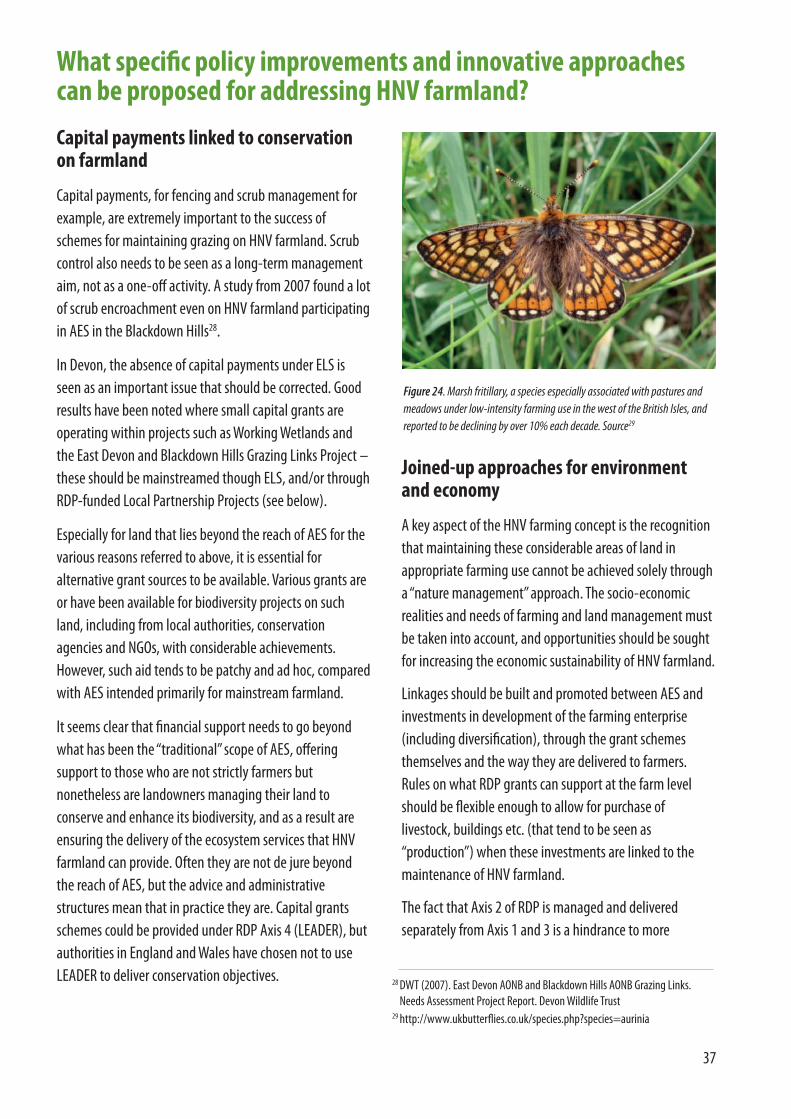
37
Capital payments linked to conservationon farmland
Capital payments, for fencing and scrub management forexample, are extremely important to the success ofschemes for maintaining grazing on HNV farmland. Scrubcontrol also needs to be seen as a long-term managementaim, not as a one-off activity. A study from 2007 found a lotof scrub encroachment even on HNV farmland participatingin AES in the Blackdown Hills28.
In Devon, the absence of capital payments under ELS isseen as an important issue that should be corrected. Goodresults have been noted where small capital grants areoperating within projects such as Working Wetlands andthe East Devon and Blackdown Hills Grazing Links Project –these should be mainstreamed though ELS, and/or throughRDP-funded Local Partnership Projects (see below).
Especially for land that lies beyond the reach of AES for thevarious reasons referred to above, it is essential foralternative grant sources to be available. Various grants areor have been available for biodiversity projects on suchland, including from local authorities, conservationagencies and NGOs, with considerable achievements.However, such aid tends to be patchy and ad hoc, comparedwith AES intended primarily for mainstream farmland.
It seems clear that financial support needs to go beyondwhat has been the “traditional” scope of AES, offeringsupport to those who are not strictly farmers butnonetheless are landowners managing their land toconserve and enhance its biodiversity, and as a result areensuring the delivery of the ecosystem services that HNVfarmland can provide. Often they are not de jure beyondthe reach of AES, but the advice and administrativestructures mean that in practice they are. Capital grantsschemes could be provided under RDP Axis 4 (LEADER), butauthorities in England and Wales have chosen not to useLEADER to deliver conservation objectives.
Joined-up approaches for environmentand economy
A key aspect of the HNV farming concept is the recognitionthat maintaining these considerable areas of land inappropriate farming use cannot be achieved solely througha “nature management” approach. The socio-economicrealities and needs of farming and land management mustbe taken into account, and opportunities should be soughtfor increasing the economic sustainability of HNV farmland.
Linkages should be built and promoted between AES andinvestments in development of the farming enterprise(including diversification), through the grant schemesthemselves and the way they are delivered to farmers.Rules on what RDP grants can support at the farm levelshould be flexible enough to allow for purchase oflivestock, buildings etc. (that tend to be seen as“production”) when these investments are linked to themaintenance of HNV farmland.
The fact that Axis 2 of RDP is managed and deliveredseparately from Axis 1 and 3 is a hindrance to more
What specific policy improvements and innovative approachescan be proposed for addressing HNV farmland?
Figure 24. Marsh fritillary, a species especially associated with pastures andmeadows under low-intensity farming use in the west of the British Isles, andreported to be declining by over 10% each decade. Source29
28 DWT (2007). East Devon AONB and Blackdown Hills AONB Grazing Links.Needs Assessment Project Report. Devon Wildlife Trust
29 http://www.ukbutterflies.co.uk/species.php?species=aurinia
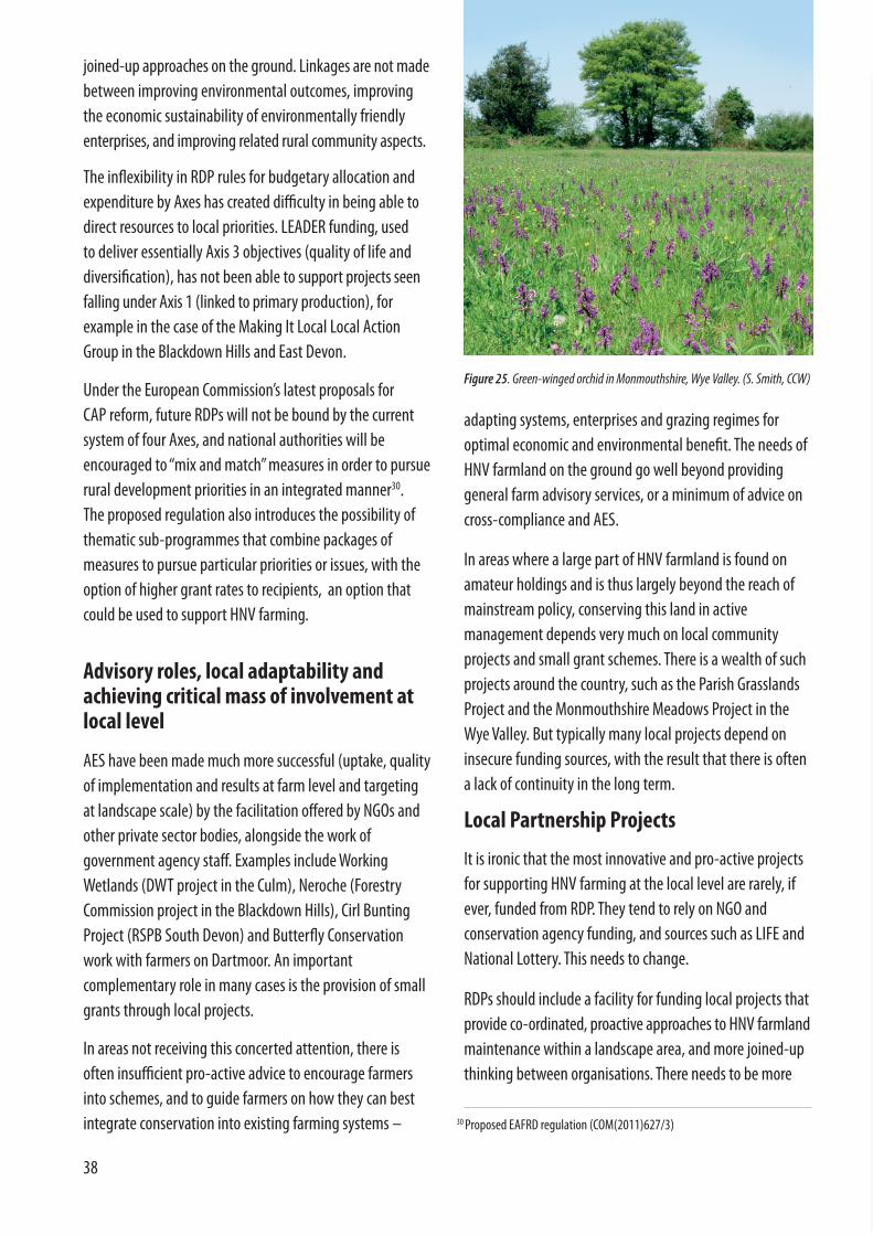
38
adapting systems, enterprises and grazing regimes foroptimal economic and environmental benefit. The needs ofHNV farmland on the ground go well beyond providinggeneral farm advisory services, or a minimum of advice oncross-compliance and AES.
In areas where a large part of HNV farmland is found onamateur holdings and is thus largely beyond the reach ofmainstream policy, conserving this land in activemanagement depends very much on local communityprojects and small grant schemes. There is a wealth of suchprojects around the country, such as the Parish GrasslandsProject and the Monmouthshire Meadows Project in theWye Valley. But typically many local projects depend oninsecure funding sources, with the result that there is oftena lack of continuity in the long term.
Local Partnership Projects
It is ironic that the most innovative and pro-active projectsfor supporting HNV farming at the local level are rarely, ifever, funded from RDP. They tend to rely on NGO andconservation agency funding, and sources such as LIFE andNational Lottery. This needs to change.
RDPs should include a facility for funding local projects thatprovide co-ordinated, proactive approaches to HNV farmlandmaintenance within a landscape area, and more joined-upthinking between organisations. There needs to be more
joined-up approaches on the ground. Linkages are not madebetween improving environmental outcomes, improvingthe economic sustainability of environmentally friendlyenterprises, and improving related rural community aspects.
The inflexibility in RDP rules for budgetary allocation andexpenditure by Axes has created difficulty in being able todirect resources to local priorities. LEADER funding, used to deliver essentially Axis 3 objectives (quality of life anddiversification), has not been able to support projects seenfalling under Axis 1 (linked to primary production), for example in the case of the Making It Local Local ActionGroup in the Blackdown Hills and East Devon.
Under the European Commission’s latest proposals for CAP reform, future RDPs will not be bound by the currentsystem of four Axes, and national authorities will beencouraged to “mix and match” measures in order to pursuerural development priorities in an integrated manner30. The proposed regulation also introduces the possibility ofthematic sub-programmes that combine packages ofmeasures to pursue particular priorities or issues, with theoption of higher grant rates to recipients, an option thatcould be used to support HNV farming.
Advisory roles, local adaptability andachieving critical mass of involvement atlocal level
AES have been made much more successful (uptake, qualityof implementation and results at farm level and targetingat landscape scale) by the facilitation offered by NGOs andother private sector bodies, alongside the work ofgovernment agency staff. Examples include WorkingWetlands (DWT project in the Culm), Neroche (ForestryCommission project in the Blackdown Hills), Cirl BuntingProject (RSPB South Devon) and Butterfly Conservationwork with farmers on Dartmoor. An importantcomplementary role in many cases is the provision of smallgrants through local projects.
In areas not receiving this concerted attention, there isoften insufficient pro-active advice to encourage farmersinto schemes, and to guide farmers on how they can bestintegrate conservation into existing farming systems –
Figure 25. Green-winged orchid in Monmouthshire, Wye Valley. (S. Smith, CCW)
30 Proposed EAFRD regulation (COM(2011)627/3)
39
BOX 4
Under the Wye Valley HNV farming project, a detailedproposal was prepared showing how a Local PartnershipProject (LPP) could work, drawing on the experience ofseveral grassland and grazing projects in the AONBinvolving local communities and landowners31.
Species-rich grasslands are among the most importanthabitats of the Wye Valley AONB, but many of these semi-natural pastures and meadows have been lost throughploughing, fertilisation and reseeding, or throughabandonment. A number of projects, such as the ParishGrasslands Project and the Monmouthshire MeadowsProject, have sought to protect, maintain and restore semi-natural grasslands, with varying degrees of input andsuccess. As in other parts of the country, these initiativestend to be quite localized and to suffer from a lack ofcontinuity, especially because funding is ad hoc.
The starting point for a new, long-term project addressingHNV grasslands across the AONB would be to establish atarget area (as intended under the EU’s HNV farmlandindicator). From the analysis of available data, the totalarea of HNV grassland, including semi-natural grasslandand semi-improved grassland which forms part of thematrix of grassland habitats, currently lies in a rangebetween 2,315ha and 5,750ha (i.e. 7-14% of the AONB). Itis estimated that existing grassland projects coverapproximately 10-15% of the total HNV grassland area, so atarget area of 2,000ha, for example, would be a majoradvance on current achievements.
The overall aim of the LPP would be to improve theenvironmental and economic sustainability of HNVgrasslands in the AONB, through appropriate use forgrazing and/or hay cutting. The LPP would have threeoverarching objectives:
• To conserve and enhance grassland habitats and species,and associated landscape features.
• To support and promote extensive farming systems,
specifically low-input cattle and sheep grazing and haymeadow management, and the marketing of the high-quality products of these systems.
• To engage local communities with grasslands andgrazing (e.g. through education, training andvolunteering) and improve the contribution of grasslandsites and extensive farming systems to the localeconomy (e.g. encouraging the local production andconsumption of beef and lamb, using local contractors,and promoting traditional skills).
The LPP would aim to deliver:
• An increase in the area of HNV grassland under positivemanagement in the AONB, including a number ofrestored sites
• Two local grassland groups sustained and three newgroups created (e.g. Woolhope, Ross-on-Wye, Forest of Dean).
• More cattle and sheep farms involved with extensivegrazing and hay meadow management, with profitablebusinesses
• More non-farming businesses linked to HNV grasslandand grazing (e.g. contractors, butchers, retailers etc.)
• Improved landowner and farmer awareness of HNVgrasslands and extensive grazing systems
• More local people involved with HNV grasslands andgrazing in a range of different ways
• More resilient and sustainable grassland sites andsystems of management (a result of the above, andinvestment in infrastructure, markets, education etc)
• Grants to farmers and other landowners from projectfunds, especially for capital items and actions prioritisedby the project that are not covered by AES and otherexisting RDP grants.
Wye Valley proposal for a Local Partnership Project on HNV grasslands
31 http://www.efncp.org/projects/united-kingdom/wye-valley/
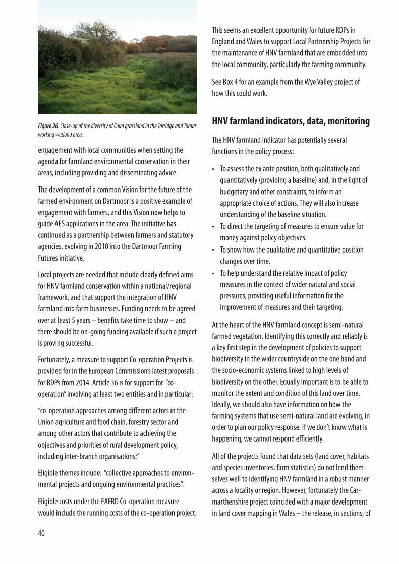
40
engagement with local communities when setting theagenda for farmland environmental conservation in theirareas, including providing and disseminating advice.
The development of a common Vision for the future of thefarmed environment on Dartmoor is a positive example ofengagement with farmers, and this Vision now helps toguide AES applications in the area. The initiative hascontinued as a partnership between farmers and statutoryagencies, evolving in 2010 into the Dartmoor FarmingFutures initiative.
Local projects are needed that include clearly defined aimsfor HNV farmland conservation within a national/regionalframework, and that support the integration of HNVfarmland into farm businesses. Funding needs to be agreedover at least 5 years – benefits take time to show – andthere should be on-going funding available if such a projectis proving successful.
Fortunately, a measure to support Co-operation Projects isprovided for in the European Commission’s latest proposalsfor RDPs from 2014. Article 36 is for support for “co-operation” involving at least two entities and in particular:
“co-operation approaches among different actors in theUnion agriculture and food chain, forestry sector andamong other actors that contribute to achieving theobjectives and priorities of rural development policy,including inter-branch organisations;”
Eligible themes include: “collective approaches to environ-mental projects and ongoing environmental practices”.
Eligible costs under the EAFRD Co-operation measurewould include the running costs of the co-operation project.
Figure 26. Close-up of the diversity of Culm grassland in the Torridge and Tamarworking wetland area.
This seems an excellent opportunity for future RDPs inEngland and Wales to support Local Partnership Projects forthe maintenance of HNV farmland that are embedded intothe local community, particularly the farming community.
See Box 4 for an example from the Wye Valley project ofhow this could work.
HNV farmland indicators, data, monitoring
The HNV farmland indicator has potentially severalfunctions in the policy process:
• To assess the ex ante position, both qualitatively andquantitatively (providing a baseline) and, in the light ofbudgetary and other constraints, to inform anappropriate choice of actions. They will also increaseunderstanding of the baseline situation.
• To direct the targeting of measures to ensure value formoney against policy objectives.
• To show how the qualitative and quantitative positionchanges over time.
• To help understand the relative impact of policymeasures in the context of wider natural and socialpressures, providing useful information for theimprovement of measures and their targeting.
At the heart of the HNV farmland concept is semi-naturalfarmed vegetation. Identifying this correctly and reliably isa key first step in the development of policies to supportbiodiversity in the wider countryside on the one hand andthe socio-economic systems linked to high levels ofbiodiversity on the other. Equally important is to be able tomonitor the extent and condition of this land over time.Ideally, we should also have information on how thefarming systems that use semi-natural land are evolving, inorder to plan our policy response. If we don’t know what ishappening, we cannot respond efficiently.
All of the projects found that data sets (land cover, habitatsand species inventories, farm statistics) do not lend them-selves well to identifying HNV farmland in a robust manneracross a locality or region. However, fortunately the Car-marthenshire project coincided with a major developmentin land cover mapping in Wales – the release, in sections, of

41
the first draft of the Habitat Inventory Map of Wales (HIW).
Of all the data sets examined, only the HIW appears to offera way forward for both identifying and monitoring theextent of HNV in the study area and probably across Wales.It can do this on a field by field scale without the necessityfor field by field survey. Although the system is still indevelopment, it clearly has this potential.
The HIW is considered to be about 75-80% accurate in termsof identifying habitats (CCW personal communication). Inthis study it was found that the HIW identified 84% of theHNV habitat in six of the eight sample areas. It did notidentify any land as being HNV that was not. While it makeserrors in classifying some HNV habitats, it is very probablethat this level of accuracy will improve as HIW is developed.
The latest UK Land Cover Map (LCM2007) is potentially veryrelevant. It has been derived from satellite images anddigital cartography and gives land cover information for theentire UK, based on BAP Broad Habitats, at a considerablyhigher level of accuracy than LCM2000. UnfortunatelyLCM2007 was not available at the time of the projectspresented here. The sample survey of the CountrysideSurvey (CS) is also of considerable interest, and was themodel used in Germany for establishing its HNV farmlandmonitoring system.
Follow-up work to this project could fruitfully investigatethe ability of LCM2007 to identify semi-natural farmland,and also the possibility of using CS sample plots as a basisfor qualitative monitoring in parallel with HIW-type remotesensing for quantitative monitoring. In principle, there is noreason why the sample survey approach should not beextended from biological monitoring to the monitoring offarming systems and practices, thus providing a completepicture of farming tendencies on HNV farmland.
To complete the toolkit, the LPIS/IACS system should beadapted to incorporate HNV farmland criteria, by recordingparcels and landscape features identified as HNV through acombination of the HIW approach and informationsupplied by the farmer, with the help of field survey wherenecessary. In this way, the same data and administrationsystems can be used for accurate monitoring of HNVfarmland, and for reliable targeting of policy instruments.
Conclusions and ways forward
The concept of High Nature Value (HNV) farming developedin the early 1990s from a growing recognition that theconservation of biodiversity in Europe depends on thecontinuation of low-intensity farming systems using semi-natural vegetation across significant areas of countryside.Although the term has not been widely adopted in the UK,the approach is entirely in tune with the increasingrecognition that effective biodiversity strategies cannot bebuilt solely on the protection of priority habitats and primesites. There is growing understanding of the need forlandscape-scale conservation, and for robust assessmentand monitoring of ecosystems and their services.
HNV farmland is not just an indicator for RDPs required bythe EU; it is part of a strategic approach to pursuingbiodiversity objectives through farming and ruraldevelopment policies. This means recognising that certaintypes of farmland and farming landscapes are of particularvalue for biodiversity, and face particular economic andpractical challenges for their maintenance. This landincludes existing designations such as SSSI and countysites, but also extends far beyond them.
In England and Wales, work to clarify HNV farming and putinto practice effective support strategies has movedforward slowly. But in fact many of the necessary tools andpolicy measures are already in place, and quite a lot isbeing done already to maintain HNV farmland, althoughwithout using this term.
However, it is equally clear that neither country can claimto be fulfilling the requirements of EU policy as it refers toHNV farming. There has been no comprehensive assess-ment of what is HNV farmland, or what is happening to it,and very little dialogue has been promoted on the subject.
Fully implementing a strategy for HNV farming does notimply a wholesale reshaping of policies for farmlandbiodiversity. But it does imply some refocusing andadaptation, in terms of key measures such as AES, and toolssuch as Countryside Survey and IACS. It also implies arational approach to biodiversity conservation onfarmland – targeting support measures on landscapes that
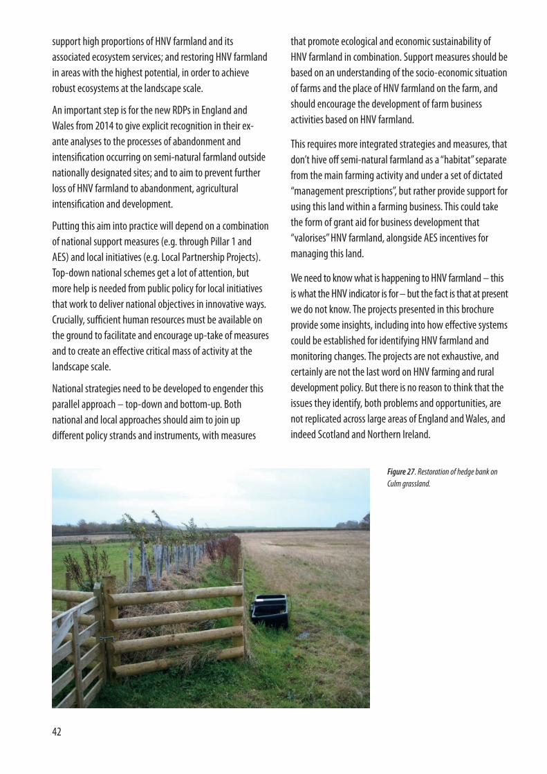
42
that promote ecological and economic sustainability ofHNV farmland in combination. Support measures should bebased on an understanding of the socio-economic situationof farms and the place of HNV farmland on the farm, andshould encourage the development of farm businessactivities based on HNV farmland.
This requires more integrated strategies and measures, thatdon’t hive off semi-natural farmland as a “habitat” separatefrom the main farming activity and under a set of dictated“management prescriptions”, but rather provide support forusing this land within a farming business. This could takethe form of grant aid for business development that“valorises” HNV farmland, alongside AES incentives formanaging this land.
We need to know what is happening to HNV farmland – thisis what the HNV indicator is for – but the fact is that at presentwe do not know. The projects presented in this brochureprovide some insights, including into how effective systemscould be established for identifying HNV farmland andmonitoring changes. The projects are not exhaustive, andcertainly are not the last word on HNV farming and rural development policy. But there is no reason to think that theissues they identify, both problems and opportunities, arenot replicated across large areas of England and Wales, andindeed Scotland and Northern Ireland.
support high proportions of HNV farmland and itsassociated ecosystem services; and restoring HNV farmlandin areas with the highest potential, in order to achieverobust ecosystems at the landscape scale.
An important step is for the new RDPs in England andWales from 2014 to give explicit recognition in their ex-ante analyses to the processes of abandonment andintensification occurring on semi-natural farmland outsidenationally designated sites; and to aim to prevent furtherloss of HNV farmland to abandonment, agriculturalintensification and development.
Putting this aim into practice will depend on a combinationof national support measures (e.g. through Pillar 1 andAES) and local initiatives (e.g. Local Partnership Projects).Top-down national schemes get a lot of attention, butmore help is needed from public policy for local initiativesthat work to deliver national objectives in innovative ways.Crucially, sufficient human resources must be available onthe ground to facilitate and encourage up-take of measuresand to create an effective critical mass of activity at thelandscape scale.
National strategies need to be developed to engender thisparallel approach – top-down and bottom-up. Bothnational and local approaches should aim to join updifferent policy strands and instruments, with measures
Figure 27. Restoration of hedge bank onCulm grassland.

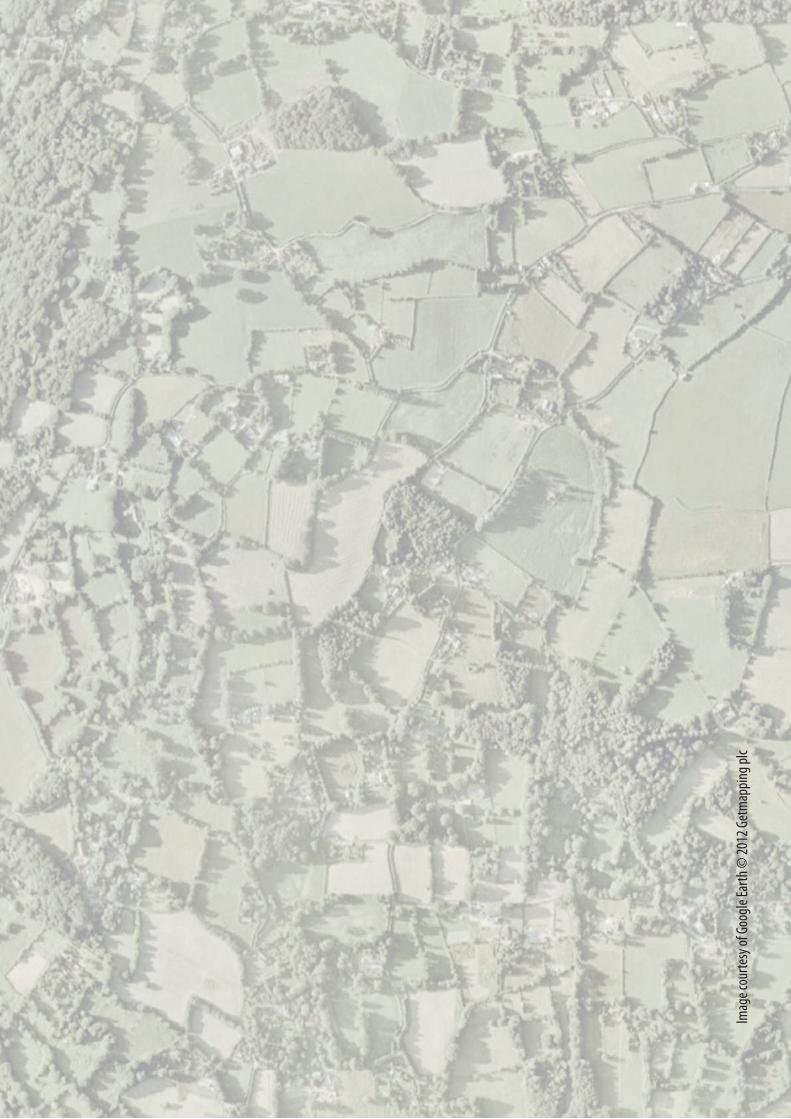
Imag
e cou
rtesy
of G
oogl
e Ear
th ©
2012
Get
map
ping
plc
Related Documents


