Top Banner
History of the Development of Geodetic Datums in the United States Vermont Society of Land Surveyors Colchester September 5, 2019 Dave Doyle NGS, Chief Geodetic Surveyor (Retired) [email protected] 301-704-9578
56

History of the Development of Geodetic Datums in the ...€¦ · History of the Development of Geodetic Datums in the United States Vermont Society of Land Surveyors Colchester September

Oct 28, 2019

Download

Documents

dariahiddleston
Welcome message from author
This document is posted to help you gain knowledge. Please leave a comment to let me know what you think about it! Share it to your friends and learn new things together.
Transcript
Page 1: History of the Development of Geodetic Datums in the ...€¦ · History of the Development of Geodetic Datums in the United States Vermont Society of Land Surveyors Colchester September

History of the Development of Geodetic Datums in the United States

Vermont Society of Land Surveyors Colchester

September 5, 2019

Dave Doyle NGS, Chief Geodetic Surveyor (Retired)

[email protected] 301-704-9578

Page 2: History of the Development of Geodetic Datums in the ...€¦ · History of the Development of Geodetic Datums in the United States Vermont Society of Land Surveyors Colchester September
Page 3: History of the Development of Geodetic Datums in the ...€¦ · History of the Development of Geodetic Datums in the United States Vermont Society of Land Surveyors Colchester September
Page 4: History of the Development of Geodetic Datums in the ...€¦ · History of the Development of Geodetic Datums in the United States Vermont Society of Land Surveyors Colchester September

24-Inch Troughton & Simms Theodolite in Hassler’s Camp Weight approx. 1000lbs required 10 men to move

Page 5: History of the Development of Geodetic Datums in the ...€¦ · History of the Development of Geodetic Datums in the United States Vermont Society of Land Surveyors Colchester September

Everest’s Theodolite Similar to Hassler’s

Page 6: History of the Development of Geodetic Datums in the ...€¦ · History of the Development of Geodetic Datums in the United States Vermont Society of Land Surveyors Colchester September

1807 - Survey of the Coast

What’s In a Name?

1970 - National Ocean Service National Geodetic Survey

1878 - US Coast and Geodetic Survey

1836 - Coast Survey

Page 7: History of the Development of Geodetic Datums in the ...€¦ · History of the Development of Geodetic Datums in the United States Vermont Society of Land Surveyors Colchester September
Page 8: History of the Development of Geodetic Datums in the ...€¦ · History of the Development of Geodetic Datums in the United States Vermont Society of Land Surveyors Colchester September

TRANSCONTINENTALARCOFTRIANGULATION

1872-1898

Page 9: History of the Development of Geodetic Datums in the ...€¦ · History of the Development of Geodetic Datums in the United States Vermont Society of Land Surveyors Colchester September

August28toSeptember22,1885

Page 10: History of the Development of Geodetic Datums in the ...€¦ · History of the Development of Geodetic Datums in the United States Vermont Society of Land Surveyors Colchester September
Page 11: History of the Development of Geodetic Datums in the ...€¦ · History of the Development of Geodetic Datums in the United States Vermont Society of Land Surveyors Colchester September

Triangulation Schemes

Page 12: History of the Development of Geodetic Datums in the ...€¦ · History of the Development of Geodetic Datums in the United States Vermont Society of Land Surveyors Colchester September

JASPER BILBY

Page 13: History of the Development of Geodetic Datums in the ...€¦ · History of the Development of Geodetic Datums in the United States Vermont Society of Land Surveyors Colchester September

Tower Construction

Page 14: History of the Development of Geodetic Datums in the ...€¦ · History of the Development of Geodetic Datums in the United States Vermont Society of Land Surveyors Colchester September
Page 15: History of the Development of Geodetic Datums in the ...€¦ · History of the Development of Geodetic Datums in the United States Vermont Society of Land Surveyors Colchester September
Page 16: History of the Development of Geodetic Datums in the ...€¦ · History of the Development of Geodetic Datums in the United States Vermont Society of Land Surveyors Colchester September

USC&GS GEODETIC NOMADS

Page 17: History of the Development of Geodetic Datums in the ...€¦ · History of the Development of Geodetic Datums in the United States Vermont Society of Land Surveyors Colchester September

USC&GS/NGS Marker Types

Page 18: History of the Development of Geodetic Datums in the ...€¦ · History of the Development of Geodetic Datums in the United States Vermont Society of Land Surveyors Colchester September

Cutting Edge Surveying Technology circa 1890

Page 19: History of the Development of Geodetic Datums in the ...€¦ · History of the Development of Geodetic Datums in the United States Vermont Society of Land Surveyors Colchester September

Salina, KS Baseline Measurement – 1896 6.5 km/4.1 mi required about 5 weeks Precision ~ 8 mm/0.03 ft (1:721,600)

Page 20: History of the Development of Geodetic Datums in the ...€¦ · History of the Development of Geodetic Datums in the United States Vermont Society of Land Surveyors Colchester September

Advances in distance measurement technology Early 1900s

Page 21: History of the Development of Geodetic Datums in the ...€¦ · History of the Development of Geodetic Datums in the United States Vermont Society of Land Surveyors Colchester September

Electronic technology 1950s - 1970

Page 22: History of the Development of Geodetic Datums in the ...€¦ · History of the Development of Geodetic Datums in the United States Vermont Society of Land Surveyors Colchester September

A Game Changer

Page 23: History of the Development of Geodetic Datums in the ...€¦ · History of the Development of Geodetic Datums in the United States Vermont Society of Land Surveyors Colchester September
Page 24: History of the Development of Geodetic Datums in the ...€¦ · History of the Development of Geodetic Datums in the United States Vermont Society of Land Surveyors Colchester September
Page 25: History of the Development of Geodetic Datums in the ...€¦ · History of the Development of Geodetic Datums in the United States Vermont Society of Land Surveyors Colchester September

GLOBAL SATELLITE TRIANGULATION NETWORK (BC-4)

1964-1973

Page 26: History of the Development of Geodetic Datums in the ...€¦ · History of the Development of Geodetic Datums in the United States Vermont Society of Land Surveyors Colchester September

ECHO/PAGEOS BALLOON SATELLITE TYPE PHOTOGRAPHED BY BC-4

Page 27: History of the Development of Geodetic Datums in the ...€¦ · History of the Development of Geodetic Datums in the United States Vermont Society of Land Surveyors Colchester September

BC-4 CAMERA PHOTOGRAPH PAGEOS SATELLITE AGAINST THE STAR BACKGROUND

Page 28: History of the Development of Geodetic Datums in the ...€¦ · History of the Development of Geodetic Datums in the United States Vermont Society of Land Surveyors Colchester September

U.S. NAVY NAVSAT TRANSIT SATELLITE “Doppler” Prototype Launched (Failed) 1959

First Successful Test 1960 Operational 1964 (Military)

Civilian Access 1967

Page 29: History of the Development of Geodetic Datums in the ...€¦ · History of the Development of Geodetic Datums in the United States Vermont Society of Land Surveyors Colchester September

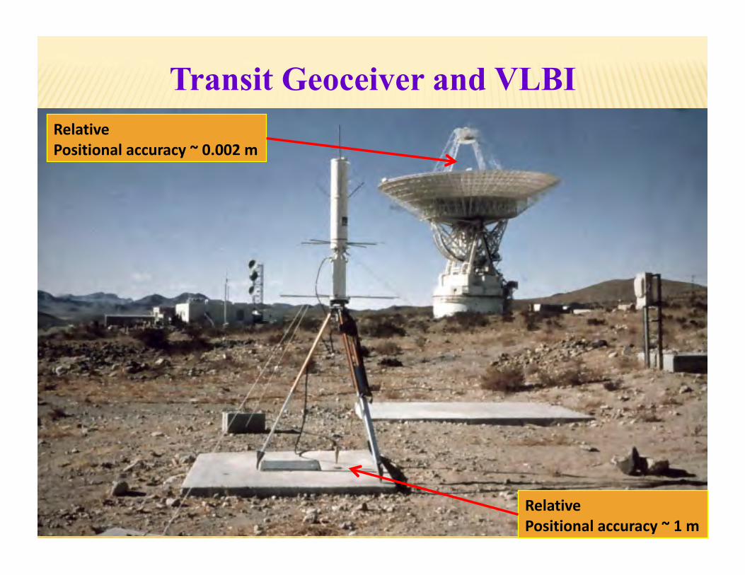
Transit Geoceiver and VLBI

RelativePositionalaccuracy~1m

RelativePositionalaccuracy~0.002m

Page 30: History of the Development of Geodetic Datums in the ...€¦ · History of the Development of Geodetic Datums in the United States Vermont Society of Land Surveyors Colchester September

30

b

a

a = Semi major axis b = Semi minor axis f = a-b = Flattening a

The Ellipsoid Mathematical Model of the Earth

Page 31: History of the Development of Geodetic Datums in the ...€¦ · History of the Development of Geodetic Datums in the United States Vermont Society of Land Surveyors Colchester September

GRS80-WGS84 CLARKE 1866

GEOID

Earth Mass Center

Approximately 236 meters

The Geoid and Two Ellipsoids

Page 32: History of the Development of Geodetic Datums in the ...€¦ · History of the Development of Geodetic Datums in the United States Vermont Society of Land Surveyors Colchester September

CLARKE 1866 a = 6,378,206.4 m 1/f = 294.97869821

(1880 – 1986)

GEODETIC REFERENCE SYSTEM 1980 - (GRS 80) a = 6,378,137 m 1/f = 298.257222101

(1986 – Present) (International Union of Geodesy and Geophysics Standard)

WORLD GEODETIC SYSTEM 1984 - (WGS 84) a = 6,378,137 m 1/f = 298.257223563

Defined by U.S. Defense Mapping Agency (DMA) for GPS

BESSEL 1841 a = 6,377,397.155 m 1/f = 299.1528128

(1848 – 1880)

Ellipsoids Used in the United States

Page 33: History of the Development of Geodetic Datums in the ...€¦ · History of the Development of Geodetic Datums in the United States Vermont Society of Land Surveyors Colchester September

!  February 22, 1978 - 1st NAVSTAR Satellite launched !  July 17, 1995 - System Fully Operational !  May 1, 2000 - Selective Availability turned off !  September 26, 2005 - L2C band added !  May 28, 2010 - First L5 Satellite added !  December 23, 2018 – First Block III scheduled for launch !  2020? - 10-50 cm real-time accuracy! Maybe Sooner!

NO GROUND CONTROL!

Global Positioning System

GPS Block I GPS Block II GPS Block III

Page 34: History of the Development of Geodetic Datums in the ...€¦ · History of the Development of Geodetic Datums in the United States Vermont Society of Land Surveyors Colchester September

Macrometer V-1000 GPS Receiver 1982 ~ appox. $250,000 each

Page 35: History of the Development of Geodetic Datums in the ...€¦ · History of the Development of Geodetic Datums in the United States Vermont Society of Land Surveyors Colchester September

Where are we now??

Page 36: History of the Development of Geodetic Datums in the ...€¦ · History of the Development of Geodetic Datums in the United States Vermont Society of Land Surveyors Colchester September

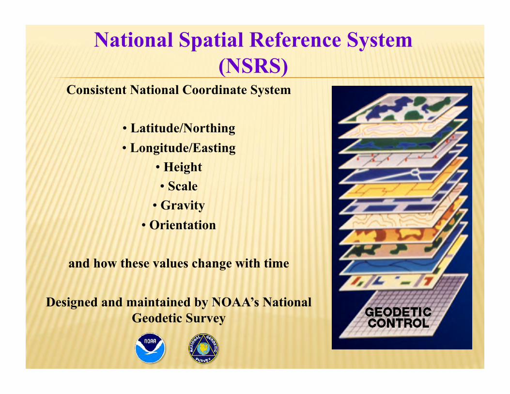
National Spatial Reference System (NSRS)

Consistent National Coordinate System

•  Latitude/Northing •  Longitude/Easting

•  Height •  Scale

•  Gravity •  Orientation

and how these values change with time

Designed and maintained by NOAA’s National Geodetic Survey

Page 37: History of the Development of Geodetic Datums in the ...€¦ · History of the Development of Geodetic Datums in the United States Vermont Society of Land Surveyors Colchester September

NSRS Control Components

Page 38: History of the Development of Geodetic Datums in the ...€¦ · History of the Development of Geodetic Datums in the United States Vermont Society of Land Surveyors Colchester September

NSRS Control Components

Page 39: History of the Development of Geodetic Datums in the ...€¦ · History of the Development of Geodetic Datums in the United States Vermont Society of Land Surveyors Colchester September

NSRS Control Components

Page 40: History of the Development of Geodetic Datums in the ...€¦ · History of the Development of Geodetic Datums in the United States Vermont Society of Land Surveyors Colchester September

Not “GPSABLE”

Poor Station Accessibility

Irregularly Spaced

Positional Accuracy

EARLY NAD 83 NETWORK PROBLEMS

Page 41: History of the Development of Geodetic Datums in the ...€¦ · History of the Development of Geodetic Datums in the United States Vermont Society of Land Surveyors Colchester September

  “GPSABLE”   Clear Horizons for Satellite Signal Acquisition

  EASY ACCESSIBILITY   Few Special Vehicle or Property Entrance Requirements

  REGULARLY SPACED   Always within 20-100 Km

  HIGH ACCURACY   A-Order (5 mm + 1:10,000,000) (3 5.5 hr sessions)

  B-Order (8mm + 1:1,000,000) (2 5.5 hr sessions)

  AVERAGE NAD 83 (1986) POSITIONAL CHANGE   0.40 m / 1.3 ft

HIGH PRECISION GPS NETWORK (HPGN) HIGH ACCURACY REFERENCE NETWORK (HARN)

1989 - 1997

Page 42: History of the Development of Geodetic Datums in the ...€¦ · History of the Development of Geodetic Datums in the United States Vermont Society of Land Surveyors Colchester September

  More State Partnerships

  Reduce distortions in early HARNS   (3-10 cm)

  Ensure Connections to CORS

  Improve ellipsoid height accuracy   (Not worse than 2 cm)

  No adjustment of old triangulation or GPS if FBN/CBN results were less than 5 cm

FEDERAL & COOPERATIVE BASE NETWORKS (FBN/CBN) 1997 -2004

Page 43: History of the Development of Geodetic Datums in the ...€¦ · History of the Development of Geodetic Datums in the United States Vermont Society of Land Surveyors Colchester September

NAD 83 (2007)

Page 44: History of the Development of Geodetic Datums in the ...€¦ · History of the Development of Geodetic Datums in the United States Vermont Society of Land Surveyors Colchester September

During 2009-2010 NGS completes multi-year solution of 2000+ CORS

Data from January 1994 to April 2011

 Replaced relative GPS antenna calibrations with absolute calibrations

 More consistent national set of coordinates Maine to Guam

 National adjustment of 81,000+ passive stations to fit new CORS coordinates

Average shift from NAD 83 (2007) to NAD 83 (2011)

NAD 83 (2011)

Page 45: History of the Development of Geodetic Datums in the ...€¦ · History of the Development of Geodetic Datums in the United States Vermont Society of Land Surveyors Colchester September

National Geodetic Vertical Datum 1929 (NGVD 29)

Original name: “General Adjustment of 1929” Changed to Sea Level Datum of 1929 in 1940s

Changed to NGVD 29 in 1973

“Zero height” held fixed at 26 tide gauges Not all on the same tidal datum epoch (~ 19 yrs)

Did not account for Local Mean Sea Level variations from the geoid

Thus, not truly a “geoid based” datum

HISTORY OF VERTICAL DATUM IN THE U.S.

Page 46: History of the Development of Geodetic Datums in the ...€¦ · History of the Development of Geodetic Datums in the United States Vermont Society of Land Surveyors Colchester September

The National Geodetic Vertical Datum of 1929 is

referenced to 26 tide gauges in the US and

Canada

Page 47: History of the Development of Geodetic Datums in the ...€¦ · History of the Development of Geodetic Datums in the United States Vermont Society of Land Surveyors Colchester September

NORTH AMERICAN VERTICAL DATUM OF 1988

Use of one fixed height removed local sea level variation problem of NGVD 29

Use of one fixed height did open the possibility of unconstrained cross-continent error build up

The H=0 surface of NAVD 88 was supposed to be parallel to the geoid…(close again)

HISTORY OF VERTICAL DATUM IN THE U.S.

Page 48: History of the Development of Geodetic Datums in the ...€¦ · History of the Development of Geodetic Datums in the United States Vermont Society of Land Surveyors Colchester September

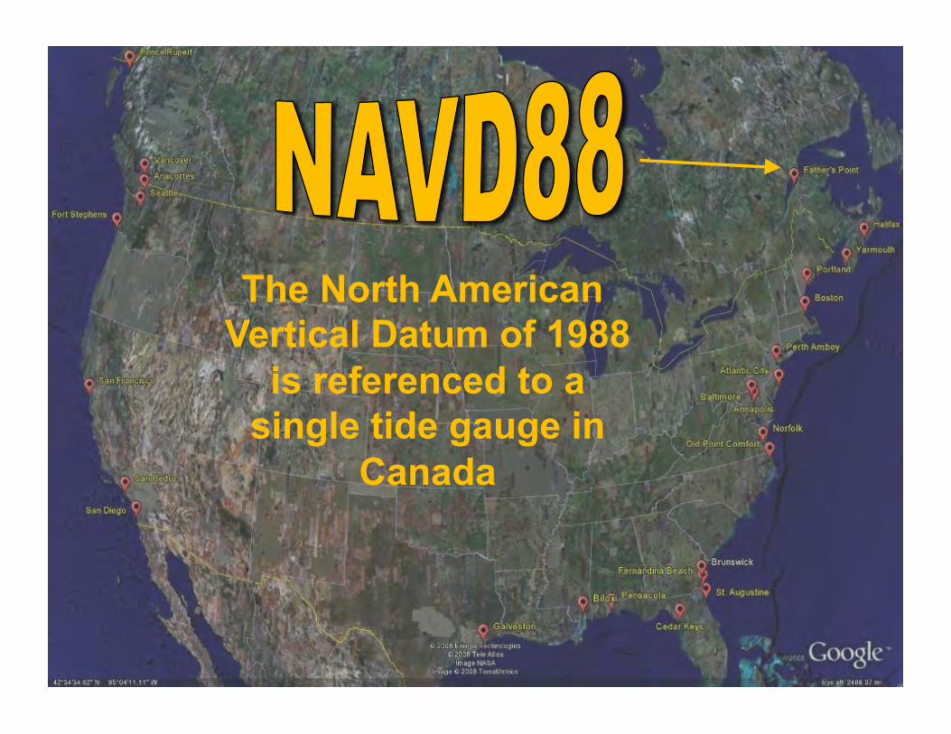
The North American Vertical Datum of 1988

is referenced to a single tide gauge in

Canada

Page 49: History of the Development of Geodetic Datums in the ...€¦ · History of the Development of Geodetic Datums in the United States Vermont Society of Land Surveyors Colchester September

H = Orthometric Height (NAVD 88)

H = h – N

h = Ellipsoid Height (NAD 83 (2011))

N = Geoid Height (GEOID12B)

H h

Ellipsoid GRS80

N

Geoid “Average Mean Sea Level”

or NAVD 88 Surface

Geoid Model

ELLIPSOID – GEOID RELATIONSHIP

Page 50: History of the Development of Geodetic Datums in the ...€¦ · History of the Development of Geodetic Datums in the United States Vermont Society of Land Surveyors Colchester September

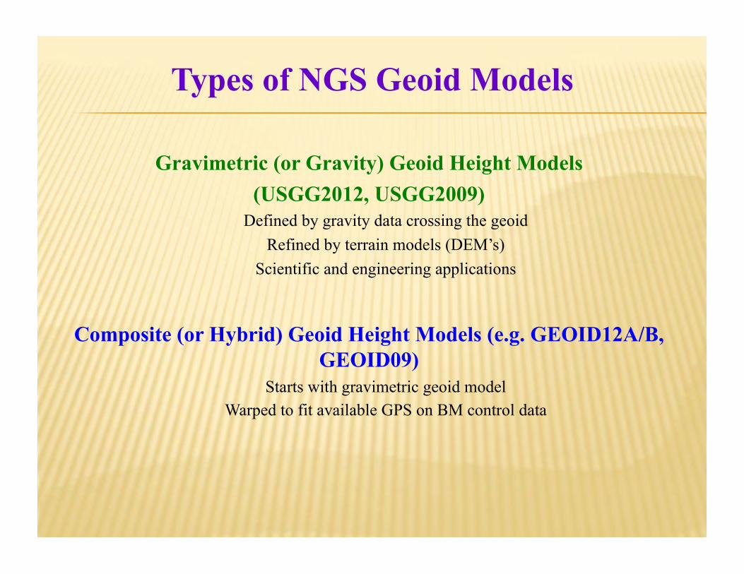
Gravimetric (or Gravity) Geoid Height Models (USGG2012, USGG2009)

Defined by gravity data crossing the geoid Refined by terrain models (DEM’s)

Scientific and engineering applications

Composite (or Hybrid) Geoid Height Models (e.g. GEOID12A/B, GEOID09)

Starts with gravimetric geoid model Warped to fit available GPS on BM control data

Types of NGS Geoid Models

Page 51: History of the Development of Geodetic Datums in the ...€¦ · History of the Development of Geodetic Datums in the United States Vermont Society of Land Surveyors Colchester September

GEOID 12A/B ACCURACY http://www.ngs.noaa.gov/web/surveys/GPSonBM/maps/GEOID12A_Accuracy.png

Page 52: History of the Development of Geodetic Datums in the ...€¦ · History of the Development of Geodetic Datums in the United States Vermont Society of Land Surveyors Colchester September

Metadata

Coordinates and heights without appropriate metadata have the same value as a boundary

line in Google Earth

Just A Wild A** Guess

Page 53: History of the Development of Geodetic Datums in the ...€¦ · History of the Development of Geodetic Datums in the United States Vermont Society of Land Surveyors Colchester September

  DATUMS and REALIZATIONS

  NAD 27, NAD 83(1986), NAD83 (199X),   NAD 83 (2007), NAD 83 (2011), Epoch xxxx.xx

  NGVD29, NAVD88

  UNITS   Meters, U.S. Survey Feet, International Feet

ACCURACY   A-Order, B-Order, 1st, 2nd, 3rd, 3cm, Scaled

METADATA Data About Data

Page 54: History of the Development of Geodetic Datums in the ...€¦ · History of the Development of Geodetic Datums in the United States Vermont Society of Land Surveyors Colchester September
Page 55: History of the Development of Geodetic Datums in the ...€¦ · History of the Development of Geodetic Datums in the United States Vermont Society of Land Surveyors Colchester September

National Geodetic Survey, TV0474 *********************************************************************** TV0474 DESIGNATION - SUGAR TV0474 PID - TV0474 TV0474 STATE/COUNTY- VQ/ST JOHN TV0474 COUNTRY - US TV0474 USGS QUAD - WESTERN ST JOHN (1982) TV0474 TV0474 *CURRENT SURVEY CONTROL TV0474 ______________________________________________________________________ TV0474* NAD 83(1997) POSITION- 18 21 05.01515(N) 064 46 38.52774(W) ADJUSTED TV0474 TV0474 HORZ ORDER - THIRD

TV0474'DESCRIBED BY COAST AND GEODETIC SURVEY 1918 (OWS) TV0474'STATION IS OLD STONE SUGAR FAN MILL ON KNOLL JUST W OF DENIS BAY TV0474'HOUSE.

Height from FEMA Flood Insurance Study = 159.6254 ft (!) “Local Tidal Datum” Which tidal datum? – MSL, MLLW, MHW? What tidal datum epoch?

Page 56: History of the Development of Geodetic Datums in the ...€¦ · History of the Development of Geodetic Datums in the United States Vermont Society of Land Surveyors Colchester September

GOOD COORDINATION BEGINS WITH GOOD COORDINATES

GEOGRAPHY WITHOUT GEODESY IS A FELONY