Introduction As a result of spatial urban development, non-urbanized arable and forest areas of significant natural and social value are included within urban boundaries. Their presence, along river valleys in particular, is one of the conditions necessary for sustainable urban development and mainte- nance of the rivers’ capacity for self-regulation within the biotic environment [1]. Currently, most of the world’s pop- ulation live in cities, which is why the evaluation, cultiva- tion and rehabilitation of green areas along river valleys play an ever more important role. The first step in restoration plans involves recognizing the current natural conditions and identifying the relics of natural ecosystems that will become refuges for native flora and fauna. In the restoration process, these refuges are of huge importance as diaspora sources of local species [1, 2]. At this point, it should be possible to take measurements aimed at restoring fragments that have been most trans- formed [3]. Pol. J. Environ. Stud. Vol. 23, No. 1 (2014), 109-117 Original Research Historical Land Use, Actual Vegetation, and the Hemeroby Levels in Ecological Evaluation of an Urban River Valley in Perspective of Its Rehabilitation Plan Marcin Kiedrzyński 1 *, Edyta Kiedrzyńska 2, 3 , Piotr Witosławski 4 , Magdalena Urbaniak 2, 3 , Józef K. Kurowski 1 1 Department of Geobotany and Plant Ecology, Faculty of Biology and Environmental Protection, University of Łódź, Banacha 12/16, 90-237 Łódź, Poland 2 European Regional Centre for Ecohydrology of the Polish Academy of Sciences, Łódź, Poland 3 Department of Applied Ecology, Faculty of Biology and Environmental Protection, University of Łódź, Poland 4 Faculty of Environmental Protection and Agriculture, City Council of Łódź, Poland Received: 4 January 2013 Accepted: 4 December 2013 Abstract The rehabilitation of landscapes along river valleys play an ever more important role in urban manage- ment. The first step is evaluation of natural conditions of green areas. We propose a validation method based on analysis of land use changes in the last 200 years, actual vegetation mapping, and the hemeroby concept. The field study was conducted in the Sokołówka River valley in Łódź city (Central Poland). All analyses were performed using the GIS software. The results show that after World War II, during urbanization and indus- trialization of Łódź, a surprising increase in the forest cover and a decline of agricultural areas have been observed in the study area. The current naturalization of the landscape should be used for rehabilitation pro- jects. Keywords: ecological indicators, hemeroby, land use change, urban river, vegetation evaluation *e-mail: [email protected] Author Copy • Author Copy • Author Copy • Author Copy • Author Copy • Author Copy • Author Copy • Author Copy • Author Copy •

Welcome message from author
This document is posted to help you gain knowledge. Please leave a comment to let me know what you think about it! Share it to your friends and learn new things together.
Transcript
Introduction
As a result of spatial urban development, non-urbanizedarable and forest areas of significant natural and socialvalue are included within urban boundaries. Their presence,along river valleys in particular, is one of the conditionsnecessary for sustainable urban development and mainte-nance of the rivers’ capacity for self-regulation within thebiotic environment [1]. Currently, most of the world’s pop-
ulation live in cities, which is why the evaluation, cultiva-tion and rehabilitation of green areas along river valleysplay an ever more important role.
The first step in restoration plans involves recognizingthe current natural conditions and identifying the relics ofnatural ecosystems that will become refuges for native floraand fauna. In the restoration process, these refuges are ofhuge importance as diaspora sources of local species [1, 2].At this point, it should be possible to take measurementsaimed at restoring fragments that have been most trans-formed [3].
Pol. J. Environ. Stud. Vol. 23, No. 1 (2014), 109-117
Original ResearchHistorical Land Use, Actual Vegetation,
and the Hemeroby Levels in Ecological Evaluation
of an Urban River Valley in Perspective
of Its Rehabilitation Plan
Marcin Kiedrzyński1*, Edyta Kiedrzyńska2, 3, Piotr Witosławski4,
Magdalena Urbaniak2, 3, Józef K. Kurowski1
1Department of Geobotany and Plant Ecology, Faculty of Biology and Environmental Protection, University of Łódź, Banacha 12/16, 90-237 Łódź, Poland
2European Regional Centre for Ecohydrology of the Polish Academy of Sciences, Łódź, Poland
3Department of Applied Ecology, Faculty of Biology and Environmental Protection, University of Łódź, Poland
4Faculty of Environmental Protection and Agriculture, City Council of Łódź, Poland
Received: 4 January 2013Accepted: 4 December 2013
Abstract
The rehabilitation of landscapes along river valleys play an ever more important role in urban manage-
ment. The first step is evaluation of natural conditions of green areas. We propose a validation method based
on analysis of land use changes in the last 200 years, actual vegetation mapping, and the hemeroby concept.
The field study was conducted in the Sokołówka River valley in Łódź city (Central Poland). All analyses were
performed using the GIS software. The results show that after World War II, during urbanization and indus-
trialization of Łódź, a surprising increase in the forest cover and a decline of agricultural areas have been
observed in the study area. The current naturalization of the landscape should be used for rehabilitation pro-
jects.
Keywords: ecological indicators, hemeroby, land use change, urban river, vegetation evaluation
*e-mail: [email protected]
Aut
hor C
opy
• Aut
hor C
opy
• Aut
hor C
opy
• Aut
hor C
opy
• Aut
hor C
opy
• Aut
hor C
opy
• Aut
hor C
opy
• Aut
hor C
opy
• Aut
hor C
opy
•
The evaluative indicators are used in ecology and envi-ronmental planning for evaluation of the conservation sta-tus of an area or for verification of management efficiency[4]. Ecological evaluation of the landscape is based, interalia, on the occurrence of umbrella species [5], the diversi-ty of biotope types, and the occurrence of valuable biotopes[6] or landscape metrics [7]. Frequently the ecological eval-uation is based on mapping of actual vegetation, which is agood indicator of the conservation status of ecosystems [8-10]. In the transformed landscapes, current vegetation pri-marily results from human activity, and to understand thedynamic processes in communities, special attention shouldbe paid to analysis of the land use history during the lastdecades or hundreds of years [7, 11].
Validation methods also use the hemeroby concept,which was proposed by Jalas [12] and developed bySukopp [13]. According to Sukopp [13] and Kowarik [14],hemeroby is defined as a holistic indicator of the culturalimpact on an ecosystem, and thus includes all the conse-quences that occur as a result of both intended and unin-tended anthropopressure. Hemeroby is most often used toassess the anthropogenic transformation of phytocoenosesand ecosystems [13-17], but as a concept it is also used forthe purpose of landscape-based analysis, serving as an indi-cator of the ecological value and landscape diversity, aswell as of the extent of the anthropogenic transformation[18-20]. Homogenization of the vegetation and the occur-rence of ruderal communities dominated by alien invasivespecies are symptomatic of the synanthropization process.Modified river valleys in cities often act as corridors alongwhich invasive species migrate [21].
The SWITCH (Sustainable Water ManagementImproves Tomorrow’s Cities’ Health) Project, financed by
the European Commission, addressed inter alia the follow-ing issues related to the concept of river valley restorationin Łódź, Poland: increase water retentiveness in the citylandscape; reduce stormwater flow peaks by a series ofponds and reservoirs; restore wetlands; and preserve andincrease biodiversity in the catchment by restoration ofriver corridors and ecotone zones [22].
The key elements in the city’s current ecological systeminclude valuable areas, natural refuges, whose fragmentswere preserved in Łódź despite 200 years of intensiveurbanization [23].
An ecological evaluation of the landscape of theSokołówka River valley − one of the small rivers in Łódź −was the main objective of this study. Three elements of thelandscape evaluation were applied: analysis of changes inland use during 200 years, actual vegetation mapping, andhemeroby concept adaptation. The result of this analysisallowed us to answer the question: how much conservationand how much rehabilitation do we need? And where do weneed them?
Materials and Methods
Study Area
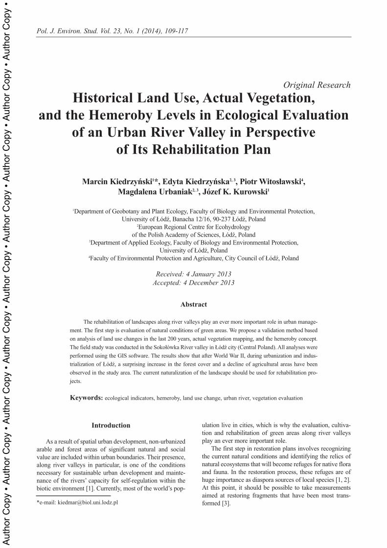
Łódź is a city of 800,000 inhabitants (an agglomerationof 1 million inhabitants), located in central Poland (Fig. 1).The city area is divided between 18 catchments drained bysmall urban streams. During the industrial revolution in theearly 1830s, the streams were channelized and set under-ground, thus becoming part of the storm water system ofthe city.
110 Kiedrzyński M., et al.
Fig. 1. The study area – ecotone buffer zones in the Sokołówka River valley in Łódź and location of urban and industrial areas in itsvicinity (based on orthophotomaps 2002-04, materials from the City Council of Lódź).
Aut
hor C
opy
• Aut
hor C
opy
• Aut
hor C
opy
• Aut
hor C
opy
• Aut
hor C
opy
• Aut
hor C
opy
• Aut
hor C
opy
• Aut
hor C
opy
• Aut
hor C
opy
•

The small Sokołówka River valley is modified and itsbed is regulated, but some small seminatural fragmentshave been preserved. In the 19th century it was situatedbetween the cities of Łódź and Zgierz and thus it was onlyaffected by the 20th century changes resulting from progres-sive urbanization [24]. Ecotone buffer zones, i.e. not built-up areas in a section of the Sokołówka River valley betweenZgierska Str. and Żabieniec Str. (Fig. 1), that cover 102 hawere chosen for this analysis.
Historical Land Use
Historical changes in land use were identified on thebasis of archival topographic maps and the actual vegeta-tion mapping. The following materials were used inarchival analysis: Topographic Data of the Kingdom ofPoland (the Map of the Congress Kingdom) issued in 1843,field mapping: 1822-39, scale 1:126,000; The Łódź CityAtlas, Sheet IV: Łódź and its environs in the first half of the19th c., scale: 1:30,000 [25]; the Polish MilitaryGeographical Institute (WIG) topographic maps, 1932-39,scale 1:25,000; the Polish General Surveyor topographicmaps, 1970-90, scale: 1:25,000.
All maps were georeferenced, drawn, and analyzedusing the ArcGIS 9.2 cartographic software package [26].
Actual Vegetation Mapping
Vegetation was mapped in 2008 with a scale of 1:5,000.The field mapping method was based on orthophotomapsas a cartographical backing [27]. Orthophotomaps from2002-04 were used in this case study, with 1 pixel − 0.5 mresolution and the 1992 Polish Coordinate System. In somecases, the precise position of phytocoenoses may need to belocated by a GPS receiver.
Vegetation units are defined as uniform phytocoenoseswith regard to their phytosociological character accordingto the Braun-Blanquet method [28], naturalness and suc-cession stage. The nomenclature of vascular plants in thispaper follows “Flora Europaea” [29] and the nomenclatureof plant communities follows Matuszkiewicz [30].
An actual vegetation map was drawn and analyzedusing ArcGIS [26].
Ecological Validation
Analysis of historical land use and actual vegetationallowed us to detect places that have not been affected byland use change in the last 200 years and have presentlyquite natural or seminatural vegetation. This analysis alsoallowed us to detect patches where succession or regenera-tion of phytocoenoses is observed and should be used in theproject of rehabilitation.
General landscape validation was done by:• designation of hemeroby levels in the study area; the
hemeroby scale should be adapted according to Blumeand Sukopp [31] (Table 1); the lowest, i.e. a-hemerobiclevel is not represented in the Sokołówka Valley; themain task was to convert the real vegetation units to cor-responding hemeroby levels; the result is a map show-ing the distribution of hemeroby levels.
• detection of vegetation patches dominated by alienspecies, which are mostly associated with human-trans-formed habitats.Validation maps were drawn and analyzed using
ArcGIS [26].
Results
Land Use Changes over the Last 200 Years
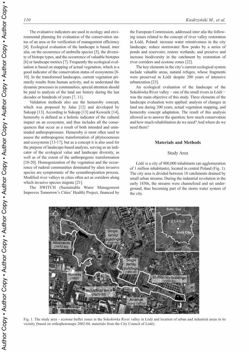
Analysis of changes in land use during the last 200years indicates a far-reaching transformation of the land-scape structure in the ecotone zones of the SokołówkaRiver valley (Table 2, Fig. 2).
At the beginning of the 19th century the landscape in theSokołówka valley had typically agro-forest character.During the industrial revolution in the 19th century that tookplace in nearby Łódź, the Sokołówka valley was affectedby a gradual transformation process. During this period, theforest area decreased from about 24% to only 11%.Whereas the contribution of transport infrastructure (railand roads) increased (up to 10%), as well as the contribu-tion of residential and industrial buildings (up to 10%). Atthe beginning of the 20th century, the largest area of waterreservoirs existed in the valley (Table 2, Fig. 2a).
Historical Land Use, Actual... 111
Table 1. Hemeroby degrees in urban ecosystems, after Blume and Sukopp [31].
Hemeroby level Anthropopressure intensity
A-hemerobic (not representedin the study area)
Lack of anthropogenic impact, flora and vegetation unaffected by human pressure.
Oligo-hemerobic Minor anthropogenic impacts are observed, however, they do not modify the substrate.
Meso-hemerobic Weak to moderate, or periodic anthropogenic factors.
Eu-hemerobic Continuous and strong anthropogenic impacts causing strong modifications of the substrate.
Poly-hemerobic Continuous and very strong anthropogenic impacts. Vegetation is characterized by a high degree of specialization and pioneer nature.
Meta-hemerobic Continuous impact of anthropogenic factors that are so strong they exceed the tolerance of plants.
Aut
hor C
opy
• Aut
hor C
opy
• Aut
hor C
opy
• Aut
hor C
opy
• Aut
hor C
opy
• Aut
hor C
opy
• Aut
hor C
opy
• Aut
hor C
opy
• Aut
hor C
opy
•
World War II was followed by trend changes. Despitethe fact that Łódź was growing as a center of the textileindustry and the location of new industrial and residentialareas in the vicinity of the valley, in most cases, the studiedecotone zone was affected by the gradual limitation eco-nomic activity, especially the disappearance of traditionalforms of agricultural use. This transformation was reflectedin the increased cover of forest and shrubs − from 18% toover 58% (Table 2, Fig. 2c) and a decrease in the contribu-tion of fields, meadows and rushes − from 56% to 25%(Table 2. Fig. 2b).
The effect of the reduced human activity in the flood-plain is also a considerable decrease in the area of waterreservoirs in the 1970s (Table 2, Fig. 2a). This trend hasbeen hampered in recent times as a result of reservoir reha-bilitation, inter alia under the SWITCH project.
Current Vegetation in the Ecotone Buffer Zones in the Sokołówka River Valley
Forest and seminatural communities in hydrogenic
habitats (4 types of communities, 62 patches, 18.2% of thearea). In the dynamic circle of humid forest, there are tall
112 Kiedrzyński M., et al.
Fig. 2. Changes in the distribution of select land use forms in the buffer zones of the Sokołówka River valley in Łódź since the 1930s:(a) water reservoirs, (b) fields and meadows, (c) forest (dark grey) and shrubs (light grey).
Table. 2. Contribution of land use forms in the total area of theecological buffer zones in the Sokołówka River valley in Łódźsince the early 19th century.
Land use formEarly 19th c.
(approximatevalues)
1930-45
1970-80
2008
Water reservoirs ~3 5.3 2.2 3.1
Wet meadows, rushes
~25 20.5 17.3 7.3
Fields, fallows, dry meadows
~43 36.0 25.3 17.8
Shrubs, clumps of trees, orchards
no data 6.5 4.9 20.3
Forests ~24 11.6 34.7 38.2
Roads ~4 7.2 8.9 6.3
Railway 0 3.1 2.8 2.9
Cemetery 0 0.8 0.0 0.0
Buildings, factories,outcrops
<1 9.0 3.9 4.1
a)
b)
c)
1930-40 1970-80 2008
2008
2008
1970-80
1970-80
1930-40
1930-40
Aut
hor C
opy
• Aut
hor C
opy
• Aut
hor C
opy
• Aut
hor C
opy
• Aut
hor C
opy
• Aut
hor C
opy
• Aut
hor C
opy
• Aut
hor C
opy
• Aut
hor C
opy
•
herb communities, rushes and wet meadows that includephytosociological alliances: Convolvulion sepium,Aegopodion podagrariae, Filipendulion, Magnocaricion,and Calthion. During spontaneous succession, nitrophilousthickets, brushes and groups of alder trees were formed. Inthe western part of the study area, and especially in the cen-tral section of the valley, fragments of alder forest havebeen preserved, representing Fraxino-Alnetum and Ribesonigri-Alnetum associations. The transformation of theground and the soil, and the regulation of the river bedtogether with a decreased groundwater level were the maincauses of the synanthropization of the wetland vegetation.
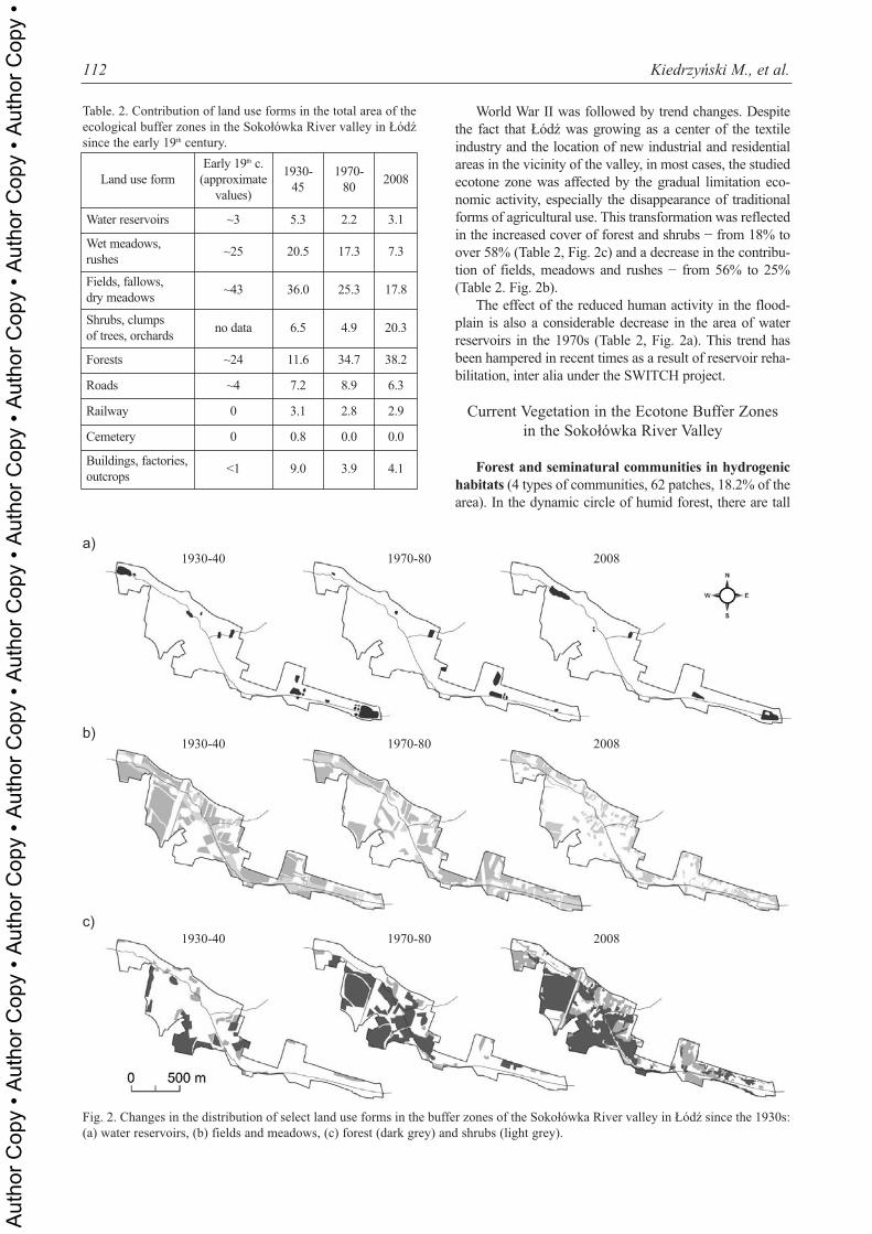
By analyzing the current vegetation and changes in landuse we can indicate the ecological processes that occur inwetlands (Fig. 3). Most often we can observe the variousstages of secondary succession in areas of former wetmeadows, rushes and water reservoirs, and in the typicalanthropogenic habitats, such as a regulated river bed andshores in new reservoirs. In many of ruderal patches, thesuccession is inhibited by regular cutting of biomass.
A special case of the forest and scrub vegetation trans-formation is observed in secondary boggy places (Fig. 3),which is a consequence of a railway embankment built over200 years ago.
Forest and seminatural communities in mineral
habitats (6 types of communities, 65 patches, 35.7% of thearea). Semi-natural vegetation at higher locations and inmineral habitats is reflected in fresh meadows from theArrhenatherion alliance. Small areas with sandy surfaces inthe abandoned fields and on the valley slopes are coveredwith psammophilous grasslands from the Corynephorioncanescentis alliance. The pre-forest stage of succession insuch habitats includes brushes and young woods with pine,oak, birch, and aspen, as well as meadow and grasslandflora. As a result of silviculture practices, or long-term suc-cession, surrogate forests with pine and birch stands devel-oped in the oak-hornbeam forest Tilio-Carpinetum habitat.
Anthropogenic communities in ruderal and trans-
formed habitats (7 types of communities, 159 patches,36.0% of the area). In the first and the second phase ofspontaneous succession in the modified habitats, there areruderal tall herb communities from the Dauco-Melilotenionalliance (especially an association with Artemisia andTanacetetum) and the Arction lappae alliance. In areas per-manently used by humans, such as trodden places andlawns, low “carpet” communities from the Polygonionaviculatis alliance are developed. Spontaneous successionin habitats transformed by humans leads to ruderal thicketsand secondary forests with dominance of alien woodyspecies and ruderal herbs. Groups of trees or planted alleysand orchards have similar character, although they havenow been naturalized.
Ecological Evaluation
Only fragments of forest relicts have survived in thestudied part of the valley. Well-preserved forests in hydro-genic habitats are exemplified by alluvial alder-ash forest,Fraxino-Alnetum, and bog alder forest, and Ribeso nigri-Alnetum (including a spring subassociation of Rn-Achrysosplenietosum). In mineral and drier habitats, smallpatches of oak-hornbeam forest, Tilio-Carpinetum, andmixed pine-oak forest, Querco roboris-Pinetum, have beenpreserved.
It was possible to identify four of the most natural partsof the ecotone buffer zone of the Sokołówka River in Łódź(numbers according to Fig 4):1. Relicts of alluvial and humid forest at the bottom and on
the slopes of the valley near the railway include phyto-coenoses of alluvial and oak-hornbeam forest.
2. Patches of alder bog and alluvial forest on the easternpart of the railway bank. As the railway bank hindersthe natural water run-off, the forest floor is flooded formost of the year. However, some plants that are rarely
Historical Land Use, Actual... 113
Fig. 3. Examples of recently observed ecological processes in wetland vegetation of the ecotone buffer zones in the Sokołówka Rivervalley in Łódź.
Spontaneous succession in formerreserviors
Vegetation transformation in secondaryboggy places initiated by railway
Regeneration in relict of bogand alluvial forest
Late succession and stabilization in secondary alluvial forests
Fluctuation during cyclic biomassremoval on regulated river banks
Early succession on reservior banks
Rushes and edge communitiesNitrophilous thickelsAlluvial forest and bog alder forestsWater vegetation
Wetlands vegetation:
Aut
hor C
opy
• Aut
hor C
opy
• Aut
hor C
opy
• Aut
hor C
opy
• Aut
hor C
opy
• Aut
hor C
opy
• Aut
hor C
opy
• Aut
hor C
opy
• Aut
hor C
opy
•
found in the area can be observed: Calla palustris, Irispseudacorus, and Valeriana sambucifolia.
3. Relicts of natural forest at the convergence of theSokołówka River and Brzoza River. In the lower areas,a bog alder forest and an alluvial forest have been pre-served, and in the upper areas there is a phytocoenosisof oak-hornbeam forest.
4. Former evangelical cemetery and its vicinity currentlyoccupied by well-preserved phytocoenosis of oak-horn-beam forest. Certain legally protected plants can befound on the forest floor: Hedera helix, Convallariamajalis, and Vinca minor.Ecological validation was based on hemeroby levels
assigned to actual vegetation units (Table 3). The most nat-
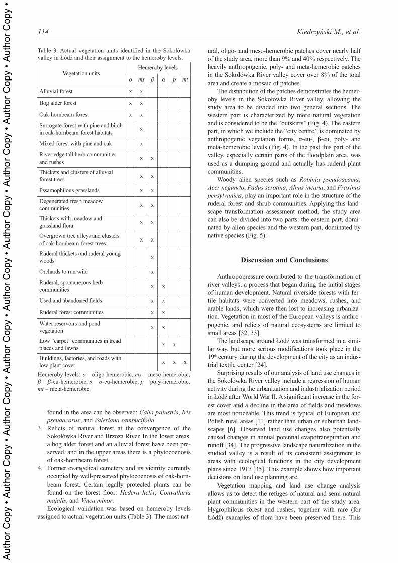
ural, oligo- and meso-hemerobic patches cover nearly halfof the study area, more than 9% and 40% respectively. Theheavily anthropogenic, poly- and meta-hemerobic patchesin the Sokołówka River valley cover over 8% of the totalarea and create a mosaic of patches.
The distribution of the patches demonstrates the hemer-oby levels in the Sokołówka River valley, allowing thestudy area to be divided into two general sections. Thewestern part is characterized by more natural vegetationand is considered to be the “outskirts” (Fig. 4). The easternpart, in which we include the “city centre,” is dominated byanthropogenic vegetation forms, α-eu-, β-eu, poly- andmeta-hemerobic levels (Fig. 4). In the past this part of thevalley, especially certain parts of the floodplain area, wasused as a dumping ground and actually has ruderal plantcommunities.
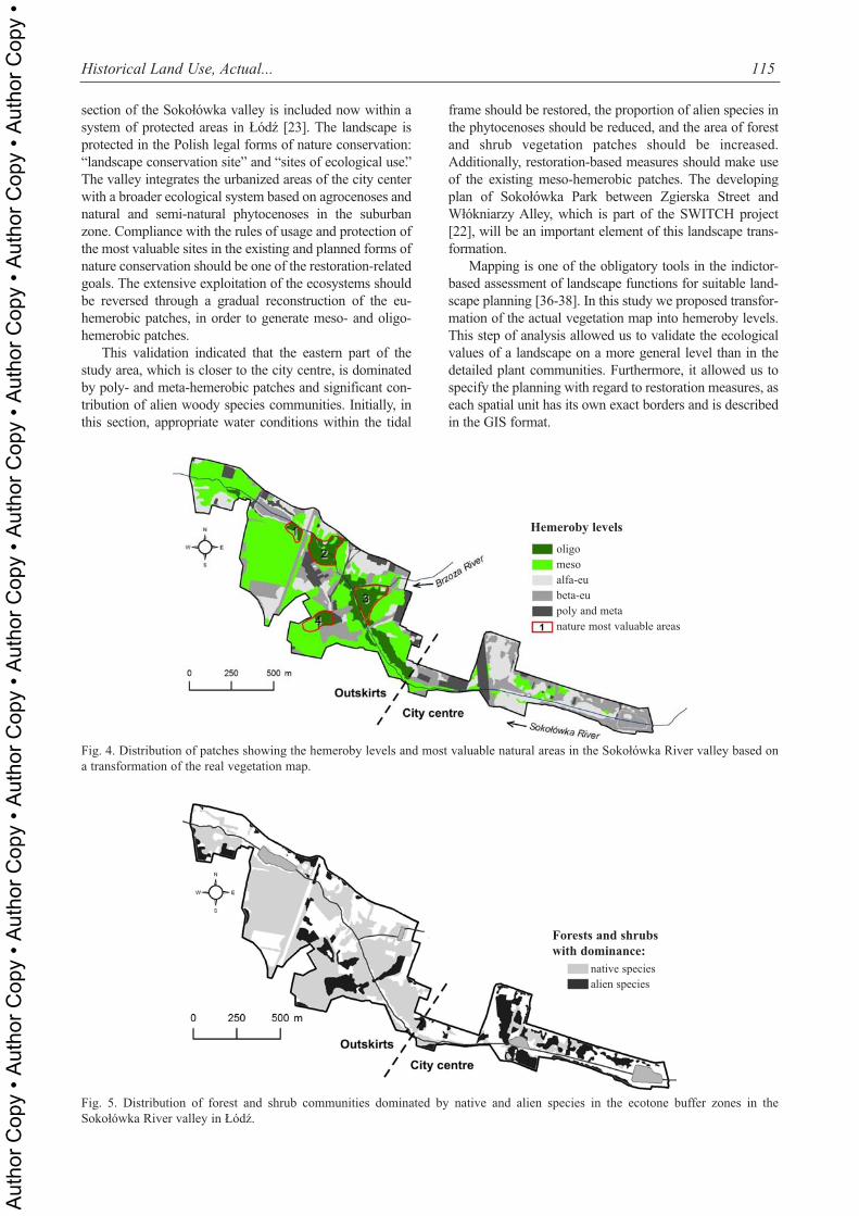
Woody alien species such as Robinia pseudoacacia,Acer negundo, Padus serotina, Alnus incana, and Fraxinuspensylvanica, play an important role in the structure of theruderal forest and shrub communities. Applying this land-scape transformation assessment method, the study areacan also be divided into two parts: the eastern part, domi-nated by alien species and the western part, dominated bynative species (Fig. 5).
Discussion and Conclusions
Anthropopressure contributed to the transformation ofriver valleys, a process that began during the initial stagesof human development. Natural riverside forests with fer-tile habitats were converted into meadows, rushes, andarable lands, which were then lost to increasing urbaniza-tion. Vegetation in most of the European valleys is anthro-pogenic, and relicts of natural ecosystems are limited tosmall areas [32, 33].
The landscape around Łódź was transformed in a simi-lar way, but more serious modifications took place in the19th century during the development of the city as an indus-trial textile center [24].
Surprising results of our analysis of land use changes inthe Sokołówka River valley include a regression of humanactivity during the urbanization and industrialization periodin Łódź after World War II. A significant increase in the for-est cover and a decline in the area of fields and meadowsare most noticeable. This trend is typical of European andPolish rural areas [11] rather than urban or suburban land-scapes [6]. Observed land use changes also potentiallycaused changes in annual potential evapotranspiration andrunoff [34]. The progressive landscape naturalization in thestudied valley is a result of its consistent assignment toareas with ecological functions in the city developmentplans since 1917 [35]. This example shows how importantdecisions on land use planning are.
Vegetation mapping and land use change analysisallows us to detect the refuges of natural and semi-naturalplant communities in the western part of the study area.Hygrophilous forest and rushes, together with rare (forŁódź) examples of flora have been preserved there. This
114 Kiedrzyński M., et al.
Table 3. Actual vegetation units identified in the Sokołówkavalley in Łódź and their assignment to the hemeroby levels.
Vegetation unitsHemeroby levels
o ms β α p mt
Alluvial forest x x
Bog alder forest x x
Oak-hornbeam forest x x
Surrogate forest with pine and birchin oak-hornbeam forest habitats
x
Mixed forest with pine and oak x
River edge tall herb communitiesand rushes
x x
Thickets and clusters of alluvialforest trees
x x
Pssamophilous grasslands x x
Degenerated fresh meadow communities
x x
Thickets with meadow and grassland flora
x x
Overgrown tree alleys and clustersof oak-hornbeam forest trees
x x
Ruderal thickets and ruderal youngwoods
x
Orchards to run wild x
Ruderal, spontanerous herb communities
x x
Used and abandoned fields x x
Ruderal forest communities x x
Water reservoirs and pond vegetation
x x
Low “carpet” communities in treadplaces and lawns
x x
Buildings, factories, and roads withlow plant cover
x x x
Hemeroby levels: o – oligo-hemerobic, ms – meso-hemerobic,β – β-eu-hemerobic, α – α-eu-hemerobic, p – poly-hemerobic,mt – meta-hemerobic.
Aut
hor C
opy
• Aut
hor C
opy
• Aut
hor C
opy
• Aut
hor C
opy
• Aut
hor C
opy
• Aut
hor C
opy
• Aut
hor C
opy
• Aut
hor C
opy
• Aut
hor C
opy
•
section of the Sokołówka valley is included now within asystem of protected areas in Łódź [23]. The landscape isprotected in the Polish legal forms of nature conservation:“landscape conservation site” and “sites of ecological use.”The valley integrates the urbanized areas of the city centerwith a broader ecological system based on agrocenoses andnatural and semi-natural phytocenoses in the suburbanzone. Compliance with the rules of usage and protection ofthe most valuable sites in the existing and planned forms ofnature conservation should be one of the restoration-relatedgoals. The extensive exploitation of the ecosystems shouldbe reversed through a gradual reconstruction of the eu-hemerobic patches, in order to generate meso- and oligo-hemerobic patches.
This validation indicated that the eastern part of thestudy area, which is closer to the city centre, is dominatedby poly- and meta-hemerobic patches and significant con-tribution of alien woody species communities. Initially, inthis section, appropriate water conditions within the tidal
frame should be restored, the proportion of alien species inthe phytocenoses should be reduced, and the area of forestand shrub vegetation patches should be increased.Additionally, restoration-based measures should make useof the existing meso-hemerobic patches. The developingplan of Sokołówka Park between Zgierska Street andWłókniarzy Alley, which is part of the SWITCH project[22], will be an important element of this landscape trans-formation.
Mapping is one of the obligatory tools in the indictor-based assessment of landscape functions for suitable land-scape planning [36-38]. In this study we proposed transfor-mation of the actual vegetation map into hemeroby levels.This step of analysis allowed us to validate the ecologicalvalues of a landscape on a more general level than in thedetailed plant communities. Furthermore, it allowed us tospecify the planning with regard to restoration measures, aseach spatial unit has its own exact borders and is describedin the GIS format.
Historical Land Use, Actual... 115
Fig. 4. Distribution of patches showing the hemeroby levels and most valuable natural areas in the Sokołówka River valley based ona transformation of the real vegetation map.
Fig. 5. Distribution of forest and shrub communities dominated by native and alien species in the ecotone buffer zones in theSokołówka River valley in Łódź.
Hemeroby levels
oligo mesoalfa-eubeta-eupoly and metanature most valuable areas
Forests and shrubs
with dominance:
native speciesalien species
Aut
hor C
opy
• Aut
hor C
opy
• Aut
hor C
opy
• Aut
hor C
opy
• Aut
hor C
opy
• Aut
hor C
opy
• Aut
hor C
opy
• Aut
hor C
opy
• Aut
hor C
opy
•
The method of landscape ecological validation used inthis study, which includes land use changes, vegetationmapping, hemeroby levels, and alien species dominance incommunities as indicators, is an example of multivariateassessment. This ecological validation could be a part ofmultidimensional models of landscape assessment pro-posed by Gómez-Sal et al. [39], which also includes “pro-ductive” and “economic” dimensions.
The ecological dimension in landscape evaluation ana-lyzes the landscape as an ecosystem and shows which land-scape maintains basic ecological processes and services[39]. The identification of ecological processes in plantcommunities is possible when the current structure of phy-tocoenoses is compared with the land use history. Wenoticed, that large spaces in the study area are affected bysecondary succession, which is an effect of reduction in theintensity of human activities in recent decades. Theobserved spontaneous naturalization of the landscapeshould be used for rehabilitation projects.
As far as ecosystem restoration policies are concerned,two divided sections in the Sokołówka River valley repre-sent different priorities. According to Hulse and Gregory’sconcept [40], the “outskirts” have high ecological potentialwith low demographic and economic constraints and the“city center” has low ecological potential with high demo-graphic and economic constraints.
Acknowledgements
Our research has been partly conducted within the EUSWITCH Project (Sustainable Water ManagementImproves Tomorrow’s Cities’ Health) (IP 6 PR UE, GOCE018530 2006-2011).
References
1. BREUSTE J. H. Decision making, planning and designfor the conservation of indigenous vegetation withinurban development. Landscape Urban Plan. 68, 439,2004.
2. KONG F., YIN H., NAKAGOSHI N., ZONG Y. Urbangreen space network development for biodiversity conserva-tion: Identification based on graph theory and gravity mod-eling. Landscape Urban Plan. 95, 16, 2010.
3. WALKER L. R., DEL MORAL R. Primary Succession andEcosystem Rehabilitation. Cambridge University Press,Cambridge: pp. 442, 2003.
4. HEINK U., KOWARIK I. What are indicators? On the def-inition of indicators in ecology and environmental planning.Ecological Indicators 10, 584, 2010.
5. ROBERGE J. M., ANGELSTAM P. Usefulness of theumbrella species concept as a conservation tool. Conserv.Biol. 18, 76, 2004.
6. WOLF T., MEYER B. C. Suburban scenario developmentbased on multiple landscape assessment. EcologicalIndicators 10, 74, 2010.
7. OLSEN L. M., DALE V. H., FOSTER T. Landscape pat-terns as indicators of ecological change at Fort Benning,Georgia, USA. Landscape Urban Plan. 79, 137, 2007.
8. ROO-ZIELIŃSKA E. Phytoindicative role of plant commu-nities in a rural landscape (Pińczów case study, southPoland). Fragm. Flor. Geobot. 41, (1), 379, 1996.
9. IIYAMA N., KAMADA M., NAKAGOSHI N. Ecologicaland social evaluation of landscape in a rural area with ter-raced paddies in southwestern Japan. Landscape UrbanPlan. 70, 301, 2005.
10. SOLON J., ROO-ZIELIŃSKA E., DEGÓRSKI M.Landscape scale of topography-soil-vegetation relationship:influence of land use and land form. Pol. J. Ecol. 60, (1), 3,2012.
11. BOMANOWSKA A., KIEDRZYŃSKI M. Changing landuse in the last decades and its impact on plant cover in agri-cultural and forest landscape in Poland. Folia Biol. et Oecol.7, 5, 2011.
12. JALAS J. Hemeroby and hemerochore of plant species. Aterminological reform effort. Acta Soc. Fauna Flora Fenn.72, 1, 1955.
13. SUKOPP H. Change of flora and vegetation in centralEurope under the influence of man. Ber. ü. Landwirtschaft.Hrsg. Bundesministerium f. Ernährung Landwirtschaft u.Forsten 50, (1), 112, 1972 [In German].
14. KOWARIK I. The human impact on flora and vegetation.Theoretical concepts and quantify modeling approach usingthe example of Berlin (West). Landschaftsentw. u.Umweltforsch. 56, 1, 1988 [In German].
15. GRABHERR G., KOCH G., KIRCHMEIR H., REITER K.Hemeroby Austrian forest ecosystems – Presentation of aresearch project under the Austrian contribution to theUNESCO MAB Programme. Zeitschrift für Ökologie undNaturschutz 4, 131, 1995 [In German].
16. JACKOWIAK B. The hemeroby concept in the evaluationof human influence on the urban flora of Viena.Phytocoenosis 10, 79, 1998.
17. FANELLI G., TESCAROLLO P., TESTI A. Ecologicalindicators applied to urban and suburban floras. EcologicalIndicators 6, 444, 2006.
18. GOLDSMITH F. B. The evaluation of ecological resourcesin the countryside for conservation purposes. Biol. Conserv.8, 89, 1975.
19. STEINHARDT U., HERZOG F., LAUSCH A., MÜLLERE., LEHMANN S. Hemeroby index for landscape monitor-ing and evaluation. In: Y. A. Pykh, D. D. Hyatt, R. J. Lenz(Eds) Environmental Indices – System Analysis Approach,Oxford, EOLSS Publ.: pp. 237-254. 1999.
20. ZEBISCH M., WECHSUNG F., KENNEWEG H.Landscape response functions for biodiversity – assessingthe impact of land-use changes at the county level.Landscape Urban Plan. 67, 157, 2004.
21. SÄUMEL I., KOWARIK I. Urban rivers as dispersal corri-dors for primarily wind-dispersed invasive tree species.Landscape Urban Plan. 94, 244, 2010.
22. ZALEWSKI M., WAGNER I. Ecohydrology – the use ofwater and ecosystem processes for healthy urban environ-ments. Aquatic Habitats in Integrated Urban WaterManagement. Ecohydrol. Hydrobiol. 5, (4), 26, 2006.
23. KUROWSKI J. K., WITOSŁAWSKI P. (Eds). The GreenTreasures of Łódź – nature refuges of the city. Departmentof Environmental Protection and Agriculture of the ŁódźCity Office, Department of Geobotany and Plant EcologyUŁ, Łódź: pp. 142, 2009 [In Polish].
24. WITOSŁAWSKI P. Atlas of distribution of vascular plantsin Łódź. University of Łódź Press, Łódź: pp. 386, 2006.
25. KOTER M. Łódź and its environs in the first half of the 19th
c. In: S. Liszewski (Ed.) The Łódź Atlas, Łódź City Council
116 Kiedrzyński M., et al.
Aut
hor C
opy
• Aut
hor C
opy
• Aut
hor C
opy
• Aut
hor C
opy
• Aut
hor C
opy
• Aut
hor C
opy
• Aut
hor C
opy
• Aut
hor C
opy
• Aut
hor C
opy
•
– Geodesy, Cadastre and Inventory Department, Łódź, SheetIV, 2011.
26. ESRI INC. ArcGIS DesktopTM 9.2. New York Street,Redlands, USA, 1999-2008.
27. MUELLER-DOMBOIS D., ELLEMBERG H. Aims andMethods of Vegetation Ecology. Wiley, New York: pp. 547,1974.
28. BRAUN-BLANQUET J. Plant sociology, Broad VegetationScience. 3 Aufl. Springer, Wien: pp. 865, 1964 [In German].
29. TUTIN T. G., HEYWOOD V. H., BURGES N. A., VALEN-TINE D. H., WALTERS S. M., WEBB D. A. FloraEuropaea. Cambridge University Press, Cambridge, Vol. I-V, 1964-1980.
30. MATUSZKIEWICZ W. Polish plant communities guide-book. Vademecum Geobotanicum, PWN, Warszawa: pp.537, 2001 [In Polish].
31. BLUME H. P., SUKOPP H. Ecological significance ofanthropogenic soil changes. Schr. R. Vegetationskde. 10, 75,1976 [In German].
32. ELLENBERG H. Vegetation ecology of central Europe. 4th
ed. Cambridge University Press, Cambridge: pp. 731, 1986.33. JONGMAN R. H. G. Homogenization and fragmentation of
the European landscape: ecological consequences and solu-tions. Landscape Urban Plan. 58, (2–4), 211, 2002.
34. YANG X., LILIANG REN L., SINGH V. P., LIU X., YUANF., JIANG S., YONG B. Impacts of land use and land coverchanges on evapotranspiration and runoff at ShalamulunRiver watershed, China. Hydrology Research, 43, (1-2), 23,2012.
35. BALD K. The city’s spatial and urban development plan-ning in historical approach. In: S. Liszewski (Ed.) The ŁódźAtlas, Łódź City Council – Geodesy, Cadastre and InventoryDepartment Łódź, Sheet XLII, 2011.
36. GIMONA A., VAN DER HORST D. Mapping hotspots ofmultiple landscape functions: a case study on farmlandafforestation in Scotland. Landscape Ecol. 22, (8), 1255,2007.
37. WILLEMEN L., VERBUNG P. H., HEIN L., VANMENSVOORT M. E. F. Spatial characterization of land-scape functions. Landscape Urban Plan. 88, (1), 34, 2008.
38. MANDER U., UUEMAA E. Landscape assessment for sus-tainable planning. Ecological Indicators 10, 1, 2010.
39. GÓMEZ-SAL A., BELMONTES J.-A., NICOLAU J.-M.Assessing landscape values: a proposal for a multidimen-sional conceptual model. Ecological Modelling 168, 319,2003.
40. HULSE D., GREGORY S. Integrating resilience into flood-plain restoration. Urban Ecosystems 7, 295, 2004.
Historical Land Use, Actual... 117
Aut
hor C
opy
• Aut
hor C
opy
• Aut
hor C
opy
• Aut
hor C
opy
• Aut
hor C
opy
• Aut
hor C
opy
• Aut
hor C
opy
• Aut
hor C
opy
• Aut
hor C
opy
•

Aut
hor C
opy
• Aut
hor C
opy
• Aut
hor C
opy
• Aut
hor C
opy
• Aut
hor C
opy
• Aut
hor C
opy
• Aut
hor C
opy
• Aut
hor C
opy
• Aut
hor C
opy
•
Related Documents