Historic Resources Survey Report Westchester-Playa del Rey Community Plan Area Prepared for: City of Los Angeles Department of City Planning Office of Historic Resources Prepared by: Architectural Resources Group, Inc. Pasadena, CA November 27, 2013

Welcome message from author
This document is posted to help you gain knowledge. Please leave a comment to let me know what you think about it! Share it to your friends and learn new things together.
Transcript
Historic Resources Survey Report
Westchester-Playa del Rey Community Plan Area
Prepared for: City of Los Angeles Department of City Planning Office of Historic Resources Prepared by:
Architectural Resources Group, Inc. Pasadena, CA
November 27, 2013

Table of Contents Project Overview 1
SurveyLA Methodology Summary 1
Project Team 3
Survey Area 3
Designated Resources 12
Community Plan Area Survey Methodology 14
Summary of Findings 15
Summary of Property Types 15
Summary of Contexts and Themes 17
Selected Bibliography 34
Appendices
Appendix A: Individual Resources Appendix B: Non-Parcel Resources Appendix C: Historic Districts and Planning Districts

SurveyLA
Westchester-Playa del Rey Community Plan Area 1
Project Overview This Historic Resources Survey Report (Survey Report) has been completed on behalf of the City of Los Angeles Department of City Planning’s Office of Historic Resources (OHR) for the SurveyLA historic resources survey of the Westchester-Playa del Rey Community Plan Area (CPA). This project was undertaken from October 2012 to August 2013 by Architectural Resources Group (ARG).
This Survey Report provides a summary of the work completed, including a description of the Survey Area; an overview of the field methodology; a summary of relevant contexts, themes and property types; and complete lists of all recorded resources. This Survey Report is intended to be used in conjunction with the SurveyLA Field Results Master Report (Master Report), which provides a detailed discussion of SurveyLA methodology and explains the terms used in this report and associated appendices . In addition, a Survey Results Map has been prepared, which graphically illustrates the boundaries of the survey area and the location and type of all resources identified during the field surveys. The Master Report, Survey Report, and Appendices are available on the Survey Findings page at SurveyLA.org. Additionally, survey data for this CPA is searchable at HistoricPlacesLA.org.
SurveyLA Methodology Summary
Below is a brief summary of SurveyLA methodology. Refer to the Master Report discussed above for more information.
Field Survey Methods
Properties surveyed for SurveyLA are evaluated for eligibility for listing in the National
Register of Historic Places, California Register of Historical Resources and for local designation as Los Angeles Historic-Cultural Monuments (HCM) or Historic Preservation Overlay Zones (HPOZ), commonly known as historic districts.
Field surveyors cover the entire area within the boundaries of a CPA. However, only resources that have been identified as significant within the contexts developed for SurveyLA are recorded.
Consultants making resource evaluations meet the Secretary of the Interior’s Professional Qualifications Standards in Architectural History, History, or a related field.
Surveys focus on identifying significant resources dating from about 1850 to 1980.
All surveys are completed from the public right-of-way (from vehicles or on foot as needed).

SurveyLA
Westchester-Playa del Rey Community Plan Area 2
Digital photographs are taken of all evaluated resources.
Field surveys do not include:
Individual resources and historic districts (including HPOZs) that are already designated (listed in the National, California or local registers).
Community Redevelopment Agency of Los Angeles (CRA/LA) surveys conducted within the last five years.
Potential HPOZ areas which have been surveyed within the last five years and are in the process of being designated.
SurveyLA Resource Types
SurveyLA identifies individual resources, non-parcel resources, historic districts and district
contributors and non-contributors. Each of these is described below. Appendices A, B, and C of this Survey Report are organized by resource type.
Individual Resources are generally resources located within a single assessor parcel, such as a residence or duplex. However, a parcel may include more than one individual resource, if each appears to be significant.
Non-Parcel Resources are not associated with Assessor Parcel Numbers (APNs) and generally do not have addresses. Examples may include street trees, street l ights, landscaped medians, bridges, and signs.
Historic Districts are areas that are related geographically and by theme. Historic
districts may include single or multiple parcels depending on the resource. Examples of resources that may be recorded as historic districts include residential neighborhoods,
garden apartments, commercial areas, large estates, school and hospital campuses, and industrial complexes.
District Contributors and Non-Contributors are buildings, structures, objects, sites and other features located within historic districts (such as residences, schools, and parks). Generally, non-contributing resources are those that are extensively altered, are built outside the period of significance, or do not relate to historic contexts and themes defined for the district.
Planning Districts are areas that are related geographically and by theme, but do not
meet eligibility standards for designation. This is generally because the majority of the contributing features have been altered, resulting in a cumulative impact on the overall
integrity of the area and making it ineligible as a Historic District. The Planning District determination, therefore, is used as a tool to inform new Community Plans being
developed by the Department of City Planning. These areas have consistent planning concepts, such as height, massing, setbacks, and street trees, which may be considered in the local planning process.

SurveyLA
Westchester-Playa del Rey Community Plan Area 3
Project Team The Westchester-Playa del Rey CPA survey team included the following personnel from ARG:
Charles E. Chase, Principal; Katie Horak, Senior Associate and Architectural Historian and Preservation Planner; Allison M. Lyons, Architectural Historian and Preservation Planner; and
Mary Ringhoff, Architectural Historian and Preservation Planner. Katie Horak served as project manager.
Concurrent with ARG’s survey of the Westchester-Playa del Rey CPA, the additional Los Angeles CPAs of Brentwood-Pacific Palisades and Bel Air-Beverly Crest were also surveyed by a team including the firms Historic Resources Group (HRG) and Galvin Preservation Associates (GPA).
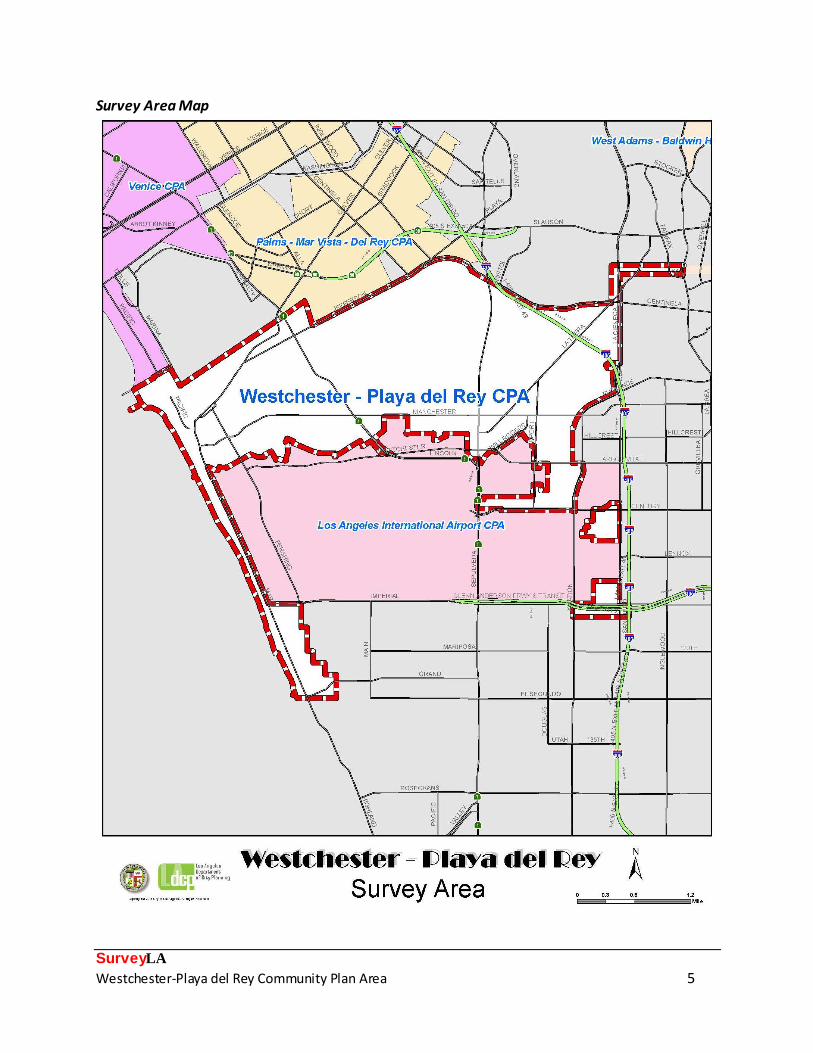
Survey Area Description of the Survey Area
The identified Survey Area corresponds with the boundary of the Westchester-Playa del Rey CPA, which is located in the westernmost portion of the City of Los Angeles, approximately 15 miles southwest of downtown Los Angeles. The irregularly-shaped Survey Area has a northern boundary that roughly follows Centinela, Jefferson, and Culver Boulevards, with the communities of Ladera Heights, Culver City and Marina del Rey to the north and east. The eastern boundary is formed primarily by La Cienega, Aviation, and La Brea Boulevards. The southern boundary follows the northern edge of Los Angeles International Airport (LAX). The western boundary of the CPA is the Pacific Ocean extending south from Culver Boulevard to Grand Avenue, including a narrow shoestring of land that extends southerly to the northern
boundary of El Segundo, along Dockweiler State Beach. Two small discontiguous areas directly east of LAX are also included in the Survey Area. They primarily comprise industrial uses and
include properties on Century Boulevard, 102nd and 104th Streets between La Cienega and Aviation Boulevards, and properties on Hindry Avenue between 111th Street and Imperial Highway. The Survey Area abuts the Community Plan Areas of Venice and Palms-Mar Vista-Del Rey to the north and LAX to the south (the airport is not included in the Survey Area). The CPA includes three distinct communities and a small portion of one additional community:
Westchester is the largest community in the Survey Area. It is located in the central and eastern section of the CPA and is generally bordered by Centinela Boulevard and Bluff
Creek Drive to the north; La Cienega, Aviation, and La Brea Boulevards to the east; LAX to the south; and Lincoln Boulevard to the west.

SurveyLA
Westchester-Playa del Rey Community Plan Area 4
Playa Vista is located directly north of Westchester, at the location of the former Howard Hughes Aircraft campus. It is generally bounded by West Jefferson Boulevard to the north, Lincoln Boulevard to the west, and Bluff Creek Drive to the south.
Playa del Rey is a coastal community located between Westchester and the Pacific
Ocean. It is generally bounded by the channelized Ballona Creek to the north, Lincoln Boulevard to the east, LAX to the south, and the Pacific Ocean to the west.
El Segundo is a small area south of Playa del Rey and LAX, along the Pacific coastline. The community of El Segundo as defined within the Survey Area includes only that portion which lies within the City of Los Angeles, and does not refer to the City of El Segundo. The area is generally bounded by Sandpiper Street to the north; Vista del Mar, Imperial Highway, and the City of El Segundo boundary to the east and south; and the Pacific coastline to the west. It includes Dockweiler State Beach.
SurveyLA
Westchester-Playa del Rey Community Plan Area 5
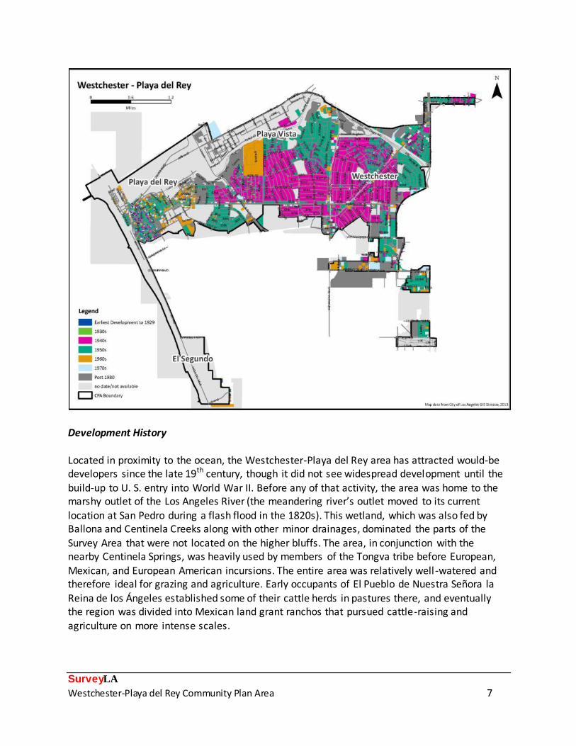
Survey Area Map
SurveyLA
Westchester-Playa del Rey Community Plan Area 6
The Survey Area contains 13,970 parcels that were surveyed by the SurveyLA team. In
accordance with SurveyLA methodology, properties not surveyed include buildings constructed after 1980 and resources designated under local, state and/or federal programs.1
The Westchester-Playa del Rey CPA is a coastal environment topographically distinguished by
the presence of the Del Rey Hills, a series of rolling hills representing ancient compacted sand dunes. The result is a topographically varied region of low hills and hill ranges interspersed with
flatter areas. The most dramatic geographical features are the Westchester Bluffs, running perpendicular to the coastline along the southern side of what used to be Ballona and Centinela Creeks and their accompanying wetlands. The creeks are now channelized and much of the low-lying wetland area has been developed as Playa Vista, but the steep bluffs remain to mark the route of this outlet to the sea. The bluffs are prominent features in the northwestern portion of Westchester and run through Playa Vista and Playa del Rey. There, they curve and continue south toward Palos Verdes. Dockweiler Beach State Park defines the western edge of the CPA.
In addition to the channelized creeks, developed wetlands, and managed beach environment, human-made features in the Survey Area include a street pattern that is regular in some areas and topographically shaped in others. They also include Interstate 405 San Diego Freeway (405 Freeway), which runs above grade through Westchester with numerous overpasses and on-ramps which visually impact the area. The major east-west arteries within the Survey Area are (from north to south): Culver Boulevard, Centinela Boulevard, Jefferson Avenue, Manchester Avenue, and Century Boulevard. The major north-south arteries are (from east to west): La Cienega Boulevard, the 405 Freeway, Sepulveda Boulevard, Lincoln Boulevard, and Vista del Mar. La Tijera Boulevard, another major artery, cuts diagonally across Westchester from southwest to northeast.
1 For the location of designated resources at the time of the survey, refer to the Designated Resources map on
page 13 or go to HistoricPlacesLA.org for the most up-to-date information.
SurveyLA
Westchester-Playa del Rey Community Plan Area 7
Development History
Located in proximity to the ocean, the Westchester-Playa del Rey area has attracted would-be developers since the late 19th century, though it did not see widespread development until the
build-up to U. S. entry into World War II. Before any of that activity, the area was home to the marshy outlet of the Los Angeles River (the meandering river’s outlet moved to its current
location at San Pedro during a flash flood in the 1820s). This wetland, which was also fed by Ballona and Centinela Creeks along with other minor drainages, dominated the parts of the
Survey Area that were not located on the higher bluffs. The area, in conjunction with the nearby Centinela Springs, was heavily used by members of the Tongva tribe before European,
Mexican, and European American incursions. The entire area was relatively well -watered and therefore ideal for grazing and agriculture. Early occupants of El Pueblo de Nuestra Señora la Reina de los Ángeles established some of their cattle herds in pastures there, and eventually the region was divided into Mexican land grant ranchos that pursued cattle-raising and
agriculture on more intense scales.
SurveyLA
Westchester-Playa del Rey Community Plan Area 8
The current Survey Area was primarily located within Rancho Sausal Redondo and Rancho
Aguaje de la Centinela. These land grants contained parts of present-day Inglewood, El Segundo, and other communities in addition to Westchester, Playa del Rey, and Playa Vista.2
After several changes in ownership over the years, in 1874 the ranchos saw the first shifts from cattle, sheep, and fruit tree cultivation to commercial grain-growing operations.3 This proved
very successful, prompting then-owner Daniel Freeman to embark on another new venture: commercial real estate development of the land. In 1887, Freeman’s Centinela-Inglewood Land
Company met with success and eventually resulted in the community of Inglewood. Freeman also leased out portions of his ranch for tenant farming, resulting in a long-lived agricultural presence that remained as late as 1960.4 The Centinela Adobe, constructed by rancho owner Ygnacio Machado in 1834 and occupied by a succession of owners, still exists on Midfield Avenue, just beyond the eastern boundary of the Survey Area in Westchester. The first major attempt at industrial development within the Survey Area occurred in 1886, when Moye L. Wicks and others formed the Ballona Harbor and Improvement Company with the goal of dredging the Del Rey Lagoon into a harbor and channel capable of handling large
freight ships. The California Central Railway Company constructed a rail line connecting the harbor-to-be with the Atchison, Topeka & Santa Fe line in Los Angeles, completing it in August 1887 to much fanfare.5 This new harbor seemed poised to become Los Angeles’ newest industrial port, competing with Phineas Banning’s operation at San Pedro and a planned harbor and wharf at Santa Monica. The new town of Port Ballona was platted on the bluffs above the marshlands. But the company ran out of money, the harbor was never completed, and most of the town was never built. The railroad ceased daily service to Ballona in 1891, citing lack of passengers.6 In 1899, the Los Angeles Times described Ballona Harbor as “an isolated spot where life is not all beer and skittles.”7 No resources exist from this era.
Starting in 1902, developers began looking anew at the Ballona area, this time in the context of the exploding beach town development that was reshaping the face of the city. Spurred by the
construction of electric railroads, Los Angeles was full of new beach resort communities, but the Beach Land Company promised that its Playa del Rey development would be the grandest
of all. The company subdivided the area around the old harbor, placing most of the residential areas on the bluffs above the beach, re-dredging the lagoon to create a scenic lake, and
2 Title Insurance and Trust Company, The Old Spanish and Mexican Ranchos of Los Angeles County, c. 1937 in Glen
Creason, Los Angeles in Maps (New York: Rizzoli International Publications, Inc., 2010), 29. Records of the boundaries of the ranchos are notoriously vague, so it is often difficult to ascertain exactly which areas were part
of a particular rancho; some of the Survey Area may have actually been considered part of the Rancho La Ballona to the north. 3 Loyola Marymount University, Family History, Freeman Family Papers, CSLA-21
(http://www.lmu.edu/Page8644.aspx), 2011. 4 Michael Engh and Betty Forsyth, National Register of Historic Places Nomination: Centinela Adobe, 1974.
5 Los Angeles Times, Ballona Harbor, 23 August 1887.
6 Los Angeles Times, The Railroads, 25 April 1891.
7 Los Angeles Times, Police Court Notes, 28 July 1899.

SurveyLA
Westchester-Playa del Rey Community Plan Area 9
centering everything on the elegant Hotel Del Rey.8 Other amenities included a massive
pavilion, bathhouses, a speedway, boathouses, grandstands, piers, a reinforced concrete bridge on the lagoon, and even an inclined railway. Playa del Rey became a popular seaside resort
town, with most of its bluff-top residences constructed by wealthy Angelenos. The electric Balloon Line Excursion Route carried visitors to the resort on a daily basis. A few miles to the
south of the grand new resort, the coast remained largely undeveloped, to the extent that in 1905 the City routed its primary sewage outfall line through the southern portion of the Survey
Area to empty into the ocean. In 1925, Los Angeles’ first waste treatment plant was constructed at the same Hyperion outfall location. The Hotel Del Rey burned down in the 1920s and the resort swiftly declined, but residential development in the Playa del Rey area continued as it did across the rest of Los Angeles, fueled by a post-World War I building boom. The Playa del Rey area became a stable low-density residential community with basic municipal services. The most notable work was by the Dickinson & Gillespie Company, led by developer Fritz B. Burns; it subdivided the Palisades del Rey, Surfridge and Del Rey Hills neighborhoods in 1924. Palisades Del Rey sat on the bluffs
between Pershing Drive and Vista Del Mar, Surfridge was south of Century Boulevard, and Del Rey Hills was north of Manchester Boulevard (including what is now Westchester).9 A number of 1920s single-family homes, most in the Spanish Colonial Revival style, still survive in the Palisades Del Rey development. Just west of Palisades Del Rey, Dickinson & Gillespie also subdivided a small tract, now known as The Jungle, wedged between the bluffs and the beach; this area remained subdivided but largely unbuilt on until the 1950s. Burns worked hard to promote the overall community of Playa del Rey by installing and improving services like sewers, water lines, gas mains, and roadways. The company also built a beach club and is said to have inspired neighboring developer Harry Culver to donate land in the Del Rey Hills to Loyola College (now Loyola Marymount University) by offering land to Los Angeles Lutheran
University in 1927.10 The courting of academic institutions showed that developers like Burns and Culver were serious about establishing the Playa del Rey area as a vibrant, and profitable,
residential community.
In an ill-timed move, Fritz Burns bought out Dickinson & Gillespie in 1929. The stock market crash later that year ended the Los Angeles building boom and took Burns’ fortune with it. The
plucky developer moved into a tent on the beach, from which he could look up and see the Italianate mansion he once owned on Waterloo (now Waterview) Street. By 1932, he was on his way back up, having managed to hold onto much of his property. Burns saved enough
money to purchase the athletes’ cottages from the 1932 Olympics in Los Angeles and placed them on the beach as a summer resort. In 1934, an oil exploration company which Burns had
allowed to prospect on his land struck “black gold,” leading to a 2% return that rescued him
8 Los Angeles Times, “Playa del Rey,” the New City of Pleasure, 24 August 1902.
9 Christina Chiang, Historic-Cultural Monument Application: Dickinson and Gillespie Building, 2008.
10 Historic Resources Group, Technical Report: Historic Resources Asses sment, Loyola-Marymount University, 2010,
13.

SurveyLA
Westchester-Playa del Rey Community Plan Area 10
from ruin.11 In that same year, the passage of the National Housing Act led to the establishment
of the Federal Housing Administration, which helped first-time homebuyers purchase property. Burns saw an opportunity and took it, partnering with Fred Marlow to form Marlow-Burns &
Company and develop residential subdivisions from the coastline to the San Fernando Valley. The stage was set for the next, and by far the largest, phase of development in the Survey Area.
Aviation was a burgeoning industry in Los Angeles as early as the 1910s, and the region was
quick to position itself as the national center for air travel. In the early 1920s, William M. Mines leased a small portion of ranchland just south of the Survey Area to build an aircraft landing strip. His Mines Field was chosen as the site for the 1928 National Air Races, where over 200,000 spectators marveled at flight demonstrations by military pilots, including Charles Lindbergh.12 In the same year, the City of Los Angeles chose Mines Field as the site for its municipal airport, paving the way for the aviation center that would eventually become Los Angeles International Airport (LAX). Los Angeles had more than just the municipal airport to advertise itself as the new hub of aircraft production and travel: by 1929, the county had 55 airports and landing fields, 27 accredited aviation schools, and several major airplane
factories.13 Airport development slowed during the Great Depression, but the Survey Area saw another piece of significant infrastructure work during that period: the channelization of Ballona Creek in 1938, as part of a large, federally supported flood control project across all of Los Angeles. Works Progress Administration (WPA) workers confined the already-altered creek to a deep, concrete channel, reducing the wetlands that had characterized the Playa del Rey Lagoon era for many decades. The 1938 work left a small saltwater lagoon (today’s Del Rey Lagoon Park) to the south of the main channel as the last remnant of the larger lagoon, and most of the remaining wetlands around it were filled and reclaimed for development.
The aircraft manufacturing industry began picking up in the late 1930s as Great Britain, France,
and eventually the United States began ordering large numbers of combat and transport planes for use in World War II. One of Los Angeles’ major production areas was centered in Inglewood-
El Segundo, where aviation-related industries sprang up around large plants like North American Aviation and Douglas Aircraft in proximity to the municipal airport. Howard Hughes
developed his aircraft manufacturing facilities on a 380-acre campus in the Ballona wetlands in the northern part of the Survey Area in the 1940s; his famous Spruce Goose aircraft was built in a hangar in the Hughes Aircraft complex, and many of the company’s new airplane and
helicopter designs were tested on the Hughes runways. These industries created a high demand for skilled workers, but housing was scarce in the primarily agricultural area. That all changed in
11
James Thomas Keane, Fritz B. Burns and the Development of Los Angeles (Los Angeles: The Thomas and Dorothy
Leavey Center for the Study of Los Angeles, Loyola Marymount University and The Historical Society of Southern California, 2001), 58-59. 12
Kevin Starr, Embattled Dreams (New York: Oxford University Press, 2002), 133. 13
Ibid., 131.

SurveyLA
Westchester-Playa del Rey Community Plan Area 11
1941, when Congress passed Title VI of the Housing Act. This legislation created additional
incentives for builders to concentrate on small, single-family houses and was restricted to industrial areas where critical housing shortages were predicted – like that around the coastal
aviation plants of Los Angeles.14 Fritz Burns and other developers jumped in to create subdivisions of affordable single-family houses for the incoming work force, which exploded in
size and intensity when the U.S. entered World War II. The developers were aided by the wartime ban on nonessential construction, which directed building toward authorized work
that included “small homes for war workers” as well as war production plants.15 Westchester quickly came into being as a modern planned community initially made up of four tracts spearheaded by four developers: Marlow-Burns’ Westchester, Bert Farrar’s Farrar Manor, the Nowell Building Company’s Westport Heights, and Frank H. Ayres & Son’s Kentwood.16 Between 1941 and 1944, the developers created a complete planned community of 10,000 people in a five-square-mile area centered on the intersection of Manchester Avenue and Sepulveda Boulevard. Sales were restricted to defense workers, and the developers planned commercial areas and other services as well as housing in order to create a self-reliant
community rather than a purely residential suburb of Los Angeles.17 The result of the planning is still evident today, with neighborhoods featuring curvilinear streets, generous setbacks, and proximity to commercial areas (especially along Sepulveda near Manchester).18 Westchester’s houses sold very quickly, leading to a near-instant community. Much of the Survey Area’s built environment emerged during wartime, but construction continued at an equally rapid pace after the end of the war as veterans returned home. The aviation industry remained robust as it shifted its focus to assembling commercial passenger planes, and numerous engineering firms continued operations. The single-family housing developments of Westchester continued to grow outward, and the subdivided but unbuilt-
upon portions of Playa del Rey quickly filled with both single-family and multi-family buildings. In 1946, Kaiser Community Homes (led by Fritz Burns as president) established a 16.5-acre
facility at the corner of Manchester and Osage for mass-production of housing components. In operation for just a couple of years, the Kaiser facility applied factory principles from the
aircraft and ship manufacturing industries to precut and partially pre-assemble house components. The components were used in building houses across Los Angeles, including a
nearby Burns development, to meet the high postwar demand.19
14
Greg Hise, Magnetic Los Angeles (Baltimore: The Johns Hopkins University Press, 1997), 142. 15
Hise, Magnetic Los Angeles, 142-143. 16
Los Angeles Times, Westchester District Sets New Development Standard, 7 June 1942. 17
Hise, Magnetic Los Angeles, 145-147; Keane, Fritz B. Burns and the Development of Los Angeles, 92. 18
Although these planning features are stil l apparent today, and the 1941-1945 Westchester developments deserve consideration as a planning district, many – if not the majority – of individual houses have been modified.
Their relatively modest size and mini mal appearance made them likely candidates for expansion and alteration in more recent years. Therefore, no eligible residential historic districts were identified in Westchester. 19
Hise, Magnetic Los Angeles, 175-180; Keane, Fritz B. Burns and the Development of Los Angeles, 123-131. Part of the Kaiser production facility’s parcel is today occupied by a county road maintenance facil ity which may contain

SurveyLA
Westchester-Playa del Rey Community Plan Area 12
By the late 1950s, the once-agricultural area of Westchester and Playa del Rey was almost
entirely built out with residential, commercial, industrial, and institutional properties. The southern part of the Survey Area, west of the City of El Segundo, saw significant municipal
infrastructure development with the expansion of the Hyperion Treatment Plant and the construction of the Scattergood power generating facility; these industrial-scaled municipal
complexes dominate the coastline in this area to the present day. The completion of the 405 Freeway and Interstate 10 Santa Monica Freeway (the 10 Freeway) in the early 1960s further
bolstered suburban growth, providing the Survey Area with quicker connections to central Los Angeles as well as points north and south. Today the region is characterized by its neighborhoods of single-family residences, most designed in Minimal Traditional and Ranch styles, and by the industrial areas surrounding LAX. The airport itself has undergone several large expansions that resulted in the removal of older homes to make room for runways. In 1958, it began a large modernization program, resulting in new terminals and runways that could accommodate ever-larger (and louder) jet airplanes. In the 1960s and 1970s, the City of Los Angeles exercised its power of eminent domain to buy up
much of southern Playa del Rey and move or demolish the homes there, resulting in the total abandonment of Dickinson & Gillespie’s 1924 Surfridge development. Development of the Survey Area did not end in the immediate postwar period; the area saw its largest subdivision in the 2000s, when developers sited the massive Playa Vista project in the remaining portion of the Ballona Creek wetlands and on the Hughes Aircraft property between the channelized creek and the Westchester Bluffs. The development is a self-contained mix of single-family and multi-family residences and commercial districts, including several buildings from the original Hughes campus rehabilitated for re-use.
Designated Resources
The following map depicts designated resources within the Westchester-Playa del Rey CPA at the time of the survey. The CPA contains two Los Angeles Historic-Cultural Monuments: the
Loyola Theater (HCM 259) at 6266 Manchester Avenue and the Dickinson and Gillespie Building (HCM 955) at 200 Culver Boulevard. The National Register-listed Centinela Adobe is just outside
the eastern boundary of the CPA. There are no National Register or California Register-listed
properties within the CPA, nor are there any designated historic districts or Historic Preservation Overlay Zones.
For up-to-date, detailed information about designated resources visit the online database at
historicplacesla.org or zimas.lacity.org.
extant buildings from the earlier occupation; it was not evaluated for significance during survey becaus e much of the property is not visible from the public right-of-way.

SurveyLA
Westchester-Playa del Rey Community Plan Area 13

SurveyLA
Westchester-Playa del Rey Community Plan Area 14
Community Plan Area Survey Methodology
The survey of the Westchester-Playa del Rey CPA was conducted using the methodology established by the OHR for SurveyLA, which includes the citywide Historic Context Statement
and customized mobile Field Guide Survey System (FiGSS).20 Concurrent with the survey of the Westchester-Playa del Rey CPA, two additional Community Plan Areas were also surveyed:
Brentwood-Pacific Palisades and Bel Air-Beverly Crest.
The field work was conducted in two phases: reconnaissance and documentation. The reconnaissance phase was conducted by the project managers and key staff, all of whom meet the Secretary of the Interior’s Professional Qualifications Standards. The reconnaissance team for the Westchester-Playa del Rey CPA included Katie Horak and Allison Lyons of Architectural Resources Group, and Kari Fowler and Christine Lazzaretto of Historic Resources Group. This phase involved a detailed and methodical review of each neighborhood, street, and individual property within the Survey Area. It was during this phase that decisions were made about
which properties and districts should be documented, and how those properties should be evaluated. During this initial reconnaissance phase, surveyors reviewed pre-loaded data
submitted by community members to MyHistoricLA, identified concentrations of resources that might later be recorded as eligible historic districts and planning districts, and developed lists of pre-field research tasks that would help inform the field survey. By making these decisions up front and as a team, this methodology ensures a more thoughtful approach to resource identification and evaluation, creates greater consensus among the field survey teams, and produces more consistent survey results across CPAs. This approach also substantially streamlines the next phase of field survey, enabling the field teams to document large numbers of properties quickly and efficiently. During the reconnaissance phase, ARG created Geographic Information Systems (GIS) maps of
each neighborhood; these maps were printed for use in the field. A blank map showing only street names, address numbers, and parcel lines was used by surveyors in the field for notes
and comments about resources identified during the reconnaissance phase. Another map featured parcels shaded by decade of building construction, which helped to illustrate
chronological development patterns and concentrations of resources. Once the reconnaissance phase was completed, the documentation phase began. During this phase, field work was conducted by teams of two. Properties that were identified during the previous phase, along with those that had significant associative qualities identified in pre-
loaded data in FiGSS, were recorded and evaluated for potential historic, cultural, or architectural significance. Documentation included a digital photograph, recordation of historic
20
For more information about the SurveyLA methodology, see the SurveyLA Field Results Master Report.

SurveyLA
Westchester-Playa del Rey Community Plan Area 15
features and subsequent alterations, and the reason for a property’s potential historic
significance. It was also during this phase that contexts and themes were applied and evaluation status codes were assigned.
Surveyed properties included residential, commercial, institutional, and industrial buildings and
important landscape features such as street trees and vernacular landscapes. All field work was conducted from the public right-of-way. Following the completion of field work, all survey data
was reviewed in detail by a qualified survey professional to ensure accuracy and consistency throughout the data set. Survey teams conducted research on individual properties and neighborhoods throughout the field survey process. When specific information was needed in order to complete an evaluation, additional research was conducted. Sources included building permits, historical newspapers and periodicals, Sanborn maps, and city directories. This research utilized the collections of the Los Angeles Public Library; Online Archive of California; University of Southern California (USC); University of California, Los Angeles (UCLA); and the Library of Congress archives. This research
helped with the identification of historic tract names and boundaries, names of tract subdividers, dates of subdivision, and original building uses and footprints.
Summary of Findings
The following discussion of Property Types, Contexts, and Themes relates to the resources identified and recorded as eligible for designation.
Summary of Property Types
The Westchester-Playa del Rey CPA contains a mix of single-family residential areas, multi-family residential areas, commercial districts, and industrial areas . Most of the CPA’s development took place during the wartime and postwar periods and is related to larger patterns of residential and industrial development across Los Angeles during this time.
Residential Properties
The Survey Area primarily comprises neighborhoods of single-family residences, although both single-family and multi-family residential properties are present throughout. Most of the
residential development in the CPA dates to the 1940s, ‘50s and ‘60s and reflects patterns of rapid postwar development in the Westchester-Playa del Rey area.
A number of residential properties were identified for their architectural merit. Almost all of the properties date from the 1920s through the 1960s and display the prevalent styles of the

SurveyLA
Westchester-Playa del Rey Community Plan Area 16
period, most commonly Spanish Colonial Revival, Streamline Moderne, and Mid-Century
Modernism. Among the earlier properties are a number of 1920s single-family homes in the early Fritz B. Burns development of Palisades del Rey, including a 1921 Mediterranean Revival
home belonging to Burns himself. Several later examples (including a duplex modified by architect Eric Owen Moss in 1977) were also identified.
The survey identified three residential historic districts: two garden apartment complexes and
one concentration of Mid-Century Modern apartment buildings. Two residential planning districts, The Jungle and Westchester, were also identified. Despite the prevalence of single-family development in the area, the survey did not identify any eligible historic districts comprising single-family residences. This is largely due to the fact that many of the individual houses within the CPA have been altered in recent decades and intact concentrations no longer exist. Commercial Properties
The survey identified numerous intact examples of commercial properties dating from the 1940s through the 1960s. Commercial resources in the Survey Area are primarily located along major commercial thoroughfares including Sepulveda Boulevard, Lincoln Boulevard, and Manchester Avenue. Recorded examples include intact corporate office buildings, restaurants, a bank, and bowling alleys. Several properties, including Pann’s Coffee Shop, Dinah’s Family Restaurant, and the Buggy Whip, were identified as long-term businesses that had been in continuous operation in the Survey Area for decades. In addition to individual commercial properties, one commercial historic district was identified: an intact collection of low-scale commercial buildings known as the Triangle and related to the
original development of Westchester.21
The survey also identified one intact neon/incandescent bulb rooftop sign and one intact pole sign advertising their associated businesses.
Institutional Properties
The Survey Area contains a number of institutional property types that serve the local communities. Common eligible institutional properties include churches, schools, medical
buildings, recreational centers, parks, Department of Water and Power (DWP) facilities, and government buildings such as a fire station, library, and municipal services building.
21
This eligible historic district is located within the Downtown Westchester Community Design Overlay District (Ordinance 179,907), adopted July 1, 2008. It is also within the proposed Westchester Residential Planning District as identified in this survey, which encompasses the entire Downtown Westchester Community Design Overlay District.

SurveyLA
Westchester-Playa del Rey Community Plan Area 17
Most of the identified institutional resources are individually eligible as excellent examples of
their respective property types, for their association with institutional development in the area, and/or as excellent examples of their representative architectural styles. Six eligible
institutional districts were identified: three school campuses (two public and one private), two parks, and one church campus.
Four institutional districts were identified but could not be evaluated for significance because
the complexes were not visible from the public right-of-way; these include two DWP complexes (the Hyperion treatment plant and the Scattergood power generating facility), one Gas Company complex, and one Los Angeles County road maintenance facility which occupies part of the parcel that once held the Kaiser Community Homes production facili ty. Industrial Properties Industrial resources in the CPA are typically large, utilitarian buildings related to the aerospace/aviation industry or other light manufacturing and distribution industries. Many are
located in distinct areas adjacent to major automobile thoroughfares. Two eligible industrial historic districts were identified; both were developed as discrete tracts during the 1950s and 1960s and are situated in proximity to the aviation complexes of Los Angeles International Airport and Hughes Aircraft. Other Properties Finally, a number of non-parcel resources were identified in the survey area. These include two air raid sirens and the Pacific Avenue Bridge. The Del Rey Lagoon Park was also identified as eligible for its significance as an early municipal park in the area and as a remnant of the Playa
Del Rey lagoon.
Summary of Contexts and Themes Many of the Contexts and Themes developed for the SurveyLA Citywide Historic Context
Statement are represented in the Westchester-Playa del Rey CPA. The following is a representative sampling of some of the more common Context/Theme combinations used in the survey, as well as some examples that are specific to this part of the city. Each Context/Theme is illustrated with specific examples from the Survey Area.
For a complete list of all individual resources identified as meeting eligibility standards and criteria for the National Register, California Register, and/or HCM/HPOZ, please refer to
Appendix A.

SurveyLA
Westchester-Playa del Rey Community Plan Area 18
Appendix B contains a complete list of all non-parcel resources identified as meeting eligibility
standards and criteria for the National Register, California Register, and/or HCM/HPOZ.
For a complete list of historic districts identified as meeting eligibility standards and criteria for the National Register, California Register, and/or HCM/HPOZ, please refer to Appendix C.

SurveyLA
Westchester-Playa del Rey Community Plan Area 19
Residential Development and Suburbanization, 1850-1980
Sub-Context: Multi-Family Residential Development, 1910-1980 Theme: Multi-Family Residential, 1910-1980
Sub-Theme: Garden Apartments, 1938-1960
Most of the Survey Area’s residential development took place in the World War II and postwar periods, as workers flocked to the area for jobs in the aviation industry. It is best-known for its
subdivisions of single-family residences, but the Survey Area also saw the development of many multi-family residences. The area contains two excellent examples of garden apartment complexes, characterized by careful site planning, simple building forms, and shared outdoor spaces. Westchester’s Ladera Townhouse (top row) and Belford Gardens (bottom row) are small-scale but excellent examples of this wartime and postwar property type.
District: Ladera Townhouse District: Ladera Townhouse
Address: 6233 S. La Brea Ave. Description: Typical building
Period of Significance: 1950 Period of Significance: 1950
District: Belford Gardens District: Belford Gardens
Description: Street view (cul-de-sac at W. 88th
Ave.) Description: Typical building
Period of Significance: 1949-1950 Period of Significance: 1949-1950

SurveyLA
Westchester-Playa del Rey Community Plan Area 20
Residential Development and Suburbanization, 1850-1980
Theme: Multi-Family Residential Development, 1910-1980 Sub-Theme: Courtyard Apartments, 1910-1980
Sub-Theme: The Stucco Box/Dingbat, 1954-1968 Sub-Theme: Multi-Family Residential District, 1910-1980
In addition to garden apartment complexes, the Survey Area is home to a number of additional multi-family property types. Among those represented are two-story stucco boxes such as the Marina (upper right) and courtyard apartments like the Tudor Revival-style Redlands House
(upper left), a rare representation of the style and property type in the area. The Survey Area also includes districts of multi-family buildings such as those in Playa del Rey’s Paseo del Rey Multi-Family Historic District (bottom row). This discrete grouping of two-story apartment buildings with interior courtyards is distinguished by its consistent application of the Mid-Century Modern style and its relatively limited (1961-1964) period of development.
Address: 8227 W. Redlands St. Address: 7838 W. Manchester Ave.
Name: The Redlands House Name: Marina
Date: 1965 Date: 1961
District: Paseo del Rey Multi -Family Historic District District: Paseo del Rey Multi -Family Historic District
Description: Street view (St. Bernard St.) Address: 7758 W. 91st
St.
Period of Significance: 1961-1964 Date: 1964

SurveyLA
Westchester-Playa del Rey Community Plan Area 21
Residential Development and Suburbanization, 1850-1980
Theme: Early Residential Development, 1880-1930 Sub-Theme: Early Single-Family Residential Development, 1880-1930 A few examples of the Survey Area’s early single-family houses survive, notably in the western
part of Playa del Rey, in the area originally known as Palisades del Rey. One of Fritz B. Burns’ earliest developments, this neighborhood on the bluffs was subdivided in 1924 but saw minimal
construction until the post-World War II period. Today the area contains a wide variety of houses on different scales, but retains a few 1920s properties, mostly Spanish Colonial Revival style and ranging from relatively modest one-story houses to imposing two-story residences with ocean views.
Address: 7030 Vista del Mar Lane Address: 7356 Rindge Avenue
Date: 1925 Date: 1928
Address: 7514 Whitlock Avenue Address: 7532 Vista del Mar Lane
Date: 1925 Date: 1930
SurveyLA
Westchester-Playa del Rey Community Plan Area 22
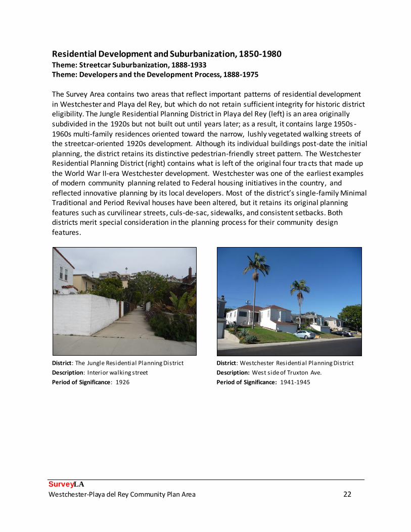
Residential Development and Suburbanization, 1850-1980 Theme: Streetcar Suburbanization, 1888-1933 Theme: Developers and the Development Process, 1888-1975
The Survey Area contains two areas that reflect important patterns of residential development
in Westchester and Playa del Rey, but which do not retain sufficient integrity for historic district eligibility. The Jungle Residential Planning District in Playa del Rey (left) is an area originally subdivided in the 1920s but not built out until years later; as a result, it contains large 1950s -
1960s multi-family residences oriented toward the narrow, lushly vegetated walking streets of the streetcar-oriented 1920s development. Although its individual buildings post-date the initial
planning, the district retains its distinctive pedestrian-friendly street pattern. The Westchester Residential Planning District (right) contains what is left of the original four tracts that made up
the World War II-era Westchester development. Westchester was one of the earliest examples of modern community planning related to Federal housing initiatives in the country, and
reflected innovative planning by its local developers. Most of the district’s single-family Minimal Traditional and Period Revival houses have been altered, but it retains its original planning features such as curvilinear streets, culs-de-sac, sidewalks, and consistent setbacks. Both districts merit special consideration in the planning process for their community design features.
District: The Jungle Residential Planning District District: Westchester Residential Planning District
Description: Interior walking street Description: West side of Truxton Ave.
Period of Significance: 1926 Period of Significance: 1941-1945

SurveyLA
Westchester-Playa del Rey Community Plan Area 23
Architecture and Engineering, 1850-1980 Theme: Post-War Modernism, 1946-1976 Sub-Theme: Mid-Century Modernism, 1945-1970
The Survey Area was predominantly developed in the post-World War II era; as a result, it contains a notable concentration of Mid-Century Modern architecture represented by a variety of property types, ranging from residential to institutional. Commercial buildings include the Richard Dorman-designed Airport Office Building and the iconic IBM Aerospace Headquarters. The 1949 house at 5760 W. 78th St. is an excellent and early example of Mid-Century
Modernism in the Westchester area, while the 1959 house at 209 E. Montreal St. demonstrates the presence of the style in Playa Del Rey. Multiple intact Mid-Century Modern churches were identified in the Survey Area, including the 1964 Westchester Lutheran, designed by Orr, Strange, Inslee and Senefeld, and the 1966 St. Jerome Catholic Church, designed by Prescott, Whalley and Weit. Finally, the Merle Norman cosmetics factory is an excellent example of the style as applied to an industrial building.
Address: 7831 Sepulveda Blvd. Address: 9100 S. Bellanca Ave.
Name: Westchester Lutheran Church Name: Merle Norman Cosmetics
Architect: Orr, Strange, Inslee and Senefeld Architect: Unknown
Date: 1964 Date: 1952
Address: 8929 S. Sepulveda Blvd. Address: 5760 W. 78
th St.
Name: Airport Office Building Name: N/A
Architect: Richard Dorman Architect: Unknown
Date: 1961 Date: 1949

SurveyLA
Westchester-Playa del Rey Community Plan Area 24
Address: 9045 S. Lincoln Blvd. Address: 209 E. Montreal St.
Name: IBM Aerospace Headquarters Name: N/A
Architect: Jones and Emmons, with Eliot Noyes Architect: Unknown
Date: 1964 Date: 1959
Address: 5570 W. Thornburn St.
Name: St. Jerome Catholic Church
Architect: Prescott, Whalley and Weit
Date: 1966

SurveyLA
Westchester-Playa del Rey Community Plan Area 25
Architecture and Engineering, 1850-1980 Sub-Context: Los Angeles Modernism, 1919-1980 Theme: Post-War Modernism, 1946-1976
Sub-Theme: New Formalism, 1955-1976
New Formalism was a popular style for commercial and institutional buildings constructed in the 1960s; it drew from historic architectural traditions while maintaining an overall modern aesthetic. Two notable examples of New Formalism were identified in the Survey Area. The
Edward T. Foley Center (at left) on Loyola Marymount University’s campus was designed by the father of New Formalism himself, Edward Durell Stone, in 1962. This elegant example of the style
features a skin of patterned pre-cast concrete panels, delicate columns that culminate into Gothic arches, and a dramatic pierced overhang, throwing dappled light onto the building’s
exterior. The Hughes Aircraft Employee Credit Union, at right, is a playful representation of the style, with its symmetry, stylized columns, and repetitive arches at the building’s base.
Address: 7800 S. Fordham Road (LMU Campus) Address: 8131 S. Barnsley Ave.
Name: Edward T. Foley Center Name: Hughes Aircraft Employee Credit Union
Architect: Edward Durell Stone Architect: Perry Langston
Date: 1962 Date: 1968

SurveyLA
Westchester-Playa del Rey Community Plan Area 26
Architecture and Engineering, 1850-1980 Sub-Context: Los Angeles Modernism, 1919-1980 Theme: Late Modernism, 1966-1980
Sub-Theme: Late Modernism, 1966-1980
The Survey Area contains several excellent examples of Late Modern architecture, reflecting the work of forward-looking architects from the late 1960s to the 1980s. The duplex at 6672-6674 S.
Vista Del Mar (upper left) was built in 1956 but underwent major alterations in 1977 to become the first built work of Eric Owen Moss. Architect Rebecca Binder’s house in Playa Del Rey (upper right) demonstrates the use of varying shapes and volumes to create a harmonious whole. And the 1978 Burns Recreation Center on the Loyola-Marymount Campus (lower left), designed by Kappe, Lotery, and Boccato, continues the Modernist vision of the school’s campus plan.
Address: 6672-6674 S. Vista Del Mar Address: 7726 W. 81st
St.
Name: N/A Name: Binder House
Architect: Eric Owen Moss Architect: Rebecca Binder
Date: 1977 Date: 1986
Address: 7800 S. Fordham Road (LMU Campus)
Name: Burns Recreation Center
Architect: Kappe, Lotery, and Boccato
Date: 1978

SurveyLA
Westchester-Playa del Rey Community Plan Area 27
Commercial Development, 1850-1980 Theme: Neighborhood Commercial Development, 1875-1960 Sub-Theme: Neighborhood Commercial Centers, 1875-1960 The Survey Area contains one intact commercial district planned as part of the larger postwar
development of Westchester, the Westchester Triangle Commercial Historic District. With its construction spanning 1947-1962, this compact neighborhood commercial center took shape
after most of the residential development was completed, but it was integral to the master plan of the new community. Located directly behind the large-scale commercial district on Sepulveda Boulevard, the district’s low scale made it pedestrian-friendly and attractive to smaller, family-run businesses. The inclusion of relatively large parking lots to the rear of the buildings reflects the importance of automobile transportation in Los Angeles at mid-century, particularly in the design of new, postwar communities. The district’s buildings are Commercial Vernacular in style, some with secondary styles featuring design elements of the American Colonial Revival, Tudor Revival, Mid-Century Modern, and Late Moderne styles. Although this historic district abuts the larger commercial district on Sepulveda, many of the buildings on that
corridor have been altered or removed and therefore it does not appear eligible for listing.
District: Westchester Triangle Commercial
District: Westchester Triangle Commercial
Description: Street view (S. La Tijera Blvd.) Address: 6242 W. 87th
St.
Period of Significance: 1947-1962 Period of Significance: 1947-1962
SurveyLA
Westchester-Playa del Rey Community Plan Area 28
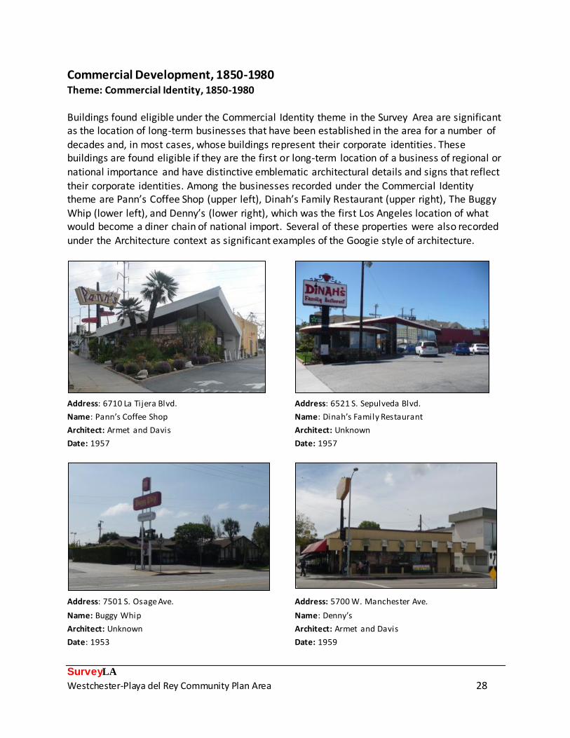
Commercial Development, 1850-1980 Theme: Commercial Identity, 1850-1980
Buildings found eligible under the Commercial Identity theme in the Survey Area are significant as the location of long-term businesses that have been established in the area for a number of
decades and, in most cases, whose buildings represent their corporate identities. These buildings are found eligible if they are the first or long-term location of a business of regional or national importance and have distinctive emblematic architectural details and signs that reflect
their corporate identities. Among the businesses recorded under the Commercial Identity theme are Pann’s Coffee Shop (upper left), Dinah’s Family Restaurant (upper right), The Buggy
Whip (lower left), and Denny’s (lower right), which was the first Los Angeles location of what would become a diner chain of national import. Several of these properties were also recorded
under the Architecture context as significant examples of the Googie style of architecture.
Address: 6710 La Tijera Blvd. Address: 6521 S. Sepulveda Blvd.
Name: Pann’s Coffee Shop Name: Dinah’s Family Restaurant
Architect: Armet and Davis Architect: Unknown
Date: 1957 Date: 1957
Address: 7501 S. Osage Ave. Address: 5700 W. Manchester Ave.
Name: Buggy Whip Name: Denny’s
Architect: Unknown Architect: Armet and Davis
Date: 1953 Date: 1959

SurveyLA
Westchester-Playa del Rey Community Plan Area 29
Public and Private Institutional Development, 1850-1980 Sub-Context: Government Infrastructure and Services, 1850-1980 Theme: Municipal Parks, Recreation, and Leisure, 1886-1978
Sub-Theme: Municipal Recreational Facilities, 1932-1978
The Survey Area contains two significant municipal recreational facilities representing different phases of the area’s development. Playa del Rey’s Del Rey Lagoon Park is one of the earliest parks in the area, created in 1938 when the channelization of the natural Ballona Creek outlet
left the small lagoon as a vestige of a much larger wetland area. The Westchester Recreation Center is a large public park established in the early 1950s to provide recreational space for the
area’s booming postwar developments. It contains multiple buildings, including the individually eligible Public Pool (designed by Arthur Wolfe) and the Westchester Municipal Building
(designed by James Homer Garrott), both built in the early 1960s.
District: Westchester Recreation Center District: Westchester Recreation Center
Description: View looking east Description: Westchester Public Pool
Period of Significance: 1952-1961 Architect: Arthur Wolfe
Date: 1961
District: Del Rey Lagoon Park
Description: View looking northwest
Period of Significance: 1938-1968

SurveyLA
Westchester-Playa del Rey Community Plan Area 30
Public and Private Institutional Development, 1850-1980 Sub-Context: Education, 1876-1980 Theme: Public Schools and the LAUSD, 1876-1980
Sub-Theme: Post WWII Schools, 1946-1966 Responding to the incredible need for new public school facilities in the rapidly-growing city in the post-World War II era, voters passed three bond measures in the 1940s and ‘50s for the
city’s schools. Money went to new construction, improvements to existing facilities, and purchase of land for future construction. Among the schools built with these funds in the Westchester-Playa del Rey CPA are Orville Wright Middle School (originally Westchester High School, built between 1948 and 1952 and converted to a middle school in 1956) and Westchester High School, built 1954-1955. These campuses are reflective of LAUSD school planning and design concepts of the period, following contemporary ideas in “building for learning,” which placed emphasis on fresh air, natural light, and the use of color. The campuses were designed for outdoor learning and
mobility with outdoor “classrooms,” recreation areas, and inventive site plans that encourage outdoor circulation in exterior corridors. Due to the relatively common nature of these resources, only those examples that are highly intact in terms of buildings, site plan, and landscape, and exhibit high quality of design and planning were recorded as eligible.
Address: 7400 W. Manchester Ave. Address: 6550 W. 80
th St.
Name: Westchester High School Name: Orvil le Wright Middle School
Architect: A.C. Zimmerman Architect: Spaulding and Rex
Period of Significance: 1954-1955 Period of Significance: 1948-1952

SurveyLA
Westchester-Playa del Rey Community Plan Area 31
Public and Private Institutional Development, 1850-1980
Sub-Context: Military Institutions and Activities, 1850-1980 Theme: Air Raid Sirens and Civil Defense, 1939-1960
Sub-Theme: Air Raid Siren
Air raid sirens were installed throughout Los Angeles during the World War II and Cold War periods. Two air raid sirens were identified in the Westchester-Playa del Rey: one “flattened
bird house” type on W. 88th St. (right) and one “rotating” type on 98th St. (left).
Address: 98
th St., east of Airport Blvd. Address: W. 88
th St., west of El Manor Ave.
Date: c. 1940 Date: 1940

SurveyLA
Westchester-Playa del Rey Community Plan Area 32
Public and Private Institutional Development, 1850-1980 Sub-Context: Government Infrastructure and Services, 1850-1980
The rapid growth of the Westchester-Playa del Rey area in the post-World War II period necessitated the expansion of government facilities. The Survey Area contains a number of significant properties representing this development. They are all good examples of Mid-Century Modernism, reflecting the widespread institutional use of this style in Los Angeles during the postwar period. The earliest building is the Westchester Branch of the Los Angeles Public Library, completed in 1949. Westchester’s Fire Station No. 5 followed soon after,
constructed in 1950. One of the most prominent government buildings is the Westchester Municipal Building, designed by local architect James Homer Garrott and built in a large municipal park in 1960. It was one of a number of branch City administrative centers built around Los Angeles between 1957 and 1970.
Address: 8946 S. Sepulveda Eastway Address: 7000 W. Manchester Ave.
Name: Los Angeles Public Library Westchester Branch Name: Westchester Municipal Building
Architect: Raymond Shaw Architect: James Homer Garrott
Date: 1949 Date: 1960
Address: 6614 W. 85th
Pl.
Name: Fire Station No. 5
Architect: Art and Ross Hutchinson
Date: 1950

SurveyLA
Westchester-Playa del Rey Community Plan Area 33
Industrial Development, 1850-1980 Sub-Context: Manufacturing for the Masses, 1883-1989 Theme: Factories, 1887-1980
Two industrial historic districts were recorded in the Survey Area, reflecting the importance of
small industrial manufacturing and distribution operations in Westchester during the postwar period. Both were located in proximity to aviation centers and continue to serve industrial purposes today. The Airport Industrial Tract (top row), with buildings designed by noted local
architect S. Charles Lee, was constructed just east of Los Angeles International Airport between 1950 and 1955. The Arizona Circle district (bottom row) was constructed near the Hughes
Aircraft campus (now part of Playa Vista) between 1959 and 1973. Both feature buildings with utilitarian designs and Mid-Century Modern elements.
District: Airport Industrial Tract Historic District District: Airport Industrial Tract Historic District
Address: 5320 W. 104th
St. Address: 5221 W. 102nd
St.
Architect: S. Charles Lee Architect: S. Charles Lee
Date: 1950 Date: 1953
District: Arizona Circle Industrial Historic District District: Arizona Circle Industrial Historic District
Address: 6330 W. Arizona Circle Address: 6300 W. Arizona Circle
Architect: Unknown Architect: Unknown
Date: 1960 Date: 1959

SurveyLA
Westchester-Playa del Rey Community Plan Area 34
Selected Bibliography Books and other published material: Creason, Glen. Los Angeles in Maps. New York: Rizzoli International Publications, Inc., 2010.
Davis, Mike. City of Quartz. New York: Vintage Books, 1992.
Dukesherer, David J. ‘Round the Clump of Willows: Westchester/Playa del Rey, California. Los
Angeles: Cental Historical Group, Inc., 2009.
Dukesherer, David J. Playa del Rey. Los Angeles: Cental Historical Group, Inc., 2010.
Hise, Greg. Magnetic Los Angeles: Planning the Twentieth-Century Metropolis. Baltimore: The Johns Hopkins University Press, 1997.
Historic Resources Group. Technical Report: Historic Resources Assessment, Loyola-Marymount University, Los Angeles, California. Prepared for Impact Sciences, Inc., June 2010.
Keane, James Thomas. Fritz B. Burns and the Development of Los Angeles. Los Angeles: The Thomas and Leavey Center for the Study of Los Angeles, Loyola Marymount University
and The Historical Society of Southern California, 2001.
Robinson, W. W. Culver City : A Calendar of Events in which is included, also, the story of Palms and Playa Del Rey together with Rancho La Ballona and Rancho Rincon de los Bueyes. Los Angeles: Title Guarantee and Trust Co., 1939.
Starr, Kevin. Embattled Dreams: California in War and Peace 1940-1950. New York: Oxford University Press, 2002.
Wallach, Ruth, Dace Taube, Claude Zachary, Linda McCann, and Curtis C. Roseman. Los Angeles in World War II. Charleston, SC: Arcadia Publishing, 2011.
Other sources of maps, photographs, periodicals, and other materials:
Chiang, Christina. Historic-Cultural Monument Application: Dickinson & Gillespie Building. Prepared for 200 Culver Investors, 2008.
Digital Sanborn Maps 1867-1970, Sanborn Fire Insurance Maps, accessed June 2013,
http://sanborn.umi.com.ezproxy.lapl.org/.

SurveyLA
Westchester-Playa del Rey Community Plan Area 35
Engh, Michael and Betty Forsyth. National Register of Historic Places Nomination: Centinela
Adobe, 1974.
Los Angeles Public Library, California Index, accessed June 2013, <http://www.lapl.org/collections-resources/visual-collections/california-index>.
Los Angeles Public Library Photographic Collection, Historic Photographs, accessed June 2013,
<http://photos.lapl.org/carlweb/jsp/photosearch_pageADV.jsp>.
Los Angeles Times. Ballona Harbor. 23 August 1887.
Los Angeles Times. The Railroads. 25 April 1891.
Los Angeles Times. Police Court Notes. 28 July 1899.
Los Angeles Times. “Playa del Rey,” the New City of Pleasure. 24 August 1902.
Los Angeles Times. Westchester District Sets New Development Standard. 7 June 1942.
Loyola Marymount University. Family History, Freeman Family Papers, CSLA-21. http://www.lmu.edu/Page8644.aspx, 2011. Accessed 26 June 2013.
McAvoy, Christy. National Register of Historic Places Registration Form: Hangar One, 1991.
Title Insurance and Trust Company, The Old Spanish and Mexican Ranchos of Los Angeles County (map), c. 1937.
Related Documents