High resolution radar data and products over the Continental United States Valliappa.Lakshmanan@noaa. gov National Severe Storms Laboratory Norman OK, USA http:// w ww.wdssii.org/

High resolution radar data and products over the Continental United States
Dec 31, 2015
High resolution radar data and products over the Continental United States. [email protected] National Severe Storms Laboratory Norman OK, USA http://w ww.wdssii.org/. Evolution of WDSS. What products? How often?. Products: Gridded hail products - PowerPoint PPT Presentation
Welcome message from author
This document is posted to help you gain knowledge. Please leave a comment to let me know what you think about it! Share it to your friends and learn new things together.
Transcript

High resolution radar data and products over the Continental United States
[email protected] Severe Storms Laboratory
Norman OK, USAhttp://www.wdssii.org/

April 19, 2023 [email protected] 2
Evolution of WDSS
1993-1998
Single-radar SCIT, MDA, TDA
Now part of RPG
1995-2000
Single-radar with multi-sensor input
NSE inputs
Scheduled for ORPG-8
2003 Multi-radar multi-sensor over regional domain
(1000km x 1000 km)
Gridded products
Shipped to select WFOs
Used in Storm Pred. Center
Product gen. for AWIPS?
2005 Multi-radar multi-sensor over CONUS
CONUS 1km grids
Available on the Internet
Used in SPC

April 19, 2023 [email protected] 3
What products? How often?
Products: Gridded hail products Reflectivity at constant temperature levels and layer averages Low-level and mid-level shear and rotation tracks Short-term forecast fields Lightning Density More …
Spatial Resolution: 0.01 deg x 0.01 deg [x 1km] resolution Approximately 1km x 1km throughout Continental United States. 1km in height
Temporal resolution: 2D reflectivity mosaics every 2 minutes 3D and derived products every 5 minutes
April 19, 2023 [email protected] 4
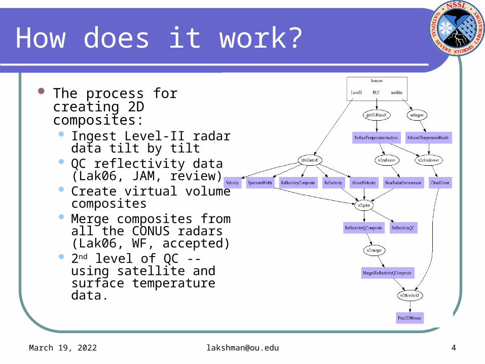
How does it work?
The process for creating 2D composites: Ingest Level-II radar
data tilt by tilt QC reflectivity data
(Lak06, JAM, review) Create virtual volume
composites Merge composites from
all the CONUS radars (Lak06, WF, accepted)
2nd level of QC -- using satellite and surface temperature data.
April 19, 2023 [email protected] 5
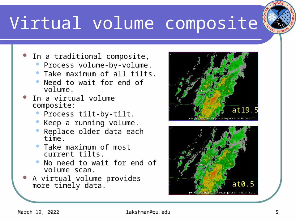
Virtual volume composite
In a traditional composite, Process volume-by-volume. Take maximum of all tilts. Need to wait for end of
volume. In a virtual volume composite:
Process tilt-by-tilt. Keep a running volume. Replace older data each time. Take maximum of most
current tilts. No need to wait for end of
volume scan. A virtual volume provides more
timely data.
at19.5
at0.5

April 19, 2023 [email protected] 6
Why do QC?
On a single-radar product, users may: want to see clear-air
returns. tolerate more clutter tolerate test patterns,
etc. On a multi-radar
product, clutter and clear-air returns are distracting.
April 19, 2023 [email protected] 7
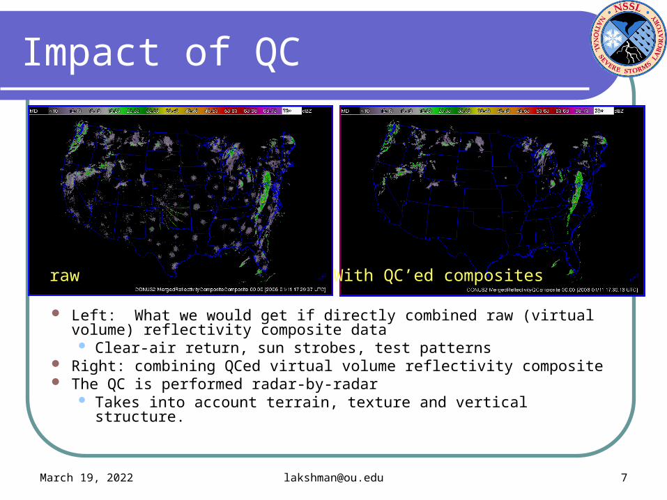
Impact of QC
Left: What we would get if directly combined raw (virtual volume) reflectivity composite data Clear-air return, sun strobes, test patterns
Right: combining QCed virtual volume reflectivity composite The QC is performed radar-by-radar
Takes into account terrain, texture and vertical structure.
With QC’ed compositesraw
April 19, 2023 [email protected] 8
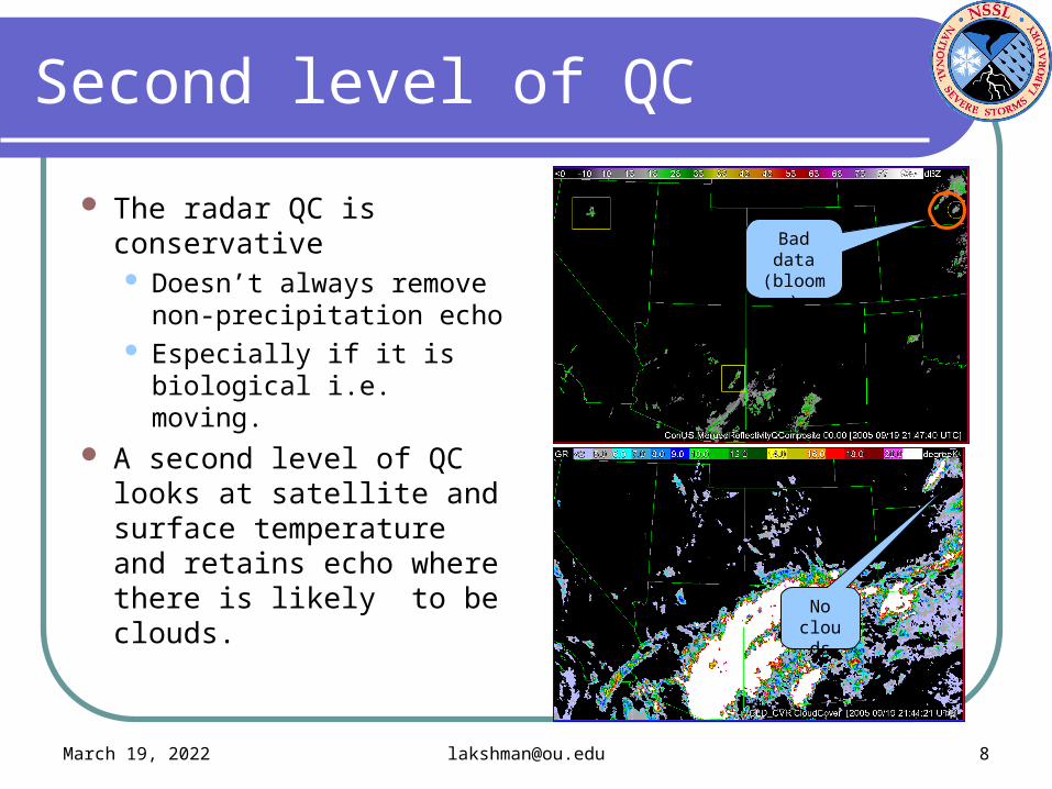
Second level of QC
The radar QC is conservative Doesn’t always remove
non-precipitation echo Especially if it is
biological i.e. moving. A second level of QC
looks at satellite and surface temperature and retains echo where there is likely to be clouds.
Bad data
(bloom)
No clouds

April 19, 2023 [email protected] 9
What do we do with the composite?
The 2D radar mosaic is created every 2 minutes at 1km resolution. Converted to Grib2 and sent to the SPC. Put on the Internet:
Snapshots with map background Converted to Geotiff
Loadable with Google Earth or any GIS software. Google Earth does real-time loading Talk in IIPS on Tuesday
http://wdssii.nssl.noaa.gov Not 24x7
The software is licensed by some private companies They run it on their own machines. They take care of 24x7 reliability.

April 19, 2023 [email protected] 10
2D vs 3D
The 2D composite is cheap to create
5 dual-Xeon machines with 6 GB RAM
But always provides an underestimate of true values.
Need to compute in 3D Height of dBZ value important! Can incorporate NSE
information by height A lot more products!
The 3D products need: 5 dual-Xeon with 6 GB RAM 2 dual-Xeon with 16 GB RAM 64-bit architecture
composite from 2D: 45 dBZ composite from 3D: 50 dBZ
April 19, 2023 [email protected] 11
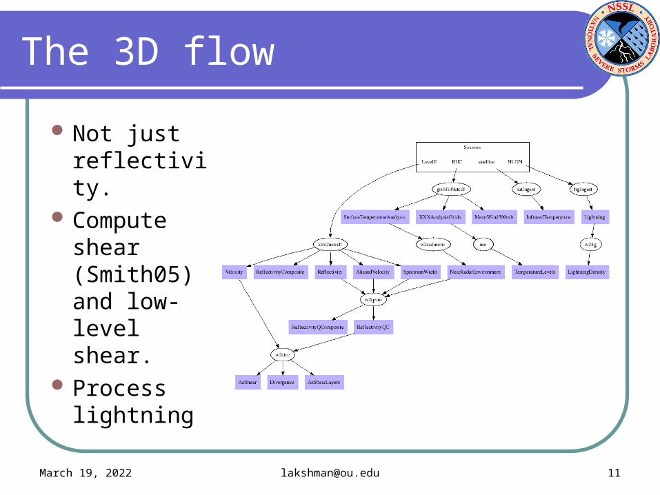
The 3D flow
Not just reflectivity.
Compute shear (Smith05) and low-level shear.
Process lightning

April 19, 2023 [email protected] 12
3D processing
Combine QC’ed reflectivity in 3D
Combine AzShear in 3D
Compute hail diagnosis and layer averages.
Compute storm motion from composite.
Use it to advect storms for short-term forecast.
April 19, 2023 [email protected] 13
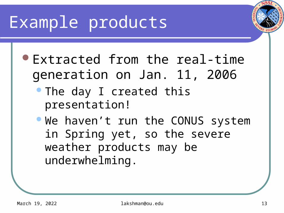
Example products
Extracted from the real-time generation on Jan. 11, 2006The day I created this presentation!We haven’t run the CONUS system in
Spring yet, so the severe weather products may be underwhelming.

April 19, 2023 [email protected] 14
Reflectivity products
Composite from 2D Composite from 3D
Height of Max Ref Which radars?

April 19, 2023 [email protected] 15
Azimuthal shear products
Azimuthal shear 0-3km MSL 30 minute rotation tracks

April 19, 2023 [email protected] 16
Severe weather diagnosis
Reflectivity at temp. levels
Echo top (18 dBZ)
VIL
Convection
Also:
Probability of Severe Hail
Maximum Expected Hail Size
VIL_Density
VIL_of_the_day
Other echo top dBZ levels
April 19, 2023 [email protected] 17
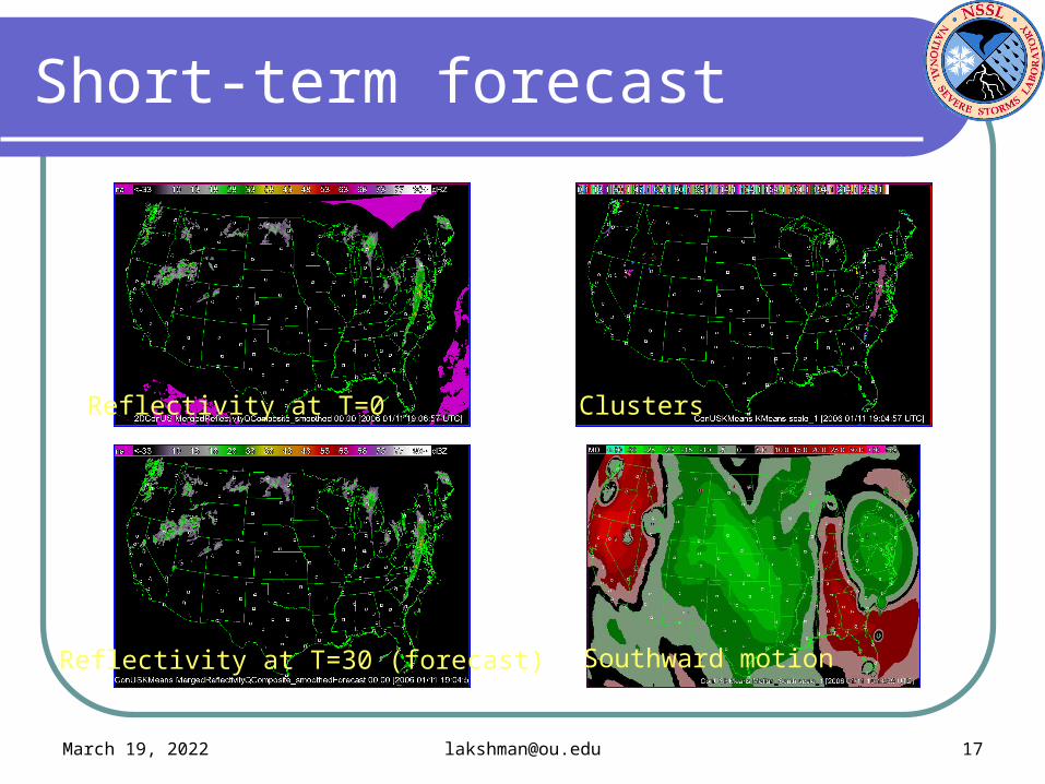
Short-term forecast
Reflectivity at T=0 Clusters
Reflectivity at T=30 (forecast) Southward motion

April 19, 2023 [email protected] 18
Precipitation estimates
Just the 88D algorithm on CONUS Uses hybrid scan reflectivity Convective/stratiform segregration
based on presence of hail 88D Z/R relationships.
Not multi-sensor QPESUMS-II under development
at NSSL.
Ref closest to ground
2hr precip accum
Instantaneous precip rate
April 19, 2023 [email protected] 19
What do we do with these products?
The 3D products are created every 5 minutes 1km resolution (0.01deg x 0.01deg x 1km) Converted to Grib2 and sent to the SPC. Put on the Internet (not all of them):
Snapshots with map background Converted to Geotiff
Loadable with Google Earth or any GIS software. Google Earth does real-time loading Talk in IIPS on Tuesday
http://wdssii.nssl.noaa.gov
Looking for the NWS to pick this up!
Related Documents