HIGH RESOLUTION SATELLITE HIGH RESOLUTION DEM / DTM for GEOCIENCES TTI Production

Welcome message from author
This document is posted to help you gain knowledge. Please leave a comment to let me know what you think about it! Share it to your friends and learn new things together.
Transcript
HIGH RESOLUTION
SATELLITE
HIGH RESOLUTION DEM / DTM
forGEOCIENCES
TTI Production
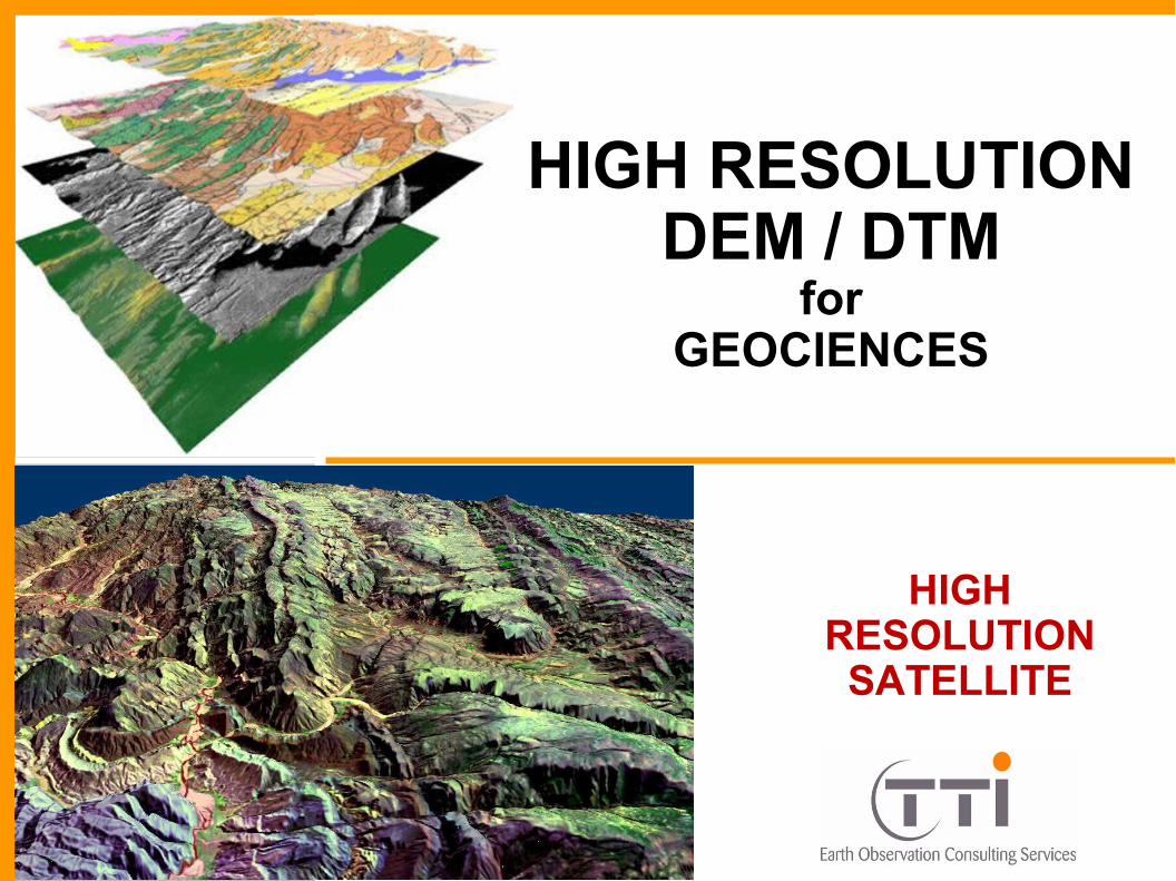
DEM / DTM APPLICATIONS
Ortho-rectification of satellite images, 3D display.
Creation of accurate topographic reference, relief maps.
Topographic profiles and contour generation.
Surface analysis.
Calculations of slope, orientation and shading.
Calculations of volume and elevation
Extraction of terrain and morphometric parameters.
Geomorphology and structural analysis.
Geological quantifications (dips, lithological thicknesses, faults and folds of geometry, etc.).
3D Reference map of resources extraction zones (quarries, open-pits).
Calculation of hydrographic networks and watershed basin.
Determination of hypsometric curves, knickpoints, etc.
Characterization of eroded areas.
Floods simulation, risks evaluation.
Volume calculation for restraints of dams.
TTI Production – David LOY
CONTACT :
REMOTE SENSING

EVOLUTION OF TECHNOLOGIES REMOTE SENSINGTTI Production
Optical very high resolution images and HR DEM ( 5m)WORLDVIEW > 0.5 mQUICKBIRD > 0.6 m IKONOS > 1.0 mPRISM + AVNIR > 2.5 m
Optical Mid to high Resolution images and DEM ( 30 m)AVNIR > 10 m
ASTER > 15 m SPOT > 5 m
LANDSAT > 15 m
NEW TECHNOLOGIES

DIGITAL ELEVATION MODEL( DEM )
orDIGITAL TERRAIN MODEL
( DTM )
Lidar first pulse
Lidar first pulse
Interpolation
DEM
DTM
DTM interpolated
DEM (first pulse)
DTM (last pulse)
+
+ +
+
TTI ProductionLIDAR DEM AND DTM EXTRACTION USING PULSES RECORDS
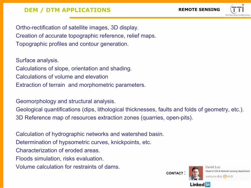
DIGITAL ELEVATION MODEL EXTRACTION
DIGITAL ELEVATION MODEL( DEM )
Extraction from VHR stereo optical satellite imagesExamples products and resolution:WORLDVIEW > 1.5 mIKONOS > 2.5 mQUICKBIRD > 2 m
REAL TERRAIN
LOW RESOLUTION DEM
HIGH RESOLUTION DEM
VERY HIGH RESOLUTION DEM
Extraction from HR stereo optical satellite imagesExamples products and resolution:ALOS PRISM > 5 mSPOT > 10 m
Extraction from LR stereo satellite images or interferometry radarExisting products and resolution:GDEM > 30 mSRTM > 30 mREF3D >30 m
TTI Production

DEM ALOS PRISM : 5 m resolution
TTI ProductionREMOTE SENSING PRODUCTS
DEM ALOS PRISM 5 m
The Advanced Land Observing Satellite (ALOS) with the Panchromatic Remote-sensing Instrument for Stereo Mapping (PRISM) is optimal for High Resolution (HR) Digital Elevation Model (DEM) extraction.PRISM consists of three panchromatic radiometers for forward, nadir, and backward views and acquires each image in the same orbit at almost the same time.
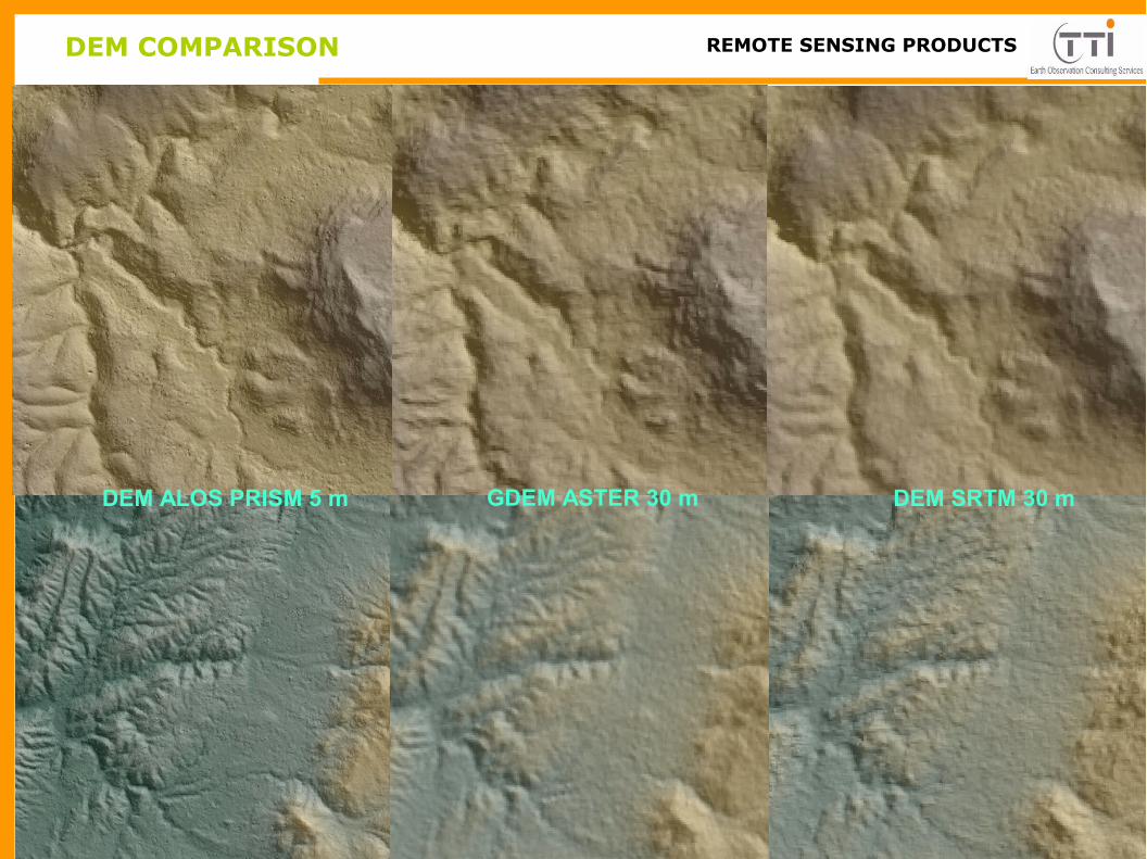
DEM COMPARISON TTI ProductionREMOTE SENSING PRODUCTS
DEM SRTM 30 mGDEM ASTER 30 mDEM ALOS PRISM 5 m
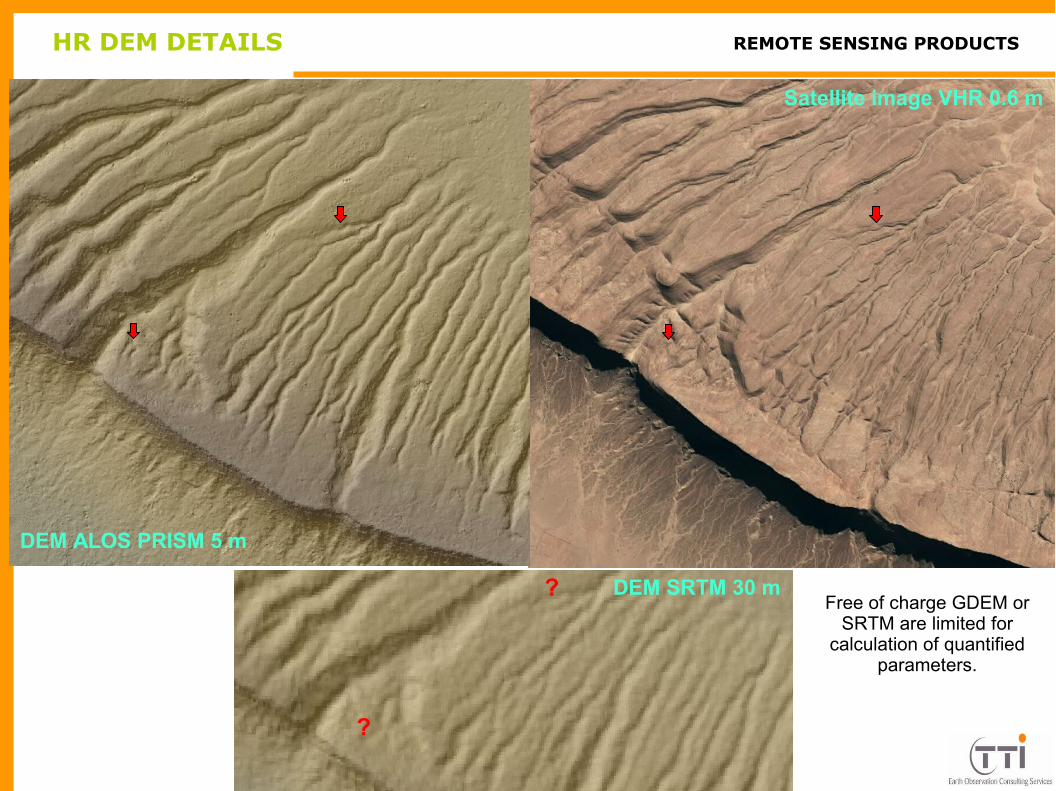
HR DEM DETAILS TTI ProductionREMOTE SENSING PRODUCTS
DEM SRTM 30 m
DEM ALOS PRISM 5 m
Satellite image VHR 0.6 m
?
?Free of charge GDEM or
SRTM are limited for calculation of quantified
parameters.

TTI ProductionREMOTE SENSING PRODUCTS
DEM SRTM 30 m
DEM ALOS PRISM 5 m Satellite image VHR 0.6 m
??
?
HR DEM DETAILS
Accurate HR DEM / DTM displays geological features with dimension of the same order than VHR images and
allows good 3D quantification.

SAMPLE OF VERY HIGH IMAGE & DEM
TTI ProductionREMOTE SENSING PRODUCTS
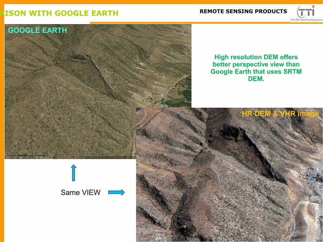
COMPARISON WITH GOOGLE EARTH
TTI ProductionREMOTE SENSING PRODUCTS
High resolution DEM offers better perspective view than
Google Earth that uses SRTM DEM.
GOOGLE EARTH
HR DEM & VHR image
Same VIEW
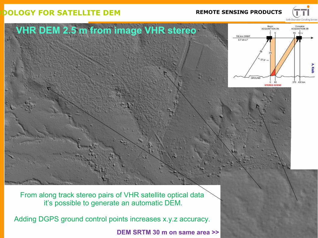
METHODOLOGY FOR SATELLITE DEM TTI Production
VHR DEM 2.5 m from image VHR stereo
DEM SRTM 30 m on same area >>
REMOTE SENSING PRODUCTS
From along track stereo pairs of VHR satellite optical data it’s possible to generate an automatic DEM.
Adding DGPS ground control points increases x.y.z accuracy.
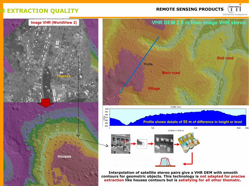
DEM EXTRACTION QUALITY TTI ProductionREMOTE SENSING PRODUCTS
Profile
VHR DEM 2.5 m from image VHR stereo
Profile shows details of 55 m of difference in height or level
Interpolation of satellite stereo pairs give a VHR DEM with smooth contours for geometric objects. This technology is not adapted for precise
extraction like houses contours but is satisfying for all other thematic.
Image VHR (WorldView 2)
Houses
Houses
Village
Main road
Rail road

METHODOLOGY TO CONVERT DEM TO DTM TTI Production
DTMDEM
Objects Mask
Image VHR (WorldView 2)
Extraction & Classification
REMOTE SENSING PRODUCTS
DEM VHR 2.5 m from image VHR stereo
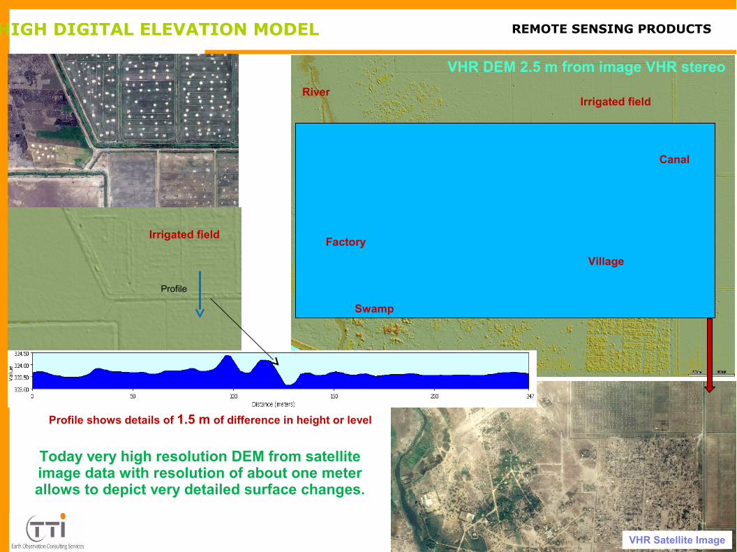
VERY HIGH DIGITAL ELEVATION MODEL TTI ProductionREMOTE SENSING PRODUCTS
Profile shows details of 1.5 m of difference in height or level
Irrigated field
Village
Factory
River
Swamp
Canal
VHR Satellite Image
VHR DEM 2.5 m from image VHR stereo
Profile
Irrigated field
Today very high resolution DEM from satellite image data with resolution of about one meter allows to depict very detailed surface changes.

DEM / DTM REPRESENTATION TTI ProductionREMOTE SENSING PRODUCTS
??
High resolution DEM offers the possibility to produce many geospatial products for relief, altitudes and
topography.
RastersTINsContoursProfilesPoints
AltitudesSlopesCurves
Example of color coded display of flowing direction instead of shadow on right or contours above.
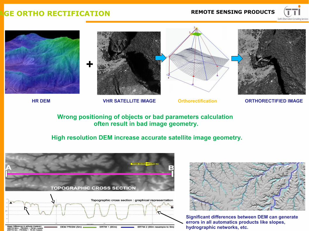
IMAGE ORTHO RECTIFICATION TTI ProductionREMOTE SENSING PRODUCTS
Significant differences between DEM can generate errors in all automatics products like slopes, hydrographic networks, etc.
+
HR DEM VHR SATELLITE IMAGE Orthorectification ORTHORECTIFIED IMAGE
Wrong positioning of objects or bad parameters calculation often result in bad image geometry.
High resolution DEM increase accurate satellite image geometry.
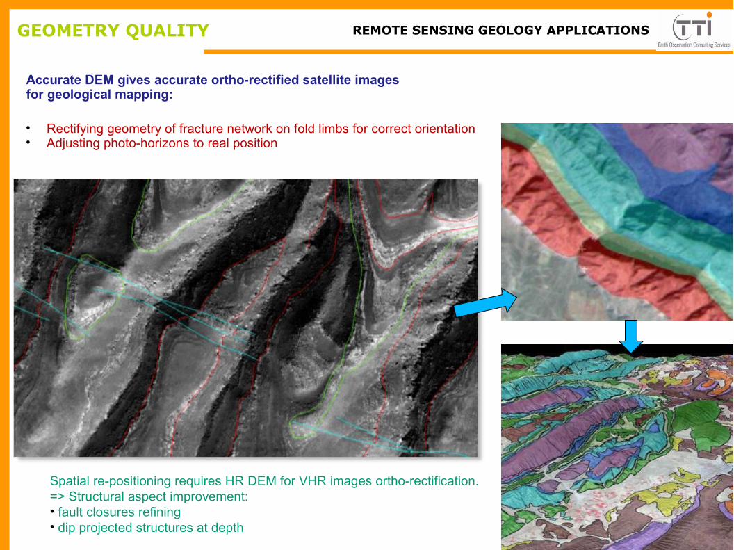
GEOMETRY QUALITY
• Rectifying geometry of fracture network on fold limbs for correct orientation• Adjusting photo-horizons to real position
TTI ProductionREMOTE SENSING GEOLOGY APPLICATIONS
Accurate DEM gives accurate ortho-rectified satellite images for geological mapping:
Spatial re-positioning requires HR DEM for VHR images ortho-rectification.=> Structural aspect improvement:• fault closures refining• dip projected structures at depth

ADDED-VALUE TOOLS FOR GEOLOGY TTI ProductionREMOTE SENSING GEOLOGY APPLICATIONS
Objectives:
Structural enhancementImproving map coverageRetrieving additional dipsSpatial correlation of structuresSub-surface/ surface adjustment
It helps the field or petroleum geologists to build advanced maps and database using GIS technics, 3D calculation from HR DEM and dedicated geo-styles to produce efficient added-value mapping products.

TTI ProductionREMOTE SENSING GEOLOGY APPLICATIONS
3D parameters needs HR DEM products.
Calculations on HR DEM allows :•Correlative thickness•Automatic stratigraphic column.•Distribution of thickness of outcropping selected units using top/wall contacts.
GEOLOGIC QUANTIZATION IN HARD ACESS AREAS
ADDED-VALUE GEOLOGY
Dip computing improves 2D/3D surface geologic database and requires HR DEM for better accuracy.
Use of high resolution DEM for geological mapping is the solution for
the Petroleum and Mining industry
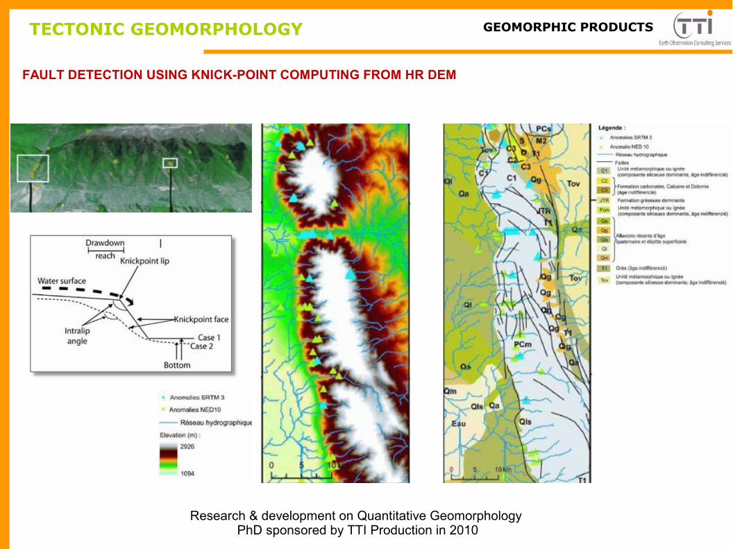
FAULT DETECTION USING KNICK-POINT COMPUTING FROM HR DEM
Research & development on Quantitative Geomorphology PhD sponsored by TTI Production in 2010
TECTONIC GEOMORPHOLOGY TTI ProductionGEOMORPHIC PRODUCTS
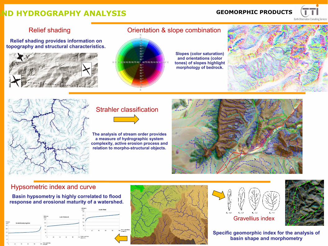
SLOPES AND HYDROGRAPHY ANALYSIS TTI Production
Strahler classification
Gravellius index
Hypsometric index and curve
Relief shading Orientation & slope combination
Specific geomorphic index for the analysis of basin shape and morphometry
Basin hypsometry is highly correlated to flood response and erosional maturity of a watershed.
The analysis of stream order provides a measure of hydrographic system
complexity, active erosion process and relation to morpho-structural objects.
Slopes (color saturation) and orientations (color
tones) of slopes highlight morphology of bedrock.
Relief shading provides information on topography and structural characteristics.
GEOMORPHIC PRODUCTS

HYDROGRAPHY ANALYSIS TTI Production
DRAINAGE DENSITY vs ALTITUDE
ASYMETRY INDEX
Computing ratio based on the distance of a stream to the basin outline and the distance to the generatrix is
assumed to be related to tectonic and lithological factors.
SINUOSITY INDEX
This index with slopes could highlight lithology distribution.
This index is an indirect morpho-structural clue for the detection of sub-surface folds or burried positive structures
Differences of length, orientation and angle of 2nd order streams on both side of main stream are indirect evidence
of distinct erosion processes or tectonic behaviour
GEOMORPHIC PRODUCTS
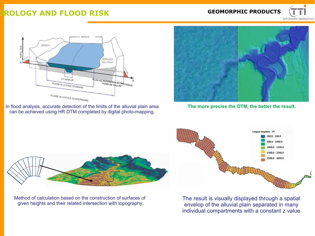
HYDROLOGY AND FLOOD RISK TTI Production
The more precise the DTM, the better the result.In flood analysis, accurate detection of the limits of the alluvial plain area can be achieved using HR DTM completed by digital photo-mapping.
The result is visually displayed through a spatial envelop of the alluvial plain separated in many
individual compartments with a constant z value
Method of calculation based on the construction of surfaces of given heights and their related intersection with topography.
GEOMORPHIC PRODUCTS
Related Documents