Quaternary Science Reviews 26 (2007) 2644–2660 High-altitude varve records of abrupt environmental changes and mining activity over the last 4000 years in the Western French Alps (Lake Bramant, Grandes Rousses Massif) Herve´ Guyard a,b,c, , Emmanuel Chapron d , Guillaume St-Onge b,c , Flavio S. Anselmetti d , Fabien Arnaud e , Olivier Magand f , Pierre Francus g,c , Marie-Antoinette Me´lie`res f,h a Universite´Bordeaux 1, DGO, UMR EPOC 5805, Avenue des faculte´s, 33405 Talence Cedex, France b Institut des sciences de la mer de Rimouski (ISMER), Universite´du Que´bec a` Rimouski, 310 alle´e des Ursulines, Rimouski, Que´bec Canada, G5L 3AI c Centre de recherche en ge´ochimie et ge´odynamique (GE ´ OTOP-UQA ` M-McGill),Universite´du Que´bec a` Montre´al, C.P. 8888, Succ. Centre-Ville, Montre´al, Que´bec Canada, H3C 3P8 d Geological Institute ETH Zu ¨ rich, Universita ¨ tstrasse 16, CH-8092 Zu ¨ rich, Switzerland e Laboratoire EDYTEM, UMR 5204, Universite´de Savoie, F-73376 Le Bourget du Lac, France f Laboratoire de Glaciologie et de Ge´ophysique de l’Environnement (LGGE), CNRS, Universite´Joseph Fourier Grenoble, Domaine Universitaire BP 36, F-38402 Saint Martin d’He`res, France g Institut National de la Recherche Scientifique- Eau, Terre, et Environnement (INRS-ETE), Que´bec Canada, G1K 9A9 h Institut de la Montagne, Universite´de Savoie, F-73376 Le Bourget du Lac, France Received 1 February 2007; received in revised form 10 July 2007; accepted 11 July 2007 Abstract Two twin short gravity cores and a long piston core recovered from the deepest part of proglacial Lake Bramant (Grandes Rousses Massif, French Alps), under and overlying a large slump identified by high-resolution seismic profile, allow the investigation of Holocene natural hazards and interactions between human activity and climatic changes at high-altitude. Annual sedimentation throughout the cores (glacial varves) is identified on photographs, ITRAX (high-resolution continuous microfluorescence-X) and CAT-Scan (computerized axial tomography) analyses and is supported by (1) the number of dark and light laminations between dates obtained by radionuclide measurements ( 137 Cs, 241 Am), (2) the correlation of a slump triggered by the nearby AD 1881 Allemond earthquake (MSK intensity VII) and of a turbidite triggered by the AD 1822 Chautagne regional earthquake (MSK intensity VIII), (3) the number of laminations between two accelerator mass spectrometry (AMS) 14 C dates, and (4) archaeological data. In Lake Bramant, dark layers are coarser, contain less detrital elements, but more neoformed elements and organic matter content. These darker laminations result from calm background sedimentation, whereas the lighter layers are finer and rich in detrital elements and reflect the summer snowmelt. Traces of mining activity during the Roman civilization apogee (AD 115–330) and during the Early Bronze Age (3770–3870 cal BP) are recorded by lead and copper content in the sediments and probably result from regional and local mining activity in the NW Alps. Warmer climate during the Bronze Age in this part of the Alps is suggested by (1) two organic deposits (4160–3600 cal BP and 3300–2850 cal BP) likely reflecting a lower lake level and smaller glaciers and (2) evidence of a different vegetation cover around 2500 m a.s.l. The onset of clastic proglacial sedimentation between 3600–3300 cal BP and since 2850 cal BP is synchronous with periods of glacier advances documented in the Alps and high-lake levels in west-central Europe. This major change in proglacial sedimentation highlights the development of a larger St. Sorlin glacier in the catchment area of Lake Bramant. r 2007 Elsevier Ltd. All rights reserved. 1. Introduction High-altitude lakes are often used as archives for past environmental changes and mountain glaciers are valuable tools to investigate climate variability over decadal to ARTICLE IN PRESS 0277-3791/$ - see front matter r 2007 Elsevier Ltd. All rights reserved. doi:10.1016/j.quascirev.2007.07.007 Corresponding author. Institut des sciences de la mer de Rimouski (ISMER, UQAR), 310, alle´e des Ursulines, Rimouski (Qc) Canada G5L3A1. Tel.: +1 418 723 1986 x 1230; fax: +1 418 724 1842. E-mail address: [email protected] (H. Guyard).

Welcome message from author
This document is posted to help you gain knowledge. Please leave a comment to let me know what you think about it! Share it to your friends and learn new things together.
Transcript

ARTICLE IN PRESS
0277-3791/$ - se
doi:10.1016/j.qu
�Correspond(ISMER, UQA
G5L3A1. Tel.:
E-mail addr
Quaternary Science Reviews 26 (2007) 2644–2660
High-altitude varve records of abrupt environmental changes andmining activity over the last 4000 years in the Western French Alps
(Lake Bramant, Grandes Rousses Massif)
Herve Guyarda,b,c,�, Emmanuel Chaprond, Guillaume St-Ongeb,c, Flavio S. Anselmettid,Fabien Arnaude, Olivier Magandf, Pierre Francusg,c, Marie-Antoinette Melieresf,h
aUniversite Bordeaux 1, DGO, UMR EPOC 5805, Avenue des facultes, 33405 Talence Cedex, FrancebInstitut des sciences de la mer de Rimouski (ISMER), Universite du Quebec a Rimouski, 310 allee des Ursulines, Rimouski, Quebec Canada, G5L 3AI
cCentre de recherche en geochimie et geodynamique (GEOTOP-UQAM-McGill),Universite du Quebec a Montreal, C.P. 8888, Succ. Centre-Ville,
Montreal, Quebec Canada, H3C 3P8dGeological Institute ETH Zurich, Universitatstrasse 16, CH-8092 Zurich, Switzerland
eLaboratoire EDYTEM, UMR 5204, Universite de Savoie, F-73376 Le Bourget du Lac, FrancefLaboratoire de Glaciologie et de Geophysique de l’Environnement (LGGE), CNRS, Universite Joseph Fourier Grenoble, Domaine Universitaire BP 36,
F-38402 Saint Martin d’Heres, FrancegInstitut National de la Recherche Scientifique- Eau, Terre, et Environnement (INRS-ETE), Quebec Canada, G1K 9A9
hInstitut de la Montagne, Universite de Savoie, F-73376 Le Bourget du Lac, France
Received 1 February 2007; received in revised form 10 July 2007; accepted 11 July 2007
Abstract
Two twin short gravity cores and a long piston core recovered from the deepest part of proglacial Lake Bramant (Grandes Rousses
Massif, French Alps), under and overlying a large slump identified by high-resolution seismic profile, allow the investigation of Holocene
natural hazards and interactions between human activity and climatic changes at high-altitude. Annual sedimentation throughout the
cores (glacial varves) is identified on photographs, ITRAX (high-resolution continuous microfluorescence-X) and CAT-Scan
(computerized axial tomography) analyses and is supported by (1) the number of dark and light laminations between dates obtained
by radionuclide measurements (137Cs, 241Am), (2) the correlation of a slump triggered by the nearby AD 1881 Allemond earthquake
(MSK intensity VII) and of a turbidite triggered by the AD 1822 Chautagne regional earthquake (MSK intensity VIII), (3) the number of
laminations between two accelerator mass spectrometry (AMS) 14C dates, and (4) archaeological data. In Lake Bramant, dark layers are
coarser, contain less detrital elements, but more neoformed elements and organic matter content. These darker laminations result from
calm background sedimentation, whereas the lighter layers are finer and rich in detrital elements and reflect the summer snowmelt. Traces
of mining activity during the Roman civilization apogee (AD 115–330) and during the Early Bronze Age (3770–3870 cal BP) are recorded
by lead and copper content in the sediments and probably result from regional and local mining activity in the NW Alps. Warmer climate
during the Bronze Age in this part of the Alps is suggested by (1) two organic deposits (4160–3600 cal BP and 3300–2850 cal BP) likely
reflecting a lower lake level and smaller glaciers and (2) evidence of a different vegetation cover around 2500ma.s.l. The onset of clastic
proglacial sedimentation between 3600–3300 cal BP and since 2850 cal BP is synchronous with periods of glacier advances documented in
the Alps and high-lake levels in west-central Europe. This major change in proglacial sedimentation highlights the development of a
larger St. Sorlin glacier in the catchment area of Lake Bramant.
r 2007 Elsevier Ltd. All rights reserved.
e front matter r 2007 Elsevier Ltd. All rights reserved.
ascirev.2007.07.007
ing author. Institut des sciences de la mer de Rimouski
R), 310, allee des Ursulines, Rimouski (Qc) Canada
+1418 723 1986 x 1230; fax: +1 418 724 1842.
ess: [email protected] (H. Guyard).
1. Introduction
High-altitude lakes are often used as archives for pastenvironmental changes and mountain glaciers are valuabletools to investigate climate variability over decadal to
ARTICLE IN PRESSH. Guyard et al. / Quaternary Science Reviews 26 (2007) 2644–2660 2645
centennial timescale (Leeman and Niessen, 1994; Leonard,1997; Intergovernmental Panel on Climate Change (IPCC),2001; Blass et al., 2003; Deline and Orombelli, 2005;Holzhauzer et al., 2005). Millennial to centennial-scaleHolocene climatic oscillations in the Alps and surroundingregions have been documented by lake-level changes,archaeological evidence and palynological records frommany small lakes in the Jura Mountains and several largerlakes in the NW French Alps and in the Swiss Plateau (seeMagny et al., 2003; Magny, 2004; Holzhauzer et al., 2005for a review). Within radiocarbon dating uncertainties,cold and wet periods favouring high lake levels seem tocoincide with well-documented advances of Swiss andAustrian glaciers and with tree-line descent in the Centraland Southern Alps. In the French Western Alps, Holoceneglacier fluctuations are documented in the Mont BlancMassif by few radiocarbon-dated glacial or fluvio-glacialdeposits and by a well-dated continuous record of floodingactivity from a large lake downstream of these glaciers (seeChapron et al., 2002, 2005; Arnaud et al., 2005a, b for areview). Since 2800 cal BP, however, increasing land use inAlpine valleys is interacting with climate and influencesenvironmental changes and clastic lacustrine sedimentation(Noel et al., 2001; Arnaud et al., 2005a, b). In contrast tothese alpine valleys, little is known about the evolution of
Table 1
Evolution of human activities in the Grandes Rousses Massif over the last 40
Chronological period Age (BC/AD)
Modern period AD 1918–present
Middle Age 476–1492 AD
Roman period 50 BC–476 AD
Iron Age 750–50 BC
Late Bronze Age 1400–750 BC
Middle Bronze Age 1700–1350 BC
Early Bronze Age 2300–1650 BC
The chronological limits of the periods are those retained by the Service Regi
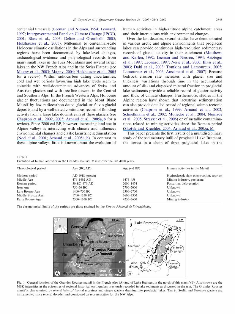
Fig. 1. General location of the Grandes Rousses massif in the French Alps (A
MSK intensities at the epicentres of regional historical earthquakes previously
massif is characterized by several belts of frontal moraines and cirque glacier
instrumented since several decades and considered as representative for the N
human activities in high-altitude alpine catchment areasand their interactions with environmental changes.Over the last decades, several studies have demonstrated
in various arctic and alpine environments that proglaciallakes can provide continuous high-resolution sedimentaryrecords of glacial activity in their catchment (Matthewsand Karlen, 1992; Leeman and Niessen, 1994; Arizteguiet al., 1997; Leonard, 1997; Nesje et al., 2000; Blass et al.,2003; Dahl et al., 2003; Tomkins and Lamoureux, 2005;Lamoureux et al., 2006; Anselmetti et al., 2007). Becausebedrock erosion rate increases with glacier size andthickness, variations through time in the accumulatedamount of silt- and clay-sized mineral fraction in proglaciallake sediments provide a reliable record of glacier activityand thus, of climate changes. Furthermore, studies in theAlpine region have shown that lacustrine sedimentationcan also provide detailed record of regional seismo-tectonicactivities (Chapron et al., 1999; Arnaud et al., 2002;Schnellmann et al., 2002; Monecke et al., 2004; Nomadeet al., 2005; Strasser et al., 2006) or of metallic contamina-tions related to mining activities since the Roman period(Shotyk and Krachler, 2004; Arnaud et al., 2005a, b).This paper presents the first results of a multidisciplinary
study of the sedimentary infill of proglacial Lake Bramant,the lowest in a chain of three proglacial lakes in the
00 years
Age (cal BP) Human activities in the Massif
Hydroelectric dam construction, tourism
1474–458 Mining industry, pasturing
2000–1474 Pasturing, deforestation
2700–2000 Unknown
3300–2700 Unknown
3600–3300 Unknown
4250–3600 Mining industry
onal de l’Archeologie.
) and of Lake Bramant in the north of this massif (B). Also shown are the
recorded in lake sediments as discussed in the text. The Grandes Rousses
s draining into proglacial lakes. The St. Sorlin and Sarennes glaciers are
W Alps.
ARTICLE IN PRESS
Fig. 2. Details of Lake Bramant catchment area. The catchment area
(thick dotted line) consists of a chain of proglacial lakes draining the Cote
Blanc glacier and a diffluence of the St. Sorlin glacier in the Bramant
valley (A). All proglacial lakes in the Bramant valley were originally
damned by frontal moraines, but since AD 1918, lakes Blanc Bramant and
Bramant were enlarged by artificial dams to produce hydroelectricity. Up
to five generations of moraines are recognized downstream from the St.
Sorlin glacier: Holocene moraines (thin black lines), the Little Ice Age
(LIA) moraines (thick black lines) and post LIA moraines (thin dotted
lines). Lake Bramant bathymetry and the location of the coring site are
based on seismic reflection profiling (B). The location of the seismic profile
shown in Fig. 3 is indicated by a thick dotted line.
H. Guyard et al. / Quaternary Science Reviews 26 (2007) 2644–26602646
northern part of the Grandes Rousses Massif (WesternAlps, France, Fig. 1). A precise chronostratigraphy in thishigh-altitude lake is established based on glacial varvecounting, radionuclide measurements and radiocarbondating. It allows especially the correlation of a major masswasting deposit with a strong local earthquake and itrelates atmospheric metallic contaminations to miningactivities in this part of the Alps. Important changes inproglacial sedimentation during the Middle Bronze Ageand since the end of the Late Bronze Age (Table 1) are usedto document environmental changes in relation with glacierfluctuations in the drainage basin, lake level changes andhuman activities in this alpine region.
2. Setting
The Grandes Rousses Massif (45170N, 6160E) is char-acterized by glaciers located between 3400 and 2500ma.s.l.,and by the occurrence of up to five generations of morainebelts formed below the present-day glacier snout positions.Two glaciers located on the southern (Sarennes) andnorthern (St. Sorlin) side of the massif (Fig. 1b) have beeninstrumented since 1949 and 1957, respectively, and aregenerally considered as representative for the NW Alpineregion (Six et al., 2001; Torinesi et al., 2002; Vincent, 2002).Several proglacial lakes are located below the uppermostmoraine belt resulting from the last advance of glaciersduring the ‘‘Little Ice Age’’ (LIA) in AD 1820–1850(Fuselin et al., 1909; Allix, 1927; Edouard, 1994).
St. Sorlin glacier (Fig. 2) is a small glacier (3 km2), butthe largest of the Grandes Rousses Massif. It is exposed tothe North and collects most of the precipitation falling in acirque of ca. 5 km2 lying entirely above 2700ma.s.l.(Lliboutry, 2002). St. Sorlin glacier mass-balance calcula-tions (Vincent, 2002) and an ice-flow model (Le Meur andVincent, 2003) covering the period between 1907 and 1999were based on direct glaciological measurements, on aerialphotographs, and on a first geomorphologic map made in1907 (Fuselin et al., 1909). This glacier forms a diffluenceon a bedrock knob near the location of the alpine hut at2710m a.s.l., used as a base camp during glaciologicalstudies (Fig. 2). Because of this diffluence, only the westernpart of St. Sorlin glacier (contoured in Fig. 2) belongs tothe drainage basin of a chain of three small proglacial lakes(lakes Tournant, Blanc Bramant and Bramant) that arealigned in the so-called Bramant Valley. These lakes ofglacial origin are dammed by three generations of frontalmoraines formed after the Younger Dryas according togeomorphologic correlations (Fuselin et al., 1909;Edouard, 1994) and pollen studies in the south of themassif (Chardon, 1991).
Glacial erosion of the bedrock (consisting of gneiss,schist, Carboniferous and Triassic sedimentary rocks) inthis small glacial valley has been enhanced by thedevelopment of intense NS and NW–SE faulting duringthe formation of the massif. This specific structural settingis partly reflected in the course of torrents draining this part
of the massif (Figs. 1b and 2a) and is associated with theoccurrence of springs and wells at the contact of contrastedlithologies in the Bramant valley. Meltwaters from thediffluence of St. Sorlin glacier form a spring below recentfrontal moraines and merge with Cote Blanc glaciermeltwaters near fresh (but washed) lateral and frontalmoraines formed in AD 1907 and during the LIA. Theseglacial meltwaters then feed a small sandur where fluvio-glacial streams are braided and today have almostcompletely filled proglacial Lake Tournant. The remnantsof this uppermost proglacial lake are very shallow and theunderground outlet feeds a spring at the base of grass-covered frontal moraines just upstream from Lake BlancBramant (Fig. 2a). Lake Blanc Bramant is deeper (17m)and its outlet constitutes the main tributary of LakeBramant, the lowermost of the three lakes. The two lowerlakes were enlarged and deepened by dams built in AD1918 to produce hydroelectricity until the 1980s.In its natural state, Lake Bramant was dammed by
frontal moraines and rock bars characterized by glacial
ARTICLE IN PRESSH. Guyard et al. / Quaternary Science Reviews 26 (2007) 2644–2660 2647
morphology. Today, it is located at 2448ma.s.l, is 600mlong, 400m wide and its maximum depth is �39m(Fig. 2b). Due to its specific geomorphologic relation withthe St. Sorlin and Cote Blanc glaciers and due to its distallocation in a chain of proglacial lakes, Lake Bramant onlyreceives the fine-grained suspension load transported byglacier meltwaters. The drainage basin of Lake Bramant issmall (ca. 5 km2) and only locally covered by soils cappedwith alpine grassland. The catchment area is snow-coveredmore than 6 months per year. On average, the lake islargely frozen from mid-November to mid-June andtributary floods resulting from snowmelt events occurfrom mid-May to mid-July. Snow avalanches can reach theEastern part of Lake Bramant and transport coarseparticles from the catchment to the lake ice.
The Western Alps are also affected by large tectonicfeatures such as basement thrusts and strike-slip faults(Thouvenot et al., 2003) and the study area has beenhistorically subjected to several moderate magnitude earth-quakes (Chapron et al., 1999; Arnaud et al., 2002; Nomadeet al., 2005). Among them, the AD 1881 Allemond earth-quake (intensity MSK VII) had an epicentre that was locatedless than 12km away from Lake Bramant (Fig. 1).The AD1822 Chautagne earthquake located at 90km from LakeBramant is the strongest of the study area (Fig. 1), with anestimated magnitude of 6–6.5 (Chapron et al., 1999).
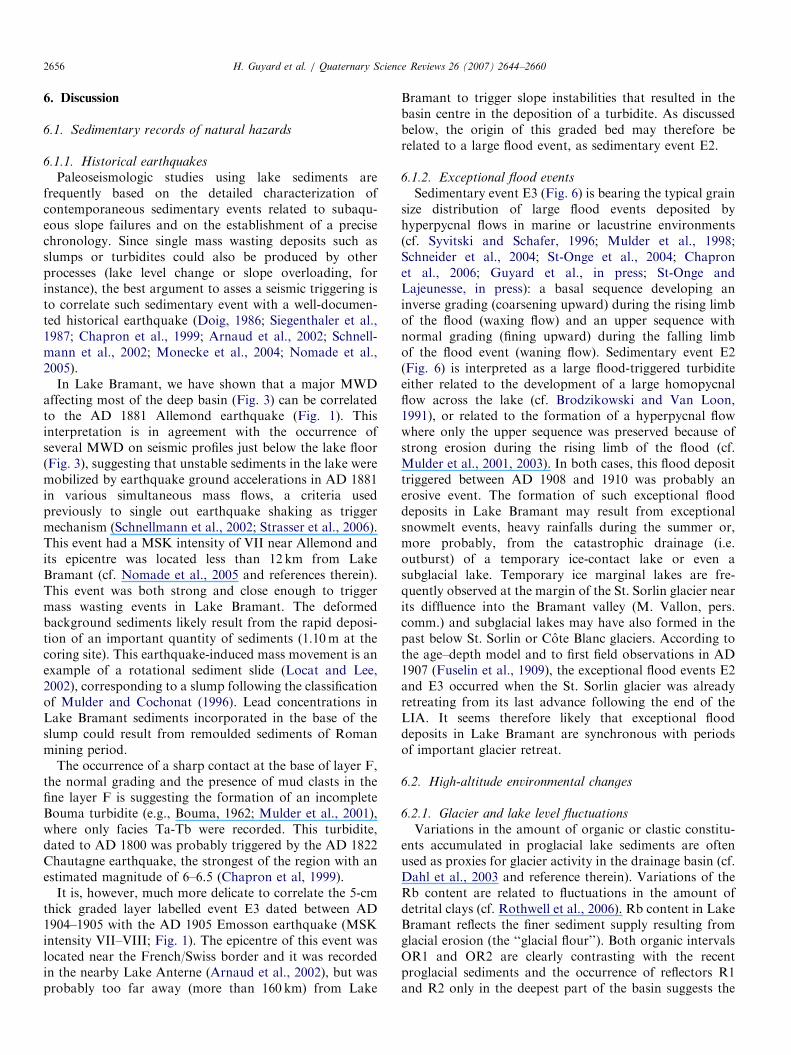
In addition to these tectonic and climate changes, themassif has a long history of human settlement and land usesince the Bronze Age (Bailly-Maıtre and Gonon, 2006)(Table 1). Evidence of a copper mining industry, developedbetween 2300 and 2650ma.s.l. during the Early Bronze Agewas indeed recently discovered in the massif, just SE of thecatchment area of Lake Bramant (Bailly-Maıtre and Gonon,2006; Bailly-Maıtre, oral communication). Furthermore,important silver and lead mining industry during the MiddleAge (Table 1) is well-documented in the south western andwestern sides of the massif between 1800 and 2500ma.s.l.(Bailly-Maitre and Bruno-Dupraz, 1994). According to thepalynological studies of Chardon (1991) on the southernslopes of the massif near Alpe d’Huez (Fig. 2), alpinegrasslands and trees appeared in our study area between1800 and 2000ma.s.l. with the first temperate phases of theLate Glacial period. Then, during the Atlantic pollen zone, aforest of birches and alders formed a transitional beltbetween coniferous subalpine forest and alpine grassland.This forest was clear cut during the Roman period (Table 1)and the present landscape of treeless grasslands becameestablished above 1800ma.s.l. On the other hand, no trace ofmining activities during the Roman civilization has beendiscovered presently in the Massif.
3. Methods
3.1. Coring site
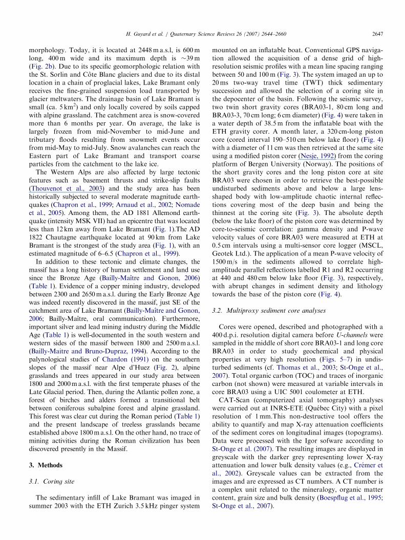
The sedimentary infill of Lake Bramant was imaged insummer 2003 with the ETH Zurich 3.5 kHz pinger system
mounted on an inflatable boat. Conventional GPS naviga-tion allowed the acquisition of a dense grid of high-resolution seismic profiles with a mean line spacing rangingbetween 50 and 100m (Fig. 3). The system imaged an up to20ms two-way travel time (TWT) thick sedimentarysuccession and allowed the selection of a coring site inthe depocenter of the basin. Following the seismic survey,two twin short gravity cores (BRA03-1, 80 cm long andBRA03-3, 70 cm long; 6 cm diameter) (Fig. 4) were taken ina water depth of 38.5m from the inflatable boat with theETH gravity corer. A month later, a 320 cm-long pistoncore (cored interval 190–510 cm below lake floor) (Fig. 4)with a diameter of 11 cm was then retrieved at the same siteusing a modified piston corer (Nesje, 1992) from the coringplatform of Bergen University (Norway). The positions ofthe short gravity cores and the long piston core at siteBRA03 were chosen in order to retrieve the best-possibleundisturbed sediments above and below a large lens-shaped body with low-amplitude chaotic internal reflec-tions covering most of the deep basin and being thethinnest at the coring site (Fig. 3). The absolute depth(below the lake floor) of the piston core was determined bycore-to-seismic correlation: gamma density and P-wavevelocity values of core BRA03 were measured at ETH at0.5 cm intervals using a multi-sensor core logger (MSCL,Geotek Ltd.). The application of a mean P-wave velocity of1500m/s in the sediments allowed to correlate high-amplitude parallel reflections labelled R1 and R2 occurringat 440 and 480 cm below lake floor (Fig. 3), respectively,with abrupt changes in sediment density and lithologytowards the base of the piston core (Fig. 4).
3.2. Multiproxy sediment core analyses
Cores were opened, described and photographed with a400 d.p.i. resolution digital camera before U-channels weresampled in the middle of short core BRA03-1 and long coreBRA03 in order to study geochemical and physicalproperties at very high resolution (Figs. 5–7) in undis-turbed sediments (cf. Thomas et al., 2003; St-Onge et al.,2007). Total organic carbon (TOC) and traces of inorganiccarbon (not shown) were measured at variable intervals incore BRA03 using a UIC 5001 coulometer at ETH.CAT-Scan (computerized axial tomography) analyses
were carried out at INRS-ETE (Quebec City) with a pixelresolution of 1mm.This non-destructive tool offers theability to quantify and map X-ray attenuation coefficientsof the sediment cores on longitudinal images (topograms).Data were processed with the Igor sofware according toSt-Onge et al. (2007). The resulting images are displayed ingreyscale with the darker grey representing lower X-rayattenuation and lower bulk density values (e.g., Cremer etal., 2002). Greyscale values can be extracted from theimages and are expressed as CT numbers. A CT number isa complex unit related to the mineralogy, organic mattercontent, grain size and bulk density (Boespflug et al., 1995;St-Onge et al., 2007).
ARTICLE IN PRESS
Fig. 3. Seismic profile (3.5 kHz) across Lake Bramant (A) and enlarged section illustrating the stratigraphy at the coring site (B). Undisturbed sediments
were retrieved by short gravity cores and a long piston core above and below a large mass wasting deposit (MWD) as discussed in the text. This slump (S)
and two high-amplitude reflectors (R1 and R2) are clearly visible in the deepest and thickest part of the basin.
H. Guyard et al. / Quaternary Science Reviews 26 (2007) 2644–26602648
Micro-fluorescence-X (XRF) analyses were made at theINRS-ETE with an ITRAX core scanner (Croudace et al.,2005; St-Onge et al., 2007) at a downcore resolution of300 mm for BRA03-1 and 100 mm for BRA03. The ITRAXcore scanner uses an intense non-destructive micro X-raybeam that irradiates the sample (during 10 s for BRA03-1and 1 s for BRA03) to collect positive X-ray images and todetect the energy of fluorescent radiation in order toprovide high-resolution relative concentration of elementalprofiles (from Al to U). Radiographs obtained weretransformed in negative X-ray images, in order to match
the CAT-Scan images. The ITRAX images are 2 cm widewith a pixel size of 0.1mm, while XRF analyses aremeasured from a 4mm-wide and 0.1mm-thick area.Elemental variations, given in peak area, are herestandardized by rubidium, an element associated with finedetrital clays (Rothwell et al., 2006), in order to detectsupplementary sources of geochemical elements differentfrom the background concentration of detritic elements.In short core BRA03-3, sediment grain size analyses
were performed (not shown) at intervals ranging from 0.2to 1 cm with a Malvern Mastersizer at Savoie University

ARTICLE IN PRESS
Fig. 4. General stratigraphy of the cores retrieved in Lake Bramant deep
basin. Short gravity cores BRA03-1 and BRA03-3 above the slump (S) are
correlated based on the occurrence of the sedimentary events (E1–E3)
discussed in the text, while the depth of piston core BRA03 is based on the
correlation of reflectors R1 and R2 with changes in the density of the
sediments occurring in the organic layers OR1 and OR2, respectively. (1)
finely laminated clastic sediments; (2) finely laminated organic-rich
sediments; (3) drop stones; (4) AMS 14C dates with a 1s confidence limit.
H. Guyard et al. / Quaternary Science Reviews 26 (2007) 2644–2660 2649
(France), whereas in short core BRA03-1 and piston coreBRA03, sediment grain size was determined at ISMER(Rimouski), with a sampling interval ranging from 0.5 to2 cm depending on the studied facies. Prior to grain sizeanalyses, the samples were added to a Calgon electrolytic
solution (sodium hexametaphosphate) and rotated forabout 3 h using an in-house rotator. The samples werethen sieved (2mm) and disaggregated in an ultrasonic bathfor 90 s prior to their analysis. Disaggregated samples werethen analysed with a Beckman-Coulter LS-13320(0.04–2000 mm). The results of two and sometimes threeruns were averaged. The average continuous disaggregatedparticle size distribution output was then processed usingthe Gradistat software for sediment parameters (Blott andPye, 2001).
3.3. Chronology
Two terrestrial plant debris, found at 423 and 493 cmbelow lake floor in core BRA03, were extracted and datedby accelerator mass spectrometry (AMS) 14C at the PoznanRadiocarbon Laboratory in Poland (Table 2). They werereported using Libby’s half-life and corrected for naturalfractionation (d13C ¼ �25%). The 14C ages were cali-brated in calendar years using the online calibrationsoftware CALIB 5.0.2 (Stuiver et al., 2005) using theReimer et al. (2004) dataset and are shown using a 1d or 2dconfidence interval (Table 2).The chronology of short core BRA03-3 is provided by
radionuclide dating (137Cs and 241Am). The samplinginterval was every 0.5 cm for the first 10 cm, and every1 cm from 10 to 37 cm (i.e., 48 sediment samples in total).Samples were dried at 60 1C for 3 days and homogenizedwith a pestle and a mortar before conditioning and analysisin gamma spectrometry. The samples were then sealed andleft for 3 weeks to allow equilibrium between 226Ra andsupported 210Pb. The samples were then analyzed in a lowbackground germanium well detector (Canberra Com-pany). All the radiometric measurements were performedin a very low-level background laboratory at the LGGE,France. Details of the methods are given in Pinglot andPourchet (1995).Short core BRA03-1 is correlated to BRA03-3 based on
the identification of several sedimentary events evidencedin both cores by digital photographs and grain sizeanalyses. The chronology is ripened by the establishmentof annual sedimentation record (i.e glacial varves). Varvecounting in short cores and piston cores based on the corephotographs, the CT number and/or Fe peak counting arefurther confirmed by the recognition of robust chronos-tratigraphic markers, such as historical earthquakes (seeSection 6.1.1), or known periods of mining activities (seeSection 6.2.2.).
4. Results
4.1. Basin fill characteristics
Seismic profiling shows limited deposition of sedimentsabove the isobath 20m, but a delta front occurs at 22mwater depth in the southern part of the basin, as well as asediment depocentre in the basin below ca. 30m water

ARTICLE IN PRESS
Fig. 5. Grain size parameters and gamma density for core BRA03. Ph:
numerical photography (core breaks are illustrated by dotted lines); RxI:
X-ray image obtained on u-channel samples by ITRAX; CT: topogram
obtained on u-channel samples by CAT-Scan; D: gamma density (g/cm3);
Mean: mean grain size (mm); VFSa, VCSi, CSi and FSi: very fine sand
(63–125mm), very coarse silt (31–63mm), coarse silt (16–31mm) and fine
silt (4–8m) percent, respectively. Location of plant debris used for AMS14C dating are illustrated by stars.
Table 2
Radiocarbon ages
Depth (cm b.l.f.) 14C age (yrBP) Calibrated ages (1s)(cal BP)
Calibrated ages (2s)(cal BP)
Material Laboratory ref.
423 2635735 2746–2773 2713–2789 Terrestrial plant debris POZ-13991
493 3650735 3900–3988 3868–4020 Terrestrial plant debris POZ-13993
The two dates were calibrated using the online calibration software CALIB 5.0.2 (Stuiver et al., 2005) using the Reimer et al. (2004) dataset. The calibrated
ages used in the age model (Fig. 14) were calculated as the mid-point of the 1d confidence interval.
H. Guyard et al. / Quaternary Science Reviews 26 (2007) 2644–26602650
depth (Figs. 2B and 3). In this deep part of the basin, theinfill is characterized (i) by the deposition of three recentcoeval lens-shaped bodies, made of chaotic to transparentacoustic facies, and (ii) by the occurrence of two high-amplitude and continuous reflectors, labelled R1 and R2.R1 and R2 are only present in the deepest part of the mainbasin and are clearly contrasting with the dominatingacoustic facies, consisting of low-amplitude and poorlycontinuous reflections (Fig. 3).
Sediment cores retrieved in the deepest part of the basinconsist of light-grey to dark coloured finely laminatedsandy silts that are containing few angular drop stonesthroughout the cores as shown in Fig. 4. Strikingsedimentary deposits labelled E1, E2, E3, S and F (seeGuyard et al., in press) are intercalated within theuppermost 2.4m of the basin fill (Figs. 4–6).
4.2. Dominating sedimentary facies
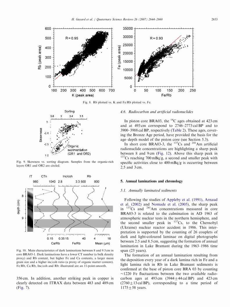
At the base of the piston core BRA03, darker-colouredfinely laminated intervals are recorded between 429 and455 cm (OR1) and between 473 and 508 cm (OR2) belowlake floor (Figs. 4, 5 and 7) and correspond to the seismicreflectors R1 and R2, respectively (Fig. 3). They arecharacterized by coarser sediments (only 17% of fine silts),an increase in organic carbon (up to 3%, Fig. 7) and a fallin gamma density (Fig. 5). The fall in bulk density is alsoreflected by the lower CT number values and the darkergrey scale observed on ITRAX images (Fig. 7). The higherorganic matter content in intervals OR1 and OR2 is alsosuggested by the ratio of incoherent over coherentscattering (inc/coh) measured during core irradiation bythe ITRAX core scanner (Fig. 7). The number ofincoherent scattering between electrons is—in theory—higher for elements with a low atomic mass. The inc/cohratio is therefore linked to the mean atomic number andcould be partly related to carbon content. This relationshipis confirmed by the correlation between TOC measure-ments and inc/coh ratio, shown on Fig. 7. These organic-rich intervals are furthermore strikingly rich in sulphur andhave higher Fe/Rb, Ca/Rb and Mn/Rb contents (Fig. 7).Throughout the core Fe, Ca and Mn are well correlatedwith Fe/Rb (r ¼ 0.93) (Fig. 8), Ca/Rb (r ¼ 0.98), and Mn/Rb (r ¼ 0.73), respectively. As shown in Fig. 8, elementsthat are usually interpreted to be of detrital origin such asSi, K and Rb are well-correlated together (r ¼ 0.94
between K and Rb). It is also worth noting that OR1and OR2 are associated with a fall in fine detrital elements,represented here by Rb contents.Between both organic intervals (455–473 cm) and after
OR1 (from 429 to 217 cm), an abrupt onset of more clasticsedimentation occurs (Figs. 4, 5 and 7). These finelylaminated sediments are characterized by a lighter colour,an abrupt increase of fine silt percent (up to 26% of the

ARTICLE IN PRESS
Fig. 6. Multiproxy analysis of BRA03-1 gravity core. Ph: digital
photography; RxI: X-ray image obtained on u-channel by ITRAX core
scanner analysis; CT: topogram obtained on u-channel by CAT-Scan
analysis; CTn: CT number; Mean: mean grain size (mm); %VFSa: % of
very fine sand (from 63 to 125mm); %FSi: % of fine silt (from 4 to 8mm).
The age of the sedimentary events was determined by counting the CT
number peaks from the top of the slump to the top of the core and
confirmed by ‘‘Fe peak counting’’. AD 1963 level estimated location is
obtained by varve counting (see text for details) and illustrated by a star.
H. Guyard et al. / Quaternary Science Reviews 26 (2007) 2644–2660 2651
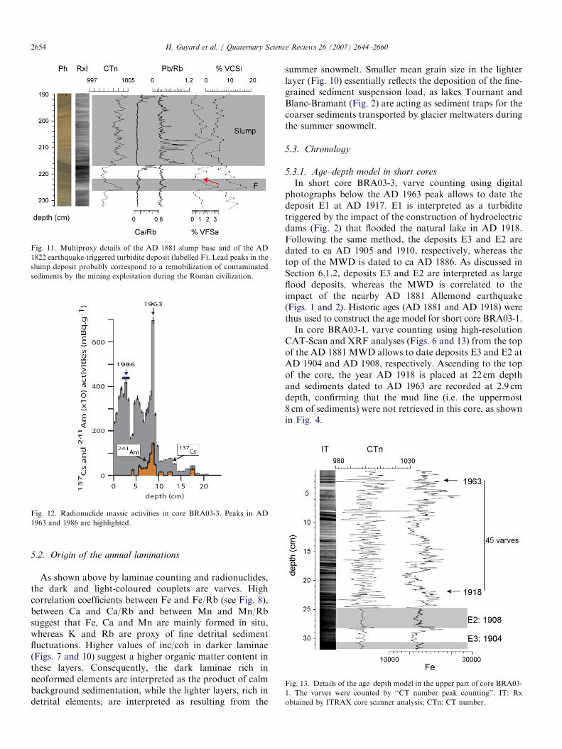
sediment; Fig. 5) and an abrupt rise in bulk density. Thesesediments are also characterized by an increase in theconcentration of detrital elements (Si, K, Rb), but by adecrease in the concentration of organic carbon, Fe, Caand Mn content. Moreover, the sorting vs. skewnessdiagram highlights two different grain size distributionpatterns (Fig. 9) between these clastic and the more organicfacies OR1 and OR2 where the clastic sediments are poorlysorted and symmetrical, whereas organic-rich sedimentsare poorly sorted and fine skewed.
4.3. Finely laminated facies
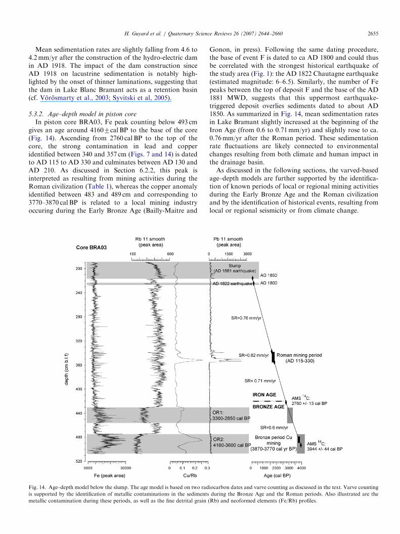
Throughout the cores, the sediments are characterizedby a fine lamination made of light and dark-colouredlaminae as shown in Figs. 5–7 and 10. Lighter-colouredlayers are rich in detrital elements, such as Rb, Si, or K (notshown), have a higher bulk density and a finer mean grainsize. On the other hand, darker layers contain less detritalelements but are rich in Fe, Ca or Mn. They are also
coarser and characterized by higher values of inc/coh,suggesting a higher content of organic content than in thelight-coloured laminae.
4.4. Sedimentary events
Between 227 and 224 cm below lake floor, event F ischaracterized by an erosional basal contact, a coarsegrained base rich in very coarse silts and a fining upwardsequence as shown by mean grain size, CT numbers and thelighter X-ray images (Figs. 5, 7 and 11). Mud clasts are alsoobserved on the Rx images from 226 to 224 cm (Guyardet al., in press).The chaotic acoustic facies identified by seismic analysis
(Fig. 3) was only retrieved at the base of the short gravitycores and the top of the piston core, as shown in Figs. 3and 4, confirming the seismic interpretation that the non-cored interval (70–190 cm below lake floor) only consists ofdisturbed sediments (i.e., a mass wasting deposit (MWD)).The base of this disturbed interval is observed at 217 cm incore BRA03, just above deformed laminae depositedduring a normal sedimentation period (Figs. 5, 7 and 11).The upper limit of disturbed sediments is observed at44.5 cm depth in core BRA03-3 and at 46 cm depth inBRA03-1 (Figs. 4 and 6). Sediments have a lighter colourwith regards to the rest of the core and are remoulded,folded, laminated and highly deformed in specific intervals.Sediments are also locally composed of cross laminations,erosive contacts and blocks of sediments with the preservedoriginal stratification as seen on topograms (Figs. 5–7, and11). Locally, relatively well-stratified sediments documen-ted by CAT-scan images within the lower part of theseremoulded deposits are enriched in lead between 216 and206 cm (Fig. 11).The deposit labelled E1 is a 0.8 cm-thick graded layer
observed at 27–28 cm in BRA03-3, but is unrecognized incore BRA03-1 (Fig. 4). Deposits E2 (observed at32–33.5 cm in BRA03-3 and at 25–28 cm in BRA03-1)and E3 (observed at 35–37 cm in BRA03-3 and at 31–35 cmin BRA03-1), are coarser graded layers (Fig. 6). In coreBRA03-1, E3 is a 4-cm thick graded bed with a basalsequence developing an inverse grading (coarsening up-ward) and an upper sequence with normal grading (finingupward) (Fig. 6). In core BRA03-1, the distribution of veryfine sand and of mean grain size in the 3-cm thick depositE2 depicts a normally graded sequence starting with asharp basal contact and a coarse base. This fining upwardsequence has no visible structures on CAT-scan and X-rayimages (Fig. 6).
4.5. Metallic contaminations
ITRAX data are highlighting a major peak in leadcontent (peak areas are up to 12 times higher than thebackground), a clear peak in copper content (Fig. 7) and inzinc content (not shown) between 340 and 357 cm. Thisheavy metal contamination culminates between 350 and

ARTIC
LEIN
PRES
S
Fig. 7. Multi-proxy analysis for piston core BRA03. Ph: numerical photography (core breaks are illustrated by thin dotted lines); RxI: X-ray image obtained on u-channel samples by ITRAX; CT:
topogram obtained on u-channel samples by CAT-Scan; CTn: CT number. Illustrated is an 11-point smooth except for the zoom (right part of the figure) on laminations and organic levels (see text for
details). TOC: % total organic carbon. Ca, Mn, Pb, K, Fe, S and Cu are normalized by Rb.
H.
Gu
ya
rdet
al.
/Q
ua
terna
ryS
cience
Review
s2
6(
20
07
)2
64
4–
26
60
2652
ARTICLE IN PRESS
Fig. 8. Rb plotted vs. K and Fe/Rb plotted vs. Fe.
Fig. 9. Skewness vs. sorting diagram. Samples from the organic-rich
layers OR1 and OR2 are circled.
Fig. 10. Main characteristics of dark laminations between 8 and 9.5 cm in
core BRA03-1. Dark laminations have a lower CT number (a bulk density
proxy) and Rb content, but higher Fe and Ca contents, a larger mean
grain size and a higher inc/coh ratio (a proxy of organic matter content).
Fe/Rb, Ca/Rb, Inc/coh and Rb: illustrated are an 11-point-smooth.
H. Guyard et al. / Quaternary Science Reviews 26 (2007) 2644–2660 2653
356 cm. In addition, another striking peak in copper isclearly detected on ITRAX data between 483 and 489 cm(Fig. 7).
4.6. Radiocarbon and artificial radionuclides
In piston core BRA03, the 14C ages obtained at 423 cmand at 493 cm correspond to 2746–2773 cal BP and to3900–3988 cal BP, respectively (Table 2). These ages, cover-ing the Bronze Age period, have provided the basis for theage–depth model of the piston core (see Section 5.3).In short core BRA03-3, the 137Cs and 241Am artificial
radionuclide concentrations are highlighting a sharp peakbetween 8 and 9 cm (Fig. 12). Above this sharp peak in137Cs reaching 700mBq/g, a second and smaller peak withspecific activities close to 400mBq/g is occurring between2.5 and 3 cm.
5. Annual laminations and chronology
5.1. Annually laminated sediments
Following the studies of Appleby et al. (1991), Arnaudet al. (2002) and Nomade et al. (2005), the sharp peakin 137Cs and 241Am concentrations measured in coreBRA03-3 is related to the culmination in AD 1963 ofatmospheric nuclear tests in the northern hemisphere, andthe second smaller peak in 137Cs, to the Chernobyl(Ukraine) nuclear reactor accident in 1986. This inter-pretation is supported by the counting of 26 couplets ofdark and light-coloured laminae on digital photographsbetween 2.5 and 8.5 cm, suggesting the formation of annuallamination in Lake Bramant during the 1963–1986 timespan (23 years).The formation of an annual lamination resulting from
the deposition every year of a dark lamina rich in Fe and alight lamina rich in Rb in Lake Bramant sediments isconfirmed at the base of piston core BRA 03 by counting�1220 Fe fluctuations between the two available radio-carbon ages at 493 cm (3944744 cal BP) and 423 cm(2760713 cal BP), corresponding to a time period of1175758 years.
ARTICLE IN PRESS
Fig. 11. Multiproxy details of the AD 1881 slump base and of the AD
1822 earthquake-triggered turbidite deposit (labelled F). Lead peaks in the
slump deposit probably correspond to a remobilization of contaminated
sediments by the mining exploitation during the Roman civilization.
Fig. 12. Radionuclide massic activities in core BRA03-3. Peaks in AD
1963 and 1986 are highlighted.
Fig. 13. Details of the age–depth model in the upper part of core BRA03-
1. The varves were counted by ‘‘CT number peak counting’’. IT: Rx
obtained by ITRAX core scanner analysis; CTn: CT number.
H. Guyard et al. / Quaternary Science Reviews 26 (2007) 2644–26602654
5.2. Origin of the annual laminations
As shown above by laminae counting and radionuclides,the dark and light-coloured couplets are varves. Highcorrelation coefficients between Fe and Fe/Rb (see Fig. 8),between Ca and Ca/Rb and between Mn and Mn/Rbsuggest that Fe, Ca and Mn are mainly formed in situ,whereas K and Rb are proxy of fine detrital sedimentfluctuations. Higher values of inc/coh in darker laminae(Figs. 7 and 10) suggest a higher organic matter content inthese layers. Consequently, the dark laminae rich inneoformed elements are interpreted as the product of calmbackground sedimentation, while the lighter layers, rich indetrital elements, are interpreted as resulting from the
summer snowmelt. Smaller mean grain size in the lighterlayer (Fig. 10) essentially reflects the deposition of the fine-grained sediment suspension load, as lakes Tournant andBlanc-Bramant (Fig. 2) are acting as sediment traps for thecoarser sediments transported by glacier meltwaters duringthe summer snowmelt.
5.3. Chronology
5.3.1. Age–depth model in short cores
In short core BRA03-3, varve counting using digitalphotographs below the AD 1963 peak allows to date thedeposit E1 at AD 1917. E1 is interpreted as a turbiditetriggered by the impact of the construction of hydroelectricdams (Fig. 2) that flooded the natural lake in AD 1918.Following the same method, the deposits E3 and E2 aredated to ca AD 1905 and 1910, respectively, whereas thetop of the MWD is dated to ca AD 1886. As discussed inSection 6.1.2, deposits E3 and E2 are interpreted as largeflood deposits, whereas the MWD is correlated to theimpact of the nearby AD 1881 Allemond earthquake(Figs. 1 and 2). Historic ages (AD 1881 and AD 1918) werethus used to construct the age model for short core BRA03-1.In core BRA03-1, varve counting using high-resolution
CAT-Scan and XRF analyses (Figs. 6 and 13) from the topof the AD 1881 MWD allows to date deposits E3 and E2 atAD 1904 and AD 1908, respectively. Ascending to the topof the core, the year AD 1918 is placed at 22 cm depthand sediments dated to AD 1963 are recorded at 2.9 cmdepth, confirming that the mud line (i.e. the uppermost8 cm of sediments) were not retrieved in this core, as shownin Fig. 4.
ARTICLE IN PRESSH. Guyard et al. / Quaternary Science Reviews 26 (2007) 2644–2660 2655
Mean sedimentation rates are slightly falling from 4.6 to4.2mm/yr after the construction of the hydro-electric damin AD 1918. The impact of the dam construction sinceAD 1918 on lacustrine sedimentation is notably high-lighted by the onset of thinner laminations, suggesting thatthe dam in Lake Blanc Bramant acts as a retention basin(cf. Vorosmarty et al., 2003; Syvitski et al, 2005).
5.3.2. Age–depth model in piston core
In piston core BRA03, Fe peak counting below 493 cmgives an age around 41607cal BP to the base of the core(Fig. 14). Ascending from 2760 cal BP to the top of thecore, the strong contamination in lead and copperidentified between 340 and 357 cm (Figs. 7 and 14) is datedto AD 115 to AD 330 and culminates between AD 130 andAD 210. As discussed in Section 6.2.2, this peak isinterpreted as resulting from mining activities during theRoman civilization (Table 1), whereas the copper anomalyidentified between 483 and 489 cm and corresponding to3770–3870 cal BP is related to a local mining industryoccuring during the Early Bronze Age (Bailly-Maitre and
Fig. 14. Age–depth model below the slump. The age model is based on two rad
is supported by the identification of metallic contaminations in the sediments
metallic contamination during these periods, as well as the fine detrital grain
Gonon, in press). Following the same dating procedure,the base of event F is dated to ca AD 1800 and could thusbe correlated with the strongest historical earthquake ofthe study area (Fig. 1): the AD 1822 Chautagne earthquake(estimated magnitude: 6–6.5). Similarly, the number of Fepeaks between the top of deposit F and the base of the AD1881 MWD, suggests that this uppermost earthquake-triggered deposit overlies sediments dated to about AD1850. As summarized in Fig. 14, mean sedimentation ratesin Lake Bramant slightly increased at the beginning of theIron Age (from 0.6 to 0.71mm/yr) and slightly rose to ca.0.76mm/yr after the Roman period. These sedimentationrate fluctuations are likely connected to environmentalchanges resulting from both climate and human impact inthe drainage basin.As discussed in the following sections, the varved-based
age–depth models are further supported by the identifica-tion of known periods of local or regional mining activitiesduring the Early Bronze Age and the Roman civilizationand by the identification of historical events, resulting fromlocal or regional seismicity or from climate change.
iocarbon dates and varve counting as discussed in the text. Varve counting
during the Bronze Age and the Roman periods. Also illustrated are the
(Rb) and neoformed elements (Fe/Rb) profiles.
ARTICLE IN PRESSH. Guyard et al. / Quaternary Science Reviews 26 (2007) 2644–26602656
6. Discussion
6.1. Sedimentary records of natural hazards
6.1.1. Historical earthquakes
Paleoseismologic studies using lake sediments arefrequently based on the detailed characterization ofcontemporaneous sedimentary events related to subaqu-eous slope failures and on the establishment of a precisechronology. Since single mass wasting deposits such asslumps or turbidites could also be produced by otherprocesses (lake level change or slope overloading, forinstance), the best argument to asses a seismic triggering isto correlate such sedimentary event with a well-documen-ted historical earthquake (Doig, 1986; Siegenthaler et al.,1987; Chapron et al., 1999; Arnaud et al., 2002; Schnell-mann et al., 2002; Monecke et al., 2004; Nomade et al.,2005).
In Lake Bramant, we have shown that a major MWDaffecting most of the deep basin (Fig. 3) can be correlatedto the AD 1881 Allemond earthquake (Fig. 1). Thisinterpretation is in agreement with the occurrence ofseveral MWD on seismic profiles just below the lake floor(Fig. 3), suggesting that unstable sediments in the lake weremobilized by earthquake ground accelerations in AD 1881in various simultaneous mass flows, a criteria usedpreviously to single out earthquake shaking as triggermechanism (Schnellmann et al., 2002; Strasser et al., 2006).This event had a MSK intensity of VII near Allemond andits epicentre was located less than 12 km from LakeBramant (cf. Nomade et al., 2005 and references therein).This event was both strong and close enough to triggermass wasting events in Lake Bramant. The deformedbackground sediments likely result from the rapid deposi-tion of an important quantity of sediments (1.10m at thecoring site). This earthquake-induced mass movement is anexample of a rotational sediment slide (Locat and Lee,2002), corresponding to a slump following the classificationof Mulder and Cochonat (1996). Lead concentrations inLake Bramant sediments incorporated in the base of theslump could result from remoulded sediments of Romanmining period.
The occurrence of a sharp contact at the base of layer F,the normal grading and the presence of mud clasts in thefine layer F is suggesting the formation of an incompleteBouma turbidite (e.g., Bouma, 1962; Mulder et al., 2001),where only facies Ta-Tb were recorded. This turbidite,dated to AD 1800 was probably triggered by the AD 1822Chautagne earthquake, the strongest of the region with anestimated magnitude of 6–6.5 (Chapron et al, 1999).
It is, however, much more delicate to correlate the 5-cmthick graded layer labelled event E3 dated between AD1904–1905 with the AD 1905 Emosson earthquake (MSKintensity VII–VIII; Fig. 1). The epicentre of this event waslocated near the French/Swiss border and it was recordedin the nearby Lake Anterne (Arnaud et al., 2002), but wasprobably too far away (more than 160 km) from Lake
Bramant to trigger slope instabilities that resulted in thebasin centre in the deposition of a turbidite. As discussedbelow, the origin of this graded bed may therefore berelated to a large flood event, as sedimentary event E2.
6.1.2. Exceptional flood events
Sedimentary event E3 (Fig. 6) is bearing the typical grainsize distribution of large flood events deposited byhyperpycnal flows in marine or lacustrine environments(cf. Syvitski and Schafer, 1996; Mulder et al., 1998;Schneider et al., 2004; St-Onge et al., 2004; Chapronet al., 2006; Guyard et al., in press; St-Onge andLajeunesse, in press): a basal sequence developing aninverse grading (coarsening upward) during the rising limbof the flood (waxing flow) and an upper sequence withnormal grading (fining upward) during the falling limbof the flood event (waning flow). Sedimentary event E2(Fig. 6) is interpreted as a large flood-triggered turbiditeeither related to the development of a large homopycnalflow across the lake (cf. Brodzikowski and Van Loon,1991), or related to the formation of a hyperpycnal flowwhere only the upper sequence was preserved because ofstrong erosion during the rising limb of the flood (cf.Mulder et al., 2001, 2003). In both cases, this flood deposittriggered between AD 1908 and 1910 was probably anerosive event. The formation of such exceptional flooddeposits in Lake Bramant may result from exceptionalsnowmelt events, heavy rainfalls during the summer or,more probably, from the catastrophic drainage (i.e.outburst) of a temporary ice-contact lake or even asubglacial lake. Temporary ice marginal lakes are fre-quently observed at the margin of the St. Sorlin glacier nearits diffluence into the Bramant valley (M. Vallon, pers.comm.) and subglacial lakes may have also formed in thepast below St. Sorlin or Cote Blanc glaciers. According tothe age–depth model and to first field observations in AD1907 (Fuselin et al., 1909), the exceptional flood events E2and E3 occurred when the St. Sorlin glacier was alreadyretreating from its last advance following the end of theLIA. It seems therefore likely that exceptional flooddeposits in Lake Bramant are synchronous with periodsof important glacier retreat.
6.2. High-altitude environmental changes
6.2.1. Glacier and lake level fluctuations
Variations in the amount of organic or clastic constitu-ents accumulated in proglacial lake sediments are oftenused as proxies for glacier activity in the drainage basin (cf.Dahl et al., 2003 and reference therein). Variations of theRb content are related to fluctuations in the amount ofdetrital clays (cf. Rothwell et al., 2006). Rb content in LakeBramant reflects the finer sediment supply resulting fromglacial erosion (the ‘‘glacial flour’’). Both organic intervalsOR1 and OR2 are clearly contrasting with the recentproglacial sediments and the occurrence of reflectors R1and R2 only in the deepest part of the basin suggests the
ARTICLE IN PRESSH. Guyard et al. / Quaternary Science Reviews 26 (2007) 2644–2660 2657
development of very different environmental conditions.Such an organic sedimentation, associated with a fall indetrital elements and with a limited percent of fine silts,suggests reduced glacier activity and glacial erosion in thecatchment area.
OR2 is deposited during the Early Bronze Age (Table 1)between 4160 and 3600 cal BP. A very good correlationbetween S and S/Rb (not displayed) in both organic facies(r ¼ 0.81) likely reflects the development of anoxic condi-tions. In these layers, higher neoformed elements contentslike Fe, Ca, or Mn also suggest very different depositionalenvironments in a much smaller and shallower lake than inthe rest of the core. A more detailed study is neverthelessneeded to define the nature of iron-rich precipitatedelements. Taken together, these characteristics are inter-preted as resulting from a phase of low lake level andreduced glacier activity in this part of the Alps between4160 and 3600 cal BP. This is in agreement with theoccurrence of lower glacier activity in the Swiss Alps(Leeman and Niessen, 1994) and a phase of low-lake levelin west-central Europe (Magny, 2004; Holzhauzer et al.,2005).
Above OR2, between 3600 and 3300 cal BP, the abruptreturn to more clastic sedimentation in Lake Bramant isinterpreted as an increase in glacier activity and glacialerosion. During this short period, the diffluence of the St.Sorlin glacier into the Bramant valley was probablyimportant enough to provide glacial meltwaters rich infine-grained particles to Lake Bramant. This is in agree-ment with a wetter and colder period during the mid-Bronze Age documented by a high lake-level periodbetween 3500 and 3100 cal BP in west-central Europe(Magny, 2004; Holzhauzer et al., 2005) and the onset ofa neoglaciation marked by glacial varve formation since3300 cal BP in the proglacial lake Silvaplanna, Swiss Alps(Leeman and Niessen, 1994). It is likely that the level ofLake Bramant was also higher and oxygenated during thisepisode since no sulphur were found in the sediments.
The upper organic interval (OR1), with the samecharacteristics than OR2, was formed between 3300 and2850 cal BP. During this Late Bronze Age period, LakeBramant was thus probably at a lower level because theSt. Sorlin glacier was likely too reduced to develop aclear diffluence into the Bramant valley. This phase ofreduced glacier activity is not clearly recorded in LakeSilvaplana (Leeman and Niessen, 1994), but suggested inthe study of Holzhauzer et al. (2005) by glacier and lake-level fluctuations.
The coarser grain size observed in the organic-richintervals OR1 and OR2 probably reflects changes duringthe Bronze Age in the size of the lake and especially in theratio between the surface of the lake and the surface of thedrainage basin. This ratio is both controlling the influenceof particles streaming versus deltaic sedimentation and theresidence time of the lake waters (Meybeck, 1995).Different grain size sorting and skewness values in organicand clastic sediments (Fig. 9) are also suggesting sedimen-
tation under rather calm hydrodynamic conditions duringBronze Age periods with low-lake levels, but moreturbulent ones during clastic dominated sedimentation.At 2850 cal BP, the abrupt return to clastic sedimenta-
tion (i.e. high density, low mean grain size due to theincrease of the fine silts, low organic matter content,absence of sulphur in the sediments and an increase indetrital elements) is interpreted as increasing glacieractivity and glacial meltwaters supply in the Bramantvalley, favouring high-lake levels in the chain of proglaciallakes. The onset of this period with larger glaciers provideda significant amount of sediments into Lake Bramant andresulted in the formation of a delta that was flooded afterAD 1918 (construction of the hydro-electric dam) and thattoday is found below a water depth of 22m (Fig. 3). Thisdelta thus attests the onset of a long period of high lake-level with significant glacier activity, in agreement with thestudies of Leeman and Niessen (1994), Magny (2004) andHolzhauzer et al. (2005) in the Alpine region. Such adrastic change in Lake Bramant sedimentation after2850 cal BP is likely due to the onset of the diffluence ofthe St. Sorlin glacier into the Bramant valley and resultedin an increase in the mean sedimentation rate from 0.59 to0.67mm/yr (Fig. 14).
6.2.2. Interactions of climate conditions and human activity
Only two terrestrial plant debris were found at the baseof core BRA03 in sediments corresponding to the EarlyBronze Age and the beginning of the Iron Age (Table 1).The absence of any terrestrial macrofossil material after2750 cal BP suggests an important change in the vegetationcover at 2500m a.s.l. (lowering of the tree line) caused byprevailing colder conditions favouring increasing glacieractivity in the catchment area.The copper content anomaly, detected between 483 and
489 cm (Figs. 7 and 14) and dated between 3770 and3870 cal BP, is most likely reflecting local atmosphericcontamination due to mining activity during the EarlyBronze Age. This hypothesis is supported by ongoingarchaeological investigations in the Grandes RoussesMassif, where evidences of a copper mining industry wasrecently discovered in the massif, just SE of the catchmentarea of Lake Bramant and 14C dated around38007100 cal BP (Bailly-Maıtre and Gonon, 2006; Bailly-Maıtre, oral communication). This mining industry, devel-oped between 2300 and 2650ma.s.l., likely became possiblebecause of smaller glaciers in the massif in response to awarmer climate during the Early Bronze Age. The firesneeded to weaken the rocks for excavating the coppermines (Bailly-Maıtre, oral communication) were likelyalimented with the surrounded vegetation. The change invegetation cover suggested after 2750 cal BP around LakeBramant could therefore have also resulted from theinteraction of climate change and high-altitude humanactivities during the Bronze Age.In addition, the major peaks of heavy metals (especially
in lead and copper) dated between AD 115 and 330 and
ARTICLE IN PRESSH. Guyard et al. / Quaternary Science Reviews 26 (2007) 2644–26602658
culminating between AD 130 and 210 are interpreted asresulting from mining activities during the Roman civiliza-tion. Lead contamination during the Roman period (100BC–AD 300) is indeed well documented in various naturalarchives from the Northern Hemisphere (Hong et al., 1994;Renberg et al., 1994; Shotyk et al., 1998; Boutron et al.,2004). Atmospheric lead contamination shows peaksaround AD 128 in the Swiss Jura (Shotyk and Krachler,2004), around AD 220 in the NW French Alps (Arnaudet al., 2005a b) and around AD 300 in the Mediterraneanregion (Veron et al., 2006), all marking the Romancivilization apogee.
Presently, no trace of Roman mining activities has beendiscovered in the Massif. Nevertheless, the identification oflead contamination in Lake Anterne (Fig. 1) and proxies ofa local metallurgical activity in the Arve Valley (Arnaudet al., 2005a b) together with the discovery of the lead peakin Lake Bramant sediments suggest an important contam-ination during the Roman period in the NW Alps aroundthe 2–3rd Centuries. The origin of these important leadcontaminations is however still unclear. The origin ofRoman land use in the massif (Chardon, 1991) and thegrowing evidence of mining activities in the Alpine region(Shotyk and Krachler, 2004; Arnaud et al., 2005a b),leading to a strong heavy metal atmospheric contaminationin Lake Bramant sediments between AD 130 and 210, mayhave resulted from a short period of climate change in thispart of Europe. This period of mining activity issynchronous with a sharp drop in lake level in the Alpineregion at AD �250 (Magny, 2004) and with smallfluctuations of the Great Aletsch glacier in the Swiss Alpsbetween AD 200 and 400 (Holzhauzer et al., 2005).However, no clear changes in glacier activity are observedduring this period in the sedimentary record of LakeBramant. It is therefore suggested that glacier activityabove 2500ma.s.l. in the Grandes Rousses massif mayhave limited the Roman impact to pasturing and defor-estation up to 2000ma.s.l. in some parts of the massif(cf. Chardon, 1991).
The evolution of the vegetation cover in this part of themassif will be confirmed by ongoing studies of the pollenrecords in Lake Bramant. Geochemical compositions ofthese proglacial sediments during the Bronze Age, theRoman period and the Middle Age, together withthe identification of the geochemistry of source rocks inthe former mines of the Grandes Rousses massif and in theArve valley, will also be performed to confirm the dominat-ing source areas of atmospheric metallic contaminationdocumented in this study. All together, these data will helpdisentangling interactions between climate changes and theevolution of high-altitude human activities.
7. Conclusions
This multidisciplinary study of glacial varves fromproglacial Lake Bramant is unravelling variations in theamount of fine-grained clastic supply and organic matter,
interpreted as changes in glacier activity in the catchmentarea. The age model originating from an annually resolvedrecord is chiefly supported by radionuclide dating and bythe correlation of a large slump with a local earthquake inAD 1881 and of a turbidite with a strong regionalearthquake in AD 1822. Natural hazards in this part ofthe Alps are related to the regional seismicity, but also tothe development of exceptional flood deposits thatoccurred during periods of significant glacier recession.Glacial varve formation since 4000 years is confirmed by
counting laminations between two AMS 14C datesobtained at the base of the core and by the identificationof atmospheric metallic contaminations in the sediments,likely resulting from a local and regional mining activityduring the Early Bronze-Age and the Roman civilization,respectively.Two prominent organic-rich intervals, identified on
seismic profiles and in the sediment core, were formedduring the Bronze Age (4160–3600 and 3300–2850 cal BP)and are probably reflecting periods of reduced glacieractivity in the drainage basin, resulting in periods of low-lake level and anoxic conditions. The dramatic lithologiccontrast of these two organic-rich units to the remainder ofthe core reflects the peculiar glacial dynamics with anupstream diffluence that acts as an on–off switch of glacialmeltwater supply once a certain climate threshold isreached. The onset of clastic proglacial sedimentationand higher lake level between 3600–3300 cal BP and since2850 cal BP are reflecting periods of higher glacier activitywith meltwater supply into the Bramant Valley. They aresynchronous with periods of glacier advances well-docu-mented in the Alps and high-lake levels in west-centralEurope.Evidences for a generally warmer climate during the
Bronze Age in this part of the Alps include lowering of thetree line, glacier activity, proglacial lake level and traces ofhigh-altitude mining activities. These reconstructionsshould however be confirmed by ongoing studies in theevolution of vegetation around the lake and by theidentification of the source areas of former mining industryin the western Alps.
Acknowledgements
We would like to thank Michel Vallon (LGGE,Grenoble) and Marie-Christine Bailly-Maıtre from theLabratoire d’Archeologie Medievale Mediterraneenne forfruitful scientific discussions. Thanks also to Urs Gerber(ETH Zurich) for the core photographs and to BrunoAxelar (Refuge de l’Etendard) for logistic support andfruitful discussions on Lake Bramant. Pierre Mandarouxand Bertrand Novel (Savoie University) are acknowledgedfor grain size measurements and varve counting on digitalphotographs on core BRA03-3, respectively. We would liketo sincerely thank Atle Nesje, Oyvind Lie and all the coringteam from Bergen University (Norway) for the collectionof piston core BRA03 from Lake Bramant and for this
ARTICLE IN PRESSH. Guyard et al. / Quaternary Science Reviews 26 (2007) 2644–2660 2659
logistic support. Finally, we wish to thank the two anony-mous reviewers for their very constructive reviews. Thisproject was funded by the French Mountain Institute. Thisis GEOTOP-UQAM-McGill contribution no. 2007-0050.
References
Allix, A., 1927. Observations glaciologiques faites en Dauphine jusqu’en
1924, Glacier de Saint Sorlin. Etudes Glaciologiques 6 (Paris,
Ministere de l’Agriculture, Direction Generale des Eaux et Forets,
Service d’Etudes des Grandes Forces Hydrauliques. Region des Alpes),
1–26, 30–31, 74–77, 116, 134.
Anselmetti, F.S., Buhler, R., Finger, D., Girardclos, S., Lancini, A.,
Christian Rellstab, C., Sturm, M., 2007. Effects of Alpine hydropower
dams on particle transport and lacustrine sedimentation. Aquatic
Sciences 69, 179–198.
Appleby, P.G., Richardson, N., Nolan, P.J., 1991. 241Am dating of lake
sediments. Hydrobiologia 214, 35–42.
Arnaud, F., Lignier, V., Revel, M., Desmet, M., Beck, C., Pourchet, M.,
Charlet, F., Trenteseaux, A., Tribovillard, N., 2002. Dating sediments
from an alpine lake (Lake Anterne, NW Alps): influence of flood-
events and gravity reworking on 210Pb vertical profile. Terra Nova 14,
225–232.
Arnaud, F., Revel, M., Chapron, E., Desmet, M., Tribovillard, N., 2005a.
7200 years of Rhone river flooding activity in Lake Le Bourget,
France: a high resolution sediment record of NW Alps hydrology. The
Holocene 15 (3), 420–428.
Arnaud, F., Serralongue, J., Winiarski, T., Desmet, M., Paterne, M.,
2005b. Pollution au plomb dans la Savoie antique (IIe-IIIe s. apr. J.-C.)
en relation avec une installation metallurgique de la cite de Vienne.
Comptes Rendus Geoscience 338, 244–252.
Ariztegui, D., Bianchi, M.M., Masaferro, J., Lafargue, E., Niessen, F.,
1997. Interhemispheric synchrony of Late-glacial climatic instability as
recorded in proglacial Lake Mascardi, Argentina. Journal of
Quaternary Science 12, 333–338.
Bailly-Maitre, M.C., Bruno-Dupraz, J., 1994. Brandes en Oisans: La mine
d’argent des Dauphins (XII-XIV e s.) Isere. Documents d’Archeologie
en Rhone-Alpes 9, 172.
Bailly-Maıtre, M.C., Gonon, T., 2006. L’exploitation de la chalcopyrite a
l’Age du Bronze dans le massif des Rousses (Oisans-Isere). In:
Proceedings of the 131st Congress of the CTHS. ‘‘Tradition et
innovation,’’ Grenoble, avril 2006.
Blass, A., Anselmetti, F.S., Ariztegui, D., 2003. 60 years of glaciolacus-
trine sedimentation in Steinsee (Sustenpass, Switzerland) compared
with historic events and instrumental meteorological data: Eclogae.
Eclogae Geologicae Helvetiae 96 (Suppl. 1), 59–71.
Blott, S.J., Pye, K., 2001. Gradistat: a grain size distribution and statistics
package for the analysis of unconsolided sediments. Earth Surface
Processes and Landforms 26, 1237–1248.
Boespflug, X., Long, B.F.N., Occhietti, S., 1995. CAT-Scan in marine
stratigraphy: a quantitative approach. Marine Geology 122, 281–301.
Boutron, C., Rosman, K., Barbante, C., Bolshov, M., Adams, F., Hong,
S., Ferrari, C., 2004. L’archivage des activites humaines par les neiges
et glaces polaires: le cas du plomb. Comptes Rendus Geoscience 336,
847–867.
Brodzikowski, K., Van Loon, A.J., 1991. Review of glacigenic sediments.
Development in Sedimentology 49, 688.
Chardon, M., 1991. L’evolution tardiglaciaire et holocene des glaciers et
de la vegetation autour de l’Alpe d’Huez (Oisans, Alpes Franc-aises).
Revue de Geographie Alpine 2, 39–53.
Chapron, E., Beck, C., Pourchet, M., Deconinck, J-F., 1999. 1822
earthquake-triggered homogenite in Lake Le Bourget (NW Alps).
Terra Nova 11, 86–92.
Chapron, E., Desmet, M., De Putter, T., Loutre, M.F., Beck, C.,
Deconinck, J.F., 2002. Climatic variability in the northwestern Alps,
France, as evidenced by 600 years of terrigenous sedimentation in Lake
Le Bourget. The Holocene 12 (2), 177–185.
Chapron, E., Arnaud, F., Noel, H., Revel, M., Desmet, M., Perdereau, L.,
2005. Rhone River flood deposits in Lake Le Bourget: a proxy for
Holocene environmental changes in the NW Alps, France. Boreas 34,
1–13.
Chapron, E., Ariztegui, D., Mulsow, S., Villarosa, G., Pino, M., Outes, V.,
Juvignie, E., Crivelli, E., 2006. Impact of the 1960 major subduction
earthquake in Northern Patagonia. Quaternary International 158,
58–71.
Cremer, J.-F., Long, B., Desrosiers, G., de Montety, L., Locat, J., 2002.
Application de la scanographie a l’etude de la densite des sediments et
a la caracterisation des structures sedimentaires: exemple des sediments
deposes dans la riviere Saguenay (Quebec, Canada) apres la crue de
1996. Canadian Geotechnical Journal 39, 440–450.
Croudace, I.W., Rindby, A., Rothwell, R.G., 2005. ITRAX: description
and evaluation of a new X-ray core scanner. In: Rothwell, R.G. (Ed.),
New Techniques in Sediment Core Analysis. Geological Society,
London, pp. 51–63.
Dahl, S.O., Bakke, J., Lie, O., Nesje, A., 2003. Reconstruction of former
glacier equilibrium-line altitudes based on proglacial sites: an
evaluation of approaches and selection of sites. Quaternary Science
Reviews 22, 275–287.
Deline, P., Orombelli, G., 2005. Glacier fluctuations in the western Alps
during the Neoglacial, as indicated by the Miage morainic amphithea-
tre (Mont Blanc massif, Italy). Boreas 34, 456–467.
Doig, R., 1986. A method for determining the frequency of large-
magnitude earthquake using lake sediments. Canadian Journal of
Earth Science 23, 930–937.
Edouard, J.L., 1994. Les lacs d’altitude dans les Alpes franc-aises.
Contribution a la connaissance des lacs d’altitude et a l’histoire des
milieux montagnards depuis la fin du Tardiglaciaire. Habilitation
Thesis, University of Grenoble, 790pp.
Fuselin, G., Jacob, C., Offner, J., 1909. Etudes glaciaires, geographiques et
botaniques dans le massif des Grandes Rousses. Etudes glaciologiques,
Ministere de l’Agriculture, Paris, pp. 107–112.
Guyard, H., St-Onge, G., Chapron, E., Anselmetti, F., Francus, P., in
press. The AD 1881 Earthquake-triggered a slump and late Holocene
flood-induced turbidites from proglacial lake Bramant, Western
French Alps. In: Lykousis, V., Sakellariou, D., Locat, J. (Eds.), Sub-
marine Mass Movements and their Consequences. Kluwer-Springer.
Holzhauzer, H., Magny, M., Zumbuhl, H.J., 2005. Glacier and lake level
variations in west-central Europe over the last 3500 years. The
Holocene 15 (6), 789–801.
Hong, S., Candelone, J., Patterson, C., Boutron, C., 1994. Greenland ice
evidence of hemispheric lead pollution two millennia ago by Greek and
Roman civilizations. Science 265, 323–326.
Intergovernmental Panel on Climate Change (IPCC), 2001. Climate
Change: Contribution of Working Group I to the Third Assesment
Report of the Intergovernmental Panel on Climate Change. Cam-
bridge University Press, New York.
Lamoureux, S.F., Stewart, K.A., Forbes, A.C., Fortin, D., 2006.
Multidecadal variations and decline in spring discharge in the
Canadian middle Arctic since 1550 AD. Geophysical Research Letters
33, L02403, doi:10.1029/2005GL024942.
Leeman, A., Niessen, F., 1994. Holocene glacial activity and climatic
variations in the Swiss Alps: reconstructing a continuous record from
proglacial lake sediments. The Holocene 4, 259–268.
Le Meur, E., Vincent, C., 2003. A two-dimensional shallow ice-flow
model of Glacier de Saint Sorlin, France. Journal of Glaciology 49,
527–538.
Leonard, E.M., 1997. The relationship between glacial activity and
sediment production: evidence from a 4450-year varve record of
neoglacial sedimentation in Hector Lake, Alberta, Canada. Journal of
Paleolimnology 17, 319–330.
Lliboutry, L., 2002. Extension of Glacier de Saint-Sorlin, Franch Alps and
equilibrium-line altitude during the Little Ice Age. Journal of
Glaciology 48, 118–124.
Locat, J., Lee, H.J., 2002. Submarine landslides: advances and challenges.
Canadian Geotechnical Journal 39, 193–212.

ARTICLE IN PRESSH. Guyard et al. / Quaternary Science Reviews 26 (2007) 2644–26602660
Magny, M., 2004. Holocene climate variability as reflected by mid-
European lake-level fluctuations and its probable impact on prehistoric
human settlements. Quaternary Internationnal 113, 65–79.
Magny, M., Begeot, C., Guiot, J., Peyron, O., 2003. Contrasting patterns
of hydrological changes in Europe in response to Holocene climate
cooling phases. Quaternary Science Reviews 22, 1589–1596.
Matthews, J.A., Karlen, W., 1992. Asynchronous neoglaciation and
Holocene climatic change reconstructed from Norwegian glacio-
lacustrine sedimentary sequence. Geology 20, 991–994.
Meybeck, M., 1995. Les lacs et leur basin. In: Pouriot, R., Meybeck, M.
(Eds.), Limnologie generale. Masson, Paris, pp. 7–59.
Monecke, K., Anselmetti, F., Becker, A., Sturm, M., Giardini, D., 2004.
The record of historic earthquakes in lake sediments of Central
Switzerland. Tectonophysics 394, 21–40.
Mulder, T., Cochonat, P., 1996. Classification of offshore mass move-
ments. Journal of Sedimentary research 66, 43–57.
Mulder, T., Syvitski, J.P.M., Skene, K.I., 1998. Modelling of erosion and
deposition by turbidity currents generated at river mouths. Journal of
Sedimetary Research 68, 124–137.
Mulder, T., Migeon, S., Savoye, B., Faugeres, J.C., 2001. Inversely graded
turbidite sequences in the deep Mediterranean: a record of deposits
from flood-generated turbidity currents? Geo-Marine Letters 21,
86–93.
Mulder, T., Syvitski, J.P.M., Migeon, S., Faugeres, J-C., Savoye, B., 2003.
Marine hyperpycnal flows: initiation, behavior and related deposits.
A review. Marine and Petroleum Geology 20, 861–882.
Nesje, A., 1992. A piston corer for lacustrine and marine sediments. Arctic
and Alpine Research 24, 257–259.
Nesje, A., Lie, O., Dhal, S.O., 2000. Is the North Atlantic Oscillation
reflected in Scandinavian glacier mass balance records? Journal of
Quaternary Science 15, 587–601.
Noel, H., Garbolino, E., Brauer, A., Lallier-Verges, E., de Beaulieu, J.L.,
Disnar, J.R., 2001. Human impact and soil erosion during the last
5000 yrs as recorded in lacustrine sedimentary organic matter at Lac
d’Annecy, the French Alps. Journal of Paleolimnology 25, 229–244.
Nomade, J., Chapron, E., Desmet, M., Reyss, J-L., Arnaud, F., Ligner,
V., 2005. Reconstructing historical seismicity from lake sediments
(Lake Laffrey, Western Alps, France). Terra Nova 17, 350–357.
Pinglot, J.F., Pourchet, M., 1995. Radioactivity measurements applied to
glaciers and lake sediments. The Science of Total Environment 173,
211–223.
Reimer, P.J., Baillie, M.G.L., Bard, E., Bayliss, A., Beck, J.W., Bertrand,
C.J.H., Blackwell, P.G., Buck, C.E., Burr, G.S., Cutler, K.B., Damon,
P.E., Edwards, R.L., Fairbanks, R.G., Friedrich, M., Guilderson,
T.P., Hogg, A.G., Hughen, K.A., Kromer, B., McCormac, F.G.,
Manning, S.W., Ramsey, C.B., Reimer, R.W., Remmele, S., Southon,
J.R., Stuiver, M., Talamo, S., Taylor, F.W., van der Plicht, J.,
Weyhenmeyer, C.E., 2004. IntCal04 terrestrial radiocarbon age
calibration, 26–0 ka BP. Radiocarbon 46, 1029–1058.
Renberg, I., Wik Persson, M., Emteryd, O., 1994. Pre-industrial
atmospheric lead contamination detected in Swedish lake sediments.
Nature 368, 32–326.
Rothwell, R.G., Hoogakker, B., Thomson, J., Croudace, I.W., Frenz, M.,
2006. Turbidite emplacement on the southern Balearic Abyssal Plain
(western Mediterranean Sea) during Marine Isotope Stages 1–3: an
application of ITRAX XRF scanning of sediment cores to lithostrati-
graphic analysis. In: Rothwell, R.G. (Ed.), New Techniques in
Sediment Core Analysis. Geological Society, London, pp. 79–98.
Schneider, J-L., Pollet, N., Chapron, E., Wessels, M., Wassmer, P., 2004.
Signature of Rhine Valley sturzstrom dam failures in Holocene sedi-
ments of Lake Constance, Germany. Sedimentary Geology 169, 75–91.
Schnellmann, M., Anselmetti, F., Giardini, D., McKenzie, J.A., 2002.
Prehistoric earthquakes history revealed by lacustrine slump deposits.
Geology 30, 1131–1134.
Shotyk, W., Krachler, M., 2004. Atmospheric deposition of silver and
thallium since 12370 14C years BP recorded by a Swiss peat bog profile,
and comparison with lead and cadmium. Journal of Environmental
Monitoring 6, 427–433.
Shotyk, W., Weiss, D., Appleby, P.G., Cheburkin, A.K., Frei, R., Gloor,
M., Kramers, J.D., Reese, S., van der Knaap, O., 1998. History of
atmospheric lead deposition since 13,370 14C yr BP recorded in a peat
bog profile, Jura Mountains, Switzerland. Science 281, 1635–1640.
Siegenthaler, C., Finger, W., Kelts, K., Wang, W., 1987. Earthquake and
seiche deposits in Lake Lucerne, Switzerland. Eclogae Geologicae
Helvetiae 80, 241–260.
Six, D., Reynaud, L., Letreguilly, A., 2001. Bilans de masse des glaciers
alpins et scandinaves, leurs relations avec l’oscillation du climat de
l’Atlantique nord. Earth and Planetary Sciences 333, 693–698.
St-Onge, G., Lajeunesse, P., in press. Flood-induced turbibites from
northern Hudson Bay and western Hudson Strait: a two-pulse record
of Lake Agassiz final outburst flood? In: Lykousis, V., Sakellariou, D.,
Locat, J. (Eds.), Submarine Mass Movements and Their Conse-
quences. Kluwer-Springer.
St-Onge, G., Mulder, T., Piper, D.J.W., Hillaire-Marcel, C., Stoner, J.S.,
2004. Earthquake and flood induced turbidites on the Saguenay Fjord
(Quebec): a Holocene paleoseismicity record. Quaternary Science
Reviews 23, 283–294.
St-Onge, G., Mulder, T., Francus, P., Long, B., 2007. Continuous physical
properties of cored marine sediments. In: Hillaire Marcel, C., de
Vernal, A. (Eds.), Proxies in Late Cenozoic Paleoceanography.
Elsevier, Amsterdam, pp. 63–98.
Strasser, M., Anselmetti, F., Fah, D., Giardini, D., Schnellmann, M.,
2006. Magnitudes and source areas of large prehistoric northern alpine
earthquakes revealed by slope failures in lakes. Geology 34 (12),
1005–1008.
Stuiver, M., Reimer, P.J., Reimer, R.W., 2005. CALIB 5.0. /www pro-
gram and documentation, http://radiocarbon.pa.qub.ac.uk/calib/S.
Syvitski, J.P.M., Schafer, C.T., 1996. Evidence for an earthquake-
triggered basin collapse in Saguenay Fjord, Canada. Sedimentary
Geology 104, 127–153.
Syvitski, J.P.M., Vorosmarty, C.J., Kettner, A.J., Green, P., 2005. Impact
of humans on the flux of terrestrial sediment to the global coastal
ocean. Science 308, 376–380.
Thomas, R.G., Guyodo, Y., Channel, J.E.T., 2003. U-channel track for
susceptibility measurements. Geochemistry, Geophysics, Geosystems
4, 6, doi:10.1029/2002GC000454.
Tomkins, J.D., Lamoureux, S.F., 2005. Multiple hydroclimatic controls
over recent sedimentation in proglacial Mirror Lake, southern Selwyn
Mountains, Northwest Territories. Canadian Journal of Earth
Sciences 42, 1589–1599.
Thouvenot, F., Frechet, J., Jenatton, L., Gamond, J.F., 2003. The
Belledonne Border Fault: identification of an active seismic strike-slip
fault in the western Alps. Geophysical Journal International 155,
174–192.
Torinesi, O., Letreguilly, A., Valla, F., 2002. A century reconstruction of
mass-balance of Glacier de Sarennes, French Alps. Journal of
Glaciology 48, 142–148.
Veron, A., Goiran, J.P., Morhange, C., Marriner, N., Empereur, J.Y.,
2006. Pollutant lead reveals the pre-Hellenistic occupation and ancient
growth of Alexandria, Egypt. Geophysical Research Letters 33, 6,
L06409, doi:10.1029/2006GL025824.
Vincent, C., 2002. Influence of climate change over the 20th Century on
four French glacier mass balances. Journal of Geophysical Research
107, D19, 4375, doi:10.1029/2001JD000832.
Vorosmarty, C.J., Meybeck, M., Fekete, B., Sharma, K., Green, P.,
Syvitski, J.P.M., 2003. Anthropogenic sediment retention: major
global impact from registered river impoundments. Global and
Planetary Change 39 (1–2), 169–190.
Related Documents


