HEXAGONAL DISCRETE GLOBAL GRID SYSTEMS FOR GEOSPATIAL COMPUTING K. Sahr Dept. of Computer Science, Southern Oregon University, Ashland, Oregon, 97520 USA – [email protected] KEY WORDS: Mapping, Integration, Modeling, Data Structures, Representation, Global, Hierarchical, Multiresolution ABSTRACT: Advanced geospatial applications often involve complex computing operations performed under sometimes severe resource constraints. These applications primarily rely on traditional raster and vector data structures based on square lattices. But there is a significant body of research that indicates that data structures based on hexagonal lattices may be a superior alternative for efficient representation and processing of raster and vector data in high performance applications. The advantages of hexagonal rasters for image processing are discussed, and hexagonal discrete global grid systems for location coding are introduced. The combination provides an efficient, unified approach to location representation and processing in geospatial systems. 1. MOTIVATION Advanced geospatial applications, such as mobile mapping, often perform complex spatial operations on potentially large data sets, with strict controls on the accuracy of internal location representations, and in computing environments that may be severely constrained by resource and size limitations. These systems therefore often place a premium on representational and algorithmic efficiency, and are in a constant state of improvement as more efficient representations and algorithms become available. Among the most fundamental data structures are those used for the representation and storage of raster image data and vector geospatial location data. Because they are so pervasive, even small improvements in efficiency or representational accuracy in these data structures can result in substantial performance increases in an overall system. Data structures for the representation and storage of raster and vector data in geospatial applications have traditionally been built on substrates of square lattices. The common standards have long been raster grids of square pixels and vector coordinates consisting of 2- or 3-tuples of floating point values. Yet if the goal is optimal representational and algorithmic efficiency and superior semantic expressiveness, then data structures based on squares are likely not the best choice. There is a substantial body of research that indicates that representations based on hexagonal lattices are superior, and such research has arrived at this conclusion consistently across a number of research areas that directly apply to geospatial systems, such as photogrammetry, image processing, and geospatial location coding. Research in hexagonal image processing and pattern recognition has been on-going for over 40 years, and has recently seen a sharp increase (Middleton 2005). At the same time, decades of research in hexagon-based location coding has culminated in the development of hexagonal discrete global grid systems (Sahr et al., 2003): multi-resolution, hierarchically indexed location systems that seamlessly tile the globe. In this paper I will survey the advantages of hexagon-based raster and vector data structures, as well as those factors that have so far inhibited more widespread adoption of hexagon- based representations for geospatial applications. 2. HEXAGONAL IMAGE PROCESSING As a basis for photogrammetry and general image processing, it is not an exaggeration to state that raster grids consisting of hexagonal pixels, arranged in a hexagonal topology, are superior to those based on square pixels of equivalent frequency under virtually every efficiency and geometric metric. Hexagon rasters are 13.4% more efficient at sampling circularly bandlimited signals (Petersen & Middleton, 1962), and processing algorithms on hexagon rasters are 25-50% more efficient (Mersereau, 1979). Staunton (1989) implemented a set of edge detection operators on a hexagonal raster and realized over 40% better performance compared to equivalent operators on square grids. These efficiencies are closely tied to the unique geometric attributes of a hexagonal lattice. Hexagons have the highest symmetry and are the most circular of all regular polygons that tile the plane (Yale, 1968). Davies (1984) noted that operators defined on square rasters may be dominated by preferred horizontal and vertical directions, leading to anisotropy in the operators’ spectral properties, and argued instead for isotropic hexagon raster operators that exhibit “circularity” (see also Coleman et al., 2004; Scotney & Coleman, 2007). Hexagon lattices have uniform and unambiguous connectivity, with each pixel having six neighbors with which it shares an edge, and whose centers are equidistant from its center. In contrast, a pixel in a square lattice has two types of neighbors: four pixels with which it shares an edge, and four pixels with which it shares a vertex, and the centers of the two types of neighbors are different distances from the central pixel. This fact alone leads to semantic paradoxes when dealing with boundaries on square lattices (Rosenfeld, 1970). The increased number of pixels in n-order neighborhoods on a hexagon raster allows for greater angular resolution (Golay, 1969). These neighborhoods are more circular than corresponding n-order neighborhoods on a square raster, making the discrete distance metric on a Archives of Photogrammetry, Cartography and Remote Sensing, Vol. 22, 2011, pp. 363-376

Welcome message from author
This document is posted to help you gain knowledge. Please leave a comment to let me know what you think about it! Share it to your friends and learn new things together.
Transcript
HEXAGONAL DISCRETE GLOBAL GRID SYSTEMS FOR GEOSPATIAL COMPUTING
K. Sahr
Dept. of Computer Science, Southern Oregon University, Ashland, Oregon, 97520 USA – [email protected]
KEY WORDS: Mapping, Integration, Modeling, Data Structures, Representation, Global, Hierarchical, Multiresolution
ABSTRACT:
Advanced geospatial applications often involve complex computing operations performed under sometimes severe resource constraints. These applications primarily rely on traditional raster and vector data structures based on square lattices. But there is a significant body of research that indicates that data structures based on hexagonal lattices may be a superior alternative for efficient representation and processing of raster and vector data in high performance applications. The advantages of hexagonal rasters for image processing are discussed, and hexagonal discrete global grid systems for location coding are introduced. The combination provides an efficient, unified approach to location representation and processing in geospatial systems.
1. MOTIVATION
Advanced geospatial applications, such as mobile mapping, often perform complex spatial operations on potentially large data sets, with strict controls on the accuracy of internal location representations, and in computing environments that may be severely constrained by resource and size limitations. These systems therefore often place a premium on representational and algorithmic efficiency, and are in a constant state of improvement as more efficient representations and algorithms become available. Among the most fundamental data structures are those used for the representation and storage of raster image data and vector geospatial location data. Because they are so pervasive, even small improvements in efficiency or representational accuracy in these data structures can result in substantial performance increases in an overall system.
Data structures for the representation and storage of raster and vector data in geospatial applications have traditionally been built on substrates of square lattices. The common standards have long been raster grids of square pixels and vector coordinates consisting of 2- or 3-tuples of floating point values.
Yet if the goal is optimal representational and algorithmic efficiency and superior semantic expressiveness, then data structures based on squares are likely not the best choice. There is a substantial body of research that indicates that representations based on hexagonal lattices are superior, and such research has arrived at this conclusion consistently across a number of research areas that directly apply to geospatial systems, such as photogrammetry, image processing, and geospatial location coding. Research in hexagonal image processing and pattern recognition has been on-going for over 40 years, and has recently seen a sharp increase (Middleton 2005). At the same time, decades of research in hexagon-based location coding has culminated in the development of hexagonal discrete global grid systems (Sahr et al., 2003): multi-resolution, hierarchically indexed location systems that seamlessly tile the globe.
In this paper I will survey the advantages of hexagon-based
raster and vector data structures, as well as those factors that have so far inhibited more widespread adoption of hexagon-based representations for geospatial applications.
2. HEXAGONAL IMAGE PROCESSING
As a basis for photogrammetry and general image processing, it is not an exaggeration to state that raster grids consisting of hexagonal pixels, arranged in a hexagonal topology, are superior to those based on square pixels of equivalent frequency under virtually every efficiency and geometric metric. Hexagon rasters are 13.4% more efficient at sampling circularly bandlimited signals (Petersen & Middleton, 1962), and processing algorithms on hexagon rasters are 25-50% more efficient (Mersereau, 1979). Staunton (1989) implemented a set of edge detection operators on a hexagonal raster and realized over 40% better performance compared to equivalent operators on square grids.
These efficiencies are closely tied to the unique geometric attributes of a hexagonal lattice. Hexagons have the highest symmetry and are the most circular of all regular polygons that tile the plane (Yale, 1968). Davies (1984) noted that operators defined on square rasters may be dominated by preferred horizontal and vertical directions, leading to anisotropy in the operators’ spectral properties, and argued instead for isotropic hexagon raster operators that exhibit “circularity” (see also Coleman et al., 2004; Scotney & Coleman, 2007). Hexagon lattices have uniform and unambiguous connectivity, with each pixel having six neighbors with which it shares an edge, and whose centers are equidistant from its center. In contrast, a pixel in a square lattice has two types of neighbors: four pixels with which it shares an edge, and four pixels with which it shares a vertex, and the centers of the two types of neighbors are different distances from the central pixel. This fact alone leads to semantic paradoxes when dealing with boundaries on square lattices (Rosenfeld, 1970). The increased number of pixels in n-order neighborhoods on a hexagon raster allows for greater angular resolution (Golay, 1969). These neighborhoods are more circular than corresponding n-order neighborhoods on a square raster, making the discrete distance metric on a
Archives of Photogrammetry, Cartography and Remote Sensing, Vol. 22, 2011, pp. 363-376

hexagon lattice a better approximation to cartesian distance (Luczak & Rosenfeld, 1976). And in addition to the advantages listed above, hexagonal rasters have long been of specific interest to researchers in machine vision because they match the hexagonal arrangement in the photoreceptor mosaic of the human eye (Roorda, 2001).
These advantages have motivated significant algorithm development on hexagon rasters. Examples of hexagon raster algorithms that are potentially useful in geospatial applications include computing metric distance (Luczak & Rosenfeld, 1976), adapted Bresenham’s line and circle rasterization (Wuthrich & Stucki, 1991), edge detection (Staunton, 1989; Abu-Bakar & Green, 1996; Middleton & Sivaswamy, 2001; He et al., 2008), determining line-of-sight and field-of-view (Verbrugge, 1997), parallel pattern transformations (Golay, 1969), image gradient operators (Snyder et al., 1999; Gardiner et al., 2009; Shima et al, 2009), image alignment (Shima et al., 2010), surface area estimation (Miller, 1999), texture characterization (Middleton, 2002), feature extraction (Laine et al., 1993; Gardiner et al., 2008; Coleman et al., 2009), perfect reconstruction filter banks (Allen, 2005), discrete Fourier transform (Mersereau, 1979; Grigoryan, 2002; Middleton & Sivaswamy, 2005; Vince & Zheng, 2007), array grammars for picture languages (Siromoney & Siromoney, 1976; Subramanian, 1979; Dersanambika et al., 2005), and the computation of ranklets (Smeraldi & Rob, 2003), Euler numbers (Sossa-Azuela et al., 2010), and wavelets (Jiang, 2009; Veni et al., 2011). Applications have included license plate recognition (He et al., 2008), reconstructing cardiac movement from medical imaging (He et al., 2006), and 3D reconstruction (Jiang et al., 2010).
Despite the significant advantages of hexagonal rasters, there is one very important factor that has hindered their adoption in image processing applications: the fact that physical sensor and display devices based on hexagonal grids are not currently commercially available. Custom hexagonal sensor arrangements have been used in research and in specific applications, including a CMOS motion detector (Delbrueck, 1993), a prototype CMOS sensor with analog spatial convolutions for edge detection (Tremblay et al., 1993), an integrated CMOS image acquisition system (Hauschild et al., 1996), an interferometer array for exoplanet detection (Guyon & Roddier, 2002), and a machine vision system consisting of a hexagonal raster of photoreceptors on a curved surface (Riley et al., 2008). Additionally, a number of projects in high energy particle physics have employed hexagonal rasters; these include a time projection spectrometer (Anderson, 1979) and silicon drift detector (Iwanczyk et al., 1999) with hexagonal CCD matrices, and a CMOS sensor array for vertex detection in linear colliders with a new 3-way signal routing scheme that eliminates ghosting (Hoedlmoser et al., 2009). I can only speculate on when sensor and display devices based on hexagonal rasters will become more widely available. However, given the numerous significant advantages of such devices it is likely that their use will continue to grow.
The dearth of hexagonal sensor and display devices has led to a proliferation of algorithms for resampling between square and hexagon rasters (see the comprehensive survey and comparison in Gardiner et al., 2010), and of algorithms
for the efficient display of hexagon rasters on square raster-based display devices (see the survey in Middleton, 2005). This allows data acquisition and display to be performed using hardware based on traditional square rasters, while allowing internal processing of the data to be performed using a hexagon raster with relatively little loss of accuracy and efficiency, making the advantages of hexagonal raster algorithms available today for use in geospatial computing.
3. OPTIMAL VECTOR REPRESENTATION
In geospatial applications vector locations are most often represented as a 2- or 3-tuple of floating point values, most commonly representing either polar (latitude/longitude) coordinates or cartesian coordinates defined in some planar map projection space. Operations on these tuples are usually defined so as to mimic the corresponding operations on tuples of real numbers. While undoubtedly useful, this approach masks the reality that any representation of real numbers on a digital computer is necessarily finite and discrete, while the real number plane itself is infinite in extension, continuous, and infinitely divisible. Consequently, performing even the most fundamental operations on these representations has the potential to introduce and/or propagate rounding error. For example, two floating-point tuples are usually considered “equal” if the distance between them is less than some relatively small number. This makes it impossible to distinguish between two addresses which represent point locations that are distinct, yet very close, and two addresses which are intended to indicate the same location but which differ due to rounding error. In geospatial applications the result of a location equality test may well have significant semantic implications; it might, for instance, be an important decision point in determining the application’s future execution path. And while it is often possible to bound the rounding error due to a single calculation or even an entire single application execution, complex geospatial computing applications often involve interactions between multiple programs and data sets. In such situations it can be very difficult, if not impossible, to bound the cumulative round-off error present in the final system results, which may themselves serve as inputs into additional geospatial processing.
Vector location representations based on floating-point tuples are no more “exact” than explicitly discrete raster integer coordinates; in both cases the infinite number of point locations on the earth’s surface are mapped to a finite number of location addresses, each of which forms an equivalence class with respect to geospatial location. The question of the optimal arrangement of these fixed points can be framed as a point quantization problem on the real number plane. Given an application with n-bit location representations we can represent at most 2n fixed points. All other points are represented by mapping them to the nearest of these fixed points. There are multiple formulations for comparing arrangements of these fixed points. We can determine which arrangement has the smallest average quantization error. Or we can treat each fixed point as the center of a circular region and find the arrangement which covers the plane with the least overlap, or the arrangement with no overlap but with the least uncovered area. The provably optimal solution to all of these formulations is to arrange the fixed points as the center
Archives of Photogrammetry, Cartography and Remote Sensing, Vol. 22, 2011, pp. 363-376
points of a hexagonal lattice (Rogers, 1964; Conway & Sloane, 2010).
Given an optimal hexagonal lattice representation of raster or vector location, we next turn our attention to the problem of efficiently assigning addresses to these locations.
4. INDEXING HEXAGONAL GRIDS
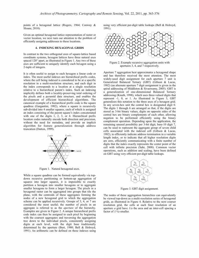
In contrast to the two orthogonal axes of square-lattice based coordinate systems, hexagon lattices have three natural axes spaced 120° apart, as illustrated in Figure 1. Any two of these axes are sufficient to uniquely identify each hexagon using a 2-tuple of integers.
It is often useful to assign to each hexagon a linear code or index. The most useful indexes are hierarchical prefix codes, where the cell being indexed is considered to be at a specific resolution in a multi-resolution structure, and each digit in the index corresponds to a location at a single resolution relative to a hierarchical parent’s index. Such an indexing implicitly defines both a locality-preserving total ordering of the pixels and a pyramid data structure, and enables the development of efficient hierarchical algorithms. The canonical example of a hierarchical prefix code is the square quadtree (Gargantini, 1982), where a square is recursively sub-divided into 4 smaller squares, each of which is assigned an index consisting of the parent square’s index concatenated with one of the digits 1, 2, 3, or 4. Hierarchical prefix location codes naturally encode both direction and precision, without the need for metadata, and provide an implicit algorithm for feature generalization through address truncation (Dutton, 1999).
Figure 1. Natural hexagonal axes.
While a square quadtree can be formed equivalently via top-down recursive partitioning or bottom-up aggregation of squares into larger squares, it is impossible to exactly partition a hexagon into smaller hexagons or to aggregate smaller hexagons to form a larger hexagon. The pixels in a hexagonal raster can be aggregated into groups that tile the plane, with the centroids of these aggregates forming the nodes of a new hexagonal grid to which the aggregation scheme can be applied recursively. Groups of 3, 4, or 7 are considered the most useful; the number of pixels in an aggregate is referred to as the aperture of the hierarchy. Examples are given in Figure 2. A unique hierarchical prefix code index can then be assigned to each pixel by beginning with the coarsest aggregates and traversing the aggregation tree down to the individual pixels, consistently assigning digits at each level, with the digit base traditionally determined by the aperture (Burt, 1980; Bell & Holroyd, 1991). An arithmetic can be defined on these indexes using
using very efficient per-digit table lookups (Bell & Holroyd, 1991).
! Figure 2. Example recursive aggregation units with apertures 3, 4, and 7 respectively.
Aperture 7 aggregation best approximates a hexagonal shape and has therefore received the most attention. The most widely-used digit assignment for each aperture 7 unit is Generalized Balanced Ternary (GBT) (Gibson & Lucas, 1982) (an alternate aperture 7 digit assignment is given in the spiral addressing of Middleton & Sivaswamy, 2005). GBT is a generalization of one-dimensional Balanced Ternary addressing (Knuth, 1998), which uses three-valued digits that represent -1, 0, or 1. As illustrated in Figure 3, GBT generalizes this notation to the three axes of a hexagon grid. In any seven-hex unit the central hex is designated digit 0. The digits 1 through 6 are arranged so that, if the digits are stored as 3-bit binary values, digits on opposite sides of the central hex are binary complements of each other, allowing negation to be performed efficiently using the binary complement operation. Depending upon the application, the remaining unused possibility per 3-bit digit, base-10 digit 7, can be used to represent the aggregate group of seven child cells associated with the indexed cell (Gibson & Lucas, 1982), to efficiently indicate address termination in a variable length index, or to indicate that all higher resolution digits are zero, efficiently communicating with a finite number of digits that the index exactly represents the center point of the cell with infinite precision (Sahr, 2008). Common vector operations, such as addition and scaling, have been defined on GBT using very efficient per-digit table lookups.
Figure 3. GBT digit assignment.
The nodes of these aggregation hierarchies can equivalently be viewed top-down as a multi-resolution series of hexagonal grids, as illustrated in Figure 4. Relative to the next coarser resolution grid, the cells at each finer resolution of an aperture a grid have 1/a the area and an inter-cell spacing a factor of 1/√a smaller.
Archives of Photogrammetry, Cartography and Remote Sensing, Vol. 22, 2011, pp. 363-376

Figure 4. Multi-resolution hexagonal grids of aperture 3, 4, and 7 respectively.
The top-down approach to hexagonal hierarchies can be traced to Christaller (1966), who argued that ideal human settlement patterns form mixed aperture 3, 4, and 7 hierarchies; Woldenberg (1979) argues that this is also true of naturally occurring branching structures such as rivers. Dacey (1965) gave a mathematical formulation of these hierarchies as a multi-resolution series of lattices. White et al. (1992) developed a computer program that generates mixed hexagon hierarchies on a hexagonal face of a truncated icosahedron and then inversely projects these hexagons to the surface of the earth, indexing the cells as per the aggregation approaches described above. Anchoring the hierarchy to the earth’s surface in this way fixes the size of the coarsest grid resolution (unlike the traditional raster case where the grid sizes are determined by the size of the finest resolution pixels); thus mixed aperture hierarchies provide finer control over the choice of grid cell size and spacing.
Aggregation-based indexing works well for hierarchically indexing a single resolution raster, but it does not provide a true multi-resolution encoding for vector locations (Sahr, 2008). In aperture 3 and 4 grids many cells overlap more than one cell at the next coarser resolution (see Figure 4), and each particular aggregation scheme arbitrarily chooses one of those coarser cells as the indexing parent. So while truncating the index of a cell will yield a valid cell index at a coarser grid resolution, that coarser cell is not necessarily the correct quantification of the vector location at that resolution. This also means that we cannot perform a coarse filter equality comparison by using the highest order digits of two indexes. Note that this is also true of addresses in a traditional decimal number system representation. For example, the one-digit truncation of decimal value 1.9 is 1, while the discrete unit quantization of that value is 2.
Note that the cells that are potentially the aperture 3 or 4 indexing children of a particular cell form a 7-hex unit, just as in the aperture 7 case. We can therefore apply the GBT indexing arrangement to create a uniform indexing scheme for pure and mixed aperture hierarchies which I call central place indexing (CPI) (Sahr, 2010). For vector locations, such indexes encode a true multi-resolution quantization with sub-pixel accuracy (see Figure 5). They also provide a uniform addressing system for aggregation schemes involving one or more tiling units (e.g., Sahr, 2008). CPI allows optimal control of resolution while maintaining the efficient binary encoding and integer arithmetic approach of GBT.
Figure 5. Multi-resolution quantization with sub-pixel accuracy on an aperture 3 CPI hierarchy.
5. DISCRETE GLOBAL GRID SYSTEMS
Multi-resolution hexagonal grids have been defined on the surface of regular polyhedra, such as the icosahedron, and then projected onto the sphere to create multi-resolution raster and vector geospatial data structures that are global in extent without singularities. These systems are known as discrete global grid systems (DGGSs) (Sahr et al., 2003); figure 6 illustrates an example. Note that it is impossible to tile the globe with hexagons; for example, if the base polyhedron is an icosahedron then there will be exactly twelve pentagonal cells, centered on the icosahedron vertices, at all resolutions.
Figure 6. Three resolutions of an aperture 3 hexagonal DGGS defined on an icosahedron.
The author has developed a software program called DGGRID (Sahr, 2002) for generating aperture 3 and 4 hexagonal DGGSs with pyramid indexing that has been used in research and data set production (e.g., Suess et al., 2004; Cressie & Johannesson, 2008; Hoffmann et al., 2010). DGGSs using hierarchical aggregation indexing schemes have been proposed for both apertures 3 and 4 (White, 2000; Sahr, 2008; Vince, 2009; Tong et al., 2010). CPI has also been extended to the sphere (Sahr, 2010) to provide a uniform indexing for pure and mixed aperture DGGSs, and a CPI grid has been designed and implemented to meet the narrow inter-cell spacing requirements of the U.S.
Archives of Photogrammetry, Cartography and Remote Sensing, Vol. 22, 2011, pp. 363-376

Environmental Protection Agency Emergency Response Atlas project (Sahr & White, 2010).
5. CONCLUSIONS
In this paper I attempted to demonstrate that raster and vector data structures based on hexagonal lattices offer significant advantages over those based on square lattices. Hexagonal lattices are now definable on multiple scales, from the entire globe down to individual sensor arrays, providing an efficient unified approach to location representation for geospatial computing applications. The primary obstacles to their adoption have been the lack of commercially available sensor and display devices, and the inertia created by the long history of widespread use of square-based location representations, with the convenience and familiarity that engenders. Since no technical limitations now exist I believe that it is only a matter of time before hexagonal raster and vector representations become more widely adopted.
6. ACKNOWLEDGEMENTS
The author would like to thank Denis White for his many insightful comments.
7. REFERENCES
Abu-Bakar, S., Green, R. J., 1996. Detection of edges based on hexagonal pixel formats. 3rd International Conference on Signal Processing Proceedings (ICSP-96), Beijing, China, pp. 1114–1117.
Allen, J.D., 2005. Perfect reconstruction filter banks for the hexagon grid, Proceedings of the Fifth International Conference on Information, Communications and Signal Processing, pp. 73–76.
Anderson, H.L., 1979. Time projection spectrometer, Informal Report LA-8165-MS, Los Alamos Scientific Laboratory, Los Alamos, NM.
Bell, S.B.M., Holroyd, F.C., 1991. Tesseral amalgamators and hierarchical tessellations. Image and Vision Computing, 9, pp. 313-328.
Burt, P.J., 1980. Tree and pyramid structures for coding hexagonally sampled binary images. Computer Graphics and Image Processing, 14, pp. 271–280.
Christaller, W. (1966). Central places in southern Germany. Prentice Hall, Englewood Cliffs, NJ.
Coleman, S.A., Scotney, B.W., Herron, M.G., 2004. A systematic design procedure for scalable near-circular Laplacian of Gaussian operators. Proceedings of the International Conference on Pattern Recognition (ICPR2004), Cambridge, MA, pp. 700-703.
Coleman, S.A., Scotney, B.W., Gardiner, B., 2009. Design of feature extraction operators for use on biologically motivated hexagonal image structures. Proceedings of the IAPR Conference on Machine Vision and Applications (MVA), Japan, pp. 178-181.
Conway, J.H., Sloane, N.J.A., 2010. Sphere packings, lattices
and groups. 3rd ed., Springer Verlag, New York, 703 pp.
Cressie, N., Johannesson, G., 2008. Fixed rank kriging for very large spatial data sets. Journal of the Royal Statistical Society: Series B (Statistical Methodology), 70(1), pp. 209–226.
Dacey, M.F., 1965. The geometry of central place theory. Geografiska Annaler: Series B, Human Geography, 47(2), pp. 111-124.
Davies, E.R., 1984. Circularity - a new principle underlying the design of accurate edge orientation operators. Image and Vision Computing, 2(3), pp. 134 -142.
Delbrueck, T., 1993. Silicon retina with correlation-based, velocity-tuned pixels. IEEE Transactions on Neural Networks, 4(3), pp. 529-541.
Dersanambika, K.S., Krithivasan, K., Martín-Vide, C., Subramanian, K.G., 2005. Local and recognizable hexagonal picture languages. International Journal of Pattern Recognition and Artificial Intelligence, 19(7), pp. 853-871.
Dutton, G., 1999. A hierarchical coordinate system for geoprocessing and cartography. Springer Verlag, New York, 230 pp.
Gardiner, B., Coleman, S.A., Scotney, B.W., 2008. Multi-scale feature extraction in a sub-pixel virtual hexagonal environment. Proceedings of the International Machine Vision and Image Processing Conference, pp. 111-116.
Gardiner, B., Coleman, S.A., Scotney, B.W., 2009. Fast multiscale operator development for hexagonal images. Proceedings of the 31st Annual Pattern Recognition Symposium of the German Association for Pattern Recognition (DAGM 2009), Jena, Germany, pp. 282-291.
Gardiner, B., Coleman, S.A., Scotney, B.W., 2010. Comparison of hexagonal image resampling techniques. Proceedings of the 14th International Machine Vision and Image Processing Conference (IMVIP 2010), Limerick, Ireland, pp. 102-115.
Gargantini, I., 1982. An effective way to represent quadtrees. Communications of the Association for Computing Machinery, 25(12), pp. 905-910.
Gibson, L., Lucas, D., 1982. Spatial data processing using generalized balanced ternary. Proceedings of the IEEE Computer Society Conference on Pattern Recognition and Image Processing, Las Vegas, NV, pp. 566-571. Golay, M.J.E., 1969. Hexagonal parallel pattern transformations. IEEE Transactions on Computers, 18(8), pp. 733-740.
Grigoryan, A.M., 2002. Efficient algorithms for computing 2-D hexagonal Fourier transforms. IEEE Transactions on Signal Processing, 50, pp. 1438– 1448.
Guyon, O., Roddier, F., 2002. A nulling wide field imager for exoplanets detection and general astrophysics. Astronomy & Astrophysics, 391(379).
Archives of Photogrammetry, Cartography and Remote Sensing, Vol. 22, 2011, pp. 363-376

Hauschild, R., Hosticka, B.J., Müller, S., Schwarz, M., 1996. A CMOS optical sensor system performing image sampling on a hexagonal grid. Proceedings of the 22nd European Solid-State Circuits Conference.
He, X., Jia, W., Wu, Q., Hintz, T., 2006. Description of the cardiac movement using hexagonal image structures. Computerized Medical Imaging and Graphics, 30(6-7), pp. 377-382.
He, X., Wu, Q., Jia, W., Hintz, T., 2008. Edge detection on hexagonal structure. Journal of Algorithms & Computational Technology, 2(1), pp. 61-78.
Hoedlmoser, H., Varner, G., Cooney, M., 2009. Hexagonal pixel detector with time encoded binary readout. Nuclear Instruments and Methods in Physics Research Section A: Accelerators, Spectrometers, Detectors and Associated Equipment, 599(2-3), pp. 152-160.
Hoffmann M, Hilton-Taylor C., Angulo A., Böhm M., Brooks T.M., Butchart S.H., Carpenter K.E., Chanson J., Collen B., Cox N.A., Darwall W.R., Dulvy N.K., Harrison L.R., Katariya V., Pollock C.M., Quader S., Richman N.I., Rodrigues A.S., Tognelli M.F., Vié J.C., Aguiar J.M., Allen D.J., Allen G.R., Amori G., Ananjeva N.B., Andreone F., Andrew P., Aquino Ortiz A.L., Baillie J.E., Baldi R., Bell B.D., Biju S.D., Bird J.P., Black-Decima P., Blanc J.J., Bolaños F., Bolivar-G W., Burfield I.J., Burton J.A., Capper D.R., Castro F., Catullo G., Cavanagh R.D., Channing A., Chao N.L., Chenery A.M., Chiozza F., Clausnitzer V., Collar N.J., Collett L.C., Collette B.B., Cortez Fernandez C.F., Craig M.T., Crosby M.J., Cumberlidge N., Cuttelod A., Derocher A.E., Diesmos A.C., Donaldson J.S., Duckworth J.W., Dutson G., Dutta S.K., Emslie R.H., Farjon A., Fowler S., Freyhof J., Garshelis D.L., Gerlach J., Gower D.J., Grant T.D., Hammerson G.A., Harris R.B., Heaney L.R., Hedges S.B., Hero J.M., Hughes B., Hussain S.A., Icochea M.J., Inger R.F., Ishii N., Iskandar D.T., Jenkins R.K., Kaneko Y., Kottelat M., Kovacs K.M., Kuzmin S.L., La Marca E., Lamoreux J.F., Lau M.W., Lavilla E.O., Leus K., Lewison R.L., Lichtenstein G., Livingstone S.R., Lukoschek V., Mallon D.P., McGowan P.J., McIvor A., Moehlman P.D., Molur S., Muñoz Alonso A., Musick JA., Nowell K., Nussbaum R.A., Olech W., Orlov N.L., Papenfuss T.J., Parra-Olea G., Perrin W.F., Polidoro B.A., Pourkazemi M., Racey P.A., Ragle J.S., Ram M., Rathbun G., Reynolds R.P., Rhodin A.G., Richards S.J., Rodríguez L.O., Ron S.R., Rondinini C., Rylands A.B., Sadovy de Mitcheson Y., Sanciangco J.C., Sanders K.L., Santos-Barrera G., Schipper J., Self-Sullivan C., Shi Y., Shoemaker A., Short F.T., Sillero-Zubiri C., Silvano D.L., Smith K.G., Smith A.T., Snoeks J., Stattersfield A.J., Symes A.J., Taber A.B., Talukdar B.K., Temple H.J., Timmins R., Tobias J.A., Tsytsulina K., Tweddle D., Ubeda C., Valenti S.V., van Dijk P.P., Veiga L.M., Veloso A., Wege D.C., Wilkinson M., Williamson E.A., Xie F., Young B.E., Akçakaya H.R., Bennun L., Blackburn T.M., Boitani L., Dublin H.T., da Fonseca G.A., Gascon C., Lacher T.E Jr., Mace G.M., Mainka S.A., McNeely J.A., Mittermeier R.A., Reid G.M., Rodriguez J.P., Rosenberg A.A., Samways M.J., Smart J., Stein B.A., Stuart S.N., 2010. The impact of conservation on the status of the world’s vertebrates. Science, 330(6610), pp. 1503-1509.
Iwanczyk, J.S., Patt, B.E., Tull, C.R., Segal, J.D., Keme, C.J., Bradley, J., Hedman, B., Hodgson, K.O., 1999. Large area silicon drift detectors for X-rays — new results. IEEE Transactions on Nuclear Science, 46, pp. 284-288.
Jiang, Q., 2009. Orthogonal and Biorthogonal √3-Refinement Wavelets for hexagonal data processing. IEEE Transactions on Signal Processing, 57(11), pp. 4304 - 4313.
Jiang, Z., Qinghui, X., Linghong, Z., 2010. 3D reconstruction based on hexagonal pixel’s dense stereo matching. Applied Mechanics and Materials, 20-23, pp. 487-492.
Knuth, D., 1998. The art of computer programming; Volume 2: Seminumerical algorithms. Addision-Wesley, Menlo Park, CA, 762 pp.
Laine, A.F., Schuler, S., Huda, W., Honeyman-Buck, J.C., Steinbach, B.G., 1993. Hexagonal wavelet processing of digital mammography. Proceedings of Medical Imaging 1993: Image Processing, Newport Beach, CA.
Luczak, E., Rosenfeld, A., 1976. Distance on a hexagonal grid. IEEE Transactions on Computers, 25(5), pp. 532-533.
Mersereau, R.M., 1979. The processing of hexagonally sampled two-dimensional signals. Proceedings of the IEEE, 67, pp. 930-949.
Middleton, L., Sivaswamy, J., 2001. Edge detection in a hexagonal-image processing framework. Image and Vision Computing, 19, pp. 1071-1081.
Middleton, L., 2002. The co-occurrence matrix in square and hexagonal lattices. Proceedings of the 7th International Conference on Control, Automation, Robotics and Vision, ICARV 2002, Singapore, pp. 90-95.
Middleton, L., Sivaswamy, J., 2005. Hexagonal Image Processing; A Practical Approach, Springer-Verlag, London, 254 pp.
Miller, E., 1999. Alternative tilings for improved surface area estimates by local counting algorithms. Computer Vision and Image Understanding (CVIU), 74, pp. 193-211.
Petersen, D.P., Middleton, D., 1962. Sampling and reconstruction of wave-number-limited functions in N-dimensional Euclidean spaces. Information Control, 5, pp. 279-323.
Riley, D.T., Harmann, W.M., Barrett, S.F., Wright, C.H.G., 2008. Musca domestica inspired machine vision sensor with hyperacuity. Bioinspiration and Biomimetics, 3(2).
Rogers, C.A., 1964. Packing and Covering. Cambridge University Press, 111 pp.
Roorda, A., Metha, A.B., Lennie, P., Williams, D.R., 2001. Packing arrangement of the three cone classes in primate retina. Vision Research, 41, pp. 1291-1306.
Archives of Photogrammetry, Cartography and Remote Sensing, Vol. 22, 2011, pp. 363-376

Rosenfeld, A., 1970. Connectivity in digital pictures. Journal of the Association for Computing Machinery, 17, pp. 146-160.
Sahr, K., 2002. DGGRID version 3.1b: User documentation for discrete global grid software. Retrieved July 14, 2011, f rom h t tp : / /d i sc re teg loba lgr ids .o rg /dggr id /docs /dggriddoc31.pdf.
Sahr, K., White, D., Kimerling, A.J., 2003. Geodesic discrete global grid systems. Cartography and Geographic Information Science, 30(2), pp. 121–134.
Sahr, K., 2008. Location coding on icosahedral aperture 3 hexagon discrete global grids. Computers, Environment and Urban Systems, 32(3), pp. 174-187.
Sahr, K., 2010. Central Place Indexing Systems, U.S. Patent Application 2010/054550.
Sahr, K., White, D., 2010. The superfund_21ha indexing system. Unpublished documentation, Southern Oregon University, Ashland, Oregon.
Scotney, B.W., Coleman, S.A., 2007. Improving angular error via systematically designed near-circular Gaussian-based feature extraction operators. Pattern Recognition, 40(5), pp. 1451-1465.
Shima, T., Saito, S., Nakajima, M., 2009. Design and evaluation of more accurate gradient operators on hexagonal lattices. IEEE Transactions on Pattern Analysis and Machine Intelligence, 32(6), pp. 961-973.
Shima, T., Sugimoto, S., Okutomi, M., 2010. Comparison of image alignment on hexagonal and square lattices. Proceedings of the 17th IEEE International Conference on Image Processing, pp. 141-144.
Siromoney, G., Siromoney, R., 1976. Hexagonal arrays and rectangular blocks. Computer Graphics and Image Processing, 5, pp. 353-381
Smeraldi, F., Rob, M.A., 2003. Ranklets on hexagonal pixel lattices. Proceedings of the British Machine Vision Conference, Norwich, UK, vol. 1, pp. 163-170.
Snyder, W., Qi, H., Sander, W., 1999. A coordinate system for hexagonal pixels. Proceedings of SPIE, the International Society for Optical Engineering, 3661, pp. 716–727.
Sossa-Azuela, J.H., Cuevas-Jiménez, E.V., Zaldivar-Navarro, D., 2010. Computation of the Euler number of a binary image composed of hexagonal cells. Journal of Applied Research and Technology, 8(3), pp. 340-351.
Staunton, R.C., 1989. The design of hexagonal sampling structures for image digitization and their use with local operators. Image and Vision Computing, 7(3), pp. 162-166.
Subramanian, K.G., 1979. Hexagonal array grammars. Computer Graphics and Image Processing, 10(4), pp. 388-394.
Suess, M., Matos, P., Gutierrez, A., Zundo, M., Martin-Neira, M., 2004. Processing of SMOS level 1c data onto a discrete global grid. Proceedings of the IEEE International Geoscience and Remote Sensing Symposium, pp. 1914-1917.
Tong, X., Ben, J., Wang, Y., 2010. A new effective hexagonal discrete global grid system: hexagonal quad balanced structure. Proceedings of Geoinformatics 2010, pp. 1-6.
Tremblay, M., d'Anjou, M., Poussart, D., 1993. Hexagonal sensor with imbedded analog image processing for pattern recognition. Custom Integrated Circuits Conference, Proceedings of the IEEE 1993, San Diego, CA, pp. 12.7.1-12.7.4.
Veni, S., Narayanankutty, K.A., Fayas., A, 2011. Employing hexagonal wavelets for detecting microcalcification in digital mammography. ICGST International Journal on Graphics, Vision and Image Processing, GVIP, 11(I), pp. 59-66.
Verbrugge, C., 1997. Hex grids. Unpublished manuscript, McGill University, Montreal, Quebec, Canada.
Vince, A., Zheng, X., 2007. Computing the discrete Fourier transform on a hexagonal lattice. Journal of Mathematical Imaging and Vision, 28, pp. 125-133.
Vince, A., Zheng, X., 2009. Arithmetic and Fourier transform for the PYXIS multi-resolution digital earth model. International Journal of Digital Earth, 2(1), pp. 59-79.
Vitulli, R., 2002. Aliasing effects mitigation by optimized sampling grids and impact on image acquisition chains. Geoscience and Remote Sensing Symposium, pp. 979-981.
White, D., Kimerling, A.J., Overton, W.S., 1992. Cartographic and geometric components of a global sampling design for environmental monitoring. Cartography and Geographic Information Systems, 19(1), pp. 5-22.
White, D., 2000. Global grids from recursive diamond subdivisions of the surface of an octahedron or icosahedrons. Environmental Monitoring and Assessment, 64(1), pp. 93-103.
Woldenberg, M.J., 1979. A periodic table of spatial hierarchies. In: Philosophy in Geography. D. Reidel, Dordrecht, Netherlands, pp. 429-456.
Wuthrich, C.A., Stucki, P., 1991. An algorithmic comparison between square- and hexagonal-based grids. CVGIP: Graphical Models and Image Processing, 53(4), pp. 324-339.
Yale, P.B., 1968. Geometry and symmetry. Holden-Day, San Francisco, 288 pp.
Archives of Photogrammetry, Cartography and Remote Sensing, Vol. 22, 2011, pp. 363-376
Related Documents