Ill u 0 Ill ... Henry W. Schasse, M. Lorraine Kaler, Nancy A. Eberle, and Rebecca A. Christie WASHINGTON DIVISION OF GEOLOGY AND EARTH RESOURCES Open File Report 94-7 June 1994 This report supersedes Open File Report 83-8 WASHINGTON STATE DEPARTMENTOF Natural Resources Jennifer M. Belcher- Commissioner of Public Lands Kaleen Cottlngham-.Supervisor

Welcome message from author
This document is posted to help you gain knowledge. Please leave a comment to let me know what you think about it! Share it to your friends and learn new things together.
Transcript
Ill
u
0
Ill
~~ ...
Henry W. Schasse, M. Lorraine Kaler, Nancy A. Eberle,
and Rebecca A. Christie
WASHINGTON DIVISION OF GEOLOGY
AND EARTH RESOURCES
Open File Report 94-7 June 1994
This report supersedes Open File Report 83-8
WASHINGTON STATE DEPARTMENTOF
Natural Resources Jennifer M. Belcher- Commissioner of Public Lands Kaleen Cottlngham-.Supervisor

CONTENTS
1 Introduction2 Acknowledgments2 User's guide to catalog (and addenda) and index maps2 Explanation of mine map catalog tabulations4 Explanation of Mylar composites 4 User's guide to the mine maps on microfilm11 History of mining development in Washington11 Mining methods12 References cited13 Explanation of index maps
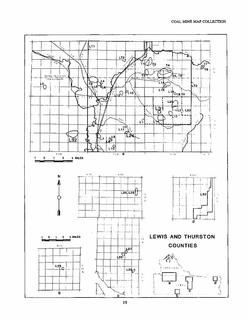
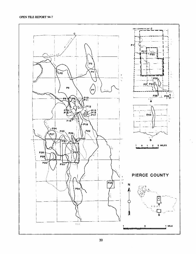
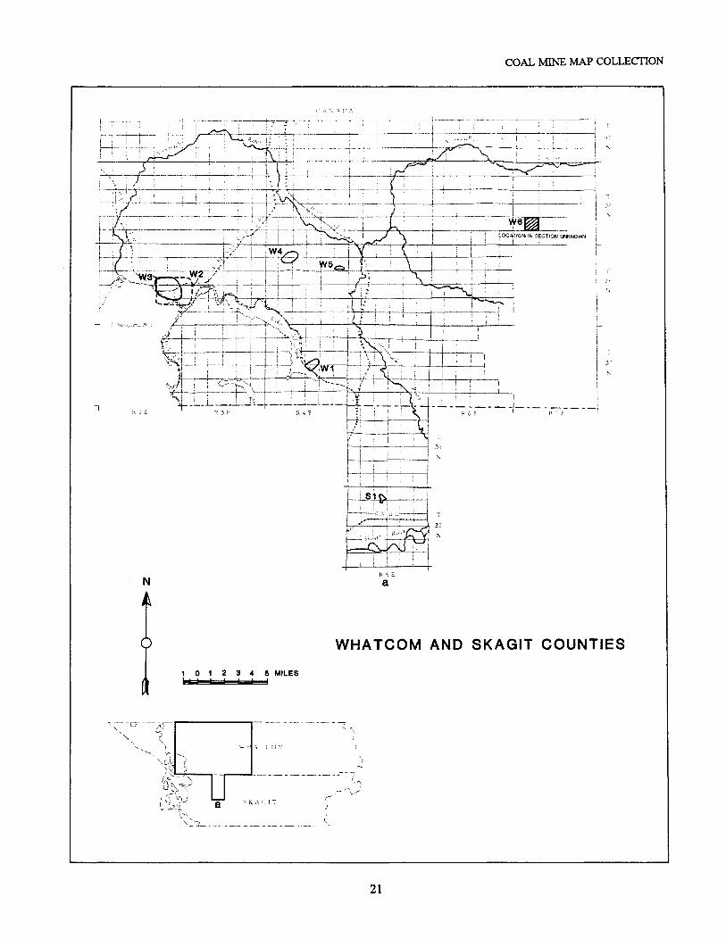
Catalog of coal mines by county:22 King County54 Kittitas County62 Lewis County67 Lewis-Thurston Counties68 Lewis-Thurston-Cowlitz Counties68 Pierce County79 Pierce-King Counties79 Skagit County79 Thurston County81 Whatcom County83 Addendum of May 198484 King County86 Kittitas County87 Pierce County88 Whatcom County89 Addendum of February 199490 King County91 Kittitas County91 Lewis County92 Pierce County92 Thurston County93 Appendix: Cross reference lists93 Alphabetical listing of mine names101 Alphabetical listing of mine operators
ILLUSTRATIONS
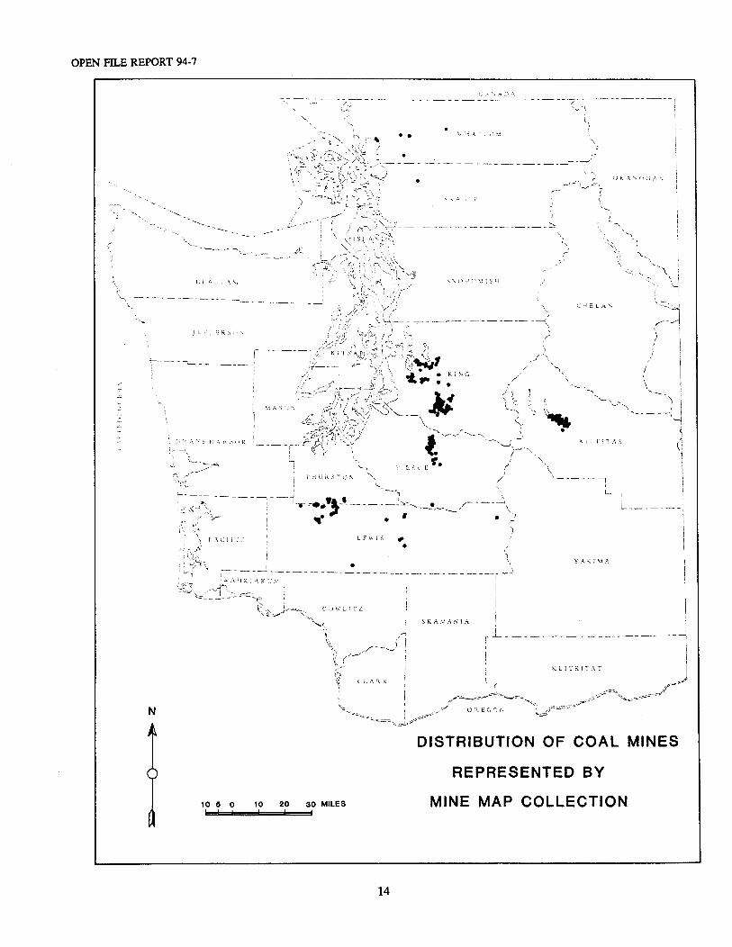
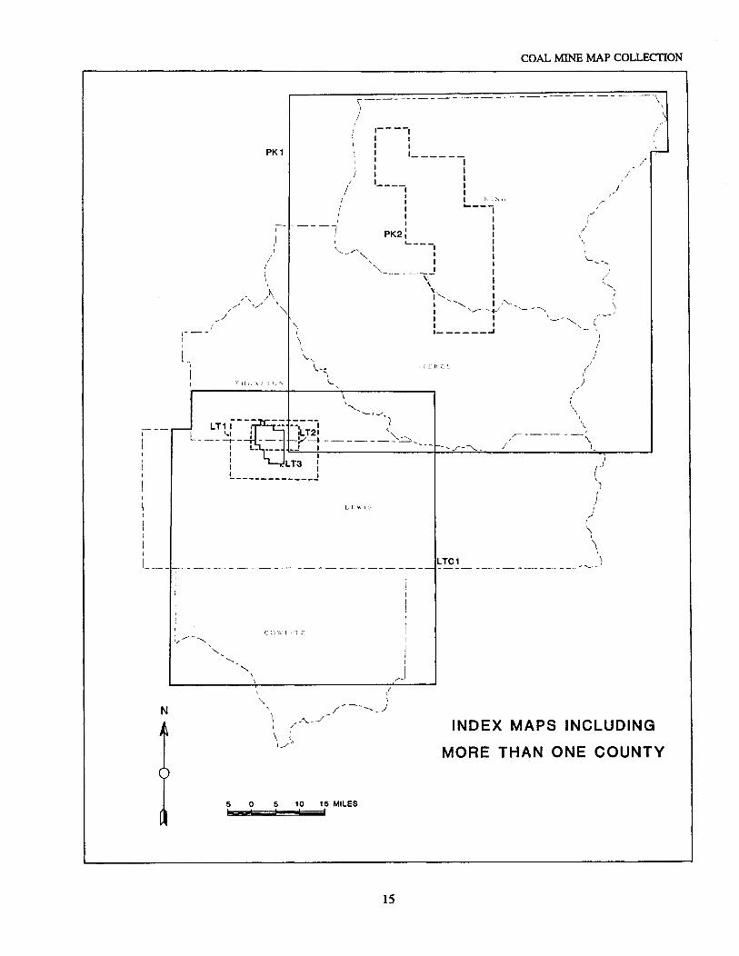
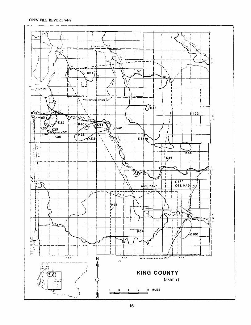
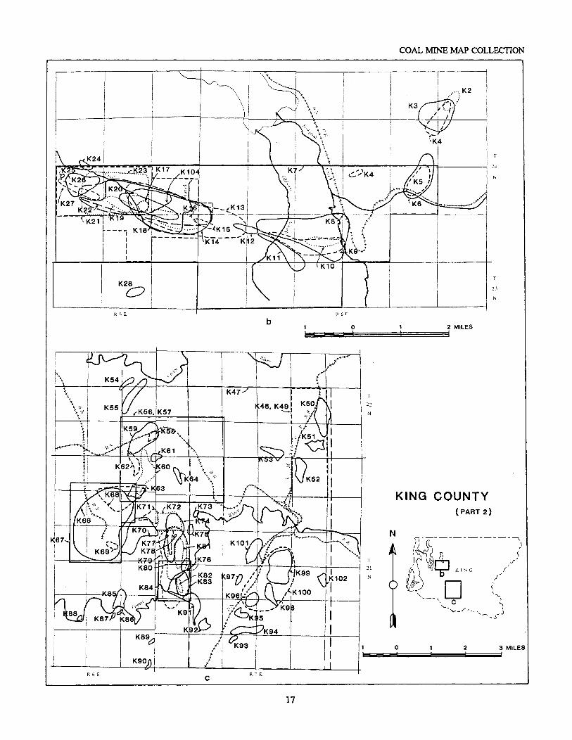
12 Diagram of main underground features of a coal mine14 Map showing distribution of coal mines represented by mine map collection15 Index maps including more than one county
2
ILLUSTRATIONS (continued)
16 Map of King County (part 1)17 Map of King County (part 2)18 Map of Kittitas County19 Map of Lewis and Thurston Counties20 Map of Pierce County21 Map of Whatcom and Skagit Counties
TABLE
7 Table 1. List of mines shown on mylar composites
1
The Washington State Coal Mine Map Collection:A Catalog, Index, and User's Guide
byHenry W. Schasse, M. Lorraine Koler, Nancy A. Eberle, and Rebecca A. Christie
INTRODUCTION
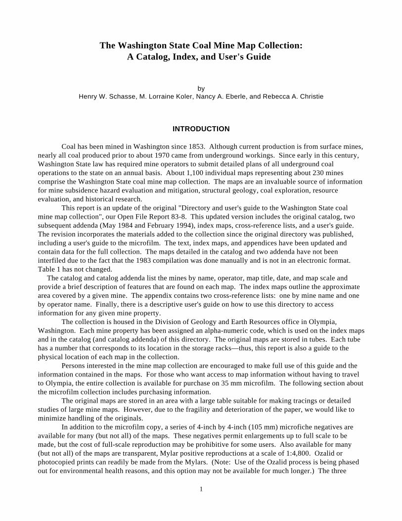
Coal has been mined in Washington since 1853. Although current production is from surface mines,nearly all coal produced prior to about 1970 came from underground workings. Since early in this century,Washington State law has required mine operators to submit detailed plans of all underground coaloperations to the state on an annual basis. About 1,100 individual maps representing about 230 minescomprise the Washington State coal mine map collection. The maps are an invaluable source of informationfor mine subsidence hazard evaluation and mitigation, structural geology, coal exploration, resourceevaluation, and historical research.
This report is an update of the original "Directory and user's guide to the Washington State coalmine map collection", our Open File Report 83-8. This updated version includes the original catalog, twosubsequent addenda (May 1984 and February 1994), index maps, cross-reference lists, and a user's guide. The revision incorporates the materials added to the collection since the original directory was published,including a user's guide to the microfilm. The text, index maps, and appendices have been updated andcontain data for the full collection. The maps detailed in the catalog and two addenda have not beeninterfiled due to the fact that the 1983 compilation was done manually and is not in an electronic format. Table 1 has not changed. The catalog and catalog addenda list the mines by name, operator, map title, date, and map scale andprovide a brief description of features that are found on each map. The index maps outline the approximatearea covered by a given mine. The appendix contains two cross-reference lists: one by mine name and oneby operator name. Finally, there is a descriptive user's guide on how to use this directory to accessinformation for any given mine property.
The collection is housed in the Division of Geology and Earth Resources office in Olympia,Washington. Each mine property has been assigned an alpha-numeric code, which is used on the index mapsand in the catalog (and catalog addenda) of this directory. The original maps are stored in tubes. Each tubehas a number that corresponds to its location in the storage racks—thus, this report is also a guide to thephysical location of each map in the collection.
Persons interested in the mine map collection are encouraged to make full use of this guide and theinformation contained in the maps. For those who want access to map information without having to travelto Olympia, the entire collection is available for purchase on 35 mm microfilm. The following section aboutthe microfilm collection includes purchasing information.
The original maps are stored in an area with a large table suitable for making tracings or detailedstudies of large mine maps. However, due to the fragility and deterioration of the paper, we would like tominimize handling of the originals.
In addition to the microfilm copy, a series of 4-inch by 4-inch (105 mm) microfiche negatives areavailable for many (but not all) of the maps. These negatives permit enlargements up to full scale to bemade, but the cost of full-scale reproduction may be prohibitive for some users. Also available for many(but not all) of the maps are transparent, Mylar positive reproductions at a scale of 1:4,800. Ozalid orphotocopied prints can readily be made from the Mylars. (Note: Use of the Ozalid process is being phasedout for environmental health reasons, and this option may not be available for much longer.) The three
OPEN FILE REPORT 94-7
2
alternative formats—35 mm microfilm, 105 mm microfiche negatives, and Mylars—are all cataloged andcross-referenced to the original mine maps.
Acknowledgments
Funding for this project came from a combination of state and federal sources and contributions byrepresentatives of private industry. The Division of Geology and Earth Resources thanks ComincoAmerican, Inc., GCO Minerals Co., Getty Oil Co., Hart-Crowser and Associates, Inc., Longview Fibre Co.,Meridian Land and Mineral Co., Rocky Mountain Energy, Soil Sampling Service, Inc., and the WeyerhaeuserCo. for their generous contributions that aided in the completion of this catalog.
Funding for the reproducible Mylar and microfiche reductions was provided by the U.S. Bureau ofMines. Funding for the microfilming of the entire collection was provided by the U.S. Office of SurfaceMining.
The authors thank William M. Phillips, Timothy J. Walsh, and Connie J. Manson of the Division ofGeology and Earth Resources for their helpful suggestions throughout the project. Further acknowledgmentis given to the tireless efforts of Joe-Ann Helms, who was instrumental in organizing many of the mapsbefore this project was undertaken.
USER'S GUIDE TO CATALOG (AND ADDENDA) AND INDEX MAPS
The mine maps indexed in the catalog (and addenda) are arranged in alphabetical order by county. Under the county headings, the mines are listed by sequential index numbers which correspond to the minelocations as drawn on the index maps.
The index maps incorporate the information from our Open File Report 83-8, an addendum datedMay 1984, and a second addendum completed in February 1994. The index maps show the approximatelocation of, and area covered by, a single mine or composite map depicting several mines in a given area.
The two addenda to the catalog follow the original catalog. Please note that the three parts are notmerged, but remain as three separate entities.
Following the addenda is an appendix containing two alphabetically arranged cross-reference lists. The first is a listing of mine names, and the second is a listing of operators. Both lists are cross-referencedby number to the catalog listings and catalog addenda.
Explanation of Mine Map Catalog Tabulations
The mine map catalog tabulations are arranged under column headings. A detailed explanation ofeach column is given below, in order from left to right across a page.
Index Number (Index No.)
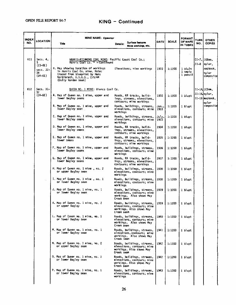
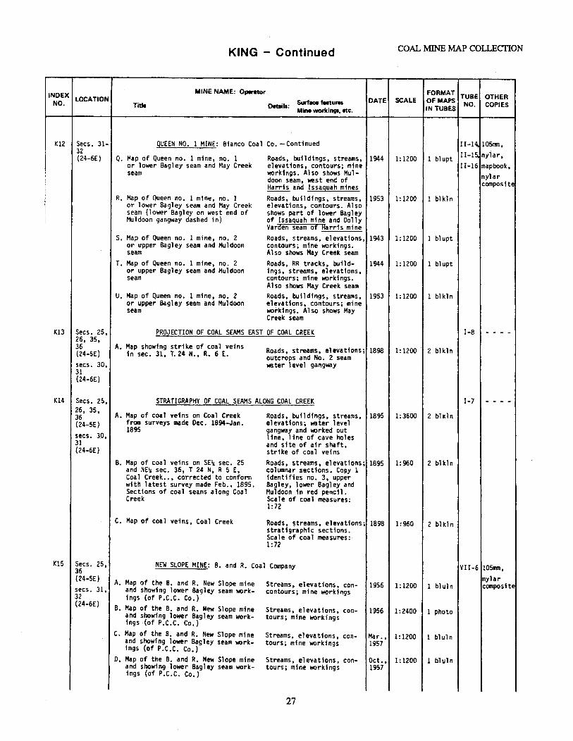
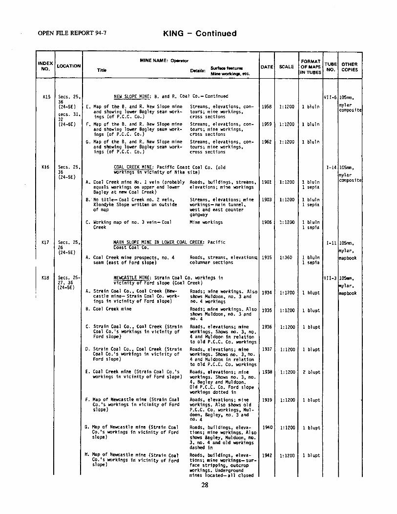
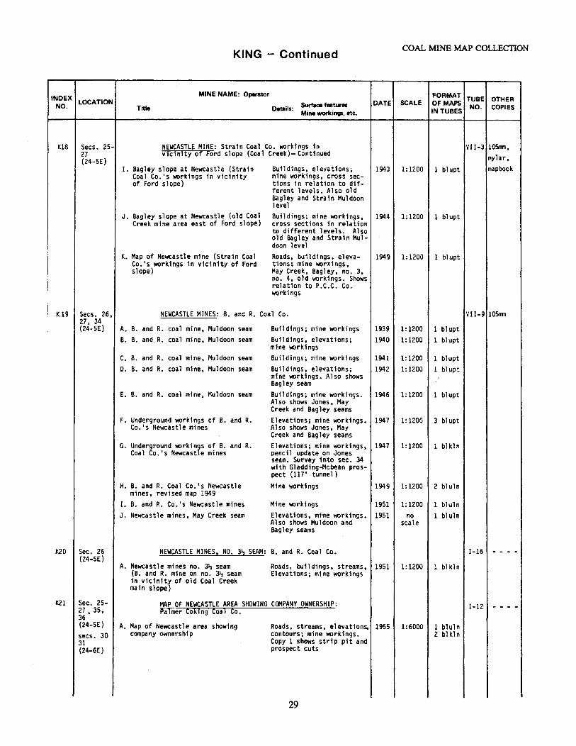
The index number is a combination of an alphabetical prefix which designates the county(ies) inwhich the mine or group of mines is located, and a sequential number. This alpha-numericdesignation keys the catalog listing of each mine or mine area within a county to its correspondingindex map. The sequential arrangement allows the user to locate the descriptive information in thecatalog section (or catalog addenda) once the index number is determined from the index map. Theindex numbers were assigned in a generally north to south and east to west arrangement. Miningproperties first listed in the addenda [K103, K104, L31, L32] do not fit into this directional scheme. The index number also links the appendices of mine names and operator names to the catalog listing.
COAL MINE MAP COLLECTION
3
The index number appears on all formats of the maps: full-scale maps, reduced scale reproducibleMylars, 105 mm negatives, and 35 mm microfilm.
Location
This column refers to the area represented by the cumulative extent of mine workings shown on themine records of a given mine. It is given as standard Government Land Office coordinates ofsection, township, and range. Locations by legal land descriptions are abbreviated, for example, assecs. 10, 11, 15-18, 22, 26 (23-6E)—meaning sections 10, 11, 15, 16, 17, 18, 22, and 26, Township23 North, Range 6 East. Because all of the townships in the region covered are north of the Mt.Hood baseline, the direction is not noted. Because the ranges in the region occur both west and eastof the Willamette Meridian (W.M.), the direction is specified.
Mine Name; Operator
The central column lists the mine name and operator(s) of the mine (or a composite map showingseveral adjacent mines or a coalfield and the company which produced the map). Beneath thisheading the mine maps are listed by title and in chronological order, although there are somevariations to this rule. Maps with broad coverage precede maps showing more detailed features. Insome places several coal seams were developed into a single mine. Where this has occurred, aneffort has been made to list the maps of each seam sequentially by number and chronologically bydate.
Details found on each mine map are listed in the column adjacent to the map title. Surface featuresare listed first, followed by mine workings and other physical details; a semicolon separates the twotypes of details when a map record contains both.
Date
The date used is the most recent date appearing on a given map. The map records of a particularmine can include periodically updated maps showing the progress of mine development.
Scale
The map scale is listed as a ratio. Many of the full-scale mine maps were drafted at a scale of 1inch = 100 feet, which appears in the catalog as the ratio 1:1200.
Format of Maps in Tubes
Formats of mine maps include paper copy blueprints (blupt), bluelines (bluln), blacklines (blkln), inkand pencil tracings (ink/pencil), prints on photo paper (photo), ink tracings on linen (linen), and sepiaprints (sepia).
Tube Number (Tube No.)
The tube number directs the user to the tube that contains the desired map(s). The maps are storedin tube racks at the Division of Geology and Earth Resources Olympia office. The Roman numeralidentifies the storage rack containing a given map tube, and the number refers to the tube locationwithin the storage rack.
OPEN FILE REPORT 94-7
4
Other copies
This column identifies mines for which the Division owns reproducible copies: 4 inch by 4 inch 105 mm negatives, reduced scale 1:4,800 (1 in. = 400 ft) individual Mylar positive prints, or Mylarcomposite maps. The microfilm copy includes all the individual mine maps in the collection to date,with the exception of the few that were missing at the time of filming.
The 105 mm negatives were acquired by photographing many of the mine maps. Due to the size ofthe original maps, it was necessary to take several photographs of each map. Several negatives mustbe combined to produce a complete map.
The individual Mylar positive prints were produced from the 105 mm negatives. As with the 105 mm negatives, several of them must be combined to produce a complete map. In several casesthe individual prints were used to construct mylar composites of major coalfields. These compositesare discussed elsewhere in the text.
The term "mapbook" refers to a forerunner of the present system which contains Ozalid copies madefrom 1:4,800 Mylar prints. It is organized by county with pages organized by Government LandOffice sections and can be a useful adjunct to the present system.
Explanation of Mylar Composites
Larger composite maps were created by splicing together and photographing some of the individualMylar positive prints. The composite maps provide a complete view of large mines not possible with theindividual Mylar sheets. They also show the correct relative geographic positions of adjacent mines. TheMylar composites are filed separately from the individual Mylar sheets and can be used to produceinexpensive blackline or blueline paper copies. They are listed under a separate heading because they are notoriginal maps and could not be appropriately cataloged in the primary tabulation.
Mines included on each Mylar composite sheet are listed in Table 1. Individual mine names arecross-referenced by index number to the primary catalog listing of the mine. A corresponding cross-reference is also made in the primary tabulations in the catalog by the notation "Mylar composite" in the farleft column.
The tube number identifies the location of the map in the physical storage system. Labels in thelower right hand corner of each Mylar composite map identify the mines appearing on the composite map. Locations of the individual mines can be determined by referring to the index maps.
User's Guide to the Mine Maps on Microfilm
The entire coal mine map collection is available on five reels of 35 mm microfilm. Purchases ofsingle reels or complete sets will be coordinated by the Division of Geology and Earth Resources. Thecurrent (1994) price for a diazo copy is $8.50 per reel plus shipping and handling. To buy microfilm, send aletter specifying what you want (quantity, reel number(s), diazo or silver) to: Publications, WashingtonDivision of Geology and Earth Resources, P.O. Box 47007, Olympia, WA 98504-7007. Please includepayment for the text, The Washington State Coal Mine Map Collection: A Catalog, Index, and User's Guide, with the request for microfilm. We will mail you the text and forward your request to the MicrofilmBureau. They will contact you directly about payment options. Money for the microfilm is not to be sent tothe Division of Geology and Earth Resources.
The Mylar composites are not included in the microfilm collection.
COAL MINE MAP COLLECTION
5
The microfilm contains the catalog portion of the directory and the mine maps; it is not intended as astand-alone product. For the index maps, appendices, and user's guide, one must still use the directory. Themicrofilm copy follows the same sequence as the catalog, with two exceptions/clarifications. First, the mapsfrom the two addenda are merged with the maps from the original catalog. Second, because some users maywant reels for a specific county only, the mine maps from combined county areas (Pierce-King, Lewis-Thurston and Lewis-Thurston-Cowlitz) were filmed twice: the PK maps follow both King and PierceCounties, and the LT and LTC maps follow both Lewis and Thurston Counties.
The reels cover the maps as follows:
reel 1: K1 - K41reel 2: K42 - K91reel 3: K92 - K104
PK1 - PK2Kt1 - Kt32
reel 4: L1 - L32LT1 - LT3LTC1P1 - P36
reel 5: P37 - P40PK1 - PK2S1T1 - T8LT1 - LT3LTC1W1 - W6
Before the map(s) for each mining property, a 'catalog sheet' was filmed to clearly delineate betweenthe mine properties on the microfilm. Each frame was filmed with an identification tag showing the alpha-numeric code and letter assigned to each mine map (that is, Kt9 map C), a tag showing the frame number(when multiple frames were necessary to film one map), and a scale bar. In the few instances where a singlemap has two or more parts or sheets, the frames are labeled as (example only): K104 map B, sheet 2,frame 1.
The majority of the original maps are large and could not be filmed to fit on a single frame. There is potential for the user to be confused when trying to visually piece together the frames into one contiguousmap. Some maps are long and narrow, whereas others required rotating and filming in two horizontal rows: upper and lower. On the maps that were filmed in two rows, the frame numbers run clockwise from theupper left corner of the map, like this:
1 2 3 or 1 2 or 16 5 4 4 3 2
The frames of long and narrow maps may be numbered:1 2 3 4The maps were filmed with ample overlap, and we hope that the frame sequences will be
understandable. Maps missing from the collection at the time of microfilming are tagged as missing on the microfilm
and are listed in the errata and missing maps section, which follows.A note on quality control and human error: The majority of the original maps are blueprints. Every
effort was made to get the best possible film copy. A few maps are too faint to read; this is due to the quality of the original map. A few frames were intentionally shot twice at different light exposures to getbetter legibility. There are a few instances of accidental shutter-tripping, mostly on reel 1, but no map
OPEN FILE REPORT 94-7
6
information is lost. There may be additional errors that were not documented at the time of filming. Wewould appreciate hearing about them so that the errata list is accurate.
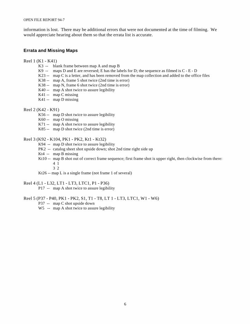
Errata and Missing Maps
Reel 1 (K1 - K41)K3 -- blank frame between map A and map BK9 -- maps D and E are reversed; E has the labels for D; the sequence as filmed is C - E - DK23 -- map C is a letter, and has been removed from the map collection and added to the office filesK38 -- map A, frame 5 shot twice (2nd time is error)K38 -- map N, frame 6 shot twice (2nd time is error)K40 -- map A shot twice to assure legibilityK41 -- map C missingK41 -- map D missing
Reel 2 (K42 - K91)K56 -- map D shot twice to assure legibilityK60 -- map O missingK71 -- map A shot twice to assure legibilityK85 -- map D shot twice (2nd time is error)
Reel 3 (K92 - K104, PK1 - PK2, Kt1 - Kt32)K94 -- map D shot twice to assure legibilityPK2 -- catalog sheet shot upside down; shot 2nd time right side upKt4 -- map B missingKt10 -- map B shot out of correct frame sequence; first frame shot is upper right, then clockwise from there:
4 13 2
Kt26 -- map L is a single frame (not frame 1 of several)
Reel 4 (L1 - L32, LT1 - LT3, LTC1, P1 - P36)P17 -- map A shot twice to assure legibility
Reel 5 (P37 - P40, PK1 - PK2, S1, T1 - T8, LT 1 - LT3, LTC1, W1 - W6)P37 -- map C shot upside downW5 -- map A shot twice to assure legibility
COAL MINE MAP COLLECTION
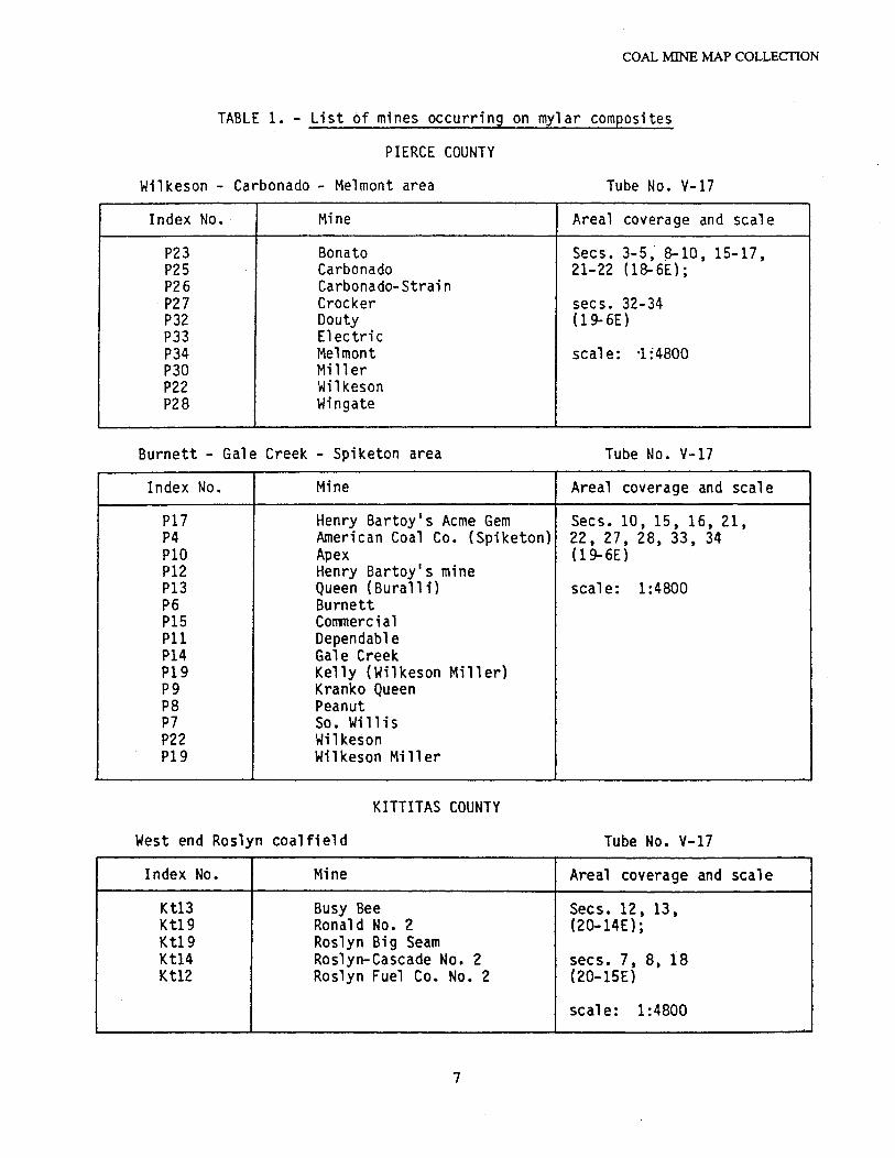
TABLE 1. - List of mines occurring on mylar composites
PIERCE COUNTY
Wilkeson - Carbonado - Melmont area Tube No. V-17
Index No. · Mine Areal coverage and scale
P23 Bonato Secs. 3-5, ~10, 15-17, P25 Carbonado 21-22 (18-6E); P26 Carbonado-Strain P27 Crocker secs. 32-34 P32 Douty ( 19-6E) P33 Electric P34 Melmont seal e: ·l :4800 P30 Mill er P22 Wilkeson P28 Wingate
Burnett - Gale Creek - Spiketon area Tube No. V-17
Index No. Mine Areal coverage and scale
Pl7 Henry Bartoy's Acme Gem Secs. 1 O, 15 , 16, 21 , P4 American Coal Co. {Spiketon) 22, 27, 28, 33, 34 PlO Apex (19- 6E) Pl2 Henry Bartoy's mine Pl3 Queen ( Bura 11 i) scale: 1 :4800 P6 Burnett Pl5 Con11lercial Pll Dependable Pl4 Gale Creek Pl9 Kelly (Wilkeson Miller) pg K ranko Queen PS Peanut P7 So. Willis P22 Wilkeson Pl9 Wilkeson Miller
KITTITAS COUNTY
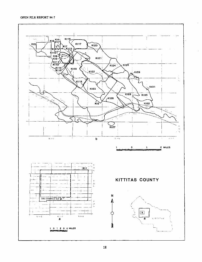
West end Roslyn coalfield Tube No. V-17
Index No. Mine Areal coverage and scale
Ktl3 Busy Bee Secs. 12, 13, Ktl9 Ronald No. 2 {20-14E); Ktl 9 Roslyn Big Seam Ktl4 Roslyn-Cascade No. 2 secs. 7 , 8 , 18 Ktl2 Roslyn Fuel Co. No. 2 (20-15E)
seal e: 1:4800
7
OPEN Fil..E R£PORT 94-7
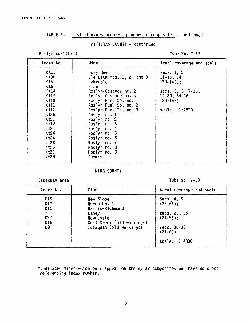
TABLE 1. - List of mines occurring on mylar composites - continued
KITTITAS COUNTY - continued
Roslyn coalfield Tube No. V-17
Index No. Mine Areal coverage and scale
Kt13 Kt30 Kt5 Kt6 Ktl4 Kt16 KtlO Ktll Kt12 Kt25 Kt21 Kt18 Kt22 Kt26 Kt24 Kt28 Kt20 i<t23 Kt29
Issaquah area
Index No.
Kl5 Kl2 Kll * K22 K16 KB
Busy Bee Cle Elum nos •. 1, 2, and 3 Lakedale Plant Roslyn-Cascade no. 2 Roslyn-Cascade no. 4 Roslyn Fuel Co. no. 1 Roslyn Fuel Co. no. 2 Roslyn Fuel Co. no. 3 Roslyn no. 1 Roslyn no. 2 Roslyn no. 3 Roslyn no. 4 Roslyn no. 5 Roslyn no. 6 Roslyn no. 7 Roslyn no. 8 Roslyn no. 9 Summit
KING COUNTY
Mine
New Slope Queen No. 1 Harris-Richmond Lahey Newcastle Coal Creek (old workings) Issaquah (old workings)
Secs. 1, 2, 11-13, 24 (20-14E);
secs. 5, 6, 7-10, 14-29, 34-36 (20-lSE)
scale: 1:4800
Tube No. V-18
Areal coverage and
Secs. 4, 5 . (23-oE); .
secs. 25, 36 (24-SE);
secs. 30-33 (24-6E)
scale: 1:4800
scale
*Indicates mines which only appear on the mylar composites and have no cross referencing index n'umber. ·
8
COAL MINE MAP COLLECTION
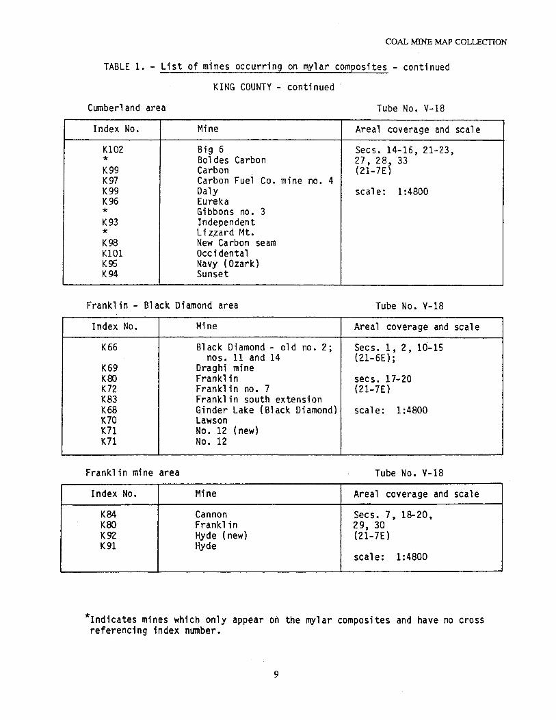
TABLE 1. - List of mines occurring on mylar composites - continued
KING COUNTY - continued.
Cumberland area Tube No. V-18
Index No. Mine Areal coverage and scale
Kl02 Big 6 Secs. 14-16, 21-23, * Bol des Carbon 27, 28, 33 K99 Carbon (21-7E) K97 Carbon Fuel Co. mine no. 4 K99 Daly scale: 1:4800 K96 Eureka * Gibbons no. 3 K93 Independent * Li z;zard Mt. K98 New Carbon seam KlOl Occidental K95 Navy (Ozark) K94 Sunset
Franklin - Black Diamond area Tube No. V-18
Index No. Mine Areal coverage and scale
K66 Black Diamond - old no. 2; Secs. 1, 2, 10-15 nos. 11 and 14 (21-6E);
K69 Draghi mine KOO Franklin secs. 17-20 K72 Frankl in no. 7 (21-7E) K83 Franklin south extension K68 Ginder Lake (Black Diamond) seal e: 1:4800 K70 Lawson K71 No. 12 (new) K71 No. 12
Franklin mine area Tube No. V-18
Index· No. Mine Areal coverage and scale
K84 Cannon Secs. 7, 18-20, KOO Franklin 29, 30 K92 Hyde ( new) (21-7E) K91 Hyde
scale: 1:4800
*Indica~es mines which only appear on the mylar composites and have no cross referencing index number.
9
EN FILE REPORT 94-7
TABLE 1. - List of mines occurring on mylar composites - continued
KING COUNTY - continued
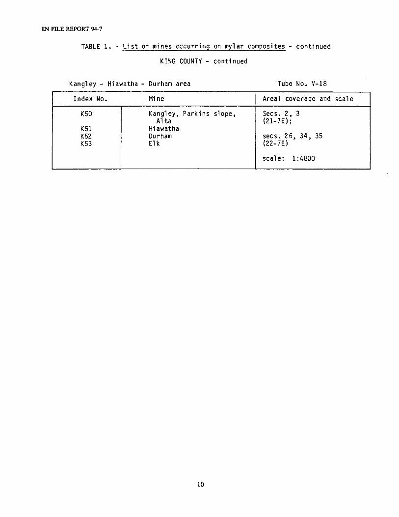
Kangley - Hiawatha - Durham area Tube No. V-18
Index No. Mine Areal coverage and seal e
KSO Kangley, Parkins slope, Secs. 2, 3 Al ta (21-7E};
KSl Hiawatha K52 Durham secs • 2 6, 34 , 35 K53 Elk (22-7E)
seal e: 1 :4800
10
COAL MINE MAP COLLECTION
11
HISTORY OF COAL MINING DEVELOPMENT IN WASHINGTON
The earliest recorded discovery of coal in Washington was in 1833 along the banks of the ToutleRiver in Cowlitz County near its junction with the Cowlitz River (Roberts, 1958). According to Jenkins(1923) the first coal mine in the state was opened in Bellingham in Whatcom County in 1853 or 1854.At about the same time, coal was discovered on the Black River, near the present site of Renton, and a minewas opened there in 1854. A few years later, the coalfields of the Issaquah and Newcastle areas in KingCounty, and the coking coal of the Carbon River and Wilkeson areas of Pierce County were discovered(Moen, 1982). The coals in the Roslyn area of Kittitas County were discovered around 1871 andproductions commenced in 1886 (Saunders, 1914). By this time the industry was well-establishedthroughout the coal-producing regions of the state. Annual coal production grew from 5,000 tons in 1860 to100,000 tons by 1876; by 1888 it exceeded 1 million tons per year. By 1890 coal ranked second inimportance to lumber as an export product of Washington.
In the three decades that followed, coal production increased significantly owing to its use as adomestic heating fuel as well as fuel for the railroads. Peak production of 4.1 million tons was reached in1918. Inroads made by competitive fuels, especially heating oils, started in the 1920's. Thereafter, coal useand production fell steadily, as competition from fuel oil, natural gas, and hydropower took effect. In the1960's annual production dropped below 100,000 tons and hit an all-time modern low of 37,000 tons in1970.
In 1971 the declining trend in state coal production was reversed by the opening of large-scalesurface mining operations in Centralia. About 4 to 5 million tons of sub-bituminous coal for power plant useare produced annually at the Centralia mine. Smaller-scale surface mining is conducted in the BlackDiamond area of King County. The 1970's also saw the closing of the last underground mine inWashington—Palmer Coking Coal Company's Rogers No. 3 mine in the Landsburg area of King County.
MINING METHODS
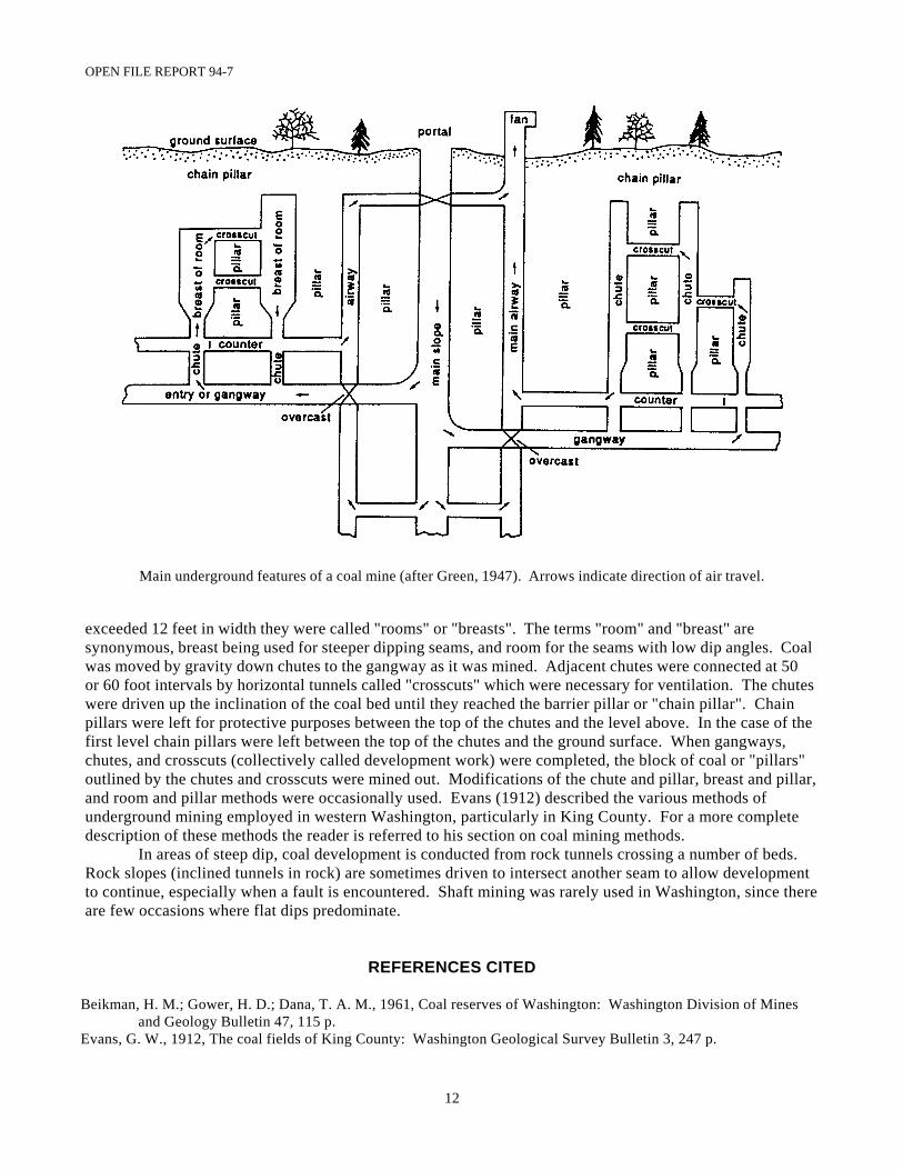
The following brief description of underground coal mining methods, as practiced in Washington, isincluded as a very general outline of the more common features of coal mining for those unfamiliar with thesubject. The main underground features of a coal mine are illustrated in the diagram which accompanies thissection. One should bear in mind that the workings illustrated are in the plane of the dipping coal bed. Thefollowing descriptions are taken from Green (1947) and Beikman and others (1961).
Most of the early underground mines were water level or drift mines. They were usually begun oncoal seams which were exposed at the surface in the valleys of streams. Tunnels or drifts were driven in thecoal from about stream level, and the coal occurring above this elevation was mined through these tunnelscalled "water-level gangways". The workings were driven slightly up the dip of the coal bed so that themine would be self-draining. As coal above the level of the portal was mined out, the mine was abandonedor slopes (inclined tunnels) were driven down the dip of the coal bed and pumps were installed to removeexcess water.
Entries (near-horizontal tunnels) which are turned off the main slope on the strike of the seam aredriven in pairs. One is called the "gangway" and is used for haulage purposes. The other is called the"counter" and is driven 40 to 60 feet above the gangway (as measured along the slope of the bed). Itfunctions as a travel way fort the return of air. Where an air course crosses a haulageway, it is carriedoverhead in an airtight and fire-proof tunnel called an "overcast" which is usually shot out of the roof andfloored with reinforced concrete.
In coal mining practice in this state, chutes were driven up dip from the haulageways or gangwaysfor the purpose of extracting coal between the different levels which were usually spaced 200 to 400 feetapart. The term "chute" was used for passageways not over 12 feet wide. When these passageways
OPEN FILE REPORT 94-7
12
Main underground features of a coal mine (after Green, 1947). Arrows indicate direction of air travel.
exceeded 12 feet in width they were called "rooms" or "breasts". The terms "room" and "breast" aresynonymous, breast being used for steeper dipping seams, and room for the seams with low dip angles. Coalwas moved by gravity down chutes to the gangway as it was mined. Adjacent chutes were connected at 50or 60 foot intervals by horizontal tunnels called "crosscuts" which were necessary for ventilation. The chuteswere driven up the inclination of the coal bed until they reached the barrier pillar or "chain pillar". Chainpillars were left for protective purposes between the top of the chutes and the level above. In the case of thefirst level chain pillars were left between the top of the chutes and the ground surface. When gangways,chutes, and crosscuts (collectively called development work) were completed, the block of coal or "pillars"outlined by the chutes and crosscuts were mined out. Modifications of the chute and pillar, breast and pillar,and room and pillar methods were occasionally used. Evans (1912) described the various methods ofunderground mining employed in western Washington, particularly in King County. For a more completedescription of these methods the reader is referred to his section on coal mining methods.
In areas of steep dip, coal development is conducted from rock tunnels crossing a number of beds. Rock slopes (inclined tunnels in rock) are sometimes driven to intersect another seam to allow developmentto continue, especially when a fault is encountered. Shaft mining was rarely used in Washington, since thereare few occasions where flat dips predominate.
REFERENCES CITED
Beikman, H. M.; Gower, H. D.; Dana, T. A. M., 1961, Coal reserves of Washington: Washington Division of Minesand Geology Bulletin 47, 115 p.
Evans, G. W., 1912, The coal fields of King County: Washington Geological Survey Bulletin 3, 247 p.
COAL MINE MAP COLLECTION
13
Green, S. H., 1947, Coal and coal mining in Washington: Washington Division of Mining and Mining Report ofInvestigations 4R, 41 p.
Jenkins, O. P., 1923, Geological investigations of the coal fields of western Whatcom County, Washington: WashingtonDivision of Geology and Earth Resources Bulletin 28, 135 p.
Moen, W. S., 1982, The mineral industry of Washington—Highlights of its development, 1853-1980: WashingtonDivision of Geology and Earth Resources Information Circular 74, 26 p.
Saunders, E. J., 1914, The coal fields of Kittitas County. Washington: Washington Geological Survey Bulletin 9, 204 p.
EXPLANATION OF INDEX MAPS
The coal mines represented in the mine map collection are identified in the catalog directory by anindex number that corresponds to a location map showing the approximate extent of workings of that mine. It is important to note that the areas shown on the index maps do not necessarily show the total extent ofunderground mine workings, but are intended to show their approximate extent on the basis of map recordsin our collection. The outline of each mine area, corresponding to a specific index number, represents thebest judgment on the part of the compilers of the directory as to the extent of that mine's undergroundworkings.
In some instances, some of the index map areas corresponding to a particular mine will extend intoland sections that are not identified in the Location column of the catalog. In such cases, the mine workingswill have appeared on map records of the adjacent mines. An attempt has been made to cross-reference theadjacent mine in the catalog description of the mine in question.
There are a few instances where workings were developed beyond those shown for a given minearea, but which only appear on a composite map showing the workings of several mines. These compositemaps are likely to postdate the latest mine map record for the given individual mine. In such cases thecomposite mine map will be cross-referenced to the individual mine listing in the catalog by a notation in theDetails column.
OPEN FILE REPORT 94-7
••
------- .. ··- .. -•r - -··- - ----:._ •-
RS,.,
------:
M
N
10 5 0 10 20 30 MILES
14
---7-----------'1..,'\
• () A' (z(; t\ \;
,, •
:\ s
L.
__ )
SK A ,\1 A~ l A
KL!CKl AT
DISTRIBUTION OF COAL MINES
REPRESENTED BY
MINE MAP COLLECTION
I
I I
I_ __
N
COAL MINE MAP COLLECTION
PK1
1
I
\
\
\--------------- ----1
I ,----, I I I I
: '------' I I I
I '---- : / I I / I I k.!:-.(:
/ I ----1
---11
PK21
\ I
i '----"-- ,,,-, I - ,, :
'--, I ----,\-'\
" .~ I --~ •'-I ,_,--~+.f '..,_-...___ I I '__. I I , ______ ..J
/ I
1
\ l
I R
TH LI, STtJ
'--..,_ '.._, _,.l
J /
) /" l
\ ' \
,,.-- -- -- - -\ L---~- : -- t:,T~------>"-LT1 ,-~--_: .-:.,~-, }
1 L- -- - • .J I - - / l I I
: LT3 :
I------------ I
l E W i S
I
LTC1 _____ ------"''-_)
l
CUWLITZ ! I
I I
J I \
/--,-__)
/
/""'",_./-
\ l i../.,
INDEX MAPS INCLUDING
MORE THAN ONE COUNTY
5 0 5 10 15 MILES
15
OPEN Fll..E REPORT 94-7
k103 T fU-,iZ...-.,;,t=~i-e-~:i-:-=~..;----+--~--+---r---+----tt---t---t----t----+--1-, ......... --!---+1---,r-----t 23
N I
N
D.-LLL-l--i--l---l---4-----l--1---+-~r-+-+--r~r-tl(A'tr--r--n-11 I
Li::t~L-L-j__j__J__-!--+--i-~~~===t:~H:-=--+~2f-l~l I I
t-+++----\:=-t---+--t-~-t--t---t~1--;--r,·-····-·'l\c~· ·~· .. :t=::i-==!~~ra--r~r--.-i I h
l-Jl-Ll~~.---+-~.-J.l:..__-l-~-+--~+-~+--r-f--~____.;f--+--t-f-=~~~l...f--l--t--'--t--~~~r--,..;;;;::il:
l--l-..n:=~~~-l--___;._-1---1---+-~-+-+---+--"*--+--:--Y--r--r;Lt---f--1---il I
l-?--4-l-i--4---+--+-3""'-=:-:....-::---t--+---==--i,,,-,..±-----L!~-+::---t---:f--+--+ ·,.(!L,.....J._.,.£.-,----t--. I I I I
W:2.-:B--~l ~--+-! --+---t-+--+-t--+--J4--+-t--=--f--+--~-!-+---t---t-.,
~ _ J _ - _ J J__J_~_.t.,-!.:..::t.-=-=-S:===-~~~~~R 7!'11'!!!E~.==-=-==-:::::!:J R SE N
i I
I I
J v~ -- ,,
---- --------- ....
OD /r KIN<, /
j--- (
: C l I -1
'-tl, '1 '\r ,/'--,- ... _,_.;
? )
a
KING COUNTY (PART 1)
0 2 3 MILES
16
K28
0 R5E R6E
b 0
R6E C
R:E
17
T
N
T
21
N
COAL MINE MAP COLLECTION
N
2 MILES
KING COUNTY (PART 2}
0 2
T
24
T
23
N
3 MILES
OPEN FILE REPORT 94-7
' i I ! T r-------·--·--········•'····-····•·····-·----+-···------i-------'·····-~-f····--t··-···-t-··--K·::-: t· .. ·-1--~ 2 I
N
I
I
, -··"···-··-· ...... -+-----------l----·--··.t··-···-·····-··--_._--J-....-.l
,---, .......... ..........j.,, __________ ................... __ __;_ ......... ____ ....,. ........ _ .. _ .... ---•-·--·--i 20
: t--·············-···l.11
--·-··•·········-·--··················--······t-·-:--------,·····----·t:· .. ······"···"··· ............... -..--.,---j
!Z 15 E R li, E
a
1 0 1 2 3 4 MILES
N
18
0 2 MILES
KITTITAS COUNTY
~ E_J
a TT I 7 A
Tlll!ltSTON CO\ll'HY ---------1.I:l.l.l~(-(J_UNTY
2
H3\\'
0 2
N
0 2
k.lE
b
3 MILES
3 MILES
T
II
N
R::!1.1,· 8
R ·IL
1L25, L26 I
--+--+-------li---1---+--~-l I
·+--+ I
•---+ I
I I t. -- -- -l--. -~-. t· -.
I I I
27
i --+--- -
! L2 rJ -·;----r- ·-' i ; --·--1-----·-t···· --
1 i j
I , ,1 J
C -....J<.,
19
JI
N
1·
COAL MINE MAP COLLECTION
I ·-······· .. 1,,,;~ '. • ....... ~ ··~-···!
I( l\\
It. 1111
H 1 r
I I
I',
\,
T I
I.:. I
-,
1
d ---+
LEWIS AND THURSTON
COUNTIES
D'! d i
< \ _,
OPEN FILE REPORT 94-7
\
\ i \ i
\
\1-1 --~=f;l~!!!+----4-~'-.--,~~-i,.:_--1----+---~---·I
\
I
20
N N
i
~-L-~---~
a
b
0 2 3 MILES
PIERCE COUNTY
\ ,~r~,~·,-·,. Li -·-a
i ER CE
0 1 MILE
COAL MINE MAP COLLECTION
R E R 6 -1- -- - ·;· E - -
N a
WHATCOM AND SKAGIT COUNTIES
1 0 1 2 3 4 5 MILES
0
------------- (,_
21
OPEN FILE REPORT 94-7 KING
INDEX LOCATION NO.
Kl
K2
K3
K4
KS
Many secs, (see map) Tps. 20-24 N., Rs. 5-7 E.
Sec. 13 (24-6E)
Secs. 13, 14, 23, 24 (24-6E)
Secs. 13, 14, 22-24 (24-6E)
Secs. 23, 26 (24-6E)
MINE NAME: Operator
Title Details: Surface features Mine workings, etc.
DATE SCALE FORMAT TUBE OTHER Of MAPS IN TUBES NO. COPIES
NORTHWESTERN IMPROVEMENT CO.'S COAL ANO LAND HOLDINGS, KING COUNTY: Northwestern Improvement Co. (N.W.I. Co.)
A~ Map showing part of the Northwestern Improvement Co.'s coal and land holdings, King County
Roads, RR tracks, streams, elevations, contours; mine survey and gangways
1928 1:48,000 1 bluln
UNITED STATES COAL CO. MINE: United States Coal Co.
A. Map showing property and veins belonging to United States Coal Co.
Roads, RR tracks, build- 1910 1:3600 1 blupt ings; mine workings, cross sections
BLACK NUGGET MINE: Northwestern Improvement Co.; Black Nugget Coal Co.*
A. Map showing survey at Black Nugget Roads, buildings, eleva-mine. Note: copied from map in off- tions; mine workings. ice of State Mine Inspector, Seattle, Shows location of Reynolds Wa., 1/26/44 by Hans Norbisrath, workings U.S.G.S.
1938
B. Map showing survey at Black Nugget mine
Roads, buildings, eleva- 1938
C. Map showing survey at Black Nugget mine*
D. Map showing development in parts of secs. 13, 14, 23 and 24, T. 24 N., R. 6 E., vicinity of Issaquah, King County, Wa.
tions,; mine workings. Copy 2 has more penciled on information bJt no new date. Roads, buildings, eleva- 1939 tions; mine workings Roads, RR tracks, build- 1945 ings, elevations; mine workings, cross sections. Also shows Issaquah Coal Co. strip mine, Reynolds Coal Co. slope and Black Nugget Coal Co. min_e ___ _
REYNOLDS COAL CO. MINE; BLACK NUGGET COAL CO. MINE: Reynolds Coal Co.; Black Nugget Coal Co.*
A. Map for Reynolds Coal Co. Roads, buildings; mine workings
1934
1: 1200
1: 1200
1:1200
1: 1200
1:1200
1 pencil
2 blupt
1 blupt 1 bl kln 1 blupt 2 bl ul n 1 bl kl n
1 blupt
B. Reynolds Coal Co. Roads, buildings, eleva- 1935 1:1200 1 blupt tions; mine workings
C. Reynolds Coal Co. map showing survey locating workings in relation to different royalty areas
O. Reynolds Coal Co.
E. Map showing survey locating workings in relation to different royalty areas in secs. 13, 14, 23 and 24, T. 24 N., R. 6 E. *
F. Map of Reynolds Coal Co. an~ Black Nugget Coal Co.*
Roads, buildings, eleva- 1936 1:1200 1 blupt tions; mine workings, col-umnar sections Roads, buildings, eleva- 1936 1:1200 1 blupt tions; mine workings Buildings, elevations; 1939 1:1200 1 blupt mine workings
Roads, buildings; mine 1940 1:1200 1 blupt workings 1, pencil
I-1
lmi crof i lm reel 1
I-10 - - - -
II-6, mylar, II-7 mapbook
II-5 105 11'111,
mylar, mapbook
GRAND RIDGE MINE: Central Coal Co.
A. Progress map, no. 1 seam Elevations, mine workings 1911 1:600
I I-2li 105nm,
1 blul n II-221 mylar' 1 sepia 11-23 mapbook
B. Map of no. 1 vein RR tracks, buildings, streams, elevations, contours; mine workings
1914 1: 1200
C. Progress map, no. 1 vein. Note: traced by D. Carter, 1/25/72
Elevations, mine workings 1919 1:600
* indicates mining company ownership
22
1 bluln 1 sepia
1 mylar tracing
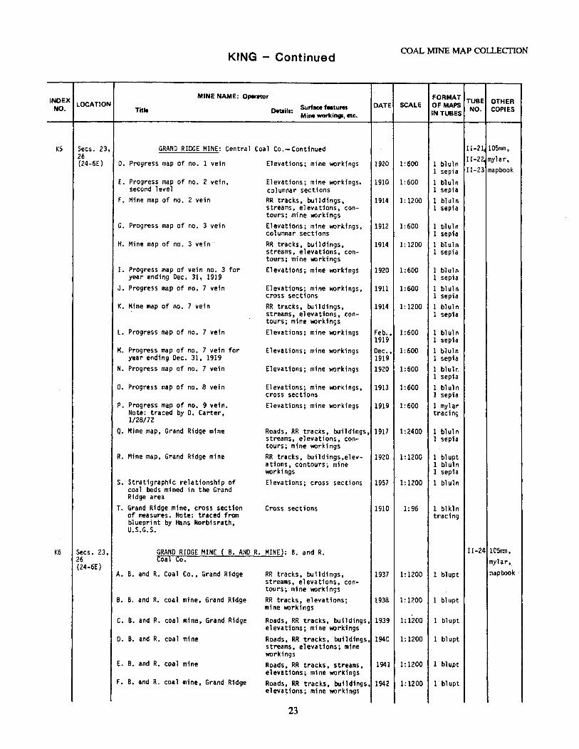
KING - Continued COAL MINE MAP COLLECTION
INDEX MINE NAME: Operat0r FORMAT TUBE OTHER
NO. LOCATION Surface f•tures DATE SCALE OF MAPS NO. COPIES Title Details:
Mine workings, etc. IN TUBES
KS Secs. 231 GRAND RIDGE MINE: Central Coal Co.-Continued II-2li 105111ll, 26 II-2Z mylar, '(24-6£) D. Progress map of no. 1 vein Elevations; mine worldngs 1920 1:600 1 bluln
l sepia II-23 mapbook
E. Progress map of no. 2 vein, Elevations; mine workings, 1910 1:600 1 bl uln second level columnar sections 1 sepia
F. Mine map of no. 2 vein RR tracks, buildings, 1914 1: 1200 1 bluln streams, elevations, con- 1 sepia tours; mine workings
G. Progress map of no. 3 vein Elevations; mine workings, 1912 1:600 1 bl ul n columnar sections 1 sepia
H. Mine map of no. 3 vein RR tracks, buildings, 1914 1: 1200 1 bluln streams, elevations, con- 1 sepia tours; mine workings
I. Progress map of vein no. 3 for Elevations; mine workings 1920 1:600 1 bluln year ending Dec. 31, 1919 l sepfa
J. Progress map of no. 7 vein Elevations; mine workings, 1911 1:600 l bluln cross sectfons 1 sepia
K. Mine map of no. 7 vein RR tracks, buildings, 1914 1: 1200 1 bluln streams, elevations, con- 1 sepia tours; mine workings
L. Progress map of no. 7 vein Elevations; mine workings Feb., 1:600 l bl ul n 1919 1 sepia
M. Progress map of no. 7 vein for Elevations; mine workings Dec., 1:600 1 bluln year ending Dec. 31, 1919 1919 1 sepia
N. Progress map of no. 7 vein Elevations; mine workings 1920 1:600 1 bluln 1 sepia
o. Progress map of no. 8 vein Elevations; mine workings, 1913 1:600 1 bl uln cross sections 1 sepia
P. Progress map of no. 9 vein. Elevations; mine workings 1919 1:600 1 mylar Note: traced by D. Carter, tracing 1/28/72
Q. Mine map, Grand Ridge mine Roads, RR tracks, buildings, 1917 1:2400 1 bluln streams, elevations, con- 1 sepia tours; mine workings
R. Mine map, Grand Ridge mine RR tracks, buildings,elev- 1920 1:1200 1 bl upt ations, contours; mine 1 bluln workings 1 sepia
s. Stratigraphic relationship of Elevations; cross sections 1957 1:1200 1 bluln coal beds mined in the Grand Ridge area
T. Grand Ridge mine, cross section Cross sections 1910 1:96 1 blkln of measures. Note: traced from tracing blueprint by Hans Norb1srath, U.S.G.S.
K6 Secs. 23, GRANO RIDGE MINE { B. ANO R. MINE): B. and R. II-24 lCSrmt, 26 Coal Co. mylar,. (24-6E)
A. B. and R. Coal Co., Grand Ridge RR tracks, buildings, 1937 1:1200 1 blupt mapbook streams, elevations, con-tours; mine workings
8. B. and R. coal mine, Grand Ridge RR tracks, elevations; 1938 1:1200 1 blupt mine workings
C. B. and R. coal mine, Grand Ridge Roads, RR tracks, buildings, 1939 1:1200 1 blupt elevations; mine workings
D. B. and R. coal mine Roads, RR tracks, buildings, 1940 1:1200 1 blupt streams, elevations; mine workings
E. B. and R. coal mine Roads, RR tracks, streams, 1941 1:1200 1 blupt elevations; mine workings
F. B. and R. coal mine, Grand Ridge Roads, RR tracks, buildings, 1942 1:1200 1 blupt elevations; mine workings
23
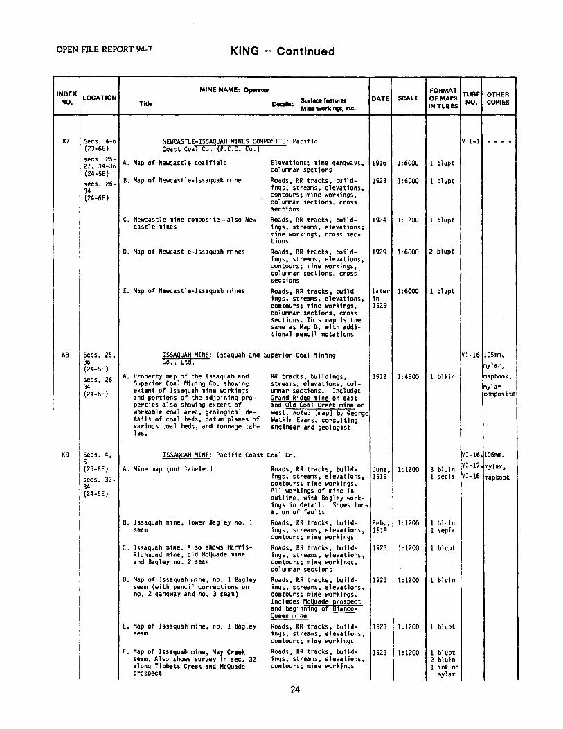
OPEN Fll..E REPORT 94-7 KING - Continued
INDEX MINE NAME: Operator FORMAT TUBE OTHER
NO. LOCATION Surface featUffl DATE SCALE OF MAPS NO. COPIES Title Details:
Mine workings, etc. IN TUBES
K7 Secs. 4-6 NEWCASTLE-ISSAQUAH MINES COMPOSITE: Pacific VII-1 - - - -(23-6E) Coast Coal Co. (P.C.C. Co.) secs. 25- A. Map of Newcastle coalfield Elevations; mine gangways, 1916 1:6000 1 blupt 27. 34-36 (24-SE) columnar sections
secs. 26- B. Map of Newcastle-Issaquah mine Roads, RR tracks, build- 1923 1:6000 1 blupt 34 ings, streams, elevations, (24-6E) contours; mine workings,
columnar sections, cross sections
C. Newcastle mine composite-also New- Roads, RR tracks, build- 1924 1:1200 1 blupt castle mines ings, streams, elevations;
·mine workings, cross sec-tions
0. Map of Newcastle-Issaquah mines Roads, RR tracks, build- 1929 1:6000 2 blupt ings, streams, elevations, contours; mine workings, columnar sections, cross sections
E. Map of Newcastle-Issaquah mines Roads, RR tracks, build- later 1:6000 1 bl upt 1ngs, streams, elevations, in contours; mine workings, 1929 columnar sections, cross sections. This map is the same as Map O. with addi-tional pencil notations
KB Secs. 25, ISSAQUAH MINE: Issaquah and Superior Coal Mining VI-16 105mn, 36 Co., Ltd. mylar,
I
(24-SE) secs. 26- A. Property map of the Issaquah and RR tracks, buildings, 1912 1:4800 1 blkl n mapbook, 34 Superior Coal Mining Co. showing streams, elevations, col- mylar (24-6E) extent of Issaquah mine \IKlrkings umnar sections. Includes composite and portions of the adjoining pro- Grand Ridge mine on east
perties also showing extent of and 01d Coa1 Creek mine on I workable coal area, geological de- west. Note: (map) by George
tails of coal beds, datum planes of Watkin Evans, consulting various coal beds, and tonnage tab- engineer and geologist les.
K9 Secs. 4, ISSAQUAH MINE: Pacific Coast Coal Co. VI-161 10Snln, 5 IVI-171 mylar, {23-6E} A. Mine map {not labeled) Roads, RR tracks, build- June, 1:1200 3 bluln secs. 32- ings, streams, elevations, 1919 1 sepia VI-18 mapbook 34 contours; mine workings. (24-6E) All workings of mine in
outline, with Bagley work-ings in detail. Shows loc-at ion of faults
B. Issaquah mine, lower Bagley no. 1 Roads, RR tracks, build- Feb., 1:1200 1 bl ul n seam ings, streams, elevations, 1919 1 sepia
contours; mine workings C. Issaquah mine. Also shows Harris- Roads, RR tracks, build- 1923 1:1200 1 blupt
Richmond mine, old McQuade mine ings, streams, elevations, and Bagley no. 2 seam contours; mine workings,
columnar sections 0. Map of Issaquah mine, no. 1 Bagley Roads, RR tracks, build- 1923 1:1200 l bluln
seam (with pencil corrections on ings, streams, elevations, no. 2 gangway and no. 3 seam) contours; mine workings.
Includes Mcguade Qros~ect and beginning of Bianco-Queen mine --
E. Map of Issaquah mine, no. 1 Bagley Roads, RR tracks, build- 1923 1:1200 1 bl upt seam ings, streams, elevations,
contours; mine workings F. Map of Issaquah mine, May Creek Roads, RR tracks, build- 1923 1:1200 1 bl upt
seam. Also shows survey in sec. 32 ings, streams, elevations, 2 bluln along Tibbets Creek and McQuade contours; mine workings 1 ink on prospect mylar
24
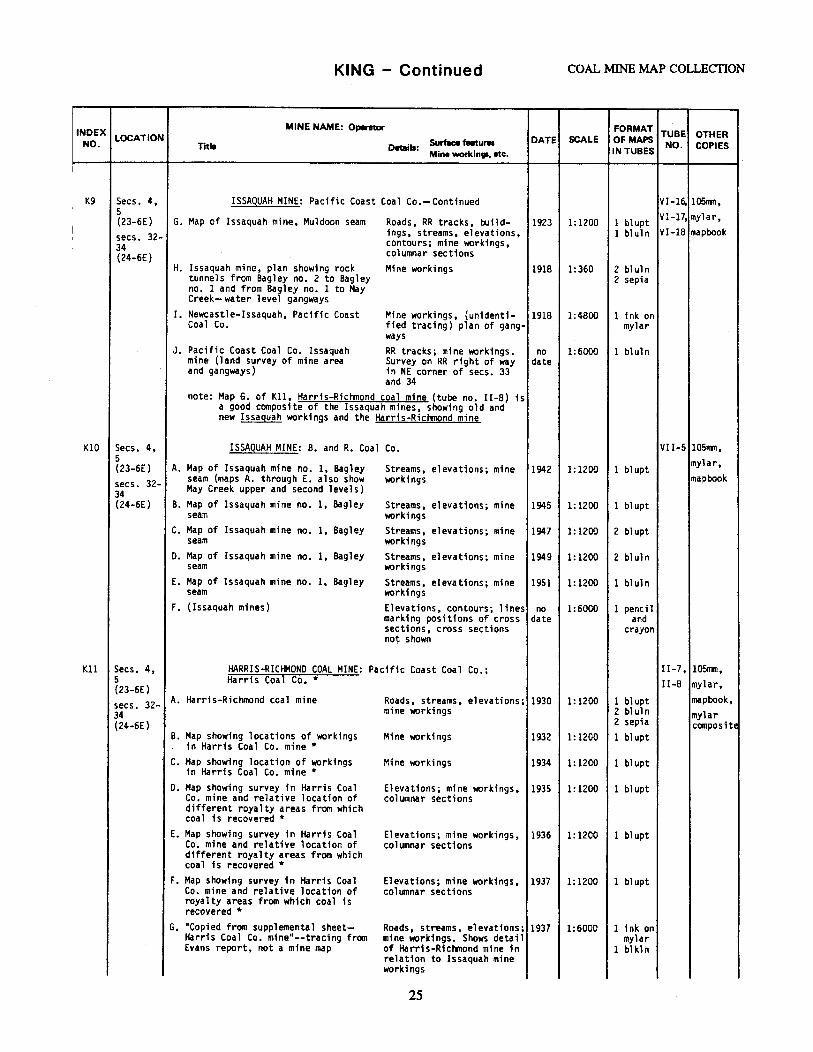
KING - Continued COAL MINE MAP COLLECTION
INDEX MINE NAME: Operator FORMAT TUBE OTHER
NO. LOCATION Surface features DATE SCALE Of MAPS NO. COPIES Title Details:
Mine workings, etc. IN TUBES
I
K9 Secs. 4, ISSAQUAH MINE: Pacific Coast Coal Co.-Continued VI-16. 105nwn, 5 VI-17, mylar, (23-6E) G. Map of Issaquah mine, Muldoon seam Roads, RR tracks, build- 1923 1:1200 1 blupt
I secs. 32- ings, streams, elevations, 1 bluln VI-18 mapbook
I contours; mine workings, 34 columnar sections (24-6E) H. Issaquah mine, plan showing rock Mine workings 1918 1:360 2 bl ul n
tunnels from Bagley no. 2 to Bagley 2 sepia no. 1 and from Bagley no. 1 to May Creek- water level gangways
I. Newcastle-Issaquah, Pacific Coast Mine workings, {unidenti- 1918 1:4800 1 ink on Coal Co. fied tracing) plan of gang- mylar
ways J. Pacific Coast Coal Co. Issaquah RR tracks; mine workings. no 1:6000 1 bl ul n
mine (land survey of mine area Survey on RR right of way date and gangways) in NE corner of secs. 33
and 34 note: Map G. of Kll, Harris-Richmond coal mine (tube no. 11-8) is
a good composite of the Issaquah mines, showing old a~~ new Issaquah workings and the Harris-Richmond mine
KIO Secs. 4, ISSAQUAH MINE: B. and R. Coal Co. VII-5 10511'1Tl, 5 mylar, (23-6E) A. Map of Issaquah mine no. I, Bagley Streams, elevations; mine 1942 1: 1200 1 blupt secs. 32- seam (maps A. through E. also show workings mapbook 34 May Creek upper and second levels) (24-6E) B. Map of Issaquah mine no. 1, Bagley Streams, elevations; mine 1945 1:1200 l blupt
seam workings c. Map of Issaquah mine no. 1, Bagley Streams, elevations; mine 1947 1:1200 2 bl upt
seam workings D. Map of Issaquah mine no. 1, Bagley Streams, elevations; mine 1949 1:1200 2 bluln
seam workings E. Map of Issaquah mine no. 1, Bagley Streams, elevations; mine 1951 1:1200 1 bluln
seam workings F. (Issaquah mines) Elevations, contours; lines no 1:6000 1 pencil
marking positions of cross date and sections. cross sections crayon not shown
Kll Secs. 4, HARRIS-RICHMOND COAL MINE: Pacific Coast Coal Co.; I 1-7, 105'rm, 5 Harris Coal Co.* 11-8 mylar, (23-6E) secs. 32- A. Harris-Richmond coal mine Roads, streams, elevations; 1930 1:1200 l blupt mapbook, 34 mine workings 2 bluln mylar (24-6E) 2 sepia compositE
B. Map showing locations of workings Mine workings 1932 1:1200 1 bl upt in Harris Coal Co. mine*
c. Map showing location of workings in Harris Coal Co. mine*
Mine workings 1934 1:1200 1 blupt
o. Map showing survey in Harris Coal Elevations; mine workings, 1935 1:1200 1 blupt Co. mine and relative location of columnar sections different royalty areas from which coal is recovered*
E. Map showing survey in Harris Coal Elevations; mine workings, 1936 1:1200 1 bl upt Co. mine and relative location of columnar sections different royalty areas from which coal is recovered*
F. Map showing survey in Harris Coal Elevations; mine workings, 1937 1: 1200 1 bl upt Co. mine and relative location of columnar sections royalty areas from which coal is recovered*
G. "Copied from supplemental sheet- Roads, streams, elevations; 1937 1:6000 l ink on Harris Coal Co. mine"--tracing from mine workings. Shows detail mylar Evans report, not a mine map of Harris-Rictlnond mine in 1 blkli"t
relation to Issaquah mine workings
25
OPEN filE REPORT 94-7 KING - Continued
INDEX MINE NAME: Operator FORMAT TUBE OTHER
NO. LOCATION Surface features DATE SCALE Of MAPS NO. COPIES Title Details:
Mine wortc.inga. etc. IN TUBES
Kll Secs. 4, HARRIS-RICtt10ND COAL MINE: Pacific Coast Coal Co.; II-7, 105nm, 5 Harris Coal Co.* -Continued II-8 mylar, (23-6E) secs. 32- H. Map showing location of workings Elevations; mine workings 1933 1:1200 l bluln map book, 34 in Harris Coal Co. mine. Note: l sepia mylar (24-6E) traced from blueprint by Hans l pencil composite Norbisrath, U.S.G.S., 2/5/44
(Dolly Varden seam)
Kl2 Secs. 31- QUEEN NO. 1 MINE: Bianco Coal Co. I I-14. 105nm, 32 I I-1S. mylar, (24-6E) A. Map of Queen no. 1 mine, upper and Roads, RR tracks, build- 1932 1:1200 1 blupt
lower Bagley seams ings, streams, elevations, II-16 mapbook, contours; mine workings mylar
B. Map of Queen no. 1 mine, upper and Roads, buildings, streams, Jan.; 1:1200 l bl upt composite lower Bagley seam elevations, contours; mine 1933
workings C. Map of Queen no. 1 mine, upper and Roads, buildings, streams, July, 1:1200 .l blupt
lower Bagley seams elevations, contours; mine 1933 workings
o. Map of Queen no. 1 mine, upper and Roads, RR tracks, build- 1934 1:1200 1 blupt lower Bagley seams ings, streams, elevations,
contours; mine workings E. Map of Queen no. 1 mine, upper and Roads, RR tracks, build- 1935 1:1200 l blupt
lower seams ings, streams, elevations, contours; mine workings
F. Map of Queen no. 1 mine, upper and lower Bagley seams
Roads, buildings, streams, elevations, contours; m;ne
1936 1: 1200 1 blupt
I workings
G. Map of Queen no. 1 mine, upper and Roads, RR tracks, build- 1937 1: 1200. 1 bl upt lower Bagley seams 1ngs, streams, elevations,
contours; mine workings H. Map of Queen no. 1 mine , no. 2 Roads, buildings, streams, 1938 1:1200 1 bl upt
or upper Bagley seam elevations, contours; mine workings
I. Map of Queen no. 1 mine , no. 1 Roads, buildings, streams, 1938 1:1200 1 blupt or lower Bagley seam elevations, contours; mine
workings J. Map of Queen no. 1 mine, no. 1 Roads, buildings, streams, 1939 1:1200 l blupt
or lower Bagley seam elevations, contours; mine workings. A 1 so shows May Creek seam
K. Map of Queen no. 1 mine, no. 2 Roads, buildings, streams, 1939 1:1200 1 blupt or upper Bagley elevations, contours; mine
workings. Also shows May Creek seam
L. Map of Queen no. 1 mine, no. 1 Roads, buildings, streams, 1940 1:1200 1 blupt or lower Bagley seam elevations, contours; mine
workings. A 1 so shows May Creek se~m
M. Map of Queen no. 1 mine, no. l Roads, buildings, streams, 1941 1:1200 1 blupt or lower Bagley seam elevations,contours; mine
workings. Also shows May Creek seam
N. Map of Queen no. 1 mine, no. 2 Roads, buildings, streams, 1942 1:1200 1 blupt or upper Bagley seam elevations, contours; mine
workings. Also shows May Creek seam
o. Map of Queen no. 1 mine, no. l Roads, buildings, streams, 1942 1:1200 1 blupt or lower Bagley seam elevations, contours; mine
workings. Also shows May Creek seam
P. Map of Queen no. 1 mine, no. 1 Roads, buildings, streams, 1943 1:1200 l blupt or lower Bagley seam elevations, contours; mine
workings
26
KING - Continued COAL MINE MAP COLLECTION
INDEX MINE NAME: Optntor FORMAT TUBE OTHER
NO. LOCATION Surface features DATE SCALE Of MAPS NO. COPIES Title Details:
Mine workings. etc. IN TUBES
Kl2 Secs. 31- QUEEN NO. l MINE: Bianco Coal Co. - Continued I I-14. 105nm, 32 I I-1S. mylar, (24-6E) Q. Map of Queen no. 1 mine, no. l Roads, buildings, streams, 1944 1: 1200 1 bl upt
or lower Bagley seam and May Creek elevations, contours; mine II-16 mapbook, seam workings. Also shows Mul- mylar doon seam, west end of composite Harris and Issaguah mines
R. Map of Queen no. 1 mine, no. 1 Roads, buildings, streams, 1953 1: 1200 1 bl kln or lower Bagley seam and May Creek elevations, contours. Also seam (lower Bagley on west end of shows part of lower Bagley Muldoon gangway dashed in) of Issaquah mine and Dolly
Varden seam of Harris mine s. Map of Queen no. 1 mine, no. 2 Roads, streams, elevations, 1943 1:1200 l blupt
or upper Bagley seam and Muldoon contours; mine workings. seam Also shows May Creek seam
T. Map of Queen no. 1 mine, no. 2 Roads, RR tracks, build- 1944 1: 1200 l blupt or upper Bagley seam and Muldoon ings, streams, elevations, seam contours; mine workings.
Also shows May Creek seam u. Map of Queen no. 1 mine, no. 2 Roads, buildings, streams, 1953 1: 1200 1 blkln
or upper Bagley seam and Muldoon elevations, contours; mine seam workings. Also shows May
Creek seam
K13 Secs. 25, PROJECTION OF COAL SEAMS EAST OF COAL CREEK I-8 - - - -26, 35, 36 A. Map showing strike of coal veins Roads, streams, elevations; 1898 1:1200 2 bl kl n (24-SE) in sec. 31, T.24 N., R. 6 E. outcrops and No. 2 seam secs. 30, water level gangway 31 (24-6E)
Kl4 Secs. 25, STRATIGRAPHY OF COAL SEAMS ALONG COAL CREEK I-7 - - - -26, 35,
A. Map of coal veins on Coal Creek Roads, buildings, streams, 1895 1:3600 2 blkln 36 (24-SE) from surveys made Dec. 1894-Jan. elevations; water level
1895 gangway and worked out secs. 30, line, line of cave holes 31 and site of air shaft, (24-6E) strike of coal veins
B. Map of coal veins on SE\ sec. 25 Roads, streams, elevations; 1895 1:960 2 blkln and NE~ sec. 36, T 24 N, R 5 E, columnar sections. Copy 1 Coal Creek •• , corrected to confonn identifies no. 3, upper with latest survey made Feb., 1895. Bagley, lower Bagley and Sections of coal seams along Coal Muldoon in red pencil. Creek Scale of coal measures:
1:72
c. Map of coal veins, Coal Creek Roads, streams, elevations; 1898 1:960 2 bl kl n stratigraphic sections. Scale of coal measures: 1:72
Kl5 Secs. 25, NEW SLOPE MINE: B. and R. Coal Company VII-6 105nm, 36 (24-SE) A. Map of the B. and R. New Slope mine Streams, elevations, con-
mylar 1956 1: 1200 1 bluln composite secs. 31, and showing lower Bagley seam work- contours; mine workings
32 ings (of P.C.C. Co.) (24-6E} B. Map of the B. and R. New Slope mine Streams, elevations, con- 1956 1:2400 and showing lower Bagl_ey seam work- tours; mine workings
1 photo ings -(of P.C.C. Co.)
c. Map of the B. and R. New Slope mine Streams, elevations, con- Mar., 1:1200 1 bluln and showing lower Bagley seam work- tours; mine workings 1957 ings (of P.C.C. Co.) D. Map of the B. and R. New Slope mine Streams, elevations, con- Oct., 1:1200 1 bluln
and showing lower Bagley seam work- tours; mine workings 1957 1ngs (of P.c.c. Co.)
27
OPEN FILE REPORT 94-7 KING - Continued
INDEX MINE NAME: Operator FORMAT
TUBE OTHER NO.
LOCATION Surface features DATE SCALE Of MAPS NO. COPIES Title Details: Mine workings. etc. IN TUBES
KlS Secs. 25, NEW SLOPE MINE: B. and R. Coal Co.-Continued VII-6 105rrm, 36 mylar (24-SE) E. Map of the B. and R. New Slope mine Streams, elevations, con- 1958 1:1200 l bluln
and showing lower Bagley seam work- tours; mine workings, composite secs. 31, ings (of P.C.C. Co.) cross sections 32 (24-6E) F. Map of the B. and R. New Slope mine Streams, elevations, con- 1959 1:1200 1 bluln
and showing lower Bagley seam work- tours; mine workings, ings (of P.c.c. Co.) cross sections
G. Map of the B. and R •. New Slope mine Streams, elevations, con- 1962 1:1200 l bluln and showing lower Bagley seam work- tours; mine workings, ings (of P.C.C. Co.) cross sections
Kl6 Secs. 25, COAL CREEK MINE: Pacific Coast Coal Co. (old I-14 105mn, 36 workings in vicinity of Nike site) mylar (24-5E)
A. Coal Creek mine No. 1 vein (probably Roads, buildings, streams, 1901 1:1200 1 bluln composite equals workings on upper and lower Bagley at new Coal Creek)
elevations; mine workings 1 sepia
B. No title-Coal Creek no. 2 vein, Streams, elevations; mine 1903 1:1200 1 bluln Klondyke Slope written on outside workings- main tunnel, 1 sepia of map west and east counter
gangway C. Working map of no. 3 vein-Coal Mine workings 1906 1:1200 1 bluln
Creek l sepia
Kl7 Secs. 25, MAIN SLOPE MINE IN LOWER COAL CREEK: Pacific 1-11 105nm, 26 Coast Coal Co. mylar, (24-5E)
A. Coal Creek mine prospects, no. 4 Roads, streams, e1evations; 1915 1:360 1 bluln mapbook seam (east of Ford slope) columnar sections l sepia
KlB Secs. 25- NEWCASTLE MINE: Strain Coal Co. workings 1n VIl-3 lOSllln, 27, 36 vicinity of Ford slope (Coal Creek) mylar, (24-SE}
A. Strain Coal Co., Coal Creek (New- Roads; mine workings. Also 1934 1: 1200 1 bl upt mapbook castle mine-Strain Coal Co. work- shows Hu1doon, no. 3 and ings in vicinity of Ford slope) no. 4 workings
B. Coal Creek mine Roads; mine workings. Also shows Muldoon, no. 3 and
1935 1: 1200 1 bl upt
no. 4 C. Strain Coal Co., Coal Creek (Strain Roads, elevations; mine 1936 1:1200 l blupt
Coal Co.'s workings in vicinity of workings. Shows no. 3, no. Ford slope) 4 and Muldoon in relation
to old P.C.C. Co. workings o. Strain Coal Co •• Coal Creek (Strain Roads, elevations; mine 1937 1:1200 1 blupt
Coal Co.•s workings in vicinity of workings. Shows no. 3, no. Ford slope) 4 and Muldoon in relation
to old P.C.C. Co. workings E. Coal Creek mine (Strain Coal Co.'s Roads, elevations; mine 1938 1: 1200 2 blupt
workings in vicinity of Ford slope) workings. Shows no. 3, no. 4, Bagley and Muldoon. Old P.C.C. Co. Ford slope workings dotted in
F. Map of Newcastle mine (Strain Coal Roads, elevations; mine 1939 1: 1200 1 blupt Co. 1 s workings 1n vicinity of Ford workings. Also shows old slope) P.C.C. Co. workings, Mul-
doon, Bagley, no. 3 and no. 4
G. Map of Newcastle mine (Strain Coal Roads, buildings, eleva- 1940 1: 1200 1 blupt Co.'s workings in vicinity of Ford tions; mine workings. Also slope) shows Bagley, Muldoon, no.
3, no. 4 and old workings dashed in
H. Map of Newcastle mine (Strain Coal Roads, buildings, eleva- 1942 1: 1200 1 blupt Co.•s workings in vicinity of Ford tions; mine workings- sur-slope) face stripping, outcrop
workings. Underground mines located- a 11 closed
28
INDEX LOCATION NO.
Kl8
I K 19
Secs. 25-27 (24-SE)
Secs. 26, 27, 34 (24-SE)
K20 Sec. 26 (24-SE)
K21 Sec. 25-27, 35, 36 (24-SE) secs. 30 31 (24-6E)
KING - Continued COAL MINE MAP COLLECTION
MINE NAME: Operator
Title Details: Surface features Mine workings, etc.
DATE SCALE
NEWCASTLE MINE: Strain Coal Co. workings in vicinity of Ford slope (Coal Creek)-Continued
I. Bagley slope at Newcastle (Strain Coal Co.'s workings in vicinity of Ford slope)
J. Bagley slope at Newcastle (old Coal Creek mine area east of Ford slope)
K. Map of Newcastle mine (Strain Coal Co.'s workings in vicinity of Ford slope)
Buildings, ele~ations; mine workings, cross sections in relation to dif-ferent levels. Also old Bagley and Strain Muldoon level
1943
Buildings; mine workings, 1944 cross sections in relation to different levels. Also old Bagley and Strain Mul-doon level Roads, buildings, eleva- 1949 tions; mine workings, May Creek, Bagley, no. 3, no. 4, old workings. Shows relation to P.C.C. Co. workings
1:1200
1:1200
1:1200
NEWCASTLE MINES: B. and R. Coal Co.
A. B. and R. coal mine, Muldoon seam B. B. and R. coal mine, Muldoon seam
C. B. and R. coal mine, Muldoon seam D. B. and R. coal mine, Muldoon seam
E. B. and R. coal mine, Muldoon seam
F. Underground workings of B. and R. Co.'s Newcastle mines
G. Underground workings of B. and R. Coal Co.'s Newcastle mines
H.B. and R. Coal Co.'s Newcastle mines, revised map 1949
I. B. and R. Co.'s Newcastle mines J. Newcastle mines, May Creek seam
Buildings; mine workings 1939 1:1200 Buildings, elevations; 1940 1:1200
·mine workings Buildings; mine workings 1941 · 1: 1200
Buildings, elevations; 1942 1:1200 mine workings. Also shows Bagley seam Buildings; mine workings. 1946 1:1200 Also shows Jones, May Creek and Bagley seams Elevations; mine workings. 1947 1:1200 Also shows Jones, May Creek and Bagley seams Elevations; mine workings, 1947 1:1200 pencil update on Jones seam. Survey into sec. 34 with Gladding-Mcbean pros-pect (117 1 tunnel)
Mine workings 1949 1: 1200
Mine workings 1951 1:1200 Elevations, mine workings. 1951 no Also shows Muldoon and scale Bagley seams
NEWCASTLE MINES, NO. 3~ SEAM: B. and R. Coal Co.
FORMAT TUBE OTHER OF MAPS IN TUBES NO. COPIES
VII-3 105mm, mylar,
1 blupt mapbook
1 bl upt
l bl upt
1 blupt 1 bl upt
1 blupt 1 bl upt
1 bl upt
3 blupt
1 blkln
2 bluln
1 bluln 1 bl ul n
VI I-9 105rml
1-16 - - - -
A. Newcastle mines no.~ seam (B. and R. mine on no.~ seam in vicinity of old Coal Creek main slope)
Roads, buildings, streams, 1951 1:1200 1 blkln Elevations; mine workings
MAP OF NEWCASTLE AREA SHOWING COMPANY OWNERSHIP: Palmer Coking Coal Co.
A. Map of Newcastle area showing company ownership
Roads, streams, elevations, 1955 contours; mine workings. Copy 1 shows strip pit and prospect cuts
29
1:6000 1 bluln 2 blkln
1-12 - - - -
OPEN FILE REPORT 94-7 KING - Continued
INDEX MINE NAME: Operator FORMAT TUBE OTHER
NO. LOCATION Surface features DATE SCALE OF MAPS NO. COPIES Title Details: Mine workings, etc. IN TUBES
1<22 Secs. 25- NEWCASTLE MINE: Pacific Coast Coal Co. VI-14\ 105mn, 27, 35, VII-4 mylar, 36 A. Plan showing proposed drainage Roads, RR tracks, build- 1917 1:1200 2 bluln (24-SE} tunnel at Coal Creek mine (Ford ings, elevations; mine 2 sepia mapbook, secs. 30, slope) workings mylar 31 B. Map of Newcastle mine, no. 1 Bag- Roads, RR tracks, build- 1923 1:1200 1 blupt composite (24-6E) ley seam ings, streams; mine work-
ings. Also shows Shoo Fly, Ragtime, Dolly Varden, May Creek, Muldoon, no. 3 and no. 4 seams
c. Map of Newcastle mine, lower Bag- Mine workings ley seam
1929 1:1200 1 blupt
o. Map of Newcastle mine, no. 3 seam Roads, RR tracks, build- 1923 1: 1200 1 blupt ings, streams, elevations; mine workings. Also shows workings on Muldoon, Bag-ley and no. 4 seams
E. Map of Newcastle mine, no. 4 seam Roads, RR tracks, build- 1927 1:1200 1 bl upt ings, streams, elevations, contours; mine workings. Also shows Bagley, Muldoon and no. 3 workings
F. Map of Newcastle mine, Muldoon Roads, RR tracks, build- 1924 1:1200 1 blupt seam ings, streams, elevations;
mine workings. Town of Newcastle
G. Map of Newcastle mine, Muldoon Roads, RR tracks, build- 1925 1:1200 1 blupt seam ings, streams, elevations;
mine workings. Newcastle H. Map of Newcastle mine, Muldoon Mine workings 1925 1:1200 1 bl upt
seam I. Newcastle rock tunnel 4th level 1922 1:120 2 bl ul n
east lower Bagley to 4th level east Muldoon
2 sepia
J. Pl an- Primrose rock tunnel turnouts 1927 1:120 1 bluln to no. 4 and Muldoon seams 1 sepia
K23 Many secs. COAL CREEK COALFIELD: Feasibility study for VII- - - - -(24-SE) Newcastle Hills Landfill 12
A. Coal Creek coalf1eld---feasib111ty Roads, RR tracks, bui1d- 1969 1:1200 1 bl ul n study for the Newca st 1 e Hi 11 s land.- ings, streams, elevations, fill contours. Shows location
of old mine tunnels B. Coal Creek coalfield, cross Roads, streams, elevations; 1969 1:1200 1 bl ul n
sections--feasibility study for cross sections the Newcastle Hills landfill
C. Letter from Glen A. Boyd, consult- 1969 n/a 1 letter 1ng geologist, to Evan Morris
K24 Secs. 22, NEWCASTLE KING COAL CO. MINE: Newcastle King 1-4 mylar, 27 Coal Co. mapbook (24-SE)
A. Map showing survey in relation to Roads, RR tracks, streams, 1935 1:2400 1 blkln coal prospect situated on land own- elevations; mine workings. ed by John Collins estate Property survey only.
B. Map showing workings ••• operated by Buildings, streams, eleva- 1938 1:1200 1 blkl n Newcastle King Coal Co. near old tions; mine "'1lrkings. Newcastle (Tissue map in poor con-
dition) c. Newcastle King Coal Co. Buildings, streams, elev- 1939 1:1200 1 blupt
ations; mine workings D. Newcastle King Coal Co. Buildings, streams, elev- 1940 1:1200 1 blupt
ations; mine workings
30
KING - Continued COAL MINE MAP COLLECTION
INDEX MINE NAME: Opemor FORMAT TUBE OTHER
NO. LOCATION Surface features DATE SCALE OFMAPS Title Details: IN TUBES NO. COPIES
Mine workings, etc.
K25 Sec. 27 NEWCASTLE KING 4 COAL CO. MINE: King 4 Coal Co. 1-5 - - - -(24-SE)
A. Map showing location of Newcastle Roads, buildings, streams, 1933 1:1200 1 1 i nen King 4 Coal Co. workings. Also the elevations; mine workings relative position of these workings to the mined out area in old New-castle mine
I NEWCASTLE COLLIERY (OLD NEWCASTLE): P.C.C. Co. I-13 10Snvn, I K26 Secs. 26,
27 (24-SE) A. Newcastle Colliery map showing the Elevations; mine workings. 1895 l:1200 1 bluln mylar,
inside workin~s of the north split Printed by hand on map: 1 sepia mapbook no. 2 vein (o d Newcastle} no. 2 lower split no. 3
seam B. Newcastle Colliery map showing the Mine workings 1895 1:1200 1 bluln
inside workings of the no. 3 vein (old Newcastle)
1 sepia
C. Newcastle Colliery map of no. 4 Mine workings 1895 1:1200 1 bluln vein (old Newcastle, old workings) 1 sepia
K27 Sec. 27 B. AND R. MINE AT NEWCASTLE IN THE RICtf10NO- VII- 10Snun, (24-SE) STANLEY TUNNEL: Richmond-Stanley Coal Co.*; 10, mylar, B. and R. (Baima and Rubitina) Coal Co. VII- mapbook ll
A. Map showing survey in Richmond- Roads, RR tracks, build- Jan., 1:1200 2 blupt · Stanley mine* 1ngs, streams, mine work- 1932
ings (P.C.C. Co. lease} B. Map showing survey in B. and R. Roads, RR tracks, build- July 1:1200 1 blupt
mine, lower split no. 3 ings, streams; m1ne work- 1932 ings
c. Map showing survey in B. and R. Roads, RR tracks, build- 1933 1:1200 1 linen mine, lower sp11t no. 3 ings, streams, elevations; 1 blupt
mine workings 1 bluln 1 sepia
D. Map showing survey in Baima Rubi- Roads, RR tracks, build- 1934 1:1200 1 blupt tina mine, showing lower split no. ings, streams, elevations; 3 seam mine workings, columnar
sections E. Map showing survey in Baima and Roads, RR tracks, build- 1935 1:1200 1 blupt
Rubitina mine, showing lower split ings, streams, elevations; no. 3 seam workings and no. 4 seam mine workings survey and gangway
F. Map showing survey in Baima and Roads, RR tracks, build- 1936 1:1200 1 blupt Rubitina mine, showing workings on ings, streams, elevations; lower no. 3 and no. 4 seam mine workings
G. Map showing survey in Baima and Roads, RR tracks, build- 1937 1:1200 l bl upt Rubitina mine leased from P.C.C. Co. ings, streams, elevations; showing lower split no. 3 seam and mine workings no. 4 seam
H. Map showing survey in Baima and Roads, streams; mine work- 1938 1:1200 1 blupt Rubitina mine, showing workings in ings, columnar sections no. 4 seam and lower split no. 3 seam
I. Map showing survey in Baima Rubi- Elevations; mine workings 1934 1: 1200 1 blupt tina mine, showing upper split no. 3 seam
J~ Map showing survey in Baima and Elevations, mine workings 1935 1: 1200 1 blupt Rubitina mine, showing upper split no. 3 seam
K. Map showing survey in Baima Rubi- Mine workings 1936 1: 1200 1 bl upt tina mine, showing upper split no. 3 seam workings
L. Map showing survey in Baima Rubi- Roads, streams, elevations; 1937 1:1200 l blupt tina mine, showing upper split no. mine workings 3 seam
31
OPEN FILE REPORT 94-7
INDEX LOCATION NO.
K27 Sec. 27-S1a of N~ (24-SE)
Title
KING - Continued
MINE NAME: Opannor
Details: Surface features Mine wortc.ings, etc.
B. AND R. MINE AT NEWCASTLE IN THE RICHMONDSTANLEY TUNNEL: Ricfmond-stanley Coal co.*; B. and R. (Baima and Rubitina) Coal Co. -Continued
DATE SCALE FORMAT TUBE OTHER OFMAPS IN TUBES NO. COPIES
VII- 105nm, lO, mapbook
VII-11
M. Map showing survey in Baima and Rubitina mine, showing upper split no. 3 seam
Roads, RR tracks, build- 1938 1:1200 1 blupt ings, streams; mine work-
K28
K29
1(30
K31
K32
K33
Sec. 2 (23-SE)
Sec. 24 (23-4E)
Secs. 17, 20 (23-SE)
Secs. 17, 20, 21, 29 (23-SE)
Secs. 16-21, 28-30 (23-SE)
Secs. 17-20, 29, 30 (23-SE)
ings
MAY CREEK MINE: May Creek Coal Co.
A. Cross section through old workings Cross sections showing relative position of coal beds. Note: traced from blueprint by Hans Norbisrath, U.S.G.S., 1/29/44
DIAMOND MINE: Diamond Coal Co.
A. Property of Diamond Coal Co. Roads, buildings. Property survey.
RENTON MINE: Denny Renton Clay and Coal Co.
A. Plan of Renton mines B. Denny-Renton Clay and Coal Co.,
Water level entry no. 1 seam
Mine workings Mine workings. Note: location T. 23 N., R. 7 E~ is written on the map itself. The correct location is T. 23 N., R. 5 E.
RENTON MINE: Seattle Electric Co.
A. Map of the Seattle Electric Co.'s Renton coal mine
RENTON MINE: Renton Coal Co.
A. Geologic structure map of Renton Coal mine to accompany report of Geo. Watkin Evans, consulting mining engineer: "A report on the property of the Renton Coal Co.", 1920. Plate II
B. Mine workings from Geo. Watkin Evans report for Renton Coal Co.
C. The Renton mine (fragment of a tracing)
D. Map of Talbo't pillar and extension workings of the Renton mine
E. Map showing the upper coal mining operations of the Renton mine under the city of Renton
SUNBEAM MINE: Renton Coal Co.
A. Sketch showing Renton Coal Co. prospects on secs. 19 and 30, T. 23 N., R. 5 E.
B. Renton-Sunbeam mine· (see other Renton mine maps for relationship to other Renton mines)
C. Renton-Sunbeam mine
Roads, buildings; mine workings. Old Talbot mine included
Roads, RR tracks, streams; mine workings. Shows old Talbot mine, Sunbeam mine and Patton mine
Roads, RR tracks, streams; mine workings Mine workings. Also shows ~ workings Mine workings
Roads; mine workings
Roads, RR tracks, streams; prospects and gangways
Roads, buildings; mine workings
Roads; mine workings
32
no 1:480 date
no date
1911
1918
1919
1920
1920
1931
1932
1955
1:360
1:480
1:480
1:1200
1:4800
1:6000
1:1200
1:1200
1:1200
1 penci 1 tracing
1 blupt
l bl upt 1 bl upt
l blupt
1 bluln
1 blkl n
1 tissue tracing
1 tissue tracing
1 bl ul n 1 sepia
1922 1:16,000 2 bluln
pre- 1:1200 1 blupt 1929
1929 1:1200 2 blupt
I-6
I-3 mylar, mapbook
I-2 10Snwn,
mylar, mapbook
VI-15 10511111,
mylar, mapbook
II-13 mapbook
II-12 105nm,
mylar, mapbook
KING - Continued COAL MINE MAP COLLECTION
INDEX MINE NAME: Operator FORMAT
TUBE OTHER NO.
LOCATION Surface features DATE SCALE OF MAPS NO. COPIES Trtle Details:
Mine workings, etc. IN TUBES
K34 Secs. 29, SPRING BROOK MINES: Maps showing workings in II-9, mylar, 30 small mines in vicinity of Spring Brook II-10 mapbook (23-SE)
A. Map showing survey in Spring Brook Roads; mine workings 1932 1:1200 1 bl upt coal mine (1st. opening by J. John-son, sec. 30)
B. Map showing survey in Spring Brook Roads, buildings, eleva- Sept. 1:1200 1 bl upt coal mine (2nd. opening by A.F. tions; mine workings 1935 Plant; 3rd. opening by J. Johnson: Spring Brook-King mine: both-sec. 30)
C. Map showing survey in Spring Brook Roads, buildings; eleva- Oct., 1:1200 1 bl upt coal mines tions; mine workings 1935
o. Map showing survey in Spring Brook Roads, buildings, eleva- 1936 l: 1200 1 bl kln coal mines (4th. opening by J. tions; mine workings 2 blupt Johnson: mine slope in sec. 29, l bluln lot 4) 1 sepia
E. Map showing survey at New Spring Elevations; mine workings 1936 1: 1200 l bl upt Brook slope in relation to north boundary of lot no. 5 (5th. opening by J. Johnson in sec. 29, lot 5)
F. Map showing development in workings Roads, buildings, streams, 1937 1:1200 ·1 pencil of Spring Brook Coal Co. mine elevations; mine workings 1 bl upt
G. Map showing workings in small mines Roads, buildings, eleva- 1938 1:1200 1 blkln in vicinity of Spring Brook (all tions; mine workings 2 bl upt mines to date plus Hi-Grade coal l bluln mine in sec. 30 (6th opening)) 1 sepia
H. Map showing all workings to date in Roads, buildings. mine 1938 l: 1200 1 bl upt small mines in vicinity of Spring workings. Note: Hi-Grade Brook. Shows connection of Hi-Grade Coal Co. final map- mine Coal Co. mine (opening no. 6) with closed old Spring Brook mines and with Spring Brook Coal Co. mine, lot 5
I
I. Map showing workings in small mines Buildings, elevations; 1943 1: 1200 1 pencil in vicinity of Spring Brook. Note: mine workings (this trac- 1 bluln copied from blueprint by Hans Nor- ing is a copy of Map G) 1 sepia bisrath, U.S.G.S., 12/27/43
K35 Sec. 29 SPRING BROOK MINE: Renton Mining Co., Inc II-11 105111n, (23-SE) mylar, A. Spring Brook property. Shows rela- Roads, elevations; mine 1944 1:360 1 blupt
t1onsh1p to old Spring Brook mines workings mapbook 8. Spring Brook property Roads, elevations; mine
workings 1945 1:360 1 blupt
c. Spring Brook workings Roads, elevations; mine 1947 1:1200 2 blupt workings
o. Spring Brook workings Roads, elevations; mine 1948 1:1200 1 blupt workings. Note: mine stopped operations on June 24, 1948-finis
K36 Sec. 29 SPRING BROOK MINE: Spring Brook Coal Co. 11-9 lmylar, (23-SE) lmapbook A. Mine map of Spring Brook coal mine Roads, buildings; mine 1940 1:1200 1 blupt
workings. Exact location in S~ of sec. 29 unknown
B. Mine map of Spring Brook coal mine Roads, buildings; mine 194·2 1:1200 2 blupt workings
c. Mine map of Spring Brook coal mine Roads, buildings; mine 1943 1:1200 2 blupt workings
D. Mine map of Spring Brook coal mine Roads, buildings; mine 1945 1:1200 1 bluln workings
E. Mine map of Spring Brook coal mine Roads, buildings, eleva- 1946 1:1200 1 bluln tions; mine workings
33
OPEN FILE REPORT 94-7 KING - Continued
INDEX MINE NAME: Operator FORMAT TUBE OTHER NO.
LOCATION Surface features DATE SCALE OFMAPS NO. COPIES Title Details: Mine workings, etc. IN TUBES
K37 Sec. 29 SPRING GLEN MINE: Spring Glen Coal Co. II-9 mylar, (23-SE) mapbook A. Spring Glen mine Roads, buildings; mine 1940 1:1200 1 blupt
workings B. Spring Glen mine Roads, buildings; mine 1942 1:1200 1 blupt
workings C. Spring G1en mine Roads, buildings; mine Aug., 1:1200 1 blupt
workings. 1943 o. Spring Glen mine Roads, buildings; mine Dec., 1:1200 1 bl upt
workings. This map has 1943 pencil notes on it made by Hans Norbisrath, U.S.
I G. S., 12/24/43 I
I E. Spring Glen mine Roads, buildings, eleva- 1947 1:1200 l bl kln
tions; mine workings
K38 Secs. 25, NEW BLACK DIAMOND MINE: Pacific Coast Coal Co. VI-lQ 105nm, 26, 35,
VI-11 mylar, 36 A. Map of New Black Diamond mine Roads, RR tracks, build- 1931 1:1200 l blupt (23-SE) composite ings, streams, elevations, VI-12. mapbook secs. 19, contours; mine workings VI-13 30 B. Map of New Black Diamond mine Roads, RR tracks, build- 1932 1: 1200 1 blupt (23-6E) composite 1ngs, streams, elevations,
contours; mine workings, columnar sections
C. Map of New Black Diamond composite Roads, buildings, streams, 1933 1:2400 1 pencil elevations; mine workings, stratigraphic colunns. Pantographic projection from original tracing by Hans Norbisrath with note: "Workings later than '33 copied from map in the office of the State Mine Inspector Jan. 26, 1944 by Hans Norbisrath (shown by red lines)"
D. Pantographic reduction by Norb1s- Roads, elevations; mine to 1:6000 1 pencil rath of 1933 Norbisrath tracing workings 1940 and ink
E. Map of New Black Diamond mine, Dis- Elevations, contours; mine 1931 1:1200 1 blupt covery seam and Ryan no. 2 seam workings
F. Map. of New Black Diamond mine, Streams, elevations, con- 1932 1:1200 1 blupt Discovery seam tours; mine workings, col-
umna r sections G. Map of New Black Diamond mine, Dis- Streams, elevations, con- 1933 1:1200 1 bl upt
covery seam and Ryan no. 2 seam tours; mine workings, col-umnar sections
H. Map of New Black Diamond mine, Streams, elevations, con- 1934 1:1200 1 bl upt Discovery seam tours; mine workings, col-
umnar sections I. Map of New Black Diamond mine, Dis- · Elevations, contours; mine
covery seam and Ryan no. 2 seam workings; stratigraphic 1935 1:1200 l bl upt
sections J. Map of New Black Diamond mine, Dis- Streams, elevations, con- 1936 1:1200 1 bl upt
covery seam and Ryan no. 2 seam tours; mine workings 1 sepia 1 bluln
K. Map of New Black Diamond mine, Dis- Streams, elevations, con- 1937 1:1200 1 blupt covery seam and Ryan no. 2 seam tours; mine workings, col-
umnar sections L. Map of New Black Diamond mine, Buildings, streams, elev- 1931 1:1200 1 blupt
Jones and no. 1 seams ations, contours; mine workings, columnar sections
M. Map of New Black Diamond mine, Streams, elevations, con- 1932 1:1200 1 blupt Jones and no. 1 seams tours; mine workings, col-
umnar sections
34
KING - Continued COAL MINE MAP COLLECTION
INDEX MINE NAME: Operator FORMAT
TUBE OTHER NO.
LOCATION Surfac::e f•tures DATE SCALE OF MAPS NO. COPIES Title Details:
Mine workings, etc. IN TUBES
K38 Secs. 25, NEW BLACK DIAMOND MINE: Pacific Coast Coal Co.- VI-10. 10511111, 26, 35, Continued Vl-11, mylar, 36 (23-SE) N. Map of New Black Diamond mine, Buildings, streams, elev- 1933 1: 1200 1 blupt VI-12, mapbook secs. 19, Jones and no. 1 seams ations, contours; mine Vl-13 workings, stratigraphic 30 columns (23-6E)
o. Map of New Black Diamond mine, Streams, elevations, con- 1934 1:1200 1 blupt Jones and no. 1 seams tours; mine workings. col-
umnar sections P. Map of New Black Diamond mine, Streams, elevations, con- 1935 1:1200 1 bl upt
Jones and no. l seams tours; mine workings, col-umnar sections
Q. Map of New Black Diamond mine, Buildings, streams, elev- 1936 1:1200 1 blupt Jones and no. 1 seams ations, contours; mine
workings, columnar sections R. Map of New Black Diamond mine, Buildings, streams, elev- 1937 l: 1200 1 blupt
Jones and no. l seams ations, contours; mine workings, columnar sections
s. Map of New Black Diamond mine, Buildings, streams, elev- 1938 1:1200 1 blupt Jones and no. 1 seams ations, contours; mine
workings, columnar sections Shows New Lake Young Coal Co. mine and West Coast ~
T. Map of New Black Diamond mine, Buildings, streams, elev- 1939 1:1200 1 blupt Jones and no. 1 seam ations, contours; mine
workings, columnar sections u. Map of New Black Diamond mine, Bu i1 dings, streams, e 1 ev- 1940 1:1200 1 blupt
Jones and no. 1 seams ations, contours; mine workings, columnar sections
V. Map of New Black Diamond mine, Buildings, streams, elev- 1941 1:1200 1 bluln Jones and no. 1 seams ations, contours; mine 1 sepia
workings. Mine closed Aug. 15, 1941. Copy 2 shows New Lake Youngs mine and Rest Coast mlne
K39 Sec. 36 NEW LAKE YOUNGS COAL CO. MINE (a.k.a. LAKE YOUNG VII-8 mylar (23-SE) COAL CO. MINE: (New) lake Young(s) Coal Co.
A. Plan and section showing proposed Elevations; survey of 1935 1:240 1 blupt development work in relation to main slope, longitudinal coal section
B. Map showing proposed location of Roads, buildings; cross 1936 1:480 1 blupt return airway and surface roadway section to mine fan
c. New Lake Youngs Coal Co. map showing Roads, RR tracks, build- June, 1:1200 1 blupt workings in no. 2 seam, also surface ings, elevations, contours; 1937 features mine workings
D. New Lake Youngs Coal Co. map showing Roads, RR tracks, build- Oct., 1:1200 1 blupt workings in no. 2 seam, also surface ings, elevations, contours; 1937 features mine workings
E. Map showing workings in no. 2 seam, Roads, RR tracks, bui 1 d- 1938 1:1200 1 bl upt also surface features ings, elevations, contours;
mine workings F. New lake Youngs Coal Co. map showing Roads, RR tracks, build- 1943 1:1200 2 bl upt
workings in no. 2 seam, also surface fngs, elevations; mine features workings
G. Plan and longitudinal section along Elevations; plan and long- 1939 1:480 1 blupt center line of Main slope itudinal section
35
OPEN Fll..E REPORT 94-7 KING - Continued
INDEX MINE NAME: °'*8tc)r FORMAT TUBE OTHER NO. LOCATION Surface features DATE SCALE Of MAPS NO. COPIES Title Details:
Mine workings, etc. IN TUBES
K40 Secs. 25, RED DEVIL MINE: Red Devil Coal Co.; Romano Coal Co. 1-9 mylar, 26 FIRE KING MINE: Fire King Mining Co. mapbook (23-SE)
A. Map showing mine workings 1n relat- Buildings, streams, elev- 1935 1:480 1 blupt ion to property lines at Red Devil ationsi mine workings mine
B. Fire King Mining Co. Inc. surface Roads, buildings, eleva- 1946 1:1200 2 blupt and underground workings tions, contours; mine 1 sepia
workings 1 blkln l bluln
K41 Sec. 25 JONES AND CEDAR MOUNTAIN COAL PROPERTIES: Jones and VII-7 mapbook (23-SE) Cedar Mountain coal properties secs. 19, A. Jones and Cedar Mountain coal prop- Streams, elevations, con- 1920 1:2400 2 bl kl n 29, 30 (23-6E) erties- prospects, faults, etc. bet- tours. Notes and classi-
ween RR track and a point 1800 ft. fication of strata found south of Jones slope in various prospects
B. Jones and Cedar Mountain coal prop- Columnar section. This 1920 1:120 1 bluln erties- columnar sections of fonnat- area was called the Indian ion mine for a while and~
opened as New Black Dia-mond in which one of the seams worked was called microfiln the Indian seam reel l
microfi ln reel 2
K42 Secs. 20, CEDAR MOUNTAIN MINE: West Coast Fuel Co.; West II-1B. 105mm, 29, 30 Coast Coal Co.*; Pacific Coast Coal Co. 11-19. mylar, (23-6E)
A. No title ••• old workings, beginning Streams, elevations; mine 1926 1:1200 1 blupt II-20 mapbook of new workings
B. Mine map - West Coast Coal Co. Buildings, streams, elev- 1927 1:1200 l blupt (old Cedar Mountain mine)* ations; mine workings.
Elevation of airway con-nections (1:240)
C. Map of north and south side gang- Elevations; cross sections. 1929 1:1200 1 bluln ways to airway on seam from sur- Elevation of airway con-face- West Coast Coal Co. (old nections (1:240) Cedar Mountain mine)*
o. Seam no. 1, north and south gangway Buildings, streams; mine 1931 1: 1200 1 sepia workings. Seam no. 1, north and south gangway to beginning 4th level south
E. Mine in sec. 29, T. 23 N., R. 6 E. Roads, RR tracks, build- Jan., 1:1200 1 blupt ings, streams, elevations; 1932 mine workings
F. Mine in sec. 29, T. 23 N., R. 6 E. Roads, RR tracks, build- July, 1:1200 1 blupt ings, streams, elevations; 1932 mine workings
G. West Coast Fuel Co. mine in sec. 29, Roads, RR tracks, build- Feb., 1:1200 1 blupt Cedar Mountain, King County ings, streams, elevations; 1933
mine workings H. Mine in sec. 29, T. 23 N., R. 6 E. Roads, RR tracks, build- June, 1:1200 2 blupt
ings, streams, elevations; 1933 mine workings
I. Cedar Mountain mine map showing Roads, RR tracks, build- 1934 1:1200 1 blupt surface features in relation to ings, streams, elevations; mine workings mine workings
J. Cedar Mountain mine map showing Roads, RR tracks, build- 1935 1: 1200 l bl upt surface features in relation to ings, streams, elevations; mine workings mine workings
K. Cedar Mountain mines- map showing Elevations; mine workings. 1936 1: 1200 1 blupt location of working place in no. 5 Amount of air delivered to chute from 6th level north gangway work area
36
COAL MINE MAP COLLECTION KING - Continued
INDEX MINE NAME: Operator FORMAT TUBE OTHER
NO. LOCATION &.riacl features DATE SCALE Of MAPS NO. COPIES Title Details: IN TUBES Mine workings, etc.
K42 Secs. 20, CEDAR MOUNTAIN MINE: West Coast Fuel Co.; I I-lBi. 105111n, 29, 30 West Coast Coa 1 Co. * - Continued (23-6E) II-19. mapbook
L. Cedar Mountain mine map showing Roads, RR tracks, build- 1936 1:1200 1 blupt 11-20 surface features in relation to ings, streams, elevations; mine workings mine workings
M. Cedar Mountain mine map showing Roads, RR tracks, build- 1937 1:1200 1 blupt surface features in relation to ings, streams, elevations; mine workings mine workings
N. Mine and property map Roads, RR tracks, build- 1937 1:2400 1 bl upt ings, streams, elevations; mine workings. Shows old workings
o. Cedar Mountain mine map showing Roads, RR tracks, build- 1938 1:1200 1 blupt surface features in relation to ings, streams, elevations; mine workings mine workings
P. Cedar Mountain mine map showing Roads, RR tracks, build- 1939 1: 1200 2 blupt surface features in relation to ings, streams, elevations; mine workings mine workings
Q. Cedar Mountain mine map showing Elevations; mine workings. 1939 1:1200 1 blupt workings in royalty area Shows tonnage from 1929-
1939 R. Cedar Mountain properties surface Roads, RR tracks, streams, 1965 1: 1200 l bl k.1 n
map elevations, contours
K43 Sec. 13 CAROLINE MINE: Caroline Coal Co. II-17 105mm, (23-6E) TIGER MOUNTAIN MINE: Tiger Mountain Coal Co. * mylar,
A. Caroline mine Streams, elevations; mine 1927 1: 1200 1 blupt mapbook workings
B. Caroline mine Mine workings only 1930 1:1200 1 blupt c. Tiger Mountain mine near Issaquah * Buildings, streams; mine 1935 1: 1200 1 bl upt
workings, cross sections. Shows old Caroline works
D. Mine map, Tiger Mountain Coal Co. * Roads, buildings, streams, 1939 1:1200 1 blupt elevations; mine workings. Shows old Caroline works
E. Mine map, Tiger Mountain Coal Co.* Roads, buildings, streams; 1940 1:1200 2 blupt mine workings
F. Tiger Mountain mine (Bearcreek Roads, buildings, streams; 1950' s 1:480 1 bl kl n Yards, Inc. (Montana Coal and mine tunnel Iron) listed on map as Company)
K44 Sec. 36 UNNAMED PROSPECT 1 MILE NORTHWEST OF HOBART I-15 - - - -(23-6E) A. Plan and cross-section along center Elevations; prospects 1935 1:1200 1 bl kl n
line of slope in relation to develop-ment work in coal mine (unnamed pros-pect 1 mile NW of Hobart.)
K45 Secs. 2- TAYLOR MINES: Denny-Renton Clay and Coal Co.; VI-7, 10511111, 5, 8-11, Gladding, McBean and Co. * VI-8 mylar, 14-17 (22-7E) A. Denny-Renton Clay and Coal Co. 's RR tracks, buildings, 1905 1:1200 1 b1upt mapbook
secs 32- mines streams, elevations; mine 34 workings (23-7E) B. Map of Denny-Renton Clay and Coal Roads, RR tracks, build- 1910 1:1200 1 bl upt
Co.'s mines and property ings, streams, elevations, I contours; mine workings. I Town of Taylor ! c. Denny-Renton Clay and Coal Co. Roads, streams, eleva- 1910- 1:1200 l blupt
Surface survey and prospect areas tions. Shows several pros- 1912 pect areas, surface survey markings
37
OPEN FILE REPORT 94-7 KING - Continued
INDEX MINE NAME: Operator FORMAT TUBE OTHER NO.
LOCATION Surface feat ... DATE SCALE OF MAPS NO. COPIES Title Details: Mine workings, etc. IN TUBES
K45 Secs. 2- TAYLOR MINES: Denny-Renton Clay and Coal Co.; VI-7 105ITITI, 5, 8-11, Gladding, McBean and Co. * -Continued mylar 14-17 (22-7E) D. Map of Taylor mines Roads, RR tracks, build- 1912 1:1200 l blupt secs. 32- ings, streams, elevations, 34 contours; mine workings (23-7E) E. No. 3~ seam east, shaft mine Mine workings 1918 1:600 1 blupt
F. No. 5 seam east and west, shaft Mine workings 1918 1:600 1 blupt mine
G. No. 5 seam workings, Denny-Renton Mine workings •. A11 water May, 1:600 1 blupt Clay and Coal Co. mines level workings were traced 1920
from map completed by J.B. Warriner, Aug. 8, 1912
H. No. l sea~ east, shaft mine Mine workings. All water June, 1:600 1 blupt level workings traced from 1920 map completed by J.B. War-riner, Aug. 8, 1912
I. No. 2 seam workings, Denny-Renton Mine workings June, 1:600 1 blupt Clay and Coal Co. mines 1920
J. Denny-Renton Clay and Coal Co. Roads, RR tracks, build- 1921 1:1200 1 blupt map of Taylor mines ings, streams, elevations,
contours; mine workings K. Map of property owned in vicinity RR tracks, buildings, 1927 1: 9600 l blupt
of Taylor -Gladding, McBean Co. * streams; property lines and drainage patterns
L. Taylar coal prospect * Roads, buildings, streams; May. 1:360 1 blupt mine tunnel 1938
M. Taylar coal prospect * Roads, RR tracks. build- June, 1:360 1 ink I ings, streams 1938 drawing
N. Map of property owned in vicinity Roads, RR tracks, streams. 1944 1: 9600 1 pencil of Taylor -Gladding, McBean Co. * Property lines, drainage tradng
patterns and filled drain-age basins
K46 No secs. OLD FRANKLIN TO NEWCASTLE MINES: 8. and R. Coal Ca. VII-2 - - - -cited (21-6E) A. Cross sections of miscellaneous Stratigraphic sections no no scale 2 bl kl n (21-7E) seams of old Franklin to Newcastle for McAllester, Green date ~24-SE) 24-6E)
River, McKay, Jones, Bag-ley, Newcastle seams and others
K47 Many CUMBERLAND-DURHAM COALFIELD: Northwestern I-48 - - - -secs., Improvement Co. see map (21-7E) A. Map of the Cumberland-Durham coal- Roads, RR tracks, build- 1914 1:12.ooc 1 blupt secs. 26- field 1ngs, streams. Shows ~ng-
~· Alta, Durham, Pa mer 28, 35 • ,cirboii";occidental, (22-7E) fi"t· Cannel, old Carbon, urea, ~vy ~yde, Sun-
set, No. an no. ~and Tncfeeendent m1nes
K48 Sec. 2 DURHAM-HIAWATHA-KANGLEY COALFIELD: Northwestern I-50 - - - -(21-7E) Improvement Co. secs. 26, A. Map of the Durham-Hiawatha-Kangley Roads, RR tracks, build- no 1:2400 1 bl upt 35 (22-7E) coalfield ings, streams, elevations, date
contours; mine workings
K49 Sec. 2 DURHAM MINE VICINITY: Northwestern Improvement Co. 1-46 - - - -(21-7E)
Topographic map in vicinity of RR tracks, buildings, 1:4800 l blupt secs. 26, A. no the Durham mine streams, elevations, con- date
35 tours. Shows Durham nos. (22-7E) 1 and 2, Hiawatha, Alta and Kangley slopes --
38
COAL MINE MAP COLLECTION KING - Continued
INDEX MINE NAME: Operator FORMAT TUBE OTHER NO.
LOCATION Surface feetures DATE SCALE OF MAPS NO. COPIES Title Details: Mine woridngs, etc. IN TUBES
KSO Secs. 25, KANGLEY 1 PARKINS SLOPEl ALTA MINES: Parkins- VII- 105rrm, 26, 35, Kangley Coal Co.; Kang ey Coal Co.* 36 mylar, 36 (22-7E) A. Sketch showing mines in vicinity Elevations; mine workings. 1924 1:1200 1 blupt mapbook,
of Kangley Shows KanTley, Alta and mylar Parkins s opes composite 8. Working map of Parkins slope and RR tracks, buildings, 1925 1:1200 1 blupt
vicinity mines streams, elevations; mine workings. Shows Alta and Kangley slopes --
C. Working map of Parkins slope and RR tracks, streams, elev- 1925 1:2400 2 photo vicinity mines ations; mine workings.
Kangley and Alta slopes . D. Working map of Parkins slope and RR tracks, buildings, 1927 1:1200 l bluln
vicinity mines streams, elevations; mine 1 sepia workings. Kangley, Alta
E. Map showing workings in slope Buildings, streams, elev- 1933 1:1200 1 ink south of old Alta mine* ations, contours; mine tracinf
workings F. Map showing workings in slope Buildings, streams, elev- 1933 1:1200 1 bl upt
south of old Alta mine* ations, contours; mine workings. Shows later undated w:,rkings.
KSl Sec. 35 HIAWATHA MINE: Northwest Improvement Co. I-47 105nln, (22-7E) mylar, A. Map of Hiawatha mine Roads, RR tracks, build- 1923 1:1200 1 blupt
ings, streams, elevations; mapbook, mine workings mylar
B. Map of Hiawatha mine Roads, RR tracks, build- 1924 1:1200 1 bl upt composite ings, streams, elevations; mine workings
C. Cross section on line of Hiawatha RR tracks; columnar sec- 1918 1:1200 1 bl upt mine tunnel tions, cross sections
K52 Sec. 2 DURHAM MINES: Morris Bros. Coal Mining Co.•; VII- 105n'ln, (21-7E) Palmer Coking Coal Co. 35 mylar,
A. Map of Morris Bros. Coal Mining RR tracks, buildings, 1929 1:1200 1 blupt mapbook, co:, mines nos. 1 and 2 • streams, elevations, con- mylar tours; mine workings composite
B. Durham mines, nos. 1 and 2 RR tracks, buildings, elev- 1934 l: 1200 1 bl upt ations; mine workings
c. Palmer Coking Coal Co., Inc., RR tracks, buildings, 1936 1:1200 l bl upt Durham mines streams, elevations, con- 1 bl kl n
tours. Shows old no. 1, no. 2 and old no.Z--
D. Palmer Coking Coal Co., Inc., RR tracks, buildings, 1943 1: 1200 2 blupt Durham mines streams, elevations, con-
tours; mine workings. Shows old no. 1, no. 1, old no. 2,-i:w:-2 aiicl""1he town~urliiiii':-Also shows 1942 water level survey~no. 2 mine
E. Map of workings of·New Durham mine Elevations; mine workings Jan., 1:1200 1 bluln
I
1937 F. Hap of workings of New Durham mine Elevations; mine workings June, 1:1200 1 blupt
1937
I G. Map of workings of New Durham mine Streams, elevations; mine
workings 1940 1:1200 1 blupt
l
j
i
39
OPEN FILE REPORT 94-7 KING - Continued
INDEX LOCATION NO.
K53 Sec. 3 (21-7E) sec. 34 (22-7E)
K54 Secs. 24, 25, 26 (22-6E)
MINE NAME: Operator
Title Details: Surface features Mine workings, etc.
DATE SCALE FORMAT TUBE OTHER OF MAPS IN TUBES NO. COPIES
ELK MINE: Elk Coal Co.; Big Four Coal Co.*
A. Mine map, Elk Coal Co. Roads, RR tracks, build- 1924 ings, streams, elevations; mine workings
1:1200 1 blupt VII- 1051J111, 32 mapbook,
B. Mine map, Elk Coal Co.
C. Mine map, Elk mine*
D. Big 4 Coal Co. mine map*
E. Big 4 Coal Co. mine map*
F. Map of Elk mine*
G. Map of Elk mine*
H. Elk mine*
I. Map of Elk mine*
J. Map of Elk mine*
Roads, RR tracks, build- 1926 ings, elevations; mine workings RR tracks, buildings, elev- 1931 ations; mine workings RR tracks, buildings, elev- 1933 at1ons; mine workings RR tracks, buildings; mine 1934 workings RR tracks, buildings, elev- 1936 ations, contours; mine workings. Shows location of Hiawatha and Durham no. 1 and no. 2 sea~ RR tracks, buildings, elev- 1940 ations, contours; mine workings Roads, streams; slope and 1940 mafo gangway
RR tracks, buildings, 1941 streams, elevations, con-tours; mine workings, col-umnar sections Roads, RR tracks, build- 1953 ings, elevations, contours; mine workings, columnar sections
1:1200
1:1200
1:1200
1:1200
1 blupt
1 blupt
1 blupt
1 blupt
1:1200 1 blupt
1:1200 1 blupt
1:1200 1 pencil 1 bluln 1 sepia
1:1200 1 blupt
1:1200 l blupt
DANVILLE MINE: North Coast Colliery; Danville Coal Co., Inc.*; Thennal Coal Co.**t Palmer Coking Coal Co.***
A. Vertical section of the Danville mine (Frasier bed workings)
B. Map showing location of old Danville coal mine workings and prospects *
C. Map of Danville coal mine*
D. Map of Danville mine**
E. Danville coal mine***
F. Danville coal mine***
G. Longitudinal section of Danville mine ***
Buildings; vertical section 1907 1:600 1 blupt showing mine workings, cross sections Roads, RR tracks, build- 1920 1:1200 1 blupt ings; surface signs of mine workings- prospects, cave-ins, tunnel openings, dumps and air shafts Roads, RR tracks, build- 1929 1:1200 1 blupt ings, streams, elevations; mine workings Roads, RR tracks, building~ 1932 1:1200 1 blupt streams, elevations, con-tours; mine workings Roads, streams, elevations, 1939 1:1200 1 blupt contours Roads, streams, elevations, 1946 1:1200 l blkln contours; mine workings. Landsburg workings, ~ Frasier workings (this is the.Danville mine) Elevations; longitudinal section showing workings
40
1940 1:1200 1 blupt
mylar composjte
VII- 1051J111, 13 mylar,
mapbook
KING - Continued COAL MINE MAP COLLECTION
INDEX MINE NAME: Open-tor FORMAT
TUBE OTHER NO.
LOCATION Surface featurt11 DATE SCALE OF MAPS NO. COPIES Title Details: Mine work.inti, etc. IN TUBES
K55 Secs. 24, LANDSBURG MINE: Landsburg Coal Co.*; Palmer VI-1 105Rlll, 25 Coking Coal Co. mylar, (22-6E)
A. Map showing survey from SE corner Roads, buildings, eleva- 1932 1:1200 1 blupt mapbook sec. 24, T. 22 N., R. 6 E., to tions; surface survey and Landsburg Coal Co.'s mine * gangway
B. Map showing survey and longitudinal Elevations; mine survey, 1933 1:1200 1 linen section through workings* longitudinal secs, (1:240)
C. Plan-profile progress map of Lands- Elevations; plan view of 1946 1:1200 1 blupt burg workings tunnel, cross section, 1 bluln
profile view 1 sepia D. Landsburg mine and property Roads, elevations; mine 1953 1:2400 1 bluln
gangways E. Landsburg mine, upper level work- Elevations; mine gangways 1958 1:1200 1 bl ul n
ings, all seams F. Landsburg mine, upper level work- Roads, elevations; mine 1959 1:1200 1 blkln
ings, a 11 seams gangways G. Landsburg mine Roads, elevations; mine 1960 1:1200 1 blkln
gangways H. Landsburg ff!ine, upper level work- Roads, elevations; mine 1961 1:1200 l blkln
ings, a 11 seams gangways I. Landsburg mine, upper level work- Roads, RR tracks, streams, 1965 1:1200 1 bl ul n
ings elevations; mine gangways 2 bl kln J. Landsburg mine, upper level work- Roads, RR tracks, streams, 1967 1:1200 1 bluln
ings , a 11 seams elevations; mine gangways K. _andsburg mine, upper level work- Roads, RR tracks, streams, 1969 1:1200 1 bl kl n
ings, al 1 seams elevations; mine gangways, cross sections
L. Landsburg mine, upper level work- Roads, RR tracks, streams, 1969 1:1200 1 blkln ings. all seams elevations; mine gangways,
cross sections of cave-in area. Shows cave-in area on Rogers vein
M. Landsburg no. 1 vein (initial work- Elevations; mine workings 1943 1:1200 1 linen ings of 18' bed) 1 blupt
2 bluln 1 sepia
N. Plan showing part of the gangway Roads, streams, elevations; 1954 1:2400 1 bluln workings (8' and 18 1 veins) mine gangways 1 sepia
0. Map showing part of the Landsburg Roads, elevations; mine Mar., l: 1200 1 bluln mine (8', 6', 18' veins) gangways 1955
P. Map showing the plan and vertical Roads, elevations; mine Sept., 1:1200 1 bluln elevations of the 8', 6' and part gangways, profiles of 1955 of the 18' veins, Landsburg mine workings, vertical eleva-workings tions
Q. Plan and vertical elevations 8', Elevations; cross sections, 1956 1:1200 1 bluln 6' and part of the 18' veins vertical elevations
R. Plan and vertical elevations 8', Elevations; cross sections, Jan., 1:1200 2 bl ul n 61 and part of the 18' veins, vertical elevations 1958 Lands burg mine
s. Plan and vertical elevations 8', Roads, elevatio.ns; mine July, 1:1200 1 blul n ; 6' and part of the 18 1 veins, workings, cross sections, 1958
Lands burg mine vertical elevations T. Lands burg mine, 8' vein, vertical Elevations; mine workings, 1959 1:1200 1 bl kl n
section cross sections u. Landsburg mine, 8' vein, vertical Cross sections Jan., 1:1200 1 blkln
section 1960 v. Lands burg mine, 8' vein, vertical Vertical section of work- Mar., 1:1200 1 bl ul n
section ings, cross sections 1960 1 sepia w. Profile map of the Landsburg mine Elevations, profile view 1955 1:600 2 bluln
showing new development of the 18' of mine workings 1 sepia vein
41
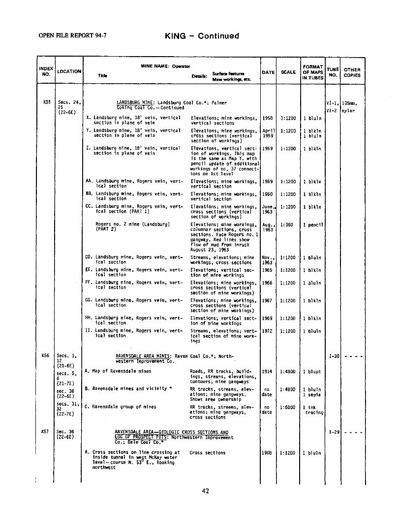
OPEN Fil..E REPORT 94-7 KING - Continued
INDEX MINE NAME: Operator FORMAT TUBE OTHER NO.
LOCATION Surface faltures DATE SCALE Of MAPS NO. COPIES Title Details: Mine work.inti, etc. IN.TUBES
K55 Secs. 24, LANOSBURG MINE: Landsburg Coal Co.*; Palmer VI-1, 105nm, 25 Cok1ng Coal Co. - Continued VI-2 mylar (22-6E)
X. Landsburg mine, 18' vein, vertical Elevations; mine workings, 1958 1:1200 1 bluln section in plane of vein vertical sections
y. Landsburg mine, 18' vein, vertical Elevations; mine workings, April l: 1200 l blkln section in plane of vein cross sections (vertical 1959 l bluln
section of workings) z. Landsburg mine, 18' vein, vertical Elevations, vertical sect~ 1959 1:1200 1 blkl n
section in plane of vein ion of workings. This map is the same as Map Y. with pencil update of additional workings of no. 37 connect-ions on 1st level
AA. Landsburg mine, Rogers vein, vert- Elevations; mine workings, 1959 1:1200 l bl kl n ical section vertical section
BB. Landsburg mine, Rogers vein, vert- Elevations; mine workings, 1960 1:1200 l bl kln ica l section vertical section
cc. Landsburg mine, Rogers vein, vert-· Elevations; mine workings, June., 1:1200 1 bl kl n teal section (PART 1) cross sections (vertical 1963
section of workings) Rogers no. 2 mine {Landsburg) Elevations; mine workings, Aug., 1:360 1 pencil (PART 2) columnar sections, cross 1963
sections. Face Rogers no. 1 gangway. Red lines show flow of mud from inrush August 23, 1963
OD. Landsburg mine. Rogers vein, vert- Streams, elevationsi mine Nov., 1: 1200 · 1 bluln 1cal section workings, cross sections 1963
EE. Landsburg mine, Rogers vein, vert- Elevations; vertical sec- 1965 1:1200 1 bl kl n ical section tion of mine workings
FF. Landsburg mine, Rogers vein, vert- Elevations; mine workings, 1966 1:1200 1 bl ul n ical section cross sections (vertical
section of mine workings) GG. Landsburg mine, Rogers vein, vert- Elevations; mine workings, 1967 1:1200 1 blkl n
1cal section cross sections (vertical section of mine workings}
HH. Landsburg mine, Rogers vein, vert- Elevations; vertical sect- 1969 1:1200 1 blkln 1ca1 section ion of mine workings
II. Landsburg mine, Rogers vein, vert- Streams, elevations; vert- 1972 1:1200 1 bl ul n ica 1 section fcal section of mine work-
1ngs
K56 Secs. 1, RAVENSOALE AREA MINES: Raven Coal Co.*; North- I-30 - - - -12 western Improvement Co. (21-6E) secs. 5, A. Map of Ravensdale mines Roads, RR tracks, build- 1914 1:4800 1 blupt 6 ings, streams, elevations, (21-7E) contours; mine gangways
sec. 36 B. Ravensdale mines and vicinity* RR tracks, streams, elev- no 1:4800 1 bl ul n (22-6E) ations; mine gangways. date 1 sepia
Shows area ownership secs. 31, C. Ravensdale group of mines RR tracks, streams, elev- no 1:6000 1 ink 32 (22-7£) ations; mine gangways, date tracing
cross sections
K57 Sec. 36 RAVENSOALE AREA--GEOLOGIC CROSS SECTIONS ANO I-29 - - - -(22-6E) LOG OF PROSPECT PITS: Northwestern Improvement
I Co.; Dale Coal Co.*
I A. Cross sections on line crossing at Cross sections 1908 1:1200 1 bluln inside tunnel in weat McKay water level- course N. 53 E., looking northwest
i I
42

KING - Continued COAL MINE MAP COLLECTION
INDEX MINE NAME: Operator FORMAT TUBE OTHER
NO. LOCATION Surface features DATE SCALE OF MAPS NO. COPIES Title Details:
Mine workings, etc. IN TUBES
K57 Sec. 36 RAVENSOALE AREA- GEOLOGIC CROSS SECTIONS ANO I-29 - - - -(22-6E) LOG OF PROSPECT PITS: Northwestern Improvement
· Co.; Dale Coal Co. * -Continued
B. Cross section of coal seams in Columnar sections, cross 1925 1:24 2 bluln the old Ravensdale mine* sections
c. Log of prospect shaft no. 64 Columnar sections 1930 1:48 2 bluln D. Cross sections of Ravensdale veins Columnar sections, cross no no 2 bluln
sections date scale
K58 Sec. 36 RAVENSDALE MINE: Raven Coal Co.; Central Coal Co.* VII- 105mm, (22-6E) 14 mylar A. Ravensdale mine workings on beds RR tracks, buildings, 1919 1: 1200 2 blupt
nos. 1 and 4 elevations; mine workings B. Ravensdale mine workings on beds RR tracks, buildings, Jan., 1:1200 1 bluln
nos. 1 and 4 * streams, elevations, con- 1921 tours; mine workings
C. Ravensdale mine workings on beds RR tracks, buildings, June 1: 1200 1 bl ul n nos. 1 and 4 * elevations, contours; 1, 1 sepia
mine workings 1921 D. Ravensdale mine workings on beds RR tracks, buildings, June 1: 1200 1 blupt
nos. land 4 * streams, elevations, con- 30, tours; mine workings 1921
1<59 Sec. 36 RAVENSDALE NO. 1 MINE: Northwestern Improvement Co. VII- 105mm, (22-6E) 18 mylar, sec. 31 A. Plan and profile showing location Elevations; mine workings, 1910 1:60; 1 bl uln (22-7E) of explosion which occured Dec. cross sections. Ventila- 1:120; mapbook
13th, 1910 at 11:17 a.m. Also tion system- several cross 1:480; where dead and injured were found. sections 1: 1200 Ravensdale no. 1 mine
B. Working map of the Ravensdale no. 1 Roads, RR tracks, build- 1911 1: 1200 1 blupt mine workings on no. 4 bed ings, streams, elevations,
contours; mine workings. Town of Ravensdale, ceme-tary, Beaver Lake
c. Working map of the Ravensdale no. 1 RR tracks, buildings, 1914 1:1200 1 blupt mine workings on no. 5 bed streams, elevations, con-
tours; mine workings. "Location of and order in which bod.Y was found shown thus- i no." (11st of dead, no. of orphans, etc.)
D. Map of Ravensdale mine no. 1 RR tracks, buildings, 1920 1 :6000 1 blupt elevations, contours; mine gangways. Town of Ravensdale
K60 Sec. l RAVENSDALE NO. 2 MINE {MCKAY WORKINGS): Northwestern VI-6 105mm, (21-6E) Improvement Co. mylar, sec. 36 A. Working map of the Ravensdale no. 2 RR tracks, buildings, 1911 1:1200 l blupt mapbook (22-6E) mine- McKay workings streams, elevations, con-
tours; mine workings B. Working map of the Ravensdale no. 2 RR tracks, buildings, Feb., 1: 1200 1 blupt
mine-McKay workings streams, elevations, con- 1935 tours; mine workings
C. Working map of the Ravensdale no. 2 RR tracks, buildings, June, 1: 1200 1 bl u_pt mine-McKay workings streams, elevations, con- 1935
tours; mine workings
D. Working map of the Ravensdale no. 2 RR tracks, buildings, 1936 1: 1200 1 blupt mine-McKay workings streams, elevations, con-
tours; mine workings E. Working map of the Ravensdale no .• 2 RR tracks, buildings, 1937 1: 1200 1 blupt
mine- McKay workings streams, elevations, con-tours; mine workings
43
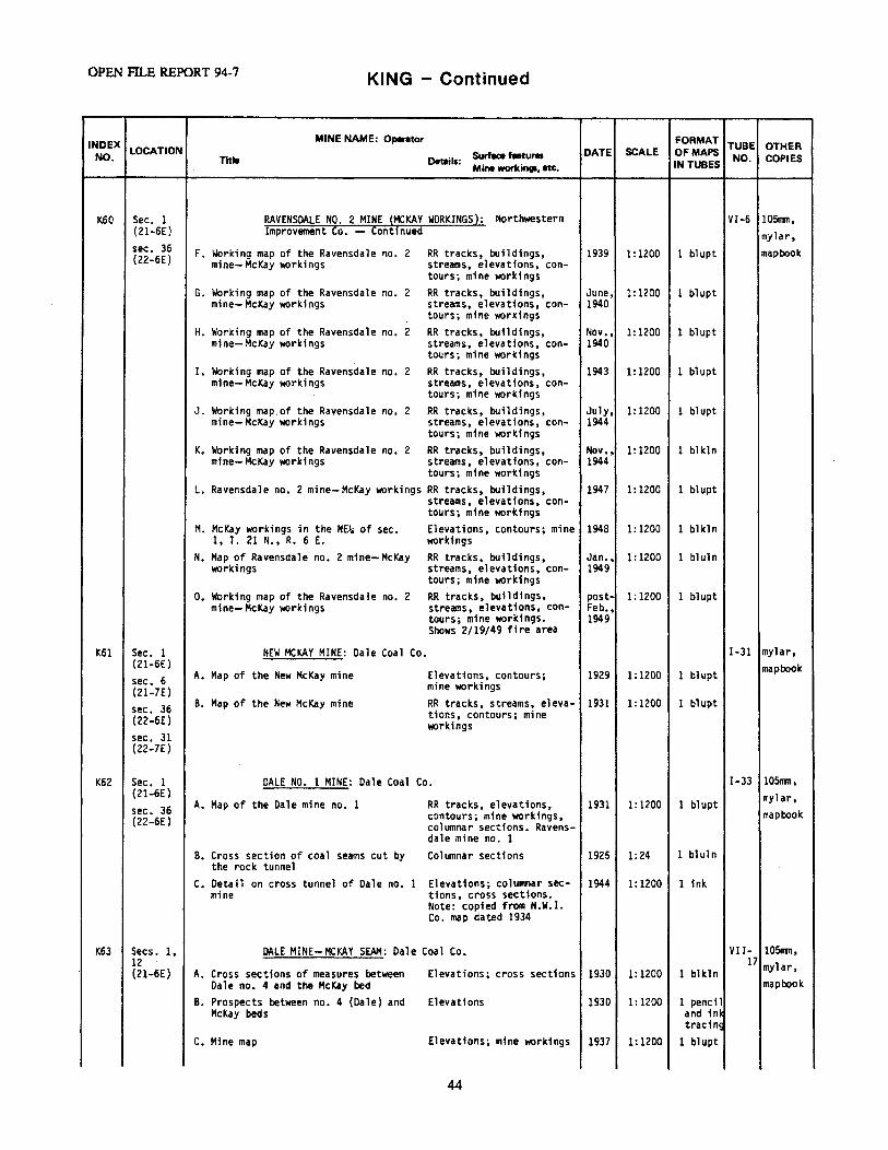
OPEN Fil..E REPORT 94-7 KING - Continued
INDEX MINE NAME: Operator FORMAT TUBE OTHER
NO. LOCATION Surface features DATE SCALE OF MAPS NO. COPIES Title Details:
Mine workings, etc. IN TUBES
K60 Sec. l P.AVENSOALE NO. 2 MINE {MCKAY WORKINGS): Northwestern VI-6 105nm, (21-6E} Improvement Co. -- Continued mylar, sec. 36 F. Working map of the Ravensdale no. 2 RR tracks, buildings, 1939 1:1200 l blupt mapbook (22-6E) mine-McKay workings streams, elevations, con-
tours; mine workings G. Working map of the Ravensdale no. 2 RR tracks, buildings, June, 1:1200 l blupt
mine- McKay workings streams, elevations, con- 1940 tours; mine workings
H. Working map of the Ravensdale no. 2 RR tracks, buildings, Nov., 1:1200 l blupt mine- McKay workings streams, elevations, con- 1940
tours; mine workings I. Working map of the Ravensdale no. 2 RR tracks, buildings, 1943 1:1200 l blupt
mine- McKay workings streams, elevations, con-tours; mine workings
J. Working map.of the Ravensdale no. 2 RR tracks, buildings, July, 1: 1200 1 blupt mine- McKay workings streams, elevations, con- 1944
tours; mine workings K. Working map of the Ravensdale no. 2 RR tracks, buildings, Nov., 1:1200 1 blkln
mine- McKay workings streams, elevations, con- 1944 tours; mine workings
L. Ravensdale no. 2 mine-McKay workings RR tracks, buildings, 1947 1:1200 1 bl upt streams, elevations, con-tours; mine workings
M. McKay workings in the NE~ of sec. Elevations, contours; mine 1948 1:1200 1 blkln 1, T. 21 N., R. 6 E. workings
N. Map of Ravensdale no. 2 mine-McKay RR tracks, buildings, Jan., 1:1200 1 bluln worldngs streams, elevations, con- 1949
tours; mine workings o. Working map of the Ravensdale no. 2 RR tracks, buildings, post- 1:1200 1 blupt
mine- McKay workings streams, elevations, con- Feb., tours; mine workings. 1949 Shows 2/19/49 fire area
K61 Sec. 1 NEW MCKAY MINE: Dale Coal Co. I-31 mylar, (21-6E) mapbook sec. 6 A. Map of the New McKay mine Elevations, contours; 1929 1:1200 1 blupt (21-7E) mfne workings
sec. 36 B. Map of the New McKay mine RR tracks, streams, eleva- 1931 1:1200 1 blupt (22-6E) tions, contours; mine
workings sec. 31 {22-7E)
K62 Sec. 1 DALE NO. 1 MINE: Dale Coal Co. I-33 1051T111, (21-6E) mylar, A. Map of the Dale mine no. 1 RR tracks, elevations, 1931 1:1200 1 blupt sec. 36 contours; mine workings, mapbook {22-6E) columnar sections. Ravens-
dale mine no. l B. Cross section of coal seams cut by Co'lumnar sections 1925 1:24 1 bluln
the rock tunnel c. Detail on cross tunnel of Dale no. 1 Elevations; columnar sec- 1944 1:1200 1 ink
mine tions, cross sections. Note: copied from N.W~I. Co. map dated 1934
K63 Secs. 1, DALE MINE- MCKAY SEAM: Dale Coal Co. VII- 105mn, 12 17 mylar, {21-6E) A. Cross sections of measures between Elevations; cross sections 1930 1:1200 1 blkln
Dale no. 4 and the McKay bed mapbook
B. Prospects between no. 4 (Dale) and Elevations 1930 1:1200 1 pencil McKay beds and in•
tracing c. Mine map Elevations; mine workings 1937 1:1200 1 blupt
44
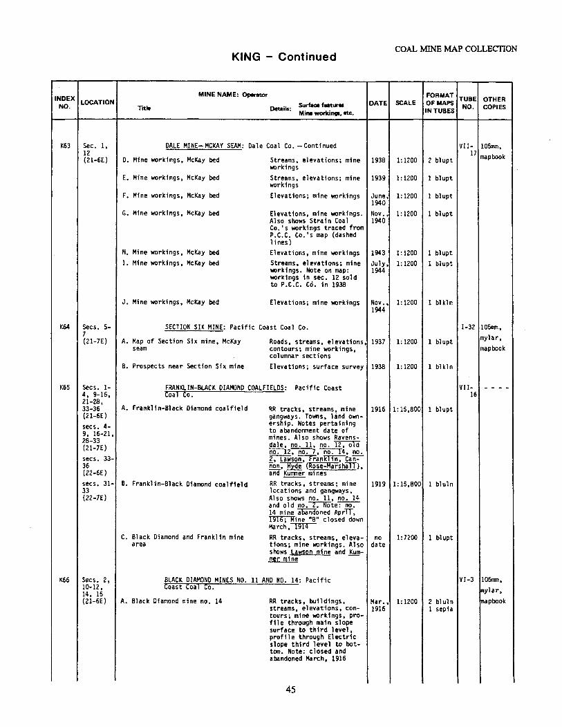
COAL MINE MAP COLLECTION KING - Continued
INDEX MINE NAME: Opemor FORMAT TUBE OTHER
NO. LOCATION Surface features DATE SCALE OF MAPS NO. COPIES Trtle Details:
Mine workings, etc. IN TUBES
1<63 Sec. l, DALE MINE- MCKAY SEAM: Dale Coal Co. -Continued VII- 105mm, 12 17 mapbook (21-6E) D. Mine workings, McKay bed Streams, elevations; mine 1938 1:1200 2 blupt
workings E. Mine workings, McKay bed Streams, elevations; mine 1939 1:1200 1 blupt
workings F. Mine workings, McKay bed Elevations; mine workings June, 1:1200 1 bl upt
1940 G. Mine workings, McKay bed Elevations, mine workings. Nov., 1:1200 1 bl upt
Also shows Strain Coal 1940 Co.'s workings traced from P.C.C. Co.'s map (dashed lines)
H. Mine workings, McKay bed Elevations, mine workings 1943 1:1200 l blupt I. Mine workings, McKay bed Streams. elevations; mine July, 1:1200 1 blupt
workings. Note on map: 1944 workings in sec. 12 sold to P.C.C. Co. in 1938
J. Mine workings, McKay bed Elevations; mine workings Nov., 1:1200 l blkl n 1944
K64 Secs. 5- SECTION SIX MINE: Pacific Coast Coal Co. I-32 105nm, 7 mylar, (21-7E) A. Map of Section Six mine, McKay Roads, streams, elevations. 1937 1:1200 1 bl upt
seam contours; mine workings, mapbook columnar sections
B. Prospects near Section Six mine Elevations; surface survey 1938 1:1200 1 bl kln
K65 Secs. 1- FRANKLIN-BLACK DIAMOND COALFIELDS: Pacific Coast VII- - - - -4, 9-16, Coal Co. 16 21-28, 33-36 A. Franklin-Black Diamond coalfield RR tracks, streams, mine 1916 1:15,800 l blupt (21-6E) gangways. Towns, land own-secs. 4- ership. Notes pertaining 9, 16-21, to abandonment date of
mines. Also shows Ravens-28-33 dale, no. 11, no. T2:-oTcf (21-7E) no:-12~,no.14, no. secs. 33- 2, Lawson, Franmn:-can'=-36 non, Hyde {R~se-MarshilT), (22-6E) and KulTlller mines secs. 31- B. Franklin-Black Diamond coalfield RR tracks, streams; mine 1919 1:15,800 l bluln 33 locations and gangways. (22-7E) Also snows no. 11, no. 14
and old no.~te~ 14 mine abandoned Apr,T, ~ine 11811 closed down March,~
c. Black Diamond and Franklin mine RR tracks, streams, eleva- no 1:7200 1 blupt area tions; mine workings. Also date
shows Lawson mine and Kum-mer mine
K66 Secs. 2, BLACK DIAMOND MINES NO. 11 AND NO. 14: Pacific VI-3 105nln, 10-12, Coast Coal Co. mylar, 14, 15 (21-6E) A. Black Diamond mine no. 14 RR tracks, buildings, Mar., 1:1200 2 bl ul n mapbook
streams, elevations, con- 1916 l sepia tours, mine workings, pro-file through main slope surface to third level, profile through Electric slope third level to bot-tom. Note: closed and abandoned March, 1916
45
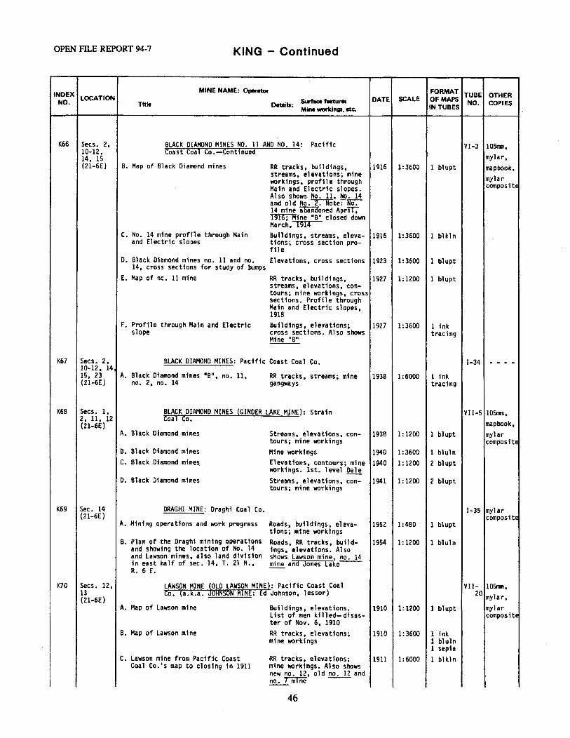
OPEN Fll..E REPORT 94-7 KING - Continued
INDEX MINE NAME: Operator FORMAT TUBE OTHER
NO. LOCATION &riace features DATE SCALE Of MAPS NO. COPIES Titla Details:
Mine workings, etc. IN TUBES
K66 Secs. 2, BLACK DIAMOND MINES NO. 11 ANO NO. 14: Pacific VI-3 105nm, 10-12, Coast Coal Co.--Continued
mylar, 14, 15 (21-6E) B. Map of Black Diamond mines RR tracks, buildings, 1916 1:3600 l bl upt mapbook,
streams, elevations; mine mylar workings, profile through Main and Electric slopes. composite Also shows No. 11, No. 14 and old No.~te~ 14 mine aliiiidoned AprTT;" ill6;Hine 11 811 closed down March, 1914
c. No. 14 mine profile through Main Buildings, streams, eleva- 1916 1:3600 l blkln and Electric slopes tions; cross section pro-
file o. Black Diamond mines no. 11 and no. Elevations, cross sections 1923 1:3600 1 blupt
14, cross sections for study of bumps E. Map of no. 11 mine RR tracks, buildings,
streams, elevations, con-1927 1:1200 1 blupt
tours; mine workings, cross sections. Profile through Main and Electric slopes, 1918
F. Profile through Main and Electric Buildings, elevations; 1927 1:3600 1 ink slope cross sections. Also shows tracing
Mine 11 B11
K67 Secs. 2, BLACK DIAMOND MINES: Pacific Coast Coal Co. 1-34 - - - -10-12, 141 15, 23 A. Black Diamond mines 11 B", no. 11, RR tracks, streams; mine 1938 1:6000 1 ink (21-6E) no. 2, no. 14 gangways tracing
K68 Secs. l, BLACK DIAMOND MINES (GINDER LAKE MINE): Strain VII-5 105mm, 2, 11, 12 Coal Co. mapbook, (21-6E)
A. Black Diamond mines Streams, elevations, con- 1938 1: 1200 1 bl upt mylar tours; mine workings compositE
B. Black Diamond mines Mine workings 1940 1:3600 1 bluln C. Black Diamond mines Elevations, contours; mine 1940 1: 1200 2 blupt
workings. 1st. level Dale 0. Black Diamond mines Streams, elevations, con- 1941 l: 1200 2 blupt
tours; mine workings
K69 Sec. 14 DRAGHI MINE: Draghi Coal Co. 1-35 mylar (21-6E) composite
A. Mining operations and work progress Roads, buildings, eleva- 1952 1:480 1 blupt tions; mine workings
B. Plan of the Draghi mining operations Roads, RR tracks, build- 1954 1:1200 1 bluln and showing the location of No. 14 ings, elevations. Also and Lawson mines, also land division shows Lawson mine, no. 14 in east half of sec. 14, T. 21 N., mine and Jones lake--R. 6 E.
K70 Secs. 12, LAWSON MINE jOLO LAWSON MINE}: Pacific Coast Coal VII- 105mm, 13 Co. (a.k.a. OHNSON MINE: Ed Johnson, lessor) 20 mylar, (21-6E)
A. Map of Lawson mine Buildings, elevations. 1910 l: 1200 1 blupt mylar List of men killed-disas- composite ter of Nov. 6, 1910
B. Map of Lawson mine RR tracks, elevations; 1910 1:3600 1 ink mine workings 1 bluln
1 sepia c. Lawson mine from Pacific Coast RR tracks, elevations; 1911 1:6000 1 bl kl n
Coal Co.'s map to closing in 1911 mine ~rkings. Also shows new no. 12, old no. 12 and no. 7 mrne
46
KING - Continued COAL MINE MAP COLLECTION
INDEX MINE NAME: Operator FORMAT TUBE OTHER
NO. LOCATION Surface features DATE SCALE Of MAPS NO. COPIES Title Details:
Mine workings, etc. IN TUBES
K70 Secs. 12, LAWSON MINE {OLD LAWSON MINE}: Pacific Coast Coal WII- 105mn, 13 Co. {a.k.a. JOHNSON MINE: Ed Johnson, lessor}-Continued 20 mylar, (21-6E)
D. Map of Lawson mine RR tracks, buildings, elevations; mine workings.
1936 1:1200 1 blupt mapbook
Li st of men killed- di sas-ter of Nov. 6, 1910
E. Johnson coal mine Elevations; mine workings. 1937 1:1200 2 blupt Note: old Lawson mine-Ed Johnson, lessor is written on copy 1 of this map
K71 Secs. 12, NO. 12 MINE: Black Diamond Coal Mining Co.; VII- 105mm, 13 Pacif1c Coast Coal Co.* 19 mapbook, (21-6E)
A. Plan showing coal workings in sec. Roads, RR tracks, build- 1888 1:1200 2 bluln mylar 12, T. 21 N., R. 6 E. ings, streams, elevations, composite
contours; mine workings B. Plan showing coal workings 1n sec. Roads, RR tracks, build- 1888 1:4800 2 photo·
12, ~ 21 N., R. 6 E. ings, streams, elevations, 1 mylar contours; mine workings (Photo-reduction of Map A.)
C. New no. 12 mine* RR tracks, buildings, 1912 1:1200 1 bl upt elevations; mine workin9s. Also shows old Lawson mine workings, old no. 12 and no. 7 workings--
D. Map of new no. 12 mine * Buildings, elevations; 1916 1:3600 1 blupt mine gangways. Note: new no. 12 closed down March, ~Other new no. 12 mine workings shown on Lawson mine, Map D. (K70)
K72 Secs. 7, FRANKLIN MINE NO. 7: Pacific Coast Coal Co.; VII- 10Srrm, 18 Strain Coal Co.* 21 mapbook, (21-7E)
A. Franklin no. 7 mine, McKay vein Mine workings 1907 1:1200 l blupt mylar workings composite
B. Strain Coal Co. no. 7 mine* Elevations; mine workings 1940 1:1200 l blupt
K73 Sec. 8 GREEN RIVER GORGE COAL MINING CO. MINES: Green I-45 mylar, (21-7E} River Gorge Coal Mining Co.; mapbook OKAY COAL CO. MINE: Okay Coal Co.
A. Map of the property of Green River Roads, buildings, streams, 1936 1:1200 1 blupt Gorge Coal Mining Co. elevations; mine workings.
Also shows mines on the Black Beauty and Okay seams
B. Map of the Okay Coal Co. 's lease of Roads, buildings, streams; 1943 1:1200 1 blupt the Okay seams mine workings
C. Map of the Okay Coal Co.'s lease of Roads, buildings, streams, c. 1:1200 1 ink the Okay seams elevations; mine workings 1943 tracing
K74 Secs. 7, BLACK DIAMOND MINE 2 NEW FRANKLIN SLOPE: Pacific VII- 1051ml, 18, 19 Coast Coal Co. 23 mylar (21-7E)
A. Black Diamond mine Buildings, streams, eleva- 1940 1:1200 1 bluln t1ons; mine workings
B. New Franklin slope Elevations; mine workings. Feb., 1: 1200 1 blupt Shows Strain Coal Co. no. 1-941 7 mine location -
C. New Franklin slope Elevations; mine workings. Apr., 1:1200 1 blupt Shows Strain Coa 1 Co. !!2.:._ 1941 7 mine location
47
OPEN FILE REPORT 94-7 KING - Continued
INDEX MINE NAME: Operator FORMAT TUBE OTHER
NO. LOCATION Surface features DATE SCALE OF MAPS NO. COPIES Title Details:
Mine workint1. etc. IN TUBES
K74 Secs. 7, BLACK DIAMOND MINE, NEW FRANKLIN SLOPE: Pacific VII- 105rrm, 18, 19 Coast Coal Co.-Continued 23 mylar (21-7E)
o. Black Diamond mine Buildings, streams, eleva- 1944 1:1200 1 bluln tions; mine workings
E. Black Diamond mine Buildings, streams, eleva-tions; mine workings
1946 1:1200 1 blupt
K75 Secs. 7, HI-HEAT COAL co.•s MINE: Hi-heat Coal Co. VII- mylar, 8, 17, 18 29 mapbook (21-7E) A. Hi-heat Coa 1 Co. mine Roads, buildings; mine 1935 1:1200 l blupt
workings B. Hi-heat Coa 1 Co. mine Roads, buildings, eleva- 1936 1:1200 1 blupt
t1ons; mine workings. Also shows coal in P.c.c. Co. sec. 7, T. 21 N., R. 7 E. above present ele-vation to south boundary line of sec. 7
C. Hi-heat Coal Co. mine Roads, buildings, eleva- 1937 1:1200 l blupt tions; mine workings. Also shows same P.C.C. Co. coal as Map B.
D. Hi-heat Coal Co. mine Roads, buildings; mine 1938 1:1200 1 blupt workings
E. Hi-heat Coal Co. mine Roads, buildings, eleva- 1939 1:1200 1 blupt tions; mine workings
F. Hi-heat Coal Co. mine Roads, buildings, eleva- 1940 1:1200 1 blupt tions, mine workings
G. Hi-heat Coa 1 Co. mfoe Roads, buildings, eleva- 1942 1:1200 1 blupt tions; mine workings
K76 Secs. 17- NEW HI-HEAT MINE AREA I-40 - - - -20 (21-7E) A. Survey, Green River southern gorge, RR tracks, buildings, no 1:1200 1 bluln
for propsecting purposes streams, elevations. Sur- date 1 sepia face survey and location of old Franklin gangway
K77 Secs. 7, FRANKLIN-GEM COAL MINE: Franklin-Gem Coal Co. 1-39 mylar, 18 mapbook (21-7E) A. Franklin-Gem Coal Co. Buildings, elevations; 1944 1:1200 1 blupt
mine workings B. Map of the Franklin-Gem coal mine Buildings, elevations, con- 1946 1:1200 1 blupt
tours; mine workings. Also shows old no. 7 mine
C. Map of the Franklin-Gem coal mine Buildings, elevations, con- 1947 1:1200 2 blupt tours; mine workings, col-umnar sections. Old !!Q.:...l mine
D. Map of the Franklin-Gem coal mine Buildings, elevations; 1950 1:1200 2 blupt mine workings, columnar sections
K78 Secs. 7, B.P.D. COAL CO. MINE: B.P.D. Coal Co. I-38 - - - -18 (21-7E) A. Map of B.P.D. Coal Co. Roads, buildings, eleva- 1948 1:1200 1 bl upt
tions; mine workings, col-umnar sections. Partial surface survey of Franklin-Gem mine
48
INDEX LOCATION NO.
K79
KSO
KSl
K82
Secs. 7, 18, 19, 29, 30 (21-7E)
Secs. 17-20 (21-7E)
Secs. 18, 19 (24-7E)
Sec. 19 (21-7E)
KING - Continued COAL MINE MAP COLLECTION
MINE NAME: Ot*ator
Title Details: Surface features Mine workings, etc.
QATE SCALE FORMAT TUBE OTHER OF MAPS IN TUBES NO. COPIES
FRANKLIN MINE, 1900-1922: Pacific Coast Coal Co.
A. Section bore hole no. 3, Franklin no. 2 mine
B. Pacific Coast Coal Co.'s Franklin mines
Elevations; columnar sectfons RR tracks, buildings, streams, elevations, mine gangways, columnar sec-tions, cross sections. Also shows E. side old no. 7 mine, Cannon mine, Hy-ae-tunnel, Gem. Note: Cannon mine closea-down May;-r§TS
1900 1:600 2 bl kl n
1916 1:3600 1 bl upt
C. Franklin mines Roads, RR tracks, build- 1919 1:1200 l blupt ings, streams, elevations, contours; mine workings
D. Franklin mines Roads, RR tracks, build- 1921 1:1200 1 blupt ings, streams, elevations, contours; mine workings
E. Franklin mines RR tracks, streams, eleva- 1922 1:6000 1 blkln tions; mine workings. Also shows Cannon mine, no. 7 mine, Lawson mine, Hyde mine
FRANKLIN MINES: Palmer Coking Coal Co.
A. Franklin mines, no. 10 seam, bottom Roads, streams; mine work- 1949 bench ings
B. Franklin mines, no. 10 seam, bottom Roads, streams, elevations; 1951 bench mine workings
1: 1200
l: 1200
2 bl ul n
1 bl upt
C. Franklin mines, nos. 10 and 12 seams Roads, streams, elevations; 1954 1:1200 1 bluln mine workings
D. Plan of the no. 10 seam workings Buildings, streams, eleva- 1954 1:1200 1 blupt tions; mine workings
E. Franklin mines, nos. 10 and 12 seams Roads, streams, elevations, 1955
F. Plan of the no. 10 seam workings, Palmer Coking Coal Co.
contours; mine workings Streams, elevations; mine 1955 workings
G. Franklin mines, nos. 10 and 12 seams Roads, streams, elevations; 1956 mine workings, cross sec-tions (1: 3600)
H. Franklin mines, nos. 10 and 12 seams Roads, streams, elevations; 1958 mine workings, cross sec-tions (1:3600)
FRANKLIN MINES (11COY 1 S WORKINGS"}: Palmer Coking Coal Co.
A. "Coy's workings, second level 0
- in Palmer Coking Coal Co. 's Frankl in mine. (11Coy11 1s the draftsman's abbreviation for Company)
Mine workings. Also inclu- no des one unidentified seam date which does not match struc-ture of above workings
FULTON NO. 2 MINE: Palmer Coking Coal Co.
A. Fulton no. 2 mine, approximate outcrop lines nos. 10 and 12. Note on map: isometric, do not scale
Elevations, cross sections 1958 (1:1200). Isometric sur-vey diagram. This is one of two seams of Franklin mines, south extens1on
49
1:1200 1 bluln
1:1200 1 bluln
1:1200 2 bluln
1:1200 2 bluln 2 blkln
1:1200
no scale
1 bl ul n 2 bl kl n
1 bluln 1 sepia
VII-24
VI-4 105mm,
1-36
mapbook, mylar composite
1-37 - - - -
OPEN FILE REPORT 94-7 KING - Continued
INDEX MINE NAME: Operator FORMAT TUBE OTHER
NO. LOCATION Surface features DATE SCALE OF MAPS NO. COPIES Title Details: IN TUBES Mine workings, etc.
K83 Secs. 19, FRANKLIN MINE 1 SOUTH EXTENSION: Palmer Coking VII- 105rrm, 20 Coal Co. 22 mapbook, (21-7E)
A. Franklin mines, south extension Roads, RR tracks, buildings, 1958 1:1200 2 bl ul n mylar streams, elevations; mine composite workings
B. Franklin mines, south extension Roads, RR tracks, build- 1959 1:1200 1 bluln ings, streams, elevations; mine workings
C. Franklin mines, south extension Roads, streams, elevations; 1970 1:1200 1 bluln mine workings 1 sepia
K84 Secs. 7, CANNON MINE AND FRANKLIN MINE: Pacific Coast VI-9 105nlll, 17-21, Coal Co. 28-32 mapbook, (21-7E) A. Frankl 1 n mines- Cannon mines com- Roads, RR tracks, build- 1922 1:1200 1 bluln mylar
posite ings, streams, elevations, 1 sepia composite contours; mine workings
B. Map of Cannon mine (composite), Roads, RR tracks, build- 1922 1:1200 1 blupt Map of Franklin mines ings, streams, elevations,
contours; mine workings, columnar sections. Shows a bit of Hyde mine
c. (No title block) Hyde, Cannon, Roads, RR tracks, build- 1922 1:4800 1 blul n Frankl in mines- old workings (com- ings, streams, elevations; pos i te drawing) mine workings
K85 Secs. 25, Kl.MMER MINE: Pacific Coast Co.; Denny-Renton VII- 105ilm, 26 Clay and Coal Co.*; Gladding, McBean and Co.**; 26 mylar, {21-6E) Kummer Coal Co.***
mapbook A. Kummer mine workings RR tracks, buildings, 1907 1:1200 l bluln
streams; mine workings B. Map of Kummer mines (fragment)* Roads, RR tracks, build- 1919 1:1200 l blupt
ings, streams; mine work-1ngs and surface survey. Shows no. 4 seam prospect south of river
c. Map of the Kumner mines (traced RR tracks, streams, eleva- 1933 1:1200 l blupt from Denny-Renton Clay and Coal Co. tions; mine workings and 1920 map with partial revisions to surface survey. Shows no. 1933) •• 4 prospect and no. 1 seam
prospects south~iver D. Kummer mine** or*** Mine workings 1934 1:240 1 blupt E. Kummer Coal mine and surface arrang-
ments at the Kummer mine** or*** Buildings; mine workings 1935 1:240 1 blupt
F. Kummer mine** Streams; mine workings 1936 1:1200 1 blupt G. Kummer mine workings** or*** RR tracks, buildings, 1939 1:1200 1 sepia
streams; mine workings. This is a copy of Map A. with pencil additions of old no. 1 seam workings and location of new work-ings on old Denny-Renton, no. 1 seam norttlof r1ver
H. Kummer mine~developement on new Buildings, streams, eleva- 1940 1:1200 1 blupt no. 1 seam workings** or*** tions; mine workings
I. Plan--Profile. Progress map of no. Roads, buildings, eleva- 1949 1:1200 2 blupt 4 seam••• tions; mine workings
50
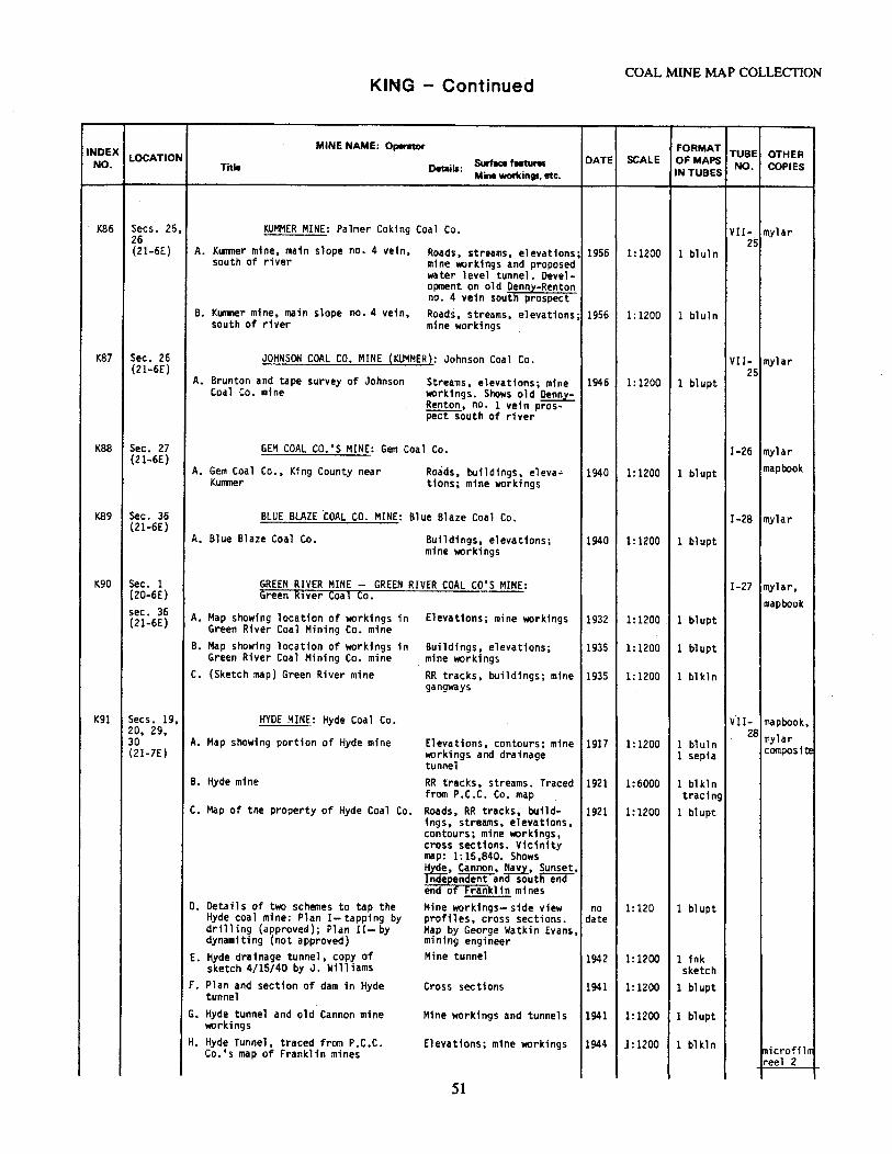
INDEX LOCATION NO.
1<86 Secs. 25, 26 (21-6E)
K87 Sec. 26 (21-6E)
1<88 Sec. 27 (21-6E)
K89 Sec. 36 (21-6E)
K90 Sec. 1 (20-6E) sec. 36 (21-6E)
K91 Secs. 19, 20, 29, 30 (21-7E)
A.
B.
A.
A.
A.
A.
KING - Continued
MINE NAME: Operator
Title Details: Swface features Mini workings, etc.
KUMMER MINE: Palmer Coking Coal Co.
KU111J1er mine, main slope no. 4 vein, Roads, streams, elevations; south of river mine workings and proposed
water level tunnel. Devel-oprnent on old Denny-Renton no. 4 vein south prospect
Kunwner mine, main slope no. 4 vein, Roads, streams, elevations; south of river mine workings
JOHNSON COAL CO. MINE (KUMMER}: Johnson Coal Co.
Brunton and tape survey of Johnson Streams, elevations; mine Coal Co. mine workings. Shows old Denny-
Renton, no. 1 vein pros-pect south of river
GEM COAL CO.'S MINE: Gem Coal Co.
Roads, bu.ildings, eleva-Gem Coal Co., King County near KUfllller tions; mine workings
BLUE BLAZE ·coAL co. MINE: Blue Blaze Coal Co.
Blue Blaze Coal Co. Buildings, elevations; mine workings
GREEN RIVER MINE - GREEN RIVER COAL CO'S MINE: Green R1ver Coal Co.
Map showing location of workings in Elevations; mine workings Green River Coal Mining Co. mine
B. Map showing location of workings in Buildings, elevationsi Green River Coal Mining Co. mine mine workings
C. (Sketch map) Green River mine RR tracks, buildings; mine gangways
HYDE MINE: Hyde Coal Co.
A. Map showing portion of Hyde mine Elevations, contours; mine workings and drainage tunnel
B. Hyde mine RR tracks, streams. Traced from P.C.C. Co. map
C. Map of the property of Hyde Coal Co. Roads, RR tracks, build-tngs, streams, elevations, contours; mine workings, cross sections. Vicinity map: 1:15,840. Shows ~yde, Cannon, :avy, Sunset,
~ndent an soutii"eiid end c:, Franklin mines
o. Details of two schemes to tap the Mine workings- side view Hyde coal mine: Plan I-tapping by profiles, cross sections. drilling (approved); Plan II- by Map by George Watkin Evans, dynamiting (not approved) mining engineer
E. Hyde drainage tunnel, copy of Mine tunnel sketch 4/15/40 by J. Williams
F. Plan and section of dam in Hyde Cross sections tunnel
G. Hyde tunnel and old Cannon mine Mine workings and tunnels workings
H. Hyde Tunnel, traced from P.C.C. Elevations; mine workings Co.'s map of Franklin mines
51
COAL MINE MAP COLLECTION
DATE SCALE
1956 1:1200
1956 1:1200
1946 1:1200
1940 1:1200
1940 1:1200
1932 l:1200
1935 1:1200
1935 1:1200
1917 1:1200
1921 1:6000
1921 1:1200
no 1:120 date
1942 1: 1200
1941 1: 1200
1941 1: 1200
1944 l: 1200
.FORMAT TUBE OTHER OF MAPS IN TUBES NO. COPIES
VII- mylar 25
1 bl ul n
l bluln
VII- mylar 25
l blupt
I-26 mylar
l bl upt mapbook
I-28 mylar
l blupt
I-27 mylar, mapbook
1 blupt
1 blupt
1 bl kln
VII- mapbook, 28 mylar 1 bluln composit.e 1 sepia
1 blkln tracing
1 bl upt
1 blupt
l ink sketch
1 blupt
1 blupt
1 blkln microfilm reel 2
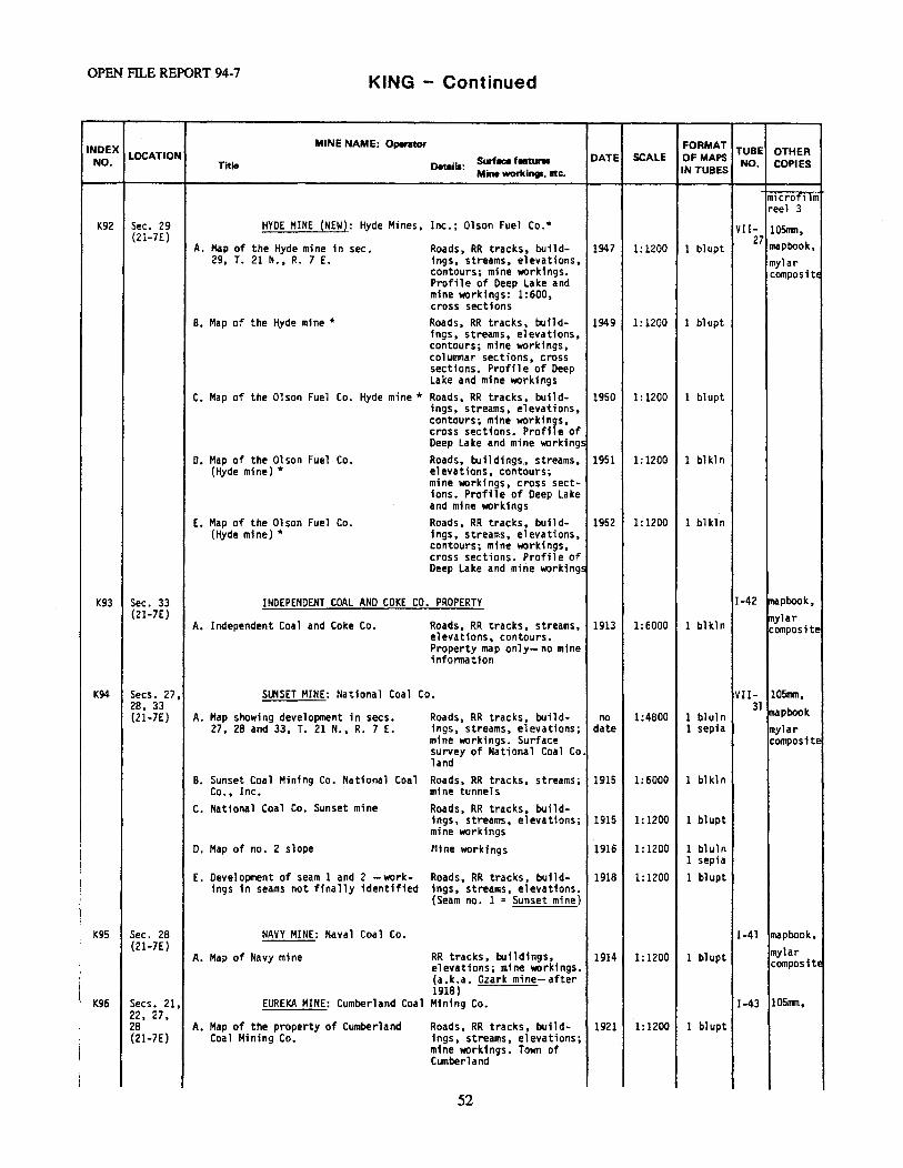
OPEN Fll..E REPORT 94-7 KING - Continued
INDEX MINE NAME: Operator FORMAT TUBE OTHER NO.
LOCATION Surface featur11 DATE SCALE OF MAPS NO. COPIES Title Details: Mine WOf'kints. etc. IN TUBES
m1crofi lm reel 3
K92 Sec. 29 HYDE MINE {NEW): Hyde Mines, Inc.; Olson Fuel Co.* VII- 105mm, (21-7E) 27 mapbook, A. Map of the Hyde mine in sec. Roads, RR tracks, build- 1947 1:1200 1 bl upt
29, T. 21 N., R. 7 E. 1ngs, streams, elevations, mylar contours; mine workings. composi tE Profile of Deep Lake and mine workings: 1:600, .cross sections
B. Map of the Hyde mine* Roads, RR tracks, build- 1949 1:1200 1 bl upt 1ngs, streams, elevations, contours; mine workings, columnar sections, cross sections. Profile of Deep Lake and mine workings
C. Map of the Olson Fuel Co. Hyde mine* Roads, RR tracks, build- 1950 1:1200 1 blupt ings, streams, elevations, contours; mine workings, cross sections. Profile of Deep Lake and mine workings
D. Map of the Olson Fuel Co. Roads, bu11 dings., streams, 1951 1:1200 1 bl kl n (Hyde mine) * elevations, contours;
mine workings, cross sect-ions. Profile of Deep Lake and mine workings
E. Map of the Olson Fuel Co. Roads, RR tracks, build- 1952 l: 1200 1 blkln (Hyde mine)* ings, streams, elevations,
contours; mine workings, cross sections. Profile of Deep Lake and mine workings
K93 Sec. 33 INDEPENDENT COAL ANO COKE CO. PROPERTY I-42 mapbook, (21-7E) mylar
A. Independent Coal and Coke Co. Roads, RR tracks, streams, 1913 1:6000 l bl kl n composite elevations, contours. Property map only- no mine infonnation
K94 Secs. 27, SUNSET MINE: National Coal Co. VII- 105mm, 28, 33 31 ~pbook (21-7E) A. Map showing development in secs. Roads, RR tracks, build- no 1 :4800 1 bl ul n
27, 28 and 33, T. 21 N., R. 7 E. ings, streams, elevations; date 1 sepia mylar mine workings. Surface composite survey of National Coal Co. land
B. Sunset Coal Mining Co. National Coal Roads, RR tracks, streams; 1915 1:6000 1 bl kl n Co., Inc. mine tunnels
c. National Coal Co. Sunset mine Roads, RR tracks, build-ings, streams, elevations; 1915 1: 1200 1 blupt mine workings
D. Map of no. 2 slope Mine workings 1916 1:1200 l bluln 1 sepia
E. Development of seam 1 and 2 -work- Roads, RR tracks, build- 1918 1:1200 1 blupt ings in seams not finally identified ings, streams, elevations.
(Seam no. l = Sunset mine)
1<95 Sec. 28 NAVY MINE: Naval Coal Co. I-41 mapbook, (21-7E)
RR tracks, buildings, mylar A. Map of Navy mine 1914 1:1200 l blupt elevations; mine workings. composite (a. k.a. Ozark mine- after 1918)
K96 Secs. 21, EUREKA MINE: Cumberland Coal Mining Co. 1-43 l05R111, 22, 27, 28 A. Map of the property of Cumberland Roads, RR tracks, build- 1921 1: 1200 1 blupt (21-7E) Coal Mining Co. 1ngs, streams, elevations;
mine workings. Town of Cumberland
52
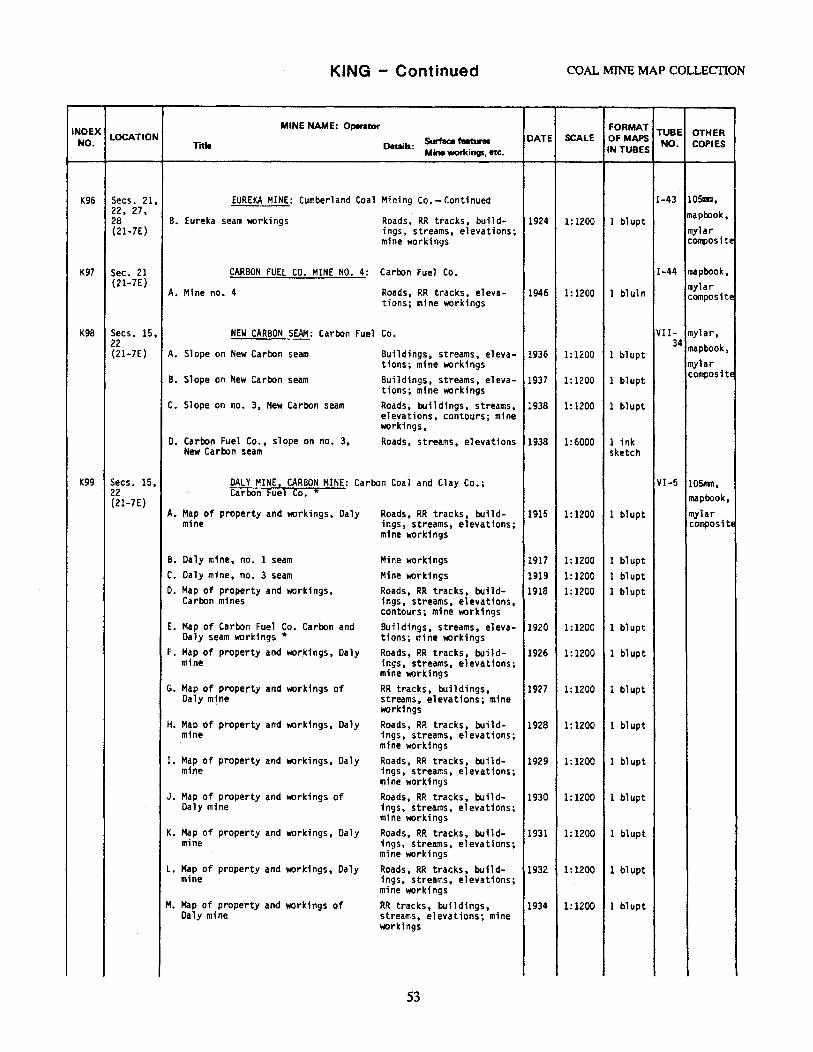
KING - Contil')ued COAL MINE MAP COLLECTION
INDEX MINE NAME: Operator FORMAT TUBE OTHER
NO. LOCATION &.feel features DATE SCALE Of MAPS NO. COPIES Title Details:
Mine workings, etc. IN TUBES
K96 Secs. 21, EUREKA MINE: Cumberland Coal Mining Co.- Contfoued I-43 105rrm, 22, 27, mapbook, 28 B. Eureka seam workings Roads, RR tracks, build- 1924 1: 1200 1 blupt (21-7E) ings, streams, elevations; mylar
mine workings composite
K97 Sec. 21 CARBON FUEL CO. MINE NO. 4: Carbon Fuel Co. I-44 mapbook, (21-7E)
Mine no. 4 Roads, RR tracks, eleva- 1946 1 bl ul n mylar A. 1:1200 composite tions; mine workings
K98 Secs. 15, NEW CARBON SEAM: Carbon Fuel Co. VII- mylar, 22 34 mapbook, (21-7E) A. Slope on New Carbon seam Buildings, streams, eleva- 1936 1:1200 1 blupt
tions; mine workings mylar B. Slope on New Carbon seam Buildings, streams, eleva- 1937 1:1200 1 blupt composite
tions; mine workings c. Slope on no. 3, New Carbon seam Roads, buildings, streams,
elevations, contours; mine 1938 1: 1200 1 blupt
workings, o. Carbon Fuel Co., slope on no. 3, Roads, streams, elevations 1938 1:6000 1 ink
New Carbon seam sketch
K99 Secs. 15, DALY MINE, CARBON HINE: Carbon Coal and Clay Co.; Vl-5 105rrm, 22 Carbon Fuel Co.* mapbook, (21-7E)
A. Map of property and workings, Daly Roads, RR tracks, build- 1915 1:1200 1 blupt mylar mine ings, streams, elevations; compositE
mine workings
B. Daly mine, no. 1 seam Mine workings 1917 1:1200 1 blupt C. Daly mine, no. 3 seam Mine worlcings 1919 1:1200 1 blupt D. Map of property and workings, Roads, RR tracks, build- 1918 1:1200 1 blupt
Carbon mines ings, streams, elevations, contours; mine work1 ngs
E. Map of Carbon Fuel Co. Carbon and Buildings, streams, eleva- 1920 1:1200 1 bl upt Daly seam workings* tions; mine workings
F. Map of property ar.id workings, Daly Roads, RR tracks, build- 1926 1:1200 1 bl upt mine 1ngs, streams, elevations;
mine workings G. Map of property and workings of RR tracks, buildings, 1927 1:1200 1 blupt
Daly mine streams, elevations; mine workings
H. Map of property and workings, Daly Roads, RR tracks, build- 1928 1: 1200 1 blupt mine ings, streams, elevations;
mine workings I. Map of property and workings, Daly Roads, RR tracks, build- 1929 1:1200 1 bl upt
mine 1ngs, streams, elevations; mine workings
J. Map of property and workings of Roads, RR tracks, build- 1930 1:1200 1 blupt Daly mine ings, streams, elevations;
mine workings K. Map of property and workings, Daly Roads, RR tracks, build- 1931 1:1200 1 blupt
mfoe ings, streams, elevations; mine workings
L. Map of property and "90rk1ngs, Daly Roads, RR tracks, build-mine ings, streams, elevations;
1932 1:1200 1 bl upt
mine workings M. Map of property and workings of RR tracks, buildings, 1934 1:1200 1 blupt
Daly mine streams, elevations; mine workings
53
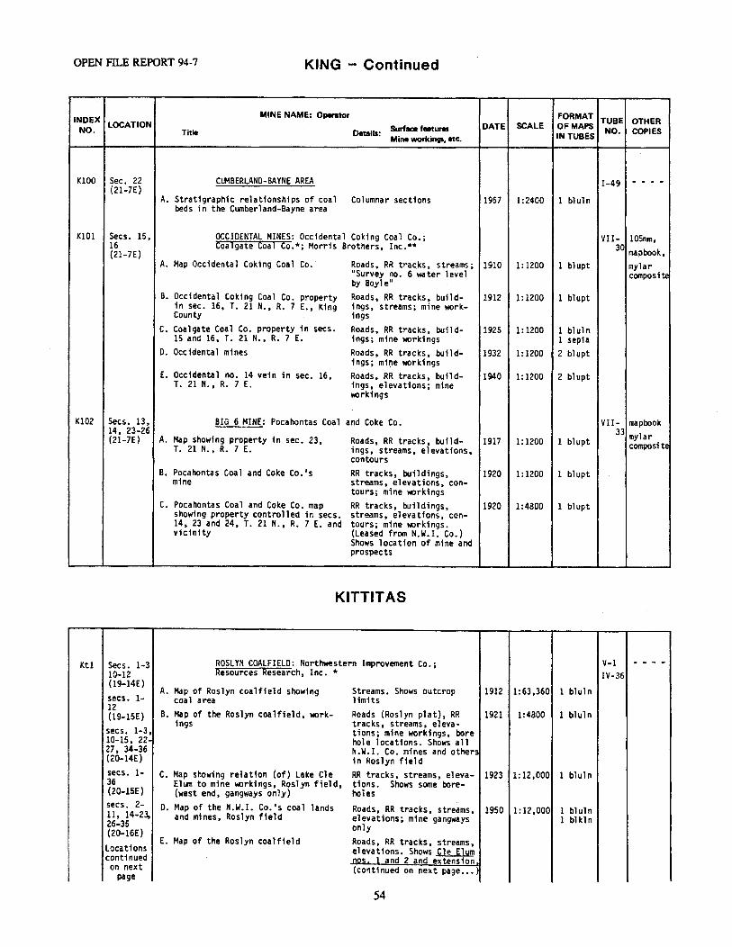
OPEN FILE REPORT 94-7 KING - Continued
INDEX MINE NAME: Operator FORMAT TUBE OTHER
NO. LOCATION Surface features DATE SCALE Of MAPS NO. COPIES Title Details:
Mine workings, etc. IN TUBES
KlOO Sec. 22 CUMBERLAND-BAYNE AREA I-49 - - - -(21-7E)
A. Stratigraphic relationships of coal Columnar sections 1957 1:2400 1 bl ul n beds in the Cumberland-Bayne area
KlOl Secs. 15, OCCIDENTAL MINES: Occidental Coking Coal Co.; VII- 10511111. 16 Coalgate Coal Co.*; Morris Brothers, Inc.** 30 mapbook, (21-7E)
A. Map Occidental Coking Coal Co. Roads, RR tracks, streams; 1910 1:1200 1 blupt mylar 11Survey no. 6 water level composit.e by Boyle"
B. Occidental Coking Coal Co. property Roads. RR tracks, build- 1912 1:1200 1 blupt in sec. 16, T. 21 N., R. 7 E., King ings, streams; mine work-County 1ngs
c. Coalgate Coal Co. property in secs. Roads, RR tracks, build- 1925 1:1200 1 blul n 15 and 16, T. 21 N., R. 7 E. ings; mine workings 1 sepia
D. Occidental mines Roads, RR tracks, build-ings; mi~e workings
1932 1:1200 2 blupt
E. Occidental no. 14 vein in sec. 16, Roads, RR tracks, build- 1940 1:1200 2 blupt T. 21 N., R. 7 E. ings, elevations; mine
workings
Kl02 Secs. 13, BIG 6 MINE: Pocahontas Coal and Coke Co. VII- mapbook 14, 23-26 33 mylar (21-7E) A. Map showing property in sec. 23, Roads, RR tracks, build- 1917 1:1200 1 blupt composite T. 21 N., R. 7 E. ings, streams. elevations.
contours B. Pocahontas Coal and Coke Co. 1 s RR tracks, buildings, 1920 1:1200 1 blupt
mine streams, elevations, con-tours; mine \IIOrkings
c. Pocahontas Coal and Coke Co. map RR tracks, buildings, 1920 1:4800 1 bl upt showing property controlled in secs. streams, elevations, con-14, 23 and 24, T. 21 N., R. 7 E. and tours; mine \IIOrkings. vicinity (Leased from N.W.I. Co.)
Shows location of mine and prospects
KITTITAS
Ktl Secs. 1-3 ROSLYN COALFIELD: Northwestern Improvement Co.; V-1 - - - -10-12 Resources Research, Inc.* IV-36 (19-14E)
A. Map of Roslyn coalfield showing Streams. Shows outcrop 1912 1:63,360 1 bluln secs. 1- coal area limits 12
B. Map of the Roslyn coalfield, work- Roads (Roslyn plat), RR 1921 1:4800 1 bluln (19-lSE) ings tracks, streams, eleva-
secs. 1-3, tions; mine workings, bore 10-15, 22- hole locations. Shows all 27, 34-36 N.W.I. Co. mines and others (20-14E) in Roslyn field secs. 1- c. Map showing relation (of) Lake Cle RR tracks, streams, eleva- 1923 1:12,000 1 bluln 36 El1Jt1 to mine workings, Roslyn field, tions. Shows some bore-(20-lSE) (west end, gangways only) holes secs. 2- D. Map of the N.W.I. Co.'s coal lands Roads, RR tracks, streams, 1950 1:12,000 1 bluln 11, 14-23, and mines, Roslyn field elevations; mine gangways 1 blkl n 26-35 only (20-16E)
E. Map of the Roslyn coalfield Roads, RR tracks, streams, Locations elevations. Shows Cle Elum continued ag~. land 2 and extension 1 on next (continued on next page ••• ) page
54
KITTITAS - Continued COAL MINE MAP COLLECTION
INDEX MINE NAME: Operator FORMAT
TUBE OTHER NO.
LOCATION Swface features DATE SCALE OF MAPS NO. COPIES Title Oeiails: IN TUBES Mine workings, etc.
Ktl Continued ROSLYN COALFIELD: Northwestern Improvement Co.; V-1, - - - -from pre- Resources Research, Inc. *- Continued IV-vious page
Map of the Roslyn coalfield 36 secs. 34- E. {continued from previous 1955 1:4800 1 bl ul n 36 page) Indel?jndent. Roslyn (21-14E) nos. 1, 2, , 4, 5, 6, 7,
,-nil T and ~. lfo s Tyn -Fuel secs. 31- Co •• Roslyn-Cascade and 36 Rona 1 d mines (21-15E) F. Map of the Roslyn coalfield- levels Roads, RR tracks, streams, 1955 1: 12,000 1 bluln secs. 31- (gangways) only elevations, contours. Bore-35 hole locations. All mines (21-16E) in field
G. Locations and cross sections of Columnar sections, cross 1918 1:600 1 blupt boreholes in sec. 27, T. 20 N., sections R. 15 E.
H. Location of boreholes and cross sec- Streams; cross sections, 1926 1:4800 1 bl kl n t1ons, southern part of Roslyn Field boreholes
I. Stratigraphic section through por- Columnar sections 1932 1:600 1 blkln tion of Roslyn coal measures com-piled from drill records and sur-veys
J. Stratigraphic section through por- Columnar sections (photo- 1932 1:1200 2 photo tion of Roslyn coal measures com- reduction of Map I.) piled .from drill records and sur-veys
K. Section of seams at Roslyn Columnar sections 1932 1:24 2 bl ul n L. Profile through east section of Elevations; cross sections. 1937 1:1200 l bl ul n
Roslyn coalfield looking west Shows borehole locations (no. 7 mine)
M. Profile through central section of Cross sections. Shows bore- 1937 1:2400 l bluln Roslyn coalfield looking west hole locations
N. Areal extent of coal seams and geo- RR tracks, streams, eleva- · 1956 1:12,000 1 bluln logic structure, top of Roslyn no. 5 tions, contours seam
O. Areal extent of coal seams and geo- RR tracks, streams, eleva- 1958 1:12,000 1 bl kl n logic structure, top of Roslyn no. 5 tions, contours seam *
P. Plate X, Stratigraphic sections of Columnar sections 1966 1:600 1 blkln drill holes A, B, C, 0, E and F, Roslyn-Cle Elum coalfield
Q. Plate X, Stratigraphic sections of Columnar sections (reduc- 1966 l: 1200 3 bluln drill holes A, B, C, D, E and F, t1on of Map N.) Roslyn-Cle Elum coalfield
Kt2 Secs. 12, CITY OF ROSLYN ANO VICINITY: Northweste~n Imp~ovement III- - - - -13, 24 Co. 48 (20-14E) secs. 7, A. Map of City of Roslyn and vicinity Roads, RR tracks, build- 1944 1:4800 1 bluln
showing general surface features ings, streams, elevations; 8, 16-21, (some) borehole locations. 28-30 (20-15E) Also shows the city of
Ronald.
Kt3 Secs. 2, CLE ELUM DAM: Department of the Interior, Bureau III- - - - -3, 10, 1.1 of Reclamation- Yakima Storage Project 47 (20-14E) 1931 1:2400 1 blupt
A. Cle Elum Dam location and log of Streams, elevations, con-test holes tours; colt111nar sections,
cross sections
55
OPEN filE REPORT 94-7 KITTITAS - Continued
INDEX MINE NAME: Operator FORMAT
TUBE OTHER NO.
LOCATION Surface featur• DATE SCALE Of MAPS NO. COPIES Title Details: Mine workings, etc. IN TUBES
Kt4 Secs. 1, NORTHWESTERN IMPROVEMENT CO. COAL DEVELOPMENT: III- 105mm 2 • 11. 12 N.W. I. co. 46 (2Q.14E)
A. Map showing coal development in Roads, RR tracks, eleva- 1943 1:1200 2 blkln parts of secs. 1, 2, 11 and 12, tions, contours; mine T. 20 N., R. 4 E. workings, columnar sec-
tions, cross sections. Also shows wp19ht, Lake. Blue Flame, ant ancr----Roslyn no. 3 mines
B. Map showing coal development in RR tracks; mine workings. 1978 1:1200 l bluln parts of secs. 1, 2, 11 and 12, Also shows Plant, Wrtght, T. 20 N., R. 4 E. old workingsincf Ros ~n
no. 3. This map is print-ei't"rom a tracing of Map A.
Kt5 Sec. 2 LAKEDALE MINE NO. 1: Consolidated Fuel Co. Ill- mylar (20-14E) 50 composite
A. Map of Lakedale mine no. 1 RR tracks, buildings, elev- 1910 1:600 1 blupt ations; mine workings. Profile of entry, profile of air course
Kt6 Sec. 2 PLANT MINE: Northwestern Improvement Co. III- mylar (20-14E) 52 composite
A. Map of Plant mine RR tracks, buildings, elev- 1918 1:1200 1 bl upt ations, contours; mine workings
Kt7 Secs. 1, JONESVILLE COAL CO.'S MINES: Jonesville Coal Co. III- 105nm, Kt8 2 and 12 56 mylar (20-14E) A. (Kt8) Jonesville Coal Co., No. 1 Roads, RR tracks, building~ 1938 1:1200 l blupt Kt9 mine streams; mine workings.
Old workings Roslyn Fuel Co. no. l mine
B. (Kt9) Map showing developnent in Roads, buildings, streams, 1940 1:1200 1 blupt Big Vein-Mine no. 3 (old work- elevations; mine workings. ings Roslyn Fuel Co. mine no. 2) Note: mine finished
c. (Kt7) Mine no. 4, no. 6 seam Buildings; m;ne workings. 1945 1: 1200 l blupt Extension of Roslyn Fuel Co. mine no. 3, no. i seam
D. (Kt7) Mine no. 4, no. 6 seam Buildings; mine workings, 1947 1: 1200 l bl kln cross sections. Connects with Rosl.z!! Fuel Co. mine ~, no. 6 seam
KtlO Secs. l, ROSLYN FUEL co.· s MINE NO. 3: Roslyn Fuel Co. IV-32 105mm, 2, 11, 12
mylar (20-14E) A. Development plan and progress map Buildings; mine workings 1920 1: 1200 1 blkl n of no. 3 mine composite
B. Map of the Roslyn Fuel Co.'smine Roads, RR tracks, build- 1926 1: 1200 1 blupt no. 3 ings, elevations, con-
tours; mine workings. Overlays Mine no. 1 and Mine no.~
Ktll Sec. 12 ROSLYN FUEL CO.'S MINES NOS. l AND 2: Roslyn IV-31 105mm, Ktl2 {20-14E) Fuel Co.
!mylar, A. (Ktll) Mines and property of the RR tracks, buildings, elev- 1920 1:1200 l blupt mapbook
Roslyn Fuel Co. ations, contours; mine workings. Note: All mine elevations are bottom of c~l, magnetic variation 22 30'
56
KITTITAS - Continued COAL MINE MAP COLLECTION
INDEX MINE NAME: Operator FORMAT TUBE OTHER
NO. LOCATION Surface feetures DATE SCALE OF MAPS NO. COPIES Title Details:
Mine workings. etc. IN TUBES
Ktll Sec. 12 ROSLYN FUEL CO. 1 S HINES NOS. 1 AND 2: Roslyn IV-31 10Snln, Kt12 {20-14E) Fuel Co.-Continued mylar,
B. (Kt 12) Map of Mine no. 2 and Roads, RR tracks, build- 1920 1:1200 2 bluln mapbook, structures ings, streams, elevations, mylar contours; mine workings composite
Ktl3 Sec. 12 BUSY BEE MINING AND DEVELOPMENT co.•s PROPERTY: II I- mylar {20-14E) Busy Bee Mining and Development Co. 4S composite
A. Map of the Busy Bee Mining and Mine workings 1915 1:1200 1 blupt Development Co.'s property showing workings on 3~' bed
Ktl4 Sec. 12 ROSLYN-CASCADE COAL CO.'S MINE NO. 2: Roslyn- II I- 105nm, (20-14E) Cascade Coal Co. ~ mapbook,
A. Map of the Roslyn-Cascade Coal Co. 's Roads, RR tracks, build- 1925 1:1200 l blupt mylar mine no. 2 ings, streams, elevations, composite
contours; mine workings. Town of Ronald
Ktl5 Sec. 12 ROSLYN-CASCADE COAL CO.'S MINE NO. 3: Roslyn- III- 105nm, (20-14E) Cascade Coal Co. 51;
A Map of Roslyn-Cascade Coal Co. 's Roads, RR tracks, build- 1940 1:1200 1 blupt no. 3 mine ings, streams, elevations,
contours; mine workings
Ktl6 Secs. 1, ROSLYN-CASCADE COAL CO.'S MINE NO. 4: Roslyn- IV-33 105nln, Cascade Coal Co. 12 mapbook, (20-14E) A. Map of the Roslyn-Cascade Coal Co.'s RR tracks, buildings, 1938 1:1200 1 blupt secs. 6, no. 4 mine, southern part streams, elevations, con- mylar 7 tours; mine workings composite (20-lSE) B. Map of Mine no. 4 on no. 6 seam Buildings, streams 1956 1:1200 1 blupt
C. Annex to no. 4 mine Elevations, contours; mine workings
1952 1:1200 1 blupt
0. Annex to no. 4 mine Elevations, contours; works 1953 1:1200 l blupt E. Annex to no. 4 mine Elevations, contours; mine
workings 1957 1:1200 1 bl upt
Ktl7 Sec. 6 ROSLYN-CASCADE COAL CO.'S MINE NO. 1: Roslyn- III- 105nm, (20-lSE) Cascade Coal Co. 53 mylar,
A. Map of the Roslyn-Cascade Coal Co.'s RR tracks, buildings, elev- 1940 1:1200 1 blupt mapbook Mine no. 1 ations, contours; mine
workings
Kt18 Secs. 12, ROSLYN NO. 3 MINE: Northwestern Improvement Co. V-2, 105nln, 13
V-3 mylar, (20-14E) A. Map of Roslyn no. 3 mine, north Roads, RR tracks, build- 1946 1:1200 1 blupt secs. 7, half ings, streams, elevations; mapbook 8, 17, 181 mine workings 19 B. Working map of the Roslyn no. 3 Roads, RR tracks, build- 1946 1: 1200 1 blupt (20-lSE) mine, south half ings, streams, elevations,
contours; mine workings C. N.W.I. Co. map of Roslyn no. 3 Streams, mine workings 1950 1:1200 1 blupt
mine, southern part D. No. 3 Annex Mine workings. Shows Mine 1951 1:1200 1 blupt
no. 4. This map joins"lilaji' K. on east 1 ine
E. N.W.I. Co. map of Roslyn no. 3 mine, southern part
Streams; mine workings 1952 1:1200 1 bl upt
57
OPEN FILE REPORT 94-7 KITTITAS - Continued
INDEX MINE NAME: Operator FORMAT TUBE OTHER
NO. LOCATION Surfac:e fletures DATE SCALE Of MAPS NO. COPIES Title Details:
Mine workings, etc. IN TUBES
Kt18 Secs. 12, ROSLYN NO. 3 MINE: Northwestern Improvement Co.-- IV-32 105rrm, 13 Continued mylar, (20-14E) secs. 7, F. N.W.I. Co. map of Roslyn no. 3 Streams; mine work;ngs Aug., 1:1200 1 blupt mapbook, 8, 17 t 181 mine, southern part 1952 mylar 19 G. N.W. I. Co." map of Roslyn no. 3 Streams; mine workings 1954 1:1200 1 bl upt composite (20-15E) mine, southern part
H. N.W.I. Co. map of Roslyn no. 3 Mine workings Jan.1 1:1200 1 blupt mine, southern part 1956
I. N.W.I. Co. map of Roslyn no. 3 Buildings, streams; mine Jan. 1:1200 1 blupt mine, southern part workings 27,
1956 J. No. 3 annex Buildings, streams, eleva- 1956 1:1200 1 blupt
tions; mine workings, col-umnar sections, Shows no. 9 mine, 3rd west entry
K. Annex to Roslyn no. 3 mine, Big Streams; mine workings 1958 1:1200 1 blupt Seam extension (see note, Map D.)
L. Map of Roslyn no. 3 mine, Big Vein RR tracks, contours; mine 1959 1:1200 1 blupt workings l blkln
M. Cross section on line of Roslyn no. Elevations; cross sections 1913 1:1200 2 blul n 3 slope
N. Sketch showing cross sections on Elevations; cross sections 1929 1:2400 3 bluln line no. 3 slope--looking west
0. Cross section through south end of Streams, elevations; colum- 1931 1:2400 1 bluln slope~no. 3 mine nar sections, cross sec-
tions. Note: cross sections of 6, 7 and 8 were taken of outcrop on section 2
P. Cross section through south end of Elevations; columnar sec- 1932 1:3600 1 bluln slope~no. 3 mine tions, cross sections
Q. Cross sections of the Roslyn bed at Columnar sections 1932 1:6 1 blkln no. 3 mine 2 bl ul n
R. Cross section showing stratigraphic Elevations, columnar sec- 1946 1:600 section through no. 3 mine dome.on tions, cross sections line of proposed haulage tunnel com-piled from drill hole records
s. Comparison of sections through coal Cross sections 1978 1:1200 1 ink on measures showing folds and faulted mylar structures in vicinity of no. 3 mine 1 bl ul n as constructed by George Otis Smith in 1904 and as present mining has developed them-view looking westerly
Ktl9 Sec. 13 RONALD NO. 2 MINE: Northwestern Improvement Co. IV-30 10Srrm, (20-14E) mapbook, secs. 18- A. Map of Ronald no. 2 mine, Big Vein Elevations; mine workings 1947 1: 1200 1 blupt mylar 20 B. Map of Ronald no. 2 mine,.Big Vein Elevations; mine workings 1949 1: 1200 1 blupt !composite (20-lSE) c. Roslyn Bi} Seam (annex to Map D. on Elevations; mine ft()rkings, 1955 1:1200 1 bl upt
east lfne cross sections D. Map of Ronald no. 2 mine, Big Vein Elevations; mine workings 1956 1:1200 1 blupt
1 bluln
Kt20 Secs. 5, ROSLYN NO. 8 MINE: Northwestern Improvement Co. IV-29 105nln, 8, 9 mapbook, (20-lSE) A. Map showing~ west entry and slope Mine ft()rkings 1926 1:1200 1 blupt
no. 8 mine mylar B. Map of Roslyn no. 8 mine, east and Elevations; mine workings 1929 1:1200 1 blupt
composite west sides
58
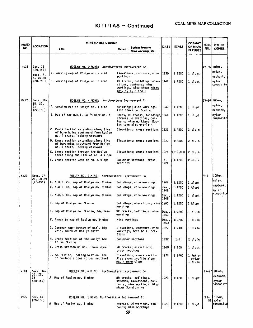
KITTITAS - Continued COAL MINE MAP COLLECTION
INDf:X MINE NAME: O.,..u,r FORMAT
TUBE OTHER NO.
LOCATION Surface features DATE SCALE OFMAPS NO. COPIES Title Details:
Mine workings, etc. IN TUBES
Kt21 Sec. 13 ROSLYN NO. 2 MINE: Northwestern Improvement Co. IV-25 105flln, (20-14E) mylar, secs. 7, A. Working map of Roslyn no. 2 mine Elevations, contours; mine 1939 1:1200 l blupt 8, 16-20 workings map book, (20-lSE} B. Working map of Roslyn no. 2 mine RR tracks, buildings, elev- 1942 1:1200 1 blupt mylar
ations, contours; mine composite workings. Also shows mines nos. 4, 11 6 and 5 ~~
Kt22 Secs. 16- ROSLYN NO. 4 MINE: Northwestern Improvement Co. IV-26 105nm, 18, 20, mylar, 21 A. Working map of Roslyn no. 4 mine Buildings; mine workings. 1947 1:1200 1 blupt (20-lSE) Also shows no. 5 mine mapbook,
B. Map of the N.W.I. Co.'s mine no. 4 Roads, RR tracks, building~ 1960 1:1200 1 blupt mylar streams, elevations, con- composite tours; mine workings. Ros-lyn town plat overlain
c. Cross section extending along line Elevations; cross sections 1921 1:4800 2 blul n of bore holes southward from Roslyn no. 4 shaft, looking westward
0. Cross section extending along line Elevations; cross sections 1921 1:4800 2 bluln of boreholes southward from Roslyn no. 4 shaft, looking eastward
E. Cross section through the Roslyn Elevations; cross sections 1924 1:12,000 2 bl ul n field along the line of no. 4 slope
F. Cross section west of no. 4 slope Columnar sections, cross c. 1:1200 2 bluln sections 1921
Kt23 Secs. 17- ROSLYN NO. 9 MINE: Northwestern Improvement Co. V-5 105nwn, 21, 28-29 mylar, (20-lSE) A. N.W.I. Co. map of Roslyn no. 9 mine Buildings; mine workings 1947 1:1200 1 blupt
B. N.W.I. Co. map of Roslyn no. 9 mine Buildings; mine workings Jan., 1:1200 1 blupt mapbook,
1949 mylar C. N.W. I. Co. map of Roslyn no. 9 mine Buildings; mine workings Dec., 1:1200 1 blupt
compositE
1949 D. Map of Roslyn no. 9 mine Buildings, elevations; mine 1963 1:1200 l blupt
worlcings E. Map of Roslyn no. 9 mine, Big Seam RR tracks, buildings; mine Dec., 1:1200 1 bluln
workings 1963 F. Annex to map of Roslyn no. 9 mine Mine workings Dec., 1:1200 l bluln
1963 G. Contour map- bottom of coa 1, big Elevations, contours; mine 1927 1:2400 1 bl kl n
vein, south of Roslyn shaft workings, bore hole loca-tions
H. Cross sections of the Roslyn bed Columnar sections 1932 1:6 2 bluln at no. 9 mine
I. Cross section of no. 9 mine dome RR tracks,· elevations; 1940 1:600 1 blupt cross sections
J. no. 9 mine, lookin{ west on line Elevations; cross section. 1978 1 :2400 l ink on of haulage slopes cross section) Also shows profile along mylar
no. 4 mine slope 1 bluln
Kt24 Secs. 14- ROSLYN NO. 6 MINE: Northwestern Improvement Co. IV-27 105nm, 16, 22, mapbook, 23 A. Map of Roslyn no. 6 mine RR tracks, buildings, 1923 1:1200 1 bl upt (20-lSE} streams, elevations, con- mylar
tours; mine workings. Also composite shows Sunmit mine
Kt25 Sec. 16 ROSLYN NO. 1 MINE: Northwestern Improvement Co. III- 105mn, (20-lSE) 58 mylar
A. Map of Roslyn no. 1 mine Streams, elevations, con- 1923 1:1200 l bl upt composite tours; mine workings
59
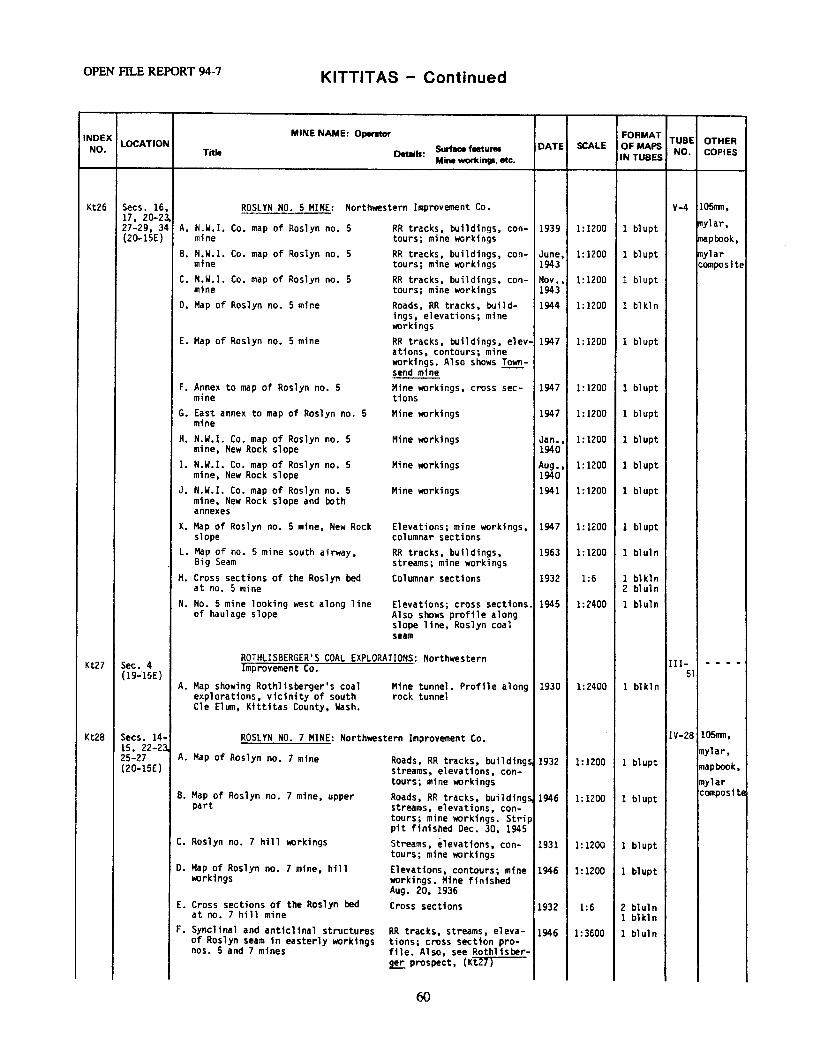
OPEN FILE REPORT 94-7 KITTITAS - Continued
INDEX MINE NAME: Operator FORMAT TUBE OTHER NO.
LOCATION Surface faetures DATE SCALE Of MAPS NO. Title Details: IN TUBES COPIES
Mine workings, etc.
Kt26 Secs. 16, ROSLYN NO. 5 MINE: Northwestern Improvement Co. V-4 105nm, 17., 20-23. 111ylar, 27-29, 34 A. N.W.I. Co. map of Roslyn no. 5 RR tracks, buildings, con- 1939 1:1200 1 blupt (20-lSE) mine tours; mine workings lrnapbook,
B. N.W.I. Co. map of Roslyn no. 5 RR tracks, buildings, con- June, 1:1200 1 blupt mylar mine tours; mine workings 1943 composite
C. N.W. I. Co. map of Roslyn no. 5 RR tracks, buildings, con- Nov., 1:1200 1 blupt mine tours; mine workings 1943
D. Map of Roslyn no. 5 mine Roads, RR tracks, build- 1944 1:1200 1 bl kl n ings, elevations; mine workings
E. Map of Roslyn no. 5 mine RR tracks, buildings, elev- 1947 1:1200 1 bl upt at1ons, contours; mine workings. Also shows Town-send mine ~-
F. Annex to map of Roslyn no. 5 Mine workings, cross sec- 1947 1:1200 1 blupt mine tions
G. East annex to map of Roslyn no. 5 Mine workings 1947 1:1200 1 blupt mine
H. N.W.I. Co. map of Roslyn no. 5 Mine workings Jan., 1:1200 1 blupt mine, New Rock slope 1940
I. N.W.I. Co. map of Roslyn no. 5 Mine workings Aug., 1:1200 1 blupt mine, New Rock slope 1940
J. N.W.I. Co. map of Roslyn no. 5 Mine workings 1941 1:1200 1 blupt mine, New Rock slope and both annexes
K. Map of Roslyn no. 5 mine, New Rock Elevations; mine workings, 1947 1:1200 1 blupt slope columnar sections
L. Map of no. 5 mine south airway, RR tracks, buildings, 1963 1:1200 1 bluln Big Seam streams; mine workings
M. Cross sections of the Roslyn bed Columnar sections 1932 1:6 1 blkln at no. 5 mine 2 bluln
N. No. 5 mine looking west along line Elevations; cross sections. 1945 1:2400 1 bluln of haulage slope Also shows profile along
slope line, Roslyn coal seam
Sec. 4 ROTHLISBERGER'S COAL EXPLORATIONS: Northwestern III- - - - -Kt27 Improvement Co.
(19-15E) 51 A. Map showing Rothlisberger's coal Mine tunnel. Profile along 1930 1:2400 1 blkln
explorations, vicinity of south rock tunnel .. Cle Elum, Kittitas County, Wash.
Kt28 Secs. 14- ROSLYN NO. 7 MINE: Northwestern Improvement Co. IV-28 105mn, 15, 22-2l mylar, 25-27 A. Map of Roslyn no. 7 mine Roads, RR tracks, buildings 1932 1:1200 1 blupt (20-lSE) streams, elevations, con- mapbook,
tours; mine workings mylar 8. Map of Roslyn no. 7 mine, upper Roads, RR tracks, buildings
part streams, elevations, con-1946 1:1200 1 blupt
composite
tours; mine workings. Strip pit finished Dec. 30, 1945
C. Roslyn no. 7 hill workings Streams, elevations, con- 1931 1: 1200 1 blupt tours; mine workings
o. Map of Roslyn no. 7 mine, hil 1 Elevations, contours; mine 1946 1: 1200 1 blupt workings workings. Mine finished
Aug. 20, 1936 E. Cross sections of the Roslyn bed Cross sections 1932 1:6 2 bluln
at no. 7 hill mine 1 blkln F. Synclinal and anticlinal structures RR tracks, streams, eleva- 1946 1:3600 1 bl ul n
of Roslyn seam in easterly workings tions; cross section pro-nos. 5 and 7 mines file. Also, see Rothlisber-
9!!. prospect, (Kt27)
60
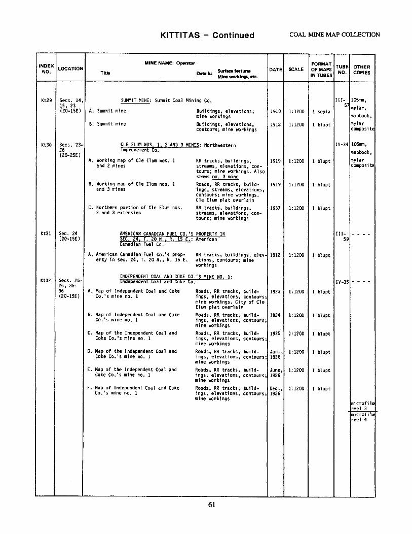
KITTITAS - Continued COAL MINE MAP COLLECTION
INDEX MINE NAME: Operator FORMAT TUBE OTHER
NO. LOCATION Surface ftetures DATE SCALE OF MAPS
NO. COPIES Title 091:ails: Mine workings, etc. IN TUBES
Kt29 Secs. 14, SUMMIT MINE: Sunmit Coal Mining Co. III- 10Smn, 15, 23 Sj mylar, (20-15E) A. Sunmit mine Buildings, elevations; 1910 1:1200 l sepia
mine workings mapbook, B. Sunmi t mine Buildings, elevations, 1918 1:1200 1 blupt mylar
contours; mine workings composite
KtJO Secs. 23- CLE ELUM NOS. 12 2 AHO 3 MINES: Northwestern IV-34 105nm, 26 Improvement Co. mapbook, (20-25E)
A. Working map of Cle Elum nos. 1 RR tracks, buildings, 1919 1:1200 1 bl upt mylar and 2 mines streams, elevations, con- composite
tours; mine workings. Also shows no. 3 mine
B. Working map of Cle Elum nos. 1 Roads, RR tracks, build- 1919 1: 1200 1 blupt and 3 mines ings, streams, elevations,
contours; mine workings. Cle Elum plat overlain
C. Northern portion of Cle Elum nos. RR tracks·, buildings, 1937 1: 1200 1 blupt 2 and 3 extension streams, elevations, con-
tours; mine workings
Kt31 Sec. 24 AMERICAN CANADIAN FUEL CO.'S PROPERTY IN III- - - - -(20-lSE) SEC. 24, t. 20 N., R. 15 E.: American 59
Canadian Fuel Co.
A. American Canadian Fuel Co.' s prop- RR tracks, buildings, elev- 1912 1:1200 l blupt erty in sec. 24, T. 20 N., R. 15 E. ations, contours; mine
workings
INDEPENDENT COAL AND COKE CO.'S MINE NO. 1: Kt32 Secs. 25- Independent Coal and Coke Co. IV-35 - - - -26, 35-
36 A. Map of Independent Coal and Coke Roads, RR tracks, build- 1923 1:1200 1 bl upt (20-lSE) Co.'s mine no. 1 1ngs, elevations, contours;
mine workings. City of Cle Elum plat overlain
B. Map of Independent Coal and Coke Roads, RR tracks, build- 1924 1: 1200 1 bl upt Co.'s mine no. l ings, elevations, contours;
mine workings c. Map of the Independent Coal and Roads, RR tracks, build- 1925 1:1200 l blupt
Coke Co.'s mine no. 1 ings, elevations, contours; mine workings
O. Map of the Independent Coal and Roads, RR tracks, build- Jan., 1:1200 1 bl upt Coke Co.'s mine no. 1 ings, elevations, contours; 1926
mine workings E. Map of the Independent Coal and Roads, RR tracks, build- June, l: 1200 1 blupt
Coke Co.'s mine no. 1 ings, elevations, contours; 1926 mine workings
F. Map of Independent Co~l and Coke Roads, RR tracks, build- Dec., 1:1200 1 blupt Co. 1 s mine no. 1 ings, elevations, contours; 1926
mine workings microfilm reel 3 microfi ln reel 4
61
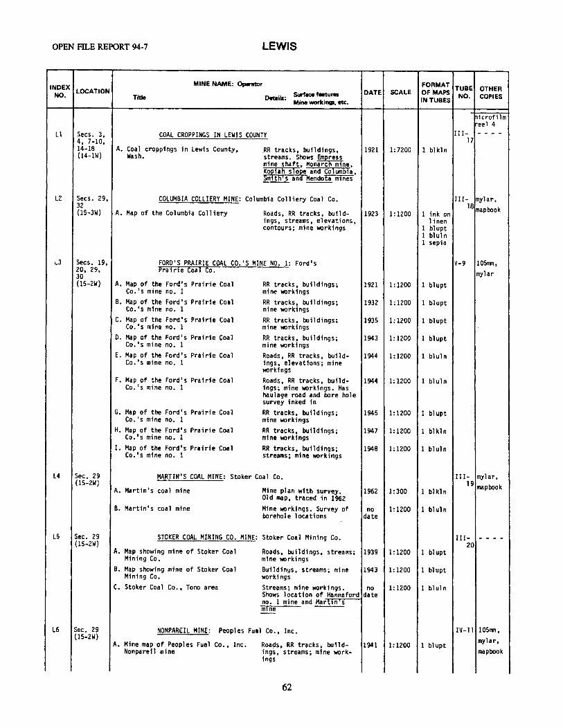
OPEN FILE REPORT 94-7 LEWIS
INDEX MINE NAME: Operator FORMAT TUBE OTHER NO.
LOCATION Surface features DATE SCALE OF MAPS NO. COPIES Title Details: Mine workings, etc. IN TUBES
lnicrofi lm reel 4
Ll Secs. 3, COAL CROPPINGS IN LEWIS COUNTY III- - - - -4, 7-10, 17 14-18 A. Coa 1 croppings in Lewis County, RR tracks, buildings, 1921 1: 7200 1 blkln (14-lW) wash. streams. Shows Emphes1 mine shaft, Monarc m ne,
Kofiah slor and Columbia, Sm th' s an Mendota mines
L2 Secs. 29, COLUMBIA COLLIERY MINE: Columbia Colliery Coal Co. III- mylar, 32 18 mapbook (15-3W) A. Map of the Columbia Colliery Roads, RR tracks, build- 1923 1:1200 1 ink on
ings, streams, elevations, 1 inen contours; mine workings 1 blupt
1 bl ul n 1 sepia
L3 Secs. 19, FORD'S PRAIRIE COAL CO.'S MINE NO. 1: Ford's V-9 105rrm, 20, 29, Pra i ri e Coa 1 Co. mylar 30 (15-2W) A. Map of the Ford's Prairie Coal RR tracks, buildings; 1921 1: 1200 1 blupt
Co. 's mine no. 1 mine workings B. Map of the Ford's Prairie Coal RR tracks, buildings; 1932 1: 1200 1 blupt
Co.'s mine no. 1 mine workings c. Map of the Ford's Prairie Coal RR tracks, buildings; 1935 1:1200 1 blupt
Co.'s mine no. 1 mine workings o. Map of the Ford's Prairie Coal RR tracks, buildings; 1943 1:1200 1 blupt
Co.'s mine no. 1 mine workings E. Map of the Ford's Prairie Coal Roads, RR tracks, build- 1944 1:1200 1 blul n
Co.'s mine no. 1 ings, elevations; mine workings
F. Map of the Ford 1 s Prairie Coal Roa·ds, RR tracks, build- 1944 1:1200 1 bluln Co. ' s mine no. 1 ings; mine workings. Has
haulage road and bore hole survey inked in
G. Map of the Ford's Prairie Coal ~R tracks, buildings; 1945 1:1200 1 bl upt Co.'s mine no. 1 mine workings
H. Map of the Ford's Prairie Coal RR tracks, buildings; 1947 1:1200 1 bl kln Co.'s mine no. 1 mine wrlcings
I. Map of the Ford's Prairie Coal RR tracks, buildings; 1948 1:1200 1 bluln Co.'s mine no. 1 streams; mine workings
L4 Sec. 29 MARTIN'S COAL MINE: Stoker Coa 1 Co. III- mylar, (15-2W) 19 mapbook A. Martin's coal mine Mine plan with survey. 1962 1:300 1 blkln
Old map, traced in 1962 B. Martin's coal mine Mine wrkings. Survey of no 1:1200 1 bluln
borehole locations date
LS Sec. 29 STOKER COAL MINING CO. MINE: Stoker Coal Mining Co. III- - - - -(15-2W) 20
A. Map showing mine of Stoker Coal Roads, buildings, streams; 1939 1:1200 1 blupt Mining Co. mine workings
B. Map showing mine of Stoker Coal Buildings, streams; mine 1943 1:1200 1 blupt Mining Co. worlcings
C. Stoker Coal Co., Teno area Streams; mine workings. no 1:1200 l bluln Shows location of Hannaford date no. 1 mine and Mart1n s mine --
L6 Sec. 29 NONPAREIL MINE: Peoples Fuel Co., Inc. IV-11 105rrm, (15-2W) mylar, A. Mine map of Peoples Fuel Co., Inc. Roa~s, RR tracks, build- 1941 1:1200 1 blupt
Nonpareil mine ings, streams; mine work- mapbook ings
62

LEWIS - Continued COAL MINE MAP COLLECTION
INDEX MINE NAME: ()pentor FORMAT TUBE OTHER NO.
LOCATION Surface features DATE SCALE OF MAPS NO. Title Details: IN TUBES COPIES Mine workings, etc.
L7 Secs. 29, SUPERIOR NO. 2: Superior Coal Co. I II- 105RIT1, 30 22 mylar, (14-2W) A. Plat of Superior Coal Co. 's mine Roads, RR tracks, build- 1920 1:1200 1 blupt
ings, streams, elevations, mapbook contours; mine workings
LB Sec. 28 LEONARD PROPERTY I II- mylar (14-2W} 28
A. Map of the Leonard property RR tracks, streams, eleva- 1917 1:2400 1 bluln tfons, contours. Includes 1 sepia area map: 1:126,720
L9 Sec. 28 RELIANCE COAL MINE: Reliance Coal Co. III- 105nm, (14-2W) 29 mylar, A. Map of Reliance coal mine Roads, RR tracks, build- 1932 1:1200 1 blupt
1ngs, elevations; mine mapbook ""?rkings. Shows Leonard ~
LlO Sec. 33 SHELDON MINE: Sheldon Coal Co. III- mylar, (14-2W) 24 mapbook A. Plat of Sheldon Coal Co.'s mine RR tracks, buildings; mine 1914 1:720 1 blupt
lf«)rkings. Profile map: 1:360
Lll Sec. 22 SALZER VALLEY MINE: King Coal Co. III- mylar, (14-2W) 21 mapbook A. Plan of Salzer Valley King Coal Co. Roads, buildings; 1931 1: 1200 1 bl upt
mine workings
Ll2 Sec. 34 CENTRALIA COAL CO. MINE: Centralia Coal Co. III- mylar, (15-2W) 23 mapbook A. Map of workings in sec. 34, RR tracks, buildings, 1909 1:1200 1 blupt
T. 15 N., R. 2 W. streams; mine workings, cross sections
L13 Sec. 35 CHARLES CHRISTAIN MINE: Hannaford Coal Co. III- mylar, (15-2W) 2~ mapbook A. Diagram of coal mine Buildings; mine diagram 1932 1:1000 1 bl upt
L14 Secs. 16, MONARCH MINE: Monarch Coal Mining Co. V-8 105nm, 17 mylar, (14-lW) A. Map of the Monarch mine RR tracks, buildings; 1922 1: 1200 1 blupt mapbook mine workings
B. Map of the Monarch mine RR tracks, buildings, 1924 streams, elevations, con-
1 :.1200 1 blupt
tours; mine workings C. Map of the Monarch mine RR tracks, buildings, 1927 1: 1200 1 bl upt
streams, elevations, con-tours; mine workings
D. Map of the Monarch mine RR tracks, buildings, 1931 1: 1200 1 bl upt streams, elevations, con- (3 parts) tours; mine workings. Pro-file of main slope; bottom of map contained in two separate pieces
E. Map of the Monarch mine RR tracks, buildings, 1932 1: 1200 1 bl upt streams, elevations, con-tours; mine workings. Pro-file of main slope: 1:600
F. Map of the Monarch mine RR tracks, buildings, streams, elevations, con-
1935 1:1200 1 bl upt
tours; mine workings. Pro-file of main slope: 1:600
63
OPEN FILE REPORT 94-7 LEWIS - Continued
INDEX MINE NAME: Operator FORMAT TUBE OTHER
NO. LOCATION Surface 1-tures DATE SCALE OF MAPS NO. COPIES Title Details:
Mine workings, etc. IN TUBES
Ll4 Secs. 16, MONARCH MINE: Monarch Coal Mining Co.- Continued V-8 l 0Srrm, 17 mylar, (14-lW) G. Map of the Monarch mine RR tracks, buildings, 1936 1:1200 2 blupt
mapbook streams, elevations, con-tours; mine workings. Pro-file of main slope: 1:600
H. Map of the Monarch mine RR tracks, buildings, streams, elevations, con-
1939 1:1200 1 blupt
tours; mine workings. Pro-file of main slope: 1:600
I. Map of the Monarch mine RR tracks, buildings, streams, elevations, con-
1940 1:1200 1 blupt
tours; mine workings. Pro-file of main slope: 1:600
Ll5 Sec. 28 BLACK PRINCE MINE; VICTORY MINE: Black Prince IV-13 10Snln, (15-lW) Coal Co. mylar,
A. Map of the property of the Black RR tracks, buildings; 1930 1:1200 1 blupt mapbook Prince Coal Co. mine workings
B. Map of the Victory mine Buildings, streams; mine 1931 1:1200 1 ink on workings. Shows caved-in bond areas
c. Map of the property of the Black Buildings; mine workings. 1934 1:1200 1 ink on Prince Coal Co. Shows workings of Vlctory bond
mine west of mains ope D. Map of property of Black Prince RR tracks, buildings, 1936 1:1200 1 blupt
Coal Co. streams, elevations; mine workings
E. Map of the property of Black Prince Roads, RR tracks, build- 1943 1:1200 1 blupt Coal Co. 1ngs; mine workings
F. Black Prince Coal Co. Roads, buildings; mine 1953 1:1200 1 blkln workings
ll6 Secs. 28, FREEBURN MINE: Olympia Coal and Minfog Co. IV-14 mylar, 33 mapbook (15-lW) A. Mine map of the Olympia Coal and Roads, ·buildings; mine 1921 1:1200 1 blupt
Mining Co. workings B. Olympia Coal and Mining Co., Pack- Roads, buildings; mine 1922 1:1200 1 blupt
wood, Wa. workings. Includes profile of main slope: 1:600
Ll7 Secs. 9, KOPIAH MINE: Wilson Coal Co. III- 1 OSrnn, 16 25 mylar, (14-lW) A. Wilson Coal Co., Kopiah mine Mine workings 1911 1:1200 1 1 inen
1 blupt mapbook
Ll8 Sec. 34 BELLE SLOPE MINE: Bucoda Coal Mining Co.; I II- mylar (15-lW) K. and K. Coal Mining Co.• 27
A. Map of the Belle mine Roads, streams, elevations. 1944 1:1200 1 bluln contours; mine workings
B. Map of the Belle slope* Roads, streams, elevations 1946 1:1200 1 blkln contours; mine workings
Ll9 Sec. 34 HANNAFORD MINE NO. 3: Bucoda Coal Mining Co. III- - - - -(15-lW} 26 A. Map of the Hannaford mine no. 3 Roads, RR tracks, streams,
elevations, contours; loc-1943 1:2100 2 photo
ation of air course and manway. Drill log included, bore hole locations
64
LEWIS - Continued COAL MINE MAP COLLECTION
INDEX MINE NAME: Operator FORMAT TUBE OTHER NO.
LOCATION Surface features DATE SCALE Of MAPS NO. COPIES Title Details:
Mine workings, etc. IN TUBES
Ll9 Sec. 34 HANNAFORD MINE NO. 3: Bucoda Coal Mining Co. III- - - - -(15-lW) - Continued 26
B. Map of the Hannaford Mine no. 3 Roads, buildings, streams, 1944 1: 1200 1 bluln elevations, contours; mine workings
L20 Secs. 3, MENDOTA COAL ANO COKE CO.'S MINE NO. 1: Mendota IV-12 105111TI, 4, 9, 10 Coal and Coke Co. (14-lW) mylar,
A. Map of Mendota Coal and Coke Co.' s Roads, RR tracks, build- 1914 1: 1200 1 bl upt mapbook mine no. 1 ings, streams; mine work-.
ings. Includes profile of main slope: 1:600
B. Map of Mendota Coal and Coke Co. 1 s Roads, RR tracks, build- 1917 l: 1200 1 bl upt mine no. 1 ings, streams, elevations;
mine workings. Includes profile of main slope: 1:600. Note: shows where psychrometric readings were taken by George wat-kin Evans of Seattle, wa., 6/30/17
c. Map of Mendota Coa 1 and Coke Co.'s Roads, RR tracks, build- 1917 1:2400 1 blkln mine no. 1 ings, streams, elevations;
mine workings. Includes profile of main slope: 1:600. Note: shows where psychrometric readings were taken by George Wat-kin Evans of Seattle, wa., 6/30/17
D. Map of Mendota Coal and Coke Co.' s Roads, RR tracks, buildings 1923 1: 1200 1 bl upt mine no. 1 streams; mine workings.
Includes profiles of no. 1 slope and no. 2 slope, no scale
E. Map of Mendota Coal and Coke Co.'s Roads, RR tracks, build- 1926 1:1200 1 blupt mine no. 1 ings, streams; mine work-
ings. Profile of slope, no scale
l21 Sec. 10 SMITH'S COAL CO. MINE NO. 1 ~a.k.a. KOLGATE KOLE IV-15 mylar (14-lW) C0. 2 Co,,tFO~T CDXL CO., P~rMI ff co~[ CO. or CORES-
TIC COAL CO.): Smith's Coal Co.
A. Map of Smith 1 s Coal Co. mine no. 1 Roads, RR tracks, streams; 1923 1:1200 1 blupt mine workings
B. Map of Smith's Coal Co. mine no. l Roads, RR tracks, build- 1924 1:1200 1 blupt ings, streams; mine work-ings
C. Map of Smith's Coal Co. m1ne no. 1 Roads, RR tracks, build- 1931 1: 1200 1 blupt 1ngs, streams; mine work-ings
D. Map of Smith's Coal Co. mine no. l Roads, RR tracks, build- 1936 1:1200 1 blupt ings, streams; mine work-ings
E. Map of Smith's Coal Co. mine no. 1 Roads, RR tracks, build- 1938 1:1200 1 blupt ings, streams; mine work-ings
F. Map of Smith's Coal Co. mine no. 1 Roads, RR tracks, build- 1939 1:1200 l bl upt ings, streams; mine work-ings
65
OPEN Fll..E REPORT 94-7 LEWIS - Continued
INDEX MINE NAME: Operator FORMAT TUBE OTHER NO.
LOCATION Surface features DATE SCALE OF MAPS NO. COPIES Title Details: Mine workings, etc. IN TUBES
L22 Sec. 10 COLUMBIA COAL co.•s PROPERTY ~OLD SMITH'S MINE}: IV-16 mylar (14-lW) Columbia Coal Co.
A. Col urnbia Coal Co.'s property Roads. buildings; mine 1944 1:1200 1 blupt workings. Note: see L21
B. Map of the Columbia Coal Co. 's Roads, buildings, streams; Jan., 1:1200 1 bl kln mines mine workings 1945
c. Map of the Columbia Coal Co. 's Roads, buildings, streams; Sept. 1:1200 1 blupt mines mine workings 1945
D. Map of the Columbia Coal Co. 's Buildings, streams; mine 1946 1:1200 1 bluln mines workings
E. Map of the Columbia Coal Co. 's Roads, buildings, streams; 1947 1:1200 2 blkln mines mine workings
L23 Secs. 15, TOLEDO COAL MINE: Graham Bros. and Hedley Coal Co. II I- mylar, 22 31 mapbook ( 11-lE) A. Sketch showing preliminary work, Elevations. Shows names of 1943 1:2400 1 bl upt
Graham Bros. and Hedley Coal adjacent property owners
L24 Secs. 22. GOLDEN GLOW COAL MINE: Golden Glow Coal Co. III- mylar, 23 30 mapbook ( 14-2W) A. Location and vertical bearing of Plan of mine workings. 1939 1:1200 1 pencil
Golden Glow coal mine Includes longitudinal sec-tions showing grades
B. Survey of Golden Glow coal mine Buildings; mine plan 1940 1:1200 1 bul pt
L25 Secs. 12, EAST CREEK MINES NOS. 3 AND 4: East Creek Coal Co. IV-17 mylar, 13
mapbook { 14-4E) A. Map of East Creek mines nos. 3 RR tracks, buildings, 1911 1:1200 1 blupt and 4 streams, elevations;
mine workings B. Map of East Creek mines nos. 3 RR tracks, buildings, 1911 1:4800 1 bl ul n
and 4 streams, elevations; mine workings. This map is a reduction of Map A.
L26 Secs. 12, PHOENIX COAL CO. PROPERTIES { OLD EAST CREEK IV-18 10511111, 13 MINES): Phoenix Coal Co. (l4-4E)
A. Map showing surveys on the Phoenix RR tracks, buildings, 1918 1:1200 1 bluln Coal Co.'s properties, Lewis County, streams, elevations, con-Wash, tours; mine workings.
Note: see L25
L27 Secs. 26, CONLEY CREEK COAL MINE: Conley Creek Coal Mining I II- mylar 35 co. 32 (13-4E)
A. Conley Creek coal mine Mine workings 1939 1:600 l blupt
L28 Sec. 34 MORTON COAL ANO COKE CO. HINE: Horton Coal and II I- mylar, (13-4E) Coke Co. 35 mapbook.
A. Map of Morton Coal and Coke Co. Roads, RR tracks, build- 1932 1:1200 2 blupt mine ings; mine workings
8. Map of Morton Coal and Coke Co. Roads, elevations; mine 1939 1:1200 1 bl upt mine workings
L29 Sec. 12 ATLAS COAL MINES 2 INC. MINE: Atlas Coal Mines, Inc. III- mylar, (12-4E} 33 rnapbook A. Atlas Coal Co. tentative plan and Elevations; cross 1939 1:480 1 pencil
profile showing grades 1n tunnel section: 1:48 and gangway, also proposed change in grade
B. Atlas Coal Mines, Inc. Roads, RR tracks, build- 1944 1:3600 1 ink ings, streams, elevations, 1 photo contours; mine workings 2 bl kl n
66
LEWIS - Continued COAL MINE MAP COLLECTION
INDEX MINE NAME: Operator FORMAT TUBE OTHER
NO. LOCATION Surface features DATE SCALE OF MAPS NO. COPIES Title Details: IN TUBES Mine workings, sic.
L29 Sec. 12 ATLAS COAL MINES, INC. MINE: Atlas Coal Mines, III- mylar (12-4E) Inc.- Continued 33
C. Atlas Coal Mines, Inc. Roads, contours; mine work- 1944 1:1200 1 blk1 n ings
L30 Secs. 1, SUMMIT CREEK PROPERTY: White Pass Anthracite III- - - - -12, 13, Coal Co., Inc 34 24, 27, 34, 35 A. Detail of coal outcrops in secs. Roads, buildings, streams, 1942 1: 12,000 l blupt (14-lOE) 1, 12, 13 and 24; longitudinal elevations; cross sections 1 photo
section of coal measure 8. Up to date holdings of White Pass Roads, buildings, streams; 1942 1:12,000 1 blupt
Anthracite Coal Co., Inc. vertical section, east and l photo west through coal. measures: 1:12,000
C. Sketch niap White Pass Anthracite Roads, buildings, streams, 1942 1:2200 1 blupt Coal Co., Inc. elevations; cross sections 1 photo
showing coal seams, pre-sent tunnel and proposed tunnel
LEWIS - THURSTON
LTl All secs. COALFIELDS OF WESTERN LEWIS AND THURSTON I II- - - - -Tps. 14- COUNTIES 37 15, Rs. l-2W, lE A. Coalfields of western Lewis and Roads, RR tracks, build- 1929 1: 24,000 1 blupt
Thurston Counties by George Wat- ings, streams, elevations, kin Evans contours; mine workings.
Shows Superior,~' ~, Mendota, V1ctory
.,~gton Union Coal Co. and Bucoda Coal ~es. Also shows the cfties of Chehalis and Centralia
LT2 Secs. 11- PROPERTY ANO IMPROVEMENTS OF THE WASHINGTON IV-19 - - - -14, 23-26, UNION COAL CO.: Washington Union Coal Co. 35, 36 (15-2W} A. Property and improvements of the Roads, RR tracks, build- 1912 1:27,000 1 blkl n
Washington Union Coal Co. ings, streams; mine work- 1 bluln ings, columnar section of 18' seam, Tono mine (1918)
B. Coal holdings, Tono seam, Washing- Roads, RR tracks, build- pre- 1:12,000 1 bluln ton Union Coal Co. ings, streams; mine work- 1929
ings c. General map showing property and Roads, RR tracks, build- 1929 1:12,000 1 bluln
improvements of the Washington ings Union Coal Co. in Lewis and Thurs-ton Counties
LT3 Secs. 2-5, CENTRALIA COALFIELD I II- - - - -8-11,14-16 36 (14-lW) A. Map of Centralia coalfield showing Roads, RR tracks, streams, 1972 1:12,000 1 bluln secs. 12- strip coal reserves elevations, contours. 13, 24-25 Shows drill holes, out-(15-2W) crops of Big, Little and
Smith seams, faults and secs. 6-9, mined areas 14-32, 26-35(15-lW)
67
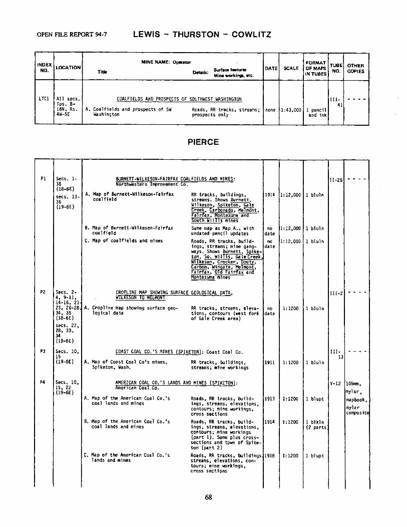
OPEN FILE REPORT 94-7 LEWIS - THURSTON - · COWLITZ
INDEX MINE NAME: Operatar FORMAT TUBE OTHER
NO. LOCATION Surface features DATE SCALE Of MAPS NO. COPIES Title Details:
Mine workings, etc. IN TUBES
LTCl All secs. COALFIELDS AND PROSPECTS OF SOUTHWEST WASHINGTON III- - - - -Tps. 8- 41 16N, Rs. A. Coalfields and prospects of SW Roads, RR tracks, streams; none 1:43,000 1 pencil 4W-SE Washington prospects only and ink
PIERCE
Pl Secs. 1- BURNETT-WILKESON-FAIRFAX COALFIELDS AND MINES: 11-26 - - - -36 Northwestern Improvement Co. (18-6E) secs. 13- A. Map of Burnett-Wilkeson-Fairfax RR tracks, buildings, 1914 1:12,000 1 bluln
coalfield streams .• Shows Burnett, 36 Wilkeson, ~iketon, Gale (19-6E) Creek, Car nado, Melmont, max I Montezuma~ "Soi:i'£'n1Till1s mines
B. Map of Burnett-Wilkeson-Fairfax Same map as Map A., with no 1:12,000 1 bluln coalfield undated pencil updates date
c. Map of coalfields and mines Roads, RR tracks, build- no 1:12,000 1 bluln ings, streams; mine gang- date ways. Shows Burnett, Spikek ton, So. WillTs";Gale Cree • wITkeson, Crocker, ~outy, Carbon, w619a~e, Me mont, f."aTrTa x , a i r'fa"x'aiia Montezuma mines
P2 Secs. 2- CROPLINE MAP SHOWING SURFACE GEOLOGICAL DATA, III-2 - - - -4, 9-11, WILRtSDR TO MtLRDRT 14-16, 21
·23, 26-28! A. Cropline map showing surface geo- RR tracks, streams, eleva- no 1:1200 1 bluln 34, 35 logical data tions, contours (west fork date (18-6E) of Gale Creek area) secs. 27, 28, 33, 34 (19-6E)
P3 Secs. 10, COAST COAL co.•s MINES (SPIKETON): Coast Coal Co. III- - - - -15 13 (19-6E) A. Map of Coast Coal Co's mines, RR tracks, buildings, 1911 1:1200 1 bl ul n
Spiketon, Wash. streams; mine workings
P4 Secs. 10, AMERICAN COAL CO.'S LANDS ANO MINES {SPIKETON): V-12 105nm, 15, 22 American Coal Co.
mylar, (19-6E) A. Map of the American Coal Co. 's Roads, RR tracks, build- 1913 1:1200 1 bl upt mapbook,
coal lands and mines ings, streams, elevations, mylar contours; mine workings,
cross sections composite
B. Map of the American Coal Co.'s Roads, RR tracks, bu i1 d- 1914 1:1200 1 bl kl n coal lands and mines ings, streams, elevations, (2 parts
contours; mine workings (part 1). Same plus cross-sections and tpwn of Spike-ton (part 2}
c. Map of the American Coal Co. 's Roads, RR tracks, buildings 1918 1:1200 l blupt lands and mines streams, elevations, con-
tours; mine workings, cross sections
68
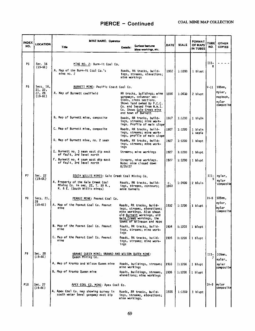
PIERCE - Continued COAL MINE MAP COLLECTION
INDEX MINE NAME: Operinor FORMAT TUBE OTHER NO.
LOCATION Surface features DATE SCALE OFMAPS NO. COPIES Title Details: Mine workings, etc. IN TUBES
PS Sec. 16 MINE NO. 2: Burn-it Coal Co. III- - - - -{19-6E) 8
A. Map of the Burn-it Coal Co. 1s Roads, RR tracks, build- 1932 1:1200 1 blupt mine no. 2 ings, streams, elevations;
mine workings
P6 Secs. 16, BURNETT MINE: Pacific Coast Coal Co. V-11 105nm, 21, 22,
mylar, 27, 28 A. Map of Burnett coalfield RR tracks, buildings; mine 1916 1:3600 2 bl~pt (19-6E) gangways, col1nnar sec- mapbook,
tions, cross sections. mylar Shows land owned by P.C.C. composite Co. and leased from N.W.I. Co. Shows Gale Creek mine and town of Burnett
8. Map of Burnett mine, composite Roads, RR tracks, build- 1917 1: 1200 1 bluln ings, streams; mine work-ings. Profile of main slope
C. Map of Burnett mine, composite Roads, RR tracks, build- 1927 l: 1200 1 bluln ings, streams; mine work- 1 sepia ings, profile of main slope
D. Map of Burnett mine, no. 2 seam Roads, RR tracks, build- 1927 1: 1200 1 bl upt ings, streams; mine work-ings
E. Burnett no. 3 seam east dip east Streams; mine workings 1927 1:1200 1 blupt of fault, 3rd level north
F. Burnett no. 4 seam east dip east Streams, mine workings. 1927 1: 1200 l blupt of fault, 3rd level north Note: mine closed down
8/25/27
P7 Sec. 22 SOUTH WILLIS MINES: Gale Creek Coal Mining Co. III- mylar, (19-6E) 9 mylar A. Property of the Gale Creek Coal Roads, RR tracks, build- c. 1:2400 2 bluln composit.e Mining Co. in sec. 22, T. 19 N., 1ngs, streams, contours; 1903
R. 6 E. (South Willis mines) mine tunnels
PB Secs. 21, PEANUT MINE: Peanut Coal Co. IV-5 105111n, 28 mylar, ( 19-6E) A. Map of the Peanut Coal Co. Peanut Roads, RR tracks, build- 1932 1: 1200 1 blupt mylar mine ings, streams, elevations;
mine workings. Also shows composite old Burnett workings, old Ga 1 e ci=eek workings, the towns of Wil lceson and tt,pe
B. Map of the Peanut Coal Co. Peanut Roads, RR tracks, build- 1934 1:1200 1 b1upt mine ings, streams; mine work-
ings c. Map of the Peanut Coal Co. Peanut Roads, RR tracks, build- 1935 1:1200 1 blupt
mine ings, streams; mine work-ings
pg Sec. 28 KRANKO guEEN MINEi KRANKO AND WILSON QUEEN MINE: III- 105nm, (19-6E) Queen M1ning Co. 7 mylar,
A. Map of Kranko and Wilson Queen mine Roads, buildings, streams; 1933 1: 1200 1 bl upt mylar mine workings compositE
B. Map of Kranko Queen mine Roads, buildings, streams, 1936 1: 1200 1 blupt elevations; mine workings
PIO Sec. 27 APEX COAL CO. MINE: Apex Coal Co. IV-9 mylar (19-6E) composite
A. Apex Coal Co. map showing survey in Roads, RR tracks, build- 1935 1:1200 1 blupt south water level gangway east dip ings, streams, elevations;
mine workings.
69
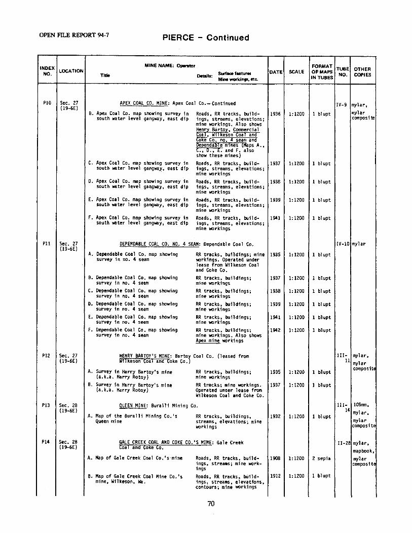
OPEN FD.,E REPORT 94-7 PIERCE - Continued
INDEX MINE NAME: 0,-ator FORMAT TUBE OTHER NO.
LOCATION Surface features DATE SCALE OF MAPS NO. COPIES Title Details: Mine workings, etc. IN TUBES
PlO Sec. 27 APEX COAL CO. MINE: Apex Coal Co.-Continued IV-9 mylar, (19-6E)
mylar 8. Apex Coal Co. map showing survey in Roads, RR tracks, build- 1936 1:1200 1 bl upt south water level gangway, east dip ings, streams, elevations; composii!!
mine workings. Also shows Henry Bartoy, Comnercial coal, ~llkeson toal ana Cciie Co. no.~ seam ana Dependable mines (Maps A., C., D., E. and F. also show these mines)
c. Apex Coal Co. map showing survey in Roads, RR tracks, build- 1937 1:1200 1 bl upt south water level gangwa~, east dip ings, streams, elevations;
mine workings D. Apex Coal Co. map showing survey in Roads, RR tracks, build- 1938 1: 1200 1 blupt
south water level gangway, east dip ings, streams, elevations; mine workings
E. Apex Coal Co. map showing survey in Roads, RR tracks, build- 1939 1:1200 1 blupt south water level gangway, east dip ings, streams, elevations;
mine workings F. Apex Coal Co. map showing survey in Roads, RR tracks, build- 1941 1: 1200 1 blupt
south water level gangway, east dip ings, streams, elevations; mine workings
Pll Sec. 27 DEPENDABLE COAL CO. NO. 4 SEAM: Dependable Coal Co. IV-10 mylar (19-6E)
A. Dependable Coal Co. map showing RR tracks, buildings; mine 1935 1:1200 1 bl upt survey in no. 4 seam workings. Operated under
lease from Wilkeson Coal and Coke Co.
B. Dependable Coal Co. map showing RR tracks, buildings; 1937 1: 1200 l blupt survey 1n no. 4 seam mine workings
c. Dependable Coal Co. map showing RR tracks, buildings; 1938 1: 1200 1 blupt survey in no. 4 seam mine workings
D. Dependable Coal Co. map showing RR tracks, buildings; 1939 1:1200 1 blupt survey in no. 4 seam mine workings
E. Dependable Coal Co. map showing RR tracks, buildings; 1941 1:1200 l blupt survey in no. 4 seam mine workings
F. Dependable Coal Co. map showing RR tracks, buildings; 1942 1:1200 1 blupt survey in no. 4 seam mine workings. Also shows
Apex mine workings
Pl2 Sec. 27 HENRY BARTOY'S MINE: Bartoy Coal Co. {leased from I II- mylar, (19-6E) Wilkeson Coal and Coke Co.) 11 mylar
A. Survey in Harry Bartoy's mine RR tracks, buildings; 1935 1:1200 1 blupt composite
(a.k.a. Harry Rotoy) mine workings B. Survey in Harry Bartoy's mine RR tracks; mine workings. 1937 1:1200 1 blupt
(a.k.a. Harry Rotoy) Operated under lease from Wilkeson Coal and Coke Co.
Pl3 Sec. 28 QUEEN MINE: Burall1 Mining Co. III- 105nm, (19-6E) 14 mylar, A. Map of the Buralli Mining Co.'s RR tracks, buildings, 1932 1: 1200 1 blupt
mylar Queen mine streams, elevations; mine workings composite
Pl4 Sec. 28 GALE CREEK COAL ANO COKE co.•s MINE: Gale Creek II-28 mylar, (19-6E} Coal and Coke Co.
mapbook, A. Map of Gal.e Creek Coal Co. 's mine Roads, RR tracks, build- 1908 1: 1200 2 sepia mylar
ings, streams; mine work- composite 1ngs
B. Map of Gale Creek Coal Mine Co.'s Roads, RR tracks, build- 1912 1: 1200 1 blupt mine, Wilkeson, Wa. ings, streams, elevations,
contours; mine workings
70
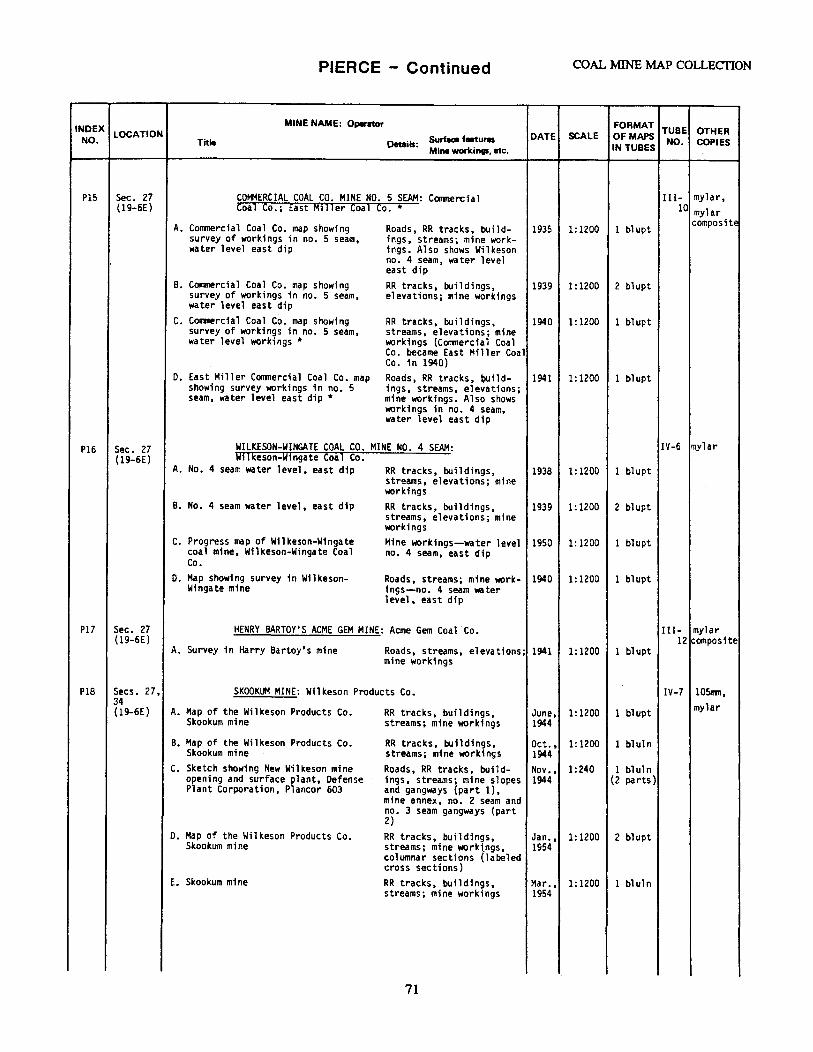
PIERCE - Continued COAL MINE MAP COLLECTION
INDEX MINE NAME: Operator FORMAT TUBE OTHER NO.
LOCATION Surface features DATE SCALE OFMAPS NO. COPIES Title Details: IN TUBES Mine workings, etc.
PIS Sec. 27 Cat+IERCIAL COAL CO. MINE NO. 5 SEAM: Coomercial Ill- mylar, {19-6E) Coal Co.; East M111er Coal Co.* 10 mylar
A. Commercial Coal Co. map showing Roads, RR tracks, build- 1935 1:1200 1 bl upt composite
survey of workings in no. 5 seam, ings, streams; mine work-water level east dip ings. Also shows Wilkeson
no. 4 seam, water level east dip
B. Commercial Coal Co. map showing RR tracks, buildings, 1939 1:1200 2 blupt survey of workings in no. 5 seam, elevations; mine workings water level east dip
C. Corrmercial Coal Co. map showing RR tracks, buildings, 1940 1:1200 1 blupt survey of workings in no. 5 seam, streams, elevations; mine water level workings* workings (Conmercial Coal
Co. became East Miller Coal Co. in 1940)
0. East Miller Commercial Coal Co. map Roads, RR tracks, build- 1941 1:1200 1 bl upt showing survey workings in no. 5 ings, streams, elevations; seam, water level east dip* mine workings. Also shows
workings in no. 4 seam, water level east dip
P16 Sec. 27 WILKESON-WINGATE COAL CO. MINE NO. 4 SEAM: IV-6 mylar (19-6E) Wilkeson-Wingate Coal Co.
A. No. 4 seam water level, east dip RR tracks, buildings, 1938 1:1200 1 bl upt streams, elevations; mine workings
B. No. 4 seam water level, east dip RR tracks, buildings, 1939 1:1200 2 bl upt streams, elevations; mine workings
C. Progress map of Wilkeson-Wingate Mine workings-water level 1950 1: 1200 1 bl upt coal mine, Wilkeson-Wingate Coal no. 4 seam, east dip Co.
0. Map showing survey in Wilkeson- Roads, streams; mine work- 1940 1:1200 1 blupt Wingate mine ings-no. 4 seam water
level, east dip
Pl7 Sec. 27 HENRY BARTOY'S ACME GEM MINE: Acme Gem Coal Co. III- mylar (19-6£) 12 composite
A. Survey in Harry Bartoy's mine Roads, streams, elevations; 1941 1:1200 1 bl upt mine workings
Pl8 Secs. 27, SKOOKUM MINE: Wilkeson Products Co. IV-7 105nm, 34 mylar (19-6E) A. Map of the Wilkeson Products Co. RR tracks, buildings, June, 1:1200 1 blupt
Skookum mine streams; mine workings 1944
B. Map of the Wilkeson Products Co. RR tracks, buildings, Oct., 1: 1200 1 bluln Skookum mine streams; mine workings 1944
C. Sketch showing New Wilkeson mine Roads, RR tracks, build- Nov., 1:240 1 bl ul n opening and surface plant, Defense ings, streams; mine slopes 1944 (2 parts) Plant Corporation, Plancor 603 and gangways (part 1),
mine annex, no. 2 seam and no. 3 seam gangways {part 2)
o. Map of the Wilkeson Products Co. RR tracks, buildings, Jan., 1:1200 2 bl upt Skookum mine streams; mine worktngs, 1954
columnar sections (labeled cross sections)
E. Skookum mine RR tracks, buildings, Mar., 1:1200 1 bl ul n streams; mine workings 1954
71
OPEN FILE REPORT 94-7 PIERCE - Continued
INDEX MINE NAME: 0.,.ator FORMAT TUBE OTHER NO.
LOCATION Surface feetuNII DATE SCALE Of MAPS NO. Title Details: IN TUBES COPIES Mine workings, etc.
Pl9 Sec. 28 KELLY COAL CO.'S MINE: Kelly Coal Co.; Wilkeson IV-8 mapbook, (19-6E) Miller Coal Co.* mylar
A. Kelly Coal Co. Roads, RR tracks, build- 1938 1:1200 1 bl upt composite ings, streams; mine work-ings. Shows Acme Gem mine
B. Kelly Coal Co. Roads, RR tracks, build- 1939 1: 1200 2 blupt ings, streams; mine work-ings. Shows Acme Gem mine
C. Kelly Coal Co. (Wilkeson-Miller Roads, RR tracks, build- 1940 1: 1200 1 blupt Coal Co. written in red pencil on 1ngs, streams; mine work-map)* ings
D. Kelly Coal Co. (Wilkeson-Miller Roads, RR tracks, build- 1941 1:1200 1 blupt Coal Co. written in red pencil on ings, streams; mine work-map)* ings
E. Kelly Coal Co. Roads, RR tracks, build- 1942 1: 1200 1 blupt ings, streams, elevations; mine workings
P20 Secs. 2- MELMONT-WILKESON-CARBONADO AREA: Pacific Coast 11-27 - - - -4, 9-11, Steel Co. 14-16 (18-6E) A. Map prepared to accompany report of Roads, RR tracks, streams, 1924 1:6000 1 pencil secs. 33, M.C. Butler, Oct. 27, 1923 elevations, contours; 1 bluln 34 cross sections E-W along (19-6E) center line of secs. 9,
10 and 11. Shows project-ed coal subcrops, struc-ture, extent of under-ground workings of some mines
B. Sections of seams in prospects on Descriptions of coal seam 1923 n/a l blkln part of T. 18 N., R. 6 E. sections in tabular form:
seam no., strike-dip, coal seam lithology
P21 Secs. 2- CARBONADO-WILKESON COALFIELDS AND MINES V-10 - - - -s. 8-11, 14-17 A. Map of Electric mine; map of Crocker Roads, RR tracks, build- 1915 1: 1200 l blupt (l8-6E) mine; map of Douty mine; map of ings, streams; mine work-secs. 27- Wingate mine fogs 28, 32- B. Map showing portion of Wilkeson- Roads, RR tracks, build- 1916 1:6000 1 bluln 34 Carbonado coalfield ings, streams; mine work-(19-6E) ings
C. Map of Carbonado-Wilkeson coalfield Roads, RR tracks, build- 1922 1:4800 1 bl uln showing the Carbon Hill, Wilkeson ings, streams, elevations; and Melmont mines. (also Electric, coal field outcrops and Crocker, Wingate, Miller and Douty) and gangways
D. Map of Carbonado-Wilkeson coalfield Roads, RR tracks, build- 1923 1:4800 2 bl ul n showing the Carbon Hill, Wilkeson ings, streams, elevations; and Helmont mines {same as Map C.) mine gangways
P22 Secs. 3, WILKESON MINES: Wilkeson Coal and Coke Co. V-15 105mn, 4 mylar, (18-6E) A. Map showing mines of Wilkeson Coal Roads, RR tracks, build- 1939 1:4800 1 blupt secs. 27, and Coke Co. in sec. 3, Tps. 18- ings, streams; mine work- map book,
28, 34 19 N., R. 6 E. ings. Also shows~ mylar (19-6E) ~ Gale creek coaJ composite
and Coke Co., Tacoma coal and Coke co,. ~ ~-~ and cmerciaJ mines
72
PIERCE - Continued COAL MINE MAP COLLECTION
INDEX MINE NAME: Operator FORMAT TUBE OTHER
NO. LOCATION Surface features DATE SCALE Of MAPS NO. COPIES Title Details: IN TUBES Mine workings, etc.
P22 Secs. 3, WILKESON MINES: Wilkeson Coal and Coke Co.-Continued V-15 105ll'lll, 4 mylar (18-6E) B. Wilkeson area composite Roads, RR tracks, build- 1939 1:4800 l bl u1 n
secs. 27, ipgs, streams; mine work-ings. Shows Dependable,
28, 34 Wilkeson-Wingate, RCnrl (19-6E) ~rto~, tommerc,al oa _, onato and Apex mines
c. Map of the Wilkeson coal mine prop- Roads, RR tracks, build- , 1943 1:1200 1 blupt erty of the Wilkeson Coal Co. ings, streams; mine work- l bluln
ings. Copy l includes annex to map. Shows~. Dependable and Bartoy mines
D. (Slope) S.W. no. 2 gangway, Wilkeson Mine workings 1920 1:1200 1 blupt Coal and Coke Co.
E. (Slope) S.W. no. 2 gangway, Wilkeson Coal and Coke Co.
Mine workings 1923 1:1200 1 blupt
F. Developments on southwest nos. 2, and 7- 2nd level
3 Mine world ngs 1925 1:600 1 bl upt
G. Developments on southwest nos. 2, 3 Mine workings 1929 1:2400 l blupt and 7- 2nd level
H. Developments on southwest nos. 2, and 7-2nd level
3 Mine workings 1931 1:2400 1 blupt
I. Cross sections of coal seams, Wilke- Columnar sections. All 1930 1:24 l blkln son mines, Wilkeson Coal Co. sections measured and sam-
pled in active workings on 2nd level
J. Wilkeson Coal and Coke Co. Roads, buildings, streams, 1934 1:1200 l blupt elevations; mine workings
K. Map showing survey in different RR tracks, buildings, 1935 1:1200 1 blupt seams of coal in relation to topo- streams; mine workings. graphy along Gale Creek, also loca- Shows Aped, Dependable, tion of leased properties Bartoy an Conmercial
mrnes L. Map showing survey in different RR tracks, buildings, 1937 1:1200 1 bl upt
seams of coal in relation to topo- streams; mine work;ngs. graphy along Gale Creek, also loca- Shows Aped, Dependable, tion of leased properties Bartoy an Conmerda 1
mines
P23 Secs. 3, BONATO COAL co.•s MINE: Bonato Coal Co. IV-4 mylar 4 compositE (18-6E) A. Map showing survey in Miller seam Roads, buildings, streams, 1935 1:1200 1 bl upt secs. 33, slope, west dip elevations; mine workings.
Also shows Wilkeson no. 4 34 seam gangway. Mine opera-(19-6E) ted under lease from Wil-keson Coal and Coke Co.
B. Map showing survey in Miller seam Roads, buildings, streams, 1936 1:1200 1 blupt slope, west dip elevations; mine workings.
Maps B. through E. have the same infonnation as Map A.
C. Map showing survey in Miller seam Roads, buildings, streams, 1937 1:1200 1 blupt slope, west dip elevations; mine workings
D. Map showing survey in Miller seam Roads, buildings, streams, 1939 1:1200 1 bl upt slope, west dip elevations; mine workings
E. Map showing survey in Miller seam Roads, buildings, streams, 1940 1:1200 1 bl upt slope, west dip elevations; mine workings
73
OPEN FILE REPORT 94-7 PIERCE - Continued
INDEX LOCATION NO.
P24
P25
Secs. 3-5, 8-10, 16, 17 (18-6E) secs. 32, 33 (19-6E}
Secs. 4, 9 (18-6E)
MINE NAME: Operator
Title o.taill: Surface features Mine worldngs, etc.
DATE SCALE FORMAT TUBE OTHER OF MAPS IN TUBES NO. COPIES
CARBON HILL COAL CO.'S MINES: Carbon Hill Coal Co. II-29i 105nm,
1910 no scale 2 bluln II-30 mylar, mapbook
A. Northwestern Improvement Co. bed sections to accompany report on Carbon Hill Coal Co. mines
B. Map of the Carbon Hill Coal Co.'s mine showing the water level workings, also a preliminery structure map showing relative positions of various beds on water level datum
C. Cross section along synclinal axis East Carbonado Basin
O. Map of southern portion coalfield water level datum
E. Geologic map of North mines
F. Map of Carbonado mine- north part
G. Map of Carbonado mine- south part
H. Map of Carbonado mine
I. Map of Carbonado mine
J. Map of Carbon Hill Coal Co. North I mine
K. Map of Carbon mine no. 7
L. Map of Carbon mine no. 7
Columnar sections
Streams; mine workings. c. 1:4800 1 blkln Map by George Watkin Evans. This map appears 1n a 1923 Evans report on property of the Carbon Hill Coal Co. without the structure
1923
Cross sections no 1:4800 1 bluln date
RR tracks, streams; mine gangways
1920 1:2400 1 blkln
RR tracks, buildings; mine 1923 workings, cross sections (part 1). Streams, colum-nar sections (part 2) Roads, RR tracks, streams; 1919 mine workings- no. 7 bed, 1st level and no. 10 bed, 1st level Roads; mine workings- bot- 1919 tom ha 1 f of no. 10 bed Roads, RR tracks, streams; 1920 mine workings- no. 7 bed, 1st level and no. 10 bed, 1st level Roads, RR tracks, streams, 1923 elevations; mine workings no. 7 bed, ,first level and no. 10 bed, first level Buildings, streams; mine 1913 workings Roads, RR tracks, streams; 1920 mine workings Roads, RR tracks, streams; 1921 mine workings
1: 1200 1 blupt (2 parts}
1:1200 1 blupt
1: 1200 l bl upt
1:1200 1 blupt
1:1200 1 blupt 2 bl ul n 2 septa
1: 1200 2 bl ul n 2 sepia
1:1200 l blupt
1:1200 1 bluln 1 sepia
CARBONADO MINE: Pacific Coast Coal Co. Il-31. 105nm,
A. Map of Carbonado mine no. 4 seam
B. Map of Carbonado mine no. 4 seam
C. Map of Carbonado mine no. 4 seam
0. Map of Carbonado mine no. 4 seam
E. Map of Carbonado mine no. 4 seam
F. Map of Carbonado mine no. 4 seam
G. Map of Carbonado mine no. 4 seam
H. Map of Carbonado mine no. 7 seam
Roads, RR tracks, streams, elevations, contours; mine workings
1929 1:1200 1 blupt II-32 mylar, mapbook, mylar
Roads, RR tracks, buildings, streams, elevations, contours; mine workings
1930 1:1200 l bl upt compos 1 tE
Roads, RR tracks, buildings, streams, elevations, contours; mine workings
1931 1:1200 l bl upt
Roads, RR tracks, streams, 1932 1:1200 l blupt elevations, contours; mine workings RR tracks, streams, eleva- 1933 1:1200 1 blupt tions, contours; mine work-ings Roads, RR tracks, build- 1936 1:1200 1 blupt ings, streams, elevations, contours; mine workings Roads, RR tracks, build- 1937 1:1200 1 blupt ings, streams, elevations, contours; mine workings Streams, elevations, con- 1938 1:1200 1 blupt tours; mine workings
74
PIERCE - Continued COAL MINE MAP COLLECTION
INDEX MINE NAME: Operator FORMAT TUBE OTHER
NO. LOCATION Surface features DATE SCALE OF MAPS NO. COPIES Title Details:
Mine workings, etc. IN TUBES
P25 Secs. 4, CARBONADO MINE: Pacific Coast Coal Co.-Continued II-3L 105mm, 9 II-32 mylar, (18-6E) J. Study map of Carbonado no. 8 bed, Mine workings 1928 1:480 1 bl ul n
1st and 2nd level 1 sepia mylar J. Map of Carbonado mine no.
(old Douty mine) 9 seam Mine workings 1934 1:1200 1 blupt composite
K. Map of Carbonado mine no. 9 seam Mine workings 1935 1:1200 1 blupt L. Map of Carbonado mine no. 9 seam Mine workings 1936 1:1200 1 blupt M. Map of Carbonado mine no. 9 seam Mine workings 1937 1: 1200 1 blupt N. Map of Carbonado mine Morgan seam Roads, RR tracks, build- 1929 1: 1200 1 blupt
ings, streams, elevations, contours; mine workings
0. Map of Carbonado mine Morgan seam RR tracks, streams, eleva- 1937 1:1200 1 bl upt tions, contours; mine work-ings. Note: mine closed March 15, 1937
P26 Sec. 4 CARBONADO MINE: Strain Coal Co. III- mylar
(18-6E) 5 composite
sec. 33 A. Strain Coal Co. Carbonado mine Buildings, elevations, 1938 1:1200 1 blupt (19-6E) contours; mine workings
P27 Sec. 5 CROCKER MINE: Carbon Hil 1 Coal Co. II-34 105mm, {18-6E) mylar, secs 32, A. Map of Crocker mine RR tracks; mine workings 1914 1:1200 1 blupt mapbook 2 bl ul n 33 2 sepb (19-6E)
P28 Secs. 5, WINGATE MINE: Carbon Hill Coal Co. II-35 105mm,
8, 9, 16, mylar, 17 A. Map of Wingate mine no. 11 bed, (18-6E} 4th level south
Mine workings 1920 1:1200 1 blupt mapbook
B. Wingate mine Mine workings 1921 1:1200 2 bl ul n 2 sepia
P29 Secs. 4, WINGATE MINE ANO CROCKER MINE {COMPOSITE~: II-33 105mm, 5 Carbon Hill Coal Co. mylar, (18-6E) secs. 32, A. Map of Wingate mine; map of Crocker Roads, RR tracks, build- 1919 1: 1200 1 bl upt mapbook
33 mine ings, streams; mine work-(19-6E) 1ngs
B. Map of Crocker mine; map of Wingate Roads, RR tracks, build- 1921 1:1200 2 bluln" mine ings, streams; mine work- 2 sepia
ings
P30 Secs. 5, MILLER MINE: Carbon Hill Coal Co. II-36 105mm, 8 mylar, (18-6E) A. Map of Miller mine Streams; mine workings 1919 1:1200 1 blupt
B. Map of Miller mine Streams; mine workings Jan., 1:1200 1 bl ul n mapbook
1920 1 sepia C. Map of Miller mine Streams; mine workings Feb., 1:1200 l blupt
1920 l bluln· l sepia
P31 Sec. 4 ELECTRIC MINE: Carbon Hill Coal Co.; Pacific III- - - - -(18-6E) Coast Coal Co.* 6
sec. 33 A. (Fragment) no. 11 seam in sec. 33 Mine workings 1919 1:1200 1 blupt (19-6E)
B. Map of Electric mine Roads, RR tracks, streams, 1925 1:1200 1 blkln elevations, contours; mine workings. Also shows west side of Douty mine
75
OPEN FILE REPORT 94-7 PIERCE - Continued
INDEX MINE NAM,E: ()p9nnor FORMAT
TUBE OTHER NO.
LOCATION Surface features DATE SCALE Of MAPS NO. COPIES Title Details:
Mine workinos, etc. IN TUBES
P31 Sec. 4 ELECTRIC MINE: Carbon Hil 1 Coal Co.; Pacific III-6 - - - -(18-6E) Coast Coal Co.* sec. 33 c. Map of Electric mine* Roads, RR tracks, build- 1937 1: 1200 1 sepia (19-6E) ings, streams, elevations,
contours; mine workings. Note: mine closed 1937
P32 Secs. 3, DOUTY MINE: Carbon Hill Coal Co.; Pacific Coast IV-1 105nm, 4, 9 Coal Co. * mylar, (18-6E)
A. Map of Douty mine Mine workings 1919 1:1200 2 blupt mylar B. Map of Douty mine Mine workings. Depicts dif- 1919 1:1200 1 blupt composite
ferent seam than Map A~ C. Map of Douty mine* Roads, RR tracks, build-
ings, streams, elevations, 1937 1:1200 1 sepia
contours; mine workings D. Map and sections of Douty crosscut Cross sections 1922 1:1200 1 bluln
and north prospect tunnel 1 sepia
P33 Secs. 3, ELECTRIC ANO DOUTY MINES: Carbon Hill Coal Co.; V-14 105mn,. 4, 9 Pacific Coast Coal Co. *
mylar, (18-6E) A. Map of Electric mine; map of Douty Roads, RR. tracks, build- 1919 1:1200 2 blupt mapbook.
mine 1ngs, streams. elevations; mylar mine workings composite
B. Map of Douty mine; map of Electric Roads, RR tracks, build- 1922 1:1200 l blupt mine ings, streams, elevations,
contours; mine workings c. Map of Douty mine; map of Electric Roads, RR tracks, build- 1927 1:1200 1 blupt
mine* ings, streams, elevations, contours; mine workings
D. Map of composite no. 8 seam Douty RR tracks, buildings, 1928 1:1200 1 blupt mine; map of Electric mine* streams, elevations, con-
tours; mine workings E. Map of Electric mine; map of Douty Roads, RR tracks, streams, Jan., 1:2600 1 blkl n
mine * buildings, elevations, con- 1929 tours; mine worki_ngs
F. Map of Electric mine; map of Douty RR tracks, buildings, Apr., 1:1200 1 blupt mine no. 8 seam* streams, elevations. con- 1929
tours G. Map of Douty mine; map of Electric Roads,. RR tracks, streams, 1930 1:1200 1 blupt
mfoe * elevations, contours; mine workings
H. Map of Electric mine; map of Douty Roads, RR tracks, build- 1931 1:1200 1 blupt mine * ings, streams, elevations,
contours; mine workings I. Map of Electric mine; map of Douty Roads, RR tracks, build- 1932 1:1200 1 blupt
mine * ings, streams, elevations, contours; mine workings
J. Map of Electric mine; map of Douty Roads, RR tracks, build- 1933 1:1200 1 blupt mine * ings, streams, elevations,
contours; mine workings K. Map of Electric mine; map of Douty* Roads, RR tracks, build- 1935 1:1200 1 blupt
mine (both are 2nd level no. 8 seam) ings, streams, elevations, contours; mine workings
L. Map of Electric mine; map of Douty Roads, RR tracks, streams, 1936 1:1200 1 blupt mine * elevations, contours; mine
workings M. Map of Electric mine; map of Douty Roads, RR tracks, build- 1937 1:1200 1 blupt
mine * ings, streams, elevations, 1 bl ul n contours; mine workings. Note: mine closed down March 15, 1937
76
PIERCE - Continued COAL MINE MAP COLLECTIO?
INDEX MINE NAME: Operator FORMAT TUBE OTHER NO.
LOCATION Surface features DATE SCALE Of MAPS Title De1ails: NO. COPIES
Mine workings, etc. IN TUBES
P34 Secs. 9, MELMONT MINE: Northwestern Improvement Co. V-16 105nm, 15, 16, mylar, 21, 22 A. Working map of the Melmont mine RR tracks, buildings, 1910 1:1200 l bl upt (18-6E) streams; mine workings mapbook,
B. Map of Carbonado and Melmont mines Roads, RR tracks, build- 1911 1:6000 2 bl ul n mylar 1ngs, streams; mine work- composite ings. Also see Carbonado mine (P25)
c. Working map of the Melmont mine Roads, RR tracks, build- 1913 1:1200 I blkln ings, streams; mine work-ings
D. Working map of the Melmont mine Roads, RR tracks, build- 1915 1:1200 1 bl ul n ings, streams, elevations; mine workings
E. Cross section Blossburg rock tunnel Cross section 1902 1:120 1 blupt F. Cross section Blossburg rock tunnel Cross section 1912 1:360 1 blupt G. Cross section on line of rock Streams; cross section 1913 1:600 2 blupt
tunnel, Melmont mine H. Cross section of measures along Cross sections 1920 1:1200 1 blupt
line of Melmont tunnel I. Melmont mine rock tunnel Cross sections no 1:600 1 blupt
date J. Carbon Hill Coal Co. cross sec- Cross sections no 1:2400 2 photo
t1on through Melmont property date 170' north of schoolhouse
K. Preliminary structure section along Cross sections no 1:1200 1 bl kln line of Melmont mine rock tunnel date
P35 Sec. 14 NORTHWESTERN IMPROVEMENT CO. PROSPECT HOLES AND III-1 - - - -(18-6E) PROPOSED DEVELOPMENT AREA: Northwestern Improve-ment Co.; Wilkeson-Tripp Co.
A. Northwestern Improvement Co. coal Streams, elevations. Coal 1909 1:1200 1 bluln prospect holes prospect holes and surface
survey B. Cross section of veins in Gale RR tracks, buildings, no 1:4100 1 bl kl n
Creek area, map of proposed deve- streams; cross sections. date 1 opment area Seams, prospect pits
and croppings
P36 Secs. 23, FAIRFAX MINE {OLD): Tacoma Smelting Co. IV-2 105nm, 26, 35 mylar, (18-6E) A. Map of Fairfax mine Mine workings from Tacoma 1910 1: 1200 1 bluln
Smelting Co.'s data. Gen- mapbook eral surveys by N.W.I. Co.
B. Map of the Tacoma Smelting Co. Buildings; mine workings 1912 1:600 1 bluln Fairfax mine
c. Tacoma Smelter preliminary map RR tracks, streams; sur- 1923 1:1200 1 bluln vey of old mine workings microfilm
reel 4 reel :>
P37 Sec. 2 FAIRFAX MINE (NEW): Tacoma Smelting Co. (American V-13 105nm, {17-6E) Smelting Co.); Fairfax Mine Co.* mylar, secs. 27, A. Hap of sec. 34 mine, Fairfax, Wa. Elevations; cross sections 1911 1:600 1 blkln mapbook 34 (18-6E) on line of main tunnel.
Entire map redrawn by George Watkin Evans
B. Fa 1 rf ax mine * Roads, RR tracks, build- 1913 1: 1200 2 bluln ings, streams, elevations, contours; mine workings
C. Map of Fairfax mine Roads, RR tracks, build- 1917 1: 1200 2 bluln 1ngs, streams, elevations, l sepia contours; mine workings
77
OPEN FILE REPORT 94-7 PIERCE - Continued
INDEX MINE NAME: Opntor FORMAT TUBE OTHER
NO. LOCATION &rface featunis DATE SCALE Of MAPS NO. COPIES Trtle Details:
Mine wortdngs, etc. IN TUBES
lmicrofi lm reel 5
P37 Sec. 2 FAIRFAX MINE (NEW): Tacoma Smelting Co. (American IV-13 105nm, (17-6E) Smelting Co.1; Fairfax Hine Co. *-Continued mylar secs. 27, o. Fairfax mine showing development Roads, RR tracks, build- 1918 1:1200 1 blkln 34 (18-6E} in sec. 34, T. 18 N., R. 6 E. and ings, streams, elevations,
in sec. 2, T. 17 N., R. 6 E. * contours; mine workings E. Fairfax mine map showing develop- Roads, RR tracks, build- 1919 1:1200 1 blupt
ment * ings, streams, elevations, contours; mine workings. Shows Montezuma mine
F. Fairfax mine map showing develop- Streams, elevations, con- 1919 1:1200 1 blupt ment of no. 4 vein* tours; mine workings
G. Fairfax mine map showing develop- Streams, elevations, con- 1920 1:1200 1 blupt ment of no. 4 vein* tours; mine workings.
Shows tunnel to Montezuma m1ne
H. Fairfax mine * Streams; mine workings 1923 1:1200 1 blupt I. Tacoma Smelter, Fairfax mine pre- RR tracks; surface outcrop 1923 1: 1200 l bl ul n 1 im1nary map survey. Location is slight-
ly north of existing new Fairfax mine
J. Fairfax mine, showing devel- RR tracks, buildings, 1929 1 :1200 l blupt opment streams; mine workings 1 blkln
P38 Sec. 2 MONTEZUMA MINE: Evans Creek Coal and Coke Co. IV-3 10Slrm, (17-6E} mylar secs. 34, A. Evans Creek Coal and Coke Co., Streams, mine workings 1906 1:1200 1 blupt 35 owners of the Montezuma mine, shoWl as cross sections of 1 sepia (18-6E) map showing underground work tunnels. This is not a
true mine map B. Four cross sections Cross sections 1911 1:3600 l b1uln
1 sepia
c. Topographical map: Fairfax- Roads, RR tracks, build- 1915 l:3600 1 blkln Montezuma district, showing ings, streams, elevations, elevations, coal seams, rock contours; mine gangways; tunnels, prospects, anticline, inset map of King-Pierce and surface improvements coal areas
P39 Sec. 6 COAL SEAMS OF SECTION 6: American Sme1 ter I I I-4 105nm, (17-7E) Securities Co. mylar,
A. American Smelter Securities Co. Roads, RR tracks, build- 1921 1:4100 1 bl kl n mapbook coal seams of sec. 6 ings, elevations, contours;
mine openings and tunnels, columnar sections
P40 Secs. 2- MASHELL COAL AND COKE CO. MINE: Mashell Coal 111-3 mylar, 4, 9-11, and Coke Co.
mapbook 14-16, 21 23, 27, A. Map of the Mashe11 Coal and Coke Mine survey, surface out- 1922 1:2400 2 bluln 28 Co., Ashford, wa. crop and rock tunnel (l5-6E) B. Map of lands of Mashell Coal and RR tracks, buildings, no 1:15,840 1 blupt secs. 21- Coke Co. at Ashford, Wa. streams; columnar sections, date 23, 26- cross sectfons 28, 33-35 {16-6E)
78
PIERCE - KING COAL MINE MAP COLLEcnON
INDEX MINE NAME: 0.,.ator FORMAT
TUBE OTHER NO.
LOCATION Surface featun11 DATE SCALE OF MAPS NO. COPIES Title Details:
Mine workings. etc. IN TUBES
PKl All secs. NORTHWESTERN IMPROVEMENT CO. MAP SHOWING LOCATION II-25 - - - -Tps. 15- OF COAL MINES: Northwestern Improvement Co. 26 N, Rs. l-13 E A. Northwestern Improvement Co. map Roads, RR tracks, streams; 1932 1:126,720 1 bl upt
showing location of coal mines, location of mines Pierce and King Counties, wa.
PK2 All secs. PACIFIC COAST COAL CO. PROPERTY: Pacific Coast II-21 -· - - -Tps. 19- Coal Co. 21 N, Rs. 6-7 E A. Hap of portion of King and Pierce RR tracks, streams, elev- 1916 1:8400 l bl upt T 22 N, Counties showing property of Pac- ations. Shows property Rs. 4 ... 7 E ific Coast Coal Co., Columbia and owneij and leased by P.C.C.
Puget Sound Railroad Co. T 23 N, Rs. 4-7 E T 24 N, Rs. 4-6 E T 25 N, R 4 E
SKAGIT
Sl Secs. 4, COKEDALE MINE: Cokedale Coal Co. II-4 mylar 9 (35-SE) A. Plan and profile of Klondyke seams Buildings, streams, eleva- 1915 1:480 1 bl upt
tions; mine workings, cross sections. This mine was also known as the Sedro mine and as the Bennett mine
THURSTON
Tl Secs. 7, OLD NORTHWESTERN COAL ANO TRANSPORTATION CO. IV-20 - - - -18, 19 MINE: Old Northwestern Coal and Transportat1on Co. (15-lW)
A. Old Northwestern Coal and Transport- RR tracks, buildings, 1918 l: 2400 l bluln ation Co.•s mine workings, Bucoda, streams, elevations, con- 1 sepia Wa. tours; mine workings, col-
umnar sections. Sketch map of railroads: 1:125,000
T2 Secs. 7, BUCODA COAL MINING co.•s MINE NO. 1: IV-21 105n"rn, 18 Bucoda Coal Mining Co.
mylar, (15-lW) A. Map of the Bucoda Coal Mining Co.•s Roads, RR tracks, build- 1923 1: 1200 l blupt mine no. 1 ings, streams, elevations, mapbook
contours; mine workings B. Map of the Bucoda Coal Mining Co.' s Roads, RR tracks, streams, 1928 1: 1200 1 blupt
mine no. 1 elevations, contours; mine workings. Also shows old Northwest coal mine
79
OPEN FILE REPORT 94-7 THURSTON - Continued
INDEX LOCATION NO.
T3
T4
TS
T6
17
Sec. 19 (15-lW)
Secs. 16, 20, 21 (15-lW)
Secs. 20-21 (15-lW)
Secs. 20, 21 (15-lW)
Sec. 18 (15-lE)
MINE NAME: Operator
.Details: Surface features Mine workings, etc.
DATE SCALE FORMAT TUBE OTHER OF MAPS IN TUBES NO. COPIES Title
BIG DIRTY SEAM: Washington Irrigation and Developinent Co.
A. Big Dirty seam- columnar section Columnar section 1961 1:36 1 bl kl n
HANNAFORD MINE NO. 2: Bucoda Coal Mining Co.
A. Map of Hannaford mine, no. 2 slope, Bucoda Coal Mining Co., Tone, Wa.
B. Map of Hannaford mine, no. 2 slope, Bucoda Coal Mining Co., Tono, Wa.
C. Map of Hannaford mine, no. 2 slope, Bucoda Coal Mining Co., Tono, Wa.
D. Map of the Hannaford mine no. 2
Streams, elevations, contours; mine workings
Jan., 1939
1: 1200 1 bl upt
Streams, elevations, con- Aug., 1:1200 1 blupt tours; mine workings 1939 Streams, elevations, con- 1940 1:1200 1 blupt tours, mine workings Elevations, contours; mine 1943 1:·1200 1 bluln workings
HANNAFORD MINE NO. 1: Wash4ngton Union Coal Co.; Strain Coal Co.*
III-38
IV-22 105frm, mylar
V-7, 105nm,
IV-24 mylar,
A. Hannaford mine no. 1, Tono, Wa. Roads, RR tracks, buildings, streams, elevations, contours; mine workings
1919 1:1200 1 ink on mapbook
B. Map of Hannaford mine no. 1 showing mine workings
C. Map of Hannaford mine no. 1 showing surface topography, Tono, Thurston County, Wa.
D. Map of Hannaford mine no. 1 showing surface topography*
RR tracks, buildings, elevations, contours; mine workings
1924
paper
1:1200 l bl upt
Roads, RR tracks, build- 1925 1:1200 l blupt 1ngs, streams, elevations, 1 blkln contours; mine workings Buildings, streams, eleva- 1947 1:1200 1 bluln tions, contours; mine workings. Also, see Strain Coal Co. Tono mine proper-!!, T6
TONO MINE PROPERTY: Strain Coal Co.
A. Map showing available strip pit coal, Tono mine property no. 1
B. Map showing available strip pit coal, Tono mine property no. 2
C. Map showing the recoverable coal area, Tono mine property
D. Map showing available coal stripping and mining, Teno mine property
E. Map of the Tono strip pit mine no. 5, Strain Coal Co.
F. Map showing the recoverable coal area, Tono mine property no. 6
G. Proposed coal washing plant, Tono mine
Elevations, contours; old mine workings, cross sections. Estimation of res-erves
1953
Roads, elevations, con- 1953 tours; old Tono mine and strip pit workings, cross sections. Estimated res-erves ( tons ) Elevations, contours; mine 1953 workings Roads, RR tracks, build- 1953 ings, elevations, contours; mine workings
1:600 1 pencil
1:600 1 pencil
1:1200 1 blupt 1 pencil
1:1200 1 blupt 1 pencil
Elevations, contours; cross 1953 1:600 sections
1 blupt 1 pencil
Elevations, contours; mine 1953 1:1200 workings Building 1953 none
1 blupt 1 pencil 1 pencil
F. AND 0. COAL MINING CO. PROPERTY: F. and 0. Coa 1 Mining Co.
A. Map of the F. and D. Coal Mining Co. • s property
Roads, elevations; mine workings
80
1943 1:1200 l blupt
IV-23 - - - -
III- mylar, 40 mapbook
THURSTON - Continued COAL MINE MAP COLLECTION
INDEX MINE NAME: Operator FORMAT TUBE OTHER LOCATION Swfac:e features DATE SCALE OF MAPS NO. COPIES NO. Trtle Details:
Mine workings, etc. IN TUBES
TS Sec. 18 MAJESTIC COAL CO. PROPERTY: Majestic Coal Co. IH- - - - -(15-lE) 39
A. Map of the Majestic Coal co.' s Roads, buildings. eleva- no 1:24,000 1 blupt property tfons; cross sections: date
1:1200
WHATCOM
Wl Secs. 15. BLUE CANYON MINE: Blue Canyon Coal Mining Co. II-3 105mn, 22
1902 1:2400 1 photo mylar, (37-4E) A. Map showing mine workings of Roads, RR tracks, build-the Blue Canyon Coal Mining Co. ings, streams, elevations; mapbook
mine workings B. Blue Canyon mine of the Whatcom Roads, RR tracks, build- 1914 1:1200 1 blupt
County Coal Co. ings, streams, elevations; mine workings
W2 Secs. 13, BELLINGHAM BAY IMPROVEMENT CO. II-1 - - - -14, 23-25 A. Diagram showing coal land belong- Roads, RR tracks, streams; 1912 1: 12,000 1 blupt (38-2E) ing to Bellingham Bay Improvement bore hole locations secs. 18, Co. 19, 30 B. Section showing coal in property of Roads; borehole locations 1912 1:12,000 1 blupt (38-3E) Bellingham Bay Improvement Co.
c. Coal lands belonging to Bellingham Columnar sections of 1912 1:24 1 blupt Bay Improvement Co. boreholes nos. 6-10 (3 parts)
W3 Secs. 13, BELLINGHAM COAL MINE CO.'S MINE NO. 1: Bellingham V-6 105nm, 14, 23- Coal Mine Co.
mylar, 25 A. Bellingham coal mines, mine no. 1 Roads, RR tracks, build- 1936 1: 1200 1 blupt (38-2E) ings, streams; mine work- mapbook
ings B. Bellingham coa1 mines, mine no. 1 Roads, RR tracks, build- 1939 1:1200 1 bl upt
1ngs, streams; mine work-1ngs
C. Bellingham coal mines, mine no. 1 Roads, RR tracks, bui.ld-1ngs, streams; mine work-
1939 1: 1200 1 blupt
1ngs. Yellow pencil mark-ings shows boreholes and market location
D. Bellingham coal mines, mine no. 1 Roads, RR tracks, build- 1940 1:1200 1 blupt ings, streams. mine work-ings
E. Bellingham coal mines, mine no. 1 Roads, RR tracks, build- 1944 1: 1200 1 blupt ings, streams; mine work-ings
F. Bellingham coal mines, mine no. 1 Roads, RR tracks, build- 1946 1:1200 1 blupt ings, streams; mine work-ings
G. Bellingham coal mines, mine no. 1 Roads, RR tracks, build- 1949 1:1200 1 blupt ings, streams; mine work-ings
H. Bellingham coal mines, mine no. 1 Roads, RR tracks, build- 1951 1:1200 1 blupt ings, streams; mine work-ings
I. Bellingham coal mines, mine no. 1 Roads, RR tracks, build- 1954 1:1200 1 blupt ings, streams; mine work-ings
81
OPEN Fil..E REPORT 94-7 WHATCOM - Continued
INDEX MINE NAME: Operator FORMAT TUBE OTHER LOCATION DATE SCALE OF MAPS NO. Title Details: Sw1ace features IN Tua·Es NO. COPIES
Mine workings, etc.
W3 Secs. 13, MINE NO. 1: Bellingham Coal Mine Co.- Continued V-6 105mm, 14, .23- mylar 25 J. Be 11 i ngham coa 1 mines coordinate Roads, buildings; bearings 1951 1:3600 1 bl upt (38-2E) map and coordinates within
levels K. Map of Bellingham coal mines accom- Elevations; mine levels 1945 1:4800 1 bluln
panying R.W. Smith's report to Bell- from top works through 1 sepia ingham Securities Co. level 10. Shows lot bound-
ries and Bellingham Secur-ities Co. holdings. Shows goverrrnent meander line and low tide line
W4 Secs. 4, GLEN ECHO MINE: Glen Echo Coal Co.; West Coast II-2 105mm, 5, 8, 9 Coal Mines, Inc.*
mylar, (38-4E) A •. Mine map, Glen Echo Coal Co. Buildings, streams; mine 1936 1:1200 1 blupt mapbook
workings. Drill hole loca-tions, prospects
B. Mine map, Glen Echo Coal Co. Buildings, streams, eleva- 1937 1:1200 1 blupt tions, contours; columnar sections, cross sections. Prospect locations
c. Mine, contour and property map of Roads, buildings, streams, 1939 1:1200 1 blupt Glen Echo Coal Co. elevations, contours; mine
workings o. Mine, contour and property map of Roads, buildings, streams, 1940 1: 1200 1 blupt
Glen Echo Coal Co. elevations, contours; mine workings
E. Mine, contour and property map of Roads, buildings, streams, 1942 1:1200 1 blupt Glen Echo Coal Co. elevations, contours; mine
workings F. Map of property and workings of Roads, buildings, streams, 194·3 1:1200 1 blupt
Glen Echo coal mine * elevations, contours; mine workings
G. Map of property and workings of Roads, buildings, streams, 1944 1: 1200 1 blupt Glen Echo coal mine * elevations, contours; mine
~JOrkings. Bore hole locat-ions
ws Sec. 12 MT. BAKER ANTHRACITE COAL MINE 1 MINE NO. 1, 11-1 mylar, (38-4E) VAN ZANDT: Mt. Baker Anthracite Coal co. mapbook
A. Mt. Baker Anthracite Coal Mines, Mine workings 1932 1:1200 1 blupt mine no. 1
W6 Sec. 29 GLACIER AREA: Company unknown II-1 - - - -(39-7E)
A. Coal beds in sec. 29 Cross section of seams and no no. 1 pencil drill holes date scale
82

COAL MINE MAP COLLECTION
83
ADDENDUM MAY 1984
This addendum consist of an index to 39 maps given to the Division of Geology by the Universityof Washington in the fall of 1983 and 23 maps from the collection of Palmer Coking Coal Company inMarch 1984. The new maps have been cataloged and filed in sequence with the existing collection. When anew map's date places it within the existing sequence, it has been given a catalog number as a subscript ofthe map it follows, for example, P37 D1. Two new mine area represented in King County have beenassigned the next available numbers: K103 and K104.
OPEN Fil..E REPORT 94-7 KING
INDEX LOCATION NO.
K7
K9
K12
Kl6
K22
, K32
K38
K41 Sec. 25 (23-SE)
sei::s. 19, 29, 30 (23-6E)
MINE NAME: Operator
Details: Surface features Mine workings, etc.
DATE SCALE FORMAT TUBE OTHER OF MAPS IN TUBES NO. COPIES Title
NEWCASTLE-ISSAQUAH MINES COMPOSITE: Pacific Coast Coal Co. (P. C. C. Co.)
F. Newcastle-Issaquah geological sections; original obtained from G. W. Evans
Columnar sections of coal 1928 seams, cross sections
1 :57 2 blkln
ISSAQUAH MINE: Pacific Coast Coal Co.
A1• Cross sections of coal seams at Issaquah
G1• Progress map, Muldoon seam, water level east and west gangways
G2• Progress map, May Creek seam, west water level gangway
G3. Progress map, Bagley (no. l)seam
Streams, sections L-l, M-M and N-N Hine workinqs
Mine workinqs
Mine workinqs
1917 1:1200 1 xerox
1923 1:1200 1 xerox
1923 1:1200 l xerox
1923 1:1200 1 xerox
QUEEN NO. 1 MINE: Bianco Coal Co.
G1• Map of Queen no. 1 mine, upper and lower Bagley seams
o1. Map of Queen no. l mine, no. l or lower Bagley seam and May Creek seam
T1• Map of Queen no. 1 mine, no. 2 or upper Bagley seam and Muldoon seam
Roads, buildings, streams, 1937 1:1200 l blupt elevations, contours; mine workings Roads, buildings, streams, 1947 1:1200 1 blupt elevations, contours; mine workings Roads, buildings, streams, 1947 1:1200 1 bluot elevations contours; mine workings
COAL CREEK MINE: Pacific Coast Coal Co.
D. Outcrop no. 4 seam on hill, if in place
Cross sections. columnar 1915 1:480 sections, projected loca-tions of seams underground, borehole log
1 xerox
NEWCASTLE MINE: Pacific Coast Coal Co.
K. f1ap of lower Bagley seam, turnoffs from Primrose tunnel
RENTON MINE: Renton Coal Co.
J. Stratigraphic section of coal seams in Renton vicinity
Mine workings
Columnar sections
1929 1:1200 1 xerox
no date 1 :450 1 xerox
NEW BLACK DIAMOND MINE: Pacific Coast Coal Co.
o1. Map of New Black Diamond mine, Jones and no. 1 seams
Buildings, streams, elev- 1935 1:1200 1 blupt ations, contours; mine workings
JONES ANO CEDAR MOUNTAIN COAL PROPERTIES
A. Prospects, faults, etc. between RR track and a point 1800 feet south of Jones slope
B. Columnar sections of formation
Streams, elevations, contours. Notes and classification of strata found in various.prospects, includ-ing Carey Prospect
1920 1:2400
Columnar sections; this 1920 1:120 area was called the Indian mine, reopened as New"BTack Diamond in which one of the seams was called the Indian seam
84
2 blkl n
1 bluln
microfilm lreel 1
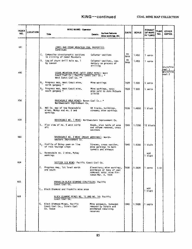
INDEX LOCATION NO.
K41
K42
K56
K59
K60
K64
: K65
K66
KING--continued COAL MINE MAP COLLECTION
MINE NAME: 0.,.-ator
Title Details: Surface features Mine workings, etc.
DATE SCALE FORMAT TUBE OTHER OFMAPS IN TUBES NO. COPIES
JONES AND CEDAR MOUNTAIN COAL PROPERTIES Continued
C. Composite stratigraphic sections in vicinity of Cedar Mountain
D. Log of churn drill hole no. l by Lawson
Columnar sections
Columnar sections, commentary on process of drilling
CEDAR MOUNTAIN MINE (WEST COAST MINE): West Coast Fuel Co.; Pac1f1c ~Coast coal Co.; * West Coast Coal Co.**
no date
no date
1:450
1 :450
1 xerox
1 xerox
s1 . Progress map, West Coast mine, north gangway *
Mine workings 1928 1:600 1 xerox
s2. Progress map, West Coast mine, south gangway*
Mine workings, note: 1928 l:600 l xerox mine sold to John McQuade 3/15/28
RAVENSOALE AREA MINES: Raven Coal Co.;* Northwestern Improvement Co.
D. NWI Co. map of the Ravensdale m.i nes, McKay and no. 5 bed workings
RR tracks, buildings, streams; mine workings
RAVENSDALE NO. 1 MINE: Northwestern Improvement Co.
1936 1:4800 1 blupt
E. Plan view of no. 5 west strip pit
Roads, plan table of area 1948 1:1200 12 blupts and volume removed, cross sections
RAVENSOALE NO. 2 MINE (MCKAY WORKINGS): Northwestern Improvement Co.
K1• Profile of McKay seam on line of rock haulage slope
L. Ravensdale no. 2 mine, McKay workings
Streams, cross section, mine workings in main tunnels and airways
SECTION SIX MINE: Pacific Coast Coal Co.
1945 1:1200 1 b1uln
add 1 bl upt
C. Progress map, 1st level north and south
Elevations; mine workings, h938 1:3600 1 xerox estimates of tons of coal removed; note: mine fin-ished.Mar. 4, 1938
FRANKLIN-BLACK DIAMOND COALFIELDS: Pacific Coast Coal Co.
C •• Black Diamond and Franklin mine area
BLACK DIAMOND MINES NO. 11 ANO NO. 14: Pacific Coast Coal Co.
G. Black Diamond Mines, Pacific Coast Coal Co., Strain Coal Co. lease
Mine gangways, tonnages removed by Strain and estimated remaining reserves
85
add 1 blupt
1940 1:3600 l sepia
1-51
tnicrofi lm reel 1 microfilm reel 2
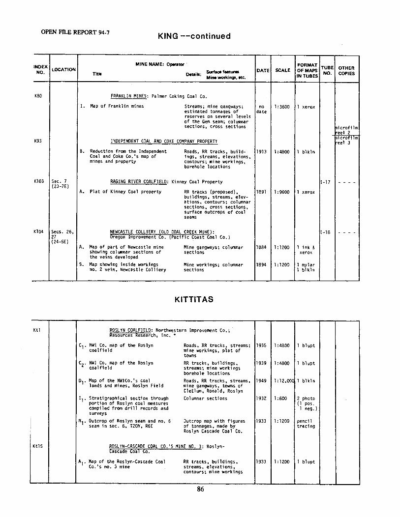
OPEN FILE REPORT 94-7 KING --continued
INDEX MINE NAME: Operator FORMAT TUBE OTHER NO.
LOCATION Surfaa features DATE SCALE OF MAPS NO. COPIES Trtle Details: Mine workings, etc. IN TUBES
K80 FRANKLIN MINES: Palmer Coking Coal Co.
I. Map of Franklin mines Streams; mine gangways; no 1: 3600 1 xerox estimated tonnages of date reserves on several levels of the Gem seam; columnar sections, cross sections microfilm
reel 2 microfilm K93 INDEPENDENT COAL ANO COKE COMPANY PROPERTY reel 3
B. Reduction from the Independent Roads, RR tracks, build- 1913 1 :4800 1 blkln Coal and Coke Co.'s map of ings, streams, elevations, mines and property contours; mine workings,
borehole locations
Kl03 Sec. 7 RAGING RIVER COALFIELD: Kinney Coal Property 1-17 - - - -(23-7E)
A. Plat of Kinney Coal property RR tracks (proposed), 1891 1 :9600 1 xerox buildings, streams, elev-ations, contours; columnar sections, cross sections, surface outcrops of coal seams
Kl04 Secs. 26, NEWCASTLE COLLIERY (OLD COAL CREEK MINE): I-18 - - - -27 (24-SE)
Oregon Improvement Co. (Pacific Coast Coal Co.)
A. Map of part of Newcastle mine Mine gangways; columnar 1884 1: 1200 1 ink & showing columnar sections of sections xerox the veins developed
B. Map showing inside workings Mine workings; columnar 1894 1:1200 1 mylar no. 2 vein, Newcastle Colliery sections 1 blkln
KITTITAS
Ktl ROSLYN COALFIELD: Northwestern Improvement Co.; Resources Research, Inc.*
c,. NWI Co. map of the Roslyn Roads, RR tracks, streams; 1935 1 :4800 l blupt coalfield mine workings, plat of
towns
C2. NWI Co. map of the Roslyn RR tracks, buildings, 1939 1 :4800 1 blupt coalfield streams; mine workings
borehole locations
D1· Map of the NWICo.'s coal Roads, RR tracks, streams, 1949 1: 12,00C l blkln lands and mines, Roslyn Field mine gangways, towns of
CleElum, Ronald, Roslyn 1,. Stratigraphical section through Columnar sections 1932 1 :600 2 photo
portion of Roslyn coal measures (1 pos. compiled from drill records and l neg.} surveys
l Nl. Outcrop of Roslyn seam and no. 6 Outcrop map with figures 1933 1:1200 pencil seam in sec. 6, T20N, R6E of tonnages, made by tracing
Roslyn Cascade Coal Co.
Kt15 ROSLYN-CASCADE COAL CO.'S MINE NO. 3: Roslyn-Cascade Coal Co.
Al. Map of the Roslyn-Cascade Coal RR tracks, buildings, 1933 1 :1200 1 blupt Co.•s no. 3 mine streams, elevations,
contours; mine workings
86
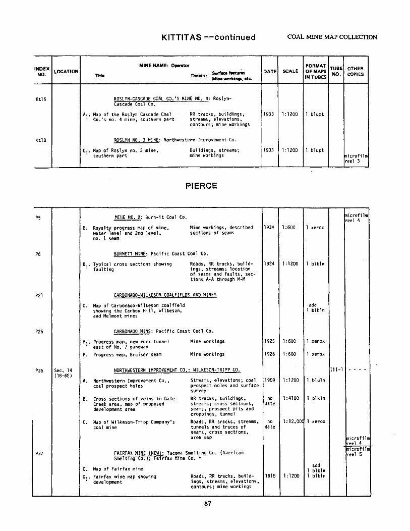
KITTITAS --continued COAL MINE MAP COLLECTION
INDEX MINE NAME: Operator FORMAT TUBE OTHER
NO. LOCATION Surface features DATE SCALE OFMAPS NO. Title Details: COPIES
Mine workings, etc. IN TUBES
Kt16 ROSLYN-CASCADE COAL CO.'S MINE NO. 4: Roslyn-Cascade Coal Co.
Al. Map of the Roslyn Cascade Coal RR tracks, buildings, 1933 1:1200 1 blupt Co.'s no. 4 mine, southern part streams, elevations,
contours; mine workings
Ktl8 ROSLYN NO. 3 MINE: Northwestern Improvement Co.
Cl. Map of Roslyn no. 3 mine, Buildings, streams; 1933 1: 1200 1 blupt southern part mine workings 1nicrofilm
reel 3
PIERCE
PS MI~E NO. 2: Burn-it Coal Co. microfilm reel 4
B. Royalty progress map of mine, Mine workings, described 1934 1 :600 1 xerox water level and 2nd level, sections of seams no. 1 seam
P6 BURNETT MINE: Pacific Coast Coal Co.
s,. Typical cross sections showing Roads, RR tracks, build- 1924 1:1200 1 bl kln faulting ings, streams; location
of seams and faults, sec-tions A-A through M-M
P2l CARBONADO-WILKESON COALFIELDS ANO MINES
c. Map of Carbonado-Wilkeson coalfield add showing the Carbon Hill, Wilkeson, 1 blkln and Melmont mines
P25 CARBONADO MINE: Pacific Coast Coal Co.
Hl. Progress map, new rock tunnel Mine workings 1925 1 :600 1 xerox east of No. 7 gangway
P. Progress map, Bruiser seam Mine workings 1926 1 :600 1 xerox
P35 Sec. 14 NORTHWESTERN IMPROVEMENT CO.: WILKESON-TRIPP CO. I II-1 - - - -{18-6E)
A. Northwestern Improvement Co., Streams, elevations; coal 1909 1: 1200 1 bluln coal prospect holes prospect holes and surface
survey B. Cross sections of veins in Gale RR tracks, buildings, no 1:4100 1 bl kln
I Creek area, map of proposed streams; cross sections, date development area seams, prospect pits and
croppings, tunnel
C. Map of Wilkeson-Tripp Company's Roads, RR tracks, streams, no 1: 12,00( 1 xerox coal mine tunnels and traces of date
seams, cross sections, area map microfilm
ireel 4
P37 FAIRFAX MINE {NEW): Tacoma Smelting Co. (American tnicrofilm
Smelt1ng co.); Fa1rfax Mine Co.* ireel 5
C. Map of Fairfax mine add
1 blkln 01. Fairfax mine map showing Roads, RR tracks, build- 1918 1:1200 1 bH:ln
development ings, streams, elevations, contours; mine workings
87
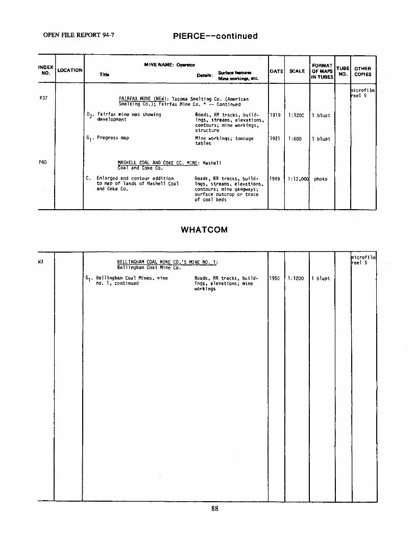
OPEN Fll.E REPORT 94-7 PIERCE--continued
INDEX MINE NAME: Operator FORMAT TUBE OTHER NO. LOCATION Surface features DATE SCALE Of MAPS NO. COPIES Title Details:
Mine workings. etc. IN TUBES
tnicrofi lm P37 FAIRFAX MINE (NEW): Tacoma Smelting Co. (American
eel 5
Smelting Co.}; Fairfax Mine Co.* -- Continued
02. Fairfax mine map showing Roads, RR tracks, build- 1919 1: 1200 1 blupt development ings, streams, elevations,
contours; mine workings, structure
G1• Prog~ess map Mine workings; tables
tonnage 1921 1 :600 1 blupt
P40 MASHELL COAL AND COKE CO. MINE: Mashell Coal and Coke Co.
c. Enlarged and contour addition Roads, RR tracks, build- 1949 1: 12,00C photo to map of lands of Mashell Coal ings, streams, elevations, and Coke Co. contours; mine gangways;
surface outcrop or trace of coal beds
WHATCOM
mkrofilm WJ BELLINGHAM COAL MINE CO.'S MINE NO. 1: reel 5
Bellingham Coal Mine Co.
61. Bellingham Coal Mines, mine Roads, RR tracks, build- 1950 1:1200 l blupt no. 1, continued ings, elevations; mine
workings
88
COAL MINE MAP COLLECTION
89
ADDENDUMFEBRUARY 1994
This addendum consists of a catalog to the maps donated to the Division and added to the coal minemap collection in February 1994; these have been cataloged and filed in sequence with the existingcollection.
When an added map's date places it within an existing chronological sequence, it has been assigneda subscripted letter designation; for example, K96 A1 falls between K96 A and K96 B.
When an added map falls at the end of an existing sequence, it has been assigned the next sequentialletter designation; for example, T5 E falls after T5 D.
Maps of two mine properties in Lewis County have been added to the collection: L31 and L32.
NOTE: The outlines of mining properties drawn on the index maps incorporate properties listed in OpenFile Report 83-8, the Addendum dated May 1984, and this second addendum, completed in February 1994.
OPEN FILE REPORT 94-7 KING
INDEX MINE NAME: Oplf'l1or FORMAT TUBE OTHER NO.
LOCATION Sc.riace features DATE SCALE OF MAPS NO. COPIES Title Details: IN TUBES Mine workinp, etc.
Kll Secs 32-34 HARRIS-RICHMOND MINE: Harris Coal Co. II-8 nicrofilm (23-6£) eel I Sec. 4 G. Map showing location of workings add (22-6E) in Harris Coal Co. mine, note 1 blkln
"long wall worked out 3/27/33"
K27 Sec. 27 B. ANO R. MINE AT NEWCASTLE IN THE RICHMOND- VII-(24-SE) STANLEY TUNNEL: Richmond-Stanley Coal Co.*; 10
B. and R. (Baima and Rubitina) Coal Co. add 1 blk.ln
F. Map showing survey in Baima and Rubitina mine, showing workings on microfilm lower no. 3 and no. 4 seams reel 1
K48 Sec. 2 DURHAM-HIAWATHA-KANGLEY COALFIELD: Northwestern I-50 microfilm (21-7E) Improvement Co. reel 2 Secs. 26-28, 35 A. Map of the Durham-Hiawatha-Kangley add (22-7E coalfield 1 blupt
KSO Sec. 35 ALTA MINE: Alta Coal Co~ VII-(22-7E) 36
A1. Map showing workings of the McGuire, streams, elevations, 1893 1: 1200 1 mylar Kangley, Scenery, and 36 veins contours; mine work-
ings; columnar sec-tions; cross-sections
K51 Sec. 35 (22-7E)
HIAWATHA MINE: Northwest Improvement Co. I-47
C. Cross-section on line of Hiawatha add mine tunnel 1 blupt
K85 Secs. 25, KUMMER HINE: Pacific Coast Coal Co.; Denney- VII-26 Renton Clay and Coal Co.*; Gladding, McBean 26 (2I-6E) and Co.**; Ku11111er Coal Co.***
J. Map showing workings on the Nos. roads, RR tracks, 1953 1:1200 I xerox 1, Ji, and 4 veins streams, mine workings
K86 Secs. 26, KUMMER CLAY MINE: Palmer Coking Coal Co. VII-35 25 (21-6E) C. Preliminary map - KU11111er Clay roads, marsh, clay 1957 1:1200 1 xerox
mine piles, mine workings; shows location of microfilrr Morris mine portal reel 2
K94 Secs. 27, microfilm
SUNSET MINE: National Coal Co. VII- reel 3 29 31 (2;1-7E) Al. Sunset Coal Mining Co., Map roads, RR tracks, 1913 1:4800 1 xerox
showing development buildings, streams, Cumberland town plat; mine workings - Old No. 1 drift, Nos. 2, 4. 5, and 6 drifts
K95 Sec. 28 NAVY MINE: Naval Coal Co. 1-41 (21-7E)
B. Map of the Naval Coal Co. RR tracks, streams, 1913 1:4800 1 xerox mine workings, bore-holes, location of Sunset mine
K96 Secs. 21, EUREKA MINE: Cumberland Coal Mining Co. I-43 28 (21-7£) Al. Leased to Eureka Coal Co. RR tracks, buildings, 1895 1:4800 1 xerox
October 2, 1894, south half streams, contours, of section21 gangways; cross-sec-
tions
i 90
KING COAL :MINE MAP COLLECTION
INDEX MINE NAME: Operator FORMAT TUBE OTHER
NO. LOCATION Surface feetures DATE SCALE Of MAPS
NO. COPIES Title Details: Mine workings, etc. IN TUBES
(99 Sec. 15, DALY MINE, CARBON MINE: Carbon Coal and Clay microfilm
VI-5 reel 3 22 Co.; Carbon Fuel Co.* (21-7E)
01. Map of properties and workings roads, RR tracks, no 1:4800 1 xerox of "Carbon mines 11 buildings, streams, date
elevations, contour.s; mine workings: Carbon gangway no. 3, 2, 1
KITTITAS
~tl ROSLYN COALFIELD: Northwestern Resources Research, Inc.*
Improvement Co.; V-1
Al. Map of the Northwestern Improve- roads, RR tracks, 1906 1:12,000 ink on ment Company's Coal Lands and streams, outcrop of linen mines; Roslyn Field, showing Roslyn Vein, limit of progress during each fiscal coalfield, boreholes; year from 1896 to 1906 plats of Roslyn, Ron-
ald, No. 5 town, Cle Elum; gangways
mi.crofilm LEWIS reel 3
microfilm .18 BELLE SLOPE MINE: Bucoda Coal Mining Co.; III- reel 4
K. and K. Coal Mining·Co. 27
B. Map of the Belle Slope add ink-pape
19 HANNAFORD MINE NO. 3: Bucoda Coal Mining Co. III-26
Al. Map of the Hannaford mine No. 3 roads, RR tracks, 1943 1:1200 1 blkln buildings, streams, elevations, contours; different scale version of map A
30 Secs. 1, SUMMIT CREEK PROPERTY: White Pass Anthracite III-2, 11, 12 Coa 1 Co., Inc. 34 13, 14, 23-26 D. Geologic Map of the Surrmit Creek roads, buildings, 1943 1:31,800 2 blkln ( 14-lOE) coal field prospect outcrops, 1 ink 4-6, 7-9, streams, contours 16-21, 28 30 (14-11 E)
31 Sec. 8 CENTRALIA COAL MINE NO. 1: Centralia Coal Mining Co. III-(14-lW) 42
A. Map of Mine No. 1, proposed RR tracks, buildings, 1918 1:1200 1 bl k.ln plan proposed workings 1 ink
32 Secs. 5-8 CURTISS COAL PROPERTY III-(13-2W) 43 1-4, 9-12 A. Map of Curtiss Coal Property RR tracks, streams, 1918 1:31,680 l xerox (13-3W) town of Chehalis, prop-17-20, erty boundaries; 29-32 cross-sections, colum-(14-2W) nar sections, assay 13-16, 21-28 (14-3W)
91
OPEN FILE REPORT 94-7 LEWIS-THURSTON
INDEX MINE NAME: Operator FORMAT TUBE OTHER NO. LOCATION Surface features DATE SCALE OF MAPS NO. COPIES Title Details:
Mine workings, etc. IN TUBES
microfilm LT2 Secs. 7, PROPERTY AND IMPROVEMENTS OF THE WASHINGTON IV- reel 4
18-20, 29 UNION COAL CO.: Washington Union Coal Co. 19 32 (15-lE) 0. Map showing properties of the RR tracks, land sur- 1915 1: 28,160 ink on 7-36 Washington Union Coal Co. vey, streams, drill linen (15-lW) holes, assessed value/ 11-14, 23 acre, levels, Bucoda, 26, 35, 3E Pacific Coal & Gas Co. (15-2W) Skookumchuck, Hanna-
ford mines
E. General map showing property roads, RR tracks, 1944 1:25,300 1 blkln and improvements of the Wash- streams, ownership, ington Union Coal Co. figured price, tow~s
of Bucoda and Tono
PIERCE
P20 Secs. 2-5 MELMONT-WILKESON-CARBONADO AREA: Pacific 11-27 8-11, 14- Coast Steel Co. 17, 21-23: 26·-28, 341 Al. Map of subsurface workings in the roads, RR tracks, ? 1:12,000 1 blkln 35 Wilkeson, Carbonado, Melmont, and structure, outcrops, (18-6E) Fairfax coalfields gangways 27, 28, 32-34 (19-6E)
rni crofi lm .. eel 4
THURSTON microfilm reel 5
TS Secs. 16- HANNAFORD MINE NO. 1: Washington Union Coal Co.; IV-24 21 Strain Coal Co.* (15-lW) 13, 24 E. Hannaford No. 1 and Northwestern roads, RR tracks, ? 1:6000 1 bluln (15-2W) Coal and Transportation Co. 1 s mine buildings, streams,
land survey, drill holes and gangways
T6 Sec. 20 TONO MINE PROPERTY: Strain Coal Co. IV-23 (15-lW}
A. Outcrop map, Tona No. 1 seam contours, outcrop, ? 1:600 pencil cross-sections on paper
92
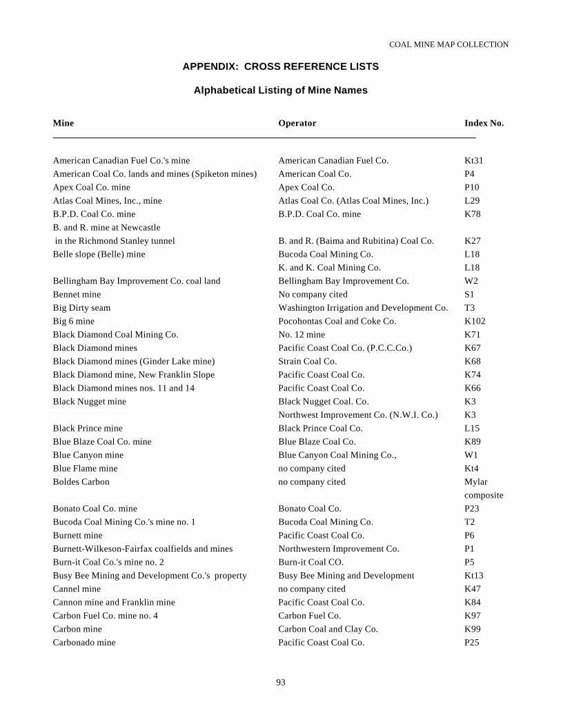
COAL MINE MAP COLLECTION
93
APPENDIX: CROSS REFERENCE LISTS
Alphabetical Listing of Mine Names
Mine Operator Index No.
American Canadian Fuel Co.'s mine American Canadian Fuel Co. Kt31American Coal Co. lands and mines (Spiketon mines) American Coal Co. P4Apex Coal Co. mine Apex Coal Co. P10Atlas Coal Mines, Inc., mine Atlas Coal Co. (Atlas Coal Mines, Inc.) L29B.P.D. Coal Co. mine B.P.D. Coal Co. mine K78B. and R. mine at Newcastle in the Richmond Stanley tunnel B. and R. (Baima and Rubitina) Coal Co. K27Belle slope (Belle) mine Bucoda Coal Mining Co. L18
K. and K. Coal Mining Co. L18Bellingham Bay Improvement Co. coal land Bellingham Bay Improvement Co. W2Bennet mine No company cited S1Big Dirty seam Washington Irrigation and Development Co. T3Big 6 mine Pocohontas Coal and Coke Co. K102Black Diamond Coal Mining Co. No. 12 mine K71Black Diamond mines Pacific Coast Coal Co. (P.C.C.Co.) K67Black Diamond mines (Ginder Lake mine) Strain Coal Co. K68Black Diamond mine, New Franklin Slope Pacific Coast Coal Co. K74Black Diamond mines nos. 11 and 14 Pacific Coast Coal Co. K66Black Nugget mine Black Nugget Coal. Co. K3
Northwest Improvement Co. (N.W.I. Co.) K3Black Prince mine Black Prince Coal Co. L15Blue Blaze Coal Co. mine Blue Blaze Coal Co. K89Blue Canyon mine Blue Canyon Coal Mining Co., W1Blue Flame mine no company cited Kt4Boldes Carbon no company cited Mylar
compositeBonato Coal Co. mine Bonato Coal Co. P23Bucoda Coal Mining Co.'s mine no. 1 Bucoda Coal Mining Co. T2Burnett mine Pacific Coast Coal Co. P6Burnett-Wilkeson-Fairfax coalfields and mines Northwestern Improvement Co. P1Burn-it Coal Co.'s mine no. 2 Burn-it Coal CO. P5Busy Bee Mining and Development Co.'s property Busy Bee Mining and Development Kt13Cannel mine no company cited K47Cannon mine and Franklin mine Pacific Coast Coal Co. K84Carbon Fuel Co. mine no. 4 Carbon Fuel Co. K97Carbon mine Carbon Coal and Clay Co. K99Carbonado mine Pacific Coast Coal Co. P25
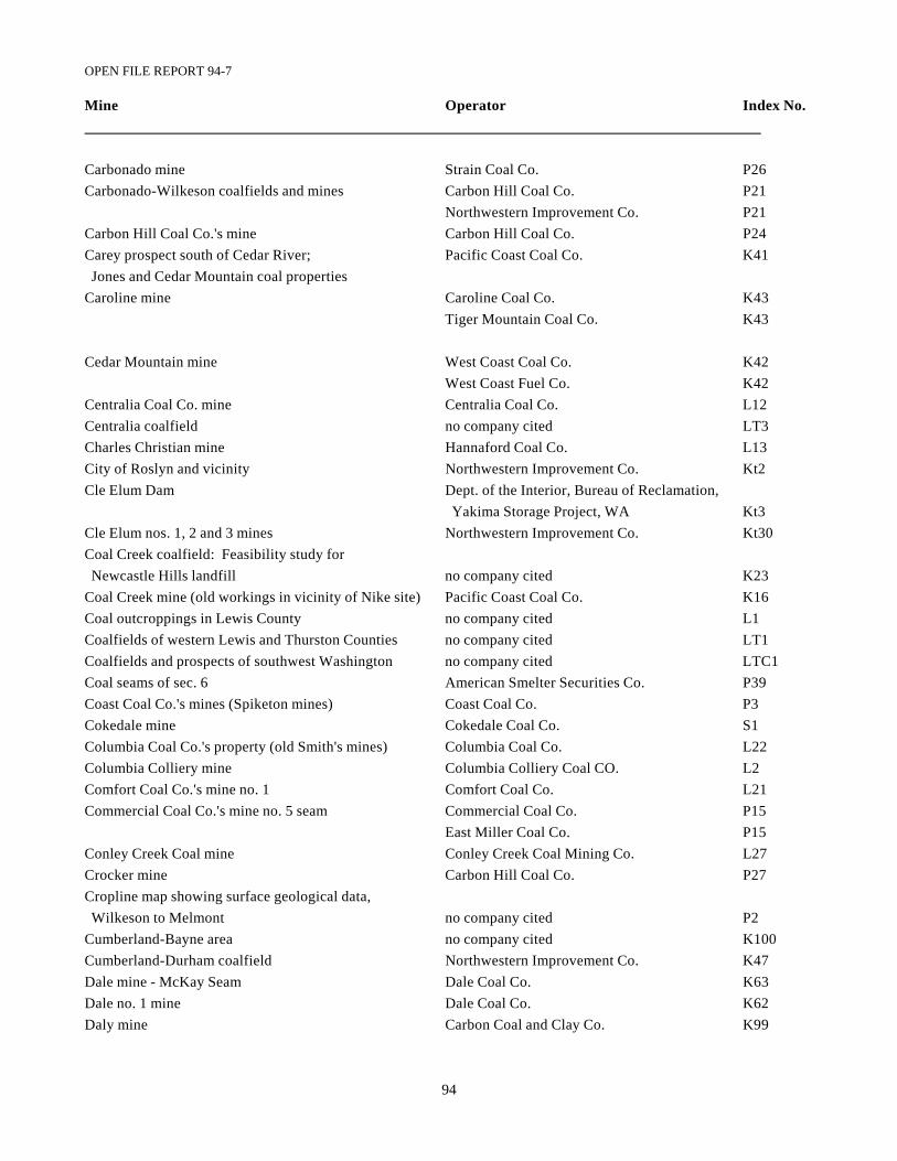
OPEN FILE REPORT 94-7
94
Mine Operator Index No.
Carbonado mine Strain Coal Co. P26Carbonado-Wilkeson coalfields and mines Carbon Hill Coal Co. P21
Northwestern Improvement Co. P21Carbon Hill Coal Co.'s mine Carbon Hill Coal Co. P24Carey prospect south of Cedar River; Pacific Coast Coal Co. K41 Jones and Cedar Mountain coal propertiesCaroline mine Caroline Coal Co. K43
Tiger Mountain Coal Co. K43
Cedar Mountain mine West Coast Coal Co. K42West Coast Fuel Co. K42
Centralia Coal Co. mine Centralia Coal Co. L12Centralia coalfield no company cited LT3Charles Christian mine Hannaford Coal Co. L13City of Roslyn and vicinity Northwestern Improvement Co. Kt2Cle Elum Dam Dept. of the Interior, Bureau of Reclamation,
Yakima Storage Project, WA Kt3Cle Elum nos. 1, 2 and 3 mines Northwestern Improvement Co. Kt30Coal Creek coalfield: Feasibility study for Newcastle Hills landfill no company cited K23Coal Creek mine (old workings in vicinity of Nike site) Pacific Coast Coal Co. K16Coal outcroppings in Lewis County no company cited L1Coalfields of western Lewis and Thurston Counties no company cited LT1Coalfields and prospects of southwest Washington no company cited LTC1Coal seams of sec. 6 American Smelter Securities Co. P39Coast Coal Co.'s mines (Spiketon mines) Coast Coal Co. P3Cokedale mine Cokedale Coal Co. S1Columbia Coal Co.'s property (old Smith's mines) Columbia Coal Co. L22Columbia Colliery mine Columbia Colliery Coal CO. L2Comfort Coal Co.'s mine no. 1 Comfort Coal Co. L21Commercial Coal Co.'s mine no. 5 seam Commercial Coal Co. P15
East Miller Coal Co. P15Conley Creek Coal mine Conley Creek Coal Mining Co. L27Crocker mine Carbon Hill Coal Co. P27Cropline map showing surface geological data, Wilkeson to Melmont no company cited P2Cumberland-Bayne area no company cited K100Cumberland-Durham coalfield Northwestern Improvement Co. K47Dale mine - McKay Seam Dale Coal Co. K63Dale no. 1 mine Dale Coal Co. K62Daly mine Carbon Coal and Clay Co. K99
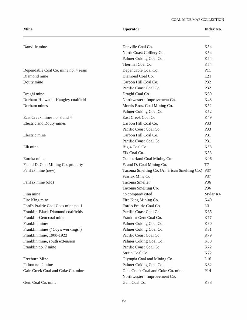
COAL MINE MAP COLLECTION
95
Mine Operator Index No.
Danville mine Danville Coal Co. K54North Coast Colliery Co. K54Palmer Coking Coal Co. K54Thermal Coal Co. K54
Dependable Coal Co. mine no. 4 seam Dependable Coal Co. P11Diamond mine Diamond Coal Co. L21Douty mine Carbon Hill Coal Co. P32
Pacific Coast Coal Co. P32Draghi mine Draghi Coal Co. K69Durham-Hiawatha-Kangley coalfield Northwestern Improvement Co. K48Durham mines Morris Bros. Coal Mining Co. K52
Palmer Coking Coal Co. K52East Creek mines no. 3 and 4 East Creek Coal Co. K49Electric and Douty mines Carbon Hill Coal Co. P33
Pacific Coast Coal Co. P33Electric mine Carbon Hill Coal Co. P31
Pacific Coast Coal Co. P31Elk mine Big 4 Coal Co. K53
Elk Coal Co. K53Eureka mine Cumberland Coal Mining Co. K96F. and D. Coal Mining Co. property F. and D. Coal Mining Co. T7Fairfax mine (new) Tacoma Smelting Co. (American Smelting Co.) P37
Fairfax Mine Co. P37Fairfax mine (old) Tacoma Smelter P36
Tacoma Smelting Co. P36Finn mine no company cited Mylar K4Fire King mine Fire King Mining Co. K40Ford's Prairie Coal Co.'s mine no. 1 Ford's Prairie Coal Co. L3Franklin-Black Diamond coalfields Pacific Coast Coal Co. K65Franklin-Gem coal mine Franklin-Gem Coal Co. K77Franklin mines Palmer Coking Coal Co. K80Franklin mines ("Coy's workings") Palmer Coking Coal Co. K81Franklin mine, 1900-1922 Pacific Coast Coal Co. K79Franklin mine, south extension Palmer Coking Coal Co. K83Franklin no. 7 mine Pacific Coast Coal Co. K72
Strain Coal Co. K72Freeburn Mine Olympia Coal and Mining Co. L16Fulton no. 2 mine Palmer Coking Coal Co. K82Gale Creek Coal and Coke Co. mine Gale Creek Coal and Coke Co. mine P14
Northwestern Improvement Co.Gem Coal Co. mine Gem Coal Co. K88
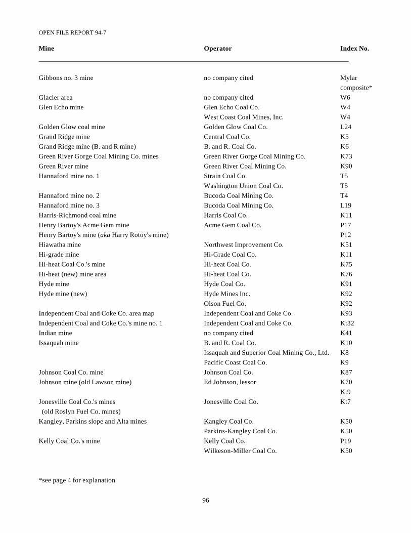
OPEN FILE REPORT 94-7
96
Mine Operator Index No.
Gibbons no. 3 mine no company cited Mylar composite*
Glacier area no company cited W6Glen Echo mine Glen Echo Coal Co. W4
West Coast Coal Mines, Inc. W4Golden Glow coal mine Golden Glow Coal Co. L24Grand Ridge mine Central Coal Co. K5Grand Ridge mine (B. and R mine) B. and R. Coal Co. K6Green River Gorge Coal Mining Co. mines Green River Gorge Coal Mining Co. K73Green River mine Green River Coal Mining Co. K90Hannaford mine no. 1 Strain Coal Co. T5
Washington Union Coal Co. T5Hannaford mine no. 2 Bucoda Coal Mining Co. T4Hannaford mine no. 3 Bucoda Coal Mining Co. L19Harris-Richmond coal mine Harris Coal Co. K11Henry Bartoy's Acme Gem mine Acme Gem Coal Co. P17Henry Bartoy's mine (aka Harry Rotoy's mine) P12Hiawatha mine Northwest Improvement Co. K51Hi-grade mine Hi-Grade Coal Co. K11Hi-heat Coal Co.'s mine Hi-heat Coal Co. K75Hi-heat (new) mine area Hi-heat Coal Co. K76Hyde mine Hyde Coal Co. K91Hyde mine (new) Hyde Mines Inc. K92
Olson Fuel Co. K92Independent Coal and Coke Co. area map Independent Coal and Coke Co. K93Independent Coal and Coke Co.'s mine no. 1 Independent Coal and Coke Co. Kt32Indian mine no company cited K41Issaquah mine B. and R. Coal Co. K10
Issaquah and Superior Coal Mining Co., Ltd. K8Pacific Coast Coal Co. K9
Johnson Coal Co. mine Johnson Coal Co. K87Johnson mine (old Lawson mine) Ed Johnson, lessor K70
Kt9Jonesville Coal Co.'s mines Jonesville Coal Co. Kt7 (old Roslyn Fuel Co. mines)Kangley, Parkins slope and Alta mines Kangley Coal Co. K50
Parkins-Kangley Coal Co. K50Kelly Coal Co.'s mine Kelly Coal Co. P19
Wilkeson-Miller Coal Co. K50
*see page 4 for explanation
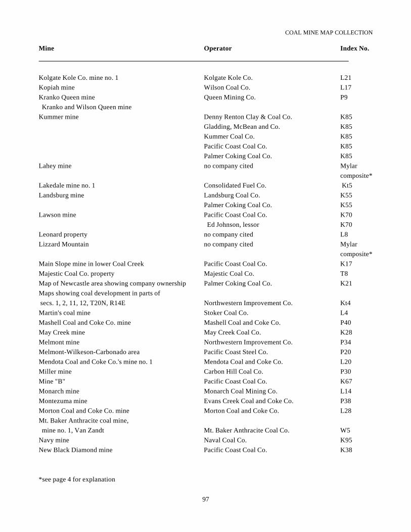
COAL MINE MAP COLLECTION
97
Mine Operator Index No.
Kolgate Kole Co. mine no. 1 Kolgate Kole Co. L21Kopiah mine Wilson Coal Co. L17Kranko Queen mine Queen Mining Co. P9 Kranko and Wilson Queen mineKummer mine Denny Renton Clay & Coal Co. K85
Gladding, McBean and Co. K85Kummer Coal Co. K85Pacific Coast Coal Co. K85Palmer Coking Coal Co. K85
Lahey mine no company cited Mylar composite*
Lakedale mine no. 1 Consolidated Fuel Co. Kt5Landsburg mine Landsburg Coal Co. K55
Palmer Coking Coal Co. K55Lawson mine Pacific Coast Coal Co. K70
Ed Johnson, lessor K70Leonard property no company cited L8Lizzard Mountain no company cited Mylar
composite*Main Slope mine in lower Coal Creek Pacific Coast Coal Co. K17Majestic Coal Co. property Majestic Coal Co. T8Map of Newcastle area showing company ownership Palmer Coking Coal Co. K21Maps showing coal development in parts of secs. 1, 2, 11, 12, T20N, R14E Northwestern Improvement Co. Kt4Martin's coal mine Stoker Coal Co. L4Mashell Coal and Coke Co. mine Mashell Coal and Coke Co. P40May Creek mine May Creek Coal Co. K28Melmont mine Northwestern Improvement Co. P34Melmont-Wilkeson-Carbonado area Pacific Coast Steel Co. P20Mendota Coal and Coke Co.'s mine no. 1 Mendota Coal and Coke Co. L20Miller mine Carbon Hill Coal Co. P30Mine "B" Pacific Coast Coal Co. K67Monarch mine Monarch Coal Mining Co. L14Montezuma mine Evans Creek Coal and Coke Co. P38Morton Coal and Coke Co. mine Morton Coal and Coke Co. L28Mt. Baker Anthracite coal mine, mine no. 1, Van Zandt Mt. Baker Anthracite Coal Co. W5Navy mine Naval Coal Co. K95New Black Diamond mine Pacific Coast Coal Co. K38
*see page 4 for explanation
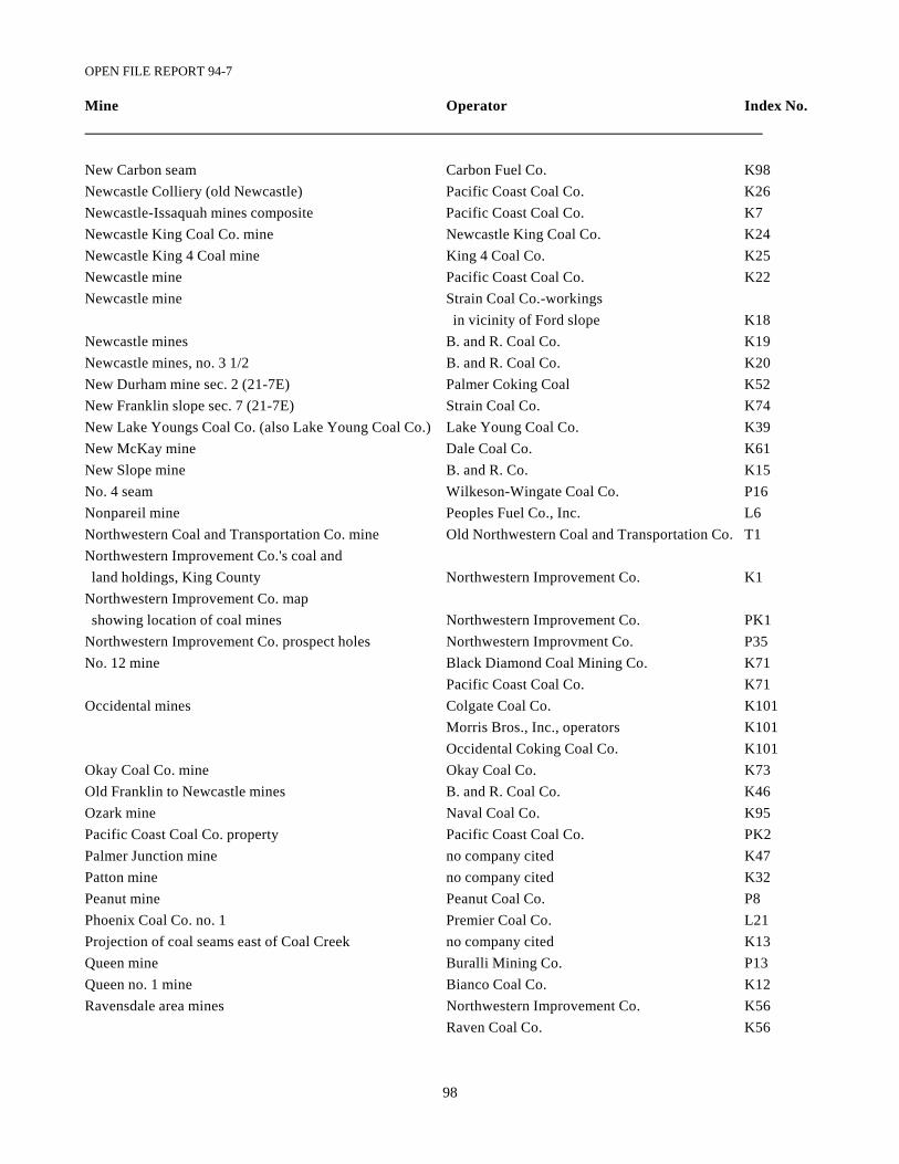
OPEN FILE REPORT 94-7
98
Mine Operator Index No.
New Carbon seam Carbon Fuel Co. K98Newcastle Colliery (old Newcastle) Pacific Coast Coal Co. K26Newcastle-Issaquah mines composite Pacific Coast Coal Co. K7Newcastle King Coal Co. mine Newcastle King Coal Co. K24Newcastle King 4 Coal mine King 4 Coal Co. K25Newcastle mine Pacific Coast Coal Co. K22Newcastle mine Strain Coal Co.-workings
in vicinity of Ford slope K18Newcastle mines B. and R. Coal Co. K19Newcastle mines, no. 3 1/2 B. and R. Coal Co. K20New Durham mine sec. 2 (21-7E) Palmer Coking Coal K52New Franklin slope sec. 7 (21-7E) Strain Coal Co. K74New Lake Youngs Coal Co. (also Lake Young Coal Co.) Lake Young Coal Co. K39New McKay mine Dale Coal Co. K61New Slope mine B. and R. Co. K15No. 4 seam Wilkeson-Wingate Coal Co. P16Nonpareil mine Peoples Fuel Co., Inc. L6Northwestern Coal and Transportation Co. mine Old Northwestern Coal and Transportation Co. T1Northwestern Improvement Co.'s coal and land holdings, King County Northwestern Improvement Co. K1Northwestern Improvement Co. map showing location of coal mines Northwestern Improvement Co. PK1Northwestern Improvement Co. prospect holes Northwestern Improvment Co. P35No. 12 mine Black Diamond Coal Mining Co. K71
Pacific Coast Coal Co. K71Occidental mines Colgate Coal Co. K101
Morris Bros., Inc., operators K101Occidental Coking Coal Co. K101
Okay Coal Co. mine Okay Coal Co. K73Old Franklin to Newcastle mines B. and R. Coal Co. K46Ozark mine Naval Coal Co. K95Pacific Coast Coal Co. property Pacific Coast Coal Co. PK2Palmer Junction mine no company cited K47Patton mine no company cited K32Peanut mine Peanut Coal Co. P8Phoenix Coal Co. no. 1 Premier Coal Co. L21Projection of coal seams east of Coal Creek no company cited K13Queen mine Buralli Mining Co. P13Queen no. 1 mine Bianco Coal Co. K12Ravensdale area mines Northwestern Improvement Co. K56
Raven Coal Co. K56
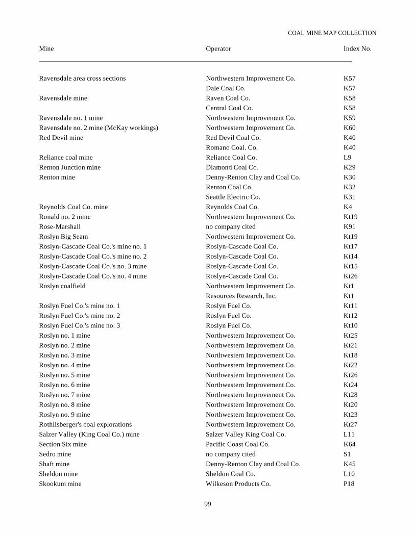
COAL MINE MAP COLLECTION
99
Mine Operator Index No.
Ravensdale area cross sections Northwestern Improvement Co. K57Dale Coal Co. K57
Ravensdale mine Raven Coal Co. K58Central Coal Co. K58
Ravensdale no. 1 mine Northwestern Improvement Co. K59Ravensdale no. 2 mine (McKay workings) Northwestern Improvement Co. K60Red Devil mine Red Devil Coal Co. K40
Romano Coal. Co. K40Reliance coal mine Reliance Coal Co. L9Renton Junction mine Diamond Coal Co. K29Renton mine Denny-Renton Clay and Coal Co. K30
Renton Coal Co. K32Seattle Electric Co. K31
Reynolds Coal Co. mine Reynolds Coal Co. K4Ronald no. 2 mine Northwestern Improvement Co. Kt19Rose-Marshall no company cited K91Roslyn Big Seam Northwestern Improvement Co. Kt19Roslyn-Cascade Coal Co.'s mine no. 1 Roslyn-Cascade Coal Co. Kt17Roslyn-Cascade Coal Co.'s mine no. 2 Roslyn-Cascade Coal Co. Kt14Roslyn-Cascade Coal Co.'s no. 3 mine Roslyn-Cascade Coal Co. Kt15Roslyn-Cascade Coal Co.'s no. 4 mine Roslyn-Cascade Coal Co. Kt26Roslyn coalfield Northwestern Improvement Co. Kt1
Resources Research, Inc. Kt1Roslyn Fuel Co.'s mine no. 1 Roslyn Fuel Co. Kt11Roslyn Fuel Co.'s mine no. 2 Roslyn Fuel Co. Kt12Roslyn Fuel Co.'s mine no. 3 Roslyn Fuel Co. Kt10Roslyn no. 1 mine Northwestern Improvement Co. Kt25Roslyn no. 2 mine Northwestern Improvement Co. Kt21Roslyn no. 3 mine Northwestern Improvement Co. Kt18Roslyn no. 4 mine Northwestern Improvement Co. Kt22Roslyn no. 5 mine Northwestern Improvement Co. Kt26Roslyn no. 6 mine Northwestern Improvement Co. Kt24Roslyn no. 7 mine Northwestern Improvement Co. Kt28Roslyn no. 8 mine Northwestern Improvement Co. Kt20Roslyn no. 9 mine Northwestern Improvement Co. Kt23Rothlisberger's coal explorations Northwestern Improvement Co. Kt27Salzer Valley (King Coal Co.) mine Salzer Valley King Coal Co. L11Section Six mine Pacific Coast Coal Co. K64Sedro mine no company cited S1Shaft mine Denny-Renton Clay and Coal Co. K45Sheldon mine Sheldon Coal Co. L10Skookum mine Wilkeson Products Co. P18
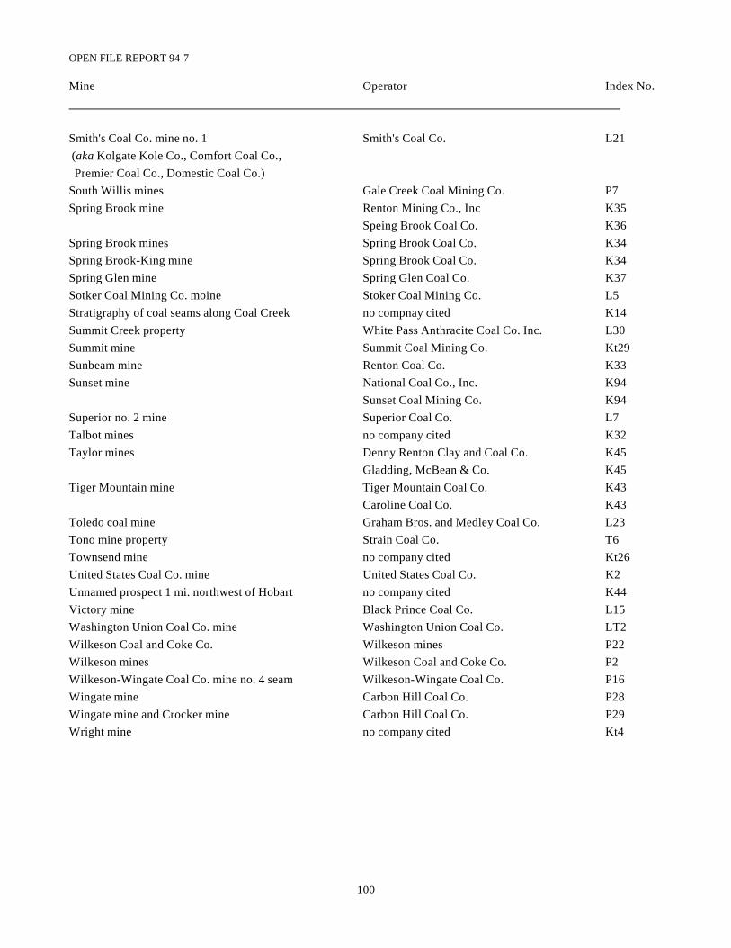
OPEN FILE REPORT 94-7
100
Mine Operator Index No.
Smith's Coal Co. mine no. 1 Smith's Coal Co. L21 (aka Kolgate Kole Co., Comfort Coal Co., Premier Coal Co., Domestic Coal Co.)South Willis mines Gale Creek Coal Mining Co. P7Spring Brook mine Renton Mining Co., Inc K35
Speing Brook Coal Co. K36Spring Brook mines Spring Brook Coal Co. K34Spring Brook-King mine Spring Brook Coal Co. K34Spring Glen mine Spring Glen Coal Co. K37Sotker Coal Mining Co. moine Stoker Coal Mining Co. L5Stratigraphy of coal seams along Coal Creek no compnay cited K14Summit Creek property White Pass Anthracite Coal Co. Inc. L30Summit mine Summit Coal Mining Co. Kt29Sunbeam mine Renton Coal Co. K33Sunset mine National Coal Co., Inc. K94
Sunset Coal Mining Co. K94Superior no. 2 mine Superior Coal Co. L7Talbot mines no company cited K32Taylor mines Denny Renton Clay and Coal Co. K45
Gladding, McBean & Co. K45Tiger Mountain mine Tiger Mountain Coal Co. K43
Caroline Coal Co. K43Toledo coal mine Graham Bros. and Medley Coal Co. L23Tono mine property Strain Coal Co. T6Townsend mine no company cited Kt26United States Coal Co. mine United States Coal Co. K2Unnamed prospect 1 mi. northwest of Hobart no company cited K44Victory mine Black Prince Coal Co. L15Washington Union Coal Co. mine Washington Union Coal Co. LT2Wilkeson Coal and Coke Co. Wilkeson mines P22Wilkeson mines Wilkeson Coal and Coke Co. P2Wilkeson-Wingate Coal Co. mine no. 4 seam Wilkeson-Wingate Coal Co. P16Wingate mine Carbon Hill Coal Co. P28Wingate mine and Crocker mine Carbon Hill Coal Co. P29Wright mine no company cited Kt4
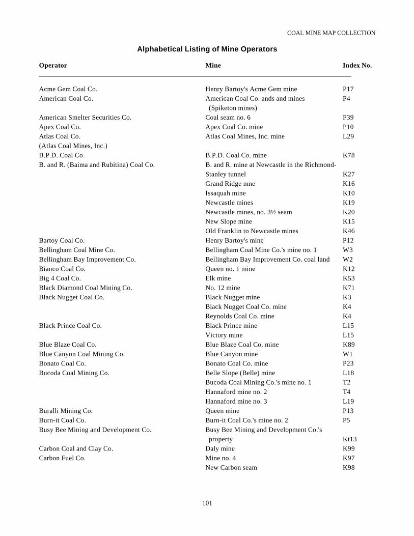
COAL MINE MAP COLLECTION
101
Alphabetical Listing of Mine Operators
Operator Mine Index No.
Acme Gem Coal Co. Henry Bartoy's Acme Gem mine P17American Coal Co. American Coal Co. ands and mines P4
(Spiketon mines)American Smelter Securities Co. Coal seam no. 6 P39Apex Coal Co. Apex Coal Co. mine P10Atlas Coal Co. Atlas Coal Mines, Inc. mine L29(Atlas Coal Mines, Inc.)B.P.D. Coal Co. B.P.D. Coal Co. mine K78B. and R. (Baima and Rubitina) Coal Co. B. and R. mine at Newcastle in the Richmond-
Stanley tunnel K27Grand Ridge mne K16Issaquah mine K10Newcastle mines K19Newcastle mines, no. 3½ seam K20New Slope mine K15Old Franklin to Newcastle mines K46
Bartoy Coal Co. Henry Bartoy's mine P12Bellingham Coal Mine Co. Bellingham Coal Mine Co.'s mine no. 1 W3Bellingham Bay Improvement Co. Bellingham Bay Improvement Co. coal land W2Bianco Coal Co. Queen no. 1 mine K12Big 4 Coal Co. Elk mine K53Black Diamond Coal Mining Co. No. 12 mine K71Black Nugget Coal Co. Black Nugget mine K3
Black Nugget Coal Co. mine K4Reynolds Coal Co. mine K4
Black Prince Coal Co. Black Prince mine L15Victory mine L15
Blue Blaze Coal Co. Blue Blaze Coal Co. mine K89Blue Canyon Coal Mining Co. Blue Canyon mine W1Bonato Coal Co. Bonato Coal Co. mine P23Bucoda Coal Mining Co. Belle Slope (Belle) mine L18
Bucoda Coal Mining Co.'s mine no. 1 T2Hannaford mine no. 2 T4Hannaford mine no. 3 L19
Buralli Mining Co. Queen mine P13Burn-it Coal Co. Burn-it Coal Co.'s mine no. 2 P5Busy Bee Mining and Development Co. Busy Bee Mining and Development Co.'s
property Kt13Carbon Coal and Clay Co. Daly mine K99Carbon Fuel Co. Mine no. 4 K97
New Carbon seam K98
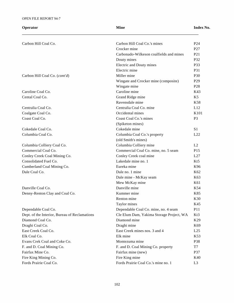
OPEN FILE REPORT 94-7
102
Operator Mine Index No.
Carbon Hill Coal Co. Carbon Hill Coal Co.'s mines P24Crocker mine P27Carbonado-Wilkeson coalfields and mines P21Douty mines P32Electric and Douty mines P33Electric mine P31
Carbon Hill Coal Co. (cont'd) Miller mine P30Wingate and Crocker mine (composite) P29Wingate mine P28
Caroline Coal Co. Caroline mine K43Cental Coal Co. Grand Ridge mine K5
Ravensdale mine K58Centralia Coal Co. Centralia Coal Co. mine L12Coalgate Coal Co. Occidental mines K101Coast Coal Co. Coast Coal Co.'s mines P3
(Spiketon mines)Cokedale Coal Co. Cokedale mine S1Columbia Coal Co. Columbia Coal Co.'s property L22
(old Smith's mines)Columbia Colliery Coal Co. Columbia Colliery mine L2Commercial Coal Co. Commercial Coal Co. mine, no. 5 seam P15Conley Creek Coal Mining Co. Conley Creek coal mine L27Consolidated Fuel Co. Lakedale mine no. 1 Kt5Cumberland Coal Mining Co. Eureka mine K96Dale Coal Co. Dale no. 1 mine K62
Dale mine - McKay seam K63Mew McKay mine K61
Danville Coal Co. Danville mine K54Denny-Renton Clay and Coal Co. Kummer mine K85
Renton mine K30Taylor mines K45
Dependable Coal Co. Dependable Coal Co. mine, no. 4 seam P11Dept. of the Interior, Bureau of Reclamations Cle Elum Dam, Yakima Storage Project, WA Kt3Diamond Coal Co. Diamond mine K29Draghi Coal Co. Draghi mine K69East Creek Coal Co. East Creek mines nos. 3 and 4 L25Elk Coal Co. Elk mine K53Evans Crek Coal and Coke Co. Montezuma mine P38F. and D. Coal Mining Co. F. and D. Coal Mining Co. property T7Fairfax Mine Co. Fairfax mine (new) P37Fire King Mining Co. Fire King mine K40Fords Prairie Coal Co. Fords Prairie Coal Co.'s mine no. 1 L3
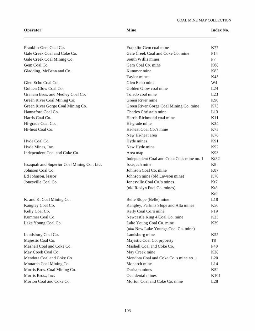
COAL MINE MAP COLLECTION
103
Operator Mine Index No.
Franklin-Gem Coal Co. Franklin-Gem coal mine K77Gale Creek Coal and Coke Co. Gale Creek Coal and Coke Co. mine P14Gale Creek Coal Mining Co. South Willis mines P7Gem Coal Co. Gem Coal Co. mine K88Gladding, McBean and Co. Kummer mine K85
Taylor mines K45Glen Echo Coal Co. Glen Echo mine W4Golden Glow Coal Co. Golden Glow coal mine L24Graham Bros. and Medley Coal Co. Toledo coal mine L23Green River Coal Mining Co. Green River mine K90Green River Gorge Coal Mining Co. Green River Gorge Coal Mining Co. mine K73Hannaford Coal Co. Charles Christain mine L13Harris Coal Co. Harris-Richmond coal mine K11Hi-grade Coal Co. Hi-grade mine K34Hi-heat Coal Co. Hi-heat Coal Co.'s mine K75
New Hi-heat area K76Hyde Coal Co. Hyde mines K91Hyde Mines, Inc. New Hyde mine K92Independent Coal and Coke Co. Area map K93
Independent Coal and Coke Co.'s mine no. 1 Kt32Issaquah and Superior Coal Mining Co., Ltd. Issaquah mine K8Johnson Coal Co. Johnson Coal Co. mine K87Ed Johnson, lessor Johnson mine (old Lawson mine) K70Jonesville Coal Co. Jonesville Coal Co.'s mines Kt7
(old Roslyn Fuel Co. mines) Kt8Kt9
K. and K. Coal Mining Co. Belle Slope (Belle) mine L18Kangley Coal Co. Kangley, Parkins Slope and Alta mines K50Kelly Coal Co. Kelly Coal Co.'s mine P19Kummer Coal Co. Newcastle King 4 Coal Co. mine K25Lake Young Coal Co. Lake Young Coal Co. mine K39
(aka New Lake Youngs Coal Co. mine)Landsburg Coal Co. Landsburg mine K55Majestic Coal Co. Majestic Coal Co. prpoerty T8Mashell Coal and Coke Co. Mashell Coal and Coke Co. P40May Creek Coal Co. May Creek mine K28Mendota Coal and Coke Co. Mendota Coal and Coke Co.'s mine no. 1 L20Monarch Coal Mining Co. Monarch mine L14Morris Bros. Coal Mining Co. Durham mines K52Morris Bros., Inc. Occidental mines K101Morton Coal and Coke Co. Morton Coal and Coke Co. mine L28
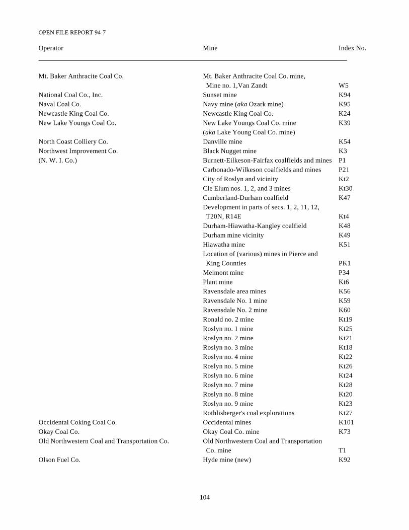
OPEN FILE REPORT 94-7
104
Operator Mine Index No.
Mt. Baker Anthracite Coal Co. Mt. Baker Anthracite Coal Co. mine, Mine no. 1,Van Zandt W5
National Coal Co., Inc. Sunset mine K94Naval Coal Co. Navy mine (aka Ozark mine) K95Newcastle King Coal Co. Newcastle King Coal Co. K24New Lake Youngs Coal Co. New Lake Youngs Coal Co. mine K39
(aka Lake Young Coal Co. mine)North Coast Colliery Co. Danville mine K54Northwest Improvement Co. Black Nugget mine K3(N. W. I. Co.) Burnett-Eilkeson-Fairfax coalfields and mines P1
Carbonado-Wilkeson coalfields and mines P21City of Roslyn and vicinity Kt2Cle Elum nos. 1, 2, and 3 mines Kt30Cumberland-Durham coalfield K47Development in parts of secs. 1, 2, 11, 12, T20N, R14E Kt4Durham-Hiawatha-Kangley coalfield K48Durham mine vicinity K49Hiawatha mine K51Location of (various) mines in Pierce and King Counties PK1Melmont mine P34Plant mine Kt6Ravensdale area mines K56Ravensdale No. 1 mine K59Ravensdale No. 2 mine K60Ronald no. 2 mine Kt19Roslyn no. 1 mine Kt25Roslyn no. 2 mine Kt21Roslyn no. 3 mine Kt18Roslyn no. 4 mine Kt22Roslyn no. 5 mine Kt26Roslyn no. 6 mine Kt24Roslyn no. 7 mine Kt28Roslyn no. 8 mine Kt20Roslyn no. 9 mine Kt23Rothlisberger's coal explorations Kt27
Occidental Coking Coal Co. Occidental mines K101Okay Coal Co. Okay Coal Co. mine K73Old Northwestern Coal and Transportation Co. Old Northwestern Coal and Transportation
Co. mine T1Olson Fuel Co. Hyde mine (new) K92
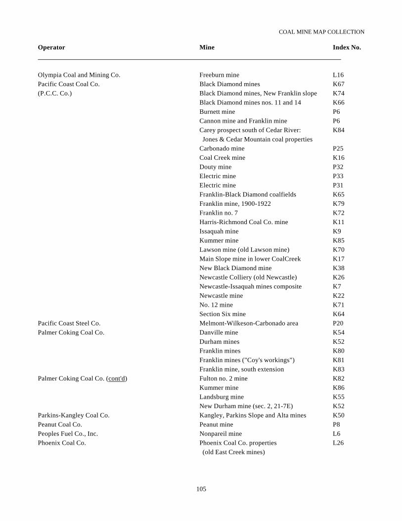
COAL MINE MAP COLLECTION
105
Operator Mine Index No.
Olympia Coal and Mining Co. Freeburn mine L16Pacific Coast Coal Co. Black Diamond mines K67(P.C.C. Co.) Black Diamond mines, New Franklin slope K74
Black Diamond mines nos. 11 and 14 K66Burnett mine P6Cannon mine and Franklin mine P6Carey prospect south of Cedar River: K84 Jones & Cedar Mountain coal propertiesCarbonado mine P25Coal Creek mine K16Douty mine P32Electric mine P33Electric mine P31Franklin-Black Diamond coalfields K65Franklin mine, 1900-1922 K79Franklin no. 7 K72Harris-Richmond Coal Co. mine K11Issaquah mine K9Kummer mine K85Lawson mine (old Lawson mine) K70Main Slope mine in lower CoalCreek K17New Black Diamond mine K38Newcastle Colliery (old Newcastle) K26Newcastle-Issaquah mines composite K7Newcastle mine K22No. 12 mine K71Section Six mine K64
Pacific Coast Steel Co. Melmont-Wilkeson-Carbonado area P20Palmer Coking Coal Co. Danville mine K54
Durham mines K52Franklin mines K80Franklin mines ("Coy's workings") K81Franklin mine, south extension K83
Palmer Coking Coal Co. (cont'd) Fulton no. 2 mine K82Kummer mine K86Landsburg mine K55New Durham mine (sec. 2, 21-7E) K52
Parkins-Kangley Coal Co. Kangley, Parkins Slope and Alta mines K50Peanut Coal Co. Peanut mine P8Peoples Fuel Co., Inc. Nonpareil mine L6Phoenix Coal Co. Phoenix Coal Co. properties L26
(old East Creek mines)
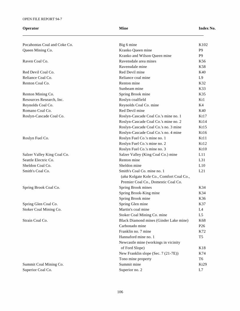
OPEN FILE REPORT 94-7
106
Operator Mine Index No.
Pocahontas Coal and Coke Co. Big 6 mine K102Queen Mining Co. Kranko Queen mine P9
Kranko and Wilson Queen mine P9Raven Coal Co. Ravensdale area mines K56
Ravensdale mine K58Red Devil Coal Co. Red Devil mine K40Reliance Coal Co. Reliance coal mine L9Renton Coal Co. Renton mine K32
Sunbeam mine K33Renton Mining Co. Spring Brook mine K35Resources Research, Inc. Roslyn coalfield Kt1Reynolds Coal Co. Reynolds Coal Co. mine K4Romano Coal Co. Red Devil mine K40Roslyn-Cascade Coal Co. Roslyn-Cascade Coal Co.'s mine no. 1 Kt17
Roslyn-Cascade Coal Co.'s mine no. 2 Kt14Roslyn-Cascade Coal Co.'s no. 3 mine Kt15Roslyn-Cascade Coal Co.'s no. 4 mine Kt16
Roslyn Fuel Co. Roslyn Fuel Co.'s mine no. 1 Kt11Roslyn Fuel Co.'s mine no. 2 Kt12Roslyn Fuel Co.'s mine no. 3 Kt10
Salzer Valley King Coal Co. Salzer Valley (King Coal Co.) mine L11Seattle Electric Co. Renton mine L31Sheldon Coal Co. Sheldon mine L10Smith's Coal Co. Smith's Coal Co. mine no. 1 L21
(aka Kolgate Kole Co., Comfort Coal Co., Premier Coal Co., Domestic Coal Co.
Spring Brook Coal Co. Spring Brook mines K34Spring Brook-King mine K34Spring Brook mine K36
Spring Glen Coal Co. Spring Glen mine K37Stoker Coal Mining Co. Martin's coal mine L4
Stoker Coal Mining Co. mine L5Strain Coal Co. Black Diamond mines (Ginder Lake mine) K68
Carbonado mine P26Franklin no. 7 mine K72Hannaford mine no. 1 T5Newcastle mine (workings in vicinity of Ford Slope) K18New Franklin slope (Sec. 7 (21-7E)) K74Tono mine property T6
Summit Coal Mining Co. Summit mine Kt29Superior Coal Co. Superior no. 2 L7
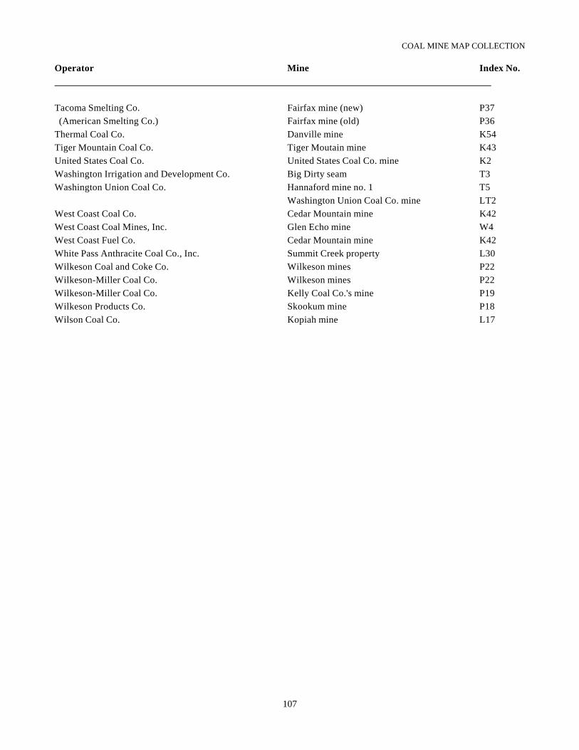
COAL MINE MAP COLLECTION
107
Operator Mine Index No.
Tacoma Smelting Co. Fairfax mine (new) P37 (American Smelting Co.) Fairfax mine (old) P36Thermal Coal Co. Danville mine K54Tiger Mountain Coal Co. Tiger Moutain mine K43United States Coal Co. United States Coal Co. mine K2Washington Irrigation and Development Co. Big Dirty seam T3Washington Union Coal Co. Hannaford mine no. 1 T5
Washington Union Coal Co. mine LT2West Coast Coal Co. Cedar Mountain mine K42West Coast Coal Mines, Inc. Glen Echo mine W4West Coast Fuel Co. Cedar Mountain mine K42White Pass Anthracite Coal Co., Inc. Summit Creek property L30Wilkeson Coal and Coke Co. Wilkeson mines P22Wilkeson-Miller Coal Co. Wilkeson mines P22Wilkeson-Miller Coal Co. Kelly Coal Co.'s mine P19Wilkeson Products Co. Skookum mine P18Wilson Coal Co. Kopiah mine L17
Related Documents