October 19, 2007 Mr. Peter Keelan The Keelan Company P.O. Box 230 Manchester, VT 05254 Re: 80, 82 & 92 West Street, Rutland Dear Mr. Keelan: This letter will serve to confirm that The Keelan Company, the entity currently owning the business and real estate assets of 80, 82 & 92 West Street in Rutland City, VT. (“Owner”) may rely upon the information presented in our Phase I Environmental Site Assessment Report and addressed to Landtect Corporation as an intended third party beneficiary of our work. Owner may assume the same rights as Landtect Corporation for all errors and omissions, and Heindel & Noyes agrees to be bound to owner by the same limitations of liability and indemnity provisions as set forth in the agreement between with Landtect Corporation and Heindel & Noyes. Best regards, Steven LaRosa (ext. 25) Senior Hydrogeologist Cc: Bukk Carleton, Landtect Corporation Q:\Landtect (Rutland)\Reliance letter.doc Heindel & Noyes, Inc . P.O. Box 4503 Burlington, VT 05406-4503 Consulting Hydrogeologists Engineers Environmental Scientists Voice 802-658-0820/Fax 802-860-1014

Welcome message from author
This document is posted to help you gain knowledge. Please leave a comment to let me know what you think about it! Share it to your friends and learn new things together.
Transcript
October 19, 2007 Mr. Peter Keelan The Keelan Company P.O. Box 230 Manchester, VT 05254 Re: 80, 82 & 92 West Street, Rutland Dear Mr. Keelan: This letter will serve to confirm that The Keelan Company, the entity currently owning the business and real estate assets of 80, 82 & 92 West Street in Rutland City, VT. (“Owner”) may rely upon the information presented in our Phase I Environmental Site Assessment Report and addressed to Landtect Corporation as an intended third party beneficiary of our work. Owner may assume the same rights as Landtect Corporation for all errors and omissions, and Heindel & Noyes agrees to be bound to owner by the same limitations of liability and indemnity provisions as set forth in the agreement between with Landtect Corporation and Heindel & Noyes. Best regards,
Steven LaRosa (ext. 25) Senior Hydrogeologist Cc: Bukk Carleton, Landtect Corporation Q:\Landtect (Rutland)\Reliance letter.doc
Heindel & Noyes, Inc. P.O. Box 4503 Burlington, VT 05406-4503
Consulting Hydrogeologists Engineers Environmental Scientists
Voice 802-658-0820/Fax 802-860-1014
October 19, 2007 Bukk Carleton Landtect 21 Technology Drive, Suite 6 West Lebanon, NH 03784 RE: 80, 82 & 92 West Street (Rutland) - Phase I Environmental Site Assessment Dear Mr. Carleton: Enclosed is our Final Draft Phase I Environmental Site Assessments for 80, 82 & 92 West Street in Rutland. Please feel free to contact Mr. Steven Larosa or myself at (802) 658-0820 if you have any questions or we can be of any future service. Best regards,
Jenny Schwartz (ext. 37) Steven LaRosa (ext. 25) Staff Scientist Senior Hydrogeologist Enclosures Q:\Landtect (Rutland)\trans_ltr_80West_FINAL.doc
Heindel & Noyes, Inc. P.O. Box 4503 Burlington, VT 05406-4503
Consulting Hydrogeologists Engineers Environmental Scientists
Voice 802-658-0820/Fax 802-860-1014
80, 82 & 92 WEST STREET/ROUTE 4 RUTLAND, VERMONT
PHASE I ENVIRONMENTAL SITE ASSESSMENT
October 19, 2007
HEINDEL & NOYES
Consulting Hydrogeologists, Engineers and Environmental Scientists
80, 82 AND 92 WEST STREET/ROUTE 4 Rutland, Vermont
PHASE I ENVIRONMENTAL SITE ASSESSMENT
Prepared by:
Prepared for: Bukk Carleton Landtect Corporation
October 19, 2007
Heindel & Noyes, Inc. P.O. Box 4503 Burlington, VT 05406-4503
Consulting Hydrogeologists Engineers Environmental Scientists
Voice 802-658-0820/Fax 802-860-1014
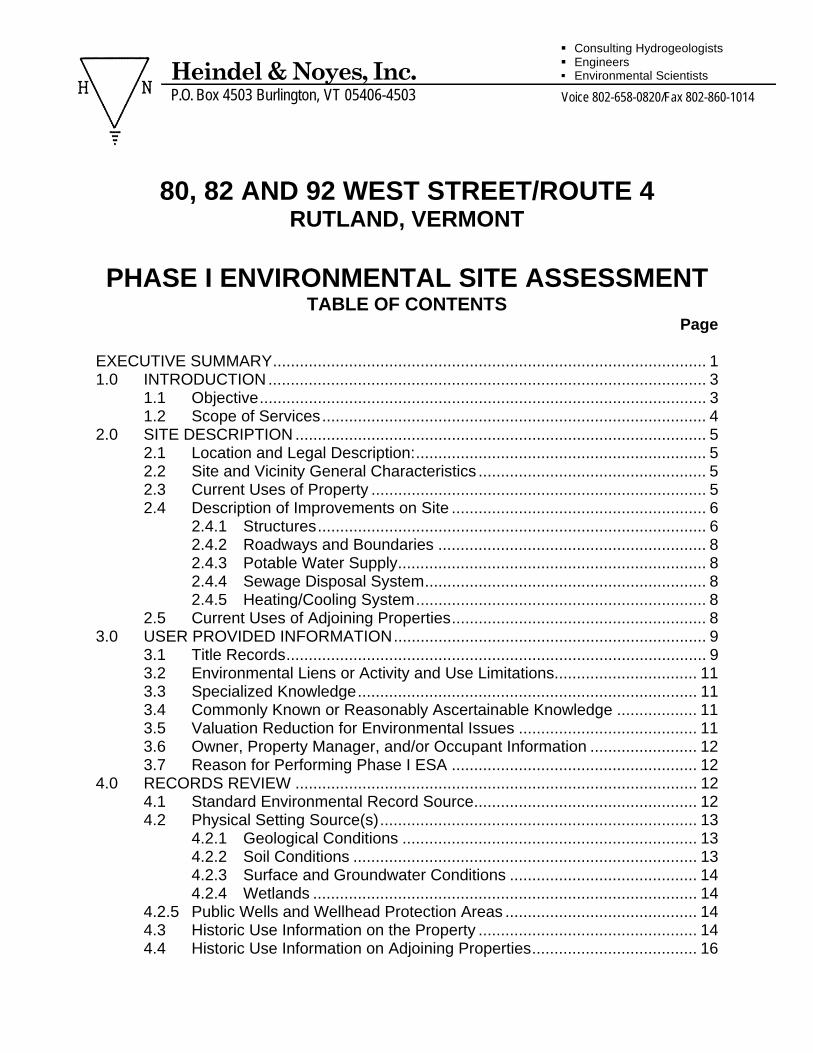
80, 82 AND 92 WEST STREET/ROUTE 4 RUTLAND, VERMONT
PHASE I ENVIRONMENTAL SITE ASSESSMENT
TABLE OF CONTENTS Page EXECUTIVE SUMMARY................................................................................................. 1 1.0 INTRODUCTION.................................................................................................. 3
1.1 Objective.................................................................................................... 3 1.2 Scope of Services...................................................................................... 4
2.0 SITE DESCRIPTION ............................................................................................ 5 2.1 Location and Legal Description:................................................................. 5 2.2 Site and Vicinity General Characteristics ................................................... 5 2.3 Current Uses of Property ........................................................................... 5 2.4 Description of Improvements on Site ......................................................... 6
2.4.1 Structures....................................................................................... 6 2.4.2 Roadways and Boundaries ............................................................ 8 2.4.3 Potable Water Supply..................................................................... 8 2.4.4 Sewage Disposal System............................................................... 8 2.4.5 Heating/Cooling System................................................................. 8
2.5 Current Uses of Adjoining Properties......................................................... 8 3.0 USER PROVIDED INFORMATION...................................................................... 9
3.1 Title Records.............................................................................................. 9 3.2 Environmental Liens or Activity and Use Limitations................................ 11 3.3 Specialized Knowledge............................................................................ 11 3.4 Commonly Known or Reasonably Ascertainable Knowledge .................. 11 3.5 Valuation Reduction for Environmental Issues ........................................ 11 3.6 Owner, Property Manager, and/or Occupant Information ........................ 12 3.7 Reason for Performing Phase I ESA ....................................................... 12
4.0 RECORDS REVIEW .......................................................................................... 12 4.1 Standard Environmental Record Source.................................................. 12 4.2 Physical Setting Source(s)....................................................................... 13
4.2.1 Geological Conditions .................................................................. 13 4.2.2 Soil Conditions ............................................................................. 13 4.2.3 Surface and Groundwater Conditions .......................................... 14 4.2.4 Wetlands ...................................................................................... 14
4.2.5 Public Wells and Wellhead Protection Areas ........................................... 14 4.3 Historic Use Information on the Property ................................................. 14 4.4 Historic Use Information on Adjoining Properties..................................... 16
Heindel & Noyes, Inc. P.O. Box 4503 Burlington, VT 05406-4503
Consulting Hydrogeologists Engineers Environmental Scientists
Voice 802-658-0820/Fax 802-860-1014
5.0 SITE RECONNAISSANCE................................................................................. 24 5.1 Methodology and Limiting Conditions ...................................................... 24 5.2 General Site Setting................................................................................. 24 5.3 Interior Observations ............................................................................... 24 5.4 Exterior Observations .............................................................................. 26 5.5 Hazardous Material or Petroleum Product Use........................................ 27 5.6 Storage Tanks ......................................................................................... 27 5.7 Odors………………. ................................................................................ 27 5.8 Pools of Liquid ......................................................................................... 28 5.9 Drums...................................................................................................... 28 5.10 Hazardous Substance and Petroleum Products Receptacles................. 28 5.11 Unidentified Substance Containers ......................................................... 29 5.12 PCBs …………………………………………………………………………...29 5.13 Stains or Corrosion .................................................................................. 29 5.14 Drains and Sumps ................................................................................... 29 5.15 Pits, Ponds or Lagoons............................................................................ 30 5.16 Stained Soil or Pavement ........................................................................ 30 5.17 Stressed Vegetation................................................................................. 30 5.18 Solid Waste Disposal ............................................................................... 30 5.19 Wastewater and Stormwater.................................................................... 30 5.20 Unnatural Fill or Grading.......................................................................... 31 5.21 Trash On-Site .......................................................................................... 31 5.22 Asbestos .................................................................................................. 31 5.23 Lead-based Paint..................................................................................... 31 2.24 Visual Observations of Adjoining Properties............................................ 31
6.0 Interviews ........................................................................................................... 31 6.1 Interview with Owner................................................................................ 31 6.2 Interview with Site Manager..................................................................... 32 6.3 Interview with Occupants ......................................................................... 32 6.4 Interview with Local Government Officials ............................................... 32 6.5 Interview with Others ............................................................................... 32 6.6 Data Gaps................................................................................................ 32
7.0 FINDINGS .......................................................................................................... 33 8.0 OPINION ............................................................................................................ 34 9.0 CONCLUSIONS ................................................................................................. 34 10.0 DEVIATIONS...................................................................................................... 37 11.0 SIGNATURES OF ENVIRONMENTAL PROFESSIONAL(S) ............................. 37 APPENDICES Appendix 1 – Maps Appendix 2 – Hazards Map and Identification Appendix 3 – Photographic Record Appendix 4 – Environmental Questionnaire Appendix 5 – First letter, SMAC letter, Documentation relating to UST tank pull on site Appendix 6 – Heindel and Noyes Preliminary Environnemental Site Screen (2002) Appendix 6 – Property Screening Service Evaluation (2004) Appendix 7 – Reports, documentation Stewart’s (neighboring Site) Appendix 8 – References Appendix 9 – Resumes
80, 82 AND 92 WEST STREET/ROUTE 4 RUTLAND, VERMONT
PHASE I ENVIRONMENTAL SITE ASSESSMENT
October 19, 2007
EXECUTIVE SUMMARY
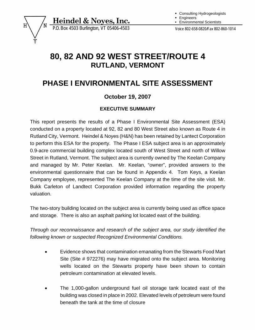
This report presents the results of a Phase I Environmental Site Assessment (ESA) conducted on a property located at 92, 82 and 80 West Street also known as Route 4 in Rutland City, Vermont. Heindel & Noyes (H&N) has been retained by Lantect Corporation to perform this ESA for the property. The Phase I ESA subject area is an approximately 0.9-acre commercial building complex located south of West Street and north of Willow Street in Rutland, Vermont. The subject area is currently owned by The Keelan Company and managed by Mr. Peter Keelan. Mr. Keelan, “owner”, provided answers to the environmental questionnaire that can be found in Appendix 4. Tom Keys, a Keelan Company employee, represented The Keelan Company at the time of the site visit. Mr. Bukk Carleton of Landtect Corporation provided information regarding the property valuation. The two-story building located on the subject area is currently being used as office space and storage. There is also an asphalt parking lot located east of the building. Through our reconnaissance and research of the subject area, our study identified the following known or suspected Recognized Environmental Conditions.
• Evidence shows that contamination emanating from the Stewarts Food Mart Site (Site # 972276) may have migrated onto the subject area. Monitoring wells located on the Stewarts property have been shown to contain petroleum contamination at elevated levels.
• The 1,000-gallon underground fuel oil storage tank located east of the
building was closed in place in 2002. Elevated levels of petroleum were found beneath the tank at the time of closure
Heindel & Noyes, Inc. P.O. Box 4503 Burlington, VT 05406-4503
Consulting Hydrogeologists Engineers Environmental Scientists
Voice 802-658-0820/Fax 802-860-1014
92, 82 & 80 WEST STREET/RTE 4- RUTLAND CITY – PHASE I ENVIRONMENTAL SITE ASSESSMENT 2
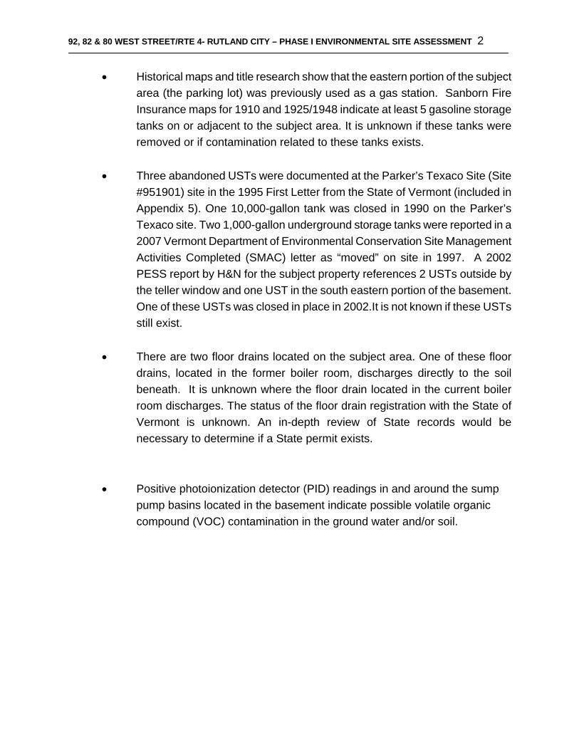
• Historical maps and title research show that the eastern portion of the subject area (the parking lot) was previously used as a gas station. Sanborn Fire Insurance maps for 1910 and 1925/1948 indicate at least 5 gasoline storage tanks on or adjacent to the subject area. It is unknown if these tanks were removed or if contamination related to these tanks exists.
• Three abandoned USTs were documented at the Parker’s Texaco Site (Site
#951901) site in the 1995 First Letter from the State of Vermont (included in Appendix 5). One 10,000-gallon tank was closed in 1990 on the Parker’s Texaco site. Two 1,000-gallon underground storage tanks were reported in a 2007 Vermont Department of Environmental Conservation Site Management Activities Completed (SMAC) letter as “moved” on site in 1997. A 2002 PESS report by H&N for the subject property references 2 USTs outside by the teller window and one UST in the south eastern portion of the basement. One of these USTs was closed in place in 2002.It is not known if these USTs still exist.
• There are two floor drains located on the subject area. One of these floor
drains, located in the former boiler room, discharges directly to the soil beneath. It is unknown where the floor drain located in the current boiler room discharges. The status of the floor drain registration with the State of Vermont is unknown. An in-depth review of State records would be necessary to determine if a State permit exists.
• Positive photoionization detector (PID) readings in and around the sump pump basins located in the basement indicate possible volatile organic compound (VOC) contamination in the ground water and/or soil.
92, 82 & 80 WEST STREET/RTE 4- RUTLAND CITY – PHASE I ENVIRONMENTAL SITE ASSESSMENT 3
80, 82 AND 92 WEST STREET/ROUTE 4
RUTLAND, VERMONT
PHASE I ENVIRONMENTAL SITE ASSESSMENT
October 19, 2007
1.0 INTRODUCTION This report presents the results of a Phase I Environmental Site Assessment (ESA) conducted on a property located at 92, 82 and 80 West Street also known as Route 4 in Rutland City, Vermont. Heindel & Noyes (H&N) has been retained by Lantect Corporation to perform this ESA for the property. The Phase I ESA subject area is an approximately 0.9-acre commercial building complex located south of West Street and north of Willow Street in Rutland, Vermont. The subject area is currently owned by The Keelan Company and managed by Mr. Peter Keelan. Mr. Keelan, “owner”, provided answers to the environmental questionnaire that can be found in Appendix 4. Tom Keys, a Keelan Company employee, represented The Keelan Company at the time of the site visit. Mr. Bukk Carleton of Landtect Corporation provided information regarding the property valuation. 1.1 Objective The purpose of this Phase I ESA is to render an opinion regarding the presence of environmental conditions within the subject area. Such conditions may indicate an existing release, a past release, or a potential threat of a release of hazardous substances or petroleum products into the environment. The investigative procedures and reporting format used herein generally conform to the requirements of the American Society for Testing and Materials (ASTM) Standard E 1527-05 and USEPA All Appropriate Inquiry Rule 40CFR312.
Heindel & Noyes, Inc. P.O. Box 4503 Burlington, VT 05406-4503
Consulting Hydrogeologists Engineers Environmental Scientists
Voice 802-658-0820/Fax 802-860-1014
92, 82 & 80 WEST STREET/RTE 4- RUTLAND CITY – PHASE I ENVIRONMENTAL SITE ASSESSMENT 4
1.2 Scope of Services A Phase I ESA is a research and reconnaissance-level review of a property and the surrounding area to identify potential environmental conditions that may indicate the presence of a release or threat of release of hazardous substances or petroleum. The assessment is largely dependent on direct observation of site conditions, inquiries into previous ownership and uses of the property, and reviews of reasonably and readily available federal, state, and local environmental records. No subsurface investigations were conducted and no laboratory samples were collected as part of this investigation. The Phase I ESA scope of services for this site included:
• Site history development: This entails a review of the history of site ownership, use, and potential environmental issues based on available information obtained from interviews with persons knowledgeable of the area.
• Record searches at appropriate federal, state and local agencies providing
information pertaining to possible environmental conditions at or in the vicinity of the subject area. This includes the subject area and properties within an appropriate minimum search distance.
• Review of available historical sources such as Sanborn Fire Insurance Maps, aerial
photographs, Beers Atlas and the Mannings Directory.
• A site reconnaissance to observe, document, and photograph site operations, property conditions, and signs of potential environmental liabilities, including asbestos and lead-based painted surfaces.
• Field testing for volatile organic compounds (VOCs) with an ION Science PhoCheck
photoionization detector (PID), with a 10.6 eV UV lamp probe, was conducted during the physical inspection of the property. The PID measures the relative levels of VOC's referenced to an isobutylene-in-air standard. Although PID screening cannot be used directly to quantify VOC concentrations or identify individual compounds, the results serve as a relative indicator of the presence of VOCs in the area. VOCs are often an indication of petroleum or solvent product contamination. VOCs are also often present in paints, varnishes, solvents, adhesives, and common household institutional cleaning agents. There were positive readings recorded on the PID during the site inspection.
92, 82 & 80 WEST STREET/RTE 4- RUTLAND CITY – PHASE I ENVIRONMENTAL SITE ASSESSMENT 5
1.3 Limitations and Exceptions Limitations and exceptions to this Phase I ESA that prevented a full view of the ground surface of the subject area include locked areas and inaccessible areas in the basement. The roof was not inspected during the site visit. 1.4 User Reliance This report was prepared solely for the use of Landtect Corporation. The conclusions provided by H&N in this report are based solely on the information referenced within this document. While we are unaware of any facts or circumstances that would cause us to suspect that the conclusions drawn herein are incorrect or misleading, it is possible that additional information could require refinement or modifications of our conclusions. This report has been prepared in general accordance with ASTM E 1527-05 and USEPA All Appropriate Inquiry Rule. 2.0 SITE DESCRIPTION 2.1 Location and Legal Description: The subject area’s legal addresses are 92, 82 and 80 West Street/Route 4 which are located within the City of Rutland, Vermont. A USGS topographic and orthophotographic maps are included in Appendix 1, pages 1 and 2. The subject area boundaries are shown on the map in Appendix 1, page 3. The centroid of the site is located at Latitude 43º 36’ 27.86”N and Longitude 72º 58’ 42.25”W (NAD83 Vermont State Plane) as determined using ArcGIS Desktop GIS software (Version 9.1. Redlands, CA: Environmental Systems Research Institute, Inc., 2005.) 2.2 Site and Vicinity General Characteristics
The topography of the subject property is generally flat, with surrounding topography sloping from east to west. The subject area is located in a developed commercial area of Rutland City, Vermont. 2.3 Current Uses of Property
The majority of the building on the subject area is currently being used as office space. Storage space and boiler rooms are located in the basement. There are empty office
92, 82 & 80 WEST STREET/RTE 4- RUTLAND CITY – PHASE I ENVIRONMENTAL SITE ASSESSMENT 6
spaces on both floors and empty storage space in the basement. An asphalt parking lot is located on the eastern portion of the subject area. 2.4 Description of Improvements on Site 2.4.1 Structures There is currently one building and one asphalt parking lot on the subject area. The building is comprised of 3 structures that were joined around 1940 according to the property owner. The building has 2 stories above ground and a basement below. The basement in the western portion of the building is partially above ground due to the slope of the subject area. (See site map included in Appendix1- page 3 and map provided by Mr. Keelan in Appendix 5) The southeastern section of the basement was not inspected during the site visit. Other areas of the basement were also not accessible at the time of inspection. The northeast portion of the basement is used as a boiler room. A closet located in this section of the basement contains a sump (Sump #2 as shown on the site map in Appendix 1- Page 3). Sump #2 was backed up with water and almost overflowing. A PID reading of 2.5 parts per million (ppm) was given at the water surface. The new boiler room is located south of Sump #2 and contains new propane boilers. Rust-colored staining was observed on the concrete floor in this area. A circular floor drain and a sump with a sump pump (Sump #3) are located in this room. A PID reading of 5.7 ppm was given from the grate of the floor drain. Mr. Keys and Mr. Keelan were unsure of where this drain discharges. There was rust-colored staining around the sump and water visibly seeping through the sides into the sump. A PID reading of 2.5 ppm was given at water level in the sump. Mr. Keelan stated that all the sumps in the building flow to the municipal sewer system. The middle portion of the basement is used for storage and contained chairs, filing cabinets and other office equipment and supplies. This area of the basement has a vinyl tile floor that potentially contains asbestos. Sump #1 is located in this middle portion of the building in an area with green commercial carpet. A PID reading of 5.2 was given at water level in the sump. Rust-colored staining was observed in the sump basin. The southwest portion of the basement is partially above ground. This area is empty with a poured concrete floor. The concrete floor observed in this area is 2-3 inches thick and poured on top of soil. An open perimeter drain with filter fabric, crushed rock and perforated
92, 82 & 80 WEST STREET/RTE 4- RUTLAND CITY – PHASE I ENVIRONMENTAL SITE ASSESSMENT 7
pipe encircle the open space. Mr. Keelan mentioned that improvements in the basement area were started in 2002-2003 and were abandoned. Soils excavated for the construction of the perimeter drain were not tested and no contamination was observed at the time of excavation. An opening in the far southwestern corner of the perimeter drain contained soil and standing water. PID readings of 14-20 ppm were recorded at the soil level in this location. This open space is separated from the hallway directly to the north of this area by a half wall of drywall. Mr. Keys stated that the rough plumbing work in this hallway was meant for bathrooms that were never installed. North of the hallway, to the east of the stairway is the old boiler room. A floor drain with a wooden grate is located in the entry of this room. Staining was observed around the floor drain. The floor drain empties directly to the soils beneath. No unusual odors were noted in this area. The old boiler room is located up a step in a room located east of the floor drain. The decommissioned oil fired boiler is still in place. Two 275-gallon fuel oil above ground storage tanks (AST) were drained and disconnected by Precision Industrial Maintenance, Inc in 2002. (see letter dated 8/26/2002 in Appendix 5) The contents were pumped out and drained and fill lines and vents were disconnected and plugged. The tanks remain in place with fuel lines and fuel filter still connected to the tanks but capped near the boiler. Minor staining was observed below and around the ASTs. A set of stairs leading above is located north of the old boiler room. A vacant section of the building is located at the top of the basement stairs on the first floor. At the time of inspection this section looked to be under construction. East of this space is a carpeted entry area with a small fountain and stairs leading to office space occupied by The Home Service Store. A communal hallway connects this area with an elevator to the south. The hallway continues east and connects the main building entry to the Key Bank office space. The Key Bank occupies the eastern suite on the first floor. Multiple stairways and an elevator are used to access the top floor of the building. The top floor of the building is vacant and occupied office space. The office area occupied by SI Trust has a small kitchen, meeting rooms and cubicles in a large main room. Vacant office space is located to the north of the SI Trust offices. Since the 2000 purchase of the building The Keelan Company has replaced the air conditioning system, added new carpet and painted throughout the building. There was previously a drive up teller window located adjacent to the Key Bank offices. The teller window has been replaced with a drive-up ATM.
92, 82 & 80 WEST STREET/RTE 4- RUTLAND CITY – PHASE I ENVIRONMENTAL SITE ASSESSMENT 8
It should be noted that PID readings obtained may be artificially high due to moisture present at each of the locations screened. No odors were noted during the building walk-through. 2.4.2 Roadways and Boundaries The property is accessed from curb cuts in West Street/Route 4 and in Wales Street which create the northern and eastern property boundaries. The Marble Valley Regional Transit Station bounds the subject area to the west and southwest. The VFW building and VFW parking lot create the remainder of the southern property boundary. A retaining wall is located between the VFW building and the southeastern corner of the building on the subject area. The surrounding properties are shown on the maps included in Appendix 1, Pages 3. For the purposes of this ESA, the boundaries of the subject area are shown on the map in Appendix 1, page 3. 2.4.3 Potable Water Supply The subject property relies on the municipal water supply serving the City of Rutland. 2.4.4 Sewage Disposal System
The subject property relies on the municipal wastewater treatment facility serving the City of Rutland.
2.4.5 Heating/Cooling System The building relies on a forced hot air heating system connected to propane tanks serviced by Haskins Gas Service, Inc. 2.5 Current Uses of Adjoining Properties Trinity Episcopal Church and a bank are located north of the subject area on the opposite side of West Street. Verizon occupies a large brick building on the northeast corner of Wales Street and West Street. Across Wales Street directly to the east of the subject area is a Stewart’s Food Mart gas station. A pub and heating supply store are located south of Stewart’s. The VFW building and a paved parking lot used by the VFW is located south and south east of the subject area. An entrance to the Marble Valley Regional Transit Center and a ticket boot are located just west of the VFW parking lot. The Transit Center is a 5-story concrete parking facility with a bus station below on ground level. The Transit
92, 82 & 80 WEST STREET/RTE 4- RUTLAND CITY – PHASE I ENVIRONMENTAL SITE ASSESSMENT 9
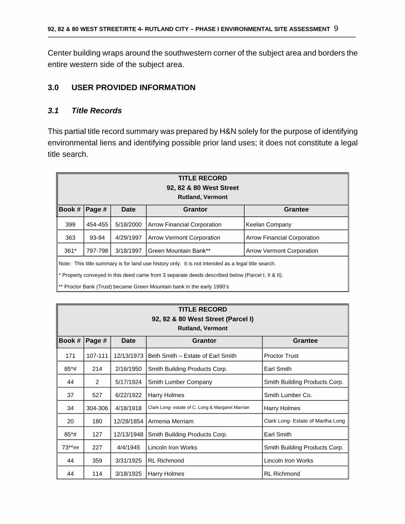
Center building wraps around the southwestern corner of the subject area and borders the entire western side of the subject area. 3.0 USER PROVIDED INFORMATION 3.1 Title Records This partial title record summary was prepared by H&N solely for the purpose of identifying environmental liens and identifying possible prior land uses; it does not constitute a legal title search.
TITLE RECORD 92, 82 & 80 West Street
Rutland, Vermont Book # Page # Date Grantor Grantee
399 454-455 5/18/2000 Arrow Financial Corporation Keelan Company
363 93-94 4/29/1997 Arrow Vermont Corporation Arrow Financial Corporation
361* 797-798 3/18/1997 Green Mountain Bank** Arrow Vermont Corporation
Note: This title summary is for land use history only. It is not intended as a legal title search.
* Property conveyed in this deed came from 3 separate deeds described below (Parcel I, II & II).
** Proctor Bank (Trust) became Green Mountain bank in the early 1990’s
TITLE RECORD
92, 82 & 80 West Street (Parcel I) Rutland, Vermont
Book # Page # Date Grantor Grantee
171 107-111 12/13/1973 Beth Smith – Estate of Earl Smith Proctor Trust
85*# 214 2/16/1950 Smith Building Products Corp. Earl Smith
44 2 5/17/1924 Smith Lumber Company Smith Building Products Corp.
37 527 6/22/1922 Harry Holmes Smith Lumber Co.
34 304-306 4/18/1918 Clark Long- estate of C. Long & Margaret Marrian Harry Holmes
20 180 12/28/1854 Armenia Merriam Clark Long- Estate of Martha Long
85*# 127 12/13/1948 Smith Building Products Corp. Earl Smith
73**## 227 4/4/1945 Lincoln Iron Works Smith Building Products Corp.
44 359 3/31/1925 RL Richmond Lincoln Iron Works
44 114 3/18/1925 Harry Holmes RL Richmond
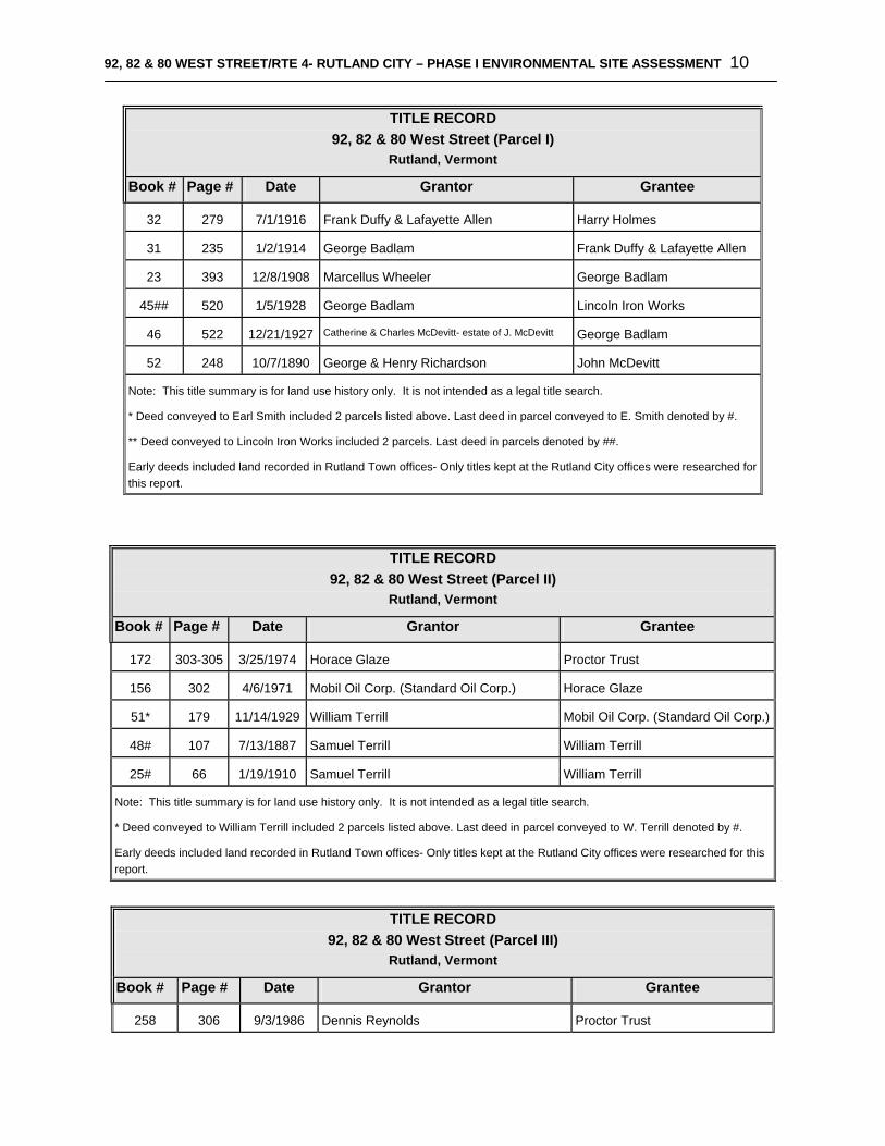
92, 82 & 80 WEST STREET/RTE 4- RUTLAND CITY – PHASE I ENVIRONMENTAL SITE ASSESSMENT 10
TITLE RECORD 92, 82 & 80 West Street (Parcel I)
Rutland, Vermont Book # Page # Date Grantor Grantee
32 279 7/1/1916 Frank Duffy & Lafayette Allen Harry Holmes
31 235 1/2/1914 George Badlam Frank Duffy & Lafayette Allen
23 393 12/8/1908 Marcellus Wheeler George Badlam
45## 520 1/5/1928 George Badlam Lincoln Iron Works
46 522 12/21/1927 Catherine & Charles McDevitt- estate of J. McDevitt George Badlam
52 248 10/7/1890 George & Henry Richardson John McDevitt
Note: This title summary is for land use history only. It is not intended as a legal title search.
* Deed conveyed to Earl Smith included 2 parcels listed above. Last deed in parcel conveyed to E. Smith denoted by #.
** Deed conveyed to Lincoln Iron Works included 2 parcels. Last deed in parcels denoted by ##.
Early deeds included land recorded in Rutland Town offices- Only titles kept at the Rutland City offices were researched for this report.
TITLE RECORD 92, 82 & 80 West Street (Parcel II)
Rutland, Vermont Book # Page # Date Grantor Grantee
172 303-305 3/25/1974 Horace Glaze Proctor Trust
156 302 4/6/1971 Mobil Oil Corp. (Standard Oil Corp.) Horace Glaze
51* 179 11/14/1929 William Terrill Mobil Oil Corp. (Standard Oil Corp.)
48# 107 7/13/1887 Samuel Terrill William Terrill
25# 66 1/19/1910 Samuel Terrill William Terrill
Note: This title summary is for land use history only. It is not intended as a legal title search.
* Deed conveyed to William Terrill included 2 parcels listed above. Last deed in parcel conveyed to W. Terrill denoted by #.
Early deeds included land recorded in Rutland Town offices- Only titles kept at the Rutland City offices were researched for this report.
TITLE RECORD
92, 82 & 80 West Street (Parcel III) Rutland, Vermont
Book # Page # Date Grantor Grantee
258 306 9/3/1986 Dennis Reynolds Proctor Trust
92, 82 & 80 WEST STREET/RTE 4- RUTLAND CITY – PHASE I ENVIRONMENTAL SITE ASSESSMENT 11
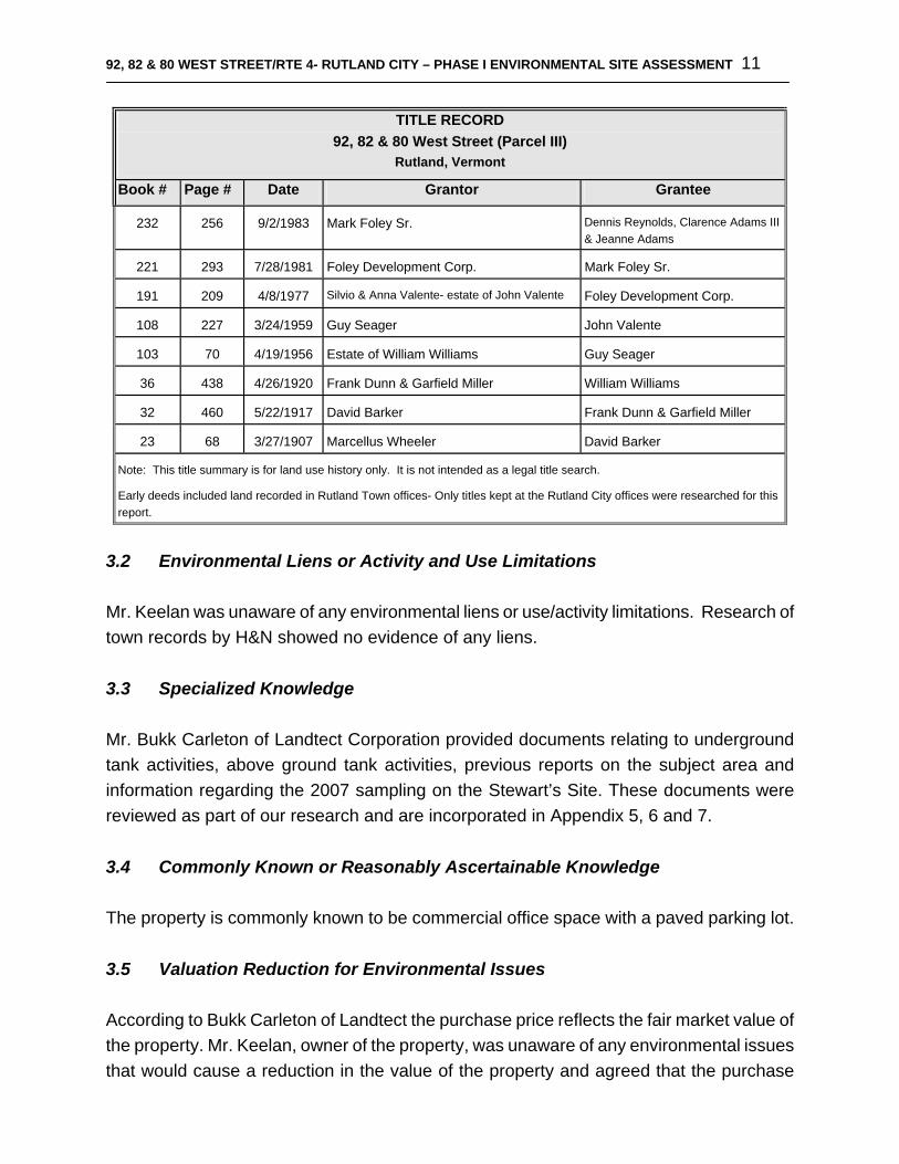
TITLE RECORD 92, 82 & 80 West Street (Parcel III)
Rutland, Vermont Book # Page # Date Grantor Grantee
232 256 9/2/1983 Mark Foley Sr. Dennis Reynolds, Clarence Adams III & Jeanne Adams
221 293 7/28/1981 Foley Development Corp. Mark Foley Sr.
191 209 4/8/1977 Silvio & Anna Valente- estate of John Valente Foley Development Corp.
108 227 3/24/1959 Guy Seager John Valente
103 70 4/19/1956 Estate of William Williams Guy Seager
36 438 4/26/1920 Frank Dunn & Garfield Miller William Williams
32 460 5/22/1917 David Barker Frank Dunn & Garfield Miller
23 68 3/27/1907 Marcellus Wheeler David Barker
Note: This title summary is for land use history only. It is not intended as a legal title search.
Early deeds included land recorded in Rutland Town offices- Only titles kept at the Rutland City offices were researched for this report.
3.2 Environmental Liens or Activity and Use Limitations Mr. Keelan was unaware of any environmental liens or use/activity limitations. Research of town records by H&N showed no evidence of any liens. 3.3 Specialized Knowledge Mr. Bukk Carleton of Landtect Corporation provided documents relating to underground tank activities, above ground tank activities, previous reports on the subject area and information regarding the 2007 sampling on the Stewart’s Site. These documents were reviewed as part of our research and are incorporated in Appendix 5, 6 and 7. 3.4 Commonly Known or Reasonably Ascertainable Knowledge The property is commonly known to be commercial office space with a paved parking lot.
3.5 Valuation Reduction for Environmental Issues According to Bukk Carleton of Landtect the purchase price reflects the fair market value of the property. Mr. Keelan, owner of the property, was unaware of any environmental issues that would cause a reduction in the value of the property and agreed that the purchase
92, 82 & 80 WEST STREET/RTE 4- RUTLAND CITY – PHASE I ENVIRONMENTAL SITE ASSESSMENT 12
price reflects the fair market value of the subject area. 3.6 Owner, Property Manager, and/or Occupant Information
The subject property is currently owned and managed by The Keelan Company of Manchester, VT. Mr. Peter Keelan represented The Keelan Company for the purposes of this Phase 1 ESA. Mr. Phil Savery is the caretaker for the property according to Mr. Keelan. Environmental issues and records are managed by The Keelan Company. Key Bank and The Home Service Store occupy the first floor of the building. SI Trust occupies the second floor of the building. Both the first and second floors have vacant office space. The basement is unoccupied but is used to store office equipment, supplies and the boiler rooms.
3.7 Reason for Performing Phase I ESA
This Phase I Environmental Site Assessment (ESA) was performed by H&N at the request of Landtect to present an opinion regarding evidence of Recognized Environmental Conditions within the subject area.
4.0 RECORDS REVIEW All records reviewed are summarized in Appendix 8. 4.1 Standard Environmental Record Source The following federal EPA and State of Vermont databases were searched for hazardous conditions which might have an impact on the environmental status of the subject area.
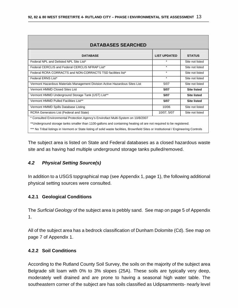
92, 82 & 80 WEST STREET/RTE 4- RUTLAND CITY – PHASE I ENVIRONMENTAL SITE ASSESSMENT 13
DATABASES SEARCHED
DATABASE LIST UPDATED
STATUS
Federal NPL and Delisted NPL Site List* * Site not listed
Federal CERCLIS and Federal CERCLIS NFRAP List* * Site not listed
Federal RCRA CORRACTS and NON-CORRACTS TSD facilities list* * Site not listed
Federal ERNS List* * Site not listed
Vermont Hazardous Materials Management Division Active Hazardous Sites List 5/07 Site not listed
Vermont HMMD Closed Sites List 5/07 Site listed
Vermont HMMD Underground Storage Tank (UST) List** 5/07 Site listed
Vermont HMMD Pulled Facilities List** 5/07 Site listed
Vermont HMMD Spills Database Listing 10/06 Site not listed
RCRA Generators List (Federal and State) 10/07, 5/07 Site not listed
* Consulted Environmental Protection Agency’s Envirofact Multi-System on 10/8/2007
**Underground storage tanks smaller than 1100-gallons and containing heating oil are not required to be registered.
*** No Tribal listings in Vermont or State listing of solid waste facilities, Brownfield Sites or Institutional / Engineering Controls
The subject area is listed on State and Federal databases as a closed hazardous waste site and as having had multiple underground storage tanks pulled/removed. 4.2 Physical Setting Source(s) In addition to a USGS topgraphical map (see Appendix 1, page 1), the following additional physical setting sources were consulted. 4.2.1 Geological Conditions
The Surficial Geology of the subject area is pebbly sand. See map on page 5 of Appendix 1. All of the subject area has a bedrock classification of Dunham Dolomite (Cd). See map on page 7 of Appendix 1. 4.2.2 Soil Conditions According to the Rutland County Soil Survey, the soils on the majority of the subject area Belgrade silt loam with 0% to 3% slopes (25A). These soils are typically very deep, moderately well drained and are prone to having a seasonal high water table. The southeastern corner of the subject are has soils classified as Udipsamments- nearly level

92, 82 & 80 WEST STREET/RTE 4- RUTLAND CITY – PHASE I ENVIRONMENTAL SITE ASSESSMENT 14
(96). Soils with this classification tend to be excessively well drained to somewhat poorly drained and are typically found in disturbed areas. See map on page 9 of Appendix 1. 4.2.3 Surface and Groundwater Conditions
Surface Water: There are no surface waters on the subject area. Rain falling on the subject area flows as sheet flow into catchbasins located in the paved parking area or towards the west. East Creek is located approximately 2,500 feet west of the subject area. Groundwater: The State of Vermont’s groundwater classification system has all but a few small locations given the default status of Class III Groundwater because they have not individually been designated Classes I, II, or IV. The subject area is in this default category of Class III Groundwater. Based on H&N’s knowledge of the immediate area, the direction of ground water flow likely mimics the topography of the area and flows to the west towards East Creek. One Hundred Year Floodplain: The subject area is not within the 100-year floodplain as designated by the Federal Emergency Management Agency (FEMA). However, this should not be considered an official flood determination. See map in Appendix 1, Page 10. 4.2.4 Wetlands
According to the Vermont Significant Wetland Inventory (VSWI), there are no mapped wetlands with in 0.53 miles of the subject area. 4.2.5 Public Wells and Wellhead Protection Areas Public Wells: The State of Vermont GIS mapping system does not identify any public wells (“Wellhead Protection Area Source Wells”) within the 0.53-mile radius of the subject property. Wellhead Protection Areas: The Wellhead Protection Areas: The subject area is not located within a designated wellhead protection area (WHPA). No surface water source protection areas are within a 0.53-mile radius of the subject area. 4.3 Historic Use Information on the Property Until 1892 Rutland City was considered to be a part of Rutland Town. Deed research
92, 82 & 80 WEST STREET/RTE 4- RUTLAND CITY – PHASE I ENVIRONMENTAL SITE ASSESSMENT 15
started in the late 1800’s when deed records for the City of Rutland begin. The subject area was used by a lumber and building supply company, an iron works, and a retail gasoline supplier. Mobil Oil Corporation owned the eastern portion of the subject area previously occupied by Terrill’s Wagon Shop from 1929 to 1971. Land uses mentioned in deed descriptions coincide with those found on the Sanborn Fire Insurance Maps. Historic Sanborn Fire Insurance maps dated 1879 through 1948 were available for the subject property. The western two-thirds of the subject area was part of H.O. Edson’s lumber yard from 1879-1890. The lumber yard is shown on the 1895 map to only occupy about one-forth of the subject area. The area previously occupied by H.O. Edson is vacant 1895 through 1916. A residential house with a livery behind is shown adjacent to the lumber yard on maps dated 1879-1916. The eastern portion of the subject area was used as a wagon shop, carriage repository and a blacksmith’s shop from 1879-1905. A bicycle shop, woodworking and storage area and paint shop also occupied buildings in the eastern portion of the subject area between 1900 and1905. The 1910 Sanborn Fire Insurance map shows the carriage shop occupying the former black smith’s shop located on the eastern portion of the subject area. A 20-gallon gasoline above ground storage tank is shown on the 1910 map adjacent to the carriage shop. A rug shop is shown north of the storage tank. See Appendix 1- Page 4 for locations of relevant historic land use and gasoline tank locations. The 1916 Sanborn Fire Insurance map shows, from west to east, a vacant lot, a residential house with livery, a rug shop, carriage factory, woodworking shop, storage and painting areas occupying the subject area. No gasoline tanks are shown. A 100–car capacity garage, store and tile shop are shown on the previously vacant area on the 1925 map. The residential house was replaced by an office and warehouse. The rug shop and a shed occupy the lot adjacent to the office space. The eastern one-third of the subject area is shown to have been used as an ice cream factory, shirt factory, paper fly catcher factory, auto sales area, woodworking shop, storage area and a rubber vulcanizing facility in 1925. Sulfur and derivatives of benzothiazole were historically used in the vulcanizing process. Benzothiazole is a compound classified as a Polycyclic Aromatic Hydrocarbon (PAH). PAHs are regarded as highly persistent in the environment and are known or suspected carcinogens. Revisions to the Sanborn map between 1925 and 1945 note at least 5 gasoline tanks on the subject area and additional gasoline tanks on adjoining properties. The revised
92, 82 & 80 WEST STREET/RTE 4- RUTLAND CITY – PHASE I ENVIRONMENTAL SITE ASSESSMENT 16
1925/1945 map shows a filling station with 4 gasoline tanks located on the eastern third of the subject area. A parking area is located between the filling station and a shop, paint and tile stores and a plumbing warehouse. The western portion of the subject area is occupied by an auto sales and service shop on the revised 1925/1945 map. A gasoline tank is located north of the auto sales and service shop. It is unclear if this gasoline tank is on the subject area or located in the right-of-way. A map showing approximate locations of the gasoline tanks and historic land use is located in Appendix 1, page 4. The 1876 Beers Atlas did not provide any additional information regarding site history or land use. According to the current property owner, three buildings on site were consolidated in the 1940’s and connected into a single structure. Until 1997 when the property was sold to Proctor Trust/Green Mountain Bank (GMB) the subject area was held in three separate deeds. The property held by the Proctor Bank included additional land located adjacent to the subject area now held in a separate deed by the Marble Valley Regional Transit Center. The subject area has included the same parcel boundary and has been a paved parking lot and a single structure since the time of purchase by the current property owner in 2000. 4.4 Historic Use Information on Adjoining Properties The adjoining properties have land use histories similar to that of the subject area. A map showing the approximate locations of gasoline tanks and neighboring land uses is in Appendix 1- Page 4. According to the Sanborn Fire Insurance maps Trinity Episcopal Church has been located directly across West Street from the subject area since 1879. Properties adjoining the subject area to the south have been occupied by residential houses, liveries, a battery service shop, parking lots, various shops, offices and stores such as a paint shop, black smith’s shops, a bowling center. The Rutland Garage Company is shown adjacent to the subject area to the south on the 1910 Sanborn map. This location is shown on the 1925/1948 map as an auto sales and service shop with 2 gasoline tanks onsite. Edson Street is shown on all researched Sanborn maps as running perpendicular to West Street and connecting through to Willow Street west of the subject area. The Marble Valley Regional Transit Center is currently located on top of what was Edson Street. From 1879 to 1925 the western end of this block was part of the lumber yard, residential houses, a tailor shop and The Elmore Hotel. The 1948 revisions to the 1925 Sanborn map show a
92, 82 & 80 WEST STREET/RTE 4- RUTLAND CITY – PHASE I ENVIRONMENTAL SITE ASSESSMENT 17
filling station with 2 gasoline tanks on the corner of Edson Street and West Street. The block across Wales Street, east of the subject area was occupied by residential houses through 1925. An auto sales shop and a dress manufacturing facility are shown along with residential houses in 1925. On the northwest corner of Wales and West Street, where Stewart’s Food Mart is now located, the 1925/1948 Sanborn map shows a filling station with 5 gasoline tanks attached to a greasing shop. A bowling alley, houses, shops and a garage with 2 gasoline tanks are also shown on the eastern side of Wales Street across from the subject area on 1925/1948 maps. The same Federal and Vermont databases that were searched for information on the search area (see Section 4.1 above) were searched in addition to the historic sources mentioned above regarding hazardous sites or conditions on neighboring properties. A map showing the locations of listed environmental sites within 0.53 miles of the center of the subject area is shown on Page 1 of Appendix 2. The remainder of Appendix 2 contains existing environmental threats within the 0.53 mile search area, as well as orphan hazardous waste sites, storage tanks, pollution source inventory sites, RCRA manifests, RCRA hazardous waste generators, orphan USTs, orphan storage tanks, orphan hazardous spills, orphan RCRA manifests and orphan RCRA generators. Orphans are sites for which the State of Vermont does not have a physical location on the maps. Below is a summary of our analysis of the hazards map and the orphan lists. All listings are current as of May 2007, with the exception of the Spills (October 2006), and Pollution Source Inventory sites (1980). Federal NPL and Delisted NPL Site List: A search area of 1 mile was used to identify potential federally listed hazards. There were no Federal NPL or Delisted NPL sites within one mile of the subject area. Federal CERCLIS and Federal CERCLIS NFRAP List: There were no Federal CERCLIS or Federal CERCLIS NFRAP sites within one mile of the subject area. Federal RCRA CORRACTS and NON-CORRACTS TSD facilities list: There are no RCRA CORRACTS sites within 1 mile of the subject property. There are no RCRA NON-CORRACTS TSD facilities within the one mile search area.
92, 82 & 80 WEST STREET/RTE 4- RUTLAND CITY – PHASE I ENVIRONMENTAL SITE ASSESSMENT 18
Hazardous Waste Sites: There are 50 State-listed open and closed hazardous waste sites listed within the 0.53-mile search area. There are 6 sites that are in close proximity to or on the subject area and are listed below. The remaining 44 sites are either downgradient or at a significant distance and therefore pose little threat to the subject property. Topography as shown on the USGS map (Appendix 1, page 1), surface water data and local knowledge were consulted to determine proximity and slope. Proctor Bank (Site # 900483) 80 West Street (subject Area)- Site was closed and combined with the active hazardous waste site Marble Valley Regional Transit District (former Parker Texaco) (MVRTD) site (site #951901) in 1997. Contamination was found during construction of transit center. See detailed description below. A Site Management Activity Completed (SMAC) letter was issued by the State of Vermont in July 2007 for a portion of the Proctor Bank site. The SMAC letter separated the Proctor Bank site from the MVRTD site and closed site #900483. This site is located on the subject area. MVRTD (Former Parker Texaco) (Site #951901) 102 West Street- This site was subdivided from the Proctor Bank property located at 80 West Street through eminent domain for the construction of the Marble Valley Regional Transit Center. A 10,000-gallon fuel oil UST in poor condition was removed in 1990. Three abandoned USTs were documented at this site in the 1995 First Letter from the State of Vermont (included in Appendix 5). Two 1,000 gallon fuel oil USTs were moved from the MVRTD site to the eastern portion of the subject area according the 2007 SMAC Letter. Contaminated soils were removed from the MVRTD location. Two monitoring wells were installed and subsequently demolished when the MVRTD transit center was constructed. This site was combined with the above Proctor Bank Site in 1997 and then separated in 2007. This site is located adjacent to the subject area and is listed as a medium priority active hazardous waste site. Stewart’s Food Mart (Site #972276) 60 West Street- In 1997 nine underground storage tanks were found onsite. Seven of the nine tanks were closed in place due to proximity to structures. Significant contamination was found on site. 630 tons of soils were removed from the site and four monitoring wells were installed during an initial site investigation. Elevated petroleum contamination levels continued to be seen in the monitoring wells closest to Wales Street during groundwater monitoring in 2007. Sampling is on-going and scheduled quarterly. The 2007 monitoring report suggests that the contamination is migrating towards the subject area. This active hazardous waste site is located approximately 50 feet upgradient from the subject area.
92, 82 & 80 WEST STREET/RTE 4- RUTLAND CITY – PHASE I ENVIRONMENTAL SITE ASSESSMENT 19
NET Rutland (Site #931366) 55 West Street- In 1993 a 3,000-gallon #2 fuel oil and a 5,000 gallon diesel fuel USTs were removed. Monitoring wells were installed. Significant concentrations of VOCs were found during soil borings at a depth of 5 to 10 feet. Groundwater samples indicated low concentrations of total petroleum hydrocarbons and no elevated PID readings were recorded in the basement of the building. Based on current conditions a SMAC letter was issued in 1996. This site is located approximately 165 feet northwest and upgradient of the subject area. Old Woolworth Building (Site #931366) 86 Merchants Row- Two USTs were removed in 1993 from the Old Woolworth Building site. Contaminated soils were stockpiled on site and disposed of in the Bristol Landfill. This site is an active hazardous waste site – medium priority. This site is located approximately 400 feet southwest and downgradient of the subject area. Downtown Basements (Site # 941628) Merchants Row- A one time occurrence of vapors in basements along Merchants Row was noted in 1994. The source is unknown. No further action was recommended. City was requested to advise plumbing traps be installed. Site is low priority. Merchants Row runs north and south and is located approximately 400 feet west of the subject area. Orphan Hazardous Waste Sites: There are 10 State-listed orphan hazardous waste sites listed for Rutland. Based on available information and addressing these orphan hazardous wastesites do not appear to be located in close proximity to the subject area and do not appear to pose a threat at this time. There are 47 State-listed Underground Storage Tank Sites (Pulled and Active) listed within the 0.53 mile search area. There are 2 tank sites listed as being on or adjacent to the subject area. Details and proximity to the subject area are listed below. Based on proximity and slope the remaining 45 tanks do not appear to pose a threat to the subject area at this time. Parker’s Texaco (Facility ID#1588) 102 West Street- Four unprotected steel USTs were pulled in 1996. The three pulled gasoline USTs had 6,280, 6,128 and 6,280-gallon capacities. The used oil tank was 500 gallons. This site is located adjacent to the subject area and is listed above as hazardous waste site #9519010. F.W. Woolworth Company (Facility ID# 7738766) 80 Merchants Row- One unprotected steel 2,000-gallon fuel oil UST was removed in 1993. Contamination was found. Refer to

92, 82 & 80 WEST STREET/RTE 4- RUTLAND CITY – PHASE I ENVIRONMENTAL SITE ASSESSMENT 20
hazardous waste site #931366 listed above. This site is located approximately 400 feet southwest and downgradient of the subject area. There are 65 State-listed Orphan Underground Storage Tank Sites (Pulled and Active) listed within Rutland. There are 9 sites with pulled and or active underground storage tanks that are in close proximity to or on the subject area and are listed below. Based on available information and addressing the remaining 56 orphan UST sites do not appear to be located in close proximity to the subject area and do not appear to pose a threat at this time. Green Mountain Bank/Proctor Bank (Facility ID# 2257) 80 West Street (subject Area)- In 1990 one 10,000-gallon fuel oil UST was pulled and reported to be in poor condition at the time of removal. A 2,000-gallon unprotected fuel oil UST was pulled from this site in 1997. No condition was noted. In 2002 a 1,000 gallon fuel oil UST was pulled and reported to be in fair condition. This site is referenced above as hazardous waste site #9519010 and site #900483. This site is the subject area. Proctor Bank (Facility ID#9990200) 80 West Street (subject Area)- In 1990 one 10,000-gallon fuel oil UST was pulled with no condition noted at the time of removal. This tank listing appears to be cross listed with the 10,000-gallon UST mentioned above. Both Facility ID# 2257 and Facility ID#9990200 have hazardous site Id #900483. This site is the subject area. Stewart’s Shop #400 (Facility ID# 327) 60 West Street- One active 12,000-gallon gasoline tank is located at 60 West Street. This tank has protective features in place such as a spill and overflow vent, a protected steel construction, and secondarily contained flexible piping. This site is located approximately 50 feet upgradient from the subject area and is listed above as hazardous waste site #972276. Verizon (4751-06) (Facility ID# 928) 55 West Street- One 3,000-gallon fuel oil UST and a 5,000-gallon diesel UST were pulled in 1993. Both tanks were reported to be in good condition when pulled. There is currently one active 5,000-gallon diesel UST onsite. This tank is made of fiberglass reinforced plastic and has copper lines secondarily contained with polyethylene pipe protection. This location is referenced above as hazardous waste site #931366. This site is located approximately 165 feet northwest and upgradient of the subject area.
92, 82 & 80 WEST STREET/RTE 4- RUTLAND CITY – PHASE I ENVIRONMENTAL SITE ASSESSMENT 21
Trinity Church (Site# 7754368) 85 West Street- In 1998 a 6,000-gallon unprotected steel fuel oil UST was pulled. No condition was noted. This is directly north, across the West Street from the subject area. Rutland Herald (Facility #9990201) 27 Wales Street- One 550-gallon unprotected stell gasoline tank was pulled from this site in 1990. No condition was noted. This site is located approximately 105 feet south and downgradient of the subject area. Rutland Public Works Department (Facility #9990203) Wales & Willow Street- One 2,000-gallon unprotected UST was removed from this site in 1988. The UST contained an unknown substance. The intersection of Wales Street and Willow Street is located approximately 110 feet southeast of the subject area. Heritage Family Credit Union (Facility #5558248) 48 West Street- One 6,000-gallon fuel oil UST was pulled in 2004 and was reported to be in good condition. This site is located approximately 400 feet east and upgradient from the subject area. Office Building (Facility #2779) 121 West Street- One active 8,000-gallon unprotected steel fuel oil tank is located at this site. This site was not accurately located in the Vermont DEC database using available data. Using e911 data points to locate an approximate range 121 West Street would be located west of the subject property. The majority of the 239 Orphan Hazardous Spill Sites listings for the Rutland area could not be located using best available addressing and local knowledge. When locations were determined, the sites were deemed not significant due to proximity. A full listing of all possible spills near the subject area are included in Appendix 2. The following spills occurred in close proximity the subject area (listed in order of possible proximity- near to far):
• Spill #1994-WMD051, 2 gallons of gasoline were spilled at 60 West Street. (Stewart’s). No responsible party listed.
• Spill #2005-WMD302, Petroleum odor in restaurant at 12 Wales Street (Bow’s Downtown Café) Consultants working on Stewart’s site to determine source. Spill managed under site file. No responsible party listed.
• Spill #2000-WMD440, #2 fuel oil reported in sump at 22 Wales Street (Salvation Army). No responsible party listed.
There are numerous spills on West Street and Route 4. Some of these spills occurred a
92, 82 & 80 WEST STREET/RTE 4- RUTLAND CITY – PHASE I ENVIRONMENTAL SITE ASSESSMENT 22
significant time ago and are not likely to be impacting the subject property at this time. Some of these spills may have occurred at a significant distance to the subject area and may not be impacting the site. However, H&N has no way to verify their locations in relation to the subject area. A full listing of all possible spills near the subject area is included in Appendix 2. RCRA Manifest: (generators of hazardous waste) There is one RCRA Manifest sites listed by the State within the 0.53-mile search area. The 1 RCRA Manifest site is located at such a distance that they do not appear to pose an environmental threat to the subject property at this time. RCRA Generators: There are 11 RCRA Generators listed by the state within the 0.53 search area. The 11 sites are either hydrologically disconnected, or at a significant distance that they do not pose an environmental threat to the subject property at this time. There are 196 State-listed Orphan RCRA Generator Sites (generators of hazardous waste) listed for Rutland. The Stewart’s Shop located at 60 West Street is listed as a conditionally exempt generator. The Rutland Herald site (27 Wales Street) is located approximately 105 feet south and downgradient of the subject area. This site is listed as “out of business”. Verizon New England, located at 55 West Street is listed as a conditionally exempt generator. This site is located approximately 165 feet northwest and upgradient of the subject area. Based on local knowledge, available information and addressing, the remaining orphan RCRA Generator sites listed for Rutland do not appear to be located in close proximity to the subject area and do not appear to pose a threat at this time. Conditionally exempt generators must meet particular State guidelines which are outlined in Section 7-306 of the State of Vermont Hazardous Waste Management Regulations, October 15, 2006. The following is an excerpt: A generator is a conditionally exempt generator if that person generates:
Generating less than 220 pounds of hazardous waste in a calendar month Generating less than 2.2 pounds of acutely hazardous waste in a calendar month Generating less than 220 pounds of any residue or contaminated soil, waste, or
other debris resulting from the cleanup of a discharge of any acutely hazardous waste in a calendar month
Accumulating less than 2,200 pounds of hazardous waste, 2.2 pounds of acutely hazardous waste or 220 pounds of any residue or contaminated soil, waste, or other

92, 82 & 80 WEST STREET/RTE 4- RUTLAND CITY – PHASE I ENVIRONMENTAL SITE ASSESSMENT 23
debris resulting from the cleanup of a discharge of any acutely hazardous waste at any time
If any person generates or accumulates hazardous wastes in amounts exceeding the limits specified in this section, that person becomes at least a small quantity generator and is subject to full regulation under these regulations.
There are 113 State-listed Orphan RCRA Manifest Sites (generators of hazardous waste) listed for Rutland. Five of these site are in close proximity to the subject area and are listed below. Parker’s Texaco located at 102 West Street is listed as having shipped 500 gallons of gas/water, 140 gallons of gas/oil sludge and 110 gallons of tetrachlor in 1996. This site is listed above as Hazardous Waste Site #9519010 and as underground storage tank Facility ID#1588.
Prime Offset located at 56 West Street is listed as shipping photo fixer, silver, etc from 1995 to 2000.
Bell Atlantic has one listing for 55 West Street (Current Verizon location). Bell Atlantic has two listings for Manhole #152A located on West Street. Rutland Herald located at 27 Wales Street is listed as shipping substances such as PCB capacitors, ink, caustics and other materials from 1994 to 1997.
Based on available information, the remaining 108 orphan RCRA manifest sites appear to not be in close proximity to the subject area. PSI (Pollution Source Inventory): There are 16 sites listed by the State within the 0.53 mile search area. These PSI locations were a predecessor to the current hazardous waste site database, and H&N has no way to verify locations. Note that our tentative analyses regarding the orphan sites and spills are based only on our limited local knowledge. We cannot be certain that none of these orphan sites are near the subject area.
92, 82 & 80 WEST STREET/RTE 4- RUTLAND CITY – PHASE I ENVIRONMENTAL SITE ASSESSMENT 24
5.0 SITE RECONNAISSANCE 5.1 Methodology and Limiting Conditions H&N Staff Scientist Jennifer Schwartz conducted a site visit on October 12, 2007. The site visit consisted of an inspection of the grounds of the subject area. Photographs taken during the site visit are shown in Appendix 3. 5.2 General Site Setting The subject area is located in a commercial and downtown area of Rutland City. There is one building on site. The building is currently vacant or being used as commercial office space or storage. The subject area has paved asphalt parking area. The parking lot medians and eastern edge of the parking area were landscaped with mowed grass, small tress and bark dust. A drive-up ATM is attached to the eastern face of the building. A municipal sidewalk borders the eastern and northern property boundary. 5.3 Interior Observations There is currently one building and one asphalt parking lot on the subject area. The building is comprised of 3 structures that were joined around 1940 according to the property owner. The building has 2 stories above ground and a basement below. The basement in the western portion of the building is partially above ground due to the slope of the subject area. (See site map included in Appendix1- page 3 and map provided by Mr. Keelan in Appendix 5) The southeastern section of the basement was not inspected during the site visit. Other areas of the basement were also not accessible at the time of inspection. The northeast portion of the basement is used as a boiler room. A closet located in this section of the basement contains a sump (Sump #2 as shown on the site map in Appendix 1- Page 3). Sump #2 was backed up with water and almost overflowing. A PID reading of 2.5 parts per million (ppm) was given at the water surface. The new boiler room is located south of Sump #2 and contains new propane boilers. Rust-colored staining was observed on the concrete floor in this area. A circular floor drain and a sump with a sump pump (Sump #3) are located in this room. A PID reading of 5.7 ppm was given from the grate of the floor drain. Mr. Keys and Mr. Keelan were unsure of where this drain discharges. There was rust-colored staining around the sump and water visibly seeping through the sides into the sump. A PID reading of 2.5 ppm was given at water level
92, 82 & 80 WEST STREET/RTE 4- RUTLAND CITY – PHASE I ENVIRONMENTAL SITE ASSESSMENT 25
in the sump. Mr. Keelan stated that all the sumps in the building flow to the municipal sewer system. The middle portion of the basement is used for storage and contained chairs, filing cabinets and other office equipment and supplies. This area of the basement has a vinyl tile floor that potentially contains asbestos. Sump #1 is located in this middle portion of the building in an area with green commercial carpet. A PID reading of 5.2 was given at water level in the sump. Rust-colored staining was observed in the sump basin. The southwest portion of the basement is partially above ground. This area is empty with a poured concrete floor. The concrete floor observed in this area is 2-3 inches thick and poured on top of soil. An open perimeter drain with filter fabric, crushed rock and perforated pipe encircle the open space. Mr. Keelan mentioned that improvements in the basement area were started in 2002-2003 and were abandoned. Soils excavated for the construction of the perimeter drain were not tested and no contamination was observed at the time of excavation. An opening in the far southwestern corner of the perimeter drain contained soil and standing water. PID readings of 14-20 ppm were recorded at the soil level in this location. This open space is separated from the hallway directly to the north of this area by a half wall of drywall. Mr. Keys stated that the rough plumbing work in this hallway was meant for bathrooms that were never installed. North of the hallway, to the east of the stairway is the old boiler room. A floor drain with a wooden grate is located in the entry of this room. Staining was observed around the floor drain. The floor drain empties directly to the soils beneath. No unusual odors were noted in this area. The old boiler room is located up a step in a room located east of the floor drain. The decommissioned oil fired boiler is still in place. Two 275-gallon fuel oil above ground storage tanks (AST) were drained and disconnected by Precision Industrial Maintenance, Inc in 2002. (see letter dated 8/26/2002 in Appendix 5) The contents were pumped out and drained and fill lines and vents were disconnected and plugged. The tanks remain in place with fuel lines and fuel filter still connected to the tanks but capped near the boiler. Minor staining was observed below and around the ASTs. A set of stairs leading above is located north of the old boiler room. A vacant section of the building is located at the top of the basement stairs on the first floor. At the time of inspection this section looked to be under construction. East of this space is a carpeted entry area with a small fountain and stairs leading to office space occupied by The Home Service Store. A communal hallway connects this area with an elevator to the south. The hallway continues east and connects the main building entry to the Key Bank office
92, 82 & 80 WEST STREET/RTE 4- RUTLAND CITY – PHASE I ENVIRONMENTAL SITE ASSESSMENT 26
space. The Key Bank occupies the eastern suite on the first floor. Multiple stairways and an elevator are used to access the top floor of the building. The top floor of the building is vacant and occupied office space. The office area occupied by SI Trust has a small kitchen, meeting rooms and cubicles in a large main room. Vacant office space is located to the north of the SI Trust offices. Since the 2000 purchase of the building The Keelan Company has replaced the air conditioning system, added new carpet and painted throughout the building. There was previously a drive up teller window located adjacent to the Key Bank offices. The teller window has been replaced with a drive-up ATM. It should be noted that PID readings obtained may be artificially high due to moisture present at each of the locations screened. No odors were noted during the building walk-through. 5.4 Exterior Observations The subject area has paved parking area. The parking lot medians and eastern edge of the parking area were landscaped with mowed grass, small tress and bark dust. A dumpster was located in the southeast corner of the paved parking area. A drive-up ATM is attached to the eastern face of the building. The main building entrance is located on the northeastern corner of the building. A municipal sidewalk borders the eastern and northern property boundary. There are municipal catchbasins located around the perimeter of the parking area. The parking area is accessed through curb cuts in Wales Street and West Street. The subject area was previously 3 separate buildings that were wrapped with concrete block and other materials to create one structure. The building has 3 stories including the basement. The western portion of the basement is above grade due to sloping on the subject area. This portion of the basement has windows above grade. A concrete retaining wall is located along the southern portion of the property boundary between the VFW building and subject area building. Concrete sidewalks connect Willow Street to the Transit center. This sidewalk wraps around the subject area and connects to the sidewalk on West Street.
92, 82 & 80 WEST STREET/RTE 4- RUTLAND CITY – PHASE I ENVIRONMENTAL SITE ASSESSMENT 27
5.5 Hazardous Material or Petroleum Product Use There are no hazardous materials or petroleum products utilized in the subject area. 5.6 Storage Tanks Two 275-gallon fuel oil above ground storage tanks (AST) were drained and disconnected by Precision Industrial Maintenance, Inc in 2002. (See letter dated 8/26/2002 in Appendix 5) The contents were pumped out and tanks were drained and fill lines and vents were disconnected and plugged. The tanks remain in place with fuel lines and fuel filter still connected to the tanks but capped near the old boiler. Staining was observed below and around the ASTs. A 1,000-gallon #2 fuel oil UST located adjacent to the building, near the teller window (now ATM) was closed in place in 2002. Fuel oil was removed and taken off site for recycling. The tank was cleaned by hand and filled with 5 cubic yards of pourable fill. No visible indications of tank failure were observed at the time of closure. Soil samples were taken from each end of the tank. A petroleum product was found in the sampled soils at levels of 69 parts per million (ppm) and 21,000 ppm. The reports relating to this UST and closure are included in Appendix 5. No further investigation was recommended and the UST was closed. A 1,000 gallon fuel oil UST at 80 West Street is listed on the State of Vermont Storage Tanks database as being pulled in 2002 (Tank ID# 2043). It is assumed that this tank listing corresponds to the tank closed in place on site in 2002. A 10,000-gallon fuel oil UST in poor condition was removed in 1990 from the Proctor Bank site located at 80 West Street. A site map and tank pull form are included in Appendix 5. Property owned by Proctor Bank was subdivided through eminent domain for the construction of the Marble Valley Regional Transit Center after the tank was pulled. Three abandoned USTs were documented at this site in the 1995 First Letter from the State of Vermont (included in Appendix 5). Two 1,000 gallon fuel oil USTs were moved from the MVRTD site to the eastern portion of the subject area according the 2007 SMAC Letter. Contaminated soils were removed from the MVRTD location. Two monitoring wells were installed and subsequently demolished when the MVRTD transit center was constructed. The MVRTD hazardous waste site was combined with the Proctor Bank hazardous waste site in 1997 and then separated in 2007. A 2007 SMAC letter closed the hazardous waste site located on the subject area (See Appendix 5). The SMAC letter also separated site #900483 from the MVRTD site

92, 82 & 80 WEST STREET/RTE 4- RUTLAND CITY – PHASE I ENVIRONMENTAL SITE ASSESSMENT 28
(#9519010). According to the 2007 letter two 1,000 gallon fuel oil tanks were moved from the MVRTD site to the eastern portion of the subject area around 1997. One of these tanks is assumed to be the above referenced 1,000-gallon UST abandoned in place in 2002. The disposition of the second 1,000 gallon fuel oil tank is unknown. The 2002 Preliminary Environmental Site Screen (PESS) for the subject area completed by H&N indicated an abandoned UST located in the eastern boiler room and two USTs located by the teller window outside. A copy of the January 2002 PESS report provided to Mr. Carelton by Mr. Keelan is included in Appendix 5. The eastern area of the basement was not inspected during the 2007 site visit. The presence of a UST in this area is not confirmed. One of the referenced USTs by the teller window is assumed to be the tank that was closed in place in 2002. There are potentially 2 unused USTs in on the subject area. Historic research revealed that the eastern portion of the subject area was owned by Mobil Corporation from 1929 to 1971 and was used as a filling station in 1948. Sanborn maps for the area show multiple gasoline tanks on the subject area. It is unknown if any of these tanks are on site or have released contaminants. 5.7 Odors There were no unusual odors noted during the site inspection. 5.8 Pools of Liquid There were pools of liquid observed during the site inspection. All 3 sump pump basins had standing water in them. A pit located in the southwest corner of the basement also had standing water. There were visible groundwater seeps in the basement. There was staining on the basement floor and walls that indicate a past presence of groundwater.
5.9 Drums
No drums were noted during the site visit. 5.10 Hazardous Substance and Petroleum Products Receptacles There were no hazardous substances noted during the site inspection. Two 275-gallon ASTs are located in the old boiler room in the basement. These tanks were
92, 82 & 80 WEST STREET/RTE 4- RUTLAND CITY – PHASE I ENVIRONMENTAL SITE ASSESSMENT 29
drained and capped in 2002.
5.11 Unidentified Substance Containers No unidentified substance containers were noted during the site visit. 5.12 PCBs Cooling oil containing PCBs is sometimes present in older electrical transformers, capacitors and hydraulic equipment. The manufacture of PCB-containing transformers was banned in 1980. No transformers were observed on site. Since the 2000 purchase of the building The Keelan Company has improved much of the interior on the first and second floors. Lighting in these areas appeared to be of newer construction. 5.13 Stains or Corrosion
There were stains present on the outdoor paved surfaces in the parking areas. Staining was observed throughout the basement. Stains in the old boiler room around and near the ASTs were dark in color. No unusual odors were noted. Staining in the remainder of the basement was rust-colored and seemed to indicate flooding and drainage.
5.14 Drains and Sumps There were 3 sumps with sump pumps observed on the subject area. An additional sump did not have a pump. There were 2 floor drains noted in the basement of the building on the subject area. A map showing the location of the floor drains and sumps is in Appendix 1, Page 3. A floor drain with a wooden grate is located in the entry of the old boiler room in the basement. Staining was observed around the floor drain. The floor drain empties directly to the soils beneath. No unusual odors were noted in this area. The old boiler room is located up a step in a room located east of the floor drain. An opening in the corner of the perimeter drain located in the south western corner of the basement contained soil and standing water. A PID reading of 14-20 ppm was taken at the soil level in this location. Sump #1 is located in this middle portion of the building. A PID reading of 5.2 was taken at water level in the sump. Rust-colored staining was observed in the sump basin.
92, 82 & 80 WEST STREET/RTE 4- RUTLAND CITY – PHASE I ENVIRONMENTAL SITE ASSESSMENT 30
Sump #2 is located in a closet in the north eastern portion of the basement. Sump #2 was backed up with water and almost overflowing. A PID reading was taken at the water surface and was 2.5 ppm. A circular floor drain and a sump with a sump pump (Sump #3) are located in the new boiler room located in the eastern portion of the basement. A PID reading of 5.7 ppm was taken through the grate of the floor drain. Tom Keys and Peter Keelan were unsure of where this drain discharges. There was rust-colored staining around the sump and water visibly seeping through the wall into the sump. A PID reading of 2.5 ppm was taken at water level in the sump. Mr. Keelan stated that all the sumps in the building flow to the municipal sewer system. It should be noted that PID readings obtained may be artificially high due to moisture present at each of the locations screened. No odors were noted during the building walk-through. 5.15 Pits, Ponds or Lagoons
As mentioned above there were 3 sumps with a pump and one pit filled with water located in the basement. No ponds or lagoons are located on the subject area. 5.16 Stained Soil or Pavement
There was no stained soil observed. There were stains present on the outdoor paved surfaces in the parking areas, in the basement around the ASTs and throughout the basement. 5.17 Stressed Vegetation
Stressed vegetation was not observed during the site inspection. 5.18 Solid Waste Disposal Solid waste is deposited in dumpsters and picked up by Casella Waste. There is a dumpster near the south east corner in the parking lot. 5.19 Wastewater and Stormwater
92, 82 & 80 WEST STREET/RTE 4- RUTLAND CITY – PHASE I ENVIRONMENTAL SITE ASSESSMENT 31
The subject area is serviced by the Rutland City municipal sewer system. The subject area does not have a stormwater permit. Stormwater entering the area flows to the municipal catchbasins located around the perimeter of the parking area or follows the local topography and flows to the west. 5.20 Unnatural Fill or Grading
There was no unnatural fill or grading. 5.21 Trash On-Site No trash was observed on site. A dumpster was located in the parking lot. 5.22 Asbestos Asbestos was banned from most building materials in 1980. Vinyl tiles in sections of the basement potentially contain asbestos. Some tiles were removed or loosened. Given the age of the building it is possible there is asbestos present. The site has not been tested for asbestos. 5.23 Lead-based Paint
Lead-based paint was banned in 1979. Given the age of the building it is possible lead paint is present on site. The building has not been tested for lead paint. 2.24 Visual Observations of Adjoining Properties The subject area is located in a downtown business and commercial district of Rutland City. The properties surrounding the subject area are outlined above and noted on the site map in Appendix 1- page 3. A full site inspection of adjoining properties was not completed. 6.0 INTERVIEWS 6.1 Interview with Owner Mr. Peter Keelan, representing The Keelan Company provided answers to the environmental questionnaire that can be found in Appendix 4. Mr. Keelan was unaware of any environmental issues. Mr. Keelan provided relevant documents regarding the
92, 82 & 80 WEST STREET/RTE 4- RUTLAND CITY – PHASE I ENVIRONMENTAL SITE ASSESSMENT 32
environmental status of the property. These documents are included in Appendix 5. Mr. Bukk Carleton of Landtect Corporation also provided helpful documents regarding the subject area. These documents are also included in Appendix 5. 6.2 Interview with Site Manager The Keelan Company manages the property. 6.3 Interview with Occupants Mr. Tom Keys, a Keelan Company employee, conducted the site visit and answered additional questions about operations. 6.4 Interview with Local Government Officials H&N attempted to contact the Rutland City Fire Department regarding any knowledge of any environmental occurrences. As of the date of this report there has been no response to our inquiry. Based on the nature of the subject area, it was determined to not be necessary to contact any other governmental agency. 6.5 Interview with Others No other parties were considered to have any information that would be useful in terms of understanding the environmental conditions within the subject area. 6.6 Data Gaps Due to source and data quality of historic maps abandoned locations of gasoline tanks, structures and property lines on/adjacent to the subject area are questionable. The gasoline tank shown on the 1910 and 1925/1948 Sanborn maps may still be present on the subject area or may have contaminated an area reaching into the subject area. Title research for the subject area started in the late 1800’s when deed records for the City of Rutland started. Deed research prior to this date was incomplete. Land uses for this time period are unknown. The floor drain in the new boiler room may flow into the municipal sewage system or stormwater system or directly to soil below.
92, 82 & 80 WEST STREET/RTE 4- RUTLAND CITY – PHASE I ENVIRONMENTAL SITE ASSESSMENT 33
The entire building was not inspected at the time of the site visit. The southeast portion of the basement was not inspected. Some doors were locked. Areas that were inspected are noted and described above. Previous reports and letters mention additional USTs on site. There is some confusion relating to the merging and separating of the MVRTD site and the 80 West Street site. 7.0 FINDINGS We have performed a Phase I ESA in conformance within the scope and limitations of ASTM Practice E 1527-05 and USEPA All Appropriate Inquiry Rule for 92, 82 and 80 West Street/ Route 4 in Rutland City, Vermont. Heindel & Noyes (H&N) was retained by the Landtect Corporation. Through our reconnaissance and research of the subject area, our study identified the following known or suspected Recognized Environmental Conditions.
• Evidence shows that contamination emanating from the Stewarts Food Mart Site (Site # 972276) may have migrated onto the subject area. Monitoring wells located on the Stewarts property have been shown to contain petroleum contamination at elevated levels.
• The 1,000-gallon underground fuel oil storage tank located east of the
building was closed in place in 2002. Elevated levels of petroleum were found beneath the tank at the time of closure.
• Historical maps and title research show that the eastern portion of the subject area (the parking lot) was previously used as a gas station. Sanborn Fire Insurance maps for 1910 and 1925/1948 indicate at least 5 gasoline storage tanks on or adjacent to the subject area. It is unknown if these tanks were removed or if contamination related to these tanks exists.
• Three abandoned USTs were documented at the Parker’s Texaco Site (Site
#951901) site in the 1995 First Letter from the State of Vermont (included in Appendix 5). One 10,000-gallon tank was closed in 1990 on the Parker’s Texaco site. Two 1,000-gallon underground storage tanks were reported in a 2007 Vermont Department of Environmental Conservation Site Management
92, 82 & 80 WEST STREET/RTE 4- RUTLAND CITY – PHASE I ENVIRONMENTAL SITE ASSESSMENT 34
Activities Completed (SMAC) letter as “moved” on site in 1997. A 2002 PESS report by H&N for the subject property references 2 USTs outside by the teller window and one UST in the south eastern portion of the basement. One of these USTs was closed in place in 2002.It is not known if these USTs still exist.
• There are two floor drains located on the subject area. One of these floor
drains, located in the former boiler room, discharges directly to the soil beneath. It is unknown where the floor drain located in the current boiler room discharges. The status of the floor drain registration with the State of Vermont is unknown. An in-depth review of State records would be necessary to determine if a State permit exists.
• Positive photoionization detector (PID) readings in and around the sump
pump basins located in the basement indicate possible volatile organic compound (VOC) contamination in the ground water and/or soil.
8.0 OPINION The subject area has been used as office space for approximately 7 years. Previous use history includes a gas station with gas tanks, an auto service shop and a rubber vulcanizing facility. Historic uses on and off site have potentially impacted the environmental quality of the site. The UST located by the teller’s window was closed in place. Elevated levels of petroleum hydrocarbons were found near the tank. Other USTs of unknown condition are potentially located on site. Floor drains and sumps located in the basement create a potential flow path on site and off site for contaminants. The Stewart’s site located across the street and upgradient from the subject area has been shown to have contamination at significant levels flowing towards the subject area. These conditions have the potential to have impacted or currently be impacting the environmental quality of the subject area. 9.0 CONCLUSIONS We have performed a Phase I Environmental Site Assessment in conformance with the scope and limitations of ASTM Practice E 1527-05 and USEPA All Appropriate Inquiry Rule for the 92, 90 and 80 West Street in Rutland City, Vermont. Any exceptions to or deletions from this practice are described in Section 10 of this report. Through our reconnaissance and research of the subject area, our study identified the
92, 82 & 80 WEST STREET/RTE 4- RUTLAND CITY – PHASE I ENVIRONMENTAL SITE ASSESSMENT 35
following known or suspected Recognized Environmental Conditions. 1. Evidence shows that contamination emanating from the Stewarts Food Mart Site (Site #
972276) may have migrated onto the subject area. Monitoring wells located on the Stewarts property have been shown to contain petroleum contamination at elevated levels.
Heindel & Noyes recommends testing soils and groundwater in the eastern portion of the subject area. Samples should be analyzed for petroleum related contaminants.
2. The 1,000-gallon fuel oil underground storage tank located east of the building was
closed in place in 2002. Elevated levels of unidentified petroleum product were found beneath the tank at the time of closure
Heindel and Noyes recommends testing soils and groundwater around the UST to define the extent and degree of contamination.
3. Historical maps and title research show that the eastern portion of the subject area (the
parking lot) was previously used as a gas station. Sanborn Fire Insurance maps for 1910 and 1925/1948 indicate at least 5 gasoline storage tanks on or adjacent to the subject area. It is unknown if these tanks were removed or if contamination related to these tanks exists.
H&N recommends collection of soil and ground water samples to define if residual petroleum and auto repair related contaminants exist beneath the eastern portion of the subject area.
4. Three abandoned USTs were documented at the Parker’s Texaco Site (Site #951901)
site in the 1995 First Letter from the State of Vermont (included in Appendix 5). One 10,000-gallon tank was closed in 1990 on the Parker’s Texaco site. Two 1,000-gallon underground storage tanks were reported in a 2007 Vermont Department of Environmental Conservation Site Management Activities Completed (SMAC) letter as “moved” on site in 1997. A 2002 PESS report by H&N for the subject property references 2 USTs outside by the teller window and one UST in the south eastern portion of the basement. One of these USTs was closed in place in 2002.It is not known if these USTs still exist.

92, 82 & 80 WEST STREET/RTE 4- RUTLAND CITY – PHASE I ENVIRONMENTAL SITE ASSESSMENT 36
H&N recommends additional records review to determine the location and existence of the two unidentified USTs on site.
5. There are two floor drains located on the subject area. One of these floor drains,
located in the former boiler room, discharges directly to the soil beneath. It is unknown where the floor drain located in the current boiler room discharges. The status of the floor drain registration with the State of Vermont is unknown. An in-depth review of State records would be necessary to determine if a State permit exists.
The actual discharge location of the floor drain should be determined and documented. If the floor drain is found to be discharging into a location other than the municipal sewage system, soil, surface water and groundwater analysis should be conducted at the discharge point. If the drain is not necessary to the building it should be sealed to prevent possible migration of hazardous materials. If the drain is to be kept open it should be properly registered and/or permitted with the State of Vermont.
6. Positive PID readings in and around the sump pump basins located in the basement
indicate possible contamination in the ground water and/or soil.
Heindel & Noyes recommends testing the soils and groundwater in each sump for VOC related contamination.
92, 82 & 80 WEST STREET/RTE 4- RUTLAND CITY – PHASE I ENVIRONMENTAL SITE ASSESSMENT 37
10.0 DEVIATIONS There were no deviations from the ASTM Practice E 1527-05 or USEPA All Appropriate Inquiry Rule for conducting a Phase I Environmental Site Assessment. 11.0 SIGNATURES OF ENVIRONMENTAL PROFESSIONAL(S) A corporate resume for Heindel & Noyes can be found in Appendix 9. The site visit, landowner interview, research, and report preparation were conducted by Jennifer Schwartz, Staff Scientist. Jeffrey E. Noyes, Chief Hydrogeologist, and Steven LaRosa, Senior Scientist, provided supervision, assistance, and report review. These resumes can be found in Appendix 9. This report was prepared solely for the use of the Landtect. The conclusions provided by H&N in this report are based solely on the information referenced within this document. While we are unaware of any facts or circumstances that would cause us to suspect that the conclusions drawn herein are incorrect or misleading, it is possible that additional information could require refinement or modifications of our conclusions. We declare that, to the best of our professional knowledge and belief, that Mr. LaRosa and Mr. Noyes meet the definition of Environmental Professional as defined in §312.40 of 40 CFR 312. We have the specific qualifications based on education, training, and experience to assess a property based on the nature, history and setting of the subject area. We have developed and performed the all appropriate inquiries in conformance with the standards and practices set forth in 40 CFR Part 312. 10/19/07 Jenny Schwartz, Staff Scientist Date 10/19/07 Steven LaRosa, Senior Scientist Date 10/19/07 Jeffrey E. Noyes, Chief Hydrogeologist Date Q:\Landtect (Rutland)\Phase 1_landtect.doc

APPENDIX 1
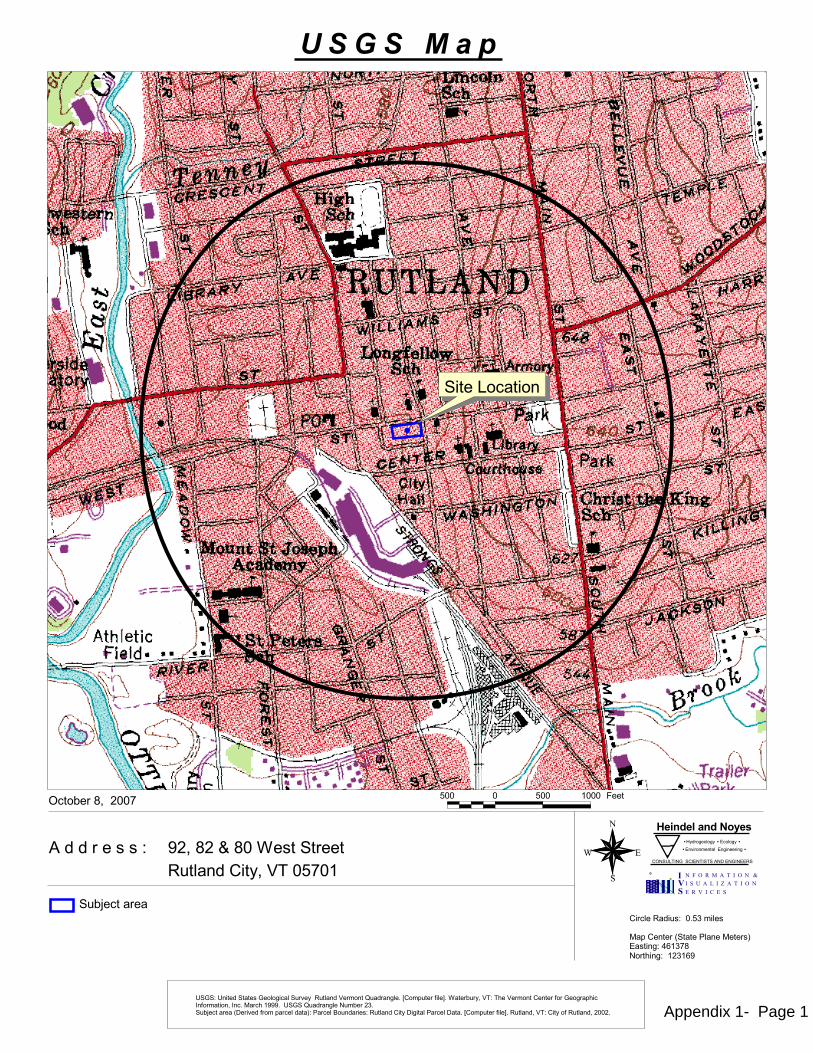
�
�
��
�
����������������������������������������������� ���������������������������������������������������
�������������������������� ���� � �
������������� ����������� �
��������������� ����������� ���� ��
!! ! !! "!!! #���
$%&�'%�(�'!�)�����������*���������&�+��! ,!"
���-���'&��%!!,
�����������*����!. /������
0�1��������2������3�����0�����4 ��������56"/,'���7������"%/"6$
�*-8��������
�����������
���������������
������������������������������*������*������+������9*��������.�:��1*����;���<.�)����-*�&�+����7��+�������������;�������17�����;������&����.�0���7�"$$$.�������9*����������*�-���%/.�*-8���������2��������;���1����������4��3������=*����������*������������������3����������.�:��1*����;���<.��*�����&�+�������;��*�����&�%!!%. Appendix 1- Page 1
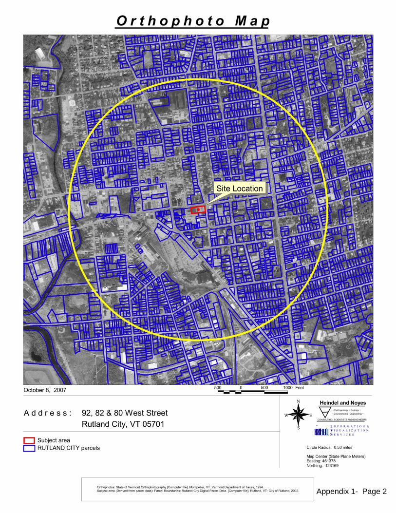
�
�
��
�
����������������������������������������������� ���������������������������������������������������
�������������������������� ���� � �
������������� ����������� �
��������������� ����������� ���� ��
!! ! !! "!!! #���
$%&�'%�(�'!�)�����������*���������&�+��! ,!"
���-���'&��%!!,
�����������*����!. /������
0�1��������2������3�����0�����4 ��������56"/,'���7������"%/"6$
��������������������������
�����������8�1��������*-9��������
�����������
���717����������:�+���������717����17�;��1*����:���<.�0��1�����&�+���+��������1��������:���=��&�"$$5.�*-9���������2��������:���1����������4��3������>*����������*������������������3����������.�;��1*����:���<.��*�����&�+�������:��*�����&�%!!%. Appendix 1- Page 2
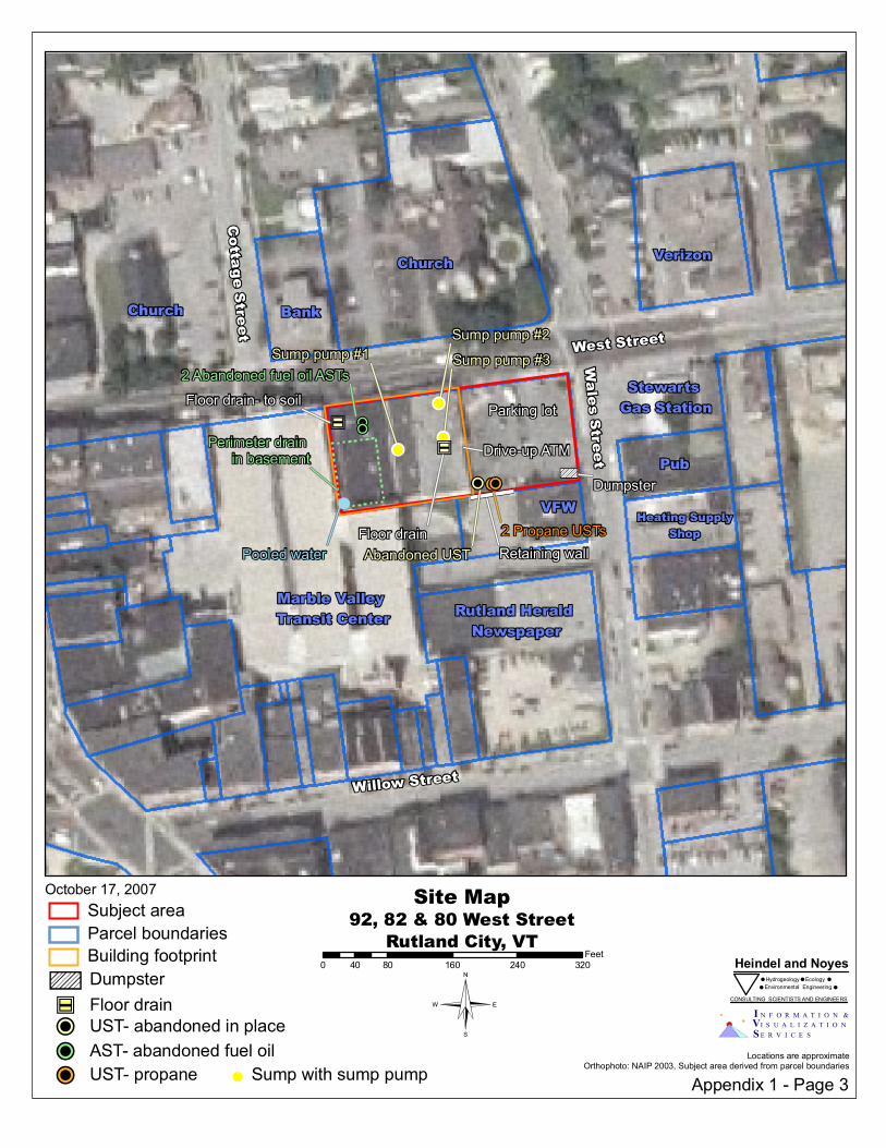
Sump pump #2Sump pump #1 Sump pump #3 West Street
Willow Street
Wales Street
Cottage Street
Parking lot
Drive-up ATM
Retaining wall
!!!!
!!
Pooled water
Perimeter drain in basement
!P!P"Cé
"Cé
VFWFloor drain
Floor drain- to soil
!
Abandoned UST
2 Abandoned fuel oil ASTs
!P DumpsterTS
Stewarts Gas Station
ChurchBank
Marble Valley Transit Center Rutland Herald Newspaper
Pub
Heating SupplyShop
Verizon
Church
2 Propane USTs
!P!P
Appendix 1 - Page 3
October 17, 2007
© I N F O R M A T I O N &I S U A L I Z A T I O NE R V I C E S
VS
Heindel and NoyesHydrogeology Ecology# # #
Environmental Engineering# #
CONSULTING SCIENTISTS AND ENGINEERS
92, 82 & 80 West StreetRutland City, VTSite Map
Locations are approximateOrthophoto: NAIP 2003, Subject area derived from parcel boundaries
0 80 160 240 32040Feet
!! Sump with sump pump
TS Dumpster"Cé Floor drain
Parcel boundaries
!P AST- abandoned fuel oil!P UST- abandoned in place
Subject area
Building footprint
!P UST- propane
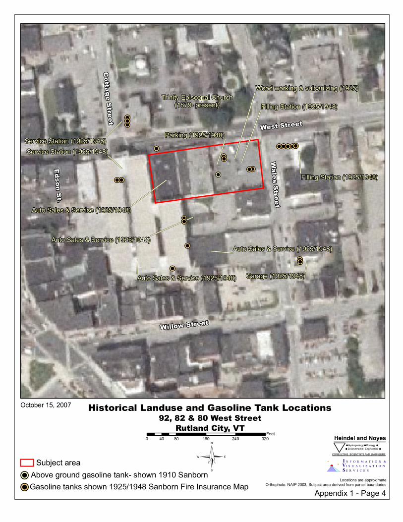
!P!P
!P!P
!P
!P
!P!P!P
!P!P!P
!P!P !P!P
!P!P
!P
!P
Filling Station (1925/1948)
Filling Station (1925/1948)
Service Station (1925/1948)Service Station (1925/1948)
Trinity Episcopal Church(1879- present)
Auto Sales & Service (1925/1948)
Auto Sales & Service (1925/1948)Auto Sales & Service (1925/1948)
Garage (1925/1948)Auto Sales & Service (1925/1948)
Parking (1925/1948)
Wood working & vulcanizing (1925)
!P
West Street
Willow Street
Wales Street
Cottage Street
Edson St.
!P
Appendix 1 - Page 4
October 15, 2007
© I N F O R M A T I O N &I S U A L I Z A T I O NE R V I C E S
VS
Heindel and NoyesHydrogeology Ecology# # #
Environmental Engineering# #
CONSULTING SCIENTISTS AND ENGINEERS
92, 82 & 80 West StreetRutland City, VTHistorical Landuse and Gasoline Tank Locations
Locations are approximateOrthophoto: NAIP 2003, Subject area derived from parcel boundaries
0 80 160 240 32040Feet
!P Above ground gasoline tank- shown 1910 SanbornSubject area
!PGasoline tanks shown 1925/1948 Sanborn Fire Insurance Map
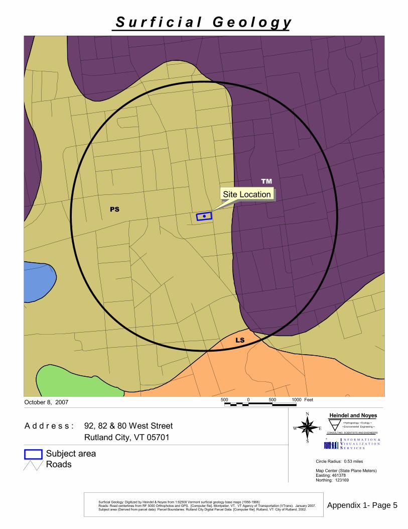
���
��
��
�
��
�
����������������������������������������������� ���������������������������������������������������
�������������������������� ���� � �
������������� ����������� �
��������������� ����������� ���� ��
!! ! !! "!!! #���
$%&�'%�(�'!�)�����������*���������&�+��! ,!"
���-���'&��%!!,
�����������*����!. /������
0�1��������2������3�����0�����4 ��������56"/,'���7������"%/"6$
�*�8������������������9���-���������(�����8���"�6% !!�+�������*�8�����������-������1��2"$ 6:"$664����������������������8����#� !!!����717��������3�.��;��1*����8���<.�0��1�����&�+�.��+��������8������1�������2+�����4.��=��*���%!!,.�*->���������2��������8���1����������4��3������?*����������*������������������3����������.�;��1*����8���<.��*�����&�+�������8��*�����&�%!!%.
�����*->��������
�����������
��������������������������� ��
Appendix 1- Page 5

Till mantling the bedrock and reflecting the topography of the underlying bedrock surface. Thicker in the valleys and thinner on the uplands. On many exposed uplands, postglacial erosion has left only rubble and scattered boulders on the bedrock.
Deposits of sand arranged by the wind.
A sinuous ridge of constructional form, consisting of stratifiedaccumulations, of glacial sand and gravel.
GLACIAL
TILL
MORAINEIce marginal till accumulations with morainic topography.M- frontal moraine assumed to be recessional.TM- terminal moraine.
KAME GRAVELIce contact outwash gravel.K- isolated kame.KT- kame terrace.KM- kame moraine, kame complex with morainic topography.
OUTWASHHorizontally bedded glaciofluvial gravel. Spillway or valleytrain gravel in stream valleys. May or may not have a thinvener of postglacial alluvium.
ESKER
EOLIAN
EOLIAN SAND AND DUNES
BEDROCK EXPOSURES
SWAMP, PEAT and/or MUCK
GRAVEL BAR
PLUVIAL
MARINE BEACH GRAVEL
MARINE CLAY
MS- marine sand without pebbles or boulders.PSM- pebbly marine sand.
MARINE SAND
CHAMPLAIN SEA
Solid filled bedrock was taken directly from the state source maps.Hatch filled bedrock represents generalized centerlines with a 25m buffer.
A natural mound or exposed face of gravel.
Accumulations of detrital materials, which have been eroded, transported, and deposited by streams.
Sand laid down by a river or a stream.
Gravel laid down by a river or a stream.
A linear accumulation of beach material, behind the beachwhich was created from waves or other action.
GLACIOLACUSTRINE
LITTORAL SEDIMENT PREDOMINANTLY GRAVEL
LG- horizontally bedded gravel deposited in a shoaling lake or topset beds of deltaic gravel where no foreset bedding is exposed.BG- beach gravel.DG- delta gravel showing foreset bedding.D- small deltas composed of sand and gravel.
LITTORAL SEDIMENTPREDOMINANTLY SAND
LS-well sorted sand, no pebbles or boulders.PS- pebbly sand.BS- sand containing ice rafted boulders.DS- delta sand.
LAKE BOTTOM SEDIMENTSSTC- silt, silty clay, and clay.VC- varved clay.BC- silt, silty clay, and/or clay containing ice rafted boulders.
WAVE-WASHED TILLTill from the top of which the finer materials have beenremoved by wave action, leaving boulder concentrations on the surface.
BEACH RIDGE
POSTGLACIAL FLUVIAL
FLUVIAL GRAVEL
FLUVIAL SAND
RECENT ALLUVIUM
B
SURFICIAL GEOLOGY LEGEND
SOURCE NOTES:Surface Geology was digitized and scanned, by Wagner, Heindel, and Noyes, into a PC ARC/INFO database from 1:62500 original State of Vermont surficial geology base maps (1956-1966).These base maps were created under the supervision of David P, Stewart (1956-1966), Paul MacClintock (1963-1966), William F. Cannon (1964), G. Gordon Connally (1965), Parker E. Calkin (1965), Robert E. Behling (1966), and William W. Shilts (1966). Surficial data for most of the state is available, in 15 minute quads, from WHN (802) 658-0820.Generalized Bedrock Outcrops were digitized from 1:62500 state surficial geology maps as linear features, which were buffered to 25m. Data available from WHN with surficial geology coverages.Road Centerlines were generated from pre-1990 1:5000 orthophotos (or better). Road data (RDSnn) is available from the Vermont Center for Geographic Information, VCGI (802) 656-4277.Linear Surface Waters are Digital Line Graph Data, generated from 1:24,000 USGS topographic maps. This data is available from VGIS.Town Boundaries were digitized from pre-1990 1:24000 USGS topographic maps. This coverage was created by the EPA and is available through VGIS.
Legend derived from 1:250,000 Surficial Geologic Map of Vermont (1970).IVS
N F O R M A T I O N &I S U A L I Z A T I O NE R V I C E S
P.O. Box 64709 - Burlington, Vermont - 05406-4709 - Tel: (802) 865-0437 - Fax: (802) 860-1014
Appendix 1- Page 6

�
��
�
��
�
����������������������������������������������� ���������������������������������������������������
�������������������������� ���� � �
������������� ����������� �
��������������� ����������� ���� ��
!! ! !! "!!! #���
$%&�'%�(�'!�)�����������*���������&�+��! ,!"
���-���'&��%!!,
�����������*����!. /������
0�1��������2������3�����0�����4 ��������56"/,'���7������"%/"6$
���������������������������
8����9�������������:���-���������(�����;���"�6% !!�+������-����9������-������1��2"$ 6<"$664����������������������;����#� !!!����717��������3�.��=��1*����;���>.�0��1�����&�+�.��+��������;������1�������2+�����4.��?��*���%!!,.�*-@���������2��������;���1����������4��3������8*����������*������������������3����������.�=��1*����;���>.��*�����&�+�������;��*�����&�%!!%.
�����*-@��������
�����������
Appendix 1- Page 7
SOURCE NOTES:Bedrock Geology was digitized and scanned, by Wagner, Heindel, and Noyes, into a PC ARC/INFO database from 1:62500 original State of Vermont bedrock geology base maps (1956-1966).These maps were made available by Dr. Barry Doolan, Geology Department Chairperson, University of Vermont. Bedrock data for most of the state is available, in 15 minute quads,from IVS (802) 865-0437.Road Centerlines were generated from pre-1990 1:5000 orthophotos (or better). Road data (RDSnn) is available from the Vermont Center for Geographic Information, VCGI (802) 656-4277.Linear Surface Waters are Digital Line Graph Data, generated from 1:24,000 USGS topographic maps. This data is available from VGIS.Town Boundaries were digitized from pre-1990 1:24000 USGS topographic maps. This coverage was created by the EPA and is available through VGIS.
Road CenterlineTown BoundaryNo LabelFeatures with no label were not attributed on the originalsource maps.
Surface Water
BEDROCK GEOLOGY LEGEND
ou
Metadiorite - Metagabbro, metadiabase and meta-adesite, too small to show are chiefly in the Missisquoi, Albee and Orfordville formations.
nhbBethlehem Gneiss - Two-micagranodiorite gneiss
nhu
Undifferentiated granitic rocksSmall dikes and sills do not show.
DEVONIANNew Hampshire Plutonic Series
PLUTONIC ROCKS
wgBiotite and hornblende granites
wsHornblende, biotite, quartz and augitesyenites
wn
Nepheline syenite and pulaskite
wdHornblende-biotite diorite; gabbro
we
Essexite
wvVolcanic breccia, felsitic tuff, and flows
Bostonite - Many small leucophyresand lamprophyres not shown.
wle
Biotite quartz and diorite gneiss
Oliverian Plutonic Series
hu
Undifferentiated granitic rocks
Highlandcroft Plutonic Series
udp us uu
udp - dunite, peridotite and serpentinite.us - serpentinite, carbonate rock, talc-carbonate rock and steatite. uu - undifferentiated ultramafic rocks.
Ultramafic rocks
ORDOVICIAN
PERMIAN OR TRIASSICWhite Mountain Plutonic-Volcanic Series
nhd
Csb
Chw
Ch Chb Chm
Hazens Notch Formation
Chg
Cho Chop Cht Chog
Hoosac Formation
Danby and Potsdam Formations
Cdt
Dalton Formation
Cf
Forestdale Marble
Cm
Monkton Quartzite
Cmo
Moosalamoo Phyllite
Cpa
Parker Slate
Cp Cpt
Pinnacle FormationCo - schistose greywacke.Cog - Tibbit Hill Volcanic Member
Co Cog
Ottauquechee FormationCarbonaceous phyllite or schist containingbeds of massive quartzite.
Cd
Dunham Dolomite
Interbedded quartzite and dolomite.
Schistose quartzite, impure dolomite,and conglomerate.
Hatch Hill - calcareous quartzite.West Castleton - silicous, carbonaceous slate.
The Hatch Hill and WestCastleton Formations
Csc CscbCscz
St. Catherine formation
Cw
Winooski Dolomite
Saxe Brook Dolomite
Cda
CsrCssm
Csa
Csh
Sweetsburg Formation
Crb
Rugg Brook FomationDolomite, conglomerate, and sandstone.
Cu
Cufp
Cug
Cuc
Cuw
Cuf
Cuj
Cufb
Cua
Cub
Cup
Underhill Formation
Ct
Tyson FormationSchist, conglomerate at base, phyllite and dolomite in upper portion.
Csc - slate and phyllite.Cscb - Bomoseen Greywacke Member.Cscz - Zion Hill Member: quartziteand greywacke.
Cbr Cbrc
Brezee formation
Cc
Cheshire Quartzite
Cbr - phyllite with beds of dolomite, marble,sandstone; beds of massive dolomite locally.Cbrc - quartzose green phyllite.
Ccs
Clarendon Springs, Ticonderoga,and Rock River Dolomites;
Gorge Formation
Cbh
Bridgeman Hill Formation
Cph Cpgc Cpg Cpc
Pinney Hollow FormationCph - Pale green phyllite with abundant magnetite.Cpgc - Chester Amphibolite Member.Cpg - greenstone and actinolitic greenstone.Cpc - carbonaceous phyllite and schist.
?Ccr ?Ccg?Ccm
Cavendish Formation
Undifferentiated dolomite, slate and conglomerate.
?Ccr - Readsboro Member: quartz-muscovite-schist.?Ccg - Bull Hill Gneiss: quartz-plagioclase-micrcline-biotite gneiss.?Ccm - buff dolomite.
Ch - interbedded carbonaceous andnoncarbonaceous schist.Chb - Belvidere Mountain Amphibolite MemberChm - schist.Chg - greenstone.
Cho - quartz-sericite schistChop - Plymouth Member: quartzite andcarbonaceous plhyllite.Cht - Turkey Mountain Member: amphiboliteand greenstone.Chog - amphibolite and greenstone.
Cs
CAMBRIAN ROCKS
Pawlet Formation
Opa
Locally carbonaceous and pyritiferous,micaceous slate.
Osp
Stony Point FormationCalcareous black shale grading upwardinto argillaceous limestone.
Oo Oor
Orwell Limestone, and Isle La Motteand Lowville Limestones
Os
Shelburne, Whitehall, andStrites Pond Formations
Chiefly a white marble or limestone with gray dolomite lineations.
Op Opv
Partridge FormationOp - NE VT - black carbonaceous slate and phyllitewith beds of rhyolite tuff. SE VT - carbonaceousmica schist.Opv - volcanics: biotite gneiss and amphibolite.
Oml
Morses Line FormationCalcareous and noncalcareous slate,locally with limestone interbeds.
Omh
Mount Hamilton FormationHard slates, some interbedded with quartzites and chert.
Omiv
Omic
OmidOmi
Middlebury and Chazy Limestones; undifferentiated Youngman and
Carman FormationsOmi - Somewhat nodular and granular limestonewith dolomite and shaly interbeds.Omiv - Valcour Member: dark gray calcarenitesucceeded by coquinal limestone.Omic - Crown Point Member: fossiliferous limestone.Omid - Day Point Member: calcareous quartz sandstone and calcarenite.
Oof Oos Oop
Ordville FormationOof - carbonaceous phyllite.Oos - Sunday Mountain Volcanics: greenstone and schists.Oop - Post Pond Volcanics: greenstone and schist.
OcbOcbr Ocbe Ocw
Chipman, Bridport, and BeldensFormations; Providence Island Dolomite
Ocbr - Bridport Dolomite Member.Ocbe - Beldens Member: dolomite with limestone and marble scoring.Ocw - Weybridge Member: limestone.Ocb - Burchards Member: limestone with spots of dolomite.
OCsgOCs OCsc
Stowe FormationOCs - phyllite and schist.OCsc - carbonaceous schist and phyllite.OCsg - greenstone and amphibolite.
ORDOVICIAN ROCKS
Oha
Hathaway FormationArgillite and bedded radiolarian chert.
Oi
Iberville FormationNoncalcareous black shale interbedded with dolomite.
Ogs Ogl
Glens Falls FormationHighly fossiliferous limestone.
Oh
Hortonville FormationPyritic slate and phyllite with limy beds.
Ohg
Hortonville, or Cumberland Head, andGlens Falls Formations, undifferentiated
Ohi
Highgate FormationBanded limestone and calcareous slate.
Och
Cumberland Head FormationInterbedded shale and limestone.
Ogo
Glens Falls and OrwellLimestones, undifferentiated
Ob Obb
Bascom Formation, and undifferentiated Luke Hill,Naylor Ledge and Hastings Creek Limestones
Ob - interbedded dolomite, limestone or marble, sandstone, quartzite and limestone breccia.Obb - Brownell Mountain Phyllite Member.
Oc
Cutting dolomite, and undifferentiated MorganCorner and Wallace Creek Formations
Omcr OmhbOmco Omc Omu
Omc Omb Omw
Omm
NORTHERN VERMONT
SOUTHERN VERMONT
STATEWIDE
Missisquoi Formation
OCu
Pinney Hollow, Ottauquechee, and StoweFormations, undifferentiated
Quartz schist, carbonaceous schist, andschistose quartzite.
Oa
Ammonoosuc Volcanics
Oal
Albee FormationQuartzite interbedded with slate and phyllite.
Gneiss, quartzite, calc-silicate granulite
pCgn
pC pCsq pCm
Mount Holly ComplexpC - biotitic gneiss, and in western areas chloritc.pCsq - quartzite, micaceous quartzite, and quartz-mica schist.pCm - calcite and dolomite marbles.
pCsg
Stamford Gneiss Granitic biotite gneiss with megacrysts of microcline.
pCg
Undifferentiated gneissic biotite granite, quartz monzonite, and granodiorite
Dw Dws Dwc Dwb Dwa
Waits River FormationDw - quartzose and micaceous crystalline limestone.Dws - Standing Pond Volcanic Member: amphibolite and garnet schist.Dwc - Crow Hill Member: tough gray quartzite.Dwb - Barton River Member: interbedded limestone and phyllite;diopside.Dwa - Ayers Cliff Limestone Member.
Dg Dgh Dga Dgm
Gile Mountain FormationDg - quartz-muscovite phyllite or schist.Dgh - Hall Stream Member: feldspathic grit, probably volcanic, schist and amphibolite.Dga - amphibolite.Dgm - Meetinghouse Slate Member.
Dl
Littleton FormationGray slate and phyllite with interbeds of schistose quartzite.
DSn
Northfield FormationQuartz-sericite slate of phyllite withsiltstone and limestone interbeds.
Ss
Shaw Mountain FormationN VT - quartzose limestone and calcareous quartzite.S VT - quartzite, quartz conglomerate, conglomerate schist,amphibolite and schist.
Sf
Fitch FormationNE VT - weathered, sandy limestone.SE VT - granulite, impure limestone and dolomite, and mica schist.
Sc
Clough FormationNE VT - conglomerate with cobbles of quartzite and schist,quartzite and schist matrix.SE VT - quartzite, quartz-conglomerate and mica schist.
SILURIAN ROCKS
DEVONIAN ROCKS
PRECAMBRIAN ROCKS
Cs - carbonaceous slate.Csh - Hungerfore Slate MemberCsr - Rockledge Conglomerate Member.Cssm - Skeels Corner Slate and Mill River Conglomeratemembers undifferentiated.Csa - St. Albans Slate Member.
Omcr - Cram Hill Member: phyllite, grades locally to dark slate.Omhb - Harlow Bridge Quartzite Member.Omco - Coburn Hill Volcanic Member: greenstoneand amphibolite, includes pillow lavas.Omc - carbonaceous phyllite and slate.Omu - Umberella Hill Member: quartz and slate pebble conglomerate.Omc - carbonaceous mica schist, quartzite and micaceous quartzite.Omb - Barnard Volcanic Member: gneiss and amphibolite.Omw - Whetstone Hill Member: carbonaceous phyllite and schist.Omm - Moretown Member: quartzite and quartz-plagioclase granulite.
Cu - grey-green schist.Cufp - Fairfield Pond Member: quartzitic schist.Cug - greenstone.Cuc - carbonaceous schist and phyllite.Cuw - White Brook Member: sandy dolomitewith crystalline limestone.Cuf - Forestdale Member: sandy dolomite and limestone.Cuj - Jay Peak Member: schist, locally quartzitic.Cufb - Foot Brook Member: schist, minorcarbonaceous interbeds.Cua - Mount Abraham Schist Member.Cub - Battell Member: carbonaceous schist and schistose quartzite.Cup - Peaked Mountain Member: greenstone.
FaultsThrust Fault; Upper Plate to West
Thurst Fault; Upper Plate to East
Uncertain Thrust Fault; Upper Plate to West
Uncertain Thurst Fault; Upper Plate to East
Reverse Fault; Upthrown Side to West
Reverse Fault; Upthrown Side to East
Normal Fault; Downthrown Side to West
Normal Fault; Downthrown Side to East
Normal Fault; Location Uncertain
Reverse Fault; Location Uncertain
Topographic Contours100 Foot Intervals500 Feet Above Sea Level1000 Feet Above Sea Level1500 Feet Above Sea Level2000 Feet Above Sea Level2500 Feet Above Sea Level3000 Feet Above Sea Level3500 Feet Above Sea Level4000 Feet Above Sea Level
Buff-weathered, pink, buff, and gray dolomitewith thin protruding siliceous partings.
IVS
N F O R M A T I O N &I S U A L I Z A T I O NE R V I C E S
P.O. Box 64709 - Burlington, Vermont - 05406-4709 - Tel: (802) 865-0437 - Fax: (802) 860-1014
Appendix 1- Page 8
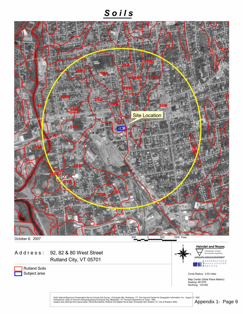
�
���
���
���
���
������
���
��������
�
���
��
�
���
�
�����
��
��� ��
�
�
�
�
��
�
����������������������������������������������� ���������������������������������������������������
�������������������������� ���� � �
������������� ����������� �
��������������� ����������� ���� ��
!! ! !! "!!! #���
$%&�'%�(�'!�)�����������*���������&�+��! ,!"
���-���'&��%!!,
�����������*����!. /������
0�1��������2������3�����0�����4 ��������56"/,'���7������"%/"6$
�*-8���������*����������
�����������
���������*�������*������������������������*��������*���.��9��1*����:���;.�)����-*�&�+����7��+�������������:�������17�����:������&����.���*�*���""&�"$$%.���717����������:�+���������717����17�9��1*����:���;.�0��1�����&�+���+��������1��������:���<��&�"$$5.�*-8���������2��������:���1����������4��3������=*����������*������������������3����������.�9��1*����:���;.��*�����&�+�������:��*�����&�%!!%.
���������
Appendix 1- Page 9
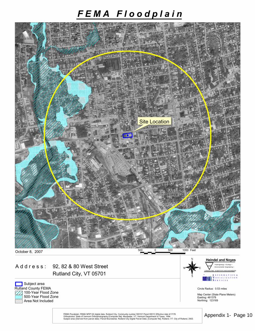
�
�
��
�
����������������������������������������������� ���������������������������������������������������
�������������������������� ���� � �
������������� ����������� �
��������������� ����������� ���� ��
!! ! !! "!!! #���
$%&�'%�(�'!�)�����������*���������&�+��! ,!"
���-���'&��%!!,
�����������*����!. /������
0�1��������2������3�����0�����4 ��������56"/,'���7������"%/"6$
�*�������*���# 0�"!!89����#���:�� !!89����#���:��������������*���
�*-;��������
�����������
# 0��#��1������# 0���#�3�</�������������.��*���������.����*�����*�-��� !!"!"�3�����!!!"�� ==������������5>",>,'.�����717����������=�+���������717����17�?��1*����=���@.�0��1�����&�+���+��������1��������=���A��&�"$$5.�*-;���������2��������=���1����������4��3������B*����������*������������������3����������.�?��1*����=���@.��*�����&�+�������=��*�����&�%!!%.
���������������������������
Appendix 1- Page 10

APPENDIX 2
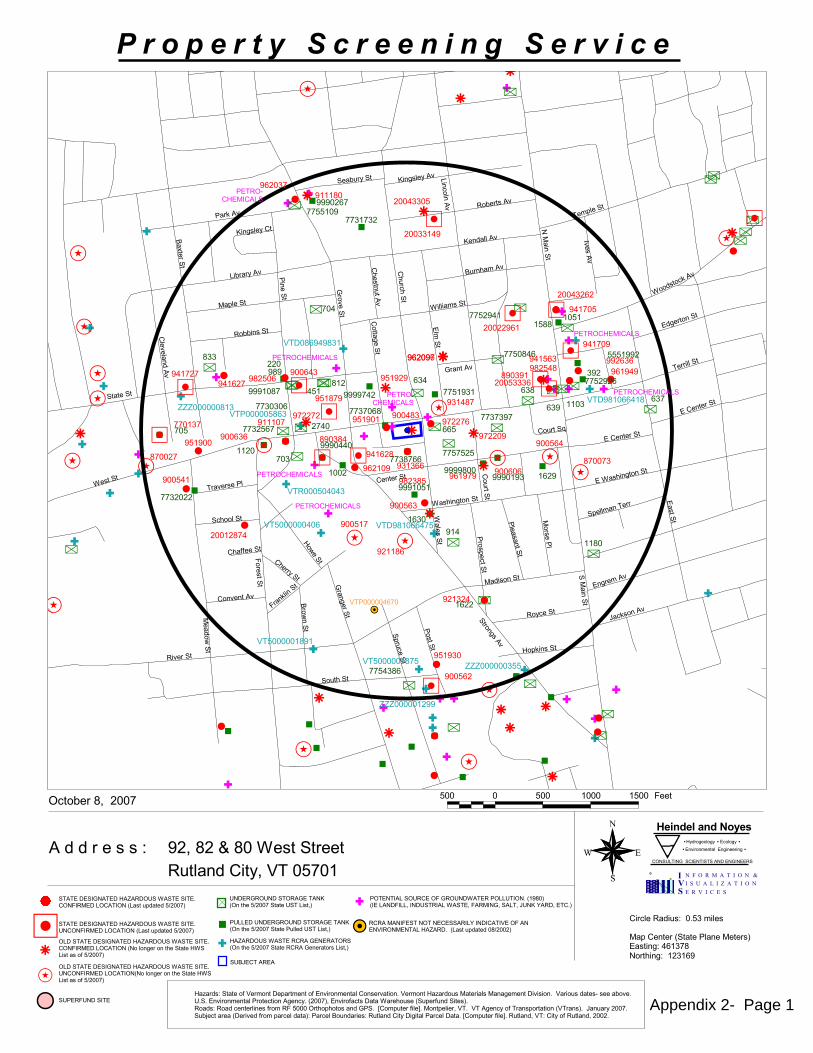
��
�
�
�
�
�
�
�
�
�
�
�
�
�
�
�
�
�
�
�
�
�
�
�
�
�
�
�
�
��
�
�
��
�
�
�
�
�
�
�
�
��
��
�
�
�
�
��
� ��� ��
�
�
�
��
��
�
�
�
�
�
�
��
�
�
�
� �
�
�
�
�
�
�
�
�
�
�
�
�
�
�
��
�
�
�
�
�
�
�
�
�
�
�
�
� �
�
��
�
�
�
� �
�
�
�
�
�
�
� ��
�
�
�
�
�
�
�
�
�
�
�
���
�
�
��
�
�
�
�
�
��
�
�
�
��
�
�
��
�
�
��
�
�
�
�
�
�
�
�
�
�
��
�
�
�� �
�
�
�
��
�
�
�
�
��
�
�
�
�
�
��������
������ ������
������
������
������
�����
�����
����
����
����
����
����
�����
������
������
�����
������
����
������
����
�����
�����
�����
������
������
�����
�����
�����
�����
�����
�����
�����
�����
���������
�����
������
������ �����
�����
���������
����
��������
�������
��������
�������
�������
�������� �����������
�� �����������
�� �����������
�� ������������
�� �����������
�� �����������
�� ������������
������
����
����
��
���
���
��
���
���
���
���
����
���
����
����
����
���
���
���
���
����
����
������
�������
�������
�����
������ �������
�����
�����
�����������
������
�����
�����
����
�������
������
�������
������
������� �������
�������
� ���������
�������
������
�������
�� ������
�������
��������
��������
������
��������
���������
��������
�� ������
���������
���� ���
�� ����
���!����"�
�
��!�#���$��"���
��
������
��������
��"��
��� ����
%��!�����
�������!�� ��������
��������
��&�'��
������� �����������
��������
�������� ������
�! �������
��&�����
�������
(�#���������� ������
%�� ���'��
�������
�!�������
��#����
��'�����
)����
����� ����
����������
��������
���"��
����
������
(��"������
��&&������
���&�'���
����������
�����������
������
����������������
����
��������
���'���
������*
��������
����������
%�� ���'���
���++�����
����������
������������
������������
���������
���������
����������
���������
�����������
������������
��������������������
���������
��������
�������������������������������� ��������������
�
��
�
��
�
����������������������������������������������� �����������!����������������!����"���!�����!�#��$�%��!����� �
��&�&�'�(�)�)�*
�� �����"����������������������%������������������������"������+� �������,)-�./&,-(&���0����
�
��������������������������������� ���������������������������������������������������
���������������+1&'23(24231�����524231� � �
�678'269(6-,4���6386(('863� �
�����������������������������������
��� � ��� ���� ���� �((-
��!����:�����()-��-'((-�.-4,6&��8-1!���������
���������������������������$��6�-;(��0������-,-(��.44(&������8)-!
���������������+� �����������������������"�������������,)-�./&,-(&��0����
������������������+� �����������������������"�������������2�4263('�26�-;(��-,-(�+���8)-�,)�2<��0����
���������������������$��6�-;(��0������-,-(������8)-!
������������������+� �������������������������"������������2�4263('�26�-;(��-,-(�+���8)-�,)�2<��0����
���������������+� �������������������������"�������������,)-�./&,-(&��0����
�5-2=('��!������
+� �����������������������������6�-;(��0������-,-(�������(6(',-2')��8)-! �
��������������� +,>,'&)*��-,-(�2<��('926-�(/,'-9(6-�2<��678'269(6-,4��26)('7,-826���('926-�+,>,'&2.)�",-('8,4)�",6,3(9(6-�878)826����,'82.)�&,-()?�)((�,=27(��������678'269(6-,4��'2-(5-826��3(651������� !��678'2<,5-)�,-,��,'(;2.)(���./('<.6&��8-() ��2,&)*��2,&�5(6-('486()�<'29����������'-;2/;2-2)�,6&�������@�29/.-('�<84(A��"26-/(48('!����������3(651�2<��',6)/2'-,-826����',6) ���#,6.,'1�������.=B(5-�,'(,��('87(&�<'29�/,'5(4�&,-, *��,'5(4�C2.6&,'8()*��.-4,6&��8-1�838-,4��,'5(4�,-,��@�29/.-('�<84(A���.-4,6&!���*��8-1�2<��.-4,6&!������
�8'54(��,&8.)*�������984()
",/��(6-('���-,-(��4,6(�"(-(') �,)-863*�������2'-;863*�������
��C#���������
Appendix 2- Page 1
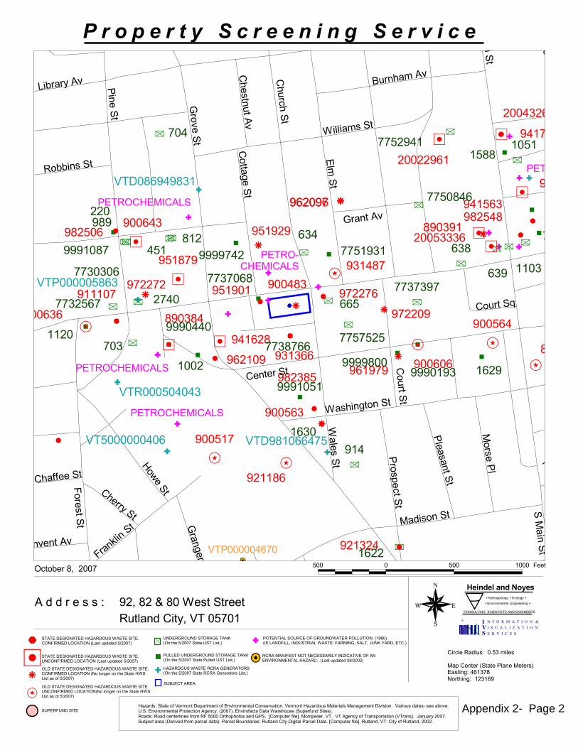
��
�
�
�
�
�
��
�
�
�
�
�
�
�
�
�
��� ���
�
�
�
��
�
�
�
�
�
�
�
�
�
�
� �
��
�
���
�
�
�
�
� �
��
�
�
�
��
�
�
�
�
���
�
�
�
�
�
�
�
�
�
�
��
�
�
��
�
�
� �
�
�
��
�
� �
�
��
���
������
������
������
������
�����
�����
����
����
�����
������
����
����
����
������
�����
����
������
���
������
������
�����
�����
�������
����
����
��� ���
�����
���������
����
����
������
�� �����������
�� �����������
�� �����������
�� ��
�� ������������
�
�����
��
��
�
���
���
��
���
���
���
����
����
���
���
����
�
��
���
���
������
�����
������ �������
�����
������
����������
������
������
�������
�������
�������
������� ������
�������
� ���������
���������
������
�� ����
�������
���������
� ����
������
���������������
����������
������� ���
��� ���������
�� ����������
��������
�� � �����
���
���������
��� "�����
#���������
���$��
����
��� ���
%����� ���
��� ������
��������
�"
��������
�������'
���������
�� �������
���((���
����������
�����������
�����������
�� �������
������������
�������������������������������� ��������������
�
��
�
��
�
������������� ������� �������� �������������������������������������� ������������� �����������!��"�#� ���������
��$�$�%�&�'�'�(
�� � �� ������������������� ��#���������������������� �� ������)�*� ������+',�-.$+,&$���/0��0�
�
��������������������������������� ���������������������������������������������������
���������������)1$%23&24231�����524231� � �
�678%269&6,+4���6386&&%863� �
���������������������������������� �
��� � ��� ���� �&&,
�0���0�:�����&',��,%&&, -,4+6$��8,1���������
����������� � �������� �������"��6�,;&��/0����,+,&��-44&$������8',��
�����������������)�*� ��������������������� ��������������+',�-.$+,&$��/0���
���������������������)�*� ��������������������� ��������������2�4263&%�26�,;&��,+,&�)���8',�+'�2<��/0���
���� � �������� �������"��6�,;&��/0����,+,&������8',��
���������������������)�*� ����������������������� �������������2�4263&%�26�,;&��,+,&�)���8',�+'�2<��/0���
�����������������)�*� ����������������������� ��������������+',�-.$+,&$��/0���
�5,2=&%�����0��
)�*� ����������� � ������ ��� ���6�,;&��/0����,+,&� � ���&6&%+,2%'��8',���
���� ����������� )+>+%$'(��,+,&�2<��&%926,��&.+%,9&6,�2<��678%269&6,+4��26'&%7+,826���&%926,�)+>+%$2-'� +,&%8+4'� +6+3&9&6,��878'826����+%82-'�$+,&'?�'&&�+=27&��������678%269&6,+4��%2,&5,826��3&651���0������678%2<+5,'��+,+��+%&;2-'&���-.&%<-6$��8,&'�� 2+$'(� 2+$�5&6,&%486&'�<%29� ��������%,;2.;2,2'�+6$�������@�29.-,&%�<84&A�� 26,.&48&%�����������3&651�2<��%+6'.2%,+,826����%+6'����!+6-+%1�0����-=B&5,�+%&+���&%87&$�<%29�.+%5&4�$+,+�(��+%5&4�C2-6$+%8&'(� -,4+6$��8,1��838,+4��+%5&4��+,+��@�29.-,&%�<84&A�� -,4+6$����(��8,1�2<� -,4+6$��0��0�
�8%54&� +$8-'(�������984&'
+.��&6,&%���,+,&��4+6&� &,&%'��+',863(������2%,;863(���0����
��C!����� ���
Appendix 2- Page 2
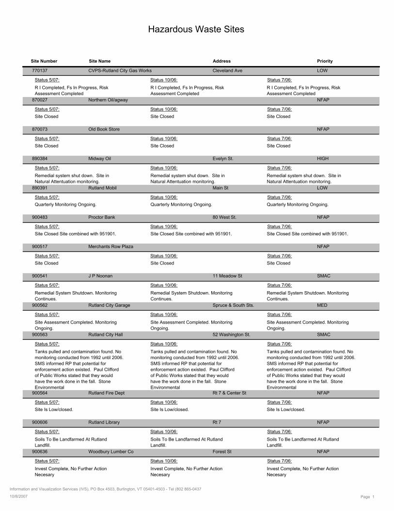
Hazardous Waste Sites
Site Number Site Name Address Priority
770137 Cleveland AveCVPS-Rutland City Gas Works LOW
R I Completed, Fs In Progress, Risk
Assessment Completed
Status 5/07: Status 10/06: Status 7/06:
R I Completed, Fs In Progress, Risk
Assessment Completed
R I Completed, Fs In Progress, Risk
Assessment Completed
870027 Northern Oil/agway NFAP
Site Closed
Status 5/07: Status 10/06: Status 7/06:
Site ClosedSite Closed
870073 Old Book Store NFAP
Site Closed
Status 5/07: Status 10/06: Status 7/06:
Site ClosedSite Closed
890384 Evelyn St.Midway Oil HIGH
Remedial system shut down. Site in
Natural Attentuation monitoring.
Status 5/07: Status 10/06: Status 7/06:
Remedial system shut down. Site in
Natural Attentuation monitoring.
Remedial system shut down. Site in
Natural Attentuation monitoring.
890391 Main StRutland Mobil LOW
Quarterly Monitoring Ongoing.
Status 5/07: Status 10/06: Status 7/06:
Quarterly Monitoring Ongoing.Quarterly Monitoring Ongoing.
900483 80 West St.Proctor Bank NFAP
Site Closed Site combined with 951901.
Status 5/07: Status 10/06: Status 7/06:
Site Closed Site combined with 951901.Site Closed Site combined with 951901.
900517 Merchants Row Plaza NFAP
Site Closed
Status 5/07: Status 10/06: Status 7/06:
Site ClosedSite Closed
900541 11 Meadow StJ P Noonan SMAC
Remedial System Shutdown. Monitoring
Continues.
Status 5/07: Status 10/06: Status 7/06:
Remedial System Shutdown. Monitoring
Continues.
Remedial System Shutdown. Monitoring
Continues.
900562 Spruce & South Sts.Rutland City Garage MED
Site Assessment Completed. Monitoring
Ongoing.
Status 5/07: Status 10/06: Status 7/06:
Site Assessment Completed. Monitoring
Ongoing.
Site Assessment Completed. Monitoring
Ongoing.
900563 52 Washington St.Rutland City Hall SMAC
Tanks pulled and contamination found. No
monitoring conducted from 1992 until 2006.
SMS informed RP that potential for
enforcement action existed. Paul Clifford
of Public Works stated that they would
have the work done in the fall. Stone
Environmental
Status 5/07: Status 10/06: Status 7/06:
Tanks pulled and contamination found. No
monitoring conducted from 1992 until 2006.
SMS informed RP that potential for
enforcement action existed. Paul Clifford
of Public Works stated that they would
have the work done in the fall. Stone
Environmental
Tanks pulled and contamination found. No
monitoring conducted from 1992 until 2006.
SMS informed RP that potential for
enforcement action existed. Paul Clifford
of Public Works stated that they would
have the work done in the fall. Stone
Environmental 900564 Rt 7 & Center StRutland Fire Dept NFAP
Site Is Low/closed.
Status 5/07: Status 10/06: Status 7/06:
Site Is Low/closed.Site Is Low/closed.
900606 Rt 7Rutland Library NFAP
Soils To Be Landfarmed At Rutland
Landfill.
Status 5/07: Status 10/06: Status 7/06:
Soils To Be Landfarmed At Rutland
Landfill.
Soils To Be Landfarmed At Rutland
Landfill.
900636 Forest StWoodbury Lumber Co NFAP
Invest Complete, No Further Action
Necesary
Status 5/07: Status 10/06: Status 7/06:
Invest Complete, No Further Action
Necesary
Invest Complete, No Further Action
Necesary
Page 110/8/2007
Information and Visualization Services (IVS), PO Box 4503, Burlington, VT 05401-4503 - Tel (802 865-0437
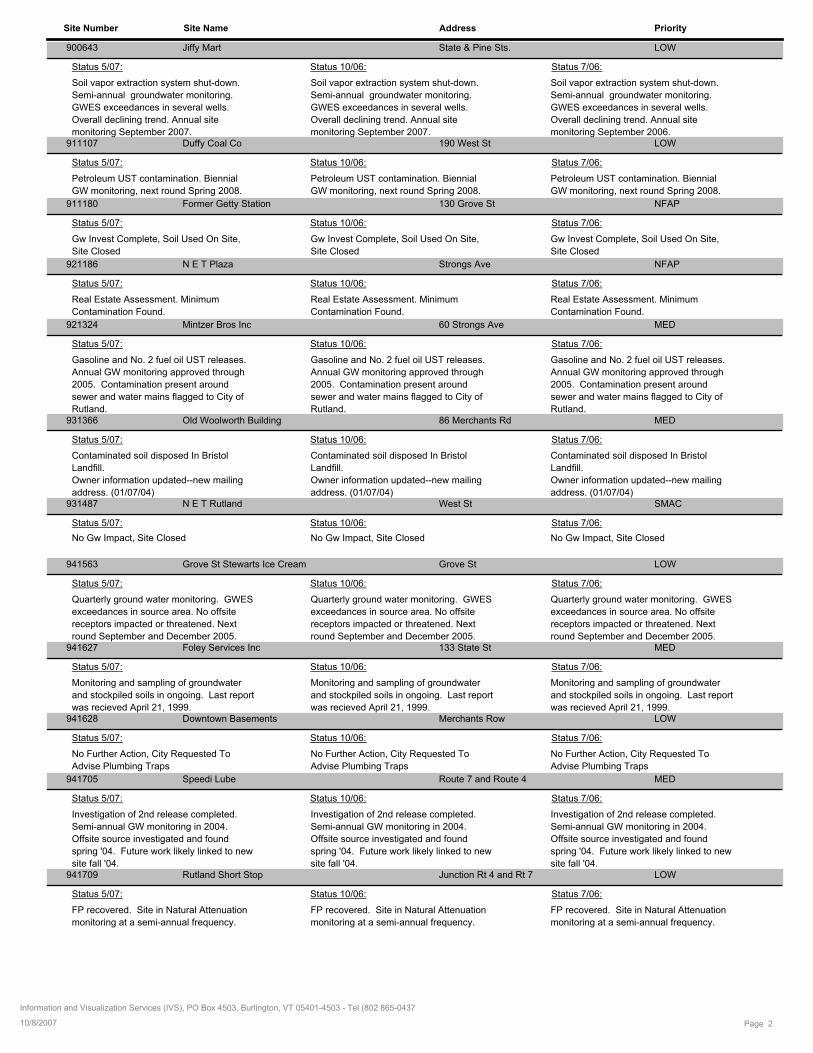
Site Number Site Name Address Priority
900643 State & Pine Sts.Jiffy Mart LOW
Soil vapor extraction system shut-down.
Semi-annual groundwater monitoring.
GWES exceedances in several wells.
Overall declining trend. Annual site
monitoring September 2007.
Status 5/07: Status 10/06: Status 7/06:
Soil vapor extraction system shut-down.
Semi-annual groundwater monitoring.
GWES exceedances in several wells.
Overall declining trend. Annual site
monitoring September 2006.
Soil vapor extraction system shut-down.
Semi-annual groundwater monitoring.
GWES exceedances in several wells.
Overall declining trend. Annual site
monitoring September 2007. 911107 190 West StDuffy Coal Co LOW
Petroleum UST contamination. Biennial
GW monitoring, next round Spring 2008.
Status 5/07: Status 10/06: Status 7/06:
Petroleum UST contamination. Biennial
GW monitoring, next round Spring 2008.
Petroleum UST contamination. Biennial
GW monitoring, next round Spring 2008.
911180 130 Grove StFormer Getty Station NFAP
Gw Invest Complete, Soil Used On Site,
Site Closed
Status 5/07: Status 10/06: Status 7/06:
Gw Invest Complete, Soil Used On Site,
Site Closed
Gw Invest Complete, Soil Used On Site,
Site Closed
921186 Strongs AveN E T Plaza NFAP
Real Estate Assessment. Minimum
Contamination Found.
Status 5/07: Status 10/06: Status 7/06:
Real Estate Assessment. Minimum
Contamination Found.
Real Estate Assessment. Minimum
Contamination Found.
921324 60 Strongs AveMintzer Bros Inc MED
Gasoline and No. 2 fuel oil UST releases.
Annual GW monitoring approved through
2005. Contamination present around
sewer and water mains flagged to City of
Rutland.
Status 5/07: Status 10/06: Status 7/06:
Gasoline and No. 2 fuel oil UST releases.
Annual GW monitoring approved through
2005. Contamination present around
sewer and water mains flagged to City of
Rutland.
Gasoline and No. 2 fuel oil UST releases.
Annual GW monitoring approved through
2005. Contamination present around
sewer and water mains flagged to City of
Rutland. 931366 86 Merchants RdOld Woolworth Building MED
Contaminated soil disposed In Bristol
Landfill.
Owner information updated--new mailing
address. (01/07/04)
Status 5/07: Status 10/06: Status 7/06:
Contaminated soil disposed In Bristol
Landfill.
Owner information updated--new mailing
address. (01/07/04)
Contaminated soil disposed In Bristol
Landfill.
Owner information updated--new mailing
address. (01/07/04) 931487 West StN E T Rutland SMAC
No Gw Impact, Site Closed
Status 5/07: Status 10/06: Status 7/06:
No Gw Impact, Site ClosedNo Gw Impact, Site Closed
941563 Grove StGrove St Stewarts Ice Cream LOW
Quarterly ground water monitoring. GWES
exceedances in source area. No offsite
receptors impacted or threatened. Next
round September and December 2005.
Status 5/07: Status 10/06: Status 7/06:
Quarterly ground water monitoring. GWES
exceedances in source area. No offsite
receptors impacted or threatened. Next
round September and December 2005.
Quarterly ground water monitoring. GWES
exceedances in source area. No offsite
receptors impacted or threatened. Next
round September and December 2005. 941627 133 State StFoley Services Inc MED
Monitoring and sampling of groundwater
and stockpiled soils in ongoing. Last report
was recieved April 21, 1999.
Status 5/07: Status 10/06: Status 7/06:
Monitoring and sampling of groundwater
and stockpiled soils in ongoing. Last report
was recieved April 21, 1999.
Monitoring and sampling of groundwater
and stockpiled soils in ongoing. Last report
was recieved April 21, 1999. 941628 Merchants RowDowntown Basements LOW
No Further Action, City Requested To
Advise Plumbing Traps
Status 5/07: Status 10/06: Status 7/06:
No Further Action, City Requested To
Advise Plumbing Traps
No Further Action, City Requested To
Advise Plumbing Traps
941705 Route 7 and Route 4Speedi Lube MED
Investigation of 2nd release completed.
Semi-annual GW monitoring in 2004.
Offsite source investigated and found
spring '04. Future work likely linked to new
site fall '04.
Status 5/07: Status 10/06: Status 7/06:
Investigation of 2nd release completed.
Semi-annual GW monitoring in 2004.
Offsite source investigated and found
spring '04. Future work likely linked to new
site fall '04.
Investigation of 2nd release completed.
Semi-annual GW monitoring in 2004.
Offsite source investigated and found
spring '04. Future work likely linked to new
site fall '04. 941709 Junction Rt 4 and Rt 7Rutland Short Stop LOW
FP recovered. Site in Natural Attenuation
monitoring at a semi-annual frequency.
Status 5/07: Status 10/06: Status 7/06:
FP recovered. Site in Natural Attenuation
monitoring at a semi-annual frequency.
FP recovered. Site in Natural Attenuation
monitoring at a semi-annual frequency.
Page 210/8/2007
Information and Visualization Services (IVS), PO Box 4503, Burlington, VT 05401-4503 - Tel (802 865-0437
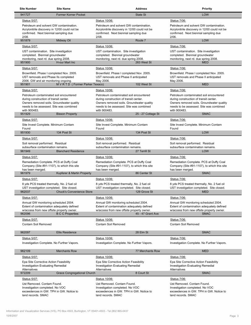
Site Number Site Name Address Priority
941727 State StFormer Korner Pocket LOW
Petroleum and solvent GW contamination.
Acrylonitrile discovery in 12/00 could not be
confirmed. Next biennial sampling due
2/08.
Status 5/07: Status 10/06: Status 7/06:
Petroleum and solvent GW contamination.
Acrylonitrile discovery in 12/00 could not be
confirmed. Next biennial sampling due
2/06.
Petroleum and solvent GW contamination.
Acrylonitrile discovery in 12/00 could not be
confirmed. Next biennial sampling due
2/08. 951879 Route 7Midway Oil LOW
UST contamination. Site investigation
completed. Biennial groundwater
monitoring, next rd. due spring 2008.
Status 5/07: Status 10/06: Status 7/06:
UST contamination. Site investigation
completed. Biennial groundwater
monitoring, next rd. due spring 2008.
UST contamination. Site investigation
completed. Biennial groundwater
monitoring, next rd. due spring 2008. 951900 263 West StH-our Mart Inc MED
Brownfield. Phase I completed Nov. 2005.
UST removals and Phase II anticipated
May 2006.
Status 5/07: Status 10/06: Status 7/06:
Brownfield. Phase I completed Nov. 2005.
UST removals and Phase II anticipated
May 2006.
Brownfield. Phase I completed Nov. 2005.
UST removals and Phase IIs completed
2006. GW and air monitoring ongoing. 951901 102 West StM V R T D ( Former Parker Texaco) MED
Petroleum contaminated soil encountered
during construction of transit center.
Owners removed soils. Groundwater quality
needs to be assessed. Site was combined
with 900483.
Status 5/07: Status 10/06: Status 7/06:
Petroleum contaminated soil encountered
during construction of transit center.
Owners removed soils. Groundwater quality
needs to be assessed. Site was combined
with 900483.
Petroleum contaminated soil encountered
during construction of transit center.
Owners removed soils. Groundwater quality
needs to be assessed. Site was combined
with 900483. 951929 25 - 27 Cottage StBisson Property SMAC
Site Invest Complete. Minimum Contam
Found
Status 5/07: Status 10/06: Status 7/06:
Site Invest Complete. Minimum Contam
Found
Site Invest Complete. Minimum Contam
Found
951930 134 Post St134 Post St LOW
Soil removal performed. Residual
subsurface contamination remains.
Status 5/07: Status 10/06: Status 7/06:
Soil removal performed. Residual
subsurface contamination remains.
Soil removal performed. Residual
subsurface contamination remains.
961949 27 Terrill StBlanchard Residence LOW
Remediation Complete. PCS at Duffy Coal
Company (Site #91-1107), to which this site
has been merged.
Status 5/07: Status 10/06: Status 7/06:
Remediation Complete. PCS at Duffy Coal
Company (Site #91-1107), to which this site
has been merged.
Remediation Complete. PCS at Duffy Coal
Company (Site #91-1107), to which this site
has been merged. 961979 86 Center StKupferer & Martin Property SMAC
8 yds PCS treated thermally, No. 2 fuel oil
UST investigation completed. Site closed.
Status 5/07: Status 10/06: Status 7/06:
8 yds PCS treated thermally, No. 2 fuel oil
UST investigation completed. Site closed.
8 yds PCS treated thermally, No. 2 fuel oil
UST investigation completed. Site closed.
962037 129 Grove StChuck's Convenience Store MED
Annual GW monitoring scheduled 2004.
Extent of contamination adequately defined
w/access from new offsite property owner.
Status 5/07: Status 10/06: Status 7/06:
Annual GW monitoring scheduled 2004.
Extent of contamination adequately defined
w/access from new offsite property owner.
Annual GW monitoring scheduled 2004.
Extent of contamination adequately defined
w/access from new offsite property owner. 962096 45 - 47 Grant AveB C C Properties SMAC
Contam Soil Removed
Status 5/07: Status 10/06: Status 7/06:
Contam Soil RemovedContam Soil Removed
962097 28 Elm StEllis Residence SMAC
Investigation Complete. No Further Vapors.
Status 5/07: Status 10/06: Status 7/06:
Investigation Complete. No Further Vapors.Investigation Complete. No Further Vapors.
962109 77 Merchants RowMerchants Row MED
Epa Site Corrective Action Feasibility
Investigation Evaluating Remedial
Alternatives
Status 5/07: Status 10/06: Status 7/06:
Epa Site Corrective Action Feasibility
Investigation Evaluating Remedial
Alternatives
Epa Site Corrective Action Feasibility
Investigation Evaluating Remedial
Alternatives 972209 8 Court StGrace Congregational Church SMAC
Ust Removed. Contam Found.
Investigation completed. No VOC
exceedences in GW. TPH in GW. Notice to
land records. SMAC
Status 5/07: Status 10/06: Status 7/06:
Ust Removed. Contam Found.
Investigation completed. No VOC
exceedences in GW. TPH in GW. Notice to
land records. SMAC
Ust Removed. Contam Found.
Investigation completed. No VOC
exceedences in GW. TPH in GW. Notice to
land records. SMAC
Page 310/8/2007
Information and Visualization Services (IVS), PO Box 4503, Burlington, VT 05401-4503 - Tel (802 865-0437
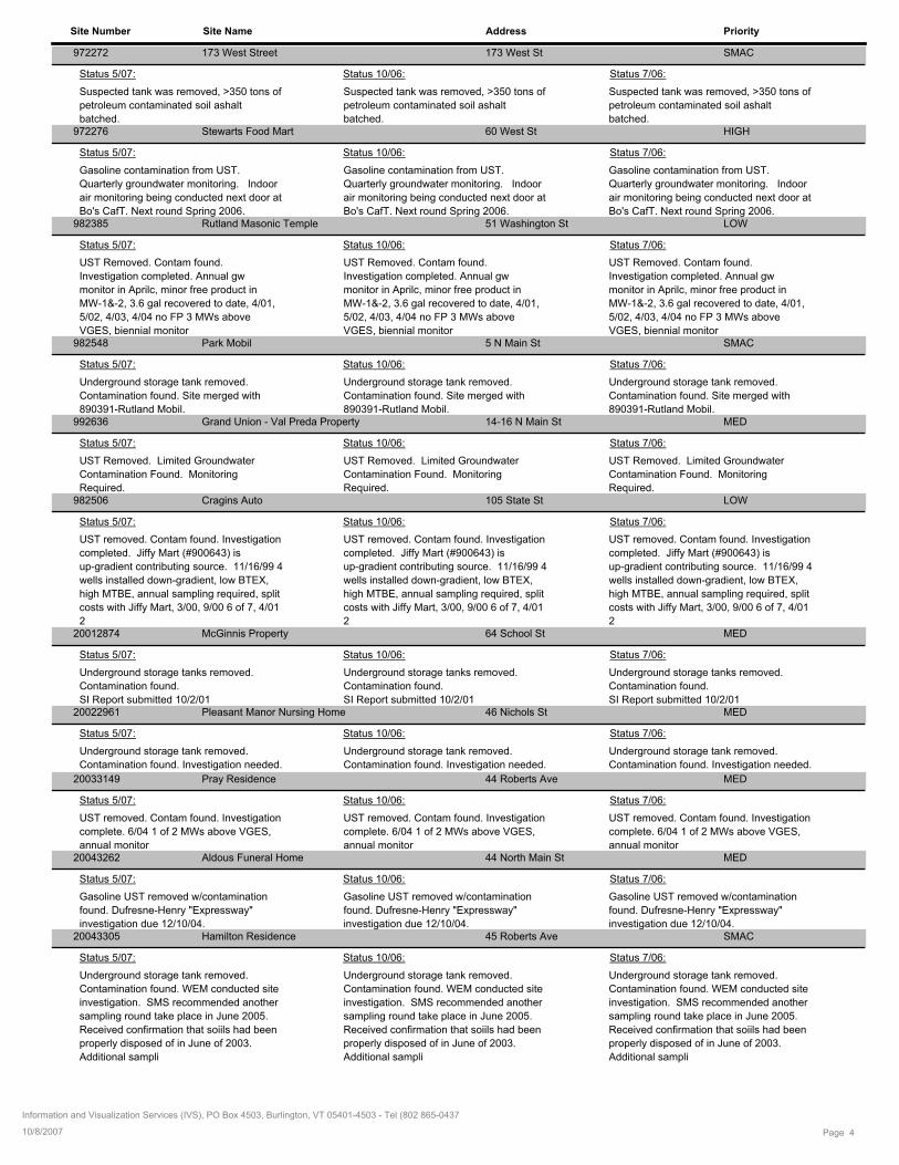
Site Number Site Name Address Priority
972272 173 West St173 West Street SMAC
Suspected tank was removed, >350 tons of
petroleum contaminated soil ashalt
batched.
Status 5/07: Status 10/06: Status 7/06:
Suspected tank was removed, >350 tons of
petroleum contaminated soil ashalt
batched.
Suspected tank was removed, >350 tons of
petroleum contaminated soil ashalt
batched. 972276 60 West StStewarts Food Mart HIGH
Gasoline contamination from UST.
Quarterly groundwater monitoring. Indoor
air monitoring being conducted next door at
Bo's CafT. Next round Spring 2006.
Status 5/07: Status 10/06: Status 7/06:
Gasoline contamination from UST.
Quarterly groundwater monitoring. Indoor
air monitoring being conducted next door at
Bo's CafT. Next round Spring 2006.
Gasoline contamination from UST.
Quarterly groundwater monitoring. Indoor
air monitoring being conducted next door at
Bo's CafT. Next round Spring 2006. 982385 51 Washington StRutland Masonic Temple LOW
UST Removed. Contam found.
Investigation completed. Annual gw
monitor in Aprilc, minor free product in
MW-1&-2, 3.6 gal recovered to date, 4/01,
5/02, 4/03, 4/04 no FP 3 MWs above
VGES, biennial monitor
Status 5/07: Status 10/06: Status 7/06:
UST Removed. Contam found.
Investigation completed. Annual gw
monitor in Aprilc, minor free product in
MW-1&-2, 3.6 gal recovered to date, 4/01,
5/02, 4/03, 4/04 no FP 3 MWs above
VGES, biennial monitor
UST Removed. Contam found.
Investigation completed. Annual gw
monitor in Aprilc, minor free product in
MW-1&-2, 3.6 gal recovered to date, 4/01,
5/02, 4/03, 4/04 no FP 3 MWs above
VGES, biennial monitor 982548 5 N Main StPark Mobil SMAC
Underground storage tank removed.
Contamination found. Site merged with
890391-Rutland Mobil.
Status 5/07: Status 10/06: Status 7/06:
Underground storage tank removed.
Contamination found. Site merged with
890391-Rutland Mobil.
Underground storage tank removed.
Contamination found. Site merged with
890391-Rutland Mobil. 992636 14-16 N Main StGrand Union - Val Preda Property MED
UST Removed. Limited Groundwater
Contamination Found. Monitoring
Required.
Status 5/07: Status 10/06: Status 7/06:
UST Removed. Limited Groundwater
Contamination Found. Monitoring
Required.
UST Removed. Limited Groundwater
Contamination Found. Monitoring
Required. 982506 105 State StCragins Auto LOW
UST removed. Contam found. Investigation
completed. Jiffy Mart (#900643) is
up-gradient contributing source. 11/16/99 4
wells installed down-gradient, low BTEX,
high MTBE, annual sampling required, split
costs with Jiffy Mart, 3/00, 9/00 6 of 7, 4/01
2
Status 5/07: Status 10/06: Status 7/06:
UST removed. Contam found. Investigation
completed. Jiffy Mart (#900643) is
up-gradient contributing source. 11/16/99 4
wells installed down-gradient, low BTEX,
high MTBE, annual sampling required, split
costs with Jiffy Mart, 3/00, 9/00 6 of 7, 4/01
2
UST removed. Contam found. Investigation
completed. Jiffy Mart (#900643) is
up-gradient contributing source. 11/16/99 4
wells installed down-gradient, low BTEX,
high MTBE, annual sampling required, split
costs with Jiffy Mart, 3/00, 9/00 6 of 7, 4/01
2 20012874 64 School StMcGinnis Property MED
Underground storage tanks removed.
Contamination found.
SI Report submitted 10/2/01
Status 5/07: Status 10/06: Status 7/06:
Underground storage tanks removed.
Contamination found.
SI Report submitted 10/2/01
Underground storage tanks removed.
Contamination found.
SI Report submitted 10/2/01 20022961 46 Nichols StPleasant Manor Nursing Home MED
Underground storage tank removed.
Contamination found. Investigation needed.
Status 5/07: Status 10/06: Status 7/06:
Underground storage tank removed.
Contamination found. Investigation needed.
Underground storage tank removed.
Contamination found. Investigation needed.
20033149 44 Roberts AvePray Residence MED
UST removed. Contam found. Investigation
complete. 6/04 1 of 2 MWs above VGES,
annual monitor
Status 5/07: Status 10/06: Status 7/06:
UST removed. Contam found. Investigation
complete. 6/04 1 of 2 MWs above VGES,
annual monitor
UST removed. Contam found. Investigation
complete. 6/04 1 of 2 MWs above VGES,
annual monitor 20043262 44 North Main StAldous Funeral Home MED
Gasoline UST removed w/contamination
found. Dufresne-Henry "Expressway"
investigation due 12/10/04.
Status 5/07: Status 10/06: Status 7/06:
Gasoline UST removed w/contamination
found. Dufresne-Henry "Expressway"
investigation due 12/10/04.
Gasoline UST removed w/contamination
found. Dufresne-Henry "Expressway"
investigation due 12/10/04. 20043305 45 Roberts AveHamilton Residence SMAC
Underground storage tank removed.
Contamination found. WEM conducted site
investigation. SMS recommended another
sampling round take place in June 2005.
Received confirmation that soiils had been
properly disposed of in June of 2003.
Additional sampli
Status 5/07: Status 10/06: Status 7/06:
Underground storage tank removed.
Contamination found. WEM conducted site
investigation. SMS recommended another
sampling round take place in June 2005.
Received confirmation that soiils had been
properly disposed of in June of 2003.
Additional sampli
Underground storage tank removed.
Contamination found. WEM conducted site
investigation. SMS recommended another
sampling round take place in June 2005.
Received confirmation that soiils had been
properly disposed of in June of 2003.
Additional sampli
Page 410/8/2007
Information and Visualization Services (IVS), PO Box 4503, Burlington, VT 05401-4503 - Tel (802 865-0437

Site Number Site Name Address Priority
20053336 10 - 12 North Main Stformer Coastal Towing MED
5 USTs removed. Contam found.
Investigation ongoing, 5/25/05 6 of 8 MWs
above VGES, confirm in Fall 2005
Status 5/07: Status 10/06: Status 7/06:
5 USTs removed. Contam found.
Investigation ongoing, 5/25/05 6 of 8 MWs
above VGES, confirm in Fall 2005
5 USTs removed. Contam found.
Investigation ongoing, 5/25/05 6 of 8 MWs
above VGES, confirm in Fall 2005
Page 510/8/2007
Information and Visualization Services (IVS), PO Box 4503, Burlington, VT 05401-4503 - Tel (802 865-0437
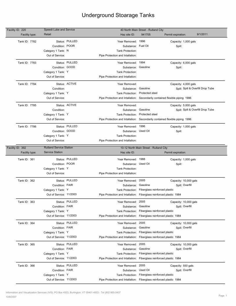
Underground Stoarage Tanks
Facility ID: 220 Speedi Lube and Service 40 North Main Street - Rutland City
RetailFacility type: Haz site ID: 941705 Permit expiration: 9/1/2011
7782Tank ID:
POOR Fuel Oil
Capacity:
Condition: Substance: Spill:
PULLED 1996Year Removed: 1,000 gals
Tank Protection:Category 1 Tank:
Pipe Protection and Intallation:Out of Service:
N
Status:
7783Tank ID:
GOOD Gasoline
Capacity:
Condition: Substance: Spill:
PULLED 1994Year Removed: 6,000 gals
Tank Protection:Category 1 Tank:
Pipe Protection and Intallation:Out of Service:
Y
Status:
7784Tank ID:
Gasoline
Capacity:
Condition: Substance: Spill & Overfill Drop TubeSpill:
ACTIVE Year Removed: 4,000 gals
Tank Protection:Category 1 Tank: Protected steel
Pipe Protection and Intallation:Out of Service:
Y
Secondarily contained flexible piping 1996
Status:
7785Tank ID:
Gasoline
Capacity:
Condition: Substance: Spill & Overfill Drop TubeSpill:
ACTIVE Year Removed: 5,000 gals
Tank Protection:Category 1 Tank: Protected steel
Pipe Protection and Intallation:Out of Service:
Y
Secondarily contained flexible piping 1996
Status:
7786Tank ID:
GOOD Used Oil
Capacity:
Condition: Substance: Spill:
PULLED 1996Year Removed: 1,000 gals
Tank Protection:Category 1 Tank:
Pipe Protection and Intallation:Out of Service:
Y
Status:
Facility ID: 392 Rutland Service Station 10-12 North Main Street - Rutland City
Service StationFacility type: Haz site ID: Permit expiration:
361Tank ID:
POOR Used Oil
Capacity:
Condition: Substance: Spill:
PULLED 1988Year Removed: 1,000 gals
Tank Protection:Category 1 Tank:
Pipe Protection and Intallation:Out of Service:
Y
Status:
362Tank ID:
FAIR Gasoline
Capacity:
Condition: Substance: OverfillSpill:
PULLED 2005Year Removed: 10,000 gals
Tank Protection:Category 1 Tank: Fiberglass reinforced plastic
Pipe Protection and Intallation:Out of Service:
Y
Fiberglass reinforced plastic 198411/2003
Status:
363Tank ID:
FAIR Gasoline
Capacity:
Condition: Substance: OverfillSpill:
PULLED 2005Year Removed: 10,000 gals
Tank Protection:Category 1 Tank: Fiberglass reinforced plastic
Pipe Protection and Intallation:Out of Service:
Y
Fiberglass reinforced plastic 198411/2003
Status:
364Tank ID:
FAIR Gasoline
Capacity:
Condition: Substance: OverfillSpill:
PULLED 2005Year Removed: 10,000 gals
Tank Protection:Category 1 Tank: Fiberglass reinforced plastic
Pipe Protection and Intallation:Out of Service:
Y
Fiberglass reinforced plastic 198411/2003
Status:
365Tank ID:
FAIR Gasoline
Capacity:
Condition: Substance: OverfillSpill:
PULLED 2005Year Removed: 10,000 gals
Tank Protection:Category 1 Tank: Fiberglass reinforced plastic
Pipe Protection and Intallation:Out of Service:
Y
Fiberglass reinforced plastic 198411/2003
Status:
366Tank ID:
FAIR Used Oil
Capacity:
Condition: Substance: OverfillSpill:
PULLED 2005Year Removed: 550 gals
Tank Protection:Category 1 Tank: Fiberglass reinforced plastic
Pipe Protection and Intallation:Out of Service:
Y
Fiberglass reinforced plastic 198411/2003
Status:
Information and Visualization Services (IVS), PO Box 4503, Burlington, VT 05401-4503 - Tel (802 865-0437
10/8/2007Page 1
Underground Stoarage Tanks
Facility ID: 451 State Office Building 9 Merchants Row - Rutland City
StateFacility type: Haz site ID: Permit expiration:
8602Tank ID:
FAIR Used Oil
Capacity:
Condition: Substance: Spill:
PULLED 1991Year Removed: 450 gals
Tank Protection:Category 1 Tank:
Pipe Protection and Intallation:Out of Service:
Y
Status:
8603Tank ID:
GOOD Gasoline
Capacity:
Condition: Substance: Spill:
PULLED 1991Year Removed: 2,000 gals
Tank Protection:Category 1 Tank:
Pipe Protection and Intallation:Out of Service:
Y
Status:
8604Tank ID:
POOR Gasoline
Capacity:
Condition: Substance: Spill:
PULLED 1991Year Removed: 2,000 gals
Tank Protection:Category 1 Tank:
Pipe Protection and Intallation:Out of Service:
Y
Status:
8605Tank ID:
GOOD Fuel Oil
Capacity:
Condition: Substance: Spill:
PULLED 1991Year Removed: 550 gals
Tank Protection:Category 1 Tank:
Pipe Protection and Intallation:Out of Service:
N
Status:
8606Tank ID:
GOOD Fuel Oil
Capacity:
Condition: Substance: Spill:
PULLED 1991Year Removed: 1,000 gals
Tank Protection:Category 1 Tank:
Pipe Protection and Intallation:Out of Service:
N
Status:
8607Tank ID:
GOOD Fuel Oil
Capacity:
Condition: Substance: NoneSpill:
PULLED 2004Year Removed: 8,000 gals
Tank Protection:Category 1 Tank: Unprotected steel
Pipe Protection and Intallation:Out of Service:
N
Unprotected steel 1979
Status:
8608Tank ID:
Fuel Oil
Capacity:
Condition: Substance: Spill & Overfill AlarmSpill:
ACTIVE Year Removed: 10,000 gals
Tank Protection:Category 1 Tank: Fiberglass reinforced plastic
Pipe Protection and Intallation:Out of Service:
N
Secondarily contained flexible piping 2004
Status:
Facility ID: 634 Longfellow Administration Building 6 Church Street - Rutland City
TownFacility type: Haz site ID: Permit expiration:
9074Tank ID:
Fuel Oil
Capacity:
Condition: Substance: NoneSpill:
ACTIVE Year Removed: 6,300 gals
Tank Protection:Category 1 Tank: Unprotected steel
Pipe Protection and Intallation:Out of Service:
N
Unprotected steel 1956
Status:
Facility ID: 637 Dana School East Center Street - Rutland City
TownFacility type: Haz site ID: Permit expiration:
9077Tank ID:
Fuel Oil
Capacity:
Condition: Substance: NoneSpill:
ACTIVE Year Removed: 8,400 gals
Tank Protection:Category 1 Tank: Unprotected steel
Pipe Protection and Intallation:Out of Service:
N
Unprotected steel 1960
Status:
Facility ID: 638 Rutland Area Christian School 112 Lincoln Avenue - Rutland City
TownFacility type: Haz site ID: Permit expiration:
9078Tank ID:
GOOD Fuel Oil
Capacity:
Condition: Substance: NoneSpill:
PULLED 2000Year Removed: 8,400 gals
Tank Protection:Category 1 Tank: Unprotected steel
Pipe Protection and Intallation:Out of Service:
N
Unprotected steel 1960
Status:
Information and Visualization Services (IVS), PO Box 4503, Burlington, VT 05401-4503 - Tel (802 865-0437
10/8/2007Page 2
Underground Stoarage Tanks
9079Tank ID:
Fuel Oil
Capacity:
Condition: Substance: OverfillSpill:
ACTIVE Year Removed: 10,000 gals
Tank Protection:Category 1 Tank: Fiberglass jacketed steel tank
Pipe Protection and Intallation:Out of Service:
N
Secondarily contained flexible piping 2000
Status:
Facility ID: 639 Northeast School Temple Street - Rutland City
TownFacility type: Haz site ID: 20033135 Permit expiration:
9080Tank ID:
POOR Fuel Oil
Capacity:
Condition: Substance: NoneSpill:
PULLED 2003Year Removed: 8,400 gals
Tank Protection:Category 1 Tank: Unprotected steel
Pipe Protection and Intallation:Out of Service:
N
Unprotected steel 1961
Status:
9081Tank ID:
Fuel Oil
Capacity:
Condition: Substance: OverfillSpill:
ACTIVE Year Removed: 5,000 gals
Tank Protection:Category 1 Tank: Fiberglass jacketed steel tank
Pipe Protection and Intallation:Out of Service:
N
Secondarily contained flexible piping 2003
Status:
Facility ID: 665 Stewart's Shop #192 Strongs Avenue and South Main Street -
RetailFacility type: Haz site ID: 941562 Permit expiration: 3/1/2009
9097Tank ID:
GOOD Gasoline
Capacity:
Condition: Substance: Spill:
PULLED 1996Year Removed: 4,000 gals
Tank Protection:Category 1 Tank:
Pipe Protection and Intallation:Out of Service:
Y
Status:
9098Tank ID:
GOOD Gasoline
Capacity:
Condition: Substance: Spill:
PULLED 1996Year Removed: 4,000 gals
Tank Protection:Category 1 Tank:
Pipe Protection and Intallation:Out of Service:
Y
Status:
9099Tank ID:
GOOD Gasoline
Capacity:
Condition: Substance: Spill:
PULLED 1996Year Removed: 4,000 gals
Tank Protection:Category 1 Tank:
Pipe Protection and Intallation:Out of Service:
Y
Status:
9100Tank ID:
GOOD Gasoline
Capacity:
Condition: Substance: Spill:
PULLED 1996Year Removed: 4,000 gals
Tank Protection:Category 1 Tank:
Pipe Protection and Intallation:Out of Service:
Y
Status:
9101Tank ID:
Gasoline
Capacity:
Condition: Substance: Spill & Overfill Float VentSpill:
ACTIVE Year Removed: 8,000 gals
Tank Protection:Category 1 Tank: Protected steel
Pipe Protection and Intallation:Out of Service:
Y
Secondarily contained flexible piping 1996
Status:
9102Tank ID:
Gasoline
Capacity:
Condition: Substance: Spill & Overfill Float VentSpill:
ACTIVE Year Removed: 8,000 gals
Tank Protection:Category 1 Tank: Protected steel
Pipe Protection and Intallation:Out of Service:
Y
Secondarily contained flexible piping 1996
Status:
Facility ID: 703 CVPS Rutland Engineering Building 23 Evelyn Street - Rutland City
Industrial/CommercialFacility type: Haz site ID: Permit expiration:
9167Tank ID:
POOR Gasoline
Capacity:
Condition: Substance: Spill:
PULLED 1988Year Removed: 1,000 gals
Tank Protection:Category 1 Tank:
Pipe Protection and Intallation:Out of Service:
Y
Status:
Information and Visualization Services (IVS), PO Box 4503, Burlington, VT 05401-4503 - Tel (802 865-0437
10/8/2007Page 3
Underground Stoarage Tanks
9168Tank ID:
GOOD Fuel Oil
Capacity:
Condition: Substance: Spill:
PULLED 1998Year Removed: 10,000 gals
Tank Protection:Category 1 Tank:
Pipe Protection and Intallation:Out of Service:
N
Status:
9169Tank ID:
Fuel Oil
Capacity:
Condition: Substance: OverfillSpill:
ACTIVE Year Removed: 10,000 gals
Tank Protection:Category 1 Tank: Fiberglass jacketed steel tank
Pipe Protection and Intallation:Out of Service:
N
Secondarily contained flexible piping 1998
Status:
Facility ID: 704 Rutland General Office Building 77 Grove Street - Rutland City
Industrial/CommercialFacility type: Haz site ID: Permit expiration:
9170Tank ID:
GOOD Gasoline
Capacity:
Condition: Substance: Spill:
PULLED 1989Year Removed: 100 gals
Tank Protection:Category 1 Tank:
Pipe Protection and Intallation:Out of Service:
Y
Status:
9171Tank ID:
Fuel Oil
Capacity:
Condition: Substance: Spill:
PULLED 1987Year Removed: 10,000 gals
Tank Protection:Category 1 Tank:
Pipe Protection and Intallation:Out of Service:
N
Status:
9172Tank ID:
Fuel Oil
Capacity:
Condition: Substance: NoneSpill:
ACTIVE Year Removed: 10,000 gals
Tank Protection:Category 1 Tank: Protected steel
Pipe Protection and Intallation:Out of Service:
N
Protected steel 1987
Status:
Facility ID: 705 Central Vermont Public Service Corp. Cleveland Avenue - Rutland City
Industrial/CommercialFacility type: Haz site ID: 770137 Permit expiration:
605Tank ID:
Fuel Oil
Capacity:
Condition: Substance: Spill:
PULLED 1992Year Removed: 4,800 gals
Tank Protection:Category 1 Tank: Unprotected steel
Pipe Protection and Intallation:Out of Service:
Status:
606Tank ID:
Gasoline
Capacity:
Condition: Substance: Spill:
PULLED 1992Year Removed: 1,000 gals
Tank Protection:Category 1 Tank: Unprotected steel
Pipe Protection and Intallation:Out of Service:
Status:
607Tank ID:
Diesel
Capacity:
Condition: Substance: Spill:
PULLED 1992Year Removed: 5,000 gals
Tank Protection:Category 1 Tank: Unprotected steel
Pipe Protection and Intallation:Out of Service:
Status:
608Tank ID:
Gasoline
Capacity:
Condition: Substance: Spill:
PULLED 1992Year Removed: 5,000 gals
Tank Protection:Category 1 Tank: Unprotected steel
Pipe Protection and Intallation:Out of Service:
Status:
609Tank ID:
Gasoline
Capacity:
Condition: Substance: Spill:
PULLED 1995Year Removed: 5,000 gals
Tank Protection:Category 1 Tank: Unprotected steel
Pipe Protection and Intallation:Out of Service:
Status:
Facility ID: 812 Grove Street Short Stop 129 Grove Street - Rutland City
RetailFacility type: Haz site ID: 962037 Permit expiration: 9/1/2010
Information and Visualization Services (IVS), PO Box 4503, Burlington, VT 05401-4503 - Tel (802 865-0437
10/8/2007Page 4
Underground Stoarage Tanks
9430Tank ID:
POOR Fuel Oil
Capacity:
Condition: Substance: Spill:
PULLED 1996Year Removed: 1,000 gals
Tank Protection:Category 1 Tank:
Pipe Protection and Intallation:Out of Service:
N
Status:
9431Tank ID:
GOOD Gasoline
Capacity:
Condition: Substance: Spill:
PULLED 1996Year Removed: 12,000 gals
Tank Protection:Category 1 Tank:
Pipe Protection and Intallation:Out of Service:
Y
Status:
9432Tank ID:
GOOD Gasoline
Capacity:
Condition: Substance: Spill:
PULLED 1996Year Removed: 12,000 gals
Tank Protection:Category 1 Tank:
Pipe Protection and Intallation:Out of Service:
Y
Status:
9433Tank ID:
GOOD Gasoline
Capacity:
Condition: Substance: Spill:
PULLED 1996Year Removed: 12,000 gals
Tank Protection:Category 1 Tank:
Pipe Protection and Intallation:Out of Service:
Y
Status:
9434Tank ID:
Gasoline
Capacity:
Condition: Substance: Spill & Overfill Float VentSpill:
ACTIVE Year Removed: 12,000 gals
Tank Protection:Category 1 Tank: Protected steel
Pipe Protection and Intallation:Out of Service:
Y
Secondarily contained flexible piping 1996
Status:
9435Tank ID:
Gasoline
Capacity:
Condition: Substance: Spill & Overfill Float VentSpill:
ACTIVE Year Removed: 12,000 gals
Tank Protection:Category 1 Tank: Protected steel
Pipe Protection and Intallation:Out of Service:
Y
Secondarily contained flexible piping 1996
Status:
Facility ID: 833 Foley Services Inc 133 State Street - Rutland City
Industrial/CommercialFacility type: Haz site ID: 941627 Permit expiration: 6/1/2011
9483Tank ID:
Fuel Oil
Capacity:
Condition: Substance: Spill:
PULLED 1996Year Removed: 10,000 gals
Tank Protection:Category 1 Tank:
Pipe Protection and Intallation:Out of Service:
N
Status:
9484Tank ID:
POOR Gasoline
Capacity:
Condition: Substance: Spill:
PULLED 1994Year Removed: 2,000 gals
Tank Protection:Category 1 Tank:
Pipe Protection and Intallation:Out of Service:
Y
Status:
9485Tank ID:
Fuel Oil
Capacity:
Condition: Substance: Spill & Overfill Float VentSpill:
ACTIVE Year Removed: 10,000 gals
Tank Protection:Category 1 Tank: Protected steel
Pipe Protection and Intallation:Out of Service:
Y
Secondarily contained flexible piping 1996
Status:
Facility ID: 914 Rutland Police Department 108 Wales Street - Rutland City
Industrial/CommercialFacility type: Haz site ID: Permit expiration:
9627Tank ID:
Fuel Oil
Capacity:
Condition: Substance: NoneSpill:
ACTIVE Year Removed: 6,000 gals
Tank Protection:Category 1 Tank: Unprotected steel
Pipe Protection and Intallation:Out of Service:
N
Unprotected steel 1976
Status:
Facility ID: 989 Rutland Jiffy Mart/Maverick 100 State Street - Rutland City
RetailFacility type: Haz site ID: 900643 Permit expiration: 9/1/2011
Information and Visualization Services (IVS), PO Box 4503, Burlington, VT 05401-4503 - Tel (802 865-0437
10/8/2007Page 5
Underground Stoarage Tanks
9775Tank ID:
POOR Gasoline
Capacity:
Condition: Substance: Spill:
PULLED 1997Year Removed: 3,000 gals
Tank Protection:Category 1 Tank:
Pipe Protection and Intallation:Out of Service:
Y
Status:
9776Tank ID:
POOR Gasoline
Capacity:
Condition: Substance: Spill:
PULLED 1997Year Removed: 4,000 gals
Tank Protection:Category 1 Tank:
Pipe Protection and Intallation:Out of Service:
Y
Status:
9777Tank ID:
POOR Gasoline
Capacity:
Condition: Substance: Spill:
PULLED 1997Year Removed: 3,000 gals
Tank Protection:Category 1 Tank:
Pipe Protection and Intallation:Out of Service:
Y
Status:
9778Tank ID:
LUST Gasoline
Capacity:
Condition: Substance: Spill:
PULLED 1990Year Removed: 4,000 gals
Tank Protection:Category 1 Tank:
Pipe Protection and Intallation:Out of Service:
Y
Status:
9779Tank ID:
GOOD Gasoline
Capacity:
Condition: Substance: Spill:
PULLED 1997Year Removed: 8,000 gals
Tank Protection:Category 1 Tank:
Pipe Protection and Intallation:Out of Service:
Y
Status:
9780Tank ID:
Gasoline
Capacity:
Condition: Substance: Spill & Overfill Drop TubeSpill:
ACTIVE Year Removed: 12,000 gals
Tank Protection:Category 1 Tank: Fiberglass jacketed steel tank
Pipe Protection and Intallation:Out of Service:
Y
Secondarily contained flexible piping 1997
Status:
9781Tank ID:
Gasoline
Capacity:
Condition: Substance: Spill & Overfill Drop TubeSpill:
ACTIVE Year Removed: 10,000 gals
Tank Protection:Category 1 Tank: Fiberglass jacketed steel tank
Pipe Protection and Intallation:Out of Service:
Y
Secondarily contained flexible piping 1997
Status:
Facility ID: 1002 Plaza Exxon Evelyn Street - Rutland City
Service StationFacility type: Haz site ID: 890384 Permit expiration:
886Tank ID:
GOOD Gasoline
Capacity:
Condition: Substance: Spill:
PULLED 1999Year Removed: 4,000 gals
Tank Protection:Category 1 Tank: Unprotected steel
Pipe Protection and Intallation:Out of Service:
Y
Unprotected steel 197612/1998
Status:
887Tank ID:
POOR Gasoline
Capacity:
Condition: Substance: Spill:
PULLED 1999Year Removed: 10,000 gals
Tank Protection:Category 1 Tank: Unprotected steel
Pipe Protection and Intallation:Out of Service:
Y
Unprotected steel 197612/1998
Status:
888Tank ID:
POOR Gasoline
Capacity:
Condition: Substance: Spill:
PULLED 1999Year Removed: 10,000 gals
Tank Protection:Category 1 Tank: Unprotected steel
Pipe Protection and Intallation:Out of Service:
Y
Unprotected steel 19767/1993
Status:
Facility ID: 1051 Rutland Armory 15 West Street - Rutland City
StateFacility type: Haz site ID: Permit expiration:
9945Tank ID:
Fuel Oil
Capacity:
Condition: Substance: Spill:
PULLED 1987Year Removed: 6,200 gals
Tank Protection:Category 1 Tank:
Pipe Protection and Intallation:Out of Service:
N
Status:
Information and Visualization Services (IVS), PO Box 4503, Burlington, VT 05401-4503 - Tel (802 865-0437
10/8/2007Page 6
Underground Stoarage Tanks
9946Tank ID:
Fuel Oil
Capacity:
Condition: Substance: NoneSpill:
ACTIVE Year Removed: 4,000 gals
Tank Protection:Category 1 Tank: Protected steel
Pipe Protection and Intallation:Out of Service:
N
Unprotected steel 1987
Status:
Facility ID: 1103 Park Mobil 5 North Main Street - Rutland City
Service StationFacility type: Haz site ID: 890391 Permit expiration: 8/1/2008
10107Tank ID:
FAIR Used Oil
Capacity:
Condition: Substance: Spill:
PULLED 1990Year Removed: 550 gals
Tank Protection:Category 1 Tank:
Pipe Protection and Intallation:Out of Service:
Y
Status:
10108Tank ID:
Gasoline
Capacity:
Condition: Substance: Spill & Overfill Float VentSpill:
ACTIVE Year Removed: 6,000 gals
Tank Protection:Category 1 Tank: Fiberglass reinforced plastic
Pipe Protection and Intallation:Out of Service:
Y
Secondarily contained flexible piping 1998
Status:
10109Tank ID:
Gasoline
Capacity:
Condition: Substance: Spill & Overfill Float VentSpill:
ACTIVE Year Removed: 8,000 gals
Tank Protection:Category 1 Tank: Fiberglass reinforced plastic
Pipe Protection and Intallation:Out of Service:
Y
Secondarily contained flexible piping 1998
Status:
10110Tank ID:
Gasoline
Capacity:
Condition: Substance: Spill & Overfill Float VentSpill:
ACTIVE Year Removed: 10,000 gals
Tank Protection:Category 1 Tank: Fiberglass reinforced plastic
Pipe Protection and Intallation:Out of Service:
Y
Secondarily contained flexible piping 1998
Status:
Facility ID: 1120 Woodbury Interstate Forest & West Street - Rutland City
Industrial/CommercialFacility type: Haz site ID: 900636 Permit expiration:
1009Tank ID:
Gasoline
Capacity:
Condition: Substance: Spill:
PULLED 1990Year Removed: 3,000 gals
Tank Protection:Category 1 Tank: Unprotected steel
Pipe Protection and Intallation:Out of Service:
Status:
1010Tank ID:
Gasoline
Capacity:
Condition: Substance: Spill:
PULLED 1990Year Removed: 4,000 gals
Tank Protection:Category 1 Tank: Unprotected steel
Pipe Protection and Intallation:Out of Service:
Status:
1011Tank ID:
Diesel
Capacity:
Condition: Substance: Spill:
PULLED 1990Year Removed: 2,000 gals
Tank Protection:Category 1 Tank: Unprotected steel
Pipe Protection and Intallation:Out of Service:
Status:
Facility ID: 1180 Christ the King School 60 South Main Street - Rutland City
InstitutionalFacility type: Haz site ID: Permit expiration:
10284Tank ID:
FAIR Fuel Oil
Capacity:
Condition: Substance: Spill:
PULLED 1988Year Removed: 4,000 gals
Tank Protection:Category 1 Tank:
Pipe Protection and Intallation:Out of Service:
N
Status:
10285Tank ID:
FAIR Fuel Oil
Capacity:
Condition: Substance: Spill:
PULLED 1988Year Removed: 1,000 gals
Tank Protection:Category 1 Tank:
Pipe Protection and Intallation:Out of Service:
N
Status:
Information and Visualization Services (IVS), PO Box 4503, Burlington, VT 05401-4503 - Tel (802 865-0437
10/8/2007Page 7

Underground Stoarage Tanks
10286Tank ID:
Fuel Oil
Capacity:
Condition: Substance: NoneSpill:
ACTIVE Year Removed: 3,000 gals
Tank Protection:Category 1 Tank: Protected steel
Pipe Protection and Intallation:Out of Service:
N
Unprotected steel 1989
Status:
Facility ID: 1588 Parker's Texaco 102 West Street - Rutland City
Service StationFacility type: Haz site ID: 961901 Permit expiration:
1474Tank ID:
Used Oil
Capacity:
Condition: Substance: Spill:
PULLED 1996Year Removed: 500 gals
Tank Protection:Category 1 Tank: Unprotected steel
Pipe Protection and Intallation:Out of Service:
Status:
1475Tank ID:
Gasoline
Capacity:
Condition: Substance: Spill:
PULLED 1996Year Removed: 6,280 gals
Tank Protection:Category 1 Tank: Unprotected steel
Pipe Protection and Intallation:Out of Service:
Status:
1476Tank ID:
Gasoline
Capacity:
Condition: Substance: Spill:
PULLED 1996Year Removed: 61,280 gals
Tank Protection:Category 1 Tank: Unprotected steel
Pipe Protection and Intallation:Out of Service:
Status:
1477Tank ID:
Gasoline
Capacity:
Condition: Substance: Spill:
PULLED 1996Year Removed: 6,280 gals
Tank Protection:Category 1 Tank: Unprotected steel
Pipe Protection and Intallation:Out of Service:
Status:
Facility ID: 1622 LaValley Building Supply 60 Strongs Avenue - Rutland City
Industrial/CommercialFacility type: Haz site ID: 921324 Permit expiration:
11366Tank ID:
GOOD Fuel Oil
Capacity:
Condition: Substance: Spill:
PULLED 1992Year Removed: 1,000 gals
Tank Protection:Category 1 Tank:
Pipe Protection and Intallation:Out of Service:
N
Status:
11367Tank ID:
POOR Fuel Oil
Capacity:
Condition: Substance: Spill:
PULLED 1998Year Removed: 500 gals
Tank Protection:Category 1 Tank:
Pipe Protection and Intallation:Out of Service:
N
Status:
11368Tank ID:
POOR Gasoline
Capacity:
Condition: Substance: Spill:
PULLED 1995Year Removed: 2,770 gals
Tank Protection:Category 1 Tank:
Pipe Protection and Intallation:Out of Service:
Y
Status:
11369Tank ID:
POOR Gasoline
Capacity:
Condition: Substance: Spill:
PULLED 1995Year Removed: 1,940 gals
Tank Protection:Category 1 Tank:
Pipe Protection and Intallation:Out of Service:
Y
Status:
11370Tank ID:
POOR Gasoline
Capacity:
Condition: Substance: Spill:
PULLED 1995Year Removed: 2,940 gals
Tank Protection:Category 1 Tank:
Pipe Protection and Intallation:Out of Service:
Y
Status:
11371Tank ID:
FAIR Gasoline
Capacity:
Condition: Substance: Spill:
PULLED 1992Year Removed: 2,000 gals
Tank Protection:Category 1 Tank:
Pipe Protection and Intallation:Out of Service:
Y
Status:
Information and Visualization Services (IVS), PO Box 4503, Burlington, VT 05401-4503 - Tel (802 865-0437
10/8/2007Page 8
Underground Stoarage Tanks
11372Tank ID:
GOOD Gasoline
Capacity:
Condition: Substance: Spill & Overfill AlarmSpill:
PULLED 2006Year Removed: 2,000 gals
Tank Protection:Category 1 Tank: Protected steel
Pipe Protection and Intallation:Out of Service:
Y
Fiberglass reinforced plastic 1992YNCS
Status:
Facility ID: 1629 Rutland Fire Department 104 Center Street - Rutland City
TownFacility type: Haz site ID: Permit expiration:
1499Tank ID:
GOOD Fuel Oil
Capacity:
Condition: Substance: NoneSpill:
PULLED 2003Year Removed: 3,000 gals
Tank Protection:Category 1 Tank: Unprotected steel
Pipe Protection and Intallation:Out of Service:
N
Unprotected steel 1969
Status:
1500Tank ID:
LUST Gasoline
Capacity:
Condition: Substance: Spill:
PULLED 1990Year Removed: 500 gals
Tank Protection:Category 1 Tank:
Pipe Protection and Intallation:Out of Service:
Y
Status:
Facility ID: 1630 Rutland City Hall Building 54 Washington Street - Rutland City
TownFacility type: Haz site ID: 20033169 Permit expiration:
1501Tank ID:
GOOD Fuel Oil
Capacity:
Condition: Substance: Spill:
PULLED 2003Year Removed: 1,000 gals
Tank Protection:Category 1 Tank:
Pipe Protection and Intallation:Out of Service:
N
Status:
1502Tank ID:
LUST Gasoline
Capacity:
Condition: Substance: Spill:
PULLED 1990Year Removed: 8,000 gals
Tank Protection:Category 1 Tank:
Pipe Protection and Intallation:Out of Service:
Y
Status:
1503Tank ID:
POOR Fuel Oil
Capacity:
Condition: Substance: Spill:
PULLED 2003Year Removed: 8,000 gals
Tank Protection:Category 1 Tank: Unprotected steel
Pipe Protection and Intallation:Out of Service:
N
Unprotected steel 1974
Status:
Facility ID: 2740 US Postal Service Carrier Annex 173 West Street - Rutland City
FederalFacility type: Haz site ID: Permit expiration:
13351Tank ID:
Fuel Oil
Capacity:
Condition: Substance: Spill & Overfill AlarmSpill:
ACTIVE Year Removed: 5,000 gals
Tank Protection:Category 1 Tank: Fiberglass reinforced plastic
Pipe Protection and Intallation:Out of Service:
N
Secondarily contained flexible piping 1999
Status:
Facility ID: 5551992 Grand Union/Val Preda Property 14-16 North Main Street - Rutland City
Industrial/CommericalFacility type: Haz site ID: 992636 Permit expiration:
3903Tank ID:
GOOD Fuel Oil
Capacity:
Condition: Substance: Spill:
PULLED 1999Year Removed: 2,000 gals
Tank Protection:Category 1 Tank:
Pipe Protection and Intallation:Out of Service:
N
Status:
Facility ID: 7730306 US Post Office 151 West Street - Rutland City
FederalFacility type: Haz site ID: 992628 Permit expiration:
14848Tank ID:
Fuel Oil
Capacity:
Condition: Substance: Spill:
PULLED 1991Year Removed: 15,000 gals
Tank Protection:Category 1 Tank:
Pipe Protection and Intallation:Out of Service:
N
Status:
Information and Visualization Services (IVS), PO Box 4503, Burlington, VT 05401-4503 - Tel (802 865-0437
10/8/2007Page 9
Underground Stoarage Tanks
14849Tank ID:
Fuel Oil
Capacity:
Condition: Substance: OverfillSpill:
ACTIVE Year Removed: 12,000 gals
Tank Protection:Category 1 Tank: Fiberglass reinforced plastic
Pipe Protection and Intallation:Out of Service:
N
Unprotected steel 1992
Status:
Facility ID: 7731732 Rutland Short Stop Route 7 - Rutland City
RetailFacility type: Haz site ID: 941709 Permit expiration:
4904Tank ID:
FAIR Gasoline
Capacity:
Condition: Substance: OverfillSpill:
PULLED 2004Year Removed: 8,000 gals
Tank Protection:Category 1 Tank: Fiberglass reinforced plastic
Pipe Protection and Intallation:Out of Service:
Y
Secondarily contained flexible piping 19946/2003
Status:
4905Tank ID:
FAIR Gasoline
Capacity:
Condition: Substance: OverfillSpill:
PULLED 2004Year Removed: 10,000 gals
Tank Protection:Category 1 Tank: Fiberglass reinforced plastic
Pipe Protection and Intallation:Out of Service:
Y
Secondarily contained flexible piping 1994
Status:
4906Tank ID:
FAIR Gasoline
Capacity:
Condition: Substance: OverfillSpill:
PULLED 2004Year Removed: 6,000 gals
Tank Protection:Category 1 Tank: Fiberglass reinforced plastic
Pipe Protection and Intallation:Out of Service:
Y
Secondarily contained flexible piping 1994
Status:
4907Tank ID:
GOOD Used Oil
Capacity:
Condition: Substance: Spill:
PULLED 1994Year Removed: 1,000 gals
Tank Protection:Category 1 Tank:
Pipe Protection and Intallation:Out of Service:
Y
Status:
Facility ID: 7732022 J.P. Noonan Transportation, Inc. 11 Meadow Street - Rutland City
Industrial/CommercialFacility type: Haz site ID: 900541 Permit expiration:
4908Tank ID:
Diesel
Capacity:
Condition: Substance: Spill:
PULLED 1990Year Removed: 4,000 gals
Tank Protection:Category 1 Tank: Unprotected steel
Pipe Protection and Intallation:Out of Service:
Status:
4909Tank ID:
Gasoline
Capacity:
Condition: Substance: Spill:
PULLED 1990Year Removed: 2,000 gals
Tank Protection:Category 1 Tank: Unprotected steel
Pipe Protection and Intallation:Out of Service:
Status:
4910Tank ID:
Diesel
Capacity:
Condition: Substance: Spill:
PULLED 1990Year Removed: 4,000 gals
Tank Protection:Category 1 Tank: Unprotected steel
Pipe Protection and Intallation:Out of Service:
Status:
4911Tank ID:
Diesel
Capacity:
Condition: Substance: Spill:
PULLED 1990Year Removed: 6,000 gals
Tank Protection:Category 1 Tank: Unprotected steel
Pipe Protection and Intallation:Out of Service:
Status:
Facility ID: 7732567 Hugh Duffy Coal Co., Inc. 190 West Street - Rutland City
RetailFacility type: Haz site ID: 911107 Permit expiration:
4919Tank ID:
Gasoline
Capacity:
Condition: Substance: Spill:
PULLED 1991Year Removed: 550 gals
Tank Protection:Category 1 Tank:
Pipe Protection and Intallation:Out of Service:
Status:
Information and Visualization Services (IVS), PO Box 4503, Burlington, VT 05401-4503 - Tel (802 865-0437
10/8/2007Page 10
Underground Stoarage Tanks
4920Tank ID:
Gasoline
Capacity:
Condition: Substance: Spill:
PULLED 1991Year Removed: 1,000 gals
Tank Protection:Category 1 Tank: Unprotected steel
Pipe Protection and Intallation:Out of Service:
Status:
Facility ID: 7737068 Carroll 113 Church Street - Rutland City
ResidentialFacility type: Haz site ID: Permit expiration:
4951Tank ID:
Fuel Oil
Capacity:
Condition: Substance: Spill:
PULLED 1995Year Removed: 1,974 gals
Tank Protection:Category 1 Tank: Unprotected steel
Pipe Protection and Intallation:Out of Service:
Status:
Facility ID: 7737397 Grace Congregational Church 8 Court Street - Rutland City
InstitutionalFacility type: Haz site ID: 972209 Permit expiration:
14882Tank ID:
FAIR Fuel Oil
Capacity:
Condition: Substance: Spill:
PULLED 1997Year Removed: 2,000 gals
Tank Protection:Category 1 Tank:
Pipe Protection and Intallation:Out of Service:
N
Status:
14883Tank ID:
POOR Fuel Oil
Capacity:
Condition: Substance: Spill:
PULLED 1997Year Removed: 5,000 gals
Tank Protection:Category 1 Tank:
Pipe Protection and Intallation:Out of Service:
N
Status:
14884Tank ID:
Fuel Oil
Capacity:
Condition: Substance: OverfillSpill:
ACTIVE Year Removed: 4,000 gals
Tank Protection:Category 1 Tank: Protected steel
Pipe Protection and Intallation:Out of Service:
N
Steel secondarily contained within polyethylene 1997
Status:
Facility ID: 7738766 F.W. Woolworth Company 80 Merchants Row - Rutland City
Industrial/CommercialFacility type: Haz site ID: 931366 Permit expiration:
4952Tank ID:
Fuel Oil
Capacity:
Condition: Substance: Spill:
PULLED 1993Year Removed: 2,000 gals
Tank Protection:Category 1 Tank: Unprotected steel
Pipe Protection and Intallation:Out of Service:
Status:
Facility ID: 7750846 Immaculate Heart of Mary Church Nichols Street & Grant Avenue - Rutland City
InstitutionalFacility type: Haz site ID: Permit expiration:
14891Tank ID:
Fuel Oil
Capacity:
Condition: Substance: NoneSpill:
ACTIVE Year Removed: 6,000 gals
Tank Protection:Category 1 Tank: Unprotected steel
Pipe Protection and Intallation:Out of Service:
N
Unprotected steel 1956
Status:
Facility ID: 7751931 Aetna Pumps Inc 267 Lincoln Avenue - Rutland City
Industrial/CommercialFacility type: Haz site ID: Permit expiration:
4957Tank ID:
UNKNOWN Diesel
Capacity:
Condition: Substance: Spill:
PULLED 1985Year Removed: 500 gals
Tank Protection:Category 1 Tank: Unprotected steel
Pipe Protection and Intallation:Out of Service:
Y
Unprotected steel 19811985
Status:
Facility ID: 7752926 Templewood Court 5 Tremont Street - Rutland City
ResidentialFacility type: Haz site ID: 2007 Permit expiration:
Information and Visualization Services (IVS), PO Box 4503, Burlington, VT 05401-4503 - Tel (802 865-0437
10/8/2007Page 11
Underground Stoarage Tanks
14904Tank ID:
Fuel Oil
Capacity:
Condition: Substance: NoneSpill:
ACTIVE Year Removed: 2,500 gals
Tank Protection:Category 1 Tank: Unprotected steel
Pipe Protection and Intallation:Out of Service:
N
Unprotected steel 1968
Status:
14905Tank ID:
POOR Fuel Oil
Capacity:
Condition: Substance: NoneSpill:
PULLED 2006Year Removed: 2,500 gals
Tank Protection:Category 1 Tank: Unprotected steel
Pipe Protection and Intallation:Out of Service:
N
Unprotected steel 1968
Status:
14906Tank ID:
POOR Fuel Oil
Capacity:
Condition: Substance: NoneSpill:
PULLED 2006Year Removed: 5,000 gals
Tank Protection:Category 1 Tank: Unprotected steel
Pipe Protection and Intallation:Out of Service:
N
Unprotected steel 1968
Status:
Facility ID: 7752941 Haven Health Center of Rutland 46-48 Nichols Street - Rutland City
InstitutionalFacility type: Haz site ID: 20022961 Permit expiration:
14907Tank ID:
Fuel Oil
Capacity:
Condition: Substance: NoneSpill:
ACTIVE Year Removed: 2,000 gals
Tank Protection:Category 1 Tank: Unprotected steel
Pipe Protection and Intallation:Out of Service:
N
Unprotected steel -1
Status:
14908Tank ID:
FAIR Fuel Oil
Capacity:
Condition: Substance: Spill:
PULLED UNKYear Removed: 10,000 gals
Tank Protection:Category 1 Tank:
Pipe Protection and Intallation:Out of Service:
N
Status:
14909Tank ID:
FAIR Fuel Oil
Capacity:
Condition: Substance: NoneSpill:
PULLED 2001Year Removed: 8,000 gals
Tank Protection:Category 1 Tank: Unprotected steel
Pipe Protection and Intallation:Out of Service:
N
Unprotected steel 1961
Status:
14910Tank ID:
Fuel Oil
Capacity:
Condition: Substance: Spill:
ACTIVE Year Removed: 8,000 gals
Tank Protection:Category 1 Tank:
Pipe Protection and Intallation:Out of Service:
N
Status:
Facility ID: 7754386 Al Melanson Company 126 Spruce Street - Rutland City
Industrial/CommercialFacility type: Haz site ID: Permit expiration:
14919Tank ID:
Fuel Oil
Capacity:
Condition: Substance: OverfillSpill:
ACTIVE Year Removed: 8,000 gals
Tank Protection:Category 1 Tank: Polyethylene jacketed steel tank
Pipe Protection and Intallation:Out of Service:
N
Unprotected steel 1997
Status:
Facility ID: 7755109 Rutland Irving Mainway #1611 86 Woodstock Avenue - Rutland City
RetailFacility type: Haz site ID: 931413 Permit expiration: 6/1/2007
14922Tank ID:
GOOD Gasoline
Capacity:
Condition: Substance: Spill:
PULLED 1997Year Removed: 10,000 gals
Tank Protection:Category 1 Tank:
Pipe Protection and Intallation:Out of Service:
Y
Status:
14923Tank ID:
GOOD Diesel
Capacity:
Condition: Substance: Spill:
PULLED 1997Year Removed: 10,000 gals
Tank Protection:Category 1 Tank:
Pipe Protection and Intallation:Out of Service:
Y
Status:
Information and Visualization Services (IVS), PO Box 4503, Burlington, VT 05401-4503 - Tel (802 865-0437
10/8/2007Page 12
Underground Stoarage Tanks
14924Tank ID:
GOOD Gasoline
Capacity:
Condition: Substance: Spill:
PULLED 1997Year Removed: 10,000 gals
Tank Protection:Category 1 Tank:
Pipe Protection and Intallation:Out of Service:
Y
Status:
14925Tank ID:
EXCELLENT Kerosene
Capacity:
Condition: Substance: Spill:
PULLED 1997Year Removed: 4,000 gals
Tank Protection:Category 1 Tank:
Pipe Protection and Intallation:Out of Service:
Y
Status:
14926Tank ID:
EXCELLENT Gasoline
Capacity:
Condition: Substance: Spill:
PULLED 1997Year Removed: 5,000 gals
Tank Protection:Category 1 Tank:
Pipe Protection and Intallation:Out of Service:
Y
Status:
14927Tank ID:
Gasoline
Capacity:
Condition: Substance: OverfillSpill:
ACTIVE Year Removed: 15,000 gals
Tank Protection:Category 1 Tank: Polyethylene jacketed steel tank
Pipe Protection and Intallation:Out of Service:
Y
Secondarily contained flexible piping 1997
Status:
14928Tank ID:
Gasoline
Capacity:
Condition: Substance: OverfillSpill:
ACTIVE Year Removed: 10,000 gals
Tank Protection:Category 1 Tank: Polyethylene jacketed steel tank
Pipe Protection and Intallation:Out of Service:
Y
Secondarily contained flexible piping 1997
Status:
14929Tank ID:
Diesel
Capacity:
Condition: Substance: Spill & Overfill Drop TubeSpill:
ACTIVE Year Removed: 12,000 gals
Tank Protection:Category 1 Tank: Polyethylene jacketed steel tank
Pipe Protection and Intallation:Out of Service:
Y
Secondarily contained flexible piping 1997
Status:
Facility ID: 7757525 Tepper & Dardeck Building 73 Center Street - Rutland City
Industrial/CommercialFacility type: Haz site ID: Permit expiration:
14941Tank ID:
Fuel Oil
Capacity:
Condition: Substance: NoneSpill:
ACTIVE Year Removed: 2,000 gals
Tank Protection:Category 1 Tank: Unprotected steel
Pipe Protection and Intallation:Out of Service:
N
Unprotected steel 1971
Status:
Facility ID: 9990193 Rutland Library Center Street - Rutland City
TownFacility type: Haz site ID: 900606 Permit expiration:
5671Tank ID:
Fuel Oil
Capacity:
Condition: Substance: Spill:
PULLED 1990Year Removed: 1,000 gals
Tank Protection:Category 1 Tank: Unprotected steel
Pipe Protection and Intallation:Out of Service:
Status:
Facility ID: 9990267 Lake's Auto Repair (Former Getty) 130 Grove Street - Rutland City
Facility type: Haz site ID: 911180 Permit expiration:
5792Tank ID:
Gasoline
Capacity:
Condition: Substance: Spill:
PULLED 1991Year Removed: 5,000 gals
Tank Protection:Category 1 Tank: Unprotected steel
Pipe Protection and Intallation:Out of Service:
Status:
5793Tank ID:
Gasoline
Capacity:
Condition: Substance: Spill:
PULLED 1991Year Removed: 3,000 gals
Tank Protection:Category 1 Tank: Unprotected steel
Pipe Protection and Intallation:Out of Service:
Status:
Information and Visualization Services (IVS), PO Box 4503, Burlington, VT 05401-4503 - Tel (802 865-0437
10/8/2007Page 13
Underground Stoarage Tanks
5794Tank ID:
Gasoline
Capacity:
Condition: Substance: Spill:
PULLED 1991Year Removed: 2,000 gals
Tank Protection:Category 1 Tank: Unprotected steel
Pipe Protection and Intallation:Out of Service:
Status:
5795Tank ID:
Used Oil
Capacity:
Condition: Substance: Spill:
PULLED 1991Year Removed: 550 gals
Tank Protection:Category 1 Tank: Unprotected steel
Pipe Protection and Intallation:Out of Service:
Status:
5796Tank ID:
Kerosene
Capacity:
Condition: Substance: Spill:
PULLED 1991Year Removed: 550 gals
Tank Protection:Category 1 Tank: Unprotected steel
Pipe Protection and Intallation:Out of Service:
Status:
Facility ID: 9990440 Freight Street Property Freight Street Parking Lot - Rutland City
RetailFacility type: Haz site ID: 890384 Permit expiration:
6082Tank ID:
Fuel Oil
Capacity:
Condition: Substance: Spill:
PULLED 1993Year Removed: 20,000 gals
Tank Protection:Category 1 Tank: Unprotected steel
Pipe Protection and Intallation:Out of Service:
Status:
6083Tank ID:
Fuel Oil
Capacity:
Condition: Substance: Spill:
PULLED 1993Year Removed: 3,300 gals
Tank Protection:Category 1 Tank: Unprotected steel
Pipe Protection and Intallation:Out of Service:
Status:
Facility ID: 9991051 Masonic Temple 51 Washington St - Rutland Town
Fish HatcheryFacility type: Haz site ID: 982385 Permit expiration:
6245Tank ID:
Fuel Oil
Capacity:
Condition: Substance: Spill:
PULLED 1998Year Removed: 1,000 gals
Tank Protection:Category 1 Tank: Unprotected steel
Pipe Protection and Intallation:Out of Service:
Status:
Facility ID: 9991087 Cragin's Auto 105 State Street - Rutland City
Industrial/CommercialFacility type: Haz site ID: 982506 Permit expiration:
6299Tank ID:
Gasoline
Capacity:
Condition: Substance: Spill:
PULLED 1998Year Removed: 4,000 gals
Tank Protection:Category 1 Tank: Unprotected steel
Pipe Protection and Intallation:Out of Service:
Y
Status:
6300Tank ID:
Gasoline
Capacity:
Condition: Substance: Spill:
PULLED 1998Year Removed: 4,000 gals
Tank Protection:Category 1 Tank: Unprotected steel
Pipe Protection and Intallation:Out of Service:
Y
Status:
6301Tank ID:
Gasoline
Capacity:
Condition: Substance: Spill:
PULLED 1998Year Removed: 4,000 gals
Tank Protection:Category 1 Tank: Unprotected steel
Pipe Protection and Intallation:Out of Service:
Y
Status:
6302Tank ID:
Gasoline
Capacity:
Condition: Substance: Spill:
PULLED 1998Year Removed: 4,000 gals
Tank Protection:Category 1 Tank: Unprotected steel
Pipe Protection and Intallation:Out of Service:
Y
Status:
Information and Visualization Services (IVS), PO Box 4503, Burlington, VT 05401-4503 - Tel (802 865-0437
10/8/2007Page 14
Underground Stoarage Tanks
6303Tank ID:
Gasoline
Capacity:
Condition: Substance: Spill:
PULLED 1998Year Removed: 4,000 gals
Tank Protection:Category 1 Tank: Unprotected steel
Pipe Protection and Intallation:Out of Service:
Y
Status:
6304Tank ID:
Gasoline
Capacity:
Condition: Substance: Spill:
PULLED 1998Year Removed: 4,000 gals
Tank Protection:Category 1 Tank: Unprotected steel
Pipe Protection and Intallation:Out of Service:
Y
Status:
Facility ID: 9999742 Bisson Property Cottage Street - Rutland City
ResidentialFacility type: Haz site ID: 951929 Permit expiration:
6588Tank ID:
Fuel Oil
Capacity:
Condition: Substance: Spill:
PULLED 1995Year Removed: 3,000 gals
Tank Protection:Category 1 Tank: Unprotected steel
Pipe Protection and Intallation:Out of Service:
Status:
6589Tank ID:
Fuel Oil
Capacity:
Condition: Substance: Spill:
PULLED 1995Year Removed: 3,000 gals
Tank Protection:Category 1 Tank: Unprotected steel
Pipe Protection and Intallation:Out of Service:
Status:
Facility ID: 9999800 Kupferer/Martin property 86 Center Street - Rutland City
Facility type: Haz site ID: 961979 Permit expiration:
6622Tank ID:
Fuel Oil
Capacity:
Condition: Substance: Spill:
PULLED 1996Year Removed: 1,000 gals
Tank Protection:Category 1 Tank: Unprotected steel
Pipe Protection and Intallation:Out of Service:
Status:
Information and Visualization Services (IVS), PO Box 4503, Burlington, VT 05401-4503 - Tel (802 865-0437
10/8/2007Page 15
10/8/2007Pollution Source Inventory
PETROCHEMICALSPSI Type:Site Number: ROC01
PETROCHEMICALSPSI Type:Site Number: ROC02
PETROCHEMICALSPSI Type:Site Number: ROC03
PSI Type:Site Number:
PETROCHEMICALSPSI Type:Site Number: ROC08
PSI Type:Site Number:
PSI Type:Site Number:
PETROCHEMICALSPSI Type:Site Number: ROC26
PSI Type:Site Number:
PETROCHEMICALSPSI Type:Site Number: ROC28
PETROCHEMICALSPSI Type:Site Number: ROC32
PETROCHEMICALSPSI Type:Site Number: ROC33
PETROCHEMICALSPSI Type:Site Number: ROC17
PETROCHEMICALSPSI Type:Site Number: ROC18
PETROCHEMICALSPSI Type:Site Number: ROC22
PETROCHEMICALSPSI Type:Site Number: ROC23
1Information and Visualization Services (IVS), PO Box 64709, Burlington, VT - Tel (802) 865-0437
8-Oct-2007RCRA Manifests
DOUG PREDOM AUTO REPAIR INC.EPA_ID ADDRESS SUBSTANCE QUANTITY UNITS DATE DESCRIPTION TOWN
VTP000004670 71 RIVER STREET MINERAL 10.00 G 1995-10-31 No info from state RUTLAND
1A maximum of 20 records are shown for each RCRA Manifest generator. More than 20 may exist for those sites.
RCRA Generators
Address Town EPA ID# StatusFacility Name
MELANSON AL CO INC 126 SPRUCE ST RUTLAND VT5000001875 Conditionally exempt generator
EZZOS INC 104 RIVER ST RUTLAND VT5000001891 Conditionally exempt generator
DURGINS THE CLEANERS AT FIVE TERRIL5 TERRILL ST RUTLAND VTD981066418 Conditionally exempt generator
MODERN CLEANERS & TAYLORS 5 STRONGS AVE RUTLAND VTD981066475 Conditionally exempt generator
RUTLAND INDUSTRIAL DEVELOPMENT CORP65 GROVE ST RUTLAND VTD086949831
AEROJET - FORMER HOWE RICHARDSON SC RUTLAND ZZZ000000355 Out of business
HIMOLENE OF VERMONT 56 HOWE ST RUTLAND VT5000000406 Out of business
G H GRIMM CO 2 PINE ST RUTLAND VTR000504043 Conditionally exempt generator
SHARP OFFSET PRINTING 10 CLEVELAND AVENUE RUTLAND ZZZ000000813 Conditionally exempt generator
QUICK PRINT OF RUTLAND 191 WEST STREET RUTLAND VTP000005863 Conditionally exempt generator
DEPARTMENT OF PUBLIC WORKS SPRUCE & SOUTH STREET RUTLAND ZZZ000001299
Page 110/8/2007
Information and Visualization Services (IVS), PO Box 4503, Burlington, VT 05401-4503 - Tel (802 865-0437
Orphan Hazardous Waste Sites
Site Number Address PrioritySite Name
20033135 North East School Temple Ave, Rutland City SMAC
Status 5/07: Underground storage tank removed. Contamination found subsequent groundwater monitoring shows no exceedances. Site closed
Spring 2004.
20033140 Suburban VT (Former Agway Bulk Plant) 295 West St, Rutland City MED
Status 5/07: Historical AST releases at site. No UST's on property but releases have occurred at adjacent properties. Jco's sampling event in
December 2005 showed petroleum compounds as well as some PCE in groundwater. Source of PCE looks to be offsite, but Jco
wil
20033169 Rutland City Hall Washington St, Rutland City SMAC
Status 5/07: 2 underground storage tanks removed. Contamination found. Investigation needed. See Closed Site #900563. WP due in Fall O5
per conversation with Paul Clifford, Public Works Director. Stone Environmental hired to conduct investigation- completed in Jan
20043183 Regency Manor Hayward St, Rutland City MED
Status 5/07: 5 of 15 USTs removed. Contam found. Apt complex with 30 year old USTs, more to be removed Fall 2004
20043204 Trolley Barn Square - JA Russell 170 South Main Street, Rutland City HIGH
Status 5/07: Leaking No.2 heating oil UST removed. FP recovery ongoing via hand bailing and vacuum truck. Over 300 gallons recovered to
date. Investigation also revealed gasoline impact. Next phase of investigations overdue, mailed letter 8/12/06.
20043233 Rutland Railyard 53 Park Street, Rutland City MED
Status 5/07: Phase II ESA completed. Additional work including risk assessment to follow.
20053416 LaCroix Residence 112 Curtis Ave, Rutland City SMAC
Status 5/07: Underground storage tank removed. Contamination found. 14.8 tons of contaminated soil removed from excavation and disposed
at ESMI in Louden, NH. No groundwater encountered at the site to a depth of 14 feet. Confirmatory samples showed no specific
petr
20053419 Marble Valley Correctional Facility 167 State St, Rutland City SMAC
Status 5/07: Underground storage tank removed. Contamination found. Contaminated soils removed from excavation and drummed with tank
waste. No detection of VOCs following soils removal. Confirmatory samples showed no evidence of contamination.
20063493 Altrui Residence 20 Giorgetti Blvd, Rutland City SMAC
Status 5/07: Underground storage tank removed. Contamination found. 3.77 tons of contaminated soils were removed from the property.
Confirmatory sample from tank excavation had a TPH level of 18.7 ppm. All residences in the area served by municipal water.
20063495 12 Giorgetti Blvd , Rutland City MED
Status 5/07: Underground storage tank removed. Contamination found. Investigation needed. Approved WEM wp for isi in April 06.
Page 110/8/2007Information and Visualization Services (IVS), PO Box 4503, Burlington, VT 05401-4503 - Tel (802 865-0437
Orphan Underground Storage Tanks
Bob's Shell 93 Woodstock Avenue - Rutland City
Service StationFacility type: Haz site ID: 890377 Permit expiration: 8/1/2010
Facility ID: 23
6883Tank ID:
GOOD Gasoline
Capacity:
Condition: Substance: Spill:
PULLED 1989Status: Year Removed: 2,000 gals
Tank Protection:Category 1 Tank:
Pipe Protection and Intallation:Out of Service:
Y
6884Tank ID:
GOOD Gasoline
Capacity:
Condition: Substance: Spill:
PULLED 1989Status: Year Removed: 3,000 gals
Tank Protection:Category 1 Tank:
Pipe Protection and Intallation:Out of Service:
Y
6885Tank ID:
FAIR Gasoline
Capacity:
Condition: Substance: Spill:
PULLED 1989Status: Year Removed: 4,000 gals
Tank Protection:Category 1 Tank:
Pipe Protection and Intallation:Out of Service:
Y
6886Tank ID:
POOR Gasoline
Capacity:
Condition: Substance: Spill:
PULLED 1989Status: Year Removed: 4,000 gals
Tank Protection:Category 1 Tank:
Pipe Protection and Intallation:Out of Service:
Y
6887Tank ID:
LUST Gasoline
Capacity:
Condition: Substance: Spill:
PULLED 1989Status: Year Removed: 4,000 gals
Tank Protection:Category 1 Tank:
Pipe Protection and Intallation:Out of Service:
Y
6888Tank ID:
FILLED IN PLACE Used Oil
Capacity:
Condition: Substance: Spill:
PULLED UNKStatus: Year Removed: 500 gals
Tank Protection:Category 1 Tank:
Pipe Protection and Intallation:Out of Service:
Y
6889Tank ID:
Gasoline
Capacity:
Condition: Substance: Spill & Overfill Float VentSpill:
ACTIVEStatus: Year Removed: 10,000 gals
Tank Protection:Category 1 Tank: Protected steel
Pipe Protection and Intallation:Out of Service:
Y
Secondarily contained flexible piping 2001
6890Tank ID:
Gasoline
Capacity:
Condition: Substance: Spill & Overfill Float VentSpill:
ACTIVEStatus: Year Removed: 10,000 gals
Tank Protection:Category 1 Tank: Protected steel
Pipe Protection and Intallation:Out of Service:
Y
Secondarily contained flexible piping 2001
Rutland Sunoco Station 99 Woodstock Avenue - Rutland City
Service StationFacility type: Haz site ID: 982469 Permit expiration: 9/1/2007
Facility ID: 91
7173Tank ID:
GOOD Fuel Oil
Capacity:
Condition: Substance: Spill:
PULLED 1991Status: Year Removed: 550 gals
Tank Protection:Category 1 Tank:
Pipe Protection and Intallation:Out of Service:
N
7174Tank ID:
GOOD Used Oil
Capacity:
Condition: Substance: Spill:
PULLED 1991Status: Year Removed: 550 gals
Tank Protection:Category 1 Tank:
Pipe Protection and Intallation:Out of Service:
Y
10/8/2007 Page 1
Information and Visualization Services (IVS), PO Box 4503, Burlington, VT 05401-4503 - Tel (802 865-0437
Orphan Underground Storage Tanks
7175Tank ID:
GOOD Gasoline
Capacity:
Condition: Substance: Spill:
PULLED 1998Status: Year Removed: 4,000 gals
Tank Protection:Category 1 Tank:
Pipe Protection and Intallation:Out of Service:
Y
7176Tank ID:
GOOD Gasoline
Capacity:
Condition: Substance: Spill:
PULLED 1998Status: Year Removed: 4,000 gals
Tank Protection:Category 1 Tank:
Pipe Protection and Intallation:Out of Service:
Y
7177Tank ID:
GOOD Gasoline
Capacity:
Condition: Substance: Spill:
PULLED 1998Status: Year Removed: 4,000 gals
Tank Protection:Category 1 Tank:
Pipe Protection and Intallation:Out of Service:
Y
7178Tank ID:
GOOD Gasoline
Capacity:
Condition: Substance: Spill:
PULLED 1998Status: Year Removed: 6,280 gals
Tank Protection:Category 1 Tank:
Pipe Protection and Intallation:Out of Service:
Y
7179Tank ID:
Gasoline
Capacity:
Condition: Substance: OverfillSpill:
ACTIVEStatus: Year Removed: 8,000 gals
Tank Protection:Category 1 Tank: Protected fiberthane steel tank
Pipe Protection and Intallation:Out of Service:
Y
Secondarily contained flexible piping 1998
7180Tank ID:
Gasoline
Capacity:
Condition: Substance: OverfillSpill:
ACTIVEStatus: Year Removed: 8,000 gals
Tank Protection:Category 1 Tank: Protected fiberthane steel tank
Pipe Protection and Intallation:Out of Service:
Y
Secondarily contained flexible piping 1998
7181Tank ID:
Gasoline
Capacity:
Condition: Substance: OverfillSpill:
ACTIVEStatus: Year Removed: 8,000 gals
Tank Protection:Category 1 Tank: Protected fiberthane steel tank
Pipe Protection and Intallation:Out of Service:
Y
Secondarily contained flexible piping 1998
Stewart's Shop #400 60 West Street - Rutland City
RetailFacility type: Haz site ID: 972276 Permit expiration: 3/1/2009
Facility ID: 327
8197Tank ID:
Gasoline
Capacity:
Condition: Substance: Spill & Overfill Float VentSpill:
ACTIVEStatus: Year Removed: 12,000 gals
Tank Protection:Category 1 Tank: Protected steel
Pipe Protection and Intallation:Out of Service:
Y
Secondarily contained flexible piping 1997
First Vermont Bank Operations 439 West Street - Rutland City
Industrial/CommercialFacility type: Haz site ID: Permit expiration:
Facility ID: 369
8344Tank ID:
Fuel Oil
Capacity:
Condition: Substance: NoneSpill:
ACTIVEStatus: Year Removed: 2,020 gals
Tank Protection:Category 1 Tank: Unprotected steel
Pipe Protection and Intallation:Out of Service:
N
Unprotected steel 1986
Marble Valley Regional Correctional 167 State Street - Rutland City
StateFacility type: Haz site ID: Permit expiration:
Facility ID: 450
8599Tank ID:
FAIR Fuel Oil
Capacity:
Condition: Substance: Spill:
PULLED 1992Status: Year Removed: 2,000 gals
Tank Protection:Category 1 Tank: Unprotected steel
Pipe Protection and Intallation:Out of Service:
N
10/8/2007 Page 2
Information and Visualization Services (IVS), PO Box 4503, Burlington, VT 05401-4503 - Tel (802 865-0437
Orphan Underground Storage Tanks
8600Tank ID:
Fuel Oil
Capacity:
Condition: Substance: NoneSpill:
PULLED 2005Status: Year Removed: 12,000 gals
Tank Protection:Category 1 Tank: Unprotected steel
Pipe Protection and Intallation:Out of Service:
N
8601Tank ID:
Fuel Oil
Capacity:
Condition: Substance: OverfillSpill:
ACTIVEStatus: Year Removed: 12,000 gals
Tank Protection:Category 1 Tank: Polyethylene jacketed steel tank
Pipe Protection and Intallation:Out of Service:
N
Secondarily contained flexible piping 2005
Patch's Petroleum Company 102 Meadow Street - Rutland City
BulkFacility type: Haz site ID: 961973 Permit expiration:
Facility ID: 620
527Tank ID:
Used Oil
Capacity:
Condition: Substance: Spill:
PULLED 1996Status: Year Removed: 275 gals
Tank Protection:Category 1 Tank: Unprotected steel
Pipe Protection and Intallation:Out of Service:
528Tank ID:
Gasoline
Capacity:
Condition: Substance: Spill:
PULLED 1996Status: Year Removed: 550 gals
Tank Protection:Category 1 Tank: Unprotected steel
Pipe Protection and Intallation:Out of Service:
Rutland Senior High School Library Avenue - Rutland City
TownFacility type: Haz site ID: Permit expiration:
Facility ID: 642
9085Tank ID:
Fuel Oil
Capacity:
Condition: Substance: NoneSpill:
ACTIVEStatus: Year Removed: 10,250 gals
Tank Protection:Category 1 Tank: Unprotected steel
Pipe Protection and Intallation:Out of Service:
N
Unprotected steel 1966
Rutland Junior High School Grove Street - Rutland City
TownFacility type: Haz site ID: Permit expiration:
Facility ID: 643
9086Tank ID:
Fuel Oil
Capacity:
Condition: Substance: NoneSpill:
ACTIVEStatus: Year Removed: 10,250 gals
Tank Protection:Category 1 Tank: Unprotected steel
Pipe Protection and Intallation:Out of Service:
N
Unprotected steel 1966
Rutland Gas and Oil Co Inc 156 Granger Street - Rutland City
BulkFacility type: Haz site ID: Permit expiration:
Facility ID: 825
713Tank ID:
Gasoline
Capacity:
Condition: Substance: Spill:
PULLED 1997Status: Year Removed: 2,000 gals
Tank Protection:Category 1 Tank: Unprotected steel
Pipe Protection and Intallation:Out of Service:
Verizon (4751-06) 55 West Street - Rutland City
Industrial/CommercialFacility type: Haz site ID: 931487 Permit expiration: 3/1/2008
Facility ID: 928
9643Tank ID:
GOOD Fuel Oil
Capacity:
Condition: Substance: Spill:
PULLED 1993Status: Year Removed: 3,000 gals
Tank Protection:Category 1 Tank:
Pipe Protection and Intallation:Out of Service:
N
10/8/2007 Page 3
Information and Visualization Services (IVS), PO Box 4503, Burlington, VT 05401-4503 - Tel (802 865-0437
Orphan Underground Storage Tanks
9644Tank ID:
GOOD Diesel
Capacity:
Condition: Substance: Spill:
PULLED 1993Status: Year Removed: 5,000 gals
Tank Protection:Category 1 Tank:
Pipe Protection and Intallation:Out of Service:
Y
9645Tank ID:
Diesel
Capacity:
Condition: Substance: OverfillSpill:
ACTIVEStatus: Year Removed: 5,000 gals
Tank Protection:Category 1 Tank: Fiberglass reinforced plastic
Pipe Protection and Intallation:Out of Service:
Y
Copper secondarily contained within polyethylene 1993
West Street Corner Store 377 West Street - Rutland City
RetailFacility type: Haz site ID: 870105 Permit expiration: 7/1/2009
Facility ID: 997
9809Tank ID:
FAIR Unknown
Capacity:
Condition: Substance: Spill:
PULLED 1998Status: Year Removed: 1,000 gals
Tank Protection:Category 1 Tank:
Pipe Protection and Intallation:Out of Service:
9810Tank ID:
FAIR Unknown
Capacity:
Condition: Substance: Spill:
PULLED 1998Status: Year Removed: 550 gals
Tank Protection:Category 1 Tank:
Pipe Protection and Intallation:Out of Service:
9811Tank ID:
FAIR Gasoline
Capacity:
Condition: Substance: Spill:
PULLED 1986Status: Year Removed: 3,000 gals
Tank Protection:Category 1 Tank:
Pipe Protection and Intallation:Out of Service:
Y
9812Tank ID:
FAIR Gasoline
Capacity:
Condition: Substance: Spill:
PULLED 1986Status: Year Removed: 2,000 gals
Tank Protection:Category 1 Tank:
Pipe Protection and Intallation:Out of Service:
Y
9813Tank ID:
FAIR Gasoline
Capacity:
Condition: Substance: Spill:
PULLED 1986Status: Year Removed: 2,000 gals
Tank Protection:Category 1 Tank:
Pipe Protection and Intallation:Out of Service:
Y
9814Tank ID:
Gasoline
Capacity:
Condition: Substance: Spill & Overfill Float VentSpill:
ACTIVEStatus: Year Removed: 4,000 gals
Tank Protection:Category 1 Tank: Protected steel
Pipe Protection and Intallation:Out of Service:
Y
Secondarily contained flexible piping 1998
9815Tank ID:
Gasoline
Capacity:
Condition: Substance: Spill & Overfill Float VentSpill:
ACTIVEStatus: Year Removed: 8,000 gals
Tank Protection:Category 1 Tank: Protected steel
Pipe Protection and Intallation:Out of Service:
Y
Secondarily contained flexible piping 1998
West Street Mobil Smartshop 446 West Street - Rutland City
RetailFacility type: Haz site ID: 951760 Permit expiration: 8/1/2007
Facility ID: 1003
9836Tank ID:
POOR Fuel Oil
Capacity:
Condition: Substance: Spill:
PULLED 1998Status: Year Removed: 700 gals
Tank Protection:Category 1 Tank:
Pipe Protection and Intallation:Out of Service:
U
10/8/2007 Page 4
Information and Visualization Services (IVS), PO Box 4503, Burlington, VT 05401-4503 - Tel (802 865-0437
Orphan Underground Storage Tanks
9837Tank ID:
Gasoline
Capacity:
Condition: Substance: Spill:
PULLED 1998Status: Year Removed: 1,000 gals
Tank Protection:Category 1 Tank:
Pipe Protection and Intallation:Out of Service:
9838Tank ID:
GOOD Gasoline
Capacity:
Condition: Substance: Spill:
PULLED 1998Status: Year Removed: 1,000 gals
Tank Protection:Category 1 Tank:
Pipe Protection and Intallation:Out of Service:
Y
9839Tank ID:
GOOD Used Oil
Capacity:
Condition: Substance: Spill:
PULLED 1995Status: Year Removed: 550 gals
Tank Protection:Category 1 Tank:
Pipe Protection and Intallation:Out of Service:
Y
9840Tank ID:
FAIR Gasoline
Capacity:
Condition: Substance: Spill:
PULLED 1998Status: Year Removed: 1,000 gals
Tank Protection:Category 1 Tank:
Pipe Protection and Intallation:Out of Service:
Y
9841Tank ID:
FAIR Gasoline
Capacity:
Condition: Substance: Spill:
PULLED 1998Status: Year Removed: 2,000 gals
Tank Protection:Category 1 Tank:
Pipe Protection and Intallation:Out of Service:
Y
9842Tank ID:
GOOD Gasoline
Capacity:
Condition: Substance: Spill:
PULLED 1998Status: Year Removed: 6,000 gals
Tank Protection:Category 1 Tank:
Pipe Protection and Intallation:Out of Service:
Y
9843Tank ID:
GOOD Gasoline
Capacity:
Condition: Substance: Spill:
PULLED 1998Status: Year Removed: 6,000 gals
Tank Protection:Category 1 Tank:
Pipe Protection and Intallation:Out of Service:
Y
9844Tank ID:
Gasoline
Capacity:
Condition: Substance: OverfillSpill:
ACTIVEStatus: Year Removed: 10,000 gals
Tank Protection:Category 1 Tank: Fiberglass jacketed steel tank
Pipe Protection and Intallation:Out of Service:
Y
Secondarily contained flexible piping 1998
9845Tank ID:
Gasoline
Capacity:
Condition: Substance: Spill & Overfill Drop TubeSpill:
ACTIVEStatus: Year Removed: 10,000 gals
Tank Protection:Category 1 Tank: Fiberglass jacketed steel tank
Pipe Protection and Intallation:Out of Service:
Y
Secondarily contained flexible piping 1998
Mt St Joseph Academy 127 Convent Avenue - Rutland City
InstitutionalFacility type: Haz site ID: Permit expiration:
Facility ID: 1147
10240Tank ID:
Fuel Oil
Capacity:
Condition: Substance: NoneSpill:
ACTIVEStatus: Year Removed: 10,000 gals
Tank Protection:Category 1 Tank: Unprotected steel
Pipe Protection and Intallation:Out of Service:
N
Unprotected steel 1956
10241Tank ID:
Fuel Oil
Capacity:
Condition: Substance: NoneSpill:
ACTIVEStatus: Year Removed: 5,000 gals
Tank Protection:Category 1 Tank: Unprotected steel
Pipe Protection and Intallation:Out of Service:
N
Unprotected steel 1960
10/8/2007 Page 5
Information and Visualization Services (IVS), PO Box 4503, Burlington, VT 05401-4503 - Tel (802 865-0437
Orphan Underground Storage Tanks
Chet's Citgo Service 417 West Street - Rutland City
Service StationFacility type: Haz site ID: 951757 Permit expiration:
Facility ID: 1385
1252Tank ID:
Gasoline
Capacity:
Condition: Substance: Spill:
PULLED 1995Status: Year Removed: 2,000 gals
Tank Protection:Category 1 Tank: Unprotected steel
Pipe Protection and Intallation:Out of Service:
1253Tank ID:
Gasoline
Capacity:
Condition: Substance: Spill:
PULLED 1995Status: Year Removed: 4,000 gals
Tank Protection:Category 1 Tank: Unprotected steel
Pipe Protection and Intallation:Out of Service:
1254Tank ID:
Used Oil
Capacity:
Condition: Substance: Spill:
PULLED 1995Status: Year Removed: 550 gals
Tank Protection:Category 1 Tank: Unprotected steel
Pipe Protection and Intallation:Out of Service:
1255Tank ID:
Gasoline
Capacity:
Condition: Substance: Spill:
PULLED 1995Status: Year Removed: 3,000 gals
Tank Protection:Category 1 Tank: Unprotected steel
Pipe Protection and Intallation:Out of Service:
1256Tank ID:
Gasoline
Capacity:
Condition: Substance: Spill:
PULLED 1995Status: Year Removed: 3,000 gals
Tank Protection:Category 1 Tank: Unprotected steel
Pipe Protection and Intallation:Out of Service:
H-Our Mart 263 West Street - Rutland City
RetailFacility type: Haz site ID: 951900 Permit expiration:
Facility ID: 1443
10835Tank ID:
POOR Gasoline
Capacity:
Condition: Substance: NoneSpill:
PULLED 2006Status: Year Removed: 8,000 gals
Tank Protection:Category 1 Tank: Unprotected steel
Pipe Protection and Intallation:Out of Service:
Y
Unprotected steel 19754/1993
10836Tank ID:
POOR Gasoline
Capacity:
Condition: Substance: NoneSpill:
PULLED 2006Status: Year Removed: 8,000 gals
Tank Protection:Category 1 Tank: Unprotected steel
Pipe Protection and Intallation:Out of Service:
Y
Unprotected steel 19754/1993
10837Tank ID:
GOOD Gasoline
Capacity:
Condition: Substance: NoneSpill:
PULLED 2006Status: Year Removed: 3,000 gals
Tank Protection:Category 1 Tank: Protected steel
Pipe Protection and Intallation:Out of Service:
Y
Unprotected steel 19864/1993
John A. Russell Corporation 127 Strongs Avenue - Rutland City
Industrial/CommercialFacility type: Haz site ID: 951820 Permit expiration:
Facility ID: 1494
1390Tank ID:
Fuel Oil
Capacity:
Condition: Substance: Spill:
PULLED 1995Status: Year Removed: 6,000 gals
Tank Protection:Category 1 Tank: Unprotected steel
Pipe Protection and Intallation:Out of Service:
1391Tank ID:
Diesel
Capacity:
Condition: Substance: Spill:
PULLED 1995Status: Year Removed: 2,000 gals
Tank Protection:Category 1 Tank: Unprotected steel
Pipe Protection and Intallation:Out of Service:
10/8/2007 Page 6
Information and Visualization Services (IVS), PO Box 4503, Burlington, VT 05401-4503 - Tel (802 865-0437

Orphan Underground Storage Tanks
Rutland Public Works Garage Spruce Street - Rutland City
TownFacility type: Haz site ID: 900562 Permit expiration:
Facility ID: 1631
1504Tank ID:
Fuel Oil
Capacity:
Condition: Substance: NoneSpill:
PULLED 1998Status: Year Removed: 10,000 gals
Tank Protection:Category 1 Tank: Unprotected steel
Pipe Protection and Intallation:Out of Service:
N
1505Tank ID:
LUST Gasoline
Capacity:
Condition: Substance: Spill:
PULLED 1990Status: Year Removed: 2,000 gals
Tank Protection:Category 1 Tank:
Pipe Protection and Intallation:Out of Service:
Y
1506Tank ID:
LUST Gasoline
Capacity:
Condition: Substance: Spill:
PULLED 1990Status: Year Removed: 4,000 gals
Tank Protection:Category 1 Tank:
Pipe Protection and Intallation:Out of Service:
Y
1507Tank ID:
GOOD Diesel/Kerosene
Capacity:
Condition: Substance: Spill:
PULLED 1990Status: Year Removed: 1,000 gals
Tank Protection:Category 1 Tank:
Pipe Protection and Intallation:Out of Service:
Y
1508Tank ID:
LUST Used Oil
Capacity:
Condition: Substance: Spill:
PULLED 1990Status: Year Removed: 275 gals
Tank Protection:Category 1 Tank:
Pipe Protection and Intallation:Out of Service:
Y
Stewart's Shop #194 State and Grove Streets - Rutland City
RetailFacility type: Haz site ID: 941563 Permit expiration: 3/1/2009
Facility ID: 1639
11412Tank ID:
FAIR Gasoline
Capacity:
Condition: Substance: Spill:
PULLED 1996Status: Year Removed: 8,000 gals
Tank Protection:Category 1 Tank:
Pipe Protection and Intallation:Out of Service:
Y
11413Tank ID:
FAIR Gasoline
Capacity:
Condition: Substance: Spill:
PULLED 1996Status: Year Removed: 8,000 gals
Tank Protection:Category 1 Tank:
Pipe Protection and Intallation:Out of Service:
Y
11414Tank ID:
Gasoline
Capacity:
Condition: Substance: Spill & Overfill Float VentSpill:
ACTIVEStatus: Year Removed: 8,000 gals
Tank Protection:Category 1 Tank: Protected steel
Pipe Protection and Intallation:Out of Service:
Y
Secondarily contained flexible piping 1996
11415Tank ID:
Gasoline
Capacity:
Condition: Substance: Spill & Overfill Float VentSpill:
ACTIVEStatus: Year Removed: 8,000 gals
Tank Protection:Category 1 Tank: Protected steel
Pipe Protection and Intallation:Out of Service:
Y
Secondarily contained flexible piping 1996
Marble Valley Regional Transit Dist 158 Spruce Street - Rutland City
TownFacility type: Haz site ID: Permit expiration: 8/1/2009
Facility ID: 1820
11953Tank ID:
FAIR Gasoline
Capacity:
Condition: Substance: Spill:
PULLED 1989Status: Year Removed: 1,500 gals
Tank Protection:Category 1 Tank:
Pipe Protection and Intallation:Out of Service:
N
10/8/2007 Page 7
Information and Visualization Services (IVS), PO Box 4503, Burlington, VT 05401-4503 - Tel (802 865-0437
Orphan Underground Storage Tanks
11954Tank ID:
Diesel
Capacity:
Condition: Substance: OverfillSpill:
ACTIVEStatus: Year Removed: 10,000 gals
Tank Protection:Category 1 Tank: Protected steel
Pipe Protection and Intallation:Out of Service:
Y
Fiberglass reinforced plastic 1989
11955Tank ID:
Diesel
Capacity:
Condition: Substance: OverfillSpill:
ACTIVEStatus: Year Removed: 5,000 gals
Tank Protection:Category 1 Tank: Protected steel
Pipe Protection and Intallation:Out of Service:
Y
Fiberglass reinforced plastic 1989
Rutland News Co Inc 207 N Main Street - Rutland City
Industrial/CommercialFacility type: Haz site ID: Permit expiration:
Facility ID: 1860
1718Tank ID:
Gasoline
Capacity:
Condition: Substance: OverfillSpill:
PULLED 1998Status: Year Removed: 10,000 gals
Tank Protection:Category 1 Tank: Unprotected steel
Pipe Protection and Intallation:Out of Service:
Y
1719Tank ID:
GOOD Gasoline
Capacity:
Condition: Substance: Spill:
PULLED 1989Status: Year Removed: 3,000 gals
Tank Protection:Category 1 Tank:
Pipe Protection and Intallation:Out of Service:
Y
Residence 17 Cottage Street - Rutland City
ResidentialFacility type: Haz site ID: Permit expiration:
Facility ID: 1953
12310Tank ID:
Fuel Oil
Capacity:
Condition: Substance: Spill:
ACTIVEStatus: Year Removed: 2,000 gals
Tank Protection:Category 1 Tank: Protected steel
Pipe Protection and Intallation:Out of Service:
N
Unprotected steel 1982
Loretto Home For the Aged 59 Meadow Street - Rutland City
InstitutionalFacility type: Haz site ID: Permit expiration:
Facility ID: 2085
12596Tank ID:
Fuel Oil
Capacity:
Condition: Substance: OverfillSpill:
ACTIVEStatus: Year Removed: 4,000 gals
Tank Protection:Category 1 Tank: Fiberglass reinforced plastic
Pipe Protection and Intallation:Out of Service:
N
Copper secondarily contained within polyethylene 1992
Linden Terrace Apartments 191 Grove Street - Rutland City
ResidentialFacility type: Haz site ID: 20053350 Permit expiration:
Facility ID: 2087
1982Tank ID:
POOR Fuel Oil
Capacity:
Condition: Substance: NoneSpill:
PULLED 2005Status: Year Removed: 10,000 gals
Tank Protection:Category 1 Tank: Unprotected steel
Pipe Protection and Intallation:Out of Service:
N
Unprotected steel 1977
Loyal Order of Moose Lodge #1122 78 Center Street - Rutland City
InstitutionalFacility type: Haz site ID: Permit expiration:
Facility ID: 2224
12760Tank ID:
Fuel Oil
Capacity:
Condition: Substance: OverfillSpill:
ACTIVEStatus: Year Removed: 2,000 gals
Tank Protection:Category 1 Tank: Unprotected steel
Pipe Protection and Intallation:Out of Service:
N
Unprotected steel 1984
Green Mountain Bank/Proctor Bank 80 West Street - Rutland City
Industrial/CommercialFacility type: Haz site ID: 900483 Permit expiration:
Facility ID: 2257
10/8/2007 Page 8
Information and Visualization Services (IVS), PO Box 4503, Burlington, VT 05401-4503 - Tel (802 865-0437
Orphan Underground Storage Tanks
2041Tank ID:
POOR Fuel Oil
Capacity:
Condition: Substance: Spill:
PULLED 1990Status: Year Removed: 10,000 gals
Tank Protection:Category 1 Tank:
Pipe Protection and Intallation:Out of Service:
N
2042Tank ID:
Fuel Oil
Capacity:
Condition: Substance: Spill:
PULLED 1997Status: Year Removed: 2,000 gals
Tank Protection:Category 1 Tank: Unprotected steel
Pipe Protection and Intallation:Out of Service:
N
2043Tank ID:
FAIR Fuel Oil
Capacity:
Condition: Substance: Spill:
PULLED 2002Status: Year Removed: 1,000 gals
Tank Protection:Category 1 Tank:
Pipe Protection and Intallation:Out of Service:
N
Midas Muffler Shop Woodstock Avenue - Rutland City
Industrial/CommercialFacility type: Haz site ID: Permit expiration:
Facility ID: 2304
2087Tank ID:
Used Oil
Capacity:
Condition: Substance: Spill:
PULLED 1994Status: Year Removed: 1,000 gals
Tank Protection:Category 1 Tank: Unprotected steel
Pipe Protection and Intallation:Out of Service:
BPOE Elks Club #345 46 Pleasant Street - Rutland City
InstitutionalFacility type: Haz site ID: Permit expiration:
Facility ID: 2367
2119Tank ID:
GOOD Fuel Oil
Capacity:
Condition: Substance: Spill:
PULLED 2003Status: Year Removed: 6,000 gals
Tank Protection:Category 1 Tank: Unprotected steel
Pipe Protection and Intallation:Out of Service:
N
Unprotected steel 1958
Rutland United Methodist Church 71 Williams Street - Rutland City
InstitutionalFacility type: Haz site ID: Permit expiration:
Facility ID: 2468
13052Tank ID:
Fuel Oil
Capacity:
Condition: Substance: Spill:
ACTIVEStatus: Year Removed: 6,600 gals
Tank Protection:Category 1 Tank: Unprotected steel
Pipe Protection and Intallation:Out of Service:
N
Unprotected steel 1963
Mac's Convenience Store 144 North Main Street Route 7 - Rutland City
RetailFacility type: Haz site ID: Permit expiration: 9/1/2009
Facility ID: 2473
13056Tank ID:
GOOD Gasoline
Capacity:
Condition: Substance: Spill:
PULLED 1993Status: Year Removed: 8,000 gals
Tank Protection:Category 1 Tank:
Pipe Protection and Intallation:Out of Service:
Y
13057Tank ID:
GOOD Gasoline
Capacity:
Condition: Substance: Spill:
PULLED 1993Status: Year Removed: 8,000 gals
Tank Protection:Category 1 Tank:
Pipe Protection and Intallation:Out of Service:
Y
13058Tank ID:
GOOD Gasoline
Capacity:
Condition: Substance: Spill:
PULLED 1993Status: Year Removed: 8,000 gals
Tank Protection:Category 1 Tank:
Pipe Protection and Intallation:Out of Service:
Y
10/8/2007 Page 9
Information and Visualization Services (IVS), PO Box 4503, Burlington, VT 05401-4503 - Tel (802 865-0437

Orphan Underground Storage Tanks
13059Tank ID:
Gasoline
Capacity:
Condition: Substance: OverfillSpill:
ACTIVEStatus: Year Removed: 10,000 gals
Tank Protection:Category 1 Tank: Fiberglass jacketed steel tank
Pipe Protection and Intallation:Out of Service:
Y
Secondarily contained flexible piping 1994
13060Tank ID:
Gasoline
Capacity:
Condition: Substance: OverfillSpill:
ACTIVEStatus: Year Removed: 8,000 gals
Tank Protection:Category 1 Tank: Fiberglass jacketed steel tank
Pipe Protection and Intallation:Out of Service:
Y
Secondarily contained flexible piping 1994
Stewart's Shop #196 194 Woodstock Avenue - Rutland City
RetailFacility type: Haz site ID: Permit expiration: 3/1/2009
Facility ID: 2657
13210Tank ID:
GOOD Gasoline
Capacity:
Condition: Substance: Spill:
PULLED 1997Status: Year Removed: 1,000 gals
Tank Protection:Category 1 Tank:
Pipe Protection and Intallation:Out of Service:
Y
13211Tank ID:
GOOD Gasoline
Capacity:
Condition: Substance: Spill:
PULLED 1997Status: Year Removed: 1,000 gals
Tank Protection:Category 1 Tank:
Pipe Protection and Intallation:Out of Service:
Y
13212Tank ID:
Gasoline
Capacity:
Condition: Substance: Spill & Overfill Float VentSpill:
ACTIVEStatus: Year Removed: 8,000 gals
Tank Protection:Category 1 Tank: Protected steel
Pipe Protection and Intallation:Out of Service:
Y
Fiberglass reinforced plastic 1997
13213Tank ID:
Gasoline
Capacity:
Condition: Substance: Spill & Overfill Float VentSpill:
ACTIVEStatus: Year Removed: 8,000 gals
Tank Protection:Category 1 Tank: Protected steel
Pipe Protection and Intallation:Out of Service:
Y
Fiberglass reinforced plastic 1997
Office Building 121 West Street - Rutland City
Industrial/CommericalFacility type: Haz site ID: Permit expiration:
Facility ID: 2779
13397Tank ID:
Fuel Oil
Capacity:
Condition: Substance: Spill:
ACTIVEStatus: Year Removed: 8,000 gals
Tank Protection:Category 1 Tank: Unprotected steel
Pipe Protection and Intallation:Out of Service:
N
Unprotected steel -1
Kenneth Hall Residence 9 Charter Hill Drive - Rutland City
ResidentialFacility type: Haz site ID: Permit expiration:
Facility ID: 2001079
2652Tank ID:
GOOD Fuel Oil
Capacity:
Condition: Substance: Spill:
PULLED 2000Status: Year Removed: 500 gals
Tank Protection:Category 1 Tank:
Pipe Protection and Intallation:Out of Service:
N
Pray Residence 44 Roberts Avenue - Rutland City
ResidentialFacility type: Haz site ID: 20033149 Permit expiration:
Facility ID: 2004084
2924Tank ID:
FAIR Fuel Oil
Capacity:
Condition: Substance: Spill:
PULLED 2003Status: Year Removed: 1,000 gals
Tank Protection:Category 1 Tank:
Pipe Protection and Intallation:Out of Service:
N
10/8/2007 Page 10
Information and Visualization Services (IVS), PO Box 4503, Burlington, VT 05401-4503 - Tel (802 865-0437
Orphan Underground Storage Tanks
Hamilton Property 45 Roberts Avenue - Rutland City
ResidentialFacility type: Haz site ID: 20043305 Permit expiration:
Facility ID: 2005093
3008Tank ID:
POOR Fuel Oil
Capacity:
Condition: Substance: Spill:
PULLED 2004Status: Year Removed: 500 gals
Tank Protection:Category 1 Tank:
Pipe Protection and Intallation:Out of Service:
N
Smart Property(pet store) 75 Woodstock Avenue - Rutland City
Industrial/CommericalFacility type: Haz site ID: 20033162 Permit expiration:
Facility ID: 5550311
3736Tank ID:
FAIR Fuel Oil
Capacity:
Condition: Substance: Spill:
PULLED 2003Status: Year Removed: 1,000 gals
Tank Protection:Category 1 Tank:
Pipe Protection and Intallation:Out of Service:
Tomasi Residence 231 Grove Street - Rutland City
Facility type: Haz site ID: 992687 Permit expiration:
Facility ID: 5554124
4117Tank ID:
Fuel Oil
Capacity:
Condition: Substance: Spill:
PULLED 1999Status: Year Removed: 500 gals
Tank Protection:Category 1 Tank:
Pipe Protection and Intallation:Out of Service:
N
Wheeler Residence 161 Church Street - Rutland City
ResidentialFacility type: Haz site ID: Permit expiration:
Facility ID: 5557676
15615Tank ID:
GOOD Fuel Oil
Capacity:
Condition: Substance: Spill:
PULLED 2006Status: Year Removed: 500 gals
Tank Protection:Category 1 Tank:
Pipe Protection and Intallation:Out of Service:
N
Heritage Family Credit Union 48 West Street - Rutland City
Industrial/CommericalFacility type: Haz site ID: Permit expiration:
Facility ID: 5558248
4471Tank ID:
GOOD Fuel Oil
Capacity:
Condition: Substance: Spill:
PULLED 2004Status: Year Removed: 6,000 gals
Tank Protection:Category 1 Tank:
Pipe Protection and Intallation:Out of Service:
N
Former Fillipo Dry Cleaners 84 Woodstock Ave - Rutland City
Industrial/CommercialFacility type: Haz site ID: 972194 Permit expiration:
Facility ID: 5558576
15624Tank ID:
POOR Fuel Oil
Capacity:
Condition: Substance: Spill:
PULLED 2006Status: Year Removed: 1,000 gals
Tank Protection:Category 1 Tank: Unprotected steel
Pipe Protection and Intallation:Out of Service:
N
15625Tank ID:
POOR Fuel Oil
Capacity:
Condition: Substance: Spill:
PULLED 2006Status: Year Removed: 1,000 gals
Tank Protection:Category 1 Tank: Unprotected steel
Pipe Protection and Intallation:Out of Service:
N
15626Tank ID:
FAIR Gasoline
Capacity:
Condition: Substance: Spill:
PULLED 2006Status: Year Removed: 600 gals
Tank Protection:Category 1 Tank: Unprotected steel
Pipe Protection and Intallation:Out of Service:
Y
10/8/2007 Page 11
Information and Visualization Services (IVS), PO Box 4503, Burlington, VT 05401-4503 - Tel (802 865-0437
Orphan Underground Storage Tanks
Wilson Moving and Storage Inc 129 Strongs Avenue - Rutland City
Industrial/CommercialFacility type: Haz site ID: 962063 Permit expiration:
Facility ID: 7736070
4946Tank ID:
Gasoline
Capacity:
Condition: Substance: Spill:
PULLED 1986Status: Year Removed: 2,000 gals
Tank Protection:Category 1 Tank: Unprotected steel
Pipe Protection and Intallation:Out of Service:
Y
4947Tank ID:
Fuel Oil
Capacity:
Condition: Substance: Spill:
PULLED 1986Status: Year Removed: 2,000 gals
Tank Protection:Category 1 Tank: Unprotected steel
Pipe Protection and Intallation:Out of Service:
N
4948Tank ID:
Fuel Oil
Capacity:
Condition: Substance: Spill:
PULLED 1996Status: Year Removed: 10,000 gals
Tank Protection:Category 1 Tank: Unprotected steel
Pipe Protection and Intallation:Out of Service:
N
Sharp Building 10 Cleveland Avenue - Rutland City
Industrial/CommercialFacility type: Haz site ID: Permit expiration:
Facility ID: 7739194
14888Tank ID:
Fuel Oil
Capacity:
Condition: Substance: NoneSpill:
ACTIVEStatus: Year Removed: 8,500 gals
Tank Protection:Category 1 Tank: Unprotected steel
Pipe Protection and Intallation:Out of Service:
N
Unprotected steel 1974
St Peter Rectory/School Same Off Meadow Street - Rutland City
InstitutionalFacility type: Haz site ID: Permit expiration:
Facility ID: 7751994
14894Tank ID:
Fuel Oil
Capacity:
Condition: Substance: NoneSpill:
ACTIVEStatus: Year Removed: 5,000 gals
Tank Protection:Category 1 Tank: Unprotected steel
Pipe Protection and Intallation:Out of Service:
N
Unprotected steel 1978
14895Tank ID:
Fuel Oil
Capacity:
Condition: Substance: NoneSpill:
ACTIVEStatus: Year Removed: 10,000 gals
Tank Protection:Category 1 Tank: Unprotected steel
Pipe Protection and Intallation:Out of Service:
N
Unprotected steel 1978
Ray Reilly Tire Corporation 221 Woodstock Avenue - Rutland City
Industrial/CommercialFacility type: Haz site ID: 941567 Permit expiration:
Facility ID: 7752945
4961Tank ID:
Fuel Oil
Capacity:
Condition: Substance: Spill:
PULLED 1994Status: Year Removed: 1,500 gals
Tank Protection:Category 1 Tank: Unprotected steel
Pipe Protection and Intallation:Out of Service:
4962Tank ID:
Gasoline
Capacity:
Condition: Substance: Spill:
PULLED 1989Status: Year Removed: 2,000 gals
Tank Protection:Category 1 Tank: Unprotected steel
Pipe Protection and Intallation:Out of Service:
4963Tank ID:
Gasoline
Capacity:
Condition: Substance: Spill:
PULLED 1989Status: Year Removed: 2,000 gals
Tank Protection:Category 1 Tank: Unprotected steel
Pipe Protection and Intallation:Out of Service:
10/8/2007 Page 12
Information and Visualization Services (IVS), PO Box 4503, Burlington, VT 05401-4503 - Tel (802 865-0437
Orphan Underground Storage Tanks
4964Tank ID:
Fuel Oil
Capacity:
Condition: Substance: Spill:
PULLED 1989Status: Year Removed: 1,500 gals
Tank Protection:Category 1 Tank: Unprotected steel
Pipe Protection and Intallation:Out of Service:
4965Tank ID:
Gasoline
Capacity:
Condition: Substance: Spill:
PULLED 1994Status: Year Removed: 1,000 gals
Tank Protection:Category 1 Tank: Unprotected steel
Pipe Protection and Intallation:Out of Service:
4966Tank ID:
Diesel
Capacity:
Condition: Substance: Spill:
PULLED 1994Status: Year Removed: 1,000 gals
Tank Protection:Category 1 Tank: Unprotected steel
Pipe Protection and Intallation:Out of Service:
Merriam Graves Corp. 184 Woodstock Avenue - Rutland City
Industrial/CommercialFacility type: Haz site ID: Permit expiration:
Facility ID: 7754365
4969Tank ID:
Fuel Oil
Capacity:
Condition: Substance: Spill:
PULLED 1990Status: Year Removed: 550 gals
Tank Protection:Category 1 Tank: Unprotected steel
Pipe Protection and Intallation:Out of Service:
N
4970Tank ID:
Diesel
Capacity:
Condition: Substance: Spill:
PULLED 1988Status: Year Removed: 3,000 gals
Tank Protection:Category 1 Tank: Unprotected steel
Pipe Protection and Intallation:Out of Service:
Y
Trinity Church 85 West Street - Rutland City
InstitutionalFacility type: Haz site ID: Permit expiration:
Facility ID: 7754368
4971Tank ID:
Fuel Oil
Capacity:
Condition: Substance: NoneSpill:
PULLED 1998Status: Year Removed: 6,000 gals
Tank Protection:Category 1 Tank: Unprotected steel
Pipe Protection and Intallation:Out of Service:
N
Mt St Joseph Convent Convent Avenue - Rutland City
InstitutionalFacility type: Haz site ID: Permit expiration:
Facility ID: 7755133
14930Tank ID:
Fuel Oil
Capacity:
Condition: Substance: NoneSpill:
ACTIVEStatus: Year Removed: 2,000 gals
Tank Protection:Category 1 Tank: Unprotected steel
Pipe Protection and Intallation:Out of Service:
N
Unprotected steel 1956
Howe Richardson Scale Co. 26 Strongs Avenue - Rutland City
Industrial/CommercialFacility type: Haz site ID: Permit expiration:
Facility ID: 7755541
4974Tank ID:
Gasoline
Capacity:
Condition: Substance: Spill:
PULLED 1987Status: Year Removed: 275 gals
Tank Protection:Category 1 Tank: Unprotected steel
Pipe Protection and Intallation:Out of Service:
4975Tank ID:
Gasoline
Capacity:
Condition: Substance: Spill:
PULLED 1987Status: Year Removed: 2,000 gals
Tank Protection:Category 1 Tank: Unprotected steel
Pipe Protection and Intallation:Out of Service:
10/8/2007 Page 13
Information and Visualization Services (IVS), PO Box 4503, Burlington, VT 05401-4503 - Tel (802 865-0437
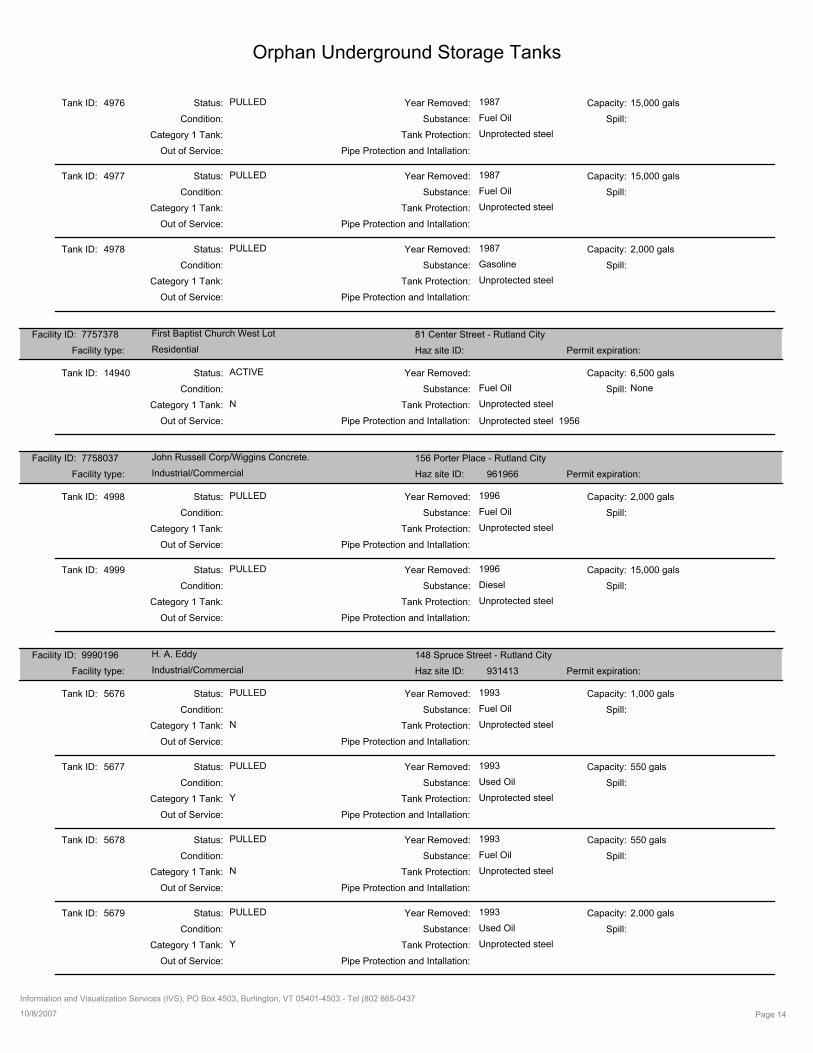
Orphan Underground Storage Tanks
4976Tank ID:
Fuel Oil
Capacity:
Condition: Substance: Spill:
PULLED 1987Status: Year Removed: 15,000 gals
Tank Protection:Category 1 Tank: Unprotected steel
Pipe Protection and Intallation:Out of Service:
4977Tank ID:
Fuel Oil
Capacity:
Condition: Substance: Spill:
PULLED 1987Status: Year Removed: 15,000 gals
Tank Protection:Category 1 Tank: Unprotected steel
Pipe Protection and Intallation:Out of Service:
4978Tank ID:
Gasoline
Capacity:
Condition: Substance: Spill:
PULLED 1987Status: Year Removed: 2,000 gals
Tank Protection:Category 1 Tank: Unprotected steel
Pipe Protection and Intallation:Out of Service:
First Baptist Church West Lot 81 Center Street - Rutland City
ResidentialFacility type: Haz site ID: Permit expiration:
Facility ID: 7757378
14940Tank ID:
Fuel Oil
Capacity:
Condition: Substance: NoneSpill:
ACTIVEStatus: Year Removed: 6,500 gals
Tank Protection:Category 1 Tank: Unprotected steel
Pipe Protection and Intallation:Out of Service:
N
Unprotected steel 1956
John Russell Corp/Wiggins Concrete. 156 Porter Place - Rutland City
Industrial/CommercialFacility type: Haz site ID: 961966 Permit expiration:
Facility ID: 7758037
4998Tank ID:
Fuel Oil
Capacity:
Condition: Substance: Spill:
PULLED 1996Status: Year Removed: 2,000 gals
Tank Protection:Category 1 Tank: Unprotected steel
Pipe Protection and Intallation:Out of Service:
4999Tank ID:
Diesel
Capacity:
Condition: Substance: Spill:
PULLED 1996Status: Year Removed: 15,000 gals
Tank Protection:Category 1 Tank: Unprotected steel
Pipe Protection and Intallation:Out of Service:
H. A. Eddy 148 Spruce Street - Rutland City
Industrial/CommercialFacility type: Haz site ID: 931413 Permit expiration:
Facility ID: 9990196
5676Tank ID:
Fuel Oil
Capacity:
Condition: Substance: Spill:
PULLED 1993Status: Year Removed: 1,000 gals
Tank Protection:Category 1 Tank: Unprotected steel
Pipe Protection and Intallation:Out of Service:
N
5677Tank ID:
Used Oil
Capacity:
Condition: Substance: Spill:
PULLED 1993Status: Year Removed: 550 gals
Tank Protection:Category 1 Tank: Unprotected steel
Pipe Protection and Intallation:Out of Service:
Y
5678Tank ID:
Fuel Oil
Capacity:
Condition: Substance: Spill:
PULLED 1993Status: Year Removed: 550 gals
Tank Protection:Category 1 Tank: Unprotected steel
Pipe Protection and Intallation:Out of Service:
N
5679Tank ID:
Used Oil
Capacity:
Condition: Substance: Spill:
PULLED 1993Status: Year Removed: 2,000 gals
Tank Protection:Category 1 Tank: Unprotected steel
Pipe Protection and Intallation:Out of Service:
Y
10/8/2007 Page 14
Information and Visualization Services (IVS), PO Box 4503, Burlington, VT 05401-4503 - Tel (802 865-0437
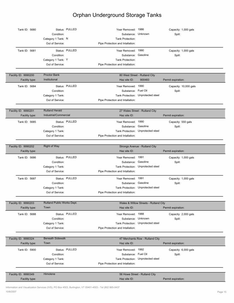
Orphan Underground Storage Tanks
5680Tank ID:
Unknown
Capacity:
Condition: Substance: Spill:
PULLED 1986Status: Year Removed: 1,000 gals
Tank Protection:Category 1 Tank:
Pipe Protection and Intallation:Out of Service:
N
5681Tank ID:
Gasoline
Capacity:
Condition: Substance: Spill:
PULLED 1990Status: Year Removed: 1,000 gals
Tank Protection:Category 1 Tank:
Pipe Protection and Intallation:Out of Service:
Y
Proctor Bank 80 West Street - Rutland City
InstitutionalFacility type: Haz site ID: 900483 Permit expiration:
Facility ID: 9990200
5684Tank ID:
Fuel Oil
Capacity:
Condition: Substance: Spill:
PULLED 1990Status: Year Removed: 10,000 gals
Tank Protection:Category 1 Tank: Unprotected steel
Pipe Protection and Intallation:Out of Service:
Rutland Herald 27 Wales Street - Rutland City
Industrial/CommercialFacility type: Haz site ID: Permit expiration:
Facility ID: 9990201
5685Tank ID:
Gasoline
Capacity:
Condition: Substance: Spill:
PULLED 1990Status: Year Removed: 550 gals
Tank Protection:Category 1 Tank: Unprotected steel
Pipe Protection and Intallation:Out of Service:
Right of Way Strongs Avenue - Rutland City
Facility type: Haz site ID: Permit expiration:
Facility ID: 9990202
5686Tank ID:
Gasoline
Capacity:
Condition: Substance: Spill:
PULLED 1991Status: Year Removed: 1,000 gals
Tank Protection:Category 1 Tank: Unprotected steel
Pipe Protection and Intallation:Out of Service:
5687Tank ID:
Gasoline
Capacity:
Condition: Substance: Spill:
PULLED 1991Status: Year Removed: 1,000 gals
Tank Protection:Category 1 Tank: Unprotected steel
Pipe Protection and Intallation:Out of Service:
Rutland Public Works Dept. Wales & Willow Streets - Rutland City
TownFacility type: Haz site ID: Permit expiration:
Facility ID: 9990203
5688Tank ID:
Unknown
Capacity:
Condition: Substance: Spill:
PULLED 1988Status: Year Removed: 2,000 gals
Tank Protection:Category 1 Tank: Unprotected steel
Pipe Protection and Intallation:Out of Service:
Beneath Sidewalk 47 Merchants Row - Rutland City
TownFacility type: Haz site ID: Permit expiration:
Facility ID: 9990324
5900Tank ID:
Fuel Oil
Capacity:
Condition: Substance: Spill:
PULLED 1992Status: Year Removed: 6,000 gals
Tank Protection:Category 1 Tank: Unprotected steel
Pipe Protection and Intallation:Out of Service:
Himolene 56 Howe Street - Rutland City
Facility type: Haz site ID: Permit expiration:
Facility ID: 9990349
10/8/2007 Page 15
Information and Visualization Services (IVS), PO Box 4503, Burlington, VT 05401-4503 - Tel (802 865-0437
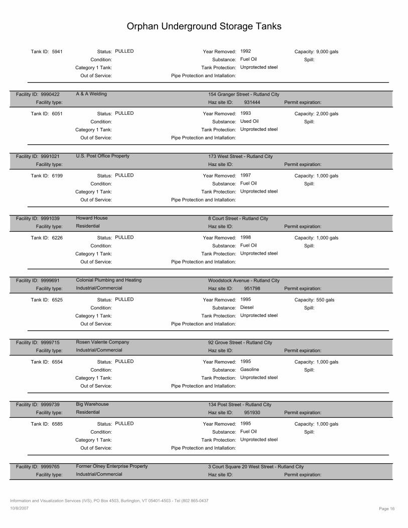
Orphan Underground Storage Tanks
5941Tank ID:
Fuel Oil
Capacity:
Condition: Substance: Spill:
PULLED 1992Status: Year Removed: 9,000 gals
Tank Protection:Category 1 Tank: Unprotected steel
Pipe Protection and Intallation:Out of Service:
A & A Welding 154 Granger Street - Rutland City
Facility type: Haz site ID: 931444 Permit expiration:
Facility ID: 9990422
6051Tank ID:
Used Oil
Capacity:
Condition: Substance: Spill:
PULLED 1993Status: Year Removed: 2,000 gals
Tank Protection:Category 1 Tank: Unprotected steel
Pipe Protection and Intallation:Out of Service:
U.S. Post Office Property 173 West Street - Rutland City
Facility type: Haz site ID: Permit expiration:
Facility ID: 9991021
6199Tank ID:
Fuel Oil
Capacity:
Condition: Substance: Spill:
PULLED 1997Status: Year Removed: 1,000 gals
Tank Protection:Category 1 Tank: Unprotected steel
Pipe Protection and Intallation:Out of Service:
Howard House 8 Court Street - Rutland City
ResidentialFacility type: Haz site ID: Permit expiration:
Facility ID: 9991039
6226Tank ID:
Fuel Oil
Capacity:
Condition: Substance: Spill:
PULLED 1998Status: Year Removed: 1,000 gals
Tank Protection:Category 1 Tank: Unprotected steel
Pipe Protection and Intallation:Out of Service:
Colonial Plumbing and Heating Woodstock Avenue - Rutland City
Industrial/CommercialFacility type: Haz site ID: 951798 Permit expiration:
Facility ID: 9999691
6525Tank ID:
Diesel
Capacity:
Condition: Substance: Spill:
PULLED 1995Status: Year Removed: 550 gals
Tank Protection:Category 1 Tank: Unprotected steel
Pipe Protection and Intallation:Out of Service:
Rosen Valente Company 92 Grove Street - Rutland City
Industrial/CommercialFacility type: Haz site ID: Permit expiration:
Facility ID: 9999715
6554Tank ID:
Gasoline
Capacity:
Condition: Substance: Spill:
PULLED 1995Status: Year Removed: 1,000 gals
Tank Protection:Category 1 Tank: Unprotected steel
Pipe Protection and Intallation:Out of Service:
Big Warehouse 134 Post Street - Rutland City
ResidentialFacility type: Haz site ID: 951930 Permit expiration:
Facility ID: 9999739
6585Tank ID:
Fuel Oil
Capacity:
Condition: Substance: Spill:
PULLED 1995Status: Year Removed: 1,000 gals
Tank Protection:Category 1 Tank: Unprotected steel
Pipe Protection and Intallation:Out of Service:
Former Olney Enterprise Property 3 Court Square 20 West Street - Rutland City
Industrial/CommercialFacility type: Haz site ID: Permit expiration:
Facility ID: 9999765
10/8/2007 Page 16
Information and Visualization Services (IVS), PO Box 4503, Burlington, VT 05401-4503 - Tel (802 865-0437

Orphan Underground Storage Tanks
6603Tank ID:
Fuel Oil
Capacity:
Condition: Substance: Spill:
PULLED 1995Status: Year Removed: 1,000 gals
Tank Protection:Category 1 Tank: Unprotected steel
Pipe Protection and Intallation:Out of Service:
6604Tank ID:
Fuel Oil
Capacity:
Condition: Substance: Spill:
PULLED 1995Status: Year Removed: 6,500 gals
Tank Protection:Category 1 Tank: Unprotected steel
Pipe Protection and Intallation:Out of Service:
Blanchard Residence 27 Terrill Street - Rutland City
ResidentialFacility type: Haz site ID: 961949 Permit expiration:
Facility ID: 9999770
6609Tank ID:
Fuel Oil
Capacity:
Condition: Substance: Spill:
PULLED 1996Status: Year Removed: 275 gals
Tank Protection:Category 1 Tank: Unprotected steel
Pipe Protection and Intallation:Out of Service:
Russell Corp 117 Strongs Avenue - Rutland City
Industrial/CommercialFacility type: Haz site ID: 951820 Permit expiration:
Facility ID: 9999808
6635Tank ID:
Fuel Oil
Capacity:
Condition: Substance: Spill:
PULLED 1996Status: Year Removed: 550 gals
Tank Protection:Category 1 Tank:
Pipe Protection and Intallation:Out of Service:
N
10/8/2007 Page 17
Information and Visualization Services (IVS), PO Box 4503, Burlington, VT 05401-4503 - Tel (802 865-0437
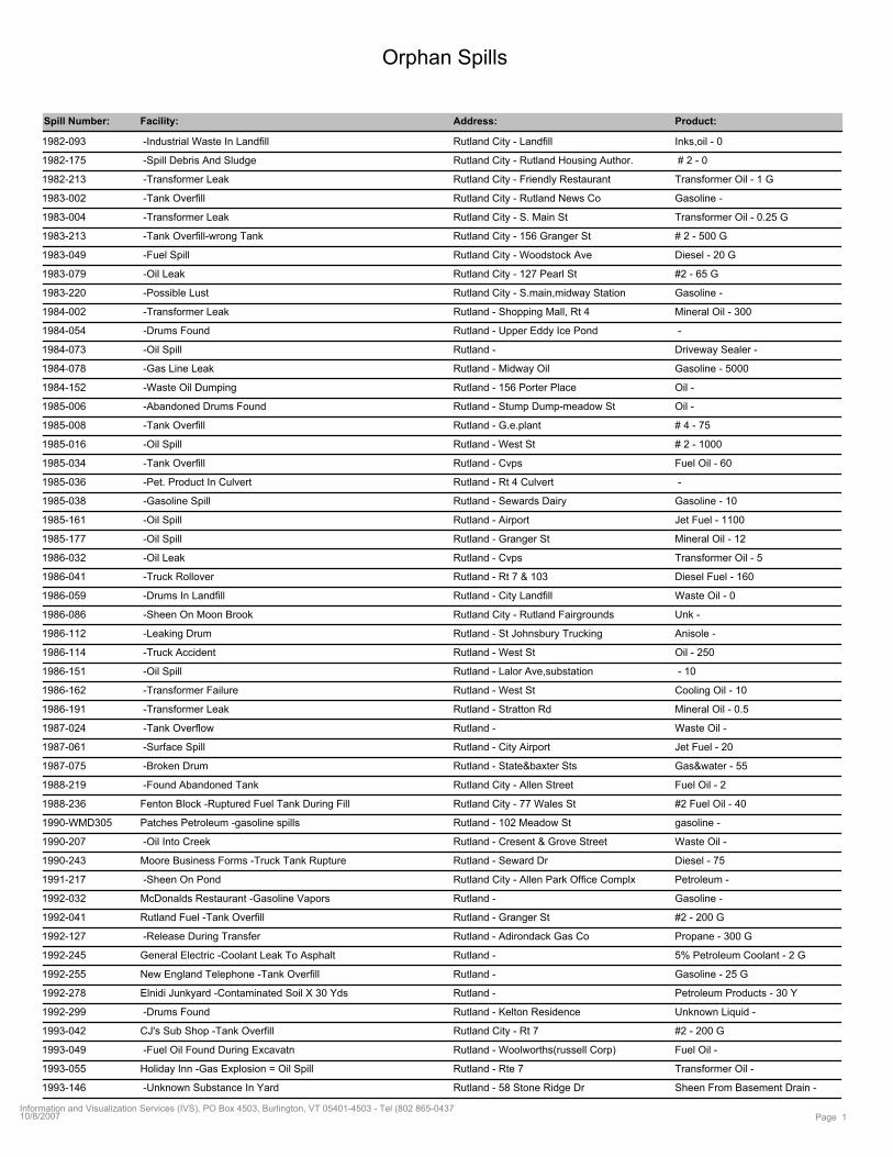
Orphan Spills
Spill Number: Facility: Address: Product:
1982-093 Rutland City - Landfill Inks,oil - 0 -Industrial Waste In Landfill
1982-175 Rutland City - Rutland Housing Author. # 2 - 0 -Spill Debris And Sludge
1982-213 Rutland City - Friendly Restaurant Transformer Oil - 1 G -Transformer Leak
1983-002 Rutland City - Rutland News Co Gasoline - -Tank Overfill
1983-004 Rutland City - S. Main St Transformer Oil - 0.25 G -Transformer Leak
1983-213 Rutland City - 156 Granger St # 2 - 500 G -Tank Overfill-wrong Tank
1983-049 Rutland City - Woodstock Ave Diesel - 20 G -Fuel Spill
1983-079 Rutland City - 127 Pearl St #2 - 65 G -Oil Leak
1983-220 Rutland City - S.main,midway Station Gasoline - -Possible Lust
1984-002 Rutland - Shopping Mall, Rt 4 Mineral Oil - 300 -Transformer Leak
1984-054 Rutland - Upper Eddy Ice Pond - -Drums Found
1984-073 Rutland - Driveway Sealer - -Oil Spill
1984-078 Rutland - Midway Oil Gasoline - 5000 -Gas Line Leak
1984-152 Rutland - 156 Porter Place Oil - -Waste Oil Dumping
1985-006 Rutland - Stump Dump-meadow St Oil - -Abandoned Drums Found
1985-008 Rutland - G.e.plant # 4 - 75 -Tank Overfill
1985-016 Rutland - West St # 2 - 1000 -Oil Spill
1985-034 Rutland - Cvps Fuel Oil - 60 -Tank Overfill
1985-036 Rutland - Rt 4 Culvert - -Pet. Product In Culvert
1985-038 Rutland - Sewards Dairy Gasoline - 10 -Gasoline Spill
1985-161 Rutland - Airport Jet Fuel - 1100 -Oil Spill
1985-177 Rutland - Granger St Mineral Oil - 12 -Oil Spill
1986-032 Rutland - Cvps Transformer Oil - 5 -Oil Leak
1986-041 Rutland - Rt 7 & 103 Diesel Fuel - 160 -Truck Rollover
1986-059 Rutland - City Landfill Waste Oil - 0 -Drums In Landfill
1986-086 Rutland City - Rutland Fairgrounds Unk - -Sheen On Moon Brook
1986-112 Rutland - St Johnsbury Trucking Anisole - -Leaking Drum
1986-114 Rutland - West St Oil - 250 -Truck Accident
1986-151 Rutland - Lalor Ave,substation - 10 -Oil Spill
1986-162 Rutland - West St Cooling Oil - 10 -Transformer Failure
1986-191 Rutland - Stratton Rd Mineral Oil - 0.5 -Transformer Leak
1987-024 Rutland - Waste Oil - -Tank Overflow
1987-061 Rutland - City Airport Jet Fuel - 20 -Surface Spill
1987-075 Rutland - State&baxter Sts Gas&water - 55 -Broken Drum
1988-219 Rutland City - Allen Street Fuel Oil - 2 -Found Abandoned Tank
1988-236 Rutland City - 77 Wales St #2 Fuel Oil - 40 Fenton Block -Ruptured Fuel Tank During Fill
1990-WMD305 Rutland - 102 Meadow St gasoline - Patches Petroleum -gasoline spills
1990-207 Rutland - Cresent & Grove Street Waste Oil - -Oil Into Creek
1990-243 Rutland - Seward Dr Diesel - 75 Moore Business Forms -Truck Tank Rupture
1991-217 Rutland City - Allen Park Office Complx Petroleum - -Sheen On Pond
1992-032 Rutland - Gasoline - McDonalds Restaurant -Gasoline Vapors
1992-041 Rutland - Granger St #2 - 200 GRutland Fuel -Tank Overfill
1992-127 Rutland - Adirondack Gas Co Propane - 300 G -Release During Transfer
1992-245 Rutland - 5% Petroleum Coolant - 2 GGeneral Electric -Coolant Leak To Asphalt
1992-255 Rutland - Gasoline - 25 GNew England Telephone -Tank Overfill
1992-278 Rutland - Petroleum Products - 30 YElnidi Junkyard -Contaminated Soil X 30 Yds
1992-299 Rutland - Kelton Residence Unknown Liquid - -Drums Found
1993-042 Rutland City - Rt 7 #2 - 200 GCJ's Sub Shop -Tank Overfill
1993-049 Rutland - Woolworths(russell Corp) Fuel Oil - -Fuel Oil Found During Excavatn
1993-055 Rutland - Rte 7 Transformer Oil - Holiday Inn -Gas Explosion = Oil Spill
1993-146 Rutland - 58 Stone Ridge Dr Sheen From Basement Drain - -Unknown Substance In Yard
Page 110/8/2007Information and Visualization Services (IVS), PO Box 4503, Burlington, VT 05401-4503 - Tel (802 865-0437
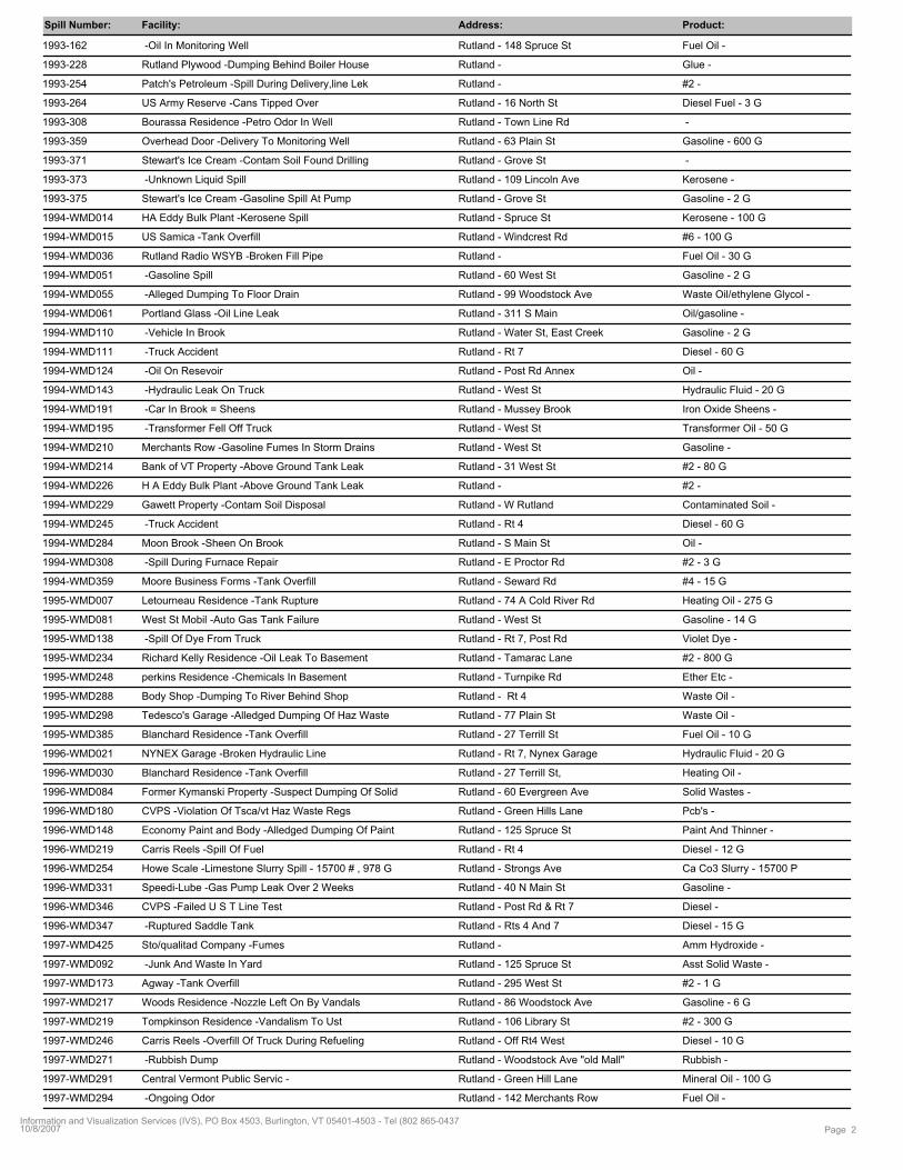
Spill Number: Facility: Address: Product:
1993-162 Rutland - 148 Spruce St Fuel Oil - -Oil In Monitoring Well
1993-228 Rutland - Glue - Rutland Plywood -Dumping Behind Boiler House
1993-254 Rutland - #2 - Patch's Petroleum -Spill During Delivery,line Lek
1993-264 Rutland - 16 North St Diesel Fuel - 3 GUS Army Reserve -Cans Tipped Over
1993-308 Rutland - Town Line Rd - Bourassa Residence -Petro Odor In Well
1993-359 Rutland - 63 Plain St Gasoline - 600 GOverhead Door -Delivery To Monitoring Well
1993-371 Rutland - Grove St - Stewart's Ice Cream -Contam Soil Found Drilling
1993-373 Rutland - 109 Lincoln Ave Kerosene - -Unknown Liquid Spill
1993-375 Rutland - Grove St Gasoline - 2 GStewart's Ice Cream -Gasoline Spill At Pump
1994-WMD014 Rutland - Spruce St Kerosene - 100 GHA Eddy Bulk Plant -Kerosene Spill
1994-WMD015 Rutland - Windcrest Rd #6 - 100 GUS Samica -Tank Overfill
1994-WMD036 Rutland - Fuel Oil - 30 GRutland Radio WSYB -Broken Fill Pipe
1994-WMD051 Rutland - 60 West St Gasoline - 2 G -Gasoline Spill
1994-WMD055 Rutland - 99 Woodstock Ave Waste Oil/ethylene Glycol - -Alleged Dumping To Floor Drain
1994-WMD061 Rutland - 311 S Main Oil/gasoline - Portland Glass -Oil Line Leak
1994-WMD110 Rutland - Water St, East Creek Gasoline - 2 G -Vehicle In Brook
1994-WMD111 Rutland - Rt 7 Diesel - 60 G -Truck Accident
1994-WMD124 Rutland - Post Rd Annex Oil - -Oil On Resevoir
1994-WMD143 Rutland - West St Hydraulic Fluid - 20 G -Hydraulic Leak On Truck
1994-WMD191 Rutland - Mussey Brook Iron Oxide Sheens - -Car In Brook = Sheens
1994-WMD195 Rutland - West St Transformer Oil - 50 G -Transformer Fell Off Truck
1994-WMD210 Rutland - West St Gasoline - Merchants Row -Gasoline Fumes In Storm Drains
1994-WMD214 Rutland - 31 West St #2 - 80 GBank of VT Property -Above Ground Tank Leak
1994-WMD226 Rutland - #2 - H A Eddy Bulk Plant -Above Ground Tank Leak
1994-WMD229 Rutland - W Rutland Contaminated Soil - Gawett Property -Contam Soil Disposal
1994-WMD245 Rutland - Rt 4 Diesel - 60 G -Truck Accident
1994-WMD284 Rutland - S Main St Oil - Moon Brook -Sheen On Brook
1994-WMD308 Rutland - E Proctor Rd #2 - 3 G -Spill During Furnace Repair
1994-WMD359 Rutland - Seward Rd #4 - 15 GMoore Business Forms -Tank Overfill
1995-WMD007 Rutland - 74 A Cold River Rd Heating Oil - 275 GLetourneau Residence -Tank Rupture
1995-WMD081 Rutland - West St Gasoline - 14 GWest St Mobil -Auto Gas Tank Failure
1995-WMD138 Rutland - Rt 7, Post Rd Violet Dye - -Spill Of Dye From Truck
1995-WMD234 Rutland - Tamarac Lane #2 - 800 GRichard Kelly Residence -Oil Leak To Basement
1995-WMD248 Rutland - Turnpike Rd Ether Etc - perkins Residence -Chemicals In Basement
1995-WMD288 Rutland - Rt 4 Waste Oil - Body Shop -Dumping To River Behind Shop
1995-WMD298 Rutland - 77 Plain St Waste Oil - Tedesco's Garage -Alledged Dumping Of Haz Waste
1995-WMD385 Rutland - 27 Terrill St Fuel Oil - 10 GBlanchard Residence -Tank Overfill
1996-WMD021 Rutland - Rt 7, Nynex Garage Hydraulic Fluid - 20 GNYNEX Garage -Broken Hydraulic Line
1996-WMD030 Rutland - 27 Terrill St, Heating Oil - Blanchard Residence -Tank Overfill
1996-WMD084 Rutland - 60 Evergreen Ave Solid Wastes - Former Kymanski Property -Suspect Dumping Of Solid
1996-WMD180 Rutland - Green Hills Lane Pcb's - CVPS -Violation Of Tsca/vt Haz Waste Regs
1996-WMD148 Rutland - 125 Spruce St Paint And Thinner - Economy Paint and Body -Alledged Dumping Of Paint
1996-WMD219 Rutland - Rt 4 Diesel - 12 GCarris Reels -Spill Of Fuel
1996-WMD254 Rutland - Strongs Ave Ca Co3 Slurry - 15700 PHowe Scale -Limestone Slurry Spill - 15700 # , 978 G
1996-WMD331 Rutland - 40 N Main St Gasoline - Speedi-Lube -Gas Pump Leak Over 2 Weeks
1996-WMD346 Rutland - Post Rd & Rt 7 Diesel - CVPS -Failed U S T Line Test
1996-WMD347 Rutland - Rts 4 And 7 Diesel - 15 G -Ruptured Saddle Tank
1997-WMD425 Rutland - Amm Hydroxide - Sto/qualitad Company -Fumes
1997-WMD092 Rutland - 125 Spruce St Asst Solid Waste - -Junk And Waste In Yard
1997-WMD173 Rutland - 295 West St #2 - 1 GAgway -Tank Overfill
1997-WMD217 Rutland - 86 Woodstock Ave Gasoline - 6 GWoods Residence -Nozzle Left On By Vandals
1997-WMD219 Rutland - 106 Library St #2 - 300 GTompkinson Residence -Vandalism To Ust
1997-WMD246 Rutland - Off Rt4 West Diesel - 10 GCarris Reels -Overfill Of Truck During Refueling
1997-WMD271 Rutland - Woodstock Ave "old Mall" Rubbish - -Rubbish Dump
1997-WMD291 Rutland - Green Hill Lane Mineral Oil - 100 GCentral Vermont Public Servic -
1997-WMD294 Rutland - 142 Merchants Row Fuel Oil - -Ongoing Odor
Page 210/8/2007Information and Visualization Services (IVS), PO Box 4503, Burlington, VT 05401-4503 - Tel (802 865-0437
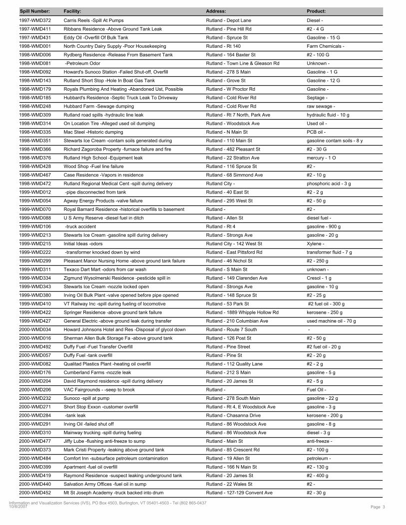
Spill Number: Facility: Address: Product:
1997-WMD372 Rutland - Depot Lane Diesel - Carris Reels -Spill At Pumps
1997-WMD411 Rutland - Pine Hill Rd #2 - 4 GRibbans Residence -Above Ground Tank Leak
1997-WMD431 Rutland - Spruce St Gasoline - 15 GEddy Oil -Overfill Of Bulk Tank
1998-WMD001 Rutland - Rt 140 Farm Chemicals - North Country Dairy Supply -Poor Housekeeping
1998-WMD006 Rutland - 164 Baxter St #2 - 100 GRydberg Residence -Release From Basement Tank
1998-WMD081 Rutland - Town Line & Gleason Rd Unknown - -Petroleum Odor
1998-WMD092 Rutland - 278 S Main Gasoline - 1 GHoward's Sunoco Station -Failed Shut-off, Overfill
1998-WMD143 Rutland - Grove St Gasoline - 12 GRutland Short Stop -Hole In Boat Gas Tank
1998-WMD179 Rutland - W Proctor Rd Gasoline - Royals Plumbing And Heating -Abandoned Ust, Possible
1998-WMD185 Rutland - Cold River Rd Septage - Hubbard's Residence -Septic Truck Leak To Driveway
1998-WMD248 Rutland - Cold River Rd raw sewage - Hubbard Farm -Sewage dumping
1998-WMD309 Rutland - Rt 7 North, Park Ave hydraulic fluid - 10 gRutland road spills -hydraulic line leak
1998-WMD314 Rutland - Woodstock Ave Used oil - On Location Tire -Alleged used oil dumping
1998-WMD335 Rutland - N Main St PCB oil - Mac Steel -Historic dumping
1998-WMD351 Rutland - 110 Main St gasoline contam soils - 8 yStewarts Ice Cream -contam soils generated during
1998-WMD366 Rutland - 482 Pleasant St #2 - 30 GRichard Zagoroba Property -furnace failure and fire
1998-WMD376 Rutland - 22 Stratton Ave mercury - 1 ORutland High School -Equipment leak
1998-WMD428 Rutland - 116 Spruce St #2 - Wood Shop -Fuel line failure
1998-WMD467 Rutland - 68 Simmond Ave #2 - 10 gCase Residence -Vapors in residence
1998-WMD472 Rutland City - phosphoric acid - 3 gRutland Regional Medical Cent -spill during delivery
1999-WMD012 Rutland - 40 East St #2 - 2 g -pipe disconnected from tank
1999-WMD054 Rutland - 295 West St #2 - 50 gAgway Energy Products -valve failure
1999-WMD070 Rutland - #2 - Royal Barnard Residence -historical overfills to basement
1999-WMD088 Rutland - Allen St diesel fuel - U S Army Reserve -diesel fuel in ditch
1999-WMD106 Rutland - Rt 4 gasoline - 900 g -truck accident
1999-WMD213 Rutland - Strongs Ave gasoline - 20 gStewarts Ice Cream -gasoline spill during delivery
1999-WMD215 Rutland City - 142 West St Xylene - Initial Ideas -odors
1999-WMD222 Rutland - East Pittsford Rd transformer fluid - 7 g -transformer knocked down by wind
1999-WMD299 Rutland - 46 Nichol St #2 - 250 gPleasant Manor Nursing Home -above ground tank failure
1999-WMD311 Rutland - S Main St unknown - Texaco Dart Mart -odors from car wash
1999-WMD334 Rutland - 149 Clarenden Ave Cresol - 1 gZigmund Wysolmerski Residence -pesticide spill in
1999-WMD343 Rutland - Strongs Ave gasoline - 10 gStewarts Ice Cream -nozzle locked open
1999-WMD380 Rutland - 148 Spruce St #2 - 25 gIrving Oil Bulk Plant -valve opened before pipe opened
1999-WMD410 Rutland - 53 Park St #2 fuel oil - 300 gVT Railway Inc -spill during fueling of locomotive
1999-WMD422 Rutland - 1889 Whipple Hollow Rd kerosene - 250 gSpringer Residence -above ground tank failure
1999-WMD427 Rutland - 210 Columbian Ave used machine oil - 70 gGeneral Electric -above ground leak during transfer
2000-WMD034 Rutland - Route 7 South - Howard Johnsons Hotel and Res -Disposal of glycol down
2000-WMD016 Rutland - 126 Post St #2 - 50 gSherman Allen Bulk Storage Fa -above ground tank
2000-WMD492 Rutland - Pine Street #2 fuel oil - 20 gDuffy Fuel -Fuel Transfer Overfill
2000-WMD057 Rutland - Pine St #2 - 20 gDuffy Fuel -tank overfill
2000-WMD082 Rutland - 112 Quality Lane #2 - 2 gQualitad Plastics Plant -heating oil overfill
2000-WMD176 Rutland - 212 S Main gasoline - 5 gCumberland Farms -nozzle leak
2000-WMD204 Rutland - 20 James St #2 - 5 gDavid Raymond residence -spill during delivery
2000-WMD206 Rutland - Fuel Oil - VAC Fairgrounds - -seep to brook
2000-WMD232 Rutland - 278 South Main gasoline - 22 gSunoco -spill at pump
2000-WMD271 Rutland - Rt 4, E Woodstock Ave gasoline - 3 gShort Stop Exxon -customer overfill
2000-WMD284 Rutland - Chasanna Drive kerosene - 200 g -tank leak
2000-WMD291 Rutland - 86 Woodstock Ave gasoline - 8 gIrving Oil -failed shut off
2000-WMD310 Rutland - 86 Woodstock Ave diesel - 3 gMainway trucking -spill during fueling
2000-WMD477 Rutland - Main St anti-freeze - Jiffy Lube -flushing anti-freeze to sump
2000-WMD373 Rutland - 85 Crescent Rd #2 - 100 gMark Cristi Property -leaking above ground tank
2000-WMD484 Rutland - 19 Allen St petroleum - Comfort Inn -subsurface petroleum contamination
2000-WMD399 Rutland - 166 N Main St #2 - 130 gApartment -fuel oil overfill
2000-WMD419 Rutland - 20 James St #2 - 400 gRaymond Residence -suspect leaking underground tank
2000-WMD440 Rutland - 22 Wales St #2 - Salvation Army Offices -fuel oil in sump
2000-WMD452 Rutland - 127-129 Convent Ave #2 - 30 gMt St Joseph Academy -truck backed into drum
Page 310/8/2007Information and Visualization Services (IVS), PO Box 4503, Burlington, VT 05401-4503 - Tel (802 865-0437
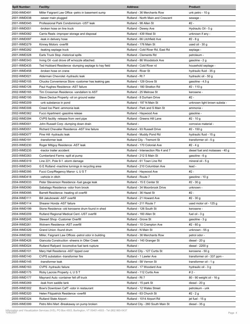
Spill Number: Facility: Address: Product:
2000-WMD491 Rutland - 36 Merchants Row unk petro - 10 gMiller Faigrant Law Office -petro in basement sump
2001-WMD038 Rutland - North Main and Crescent sewage - -sewer main plugged
2001-WMD045 Rutland - 98 Allen St #2 - Professional Park Condominium -UST leak
2001-WMD051 Rutland - Dewey Ave Hydraulic Oil - 5 g -broken hose on line truck
2001-WMD082 Rutland - 439 West St unknown if any - Carris Reels -improper storage and disposal
2001-WMD097 Rutland - 66 Litchfield Ave #2 - 8 g -leak in delivery hose
2001-WMD279 Rutland - 176 Main St used oil - 30 gKinney Motors -overfill
2001-WMD282 Rutland - Cold River Rd, East Rd septage - -leaking septage truck
2001-WMD328 Rutland - Clements Rd petroleum - Earls Truck Stop -historical spills
2001-WMD343 Rutland - 86 Woodstock Ave gasoline - 2 gIrving Oil -cust drove off w/nozzle attached.
2001-WMD435 Rutland - Cold River rd household septage - Ted Hubbard Residence -dumping septage to hay field
2001-WMD458 Rutland - River St hydraulic fluid - 35 g -broken hose on crane
2002-WMD021 Rutland - Rt 7 hydraulic oil - 50 gAlderman Chevrolet -hydraulic leak
2002-WMD105 Rutland - 129 Grove St gasoline - 4.5 gChucks Convenience Store -customer has leaking gas
2002-WMD126 Rutland - 180 Stratton Rd #2 - 110 gPaul Hughes Residence -AST failure
2002-WMD165 Rutland - 25 Melrose St kerosene - Tim Crossman Residence -vandalism to AST
2002-WMD195 Rutland - 8 Durham Drive #2 - Steve Declue Property -oil on ground water
2002-WMD209 Rutland - 197 N Main St unknown light brown substa - -unk substance in pond
2002-WMD306 Rutland - Park and S Main St ammonia - Creed Ice Plant -ammonia leak
2002-WMD362 Rutland - Haywood Ave gasoline - Fucci Apartment -gasoline releae
2002-WMD394 Rutland - Greens Hill Lane #2 - 10 gCVPS facility -release from vent pipe
2003-WMD001 Rutland - corrosive material - John Russell Corp -dumping down drain
2003-WMD051 Rutland - 93 Russell Drive #2 - 150 gRichard Chevalier Residence -AST line failure
2003-WMD077 Rutland - Muddy Pond Rd hydraulic fluid - 15 gPine Hill -hydraulic leak
2003-WMD191 Rutland City - Tremont St transformer oil - 5 g -transformer leak
2003-WMD230 Rutland - 170 Colonial Ave #2 - 4 gRoger Mitiguy Residence -AST leak
2003-WMD235 Rutland - Intersection Rts 4 and 7 diesel fuel and molasses - 40 g -tractor trailer accident
2003-WMD263 Rutland - 212 S Main St gasoline - 6 gCumberland Farms -spill at pump
2003-WMD319 Rutland - 61 Town Line Rd mineral oil - 5 gLine 221, Pole 9-1 -storm damage
2003-WMD343 Rutland - 210 Columbian Ave lead - G E Rutland -machine turnings in recycling area
2003-WMD395 Rutland - Haywood Ave #2 - Fucci Corp/Regency Manor -L U S T
2003-WMD418 Rutland - Route 7 gasoline - 10 g -vehicle in ditch
2004-WMD033 Rutland - 15 E Center St #2 - 30 gPeter Stevenson Residence -fuel gauge leak
2004-WMD090 Rutland - 34 Moonbrook Drive unknown - Sabatago Residence -odor from brook
2004-WMD095 Rutland - 36 Hazel St #2 - Barrett Residence -heating oil overfill
2004-WMD111 Rutland - 21 Howard Ave #2 - 30 gBill Jakubowski -AST overfill
2004-WMD114 Rutland - 211 Route 7 used motor oil - 125 gShearer Honda -AST failure
2004-WMD199 Rutland - 126 South St kerosene - Stone Residence -old kerosene drum found in shed
2004-WMD209 Rutland - 160 Allen St fuel oil - 3 gRutland Regional Medical Cent -UST overfill
2004-WMD245 Rutland - Grove St gasoline - 3 gStewart Shop -Customer Overfill
2004-WMD261 Rutland - 10 Crampton Ave #2 - 60 gWolvern Residence -AST overfill
2004-WMD326 Rutland - N Main St unknown - 55 gGrand Union -found drum
2004-WMD382 Rutland - 36 Merchants Row petrol odor - Miller, Faignant Law Offices -petrol odor in building
2004-WMD426 Rutland - 140 Granger St diesel - 20 gGiancola Construction -sheens in Otter Creek
2005-WMD024 Rutland - diesel - 2200 gRutland Railyard -locomotive fuel tank rupture
2005-WMD101 Rutland City - 127 Curtis St kerosene - 50 gMary Hall Residence -AST tipped over
2005-WMD140 Rutland - 1 Lawler Ave transformer oil - 337 ppm - CVPS substation -transformer fire
2005-WMD145 Rutland - 58 Vernon St transformer oil - 1 g -transformer leak
2005-WMD163 Rutland - 17 Woodard Ave hydraulic oil - 3 gCVPS -hydraulic failure
2005-WMD175 Rutland - 112 Curtis Ave # 2 - Ricky Lacroix Property -L U S T
2005-WMD177 Rutland - Rt 7 80 - 90 weight oil - 16 gMaynard Auto -container fell off truck
2005-WMD269 Rutland - 15 park St diesel - 20 g -leak from saddle tank
2005-WMD302 Rutland - 12 Wales Street petroleum - unk Bow's Downtown CafT -odor in restaurant
2005-WMD320 Rutland - 63 Church St #2 - 2 gHelen Fitzpatrick Residence -overfill
2005-WMD324 Rutland - 1014 Airport Rd jet fuel - 15 gRutland State Airport -
2005-WMD399 Rutland City - 260 South Main St diesel - 35 gPetro Mini Mart -Breakaway on pump broken
Page 410/8/2007Information and Visualization Services (IVS), PO Box 4503, Burlington, VT 05401-4503 - Tel (802 865-0437
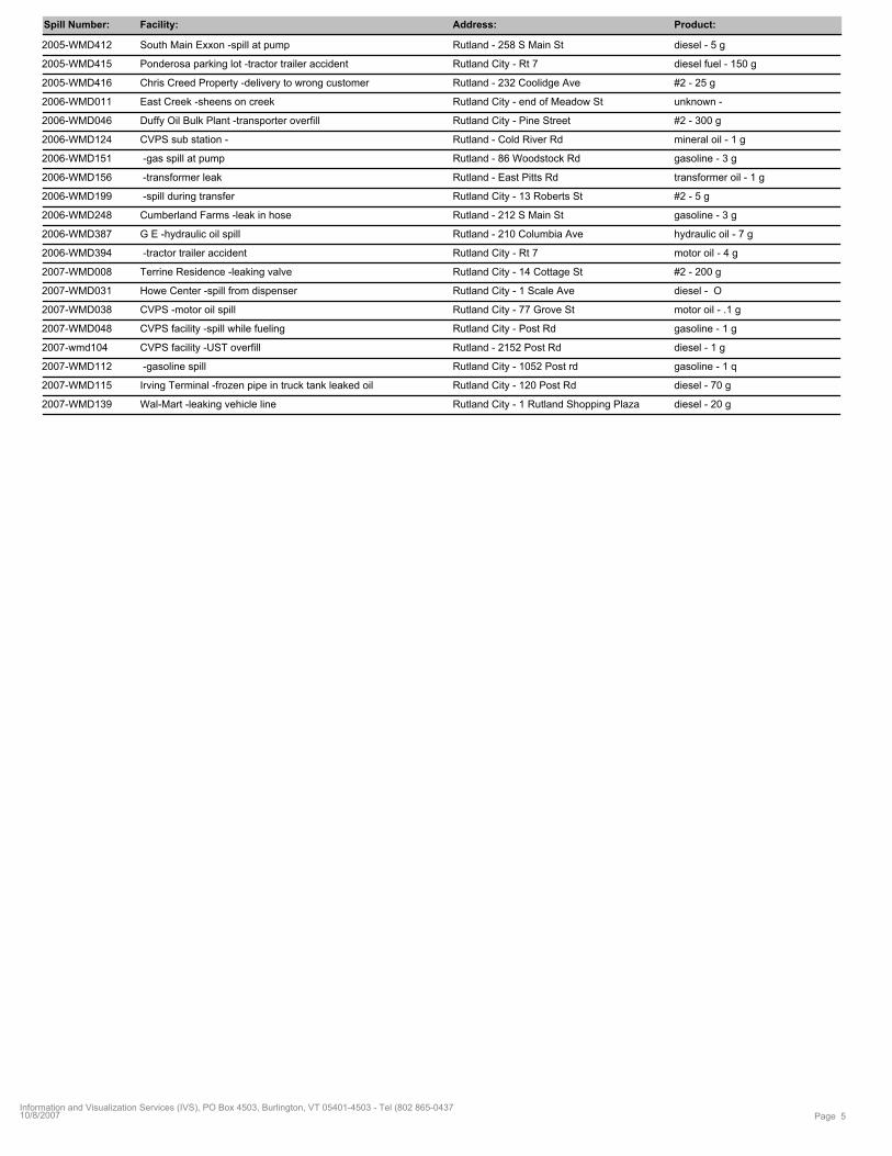
Spill Number: Facility: Address: Product:
2005-WMD412 Rutland - 258 S Main St diesel - 5 gSouth Main Exxon -spill at pump
2005-WMD415 Rutland City - Rt 7 diesel fuel - 150 gPonderosa parking lot -tractor trailer accident
2005-WMD416 Rutland - 232 Coolidge Ave #2 - 25 gChris Creed Property -delivery to wrong customer
2006-WMD011 Rutland City - end of Meadow St unknown - East Creek -sheens on creek
2006-WMD046 Rutland City - Pine Street #2 - 300 gDuffy Oil Bulk Plant -transporter overfill
2006-WMD124 Rutland - Cold River Rd mineral oil - 1 gCVPS sub station -
2006-WMD151 Rutland - 86 Woodstock Rd gasoline - 3 g -gas spill at pump
2006-WMD156 Rutland - East Pitts Rd transformer oil - 1 g -transformer leak
2006-WMD199 Rutland City - 13 Roberts St #2 - 5 g -spill during transfer
2006-WMD248 Rutland - 212 S Main St gasoline - 3 gCumberland Farms -leak in hose
2006-WMD387 Rutland - 210 Columbia Ave hydraulic oil - 7 gG E -hydraulic oil spill
2006-WMD394 Rutland City - Rt 7 motor oil - 4 g -tractor trailer accident
2007-WMD008 Rutland City - 14 Cottage St #2 - 200 gTerrine Residence -leaking valve
2007-WMD031 Rutland City - 1 Scale Ave diesel - OHowe Center -spill from dispenser
2007-WMD038 Rutland City - 77 Grove St motor oil - .1 gCVPS -motor oil spill
2007-WMD048 Rutland City - Post Rd gasoline - 1 gCVPS facility -spill while fueling
2007-wmd104 Rutland - 2152 Post Rd diesel - 1 gCVPS facility -UST overfill
2007-WMD112 Rutland City - 1052 Post rd gasoline - 1 q -gasoline spill
2007-WMD115 Rutland City - 120 Post Rd diesel - 70 gIrving Terminal -frozen pipe in truck tank leaked oil
2007-WMD139 Rutland City - 1 Rutland Shopping Plaza diesel - 20 gWal-Mart -leaking vehicle line
Page 510/8/2007Information and Visualization Services (IVS), PO Box 4503, Burlington, VT 05401-4503 - Tel (802 865-0437
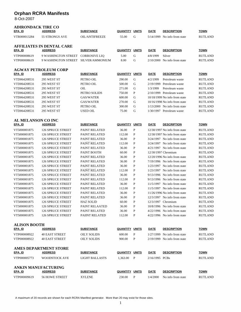
8-Oct-2007Orphan RCRA Manifests
EPA_ID ADDRESS SUBSTANCE QUANTITY UNITS DATE TOWNADIRONDACK TIRE CO
DESCRIPTION
VTR000013284 55 STRONGS AVE OIL/ANTIFREEZE 55.00 G No info from state RUTLAND5/14/1999
EPA_ID ADDRESS SUBSTANCE QUANTITY UNITS DATE TOWNAFFILIATES IN DENTAL CARE
DESCRIPTION
VTP000008619 9 WASHINGTON STREET CORROSIVE LIQ 5.00 G Silver RUTLAND4/8/1999VTP000008619 9 WASHINGTON STREET SILVER/AMMONIUM
THIOSULFATE8.00 G No info from state RUTLAND2/10/2000
EPA_ID ADDRESS SUBSTANCE QUANTITY UNITS DATE TOWNAGWAY PETROLEUM CORP
DESCRIPTION
VTD064208531 295 WEST ST PETRO OIL 290.00 G Petroleum waste RUTLAND4/2/1999VTD064208531 295 WEST ST PETRO OIL 500.00 G Petroleum waste RUTLAND2/19/1999VTD064208531 295 WEST ST OIL 271.00 G Petroleum waste RUTLAND1/3/1999VTD064208531 295 WEST ST PETRO SOLIDS 750.00 P Petroleum waste RUTLAND2/10/1999VTD064208531 295 WEST ST GAS/WATER 600.00 G No info from state RUTLAND10/18/1999VTD064208531 295 WEST ST GAS/WATER 270.00 G No info from state RUTLAND10/16/1998VTD064208531 295 WEST ST PETRO OIL 300.00 G No info from state RUTLAND1/13/2000VTD064208531 295 WEST ST USED OIL 75.00 G Petroleum waste RUTLAND1/30/1997
EPA_ID ADDRESS SUBSTANCE QUANTITY UNITS DATE TOWNAL MELANSON CO INC
DESCRIPTION
VT5000001875 126 SPRUCE STREET PAINT RELATEDMATERIAL
36.00 P No info from state RUTLAND12/30/1997VT5000001875 126 SPRUCE STREET PAINT RELATED
MATERIAL112.00 P No info from state RUTLAND12/30/1997
VT5000001875 126 SPRUCE STREET PAINT RELATEDMATERIAL
36.00 P No info from state RUTLAND3/24/1997VT5000001875 126 SPRUCE STREET PAINT RELATED
MATERIAL112.00 P No info from state RUTLAND3/24/1997
VT5000001875 126 SPRUCE STREET PAINT RELATEDMATERIAL
36.00 P No info from state RUTLAND4/21/1997VT5000001875 126 SPRUCE STREET PAINT BOOTH
FILTERS60.00 P Chromium RUTLAND12/30/1997
VT5000001875 126 SPRUCE STREET PAINT RELATEDMATERIAL
36.00 P No info from state RUTLAND12/20/1996VT5000001875 126 SPRUCE STREET PAINT RELATED
MATERIAL36.00 P No info from state RUTLAND7/19/1996
VT5000001875 126 SPRUCE STREET PAINT RELATEDMATERIAL
36.00 P No info from state RUTLAND1/23/1997VT5000001875 126 SPRUCE STREET PAINT RELATED
MATERIAL112.00 P No info from state RUTLAND1/23/1997
VT5000001875 126 SPRUCE STREET PAINT RELATEDMATERIAL
36.00 P No info from state RUTLAND9/13/1996VT5000001875 126 SPRUCE STREET PAINT RELATED
MATERIAL112.00 P No info from state RUTLAND9/13/1996
VT5000001875 126 SPRUCE STREET PAINT RELATEDMATERIAL
36.00 P No info from state RUTLAND11/5/1997VT5000001875 126 SPRUCE STREET PAINT RELATED
MATERIAL112.00 P No info from state RUTLAND11/5/1997
VT5000001875 126 SPRUCE STREET PAINT RELATEDMATERIAL
36.00 P No info from state RUTLAND11/26/1996VT5000001875 126 SPRUCE STREET PAINT RELATED
MATERIAL36.00 P No info from state RUTLAND12/3/1997
VT5000001875 126 SPRUCE STREET HAZ SOLID 60.00 P Chromium RUTLAND12/3/1997VT5000001875 126 SPRUCE STREET PAINT RELAATED
MATERIAL36.00 P No info from state RUTLAND10/8/1996
VT5000001875 126 SPRUCE STREET PAINT RELATEDMATERIAL
36.00 P No info from state RUTLAND4/22/1996VT5000001875 126 SPRUCE STREET PAIINT RELATED
MATERIAL112.00 P No info from state RUTLAND4/22/1996
EPA_ID ADDRESS SUBSTANCE QUANTITY UNITS DATE TOWNALISON BOOTH
DESCRIPTION
VTP000008922 40 EAST STREET OILY SOLIDS 600.00 P No info from state RUTLAND1/27/1999VTP000008922 40 EAST STREET OILY SOLIDS 900.00 P No info from state RUTLAND2/19/1999
EPA_ID ADDRESS SUBSTANCE QUANTITY UNITS DATE TOWNAMES DEPARTMENT STORE
DESCRIPTION
VTP000005773 WOODSTOCK AVE LIGHT BALLASTS 1,363.00 P PCBs RUTLAND2/16/1995
EPA_ID ADDRESS SUBSTANCE QUANTITY UNITS DATE TOWNANKIN MANUFACTURING
DESCRIPTION
VTP000009619 56 HOWE STREET XYLENE 230.00 P No info from state RUTLAND1/4/2000
1A maximum of 20 records are shown for each RCRA Manifest generator. More than 20 may exist for those sites.
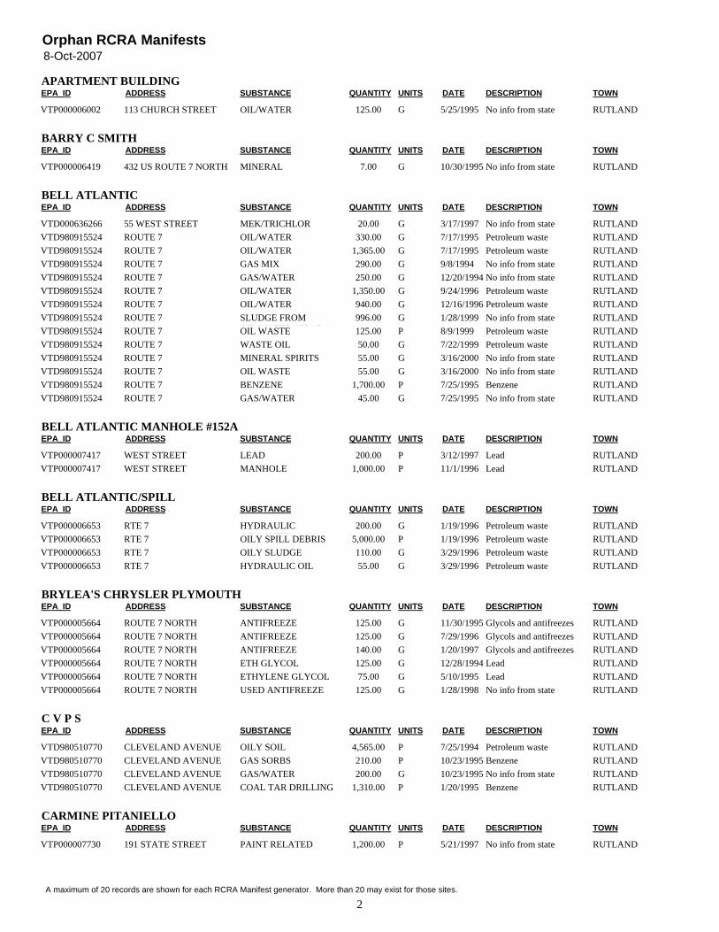
8-Oct-2007Orphan RCRA Manifests
EPA_ID ADDRESS SUBSTANCE QUANTITY UNITS DATE TOWNAPARTMENT BUILDING
DESCRIPTION
VTP000006002 113 CHURCH STREET OIL/WATER 125.00 G No info from state RUTLAND5/25/1995
EPA_ID ADDRESS SUBSTANCE QUANTITY UNITS DATE TOWNBARRY C SMITH
DESCRIPTION
VTP000006419 432 US ROUTE 7 NORTH MINERALSPIRITS/DIRT/OIL
7.00 G No info from state RUTLAND10/30/1995
EPA_ID ADDRESS SUBSTANCE QUANTITY UNITS DATE TOWNBELL ATLANTIC
DESCRIPTION
VTD000636266 55 WEST STREET MEK/TRICHLOR 20.00 G No info from state RUTLAND3/17/1997VTD980915524 ROUTE 7 OIL/WATER 330.00 G Petroleum waste RUTLAND7/17/1995VTD980915524 ROUTE 7 OIL/WATER 1,365.00 G Petroleum waste RUTLAND7/17/1995VTD980915524 ROUTE 7 GAS MIX 290.00 G No info from state RUTLAND9/8/1994VTD980915524 ROUTE 7 GAS/WATER 250.00 G No info from state RUTLAND12/20/1994VTD980915524 ROUTE 7 OIL/WATER 1,350.00 G Petroleum waste RUTLAND9/24/1996VTD980915524 ROUTE 7 OIL/WATER 940.00 G Petroleum waste RUTLAND12/16/1996VTD980915524 ROUTE 7 SLUDGE FROM
OIL/WATER SEPARA996.00 G No info from state RUTLAND1/28/1999
VTD980915524 ROUTE 7 OIL WASTE 125.00 P Petroleum waste RUTLAND8/9/1999VTD980915524 ROUTE 7 WASTE OIL 50.00 G Petroleum waste RUTLAND7/22/1999VTD980915524 ROUTE 7 MINERAL SPIRITS 55.00 G No info from state RUTLAND3/16/2000VTD980915524 ROUTE 7 OIL WASTE 55.00 G No info from state RUTLAND3/16/2000VTD980915524 ROUTE 7 BENZENE 1,700.00 P Benzene RUTLAND7/25/1995VTD980915524 ROUTE 7 GAS/WATER 45.00 G No info from state RUTLAND7/25/1995
EPA_ID ADDRESS SUBSTANCE QUANTITY UNITS DATE TOWNBELL ATLANTIC MANHOLE #152A
DESCRIPTION
VTP000007417 WEST STREET LEAD 200.00 P Lead RUTLAND3/12/1997VTP000007417 WEST STREET MANHOLE
SEDIMENT/LEAD1,000.00 P Lead RUTLAND11/1/1996
EPA_ID ADDRESS SUBSTANCE QUANTITY UNITS DATE TOWNBELL ATLANTIC/SPILL
DESCRIPTION
VTP000006653 RTE 7 HYDRAULICOIL/WATER
200.00 G Petroleum waste RUTLAND1/19/1996VTP000006653 RTE 7 OILY SPILL DEBRIS 5,000.00 P Petroleum waste RUTLAND1/19/1996VTP000006653 RTE 7 OILY SLUDGE 110.00 G Petroleum waste RUTLAND3/29/1996VTP000006653 RTE 7 HYDRAULIC OIL 55.00 G Petroleum waste RUTLAND3/29/1996
EPA_ID ADDRESS SUBSTANCE QUANTITY UNITS DATE TOWNBRYLEA'S CHRYSLER PLYMOUTH
DESCRIPTION
VTP000005664 ROUTE 7 NORTH ANTIFREEZE 125.00 G Glycols and antifreezes RUTLAND11/30/1995VTP000005664 ROUTE 7 NORTH ANTIFREEZE 125.00 G Glycols and antifreezes RUTLAND7/29/1996VTP000005664 ROUTE 7 NORTH ANTIFREEZE 140.00 G Glycols and antifreezes RUTLAND1/20/1997VTP000005664 ROUTE 7 NORTH ETH GLYCOL 125.00 G Lead RUTLAND12/28/1994VTP000005664 ROUTE 7 NORTH ETHYLENE GLYCOL 75.00 G Lead RUTLAND5/10/1995VTP000005664 ROUTE 7 NORTH USED ANTIFREEZE 125.00 G No info from state RUTLAND1/28/1998
EPA_ID ADDRESS SUBSTANCE QUANTITY UNITS DATE TOWNC V P S
DESCRIPTION
VTD980510770 CLEVELAND AVENUE OILY SOIL 4,565.00 P Petroleum waste RUTLAND7/25/1994VTD980510770 CLEVELAND AVENUE GAS SORBS 210.00 P Benzene RUTLAND10/23/1995VTD980510770 CLEVELAND AVENUE GAS/WATER 200.00 G No info from state RUTLAND10/23/1995VTD980510770 CLEVELAND AVENUE COAL TAR DRILLING
WASTE1,310.00 P Benzene RUTLAND1/20/1995
EPA_ID ADDRESS SUBSTANCE QUANTITY UNITS DATE TOWNCARMINE PITANIELLO
DESCRIPTION
VTP000007730 191 STATE STREET PAINT RELATEDMATERIAL
1,200.00 P No info from state RUTLAND5/21/1997
2A maximum of 20 records are shown for each RCRA Manifest generator. More than 20 may exist for those sites.
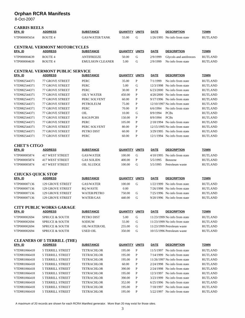
8-Oct-2007Orphan RCRA Manifests
EPA_ID ADDRESS SUBSTANCE QUANTITY UNITS DATE TOWNCARRIS REELS
DESCRIPTION
VTP000005654 ROUTE 4 GAS/WATER/TANKBOTTOMS
55.00 G No info from state RUTLAND1/26/1995
EPA_ID ADDRESS SUBSTANCE QUANTITY UNITS DATE TOWNCENTRAL VERMONT MOTORCYCLES
DESCRIPTION
VTP000004639 ROUTE 4 ANTIFREEZE 50.00 G Glycols and antifreezes RUTLAND2/9/1999VTP000004639 ROUTE 4 EMULSION CLEANER 5.00 G No info from state RUTLAND2/9/1999
EPA_ID ADDRESS SUBSTANCE QUANTITY UNITS DATE TOWNCENTRAL VERMONT PUBLIC SERVICE
DESCRIPTION
VTD982544371 77 GROVE STREET PERCCONTAMINATED PRE
35.00 P No info from state RUTLAND7/1/1999VTD982544371 77 GROVE STREET PERC
CONTAMINATED PRE5.00 G No info from state RUTLAND12/3/1998
VTD982544371 77 GROVE STREET PERCCONTAMINATED PRI
30.00 P No info from state RUTLAND6/23/2000VTD982544371 77 GROVE STREET OILY WATER 450.00 P No info from state RUTLAND4/20/2000VTD982544371 77 GROVE STREET PERC SOLVENT 60.00 P No info from state RUTLAND9/17/1996VTD982544371 77 GROVE STREET PETROLEUM
DISTILLATES75.00 P No info from state RUTLAND12/10/1997
VTD982544371 77 GROVE STREET PERC 70.00 P No info from state RUTLAND6/6/1994VTD982544371 77 GROVE STREET OIL 10.00 G PCBs RUTLAND8/9/1994VTD982544371 77 GROVE STREET RAGS/PCBS 150.00 P PCBs RUTLAND8/9/1994VTD982544371 77 GROVE STREET PERC 105.00 P No info from state RUTLAND2/18/1994VTD982544371 77 GROVE STREET PERC SOLVENT 80.00 P No info from state RUTLAND12/15/1995VTD982544371 77 GROVE STREET PETRO DIST 60.00 P No info from state RUTLAND3/29/1995VTD982544371 77 GROVE STREET PERC 60.00 P No info from state RUTLAND12/1/1994
EPA_ID ADDRESS SUBSTANCE QUANTITY UNITS DATE TOWNCHET'S CITGO
DESCRIPTION
VTP000005874 417 WEST STREET GAS/WATER 100.00 G No info from state RUTLAND4/10/1995VTP000005874 417 WEST STREET GAS SOLIDS 400.00 P Benzene RUTLAND5/5/1995VTP000005874 417 WEST STREET OIL SLUDGE 100.00 G Petroleum waste RUTLAND5/5/1995
EPA_ID ADDRESS SUBSTANCE QUANTITY UNITS DATE TOWNCHUCKS QUICK STOP
DESCRIPTION
VTP000007136 129 GROVE STREET GAS/WATER 100.00 G No info from state RUTLAND1/22/1999VTP000007136 129 GROVE STREET RQ WASTE
GASOLINE MIX0.00 No info from state RUTLAND7/26/1998
VTP000007136 129 GROVE STREET WATER/PETRO 750.00 G No info from state RUTLAND7/25/1996VTP000007136 129 GROVE STREET WATER/GAS 440.00 G No info from state RUTLAND9/20/1996
EPA_ID ADDRESS SUBSTANCE QUANTITY UNITS DATE TOWNCITY PUBLIC WORKS GARAGE
DESCRIPTION
VTP000002694 SPRUCE & SOUTHSTREET
PETRO DIST 5.00 G No info from state RUTLAND11/23/1999VTP000002694 SPRUCE & SOUTH
STREETSODIUMHYDROXIDE/METHA
55.00 G No info from state RUTLAND11/23/1999VTP000002694 SPRUCE & SOUTH
STREETOIL/WATER/OILSLUDGE
255.00 G Petroleum waste RUTLAND11/23/1999VTP000002694 SPRUCE & SOUTH
STREETUSED OIL 350.00 G Petroleum waste RUTLAND10/15/1996
EPA_ID ADDRESS SUBSTANCE QUANTITY UNITS DATE TOWNCLEANERS OF 5 TERRILL (THE)
DESCRIPTION
VTD981066418 5 TERRILL STREET TETRACHLOR 195.00 P No info from state RUTLAND11/5/1997VTD981066418 5 TERRILL STREET TETRACHLOR 195.00 P No info from state RUTLAND7/14/1999VTD981066418 5 TERRILL STREET TETRACHLOR 195.00 P No info from state RUTLAND11/26/1997VTD981066418 5 TERRILL STREET TETRACHLOR 60.00 P No info from state RUTLAND2/24/1998VTD981066418 5 TERRILL STREET TETRACHLOR 390.00 P No info from state RUTLAND2/24/1998VTD981066418 5 TERRILL STREET TETRACHLOR 195.00 P No info from state RUTLAND12/3/1997VTD981066418 5 TERRILL STREET TETRACHLOR 390.00 P No info from state RUTLAND3/23/1999VTD981066418 5 TERRILL STREET TETRACHLOR 352.00 P No info from state RUTLAND6/25/1996VTD981066418 5 TERRILL STREET TETRACHLOR 195.00 P No info from state RUTLAND7/18/1997VTD981066418 5 TERRILL STREET TETRACHLOR 195.00 P No info from state RUTLAND5/22/1997
3A maximum of 20 records are shown for each RCRA Manifest generator. More than 20 may exist for those sites.
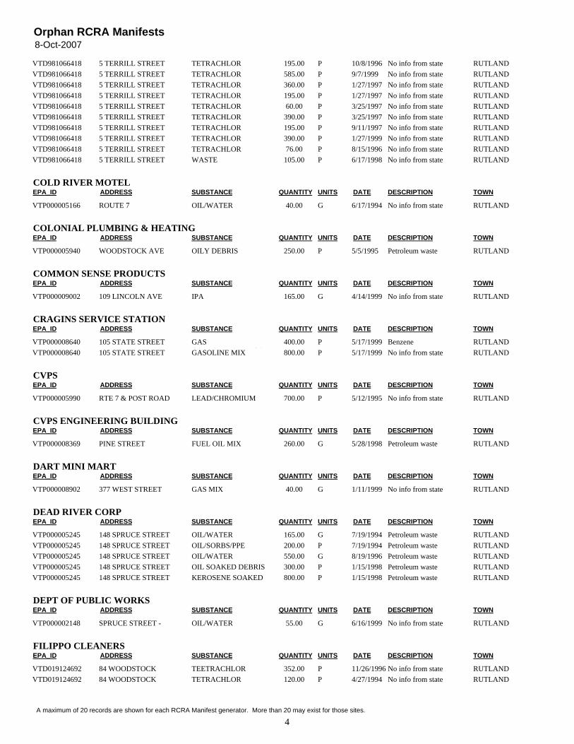
8-Oct-2007Orphan RCRA Manifests
VTD981066418 5 TERRILL STREET TETRACHLOR 195.00 P No info from state RUTLAND10/8/1996VTD981066418 5 TERRILL STREET TETRACHLOR 585.00 P No info from state RUTLAND9/7/1999VTD981066418 5 TERRILL STREET TETRACHLOR 360.00 P No info from state RUTLAND1/27/1997VTD981066418 5 TERRILL STREET TETRACHLOR 195.00 P No info from state RUTLAND1/27/1997VTD981066418 5 TERRILL STREET TETRACHLOR 60.00 P No info from state RUTLAND3/25/1997VTD981066418 5 TERRILL STREET TETRACHLOR 390.00 P No info from state RUTLAND3/25/1997VTD981066418 5 TERRILL STREET TETRACHLOR 195.00 P No info from state RUTLAND9/11/1997VTD981066418 5 TERRILL STREET TETRACHLOR 390.00 P No info from state RUTLAND1/27/1999VTD981066418 5 TERRILL STREET TETRACHLOR 76.00 P No info from state RUTLAND8/15/1996VTD981066418 5 TERRILL STREET WASTE
TETRACHLOROETHY105.00 P No info from state RUTLAND6/17/1998
EPA_ID ADDRESS SUBSTANCE QUANTITY UNITS DATE TOWNCOLD RIVER MOTEL
DESCRIPTION
VTP000005166 ROUTE 7 OIL/WATER 40.00 G No info from state RUTLAND6/17/1994
EPA_ID ADDRESS SUBSTANCE QUANTITY UNITS DATE TOWNCOLONIAL PLUMBING & HEATING
DESCRIPTION
VTP000005940 WOODSTOCK AVE OILY DEBRIS 250.00 P Petroleum waste RUTLAND5/5/1995
EPA_ID ADDRESS SUBSTANCE QUANTITY UNITS DATE TOWNCOMMON SENSE PRODUCTS
DESCRIPTION
VTP000009002 109 LINCOLN AVE IPA 165.00 G No info from state RUTLAND4/14/1999
EPA_ID ADDRESS SUBSTANCE QUANTITY UNITS DATE TOWNCRAGINS SERVICE STATION
DESCRIPTION
VTP000008640 105 STATE STREET GASCONTAMINATED SO
400.00 P Benzene RUTLAND5/17/1999VTP000008640 105 STATE STREET GASOLINE MIX 800.00 P No info from state RUTLAND5/17/1999
EPA_ID ADDRESS SUBSTANCE QUANTITY UNITS DATE TOWNCVPS
DESCRIPTION
VTP000005990 RTE 7 & POST ROAD LEAD/CHROMIUM 700.00 P No info from state RUTLAND5/12/1995
EPA_ID ADDRESS SUBSTANCE QUANTITY UNITS DATE TOWNCVPS ENGINEERING BUILDING
DESCRIPTION
VTP000008369 PINE STREET FUEL OIL MIX 260.00 G Petroleum waste RUTLAND5/28/1998
EPA_ID ADDRESS SUBSTANCE QUANTITY UNITS DATE TOWNDART MINI MART
DESCRIPTION
VTP000008902 377 WEST STREET GAS MIX 40.00 G No info from state RUTLAND1/11/1999
EPA_ID ADDRESS SUBSTANCE QUANTITY UNITS DATE TOWNDEAD RIVER CORP
DESCRIPTION
VTP000005245 148 SPRUCE STREET OIL/WATER 165.00 G Petroleum waste RUTLAND7/19/1994VTP000005245 148 SPRUCE STREET OIL/SORBS/PPE 200.00 P Petroleum waste RUTLAND7/19/1994VTP000005245 148 SPRUCE STREET OIL/WATER 550.00 G Petroleum waste RUTLAND8/19/1996VTP000005245 148 SPRUCE STREET OIL SOAKED DEBRIS 300.00 P Petroleum waste RUTLAND1/15/1998VTP000005245 148 SPRUCE STREET KEROSENE SOAKED
DEBRIS800.00 P Petroleum waste RUTLAND1/15/1998
EPA_ID ADDRESS SUBSTANCE QUANTITY UNITS DATE TOWNDEPT OF PUBLIC WORKS
DESCRIPTION
VTP000002148 SPRUCE STREET -GARAGE
OIL/WATER 55.00 G No info from state RUTLAND6/16/1999
EPA_ID ADDRESS SUBSTANCE QUANTITY UNITS DATE TOWNFILIPPO CLEANERS
DESCRIPTION
VTD019124692 84 WOODSTOCKAVE/STATION A
TEETRACHLOR 352.00 P No info from state RUTLAND11/26/1996VTD019124692 84 WOODSTOCK
AVE/STATION ATETRACHLOR 120.00 P No info from state RUTLAND4/27/1994
4A maximum of 20 records are shown for each RCRA Manifest generator. More than 20 may exist for those sites.

8-Oct-2007Orphan RCRA Manifests
VTD019124692 84 WOODSTOCKAVE/STATION A
TETRACHLOR 60.00 P Waste chlorinatedl ( hl h l
RUTLAND2/3/1995VTD019124692 84 WOODSTOCK
AVE/STATION ATETRACHLOR 120.00 P Waste chlorinated
l ( hl h lRUTLAND1/5/1995
VTD019124692 84 WOODSTOCKAVE/STATION A
TETRACHLOR 60.00 P No info from state RUTLAND6/22/1994VTD019124692 84 WOODSTOCK
AVE/STATION ATETRACHLOR 195.00 P No info from state RUTLAND9/22/1994
VTD019124692 84 WOODSTOCKAVE/STATION A
TETRACHLOR 120.00 P No info from state RUTLAND9/22/1994VTD019124692 84 WOODSTOCK
AVE/STATION ATETRACHLOR 60.00 P No info from state RUTLAND8/26/1994
VTD019124692 84 WOODSTOCKAVE/STATION A
TETRACHLOR 195.00 P No info from state RUTLAND1/4/1994VTD019124692 84 WOODSTOCK
AVE/STATION ATETRACHLOR 120.00 P No info from state RUTLAND7/29/1994
VTD019124692 84 WOODSTOCKAVE/STATION A
TETRACHLOR 120.00 P No info from state RUTLAND3/30/1994VTD019124692 84 WOODSTOCK
AVE/STATION ATETRACHLOR 60.00 P No info from state RUTLAND3/2/1994
VTD019124692 84 WOODSTOCKAVE/STATION A
TETRACHLOR 60.00 P No info from state RUTLAND2/1/1994VTD019124692 84 WOODSTOCK
AVE/STATION ATETRACHLOR 120.00 P No info from state RUTLAND5/26/1994
VTD019124692 84 WOODSTOCKAVE/STATION A
TETRACHLOR 120.00 P No info from state RUTLAND11/9/1995VTD019124692 84 WOODSTOCK
AVE/STATION ATETRACHLOR 60.00 P No info from state RUTLAND9/13/1995
VTD019124692 84 WOODSTOCKAVE/STATION A
TETRACHLOR 150.00 P No info from state RUTLAND5/23/1996VTD019124692 84 WOODSTOCK
AVE/STATION ATETRACHLOR 120.00 P No info from state RUTLAND8/15/1995
VTD019124692 84 WOODSTOCKAVE/STATION A
TETRACHLOR 195.00 P No info from state RUTLAND3/28/1996
EPA_ID ADDRESS SUBSTANCE QUANTITY UNITS DATE TOWNFIRST VERMONT BANK(FRM BANKNORTH)
DESCRIPTION
VTP000007433 77/89 MERCHANTSROW(CONT PROP)
WATER/OIL 300.00 G No info from state RUTLAND11/13/1996VTP000007433 77/89 MERCHANTS
ROW(CONT PROP)SORBS/RAGS/OIL 200.00 P Petroleum waste RUTLAND11/13/1996
VTP000007433 77/89 MERCHANTSROW(CONT PROP)
OILYSOLIDS/SLUDGE
55.00 G Petroleum waste RUTLAND9/17/1997VTP000007433 77/89 MERCHANTS
ROW(CONT PROP)OIL & WATER 35.00 G No info from state RUTLAND12/8/1997
VTP000007433 77/89 MERCHANTSROW(CONT PROP)
WATER/OIL 55.00 G No info from state RUTLAND9/17/1997VTP000007433 77/89 MERCHANTS
ROW(CONT PROP)OIL 55.00 G Petroleum waste RUTLAND9/17/1997
VTP000007433 77/89 MERCHANTSROW(CONT PROP)
TANK BOTTOMSLUDGE
495.00 G Petroleum waste RUTLAND9/17/1997VTP000007433 77/89 MERCHANTS
ROW(CONT PROP)OIL WASTE 55.00 G No info from state RUTLAND10/22/1997
VTP000007433 77/89 MERCHANTSROW(CONT PROP)
USED OIL 220.00 G Petroleum waste RUTLAND2/28/1998
EPA_ID ADDRESS SUBSTANCE QUANTITY UNITS DATE TOWNFOLEY SERVICES
DESCRIPTION
VTD019125590 133 STATE STREET OIL/WATER 120.00 G Petroleum waste RUTLAND10/11/1996VTD019125590 133 STATE STREET USED OIL 750.00 G Petroleum waste RUTLAND9/27/1996VTP000005670 133 STATE STREET MEDICAL WASTE 66.00 P Medical wastes RUTLAND12/19/1995VTP000005670 133 STATE STREET MEDICAL WASTE 118.00 P Medical wastes RUTLAND3/15/1995VTP000005670 133 STATE STREET MEDICAL WASTE 7.00 P Medical wastes RUTLAND11/8/1994
EPA_ID ADDRESS SUBSTANCE QUANTITY UNITS DATE TOWNGARY KUPFERER
DESCRIPTION
VTP000006946 86 CENTER STREET OILY SLUDGE 55.00 G Petroleum waste RUTLAND6/14/1996
EPA_ID ADDRESS SUBSTANCE QUANTITY UNITS DATE TOWNGRACE CONGREGATIONAL CHURCH
DESCRIPTION
VTP000007756 8 COURT STREET OILY SLUDGE 200.00 G Petroleum waste RUTLAND6/10/1997
EPA_ID ADDRESS SUBSTANCE QUANTITY UNITS DATE TOWNGRACE CONGREGATIONAL UNITED CHURCH
DESCRIPTION
VTP000008231 8 COURT ST FUEL OIL TANKBOTTOMS
50.00 G No info from state RUTLAND3/6/1998
EPA_ID ADDRESS SUBSTANCE QUANTITY UNITS DATE TOWNGRYPHON BUILDING
DESCRIPTION
VTP000005717 56 1/2 MERCHANTS ROW OIL/WATER 165.00 G Petroleum waste RUTLAND1/26/1995VTP000005717 56 1/2 MERCHANTS ROW OIL/SORBS/CLAY 300.00 P Petroleum waste RUTLAND1/26/1995
EPA_ID ADDRESS SUBSTANCE QUANTITY UNITS DATE TOWNH.A. EDDY ENERGY CORP
DESCRIPTION
5A maximum of 20 records are shown for each RCRA Manifest generator. More than 20 may exist for those sites.
8-Oct-2007Orphan RCRA Manifests
VTP000004607 148 SPRUCE STREET FUEL OIL 55.00 G Petroleum waste RUTLAND9/12/1994VTP000004607 148 SPRUCE STREET OIL SOLIDS 70.00 P Petroleum waste RUTLAND9/12/1994VTP000004607 148 SPRUCE STREET OIL/WATER 5,000.00 G No info from state RUTLAND7/19/1994VTP000004607 148 SPRUCE STREET GAS/WATER 75.00 G No info from state RUTLAND10/23/1995
EPA_ID ADDRESS SUBSTANCE QUANTITY UNITS DATE TOWNH.A. EDDY MINI MART
DESCRIPTION
VTP000004217 86 WOODSTOCK AVE GAS/KEROSENE/DIESEL/WATER
51.00 G No info from state RUTLAND3/25/1997VTP000004217 86 WOODSTOCK AVE GAS/WATER 3,593.00 P No info from state RUTLAND3/11/1994VTP000004217 86 WOODSTOCK AVE GAS/WATER 132.00 G No info from state RUTLAND2/4/1994VTP000004217 86 WOODSTOCK AVE BENZENE DEBRIS 1,911.00 P No info from state RUTLAND11/24/1997VTP000004217 86 WOODSTOCK AVE GAS SOLIDS 700.00 P No info from state RUTLAND11/28/1997VTP000004217 86 WOODSTOCK AVE KEROSENE/WATER 240.00 G No info from state RUTLAND2/4/1994
EPA_ID ADDRESS SUBSTANCE QUANTITY UNITS DATE TOWNHILINEX VERMONT**
DESCRIPTION
VTP000005486 56 HOWE STREET NAPHTHA 17.00 G No info from state RUTLAND7/28/1995VTP000005486 56 HOWE STREET BRAKE SOL 10.00 G Tetrachloroethylene RUTLAND10/2/1995
EPA_ID ADDRESS SUBSTANCE QUANTITY UNITS DATE TOWNHIMOLENE VERMONT
DESCRIPTION
VT5000000406 56 HOWE STREET PARTS CLEANER 9.00 G RUTLANDVT5000000406 56 HOWE STREET NAPHTHA 10.00 G No info from state RUTLAND9/6/1996VT5000000406 56 HOWE STREET PARTS CLEANER 15.00 G No info from state RUTLAND1/22/1998VT5000000406 56 HOWE STREET PARTS CLEANER 17.00 G No info from state RUTLAND2/18/1997VT5000000406 56 HOWE STREET PARTS CLEANER 17.00 G No info from state RUTLAND11/22/1996VT5000000406 56 HOWE STREET NAPHTHA 12.00 G No info from state RUTLAND11/22/1996VT5000000406 56 HOWE STREET PARTS CLEANER 17.00 G No info from state RUTLAND9/28/1998VT5000000406 56 HOWE STREET PARTS CLEANER 12.00 G No info from state RUTLAND10/30/1997VT5000000406 56 HOWE STREET PARTS WASHER 12.00 G Tetrachloroethylene RUTLAND3/16/1999VT5000000406 56 HOWE STREET PARTS CLEANER 15.00 G No info from state RUTLAND8/5/1997VT5000000406 56 HOWE STREET PARTS WASHER SOL 14.00 G Tetrachloroethylene RUTLAND8/31/1999VT5000000406 56 HOWE STREET PARTS WASHER
SOLUTION16.00 G Tetrachloroethylene RUTLAND6/8/1999
VT5000000406 56 HOWE STREET PARTS WASHER 15.00 G No info from state RUTLAND5/10/2000VT5000000406 56 HOWE STREET BRAKE FLUID 14.00 G No info from state RUTLAND7/7/1998VT5000000406 56 HOWE STREET PARTS CLEANER 12.00 G No info from state RUTLAND4/17/1998VT5000000406 56 HOWE STREET NAPHTHA 12.00 G No info from state RUTLAND2/16/2000VT5000000406 56 HOWE STREET PARTS WASHER
SOLUTION16.00 G No info from state RUTLAND2/16/2000
VT5000000406 56 HOWE STREET PARTS WASHERSOLUTION
27.00 G No info from state RUTLAND10/23/2000VT5000000406 56 HOWE STREET PARTS WASHER
SOLUTION27.00 G No info from state RUTLAND7/31/2000
VTP000002975 56 HOWE STREET WASTE OIL 200.00 P No info from state RUTLAND3/20/1994VTP000002975 56 HOWE STREET WASTE OIL 413.00 P No info from state RUTLAND8/23/1995
EPA_ID ADDRESS SUBSTANCE QUANTITY UNITS DATE TOWNHOWARDS SUNOCO/AR SANDRI
DESCRIPTION
VTR000003525 278 S MAIN STREET BAY DRAIN SLUDGE 150.00 G Petroleum waste RUTLAND1/7/2000
EPA_ID ADDRESS SUBSTANCE QUANTITY UNITS DATE TOWNHOWE CENTER
DESCRIPTION
VTP000009847 GRANGER STREET NON REG MATERIAL 4,800.00 P No info from state RUTLAND6/30/2000
EPA_ID ADDRESS SUBSTANCE QUANTITY UNITS DATE TOWNHUGH DUFFY COAL COMPANY
DESCRIPTION
VTP000008386 PINE STREET STATE REGULATEDOILY MATERIAL (OIL
3,000.00 P No info from state RUTLAND6/8/1998
EPA_ID ADDRESS SUBSTANCE QUANTITY UNITS DATE TOWNIRVING OIL
DESCRIPTION
6A maximum of 20 records are shown for each RCRA Manifest generator. More than 20 may exist for those sites.
8-Oct-2007Orphan RCRA Manifests
VTP000008524 148 SPRUCE STREET GAS/WATER 180.00 G No info from state RUTLAND1/29/1999VTP000008542 146 SPRUCE STREET STATE REG WASTE/
OIL WATER SEPARAT180.00 G Petroleum waste RUTLAND7/7/1998
EPA_ID ADDRESS SUBSTANCE QUANTITY UNITS DATE TOWNJ.P. NOONAN TRANSPORT
DESCRIPTION
VTP000005129 11 MEADOW STREET CARBON 1,200.00 P Petroleum waste RUTLAND8/13/1997VTP000005129 11 MEADOW STREET GAS/WATER 150.00 G No info from state RUTLAND6/20/1996VTP000005129 11 MEADOW STREET OILY DEBRIS 6,000.00 P Petroleum waste RUTLAND6/7/1994
EPA_ID ADDRESS SUBSTANCE QUANTITY UNITS DATE TOWNJERRY'S NISSAN
DESCRIPTION
VTD079950671 ROUTE 7 N ANTIFREEZE 135.00 G Glycols and antifreezes RUTLAND10/7/1996VTD079950671 ROUTE 7 N ANTIFREEZE 100.00 G Glycols and antifreezes RUTLAND11/30/1995VTD079950671 ROUTE 7 N ETHYLENE GLYCOL 100.00 G Lead RUTLAND1/30/1995VTD079950671 ROUTE 7 N ETHYLENE GLYCOL 200.00 G Lead RUTLAND10/4/1994VTD079950671 ROUTE 7 N ETH GLYCOL 125.00 G Glycols and antifreezes RUTLAND1/20/1994VTD079950671 ROUTE 7 N USED ANTIFREEZE 115.00 G No info from state RUTLAND1/28/1998VTD079950671 ROUTE 7 N ANTIFREEZE 125.00 G No info from state RUTLAND9/21/1999
EPA_ID ADDRESS SUBSTANCE QUANTITY UNITS DATE TOWNJIFFY MART
DESCRIPTION
VTP000002923 100 STATE STREET OIL/WATER 390.00 G Petroleum waste RUTLAND5/27/1997VTP000002923 100 STATE STREET GAS/WATER 220.00 G No info from state RUTLAND6/2/1997VTP000002923 100 STATE STREET GAS/SPEEDY 220.00 G No info from state RUTLAND6/2/1997VTP000002923 100 STATE STREET GAS/WATER 165.00 G No info from state RUTLAND1/18/2000VTP000002923 100 STATE STREET GAS/WATER 150.00 G No info from state RUTLAND1/10/2000VTP000004847 98 STATE STREET GAS/WATER 55.00 G No info from state RUTLAND1/7/1994VTP000004847 98 STATE STREET GASOLINE 55.00 G No info from state RUTLAND7/20/2000
EPA_ID ADDRESS SUBSTANCE QUANTITY UNITS DATE TOWNJOHN A RUSSELL CORP
DESCRIPTION
VTP000006718 156 PORTER PLACE OILY SLUDGE 200.00 G Petroleum waste RUTLAND2/22/1996VTP000006718 156 PORTER PLACE BALLASTS 176.00 P PCBs RUTLAND2/22/1996VTP000006792 156 PORTER PLACE OILY SLUDGE 500.00 P Petroleum waste RUTLAND6/14/1996
EPA_ID ADDRESS SUBSTANCE QUANTITY UNITS DATE TOWNKINNEY SUBARU
DESCRIPTION
VTD988375374 RTE 75 BOX 276 BRAKE FLUID 5.00 G No info from state RUTLAND4/25/1997VTD988375374 RTE 75 BOX 276 NAPHTHA 17.00 G No info from state RUTLAND11/6/1996VTD988375374 RTE 75 BOX 276 BRAKE FLUID 5.00 G No info from state RUTLAND11/6/1996VTD988375374 RTE 75 BOX 276 BRAKE FLUID 5.00 G No info from state RUTLAND1/24/1997VTD988375374 RTE 75 BOX 276 NAPHTHA 17.00 G No info from state RUTLAND10/8/1997VTD988375374 RTE 75 BOX 276 BRAKE FLUID 5.00 G No info from state RUTLAND10/8/1997VTD988375374 RTE 75 BOX 276 NAPHTHA 16.00 G Tetrachloroethylene RUTLAND2/23/1999VTD988375374 RTE 75 BOX 276 BRAKE FLUID 5.00 G Tetrachloroethylene RUTLAND2/23/1999VTD988375374 RTE 75 BOX 276 NAPHTHA 16.00 G No info from state RUTLAND8/13/1996VTD988375374 RTE 75 BOX 276 BRAKE FLUID 5.00 G No info from state RUTLAND8/13/1996VTD988375374 RTE 75 BOX 276 DRAINED OIL
FILTERS444.00 P No info from state RUTLAND8/13/1996
VTD988375374 RTE 75 BOX 276 NAPHTHA 5.00 G Tetrachloroethylene RUTLAND8/9/1999VTD988375374 RTE 75 BOX 276 NAPHTHA 16.00 G No info from state RUTLAND1/26/2000VTD988375374 RTE 75 BOX 276 BRAKE FLUID 5.00 G No info from state RUTLAND1/26/2000VTD988375374 RTE 75 BOX 276 NAPHTHA 15.00 G No info from state RUTLAND3/23/1998VTD988375374 RTE 75 BOX 276 BRAKE FLUID 5.00 G No info from state RUTLAND3/23/1998VTD988375374 RTE 75 BOX 276 BRAKE FLUID 5.00 G Tetrachloroethylene RUTLAND11/3/1999VTD988375374 RTE 75 BOX 276 NAPHTHA 16.00 G No info from state RUTLAND9/4/1998VTD988375374 RTE 75 BOX 276 BRAKE FLUID 5.00 G No info from state RUTLAND9/4/1998VTD988375374 RTE 75 BOX 276 BRAKE FLUID 5.00 G No info from state RUTLAND7/13/2000
7A maximum of 20 records are shown for each RCRA Manifest generator. More than 20 may exist for those sites.
8-Oct-2007Orphan RCRA Manifests
EPA_ID ADDRESS SUBSTANCE QUANTITY UNITS DATE TOWNLINDAA ELLIS
DESCRIPTION
VTP000007046 28 ELM STREET CARBON/OIL 75.00 P No info from state RUTLAND7/11/1996
EPA_ID ADDRESS SUBSTANCE QUANTITY UNITS DATE TOWNMALL MOBIL #836
DESCRIPTION
VTP000008347 WOODSTOCK AVE - RT 4EAST
GASOLINE MIX 100.00 G No info from state RUTLAND11/7/2000VTP000008347 WOODSTOCK AVE - RT 4
EASTRQ WASTEGASOLINE MIXTURE
2,325.00 G No info from state RUTLAND6/1/1998VTP000008347 WOODSTOCK AVE - RT 4
EASTRQ WASTEGASOLINE MIX
250.00 G No info from state RUTLAND6/19/1998VTP000008347 WOODSTOCK AVE - RT 4
EASTRQ WASTEGASOLINE MIX
2,900.00 G No info from state RUTLAND6/1/1998
EPA_ID ADDRESS SUBSTANCE QUANTITY UNITS DATE TOWNMANHOLE #52
DESCRIPTION
VTP000007382 MERCHANTS ROW MANHOLESEDIMENT
800.00 P No info from state RUTLAND10/17/1996
EPA_ID ADDRESS SUBSTANCE QUANTITY UNITS DATE TOWNMARBLE VALLEY REG.TRANSPORTATION
DESCRIPTION
VTP000004114 158 SPRUCE STREET OILY SLUDGE 200.00 P No info from state RUTLAND9/15/1997
EPA_ID ADDRESS SUBSTANCE QUANTITY UNITS DATE TOWNMARTIN'S
DESCRIPTION
VTP000004974 ROUTE 4 RUTLANDMALL
PCB BALLASTS 1,683.00 P PCBs RUTLAND4/7/1994
EPA_ID ADDRESS SUBSTANCE QUANTITY UNITS DATE TOWNMASONIC TEMPLE
DESCRIPTION
VTP000008354 51 WASHINGTONSTREET
COMBUSTIBLELIQUID N O S (FUEL O
50.00 G Petroleum waste RUTLAND5/21/1998
EPA_ID ADDRESS SUBSTANCE QUANTITY UNITS DATE TOWNMENDON METHODIST CHURCH
DESCRIPTION
VTP000006531 ROUTE 4 CARABON/OIL 300.00 P No info from state RUTLAND12/8/1995VTP000006531 ROUTE 4 OIL CARBON
FILTERS500.00 P No info from state RUTLAND3/20/1996
EPA_ID ADDRESS SUBSTANCE QUANTITY UNITS DATE TOWNMERCHANTS BANK PROPERTY
DESCRIPTION
VTP000006327 25-27 COTTAGE STREET MOTOR/HEATINGOIL
1,463.00 G Petroleum waste RUTLAND10/13/1995
EPA_ID ADDRESS SUBSTANCE QUANTITY UNITS DATE TOWNMIDWAY OIL
DESCRIPTION
VTP000005745 446 WEST STREET GASOLINE MIXTURE 190.00 G No info from state RUTLAND9/17/1998VTP000005745 446 WEST STREET OILY DEBRIS 40.00 G Petroleum waste RUTLAND9/17/1998VTP000005745 446 WEST STREET FUEL OIL MIX 675.00 G Petroleum waste RUTLAND9/17/1998VTP000005745 446 WEST STREET GASOLINE/WATER 1,954.00 G No info from state RUTLAND1/30/1995VTP000006267 118 SOUTH STREET OIL/SLUDGE 220.00 G Petroleum waste RUTLAND9/20/1995VTP000006267 118 SOUTH STREET GAS/WATER/CARBO
N55.00 G No info from state RUTLAND2/6/1996
EPA_ID ADDRESS SUBSTANCE QUANTITY UNITS DATE TOWNMIDWAY OIL CORP
DESCRIPTION
VTP000006239 ROUTE 7 OIL/WATER 110.00 G Petroleum waste RUTLAND3/20/1996
EPA_ID ADDRESS SUBSTANCE QUANTITY UNITS DATE TOWNMINTZER BROTHERS INC
DESCRIPTION
VTP000004209 60 STRONGS AVENUE BENZENE/WATER 2,500.00 G No info from state RUTLAND1/19/1995VTP000004209 60 STRONGS AVENUE BENZENE/WATER 5,000.00 G No info from state RUTLAND1/18/1995VTP000004209 60 STRONGS AVENUE GAS SOLIDS 500.00 P No info from state RUTLAND1/25/1995
8A maximum of 20 records are shown for each RCRA Manifest generator. More than 20 may exist for those sites.
8-Oct-2007Orphan RCRA Manifests
EPA_ID ADDRESS SUBSTANCE QUANTITY UNITS DATE TOWNMODERN CLEANERS AND TAILORS
DESCRIPTION
VTD981066475 5 STRONGS AVENUE TETRACHLOR 197.00 P No info from state RUTLAND2/14/1997VTD981066475 5 STRONGS AVENUE TETRACHLOR 130.00 P No info from state RUTLAND11/5/1997VTD981066475 5 STRONGS AVENUE TETRACHLOR 150.00 P No info from state RUTLAND11/3/1998VTD981066475 5 STRONGS AVENUE TETRACHLOR 176.00 P No info from state RUTLAND8/18/1996VTD981066475 5 STRONGS AVENUE TETRACHLOR 105.00 P No info from state RUTLAND7/14/1999VTD981066475 5 STRONGS AVENUE TETRACHLOR 195.00 P No info from state RUTLAND10/8/1996VTD981066475 5 STRONGS AVENUE TETRACHLOR 105.00 P No info from state RUTLAND8/9/1999VTD981066475 5 STRONGS AVENUE TETRACHLOR 105.00 P No info from state RUTLAND12/30/1997VTD981066475 5 STRONGS AVENUE TETRACHLOR 195.00 P No info from state RUTLAND8/15/1997VTD981066475 5 STRONGS AVENUE TETRACHLOR 176.00 P No info from state RUTLAND10/30/1996VTD981066475 5 STRONGS AVENUE TETRACHLOR 390.00 P No info from state RUTLAND5/16/1997VTD981066475 5 STRONGS AVENUE TETRACHLOR 36.00 P No info from state RUTLAND7/19/1996VTD981066475 5 STRONGS AVENUE TETRACHLOR 195.00 P No info from state RUTLAND4/21/1997VTD981066475 5 STRONGS AVENUE TETRACHLOR 100.00 P No info from state RUTLAND3/23/1999VTD981066475 5 STRONGS AVENUE TETRACHLOR 140.00 P No info from state RUTLAND2/26/1999VTD981066475 5 STRONGS AVENUE TETRACHLOR 195.00 P No info from state RUTLAND7/16/1997VTD981066475 5 STRONGS AVENUE TETRACHLOR 110.00 P No info from state RUTLAND12/3/1997VTD981066475 5 STRONGS AVENUE TETRACHLOR 195.00 P No info from state RUTLAND9/24/1997VTD981066475 5 STRONGS AVENUE TETRACHLORO 110.00 P No info from state RUTLAND1/28/1998VTD981066475 5 STRONGS AVENUE TETRACHLOR 125.00 P No info from state RUTLAND1/27/1999
EPA_ID ADDRESS SUBSTANCE QUANTITY UNITS DATE TOWNMONTGOMERY WARD
DESCRIPTION
VTD988380622 RTE 4/ RUTLAND MALL OILY SLUDGE 180.00 G Petroleum waste RUTLAND8/11/1995VTD988380622 RTE 4/ RUTLAND MALL PCB BALLASTS 3,795.00 P PCBs RUTLAND6/20/1994VTD988380622 RTE 4/ RUTLAND MALL ANTIFREEZE 60.00 G Glycols and antifreezes RUTLAND2/26/1996VTD988380622 RTE 4/ RUTLAND MALL ETHYLENE GLYCOL 55.00 G Lead RUTLAND12/28/1994
EPA_ID ADDRESS SUBSTANCE QUANTITY UNITS DATE TOWNOLNEY APARTMENTS
DESCRIPTION
VTP000006466 20 WEST AND 3 COURTSTREET
PETRO SOLIDS 75.00 P Petroleum waste RUTLAND12/3/1995VTP000006466 20 WEST AND 3 COURT
STREETOIL/WATER 211.00 G No info from state RUTLAND11/13/1995
EPA_ID ADDRESS SUBSTANCE QUANTITY UNITS DATE TOWNPARK MOBIL
DESCRIPTION
VTP000008594 INTERSECTION RTE 4 & 7 RQ WASTEFLAMMABLE LIQ
0.00 No info from state RUTLAND7/27/1998VTP000008594 INTERSECTION RTE 4 & 7 RQ WASTE
FLAMMABLE LIQ0.00 No info from state RUTLAND7/27/1998
EPA_ID ADDRESS SUBSTANCE QUANTITY UNITS DATE TOWNPARKERS TEXACO
DESCRIPTION
VTP000007071 102 WEST STREET GAS/WATER 500.00 G No info from state RUTLAND6/26/1996VTP000007071 102 WEST STREET GAS/OIL SLUDGE 140.00 G No info from state RUTLAND7/31/1996VTP000007071 102 WEST STREET TETRACHLOR 110.00 G No info from state RUTLAND7/31/1996
EPA_ID ADDRESS SUBSTANCE QUANTITY UNITS DATE TOWNPATCH'S PETROLEUM
DESCRIPTION
VTP000006549 102 MEADOW STREET GASOLINE/KEROSENE
80.00 G No info from state RUTLAND8/26/1998VTP000006549 102 MEADOW STREET OIL/SPEEDY 1,600.00 P No info from state RUTLAND6/10/1997VTP000006549 102 MEADOW STREET GAS/WATER 50.00 G No info from state RUTLAND4/15/1996VTP000007750 102 MEADOW STREET SPENT RESINS 500.00 P No info from state RUTLAND6/10/1997VTP000007750 102 MEADOW STREET RESIN SOLUTION 250.00 P No info from state RUTLAND6/10/1997VTP000008162 102 MEADOW STREET GAS/DIESEL/KERO 2,575.00 G No info from state RUTLAND12/30/1997VTP000008162 102 MEADOW STREET GASOLINE MIXTURE 1,000.00 G No info from state RUTLAND1/15/1998VTP000008162 102 MEADOW STREET OIL SOAKED DEBRIS 600.00 P No info from state RUTLAND1/15/1998VTP000008162 102 MEADOW STREET GASOLINE 559.00 G No info from state RUTLAND4/25/2000
9A maximum of 20 records are shown for each RCRA Manifest generator. More than 20 may exist for those sites.

8-Oct-2007Orphan RCRA Manifests
EPA_ID ADDRESS SUBSTANCE QUANTITY UNITS DATE TOWNPETER FAGAN
DESCRIPTION
VTP000006340 134 POST STREET OIL TANK BOTTOMS 50.00 G Petroleum waste RUTLAND11/7/1995
EPA_ID ADDRESS SUBSTANCE QUANTITY UNITS DATE TOWNPETER MONTELLO
DESCRIPTION
VTP000008154 9 ROBERTS AVE RQ HAZARDOUSWASTE SOLID NOS
150.00 P Lead RUTLAND4/21/1998VTP000008154 9 ROBERTS AVE LEAD PAINT CHIPS 90.00 P Lead RUTLAND12/21/1997
EPA_ID ADDRESS SUBSTANCE QUANTITY UNITS DATE TOWNPHOTO HUT
DESCRIPTION
VTP000003610 RTE 4 PERCHLOR SLUDGE 1,800.00 P No info from state RUTLAND11/17/1995
EPA_ID ADDRESS SUBSTANCE QUANTITY UNITS DATE TOWNPLAZA MOBIL
DESCRIPTION
VTP000004709 EVELYN STREET GASOLINE MIX 100.00 G No info from state RUTLAND10/7/1998VTP000004709 EVELYN STREET WATER/GASOLINE 563.00 G No info from state RUTLAND2/4/1999VTP000004709 EVELYN STREET GAS MIX 50.00 G No info from state RUTLAND8/13/1997VTP000004709 EVELYN STREET GAS/WATER 1,500.00 G No info from state RUTLAND11/10/1999VTP000004709 EVELYN STREET GASOLINE 3,000.00 G No info from state RUTLAND11/10/1999VTP000004709 EVELYN STREET GAS MIX 55.00 G No info from state RUTLAND2/4/2000VTP000004709 EVELYN STREET GAS/WATER 1,300.00 P No info from state RUTLAND10/13/1994VTP000004709 EVELYN STREET GAS/WATER 100.00 G No info from state RUTLAND6/20/1996VTP000004709 EVELYN STREET CARBON 4,000.00 P Benzene RUTLAND7/6/1994VTP000004709 EVELYN STREET SPENT CARBON/GAS 400.00 P No info from state RUTLAND2/4/2000VTP000004709 EVELYN STREET GAS/SOIL 1,600.00 P No info from state RUTLAND2/4/2000VTP000004709 EVELYN STREET GASOLINE 150.00 G No info from state RUTLAND1/18/2000VTP000004709 EVELYN STREET CARBON/GASOLINE 300.00 P Benzene RUTLAND8/13/1997VTP000004709 EVELYN STREET GASOLINE DEBRIS 250.00 P Benzene RUTLAND10/28/1998VTP000004709 EVELYN STREET BENZENE/CARBON 750.00 P Benzene RUTLAND10/28/1998VTP000004709 EVELYN STREET SPENT
CARBON/GASOLINE450.00 P No info from state RUTLAND10/7/1998
EPA_ID ADDRESS SUBSTANCE QUANTITY UNITS DATE TOWNPLEASANT MANOR NURSING HOME
DESCRIPTION
VTP000009260 46 NICHOLS STREET NON REG MATERIAL 8,400.00 P No info from state RUTLAND9/2/1999
EPA_ID ADDRESS SUBSTANCE QUANTITY UNITS DATE TOWNPRIME OFFSET
DESCRIPTION
VTP000005902 56 WEST STREET PHOTO FIXER 140.00 P Silver RUTLAND12/30/1997VTP000005902 56 WEST STREET FIXER 151.00 P Silver RUTLAND10/2/1996VTP000005902 56 WEST STREET SILVER FIXER 120.00 P Silver RUTLAND1/26/1999VTP000005902 56 WEST STREET SILVER SOL 146.00 P Silver RUTLAND9/11/1997VTP000005902 56 WEST STREET RQ HAZARDOUS
WASTE LIQ NOS0.00 No info from state RUTLAND7/15/1998
VTP000005902 56 WEST STREET SILVER FIXER 135.00 P No info from state RUTLAND1/27/2000VTP000005902 56 WEST STREET SILVER SOLUTION 120.00 P Silver RUTLAND7/14/1999VTP000005902 56 WEST STREET FIXER 143.00 P Silver RUTLAND9/19/1995VTP000005902 56 WEST STREET FIXER 142.00 P Silver RUTLAND1/24/1996VTP000005902 56 WEST STREET FIXER 142.00 P Silver RUTLAND4/16/1996VTP000005902 56 WEST STREET FIXER/DEVELOPER 199.00 P Silver RUTLAND4/18/1995
EPA_ID ADDRESS SUBSTANCE QUANTITY UNITS DATE TOWNPROGRESSIVE PRODUCTS INC
DESCRIPTION
VTP000006636 56 HOWE STREET OIL/WATER 250.00 G Petroleum waste RUTLAND3/18/1997VTP000006636 56 HOWE STREET HYDRAULIC/CUTTIN
G OIL10,540.00 P Lead RUTLAND6/24/1996
VTP000006636 56 HOWE STREET COOLANT/WATER/OIL
440.00 G Petroleum waste RUTLAND2/6/1996VTP000006636 56 HOWE STREET LEAD LIQ 4,400.00 P Lead RUTLAND1/4/2000
10A maximum of 20 records are shown for each RCRA Manifest generator. More than 20 may exist for those sites.
8-Oct-2007Orphan RCRA Manifests
EPA_ID ADDRESS SUBSTANCE QUANTITY UNITS DATE TOWNQUICK PRINT OF RUTLAND
DESCRIPTION
VTP000005863 191 WEST STREET FIXER 151.00 P Silver RUTLAND11/22/1996VTP000005863 191 WEST STREET FIXER 150.00 P Silver RUTLAND3/24/1997VTP000005863 191 WEST STREET SILVER 140.00 P Silver RUTLAND5/22/1997VTP000005863 191 WEST STREET SILVER FIXER 272.00 P Silver RUTLAND12/30/1998VTP000005863 191 WEST STREET FIXER 146.00 P Silver RUTLAND3/25/1998VTP000005863 191 WEST STREET RQ HAZ WASTE
LIQUID NOS0.00 No info from state RUTLAND7/15/1998
VTP000005863 191 WEST STREET SILVER FIXER 120.00 P Silver RUTLAND2/26/1999VTP000005863 191 WEST STREET SILVER FIXER 120.00 P Silver RUTLAND5/20/1999VTP000005863 191 WEST STREET SILVER SOLUTION 120.00 P Silver RUTLAND9/7/1999VTP000005863 191 WEST STREET SILVER FILTERS 120.00 P Silver RUTLAND12/30/1999VTP000005863 191 WEST STREET SILVER SOLUTION 135.00 P No info from state RUTLAND2/23/2000VTP000005863 191 WEST STREET SILVER FIXER 120.00 P Silver RUTLAND6/17/1999VTP000005863 191 WEST STREET SILVER SOLUTION 135.00 P No info from state RUTLAND8/8/2000VTP000005863 191 WEST STREET SILVER SOLUTION 135.00 P No info from state RUTLAND6/14/2000VTP000005863 191 WEST STREET FIXER 151.00 P Silver RUTLAND6/12/1996VTP000005863 191 WEST STREET FIXER 142.00 P Silver RUTLAND11/2/1995
EPA_ID ADDRESS SUBSTANCE QUANTITY UNITS DATE TOWNRAY REILLY TIRE CENTER
DESCRIPTION
VTP000004861 221 WOODSTOCK AVE OIL/WATER 125.00 G No info from state RUTLAND1/12/1994
EPA_ID ADDRESS SUBSTANCE QUANTITY UNITS DATE TOWNRICKY RYBERG
DESCRIPTION
VTP000008168 164 BAXTER ST OIL/WATER 330.00 G Petroleum waste RUTLAND1/15/1998VTP000008168 164 BAXTER ST OIL SOAKED DEBRIS 550.00 P Petroleum waste RUTLAND1/15/1998VTP000008168 164 BAXTER ST WASTE NON HAZ 80.00 P No info from state RUTLAND1/15/1998
EPA_ID ADDRESS SUBSTANCE QUANTITY UNITS DATE TOWNROADSIDE SPILL
DESCRIPTION
VTP000004987 278 S MAIN STREET OILY DEBRIS 3,500.00 P Petroleum waste RUTLAND4/12/1994VTP000004987 278 S MAIN STREET DIESEL/WATER 1,200.00 G Petroleum waste RUTLAND4/12/1994
EPA_ID ADDRESS SUBSTANCE QUANTITY UNITS DATE TOWNROSEN & VALENTEE
DESCRIPTION
VTP000006155 92 GROVE STREET WATER/GASOLINE 150.00 G Benzene RUTLAND8/3/1995
EPA_ID ADDRESS SUBSTANCE QUANTITY UNITS DATE TOWNRUTLAND AREA CHRISTIAN SCHOOL
DESCRIPTION
VTP000010019 112 LINCOLN AVE #2 FUEL OIL TANKBOTTOMS
100.00 G No info from state RUTLAND11/3/2000VTP000010019 112 LINCOLN AVE FUEL OIL MIX 100.00 G No info from state RUTLAND11/3/2000
EPA_ID ADDRESS SUBSTANCE QUANTITY UNITS DATE TOWNRUTLAND COUNTY WOMENS NETWORK
DESCRIPTION
VTP000005255 103 GROVE STREET LEAD PAINT CHIPS 400.00 P Lead RUTLAND12/1/1994VTP000005255 103 GROVE STREET PAINT CHIPS 80.00 P Lead RUTLAND8/1/1994
EPA_ID ADDRESS SUBSTANCE QUANTITY UNITS DATE TOWNRUTLAND EXXON SHORT STOP
DESCRIPTION
VTR000012641 RTE 4 & 7 GAS/WATER 165.00 G No info from state RUTLAND4/3/2000VTR000012641 RTE 4 & 7 GAS/WATER 110.00 G No info from state RUTLAND9/10/1999
EPA_ID ADDRESS SUBSTANCE QUANTITY UNITS DATE TOWNRUTLAND FUEL
DESCRIPTION
VTP000007758 156 GRANGER STREET GASOLINE 150.00 P Benzene RUTLAND6/24/1997
11A maximum of 20 records are shown for each RCRA Manifest generator. More than 20 may exist for those sites.
8-Oct-2007Orphan RCRA Manifests
EPA_ID ADDRESS SUBSTANCE QUANTITY UNITS DATE TOWNRUTLAND HERALD
DESCRIPTION
XTP000002764 27 WALES STREET NON REG 100.00 P No info from state RUTLAND4/29/1997XTP000002764 27 WALES STREET NON REG 100.00 P No info from state RUTLAND4/29/1997XTP000002764 27 WALES STREET CORROSIVE LIQ 100.00 P No info from state RUTLAND4/29/1997XTP000002764 27 WALES STREET POTASS HYDROXIDE 10.00 P Corrosive waste RUTLAND4/29/1997XTP000002764 27 WALES STREET CYANIDE SOL 5.00 P Corrosive waste RUTLAND4/29/1997XTP000002764 27 WALES STREET OIL BASED INK 110.00 G Combustible liquids RUTLAND10/26/1994XTP000002764 27 WALES STREET CORROSIVE LIQ 5.00 G Corrosive waste RUTLAND2/6/1996XTP000002764 27 WALES STREET CAUSTICS 15.00 G Corrosive waste RUTLAND2/6/1996XTP000002764 27 WALES STREET CORROSIVE LIQ 500.00 P Corrosive waste RUTLAND3/18/1997XTP000002764 27 WALES STREET INK 250.00 G Combustible liquids RUTLAND3/18/1997XTP000002764 27 WALES STREET INK SOLIDS 600.00 P Combustible liquids RUTLAND3/18/1997XTP000002764 27 WALES STREET FLAMMABLE LIQ 700.00 P No info from state RUTLAND3/18/1997XTP000002764 27 WALES STREET WASTE INK 275.00 G Petroleum waste RUTLAND6/9/1994XTP000002764 27 WALES STREET INK SOLIDS/PPE 1,500.00 P Petroleum waste RUTLAND6/9/1994XTP000002764 27 WALES STREET PCB CAPACITORS 1,052.00 P Petroleum waste RUTLAND2/24/1994XTP000002764 27 WALES STREET OIL BASED INK 220.00 G Combustible liquids RUTLAND2/6/1996XTP000002764 27 WALES STREET INK SOLIDS/PPE 400.00 P Combustible liquids RUTLAND2/6/1996XTP000002764 27 WALES STREET NON REG 500.00 P No info from state RUTLAND2/6/1996
EPA_ID ADDRESS SUBSTANCE QUANTITY UNITS DATE TOWNRUTLAND HIGH SCHOOL
DESCRIPTION
VTP000004372 LIBRARY AVE AEROSOLS 25.00 P No info from state RUTLAND8/15/1994VTP000004372 LIBRARY AVE MERCURY 25.00 P No info from state RUTLAND8/15/1994VTP000004372 LIBRARY AVE POISON LIQ 15.00 P No info from state RUTLAND8/15/1994VTP000004372 LIBRARY AVE FLAMMABLE SOLID 10.00 P No info from state RUTLAND8/15/1994VTP000004372 LIBRARY AVE OXIDIZING SUB 40.00 P No info from state RUTLAND8/15/1994VTP000004372 LIBRARY AVE NON REG 150.00 P No info from state RUTLAND8/15/1994VTP000004372 LIBRARY AVE CARBON DISULFIDE 10.00 P No info from state RUTLAND8/19/1994VTP000004372 LIBRARY AVE SODIUM SULFIDE 10.00 P No info from state RUTLAND8/19/1994VTP000004372 LIBRARY AVE FLAMMABLE LIQ 70.00 P No info from state RUTLAND8/15/1994VTP000004372 LIBRARY AVE CORROSIVE SOLID 100.00 P No info from state RUTLAND8/15/1994VTP000004372 LIBRARY AVE CORROSIVE LIQ 50.00 P No info from state RUTLAND8/15/1994VTP000004372 LIBRARY AVE WATER REACTIVE
SUBSTANCES10.00 P No info from state RUTLAND8/15/1994
VTP000004372 LIBRARY AVE PETRO LIQ 880.00 G Petroleum waste RUTLAND10/3/1996VTP000004372 LIBRARY AVE OIL 100.00 G No info from state RUTLAND11/15/1996
EPA_ID ADDRESS SUBSTANCE QUANTITY UNITS DATE TOWNRUTLAND IRVING MAINWAY
DESCRIPTION
VTP000008719 86 WOODSTOCK AVE KEROSENE/WATER 109.00 G Petroleum waste RUTLAND9/28/1998VTP000008719 86 WOODSTOCK AVE OILY DEBRIS 450.00 P Petroleum waste RUTLAND6/10/1999VTP000008719 86 WOODSTOCK AVE BENZENE 150.00 P No info from state RUTLAND2/14/2000VTR000012849 86 WOODSTOCK AVE BENZENE 500.00 P No info from state RUTLAND8/8/2000
EPA_ID ADDRESS SUBSTANCE QUANTITY UNITS DATE TOWNRUTLAND MASONIC ASSOCIATION
DESCRIPTION
VTP000008861 51 WASHINGTONSTREET
OIL SOAKED DEBRIS 900.00 P Petroleum waste RUTLAND12/11/1998
EPA_ID ADDRESS SUBSTANCE QUANTITY UNITS DATE TOWNRUTLAND REHAB LTD PARTNERSHIP
DESCRIPTION
VTP000008359 18 1/2 COTTAGE STREET COMBUSTIBLELIQUID N O S (FUEL O
130.00 G Petroleum waste RUTLAND5/21/1998
EPA_ID ADDRESS SUBSTANCE QUANTITY UNITS DATE TOWNRUTLAND SHORT STOP
DESCRIPTION
VTP000004878 RTE 4 & 7 GAS/WATER 600.00 G No info from state RUTLAND9/20/1994
12A maximum of 20 records are shown for each RCRA Manifest generator. More than 20 may exist for those sites.
8-Oct-2007Orphan RCRA Manifests
VTR000013094 129 GROVE STREET GAS/WATER 88.00 G No info from state RUTLAND12/22/1999VTR000013094 129 GROVE STREET GAS/WATER 55.00 G No info from state RUTLAND3/29/2000
EPA_ID ADDRESS SUBSTANCE QUANTITY UNITS DATE TOWNSANDRA CHANCE
DESCRIPTION
VTP000006135 135 ROBBINS STREET #2 OIL 40.00 G Petroleum waste RUTLAND7/21/1995
EPA_ID ADDRESS SUBSTANCE QUANTITY UNITS DATE TOWNSEWARD'S DAIRY INC
DESCRIPTION
VTP000006177 ROUTE 7 GAS MIX 50.00 G No info from state RUTLAND2/4/2000VTP000006177 ROUTE 7 MINERAL
SPIRITS/DIRT/OIL9.00 G No info from state RUTLAND10/24/1995
EPA_ID ADDRESS SUBSTANCE QUANTITY UNITS DATE TOWNSEWARD'S SALES AND SERVICE
DESCRIPTION
VTD019127299 RTE 7 SOUTH SOLVENT 195.00 P No info from state RUTLAND12/1/1997VTD019127299 RTE 7 SOUTH SOLVENT 240.00 P No info from state RUTLAND6/23/1997VTD019127299 RTE 7 SOUTH WASTE
COMBUSTIBLE LIQUI7.00 G No info from state RUTLAND4/30/1998
VTD019127299 RTE 7 SOUTH BRAKE FLUID 5.00 G No info from state RUTLAND6/18/1996VTD019127299 RTE 7 SOUTH OILY SOLIDS 200.00 P Petroleum waste RUTLAND12/30/1999VTD019127299 RTE 7 SOUTH ETHYLENE GLYCOL 165.00 G Glycols and antifreezes RUTLAND12/30/1999VTD019127299 RTE 7 SOUTH OILY SLUDGE 55.00 G Petroleum waste RUTLAND12/30/1999VTD019127299 RTE 7 SOUTH NAPHTHA 221.00 P No info from state RUTLAND3/27/1997VTD019127299 RTE 7 SOUTH NAPHTHA 16.00 G No info from state RUTLAND11/26/1996VTD019127299 RTE 7 SOUTH STYRENE 149.00 P No info from state RUTLAND1/2/1997VTD019127299 RTE 7 SOUTH NAPHTHA 22.00 G No info from state RUTLAND7/17/1996VTD019127299 RTE 7 SOUTH NAPHTHA 8.00 G No info from state RUTLAND1/4/1996VTD019127299 RTE 7 SOUTH NAPHTHA 29.00 G No info from state RUTLAND1/4/1996VTD019127299 RTE 7 SOUTH BRAKE FLUID 5.00 G No info from state RUTLAND1/4/1996VTD019127299 RTE 7 SOUTH OIL SLUDGE 275.00 G Petroleum waste RUTLAND11/30/1995VTD019127299 RTE 7 SOUTH NAPHTHA 27.00 G No info from state RUTLAND3/21/1996VTD019127299 RTE 7 SOUTH BRAKE FLUID 5.00 G No info from state RUTLAND3/21/1996VTD019127299 RTE 7 SOUTH PARTS CLEANER 30.00 G No info from state RUTLAND6/18/1996VTD019127299 RTE 7 SOUTH OIL SLUDGE 55.00 G Petroleum waste RUTLAND8/23/1995VTD019127299 RTE 7 SOUTH OIL/CORN COB 55.00 G Petroleum waste RUTLAND8/23/1995
EPA_ID ADDRESS SUBSTANCE QUANTITY UNITS DATE TOWNSHARP OFFSET PRINTING
DESCRIPTION
VTR000006240 10 CLEVELAND AVE PHOTO FIXERSILVER
1,932.00 P Silver RUTLAND12/31/1997VTR000006270 10 CLEVELAND AVE SILVER FILTERS 75.00 P Silver RUTLAND12/30/1999VTR000006270 10 CLEVELAND AVE SILVER FILTERS 55.00 P No info from state RUTLAND6/14/2000XTP000005937 10 CLEVELAND AVE SILVER SOL 505.00 P Silver RUTLAND7/19/1997XTP000005937 10 CLEVELAND AVE FLAMMABLE LIQ 169.00 P No info from state RUTLAND9/6/1996XTP000005937 10 CLEVELAND AVE INK/WATER 169.00 P No info from state RUTLAND10/2/1995XTP000005937 10 CLEVELAND AVE FIXER 521.00 P Silver RUTLAND10/2/1995XTP000005937 10 CLEVELAND AVE FLAMMABLE LIQ 169.00 P No info from state RUTLAND12/28/1995XTP000005937 10 CLEVELAND AVE FIXER 521.00 P Silver RUTLAND12/28/1995XTP000005937 10 CLEVELAND AVE INK/WATER 170.00 P Benzene RUTLAND6/22/1995XTP000005937 10 CLEVELAND AVE WATER/FIXER 521.00 P Silver RUTLAND6/22/1995
EPA_ID ADDRESS SUBSTANCE QUANTITY UNITS DATE TOWNSHEARER HONDA
DESCRIPTION
VTP000004245 RTE 7 NAPHTHA 12.00 G No info from state RUTLAND7/14/1997VTP000006103 RTE 7 SOUTH LIGHT BALLASTS 220.00 P PCBs RUTLAND7/10/1995VTP000006103 RTE 7 SOUTH WATER/OIL 660.00 G Petroleum waste RUTLAND7/10/1995VTP000006103 RTE 7 SOUTH OILY SLUDGE 220.00 G Petroleum waste RUTLAND7/10/1995VTP000006103 RTE 7 SOUTH ANTIFREEZE 125.00 G Glycols and antifreezes RUTLAND4/16/1996VTP000006103 RTE 7 SOUTH PETRO DIST 35.00 G No info from state RUTLAND9/20/1995VTP000006103 RTE 7 SOUTH PCB BALLASTS 600.00 P PCBs RUTLAND9/20/1995
13A maximum of 20 records are shown for each RCRA Manifest generator. More than 20 may exist for those sites.
8-Oct-2007Orphan RCRA Manifests
VTP000006103 RTE 7 SOUTH GREASE 5.00 G Petroleum waste RUTLAND9/20/1995VTP000006103 RTE 7 SOUTH CLEANING SOL 5.00 G No info from state RUTLAND9/20/1995
EPA_ID ADDRESS SUBSTANCE QUANTITY UNITS DATE TOWNSHERMAN V ALLEN HOTELS (DAYS INN)
DESCRIPTION
VTP000007037 RTE 7 SOUTH OIL/WATER 220.00 G Petroleum waste RUTLAND6/14/1996VTP000007037 RTE 7 SOUTH FREON/TETRACHLOR 150.00 P Waste chlorinated
l ( hl h lRUTLAND6/13/1996
EPA_ID ADDRESS SUBSTANCE QUANTITY UNITS DATE TOWNSHERMAN V ALLEN INC
DESCRIPTION
VTP000005285 126 - 128 POST STREET OILY DEBRIS 450.00 P Petroleum waste RUTLAND5/28/1999VTP000005285 126 - 128 POST STREET WASTE FUEL OIL
MIXTURE (#2)575.00 G No info from state RUTLAND5/20/1998
VTP000005285 126 - 128 POST STREET FUEL OIL/GASOLINE 380.00 G No info from state RUTLAND10/14/1996VTP000005285 126 - 128 POST STREET OILY DEBRIS 600.00 P No info from state RUTLAND3/2/2000VTP000005285 126 - 128 POST STREET OILY DEBRIS 300.00 P No info from state RUTLAND3/2/2000VTP000005285 126 - 128 POST STREET SPEEDY/OIL/SORBS 1,000.00 P No info from state RUTLAND10/11/1996VTP000005285 126 - 128 POST STREET GAS/OIL/WATER 55.00 G No info from state RUTLAND8/11/1995VTP000005285 126 - 128 POST STREET OIL/ANTIFREEZE/WA
TER55.00 G No info from state RUTLAND8/11/1995
VTP000005285 126 - 128 POST STREET GREASE 385.00 G Petroleum waste RUTLAND8/11/1995VTP000005285 126 - 128 POST STREET OIL SPILL DEBRIS 3,500.00 P No info from state RUTLAND8/11/1995VTP000005285 126 - 128 POST STREET DIESEL/OIL/WATER 1,200.00 G Petroleum waste RUTLAND9/18/1995VTP000005285 126 - 128 POST STREET ANTIFREEZE/OIL/WA
TER950.00 G No info from state RUTLAND10/12/1995
VTP000005285 126 - 128 POST STREET GREASE/SPEEDY 600.00 P Petroleum waste RUTLAND10/12/1995VTP000005285 126 - 128 POST STREET WATER/OIL 435.00 G Petroleum waste RUTLAND2/29/1996VTP000005285 126 - 128 POST STREET OIL WASTE 1,403.00 G Petroleum waste RUTLAND6/26/1996VTP000005285 126 - 128 POST STREET OILY DEBRIS 2,000.00 P Petroleum waste RUTLAND8/1/1994
EPA_ID ADDRESS SUBSTANCE QUANTITY UNITS DATE TOWNSHERWIN WILLIAMS #5449
DESCRIPTION
VTR000013185 76 WOODSTOCK AVE WASTE PAINT 1,320.00 G No info from state RUTLAND8/3/1999VTR000013185 76 WOODSTOCK AVE PAINT RELATED
MATERIAL165.00 G No info from state RUTLAND3/28/2000
EPA_ID ADDRESS SUBSTANCE QUANTITY UNITS DATE TOWNSHERWIN WILLIAMS CO
DESCRIPTION
VTP000007808 76 WOODSTOCK AVE WASTE PAINT 250.00 G No info from state RUTLAND1/28/1998
EPA_ID ADDRESS SUBSTANCE QUANTITY UNITS DATE TOWNSMITH BUICK
DESCRIPTION
VTP000005741 ROUTE 107 OILY SOLIDS 138.00 P Petroleum waste RUTLAND1/25/1995VTP000005741 ROUTE 107 OILY LIQ 3,575.00 P Petroleum waste RUTLAND1/25/1995VTP000005741 ROUTE 107 PAINT RELATED
MATERIAL500.00 P No info from state RUTLAND1/25/1995
EPA_ID ADDRESS SUBSTANCE QUANTITY UNITS DATE TOWNSPEEDY LUBE
DESCRIPTION
VTP000004924 ROUTE 7 GAS/WATER 110.00 G No info from state RUTLAND6/14/1996VTP000004924 ROUTE 7 WATER/GAS 275.00 G No info from state RUTLAND3/2/1994VTP000004924 ROUTE 7 WATER/GAS 440.00 G No info from state RUTLAND8/30/1994VTP000004924 ROUTE 7 GAS MIX 440.00 G No info from state RUTLAND8/29/1994
EPA_ID ADDRESS SUBSTANCE QUANTITY UNITS DATE TOWNSPORTS WEST SUNOCO
DESCRIPTION
VTP000005633 ROUTE 4 GAS/WATER 10.00 G No info from state RUTLAND1/12/1995VTP000005633 ROUTE 4 GAS/WATER 30.00 G No info from state RUTLAND6/26/1995
EPA_ID ADDRESS SUBSTANCE QUANTITY UNITS DATE TOWNSTAFFORD TECHNICAL CENTER
DESCRIPTION
VTP000002320 WOODSTOCK AVE FUEL OIL MIX 110.00 G No info from state RUTLAND11/6/2000
14A maximum of 20 records are shown for each RCRA Manifest generator. More than 20 may exist for those sites.
8-Oct-2007Orphan RCRA Manifests
VTP000002320 WOODSTOCK AVE PAINT RELATEDMATERIAL
224.00 P No info from state RUTLAND10/13/1995
EPA_ID ADDRESS SUBSTANCE QUANTITY UNITS DATE TOWNSTEWARTS SHOP #194
DESCRIPTION
VTP000006984 GROVE STREET GAS/WATER 20.00 G No info from state RUTLAND6/15/1999
EPA_ID ADDRESS SUBSTANCE QUANTITY UNITS DATE TOWNTRINITY EPISCOPAL CHURCH
DESCRIPTION
VTP000008736 12 COTTAGE STREET OILY SOLIDS/DEBRIS 1,000.00 P Petroleum waste RUTLAND10/12/1998VTP000008736 12 COTTAGE STREET OIL 220.00 G Petroleum waste RUTLAND10/12/1998
EPA_ID ADDRESS SUBSTANCE QUANTITY UNITS DATE TOWNU-HAUL
DESCRIPTION
VTP000008210 ROUTE 7 SOUTH END OFRUTLAND
LEAD/DICHLOROBENZENE
660.00 G No info from state RUTLAND3/16/1998
EPA_ID ADDRESS SUBSTANCE QUANTITY UNITS DATE TOWNUNITED METHODIST CHURCH
DESCRIPTION
VTP000005037 71 WILLIAMS STREET MOTOR OIL 534.00 G Petroleum waste RUTLAND5/4/1994
EPA_ID ADDRESS SUBSTANCE QUANTITY UNITS DATE TOWNVACANT BUILDING
DESCRIPTION
VTP000008105 173 WEST STREET FUEL OIL TANKBOTTOMS
50.00 G No info from state RUTLAND12/4/1997
EPA_ID ADDRESS SUBSTANCE QUANTITY UNITS DATE TOWNVERMONT ROOFING
DESCRIPTION
VTP000007757 126 SPRUCE STREET GASOLINE 250.00 P Benzene RUTLAND6/24/1997VTP000007757 126 SPRUCE STREET OILY SOLIDS 400.00 P Petroleum waste RUTLAND6/24/1997
EPA_ID ADDRESS SUBSTANCE QUANTITY UNITS DATE TOWNVERMONT TUBBS
DESCRIPTION
VTP000004184 STRONGS AVE/HOWECENTER COMPLE
PAINT RELATEDMATERIAL
110.00 G No info from state RUTLAND6/14/1994VTP000004184 STRONGS AVE/HOWE
CENTER COMPLEPAINT OVERSPRAY 1,600.00 P No info from state RUTLAND6/14/1994
VTP000004184 STRONGS AVE/HOWECENTER COMPLE
PAINT RELATEDMATERIAL
36.00 P No info from state RUTLAND4/22/1996VTP000004184 STRONGS AVE/HOWE
CENTER COMPLEHAZ SOLID 235.00 P Chromium RUTLAND2/20/1997
VTP000004184 STRONGS AVE/HOWECENTER COMPLE
HAZ SOLID 235.00 P Chromium RUTLAND2/21/1996VTP000004184 STRONGS AVE/HOWE
CENTER COMPLEHAZ SOLID 469.00 P Chromium RUTLAND9/6/1996
VTP000004184 STRONGS AVE/HOWECENTER COMPLE
HAZ SOLID 234.00 P Chromium RUTLAND7/8/1996VTP000004184 STRONGS AVE/HOWE
CENTER COMPLEHAZ SOLID 235.00 P Chromium RUTLAND4/16/1996
VTP000004184 STRONGS AVE/HOWECENTER COMPLE
HAZ SOLID 234.00 P Chromium RUTLAND1/20/1997VTP000004184 STRONGS AVE/HOWE
CENTER COMPLEHAZ SOLID 234.00 P Chromium RUTLAND10/31/1996
VTP000004184 STRONGS AVE/HOWECENTER COMPLE
HAZ SOLID 235.00 P Chromium RUTLAND11/27/1995VTP000004184 STRONGS AVE/HOWE
CENTER COMPLEHAZ SOLID 235.00 P Chromium RUTLAND1/22/1996
VTP000004184 STRONGS AVE/HOWECENTER COMPLE
HAZ SOLID 235.00 P Chromium RUTLAND1/23/1996VTP000004184 STRONGS AVE/HOWE
CENTER COMPLEHAZ SOLID 235.00 P No info from state RUTLAND8/10/1995
VTP000004184 STRONGS AVE/HOWECENTER COMPLE
HAZ SOLID 469.00 P No info from state RUTLAND7/11/1995VTP000004184 STRONGS AVE/HOWE
CENTER COMPLEHAZ SOLID 234.00 P Chromium RUTLAND7/6/1996
VTP000004184 STRONGS AVE/HOWECENTER COMPLE
HAZ SOLID 234.00 P Chromium RUTLAND11/22/1996VTP000004184 STRONGS AVE/HOWE
CENTER COMPLEPAINT BOOTH SPRAY 561.00 P Waste nonchlorinated
l (X lRUTLAND8/6/1996
VTP000004184 STRONGS AVE/HOWECENTER COMPLE
PAINT/WATER 269.00 P Waste nonchlorinatedl (X l
RUTLAND8/2/1994VTP000004184 STRONGS AVE/HOWE
CENTER COMPLEPAINT RELATEDMATERIAL
814.00 P Waste nonchlorinatedl (X l
RUTLAND8/2/1994
EPA_ID ADDRESS SUBSTANCE QUANTITY UNITS DATE TOWNW C LANDON TRUE VALUE
DESCRIPTION
VTP000008545 261 N MAIN STREET OIL MIX 25.00 G No info from state RUTLAND2/4/2000VTP000008545 261 N MAIN STREET #2 FUEL OIL TANK
BOTTOMS50.00 G No info from state RUTLAND2/4/2000
VTP000008545 261 N MAIN STREET WASTE GASOLINE 50.00 P Benzene RUTLAND11/4/1998
15A maximum of 20 records are shown for each RCRA Manifest generator. More than 20 may exist for those sites.
8-Oct-2007Orphan RCRA Manifests
EPA_ID ADDRESS SUBSTANCE QUANTITY UNITS DATE TOWNWEATHERVANE RESTAURANT
DESCRIPTION
VTP000007040 124 WOODSTOCK AVE OILY SORBS 840.00 P Petroleum waste RUTLAND7/2/1996
16A maximum of 20 records are shown for each RCRA Manifest generator. More than 20 may exist for those sites.
Orphan RCRA Generators
Facility Name Address Town EPA ID# Status
VT ARMY NATL GUARD OMS NO 2 22 PIERPOINT AVE RUTLAND VT0210095899 Out of business
VT MARBLE POWER DIV OMYA INC OLD MILL RD RUTLAND VT5000000620 Conditionally exempt generator
TUTTLE LAW PRINT INC 453 QUALITY LN RUTLAND VT5000000851 Conditionally exempt generator
GIBEAULT AUTO BODY INC 134 PARK ST RUTLAND VT5000001529 Conditionally exempt generator
PARKERS CLASSIC AUTO WORKS 18A CHAPLIN AVE RUTLAND VT5000001941 Conditionally exempt generator
ISOVOLTA INC/U S SAMICA CORP 477 WINDCREST RD RUTLAND VTD020673299 Large quantity generator
RUTLAND HERALD THE 27 WALES ST RUTLAND VTR000008169 Out of business
GOSS TIRE CO 133 STRONGS AVE RUTLAND VTR000008177 Conditionally exempt generator
S B COLLINS INC RTE 4 EXXON 351 US RTE 4E RUTLAND VTR000013003 Conditionally exempt generator
S B COLLINS INC GROVE ST 129 GROVE ST RUTLAND VTR000013094 Conditionally exempt generator
SHERWIN WILLIAMS STORE #5449 76 WOODSTOCK AVE RUTLAND VTR000013185 Conditionally exempt generator
ADIRONDACK TIRE 55 STRONGS AVE RUTLAND VTR000013284 Conditionally exempt generator
QUALITAD PLASTICS PLANT 112 QUALITY LN RUTLAND VTR000013573 Out of business
JIFFY MART 100 STATE ST RUTLAND VTR000013946 Conditionally exempt generator
CHAMPLAIN OIL CO SPEEDY LUBE RTE 7 RUTLAND VTR000013961 Small quantity generator
BELDEN CO INC THE 20 BELDEN RD RUTLAND VTR000014548 Small quantity generator
RUTLAND CITY OF DEPT OF PUBLIC WORK130 SOUTH ST CITY GARAGE RUTLAND VTR000014662 Conditionally exempt generator
GENERAL ELECTRIC CO PLT 4 RANDBURY RD CO TODD TRANSPORTRUTLAND VT5000002154
CARRIS PLASTICS 628 BUSINESS RTE 4 RUTLAND VT5000002162 Conditionally exempt generator
BUXTONS SUNOCO LTD 137 N MAIN ST RUTLAND VT5000002261 Conditionally exempt generator
US D O I GREEN MOUNTAIN NATL FOR151 WEST ST RUTLAND VT7122307682
US ARMY A M S A 63 SUB SHOP 26 ALLEN ST RUTLAND VT9210521754 Conditionally exempt generator
RUTLAND TOWN OF POST RD RUTLAND VTD000636209
VERIZON NEW ENGLAND INC 55 WEST ST RUTLAND VTD000636266 Conditionally exempt generator
GENERAL ELECTRIC CO PLT 3 360 WEST ST RUTLAND VTD000649723
FILIPPO CLEANERS 84 WOODSTOCK AVE RUTLAND VTD019124692 Non-generator
FILIPPO CLEANERS 48 STRONGS AVE RUTLAND VTD019125566 Non-generator
FOLEY SVCS 133 STATE ST RUTLAND VTD019125590
FORMULA FORD LINCOLN MERCURY 423 S MAIN ST RUTLAND VTD019127299 Conditionally exempt generator
ALDERMANS CHEVROLET INC 65 WINDCREST RD RUTLAND VTD019127562 Small quantity generator
CARRIS REELS INC DEPOT LN RUTLAND VTD002071736 Conditionally exempt generator
VT PLATING CO 113 S MAIN ST RUTLAND VTD002072890 Conditionally exempt generator
TAMBRANDS INC PARK ST RUTLAND VTD002077915 Conditionally exempt generator
HOWE RICHARDSON SCALE CO 26 STRONGS AVE RUTLAND VTD002078509
SMITH BUICK GMC 263 S MAIN ST RUTLAND VTD982766529 Conditionally exempt generator
GENERAL ELECTRIC CO RUTLAND 210 COLUMBIAN AVE RUTLAND VTD002085108 Large quantity generator
VT ELECTRIC POWER CO PINNACLE RIDGE AVE RUTLAND VTD005791934 Small quantity generator
CENTRAL VERMONT PUBLIC SERVICE CORPGREENS HILL LANE RUTLAND VTD007939614 Large quantity generator
TODD TRANSPORTATION CO 25 CURTIS AVE RUTLAND VTD045648334
MAL TOOL & ENGINEERING CO SEWARD RD RUTLAND VTD046872529 Out of business
ELPAM INC 136 GRANGER ST RUTLAND VTD060531043
SHERWIN WILLIAMS CO RUTLAND PLZ MERCHANTS ROW RUTLAND VTD061302527 Out of business
SUBURBAN HEATING OIL PARTNERS LLC295 WEST ST RUTLAND VTD064208531 Small quantity generator
GIBEAULTS BODY SHOP 134 PARK STREET RUTLAND VTD066836404
Page 110/8/2007
Information and Visualization Services (IVS), PO Box 4503, Burlington, VT 05401-4503 - Tel (802 865-0437
Facility Name Address Town EPA ID# Status
MOORE DOCUMENT SOLUTIONS 4 SEWARD RD RUTLAND VTD071079396
RUTLAND VETERINARY CLINIC INC N MAIN ST RUTLAND VTD071084008 Conditionally exempt generator
JERRYS NISSAN INC 2201 U S RTE 7 RUTLAND VTD079950671
STO CORP 251 QUALITY LN RUTLAND VTD096924857 Conditionally exempt generator
MOORES AUTO 482 US RTE 7 N RUTLAND VTD099692543 Conditionally exempt generator
VT CABINETRY 25 FOREST ST RUTLAND VTD194008637 Out of business
CENTRAL VT PUBLIC SERVICE CLEVELAND AVE RUTLAND VTD980510770
MUNGER ED SCRAP METALS 260 CHASE AVE RUTLAND VTD980525612
VERIZON NEW ENGLAND INC 1431 U S RTE 7 RUTLAND VTD980915524 Conditionally exempt generator
NEW ENGLAND FIBERGLASS PRODUCTS INC123 PARK ST RUTLAND VTD981064645
SHORTLE WILLIAM CORP RANDBURY RD RUTLAND VTD981213325
RUTLAND PLYWOOD CORP RIPLEY RD RUTLAND VTD981213549 Small quantity generator
GREEN MOUNTAIN COLLISION 100 CLEVELAND AVE RUTLAND VTD981889298
BLOWS SERVICE STATION 180 SOUTH MAIN ST RUTLAND VTD982189763 Conditionally exempt generator
LAFOND AUTO BODY INC N MAIN ST (RTE 7) RUTLAND VTD982542953
CENTRAL VT PUBLIC SERVICE CORP 77 GROVE ST RUTLAND VTD982544371 Conditionally exempt generator
PICO SKI AREA MANAGEMENT CO 2 SHERBURNE PASS RTE 4 RUTLAND VTD982753238 Non-generator
VT AGENCY OF TRANSPORTATION RUTLAND GARAGE MCKINLE AVE RUTLAND VTD982762718 Conditionally exempt generator
UNITED PARCEL SERVICE 125 PARK ST RUTLAND VTD988366217 Conditionally exempt generator
J R AUTO BODY 49 JACKSON AVE RUTLAND VTD988366241 Conditionally exempt generator
W A SANDRI INC RTE 4A WEST SOUTHSIDE RUTLAND VTD988366258 Conditionally exempt generator
KINNEY MOTORS LTD 291 S MAIN ST RUTLAND VTD988366548 Conditionally exempt generator
GREEN MOUNTAIN CYCLERY 133 STRONGS AVE RUTLAND VTR000002881 Conditionally exempt generator
VT DEPT OF STATE BUILDINGS 167 STATE ST MAINTENANCE SHOP RUTLAND VTR000003038 Conditionally exempt generator
VT DEPT OF STATE BUILDINGS 9 MERCHANTS ROW MAINT SHOP RUTLAND VTR000003046 Conditionally exempt generator
STEWARTS SHOP 400 60 WEST ST RUTLAND VTD988367298 Conditionally exempt generator
CENTRAL VT PUBLIC SERVICE POST RD RUTLAND VTD988367355 Small quantity generator
KINNEY SUBARU 287 S MAIN ST RUTLAND VTD988375374 Conditionally exempt generator
MONTGOMERY WARD AUTO EXPRESS MGRRUTLAND MALL RTE 4 EAST RUTLAND VTD988380622 Out of business
MIDAS SERVICE CENTER WOODSTOCK AVE RR3 BOX 610B RUTLAND VTR000003152 Conditionally exempt generator
B & C AUTOMOTIVE DBA MEINEKE WOODSTOCK AVE RUTLAND VTR000003293 Conditionally exempt generator
W A SANDRI INC 278 S MAIN ST RUTLAND VTR000003525 Conditionally exempt generator
A R SANDRI MIGHTY MUFFLER 99 WOODSTOCK RD RUTLAND VTR000003533 Conditionally exempt generator
ECONOMY PAINT & BODYWORKS 125 SPRUCE ST RUTLAND VTR000004804 Conditionally exempt generator
SEARS P/S 7053 82 DIAMOND RUN PLACE RUTLAND VTR000004937 Small quantity generator
RUTLAND COUNTY SWD TRF STATION1 GLEASON RD RUTLAND VTR000005223 Large quantity generator
TURBINE COOLING SOLUTIONS 87 CLEVELAND AVE RUTLAND VTR000005397 Large quantity generator
FARRELL DISTRIBUTING CORP 200 FARRELL RD RUTLAND VTR000005454 Small quantity generator
BEANE RAY INC 140 S MAIN ST RUTLAND VTR000006197 Conditionally exempt generator
COMMERCIAL TIRE OF VERMONT 3 RANDBURY RD RUTLAND VTR000006205 Conditionally exempt generator
SHARP OFFSET PRINTING 10 CLEVELAND AVE RUTLAND VTR000006270 Conditionally exempt generator
GREGS AUTO 74 STRONG AVE RUTLAND VTR000006395 Conditionally exempt generator
CINEMA NORTH CORP 53 CHESTNUT ST RUTLAND VTR000007450 Conditionally exempt generator
SHEARER HONDA 211 US RTE 7 RUTLAND VTR000004416 Small quantity generator
NILSEN DAVE AUTO INC 1 SCALE AVE RUTLAND VTR000007724 Conditionally exempt generator
CARPENTERS AUTO 312-A WEST ST RUTLAND VTR000007732 Conditionally exempt generator
MELANSON AL CO 132 POST ST RUTLAND VTR000009811 Small quantity generator
OWNER SERVICES-HOWE CTR FUEL STOPHOWE CTR BLDG 23 RUTLAND VTR000500876 Conditionally exempt generator
Page 210/8/2007
Information and Visualization Services (IVS), PO Box 4503, Burlington, VT 05401-4503 - Tel (802 865-0437
Facility Name Address Town EPA ID# Status
RUTLAND TOWN OF TRANSFER STATION229 POST RD EXTENSION RUTLAND VTR000501197
WAL-MART 2530 1 RUTLAND PLAZA RUTLAND VTR000501205 Conditionally exempt generator
ALLEN SHERMAN V INC 126 POST ST RUTLAND VTR000010215 Conditionally exempt generator
MEDICAL WAST OF VERMONT 13 SONIA DRIVE RUTLAND VTR000011460
CARRIS REELS R & D 328 BUSINESS RTE 4 RUTLAND VTR000012211
S B COLLINS INC RUTLAND SHORT STOPROUTES 4 & 7 RUTLAND VTR000012641 Conditionally exempt generator
IRVING OIL CORP 86 WOODSTOCK AVE RUTLAND VTR000012849 Small quantity generator
IRVING OIL CORP 148 SPRUCE ST RUTLAND VTR000015362 Conditionally exempt generator
MIGHTY DISCOUNT MUFFLER & BRAKES99 WOODSTOCK AVE RUTLAND VTR000015412
QUICKPRINT OF RUTLAND 191 WEST ST RUTLAND VTR000500165 Conditionally exempt generator
MIDWAY OIL MIDWAY MOBIL MART 118 S MAIN ST RUTLAND VTR000500504 Conditionally exempt generator
MIDWAY OIL WEST STREET SMART SHOP446 WEST ST RUTLAND VTR000500637 Conditionally exempt generator
MIDWAY OIL TENNEY BROOK MARKET217 N MAIN ST RUTLAND VTR000500660 Small quantity generator
MIDWAY OIL PARK SMART SHOP 5 N MAIN ST RUTLAND VTR000500686 Conditionally exempt generator
MIDWAY OIL MALL MOBIL MART WOODSTOCK AVE RUTLAND VTR000500694 Conditionally exempt generator
JIFFY LUBE #1524 60 US RTE 7 SOUTH RUTLAND VTR000501577 Conditionally exempt generator
EARLES TRUCK REPAIR INC CAMPBELL DR RUTLAND VTR000501973 Conditionally exempt generator
SPRAGUE ENERGY CORP 1 POST ST RUTLAND VTR000506063 Out of business
FAMILY DENTAL ASSOC 217 STRATTON RD RUTLAND VTR000506097 Conditionally exempt generator
DR MICHAEL R DICK DMD 240 STRATTON RD RUTLAND VTR000506113 Conditionally exempt generator
GREEN MOUNTAIN ORAL SURGERY 66 N MAIN ST RUTLAND VTR000506451 Conditionally exempt generator
PAULS CLEANERS & TAILORS 293 N MAIN ST RUTLAND VTR000502278 Conditionally exempt generator
STAFFORD TECHNICAL CTR 8 STRATTON RD RUTLAND VTR000502583 Non-generator
CUMBERLAND FARMS #4004 212A S MAIN ST RUTLAND VTR000502732 Conditionally exempt generator
RUSSELL JOHN A CORP 156 PORTER PL RUTLAND VTR000502807 Out of business
MOUNT ST JOSEPH ACADEMY 127 CONVENT AVE RUTLAND VTR000502831 Conditionally exempt generator
ROSEN & BERGER AUTO PARTS INC 29 OLD RTE 4A RUTLAND VTR000503375 Conditionally exempt generator
COLLEGE OF ST JOSEPH 71 CLEMENT RD RUTLAND VTR000503680 Conditionally exempt generator
DR WILLIAM J MCDONALD DMD 198 N MAIN ST RUTLAND VTR000506907 Conditionally exempt generator
DR EARL A OLSON DMD 163 STRATTON RD RUTLAND VTR000506972 Conditionally exempt generator
DR JAMES C BOOTH DDS 254 STRATTON RD RUTLAND VTR000507079 Conditionally exempt generator
DR SS WYSOLMERSKI 13 CHURCH ST RUTLAND VTR000507269 Conditionally exempt generator
GENTLE DENTAL CARE 135 N MAIN ST RUTLAND VTR000507335 Conditionally exempt generator
DR GARY BREEN 50 MAHONEY AVE RUTLAND VTR000504399 Conditionally exempt generator
DRS FRANK & DEBORAH IACONO DDS72 ALLEN ST RUTLAND VTR000504498 Conditionally exempt generator
RUTLAND RENTAL & PARTY 135 STRONGS AVE RUTLAND VTR000504589 Conditionally exempt generator
HEATON & FISCH DENTAL ASSOC 204 N MAIN ST RUTLAND VTR000504878 Conditionally exempt generator
DR PETER B GRAY DMD 143 ALLEN ST RUTLAND VTR000504894 Conditionally exempt generator
DR GREGORY H ELLIS DMD PC 40 WASHINGTON ST RUTLAND VTR000504977 Conditionally exempt generator
CENTER FOR DENTAL HEALTH 240 STRATTON RD RUTLAND VTR000505040 Conditionally exempt generator
DR DONALD P MCLAUGHLIN 206 N MAIN ST RUTLAND VTR000505107 Conditionally exempt generator
DR GEORGE M CIAVOLA DDS 6 ROBERTS AVE RUTLAND VTR000505271 Conditionally exempt generator
DR THOMAS A GALLIVAN JR DDS 198 N MAIN ST RUTLAND VTR000505305 Conditionally exempt generator
SOUTHERN VERMONT ENDODONTICS PC38 WASHINGTON ST RUTLAND VTR000505396 Conditionally exempt generator
DR EDWARD K REIMAN DDS 98 MERCHANTS ROW RUTLAND VTR000505438 Conditionally exempt generator
AFFILIATES IN DENTAL CARE 9 WASHINGTON ST RUTLAND VTR000505503 Conditionally exempt generator
DR MARK A PRICE DDS MSD PC 58 N MAIN ST RUTLAND VTR000505800 Conditionally exempt generator
BRILEYAS C-J INC 1253 US RTE 7 N RUTLAND VTR000507681 Conditionally exempt generator
Page 310/8/2007
Information and Visualization Services (IVS), PO Box 4503, Burlington, VT 05401-4503 - Tel (802 865-0437

Facility Name Address Town EPA ID# Status
RUTLAND REGIONAL MEDICAL CTR 160 ALLEN ST RUTLAND VTR000510644 Small quantity generator
COAST TO COAST SILKSCREENING 232 WEST ST RUTLAND VTR000510917 Conditionally exempt generator
MACS CONVENIENCE STORE RTE 4A CTR RUTLAND RUTLAND VTR000511014 Conditionally exempt generator
MACS CONVENIENCE STORE 145 N MAIN ST RUTLAND VTR000511022 Conditionally exempt generator
GULF MART & CAR WASH 258 SOUTH MAIN ST RUTLAND VTR000513788 Non-generator
SUBURBAN HEATING OIL PARTNERS LLC289 RANDBURY RD RUTLAND VTR000514133 Conditionally exempt generator
SAFE T MUFFLER & BRAKE 67 US RTE 7 SOUTH RUTLAND CITY VTR000514679 Conditionally exempt generator
ARGOS AUTOMOTIVE HOWE CTR 1 SCALE AVE UNIT 11D RUTLAND CITY VTR000514612 Conditionally exempt generator
B E MCGEE INC 30 QUALITY LANE RUTLAND VTR000507772 Conditionally exempt generator
IMPLANT & GENERAL DENTISTRY OF VERM65 N MAIN ST RUTLAND VTR000508465 Conditionally exempt generator
AAMCO TRANSMISSIONS 172 WOODSTOCK AVE RUTLAND VTR000508598 Conditionally exempt generator
COCA COLA ENTERPRISES OF RUTLAND30 QUALITY LN RUTLAND VTR000509398 Conditionally exempt generator
B M D PODIATRY GROUP 162 N MAIN ST RUTLAND VTR000509695 Conditionally exempt generator
VERMONT RAILWAY 52 PARK ST RUTLAND VTR000513580 Small quantity generator
MACS CONVENIENCE STORE 239 S MAIN ST RUTLAND VTR000510123 Conditionally exempt generator
PIPERS REPAIR SVC 1 SCALE AVE BLDG 12C RUTLAND VTR000510172 Conditionally exempt generator
TURKS AUTOBODY INC 43 DORR DR RUTLAND VTR000510230 Conditionally exempt generator
HOME DEPOT 4502 299 US RTE 4 EAST RUTLAND VTR000511527 Small quantity generator
METROGROUP EXPERIAN CORP 155 SEWARD RD RUTLAND VTR000511402 Conditionally exempt generator
MARBLE VALLEY REGIONAL TRANSIT DIST158 SPRUCE ST RUTLAND VTR000511766 Conditionally exempt generator
OWNER SERVICES FUEL STOP US RTE 4A RUTLAND VTR000511592 Conditionally exempt generator
SMART PROPERTY REMEDIATION SITE75 WOODSTOCK AVE RUTLAND VTR000511683 Conditionally exempt generator
QUESTECH CORP 92 PARK ST RUTLAND CITY VTR000512020 Large quantity generator
JOHNSON ENERGY INC 573 BUSINESS RTE 4 CENTER RUTL RUTLAND VTR000513135 Conditionally exempt generator
PRIME OFFSET 150 WOODSTOCK AVE RUTLAND VTR000513192 Conditionally exempt generator
COMMUNITY COLLEGE OF VERMONT 24 EVELYN ST RUTLAND VTR000513424 Conditionally exempt generator
RUTLAND PRINTING COMPANY 267 LINCOLN AVE RUTLAND VTR000513705 Conditionally exempt generator
R S D LEASING INC 132 RANDBURY RD RUTLAND CITY VTR000515114 Small quantity generator
EXXON MOBIL CORP 99 PATCH 102 MEADOW ST RUTLAND VTR000514497 Large quantity generator
Page 410/8/2007
Information and Visualization Services (IVS), PO Box 4503, Burlington, VT 05401-4503 - Tel (802 865-0437
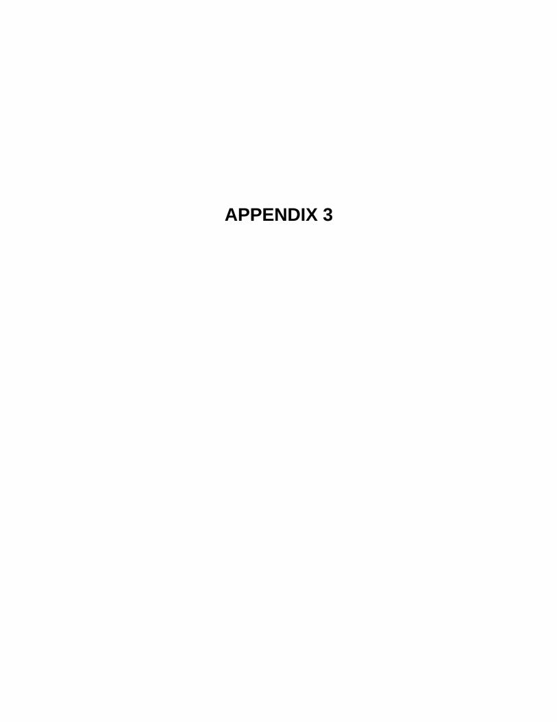
APPENDIX 3
92, 82 & 80 West Street Page 1 of 4 Rutland, VT Photos taken October 12, 2007
1. Subject area looking southwest (West Street)
3. Subject area looking along southern property boundary looking east
2. Subject area looking west (Wales Street)
4. Subject area looking along western property
boundary looking south

92, 82 & 80 West Street Page 2 of 4 Rutland, VT Photos taken October 12, 2007
5. Subject area looking northwest from VFW parking lot
7. Underground propane tanks
9. Subject area to the right looking east
6. Office space
8. Floor drain in old boiler room
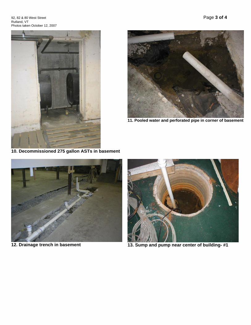
92, 82 & 80 West Street Page 3 of 4 Rutland, VT Photos taken October 12, 2007
10. Decommissioned 275 gallon ASTs in basement
12. Drainage trench in basement
11. Pooled water and perforated pipe in corner of basement
13. Sump and pump near center of building- #1
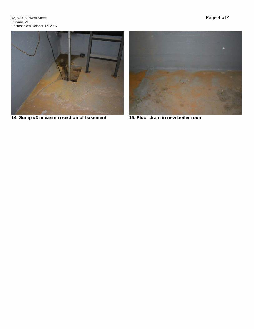
92, 82 & 80 West Street Page 4 of 4 Rutland, VT Photos taken October 12, 2007
14. Sump #3 in eastern section of basement
15. Floor drain in new boiler room

APPENDIX 4
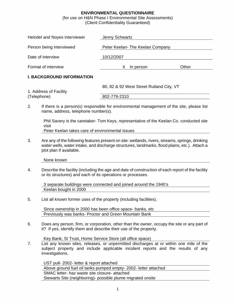
1
ENVIRONMENTAL QUESTIONNAIRE (for use on H&N Phase I Environmental Site Assessments)
(Client Confidentiality Guaranteed) Heindel and Noyes interviewer
Jenny Schwartz
Person being interviewed
Peter Keelan- The Keelan Company
Date of interview
10/12/2007
Format of interview
X
In person
Other
I. BACKGROUND INFORMATION 1. Address of Facility
80, 82 & 92 West Street Rutland City, VT
(Telephone) 802-779-2310 2. If there is a person(s) responsible for environmental management of the site, please list
name, address, telephone number(s).
Phil Savery is the caretaker- Tom Keys, representative of the Keelan Co. conducted site visit Peter Keelan takes care of environmental issues
3. Are any of the following features present on site: wetlands, rivers, streams, springs, drinking
water wells, water intake, and discharge structures, landmarks, flood plains, etc.). Attach a plot plan if available.
None known
4. Describe the facility (including the age and date of construction of each report of the facility
or its structures) and each of its operations or processes.
3 separate buildings were connected and joined around the 1940’s Keelan bought in 2000
5. List all known former uses of the property (including facilities).
Since ownership in 2000 has been office space- banks, etc Previously was banks- Proctor and Green Mountain Bank
6. Does any person, firm, or corporation, other than the owner, occupy the site or any part of
it? If yes, identify them and describe their use of the property.
Key Bank, SI Trust, Home Service Store (all office space) 7. List any known sites, releases, or unpermitted discharges at or within one mile of the
subject property and include applicable incident reports and the results of any investigations.
UST pull- 2002- letter & report attached Above ground fuel oil tanks pumped empty- 2002- letter attached SMAC letter- haz waste site closure- attached Stewarts Site (neighboring)- possible plume migrated onsite
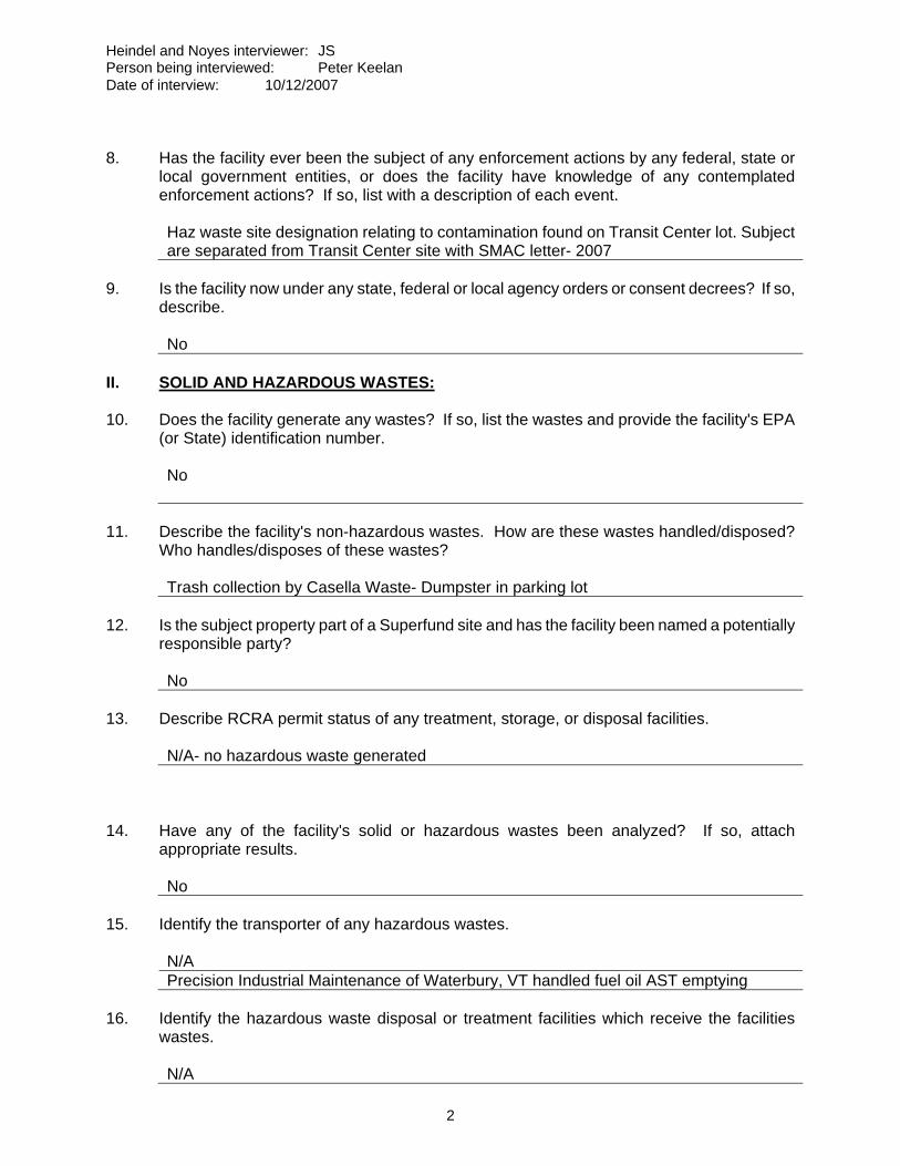
Heindel and Noyes interviewer: JS Person being interviewed: Peter Keelan Date of interview: 10/12/2007
2
8. Has the facility ever been the subject of any enforcement actions by any federal, state or
local government entities, or does the facility have knowledge of any contemplated enforcement actions? If so, list with a description of each event.
Haz waste site designation relating to contamination found on Transit Center lot. Subject are separated from Transit Center site with SMAC letter- 2007
9. Is the facility now under any state, federal or local agency orders or consent decrees? If so,
describe.
No II. SOLID AND HAZARDOUS WASTES: 10. Does the facility generate any wastes? If so, list the wastes and provide the facility's EPA
(or State) identification number.
No
11. Describe the facility's non-hazardous wastes. How are these wastes handled/disposed?
Who handles/disposes of these wastes?
Trash collection by Casella Waste- Dumpster in parking lot 12. Is the subject property part of a Superfund site and has the facility been named a potentially
responsible party?
No 13. Describe RCRA permit status of any treatment, storage, or disposal facilities.
N/A- no hazardous waste generated 14. Have any of the facility's solid or hazardous wastes been analyzed? If so, attach
appropriate results.
No 15. Identify the transporter of any hazardous wastes.
N/A Precision Industrial Maintenance of Waterbury, VT handled fuel oil AST emptying
16. Identify the hazardous waste disposal or treatment facilities which receive the facilities
wastes.
N/A
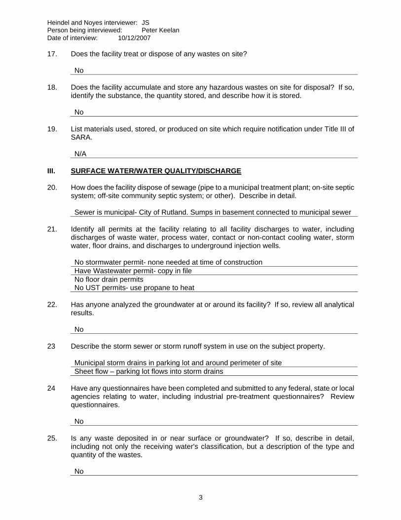
Heindel and Noyes interviewer: JS Person being interviewed: Peter Keelan Date of interview: 10/12/2007
3
17. Does the facility treat or dispose of any wastes on site?
No 18. Does the facility accumulate and store any hazardous wastes on site for disposal? If so,
identify the substance, the quantity stored, and describe how it is stored.
No 19. List materials used, stored, or produced on site which require notification under Title III of
SARA.
N/A III. SURFACE WATER/WATER QUALITY/DISCHARGE 20. How does the facility dispose of sewage (pipe to a municipal treatment plant; on-site septic
system; off-site community septic system; or other). Describe in detail.
Sewer is municipal- City of Rutland. Sumps in basement connected to municipal sewer 21. Identify all permits at the facility relating to all facility discharges to water, including
discharges of waste water, process water, contact or non-contact cooling water, storm water, floor drains, and discharges to underground injection wells.
No stormwater permit- none needed at time of construction Have Wastewater permit- copy in file No floor drain permits No UST permits- use propane to heat
22. Has anyone analyzed the groundwater at or around its facility? If so, review all analytical
results.
No 23 Describe the storm sewer or storm runoff system in use on the subject property.
Municipal storm drains in parking lot and around perimeter of site Sheet flow – parking lot flows into storm drains
24 Have any questionnaires have been completed and submitted to any federal, state or local
agencies relating to water, including industrial pre-treatment questionnaires? Review questionnaires.
No
25. Is any waste deposited in or near surface or groundwater? If so, describe in detail,
including not only the receiving water's classification, but a description of the type and quantity of the wastes.
No
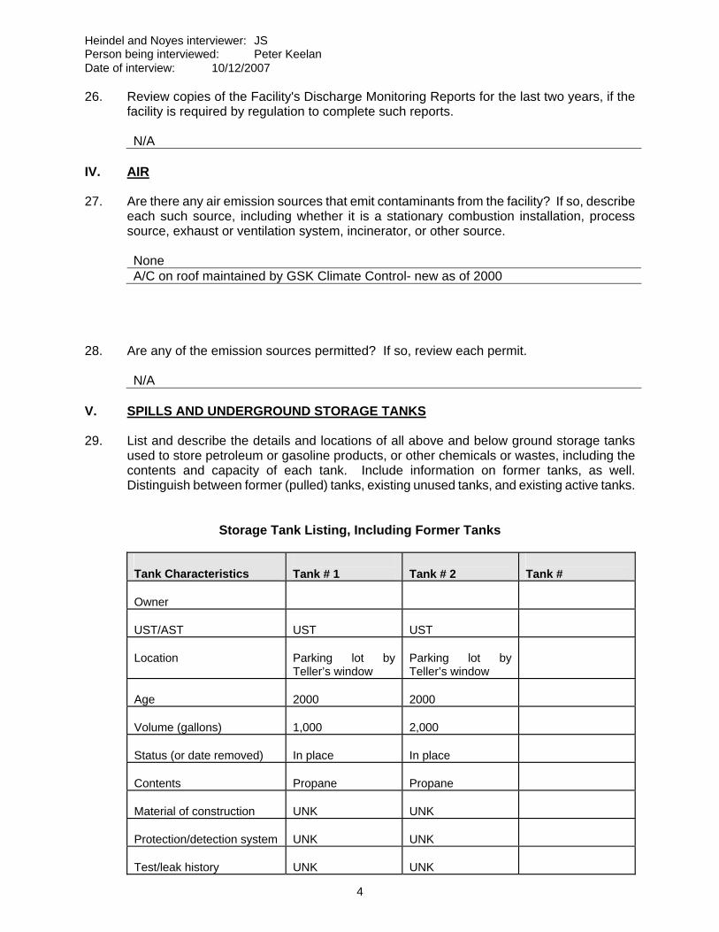
Heindel and Noyes interviewer: JS Person being interviewed: Peter Keelan Date of interview: 10/12/2007
4
26. Review copies of the Facility's Discharge Monitoring Reports for the last two years, if the facility is required by regulation to complete such reports.
N/A
IV. AIR 27. Are there any air emission sources that emit contaminants from the facility? If so, describe
each such source, including whether it is a stationary combustion installation, process source, exhaust or ventilation system, incinerator, or other source.
None A/C on roof maintained by GSK Climate Control- new as of 2000
28. Are any of the emission sources permitted? If so, review each permit.
N/A V. SPILLS AND UNDERGROUND STORAGE TANKS 29. List and describe the details and locations of all above and below ground storage tanks
used to store petroleum or gasoline products, or other chemicals or wastes, including the contents and capacity of each tank. Include information on former tanks, as well. Distinguish between former (pulled) tanks, existing unused tanks, and existing active tanks.
Storage Tank Listing, Including Former Tanks
Tank Characteristics
Tank # 1
Tank # 2
Tank #
Owner
UST/AST
UST
UST
Location
Parking lot by Teller’s window
Parking lot by Teller’s window
Age
2000
2000
Volume (gallons)
1,000
2,000
Status (or date removed)
In place
In place
Contents
Propane
Propane
Material of construction
UNK
UNK
Protection/detection system
UNK
UNK
Test/leak history
UNK
UNK

Heindel and Noyes interviewer: JS Person being interviewed: Peter Keelan Date of interview: 10/12/2007
5
Distance up/downgradient
30. List all permit numbers for underground storage tanks on site, even if they are not now in
service, and state whether any notification has been filed with the local, state or federal government concerning existence of those tanks.
UST pulled in 2002 No additional tanks known to be onsite
31. Have there been any leaks, spills, releases, or other discharges associated with any of
these tanks (existing or former)? If so, give full details, including the response taken and all analytical results or reports developed through investigation (whether internal or external), and the agencies which were involved.
UST- see attached report. 2 soil samples taken -> 69 ppm and 21000 ppm of unidentified petroleum hydrocarbon found SMAC issued for subject area. Site separated from Transit Center contamination ASTs in basement- emptied. No sampling of floor drain or surrounding concrete done
VI. POLYCHLORINATED BIPHENYLS ("PCBs") 32. Review any records the facility has concerning any on-site PCBs or PCB equipment,
whether produced as a by-product of a manufacturing process or otherwise. (PCBs are generally associated with transformers, capacitors, circuit breakers, voltage regulators, switches, cables, hydraulic equipment, pneumatic equipment, heat exchange equipment, or hydraulic elevator lifts).
None
33. Have there been any known PCB spills, discharges, or other accidents? If so, describe all
the circumstances.
No VII. ASBESTOS 34. Does the facility contain any known asbestos containing materials? If so, list and
differentiate between friable and non-friable ACMs.
Possibly. Never tested. Floor tiles in basement appear to contain asbestos. Age of buildings supports this.
VIII. OTHER 35. Describe the use and disposal of pesticides on the subject property by type.
N/A 36. Describe any pesticide manufacturing which takes place on site.
N/A
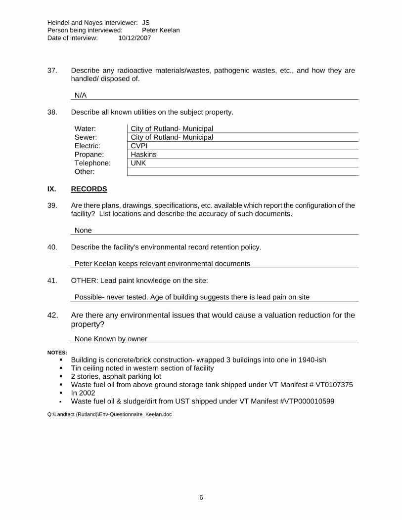
Heindel and Noyes interviewer: JS Person being interviewed: Peter Keelan Date of interview: 10/12/2007
6
37. Describe any radioactive materials/wastes, pathogenic wastes, etc., and how they are
handled/ disposed of.
N/A 38. Describe all known utilities on the subject property.
Water: City of Rutland- Municipal Sewer: City of Rutland- Municipal Electric: CVPI Propane: Haskins Telephone: UNK Other:
IX. RECORDS 39. Are there plans, drawings, specifications, etc. available which report the configuration of the
facility? List locations and describe the accuracy of such documents.
None 40. Describe the facility's environmental record retention policy.
Peter Keelan keeps relevant environmental documents 41. OTHER: Lead paint knowledge on the site:
Possible- never tested. Age of building suggests there is lead pain on site 42. Are there any environmental issues that would cause a valuation reduction for the
property?
None Known by owner NOTES:
Building is concrete/brick construction- wrapped 3 buildings into one in 1940-ish Tin ceiling noted in western section of facility 2 stories, asphalt parking lot Waste fuel oil from above ground storage tank shipped under VT Manifest # VT0107375 In 2002 Waste fuel oil & sludge/dirt from UST shipped under VT Manifest #VTP000010599
Q:\Landtect (Rutland)\Env-Questionnaire_Keelan.doc

APPENDIX 5
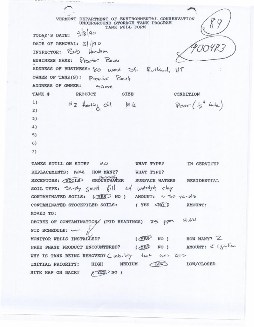
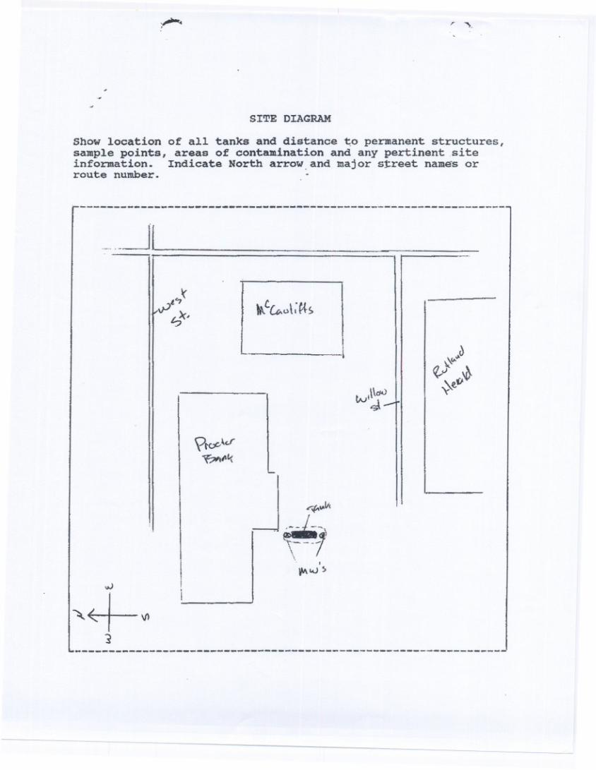
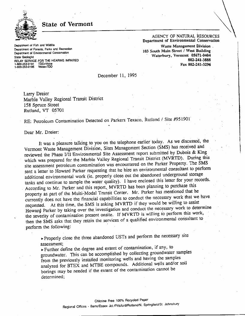
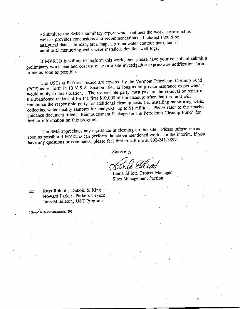
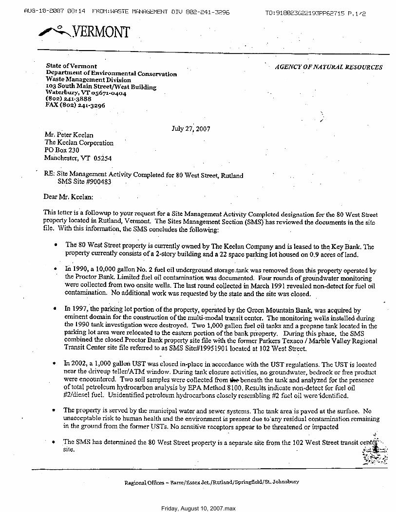
Friday, August 10, 2007.max

Friday, August 10, 2007.max
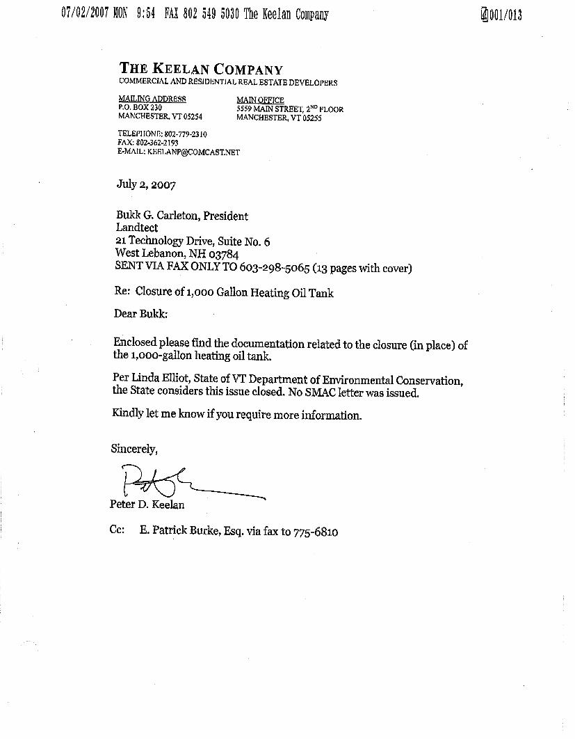
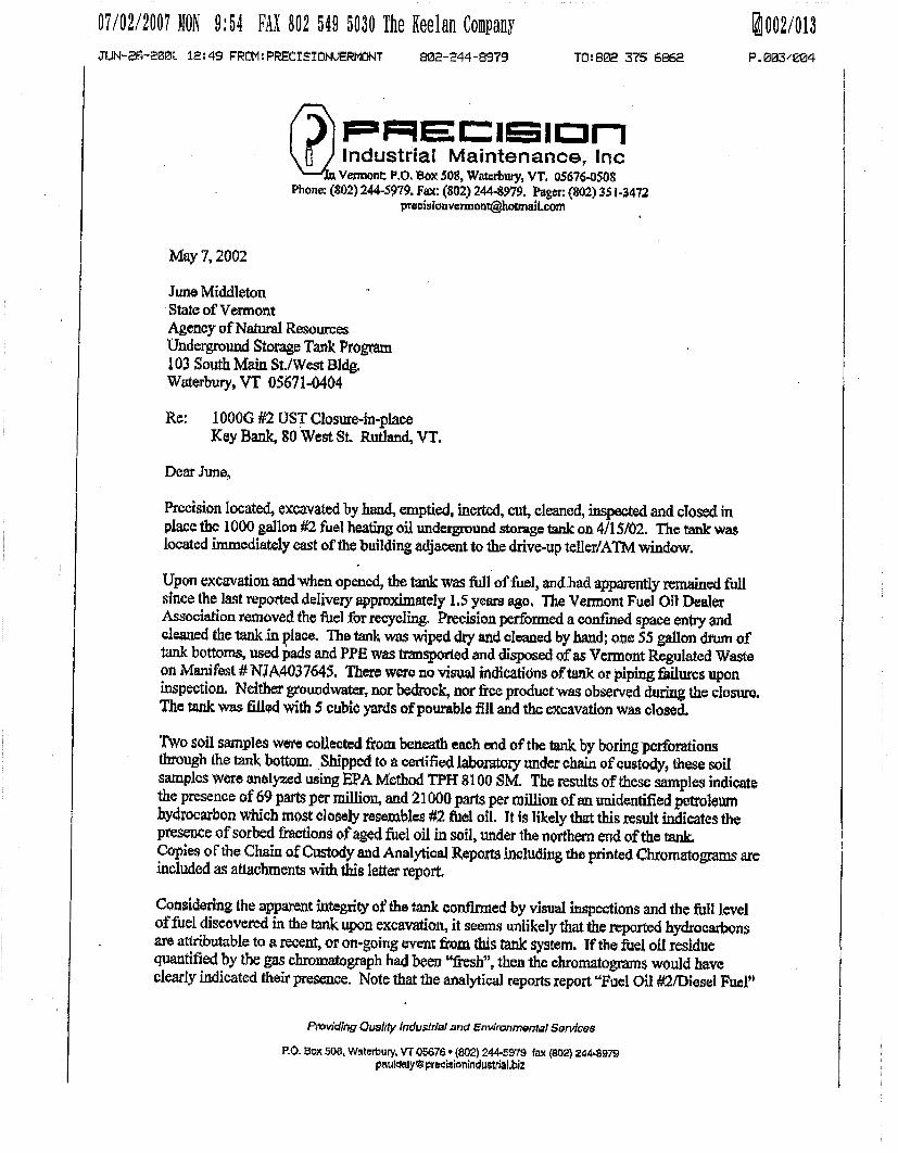
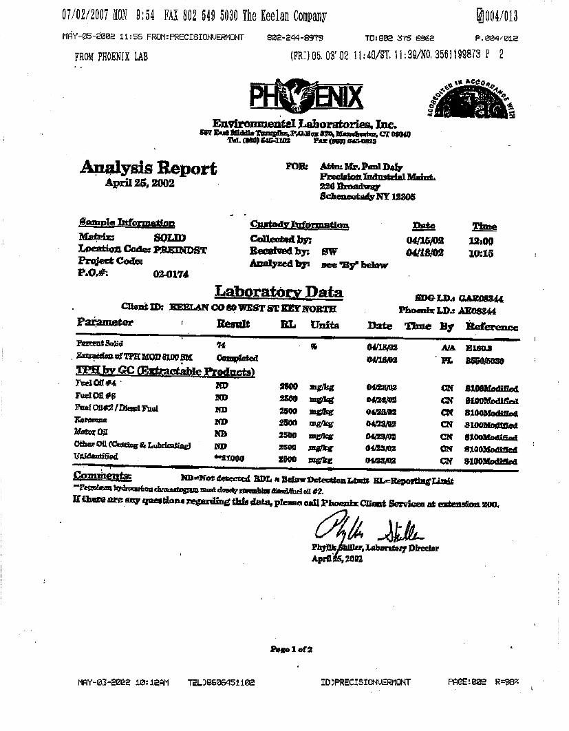

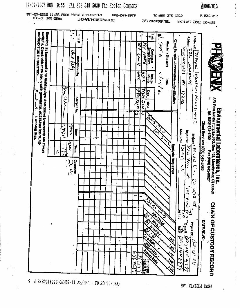


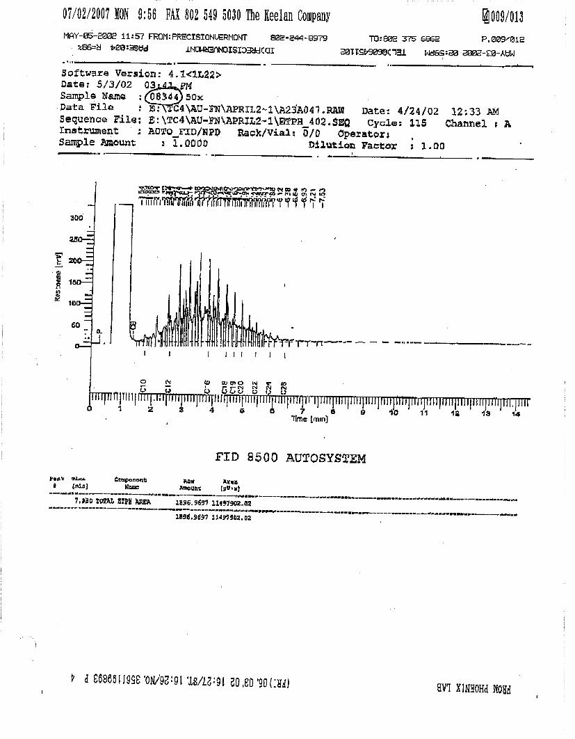
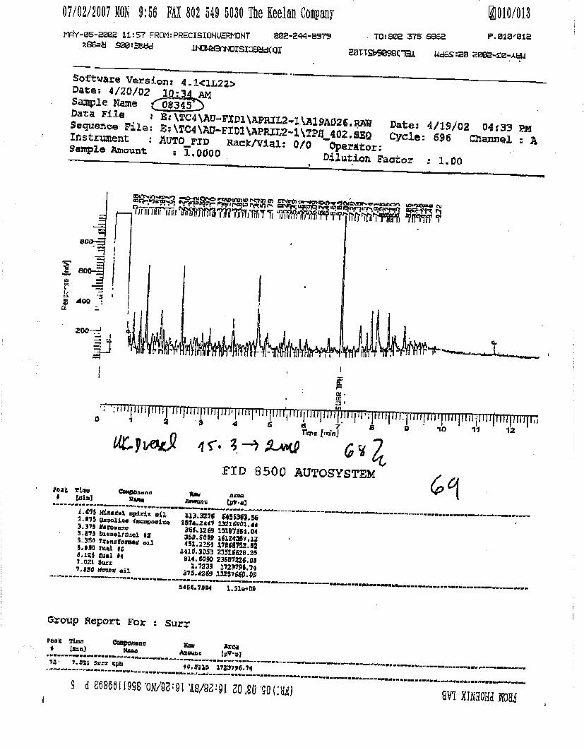
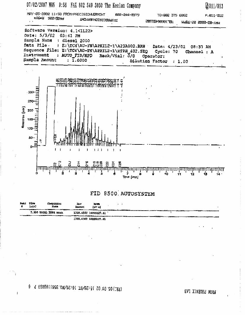
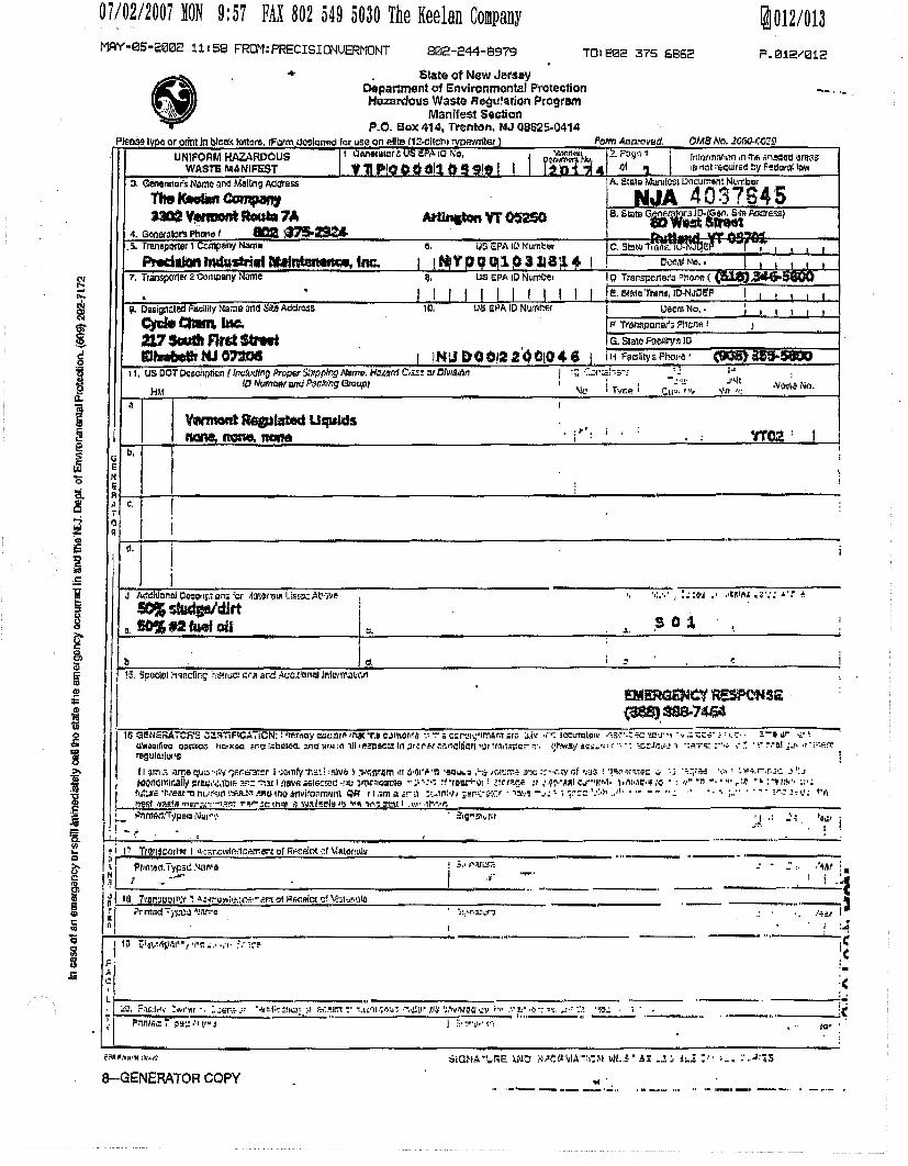


Thursday, August 25, 2005.max
Thursday, August 25, 2005.max
Thursday, August 25, 2005 (2).max
Thursday, August 25, 2005 (2).max
Thursday, August 25, 2005 (2).max

APPENDIX 6


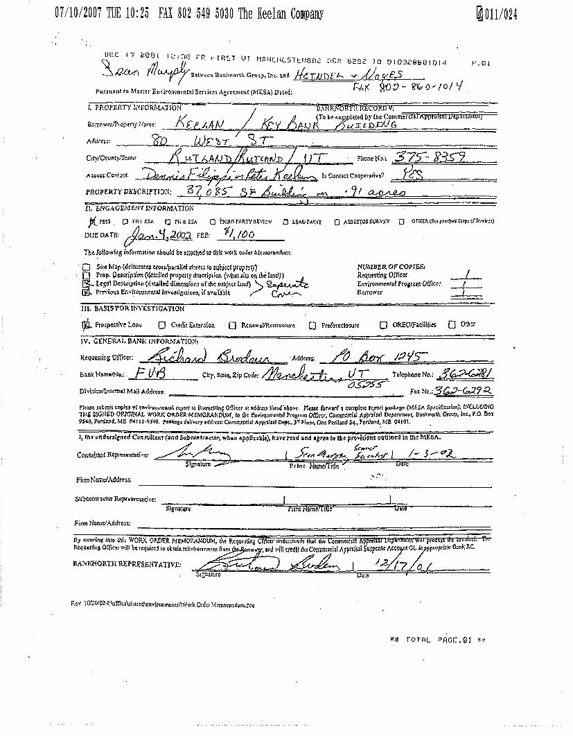
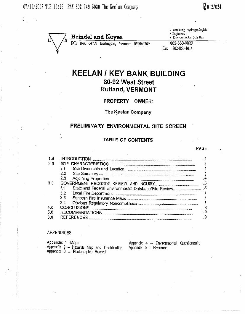
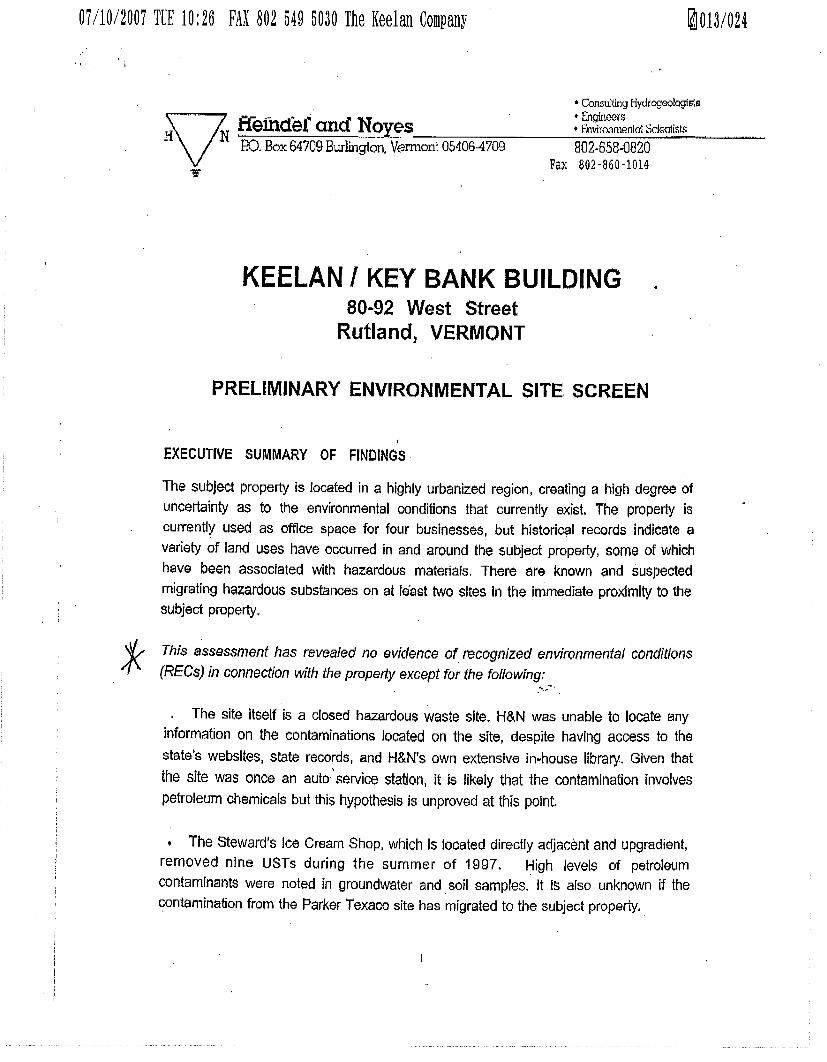
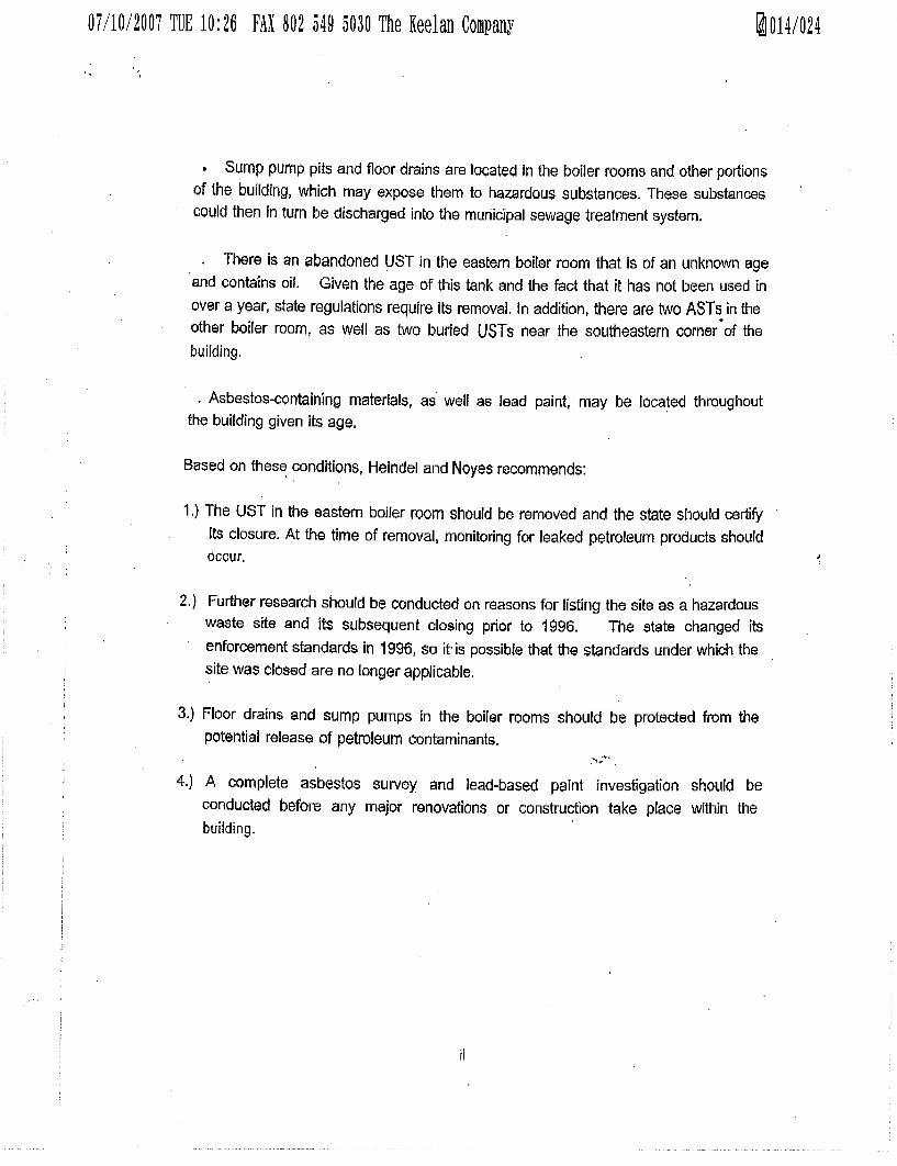
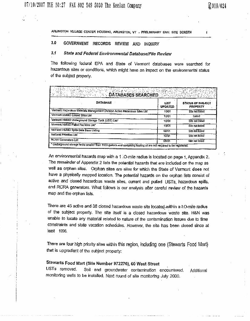


APPENDIX 7
Regional Offices – Barre/Essex Jct./Rutland/Springfield/St. Johnsbury
AGENCY OF NATURAL RESOURCES
October 15, 2007 Mr. Bukk Carleton PG Apartments Limited Partnership 21 Technology Drive, Suite #6 West Lebanon, NH 03784 RE: Clarification of Petroleum Cleanup Fund at Stewart’s Shop, 60 West Street, Rutland Dear Mr. Carleton: This letter is a follow up to my previous letter I sent you on October 11, 2007. Since the letter, it has come to my attention that clarification is needed on the liability of the petroleum contamination at the 60 West Street property currently owned and operated by Stewart’s Shop (Stewart’s). As my previous letter stated, the Sites Management Section (SMS is part of the Waste Management Division, Vermont Agency of Natural Resources) will continue to direct Stewart’s to monitor and report site conditions to the SMS in a timely manner. Stewart’s has been complying with this requirement since the discovery of the release. If it is discovered that the Stewart’s petroleum plume (contamination) has migrated offsite to adjacent properties, including the 80 West Street property, the SMS will direct Stewart’s to investigate the degree and extent and initiate appropriate corrective action. It is the responsibility of Stewarts to perform this work and seek reimbursement from the PCF. It will not be the responsibility of the owners of the 80 West Street property. Please be advised that any offsite work requires prior approval from the SMS as well as property access permission from the impacted property owner. The SMS would request that the impacted property owner grant site access to appropriate parties (such as Stewart’s environmental consultant) to carry out the necessary work. Currently, Stewart’s is participating in the PCF which includes Third Party Claim coverage. The SMS has been involved with many projects like this and has developed a number of guidance documents and procedures to assist property owners. These documents are available online at http://www.anr.state.vt.us/dec/wastediv/sms/smsgdint.htm including “Policies and Procedures Manual For Third-Party Claims Against The Petroleum Cleanup Fund. We are fortunate here in Vermont that we have a viable PCF. I hope this additional information helps you with your decision on the 60 West Street, Rutland property. If you have any additional questions then please feel free to contact me at 802-241-3897 or electronically at [email protected]. Sincerely,
Linda Elliott, Project Manager Sites Management Section c: Marcy Montana, via electronically K:site.files\1997.2276.Stewarts.Shop\2007\1015.elliott.carleton.PCF.inquiry.let.pdf
State of Vermont Department of Environmental Conservation Waste Management Division 103 South Main Street/West Building Waterbury, VT 05671-0404 (802) 241-3888 FAX (802) 241-3296 [email protected]

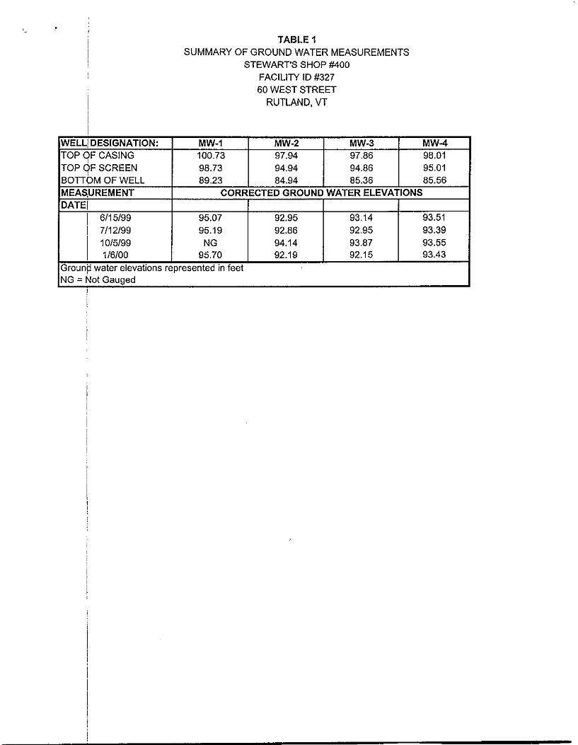
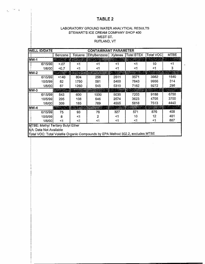
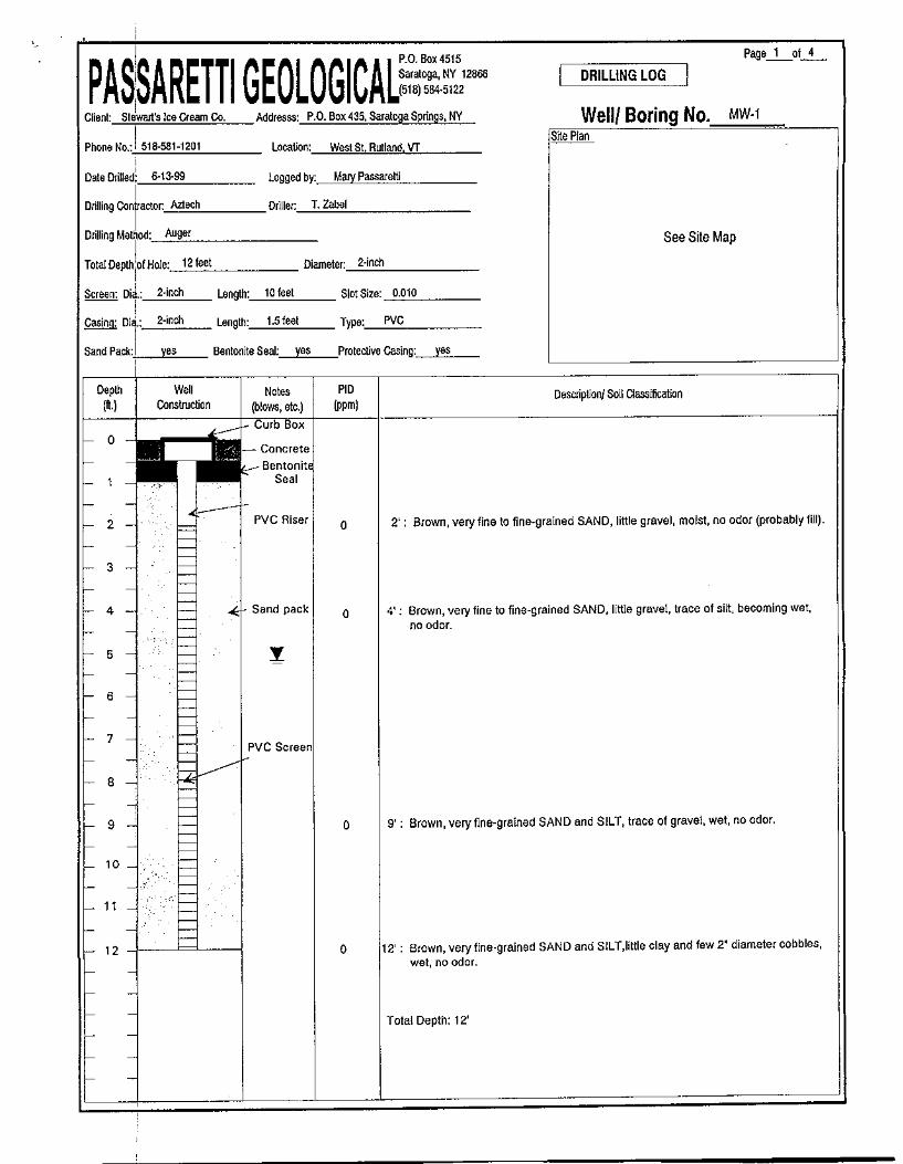

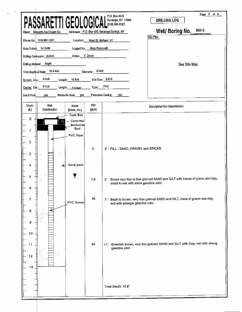
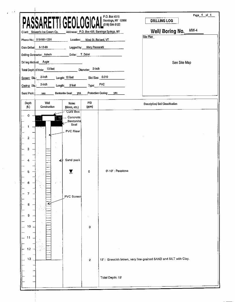


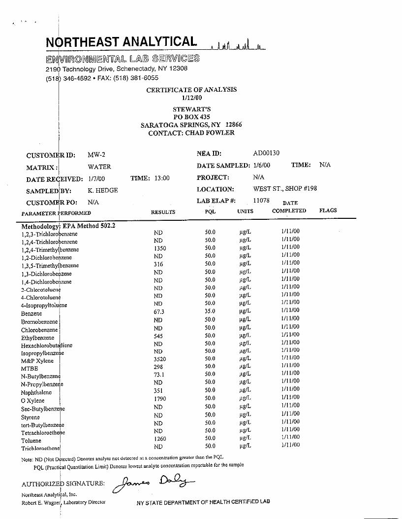
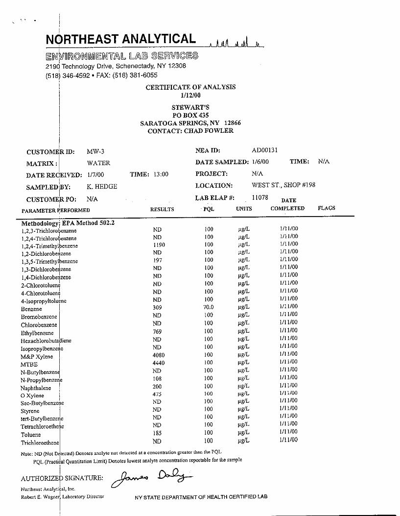

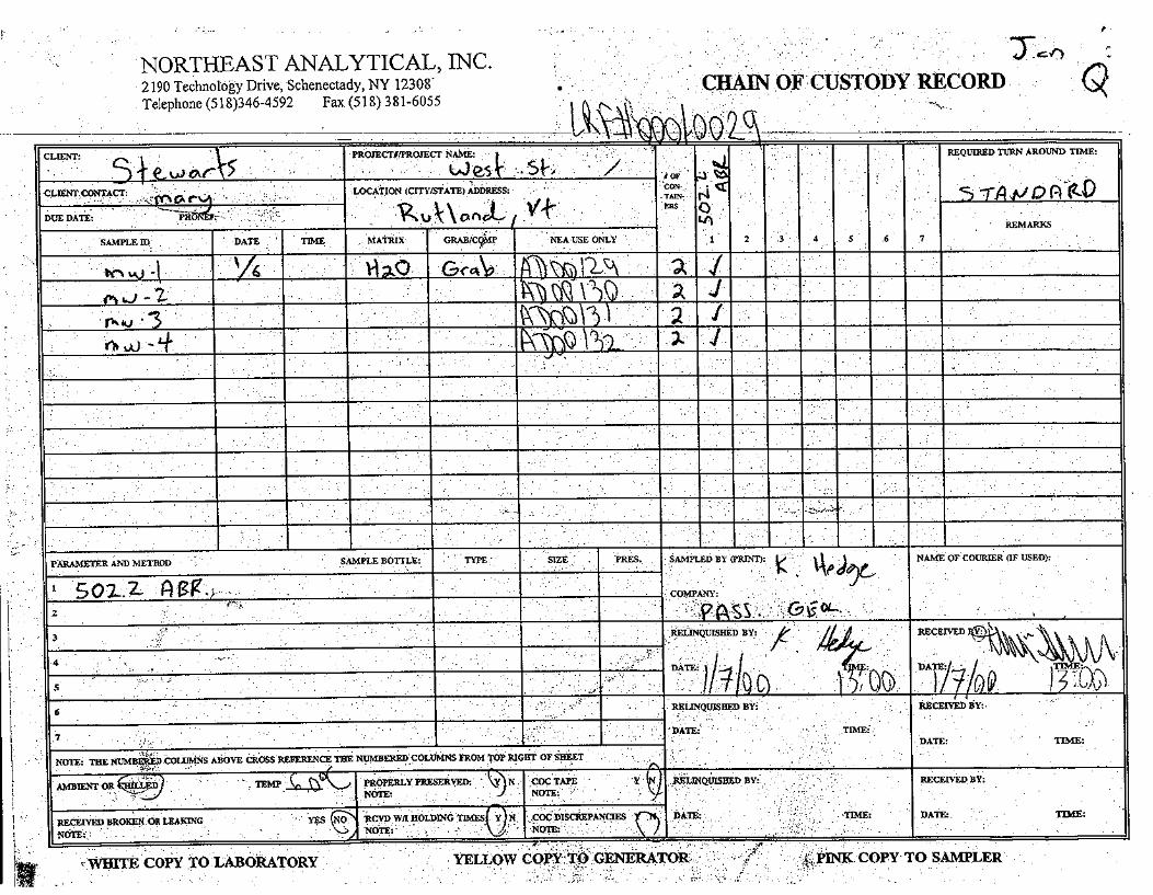
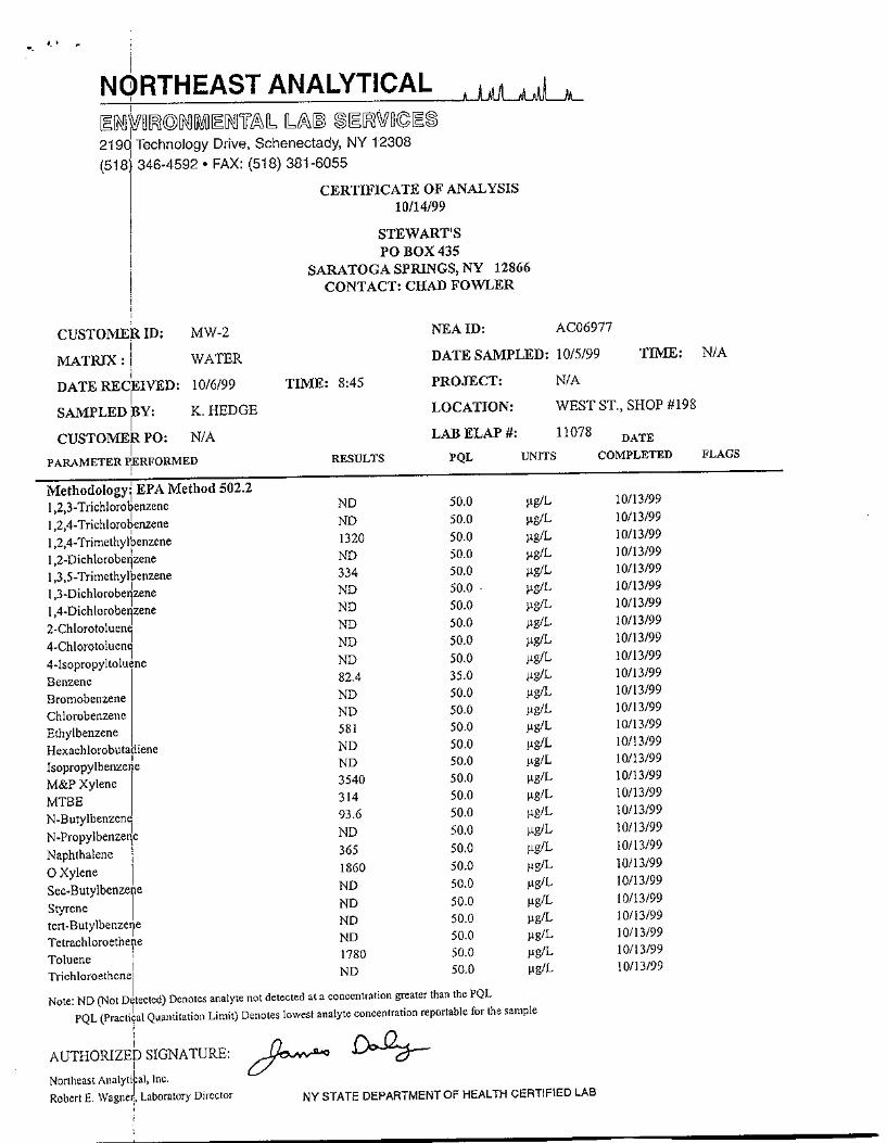
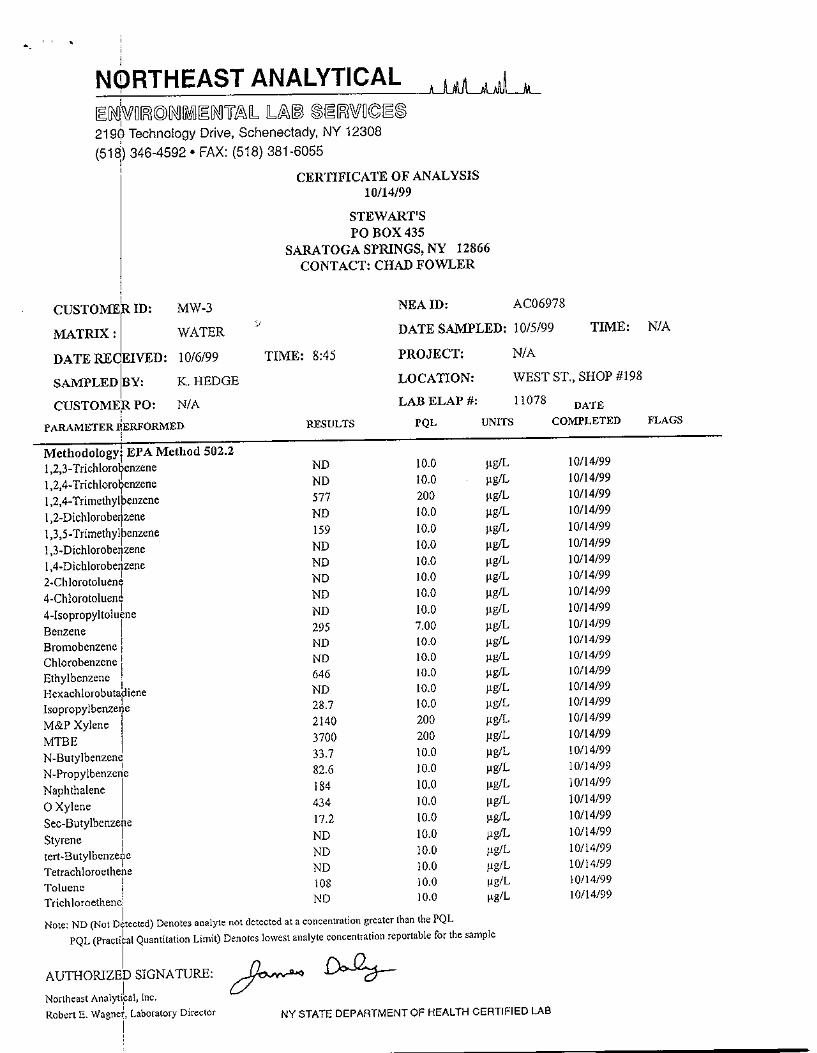


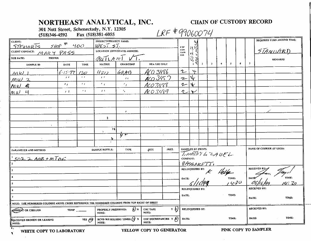

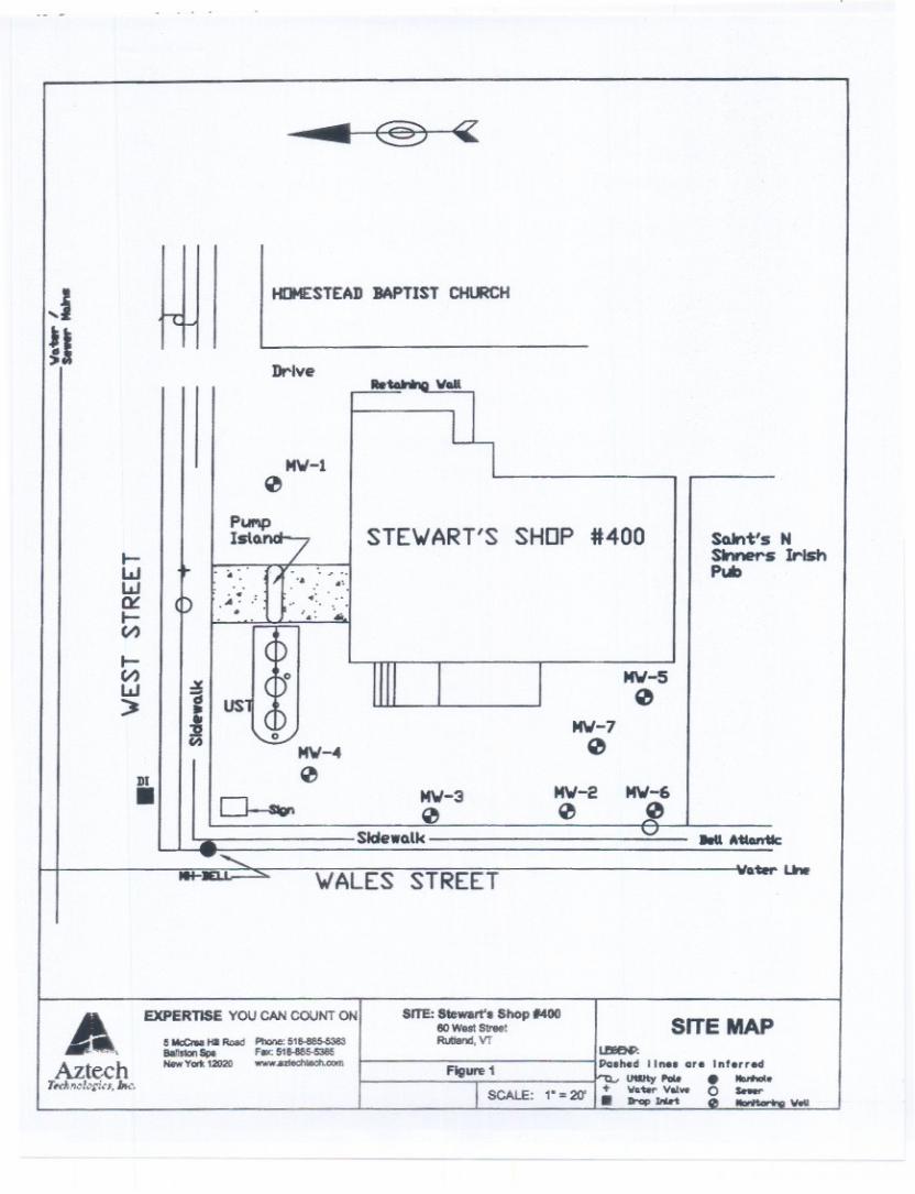
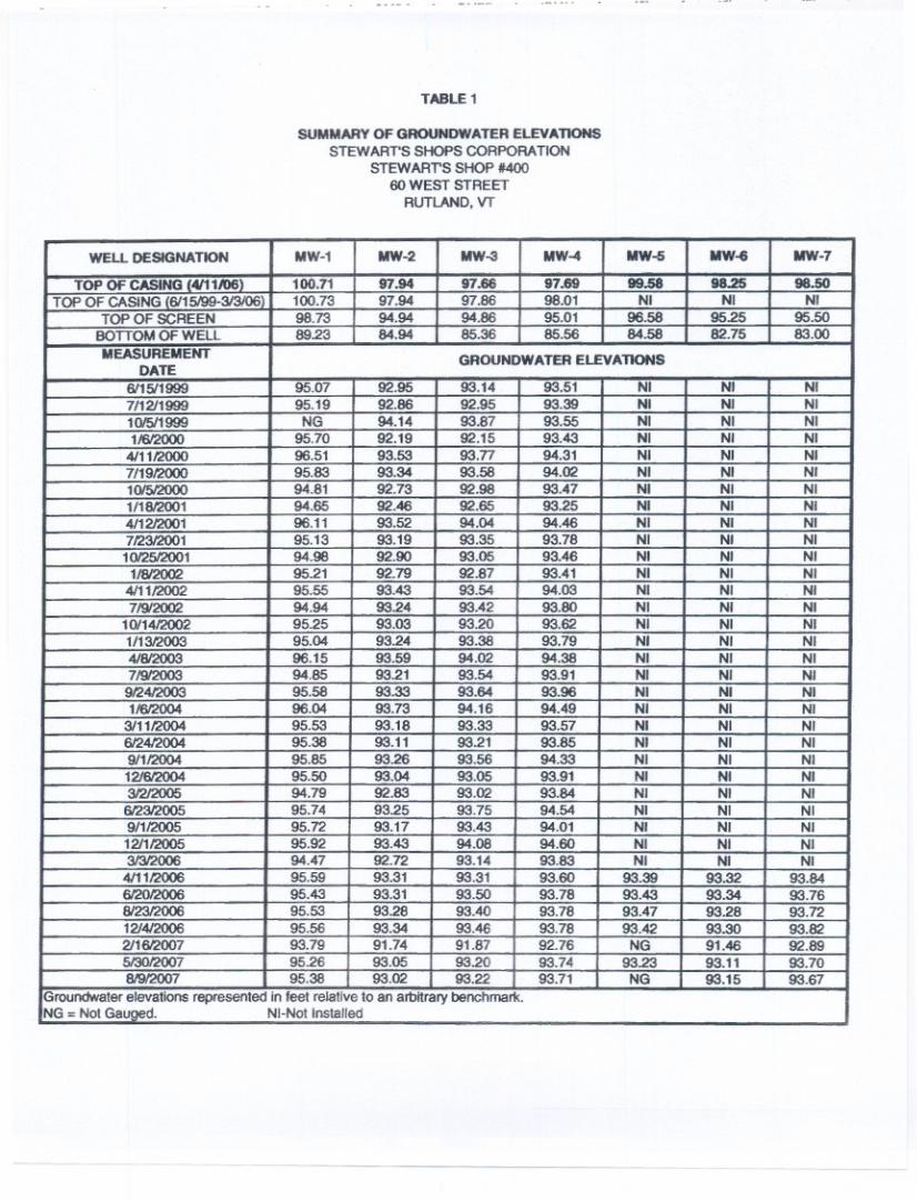
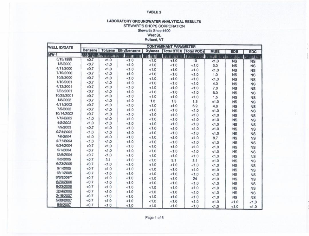
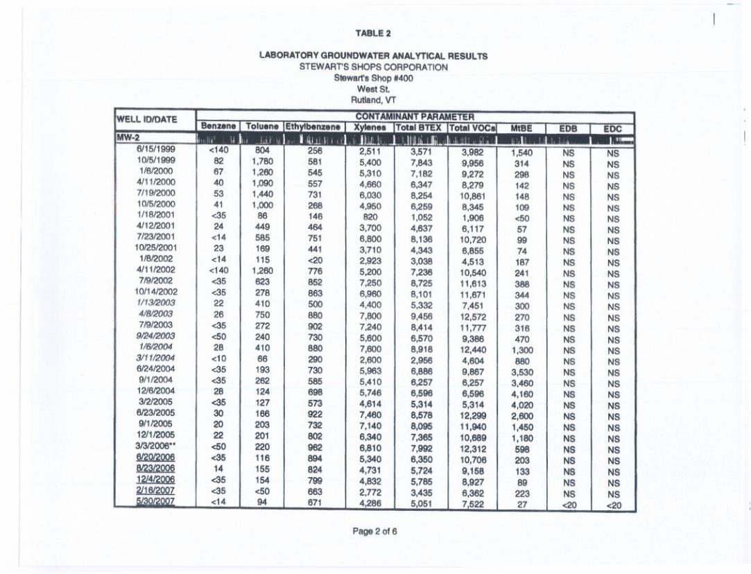
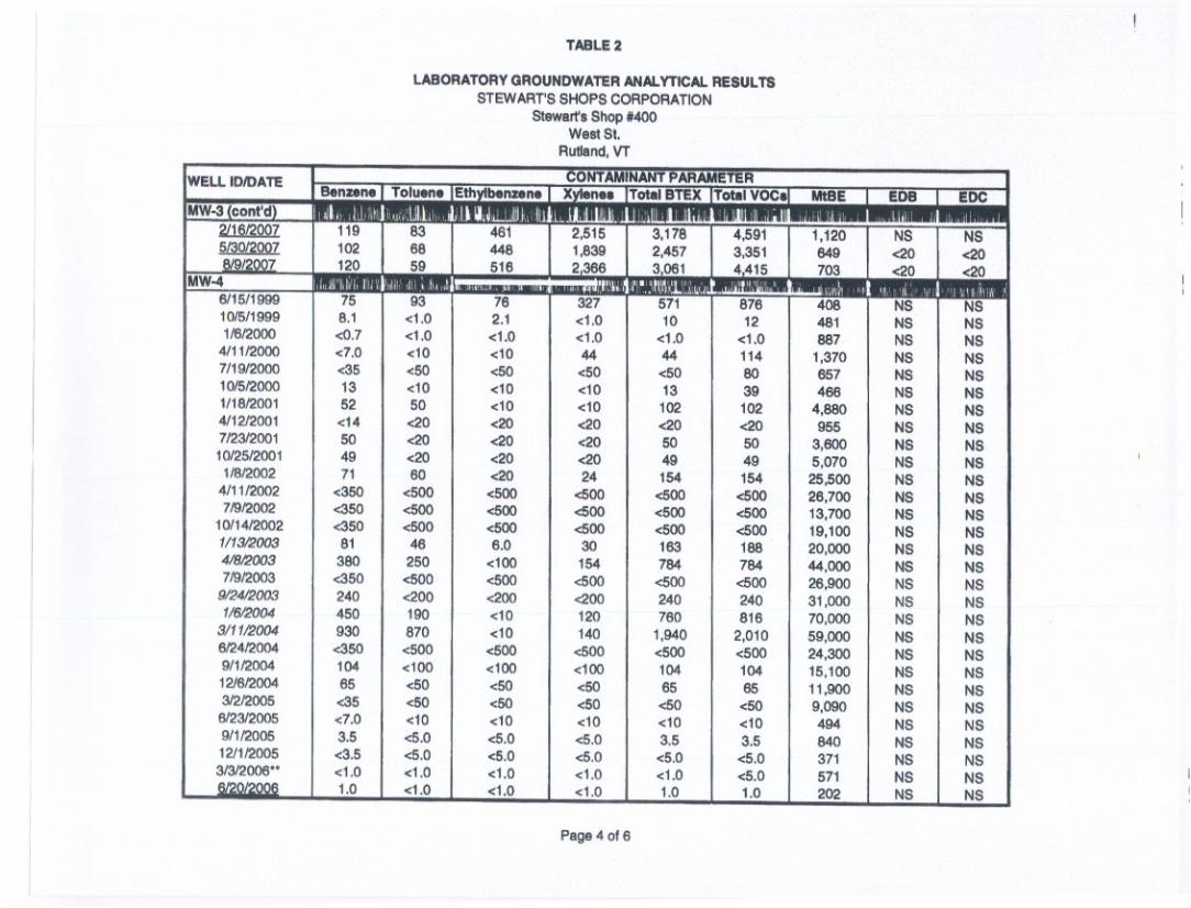

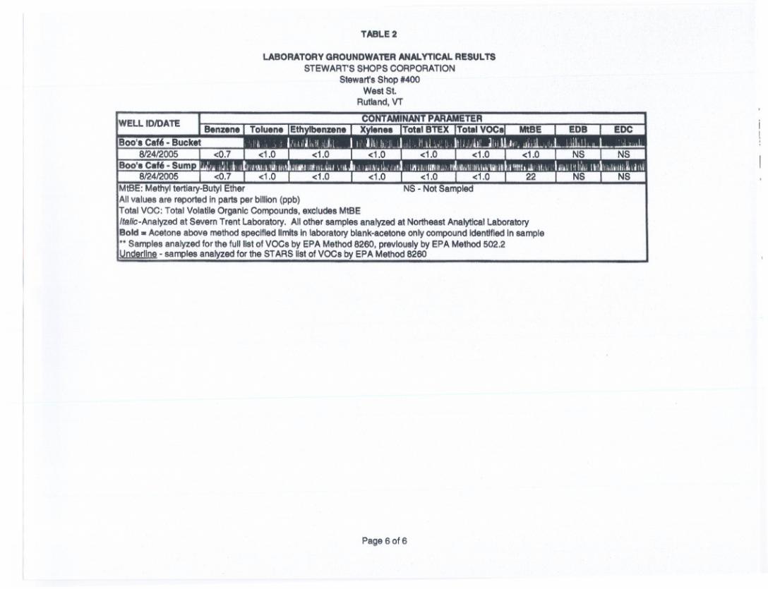
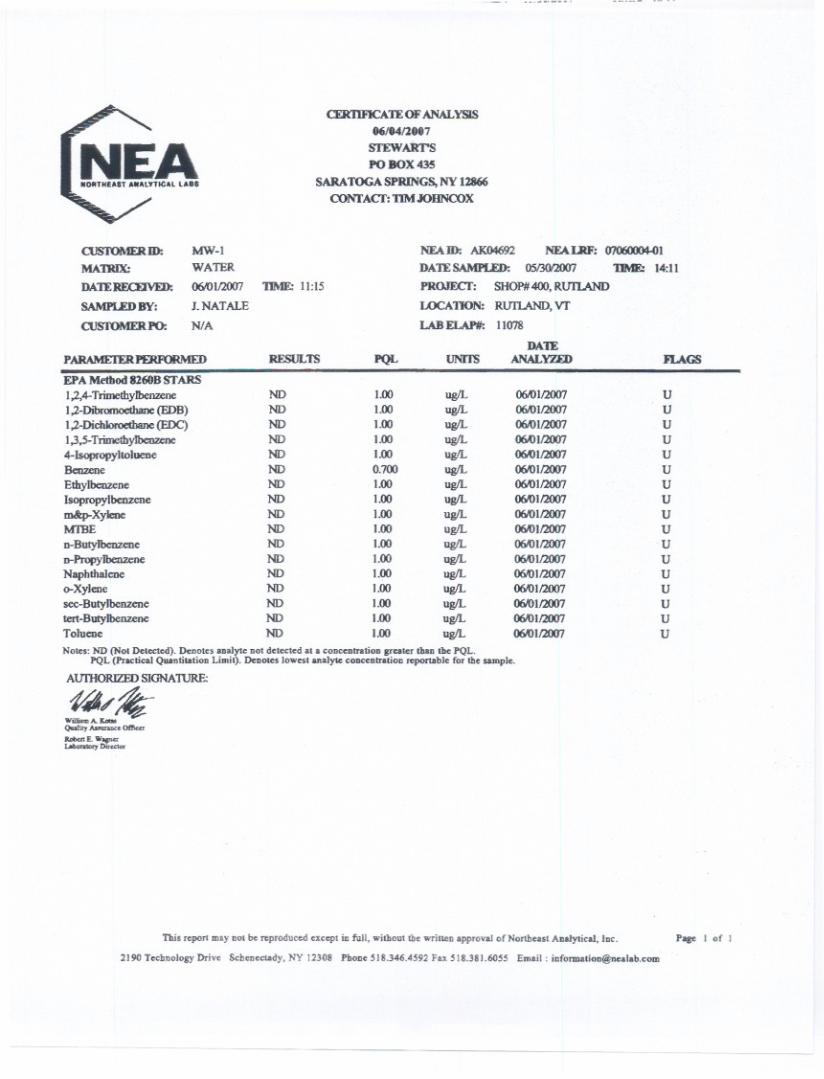
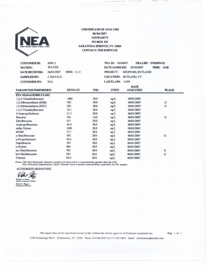
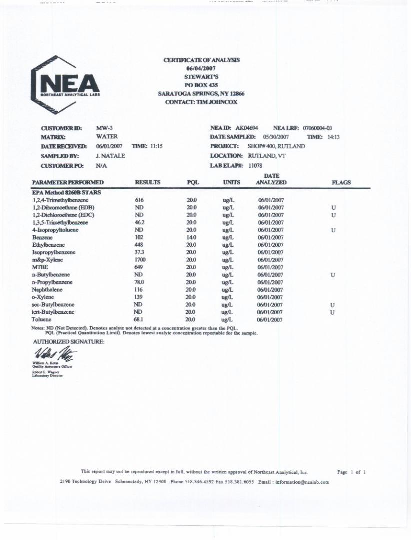
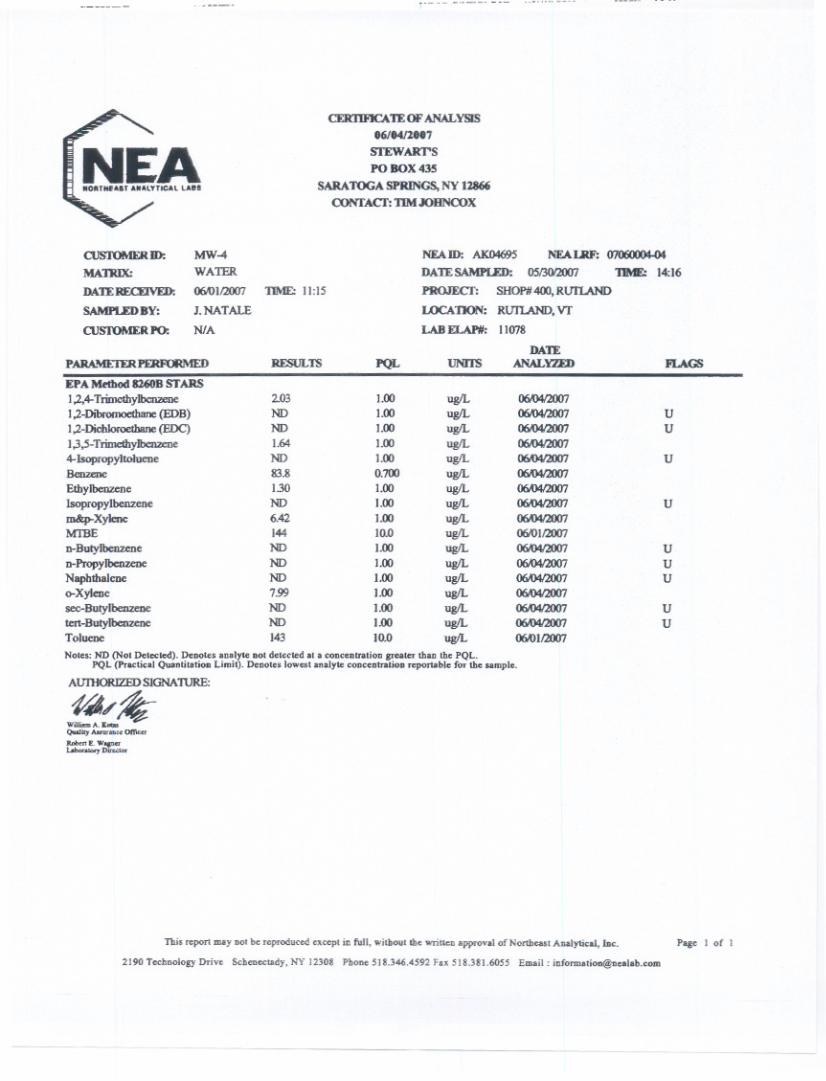

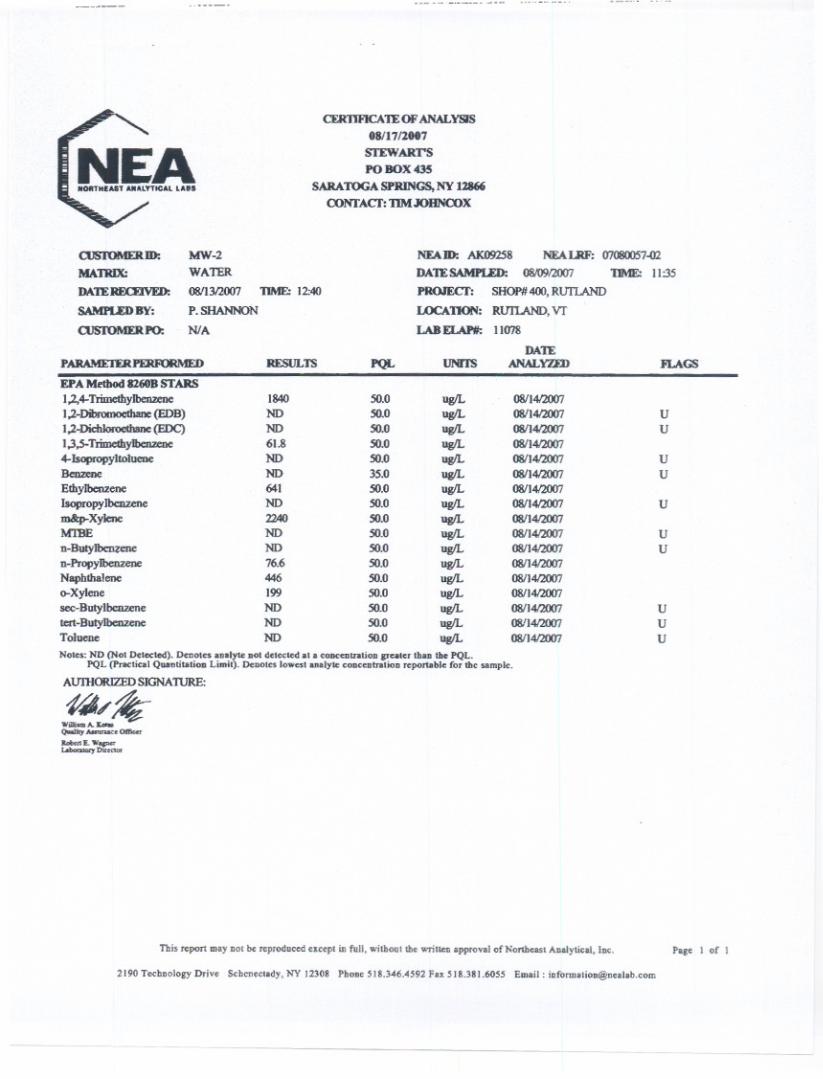
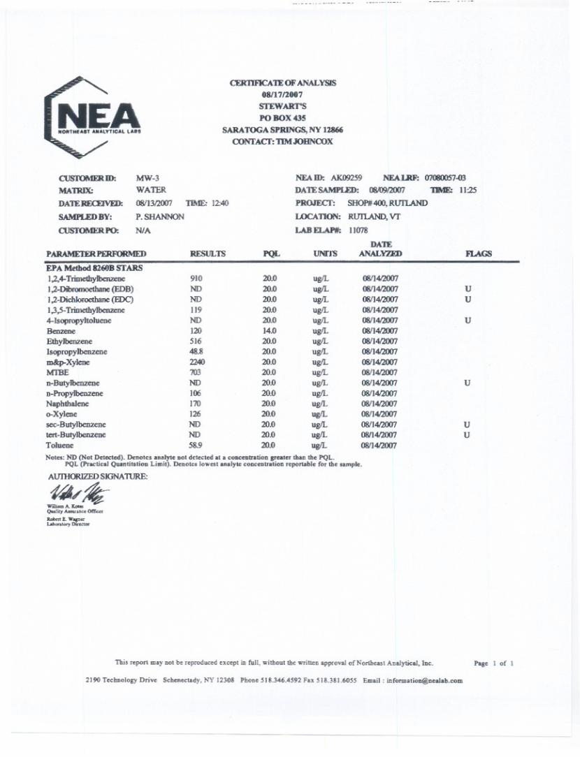
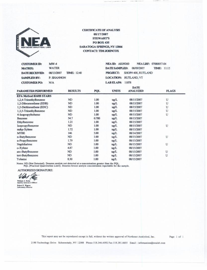
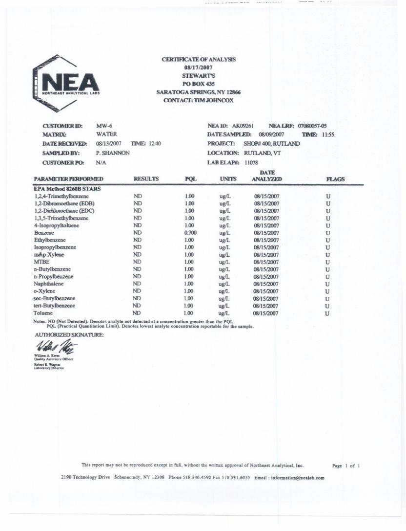
APPENDIX 8

1
References: City of Rutland Vermont. Town Clerk Webpage. (2007) Retrieved October 2007, from
http://rutland.govoffice.com/ Materials provided by Bukk Carleton: State of Vermont water supply/wastewater permit: 2007 Previous environmental reports- Merchants Bank 2/17/2004, Banknorth 1/3/2002 Documents relating to 1,000-gallon UST- site map, SMAC (2007),
report/investigation by Precision Industrial Maintenance, Inc. (2002) Quarterly report/investigation- Stewart’s (60 West St): 9/14/2007 Due diligence materials: Tax bills- current and prior 2 fiscal periods, brief listing of
capital improvements on site, Title insurance policy, Certified rent roll, Utility bills (water, electric, propane)
VT Division of Fire Safety- final certificates of occupancy Materials provided by Peter Keelan: Survey Floor Plans Location Map: 8/2005 Clarification of Petroleum Cleanup Fund at Stewart’s (60 West St)” 10/15/2007
Sanborn Map& Publishing Company. Rutland Vermont- Rutland County. New York, NY: Sanborn-Perris Map Co. Limited. October 1879. p. 3, 2
Sanborn Map& Publishing Company. Rutland Vermont- Rutland County. New York, NY: Sanborn-Perris Map Co. Limited. March 1885. p. 5, 4
Sanborn Map& Publishing Company. Rutland Vermont- Rutland County. New York, NY: Sanborn-Perris Map Co. Limited. October 1890. p. 7, 8
Sanborn Map& Publishing Company. Rutland Vermont- Rutland County. New York, NY: Sanborn-Perris Map Co. Limited. December 1895. p. 6, 7
Sanborn Map& Publishing Company. Rutland Vermont- Rutland County. New York, NY: Sanborn-Perris Map Co. Limited. October 1900. p. 8, 9
Sanborn Map& Publishing Company. Rutland Vermont- Rutland County. New York, NY: Sanborn-Perris Map Co. Limited. November 1905. p. 10, 11
Sanborn Map& Publishing Company. Rutland Vermont- Rutland County. New York, NY: Sanborn-Perris Map Co. Limited. August 1910. p. 22, 23
Sanborn Map& Publishing Company. Rutland Vermont- Rutland County. New York, NY: Sanborn-Perris Map Co. Limited. March 1916. p. 19, 20

2
Sanborn Map& Publishing Company. Rutland Vermont- Rutland County. New York, NY: Sanborn-Perris Map Co. Limited. April 1925. p. 3, 6
Sanborn Map& Publishing Company. Rutland Vermont- Rutland County. New York, NY: Sanborn-Perris Map Co. Limited. April 1925 - April 1945. p. 3, 6, 7
State of Vermont Department of Environmental Conservation. Vermont Hazardous Materials Management Division. Active Hazardous Sites List (5/2007), Closed Sites List (5/2007), Underground Storage Tank (UST) List (5/2007), Pulled Facilities List (5/2007), RCRA Generators List (5/2007), RCRA Manifests (8/2006), Potential Source of Groundwater Pollution (1980).
State of Vermont Department of Environmental Conservation. Vermont Hazardous
Materials Management Division. First Letter- MVRTD Site #951501 (1995). Stewart’s Ice Cream Shop #400 Phase II (Updated 2000). NET Rutland (Site #931487) First letter, First report, SMAC. Old Woolworth Building (Site #931366) First letter, First report.
Plan of Rutland Co., Vermont. Beers Atlas. New-York: H.W. Burgett & Co. 1876. Rutland County Soil Survey. USDA Natural Resources Conservation Service. Issued
1998. U.S. Environmental Protection Agency. (2007), Envirofacts Data Warehouse. Retrieved
October 2007, from http://www.epa.gov/enviro/html/multisystem_query_java.html
GIS Data:
Bedrock Geology: Digitized by Heindel & Noyes from 1:62500 Vermont bedrock geology base maps (1956-1966)
E911: E911 Site locations (Enhanced 9-1-1 Site locations). [Computer file]. Montpelier, VT. Enhanced 9-1-1 Board. March 2007.
FEMA Floodplain: FEMA NFIP Q3 digital data. Rutland City. Community number 500101 Panel 0001C Effective date 4/17/78.
Groundwater Protection Areas: Groundwater Protection Areas. [Computer file]. Waterbury, VT: State of Vermont. August 2006.
Hazards: State of Vermont Department of Environmental Conservation. Vermont Hazardous Materials Management Division. Active Hazardous Sites List (5/2007), Closed Sites List (5/2007), Underground Storage Tank (UST) List (5/2007), Pulled Facilities List (5/2007), RCRA Generators List (5/2007), RCRA Manifests (8/2006), Potential Source of Groundwater Pollution (1980).
3
Hazards: U.S. Environmental Protection Agency. (2007), Envirofacts Data Warehouse
(Superfund Sites). Retrieved June 2007, from http://www.epa.gov/enviro/html/multisystem_query_java.html
Orthophotos: State of Vermont Orthophotography [Computer file]. Montpelier, VT: Vermont Department of Taxes, 1994.
National Agriculture Imagery Program (NAIP)[Computer file]. Salt Lake City, UT: USDA Farm Service Agency Aerial Photography Field Office, 2003
Parcel Boundaries: Rutland City Digital Parcel Data. [Computer file]. Rutland, VT: City of Rutland, 2002.
Roads: Road centerlines from RF 5000 Orthophotos and GPS. [Computer file]. Montpelier, VT. VT Agency of Transportation (VTrans). January 2007.
Soils: Natural Resource Conservation Service County Soil Survey. [Computer file]. Waterbury, VT: The Vermont Center for Geographic Information, Inc. August 11, 1992.
Source Well. Source Well. [Computer file]. Waterbury, VT: State of Vermont. August 2006.
Subject area: Derived from Rutland City Digital Parcel Data. [Computer file]. Rutland, VT: City of Rutland, 2002.
Surface Water: The National Hydrography Dataset. [Computer file]. Waterbury, VT: The Vermont Center for Geographic Information, Inc. June 3, 2003.
Surface Water Protection Areas: Surface Water Protection Areas. [Computer file]. Waterbury, VT: State of Vermont. August 2006.
Surficial Geology: Digitized by Heindel & Noyes from 1:62500 Vermont surficial geology base maps (1956-1966)
Town Boundaries: Vermont Town Boundaries at RF 24,000. [Computer file]. Waterbury, VT. The Vermont Center for Geographic Information, Inc. 2002.
USGS: United States Geological Survey Rutland Vermont Quadrangle. [Computer file]. Waterbury, VT: The Vermont Center for Geographic Information, Inc. March 1999. USGS Quadrangle Number 23.
Wetlands: Vermont Significant Wetlands Inventory. [Computer file]. Waterbury, VT: The Vermont Center for Geographic Information, Inc. 2006.
4
National Wetland Inventory. [Computer file]. Waterbury, VT: The Vermont Center for Geographic Information, Inc. 1983.
U:\Projects\Phase 1s\Landtect (Rutland)\references_80 West St.doc

APPENDIX 9
Heindel & Noyes, Inc. P.O. Box 4503 Burlington, VT 05406-4503
§ Consulting Hydrogeologists § Engineers § Environmental Scientists
Voice 802-658-0820/Fax 802-860-1014
CORPORATE PROFILE OF
HEINDEL & NOYES Heindel & Noyes was founded in 1972 (predecessor firms: Wagner, Heindel & Noyes, Inc. and Environmental Associates). Through the 1970’s and early 1980’s, the firm operated as a specialty environmental geology consulting firm, offering hydrogeologic, geophysical, and mapping services. In the mid-1980’s we substantially increased our consulting portfolio, adding wetland ecology, surface water hydrology, wildlife ecology, professional engineering, hazardous waste management, water supply development, geochemistry, fisheries, and computer science and graphic services. We currently have a staff of 23. In 1987 we founded an EPA-certified lab (Endyne, Inc.) which provides environmental testing services throughout New England and New York. Endyne offers a full complement of environmental testing of water, soil, and waste materials. Endyne is now an independent laboratory providing core support to Heindel and Noyes. In 1990 we launched New England Air Quality Testing (NEAQT), a full-service consulting group comprised of environmental engineers, chemists, and certified industrial hygienists. NEAQT is a wholly-owned subsidiary of H & N, and operates throughout New England and New York offering indoor air quality testing, stack testing, and ambient air testing. Information and Visualization Services (IVS) was founded in 1994. It provides geographic information system (GIS) analyses, high-end graphics, and computer-aided design and programming services, including 3-D visualizations of buildings, landscapes, and environmental phenomena. IVS has developed a 150-gigabyte library of environmental databases covering the states of Vermont and New Hampshire, and also offers Property Screening Services (PSS), a low-cost environmental audit protocol. IVS is a wholly owned subsidiary of H&N, and provides essential and seamless support. Specialty Drilling & Investigation (SDI) was founded in 1997. We currently own a Simco 2800 drill rig capable of performing both hollow-stem auger and percussion-hammer-probe soil investigations. Capabilities include standard geotechnical boring installations such as split-spoon sampling, Shelby tube sampling, groundwater monitor wells, air-sparging wells, and soil-vapor extraction wells. The drill rig is a completely self-supporting platform, which carries a steam cleaner, clean water supply, monitoring well and sampling materials, allowing us to perform many different jobs with one piece of equipment. We also have experience performing pressure grouting, and can collect discrete-interval groundwater, soil, and gas samples. The geologist who operates our drill rig has more than ten years of field experience analyzing geologic depositional environments. Ridge Consulting Engineers (RCE) was founded in 2001 as a small engineering firm that specializes in all aspects of engineering for projects sized from one-lot subdivisions served by on-site sewage disposal and on-site water supply to 60+ lot subdivisions served by municipal sewer, water, storm drainage and road/street systems. RCE prepares State and Town permit applications including Subdivision, Act 250, Wetland Conditional Use, Water Main Extension and Discharge Permits for Stormwater Runoff; corresponds with clients, State and Town Review personnel; and attends State and Town review hearings. Services include soil testing, topographic surveying, site evaluations, construction layout, construction supervision, and inspection for on-site sewage disposal systems and construction of municipal sewer, water, storm drainage and road/street systems. U:\ADMIN\RESUMES\Corporate Profie H & N.doc
JEFFREY E. NOYES Project Management Heindel and Noyes Hazardous Waste Investigations Chief Hydrogeologist Engineering Geology Education
M.S., Geology, University of Vermont B.S., Geology, University of Vermont
Additional Advanced Study
• Remediation of Chlorinated and Recalcitrant Compounds, Monterey, California (2002) • In Situ and On-Site Bioremediation, San Diego, California (2001) • Petroleum Hydrocarbons and Organic Chemicals In Groundwater, Battelle (1999) • Monitored Natural Attenuation and In Situ Remediation of Ground Water (1999) • DNAPLs in Fractured Geologic Media: Behavior, Monitoring and Remediation (1997) • National Water Well Association Outdoor Action Conference (1997) • Petroleum Hydrocarbons and Organic Chemicals in Groundwater: Prevent, Detection and
Remediation Conference (1996) • DNAPL Site Diagnosis and Remediation (1995) • Dissolved Organic Contaminants in Groundwater, Innovative Technologies for Site Characterization
in Plume Remediation (1995) • Petroleum Hydrocarbons and Organic Chemicals in Groundwater, Prevention, Detection, and
Remediation Conference (1994) • Application of Health Risk Assessment for Environmental Decision-Making (1994) • Understanding Migration, Assessment, and Remediation of Non-Aqueous Phase Liquids (1993) • Battelle Symposium on Bioremediation Techniques (1993) • In Situ Soil Remediation Techniques, University of Wisconsin (1992) • Migration and Remediation of Dissolved Organic Contaminants in Groundwater (1992) • Petroleum Hydrocarbons and Organic Chemicals in Groundwater, Conference (1991) • Bioremediation Engineering, General Physics Corp. (1991) • Battelle Symposium on Bioremediation Techniques (1991) • Geochemistry of Natural and Contaminated Groundwater (1991) • Effective Techniques for Contaminated Groundwater Treatment (1990) • Hazardous Waste Site Workers, Basic Health and Safety Course (40-hour course), New England
Consortium (most recent certification: July 1990) • Design of Water Quality Monitoring Network in the Vadose Zone (1986) • Modeling Pollutant Movement in Groundwater (1983) • Aquifer Restoration and Groundwater Monitoring (1982) • Field Methods in Contaminant Hydrology (1981) • Groundwater Analysis and Design of Dewatering System (1980) • Design of Groundwater Monitoring Network (1979) • Groundwater Pollution Hydrology (1977) Employment History • President and Chief Hydrogeologist, Heindel and Noyes (1980-Present) • Groundwater Hydrologist/Environmental Engineer, State of Vermont (1978-80) • Lecturer-Hydrology, University of Vermont (1978-80) • Engineering Geologist, D'Appolonia Consulting Engineers (1975-78) • Hydrogeologist, Environmental Associates (1972-75)
Relevant Experience
Hydrogeology. Directly involved in the implementation and supervision of over 1,500 geologic, groundwater, water resource, and contaminant hydrology investigations through the northeastern United States (1980-2005).
Instruction. Instructor in graduate level groundwater hydraulics seminar course at the University of Vermont. Course trained practicing professional engineers and graduate students in engineering and geology (1978-80).
Jeffrey E. Noyes (Continued) 2
Groundwater Hydrology. Groundwater hydrologist for State of Vermont; responsible for research and development activities in high capacity and conventional on-site disposal systems. Responsibilities also included acting as in-house hydrogeologic consultant throughout State government (1979-80).
State of Vermont Landfill/Hazardous Waste Program. Lead technical staff person for State of Vermont landfill/hazardous waste program. Assisted in the development of state and federal landfill regulations. Reviewed and/or direct supervision of hydrology investigations for more than 50 existing landfill/hazardous waste disposal areas. Designed and installed water quality monitoring networks at numerous waste disposal sites (1978-79).
Hazardous Waste Disposal Site. Field supervision of testing on an existing hazardous waste disposal site in West Virginia. Field investigation included installation of multi-staged water quality monitoring network in and adjacent to the waste facility. Aquifer testing with pneumatic and mechanical packers; water budget analysis (1975-78).
Groundwater Studies. Conducted numerous groundwater studies of active and abandoned waste lagoons for the coal industry. Assessed contamination from heavy metals in coal waste. Participated in groundwater investigations to limit water quality problems related to subsurface drainage of old mine shafts that were contaminating surface water resources. Performed groundwater investigations to establish dewatering schemes for deep slab foundation in active and proposed ore yards on the Great Lakes. Studies involved hydrologic evaluations of Midwestern glacial tills. Also, conducted groundwater studies related to slope stability problems in residual soils (1975-78).
Groundwater Manual. Assisted in the development of groundwater manual for U.S. Environmental Protection Agency (1975-78).
Drainage Schemes. Design and layout of a number of surface water/groundwater drainage schemes. Participated in dewatering aquifer study on Caribbean Island to determine feasibility of dewatering coral bedrock for a nuclear power plant foundation (1975-78).
Geophysical and Wastewater Studies. Numerous geophysical studies of glacial deposits using seismic and resistivity surveys. Aquifer analysis and wastewater studies throughout Vermont (1972-75).
Research Grants and Publications
M.S. Thesis. University of Vermont, Evaluation of Hydraulic Conductivity Tests and Data (1975).
Research for State of Vermont. Evaluation of the Impact of On-Site Disposal Systems on Groundwater Quality (1980).
Regional Hydrogeologic Investigation. Evaluation of the Impact of Septic Tanks on Groundwater at Lake Morey, published by the Vermont Department of Water Resources (1982).
United States Forest Service. Groundwater and Surface Water Hydrology of Bedrock Aquifer and Upland Stream Surrounding the Sugarbush Ski Area (1981).
Disposal Systems and Spray Irrigation. Literature Review of the Effect of On-Site Disposal Systems and Spray Irrigation.
Affiliations and Certifications
• Association of Engineering Geologists
• National Water Well Association, Technical Division
• 40-hour Hazardous Waste Site Workers, Basic Health and Safety Course (most recent certification: July 1990).
STEVEN J. LAROSA Project Manager Heindel & Noyes, Inc. Hydrogeology Senior Scientist Contaminant Transport Remedial System Design Education Bachelor of Science, Geology, Biology minor, Northeastern University (1987) Employment History
Senior Scientist, Hydrogeologist, Heindel & Noyes, Inc. (2006-Present) Chief of Operations, Lincoln Applied Geology, Inc. (2001-2006) Senior Scientist, Hydrogeologist, Heindel & Noyes, LLC (1997-2001) Geologist and Hydrogeologist, Lincoln Applied Geology, Inc. (1987-1997) Hazardous Waste Technician, State of Vermont Department of Water Resources (1986. Cooperative
Education Program) Analytical Chemistry Laboratory Technician, Aquatec, Inc. (1985, Cooperative Education Program) Research Technician, United States Army Natick Research and Development Center (1984,
Cooperative Education Program) Relevant Qualifications and Current Experience
Mr. LaRosa oversees and performs field work related to ground water contaminant investigations, site investigations including asbestos audits and soil evaluations for onsite sewage disposal system location. He has extensive experience in preparing work plans, health and safety plans and corrective action plans regarding hazardous waste site investigation and remediation. He is involved with all aspects of surface and subsurface investigation with various types of drill and excavation equipment and has extensive training in hazard recognition and health and safety plan implementation. His project management duties extend to staff supervision, report preparation, review and submittal, and continued contact and negotiation with regulatory representatives from the State of Vermont. Mr. LaRosa is a certified onsite sewage disposal technician, Vermont Certification No. 382-A; Vermont certified asbestos site investigator/management planner No. 16951; and has received OSHA certification as a hazardous waste site supervisor.
Relevant Experience
Project Manager – Oversight, design, and implementation of the investigation and remediation of several chlorinated solvent sites in Vermont, including responsibilities for technical staff, proposal generation, and quality control for all contaminant-related sites.
Project Geologist - Oversight/direction of 75 to 100 petroleum contaminated sites investigated or remediated, or ongoing remediation in Vermont, New York and New Hampshire.
Project Geologist - Performed oversight and direction of 15 to 20 contaminated sites investigated, remediated and/or ongoing remediation for the New York Department of Environmental Conservation.
Designed and supervised installation of numerous residential onsite sewage disposal systems. Designed, performed and implemented feasibility tests of several ground water and soil remediation
techniques at numerous contaminated sites. Emergency petroleum vapor mitigation, investigation, long-term remedial plan design and
implementation utilizing co-remedial techniques including pump and treat, soil vapor extraction and air sparging, Vergennes, Vermont.
Petroleum hydrocarbon contamination investigation and remediation including high angle boring, soil vapor extraction, and ground water interception to protect surface waters and residences, New York.
Investigation, negotiation and delisting of solvent contamination site from federal and state hazardous waste site lists.
Supervision, design and analysis of several water supply well pumping tests and appropriate permitting.
Investigation and determination of petroleum releases from multiple potential sources, Massena, New York.
U:\ADMIN\RESUMES\Larosa 112906.doc

JENNIFER SCHWARTZ Staff Scientist, GIS technician Heindel and Noyes Education
B.S., Natural Resources: Integrated University of Vermont (12/2004)
Employment History
Heindel & Noyes (January 2006- present) Chittenden County Regional Planning Commission (January-September 2005) Chittenden County Regional Planning Commission (internship, June-August 2004) University of Vermont Map Room (part-time) (2003-December 2004)
Relevant Experience
• Field Work -Perform field work related to hazardous waste sites. Complete monitoring, site inspection and drilling activities. 40-Hour OSHA Haz-Woper certified. OSHA 8-hour refresher for 40-hour course, March 2007 - Vegetation surveys- relative abundance, identification, wetland monitoring
• Phase I Environmental Site Assessments-
- Grounds and facility reconnaissance to assess potential environmental hazards in commercial, industrial and residential settings - Data interpretation pertaining to site monitoring regarding hazardous waste sites - Report writing and research in accordance with American Society of Testing Materials (ASTM) Standards
• GIS / GPS work - Manage GIS-based flood determination program; Digitize FEMA data using spatial referencing tools; Maintain current NFIP databases and spatial data, provide customer support and life of loan monitoring for lenders throughout Vermont and New Hampshire - GPS and data collection for culverts and bridges for numerous municipalities; formatted collected data consistent with VCGI Bridge and Culvert Data Standards - GPS and data collection for culverts and bridges; formatted collected data for inclusion in ANR Stream Geomorphic Assessment - Create maps and hazard reports for Property Screening Service reports and Phase I reports - Supported all aspects of AssetGIS for MPO, including GIS fieldwork for municipalities, converting CAD data, attributing and querying data, technical support and installation for municipalities; Created shapefiles and metadata
Skills Proficient with Garmin and Trimble GeoExplorer GPS units, MS Word, Excel, Access, PowerPoint, Adobe Photoshop, ArcView 3x, ArcGIS 8 & 9, DNR Garmin software, Pathfinder Office, statistical analysis using SPSS, S-Plus and ArcMap, basic knowledge of SQL, Comfortable with PC, Linux, and Mac operating systems.
Related Documents