HartFi: An Energy-Efficient Localization System Song Han † Tianji Li †§ Chen Qian † Douglas Leith § Aloysius K. Mok † Simon S. Lam † † University of Texas at Austin § National Univ. of Ireland Maynooth {shan, cqian, mok, lam}@cs.utexas.edu {tianji.li, doug.leith}@nuim.ie ABSTRACT Location-based applications (LBAs) are emerging to be the killer applications on mobile devices. To know the whereabouts of de- vices, various interfaces (i.e., GPS, Wi-Fi or cellular) can be used to sense their locations. Ideally, localization should be done all the time. However, keeping any of these interfaces running con- tinuously would drain a device’s battery rapidly. In this paper, we present a radical design of a collaborative localization system called HartFi, which enhances existing devices with a low-power 802.15.4-based WirelessHART interface. A salient feature of this added interface is that its energy consumption is up to two orders of magnitude less than that of a standard Wi-Fi interface; yet it pro- vides a comparable range of coverage. In the HartFi system, there- fore, WirelessHART interfaces are used whenever and wherever it is feasible to share location information that has been obtained using GPS/Wi-Fi/cellular interfaces. We have designed a mecha- nism to avoid location error accumulation in HartFi, which raises its localization accuracy to a level comparable to that of Wi-Fi lo- calization. We are implementing a HartFi system at the moment and current results are promising. Categories and Subject Descriptors C.2 [Computer Systems Organization]: COMPUTER COMMU- NICATION NETWORKS General Terms Design, Experimentation Keywords Localization, Energy Efficiency 1. INTRODUCTION Location-based applications (LBAs), e.g., Foursquare [1], Face- book Places [2], Gowalla [3], MicroBlog [12], TrafficSense [14], Pothole Patrol [11], PeopleNet [15], are becoming increasingly pop- ular. A common and natural requirement of these applications Permission to make digital or hard copies of all or part of this work for personal or classroom use is granted without fee provided that copies are not made or distributed for profit or commercial advantage and that copies bear this notice and the full citation on the first page. To copy otherwise, to republish, to post on servers or to redistribute to lists, requires prior specific permission and/or a fee. Green Networking 2011, August 19, 2011, Toronto, Canada. Copyright 2011 ACM 978-1-4503-0196-1/10/08 ...$10.00. is that they need to know the physical location of a device, and many applications would greatly benefit from having this informa- tion available at all times rather than only intermittently. However, existing localization technology is energy intensive and drains the battery of a mobile device too quickly to be usable for sustained periods. The Global Positioning System (GPS [10]) currently provides the most accurate technique for localization of mobile devices. GPS can normally locate a device with errors of about 10 meters [12,19]. However, GPS has two major disadvantages: 1) it is energy hungry, for example, Vtrack [19] and MicroBlog [12] report that a phone that was continuously using GPS can only last for about 10 hours before its battery is drained, and 2) if there is no line of sight be- tween a GPS device and the satellites then location information cannot be determined, with an immediate consequence of this be- ing that GPS often does not work at all in indoor environments and in city center areas with many high buildings [16]. To reduce energy consumption and enhance coverage within build- ings and built-up areas, other interfaces, such as, cellular, Wi-Fi and Bluetooth interfaces can be used for locating devices. However, the tradeoff between location accuracy, coverage and energy consump- tion is complex: • Cellular networks cover large areas and provide coverage both indoors and outside. Cellular interfaces consume less energy than GPS (a device using cellular localization can last for 60 hours). However, the location estimates via cellular base stations are much less accurate than GPS, with errors of around 400 meters [18]; see Table 1. • Wi-Fi interfaces are nowadays ubiquitous on smartphones and tablets. Their estimation accuracy and energy efficiency lie between those of GPS and cellular: current techniques for Wi-Fi location estimation normally have errors of around 40-meters, and a device using Wi-Fi localization can last for about 40 hours [4, 8, 9]. • Modern mobile devices are also often equipped with Blue- tooth interfaces. However, the coverage of Bluetooth only extends to about 10 meters and its energy consumption is comparable to Wi-Fi. (Note that the per-bit energy consump- tion of Bluetooth is much less than that of Wi-Fi. However, Bluetooth expends much greater time/energy in discovery and other tasks.) If this small coverage area is sufficient, location information using Bluetooth can be of high accu- racy [16]. IEEE 802.15.4 technology (e.g., WirelessHART [17], ZigBee [6]) is becoming popular in sensor networks, smart home environments, and industry control. They can be expected to become available on mobile devices in the near future (e.g., SIM cards with a ZigBee 25

Welcome message from author
This document is posted to help you gain knowledge. Please leave a comment to let me know what you think about it! Share it to your friends and learn new things together.
Transcript

HartFi: An Energy-Efficient Localization System
Song Han† Tianji Li†§ Chen Qian† Douglas Leith§ Aloysius K. Mok† Simon S. Lam†
†University of Texas at Austin §National Univ. of Ireland Maynooth{shan, cqian, mok, lam}@cs.utexas.edu {tianji.li, doug.leith}@nuim.ie
ABSTRACTLocation-based applications (LBAs) are emerging to be the killerapplications on mobile devices. To know the whereabouts of de-vices, various interfaces (i.e., GPS, Wi-Fi or cellular) can be usedto sense their locations. Ideally, localization should be done allthe time. However, keeping any of these interfaces running con-tinuously would drain a device’s battery rapidly. In this paper,we present a radical design of a collaborative localization systemcalled HartFi, which enhances existing devices with a low-power802.15.4-based WirelessHART interface. A salient feature of thisadded interface is that its energy consumption is up to two ordersof magnitude less than that of a standard Wi-Fi interface; yet it pro-vides a comparable range of coverage. In the HartFi system, there-fore, WirelessHART interfaces are used whenever and whereverit is feasible to share location information that has been obtainedusing GPS/Wi-Fi/cellular interfaces. We have designed a mecha-nism to avoid location error accumulation in HartFi, which raisesits localization accuracy to a level comparable to that of Wi-Fi lo-calization. We are implementing a HartFi system at the momentand current results are promising.
Categories and Subject DescriptorsC.2 [Computer Systems Organization]: COMPUTER COMMU-NICATION NETWORKS
General TermsDesign, Experimentation
KeywordsLocalization, Energy Efficiency
1. INTRODUCTIONLocation-based applications (LBAs), e.g., Foursquare [1], Face-
book Places [2], Gowalla [3], MicroBlog [12], TrafficSense [14],Pothole Patrol [11], PeopleNet [15], are becoming increasingly pop-ular. A common and natural requirement of these applications
Permission to make digital or hard copies of all or part of this work forpersonal or classroom use is granted without fee provided that copies arenot made or distributed for profit or commercial advantage and that copiesbear this notice and the full citation on the first page. To copy otherwise, torepublish, to post on servers or to redistribute to lists, requires prior specificpermission and/or a fee.Green Networking 2011, August 19, 2011, Toronto, Canada.Copyright 2011 ACM 978-1-4503-0196-1/10/08 ...$10.00.
is that they need to know the physical location of a device, andmany applications would greatly benefit from having this informa-tion available at all times rather than only intermittently. However,existing localization technology is energy intensive and drains thebattery of a mobile device too quickly to be usable for sustainedperiods.
The Global Positioning System (GPS [10]) currently providesthe most accurate technique for localization of mobile devices. GPScan normally locate a device with errors of about 10 meters [12,19].However, GPS has two major disadvantages: 1) it is energy hungry,for example, Vtrack [19] and MicroBlog [12] report that a phonethat was continuously using GPS can only last for about 10 hoursbefore its battery is drained, and 2) if there is no line of sight be-tween a GPS device and the satellites then location informationcannot be determined, with an immediate consequence of this be-ing that GPS often does not work at all in indoor environments andin city center areas with many high buildings [16].
To reduce energy consumption and enhance coverage within build-ings and built-up areas, other interfaces, such as, cellular, Wi-Fi andBluetooth interfaces can be used for locating devices. However, thetradeoff between location accuracy, coverage and energy consump-tion is complex:
• Cellular networks cover large areas and provide coverageboth indoors and outside. Cellular interfaces consume lessenergy than GPS (a device using cellular localization can lastfor 60 hours). However, the location estimates via cellularbase stations are much less accurate than GPS, with errors ofaround 400 meters [18]; see Table 1.
• Wi-Fi interfaces are nowadays ubiquitous on smartphonesand tablets. Their estimation accuracy and energy efficiencylie between those of GPS and cellular: current techniquesfor Wi-Fi location estimation normally have errors of around40-meters, and a device using Wi-Fi localization can last forabout 40 hours [4, 8, 9].
• Modern mobile devices are also often equipped with Blue-tooth interfaces. However, the coverage of Bluetooth onlyextends to about 10 meters and its energy consumption iscomparable to Wi-Fi. (Note that the per-bit energy consump-tion of Bluetooth is much less than that of Wi-Fi. However,Bluetooth expends much greater time/energy in discoveryand other tasks.) If this small coverage area is sufficient,location information using Bluetooth can be of high accu-racy [16].
IEEE 802.15.4 technology (e.g., WirelessHART [17], ZigBee [6])is becoming popular in sensor networks, smart home environments,and industry control. They can be expected to become available onmobile devices in the near future (e.g., SIM cards with a ZigBee
25
GPS Wi-Fi Cellular Bluetooth 802.15.4Lifetime(h) 10 40 60 60 TBD, but longer than cellularCoverage(m) Outdoor 50 Everywhere 10 35-75Error(m) 10 40 400 10 TBDRadio Emitting Power(mW) Vary 32–200 100–2000 10 1
Table 1: Comparison among popular wireless technologies. Note that the actual energy consumption is greater than the radio trans-mission power due to the energy consumption of the analogue front-end (amplifiers etc), digital signal processing and, importantly,protocol overheads.
chip embedded already exist). A salient feature of 802.15.4 is thatradios consume up to two orders of magnitude less energy thanstandard Wi-Fi, while at the same time it covers an area compara-ble to Wi-Fi. The data rate supported by 802.15.4 (250 kbps) is oneorder of magnitude less than Wi-Fi’s, but it is already sufficient forlocation-based applications.
In this paper, we introduce a radical design called HartFi1. HartFicombines the use of Wi-Fi and WirelessHART for energy-efficientlocalization. In HartFi, only a few devices in the network need todirectly communicate with Wi-Fi APs to determine their locations.Once the location information is available, it will be broadcastedusing the low-power WirelessHART interface. After hearing thesebroadcast packets and at the same time measuring RSS (ReceivedSignal Strength), other devices can derive their own locations andonce again broadcast their locations. HartFi thus has the potentialof achieving remarkable energy saving compared to existing Wi-Fi-based localization systems as most communication is now throughlow-power WirelessHART interfaces.
The HartFi system also features larger coverage than Wi-Fi. Thisis due to the fact that the WirelessHART interfaces form a multi-hop mesh network. Areas that are not covered by Wi-Fi APs cannow be covered by this mesh network.
To ease deployment, we design an incremental algorithm withwhich the HartFi system works regardless of the number of Wire-lessHART interfaces. That is, if there is no WirelessHART, theHartFi system becomes the original Wi-Fi based system. As thenumber of WirelessHART increases, the gain of energy saving alsoimproves. See Section 2 for details.
We are in the progress of implementing a hardware testbed and alarge scale simulation. Preliminary but encouraging results can befound in Section 3.
2. THE HartFi SYSTEM
2.1 The InfrastructureThe infrastructure of the HartFi localization system is depicted
in Fig. 1. A device in such system can have multiple interfaces,including GPS, Wi-Fi, cellular, Bluetooth and WirelessHART. Allother interfaces work as usual, but the WirelessHART interfacesform a multiple-hop mesh network. In this mesh network, a devicecan either be a coordinator or a normal node. There is one and onlyone coordinator in this mesh, which schedule all the transmissions.That is, this mesh is TDMA in nature. All normal nodes simplyjoin and listen to the coordinator’s schedule.
In particular, formation of the WirelessHART mesh network con-sists of three main phases: network initialization, device joiningand normal operation.
When a device powers up, its WirelessHART interface first scansall 16 channels to detect the advertisement messages broadcasted
1Note that in this paper we use Wi-Fi as a reference interface. Theproposed system works the same when one replaces Wi-Fi withGPS, and indeed more saving expected with such a GPS-Fi system.
from existing WirelessHART nodes for a period of time. If it can-not hear any advertisement messages, it will take the role of coor-dinator. It will then broadcast advertisement messages periodicallyto notify others of its existence. Each advertisement contains thenetwork id, the communication links that are available to new de-vices to join in and the absolute slot number for new devices tosynchronize with the coordinator.
If the device can detect one or more advertisement messagesaround it, it will go through a join process to fully integrate intothe network. The general progression that must be followed for thejoining device to become operational includes the following steps:
• It listens for an advertisement message to synchronize to thenetwork clock and identify potential parents.
• It then presents its credentials to the coordinator.
• The Network Manager at the coordinator provides the firstsession key and network key to the device. The device isthen in the quarantined state.
• The Network Manager then proceeds to integrate the deviceinto the network by provisioning the device with normal su-perframes and links.
• The device becomes operational and begins acquiring band-width and communication resources required for various com-munication purposes.
After the new devices have fully joined into the network, they willalso broadcast advertisement messages. This will significantly in-crease the scale of the formed WirelessHART mesh network andcovers many areas that cannot be covered by Wi-Fi access points.
In the normal operation phase, the WirelessHART devices willcommunicate with each other according to the communication sched-ule configured by the coordinator. If there is no data messageexchanged between two devices, Keep-alive messages will be ex-changed between them periodically to keep them synchronized.
2.2 LocalizationTo determine its own position, a device can use one of its avail-
able interfaces (called client NIC in the following) to communicatewith a few network devices (called master or anchor devices) whichknow their own locations. For example, for Wi-Fi localization, theclient interface is a Wi-Fi card and the master devices are APs. Forcellular localization, the cellular interface is the client, the masterdevices are BSs.
While communicating with the master devices, a device can mea-sure certain metrics to determine its distance to the master devices.Once three or more master devices’ locations are known, this node’sown location can be calculated using trilateration.
To compute the distance, a mobile device might measure up tofour metrics regarding its position relative to a master device: angleof arrival, time of arrival, time difference of arrival, and RSS. How-ever, the first three options require line of sight, which is usually notfeasible in the indoor environments that we are targeting [8] [13].Hence, we focus on the use of RSS measurements to infer distance,
26
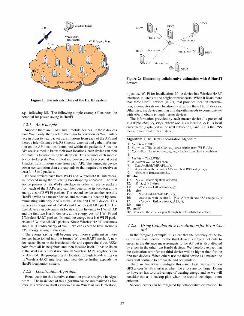
Figure 1: The infrastructure of the HartFi system.
e.g. following [8]. The following simple example illustrates thepotential for power saving in HartFi.
2.2.1 An ExampleSuppose there are 3 APs and 3 mobile devices. If these devices
have Wi-Fi only, then each of them has to power on its Wi-Fi inter-face in order to hear packet transmissions from each of the APs andthereby infer distance (via RSS measurements) and gather informa-tion on the AP locations (contained within the packets). Since theAPs are assumed to know their own locations, each device can thenestimate its location using trilateration. This requires each mobiledevice to keep its Wi-Fi interface powered on to receive at least3 packet transmissions (one from each AP). The aggregate devicepower consumption then corresponds to that required to receive atleast 3×3 = 9 packets.
If these devices have both Wi-Fi and WirelessHART interfaces,we proceed using the following bootstrapping approach. The firstdevice powers on its Wi-Fi interface in order to receive packetsfrom each of the 3 APs, and can then determine its location at theenergy cost of 3 Wi-Fi packets. The second device can then use thisHartFi device as a master device, and estimate its location by com-municating with only 2 APs as well as the first HartFi device. Thiscarries an energy cost of 2 Wi-Fi and 1 WirelessHART packet. Thethird device can determine its location from listening to 1 Wi-Fi APand the first two HartFi devices, at the energy cost of 1 Wi-Fi and2 WirelessHART packets. In total, the energy cost is 6 Wi-Fi pack-ets and 3 WirelessHART packets. Since WirelessHART consumesabout 1/100 radio energy of Wi-Fi, we can expect to have around a33% energy saving in this case.
The energy saving will become even more significant as moredevices have joined into the formed WirelessHART mesh. A newdevice can listen on the broadcast links and capture the <Loc, RSS>pairs from all its neighbors and then localize itself. It has to listento the Wi-Fi APs only if not enough WirelessHART neighbors canbe detected. By propagating its location through broadcasting onits WirelessHART interface, each new device further expands theHartFi localization system.
2.2.2 Localization AlgorithmPseudocode for this iterative estimation process is given in Algo-
rithm 1. The basic idea of this algorithm can be summarized as fol-lows. If a device in HartFi system has no WirelessHART interface,
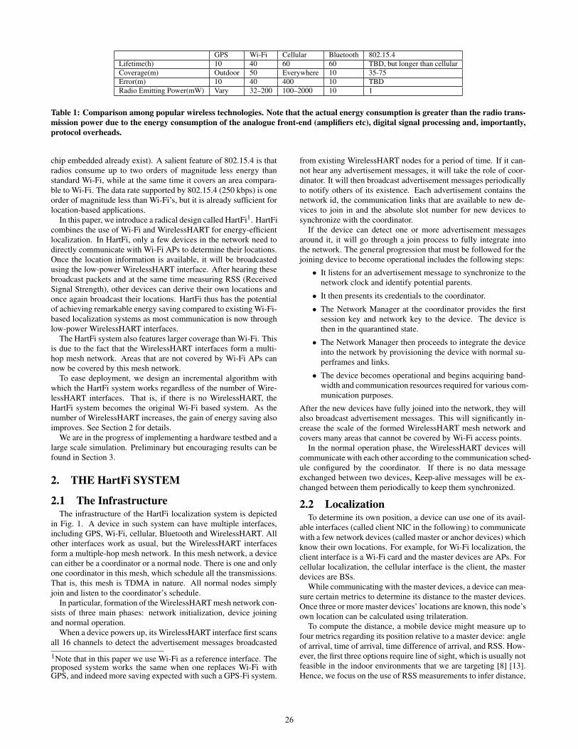
Figure 2: Illustrating collaborative estimation with 5 HartFidevices
it just use Wi-Fi for localization. If the device has WirelessHARTinterface, it listens to the neighbor broadcasts. When it hears morethan three HartFi devices (in 2D) that provides location informa-tion, it computes its own location by referring these HartFi devices.Otherwise, the device running this algorithm needs to communicatewith APs to obtain enough master devices.
The information provided by each master device i is presentedas a triple <loci, ei, rssi>, where loci is i’s location, ei is i’s localerror factor (explained in the next subsection), and rssi is the RSSmeasurement that infers distance.
Algorithm 1 The HartFi Localization Algorithm1: hasWH = TRUE;2: Sw f =∅; // The set of <loci, ew f , rssi> triples from Wi-Fi APs3: Swh =∅; // The set of <loci, ei, rssi> triples from HartFi neighbors4:5: hasWH = CheckWH();6: if (hasWH == FALSE) then7: ScanAvailableWiFiAPList();8: Associate with the first 3 APs with best RSS and get Sw f ;9: <loc, e> = EstLocation(Sw f );
10: else11: Swh = ListenNeighborLocBcast();12: if (|Swh| ≥ 3) then13: <loc, e> = EstLocation(Swh);14: else15: ScanAvailableWiFiAPList();16: Associate with the first 3−|Swh| APs with best RSS and get Sw f ;17: <loc, e> = EstLocation(Swh
⋃Sw f );
18: end if19: end if20: Broadcast the <loc, e> pair through WirelessHART interface;
2.2.3 Using Collaborative Localization for Error Con-trol
In the foregoing example, it is clear that the accuracy of the lo-cation estimate derived by the third device is subject not only toerrors in the distance measurements to the AP but is also affectedby errors in the other two HartFi devices. We therefore expect thatthe estimation error for the third device will be higher than for thefirst two devices. When others use the third device as a master, theerror will continue to propagate and accumulate.
There are two ways to mitigate this issue. First, we can turn onGPS and/or Wi-Fi interfaces when the errors are too large. Doingso however has to disadvantage of wasting energy and so we willconsider this as a backup plan when the second technique is notefficient.
Second, errors can be mitigated by collaborative estimation. In
27

particular, each HartFi device considers all its neighboring masterHartFi devices, rather than three of them, to localize itself. An ex-ample of using 5 master devices is shown in Fig. 2. Every HartFidevice estimates its location by the algorithm EstLocation(S) (pseu-docode shown in Algorithm 2), where S is the set of triples frommaster devices. The algorithm assigns the device a location l thatminimize the sum of the squared error between the distance from land the measured distance to each master device:
l = argminl
∑i∈S
fi(‖ l − loci ‖ −di)2
where for each master device i, ‖ l − loci ‖ is the distance froml to loci, fi is the confidence for referring this master device. fi iscomputed as:
fi = ew f /(ew f + ei)
where ew f is an empirical constant value of the average error inWi-Fi localization, and ei is the error factor for the master device i.It is clear that when ei is large, the confidence value is small. Weuse ew f /(ew f + ei) rather than 1/ei to avoid extreme values.
Algorithm 2 EstLocation(S) Algorithmtb Input: A set S of <loci, ei, rssi> triples from neighbors, and the currentestimated location l′ and the error factor e′Output: Device’s updated estimated location l and error factor e.
1: for each <loci, ei, rssi> triple in S do2: Derive di, the estimated distance to i, from rssi according to the RSS
model;3: fi = ew f /(ew f + ei); // confidence for each master device4: end for5: l = argmin
l∑i∈S
fi(‖ l − loci ‖ −di)2
6: if l′ = null then7: e = β · ∑ei
|S| ; // β: tuning parameter larger than 1
8: else9: enew =
√∑ei|S| · ‖ l − l′ ‖;
10: e=α ·e′+(1−α) ·enew; // α∈ (0,1): parameter for moving average11: end if12: return <l,e>;
The error factor for each AP is ew f . When it is the first time fora HartFi device to run localization, it initializes its error factor tobe e = β · ∑ei
|S| , where β is a tuning parameter larger than 1. Suchinitialization means that the error factor is always larger than theaverage value of the error factors from its masters. After that, whenfinish location estimation once, the device updates its error factorby a moving average:
e = α · e′+(1−α) · enew
enew =
√∑ei
|S| · ‖ l − l′ ‖
l′ and e′ are the previous estimated location and error factor. enew isthe geometric mean of the average error factors of masters and thedifference between the updated prior locations. When most mastershave low error factors, or the updated location does not have muchchange, enew will be very small. It helps the system to converge.
After finishing updating l and e, the HartFi device broadcaststhese two values. Every HartFi device runs the localization processiteratively.
Figure 3: Leveraging ZigBee devices in localization
We are currently running large-scale simulations to find the propervalue of α and β for accurate and fast convergence.
2.3 Leveraging ZigBee devices in HartFi sys-tem
ZigBee interface is currently more popular in the market thanWirelessHART. We choose WirelessHART instead of the ZigBeeinterface to collaborate with Wi-Fi in the HartFi system becauseWirelessHART has several dominating advantages over ZigBee.The most important is that it supports packet level channel hopping,which also plays a key role in other low-power wireless standardssuited to coexistence with Wi-Fi in the 2.4 GHz frequency band.
We note that ZigBee and WirelessHART both use the same 802.15.4PHY layer. The ZigBee MAC layer message is strictly compliant tothe 802.15.4 MAC format while WirelessHART MAC message isthe data type of the 802.15.4 MAC message with its first byte of theframe control field set as 0x41. For this reason, a WirelessHARTinterface can hear any ZigBee packets in its neighborhood. Sincethe PHY and MAC headers of ZigBee packets are not encrypted,WirelessHART interface can simply derive the transmitting ZigBeedevice’s PAN id, nickname and the RSS of the messages. If multi-ple WirelessHART interfaces (for example, DEV2, DEV3, DEV4in Fig. 3) can hear from the same ZigBee device, they will reportthe ZigBee device’s RSS information to the coordinator. Combinedwith these reporters’ own locations, the coordinator can estimatethe location of the ZigBee device even it is not integrated into theHartFi system. The learnt ZigBee location can then be broadcastedin the whole mesh. This can further help other WirelessHART in-terfaces to reduce the number of possible requests to Wi-Fi accesspoints. For example, DEV5 has the <loc, rss> pairs from neighborDEV3 and DEV4, and can overhear the ZigBee device. With theaddition of the ZigBee device’s location which is broadcasted inthe network, DEV5 can estimate its own location without talkingto any Wi-Fi AP.
3. EXPERIMENTAL RESULTS
3.1 The HardwareWe set up a set of experiments to compare the power consump-
tion between the Wi-Fi and WirelessHART interfaces. Four ASUSnetbooks are used in the experiments (see Fig. 4). Each netbookis equipped with an internal 802.11b/g card and an external Wire-lessHART development board. Our WirelessHART board is builtwith the Freescale DEMOJM128 toolkit and runs the WirelessHARTstack developed by ourselves [17]. The toolkit includes a 50.33
28
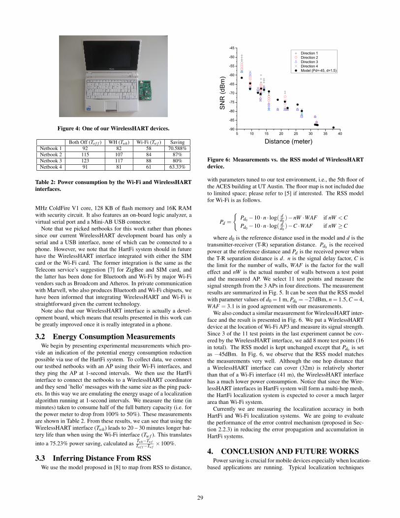
Figure 4: One of our WirelessHART devices.
Both Off (To f f ) WH (Twh) Wi-Fi (Tw f ) SavingNetbook 1 92 82 58 70.588%Netbook 2 115 107 84 87%Netbook 3 123 117 88 80%Netbook 4 91 81 61 63.33%
Table 2: Power consumption by the Wi-Fi and WirelessHARTinterfaces.
MHz ColdFire V1 core, 128 KB of flash memory and 16K RAMwith security circuit. It also features an on-board logic analyzer, avirtual serial port and a Mini-AB USB connector.
Note that we picked netbooks for this work rather than phonessince our current WirelessHART development board has only aserial and a USB interface, none of which can be connected to aphone. However, we note that the HartFi system should in futurehave the WirelessHART interface integrated with either the SIMcard or the Wi-Fi card. The former integration is the same as theTelecom service’s suggestion [7] for ZigBee and SIM card, andthe latter has been done for Bluetooth and Wi-Fi by major Wi-Fivendors such as Broadcom and Atheros. In private communicationwith Marvell, who also produces Bluetooth and Wi-Fi chipsets, wehave been informed that integrating WirelessHART and Wi-Fi isstraightforward given the current technology.
Note also that our WirelessHART interface is actually a devel-opment board, which means that results presented in this work canbe greatly improved once it is really integrated in a phone.
3.2 Energy Consumption MeasurementsWe begin by presenting experimental measurements which pro-
vide an indication of the potential energy consumption reductionpossible via use of the HartFi system. To collect data, we connectour testbed netbooks with an AP using their Wi-Fi interfaces, andthey ping the AP at 1-second intervals. We then use the HartFiinterface to connect the netbooks to a WirelessHART coordinatorand they send ’hello’ messages with the same size as the ping pack-ets. In this way we are emulating the energy usage of a localizationalgorithm running at 1-second intervals. We measure the time (inminutes) taken to consume half of the full battery capacity (i.e. forthe power meter to drop from 100% to 50%). These measurementsare shown in Table 2. From these results, we can see that using theWirelessHART interface (Twh) leads to 20 – 30 minutes longer bat-tery life than when using the Wi-Fi interface (Tw f ). This translates
into a 75.23% power saving, calculated as Twh−Tw f
To f f −Tw f×100%.
3.3 Inferring Distance From RSSWe use the model proposed in [8] to map from RSS to distance,
Figure 6: Measurements vs. the RSS model of WirelessHARTdevice.
with parameters tuned to our test environment, i.e., the 5th floor ofthe ACES building at UT Austin. The floor map is not included dueto limited space; please refer to [5] if interested. The RSS modelfor Wi-Fi is as follows.
Pd =
{Pd0 −10 ·n · log( d
d0)−nW ·WAF if nW <C
Pd0 −10 ·n · log( dd0)−C ·WAF if nW ≥C
where d0 is the reference distance used in the model and d is thetransmitter-receiver (T-R) separation distance. Pd0 is the receivedpower at the reference distance and Pd is the received power whenthe T-R separation distance is d. n is the signal delay factor, C isthe limit for the number of walls, WAF is the factor for the walleffect and nW is the actual number of walls between a test pointand the measured AP. We select 11 test points and measure thesignal strength from the 3 APs in four directions. The measurementresults are summarized in Fig. 5. It can be seen that the RSS modelwith parameter values of d0 = 1 m, Pd0 =−27dBm, n = 1.5, C = 4,WAF = 3.1 is in good agreement with our measurements.
We also conduct a similar measurement for WirelessHART inter-face and the result is presented in Fig. 6. We put a WirelessHARTdevice at the location of Wi-Fi AP3 and measure its signal strength.Since 3 of the 11 test points in the last experiment cannot be cov-ered by the WirelessHART interface, we add 8 more test points (16in total). The RSS model is kept unchanged except that Pd0 is setas −45dBm. In Fig. 6, we observe that the RSS model matchesthe measurements very well. Although the one hop distance thata WirelessHART interface can cover (32m) is relatively shorterthan that of a Wi-Fi interface (41 m), the WirelessHART interfacehas a much lower power consumption. Notice that since the Wire-lessHART interfaces in HartFi system will form a multi-hop mesh,the HartFi localization system is expected to cover a much largerarea than Wi-Fi system.
Currently we are measuring the localization accuracy in bothHartFi and Wi-Fi localization systems. We are going to evaluatethe performance of the error control mechanism (proposed in Sec-tion 2.2.3) in reducing the error propagation and accumulation inHartFi systems.
4. CONCLUSION AND FUTURE WORKSPower saving is crucial for mobile devices especially when location-
based applications are running. Typical localization techniques
29
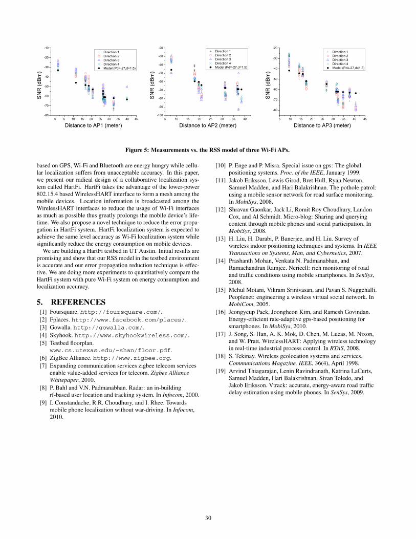
Figure 5: Measurements vs. the RSS model of three Wi-Fi APs.
based on GPS, Wi-Fi and Bluetooth are energy hungry while cellu-lar localization suffers from unacceptable accuracy. In this paper,we present our radical design of a collaborative localization sys-tem called HartFi. HartFi takes the advantage of the lower-power802.15.4 based WirelessHART interface to form a mesh among themobile devices. Location information is broadcasted among theWirelessHART interfaces to reduce the usage of Wi-Fi interfacesas much as possible thus greatly prolongs the mobile device’s life-time. We also propose a novel technique to reduce the error propa-gation in HartFi system. HartFi localization system is expected toachieve the same level accuracy as Wi-Fi localization system whilesignificantly reduce the energy consumption on mobile devices.
We are building a HartFi testbed in UT Austin. Initial results arepromising and show that our RSS model in the testbed environmentis accurate and our error propagation reduction technique is effec-tive. We are doing more experiments to quantitatively compare theHartFi system with pure Wi-Fi system on energy consumption andlocalization accuracy.
5. REFERENCES[1] Foursquare. http://foursquare.com/.[2] Fplaces. http://www.facebook.com/places/.[3] Gowalla. http://gowalla.com/.[4] Skyhook. http://www.skyhookwireless.com/.[5] Testbed floorplan.
www.cs.utexas.edu/~shan/floor.pdf.[6] ZigBee Alliance. http://www.zigbee.org.[7] Expanding communication services zigbee telecom services
enable value-added services for telecom. Zigbee AllianceWhitepaper, 2010.
[8] P. Bahl and V.N. Padmanabhan. Radar: an in-buildingrf-based user location and tracking system. In Infocom, 2000.
[9] I. Constandache, R.R. Choudhury, and I. Rhee. Towardsmobile phone localization without war-driving. In Infocom,2010.
[10] P. Enge and P. Misra. Special issue on gps: The globalpositioning systems. Proc. of the IEEE, January 1999.
[11] Jakob Eriksson, Lewis Girod, Bret Hull, Ryan Newton,Samuel Madden, and Hari Balakrishnan. The pothole patrol:using a mobile sensor network for road surface monitoring.In MobiSys, 2008.
[12] Shravan Gaonkar, Jack Li, Romit Roy Choudhury, LandonCox, and Al Schmidt. Micro-blog: Sharing and queryingcontent through mobile phones and social participation. InMobiSys, 2008.
[13] H. Liu, H. Darabi, P. Banerjee, and H. Liu. Survey ofwireless indoor positioning techniques and systems. In IEEETransactions on Systems, Man, and Cybernetics, 2007.
[14] Prashanth Mohan, Venkata N. Padmanabhan, andRamachandran Ramjee. Nericell: rich monitoring of roadand traffic conditions using mobile smartphones. In SenSys,2008.
[15] Mehul Motani, Vikram Srinivasan, and Pavan S. Nuggehalli.Peoplenet: engineering a wireless virtual social network. InMobiCom, 2005.
[16] Jeongyeup Paek, Joongheon Kim, and Ramesh Govindan.Energy-efficient rate-adaptive gps-based positioning forsmartphones. In MobiSys, 2010.
[17] J. Song, S. Han, A. K. Mok, D. Chen, M. Lucas, M. Nixon,and W. Pratt. WirelessHART: Applying wireless technologyin real-time industrial process control. In RTAS, 2008.
[18] S. Tekinay. Wireless geolocation systems and services.Communications Magazine, IEEE, 36(4), April 1998.
[19] Arvind Thiagarajan, Lenin Ravindranath, Katrina LaCurts,Samuel Madden, Hari Balakrishnan, Sivan Toledo, andJakob Eriksson. Vtrack: accurate, energy-aware road trafficdelay estimation using mobile phones. In SenSys, 2009.
30
Related Documents