Haiyan Guan, Jonathan Li, Yongtao Yu, Michael Chapman, and Cheng Wang IEEE Transactions on Intelligent Transportation Systems, Vol. 16, No. 1, pp.194-205, February 2015 Presented by: Yang Yu {[email protected]} Apr. 4, 2015 Automated Road Information Extraction From Mobile Laser Scanning

Haiyan Guan, Jonathan Li, Yongtao Yu, Michael Chapman, and Cheng Wang IEEE Transactions on Intelligent Transportation Systems, Vol. 16, No. 1, pp.194-205,
Dec 13, 2015
Welcome message from author
This document is posted to help you gain knowledge. Please leave a comment to let me know what you think about it! Share it to your friends and learn new things together.
Transcript

Haiyan Guan, Jonathan Li, Yongtao Yu, Michael Chapman, and Cheng Wang
IEEE Transactions on Intelligent Transportation Systems, Vol. 16, No. 1, pp.194-205,February 2015
Presented by: Yang Yu {[email protected]}Apr. 4, 2015
Automated Road Information ExtractionFrom Mobile Laser Scanning

2
Intelligent Systems Lab.
Overview
This paper extracts road features (road surfaces, road markings, and pavement cracks) from Mobile Laser Scanning (MLS) point cloud data.
Detect road curbs from a set of profiles that are sliced along vehicle trajectory data. Create Geo-Referenced Feature (GRF) images base on segmented road surface points, . Develop two algorithms: 1) road markings with high retroreflectivity, 2) cracks containing low contrast with their surroundings, low signal-to-noise ratio, and poor continuity.

3
Intelligent Systems Lab.
Motivation
Compared with photogrammetry and field surveys, an MLS system captures high point density and accurate 3-D point clouds in a relatively short time period.This system is still in its infancy and has only been commercially available for several years. Thus, there is an urgent need to investigate MLS as a reliable and cost-effective alternative for road inspection, particularly in regard to effective road traffic safety.

4
Intelligent Systems Lab.
MLS SystemTwo RIEGL VQ450 laser scanners; Four charge-coupled device cameras; A set of Applanix POS LV 520 processing systems containing two GNSS antennas, an IMU system, and a distance measurement indicator.The laser scanner is georeferenced when its position and orientation relative to the mapping coordinate system are known by a set of navigation systems.

5
Intelligent Systems Lab.
Road Surface ExtractionPerpendicular to trajectory data, we first partition point clouds into a number of data blocks with a given length . A profile is sliced for each data block with a given width.
(a) Trajectory-based MLS data profiling. (b) A number of profile exam-ples.

6
Intelligent Systems Lab.
Data Profiling
All points for each profile are projected onto the YoZ plane, we estimate curbs by slope and elevation difference criteria. This is close-up views of road curbs.

7
Intelligent Systems Lab.
Pseudo Scan Line GenerationEach profile is vertically divided into a number of bars. A sampling strategy is carried out for each bar to select a principal point,
From the lowest point, we calculate the elevation difference of two consecutive points.The two consecutive points are labeled into the same layer if the elevation difference lies below a predefined threshold.This maintains road surface points and critical road features with less disruptive noise.

8
Intelligent Systems Lab.
Curb DetectionStart the labeling process from the vehicle position on the road surface. The slope criterion is used to detect nonroad points. Once a point slope greater than a predefined threshold, it means that the point reaches a possible curb.If a curb candidate’s elevation difference is within the predefined range, the curb candidate is labeled as a curb.
Select curb candidates closest to the scanning center as curbs. Use a cubic spline interpolation method to generate two smooth road edges from these curb points, and finally separate road points from nonroad points.

9
Intelligent Systems Lab.
Road Surface Extraction Result
Huandao data set containing 8.4 million points and ICEC date set containing 5.4 million points.
(Top) Raw MLS data, (bottom) extracted road surfaces.

10
Intelligent Systems Lab.
Road Surface Extraction Result
This algorithm is able to handle roads with curvatures.
(Left) Raw MLS data, (right)extracted road surfaces

11
Intelligent Systems Lab.
Road Surface Extraction Result
The central line represents the median value, whereas its lower and upper edges represent the 25% and 75% percentiles. The minimum and maximum values are represented by the lower and upper adjacent values.
Box plot for the accuracy of the extracted road edges

12
Intelligent Systems Lab.
GRF Image Generation
The MLS data indicate that road markings painted on road surfaces are highly retroreflective; thus, high reflectance in the form of intensity has been widely used to extract road markings. GRF image generation, which locally and globally interpolates the extracted road surface points into a GRF image based on elevation and intensity data via an extended inverse distance weighted method.

13
Intelligent Systems Lab.
Point-density-dependent Thresholding
Within different ranges of the scanning distances, local optimal segmentation thresholds are adaptively estimated.Intensity values gradually fade from the scanning center to its two sides, it depend on:
1) the scanning range from the laser sensor to the target; 2) the incidence angle of the laser beam; 3) material properties of the target.
Point density approximates Gaussian normal distribution.

14
Intelligent Systems Lab.
Morphological Operations
It refines the extracted road markings by removing noise and filling out holes.A horizontally linear shaped structuring element is used to dilate and erode the extracted road markings.The linear structure with length l and direction θ is denoted by Kline θ(l). The direction θ is determined by trajectory data. The length l = 3 pixels is selected for convoluting road markings.

15
Intelligent Systems Lab.
Quantitative Assessment
Completeness. cpt = Cp/Rf. Correctness. crt = Cp/Ep. Cp denotes the number of pixels belonging to the real road markings, Rf is the number of the ground truth pixels collected by the manual interpretation method.Ep represents the number of pixels extracted by the proposed algorithm. F-measure is an overall score, F = 2 × ((cpt · crt)/(cpt + crt)).

16
Intelligent Systems Lab.
Road Markings
(left) GRF image; (middle) point-density-dependent multithresholding segmentation results; (right) extracted road markings.

17
Intelligent Systems Lab.
Road Markings
Extracted road markings overlaid on the GRF images. (a) Huandao data set. (b) ICEC data set..
18
Intelligent Systems Lab.
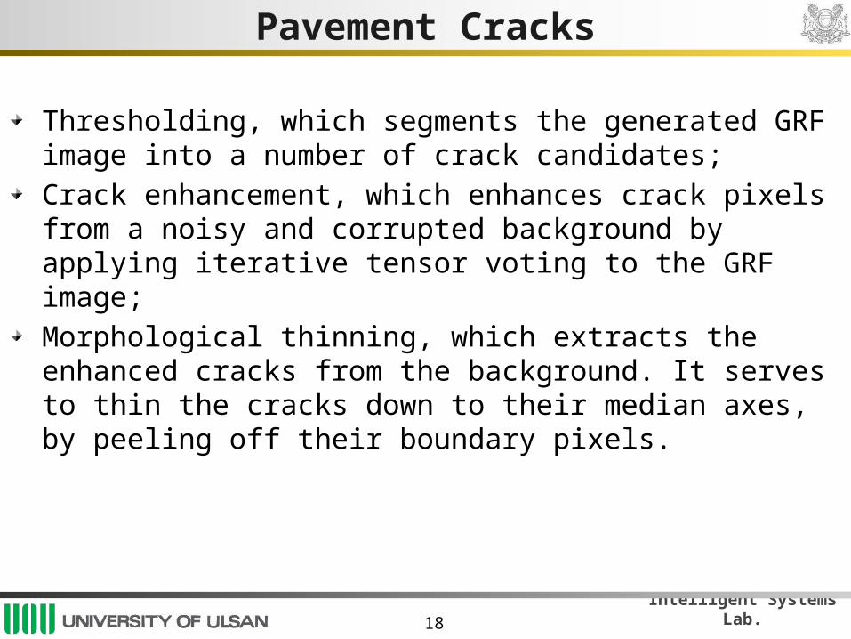
Pavement Cracks
Thresholding, which segments the generated GRF image into a number of crack candidates;Crack enhancement, which enhances crack pixels from a noisy and corrupted background by applying iterative tensor voting to the GRF image; Morphological thinning, which extracts the enhanced cracks from the background. It serves to thin the cracks down to their median axes, by peeling off their boundary pixels.

19
Intelligent Systems Lab.
Iterative Tensor Voting
In two dimension, a second-order symmetric nonnega-tive definite tensor is represented by a 2 × 2 matrix, which is decomposed as
λ1 and λ2 (λ1>λ2) are the eigenvalues. e1 and e2 are the corresponding eigenvectors.The first term is a stick tensor, indicating an elementary curve element with e1 as its curve normal. The second term is a ball tensor, indicating a perceptual structure without preferred orientation.

20
Intelligent Systems Lab.
Iterative Tensor Voting
Each crack candidate is initially encoded by a ball tensor with unit saliency, in a form of a 2 × 2 identity matrix. The ball tensors only cast votes to other ball tensors in their voting fields. All the tensors corresponding to the crack candidates obtain rough orientations and magnitudes.Each oriented crack candidate is further encoded as a stick tensor to refine the orientations and to obtain a saliency map of cracks.Use iterative tensor voting (ITV) to obtain a good saliency map of cracks. The tensor with high λ1 − λ2 values seems to be concentrated.
21
Intelligent Systems Lab.
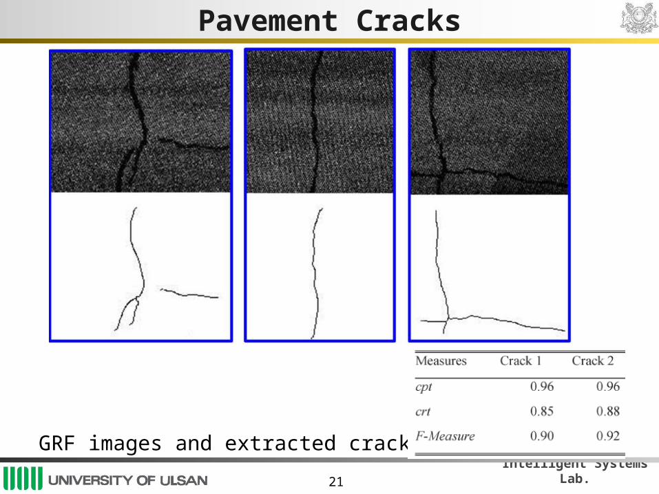
Pavement Cracks
GRF images and extracted cracks.

22
Intelligent Systems Lab.
Pavement Cracks
Crack detection results for the 75-m-long road section. (a) GRF image. (b) Detected cracks. (c) Detected cracks overlaid on the GRF image.

23
Intelligent Systems Lab.
Conclusions
The accuracies of detected road surfaces meet the requirements of transportation-related road applications, such as mapping natural terrain, assessing roadway condition, conducting Geographic Information System, and modeling urban traffic. This algorithm achieve stable performance on six road sections, and enhance curvilinear crack structures from noisy and corrupted road data.Future work
Apply this algorithm to the car washing system.Improve the road features extraction method.
Related Documents