© OCR 2016 H414/03 Turn over 603/0782/1 F100022/2.0 A Level Geology H414/03 Practical skills in geology Sample Question Paper Date – Morning/Afternoon Time allowed: 1 hour 30 minutes You must have: • the Insert • a protractor • a ruler (cm/mm) • a pencil You may use: • a scientific or graphical calculator * 0 0 0 0 0 0 * First name Last name Centre number Candidate number INSTRUCTIONS • Use black ink. You may use an HB pencil for graphs and diagrams. • Complete the boxes above with your name, centre number and candidate number. • Answer all the questions. • Write your answer to each question in the space provided. If additional space is required, use the lined page(s) at the end of this booklet. The question number(s) must be clearly shown. • Do not write in the bar codes. INFORMATION • The total mark for this paper is 60. • The marks for each question are shown in brackets [ ]. • Quality of extended responses will be assessed in questions marked with an asterisk (*). • This document consists of 20 pages. SPECIMEN

Welcome message from author
This document is posted to help you gain knowledge. Please leave a comment to let me know what you think about it! Share it to your friends and learn new things together.
Transcript
© OCR 2016 H414/03 Turn over 603/0782/1 F100022/2.0
A Level Geology H414/03 Practical skills in geology Sample Question Paper
Date – Morning/Afternoon Time allowed: 1 hour 30 minutes
You must have:
• the Insert
• a protractor
• a ruler (cm/mm)
• a pencil
You may use:
• a scientific or graphical calculator
* 0 0 0 0 0 0 *
First name
Last name
Centre number
Candidate
number
INSTRUCTIONS
• Use black ink. You may use an HB pencil for graphs and diagrams.
• Complete the boxes above with your name, centre number and candidate number. • Answer all the questions.
• Write your answer to each question in the space provided. If additional space is required, use the lined page(s) at the end of this booklet. The question number(s) must be clearly shown.
• Do not write in the bar codes.
INFORMATION
• The total mark for this paper is 60.
• The marks for each question are shown in brackets [ ].
• Quality of extended responses will be assessed in questions marked with an asterisk (*).
• This document consists of 20 pages.
SPECIMEN
2
© OCR 2016 H414/03
Answer all the questions.
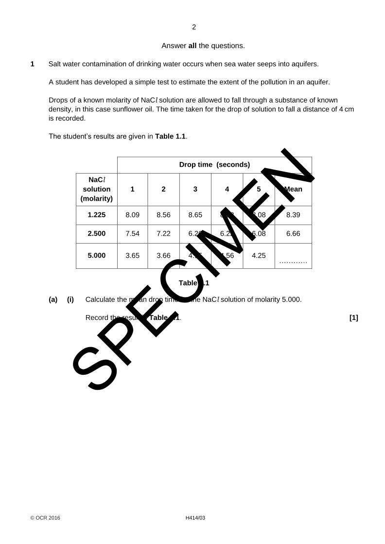
1 Salt water contamination of drinking water occurs when sea water seeps into aquifers.
A student has developed a simple test to estimate the extent of the pollution in an aquifer.
Drops of a known molarity of NaCl solution are allowed to fall through a substance of known
density, in this case sunflower oil. The time taken for the drop of solution to fall a distance of 4 cm
is recorded.
The student’s results are given in Table 1.1.
Drop time (seconds)
NaCl
solution
(molarity)
1 2 3 4 5 Mean
1.225 8.09 8.56 8.65 8.58 8.08 8.39
2.500 7.54 7.22 6.26 6.22 6.08 6.66
5.000 3.65 3.66 4.15 4.56 4.25 …………
Table 1.1
(a) (i) Calculate the mean drop time for the NaCl solution of molarity 5.000.
Record the result in Table 1.1. [1]
SPECIMEN
3
© OCR 2016 H414/03 Turn over
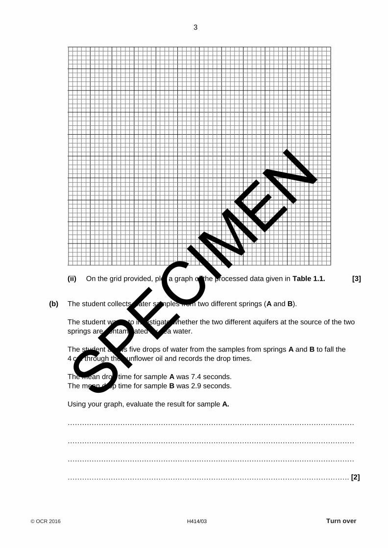
(ii) On the grid provided, plot a graph of the processed data given in Table 1.1. [3]
(b) The student collects water samples from two different springs (A and B).
The student wants to investigate whether the two different aquifers at the source of the two
springs are contaminated by sea water.
The student allows five drops of water from the samples from springs A and B to fall the
4 cm through the sunflower oil and records the drop times.
The mean drop time for sample A was 7.4 seconds.
The mean drop time for sample B was 2.9 seconds.
Using your graph, evaluate the result for sample A.
…………………………………………………………………………………………………………
…………………………………………………………………………………………………………
…………………………………………………………………………………………………………
………………………………………………………………………………………………………. [2]
SPECIMEN

4
© OCR 2016 H414/03
(c) Suggest two modifications to the practical procedure that would enable a more accurate
estimate of the molarity of the samples. Give reasons for your answers.
1 ………………………………………………………………………………………………..……...
………………………………………………………………………………………………………....
2 ………………………………………………………………………………………………..………
………………………………………………………………………………………….………………
[2]
(d) The flow of fluids through aquifers is controlled by geological factors.
Describe and explain one factor that will decrease the flow of salt water contamination in an
aquifer.
…………………………………………………………………………………………………………
…………………………………………………………………………………………………………
…………………………………………………………………………………………………………
………………………………………………………………………………………………………. [2]
SPECIMEN

5
© OCR 2016 H414/03 Turn over
BLANK PAGE
PLEASE DO NOT WRITE ON THIS PAGE
SPECIMEN
6
© OCR 2016 H414/03
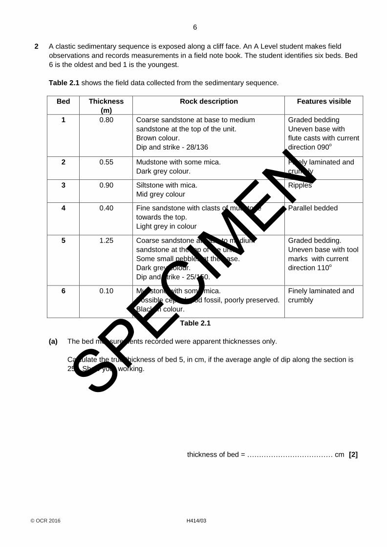
2 A clastic sedimentary sequence is exposed along a cliff face. An A Level student makes field
observations and records measurements in a field note book. The student identifies six beds. Bed
6 is the oldest and bed 1 is the youngest.
Table 2.1 shows the field data collected from the sedimentary sequence.
Bed Thickness
(m)
Rock description Features visible
1 0.80 Coarse sandstone at base to medium
sandstone at the top of the unit.
Brown colour.
Dip and strike - 28/136
Graded bedding
Uneven base with
flute casts with current
direction 090o
2 0.55 Mudstone with some mica.
Dark grey colour.
Finely laminated and
crumbly
3 0.90 Siltstone with mica.
Mid grey colour
Ripples
4 0.40 Fine sandstone with clasts of mudstone
towards the top.
Light grey in colour
Parallel bedded
5 1.25 Coarse sandstone at base to medium
sandstone at the top of the unit.
Some small pebbles at the base.
Dark grey colour.
Dip and strike - 25/150.
Graded bedding.
Uneven base with tool
marks with current
direction 110o
6 0.10 Mudstone with some mica.
Possible cephalopod fossil, poorly preserved.
Black in colour.
Finely laminated and
crumbly
Table 2.1
(a) The bed measurements recorded were apparent thicknesses only.
Calculate the true thickness of bed 5, in cm, if the average angle of dip along the section is
25°. Show your working.
thickness of bed = ……………………………… cm [2]
SPECIMEN

7
© OCR 2016 H414/03 Turn over
(b) (i) Using the data in Table 2.1, plot a graphic log to show the information in the table.
Choose an appropriate scale for your plot.
Provide a key next to your graphic log to help you with your answer.
[5]
(ii) Using evidence from the field observations in the table, deduce the environment of
deposition for this sequence of sedimentary rocks.
…………………………………………………………………………….………………..……
…………………………………………………………………………….………………..……
…………………………………………………………………………….………………..……
…………………………………………………………………………….………………..……
…………………………………………………………………………….………………..……
…………………………………………………………………………….…………………. [3]
(iii) Give the name for the technique outlined above for determining the origin of the rocks.
…………………………………………………………………………….…………………. [1]
SPECIMEN
8
© OCR 2016 H414/03
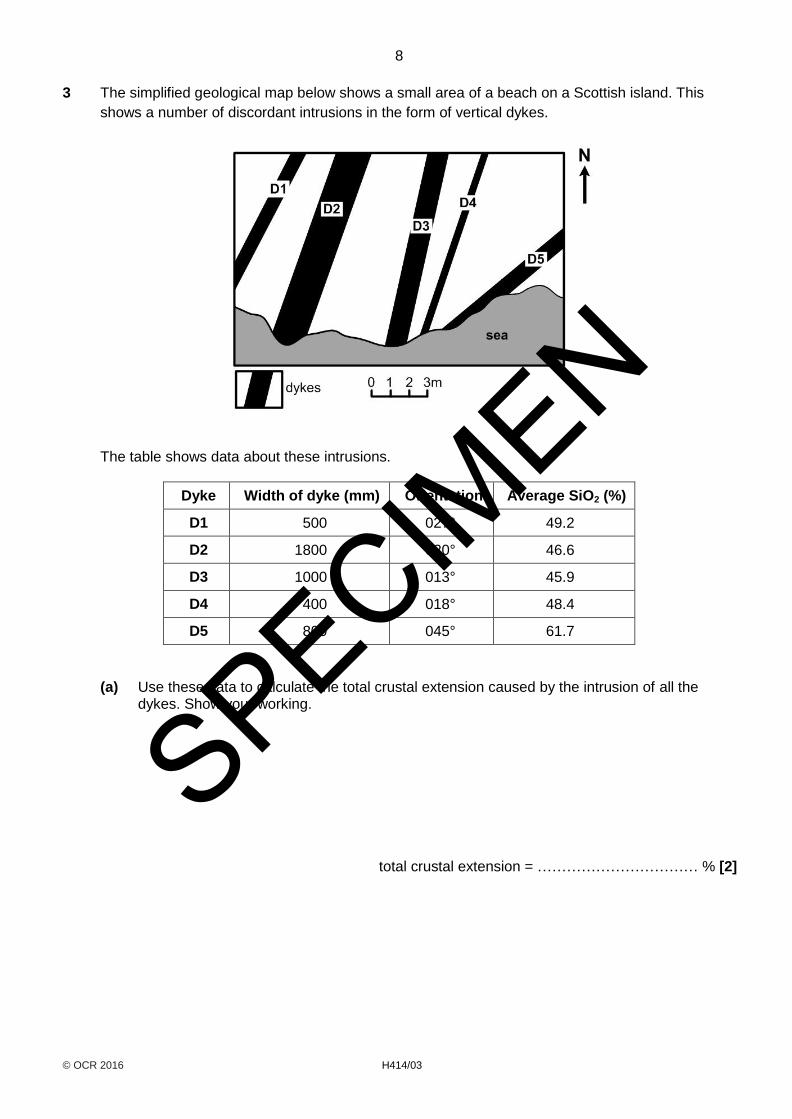
3 The simplified geological map below shows a small area of a beach on a Scottish island. This
shows a number of discordant intrusions in the form of vertical dykes.
The table shows data about these intrusions.
Dyke Width of dyke (mm) Orientation Average SiO2 (%)
D1 500 027° 49.2
D2 1800 020° 46.6
D3 1000 013° 45.9
D4 400 018° 48.4
D5 800 045° 61.7
(a) Use these data to calculate the total crustal extension caused by the intrusion of all the dykes. Show your working.
total crustal extension = …………………………… % [2]
SPECIMEN

9
© OCR 2016 H414/03 Turn over
(b) Name two processes that could have caused the different compositions of the dykes and explain how each process affects the composition of the magma.
1 ….……………………………………………………………………………………………………
…………………………………………………………………………………………………………
2 ….……………………………………………………………………………………………………
…………………………………………………………………………………………………………
[2]
(c) Describe how you could take an orientation on a dyke using a compass clinometer.
…………………………………………………………………………….………………..…………
…………………………………………………………………………….………………..…………
…………………………………………………………………………….………………..…………
…………………………………………………………………………….………………..……….[2]
SPECIMEN
10
© OCR 2016 H414/03
BLANK PAGE
PLEASE DO NOT WRITE ON THIS PAGE
SPECIMEN
11
© OCR 2016 H414/03 Turn over
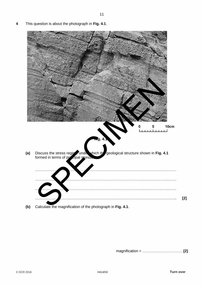
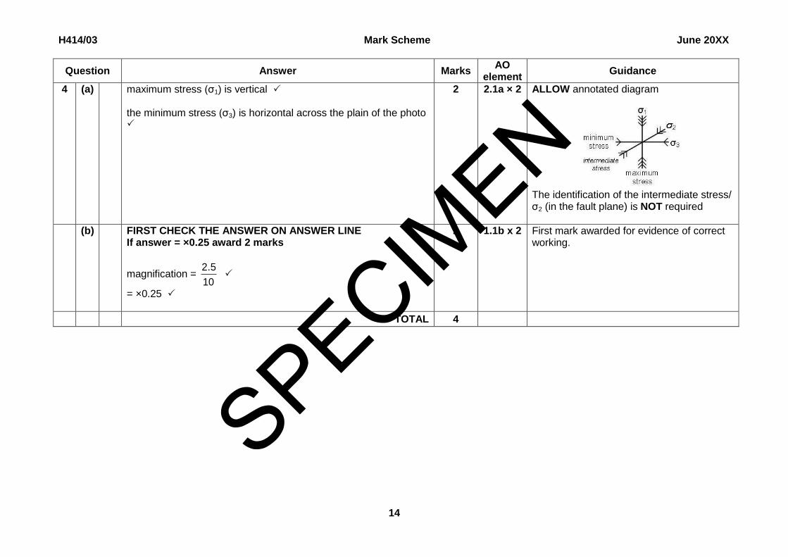
4 This question is about the photograph in Fig. 4.1.
Fig. 4.1
(a) Discuss the stress regime under which the geological structure shown in Fig. 4.1 formed in terms of principal stresses.
…………………………………………………………………………….………………..……
…………………………………………………………………………….………………..……
…………………………………………………………………………….………………..……
…………………………………………………………………………….…………………….. [2]
(b) Calculate the magnification of the photograph in Fig. 4.1.
magnification = ……………………………[2]
SPECIMEN
12
© OCR 2016 H414/03
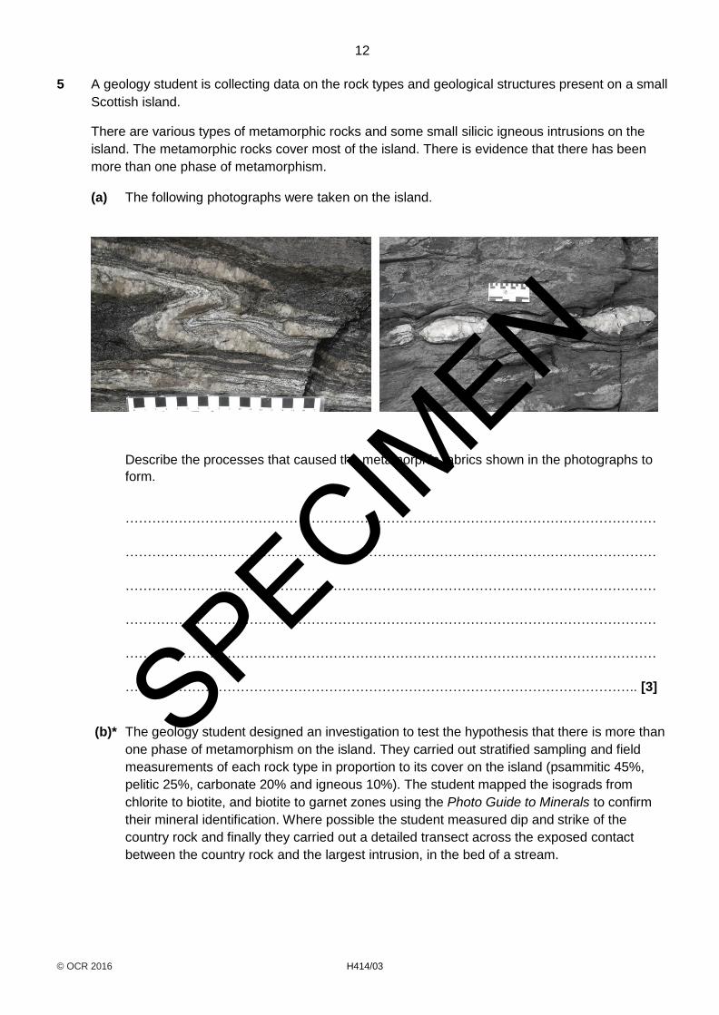
5 A geology student is collecting data on the rock types and geological structures present on a small
Scottish island.
There are various types of metamorphic rocks and some small silicic igneous intrusions on the
island. The metamorphic rocks cover most of the island. There is evidence that there has been
more than one phase of metamorphism.
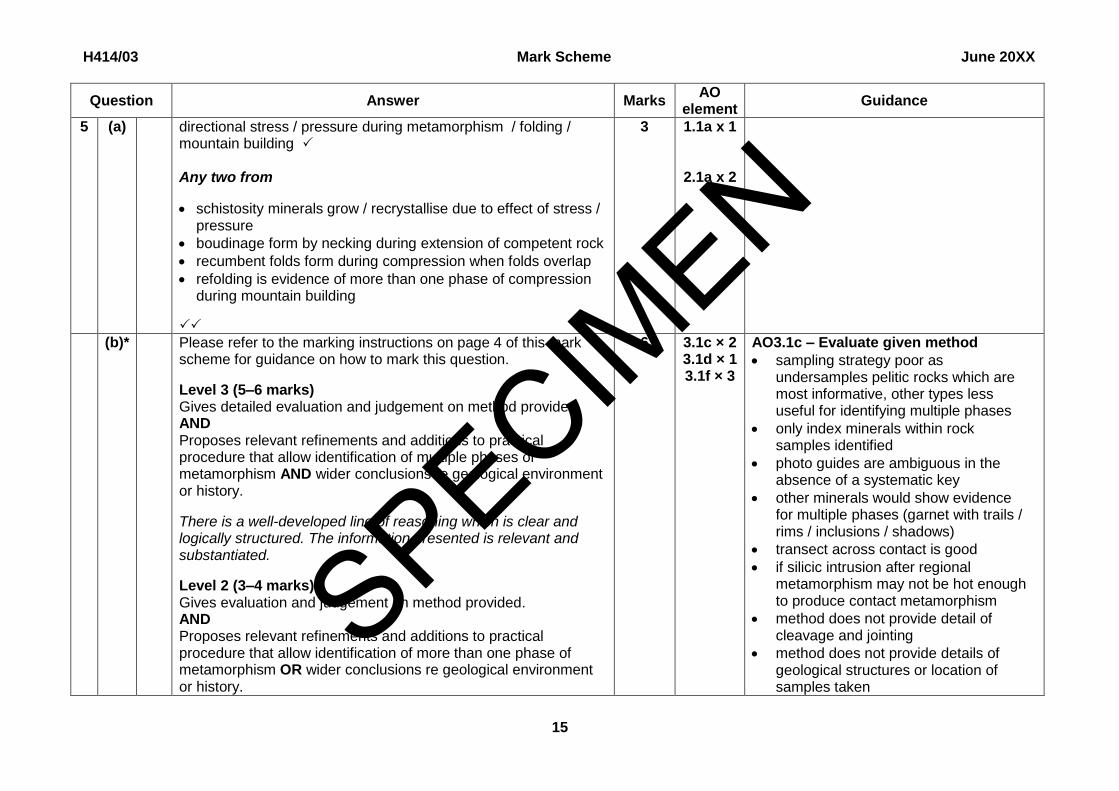
(a) The following photographs were taken on the island.
Describe the processes that caused the metamorphic fabrics shown in the photographs to
form.
…………………………………………………………………………………………………………
…………………………………………………………………………………………………………
…………………………………………………………………………………………………………
…………………………………………………………………………………………………………
…………………………………………………………………………………………………………
…………………………………………………………………………………………………….. [3]
(b)* The geology student designed an investigation to test the hypothesis that there is more than
one phase of metamorphism on the island. They carried out stratified sampling and field
measurements of each rock type in proportion to its cover on the island (psammitic 45%,
pelitic 25%, carbonate 20% and igneous 10%). The student mapped the isograds from
chlorite to biotite, and biotite to garnet zones using the Photo Guide to Minerals to confirm
their mineral identification. Where possible the student measured dip and strike of the
country rock and finally they carried out a detailed transect across the exposed contact
between the country rock and the largest intrusion, in the bed of a stream.
SPECIMEN

13
© OCR 2016 H414/03 Turn over
Evaluate the method that the geology student has used.
Suggest modifications to this method that would enable you to gain more accurate data.
Assume that you have access to the standard equipment available to a student in a school
or field study centre.
…………………………………………………………………………………………………………
…………………………………………………………………………………………………………
…………………………………………………………………………………………………………
…………………………………………………………………………………………………………
…………………………………………………………………………………………………………
…………………………………………………………………………………………………………
…………………………………………………………………………………………………………
…………………………………………………………………………………………………………
…………………………………………………………………………………………………………
…………………………………………………………………………………………………………
…………………………………………………………………………………………………………
…………………………………………………………………………………………………….. [6]
SPECIMEN
14
© OCR 2016 H414/03
6 The 1 : 50 000 geological map excerpt (Wells) should be used for this question.
(a) In terms of engineering geology, analyse and evaluate the position of the Cheddar Reservoir
shown on the map.
…………………………………………………………………………………………………………
…………………………………………………………………………………………………………
…………………………………………………………………………………………………………
…………………………………………………………………………………………………………
…………………………………………………………………………………………………………
…………………………………………………………………………………………………………
…………………………………………………………………………………………………………
………………………………………………………………………………………………………. [4]
(b) On the topographic sketch profile below, draw and clearly label a cross-section from grid
reference 480550 to 480600. Use symbols to show the same rock types on your cross-
section.
Do not use coloured pencils or highlighters.
[7]
SPECIMEN

15
© OCR 2016 H414/03 Turn over
(c)* A mining company have applied for planning permission to site a quarry in the Hotwells
Limestone, at grid reference 485535. The overall size of the quarry would cover around 2 km2.
Analyse the potential geohazards that may occur around the area of extraction.
Conclude whether you think that this quarry should be given planning permission for limestone extraction.
…………………………………………………………………………….………………..……………
…………………………………………………………………………………………………………...
…………………………………………………………………………….………………..……………
…………………………………………………………………………….………………..……………
…………………………………………………………………………….………………..……………
…………………………………………………………………………….………………..……………
…………………………………………………………………………….………………..……………
…………………………………………………………………………………………………………...
…………………………………………………………………………….………………..……………
…………………………………………………………………………….………………..……………
…………………………………………………………………………….………………..……………
…………………………………………………………………………….………………..………. [6]
SPECIMEN
16
© OCR 2016 H414/03
(d) Geologists believe that there is extensive mineralization in the Black Rock Limestone which
underlies the Dolomitic Conglomerate at grid reference 515540. They plan to drill an
excavation borehole to intersect with the top of the Black Rock Limestone.
Calculate the depth to which the borehole must be drilled. Show your working.
depth of borehole = …………………………… m [3]
END OF QUESTION PAPER
SPECIMEN
17
© OCR 2016 H414/03 Turn over
ADDITIONAL ANSWER SPACE
If additional space is required, you should use the following page(s). The question number(s) must be
clearly shown in the margin.
……………………………………..…………………………………………………………………………………
……………………………………..…………………………………………………………………………………
……………………………………..…………………………………………………………………………………
……………………………………..…………………………………………………………………………………
……………………………………..…………………………………………………………………………………
……………………………………..…………………………………………………………………………………
……………………………………..…………………………………………………………………………………
……………………………………..…………………………………………………………………………………
……………………………………..…………………………………………………………………………………
……………………………………..…………………………………………………………………………………
……………………………………..…………………………………………………………………………………
……………………………………..…………………………………………………………………………………
……………………………………..…………………………………………………………………………………
……………………………………..…………………………………………………………………………………
……………………………………..…………………………………………………………………………………
……………………………………..…………………………………………………………………………………
……………………………………..…………………………………………………………………………………
……………………………………..…………………………………………………………………………………
……………………………………..…………………………………………………………………………………
……………………………………..…………………………………………………………………………………
……………………………………..…………………………………………………………………………………
……………………………………..…………………………………………………………………………………
SPECIMEN
18
© OCR 2016 H414/03
……………………………………..…………………………………………………………………………………
……………………………………..…………………………………………………………………………………
……………………………………..…………………………………………………………………………………
……………………………………..…………………………………………………………………………………
……………………………………..…………………………………………………………………………………
……………………………………..…………………………………………………………………………………
……………………………………..…………………………………………………………………………………
……………………………………..…………………………………………………………………………………
……………………………………..…………………………………………………………………………………
……………………………………..…………………………………………………………………………………
……………………………………..…………………………………………………………………………………
……………………………………..…………………………………………………………………………………
……………………………………..…………………………………………………………………………………
……………………………………..…………………………………………………………………………………
……………………………………..…………………………………………………………………………………
……………………………………..…………………………………………………………………………………
……………………………………..…………………………………………………………………………………
……………………………………..…………………………………………………………………………………
……………………………………..…………………………………………………………………………………
……………………………………..…………………………………………………………………………………
……………………………………..…………………………………………………………………………………
……………………………………..…………………………………………………………………………………
……………………………………..…………………………………………………………………………………
……………………………………..…………………………………………………………………………………
……………………………………..…………………………………………………………………………………
SPECIMEN
19
© OCR 2016 H414/03 Turn over
……………………………………..…………………………………………………………………………………
……………………………………..…………………………………………………………………………………
……………………………………..…………………………………………………………………………………
……………………………………..…………………………………………………………………………………
……………………………………..…………………………………………………………………………………
……………………………………..…………………………………………………………………………………
……………………………………..…………………………………………………………………………………
……………………………………..…………………………………………………………………………………
……………………………………..…………………………………………………………………………………
……………………………………..…………………………………………………………………………………
……………………………………..…………………………………………………………………………………
……………………………………..…………………………………………………………………………………
……………………………………..…………………………………………………………………………………
……………………………………..…………………………………………………………………………………
……………………………………..…………………………………………………………………………………
……………………………………..…………………………………………………………………………………
……………………………………..…………………………………………………………………………………
……………………………………..…………………………………………………………………………………
……………………………………..…………………………………………………………………………………
……………………………………..…………………………………………………………………………………
……………………………………..…………………………………………………………………………………
……………………………………..…………………………………………………………………………………
……………………………………..…………………………………………………………………………………
……………………………………..…………………………………………………………………………………
……………………………………..…………………………………………………………………………………
SPECIMEN
20
© OCR 2016 H414/03
……………………………………..…………………………………………………………………………………
……………………………………..…………………………………………………………………………………
……………………………………..…………………………………………………………………………………
……………………………………..…………………………………………………………………………………
……………………………………..…………………………………………………………………………………
……………………………………..…………………………………………………………………………………
……………………………………..…………………………………………………………………………………
……………………………………..…………………………………………………………………………………
……………………………………..…………………………………………………………………………………
……………………………………..…………………………………………………………………………………
……………………………………..…………………………………………………………………………………
……………………………………..…………………………………………………………………………………
……………………………………..…………………………………………………………………………………
……………………………………..…………………………………………………………………………………
……………………………………..…………………………………………………………………………………
……………………………………..…………………………………………………………………………………
……………………………………..…………………………………………………………………………………
……………………………………..…………………………………………………………………………………
……………………………………..…………………………………………………………………………………
Copyright Information:
OCR is committed to seeking permission to reproduce all third-party content that it uses in the assessment materials. OCR has attempted to
identify and contact all copyright holders whose work is used in this paper. To avoid the issue of disclosure of answer-related information to
candidates, all copyright acknowledgements are reproduced in the OCR Copyright Acknowledgements booklet. This is produced for each
series of examinations and is freely available to download from our public website (www.ocr.org.uk) after the live examination series.
If OCR has unwittingly failed to correctly acknowledge or clear any third-party content in this assessment material, OCR will be happy to correct
its mistake at the earliest possible opportunity.
For queries or further information please contact the Copyright Team, First Floor, 9 Hills Road, Cambridge CB2 1GE.
OCR is part of the Cambridge Assessment Group; Cambridge Assessment is the brand name of University of Cambridge Local Examinations
Syndicate (UCLES), which is itself a department of the University of Cambridge.
SPECIMEN
F100021/2.0
…day June 20XX – Morning/Afternoon
A Level Geology
H414/03 Practical skills in geology
SAMPLE MARK SCHEME
Duration: 1 hour 30 minutes
MAXIMUM MARK 60
This document consists of 20 pages
SPECIMEN
H414/03 Mark Scheme June 20XX
2
MARKING INSTRUCTIONS PREPARATION FOR MARKING RM ASSESSOR 1. Make sure that you have accessed and completed the relevant training packages for on-screen marking: RM assessor Online Training; OCR
Essential Guide to Marking. 2. Make sure that you have read and understood the mark scheme and the question paper for this unit. 3. Log-in to RM assessor and mark the required number of practice responses (“scripts”) and the required number of standardisation
responses.
MARKING 1. Mark strictly to the mark scheme. 2. Marks awarded must relate directly to the marking criteria. 3. The schedule of dates is very important. It is essential that you meet the RM assessor 50% and 100% (traditional 50% Batch 1 and 100%
Batch 2) deadlines. If you experience problems, you must contact your Team Leader (Supervisor) without delay. 4. If you are in any doubt about applying the mark scheme, consult your Team Leader by telephone, email or via the RM assessor messaging
system.
SPECIMEN
H414/03 Mark Scheme June 20XX
3
5. Work crossed out: a. where a candidate crosses out an answer and provides an alternative response, the crossed out response is not marked and gains no
marks b. if a candidate crosses out an answer to a whole question and makes no second attempt, and if the inclusion of the answer does not
cause a rubric infringement, the assessor should attempt to mark the crossed out answer and award marks appropriately. 6. Always check the pages (and additional objects if present) at the end of the response in case any answers have been continued there. If the
candidate has continued an answer there then add a tick to confirm that the work has been seen. 7. There is a NR (No Response) option. Award NR (No Response)
- if there is nothing written at all in the answer space - OR if there is a comment which does not in any way relate to the question (e.g. ‘can’t do’, ‘don’t know’) - OR if there is a mark (e.g. a dash, a question mark) which isn’t an attempt at the question. Note: Award 0 marks – for an attempt that earns no credit (including copying out the question).
8. The RM Assessor comments box is used by your Team Leader to explain the marking of the practice responses. Please refer to these
comments when checking your practice responses. Do not use the comments box for any other reason. If you have any questions or comments for your Team Leader, use the phone, the RM Assessor messaging system, or email.
9. Assistant Examiners will send a brief report on the performance of candidates to their Team Leader (Supervisor) via email by the end of the marking period. The report should contain notes on particular strengths displayed as well as common errors or weaknesses. Constructive criticism of the question paper/mark scheme is also appreciated.
SPECIMEN
H414/03 Mark Scheme June 20XX
4
10. For answers marked by levels of response: Read through the whole answer from start to finish, using the Level descriptors to help you decide whether it is a strong or weak answer. The indicative geological content in the Guidance column indicates the expected parameters for candidates’ answers, but be prepared to recognise and credit unexpected approaches where they show relevance. Using a ‘best-fit’ approach based on the skills and geological content evidenced within the answer, first decide which set of level descriptors, Level 1, Level 2 or Level 3, best describes the overall quality of the answer. Once the level is located, award the higher or lower mark: The higher mark should be awarded where the level descriptor has been evidenced and all aspects of the communication statement (in italics) have been met. The lower mark should be awarded where the level descriptor has been evidenced but aspects of the communication statement (in italics) are missing. In summary: The skills and geological content determines the level. The communication statement determines the mark within a level. Level of response questions on this paper are 5b and 6c.
SPECIMEN
H414/03 Mark Scheme June 20XX
5
11. Annotations
Annotation Meaning
DO NOT ALLOW Answers which are not worthy of credit
IGNORE Statements which are irrelevant
ALLOW Answers that can be accepted
( ) Words which are not essential to gain credit
__ Underlined words must be present in answer to score a mark
ECF Error carried forward
AW Alternative wording
ORA Or reverse argument
SPECIMEN

H414/03 Mark Scheme June 20XX
6
12. Subject-specific Marking Instructions
INTRODUCTION Your first task as an Examiner is to become thoroughly familiar with the material on which the examination depends. This material includes:
the specification, especially the assessment objectives
the question paper
the mark scheme.
You should ensure that you have copies of these materials. You should ensure also that you are familiar with the administrative procedures related to the marking process. These are set out in the OCR booklet Instructions for Examiners. If you are examining for the first time, please read carefully Appendix 5 Introduction to Script Marking: Notes for New Examiners. Please ask for help or guidance whenever you need it. Your first point of contact is your Team Leader.
SPECIMEN
H414/03 Mark Scheme June 20XX
7
The breakdown of Assessment Objectives for GCE Geology:
Assessment Objective
AO1 Demonstrate knowledge and understanding of geological ideas, skills and techniques
AO1.1a Demonstrate knowledge of geological ideas
AO1.1b Demonstrate knowledge of geological skills and techniques
AO1.1c Demonstrate understanding of geological ideas
AO1.1d Demonstrate understanding of geological skills and techniques
AO2 Apply knowledge and understanding of geological ideas, skills and techniques
AO2.1a Apply knowledge and understanding of geological ideas
AO2.1b Apply knowledge and understanding of geological skills and techniques
AO3 Analyse, interpret and evaluate geological information, ideas and evidence to make judgements, draw conclusions, and develop and refine practical design and procedures
AO3.1a Analyse geological information, ideas and evidence
AO3.1b Interpret geological information, ideas and evidence
AO3.1c Evaluate geological information, ideas and evidence
AO3.1d Make judgements
AO3.1e Draw conclusions
AO3.1f Develop and refine practical design and procedures
SPECIMEN
H414/03 Mark Scheme June 20XX
8
Question Answer Marks AO
element Guidance
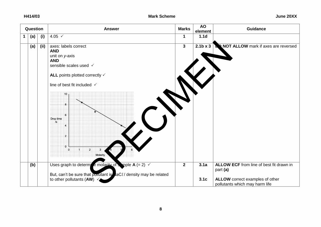
1 (a) (i) 4.05 1 1.1d
(a) (ii) axes: labels correct AND unit on y-axis AND sensible scales used ALL points plotted correctly line of best fit included
3
2.1b x 3 DO NOT ALLOW mark if axes are reversed
(b) Uses graph to determine molarity of sample A (= 2) But, can’t be sure that pollutant is NaCl / density may be related to other pollutants (AW)
2 3.1a
3.1c
ALLOW ECF from line of best fit drawn in part (a) ALLOW correct examples of other pollutants which may harm life SPECIM
EN
H414/03 Mark Scheme June 20XX
9
Question Answer Marks AO
element Guidance
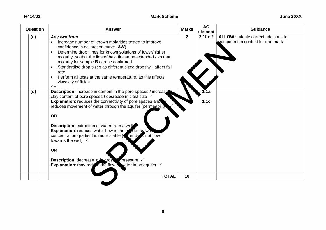
(c) Any two from
Increase number of known molarities tested to improve confidence in calibration curve (AW)
Determine drop times for known solutions of lower/higher molarity, so that the line of best fit can be extended / so that molarity for sample B can be confirmed
Standardise drop sizes as different sized drops will affect fall rate
Perform all tests at the same temperature, as this affects viscosity of fluids
2 3.1f x 2 ALLOW suitable correct additions to equipment in context for one mark
(d) Description: increase in cement in the pore spaces / increase in clay content of pore spaces / decrease in clast size Explanation: reduces the connectivity of pore spaces and so reduces movement of water through the aquifer (permeability) OR Description: extraction of water from a well Explanation: reduces water flow in the aquifer as water concentration gradient is more stable (water does not flow towards the well) OR Description: decrease in hydrostatic pressure Explanation: may reduce the flow of water in an aquifer
2 1.1a
1.1c
TOTAL 10
SPECIM
EN
H414/03 Mark Scheme June 20XX
10
Question Answer Marks AO
element Guidance
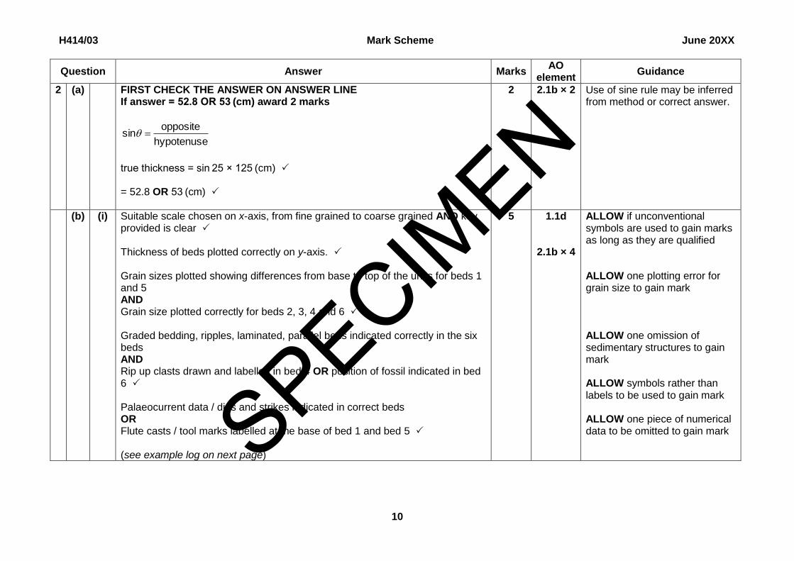
2 (a) FIRST CHECK THE ANSWER ON ANSWER LINE If answer = 52.8 OR 53 (cm) award 2 marks
hypotenuse
oppositesin
true thickness = sin 25 × 125 (cm) = 52.8 OR 53 (cm)
2 2.1b × 2 Use of sine rule may be inferred from method or correct answer.
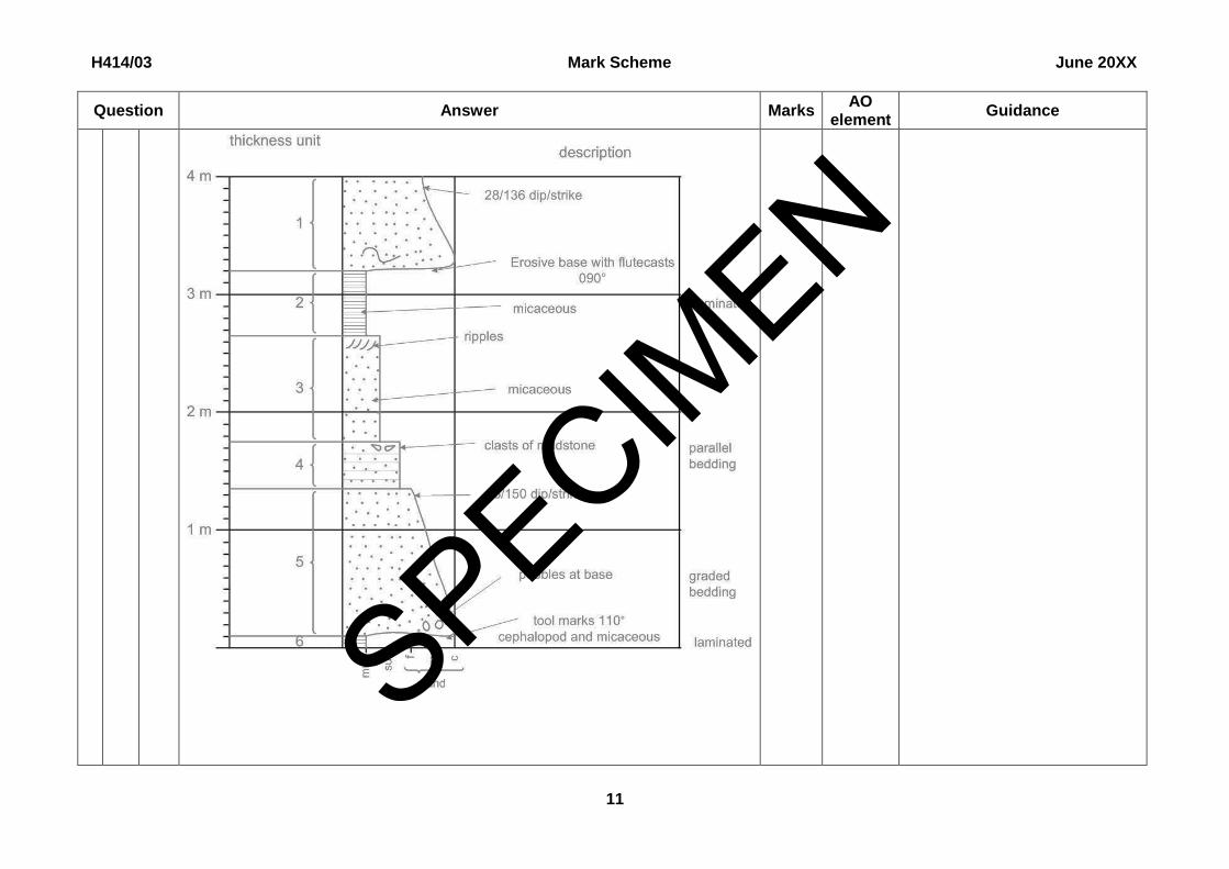
(b) (i) Suitable scale chosen on x-axis, from fine grained to coarse grained AND key provided is clear
Thickness of beds plotted correctly on y-axis. Grain sizes plotted showing differences from base to top of the units for beds 1 and 5 AND Grain size plotted correctly for beds 2, 3, 4 and 6
Graded bedding, ripples, laminated, parallel beds indicated correctly in the six beds AND Rip up clasts drawn and labelled in bed 4 OR position of fossil indicated in bed 6
Palaeocurrent data / dips and strikes indicated in correct beds OR Flute casts / tool marks labelled at the base of bed 1 and bed 5 (see example log on next page)
5
1.1d
2.1b × 4
ALLOW if unconventional symbols are used to gain marks as long as they are qualified ALLOW one plotting error for grain size to gain mark ALLOW one omission of sedimentary structures to gain mark ALLOW symbols rather than labels to be used to gain mark ALLOW one piece of numerical data to be omitted to gain mark SPECIM
EN
H414/03 Mark Scheme June 20XX
11
Question Answer Marks AO
element Guidance
SPECIMEN
H414/03 Mark Scheme June 20XX
12
Question Answer Marks AO
element Guidance
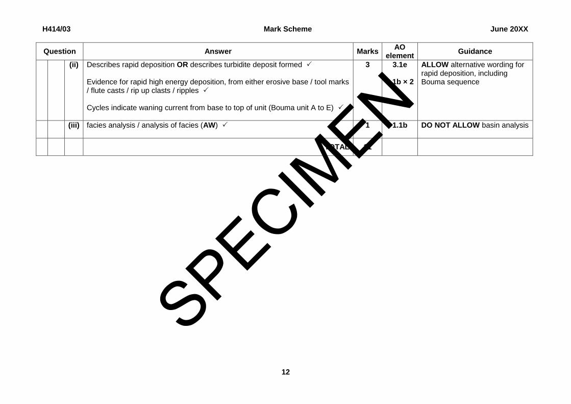
(ii) Describes rapid deposition OR describes turbidite deposit formed Evidence for rapid high energy deposition, from either erosive base / tool marks / flute casts / rip up clasts / ripples Cycles indicate waning current from base to top of unit (Bouma unit A to E)
3 3.1e
3.1b × 2
ALLOW alternative wording for rapid deposition, including Bouma sequence
(iii) facies analysis / analysis of facies (AW)
1 1.1b DO NOT ALLOW basin analysis
TOTAL 11
SPECIMEN
H414/03 Mark Scheme June 20XX
13
Question Answer Marks AO
element Guidance
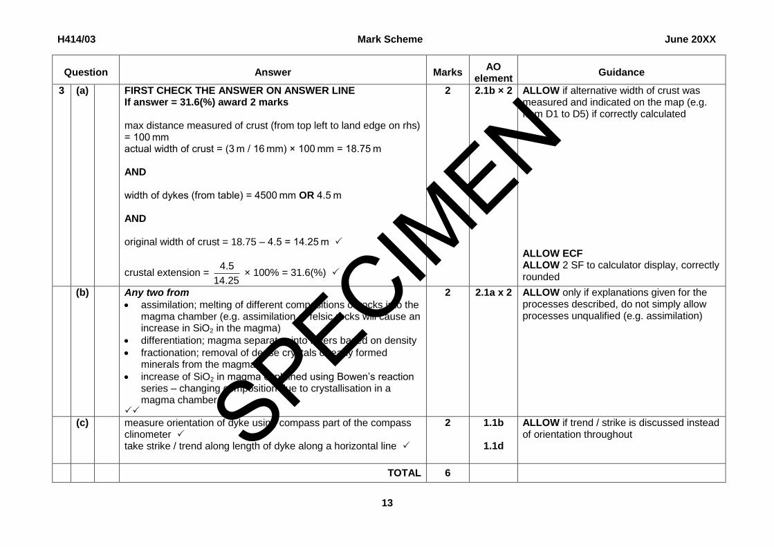
3 (a) FIRST CHECK THE ANSWER ON ANSWER LINE If answer = 31.6(%) award 2 marks max distance measured of crust (from top left to land edge on rhs) = 100 mm actual width of crust = (3 m / 16 mm) × 100 mm = 18.75 m AND width of dykes (from table) = 4500 mm OR 4.5 m AND original width of crust = 18.75 – 4.5 = 14.25 m
crustal extension = 25.14
5.4 × 100% = 31.6(%)
2 2.1b × 2 ALLOW if alternative width of crust was measured and indicated on the map (e.g. from D1 to D5) if correctly calculated ALLOW ECF ALLOW 2 SF to calculator display, correctly rounded
(b) Any two from
assimilation; melting of different compositions of rocks into the magma chamber (e.g. assimilation of felsic rocks will cause an increase in SiO2 in the magma)
differentiation; magma separates into layers based on density
fractionation; removal of dense crystals or early formed minerals from the magma
increase of SiO2 in magma explained using Bowen’s reaction series – changing composition due to crystallisation in a magma chamber
2 2.1a x 2
ALLOW only if explanations given for the processes described, do not simply allow processes unqualified (e.g. assimilation)
(c) measure orientation of dyke using compass part of the compass clinometer take strike / trend along length of dyke along a horizontal line
2 1.1b
1.1d
ALLOW if trend / strike is discussed instead of orientation throughout
TOTAL 6
SPECIMEN
H414/03 Mark Scheme June 20XX
14
Question Answer Marks AO
element Guidance
4 (a)
maximum stress (σ1) is vertical the minimum stress (σ3) is horizontal across the plain of the photo
2
2.1a × 2 ALLOW annotated diagram
The identification of the intermediate stress/ σ2 (in the fault plane) is NOT required
(b) FIRST CHECK THE ANSWER ON ANSWER LINE If answer = ×0.25 award 2 marks
magnification = 10
5.2
= ×0.25
2 1.1b x 2 First mark awarded for evidence of correct working.
TOTAL 4
SPECIMEN
H414/03 Mark Scheme June 20XX
15
Question Answer Marks AO
element Guidance
5 (a) directional stress / pressure during metamorphism / folding / mountain building Any two from
schistosity minerals grow / recrystallise due to effect of stress / pressure
boudinage form by necking during extension of competent rock
recumbent folds form during compression when folds overlap
refolding is evidence of more than one phase of compression during mountain building
3 1.1a x 1
2.1a x 2
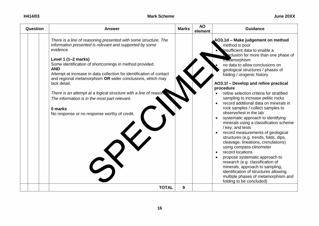
(b)* Please refer to the marking instructions on page 4 of this mark scheme for guidance on how to mark this question.
Level 3 (5–6 marks) Gives detailed evaluation and judgement on method provided. AND Proposes relevant refinements and additions to practical procedure that allow identification of multiple phases of metamorphism AND wider conclusions re geological environment or history.
There is a well-developed line of reasoning which is clear and logically structured. The information presented is relevant and substantiated.
Level 2 (3–4 marks) Gives evaluation and judgement on method provided. AND Proposes relevant refinements and additions to practical procedure that allow identification of more than one phase of metamorphism OR wider conclusions re geological environment or history.
6 3.1c × 2 3.1d × 1 3.1f × 3
AO3.1c – Evaluate given method
sampling strategy poor as undersamples pelitic rocks which are most informative, other types less useful for identifying multiple phases
only index minerals within rock samples identified
photo guides are ambiguous in the absence of a systematic key
other minerals would show evidence for multiple phases (garnet with trails / rims / inclusions / shadows)
transect across contact is good
if silicic intrusion after regional metamorphism may not be hot enough to produce contact metamorphism
method does not provide detail of cleavage and jointing
method does not provide details of geological structures or location of samples taken
SPECIMEN
H414/03 Mark Scheme June 20XX
16
Question Answer Marks AO
element Guidance
There is a line of reasoning presented with some structure. The information presented is relevant and supported by some evidence. Level 1 (1–2 marks) Some identification of shortcomings in method provided. AND Attempt at increase in data collection for identification of contact and regional metamorphism OR wider conclusions, which may lack detail. There is an attempt at a logical structure with a line of reasoning.
The information is in the most part relevant.
0 marks No response or no response worthy of credit.
AO3.1d – Make judgement on method
method is poor
insufficient data to enable a conclusion for more than one phase of metamorphism
no data to allow conclusions on geological structures / phases of folding / orogenic history
AO3.1f – Develop and refine practical procedure
refine selection criteria for stratified sampling to increase pelitic rocks
record additional data on minerals in rock samples / collect samples to observe/test in the lab
systematic approach to identifying minerals using a classification scheme / key, and tests
record measurements of geological structures (e.g. trends, folds, dips, cleavage, lineations, crenulations) using compass clinometer
record locations
propose systematic approach to research (e.g. classification of minerals, approach to sampling, identification of structures allowing multiple phases of metamorphism and folding to be concluded)
TOTAL 9
SPECIMEN
H414/03 Mark Scheme June 20XX
17
Question Answer Marks AO
element Guidance
6 (a) Overall evaluation that position of reservoir is not ideal Supporting analysis – any 3 from the following list:
reservoir is sited on drift deposits (Quaternary head and estuarine alluvial), which lack structure and strength
limestone beneath drift deposits is jointed meaning water could leak from the reservoir
beneath limestones and drift there is the Old Red Sandstone Series, which have high porosity – water from limestones could migrate into these
large fault to the east of the reservoir may extend under the drift deposits, placing dam at risk of collapse due to earthquakes
unknown what lies beneath drift deposits to the south of the reservoir, potential hidden dangers OR requirement for expensive investigation
4 3.1c
3.1a × 3
ALLOW one mark maximum for a general discussion of leakage or subsidence from the reservoir without specific links to geological reasons
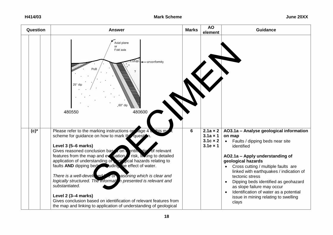
(b) Symbols used to show same rock type (key not necessary) Southern limb dipping 25o Northern limb dipping 60o Asymmetric anticline with correct number of beds plotted Axial plane OR fold axis labelled Position of unconformity marked to the north, plotted as horizontal or near horizontal beds Extrapolated beds under the unconformity in the north drawn or uncertainty shown (e.g. uses question mark) (See sample cross-section on next page)
7 1.1d
2.1b × 2
3.1a 2.1b
3.1b × 2
Dips on limbs are marked in terms of
accuracy 5o
ALLOW one bed to be missed in the anticline to still gain the mark
SPECIMEN
H414/03 Mark Scheme June 20XX
18
Question Answer Marks AO
element Guidance
(c)* Please refer to the marking instructions on page 4 of this mark scheme for guidance on how to mark this question. Level 3 (5–6 marks) Gives reasoned conclusion based on identification of relevant features from the map and evaluation of risk, linking to detailed application of understanding of geological hazards relating to faults AND dipping beds, including the effect of water. There is a well-developed line of reasoning which is clear and logically structured. The information presented is relevant and substantiated. Level 2 (3–4 marks) Gives conclusion based on identification of relevant features from the map and linking to application of understanding of geological
6 2.1a × 2 3.1a × 1 3.1c × 2 3.1e × 1
AO3.1a – Analyse geological information on map
Faults / dipping beds near site identified
AO2.1a – Apply understanding of geological hazards
Cross cutting / multiple faults are linked with earthquakes / indication of tectonic stress
Dipping beds identified as geohazard as slope failure may occur
Identification of water as a potential issue in mining relating to swelling clays
SPECIMEN
H414/03 Mark Scheme June 20XX
19
Question Answer Marks AO
element Guidance
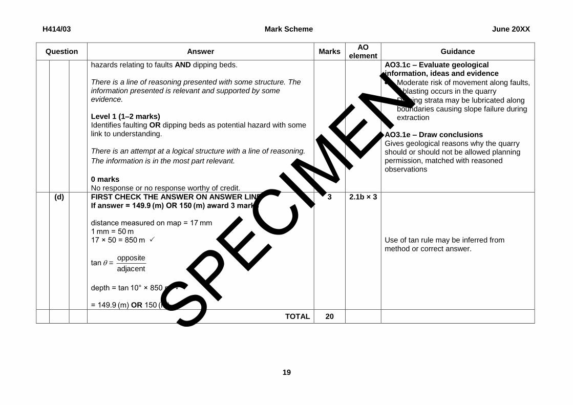
hazards relating to faults AND dipping beds. There is a line of reasoning presented with some structure. The information presented is relevant and supported by some evidence. Level 1 (1–2 marks) Identifies faulting OR dipping beds as potential hazard with some link to understanding. There is an attempt at a logical structure with a line of reasoning.
The information is in the most part relevant.
0 marks No response or no response worthy of credit.
AO3.1c – Evaluate geological information, ideas and evidence
Moderate risk of movement along faults, if blasting occurs in the quarry
Dipping strata may be lubricated along boundaries causing slope failure during extraction
AO3.1e – Draw conclusions Gives geological reasons why the quarry should or should not be allowed planning permission, matched with reasoned observations
(d) FIRST CHECK THE ANSWER ON ANSWER LINE If answer = 149.9 (m) OR 150 (m) award 3 marks distance measured on map = 17 mm 1 mm = 50 m 17 × 50 = 850 m
tan = adjacent
opposite
depth = tan 10° × 850 m = 149.9 (m) OR 150 (m)
3 2.1b × 3 Use of tan rule may be inferred from method or correct answer.
TOTAL 20
SPECIMEN
H414/03 Mark Scheme June 20XX
20
BLANK PAGE
SPECIMEN
Related Documents