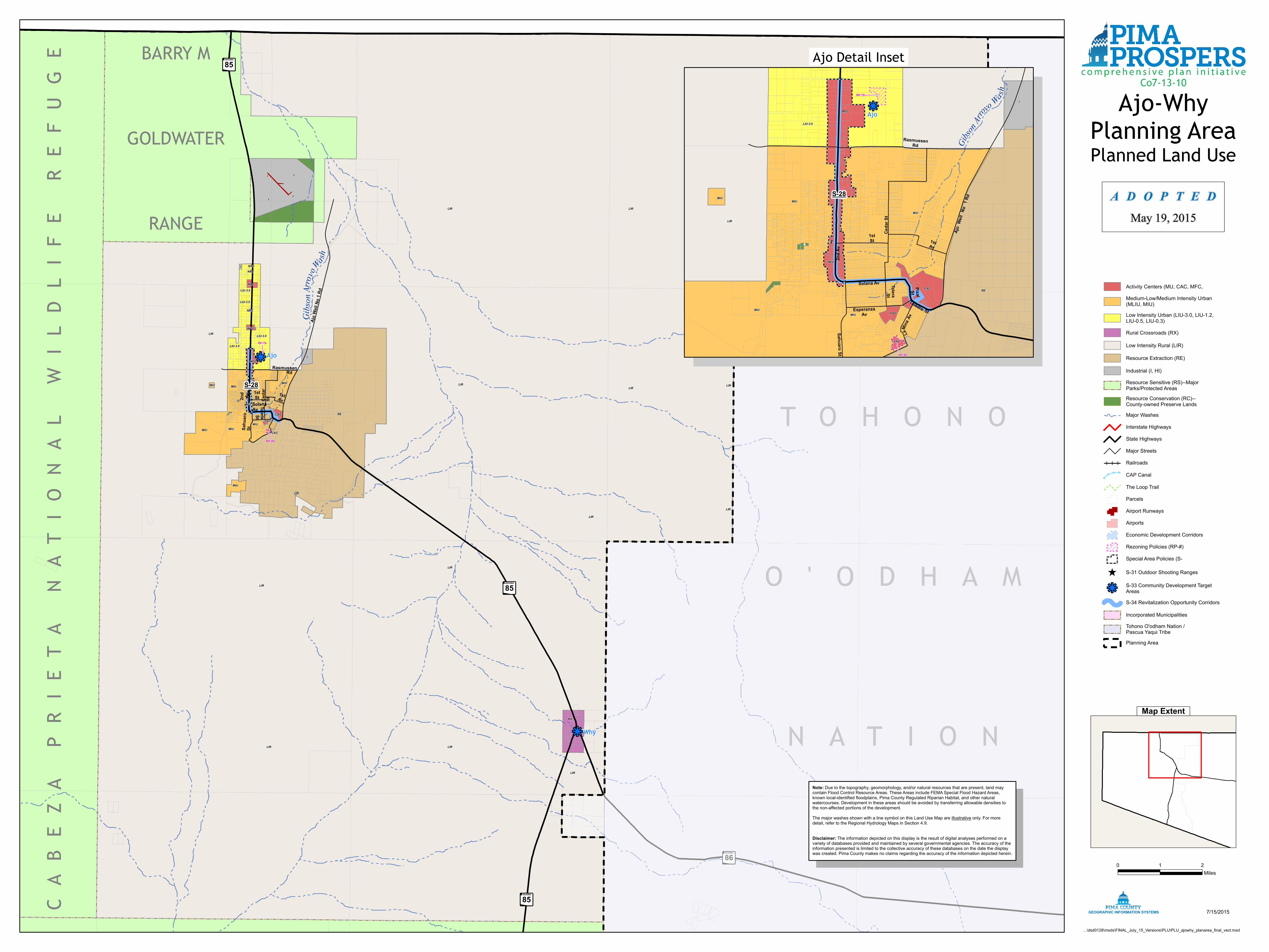
T O H O N O ' O D H A N A T I O N CABEZA PRIETA NATIONAL WILDLIFE REFUGE BARRY M GOLDWATER RANGE " x 85 " x 85 " x 85 " x 86 k j k j G i b s o n A r r o y o W a sh LIR LIR LIR LIR LIR LIR LIR LIR LIR LIR LIR LIR LIR LIR RE LIR I I I I NAC LIU-3.0 LIU-3.0 LIU-3.0 LIU-3.0 I NAC NAC NAC NAC MFC MFC I MIU MIU MIU MIU MIU MIU CAC CAC CAC MIU RX S-28 Solana Av 2nd Av Cedar St 1st Av Ajo Well No 1 Rd Telera St 1st St Rasmussen Rd Sahuaro St RP-79 RP-89 Ajo Why Ajo-Why Planning Area Planned Land Use ...\dsd0128\mxds\FINAL_July_15_Versions\PLU\PLU_ajowhy_planarea_final_vect.mxd 7/15/2015 0 1 2 Miles GEOGRAPHIC INFORMATION SYSTEMS Co7-13-10 k j G i b son A r r o yo W a s h LIR RE LIU-3.0 MFC MFC I MIU MIU MIU MIU MIU CAC CAC CAC S-28 Esperanza Av Pizal St Ta ladro St Solana Av 2nd Av Cedar St La M in a Av 1st Av A jo W e ll N o 1 R d Telera St 1st St Rasmussen Rd Sahuaro St RP-79 RP-89 Ajo Ajo Detail Inset Note: Due to the topography, geomorphology, and/or natural resources that are present, land may contain Flood Control Resource Areas. These Areas include FEMA Special Flood Hazard Areas, known local-identified floodplains, Pima County Regulated Riparian Habitat, and other natural watercourses. Development in these areas should be avoided by transferring allowable densities to the non-affected portions of the development. The major washes shown with a line symbol on this Land Use Map are illustrative only. For more detail, refer to the Regional Hydrology Maps in Section 4.9. Disclaimer: The information depicted on this display is the result of digital analyses performed on a variety of databases provided and maintained by several governmental agencies. The accuracy of the information presented is limited to the collective accuracy of these databases on the date the display was created. Pima County makes no claims regarding the accuracy of the information depicted herein. Map Extent ADOPTED May 19, 2015 Resource Sensitive (RS)--Major Parks/Protected Areas Resource Conservation (RC)-- County-owned Preserve Lands Major Washes Interstate Highways State Highways Major Streets Railroads ! ! ! ! CAP Canal The Loop Trail Parcels Airport Runways Airports Economic Development Corridors Rezoning Policies (RP-#) Special Area Policies (S- ^ S-31 Outdoor Shooting Ranges k j S-33 Community Development Target Areas S-34 Revitalization Opportunity Corridors Incorporated Municipalities Tohono O'odham Nation / Pascua Yaqui Tribe Planning Area Activity Centers (MU, CAC, MFC, Medium-Low/Medium Intensity Urban (MLIU, MIU) Low Intensity Urban (LIU-3.0, LIU-1.2, LIU-0.5, LIU-0.3) Rural Crossroads (RX) Low Intensity Rural (LIR) Resource Extraction (RE) Industrial (I, HI)

Welcome message from author
This document is posted to help you gain knowledge. Please leave a comment to let me know what you think about it! Share it to your friends and learn new things together.
Transcript
T O H O N O
O ' O D H A M
N A T I O N
CA
BE
ZA
P
RIE
TA
N
AT
ION
AL
W
ILD
LIF
E
RE
FU
GE BARRY M
GOLDWATER
RANGE
"x85
"x85
"x85
"x86
kj
kj
Gibso
nArro
y oWash
LIR
LIR
LIR
LIR
LIR
LIR
LIR
LIR
LIR
LIR
LIR
LIR
LIR
LIR
RE
LIR
I
I
I
I
NAC
LIU-3.0
LIU-3.0
LIU-3.0
LIU-3.0
INAC
NAC
NAC
NAC
MFC
MFCI
MIUMIU
MIU MIUMIU
MIU
CACCAC
CAC
MIU
RX
S-28
SolanaAv
2nd Av Ceda
rSt
1stAv
Ajo W
ell No
1 Rd
TeleraSt
1stSt
RasmussenRd
Sahu
aroSt
RP-79
RP-89
Ajo
Why
Ajo-WhyPlanning AreaPlanned Land Use
...\dsd0128\mxds\FINAL_July_15_Versions\PLU\PLU_ajowhy_planarea_final_vect.mxd
7/15/2015
0 1 2Miles
GEOGRAPHIC INFORMATION SYSTEMS
Co7-13-10kj
Gibson
Arr
oyo
Wash
LIR
RE
LIU-3.0
MFC
MFC
I
MIU
MIU
MIUMIU
MIU
CAC
CAC
CAC
S-28
EsperanzaAv
PizalSt
Taladro St
Solana Av
2nd A
v
Ceda
r St
LaMi
naAv
1stAv
AjoWe
llNo
1 Rd
TeleraSt
1stSt
RasmussenRd
Sahuaro St
RP-79
RP-89
Ajo
Ajo Detail Inset
Note: Due to the topography, geomorphology, and/or natural resources that are present, land maycontain Flood Control Resource Areas. These Areas include FEMA Special Flood Hazard Areas,known local-identified floodplains, Pima County Regulated Riparian Habitat, and other naturalwatercourses. Development in these areas should be avoided by transferring allowable densities tothe non-affected portions of the development.The major washes shown with a line symbol on this Land Use Map are illustrative only. For moredetail, refer to the Regional Hydrology Maps in Section 4.9.
Disclaimer: The information depicted on this display is the result of digital analyses performed on avariety of databases provided and maintained by several governmental agencies. The accuracy of theinformation presented is limited to the collective accuracy of these databases on the date the displaywas created. Pima County makes no claims regarding the accuracy of the information depicted herein.
Map Extent
A D O P T E DMay 19, 2015
Resource Sensitive (RS)--MajorParks/Protected AreasResource Conservation (RC)--County-owned Preserve LandsMajor WashesInterstate HighwaysState HighwaysMajor StreetsRailroads
!
!! ! CAP Canal
The Loop TrailParcelsAirport RunwaysAirportsEconomic Development CorridorsRezoning Policies (RP-#)Special Area Policies (S-
^ S-31 Outdoor Shooting Ranges
kj S-33 Community Development TargetAreasS-34 Revitalization Opportunity Corridors
Incorporated MunicipalitiesTohono O'odham Nation /Pascua Yaqui TribePlanning Area
Activity Centers (MU, CAC, MFC,Medium-Low/Medium Intensity Urban(MLIU, MIU)Low Intensity Urban (LIU-3.0, LIU-1.2,LIU-0.5, LIU-0.3)Rural Crossroads (RX)
Low Intensity Rural (LIR)
Resource Extraction (RE)
Industrial (I, HI)
Related Documents