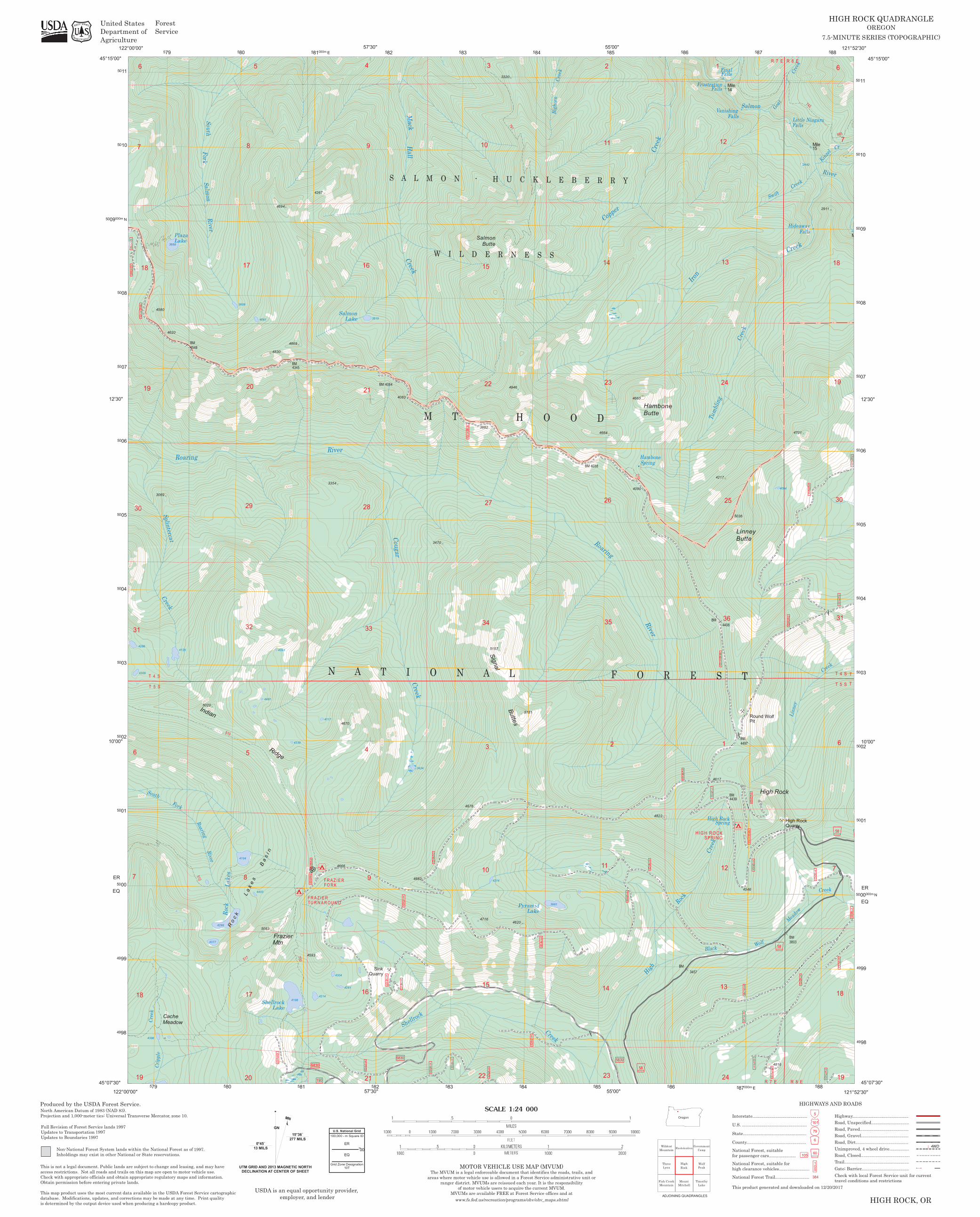
EE EE E E EE EE E E EE E E EE C C 4200 4400 4000 4600 4000 4200 4800 4600 4 3600 3400 4000 4200 4000 4400 3400 4000 4000 3400 4400 4000 3400 3600 4800 4800 2600 2200 4000 4000 3400 440 3800 3400 4000 5000 4000 2800 4000 4200 4600 3200 3600 3000 3400 4200 3400 3600 3200 4800 2400 4600 4000 3800 4200 3400 3800 3000 3800 3800 3600 3600 5000 3000 3800 2600 40 4000 3800 4000 4200 2400 4200 3200 4800 4600 5000 3000 2600 3800 4800 4600 3800 4000 3800 4000 3800 2800 3400 3000 3600 3800 3000 5000 3400 4000 3400 4000 2200 4200 4600 4600 3000 2600 4400 460 3800 4000 4200 3400 2800 3000 2400 3600 3400 3800 4000 4000 3600 4800 3200 5000 4800 3000 2800 3600 3600 4000 3600 3800 4000 2000 4000 2 3600 4200 3 3600 3800 3800 4000 3200 4200 4400 3400 3600 2600 3200 4200 3400 4400 4000 4400 4400 4400 2 3 2800 4000 4200 4600 4600 4200 4000 3600 3600 2600 3400 4600 3800 3600 3000 2600 4600 3000 4400 3400 2800 4800 3600 3600 4800 3000 4600 3400 3600 3200 3000 2400 3200 2800 3600 3600 4800 3400 3800 4000 4 3200 3600 4000 4800 4000 3400 3800 4600 3400 3800 4400 4800 4000 3200 3400 0 4400 4000 4400 5000 3400 3600 3400 4200 2600 3200 3400 3000 3400 4000 3800 3 2600 3600 3400 2200 3400 2800 4400 4600 4400 4600 4600 4200 4400 4400 3600 4200 5000 4000 4000 3000 4200 4600 4000 3600 2200 4400 2 3800 4000 4400 4400 3000 4000 3000 3600 4000 4600 4600 240 240 H H H H H H H H H H H H H H H H H H H H H H H H H H H H H H H H H H H H H H H H H H H H H H H H H H H H H H H H H H H H H H H H H H H H H H H H H H J J J J o W W W R R R R R R R R R R R R R R R R R R R R R R R R R R R R R R R R R R R R R R R R R R R ± " R R ± ± ± ± ± " ` ` ` ã k k k k k 19 6 Cripple Fork 4125 BM 4548 Rock 510 517 4104 29 @ 21 9 Cougar 4882 Creek 4716 5157 23 14 4090 Frustration BM 25 Linney Butte Falls High Rock Quarry Hideaway Mile 6 T 5 7 South 31 4286 18 512 4299 B a s i n 5 4353 BM FRAZIER TURNAROUND 4281 N A T I O N A L F O R E S T S A L M O N - H U C K L E B E R R Y 3470 3882 Buttes 791 Pyramid Lake 5181 35 26 2 High 4822 Spring Rock C 24 Black Creek High Rock Final Creek Wolf R 8 E Creek 6 18 Meadow 4580 Salmon South 17 R o c k L a k e s Mtn Frazier River 33 21 4 10 10 Roaring 210 HIGH ROCK SPRING Spring 13 Falls 4546 BM 4439 4701 R 8 E Creek 2911 T 4 S River T 4 19 4386 4309 30 7 Creek Roaring 5020 8 17 8 5083 4481 4061 700 4345 4214 4267 4304 4670 3354 Creek M M T H O O D 3 27 15 4946 14 4664 Copper 2 Hambone Butte 13 4408 4217 Round Wolf Pit R 7 E Meadow 4094 Creek Kinzel 18 T 5 S 31 18 4620 3668 Plaza Lake 5 Shellrock Lake 4198 4869 4694 FRAZIER FORK 3819 3424 3 3981 23 Creek 36 24 BM 4497 Salmon High Rock Linney 15 665 Cache 3069 River 32 4403 Ridge 4339 4117 Salmon Lake 9 4083 15 34 22 4214 4620 BM 4038 11 Hambone 3457 12 1 12 Vanishing 1 14 Mile R 7 E Swift Goat R 7 E Creek Creek 742 19 7 30 19 7 T 5 S Splintercat Roaring 4377 River 20 20 4830 4666 4 BM 4084 Shellrock 4876 Salmon Butte 3320 Creek Bighorn 11 River 4660 Iron 4617 Falls 5036 Falls Falls 2442 M Creek 6 T 4 S Indian Fork Lakes 3608 4593 16 28 16 Sink Quarry Hall Mack W I L D E R N E S S 22 Signal Creek BM Tumbling 4816 BM 3803 Little Niagara R 8 E Cr 50 N 5 80 5 82 5 00" 88 121° 99 03 50 ER 00" 12' 09 50 50 11 5 81 000m 30" 30" 83 83 5 85 5 86 52' 00 45° 000m 49 50 50 50 05 00" 79 5 E 57' 55' 50 02 50 09 50 30" 45° 30" 30" EQ ER 50 01 02 07 82 5 5 86 5 87 87 88 52' 49 50 06 50 15' 122° 50 50 99 122° 00' 00" 80 84 121° 10 11 07' 45° 50 000m 50 00 81 57' 55' 5 5 000m 5 98 01 04 50 07 30" 10' N 15' 45° 10' 49 50 03 04 06 08 10 84 00" 5 50 08 EQ 07' 00" 00" 30" 98 00' 79 5 5 5 5 5 85 E 5 49 50 50 05 50 50 12' 00" 30" 58 58 58 0 3 0 0 3 1 1 3 0 2 3 0 2 2 0 1 7 0 1 9 0 1 4 0 2 5 0 2 4 0 1 5 0 1 4 5 1 8 0 1 9 0 1 6 0 1 2 0 0 3 5 1 6 0 1 6 0 1 7 4 0 3 6 2 2 0 2 0 0 2 3 0 1 5 0 1 4 0 2 2 0 1 7 5 1 4 9 1 5 0 2 4 0 1 3 0 0 2 0 4 6 1 0 4 6 1 0 4 6 1 0 4 6 1 0 190 5830 5830 5830 2 6 0 7.5-MINUTE SERIES (TOPOGRAPHIC) HIGH ROCK QUADRANGLE OREGON HIGH ROCK, OR Fish Creek Mountain Rhododendron Mount Mitchell Wildcat Mountain Government Camp Wolf Peak Three Lynx High Rock Timothy Lake Oregon × Ù GN MN 0°45´ 13 MILS 15°36´ 277 MILS UTM GRID AND 2013 MAGNETIC NORTH DECLINATION AT CENTER OF SHEET 50 00 ER EQ Grid Zone Designation 10T U.S. National Grid 100,000 - m Square ID This is not a legal document. Public lands are subject to change and leasing, and may have access restrictions. Not all roads and trails on this map are open to motor vehicle use. Check with appropriate officials and obtain appropriate regulatory maps and information. Obtain permission before entering private lands. This map product uses the most current data available in the USDA Forest Service cartographic database. Modifications, updates, and corrections may be made at any time. Print quality is determined by the output device used when producing a hardcopy product. Non-National Forest System lands within the National Forest as of Inholdings may exist in other National or State reservations. North American Datum of 1983 (NAD 83). Produced by the USDA Forest Service. Projection and 1,000-meter tics: Universal Transverse Mercator, zone 10. 1997 Full Revision of Forest Service lands Updates to Transportation Updates to Boundaries 1997 1997 ADJOINING QUADRANGLES 1997. USDA is an equal opportunity provider, employer, and lender United States Department of Agriculture Forest Service MOTOR VEHICLE USE MAP (MVUM) The MVUM is a legal enforceable document that identifies the roads, trails, and areas where motor vehicle use is allowed in a Forest Service administrative unit or ranger district. MVUMs are reissued each year. It is the responsibility of motor vehicle users to acquire the current MVUM. MVUMs are available FREE at Forest Service offices and at www.fs.fed.us/recreation/programs/ohv/ohv_maps.shtml This product generated and downloaded on 12/20/2017 State .................................................... National Forest, suitable for passenger cars ...................... County................................................. National Forest, suitable for high clearance vehicles ......................... ¼ j ¬ k ° 105 1 0 5 60 79 6 HIGHWAYS AND ROADS Interstate............................................. U.S . ..................................................... ¥ ¦ 5 101 Road, Unspecified ............................... Highway.............................................. National Forest Trail ............................ 384 Road, Gravel ....................................... Road, Paved........................................ Unimproved, 4 wheel drive ................ n 4WD Road, Dirt ........................................... Road, Closed........................................ Trail ..................................................... Check with local Forest Service unit for current travel conditions and restrictions Gate; Barrier....................................... o J

Welcome message from author
This document is posted to help you gain knowledge. Please leave a comment to let me know what you think about it! Share it to your friends and learn new things together.
Transcript
EEEEEE
EEEEE
EEEEEEEEEEEE
EEEE
EEEEEEEE
CC
CCCC
4200
4400
4000
4600
4000
4200
4800
4600
4000
3600
3400
4000
4200
4000
4400
3400
4000
4000
3400
4400
4000
3400
3600
4800
4800
2600
2200
4000
4000
3400
4400380
0
3800
3400
2800
4000
5000
4000
2800
4000
4200
4600
3200
3600
3000
3400
4200
3400
3600
3200
4800
24004600
4000
3800
4200
3400
3800
3000
3800
38003600
3600
5000
3000
3800
2600
4000
4400
4000
3800
4000
4200
2400
4200
3200
4800
4600
5000
3000
2600
3800
4800
4600
3800
4000
3800
4000
38002800
3400
3000
3600
3800
3000
5000
340040
00
2000
3400
4000
2200
4200
4600
4600
3000
2600
4400
4600
3800
4000
4200
3400
2800
3000
2400
2600
3600
3400
3800
4000
4000
3600
4800
3200
5000
4800
3000
2800
3600
3600
4000
3600
3800
4000
2000
4000
2600
3600
4200
3400
360044
0038
0038
0040
00
3200
4200
4400
3400
3600
2600
3200
4200
3400
4400
4000
4400
4400
2600
4400
2600
3800
280040
00
4200
4600
4600
4200
4000
3600 3600
2600
3400
4600
3800
3600
3000
2600
4600
4000
2400
3000
4400
3400
2800
4800
3600
3600
4800
3000
4600
3400
3600
3200
3000
2400
3200
2800
3600
3600
4800
3400
3800
4000
4000
3200
3600
4000
4800
4000
3400
3800
4600
3400
2000
3800
4400
4800
4000
3200
3400
48003200
4400
3400
4400
4000
4400
5000
3400
3600340
0
4200
2600
3200
3400
3000
3400
4000380
0
3400
2600
3600
3400
2200
3400
2800
4400
4600
4400
4600
4600
4000
40004200
4400
4400
3600
4200
5000
4000
40003000
4200
4600
4000
3600
2200
4400
2200
3800
4000
4400
4400
3000
3000
4000
3000
3600
4000
4600
4600
2600
2400
2400
H
H
H
H
H
H
H
H
H
H
H
H
H
H
H
H
H
HH
H
HH
H
HH
H
H
H
H
HH
H
H
HH
H
H
H
H
H
H
H
H
H
H
H
H
H
H
H
H
H
H
H
H
H
H
H
H
H
H
H
H
H
H
H
H
H
H
H H
H
H
HHHHHHHH
H
H
H
H
H H
H
H
H
H
H
H
H
HH
HH
HH
HH
H H H
HH
H
H
H
H
H
H
H
H
H
H
HH
HH
H
H
H
H
HH
H
H
H
H
H
H
H
H
H
H
H
H
H
J
J
J
J
J
o
W
W
W
W
R
R
R
R
R
R
R
R
R
R
R
R
R
R
R
R
R
R
R
R
R
R
R
R
R
R
R
R
R
R
R
R
R
R
R
R
R
R
R
R
R
R
R
R
±
"
R
R
±
±
± ±
±R
"
`
`
`
ã
k
kk
k
k
T 5 S
19
6
Cripp
le
Fork
4125
BM4548
Rock
510
517
4104
29
@
21
9
Cougar
4882
Creek
4716
5157
23
14
4090
Frustration
BM
25
LinneyButte
Falls
High RockQuarry
Hideaw ay
Mile
6
T 5 S
7
South
314286
18
512
4299
B a s i
n
5
4353
BM
F R A Z I E RT U R N A R O U N D
4281
N A T I O N A L F O R E S T
S A L M O N - H U C K L E B E R R Y
3470
3882
Buttes791
Pyram idLake
5181
35
26
2
H igh
4822
Spring
Rock
Copper
24
Black
Creek
H igh Rock
Fina l
Creek
Wolf
R 8 ER 8 E
Creek
6
Sp lit
4326
18
Meadow
4580
Sa lm onSouth
17
R o c k
L a k e
s
MtnFrazier
River
33
21
4
10
10
Roaring
210
HIG H RO CKSPRING
Spring
13
Falls
4546
BM4439
4701
R 8 E
Creek
2911
T 4 S
R iver
T 4 ST 4 S
19
4386
4309
30
7
Creek
Roaring
5020
8
17
8
5083
4481
4061
700
4345
4214
4267
4304
4670
3354
Creek
Mack
M T H O O D
3
27
15
4946
14
4664
Copper
2
HamboneButte
13
4408
4217
Round WolfPit
R 7 E
Meadow
4094
Creek
Kinzel
18
T 5 S
31
18
16
F alls
4620
3668
PlazaLake
5
ShellrockLake
4198
4869
4694
F R A Z I E RF O R K
3819
3424
3
3981
23
Creek
36
24
BM4497
S alm on
High RockLin
ney
15
665
Cache
3069
River
32
4403
Ridge4339
4117
Salm onLake
9
4083
15
34
22
4214
4620
BM 4038
11
Ham bone
3457
12
1
12
Vanishing
1
14Mile
R 7 ER 7 E
Swift
Goat
R 7 E
Creek
Creek
742
19
7
30
19
7
T 5 S
Splinterca t
Roaring
4377
River
20
20
4830
4666
4
BM 4084
Sh ellro ck
4876
SalmonButte
3320
Creek
Bighor
n
11
River
4660
Iron
4617
Falls
5036
Falls
Fa lls
2442
Mile
Creek
6
T 4 S
Indian
Fork
L ake
s
3608
4593
16
28
16
SinkQuarry
HallM ack
W I L D E R N E S S
22
Signal
Creek
BM
Tumb
ling
4816
BM3803
Little N iagara
R 8 E
Cr
50
N
5
80
5 82
500"
88 121°
99
03
50
ER
00"
12'
09
50
50
11
5 81000m
30"
30"
83
83
5
85
5
86
52'
00
45°
000m
49
50
50
50
05
00"
79 5 E
57'
55'
50
02
50
09
50
30"45°
30"30"
EQ
ER
50
01
02
07
82 5
5 86
5
87
87
88
52'
49
50
06
50
15'
122°
50
50
99
122°
00'
00"
80
84
121°
10
11
07'45°
50 000m
50
00
81
57'
55'
5
5 000m 5
98
01
04
50
07
30"
10'
N
15'45°
10'
49
50
03
04
06
08
10
84 00"
5
50
08
EQ
07'
00"
00"
30"
98
00'
79 5
5
5
5
5 85 E
5
49
50
5005
50
50
12'
00"
30"
58
58
58
030
031130
230
220
170
190140
250
240
150
145
180
190
160
120
035
160
160174
036
220
200
230
150
140
220
175
149
150
240
130
020
4610
4610
4610
4610
190
58305830
5830
260
7.5 -M IN U TE SERIES (TOPO GRAPH IC)
HIGH ROCK QUADRANGLEOREG ON
HIGH ROCK, OR
Fish C reekM oun ta in
R h o do de n d ro n
M oun tM itch ell
WildcatM oun ta in
G o vern m entC a m p
WolfPeak
Th reeLyn x
H ig hR ock
Tim othyLa ke
Oregon×
ÙGN
MN
0°45´13 MILS
15°36´277 MILS
UTM GRID AND 2013 MAGNETIC NORTHDECLINATION AT CENTER OF SHEET
5000ER
EQ
Grid Zone Designation10T
U.S. National Grid100,000 - m Square ID
This is not a legal docum ent. Public lands are subject to change and leasing, and m ay have access restrictions. N ot all roads and tra ils on this m ap are open to m otor vehicle use. Check with appropriate officials and obtain appropriate regulatory m aps and inform ation. Obtain perm ission before entering private lands.
This m ap product uses the m ost current data available in the U SD A Forest Service cartographic database. M odifications, updates, and corrections m ay be m ade at any tim e. Print quality is determ ined by the output device used w hen producing a hardcopy product.
Non-National Forest System lands w ithin the National Forest as of Inholdings m ay exist in other N ational or State reservations.
North Am erican D atum of 1983 (N AD 83). Produced by the U SDA Forest Service.Projection and 1,000-m eter tics: U niversa l Transverse Mercator, zone 10.
1997Full Revision of Forest Service landsUpdates to Transportation Updates to Boundaries
19971997
ADJOINING QUADRANGLES
1997.
USDA is an equal opportunity provider, em ployer, and lender
U nited StatesDepartm ent of Agriculture
Forest Service
M OTO R VEH ICLE USE M AP (M VU M )The MVU M is a legal enforceable docum ent that identifies the roads, trails, and
areas w here m otor vehicle use is allow ed in a Forest Service adm inistrative unit orranger district. MVU M s are reissued each year. It is the responsibility
of m otor vehicle users to acquire the current MVU M .MVU M s are available FREE at Forest Service offices and at
ww w.fs.fed.us/recreation/program s/ohv/ohv_m aps.shtm l
This product generated and dow nloaded on 12/20/2017
State....................................................
National Forest, suitablefor passenger cars......................
County.................................................
National Forest, suitable for high clearance vehicles.........................¼
j¬
k°105105
60
796
HIG H WAYS AN D RO AD SInterstate.............................................U.S . .....................................................
¥¦
5101 Road, U nspecified...............................
Highway..............................................
National Forest Trail............................ 384
Road, G ravel.......................................Road, Paved........................................
Unim proved, 4 w heel drive................ n 4WDRoad, D irt...........................................
Road, C losed........................................Trail.....................................................
Check with local Forest Service unit for current travel conditions and restrictions
Gate; Barrier....................................... o J
Related Documents