GY301 Geomorphology Fluvial Erosion Landforms Introduction Running water is by far the most important erosional agent on Earth. Even in arid climates, it is the primary agent of erosion. This is evident from the abundance of stream beds found throughout desert areas. Although these areas receive little rain throughout the year, the few days of rainfall produce flash floods that erode and transport tremendous amounts of material because of the lack of vegetation. Stream Gradient The stream gradient refers to the slope of the land surface upon which a stream flows. The stream gradient is calculated by comparing two points of known elevation along the stream's course with the horizontal map distance between the two points: The gradient is generally given in units of feet per mile (or m/km). When calculating a gradient do not try to convert the numerator and denominator of the fraction to equivalent units unless explicitly requested to do so. For example, if two points had an elevation difference of 200 feet according to the contour data, and the two points were 4 miles apart as measured along the stream course,the resulting gradient would be 50 feet per mile. The stream gradient bears a direct relationship with topographic contour spacing; if the stream course runs across many contours in a short distance the gradient will be high, whereas streams flowing across flat plains will have low gradients. The calculation of a stream gradient may be made from any two points along the stream since elevations may be interpolated from contours and map distance is determined by the map scale, however, it is more convenient to pick points that lay on contour lines to determine elevations. The erosional power of a stream is proportional to the discharge of the stream which is, in turn, primarily a function of the size of the stream and the velocity of the stream water. Because an increased stream gradient is usually correlated with a higher velocity, the higher gradient streams will erode their channels at a faster rate than other lower-gradient stream systems. Page -1-

Welcome message from author
This document is posted to help you gain knowledge. Please leave a comment to let me know what you think about it! Share it to your friends and learn new things together.
Transcript
GY301 GeomorphologyFluvial Erosion Landforms
Introduction
Running water is by far the most important erosional agent on Earth. Even in aridclimates, it is the primary agent of erosion. This is evident from the abundance of streambeds found throughout desert areas. Although these areas receive little rain throughout theyear, the few days of rainfall produce flash floods that erode and transport tremendousamounts of material because of the lack of vegetation.
Stream Gradient
The stream gradient refers to the slope of the land surface upon which a streamflows. The stream gradient is calculated by comparing two points of known elevation alongthe stream's course with the horizontal map distance between the two points:
The gradient is generally given in units of feet per mile (or m/km). When calculating agradient do not try to convert the numerator and denominator of the fraction to equivalentunits unless explicitly requested to do so. For example, if two points had an elevationdifference of 200 feet according to the contour data, and the two points were 4 miles apartas measured along the stream course,the resulting gradient would be 50 feet per mile. Thestream gradient bears a direct relationship with topographic contour spacing; if the streamcourse runs across many contours in a short distance the gradient will be high, whereasstreams flowing across flat plains will have low gradients. The calculation of a streamgradient may be made from any two points along the stream since elevations may beinterpolated from contours and map distance is determined by the map scale, however, itis more convenient to pick points that lay on contour lines to determine elevations.
The erosional power of a stream is proportional to the discharge of the stream whichis, in turn, primarily a function of the size of the stream and the velocity of the stream water.Because an increased stream gradient is usually correlated with a higher velocity, thehigher gradient streams will erode their channels at a faster rate than other lower-gradientstream systems.
Page -1-
GY301 GeomorphologyFluvial Erosion Landforms
Divides
A stream divide separates stream drainage basins. The separation between twodrainage basins is a linear topographic high such as a a ridge or plateau; on opposite sidesof the ridge streams of the different drainage systems flow in opposite directions. Todelineate the divide one could draw a pencil line on a topographic map that connectspoints of maximum elevation along the ridge crest. This line will divide the two drainagesystems because all streams will drain away from this line.
A stream system is typically made up of a dendritic pattern of tributaries that draina large drainage basin. A ridge will separate individual drainage basins along a divide. Adivide may be recognized on a topographic map as a ridge across which streams tend toflow in opposite directions. The continental divide west of the front range of the RockyMountains is but one example of a large divide. The divides are important to earthscientists because the water resources of one drainage basin are normally isolated fromthose of another drainage basin.
Alluvial Fans
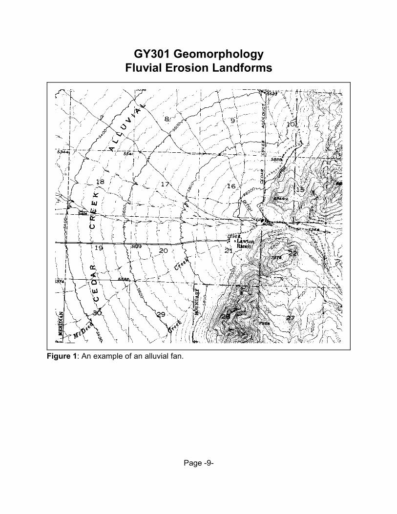
Alluvial fans are common in arid to semiarid climates and are depositional productsof running water that is, surprisingly, the primary erosional agent in these types of climates.Since arid landforms do not have the extensive vegetative cover found in humid climatesthe soil horizon is not well anchored in these types of terrains. Therefore, during rare butsubstantial rain or snow-melt the soil horizon is eroded very quickly. The drainage systemof a desert landform is not well-integrated so most of the transported material is not moveda large distance. The deposited sediment tends to collect at slope breaks where thecapacity of the stream is exceeded. These conical aprons of sediment that build-up alongthe flanks of mountain ranges are termed alluvial fans. Alluvial fans are easily recognizedbecause of the characteristic shape of contour lines that cross the fan. The contours tendto form evenly spaced semicircular geometries because of the conical shape of the alluvialfan surface. Figure 1 is a portion of a USGS 7.5' quadrangle that contains an alluvial fanlandform feature. Note that the contours are evenly spaced about the alluvial fan, indicatinga relatively constant slope angle. Also note that a topographic profile taken perpendicularto evenly spaced contours produces a planar sloping surface. Natural landforms in aridregions will not possess contours that are perfectly spaced, therefore, the surface is usuallyslightly concave up in form.
Because the sediment incorporated into an alluvial fan has traveled a relatively shortdistance, the particles that compose the sediment tend to be angular and poorly sorted ascompared to sediments deposited by streams in a humid climate. Because the particles
Page -2-
GY301 GeomorphologyFluvial Erosion Landforms
have a short transport residence time, the materials composing the sediment may be onlyslightly affected by chemical weathering. This is also due to the low humidity in the aridclimate. Streams that flow on top of alluvial fans are typically intermittent and form braidedchannels since they are often overloaded with sediment.
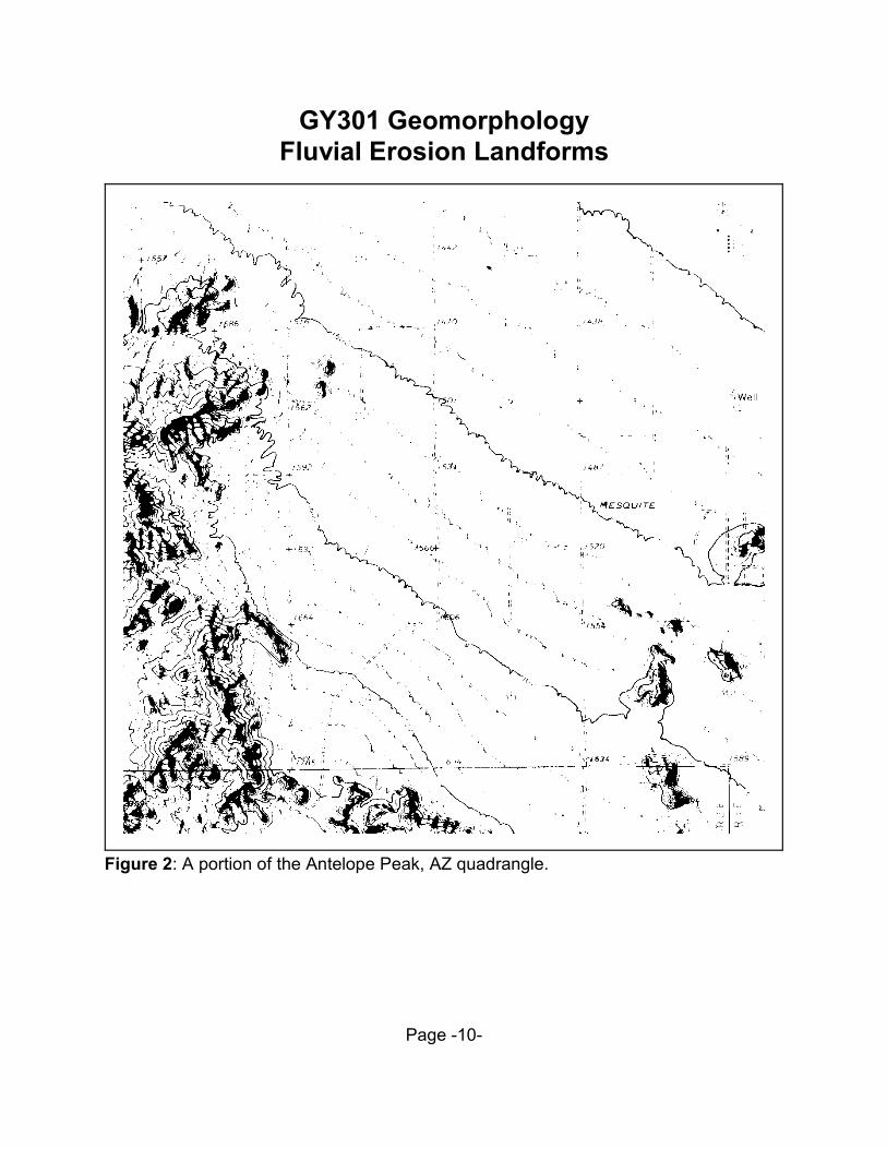
As erosion wears down mountain ranges in arid climates, alluvial fans build at thebase of the mountain ranges. The alluvial fans become larger over time until several fanswill merge to form a broad apron of debris that is termed a bajada. The bajada isrecognized on a topographic map by the straight rather than crescent-shaped contour linesthat have a constant spacing. In Figure 2 the bajada can be recognized from the relativelystraight and equally spaced contour lines. A mountain range in the mature stage of the aridcycle of erosion may be entirely covered by a bajada on each flank. The elevated remnantsof a mountain range surrounded by an expanding bajada is termed inselberg, which is aGerman derivation meaning literally "island mountain". Several inselbergs are present astopographic hills in Figure 2.
The low-lying valleys that lie between mountain ranges are the sites where runofffrom alluvial fans collect. The collecting water forms broad shallow lakes during the springwhen snow melts at higher elevations in the mountain ranges. However, this time ofabundant runoff is short-lived. The lakes are termed playa lakes and soon completelyevaporate. Because the water that formed the lake also contained dissolved material, thesite of a playa is marked by deposits of various salts such as halite (NaCl) and gypsum
4 2CaSO •2H O). These can be recognized from aerial photographs which show these areasas patches of white.
Stream Systems in Humid Climates
Most of the United States east of the Mississippi River can be classified as a humidclimate. In these areas the dominant erosional force is a well integrated system of streams.We are most familiar with the larger river systems such as the Mississippi, Ohio, andMissouri Rivers, but smaller streams also do much erosional work. The integrated streamsystems found throughout the eastern United States also transport tremendous amountsof sediment to the ocean basins. The larger accumulations of this material are termeddeltas.
Because the erosional work done by a stream is primarily a function of the streamvelocity, the stream gradient is an important value to earth scientists that study the effectsof stream erosion. The stream gradient, in addition to the shape of the stream channel andsize of the channel, control the stream velocity. A term that is also useful in describing thestreamflow is discharge. The discharge of a stream is the amount of water flowing withinthe stream channel over some specified period of time. For example, discharge may bemeasured in units of gallons per second, or liters per second. So how does an earth
Page -3-
GY301 GeomorphologyFluvial Erosion Landforms
scientist measure discharge? It's actually quite simple. Two measurements must becompleted: 1) the velocity of the stream is measured by timing a floating object as it movesfrom a previously measured start and stop point, and 2) the cross-sectional area of thestream must be calculated from a topographic profile of the stream channel constructedwhen the river is low. Since velocity is measured in units of length per time, and since areais measured as length , if we multiply velocity times area:2
meters/second x meters = meters /second2 3
we will have units of volume/time. This is a measure of discharge- in this case cubic metersper second are the units used.
Early Stages of Stream Development
When streams first form channels they tend to have specific topographic featuresindependent of climate zones and other factors. These characteristics include:
(1) Steep gradients.(2) No floodplain(3) Flat divides(4) Steep valley sides(5) "V" shapes profiles(6) Straight course
The early stages of stream development are closely linked to uplifts of the crust, andtherefore tectonic activity. In other words, the early stage of stream development isgenerated by uplift of the crust, lowering of sea level, or both. This increases the streamgradient so that the primary erosional work of the stream is a downcutting action. Thisproduces the steep valley sides characteristic of an early stage stream valley. Since thestream gradient is high and the stream quickly cuts down into bedrock, there is littleopportunity for the stream to meander. Therefore the stream tends to be straight. Becausethe stream cannot meander, it also cannot erode laterally to produce a floodplain. Whenobserving topographic maps, remember that the contours in the valley of the early stagestream should be closely spaced down to the edge of the stream indicating the steep valleywalls and "V" shaped profile. No flat floodplain areas at the base of the stream will bepresent. The map should also display a relatively straight course. Away from the streamvalley the divides will be flat; this is indicated by high elevation values but widely spacedcontours.
Page -4-
GY301 GeomorphologyFluvial Erosion Landforms
Mature Stage
The mature stage of stream valley development is marked by the development ofa floodplain. As an early stage stream continues to downcut vertically over time the streamchannel approaches the base level. The base level of a stream is defined as the lowestlevel to which a stream may erode its channel- usually this is sea level. When the streamchannel elevation approaches the base level the stream begins to erode laterally producinga series of meanders. The meanders are confined to the floodplain. The floodplain itselfcan be recognized as the very flat area adjacent to the stream channel. The floodplain isusually quite swampy and is often marked with the map symbols for swamp or marshterrain. This area of the floodplain that is swampy is known as the backswamp.
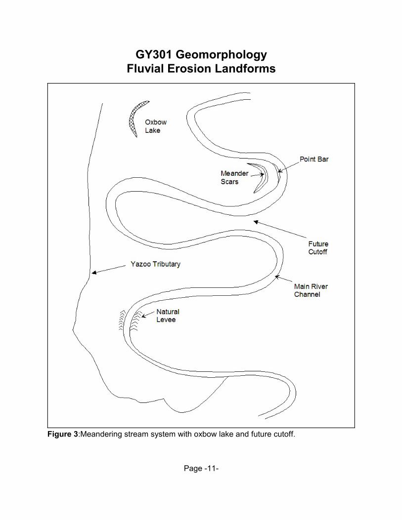
As lateral erosion produces meanders, the meanders progressively become morepronounced. This is produced by the tendency of the stream to flow at a higher velocity onthe outside of a meander curve where water is deeper and less subject to frictional drag.This increases erosion of the channel on the outside of the meander. On the other hand,the shallow water depth and corresponding higher drag on the inside of the meander bendproduces a lower than normal stream velocity. This causes deposition of sand particles toform a point bar. Point bars are one of the most common types of sand bars found inmeandering river systems. As this trend of erosion and deposition occurs the meanderbends become more and more extreme until finally adjacent bends may "neck down" toform a cutoff. Figure 3 displays a meandering stream system with a future cutoff location.When a cutoff actually forms, portions of the former main channel become silted-inisolating the meander bend from the rest of the river. This leaves an isolated lake termedan oxbow because it retains the arcuate shape of the meander bend. Most mature riversystem floodplains are littered with oxbow lakes. In addition to the oxbow lakes, theadjacent point bar deposits that are deposited on the inside of a migrating meander tendsto build numerous arcuate sandy ridges that are parallel. These features are termedmeander scars.
Stream systems are continually in a state of flux. During the spring when most areasof the northern hemisphere experience increased precipitation, the stream systems maybe at or above flood stage. When the volume of water in a stream surpasses the size ofthe channel the river spills over its banks into the adjacent floodplain. Before this event, thevelocity of the stream is commonly very high, therefore, the stream carries a largesediment load while it is confined to its channel. When the water leaves the channel,however, the velocity of the water drops dramatically. This loss of velocity rapidlydecreases the ability of the stream to transport sediment. Directly adjacent to the streamchannel the largest particles - usually coarse sand - are deposited first. The smaller clay-sized particles settle less rapidly throughout the floodplain. The annual cycle of floodingbuilds up deposits of sand along the banks of a river to produce a linear ridge termed alevee. Because levees are protection from future floods, humans often enlarge the levee
Page -5-
GY301 GeomorphologyFluvial Erosion Landforms
system near populated areas. Since tributaries that feed into the main river channel cannotflow over the levee, the levee acts as a barrier. The tributaries are forced to closely parallelthe main river channel for many miles until a break in the levee is encountered. Thesetypes of tributaries are termed Yazoo tributaries for the Yazoo River in Mississippi. Insummary, look for the following key features to identify mature stream valley development:
(1) Well-developed floodplain(2) Rounded instead of flat divides(3) Oxbow lakes(4) Levees(5) Backswamp(6) Meander scars(7) Cutoffs(8) Yazoo tributaries
Rejuvenated Systems
The final stages of the stream valley development occur when the stream haseroded down to base level over its entire course. In this state the stream is no longerdowncutting but is instead laterally eroding the loose unconsolidated sediment of its ownfloodplain. The entire region will then be eroded to a flat plane. If this area is affected byuplift the stream system will react by sharply downcutting again. This produces very steepvalley walls and flat divides that are characteristic of the early stage of stream valleydevelopment. However, in this scenario the extreme meandering of the former streamsystem may be inherited to produce entrenched meanders.
Page -6-
GY301 GeomorphologyFluvial Erosion Landforms
EXERCISE 3: FLUVIAL (STREAM) SYSTEMS
For this exercise you will be using the USGS quadrangle maps located in room #335in the map cases. The map names are labeled on the front of the drawers.
Problem 1: Cane Springs Mt., Arizona 7.5' Sheet
a) Carefully inspect the quadrangle topography. Inspect the direction of flow of the variousstream systems throughout the northern half of the quadrangle. In terms of stream flowdirection what is significant about Hardscrabble Mesa? What landform term would bestdescribe this feature?
b) By inspecting the topographic contours of the map area, formulate an answer for thefollowing question: on average, are the stream gradients larger north of the HardscrabbleMesa, or south of it? Explain your reasoning.
Problem 2: West of Furnace Creek, CA 7.5' Sheet
a) On this quadrangle along the west margin several areas are covered by arcuatetopographic contours that are regularly spaced. What is the name of this landform feature?
b) What is the term used for the dry lake beds in the north-center of the map?
c) Calculate the stream gradient (feet/mile) from where Tucki Wash intersects the westmargin of the map (UTM 500,000e: 4,033,900n) to where it crosses the -265 contour line.
Problem 3: Antelope Peak, Arizona 15' Sheet
a) Name the landform feature that makes up the north-eastern portion of the map.
b) In this map several hills in the east-central portion of the map stand above a uniformlysloping area. What is the term for these isolated hill features?
c) Calculate the topographic gradient from the southwest corner of section 34 (T6S, R2Eon the quadrangle) to the northeast corner in feet per mile units.
Problem 4: Jordan Narrows, Utah 7.5' Sheet
a) The NE1/4, section 12, T5S, R1W contains several islands which are surrounded by theJordan River. Describe how these islands form, and list the term for the type of landformfeature present in this area of the map.
Page -7-
GY301 GeomorphologyFluvial Erosion Landforms
b) Give the location (nearest 1/4 section) of a place on the Jordan River that is most likelyto evolve into a landform feature like the one in the NE 1/4 of section 12 at some time inthe near future.
Problem 5: Lake Tapps, Washington 15' Sheet
a) At what stage of stream erosion is the valley between the towns of Orting and Sumner?Cite your evidence:
b) At what stage of stream erosion is the valley drained by the Carbon River near the townof Carbonado? Cite your evidence:
Problem 6: Philipp, Mississippi 15' Sheet
a) Along the western margin of the map are distinct crescent-shaped hills. What is thelandform term for these hills, and how did they form?
b) What does state route 35 generally coincide with?
c) What landform feature is found in SW 1/4, section 19, T23N, R1E?
d) Estimate the elevation of Yonkapin Lake in the NE 1/4, section 26, T23N, R1E.
Problem 7: Chickasaw, Alabama and Hurricane, Alabama 7.5' Sheets
a) Align these two sheets together. Measure the maximum width of the Mobile Deltafloodplain in miles.
b) On these two maps you can observe several tributary streams of the Mobile and Tensawrivers that parallel both rivers closely for long distances before finally connecting with themain channel. Big Bayou Canot is but one example. What is the term used for these typesof tributaries?
c) Assume that you are a geologist hired by a real estate firm to assess the danger offlooding in section 2, T3S, R1W. A study of flood records indicates that the largestrecorded flood stage was 10 feet above the present elevation of the river. What percentageof section 2 has been flooded in the past? Aswer with the value from the following list thatis closest in value to your area estimate: 0%, 10%, 25%, 50%, 75%, 90%,100%.
Page -8-
GY301 GeomorphologyFluvial Erosion Landforms
Figure 1: An example of an alluvial fan.
Page -9-
GY301 GeomorphologyFluvial Erosion Landforms
Figure 2: A portion of the Antelope Peak, AZ quadrangle.
Page -10-
GY301 GeomorphologyFluvial Erosion Landforms
Figure 3:Meandering stream system with oxbow lake and future cutoff.
Page -11-
GY301 GeomorphologyFluvial Erosion Landforms
Page -12-
Related Documents