Mississippi River Basin – Gulf Hypoxia Initiative Integrating Basin‐Wide Challenges from Grassland Birds to Gulf Shrimp SWCS 2016 Michael Schwartz The Conservation Fund

Welcome message from author
This document is posted to help you gain knowledge. Please leave a comment to let me know what you think about it! Share it to your friends and learn new things together.
Transcript
Mississippi River Basin – Gulf Hypoxia InitiativeIntegrating Basin‐Wide Challenges from
Grassland Birds to Gulf Shrimp
SWCS 2016
Michael SchwartzThe Conservation Fund
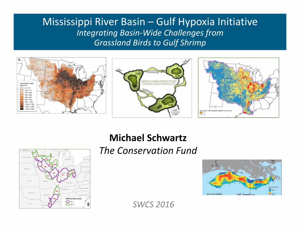
Precision Conservation Blueprint v.1Next Step: Where? > Targeting conservation delivery
Bottomland Forest in Upper Basin Floodplains
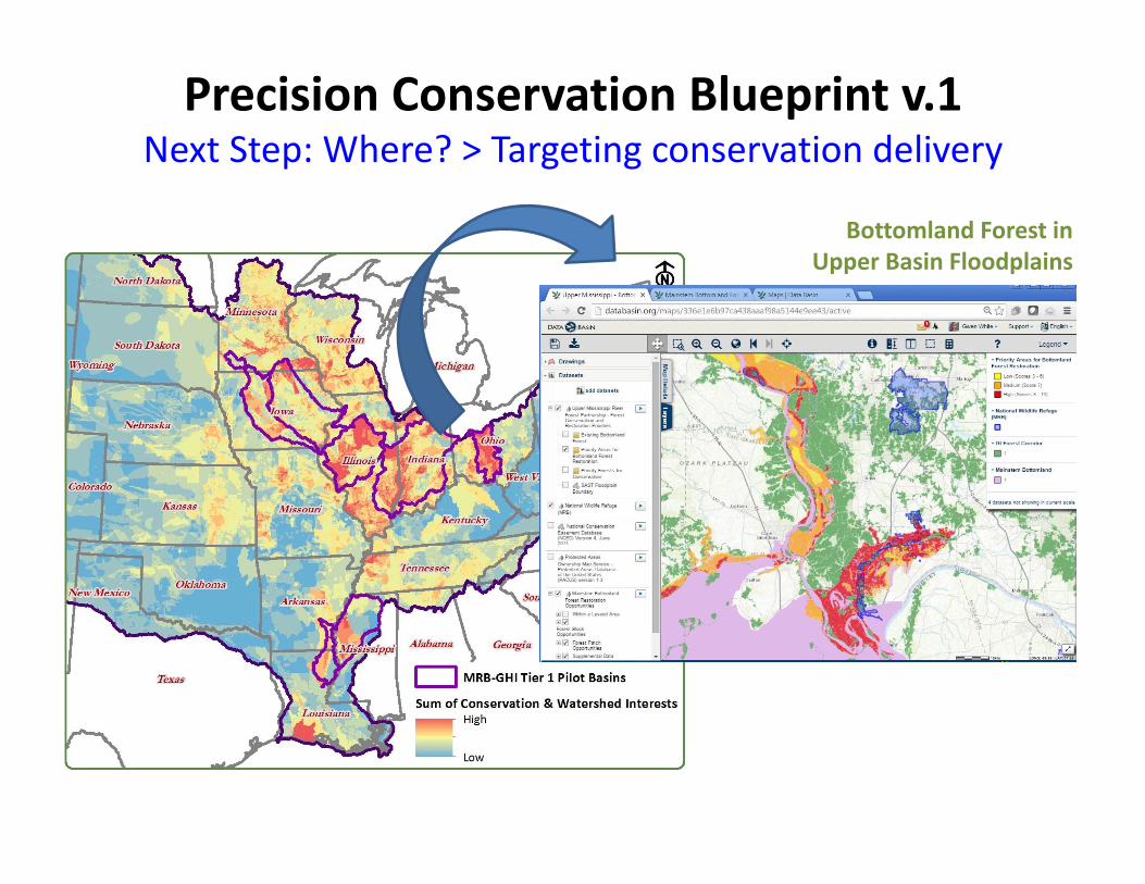
Precision Conservation Blueprint
GOALS Benefit Species Conservation Benefit Water Quality Benefit Agricultural Production
OBJECTIVES Leverage Investments Where are the interests? First Step – Identify Landscapes
Where are the opportunities? Second Step – Identify Site Scale Opportunities
Where can these opportunities benefit habitat? Third Step – Evaluate Landscape Context
Landscape
Opportunity Landscapes ‐Where Are The Interests? Where are investments occurring? ConservationWater Quality
Where are agricultural nutrient loads focused?Where are the production systems focused?
Data Used to Identify Opportunity Landscapes Nutrient Loads Conservation InterestsWater Quality Interests Distribution of agricultural production systems
Landscape
Opportunity LandscapesWater Quality Priority Zone Highest potential for nutrient loads from agriculture =
Water Quality Opportunities Conservation and Watershed Interest Focal Areas Leveraging Opportunities Species OpportunitiesWater Quality Opportunities
Production Systems System Specific Opportunities
Corn & Soybeans Cotton Rice Grazing
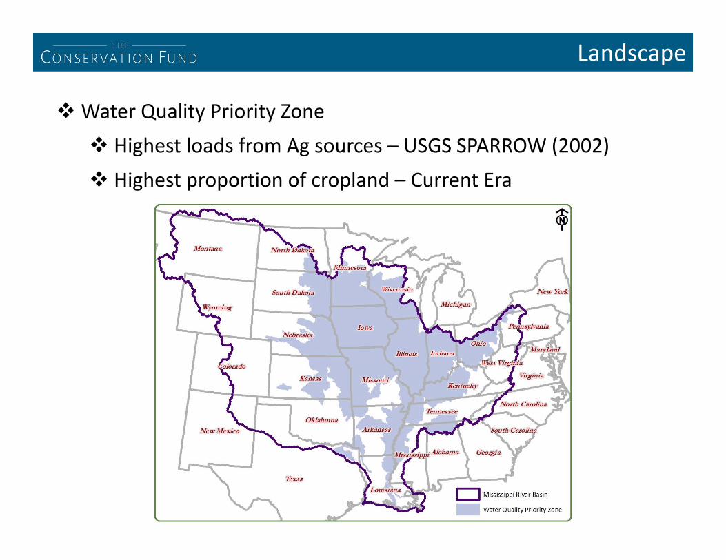
Landscape
Water Quality Priority Zone Highest loads from Ag sources – USGS SPARROW (2002) Highest proportion of cropland – Current Era
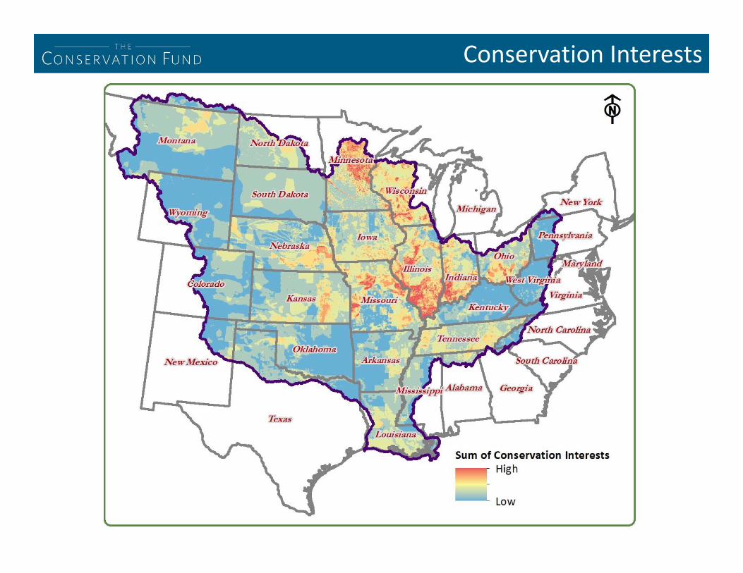
Conservation Interests
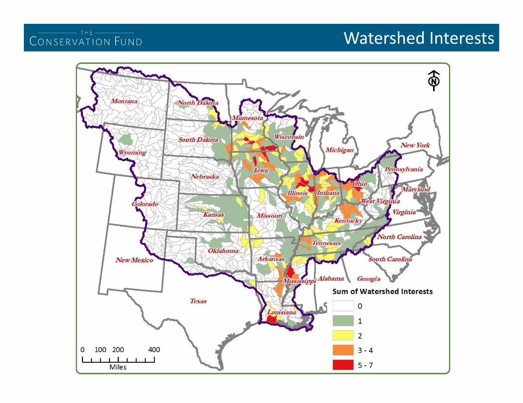
Watershed Interests

Production Systems

Landscape Pilot Basins
Maximum Alignment Water Quality
Priority Zone Conservation
Interests Watershed Interests Production Systems
Multi‐Benefit Landscapes Tier 1: Have the highest
nutrient load potential and the highest amount of implementation interest
Tier 2: Have either lower load potential or lower implementation interest than Tier 1 pilot basins
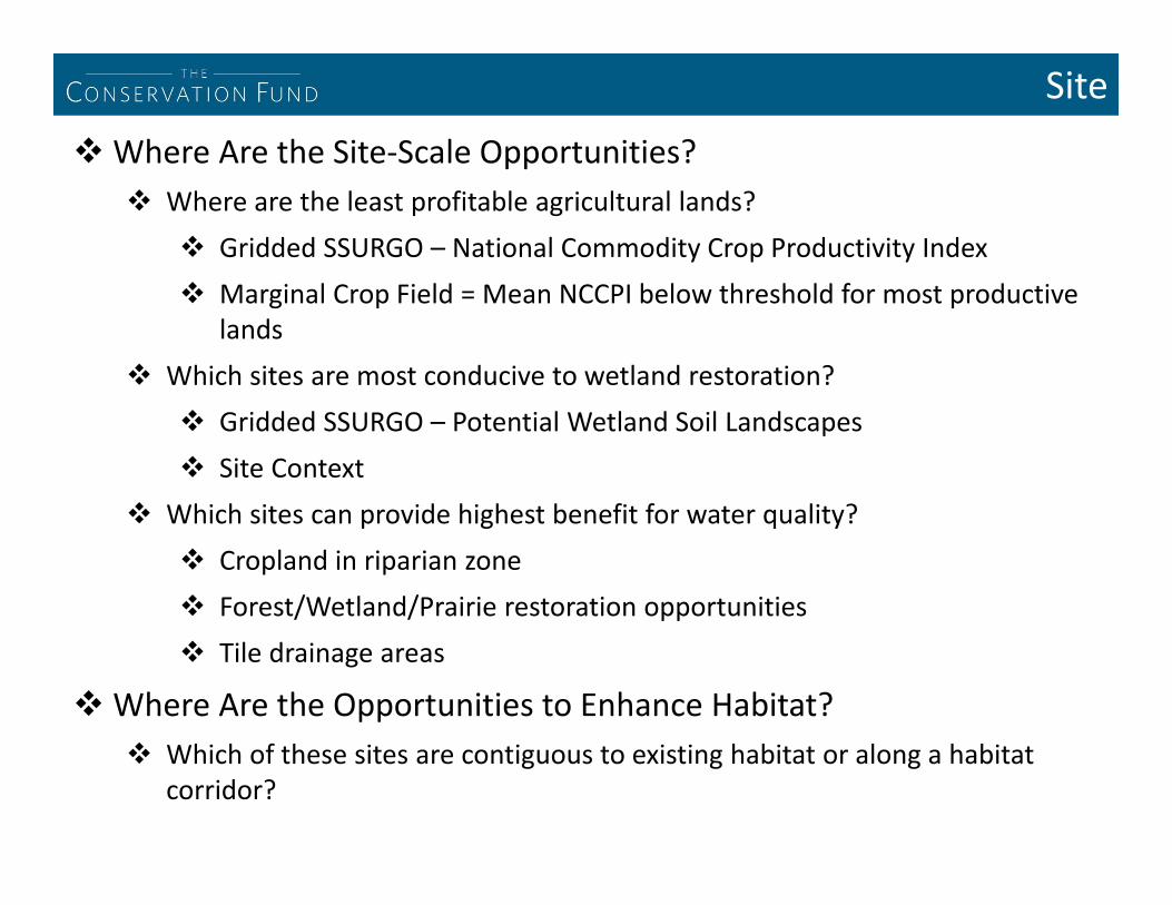
SiteWhere Are the Site‐Scale Opportunities?
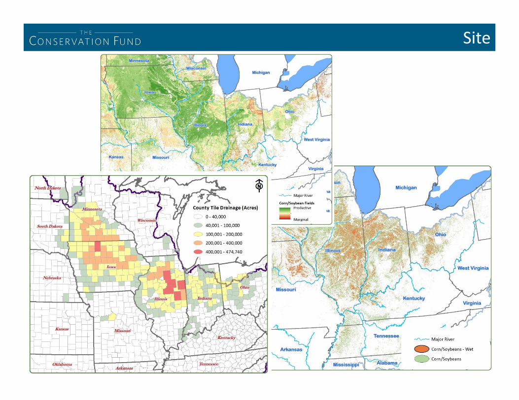
Where are the least profitable agricultural lands? Gridded SSURGO – National Commodity Crop Productivity Index Marginal Crop Field = Mean NCCPI below threshold for most productive
lands Which sites are most conducive to wetland restoration?
Gridded SSURGO – Potential Wetland Soil Landscapes Site Context
Which sites can provide highest benefit for water quality? Cropland in riparian zone Forest/Wetland/Prairie restoration opportunities Tile drainage areas
Where Are the Opportunities to Enhance Habitat? Which of these sites are contiguous to existing habitat or along a habitat
corridor?
Site
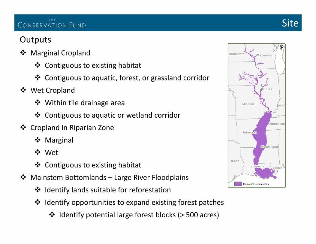
SiteOutputs Marginal Cropland
Contiguous to existing habitat Contiguous to aquatic, forest, or grassland corridor
Wet Cropland Within tile drainage area Contiguous to aquatic or wetland corridor
Cropland in Riparian Zone Marginal Wet Contiguous to existing habitat
Mainstem Bottomlands – Large River Floodplains Identify lands suitable for reforestation Identify opportunities to expand existing forest patches
Identify potential large forest blocks (> 500 acres)

Corn/SoybeanOpportunities

Benefits
Agricultural Benefits Focus on least productive lands – Marginal Cropland
Wildlife Benefits Enhance Existing Habitat Enhance Connectivity Create New Habitat Leverage Aligned Conservation Interests
Aquatic Benefits (Species/Water Quality/Hypoxia) Enhance Existing Habitat Enhance Connectivity (Riparian) Create New Habitat Drainage Water Management Leverage Aligned Watershed Interests Focus on Water Quality Priority Zone
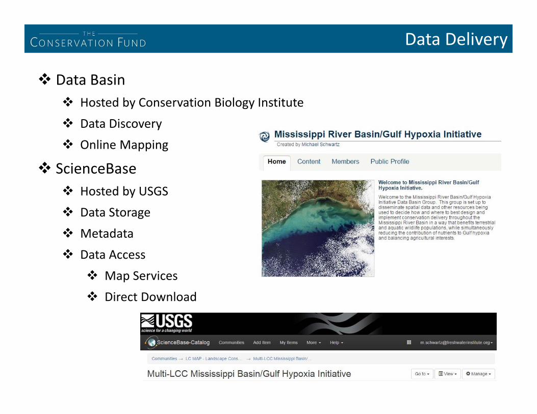
Data Delivery
Data Basin Hosted by Conservation Biology Institute Data Discovery Online Mapping
ScienceBase Hosted by USGS Data Storage Metadata Data Access
Map Services Direct Download

QUESTIONS?
Gulf Hypoxia Initiative Site: www.tallgrassprairielcc.org/issue/gulf‐hypoxia
Con. Blueprint Resources: tallgrassprairielcc.org/gulf‐hypoxia/where
Data Basin GHI Site: tinyurl.com/MRB‐GHI‐DataBasin
ScienceBase GHI Site: tinyurl.com/MRB‐GHI‐ScienceBase
Related Documents


![LCC Mississippi Gulf Hypoxia Initiative (MRB/GHI ... Hypoxia... · will change hands –some to international investors. [all national cropland = 442 million acres] From: Oakland](https://static.cupdf.com/doc/110x72/605a6fc00734c910bc13f266/lcc-mississippi-gulf-hypoxia-initiative-mrbghi-hypoxia-will-change-hands.jpg)