The following file is part of the Grover Heinrichs Mining Collection ACCESS STATEMENT These digitized collections are accessible for purposes of education and research. We have indicated what we know about copyright and rights of privacy, publicity, or trademark. Due to the nature of archival collections, we are not always able to identify this information. We are eager to hear from any rights owners, so that we may obtain accurate information. Upon request, we will remove material from public view while we address a rights issue. CONSTRAINTS STATEMENT The Arizona Geological Survey does not claim to control all rights for all materials in its collection. These rights include, but are not limited to: copyright, privacy rights, and cultural protection rights. The User hereby assumes all responsibility for obtaining any rights to use the material in excess of “fair use.” The Survey makes no intellectual property claims to the products created by individual authors in the manuscript collections, except when the author deeded those rights to the Survey or when those authors were employed by the State of Arizona and created intellectual products as a function of their official duties. The Survey does maintain property rights to the physical and digital representations of the works. QUALITY STATEMENT The Arizona Geological Survey is not responsible for the accuracy of the records, information, or opinions that may be contained in the files. The Survey collects, catalogs, and archives data on mineral properties regardless of its views of the veracity or accuracy of those data. CONTACT INFORMATION Mining Records Curator Arizona Geological Survey 416 W. Congress St., Suite 100 Tucson, Arizona 85701 602-771-1601 http://www.azgs.az.gov [email protected]

Welcome message from author
This document is posted to help you gain knowledge. Please leave a comment to let me know what you think about it! Share it to your friends and learn new things together.
Transcript

The following file is part of the Grover Heinrichs Mining Collection
ACCESS STATEMENT
These digitized collections are accessible for purposes of education and research. We
have indicated what we know about copyright and rights of privacy, publicity, or
trademark. Due to the nature of archival collections, we are not always able to identify
this information. We are eager to hear from any rights owners, so that we may obtain
accurate information. Upon request, we will remove material from public view while we
address a rights issue.
CONSTRAINTS STATEMENT
The Arizona Geological Survey does not claim to control all rights for all materials in its
collection. These rights include, but are not limited to: copyright, privacy rights, and
cultural protection rights. The User hereby assumes all responsibility for obtaining any
rights to use the material in excess of “fair use.”
The Survey makes no intellectual property claims to the products created by individual
authors in the manuscript collections, except when the author deeded those rights to the
Survey or when those authors were employed by the State of Arizona and created
intellectual products as a function of their official duties. The Survey does maintain
property rights to the physical and digital representations of the works.
QUALITY STATEMENT
The Arizona Geological Survey is not responsible for the accuracy of the records,
information, or opinions that may be contained in the files. The Survey collects, catalogs,
and archives data on mineral properties regardless of its views of the veracity or
accuracy of those data.
CONTACT INFORMATION Mining Records Curator
Arizona Geological Survey 416 W. Congress St., Suite 100
Tucson, Arizona 85701 602-771-1601
http://www.azgs.az.gov [email protected]

" -.. :; . .:..--'~~ .. > -
"
,
:'.
. t ~
INTRODUCTION:
The Great Eastern vein and its related structures,
particularly the Siou~ City vein, have been a subject ~f
great interest for many years. Such interest is natural in
light of the strength of the vein and the tenor of the ore
it has intermi tten tly produced • . ' This production has been
w~ested under excruciating conditions of weather, altitude,
and precipitous rock faces.
Also of great and long ... standi!l·g interest is the poss'i
bility of crosscutti!lg .the Great Eastern vein at a substantial
d~pth below its outcrop • . The,p6ssibility of executing such
a pr~~ram is excellent through joint use of the Silver Wi~g
Tunnel wherein more than half 9f .the necessary work has
already been done. This crosscut, portaled at an. elevation
of 10, 400. f~et, would, ,if proj ected, intersect the Great' Easte:n
vein almost 2,000 ~ertical feet below its h~ghest outcrop and
about , 1~500 feet below th~ current upper worki!lgs.
The purpose of this report is to evaluate whether the
interveni!lg 1,500 feet constitute a , geol~gic target worthy of
invest~gation and, if so, what the details of an exploration
pr~gram would be. It does indeed appear that the downward
projection of the Great Eastern vein and its related structures
comprise a ta!get worthy of exploration, and that such explora:io~
can be £easibly conducted thro~gh the Silver Wing. Tunnel. The
reasons therefor and the details incident thereto are herein-
after -set forth.
-1';

" .
" "
, . " F.
" .
L f
, ,
........ " - ~ : . ~ . ,' .,
CONCLUSIONS:
I. The geologic structure, the perpetuation of this
structure, and the tenor of mineralization within the Great
Eastern vein are such that it is considered an outstandi?g
, . geologic target for furth~r exploration and developmerit at
depth;
II,. The for~goi~g premise is enhanced by th~ fact that
there is a projected intersection at depth with the strong,
tho~gh lesser, ,Sioux City vein which is also well mineraliz~d;
III. This premise is still further enhanced by a projecteE
intersection of the steeplyMdtppi~g , and cros's-striking Carol
vein;
IV. The intersection of these structures would comprise , '
a locus of great shattering which, in knQ;.o.rn mineralized v'eins,
would normally localize mineral deposition to f6rm a h~gh.
, gr~de ore . body;
V • The direct explbi'ation of this area '· can be conducted
. with reas~nable expenditures of time and money ~hrough joint
use pf the Silver Wing Tunnel:
(1) This would permit an all-weather pr~gram;
,(2) Any subsequent operation of the Great Eastern or associated veins at this depth could be conducted through the Silver Wing Tunnel as extend~d; ' .
(3) .The projected exploration and possible operatio!:. can be extended to include the Monitor and Klondike veins. It is pointed out that these veins are not a part of ' the Great Eastern Mines, Inc. and their acquisition would be a matter of future negotiation.
'L

.. ,
,"
. -,-\-.
: .. I .
~-
VI.
'4) Inasmuch as the Silver Wing Tunnel is -a "gunbarrel" crosscut and the proposed pro .. jection would be a straightline continuation thereof, any future heavy haulage could be effected with an underground conveyor belt for waste and ore. Thus only a single track would be required for a mart tram and supply •
.. (5) - From adequate drill stations underground it
would be feasible to conduct down~dip drilling on the Great Eastern vein and related stru~- tures and to probe the underlying sediments (limestones) to basement. -
FINAL CONCLUSION: Notwithstandi~g the attractiveness
- of the projected geol~gic targets, the proposed exploration
should be undertaken only by an organization that is adequately
financed and properly staffed ,for matters mini~g~ This would
include operati~g'mini~g companies -desirous of expanding the
scope of their operations or an eminently able individual or
group of private investors who are desirous of conducting
such .an exploration within . the writeoff provisions of existi~g
tax laws. It is, emphatically not an undertaking for out-of ..
pocket, savings accounts, of parsimonious promotion.

, :. j •. ~ .
I ·
r'. l . .
t·
,
. . . .
RECOMMENDATIONS:
(1) Locate Ted Chase 11, Ted Chase 12, and Ted Chase 13
lode mining claims as shown on Plate III.
(2) Work out ground rules with the Silver Wing Mining
Company for joint use of the Silver Wi~g Tunnel. This
should also include joint use of the powder and cap
(3)
(4)
(5)
(6)
(7)
m~gazines.
Install separate power meter and switch ' gear.
Construct waste trestle south of present snow shed
and install appropriate track and switches. A snow shed
over this trestle can be ,constructed as convenient during
the summer.
.Install 4" air line from the portal to the bend in
the tunnel.
Lay heavy haul~ge track from the Silver Wing workings
to the bend in .the. tunnel. Ins tall a swi tch at this
point and switch track on to the face of the crosscut.
This .will allow adequate switchi~g and storage room as
the Tunnel is driven stra~ght ahead.
Run electric power lines to the . breast of the tunnel
for lights and electric booster fans.
(8) " Extend ventilation tubing to the worki~g heading.
(9) Instal,l pressure water system for drilling, smoke and
dust control. Tapping one 6f Silver Wi~g's diamond
drill holes ~hich are making good water would be an
excellent source.
-4-

1··---
t ! !'
I
I' ; -
I': _ I. ~,
,-
,. -
r r I-I' r I
t I
f~ I i--. I -, , -J "
. (10) Equip .the operation as follo~s: 900 cfm compre~sor;
l-jib jumbo, steel, hoses, and bit~; 2l-B ~ucking machine;
heavy trammer with extra battery; six (6) mine cars;-_
30 cuft minimum; -hand mini~g ,tools; and hand tools.
(11) Thus prepared and equi~ped, drive the Silver Wi~~
Tunnel straight ahead until the Great Eastern-Sioux City
vein system is contacted. The followi~g is a description
of the work units involved:
(a) _ The crosscutti~g necessary to contact the Great
Eastern appears to. the _erder of 1400 feet.
(b)
It is here ~ointed out that specific projections
for such distances are risky, and the l40-0-foot
figure is considered mere than adequate.
Once the vein in centacted, a minimum of sao feet
of drifti~g should be done on the vein itself,
and a minimum of 100 feet of wal-l-te .. wall cross"
cutti~g should be done. This not enly serves
for sampling and evaluation, but these hangi~g
and footwall crosscuts mak~ . good diamond drilli!1g
stations.
ec) In addition to the f6r~g6ing, a minimum of 300
feet of raisi~g should be done in order to explore
any possible cha!1ge in par~genesis - as the vein
passes from the upper Eureka rhyolite into the
lower Picayune andesite. Two stations should
be cut in this raise for diamond drilling.

I .
i ' .
t .
t-··
..
Cd) At least 2,000 feet of diamond core drilling, EX for
short holes and AX for lo~ger ones. The drilling
pattern will be laid out after the structure has
been crosscut and sufficient drifting done to
evaluate the situation~ At least sao feet ~f this
drilling should be done along strike. Longhole
percussion drilling from wall to wall may be done
out of the drift within the vein; it is not · recom-
mended for holes over 20. feet in le~gth, however •
,

ESTIMATES AS TO COST AND TIME:
.(1) Fixed installation: .
Ca) Waste Dump, trestle, and snowshed Cb) Air line (c) Ventilation (d) Water system ee) Electric power hookup, switch
. gear and inside lines (f) Main haulage track
C 2) Machine ry :
(3) .
(4)
. ( 5)
Ca) 900 cfm Compressor (b) 21-B mucking machine (c) . l-jib Jumbo, steel, bits, hoses (d) Heavy trammer and extra battery (e) 6-mine. cars, 30 cuft minimum (f) Fan
Exploration costs everything furnished at these unit costs:
(a) 2,000 feet crosscutting and on the vein @ $7S.00/ft
drifti!lg
(b) 300 feet raising @ $SO~OO/ft (c) 2,000 feet diamond core drilling,
EX or AX @ $7 .• 50/ft .' (d) Assaying, 500 samples Au-Ag-Cu-Pb-Zn
@ $12.00 each .
Administrative overhead .to include all administrative expenses, consulti!lg, arid travel
Conti!lgency furtd:
I . Estimated Total:
) ) ) )
. ) ) )
) ) ) ) ) )
) . ) ) ) ) ) )
. $21,000.
. $55,000.
. $lS0,000. $ 15,00.0.
$ 15,000.
$ 6,000:
$ 13,000.
"'$ '2"5", '00-0 •
'$ 3 0 0- ,:00'0 •
TIME . REQUIREMENTS for the pr~gram will be approximately as follovs:
(a)
(b)
ecl
Initial setup time:
Crosscutting and drifti~g @ 7S-feet per week, . a~erage for double shift operation
Raising and diamond . drilling
Estimated Total Time:
-1-
..
. Six (6) weeks
Seven (7) mon tls
Ten. (10) we.eks
Eleven (11) mOLths

~: , L· · . i
~ ..
' .
GEOLOGY':
The Great Eastern vein occupies a large fissure (25 or
more feet w~de) within the Eureka Rhyolite (upper) and Picayune
andesite (lower) on the eastern edge of the Silverton caldera.
These two formations are lower members of the Silverton volcanic
series. The large and well-defined fissures such as the one
co.ntaining the Great Eastern vein are members of a "ring fault"
system associated with the collapse of the Silverton caldera •.
In the vicinity of the Great Eastern they trend northeast
southwest an~ the dip is steeply westward. The smaller faults
trending across these major s~ructures ·(such as the Sioux City
and ' Carol fissures) are relief or readjustment features. The
dip of these smaller fissures is generally near-vertical. It
appears th~t all of the northerly-trendi?g fissures within
the Great Eastern Group will terminate to the north against
the Fredrica shear, while to the south and southwest they
proj ect ·into the Animas gorge. ' . I····
The mast attractive aspects of the Great Eastern exploration
lie in (1) a projected intersection of the Great Eastern,
Sioux City, and Carol veins at an elevation approximati?g
that of .the Silver Wing Tunnel, and .(2) the feasibility of
exploring this target by drivi!lg that Tunnel straight ahead.
Plate IV shows thi~ ; Telationship in cross section while Plate III
shows that the veins converge along strike also. The locus
of their intersection will rake steeply to the north and the
. projected crosscut will approximately intersect their juncture.
What influence the smaller and vertical Ii-dipping Carol structure
will exert is a matter of conjecture, but the overall evaluation .~~ o -)~

of this situation indicates an area of great shattering with
a high percent~ge of ~rimary ?penings which could serve as
a locus for the deposition of ore minerals. As such it
constitutes an outstanding geologic target worthy of the
exploration and development work outlined herein.
While it is impossible to make specific projections
regarding tenor, it is noteworthy that the Great Eastern vein
has produced some excellent ore from near-surface workings •
. The character of this ore is shown ~n the shipping returns
attached hereto. Similar ore remains in place, and a summer
operation thereon is contempl~ted for the near future.
Associated with this higher. grade material is a much larger
quantity of low grade which has been bypassed and left in
place, or dumped.
The charac·ter of this mineralization is observed to ·
project downward from the. highest workings, and between
surface and underground e~posures at lease 500 vertical feet
of mineralized vein is shown. How muchfu·rther downward it
projects :is strictly a matter of conjecture, for exploration
al.one w~ll reveal this ul timate d~pth. -It is this author's
carefully considered op~nion that th~ favorable aspects of
the structure increase with depth and, therefore, it may
be .reasonably expected that the 'quality of the vein will
increase also, whether in tonnage, tenor, or both.
An · unknown factor will be the possible change in para
genesis when the vein passes from the overlying Eureka
rhyolite into the Picayune andesite. This relationship is
shown in Plate IV. The raising which has been prescribed ( .,

herein is for the purpose of exploring the contact between
the two lavas.

.... -.
I.
t I ·
LOCATION AND ACCESS:
The properties of the Great Eastern Mines, Inc. are
situate as shown on Plates I, ,-.II, and IlIon the northwest
spur of Jones Mountain. Plate II shows an apparent dis
crepancy wherein the names of Jones Mountain and Niagra
Peak have been reversed. Also there is a di~crepancy in the
designation of "Picayne Gulch" which should read "Picay~ne
Gulch". It is here that the Picayune andesite is well shown
t~gether with its relationship to the overlying Euieka
rhyolite.
The properties are accessible via the roads shown on
Plates I and II. The distance from the 'portal of the Silver
Wing Tunnel to Silve.rton is just over 11 miles. The approxi
mate distance to the upper workings is about 14 miles, and
these are accessible only during the summer months. The
two means of access which must be considered are (1) via the
aforementioned roads duri!lg the summer months only and . . . ;:
(2) Vla an extenslonof the Silver Wi!lg Tunnel to crosscUt
the projected structures at depth.
Inasmuch as the portal of the Silver Wing Tunnel is
: gener...ally accessible thro~ghout the year, the exploration
pr~gram herein outlirtes proposes to take advantage of the
convenience and relati~e c~mfort of a direct approach from
underground. Nothing herein would impede or impair the
conduct of near-surface workings on the high grade showirigs
within the Great Eastern vein during the summer months.

"
~.;' .
STATEMENT OF TITLE AND OWNERSHIP:
The properties covered by this report 'are owned and
intermittently operated by the Great Eastern Mines, Inc.,
a New Mexico corporation whose offices are at 1122 Bank of
New Mexico Building, Albuquerque,' New Mexico, 87101. Mr.
Edward P. Chase is President.
The holdi~gs of the Great Eastern Mines, Inc. consist
of six (6) patented lode mini~g claims and fourteen (14)
: unpatented iode mining claims all situate in the Eureka Mining
Disirict, San ,Juan County, Colorado. More specifically,
the ' claims a~e situate in Sections 16 and 17, T 42 N, ' R 6 W, I
"':l NM~B&M. The unpatented lode mini~g claims are recorded in
the office of the San Juan County Clerk, Silverton, Colorado.
The claims comprise a cont~guous , group with certain
overlaps within' ,the , group and other, overlaps on excluding
patented claims. This relationship is shown on the accompanying
map marked Plate III. Th~ followi?g tabulation is a complete . "
listing of these claims.
Patented Lode Mini~g Claims:
Nanie: Survey No: Patent No:
( 1) Great Eastern Lode 239 3,845 (2) Sioux Ci ty .... Lode 382 5,344 (3) Vulture 4860 Not recordea (4) Lookout 4861 17,352 (5) Tip Top do do (6) La Plata Lode 19003 349,476
Unpatented Lode Mini?g Claims:
Name: Book: Page:
(1) Carol 172 103 (2) Billy 172 104
: 1 ?: C),

, '
I
[',:
Name: Book: P~,ge :
(3) Sioux City Extension 172 183 (4) Great Eastern Extension 172 184 (5) Ted Chase 1 189 290 (6) Ted Chase 2 189 291 (7) Ted Chas'e 3 189 292 (8) Ted Chas e 4 189 293 (9) Ted Chase 5 189 294
(10) Ted Chas e 6 189 295 ( 11) Ted Chase 7 189 296 ( 12) Ted Chase 8 189 297 ( 13) Ted Chas e 9 189 298 (14) Ted Chase 10 189 299
Note 1 : The foregoi!1g unpatented lode mining claims have
been located as 300 f ,x 1500', units to conform to
the size of the, very old patented mining claims.
Note '2: It is considered neceisary to locate additional
unpatented lode mining claims 'on the southwest
flank of the Great Eastern Group. These claims,
designated as Ted Chase 11, Ted Chise 12, and
Ted Chase 13 should be situate as shown on Plate 'III
and located as 600' x 1500' units.
Note '3: The Silver Wip,g Tunnel is situate on property owned
by COlorado Minei arid Metals, Inc. and currently
teased to the Silver Wing Mining Company. Great
Eastern Mines, Inc. has a perpetuating right in the
join~ use ,of this Tunnel. A statement attesting
this r~ght is attached hereto.

CONCLUSION:
The for~going progra~ is considered adequate to
crosscut the Great Eastern vein about 2,000 feet below its
highest outcrop and to effect at least 1,000 feet of explora
tion along its strike. A nominal amount of wallwto-wall
crosscutting has been specified, while the EX and AX diamond
drilling will permit evaluation of the deposit at the level
of the Silver Wing Tunnel. The raising specified will permit
a study of the vein system at the contact of the dissimilar
lavas.
The target area for t~is exploration is huge, and
the projected tonnage to this depth is in the order of several
million. If a large shattered zone is encountered as might
be expected at the intersection of the Great Eastern and Sioux City
structures, the tonn~ge would be greatly increased beyond the
projected cube of these tabular structures alone •
. It would be facetious to project tenor to this depth,
and an attempt to do so would be irresponsible. It is reasonable
to expect that values will project to this depth, however, and
it is worthwhile to consider ~h~t the very mediocre ore values
in the upper workings will carry six (6) ounces of silver per ·
ton, ten (10). percent lead, and two (2) percent zinc. Minor
gold and copper is noted, and the copper might be expected to
increase at depth.
These values, in quantity indicated by the Great Eastern
and Sioux City structures, would comprise a tremendous ore body
worthy of its own mill. Conditions are ideal for constructing
i I
I····
this mill underground. The mining show will be excellent,
for the stro?gwalls will per~it shrink stoping with minimum
timbering. Sand filling may be practiced, though it will
probably be more for tailings disposal than ground support.
All thi~gs considered, the Great Eastern property is the
most outstandi~g exploration opportuniti that his ever come·
to this writer's attention.
Respect£u~tt~d: -=~=>"-____ _
~.-----: ~~ Marion E. Price .
I Geol~gical Eng,ineer '
/~

i'j: I.r ., ,., I . ·u
· a~ ,I ,J
· ,., G··11 · C~ Co" ,.,1 . (~
. q
· C·, · ., · II
· .1-. tll " .1J .. lo' o! · C~
. . C~
. . C~
.' f·' , e.ll · C·1)
. . 14 .. ' ·1 , ( " .1-1) · ~,
'"
r
.J, , I
I
J: .l! ::;,
o Q. o e
,. , '. I
\ I
: \
I I
·1 ; I
~I !;. I
l~·:~~~-;,., > 3~: ....... 1' ,tJ1 i
I , c:.,..".If ... \ '/ / .. ~ - \
-
....... , 'i ~ . I
I
,r. · ..
m=::=:==~~~=====~-~ i~ . ,.~~. " Plate I: of South- R~t~~ western Color<ldo showing ~~:-, .... ~~.~.'''; location o£ ~reat Eastor~t' ~J~:.~2·;· Group near S11verton r· "~"/! /
f' . • y
11!:::.:i:i~~Q~~=:::v;~~~L S'~ ,<-
,..: .. .

"". ,caa
Plate II 6ut from sheet Haines Peak Note various adits on south side of Burns
F=5C::=:c::::a::=:::E:3:=::::E:====::::e;;:S::=::E==========&Gul-c-h:::w-h~ ~~ ~l~ end r i v e ~ in t 0 ve in 5 •
4000 J\pte G<BFom~~tjl,t rift in topography · where
SCALE 1:24000
t 0
__ .L:::=:"':"-- Greatr[!;a·st'ern vein crO~Be8 ridge • . _ _
! COlORAl I .-
1000 0 1000 1000 3000 EL13::EL -== J EO:
1 .5 0 F3 F3 F3 F3 F3
CONTOUR INTERVAL 40 FEET. DATU,", IS "'O Il ::tl I I Yrl

0 n i .1 I ! U
<.0 < ~ rrJ \0 Z 0 .. 1 < rrJ
j r ,-_. a
v .. l:j
Z -i
----0 :lJ ~

------~.--.----_ ... _ .
'-::--(J
II. f4-~o
/1, 7 () 0
p, .:)00
d. 3 Co t? ... /I, /1/0
/P'7vO
Sioux City vein
Great Eastern vein Klondike
'\ I,
1\ /1 ~ / I
/ I ' ~I . jl I
. I f . " Silv~r I II . /f II Wing 'I II
~/I vein ' I I . j,1 I//~ , I \.\.1// I
') ' , ~)n T 71/
/ /
/ . I /
/ /
/
111, ,I I.' '-vYx~ '.~ . .• _ . /.. .. / '* 4 .. • I> • .\ / T ., •• " • ., • " •• , f' .
~.~" /'~' "~,~:l.~~~ '~~'~f~'_>~\~_ I " I / , ~.:;;=: Silver W,ng Tunnel::::;r-" I ~~~~'/'> Observed variJ.tions in d1p /t) ·3 Predic ted aha t £e/'o e.\)!j/ a t the surface would caus~
I :-- \; " } , Grea tEas tern 've in to proJec t " . ' . between these two points
Cross section oC northwest spur oC Jones Mountain taken along the Silver Wing Tunnel and the proposed extension · thereof. The : round dotted line indicates tl~e inCerred contact between the Eureka Rhyolite (upper) and the Pica~une Andesite (lower). The raising recommended in this ~eport will explore that contact.
It is noted here that this cross section does not pass through the highest point on the Great Eastern vein. That point lies at an elevation oC about 12,400 Ceet, or some 2,000 verticalCeet above the level oC the Silver Wing Tunnel.
Plate.. IV
. . . . 1
.. .... .1 __ .: .. _ ..... _ : .. • - . - . ,:" "':"t----,

· . 4 •• "
,?-C'.

n - "',:, . _ ... I • • • • . J
C Il II.(
~. ", .. r" " ,. ..... . >·.N.':"~~v· )
F __ C_-""i.::.·""I3=-=8.::..·..:;:;_.,...=t.:.;i...::.:;E::.: ...:.T:..:' i;)",o ""'.C,-,=,n:.-.:.l,..:r",i:,;n:.:..:i:.=,n,,, . • <::S,-.::.C-=O~:::.· ·...:D~.~· ____ _
FO~;------~ __ 92Zc~"~!~~ __________ ~ .lACKS
;r. Or. C.j:~"";"/!~C"'I-::. CU;!J~c:': ·:0 C:K"')\~tZ . VII'lWO\T( ~a':;e;. . . . .
:J:,';, .'" ..... • ',t I ~ .!'/ .~,.'. ( t;·:J ·o; ..... :, .
, ,., .. ~. .' ""
':.':"~ .. '\ .... . '.:'.' ..... : .. ;; .', :, ~l~' ... ·i, • ~: :. :1, : . . ,: i ' . . . ~ : ', ' " . .: , ,,1 -: . ... ,' " :" , :"
••.•... : •. '.: ••• , :.i .;. '" .:):.,: " '. " . L 4 ' I ......... , . " .. ~ .. ' .• "" , 't': ~ .1.: .1 .. ... :.:_ .• ..:. ... .
,' : '
' . . ' :', ..
.,
,t.:
,'.
: " ,'
' . . . ~ .. ;' . ; o, •• !:" .; ,\
1'" ' . / :': . : Af :
I .
i . .
.. ~Il 't : I •
I)':. J> . .... !:~) ~ : ,~::~: ::~ ·,~~~'tt, ~(il.
_' .f ;;;:....~.;\.j .. ~"ILLI!. COLO .• OC j-.
. , . : '
L
, .- . " :; . ' 1 ' , '
" .. " '. ~
~ \. . :..- ,'"",
t J. ';~ .. J ~ , ,j .. ,)lt:,
. ;~( ' "
I , f . __ ' i':i !
", .
" .. r~ -.--'~, ," .. .. --5. ~ __ ~ ,~,
" !., -- ,'"
.:~ ,
. ' . ~ . 'i'
~"
. !
, !! : ...... ~ ( i , '
I ,~ ; , ' F ~ !:. . : .. 1
__ : :,~: 'ii','! , ~ '
--':';, ' . ::~ ~ .... , --.n: 'J r : '
--.:;!i, __ " t"

:.,, : ~. '.
'.:
':.
: , ; . ' ..
I, ~ . .. , ; .
.~ : ; ,
" ' I .
- : .. I '
;.
:. ,. ~
,"\
- ; !
. .' , .: .' ~ l " . ,
. • · .. ' 1' . .
":"
:; .. '.:- '
. ' .. ~ .. ~
.:.1..: ':.'" ; . . " ~
" .... : .... : " ';'
, ~: ~ ,
\ ::" ,

',: . .
- . _I , .
', : .. .. :.-
, " I.
'"
: . . . ~ : - . j ' . •
'; , ',' ,'
' . ," I
'.:',: ; . . 4: :( .. ' . ~ . .: ,
' . , . . . ;~
',. .' '
.i' -
,,".': ' . .. . .: . : . ' .\. \oJ . . : : .. ~ "' " ;
. ,' . , '
.. .. " ~
.: ~ : ..
.;, ' ; ... . • of..: . ' '
, .1' ,
'~.: : . \
.. " .. ~ .. . -: . , ~ . ; . ,:1 , .
' j . "
'"
I
" ' !j ',
I",: ' "
" '.' , . J ~ .
,'j '
I
. ' ~


... - !.-.'t
. , MARCH 1976 ~
GREAT EASTERN MINES, INC, (Mining Claims currently held by company)
Patented Hlning Claims:
I , Great Estern lode minIng claim - U.S, Survey No. 239 2, Sioux City lode mining claim - U. S, Su rvey No. 382 3. Vulture lode mining claim - U. 5. Su rvey No. 4860 4, lookout lode mining claim - U. 5, 5u rvey No, 4861 5. Tip Top lode mining claim - u. 5. 5u rvey No. 4861 6. La Plata lode mining clalm-U. 5. Survey No. 19003 7. Dai sy lode mining claim - U. S. $u rvey No. 19908 8. Golconda lode mining clalm- U. S. Su rvey No. 19908 9, Klondike lode mining claim- U, S. Su rvey No. 19908
10, Klondike Extension claim - u. 5, Su rvey No, 19908
Unpatented Mining Claims:
1 • 2. 3. 4. 5. 6. 7. 8. 9.
10. 11. 12. 13. 14. 15. 16. 17.
Carol, Book 172, page 103 Billy, Book 172, Page 104 Sioux City Extension, Book 172, page 183 Great Eastern Extension, Book 172, page 184 Ted Chase #1, Book 189, . page 290 Ted Chase #2, Book 189, page 291 Ted Chase #3, Book 189, page 292 Ted Chase #4, Book 189, page 293 Ted Chase #5, Book 189, page 294 Ted Chase #6, Book 189, page 295 Ted Chase #7, Book 189, page 296 Ted Chase #8, 800k 189, page 297 Ted Chase #9, Book 189, page 298 Ted Chase #IO,Book 189. page 299 Ted Chase #II,Book 194, page 4 Ted Chase #12, Book 194,page 5 Ted Chase #13, Book 194,page 6
(NOTE: Items I thru 14 are 300'X l 500 '-unpatented claims)
(NOTE: Items 15,16 & 17 are 600'XI500'-unpatented claims)
· _. ' _ .... 4.,· . _. ~ ._ - . - .- ._._- . ~.- -- - - " -- '
tlARCH 1976
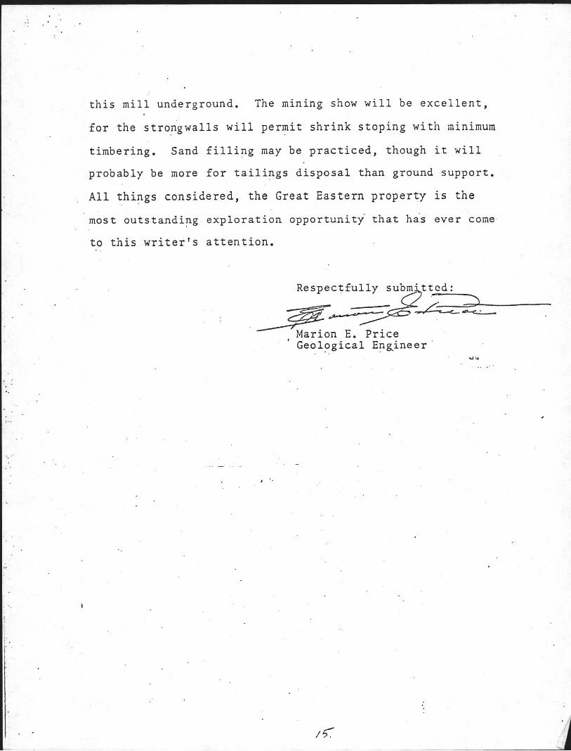
COLORADO MI~ES & METALS (t1ining Claims currently held by coopany)
p~tcnted Mining Claims:
1. The Silver ~in9 lode mining claim - U.S.Survey #70 2. Manitou lode mining claim - U.S. Survey #125 3. Cynic lode mining claim - U.S. Survey No. 126 4. ~lhale lode mining claim - U. S. Survey #127 5. Rocky Mountain Chief lode -U.S.Survey #131 6. Denver Belle lode claim - U.S. Survey #132 7. Edward lode mining claim -U.S. Survey #210 8. Rob Roy lode mining claim - U.S.Survey 1.!499 9. Frederica mining claim - U.S. Survey #1314
10. Bullion City mining claim-U,S. Survey #1382 11. Noah's Ark mIning claim -u.s. Survey # 138 12. McGinty lode mining claim-U.S. Survey #2687 13. Morning Star mining claim-U.S. Survey #19003 14. Lillie lode mining claim -U.S.Survey #19004 15. Nanon lode mining claim - U.S. Survey #18923 16. Little Joe mining claim - U.S. Survey #18923 17. ~ild Cat mining Claim - . U. S.Survey #18923
Unpatented Mining Claims:
1. Ada No.2, Book 114, Page 423 2. Mable] Book 92, Page 540 3. Stanley, Book 92, Page 541 4. Alice Lode, Book 192] Page 103 5. Bessie Lode, Book 192, Page 104 6. saId Eagle Lode, Book 192, Page 105 7. Dido Lode, Book 192, page 106 8. Enterprise No. I, Book 192, Page 107
(Following -Recorded in Colorado, but book & page nos. not 9. Judy No. 1 provided herein, ava! lable upon request)
10. Judy No. 2 11. Denver Belle Extension 12. Silver Wing Extension 13. North,..,est Vein Nos. 1 & 2 14. Leads . 15. South Silver Wing

- .. _---- -- -----_._------ _.- --- ----- - - - - - -
- - - .. .. ... _. - ..
· · -----~ i ---1~~AOA~ _ ---lll--- ;;~ ~ . ' .. .. -- -I --- -: I '~ J 'I / II "
.;--:,----------'-' ~:j -~---- ~ - -- ~ --. ! -.-. - - ---'-'--- 1--.----. --- I

· -- ~
EXPLORATION AND DEVELOPMENT
Drillin~ and Assaying 10,000 ft. @ ~ 20.00 per ft.
Assay 2000 samples @ $12.00 each
Split cores-labor
Boxes for storage and shipping to assay offive and postage
Misc.
'T'unnel Extension Enlarge present tunnel 800 ft. @ $55.00 per ft.
New tunnel 1500 ft. @ $170.00 per ft.
Repairs to existing tunnel and vent. system
Misc.
Eauipment 10 New Jack Leg drills @ $2700.00 10 Mine Cars-used-60cu.ft.-Gramby-type @ $3500.00 2 Camel backs for cars @ $1500.00 2 Locomotives-recon. @ $10,000.00 4 New Batteries @ $4200.00 2 New Battery Chargers @ $2,500.00 2 Muckers-Eimco #21-recon. ~ $10,500.00 2 Slushers-15HP-double drum @ $3,500.00 2 Slusher buckets @ $425.00 1 Tugger Hoist @ $5,000.00 4 Stopers @ ~2400.00 1500 ft.- linch air hose-50 ft. lengths with
fittings @ $75.00 1500 ft.- 2inch water hose- 50 ft. lengths with
fittings @ $65.00 1500 ft.- 4 inch ale air line @ $165.00/100ft. 1500 ft.. -2 II II II II @ $ 69.50/100ft. JO- 4 inch couplings @ $10.50 JO- 2 II II @ $ 5.50 1 Compressor-recon.- 900 CFM- diesel
Tax 3% Freight-12 trucks @ $270.00 Repair existing compressor
1\11 sc.
$200,OOO.BO
24,000.00
4,000.00
J,OOO.OO
4,000.00 $235,000.00
44,000.00
255,000.00
28,000.00
6,000.00 ~$333,000.00
27,000.00 35,000.00 3,000.00
20,000.00 16,800.00
5,000.00 21,000.00 7,000.00
850.00 5,000.00 9,600.00
2,250.00
1,950.00 2,475.00 1,045.00
315.00 165.00
25,000.00 $183,450.00
5,510.00 3,240.00 4,800.00 3.000,00
$200,000.00

r
".- General
Rent 1i ton truck- 6 mo. @ $400.00 per mo. Loading device to transfer ore from cars to truck Taxes Watchman Consultant Fee Labor-2 Men- 6 Months Mine Mgr.(part time) Gen. Mgr. Repair present buildings Reinforse Bridge New building for truck and miners fiJi sc.
Drilling and Assaying Tunnel Extension Equipment General
$ 23.5,000.00 333,000.00 200,000.00 122,000.00
2,400.00 1.5,000.00
8,000.00 7,200.00 6,400.00
12,000.00 8,000.00 9,000.00
10,000.00 20,000.00 15,000.00
9,000.00 $122,000.00
Exploration and Development $ 890,000.00 Total
1-'
, '
'.
. .
.: ". "
.',
" ".
.'
• : (f:\. '(i
f.~ ·· {:'\ i':\ ") ,:. ·"1 . ~ :.. r" I" 0 ~) no')" ::i toJ : •
o I :J q UI ') \5 '0' e; P.J (:./ . (j 0 ~ ' ) , .. ,', C. ctJ" • . CJ ..•• t" 1.)' 1) .. ; 0 (0)
o f:l :.t, 1 .. 1 p. P ,," .:' (l (J I ' ~I p I .. J · :.i
:.~ ~ fh ~I' I· I-c'. :=' :~ . I~ (~. ,; (I, t'J ,. ,. (I' (': .
U ('.I ~ '.,
J) r: I'll H t·J , ....
I " 1-" (fJ I-:
J <: / • .
I·" •. ' ~ , (il r:. (II O .
( :' r:l (-) lrl 'PI
H (11 :.> 'd c:' p (~ ::3 I'" I J. . J (<j
:,. I' ) (:) ,
. (. ,- . ~~ . .. c') 0
I·) I;
r: 0:· '\,'j ;j " () .G · , r.i t " .,
Cn Ci. • { P f I; (.h
\~i ::) . en :. ~ .. P)
e; ) (\1 . ~ ., .'
.' .
1-' I-J I ·~J \0 \0 \D
n L'" (/j 0 C-: .!-:- .~. c: fil vI · o «() 1-". I"; fll J,~ 1'.1 0 0 co /.J f') I-J P Ie! , , eli () ,. H 0 • ...; c':' Ir} 1·.1 I-I.. (v 1,,1 I:) (,I (,' I· ',;J ... 0 \D '0 \f.) ::j 1-; ") 0" .!::- .~-:- y. c.':' .J:O:-p,.. .:.i O\~::-\\) I-I (:> f.jj l'J P) •• •• <! 0 fl ·
1-; . !·.Ij ('I: •• r.s . f') 0 .. 1-" {'II . p. . I..J iJ
, ' :; I ~ 0 ~ 10 l-~I 1-' .!;:', () 0 1-" rl> (C .. 5 (:) {l1:Y 1''1 (.I, 0 c;· 1-.1
<: 1-'· J tr.l PI'" 1-" o tf.!<";; ;J '.h rY p. c:· (I) C> (~ fil U) I '" (Il I'~ c:· 11 I ') C!. (I)'V i:l <! (t)
'<.1 .:::.:s J .... rl t.~ (() PI • {'.I 1-" I "~ 0 pi. " ;i Co. c: 1' ::(J ::1:J I\>
l.:! (v n, (II '" 'e! Cl o t,-, f.!s :'(1 "'-; •
l :,jp 1.1' 1"''' C!(:> 0 .:.r., ' >~ (I) c j. f,.l • () I '''~ y
(ii f'~ :·S C! t(,1 (~I :.i o .,< c " (:.." ~ I .. Jt (: ~ :~:~ r: 1,·', I"~ p, U) < FJ I'·' ,: . (J 0 c ~:;~ (v (~. ") , ,. ",' ", (. ,,', (.1J "J 1.1•
j . 1-. I" I '.:.1 I ·· I,\,) 0 t:;, C' .. 4 ,:. :.-;
0;3 i.': 11'· .... :j (0 (0,)' (') I' \! t:I I.). ;,s 1-:,.-
"'W . (i) '. '
... ~ : • t-1. (~ Ci) . ••
. '.
!Jj /'0 (~ J.) (i~' 0
. 1-" • HJ' ' (fl. <V ct.. : co"
.: .- (i).' til I)' , ... (0 0 p.. >j '
.. '. ~) "iJ ' r-.I I') o
"'-\0 (0) • CJ) (f) I,"
'0 :J :
,'. f:) .,
.. ~,
f.
~ .. .'. r..J·
-.~
'.:- .
..
. Q ..... . :.' . (0 . '.
" . 0 ,'. ~.' 1-1. . . () ,
·01 . ,. I·"
'.
(.' f'J •
'1 .. 1'.
o ,; 1···/ .... · J'" f.; (:\ Ii; 0 (; . (Il:,< I·" 0 (> .: ,.. .,l'f)' I·:, f: (,i (f, ((I C'-.\ [n U I.; . •• . " • p . /.,. ,;i I· " I···· 1 '; r,:' ICJ . .' .; (,:) o r . ..., 0 0 ~.~, It, t/~ (J) " . \:;. ,'. . \.,. (0) / V (~ ; i 0 0, pJ (t) • • • •••• \.J I) J.J ,.) '" q r~ () . (;' .
" {II 'c:' '0 \0 C' t $ ·.(ll·· c:· 1.1• ;)' ('1 c::. 6 (',I :1~
(.) () 1\) 0 . . (I> 0 c::. 0 l:j , ,.
::i 0 )-, :',) p, p, In ~ .i ~ '. P'lj' () " '. 0
c! I' (II ~ O~ I ') ,' • . ~ ~. . (:) ~ .-~ . .1 (-I. jj r~ (v 0 (I ' I'I ',,: •
\fI (i. J." r:J' I'; ~ :::; 0 C/ .... f'J " . '. ('h' P)
\.\1 f!1 c:· I ·' .-:: 0., I-~ 1'" • I p, t.4 I .. •• . (\) r.: l~
~Ll (j 0 0 ())() c:· (l ,') I ... · p, (;) .!~- , .(. iY 0, :.: .. ' . c:l- J .J. (i; J.;, • Y, JJ, . III Cll 0 J"":~~ UI .,': • 0 c ~ ~J i: : () ~.t ;:i (il !.o:-: 0 ,~; . .,.~ l:~ 1-" I .. ·• i·... p, \I) : r : '.
., ,-"""
(t> H J 0 [:1 Q (.\ \') < p ·\.0 IJ I-J;3 1-'; l .~ I·J I'·'I..:! 1-; ., '¥..:J'
(~\" r" P f'" (i' . ;'~. .I ~. \.) ' ~i [.J lr: (~ (:i • [. I l'/ If I P ,,, l\.1 (I r·I •• (, :. 1· ,1 , .; t '
t:' P (." (.1 (I ('.' (: . (/ t · ~
.' .; c,) l: .1 ! .: .. ... t:· "t-1/ (I h'
.,' .. .'
.'
~. t: . 0" ::1 . 0: 1·)
• ' 1\)' >-{
~
~ () I .. " (:) , i .. ,.J. (l)
CIl .f
I·J P f:;
lJJ () t,: .. fu
1,:,1 r" ,
' G') •
tL P, ~ f,l . ,:. (v .. 0'· o loJ o pi p. . 0:
~rJ () :.) .. (J 0" ~_I
(l I-v' , . .1' p; :) (,)
c!.! " gl I..J 11, (.) . ~. " .'
o (I / .. , o · . ' c· •
(,')
(j) I")
. f~ ., pj r.;. fll ,-t-'
.(0 ... c:. • ~J ' o
.- , . rot .J ' .. 'p I··": :I.!I (.\ ['I .
(lJ (,; . l'1 .. ( .~
'" !r.", :: '-:> b p 'd
:'0 I-J 1-" en
'" I~~ ~j ., I··J fll :.s r>, ....
(lJ· • o r..J td C> .~
en Cll ).... . n:\') j .. I
H :. ~ ( " \ I.
! :.
o ~::! (':)
,....,. loJ '-'
~ (l)
I\> 1 '~
o o JoJ
o I~ p, o :r, f:'"' . " ,- ~I ,
I ... ;
c:-
o (,1 I"J I·J /." .::1 (I)
u
o o 1-' o I) III (). ()
........ '0 . ) Ctl J
(0) :~
r::l J.J.
::> (Ll (l' 1,< , " 1'3 (II '-'"
H r:u r-
.() fI> c: .. ·. I·" o :'$
"r. "i.J , .., ~. " o I:) i-:1 I ~ <D I)
1.1•
I\) (~ Ii (..'lJ p, ' ....
o ~ 1-1) J HJ C.I ~-'. p. () I.)' (I> I-J
PJ f!l 1) ()J (ll
PJ :j I-~ (.> fll ",. n., Vl r~\
" (n
~ ~ I·'l ~ ~
o . ~
Q ,.J I-I ()\ o ~ , . l ~
o ~ ru o.
~I :"0-
(0
rJ 0' o <: (l)
• I
ru (0 /'"
(J.I i'J' ,i-.. \J1
V) ~ ,~ .... ~ (v I·" rn 'J( .:.
1·-' (n o '" f)" fl' 1.1•
1'; (}>
o (" . 04 •
" (l) (fJ
•• o· I'S (I
:] .... ~ (,~ {.J (.J elI)' .. (0) ;.~ () (')
I'" I I (II
IJ c::-
td o '") Ij o.
~> '0 r) . 1_" f-1
\.n 'U
I...J \0 (0 o " r·l ,,:.
,0 ~~ II. IJ· 1.1
" 1-;1 r.,
. :.~ I!l [Il
~~ \.) I ·" o ::$ M
... ,. !~:~ I'" :r,' (!)
., ,. I'd 11 ). ,. (.1
<D
.%J
c_: . f-:, ~
1. 1
\)!
" J- , \.0 0\ ():)
"'"
:< (l U t.: c: . i !' (! -I )J '\: t· :' < [J '. ()
I: I. l: !. () o ~J . ; • ,! ( ' )
~ ;
ro Z 1-1 :0: 0 . . ' () tJ ~:-- /. fo
11 / .
%, ). l" .. tl f. III -: () , l-J •
() ). i! • ,-l' L.il '- /. • \i II :x: II ~ (J ',1 • 1\ If' .,
~ (I ~ 'I. () w ~ . t'J I'; 11 [.J
. ~ :,; .
'" . j: . :~. - , .
. , , .

. ... ' . ;: .
...
..
GSOI...CC:::C .. '.:" 2~C:S.:2':;~
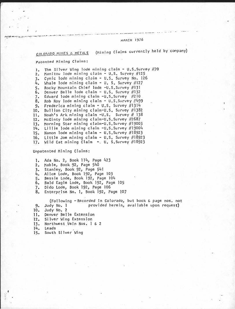
?rof2ssional E __ :per'ieY!.ce:
191t8 -'-0 "'-.... -3""'.,.., .. •• -:f;.",:, OT·' · "''''',-,~,-~ ,~ ,-:-> , ~,,'-O·'''' .,..'·~.,.,~ ~"r- CO'-,·:·..,..··'r·· ... O-· .... (SU'_" '"I:::'",:= _ • U !:I_V \JL. .. V ~ __ ... _\.;.1 • ___ l,,;,.;_ u;..,1 ___ ..... _, -.:...l_- ___ JoO __ :...J_'-vv _ _ __ ..;;,I
".~ .... ~ "'''c.' '::)·"'a-"o-''''d)· Q~-..... '; II -\ ',:1., •. , CO·,-··:· ·r-=:. r.·:· ~ ,-> (C:'" :-~o·r,c.~ ,:) ·.--:d _·('O·:·. :~ '_'-'-:'." ') ~ r.:_ •• _~ -; 1 "'-- ... _'--"- t.,...(,. __ ...... _ .. (._ ........... _ , _ ___ ..l.._ C _ ... 0.,1 __ ...... '-lV_ ~c;.. .. _. __ ___ __...' ~
c·~)e:C"2:(, o:.~ (:Llot,c:..-~ i 0::1. 2.nd. S~~ '.Yi·~ ~r); 2..:."".:.0.. CO!:..:::' l::l t ir4[S 0!!5::'1-~8e:'~;J Z:·:p~:::'''''ie~ce is divided. app::.,...o:.cii~.::.t,C:ly z-s fello·.-/s: Urlde::-·sro\l.:.:'·::, 75%; '!--,,....?.-, '.~ Qr-(ff ;':!"""-pl i oj Co:' 00::'
" ';\~"~-:--:,-:-.···~ll" ~..... ~/::;. ·0 . .-,.+ '.-.,,1 r,'·."'" ~d _u. __ G..vc, _-;:)/.1. .. ... ::,..\.1 ____ 0, / I~' _.v __ 1_ ...... '"' ....... ___ '-"~~ -' ~ _ _ -.1_\...,,1_(,;;\,..00. ........ J/->.
Lode L:!i~ing, 90}~; :?lac8r 2:C1G. ~r.:.8e ·~.:.solic..~.:t0d deposi.1us ; 5%, ~~ll': :":'" 3~ :-~I ' ~ • -::>/:'0 Sc~pe or G?2:!...o"\C;..t io~-:.. .s h~ ""..'0 :.~c::.::-~ECc.. :-.:..-c~ 2- feT:i ·c C~g p~.r day O~ rn~;)s?G,~t/i:n.5 op&r2..J(,io~s 'co 500--::,o~.:.s 9c~ G.c.y on _OYl-a lc..:. .... 5c 1.:.:-:c.a:. ..... -5~C·11r:.d t.lli:.sst,c:n 0:.:>8:. .... 2..-'.::.~O:c.l.~
-r-.rr .. t· .. - ... t v~..... -., ' c."·OO" - ~,..., " .. _- ~' . "-
. Ch2.y·le~ ? Kaasal (!~!iY.:iY!.6 2..:'!.d 2"::::·::'c..ll u:nc~ cal) las V82."2..3, ~\8v8.da
l72l '"Sout .. h
H.H. Chsssher, J~. Gaz3"l, te Building,
( (3-""0: 0 .~~ -.,,:,! ) '\ ...., - c-'-,;-- :1 2120
..,... . Df"'-~ .. =-~- M; ~ .. ,.. J'(' 10}'0 Sirc,(l ~0~~ - --- ,,~-.:.;;- , - . ,
E$B:. JOC:l3to~*J ~~Tas"::' 909 S? T'E. .s.-~~
"::!_"' .., ./\J'. . --""'.,..:..:'- - --
:::::;: .... i"\:-:eJ'::, ""'" ')
~ ,-.'7".---: "~r:'\ __ '1 ...... __ \.4_)
~~ s'.-o'''I Co-r--"o .~.1. :;-~ ~_ ... - ... _ _::' .L_V--J~_,
Co~""':; SSi ~ ...... ....... _._ _v __ :;
_t._:~c...co:,,"""'::'a s :·tas ~.;; ' .... r-:.. --.... ;) ·---~-OVU_-
Spo~z.~~:;. , :~Tash~ns:::'c:_
1.:·0:2 Clir:~o~ s-::..) 3~::·:-:2..·:;~", ~ _ \j .. C}_~~~_~_

.- ..... ~~ . . J :,;~..:
..
( '"'1 -; ,..,..'\ .... S -'0"-':' .; ·r.'~I":\':; ) v __ c;; ... _v , \woo ... _\J _ .. _~1..:.0'--
D::-. Reed C. _'Pe~·.+.y, Fi~-.l..l~rYr.-'?r.:.~··;·.y, '<' ·('\,.. .• '1·J.~ol"~ .. iYlr" Co·~~·"'~c.J·oY>s ~_ ~ _._v __ "'-__ _" .• :::;._ .~~--.-o ._ .... _co v - ~ 6900 Van ~iuy.s Blvd., Van lJuys, C3.li.:toY·r!i 2..
:!:nc. ::: .. 0. Box
Roy ~·i -. / r-· - -. - .
C 0 .• t""I::-. t., -,-.':" -. ~ .. ..... ~.. .J - ~"." _ '114" __ _ '-- ___ ~ _ v -....., )
r:.;:.· ..... l O,.,.i c~· , \:;~ ..... - 00- --


Related Documents