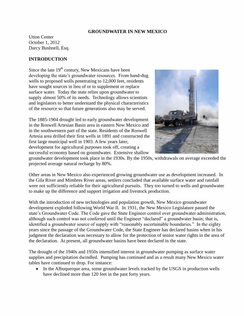
GROUNDWATER IN NEW MEXICO Utton Center October 1, 2012 Darcy Bushnell, Esq. INTRODUCTION Since the late 19 th century, New Mexicans have been developing the state‟s groundwater resources. From hand-dug wells to proposed wells penetrating to 12,000 feet, residents have sought sources in lieu of or to supplement or replace surface water. Today the state relies upon groundwater to supply almost 50% of its needs. Technology allows scientists and legislators to better understand the physical characteristics of the resource so that future generations also may be served. The 1885-1904 drought led to early groundwater development in the Roswell Artesian Basin area in eastern New Mexico and in the southwestern part of the state. Residents of the Roswell Artesia area drilled their first wells in 1891 and constructed the first large municipal well in 1903. A few years later, development for agricultural purposes took off, creating a successful economy based on groundwater. Extensive shallow groundwater development took place in the 1930s. By the 1950s, withdrawals on average exceeded the projected average natural recharge by 80%. Other areas in New Mexico also experienced growing groundwater use as development increased. In the Gila River and Mimbres River areas, settlers concluded that available surface water and rainfall were not sufficiently reliable for their agricultural pursuits. They too turned to wells and groundwater to make up the difference and support irrigation and livestock production. With the introduction of new technologies and population growth, New Mexico groundwater development exploded following World War II. In 1931, the New Mexico Legislature passed the state‟s Groundwater Code. The Code gave the State Engineer control over groundwater administration, although such control was not conferred until the Engineer “declared” a groundwater basin; that is, identified a groundwater source of supply with “reasonably ascertainable boundaries.” In the eighty years since the passage of the Groundwater Code, the State Engineer has declared basins when in his judgment the declaration was necessary to allow for the protection of senior water rights in the area of the declaration. At present, all groundwater basins have been declared in the state. The drought of the 1940s and 1950s intensified interest in groundwater pumping as surface water supplies and precipitation dwindled. Pumping has continued and as a result many New Mexico water tables have continued to drop. For instance: In the Albuquerque area, some groundwater levels tracked by the USGS in production wells have declined more than 120 feet in the past forty years.

Welcome message from author
This document is posted to help you gain knowledge. Please leave a comment to let me know what you think about it! Share it to your friends and learn new things together.
Transcript
GROUNDWATER IN NEW MEXICO Utton Center
October 1, 2012
Darcy Bushnell, Esq.
INTRODUCTION
Since the late 19th
century, New Mexicans have been
developing the state‟s groundwater resources. From hand-dug
wells to proposed wells penetrating to 12,000 feet, residents
have sought sources in lieu of or to supplement or replace
surface water. Today the state relies upon groundwater to
supply almost 50% of its needs. Technology allows scientists
and legislators to better understand the physical characteristics
of the resource so that future generations also may be served.
The 1885-1904 drought led to early groundwater development
in the Roswell Artesian Basin area in eastern New Mexico and
in the southwestern part of the state. Residents of the Roswell
Artesia area drilled their first wells in 1891 and constructed the
first large municipal well in 1903. A few years later,
development for agricultural purposes took off, creating a
successful economy based on groundwater. Extensive shallow
groundwater development took place in the 1930s. By the 1950s, withdrawals on average exceeded the
projected average natural recharge by 80%.
Other areas in New Mexico also experienced growing groundwater use as development increased. In
the Gila River and Mimbres River areas, settlers concluded that available surface water and rainfall
were not sufficiently reliable for their agricultural pursuits. They too turned to wells and groundwater
to make up the difference and support irrigation and livestock production.
With the introduction of new technologies and population growth, New Mexico groundwater
development exploded following World War II. In 1931, the New Mexico Legislature passed the
state‟s Groundwater Code. The Code gave the State Engineer control over groundwater administration,
although such control was not conferred until the Engineer “declared” a groundwater basin; that is,
identified a groundwater source of supply with “reasonably ascertainable boundaries.” In the eighty
years since the passage of the Groundwater Code, the State Engineer has declared basins when in his
judgment the declaration was necessary to allow for the protection of senior water rights in the area of
the declaration. At present, all groundwater basins have been declared in the state.
The drought of the 1940s and 1950s intensified interest in groundwater pumping as surface water
supplies and precipitation dwindled. Pumping has continued and as a result many New Mexico water
tables have continued to drop. For instance:
In the Albuquerque area, some groundwater levels tracked by the USGS in production wells
have declined more than 120 feet in the past forty years.

In the Animas Basin located in the southwest corner of New Mexico, groundwater pumping for
agricultural uses caused the water table to drop more than 80 feet between 1948 and 1981.
In the Roswell Artesian Basin, from 1950 to 1975, the declines in the alluvial aquifer ranged
between 40 and 80 feet.
In the Gallup area, the water table dropped about 200 feet between 1999 and 2009 and is not
expected to meet the demands of the population by 2019.
A central concern about groundwater from a legal point of view is the connection between
groundwater and surface water. To the extent that groundwater pumping affects surface supply, the
increase in groundwater use in New Mexico may reduce the amount of water available for surface
water rights, which are often senior to groundwater rights. In City of Albuquerque v. Reynolds, the
New Mexico Supreme Court established a principle that has deeply affected water law and
administration throughout the West; that is, a state‟s water official, such as the New Mexico State
Engineer, has the authority to recognize the connection between surface and groundwater in his
administration of water. This principle means that ground and surface water must be considered
together in any analysis of water rights.
As of 2009, New Mexico uses about 1.9 million acre-feet of groundwater each year for agricultural,
municipal and other purposes. According to the National Groundwater Association, groundwater
supplies 47% of the water used in New Mexico. The Association reported the annual usage in 2011 as
follows:
Purpose MGD % total GW % total supply for Purpose
Public Supply 249 15% 87%
Household (self
supplied)
32 02% 100%
Irrigation 1,270 76% 45%
Livestock/Aquaculture 49 03% 70%
Industrial (self
supplied)
12 01% 87%
Mining 57 03% 98%
Thermoelectric 10 01% 19%
In 1964, Charles Theis warned:
…[R]eserves of groundwater accumulated over millennia are being depleted at a
rate that will exhaust some of them in decades and will demand changes in the
economy or the development of new concepts in water supply in the not-distant
future.…
…In their pristine state, water bodies are in approximate dynamic equilibrium,
with recharge over a period of years balancing the natural discharge through
springs, invisible seepage into surface streams or lakes, and evaporation and
transpiration where the water table stands near the surface. Wells represent a new

discharge superimposed on this previously stable system, and the discharge from
wells has to be balanced by increasing the recharge, or decreasing the natural
discharge, or by some combinations of these processes.
As the population grows and drought intensifies, groundwater sources are tapped with increasing
urgency, even as precipitation decreases. Limited steps are being taken to preserve groundwater
through limiting withdrawals when surface water is available, conservation, and groundwater recharge.
References 1
GROUNDWATER BASINS OF NEW MEXICO
There are 39 underground water basins in New Mexico. Some of these
are isolated or closed basins and some are hydrologically connected to
surface water. An isolated or closed basin, encased by surrounding
geology, does not receive significant recharge from surface water or
precipitation. These basins do not recover appreciably from withdrawals.
Groundwater withdrawal which exceeds a basin‟s recharge is regarded as
mining or overdrafting. Examples of mined aquifers in New Mexico
include the Ogallala Aquifer of the Great Plains where it extends into
eastern New Mexico; the Jornada del Muerto and Hueco Basins of the
southern New Mexico; and the Estancia Basin located east of
Albuquerque and the Sandia Mountains. Some basins are not well
connected to surface water sources and thus recharge and recover from
pumping slowly. Other basins, such as the Albuquerque Basin are
hydraulically well connected to surface water and receive recharge from
stream flows.
Declared Groundwater Basins in N.M.
Underlying the declared groundwater basins are undefined deep water basins or aquifers. Toward the
end of the 20th
century, attention turned to this groundwater as a possible source to meet New
Mexico‟s increasing demand. The nature of deep groundwater is not well understood, but it is less
dependent upon surface water than shallow groundwater basins for recharge. It is not accessed
frequently because of the expense of deep drilling and uncertainty about its quality.
To be classified as deep groundwater, the top of an aquifer must be at least 2,500 feet below the land
surface and contain nonpotable water. Nonpotable groundwater contains not less than 1000 mg/l of
total dissolved solids. If an overlying shallow groundwater basin contains nonpotable water, it is likely
that the underlying deep groundwater will also be nonpotable. Information about these aquifers is
derived largely from oil and gas wells and is fairly sparse. To ascertain the boundaries of these basins,
hydrogeologists apply existing knowledge, information about geology and structure, and the principle
that the major regional divides between surface and shallow groundwater generally reflect the deeper
underlying structures. The OSE Hydrology Bureau continues to examine potential deep groundwater
basin boundaries and their hydrologic connections to shallow groundwater and surface water.
References 2

INSTITUTIONAL STRUCTURES FOR REGULATION
State, federal and tribal governments manage some aspects of groundwater. The federal government
has long deferred to state law in this arena; however, there are exceptions where the federal
government has a management or regulatory role. Some tribes have developed and adopted tribal
water codes which include provisions regarding groundwater management.
State Institutions: The public owns all water, including groundwater, in New Mexico, with the right to
use water established by state law. The New Mexico Office of the State Engineer (OSE) administers
the state's water resources through the supervision, measurement, appropriation and distribution of all
surface and groundwater in the state. Under the 1931 Groundwater Code, the State Engineer gained
jurisdiction over groundwater by delineating or „declaring‟ groundwater basins. The Engineer develops
rules, regulations and guidelines to carry out the purposes of the Code. The Engineer creates water
districts and appoints water masters to help actively manage both ground and surface water, to assist
with compliance issues and to administer water distribution on a daily basis.
To declare a basin, the State Engineer conducts studies to determine the
basin's hydrologically distinct or “reasonably ascertainable” boundaries.
The Engineer declares basins in response to increased well development,
aquifer draw downs and impacts on surface water which put existing
interstate and intrastate obligations and uses at risk. In 2006, the State
Engineer declared all remaining undeclared basins in the state. The legal
description of each basin is found in Article 7 of the Rules and
Regulations. These declared basins do not involve deep, nonpotable
groundwater in aquifers with tops more than 2500 feet below the land
surface.
Rules, Regulations and Guidelines: The statutes provide the Engineer with the authority to:
…adopt regulations and codes to implement and enforce any provision of any law
administered by him and may issue orders necessary to implement his decisions and
to aid him in the accomplishment of his duties. In order to accomplish its purpose, this
provision is to be liberally construed. (N.M.S.A 1978 § 72-2-8)
The State Engineer develops rules and regulations to carry out the purposes of the New Mexico water
codes. The Engineer has adopted general groundwater regulations that address:
Rights that were developed prior to the declaration of a basin;
Well permitting process;
Licensing of uses;
Construction of wells;
Changes to location, place or purpose of use;
Changes of ownership;
Supplemental, deepened and repaired wells;
Plugging of wells;
Termination of water use;
Metering and reporting requirements; and

Transport and storage of water.
Appropriations, Declarations, Permits & Licenses: State Engineer documents that describe
appropriations include declarations, permits, licenses or some combination of the three. Prior to the
State Engineer‟s declaration of a groundwater basin, regulation of groundwater appropriation occurred
under the common law. A future appropriator had only to dig or drill a well and put the water to
beneficial use to create a vested or perfected right. This water right owner could file a declaration with
the OSE, but it was not required. A declaration gives the public notice of an intent, or of previous
actions taken, to use groundwater. Declarations serve as prima facie proof of the facts stated, but do
not actually create a water right. That is accomplished through beneficial use. Under the Mendenhall
doctrine, if drilling a well is initiated but not completed prior to the declaration of a basin, no permit is
required.
Once a basin is declared, all new groundwater appropriations, alterations to existing uses, and drilling
of supplemental or replacement wells require a permit from the State Engineer. When an application is
filed, the Engineer publishes a notice once a week, for three weeks in a newspaper located in the
county where the well will be located and in each county where the water will be used or other water
rights will be affected. Anyone who objects to the proposed water right or well may file an objection
with the OSE. The basis for objections must include substantial and specific impairment of the
objector‟s existing rights. In addition, an objector may assert that granting the permit would be
contrary to the public welfare and/or the conservation of water within, or detrimental to the public
welfare of the state. If there is unappropriated groundwater water and the other tests are met, the
permit will likely be issued.
Today, most applications are challenged. The OSE‟s Administrative Hearing Unit hears challenges,
takes evidence and renders decisions. The hearing examiner submits a report and recommendations to
the State Engineer for disposition. Any decision of the Engineer may be appealed to the district court
in the county where the diversion will take place. Following the issuance of a permit, a licensed driller
constructs the well and files the appropriate paperwork with the Engineer. Cities such as Santa Fe may
further limit wells drilling within their boundaries.
Once a well is drilled and water is put to beneficial use, the regulations provide that an applicant shall
prepare and file a final inspection and report prepared by a registered survey professional. When that
step is completed, the State Engineer will issue a “Certificate and License to Appropriate.” Very few
licenses have been issued in recent years.
Mined Groundwater Basins: The process, law, and regulations for permitting or licensing new and
changed uses are the same for all groundwater appropriations. The State Engineer, however, may
develop administrative guidelines for issuing permits for new appropriations and changes to uses in
mined groundwater basins. Groundwater mining occurs when groundwater is pumped faster than it is
replenished in a basin. The Engineer‟s objective is to administer groundwater basins to extend their
productive life by regulating the rate of dewatering. The guidelines often follow the Engineer‟s
determination that the groundwater in a basin has been fully appropriated. This determination is
captured in an order which closes the basin for an indefinite period to new water use permits issued
under the general groundwater appropriation statute, N.M.SA 1978 § 72-12-3. Among those closed to
new development are the underground water basins of Estancia (2001), Curry County and Portales

(2009), and the Lea County - High Plains Aquifer area (2009), and portions of the Roswell
Underground Water Basin (2005).
The State Engineer considers developing guidelines when a groundwater basin shows signs of
significant stress. Thus, problems which have lead to guidelines include:
domestic wells going dry and irrigation wells experiencing reduced production in the Curry
County-Portales Basin;
declining water levels and deteriorating water quality in the Estancia and Tularosa Basins; and
concerns about groundwater depletion effects on the Rio Grande from Albuquerque‟s
municipal pumping and the subsequent effects on senior users, Compact obligations, and land
subsidence.
These conditions signaled a need for more careful and restrictive administration.
The goal of the guidelines is to guide OSE staff in the administration of the groundwater to 1) assure
the orderly development of the water resources within the basin; 2) meet the statutory obligations
regarding protection of the senior users; and, 3) extend the life of these basins so that they have a
minimum of forty years of productivity. These guidelines may include provisions such as, but are not
limited to:
closing a basin to new appropriations except for those obtained under N.M.SA 1978 § 72-12-1;
using block computer models and local assessment methods to evaluate the effects of a
proposed well and to appropriately limit drawdowns in areas;
limiting drawdowns over a set period of time such as 40 years;
limiting permits to consumptive beneficial use for different purposes as determined by the
OSE;
limiting the per-acre amount to be transferred for an irrigation use where there is to be a change
of use;
limiting transfer amounts in the case of stacking or spreading of water rights; and,
requiring meters and usage reports in certain instances.
Guidelines have been issued for the underground water basins of Estancia (2002), Lea County (2009),
Curry County and Portales (2010), and Roswell (2005) as well as the administrative areas in the
Mesilla Valley (1999), the Alamogordo-Tularosa area in the Tularosa Underground Water Basin
(1997), and the Middle Rio Grande (2000).
The State Engineer can also declare a Critical Management Area (CMA) within a mined basin. A
CMA defines an area where excessive water level decline rates require additional protection. It
generally includes any area where there is insufficient groundwater to sustain existing appropriations
for a forty year period. In a CMA, drawdown restrictions are more stringent to maximize the useful
life of the designated area. Basins which include CMAs include the Estancia, the Lea County, the
Curry County-Portales, the Roswell, the Tularosa, and the Middle Rio Grande.
Pumping Depletions on Surface Water: Where groundwater pumping is or will cause unacceptable
depletions on fully appropriated surface water resources, the State Engineer can condition any new
permit by requiring „offsets‟. To effect an offset requirement, a proposed appropriator must acquire a
senior surface water right and obtain a OSE permit to transfer it, that is, change the place of use, to the

proposed groundwater diversion. The land on which the surface water was used, no longer has an
appurtenant water right and the water right is said to be „retired‟.
Offsets are a part of the Mesilla Valley Administrative Criteria and are described as being
“…achieved by acquiring a volume of water through a water right or other
contractual obligation in the affected water source and releasing that water to
replenish the affected volume in the source that results from exercise of the
permitted groundwater appropriation. Offsets must be made before groundwater
withdrawals commence tantamount to surface water effects associated with the
full exercise of the permit.”
Mesilla Guidelines at page 5. Requiring offsets protects the surface flows of the related stream by
reducing surface water diversions from a river to accommodate depletion or reduction by pumping.
This strategy is a critical part of conjunctive management of surface and groundwater resources.
Offsets are also required in the guidelines of the Middle Rio Grande Basin, and the Roswell Basin.
Domestic and Other Small Uses: The State Engineer‟s authority over relatively small groundwater
withdrawals for domestic, livestock and temporary purposes is somewhat limited. N.M.SA 1978 § 72-
12-1 and its subparts require applicants to apply for permits and require the Engineer to issue them.
The Engineer does so without evaluation, public notice or hearing because issuance is mandatory.
In the exercise of his authority, however, the State Engineer has developed domestic well regulations.
The current regulations were issued in 2006 and amended in 2011, and do not affect pre-existing
appropriations. The regulations are similar to those issued for other groundwater uses. The State
Engineer may also declare a Domestic Well Management Area or CMA to protect valid, existing water
rights and mined aquifers from the effects of domestic wells. The subsequent guidelines may include
more restrictive limits on the amount allowed per domestic right. The limits are based on the
hydrologic conditions and the number of existing water rights within the declared area. In 2003, the
Engineer declared a CMA in the Tularosa Underground Water Basin for the La Luz, Fresnal and
Laborcita watersheds in the Sacramento Mountains and limited new domestic well diversions to no
more than .5 acre-feet per year.
Metering: To further the mission of protecting and administering New Mexico‟s groundwater
diversions, the State Engineer now requires metering, monitoring and reporting water usage in certain
areas. Previously, metering was not required unless by a court order. In the Roswell Artesian Basin,
the Lewis court entered a January 19, 1966 Partial Final Judgment and Decree which provided for the
metering of all irrigation, industrial and municipal wells. In the Aamodt water rights adjudication of
the Rio Pojoaque Valley, the federal court ordered that all subsequent domestic wells developed be
metered and limited to indoor use only. Metering and reporting allows the State Engineer water
masters to monitor for over-diversion and to manage the condition of the aquifer.
The State Engineer also requires metering in the critical underground water areas in the Roswell
Underground Water Basin, Carlsbad Underground Water Basin and Capitan Underground Water Basin.
The Engineer ordered metering of all groundwater diversions in the Lower Rio Grande Water Master
District, except for domestic or livestock purposes. He retained authority to order metering of these

exceptions at a later date. The Engineer requires affected well owners to obtain, install, maintain, and
repair any meter and to report meter readings to the OSE quarterly or more frequently if necessary.
Deep Groundwater Basins: The State Engineer‟s authority over deep groundwater basins is also
limited. In 1967 the legislature passed the original deep groundwater statutes. This action was taken to
protect oil and gas interests from involvement in Pecos Compact administration. Between then and
2009 when the legislature amended N.M.SA § 72-12-25, the State Engineer did not have authority to
administer water from deep groundwater basins. The law only required simple notice for the drilling of
a legal well. In 1997, Midway Ranch Ltd Partnership filed the first notice of intent, completing the
well that same year. By April 2009, a total of 607 notices had been filed for appropriations for about
1.6 million acre-feet per year from depths between 2,500 to 12,000 feet. At that time, only five wells
had actually been constructed. Most of the notices were filed in 2008-2009 and were related to
drilling in the Middle Rio Grande area.
Under the current statute, the Engineer may obtain regulatory authority over nonpotable deep
groundwater for any use except oil and gas exploration, and production, prospecting, mining, road
construction, agriculture, generation of electricity, use in industrial processes or geothermal use.
Effectively, the Engineer‟s authority is limited to uses for municipal purposes. To obtain authority to
regulate this water in the same manner as other groundwater, the State Engineer must declare a deep
groundwater basin.
In a presentation in 2009, then State Engineer, John D‟Antonio, stated if a deep aquifer was
hydrologically connected to a shallow aquifer, there was no need to declare the deep basin. He
outlined the next steps for the OSE to pursue:
1. Declaring nonpotable deep water aquifers if technically defensible;
2. Determining the legal significance of the Notices of Intent filed and published prior to 2009;
3. Formalizing procedures for filing applications to appropriate water from deep aquifers;
4. Formalizing procedures to manage drilling of and reporting of usage from deep wells;
5. Setting a well-defined process to facilitate development of deep nonpotable resources while
protecting water rights and compacts; and
6. Recognizing that the economics of development will limit the use deep aquifer water in the
near term.
Today, OSE administrative procedures require interested parties to submit a notice of intent and to file
an exploratory well permit application and proof of publication in the newspaper. After drilling the
well owner must submit well records, proof of compliance with drilling standards, and water quality
results. Then meter readings are submitted on a quarterly basis. In order to avoid the OSE permitting
requirements, the owner must show the two conditions set out in the statute are met: the depth to water
and the nonpotable nature of the water.
The Interstate Stream Commission (ISC) protects New Mexico‟s right to water under eight (8)
interstate compacts, ensures the state meets its obligations to its sister states and makes certain that
endangered species are afforded necessary water. The ISC becomes involved in groundwater
management where pumping affects surface water deliveries required under compacts and by
endangered species such as in the Lower Rio Grande and Pecos River regions. The ISC develops

groundwater models to assist in the prediction of groundwater impacts on the rivers in its management
of compact obligations. The legislature authorized the ISC to purchase water rights or appropriate
water on behalf of any region. Under this authority, the ISC purchases and leases groundwater to
supplement Pecos River flows so New Mexico can meet its obligations to Texas under the Pecos
Compact.
Federal Management of Water: The federal government generally defers to state law for the
management of water. In California Oregon Power Co. v. Beaver Portland Cement Company, the
United States Supreme Court addressed the question of federal involvement in water regulation in the
western states. It recognized that water use “generally was fixed and regulated by local rules and
customs.” This approach included the doctrine of prior appropriation and was formalized in the
Mining Act of 1866, the Desert Lands Act of 1877 and their subsequent amendments. The Supreme
Court held that:
…[F]ollowing the act of 1877, if not before, all nonnavigable waters then a part of
the public domain became publici juris, subject to the plenary control of the
designated states, including those since created out of the territories named, with
the right in each to determine for itself to what extent the rule of appropriation or
the common law rule in respect of riparian rights should obtain.
The Court went on to observe in a footnote that “Congress, since the passage of the Desert Land Act,
has repeatedly recognized the supremacy of state law in respect of the acquisition of water,” citing to
the Reclamation Act of 1902.
However, the federal government is not without constitutional authority to regulate or influence
groundwater management. In the Sporhase v. Nebraska case, the United States Supreme Court found
that the Commerce Clause clearly gives Congress the “affirmative power… to implement its own
policies concerning [groundwater] regulation… Groundwater overdraft is a national problem and
Congress has the power to deal with it on that scale.”
The effects of groundwater pumping on the federal claims to state law surface water rights is playing
out in New Mexico‟s Lower Rio Grande water rights state court adjudication. The United States
recently sought to protect its surface water rights for the federal Rio Grande Project from depletions
caused by groundwater pumping in the area. As a matter of both state and federal law, the United
States asserted that the source of the water for the Project is “(1) all the surface water in the lower Rio
Grande and (2) water in the ground hydrologically connected to surface waters in the lower Rio
Grande.” The state and other responding parties countered that the United States‟ claim is unsupported
by New Mexico state law. On August 16, 2012, the state adjudication court found that the Project right
being adjudicated is limited to a surface right and ruled that the federal claim is beyond the scope of
the adjudication.
Tribal Institutions: The water rights of Native American are generally identified and defined under
federal law. In Winters v. United States, the United States Supreme Court held that when the federal
government created reservations, it sets aside both lands and water. These rights are known as federal
reserved rights or Winters rights. This holding could be interpreted to mean that reservation tribes have
a right to the water itself, and certainly means that they have the right to the use of the water. While

this issue has not been address head on by court or by commentator, it certainly underlies questions of
administration.
Most state and federal adjudication courts have held that tribes have Winters rights to groundwater as
well as to surface water. In New Mexico, many of the Native Americans are Pueblo peoples who have
held their lands and waters long before the arrival of other Americans. In its 1985 opinion, the Aamodt
federal district court concluded that the Pueblos‟ water rights under Spain and Mexico law still exist
and could be satisfied from either surface water or hydrologically connected groundwater. Later in
2001, the Aamodt court examined the question of whether the Pueblos own groundwater. It held that
that under every sovereign, the Pueblos did not own groundwater but rather developed rights to use it.
Groundwater Regulation by Tribes: Whether tribes can regulate their groundwater water or must
comply with state law is a matter of debate. Some commentators argue that administration of water
within reservation boundaries is a matter of sovereignty. Others assert that since the reservations are
located within state boundaries, rational management of the ground and surface water resource
demands that the tribal portion be administered under the rules and regulations of the local state
engineer.
Development of a tribal water code is one avenue to administration within tribal boundaries. The
Navajo Nation, for instance, asserts ownership of full equitable title to groundwater through the
Navajo Nation Water Code. The Nation‟s situation is not representative. Only a few tribes regulate
the allocation of their surface and groundwater. Under the Indian Reorganization Act of 1934, tribes
must obtain approval of the secretary of the Department of Interior when enacting laws. Under
pressure from western states, the U.S. Department of Interior stopped approving tribal water codes in
1975 until such time as it could promulgate appropriate rules for the use of water on tribal lands. To
date, these rules have not been written.
Native American water settlements, however, have addressed administration in a variety of ways.
Tribes may agree to submit to local state engineer administration. In the Aamodt Litigation Settlement
Act of 2010, the Pueblos agreed to inform the local state engineer or non-Indian water users about
aspects of their water management. In the Navajo proposed final decree arising out of the
Northwestern New Mexico Rural Water Projects Act Settlement Act of 2009, the Nation agreed to seek
New Mexico State Engineer approval of any lease of their rights for uses off of trust lands. Tribes may
also agree to forbearance provisions or to administer through tribal water codes as set forth in the
Crow Tribe Water Rights Settlement Act of 2010.
None of the New Mexico tribe settlements include tribal water code provisions. However, in a survey
conducted by the Tribal Law Journal, several New Mexico tribes have indicated that they have codes
addressing water. These Pueblos and Nations include: Acoma Pueblo, Mescalero Apache Tribe,
Ohkay Owingeh Pueblo, San Felipe Pueblo, Pueblo de San Ildefono, and Santa Clara Pueblo. The
survey, however, does not contain details of the content of these water codes which could be related to
groundwater, surface water, water management and/or water quality.
References 3

KEY PRINCIPLES OF NEW MEXICO LAW CONCERNING GROUNDWATER
In New Mexico, water belongs to the public, but individuals, public entities and
private entities may acquire a right to use water. State statutes identify the core
elements of water rights which include: priority, amount, purpose, periods and
place of use and, as to irrigation water, the specific tracts of land to which it is
appurtenant. These principles apply to both surface and groundwater.
Permits: By issuing a permit the State Engineer grants the applicant permission
to drill a well and to develop water up to a certain amount. The permit is not
proof of a water right in and of itself. The appropriator must diligently pursue
development and application of water to beneficial use. The maximum amount
allowed under a permit is governed by regulation and/or adjudication. Following development, the
Engineer may issue a license upon inspection and proof of actual beneficial use. The hierarchy of
formal recognition of a ground or surface water right has a declaration of water use at the bottom, rises
through a permit to a license, and ends up with a decreed right from a court.
The decision of whether to issue a groundwater permit depends on the type of permit desired; whether
unappropriated water is available; whether senior groundwater users will be impaired; whether
additional depletions on fully appropriated streams will occur or interstate compact streams will be
impaired; whether the use is contrary to the conservation of water in the State; and, whether granting
the permit will be detrimental to public welfare.
The State Engineer determines impairment on a case-by-case basis. There is no statutory guidance
except that the impairment must be substantial and specific to existing water rights. Lowering of a
water level in a well, shortening of the useful life of a well, adding to lift costs, reducing the ability to
produce, slight increases in salinity, and making it necessary to drill more wells to produce the same
amount of water do not necessarily constitute impairment but these factors provide some evidence of
substantial impairment. Considerations that can mitigate an impairment claim include the age and
construction of the allegedly impaired well, the ability of the well owner to continue to use the well,
and whether the well can be productively deepened.
If the proposed water right will impair a hydrologically connected surface water right, the State
Engineer will deny the application unless that effect is de minimis, the permit can be conditioned to
avoid the impairment, or the effect can be offset. Typically, an applicant offsets effects by purchasing
and retiring existing valid senior surface water rights. In the past, these offsets could be purchased and
retired over time as the pumping effects were observed on the affected surface water through a process
known as „dedication‟. This practice was discontinued in 1994 after the state attorney general declared
it illegal.
There is little case law or statutory guidance regarding the tests of “contrary to the conservation of
water within the state or detrimental to the public welfare of the state.” These tests are also examined
on a case-by-case basis and may be overcome by a showing of conservation practices or benefit to the
public welfare. Thus, recent municipal applications by Albuquerque and Alamogordo were supported
by descriptions of present and future conservation successes and plans. One case, State v. City of Las

Vegas, suggests that the detrimental public welfare test can be overcome where there is evidence of
well development as a part of a municipality‟s forty year plan to accommodate reasonable population
growth. However, development of such wells could meet the test of „detrimental to the public welfare‟
if the proposed development threats compact obligations, municipal water supply or senior rights.
All rights for which permits are issued must undergo this analysis, with one exception - domestic well
permits. Under New Mexico statutes, the State Engineer must issue permits for domestic uses. The
constitutionality of this statute is presently under consideration by the New Mexico Supreme Court in
Bounds v. D’Antonio, No. 28,860 (2011 N.M.C.A. 011), cert. granted, Nos. 32,713 and 32,717 (N.M.
January 27, 2011).
Priority and Priority Calls: The priority of a water right is related to the date on which the water either
was put to beneficial use; the date of an application for a permit, or the date of some other indicia of
intent to appropriate. The rules for determining a priority date of a groundwater right are the same as
for a surface water right. Water associated with a supplemental well is an exception. In that case, the
supplemental groundwater right priority relates back to that of the original water right.
Priority calls are the mechanism for managing water when there is a shortage. In that event, the State
Engineer arrays the water rights in order of priority and administers deliveries water from the most
senior down to the most junior. This system works fairly well where surface water users are involved.
However in some cases, such as where senior surface users are downstream from junior groundwater
users, the call against the junior users may not result in timely delivery to the seniors.
The Carlsbad Irrigation District (CID) priority call illustrates the problem. The Carlsbad area was
settled before Roswell area and so surface water rights in Carlsbad are senior to groundwater rights in
the Roswell Basin. In order to gain control of illegal and excessive pumping in the Roswell Artesian
basin, the State Engineer initiated the Lewis adjudication of water uses in the Basin. In 1976, the CID
placed a priority call with the State Engineer. The Engineer contended that there would be devastating
effect on local economies of shutting down groundwater uses in Roswell. It was also not clear that
shutting down groundwater uses above the CID would get surface water to the District farmers. State
Engineer policy at the time also allowed administration only where rights were adjudicated. Since the
CID‟s rights were not adjudicated, the Engineer expanded the Lewis adjudication to include the rest of
the Pecos. As of 2012, the adjudication continues. Although the priority call never materialized, the
2003 Pecos Settlement provides some relief to District farmers through the purchase and retirement of
water rights by the state, and development of a pumping plan of groundwater from the Roswell
artesian aquifer to augment downstream supplies for the farmers.
Domestic Rights: The State Engineer must grant applications for domestic wells. The priority of
domestic right is the date on which the application for a permit was filed, if the well was drilled after
the affected groundwater basin was declared. The date of a pre-basin well is the date when the well
was drilled, dug or the intent to do so was formed. The amount of a water right depends on the
amount of water put to beneficial use, while staying within the permitted cap or maximum. Thus, prior
to the 2006 regulations domestic water rights were limited to 3 acre-feet per year. This water was
intended to serve a family‟s domestic uses, its livestock and the irrigation of 1 acre of land for home
food production. Today, the average domestic well serves only the household domestic needs, and by
regulation in 2006, the State Engineer reduced the cap to 1 acre-foot per year. These uses cannot be

transferred except under very limited circumstances set forth in the 2011 domestic well rule
amendments.
Supplemental Wells: The source of irrigation rights may be surface water, groundwater or a
combination of the two. Under the Templeton doctrine, when a surface water right owner is no longer
able to get a sufficient supply of water from a surface source, the owner is entitled, as a matter of right,
to drill a supplemental well in an aquifer that supports the surface water. If it becomes necessary to
drill a supplemental well, the amount of the water right does not change. Supplemental wells may also
be obtained for other types of water rights that can no longer be satisfied with an existing source.
Water Transfers: Under New Mexico law, water rights may be severed from the original place or
purpose of use and moved to a new place or purpose of use. The State Engineer requires an owner
wishing to make a transfer to apply for a permit to do. As with any permit, the applicant must provide
public notice and if the application is protested, defend the application in a hearing before the OSE‟s
Administrative Hearing Unit. When considering a groundwater right transfer, the State Engineer must
consider the local effect of the new withdrawal in the move-to basin. The priority date of the right
travels with it to the new location and when fit into the priority scheme, can cause impairment to
existing water rights. Minor impairment will not block a transfer, but more extensive impairment
could. These decisions are made on a case-by-case basis.
References 4
V. UNRESOLVED QUESTIONS
Several groundwater issues present today are: the effects of groundwater pumping on surface water;
the constitutionality of domestic wells; and groundwater supplies for municipalities.
As groundwater is pumped, a cone of depression is created. A cone of depression is a dewatered area
around a well shaft. Surrounding water flows along the cone toward the well shaft from every
direction. Over time as pumping continues, the cone of depression expands, lowers the water table and
eventually reaches hydrologically connected surface water. Where pumping lowers the water table,
wells may be impaired or cease to function. Where there is a sufficient connection between surface
water and an aquifer, surface water flows into the aquifer and toward the well, thus depleting the
surface water resource.
Domestic Wells: Since 1943 the State Engineer has not required either publication of notice or a
hearing on protests before issuing a permit since the issuance is mandatory. In 1953, the legislature
formalized this practice in the first domestic well statute. The amount of water withdrawn from each
domestic well is minimal, or de minimis. In areas where wells are widely distributed, this minor
amount of withdrawal per well has little effect on water rights in surrounding ground or surface water.
Concentrations of domestic wells, however, can have a significant adverse effect on surrounding wells,
surface water flows, and senior users. According to OSE records from 2000, there are about 137,000
domestic wells throughout the state. Of these, 26% are within one mile and another 27% are within 5

miles of a perennial stream. For purposes of hydrologic modeling, the OSE assumes that withdrawals
from wells within 1 mile have a 100% effect on the stream. While the effects of pumping take time to
reach any nearby stream, they will eventually reduce surface water flow. Since surface water is fully
appropriated in the state, the rights of senior users will be impaired as the cone of depression intersects
with streams.
In the mid-2000‟s, the case of Bounds v. D’Antonio took on the question of
mandatory issuance of domestic well permits. Horace and Jo Bounds are
farmers who hold senior water rights in the fully appropriated Mimbres
Groundwater Basin in southwest New Mexico. The Mimbres Basin has been
closed to new development since 1972, but since the final adjudication of water
rights in 1993, 45 additional domestic well permits had been issued at the time
the case was filed. The Bounds argue that the domestic well statutes allow a
proliferation of wells that will affect surface water flow and impair their senior
surface water rights. They assert that this impairment constitutes a taking of
Mimbres Underground Basin private property (their right to water) without just compensation or due
process. They also argue that the statute is unconstitutional because it violates the prior appropriation
doctrine and prevents the State Engineer from protecting senior users. The trial court found in Bounds‟
favor in 2008, but the Court of Appeals reversed in October 2010. The New Mexico Supreme Court
granted certiorari in 2011 and the matter is currently under review.
Municipal Wells: In the Albuquerque area, 92 municipal wells supplied 19.6 billion gallons of drinking
water in 2010. These wells have created cones of depression on both the east and the west sides of the
Rio Grande. In 2004, the east side cone covered about 40 miles and in places lowered the water table
about 150 feet. While the west side cone is smaller, similar effects were noted. Studies show that one
half of the withdrawn water is being recharged while the other half is mined.
The USGS developed a groundwater flow model that predicts what will happen if pumping continues
at the same rate to the year 2060. The model predicts, even with conservation goals in place,
significant aquifer drawdowns and land surface subsidence. Significant drawdown jeopardizes the
City‟s ability to provide water to its residents into the future. While relatively little land subsidence has
been observed in Albuquerque, as depletions continue, the City can look to Tucson‟s experience.
Downtown Tucson has dropped 6 inches in the last 20 years due to aquifer depletion, and suffered
property damage and other problems as a result.
In an effort to forestall these problems, the Albuquerque Bernalillo
County Water Utility (utility) was formed and a Water Resources
Management Strategy developed. The strategy‟s goal is to reduce
reliance on the aquifer, to reduce demand through conservation
and to switch to renewable resources.
To reduce reliance on groundwater, the San Juan – Chama
Drinking Water Project which replaces groundwater with treated
contract surface water and the Reclamation/Reuse Project which
uses treated effluent for irrigated sites such as parks and golf

courses were developed. Through utility‟s the conservation program, City residents have reduced their
use by 252 gallons per person per day in the mid-1990s to 150 gallons per day in 2011. The utility met
this goal three years early. The goal of the three programs is to reduce annual pumping to 60,000 acre-
feet a year to rest the aquifer so that it recovers through recharge. This strategy reserves groundwater
for the future and for times of shortage. The strategy also calls for implementing an aquifer storage
and recovery program whereby the utility stores water underground during the winter while demand is
low for withdrawal in the summer when demand is high. This project is not designed to recharge the
aquifer but rather to provide temporary underground storage.
The utility continues to use surface water as it is available, but must rely on the groundwater more than
originally anticipated. First, the transition to surface water was delayed and then, ash from the Los
Conchas fire in the surface water excessive treatment costs requiring reversion to groundwater for two
(2) months in 2010. Almost as soon as the San Juan-Chama Project was completed, drought conditions
set in. As a result, the San Juan-Chama diversions were reduced by more than half in 2012. Surface
flows in the river declined and as did the predicted natural recharge from runoff. In spite of these
setbacks, the USGS reported in 2011 rising groundwater levels in the Albuquerque Basin at fifteen
(15) of its eighteen (18) monitoring sites.
Rural Wells Supply Growing Cities: Supplying water to municipal users underlies the controversy of
the San Agustin Basin Project. In that project, a group of New York based investors sought a permit
from the State Engineer for the right to pump 54,000 acre-feet a year from a deep well field of 37
wells in the San Agustin Plains near Datil, New Mexico. Augustin Plains Ranch LLC planned to
market water to municipalities and the state to help meet its obligations under the Rio Grande
Compact. Nearly 900 protests were filed with the OSE‟s Administrative Hearing Unit. After a hearing
and a recommendation from the hearing officer, the State Engineer “denied the application [without
prejudice] because it was vague, over broad, lacked specificity, and the effects of granting it cannot
reasonably be evaluated; problems which are contrary to public policy.” On April 9, 2012, the
Augustin Plains Ranch LLC filed its appeal in state district court.
Groundwater for Agriculture: Supplying water to thirsty agriculturalists is an issue exemplified by the
situation in the Lower Rio Grande region of New Mexico. The Rio Grande is fully allocated through
the Compact, the Rio Grande Project and existing users. There is a significant connection between the
surface water flows of the Rio Grande and some of the surrounding groundwater basins of Rincon
Valley, Mesilla, Jornada del Muerto and Hueco. Recharge in the Jornada and Hueco is very low and
pumping above the recharge rate is mining the groundwater. The Rincon Valley and Mesilla Valley are
interconnected with the Rio Grande which provides recharge in above-normal flow years. However, if
pumping increases over 2004 levels, these basins will also be mined and the Rio Grande flows will be
reduced.
Agriculture is an intrinsically valued part of the economy of the area. Yet, with the arid climate, crop
evapotranspiration rates are high. Under conditions of prolonged drought, available surface water is
insufficient to meet the needs of the crops. The irrigators turn to groundwater to keep their crops and
economies alive. The 2004 Lower Rio Grande Regional Water Plan reports that the OSE lists 1,738
irrigation wells in the Plan area and 140 livestock wells. As the groundwater is mined, and the surface
water is depleted through recharge and drought, the obligations to Texas and Mexico under the
Compact, to New Mexico and Texas farmers and ranchers in the Rio Grande Project, to the

municipalities and other users cannot all be met. The question of how to divide and manage the water
between all competing interests and obligations during times of plenty is hard, and in times of drought,
very difficult.
References 5

References 1
George B. Anderson, History of New Mexico: Its Resources and People, Pacific States Pub. Co. (1907)
http://archive.org/details/historynewmexic00cogoog
J. O. Baxter, Dividing New Mexico‟s Water, 1700-1912, University of N.M. Press (1997)
James C. Brockman, Overview of New Mexico‟s Groundwater Code, presented at 27th Biennial
Groundwater Conference and 18th Annual Meeting of the Groundwater Resources Association of California
(October, 2009) http://pg-tim.com/files/N.M._GW_Presentation_JBrockmann.pdf
Bureau of Reclamation, Navaho-Gallup Water Supply Project Planning Report and Final Environmental
Impact Statement (2009) http://www.usbr.gov/uc/envdocs/eis/navgallup/FEIS/index.html
Ira G. Clark, Water in New Mexico: A History of its Management and Use, University of N.M. Press (1987)
John R. D„Antonio, Jr., The Future of New Mexico‟s Deep Water presented at the 54th Annual New Mexico
Water Conference, Water Planning in a Time of Uncertainty (October 2009)
http://wrri.N.M.su.edu/publish/watcon/proc54/dantonio.pdfhttp://wrri.N.M.su.edu/publish/watcon/proc54/d
antonio.pdf
Martha Franks, The New Mexico Water Code, 1907-2007 (n.d.)
http://www.ose.state.N.M..us/PDF/Legal/Presentations/N.M.-WaterCodePresentation-byMarthaFrank.pdf
G. Emlin Hall, High and Dry: The Texas-New Mexico Struggle for the Pecos River University of N.M.
Press (2002)
National Groundwater Association, Groundwater Use for New Mexico (2012)
http://www.ngwa.org/Documents/States/Use/N.M..pdf
Calvin Lashway, A History Of New Mexico State University's Well Development And Groundwater Use
(May 1999) http://wrri.N.M.su.edu/publish/techrpt/abstracts/abs232.html
Charles V. Theis, Groundwater in the Southwestern Region, presented at 6th Annual Meeting of the
Southwestern Federation of Geological Societies and Southwestern Regional Meeting of the American
Association of Petroleum Geologists, at Midland, Texas (1964) p. 327.
http://search.datapages.com/data/specpubs/methodo2/images/a071/a0710001/0300/03270.pdf
F.D. Trauger and CG.C. Doty, Groundwater -- Its Occurrence and Relation to the Economy and Geology of
Southwestern New Mexico, presented at the 16th Field Conference, in Guidebook of Southwestern New
Mexico II, J. Paul Fitzsimmons and Christina Lochman-Balk, co-eds. (1965) p. 215.
http://N.M.gs.N.M.t.edu/publications/guidebooks/downloads/16/16_p0215_p0227.pdf
New Mexico Bureau of Geology and Mineral Resources:
o Water Resources http://geoinfo.N.M.t.edu/resources/water/home.html
o Alletta Belin, Consuelo Bokum & Frank Titus, Water Resources of the Lower Pecos Region, New
Mexico, Groundwater is Renewable Only If Managed That Way (2003)
http://geoinfo.N.M.t.edu/publications/decisioN.M.akers/2003/DecisoN.M.akers2003.pdf
US Department of Agriculture, Natural Resources Conservation Service, New Mexico, Field Office
Technical Guide (n.d.) http://www.N.M..nrcs.usda.gov/technical/fotg/section-1/maps.html
US Forest Service:
o A.G. Fiedler & S.S. Nye, Geology and Ground-Water Resources of the Roswell Artesian Basin, New
Mexico, U.S.F.S. Water Supply Paper 639 (1933) http://pubs.er.usgs.gov/publication/wsp639
US Geological Survey:
o William M. Alley, Thomas E. Reilly & O. Lehn Franke, Sustainability of Ground-Water Resources
http://pubs.usgs.gov/circ/circ1186/html/intro.html
o Programs in New Mexico: Ground-Water Depletion and Contamination in the Albuquerque Basin,
http://water.usgs.gov/wid/html/N.M..html
o Laura M. Bexfield and Schott K. Anderholm, Estimated Water-Level Declines in the Santa Fe Group
Aquifer System in the Albuquerque Area, Central New Mexico, Predevelopment to 2002, Water

Resources Investigation Report 02-4235, prepared in cooperation with the City of Albuquerque (2002)
http://N.M..water.usgs.gov/publications/abstracts/mapreport02-4233.pdf
o Groundwater Atlas of the United States, Arizona, Colorado, New Mexico, Utah, HA 730-C
http://pubs.usgs.gov/ha/ha730/ch_c/C-text4.html
City of Albuquerque v. Reynolds, 71 N.M. 428, 379 P. 2d 73 (1962)

References 2
John R. D„Antonio, Jr., The Future of New Mexico‟s Deep Water presented at the 54th Annual New Mexico
Water Conference, Water Planning in a Time of Uncertainty (October 2009)
http://wrri.N.M.su.edu/publish/watcon/proc54/dantonio.pdf
Stephen Foster, Marcella Nanni, Karin Kemper, Hector Garduno, Albert Tuinhof & Phoebe Koundouri,
Sustainable Groundwater Management Concepts and Tools, Groundwater Dimensions of National Water
Resource and River Basin Planning, Briefing Note Series, Note 10, The World Bank - (2002-2006)
http://siteresources.worldbank.org/EXTWAT/Resources/4602122-1210186362590/GWM_Briefing_10.pdf
The High Plains Underground Water Conservation District No. 1 – The Ogallala Aquifer (2012)
www.hpwd.com/the_ogallala.asp
Peggy Johnson, Estancia Basin and East Mountains (n.d.)
http://geoinfo.N.M.t.edu/resources/water/projects/Estancia.html
Matthew Lindon, P.E, Water Mining for a Pot of Gold (n.d.)
http://www.waterrights.utah.gov/wellinfo/theis/mlindon-water_mining.pdf
Richard P. Thomas, Estancia Basin Dynamic Water Budget, Sandia Report, SAND 2004-1796
http://www.ebwpc.org/EstanciaModel/Estancia%20Basin%20Dynamic%20Water%20Budget9.pdf
New Mexico Bureau of Geology and Mineral Resources:
o Decision Makers Field Guides http://geoinfo.N.M.t.edu/publications/decisioN.M.akers/home.cfm
Office of the State Engineer:
o Rules and Regulations Governing the Appropriation and Use of Groundwater in New Mexico, Article 7,
Declared and Underground Water Basins (2006) http://www.ose.state.N.M..us/PDF/GroundWaterRegs-
Article7.pdf
o Glossary of Water Terms (2012) http://www.ose.state.N.M..us/water_info_glossary.html#C
o Office of the State Engineer Library containing technical and hydrology reports, Historical documents,
bulletins, and related links http://www.ose.state.N.M..us/publications_library.html
o Hydrology Bureau http://www.ose.state.N.M..us/water_info_hydrology.html
USDA, Natural Resources Conservation Service:
o Field Office Technical Guide (New Mexico) http://www.N.M..nrcs.usda.gov/technical/fotg/section-
1/maps.html
US Geological Survey:
o New Mexico Science Center Publications – Groundwater
http://N.M..water.usgs.gov/publications/pubsgw.html
o Open File Report 93-643 http://www.ngwa.org/Documents/States/Use/N.M..pdf
o Water Science School, Water Science Glossary of Terms (2012)
http://ga.water.usgs.gov/edu/dictionary.html#G
o J.R. Bartolino, & James C. Cole, Ground-Water Resources of the Middle Rio Grande, Water-Resources
Circular 1222 (2002) http://pubs.usgs.gov/circ/2002/circ1222/
o Douglas P. McAda, Plan of Study to Quantify The Hydrologic Relations Between The Rio Grande And
The Santa Fe Group Aquifer System Near Albuquerque, Central New Mexico, Water-Resources
Investigations Report 96-4006 http://pubs.usgs.gov/wri/1996/4006/report.pdf

References 3
Diana Alba-Soular, Judge Rules Against Federal Government in Local Groundwater Case, Las Cruces Sun
News (August 1, 2012) http://www.lcsun-news.com/las_cruces-news/ci_21213398/judge-rules-against-
federal-goverN.M.ent-local-groundwater-case
American Indian Resources Institute, Sourcebook on Indian Water Settlements, The Indian Resources
Institute, (US), publisher (1989)
John R. D„Antonio, Jr., The Future of New Mexico‟s Deep Water presented at the 54th Annual New Mexico
Water Conference, Water Planning in a Time of Uncertainty (October 2009)
http://wrri.N.M.su.edu/publish/watcon/proc54/dantonio.pdfhttp://wrri.N.M.su.edu/publish/watcon/proc54/d
antonio.pdf
James C. Brockman, Overview of New Mexico‟s Groundwater Code, presented at 27th Biennial
Groundwater Conference and 18th Annual Meeting of the Groundwater Resources Association of California
(October 6-7, 2009) http://pg-tim.com/files/N.M._GW_Presentation_JBrockmann.pdf
Peter Chestnut, Water and Growth Issues for Tribes and Pueblos in New Mexico – Legal Considerations,
presented at Water, Growth and Sustainability: Planning for the 21st Century, WRRI (2000)
http://wrri.nmsu.edu/publish/watcon/proc45/chestnut.pdf
Thomas W. Clayton, The Policy Choices Tribes Face When Deciding Whether to Enact a Water Code, 17
Am. Indian L. Rev. 523 (1992)
Argen Duncan, Domestic Wells Going Dry in Curry County, Clovis News Journal (January 11, 2011)
http://cnjonline.com/cms/news/story-528666.html
David H. Getches, Management and Marketing of Indian Water: From Conflict to Pragmatism, 58 U. Colo.
L. Rev. 515 (1988)
Goldsby, Aubri, The McCarran Amendment and Groundwater: Why Washington State Should Require
Inclusion of Groundwater in General Stream Adjudications Involving Federal Reserved Water Rights, 86
Wash. L. Rev. 185 (2011)
Gregory, Liana, “Technically Open”: The Debate Over Native American Reserved Groundwater Rights, 28,
J. Land, Resources & Envtl. Law, 361 (2008)
Josh Hazard & David Shively, Conjunctive Management of Surface and Ground Water Resources in the
Western United States, Department of Geography, University of Montana, Missoula, Montana (2011)
http://dnrc.mt.gov/wrd/water_mgmt/clarkforkbasin_taskforce/pdfs/conjunctive_watermgmt_western_us.pdf
Yule Kim, Indian Reserved Water Rights: An Overview, CRS Report for Congress, Order Code RL 32198
(2008)
Michelle Knapik, Who Shall Administer Water Rights on the Wind River Reservation: Has Wyoming
Halted an Environmentally Sound Indian Water Management System?, 12 Temp. Envtl. L. & Tech. J. 233
(1993) http://nationalaglawcenter.org/assets/bibarticles/knapik_shall.pdf
John D. Leshy:
o The Federal Role in Managing the Nation‟s Groundwater, 11 Hastings W.-Nw. J. Envtl L. & Pol‟y
(2004-5) (reprinted in 14 Hastings W.-N.W. J. Envtl. L. & Pol'y 1323 (2008))
o Interstate Groundwater Resources: The Federal Role, 14 Hastings W.–Nw. J. Envtl. L. & Pol'y 1475
(2008)
o Arizona Law Where Ground and Surface Water Meet, 20 Ariz. St. L.J. 657 (1988) (with James
Belanger)
Lorenzo, Fidel, Growth and Development for Tribes and Pueblos in New Mexico, Water, Growth and
Sustainability: Planning for the 21st Century, New Mexico Water Research Institute (2000)
Nelson, Rebecca, Institute Integration: Findings of the Comparative Groundwater Law & Policy Program‟s
Workshop 1, Water in the West Working Paper 3 (2012)
Nell Jessup Newton, Robert Anderson, et al., Cohen‟s Handbook of Federal Indian Law, LexisNexis,
publisher (2005)

Elizabeth Hartwell Richards, Over-allocation and the Doctrine of Prior Appropriation: Water Rights
ProQuest, UMI Dissertation Publishing, (2011)
Judith Royster,
o Indian Tribal Rights to Groundwater, 15 Kansas Journal of Law & Pubic Policy, Vol. 15, p. 489 (2006)
o Conjunctive Management of Reservation Water Resources: Legal issues Facing Tribes, 47 Idaho L.
Rev. 255 (2011)
Nabil G. Shafike, Linked Surface Water And Groundwater Model For San Acacia Reach As A Tool To
Support Decision Making Analysis presented at Identifying Technologies to Improve Regional Water
Stewardship, A Conference Series Featuring the Intersection of Technology and Water Management: North-
Middle Rio Grande Corridor University of New Mexico (April 21-22 , 2004)
http://www.uN.M..edu/~cstp/Reports/H2O_Session_3/3-1_Shafike.pdf;
http://www.uN.M..edu/~cstp/Reports/H2O_Session_1/Intro-TOC.pdf
Steven J. Shupe, Water in Indian Country: From Paper Rights to a Managed Resource, 57 U. Colo. L. Rev.
561 (1986)
Jay F. Stein, The Mccarran Amendment And The Administration Of Tribal Reserved Water Rights (2011)
http://opensiuc.lib.siu.edu/cgi/viewcontent.cgi?article=1284&context=jcwre
Susan Williams, Indian Winters Water Rights Administration: Averting New Era, 11 Pub. Land & Resources
L. Rev. 53 (1990)
N.M. Office of the State Engineer http://www.ose.state.N.M..us
o Annual Report (2009-2011) http://www.ose.state.N.M..us/Plans/ose%2009-11%20all.pdf
o Domestic Wells in New Mexico, presented by John D‟Antonio, Jr., New Mexico State Engineer at the
Western States Water Council (March 2008)
http://www.westgov.org/wswc/wswc%20march%202008%20domestic%20wells.pdf
o OSE Technical Reports http://www.ose.state.N.M..us/publications_library_techrpts.html
o The Water Line: Anatomy of a Regional Water Plan: the Estancia Basin (3/16/2000)
http://www.ose.state.nm.us/publications/waterlines/wl-winter-2000/estanc.html
o Rules and Regulations http://www.ose.state.N.M..us/water_info_rights_rules.html
Rules and Regulations Governing the Appropriation and Use of Groundwater in New Mexico
Article 1, Declaration of Existing Water Rights; Initiation of Water Rights (2006)
Article 7, Declared and Underground Water Basins (2006)
Curry County and Portales Underground Water Basins - Order and Guidelines (2010)
Estancia Underground Water Basin, - Order and Guidelines (2002)
Lea County Underground Water Basin - Order and Guidelines (2009)
Mesilla Valley Administrative Area Guidelines (1999)
Middle Rio Grande Administrative Area Guidelines (2000)
Roswell Basin Guidelines (2005)
Tularosa Underground Water Basin Administrative Criteria for the Alamogordo-Tularosa Area
(1997)
Underground Storage and Recovery Rules and Regulations (2001)
o State Engineer Hires New Water Master in the Upper Mimbres River Basin, press release (February 4,
2008) http://www.ose.state.N.M..us/PDF/News/2008/pr-2008-02-04-AdamPolley.pdf
o Strategic Plan for Fiscal Year 2013
http://www.ose.state.N.M..us/PDF/Publications/StrategicPlans/strategic_plan_2013.pdf
o Water Masters http://www.ose.state.N.M..us/water_info_awrm_masters.html
N.M. State University
o Groundwater Bibliography, WRRI (1996) http://wrri.N.M.su.edu/wrdis/gwbiblio/gwbiblio.html;
http://wrri.N.M.su.edu/publish/publications.html ;
http://www.nationalaglawcenter.org/assets/bibarticles/williams_indian.pdf

Tribal Law Journal, Tribal Court Handbook, University of New Mexico School of Law
(n.d.http://tlj.unm.edu/handbook/index.php
U.S. Geological Survey:
o William M. Alley, Thomas E. Reilly & O. Lehn Franke, Sustainability of Ground-Water Resources
http://pubs.usgs.gov/circ/circ1186/html/intro.html
Utton Center:
o Paul Bossert, Domestic Wells, Water Matters!, (2008) updated by Susan Kelly (2010)
http://uttoncenter.uN.M..edu/pdfs/Water-Matters-2012/11%20-%20Domestic%20Wells.pdf
o Water Administration Overview, New Mexico, prepared by Geoff Klise, Water Resource Specialist
(2005) http://uttoncenter.uN.M..edu/pdfs/N.M._MX_water%20english10-12-05.pdf
Water Assembly,
o Río Jemez & Río Puerco Subregional Water Plan, 12.17 Bibliography (n.d)
http://www.waterassembly.org/archives/MRG-Plan/F-
Rio%20Puerco%20and%20Rio%20Jemez%20Subregional%20Plan/SEC12.17.%20%20Bibliography.p
df
o Middle Rio Grande Regional Water Plan (2000) http://www.ose.state.nm.us/isc_regional_plans12.html
Desert Lands Act of 1877, ch. 107, 19 Stat. 377
Indians - Irrigation Lands; Regulation of Use of Water, 25 U.S.C. 381 (2010)
Mining Act of 1866, ch. 262, 14 Stat. 251
Reclamation Act of 1902, 43 U.S.C. 383
Act of March 30, 2009, P.L. 111-11, 123 Stat. 1367
o Title X, Subtitle B - Northwestern New Mexico Rural Water Projects Act Settlement Act
Claims Settlement Act of 2010, P.L. 111-291, § 501, et seq., 124 Stat. 3122
o Title IV - Crow Tribe Water Rights Settlement Act
o Title V - Taos Pueblo Indian Water Rights Settlement Act
Fort Hall Indian Water Rights Act of 1990, P.L. 101–602, 104 Stat. 3059
Jicarilla Apache Tribe Water Settlement Act of 1992, P.L. 102-441, 106 Stat. 2237
Northern Cheyenne Indian Reserved Water Rights Settlement Act of 1992, P.L. 102-374, 106 Stat. 1186
Ute Indian Water Compact, Utah Code Ann. § 73-21-2 (1980)
http://le.utah.gov/~code/TITLE73/htm/73_21_000200.html
Law and Order Code of the Shoshone and Arapaho Tribes of the Wind River Indian Reservation, Wyoming,
Title XI, Regulation of Natural Resources and Land, Ch. 8 - Wind River Water Code (1991)
http://www.narf.org/nill/Codes/shoshonearapaho
Jicarilla Apache Tribal Water Code (2009) http://tlj.uN.M..edu/handbook/pdfs/JicarillaApache2009.pdf
Navajo Nation Water Code Administration, 22 NNC. §§ 1101, et seq. (1984) http://www.watercode.navajo-
nsn.gov
Salt River Pima-Maricopa Indian Community Code of Ordinances, ch. 18, Art. §§ 18-22
Administrative regulations, codes, instructions, orders; presumption of correctness. N.M.S.A. 1978 § 72-2-8
(2012)
Underground Waters, N.M.SA 1978 §§ 72-12-1 et seq. (2012)
Application for Use of Underground Water, N.M.SA 1978 §§ 72-12-3.
Deep Water, N.M.SA 1978 §§ 72-12-25 through 72-12-28 (2012)
Domestic, Livestock and Temporary Uses of Water, N.M.SA 1978 §§ 72-12-1.1 thorough 72-12-1.3

Interstate Stream Commission; Groundwater Appropriation; Water Rights Purchase; Water Planning
Funding, N.M.SA 1978, §§ 72-14-44 (2012)
Pecos River Compact (1948), N.M.SA 1978, § 72-15-19
Rio Grande Compact (1939), as amended 1953, N.M.SA 1978 § 72-15-23
Water Masters, N.M.SA 1978 §§ 72-3-1, et seq. (2012)
California Oregon Power Co. v. Beaver Portland Cement Co., 295 U.S. 142 (1935)
City of Alamogordo et al., v. New Mexico State Engineer, N.M.C.A. No. 28,643 (November 3, 2008) re City
of Alamogordo Permit No. T-3825
City of Albuquerque v. Browner, 97 F.3d 415 (1996)
City of Albuquerque v. Reynolds, 71 N.M. 428, 379 P. 2d 73 (1962)
City of Roswell v. Berry, 80 N.M. 110, 452 P.2d 179 (1969)
In re General Adjudication of All Rights to Use Water in the Big Horn River System, 835 P.2d 273 (Wyo.
1992) (Big Horn III)
In re City of Roswell, 86 N.M. 249, 522 P.2d 796 (1974)
Mathers v. Texaco, Inc., 77 N.M. 239, 421 P.2d 771 (1966)
McBee v. Reynolds, 74 N.M. 783, 399 P.2d 110 (1965)
New Mexico, ex rel., State Engineer v. Aamodt, No. 6-66cv6639:
o Mem. Op., (DCN.M. Dec. 1, 1986)
o Mem. Op., (DCN.M. Jan. 31, 2001)
New Mexico, ex rel., State Engineer v. Aamodt, 618 F.Supp. 993, 1010 (D.N.M. 1985)
New Mexico v. E.B.I.D., Lower Rio Grande Adjudication, Stream System Issue 104 United States‟ Interest
in the Stream System http://www.N.M.courts.gov/watercases/stream_system_issue104.php
New Mexico v. Lewis, 2007-N.M.CA-008, 141 N.M. 1, 150 P.3d 375
Smith GWP Inc v. City of Santa Fe, 2006-N.M.CA-048, 139 N.M. 410, 133 P.3d 866, aff’d, Smith v. City of
Santa Fe, 2007-N.M.S.C.-055, 142 N.M. 786, 171 P.3d
United States v. Anderson, 5191 F.Supp. 1 (E.D.Wash. 1982)
United States v. New Mexico, 438 U.S. 696 (1978)
United States v. Plains Elec. Generation & Transmission Coop., 106 N.M. 775, 750 P.2d 475 (N.M.CA
1988)
Winters v. United States, 207 U.S. 564 (1908)
In the Matter of the Application by City of Albuquerque Public Works Department to Divert Surface Water
from the Rio Grande Basin of New Mexico, Hearing No. 02-017, OSE File No. 4830 Report and
Recommendation of the Hearing Examiner (2004) http://www.ose.state.N.M..us/water-info/hearing-
decisions/hu02-017.pdf

References 4
Peggy Barroll, Ph.D., Regulation of Water Versus Hydrologic Reality in New Mexico, Southwest Hydrology
20 (July/August 2003) http://www.swhydro.arizona.edu/archive/V2_N4/feature5.pdf
James C. Brockman, Overview of New Mexico‟s Groundwater Code, presented at 27th Biennial Groundwater
Conference and 18th Annual Meeting of the Groundwater Resources Association of California (October 6-7,
2009) http://pg-tim.com/files/N.M._GW_Presentation_JBrockmann.pdf
Bureau of Reclamation, Pecos River Settlement Agreement (Sept. 2009)
http://www.usbr.gov/uc/feature/pecos/index.html
Martha Franks, The New Mexico Water Code, 1907-2007 presented at CLE International New Mexico Water
Law Conference (August 2007)
http://www.ose.state.N.M..us/PDF/Legal/Presentations/N.M.-WaterCodePresentation-byMarthaFrank.pdf
Micha Gisser, Groundwater: Focusing on the Real Issue, 91 J. Pol. Econ. 1001 (Dec., 1983) http://ron-
griffin.tamu.edu/AgEc677reads/gisser.pdf
Zachary A. Smith, Decentralized Decision-making in the Administration of Groundwater Rights: The
Experience of Arizona, California and New Mexico and Suggestions for the Future, 24 Nat. Resources J.
641 (1984) http://lawlibrary.uN.M..edu/nrj/24/3/06_smith_centralized.pdf
Utton Center, Water Matters! http://uttoncenter.uN.M..edu/projects/water-matters.php
o Deep Well Regulation (2009)
o Domestic Wells (2010)
N.M. Office of the State Engineer and Interstate Stream Commission http://www.ose.state.N.M..us/
o 1998-1999 Annual Report http://www.ose.state.N.M..us/publications/98-99-annual-report/15anrpt.html
o Rules and Regulations Governing the Appropriation and Use of Groundwater in New Mexico (2006)
http://www.ose.state.N.M..us/PDF/RulesRegsGuidelines/GroundWaterRulesRegs-2005-08-15.pdf
o Rules And Regulations Governing The Use Of Public Underground Waters For Household Or Other
Domestic Use (2011) http://www.ose.state.N.M..us/PDF/RulesRegsGuidelines/DomesticWells/72-12-1-
Rules19-27-5-N.M.AC-2011-10-31.pdf
o The Pecos Settlement – What Does Implementation Mean?, presented to Water and Natural Resources
Interim Committee of the New Mexico Legislature (August 2009)
http://www.N.M.acc.net/WNRCommittee/WNRC_8-20-09-Pecos_settlementf.pdf
o Pecos River Basin – Carlsbad Project Settlement
http://www.ose.state.N.M..us/isc_pecos_carlsbad_project.html
N.M. Const., art. XVI, Irrigation and Water Rights.
Water Law, N.M.SA (1978) Ch. 72
o Artesian Wells, N.M.SA (1978) § 72-13-1 et seq.
o Groundwater Storage and Recovery, N.M.SA (1978) § 72-5A-1 et seq.
o Surveys, Investigations and Adjudication of Rights, N.M.SA 72-5-1 et seq.
o Underground Waters, N.M.SA (1978) § 72-12-1, et seq.
o Water Districts and Water Masters, N.M.SA (1978) § 72-3-1 et seq.
Bliss v. Dority, 55 N.M. 12, 25 P.2d 1007 (1950)
Bounds v. D’Antonio, No. 28,860 (2011 N.M.C.A. 011), cert. granted, Nos. 32,713 and 32,717 (N.M.
January 27, 2011)
City of Albuquerque v. Reynolds, 71 N.M. 428, 379 P.2d 73 (1962)
City of Roswell v. Berry, 80 N.M. 110, 452 P.2d 179 (1969)
Durand v. Reynolds, 75 N.M. 497, 406 P.2d 817 (1965)
Eldorado Utilities, Inc. v. D’Antonio, 2005-N.M.SC-041, 137 N.M. 268, 110 P.3d. 76

Ensenada land & Water Ass’n v. Sleeper, 107 N.M. 494, 760, P.2d 787 (Ct. App. 1988 writ quashed107
N.M. 413, 759 P.2d 200 (S.Ct. 1988)
Hanson v. Turney, 136 N.M. 1, 3 (Ct. App. 2004)
Heine v. Reynolds, 69 N.M. 398, 367 P.2d 708 (1962)
Herrington v. New Mexico, 2006-N.M.SC-014, 139 N.M. 368, 133 P.3d 258
McBee v. Reynolds, 74 N.M. 783, 399 P.2d 110 (1965)
Mathers v. Texaco, Inc., 77 N.M. 239, 421 P.2d 771 (1966)
Montgomery v. Lomos Altos, 2007-N.M.SC-002, 141 N.M. 21, 150 P.3d 971
Montgomery v. State Engineer, 2005-N.M.CA-071, 137 N.M. 659, 114 P.3d 339
Pecos Valley Conservancy Dist. v. Peters, 50 N.M. 165, 173 P.2d 490 (1945)
State et al., v. Aamodt, et al., Order, No. 6:66cv6639 (DCN.M. January 13, 1983)
State v. Las Vegas, 2004-N.M.SC-009, 135 N.M. 375, 89 P.3d 47
State v. Lewis, Partial Final Judgment and Decree, N.M. Dist Ct, Chaves Cnty., No. 20294 & 22600
Consolidated (January 10, 1966)
State v. Mendenhall, 68 N.M. 467, 362 P.2d 998 (1961)
State v. McLean, 62 N.M. 264, 308 P.2d 983 (1957)
State v. Rio Rancho, 95 N.M. 560, 624 P.2d 502 (1981)
Stokes v. Morgan, 101- N.M. 680 P.2d 335 (S. Ct. 1984)
Templeton v. Pecos Valley Artesian Conservancy Dist., 65 N.M. 59, 332 P.2d 465 (1958)
Yeo v. Tweedy, 34 N.M. 611, 285 P. 970 (1929)

References 5
Susan Combs, The Impact of the 2011 Drought and Beyond, Texas Comptroller of Public Accounts,
Publication# 96-1704 (Feb. 2012) http://www.window.state.tx.us/specialrpt/drought/Texas
Everheart, J.T. Preliminary Hydrologic report, San Agustin Plains, New Mexico Office of the State
Engineer Hydrology Reports (1978) http://www.ose.state.N.M..us/publications_library_hydrologyrpts.html
John Fleck, Augustin Plaines Ranch Files Appeal, El Defensor Chieftain (April 11, 2012)
http://www.dchieftain.com/2012/04/11/augustin-plains-ranch-files-appeal
Martha Franks, The Future of Albuquerque and Middle Rio Grande Basin, WRRI- Rio Grande Task Force
Conclusions (Nov. 1994) http://wrri.N.M.su.edu/publish/watcon/proc39/Franks.pdf
Staci Matlock, Official rejects request to pump water from Catron County to Santa Fe, Santa Fe New
Mexican (April 2, 2012) http://www.santafenewmexican.com/localnews/Official-rejects-massive-water-
permit-request
New Mexico Environmental Law Center, Augustin Plains Ranch Water Rights Application
http://N.M.envirolaw.org/index.php/site/cases/san_augustin_plains_ranch_water_rights_application
John M. Stomp, III:
o Albuquerque Water Reuse Initiatives, WRRI-Water Desalinization and Reuse Strategies for New
Mexico http://wrri.N.M.su.edu/publish/watcon/proc49/stomp.pdf
o Overview of Albuquerque‟s Vision and Projects, WRRI - Surface Water Opportunities in New Mexico
(2008) http://wrri.N.M.su.edu/publish/watcon/proc53/stomp.pdf
Stacy Timmons, San Augustin and Alamosa Creek Study, New Mexico Bureau of Geology and Mineral
Resources (2007-2008) http://geoinfo.N.M.t.edu/resources/water/projects/San_Agustin.html
Terracon, et al., New Mexico Lower Rio Grande Regional Water Plan (2004)
http://wrri.N.M.su.edu/lrgwuo/rwp/LowerRioGrandeRegionalWaterPlan.pdf
Albuquerque Bernalillo County Water Utility Authority:
o Conservation Goal Achieved Three Years Early (2012) http://www.abcwua.org
o About Our Aquifer - Getting Water Out Of Rocks http://www.abcwua.org/content/view/241/446
o Source Water Quality Protection http://www.abcwua.org/content/view/41/36
N.M. Office of the State Engineer, New Mexico State Engineer Denies Augustin Plains Ranch LLC
Application, Press Release (April 2, 2012)
http://www.ose.state.N.M..us/PDF/News/2012/Augustin%20Plains%20Ranch%20LLC%20Application%20
Denied.pdf
US Geological Survey:
o Groundwater Atlas of the United States, Arizona, Colorado, New Mexico, Utah – HA 730-C
http://pubs.usgs.gov/ha/ha730/ch_c/C-text4.html
o Laura M. Bexfield and Schott K. Anderholm, Estimated Water-Level Declines in the Santa Fe Group
Aquifer System in the Albuquerque Area, Central New Mexico, Predevelopment to 2002, Water
Resources Investigation Report 02-4235, prepared in cooperation with the City of Albuquerque (2002)
http://N.M..water.usgs.gov/publications/abstracts/mapreport02-4233.pdf
o Middle Rio Grande Basin Study 1995-2002 http://N.M..water.usgs.gov/projects/middleriogrande
o River Water Use Allows Aquifer to Recharge: But Changes Slower Than Utility Had Envisioned by
John Fleck, Albuquerque Journal (2011) http://water.usgs.gov/coop/features/N.M..riverwateruse.pdf
o Selected Publications on the Water Resources of New Mexico, 1994 to Present
http://N.M..water.usgs.gov/publications/pubs94_now.html
o Simulation of Ground-Water Flow in the Middle Rio Grande Basin Between Cochiti and San Acacia,
New Mexico, Water-Resources Investigations Report 02-4200 prepared in cooperation with the N.M.
Office of the State Engineer and the City of Albuquerque Public works Department (2002)
http://N.M..water.usgs.gov/publications/abstracts/wrir02-4200.pdf
Utton Center, Water Matters!, http://uttoncenter.uN.M..edu/projects/water-matters.php
o Domestic Wells (2010)
Underground Waters, N.M.SA (1978) § 72-12-1, et seq.
Bounds v. D’Antonio, No. 28,860 (2011 N.M.C.A. 011), cert. granted, Nos. 32,713 and 32,717 (N.M.
January 27, 2011)
Related Documents