Introduction The subtropical Lake St Lucia in northeast South Africa (Fig. 1) is one of the largest African estuaries. It is the focal feature of the Greater St Lucia Wetland Park, which was inscribed as a Natural World Heritage Site in 1999. St Lucia’s complex biodiversity is driven by varia- tions of salinity over time and space, which control the occurrence and growth of plants and animals at any particular time and locality (Starfield et al. 1989; Taylor 1993). For management it is necessary to know how the biota survive extreme salinity conditions, as the resi- lience of the system is dependent on their survival. Ricky Taylor Bruce Kelbe Sylvi Haldorsen Greg A. Botha Bente Wejden Lars Været Marianne B. Simonsen Groundwater-dependent ecology of the shoreline of the subtropical Lake St Lucia estuary Received: 28 June 2005 Accepted: 28 August 2005 Published online: 21 December 2005 ȑ Springer-Verlag 2005 Abstract The ecology of the St Lu- cia estuary in South Africa is of unique international importance. During droughts the estuary experi- ences high salinities, with values above that of seawater. Ion-poor groundwater flowing into the es- tuary from prominent sand aquifers along its eastern shoreline forms low-salinity habitats for salt-sensi- tive biota. During droughts, plants and animals can take refuge in the groundwater discharge zone until the condition in the estuary regains tolerable salinity. Simulations of the groundwater discharge indicate that the flow can persist during droughts over at least a decade, and be of great important for the resilience of the estuary. Anthropogenic activities have reduced the river inflow and made the St Lucia estuary more sensitive to droughts. The ground- water has thereby become increas- ingly important for the estuary’s ecology. Protection of the ground- water discharge along the shoreline itself and actions to increase the groundwater recharge are therefore important management tasks. Keywords Estuary Groundwater Salinity Ecology Refugia South Africa KwaZulu-Natal St Lucia Environ Geol (2006) 49: 586–600 DOI 10.1007/s00254-005-0095-y ORIGINAL ARTICLE R. Taylor (&) KZN Wildlife, Private Bag X01, St Lucia 3936, South Africa E-mail: [email protected] Tel.: +27-355901436 Fax: +27-355901343 B. Kelbe Department of Hydrology, University of Zululand, Private Bag X1001, Kwa-Dlangezwa 3886, South Africa R. Taylor S. Haldorsen B. Wejden L. Været M. B. Simonsen Department of Plant and Environmental Sciences, Norwegian University of Life Sciences, P.O. Box 5003 1432 A ˚ s, Norway G. A. Botha Council for Geoscience, P.O.Box 900 Pietermaritzburg 3200, South Africa B. Wejden Nordre Skuterudvei 16, 1432 A ˚ s, Norway M. B. Simonsen Norconsult AS, Vestfjordgaten 4, 1338 Sandvika, Norway

Welcome message from author
This document is posted to help you gain knowledge. Please leave a comment to let me know what you think about it! Share it to your friends and learn new things together.
Transcript
Introduction
The subtropical Lake St Lucia in northeast South Africa(Fig. 1) is one of the largest African estuaries. It is thefocal feature of the Greater St Lucia Wetland Park,which was inscribed as a Natural World Heritage Site in1999.
St Lucia’s complex biodiversity is driven by varia-tions of salinity over time and space, which control theoccurrence and growth of plants and animals at anyparticular time and locality (Starfield et al. 1989; Taylor1993). For management it is necessary to know how thebiota survive extreme salinity conditions, as the resi-lience of the system is dependent on their survival.
Ricky Taylor
Bruce Kelbe
Sylvi Haldorsen
Greg A. Botha
Bente Wejden
Lars Været
Marianne B. Simonsen
Groundwater-dependent ecologyof the shoreline of the subtropicalLake St Lucia estuary
Received: 28 June 2005Accepted: 28 August 2005Published online: 21 December 2005� Springer-Verlag 2005
Abstract The ecology of the St Lu-cia estuary in South Africa is ofunique international importance.During droughts the estuary experi-ences high salinities, with valuesabove that of seawater. Ion-poorgroundwater flowing into the es-tuary from prominent sand aquifersalong its eastern shoreline formslow-salinity habitats for salt-sensi-tive biota. During droughts, plantsand animals can take refuge in thegroundwater discharge zone untilthe condition in the estuary regainstolerable salinity. Simulations of thegroundwater discharge indicate thatthe flow can persist during droughtsover at least a decade, and be ofgreat important for the resilience ofthe estuary. Anthropogenic activitieshave reduced the river inflow andmade the St Lucia estuary moresensitive to droughts. The ground-water has thereby become increas-ingly important for the estuary’secology. Protection of the ground-water discharge along the shorelineitself and actions to increase thegroundwater recharge are thereforeimportant management tasks.
Keywords Estuary Æ Groundwater ÆSalinity Æ Ecology Æ Refugia ÆSouth Africa Æ KwaZulu-Natal ÆSt Lucia
Environ Geol (2006) 49: 586–600DOI 10.1007/s00254-005-0095-y ORIGINAL ARTICLE
R. Taylor (&)KZN Wildlife, Private Bag X01,St Lucia 3936, South AfricaE-mail: [email protected].: +27-355901436Fax: +27-355901343
B. KelbeDepartment of Hydrology,University of Zululand, Private Bag X1001,Kwa-Dlangezwa 3886, South Africa
R. Taylor Æ S. Haldorsen Æ B. WejdenL. Været Æ M. B. SimonsenDepartment of Plant and EnvironmentalSciences, Norwegian University of Life
Sciences, P.O. Box 5003 1432 As, Norway
G. A. BothaCouncil for Geoscience, P.O.Box 900Pietermaritzburg 3200, South Africa
B. WejdenNordre Skuterudvei 16,1432 As, Norway
M. B. SimonsenNorconsult AS, Vestfjordgaten 4,1338 Sandvika, Norway
Ecologists are becoming increasingly aware of thefreshwater needs of estuaries (Allanson and Baird 1999).The management focus is mainly on the river contribu-tion, which generally is the major freshwater compo-nent, and the one most affected by human activities. Theimportance of groundwater in estuarine systems is oftenignored. In this study we have focused on the ground-water flow along the land/estuary interface of the LakeSt Lucia.
A combination of habitat mapping and groundwaterflow-modelling has been used to quantify the ground-water flow and, by understanding its ecological im-portance, to provide a basis for sustainablemanagement. Although it is well known that ground-water in many cases is important for ecosystems, this is,to our knowledge, seldom quantified or directly linkedto ecosystem dynamics. We therefore believe that ourapproach is relevant also for other aquatic systems withlarge salinity variations.
Location, geology and geomorphology
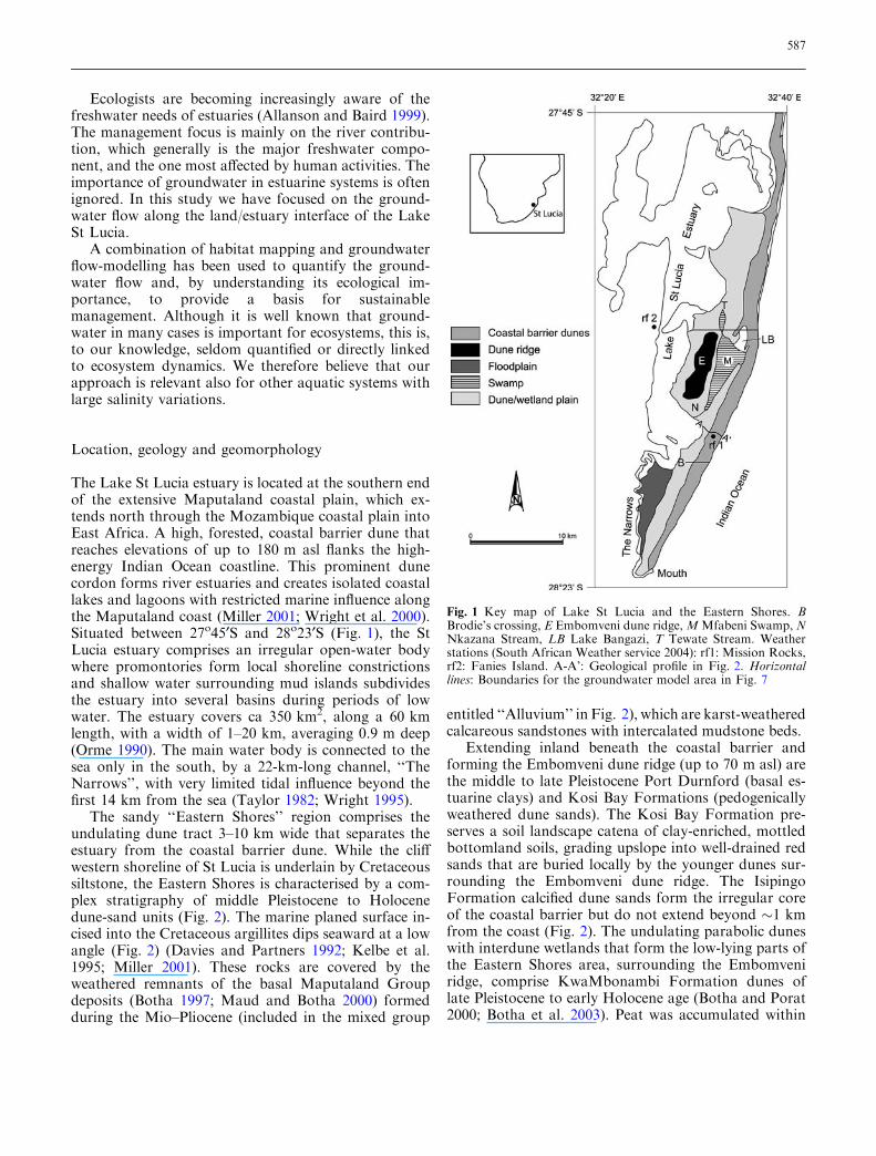
The Lake St Lucia estuary is located at the southern endof the extensive Maputaland coastal plain, which ex-tends north through the Mozambique coastal plain intoEast Africa. A high, forested, coastal barrier dune thatreaches elevations of up to 180 m asl flanks the high-energy Indian Ocean coastline. This prominent dunecordon forms river estuaries and creates isolated coastallakes and lagoons with restricted marine influence alongthe Maputaland coast (Miller 2001; Wright et al. 2000).Situated between 27o45¢S and 28o23¢S (Fig. 1), the StLucia estuary comprises an irregular open-water bodywhere promontories form local shoreline constrictionsand shallow water surrounding mud islands subdividesthe estuary into several basins during periods of lowwater. The estuary covers ca 350 km2, along a 60 kmlength, with a width of 1–20 km, averaging 0.9 m deep(Orme 1990). The main water body is connected to thesea only in the south, by a 22-km-long channel, ‘‘TheNarrows’’, with very limited tidal influence beyond thefirst 14 km from the sea (Taylor 1982; Wright 1995).
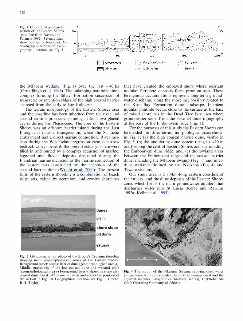
The sandy ‘‘Eastern Shores’’ region comprises theundulating dune tract 3–10 km wide that separates theestuary from the coastal barrier dune. While the cliffwestern shoreline of St Lucia is underlain by Cretaceoussiltstone, the Eastern Shores is characterised by a com-plex stratigraphy of middle Pleistocene to Holocenedune-sand units (Fig. 2). The marine planed surface in-cised into the Cretaceous argillites dips seaward at a lowangle (Fig. 2) (Davies and Partners 1992; Kelbe et al.1995; Miller 2001). These rocks are covered by theweathered remnants of the basal Maputaland Groupdeposits (Botha 1997; Maud and Botha 2000) formedduring the Mio–Pliocene (included in the mixed group
entitled ‘‘Alluvium’’ in Fig. 2), which are karst-weatheredcalcareous sandstones with intercalated mudstone beds.
Extending inland beneath the coastal barrier andforming the Embomveni dune ridge (up to 70 m asl) arethe middle to late Pleistocene Port Durnford (basal es-tuarine clays) and Kosi Bay Formations (pedogenicallyweathered dune sands). The Kosi Bay Formation pre-serves a soil landscape catena of clay-enriched, mottledbottomland soils, grading upslope into well-drained redsands that are buried locally by the younger dunes sur-rounding the Embomveni dune ridge. The IsipingoFormation calcified dune sands form the irregular coreof the coastal barrier but do not extend beyond �1 kmfrom the coast (Fig. 2). The undulating parabolic duneswith interdune wetlands that form the low-lying parts ofthe Eastern Shores area, surrounding the Embomveniridge, comprise KwaMbonambi Formation dunes oflate Pleistocene to early Holocene age (Botha and Porat2000; Botha et al. 2003). Peat was accumulated within
Fig. 1 Key map of Lake St Lucia and the Eastern Shores. BBrodie’s crossing, E Embomveni dune ridge,MMfabeni Swamp, NNkazana Stream, LB Lake Bangazi, T Tewate Stream. Weatherstations (South African Weather service 2004): rf1: Mission Rocks,rf2: Fanies Island. A-A’: Geological profile in Fig. 2. Horizontallines: Boundaries for the groundwater model area in Fig. 7
587
the Mfabeni wetland (Fig. 1) over the last �40 ka(Grundlingh et al. 1998). The onlapping parabolic dunecomplex forming the Sibayi Formation succession oftransverse or retention ridges of the high coastal barrieraccreted from the early to late Holocene.
The terrain morphology of the Eastern Shores areaand the coastline has been inherited from the river andcoastal erosion processes spanning at least two glacialcycles during the Pleistocene. The core of the EasternShores was an offshore barrier island during the LastInterglacial marine transgression, when the St Luciaembayment had a direct marine connection. River inci-sion during the Weichselain regression created narrowbedrock valleys beneath the present estuary. These werefilled in and buried by a complex sequence of marine,lagoonal and fluvial deposits deposited during theFlandrian marine incursion as the marine connection ofthe system was constricted by the accretion of thecoastal barrier dune (Wright et al. 2000). The presentform of the eastern shoreline is a combination of beachridge sets, raised by accretion, and erosive shorelines
that have created the embayed shore where resistantnodular ferricrete deposits form promontories. Theseferruginous accumulations represent long-term ground-water discharge along the shoreline, possibly related tothe Kosi Bay Formation dune landscape. Incipientnodular plinthite occurs close to the surface at the baseof raised shorelines in the Dead Tree Bay area wheregroundwater seeps from the elevated dune topographyat the base of the Embomveni ridge (Fig. 1).
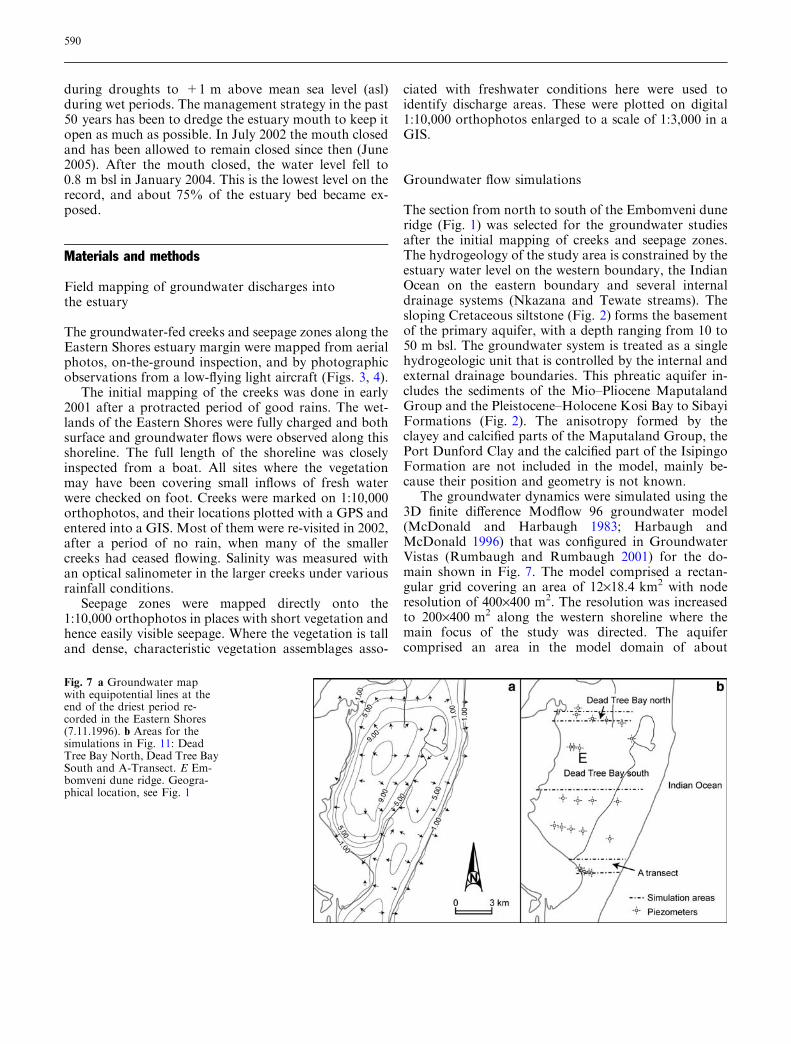
For the purposes of this study the Eastern Shores canbe divided into three terrain morphological areas shownin Fig. 1; (a) the high coastal barrier dune, visible inFig. 3; (b) the undulating dune system rising to �20 masl, forming the central Eastern Shores and surroundingthe Embomveni dune ridge; and, (c) the lowland areasbetween the Embomveni ridge and the coastal barrierdune, including the Mfabeni Swamp (Fig. 1) and inter-dune wetlands drained by the Nkazana (Fig. 4) andTewate streams.
Our study area is a 70-km-long eastern coastline ofthe estuary, and the dune deposits of the Eastern Shoreszone, which forms the main groundwater aquifer, thatdischarges water into St Lucia (Kelbe and Rawlins1992a; Kelbe et al. 1995).
Fig. 3 Oblique aerial air photo of the Brodie’s Crossing shorelineshowing main geomorphological zones of the Eastern Shores.Background (east): coastal barrier dune (geomorphological area a).Middle: grasslands of the low coastal dune and wetland plain(geomorphological area c) Foreground (west): shoreline slope withcoastal dune forest. White line is 180 m and shows the position ofthe section in Fig. 10. Geographical location, see Fig. 1. (Photo:R.H. Taylor)
Fig. 4 The mouth of the Nkazana Stream, showing open water(stained dark with humic acids), the riparian swamp forest and theadjacent marshes. Geographical location, see Fig. 1. (Photo: AirCraft Operating Company of Africa)
Fig. 2 Conceptual geologicalsection of the Eastern Shores(modified from Davies andPartners 1992). Vertical linesshow position of boreholes. FmStratigraphic formation. Geo-graphical location, see Fig. 1
588

Climate, hydrology and salinity
The regional and temporal variations in rainfall (Fig. 5)are the driving factors behind the hydrology and salinityvariations of the St Lucia estuarine system. The rainfallgradient westwards from the coast is strong, with aprecipitation at Mission Rocks on the Indian Oceancoastal barrier dune (Fig. 1) exceeding 1,200 mm/yearand decreasing to around 900 mm/year at Fanies Islandon the western shoreline of the estuary.
All the river catchments in the western interior draintowards the estuary. In the period 1981–1994, on aver-age, 50% of the estuary’s freshwater input was fromdirect precipitation, and around 45% was inflow fromthe river catchments in the east and north (Quibell1996). During 1981–1994 the average groundwatercontribution to the estuary was estimated to be less than10% of the estuary’s total freshwater budget (Quibell1996), with two-thirds of it flowing in from the EasternShores (Kelbe et al. 1995). Groundwater is thus of nogreat importance for the water budget of the estuaryduring normal and wet conditions. In extreme droughtconditions, however, the rivers become dry and providealmost no recharge to the estuary (Quibell 1996), andgroundwater from the Eastern Shores then constitutesthe only freshwater inflow.
The large surface area of the estuary (350 km2)compared to its shallowness (on average 0.9 m) makes itvery sensitive to the effects of evaporation (Hutchisonand Midgley 1978). Salinity measurements at 25 sites inSt Lucia since the late 1950s show major spatial as wellas temporal variations (Fig. 6). During wet periods, thenorthern part of the estuary is almost fresh due to riverinflow, while the salinity approaches that of seawater inthe southern part close to the estuary mouth. During dryperiods when evaporation losses exceed freshwatergains, the salinity of the estuary rises. As long as theestuary mouth is open, the water lost is replaced byseawater flowing in from the Indian Ocean. This canexceed 1 million m3 per day. The salinity near the es-tuary mouth therefore remains close to that of seawater.The northern part of the estuary, on the contrary, has noriver inflow during droughts and salinity here can be-come considerably higher. During the past 50 years StLucia has experienced drought-caused hypersaline con-ditions in the inner part of the estuary at intervals ofabout a decade (Fig. 6). The most recent drought startedin 2002 after the particular wet summer of 2000/2001and had not yet terminated at the time that this paperwas written (June 2005).
With open mouth the estuary level is relatively stableranging from about )0.3 m below mean sea level (bsl)
Fig. 5 Rainfall record for thecoastal meteorological stationMission Rocks (Fig. 1, rf 1) andthe more inland station FaniesIsland (Fig. 1, rf 2) for theperiod 1952–2004 (South Afri-can Weather Service 2004), anddry stress period used in thegroundwater simulations
Fig. 6 Graph of the salinity inthe St Lucia estuary for theperiod 1952–2004
589
during droughts to +1 m above mean sea level (asl)during wet periods. The management strategy in the past50 years has been to dredge the estuary mouth to keep itopen as much as possible. In July 2002 the mouth closedand has been allowed to remain closed since then (June2005). After the mouth closed, the water level fell to0.8 m bsl in January 2004. This is the lowest level on therecord, and about 75% of the estuary bed became ex-posed.
Materials and methods
Field mapping of groundwater discharges intothe estuary
The groundwater-fed creeks and seepage zones along theEastern Shores estuary margin were mapped from aerialphotos, on-the-ground inspection, and by photographicobservations from a low-flying light aircraft (Figs. 3, 4).
The initial mapping of the creeks was done in early2001 after a protracted period of good rains. The wet-lands of the Eastern Shores were fully charged and bothsurface and groundwater flows were observed along thisshoreline. The full length of the shoreline was closelyinspected from a boat. All sites where the vegetationmay have been covering small inflows of fresh waterwere checked on foot. Creeks were marked on 1:10,000orthophotos, and their locations plotted with a GPS andentered into a GIS. Most of them were re-visited in 2002,after a period of no rain, when many of the smallercreeks had ceased flowing. Salinity was measured withan optical salinometer in the larger creeks under variousrainfall conditions.
Seepage zones were mapped directly onto the1:10,000 orthophotos in places with short vegetation andhence easily visible seepage. Where the vegetation is talland dense, characteristic vegetation assemblages asso-
ciated with freshwater conditions here were used toidentify discharge areas. These were plotted on digital1:10,000 orthophotos enlarged to a scale of 1:3,000 in aGIS.
Groundwater flow simulations
The section from north to south of the Embomveni duneridge (Fig. 1) was selected for the groundwater studiesafter the initial mapping of creeks and seepage zones.The hydrogeology of the study area is constrained by theestuary water level on the western boundary, the IndianOcean on the eastern boundary and several internaldrainage systems (Nkazana and Tewate streams). Thesloping Cretaceous siltstone (Fig. 2) forms the basementof the primary aquifer, with a depth ranging from 10 to50 m bsl. The groundwater system is treated as a singlehydrogeologic unit that is controlled by the internal andexternal drainage boundaries. This phreatic aquifer in-cludes the sediments of the Mio–Pliocene MaputalandGroup and the Pleistocene–Holocene Kosi Bay to SibayiFormations (Fig. 2). The anisotropy formed by theclayey and calcified parts of the Maputaland Group, thePort Dunford Clay and the calcified part of the IsipingoFormation are not included in the model, mainly be-cause their position and geometry is not known.
The groundwater dynamics were simulated using the3D finite difference Modflow 96 groundwater model(McDonald and Harbaugh 1983; Harbaugh andMcDonald 1996) that was configured in GroundwaterVistas (Rumbaugh and Rumbaugh 2001) for the do-main shown in Fig. 7. The model comprised a rectan-gular grid covering an area of 12·18.4 km2 with noderesolution of 400·400 m2. The resolution was increasedto 200·400 m2 along the western shoreline where themain focus of the study was directed. The aquifercomprised an area in the model domain of about
Fig. 7 a Groundwater mapwith equipotential lines at theend of the driest period re-corded in the Eastern Shores(7.11.1996). b Areas for thesimulations in Fig. 11: DeadTree Bay North, Dead Tree BaySouth and A-Transect. E Em-bomveni dune ridge. Geogra-phical location, see Fig. 1
590

130 km2 (Fig. 7a) and the thickness of the sand de-posits forming the acquifer varied from approximately30 m along the shorelines to 200 m under the dunecordon.
Marine tides in the Indian Ocean and in the StLucia estuary have been ignored because of the timeresolution of the model (>day). Both the Indian Oceanand the Lake St Lucia are configured as constant headboundaries at mean sea level (0 m asl). Under normalhydrological conditions there is a slight gradient in theestuary depending on the inflow pattern. However, todetermine the groundwater seepage contribution to theestuary, it is assumed that the estuary can also be re-presented by a constant head boundary at mean sealevel. A simple calculation based on the Ghyben–Herzberg principle shows that the depth to saltgroundwater is below the base of the aquifer, anddensity differences have therefore been ignored. Thegroundwater at the northern and southern boundarieswere shown by Kelbe et al. (1995) to flow approxi-mately perpendicular to the shorelines and conse-quently it was assumed that these boundaries could beadequately represented as no-flow boundaries (Ander-son and Woessner 1991).
The internal stream boundaries (Nkazana and Te-wate; Fig. 1) have been configured as drains (Andersonand Woessner 1991) with no restrictive bed layers (highbed conductance). These boundaries drain directly intoLake St Lucia from Lake Bangazi in the central part ofthe Embomveni Plain. Limited measurements indicatethat the Nkazana stream is perennial but has persistentlylow flows.
Transient flow simulations were conducted usingstress periods that reflected relatively uniform rechargeand discharge conditions. The only reliable data for es-tablishing the stress periods were rainfall (recharge)shown in Fig. 5.
The groundwater simulations were based on the in-itial modelling by Kelbe and Rawlins (1992a, b), Kelbeet al. (1995), Kelbe and Germishuyse (2000). Kelbe andRawlins (1992a) examined the observed change in watertable elevation, following isolated rainfall events in thestudy area. They indicated that the water table, at adepth of 2–3 m below ground surface, would only re-spond to a rainfall event that exceeds approximately10 mm. Kelbe et al. (1995) used this approach to createannual series of groundwater recharge based on dailyrainfall. Kelbe et al. (1995, 2001) used filtering techni-ques to smooth the annual rainfall series to identifystress periods of uniform rainfall. Where there was asignificant recharge event within a stress period, it wasextracted as an unique event (eg. a cyclone) and theoriginal stress event revised as separate periods. Time-varying characteristic parameters were assigned for eachperiod to enable simulations of heads and fluxes chan-ging with time.
The groundwater model was calibrated againstwater levels measured in a network of monitoringboreholes established in 1973 in the study area(Fig. 7b). The initial hydraulic conductivity was esti-mated from piezometer tests (Været 2002; Wejden2003), grain-size analysis (Været 2002) and relevantliterature (Wejden 2003). The hydraulic conductivityand porosity were subsequently adjusted in the model
Fig. 8 a A typical creek,formed by confluence ofgroundwater flow from thedune. b Typical seepage shore-line, with catchment area,groundwater discharge, pond-ing of water at the base of theseepage slope, and vegetatedplatform
591

to achieve best fit under steady-state and transientconditions. Three zones with hydraulic conductivity(storativity) of 10 m/day (0.42), 3.6 m/day (0.32)and 0.5 m/day (0.22) were delineated in the modeldomain to achieve adequate correspondence with theborehole series. The areas with low conductivity(0.5 m/day) and low storativity (0.22) were assumed tohave lenses of either organic material or silty/clayeysediments.
Groundwater chemistry
Groundwater samples were taken from a series ofobservation wells (Fig. 7b) in January, June andNovember 2002 and February 2003. Electrical con-ductivity was measured in the field during these sam-pling events with a WTW LF 330/SET conductivitymeter, which was calibrated before the field period.Automatic temperature compensation was used. Thesemeasurements were repeated in November 2005, whenthe groundwater also seeping out along the shorelinewas included. Chemical analysis was carried out atthe Norwegian University of Life Sciences (cations:Perkin-Elmer 2380 Atomic Absorption Spectrophoto-meter; anions: ion chromatography according toNS-EN ISO 10304-1), Jordforsk (cations: ICP-AES;anions: ion chromatography according to NS-EN ISO10304-1) and the University of KwaZulu-Natal(cations: Perkin Elmer AAnalyst 100, Atomic Absorp-tion Spectrophotometer).
Results
Groundwater-dependent habitats: the link between theterrestrial and estuarine environments
Creeks
Around 80 groundwater-fed creeks were identified in2001, originating some distance from the estuary marginwhere there is a confluence of groundwater (Fig. 8a). In2002, when the drought started, many were already dryand only 13 creeks remained that were regarded to belarge enough have an ecological influence during mod-erate to dry conditions (see Fig. 9a, Table 1). All thesehave been flowing during the whole present droughtperiod.
As the creek banks are generally steep-sided, there isno particular plant community associated with them.The adjacent vegetation may be mangroves (Shark basinand Oxbow, Fig. 9a), salt-resilient sedges and rushes(Croc Creek), Phragmites australis reeds (Nkazana andTewate Streams) or salt-tolerant lawns (NtombisaStream). In the upper reaches there are usually typicalfreshwater plants—such as water lilies (Nymphaea nou-chali), swamp forest trees (Barringtonia racemosa) andpapyrus (Cyperus papyrus).
Fish species such as mullet (Mugil cephalus) moveinto the creeks in large numbers and at times there arealso concentrations of prawns and shrimps. The persis-tent streams are important for hippo and crocs for
Fig. 9 Groundwater dischargealong the Eastern Shores,mapped in the field. a Persistentcreeks. b Seepage zones
592

drinking, and are used by birds such as pelicans forwashing and preening.
The shoreline seepage
Diffuse shoreline seepages (Fig. 8b) were identified alonglarge parts of the Eastern Shores (Fig. 9b) and wereparticularly prevalent where the dunes (units a and b)are close to the estuary shore. Groundwater confluenceoccurs where there is a clayey shoreline, or where nod-ular ferricrete deposits are abundant. The seepage zonescharacteristically support assemblages of estuary-asso-ciated vegetation that require dilution of the estuarinesaline water with fresh water to survive.
Detailed studies were conducted at Brodie’s Crossing(Figs. 1, 3, 10). Here the seepage zone is elevated byabout 1.5 m asl and terminates in a 60 m wide platformwith an impervious clay basement (Fig. 10). The out-flowing groundwater is perched on this clay and, as itmingles with the saline estuary water, a habitat with
variable salinity is set up. The water here becomes moresaline towards the estuary—where waves carrying salinewater overtop. This results in typical bands of vegetationfrom the land towards the estuary (Fig. 10). Above theseepage zone is a forest typical of dry sites—indicated bytrees characteristics of the early phases of forest suc-cession such as Albizia adianthifolia and Brachylaenadiscolor. Below this the fern Stenochlaena tenufolia oc-curs where the slopes become moist. In the water-satu-rated seepage areas swamp forest (trees such asMacaranga capensis and Voacanga thouarsii) dominates,and large sedges (Cyperus papyrus and C. immensus) arefound where the ground is flat with standing water. Inthe direction of the estuary then follows a zone withvarious estuary margin sedges—and the plant Bacopamonnieri, the latter indicating very low-salinity condi-tions. Outside this there is a zone dominated by the reedPhragmites australis. The estuary margin itself consistsof plants such as the salt-marsh rush Juncus kraussii andthe mangrove fern Acrostichum aureum. The vegetation
Table 1 Characteristics of the ecologically important creeks—from south to north
Name Sustainedflow
Mouth alwayslinked to estuary
Upwelling throughsandy beachat mouth
Comments Ecological importance
Shark Basin Yes Yes Yes Outflow strong—became fresh
High—has large populations ofbrack-water shrimp at peak of drought
Bridge Yes No Yes Fresh Low—important for hippodrinking and for emergent vegetation
Oxbow Yes Yes No Outflow strong—became fresh
High—in a mangrove habitat
Esengeni-north Weak No No Saline Low—could dry in very dry periodsCroc Creek Weak Yes No Saline Moderate—provides a large range of
habitats—and is especially importantin providing shelter
Brodies Yes No Yes Fresh High—especially for submergedmacrophytes and fish requiring alow-salinity habitat
Nkazana Very strong Yes Yes Outflow strong—became fresh
Very high—this is the largestconcentrated inflow of freshwater.It has a delta where it reachesthe estuary—where there is avariety of salinity habitats
Mamba Stream Weak No No Saline Low as much of this site driesas water levels fall.
Tewate–south Yes Yes No Outflow strong—became fresh
High—a strong sustained flowof freshwater
Tewate-north Very strong Yes Yes Outflow strong—became fresh
Very high—the inflowing freshwatersustains a large low-salinity poolin which hippo and crocs are able tosurvive severe drought conditions.Also important for birds
Ogodweni Weak No No Saline Low—very low volumes of waterNtombiza weak No No Saline Low—very low volumes of sustained
water inflow, and subjected to flushingby high flows of surface runoffduring a rainfall event
Selleys Yes Yes Yes Saline Very high—especially for hippo andcroc drinking as it creates a low-salinitypool in the dry lake-bed during droughts
593

zones do not change rapidly in response to short-termfluctuations (less than a decade), unless the plants arekilled by being inundated by highly hypersaline water.
The conditions along the seepage zones also create adiscrete and unique habitat used by some animal speciesthat are rare elsewhere. Examples are the fishes Hypse-leotris dayi and Redigobius dewaali collected in such ahabitat near Brodie’s Crossing by Vrdoljak (2004).
The regional groundwater flow pattern
The groundwater simulation at the end of a very dryperiod prior to November 1996 is shown in Fig. 7, witha regional groundwater flow closely related to thegeomorphologic units shown in Figs 1 and 3: (a) thehigh coastal barrier dune; the groundwater levels arerather stable over time, with variations between dryand wet periods of maximum a couple of metres. Thegroundwater has an easterly flow component towardsthe Indian Ocean and a westerly one that is interceptedby the Nkazana stream near the low-lying plain.However, towards the south, for instance at Brodie’sCrossing (Figs. 1, 3, 10), it flows directly into the es-tuary. (b) The dunes of the Central Eastern Shores:The Embomveni dune ridge and surrounding undulat-ing dune plain creates a distinct groundwater mound,with the groundwater flowing in a radial pattern intothe low-lying Mfabeni Swamp in the east and south-east, and into the estuary in the north and west. Thedifference in the groundwater levels during extreme dryand wet conditions is about 5 m, showing that theconditions in this part of the aquifer to a great extentcontrol the variation in discharge into the estuary. (c)The low-lying plain. The large Mfabeni Swamp andmany of the smaller wetlands are fed by the confluence
of groundwater from units a and b. This controlsthe flow of water on the whole plain, and feeds theNkazana and Tewate Streams, which drain the watertowards the estuary shoreline. The groundwater level israther constant over time, and is mainly confined bythe topography.
The groundwater discharge into the St Lucia estuary
The groundwater outflow per kilometre width along theEastern Shores estuary—shoreline interface was simu-lated for three sections of the model area (Fig. 7b): DeadTree Bay north (DTBN) (0.8 km), Dead Tree Bay south(DTBS) (5.2 km) and A-transect (1.2 km). The A-transect at the south end of Dead Tree Bay (Fig. 1) has ahydrogeology similar to that of Brodie’s Crossing and isalso believed to be the representative of the situation atthat site. Measured heads versus simulated headsshowed the best fit for the A-transect, where water flowsdirectly from the coastal dunes to the estuary. The areaaround the Embomveni Plain further north is morecomplex and required the delineation of several zoneswith different hydraulic conductivity. Although DTBNand DTBS were more difficult to simulate and showed aslightly greater deviation from the measured heads, thesimulations were adequate for estimating the seepagerates for these zones shown in Fig. 11.
The discharge flux was first simulated for the period1996 to January 2003 (Fig. 11). This simulation periodwas based on actual precipitation records andobserved groundwater levels. The simulations indicatea high discharge during the period from October 1996to February 1999, a period of 2 years and 3 months.During this period, the maximum discharge wasin March 1997, with a simulated flow of somewhat
Fig. 10 The seepage zone ofBrodie’s Crossing, showing thevegetation zones relative to thegroundwater level. Geographi-cal location, see Fig. 1 andphoto Fig. 3
594
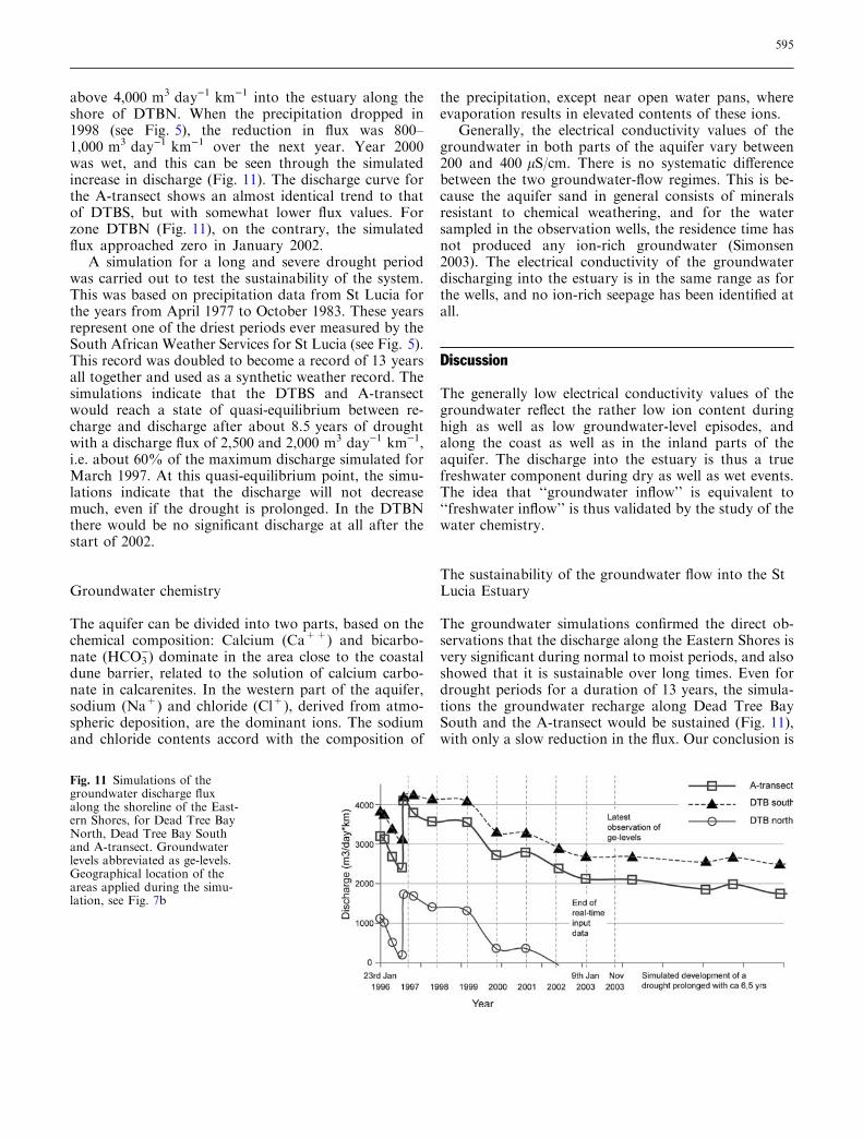
above 4,000 m3 day)1 km)1 into the estuary along theshore of DTBN. When the precipitation dropped in1998 (see Fig. 5), the reduction in flux was 800–1,000 m3 day)1 km)1 over the next year. Year 2000was wet, and this can be seen through the simulatedincrease in discharge (Fig. 11). The discharge curve forthe A-transect shows an almost identical trend to thatof DTBS, but with somewhat lower flux values. Forzone DTBN (Fig. 11), on the contrary, the simulatedflux approached zero in January 2002.
A simulation for a long and severe drought periodwas carried out to test the sustainability of the system.This was based on precipitation data from St Lucia forthe years from April 1977 to October 1983. These yearsrepresent one of the driest periods ever measured by theSouth African Weather Services for St Lucia (see Fig. 5).This record was doubled to become a record of 13 yearsall together and used as a synthetic weather record. Thesimulations indicate that the DTBS and A-transectwould reach a state of quasi-equilibrium between re-charge and discharge after about 8.5 years of droughtwith a discharge flux of 2,500 and 2,000 m3 day)1 km)1,i.e. about 60% of the maximum discharge simulated forMarch 1997. At this quasi-equilibrium point, the simu-lations indicate that the discharge will not decreasemuch, even if the drought is prolonged. In the DTBNthere would be no significant discharge at all after thestart of 2002.
Groundwater chemistry
The aquifer can be divided into two parts, based on thechemical composition: Calcium (Ca++) and bicarbo-nate (HCO3
)) dominate in the area close to the coastaldune barrier, related to the solution of calcium carbo-nate in calcarenites. In the western part of the aquifer,sodium (Na+) and chloride (Cl+), derived from atmo-spheric deposition, are the dominant ions. The sodiumand chloride contents accord with the composition of
the precipitation, except near open water pans, whereevaporation results in elevated contents of these ions.
Generally, the electrical conductivity values of thegroundwater in both parts of the aquifer vary between200 and 400 lS/cm. There is no systematic differencebetween the two groundwater-flow regimes. This is be-cause the aquifer sand in general consists of mineralsresistant to chemical weathering, and for the watersampled in the observation wells, the residence time hasnot produced any ion-rich groundwater (Simonsen2003). The electrical conductivity of the groundwaterdischarging into the estuary is in the same range as forthe wells, and no ion-rich seepage has been identified atall.
Discussion
The generally low electrical conductivity values of thegroundwater reflect the rather low ion content duringhigh as well as low groundwater-level episodes, andalong the coast as well as in the inland parts of theaquifer. The discharge into the estuary is thus a truefreshwater component during dry as well as wet events.The idea that ‘‘groundwater inflow’’ is equivalent to‘‘freshwater inflow’’ is thus validated by the study of thewater chemistry.
The sustainability of the groundwater flow into the StLucia Estuary
The groundwater simulations confirmed the direct ob-servations that the discharge along the Eastern Shores isvery significant during normal to moist periods, and alsoshowed that it is sustainable over long times. Even fordrought periods for a duration of 13 years, the simula-tions the groundwater recharge along Dead Tree BaySouth and the A-transect would be sustained (Fig. 11),with only a slow reduction in the flux. Our conclusion is
Fig. 11 Simulations of thegroundwater discharge fluxalong the shoreline of the East-ern Shores, for Dead Tree BayNorth, Dead Tree Bay Southand A-transect. Groundwaterlevels abbreviated as ge-levels.Geographical location of theareas applied during the simu-lation, see Fig. 7b
595
that groundwater will feed the 13 creeks and the seepagezones (Fig. 9) during droughts of much longer durationthan hitherto recorded in St Lucia. This is because mostcoastal rainfall (Fig. 5) during this whole period is highenough to generate a limited and consistent groundwaterrecharge.
Along the Dead Tree Bay North both the mapping(Fig. 9) and the groundwater flow simulation (Fig. 11)show that there is no sustained groundwater dischargeduring dry periods. The groundwater here discharges onto the flat clay plain of the peninsula in the northwest,where pans are formed behind the estuary shoreline andmajor evaporation takes place.
Along the A-transect (Fig. 11) the simulation shows apersistent flow directly from the main dune cordon intothe estuary. This is further verified by the mapping of theimportant seepage ecosystems from the A-profilesouthwards to Brodie’s Crossing (Fig. 10). Although notincluded in the groundwater modelling, the uniformgeology to the north and south or our model area in-dicates that refuge sites will also occur in many otherareas of the Eastern Shores, where groundwater drainsfrom the sandy aquifer into the estuary.
The drop in the estuary level, after the estuary mouthbecame closed in July 2002, has resulted in a shorelinedisplacement along the whole coastline between DeadTree Bay and Brodie’s Crossing of several hundredmetres. From that time until the present (January 2005) avisible groundwater discharge has been directly observedalong most of this section of the shoreline, which in 2001was mapped as groundwater-fed seepage habitats(Fig. 9b). Freshwater-dependent plants have becomeestablished along the Brodie’s Crossing, the A-transectarea as well as along the coast of Dead Tree Bay South.The flow out from the 13 largest creeks (Fig. 9a) has beenpersistent. This has visually confirmed that the simulatedsustainability of the groundwater discharge is reliable.
Ecological importance of groundwater flow intothe St Lucia estuary
Refuge sites
Salt concentrations higher than that of the sea have beenexperienced in Lake St Lucia in the last four droughts(Fig. 6). The frequency and magnitude of salinity ex-tremes in Lake St Lucia have increased during the last30 years as a result of less fresh water from the rivercatchment areas due to planting of forest plantationsand building of dams for irrigation (Quibell 1996). Thishas two main effects:
1. Organisms of various species, which cannot toleratehigh salinity, are killed off more frequently in themain estuary.
2. When recolonisation occurs, the full progression ofthe colonisation by a species is often truncated byunfavourable salinity before the maximum popula-tion is reached. The rate of recolonisation is affectedby the quality, number and the locations of sites fromwhich recolonisation can occur. The greater thenumber of sites and the more widespread they are; thefaster the initial stages of the recolonisation process.
Under such conditions of salinity stress, strong andlocalised freshwater inflow is needed to enable manyspecies to survive. The groundwater creates micro-habitats, in which small populations of species can takerefuge (refuge sites). For a site to act as a refuge againsthigh-salinity conditions, it must have physical condi-tions that are suitable to support the species concernedfor the duration of the adverse conditions. The mainconditions are that salinity should remain lower than inthe adjacent part of the estuary during the whole criticalperiod. Furthermore, to enable a fast recolonisation, therefuge sites should be widespread. The local ground-water seeps and creeks along the Eastern Shores provideboth these conditions. The main species that are likely tobenefit from refugia are those that are relativelyimmobile and do not produce seeds or spores to surviveadverse conditions. We believe that the following may beamong the ecologically most important groundwater-refuge dependent biota:
– The submerged plants Potamogeton pectinatus andRuppia cirrhosa are important primary producers thatalso create a structural habitat for many organisms.They both have shown rapid dispersal from thefresher groundwater-fed margins of the estuary intothe open water after salinity dropped temporarily as aresult of a rainfall in January 2004.
– The drought since 2002 has also shown howimportant the groundwater-fed shorelines are foremergent vegetation once the water level has droppedto expose wide beaches. It is a common feature to seethe expansion of P. australis reeds, Schoenoplectusscirpoideus, and many sedges and salt-resistantgrasses such as Paspalum vaginatum in these exposedshorelines.
– The small estuarine fish, Ambassis natalensis, is one ofthe few estuarine-breeding fish. It can occur in largenumbers and its populations can build up veryrapidly. Much of its feeding is on zooplankton anddiatoms. It is an important food source for manypredatory fish and birds. They can survive in thesmall creeks and streams that flow persistently duringthe extreme dry conditions.
– The bivalve Solen cylindraceus is a very immobilespecies, but has a planktonic larva. It is speculatedthat this, and other estuarine bivalves, rely on popu-lations surviving within the system for recolonisation.
596

Groundwater-fed sites could create suitable habitatwhere they could survive during periods of hypersalineconditions.
– The snail Assiminea globifera is a tiny gastropod(1–3 mm long) that has been recorded in numbers ofup to several thousand per square metre shortly aftera period of extreme hypersalinity (Boltt 1975). Thishas been seen to be abundant in areas adjacent toseepage shorelines.
– In addition, there are likely to be many diatoms,copepods and numerous benthic animals that couldand would survive in the refuge sites.
DeAngelis and White (1994) define the resilience ofan ecosystem to be its ability to recover after a pertur-bation. The groundwater-dependent refuge sites andhabitats would then be very important in maintainingthe resilience of the St Lucia estuary ecosystem throughenabling a more rapid and complete recovery.
The drought since 2002 has shown that the seepagezones cover a much larger area of the shoreline than theareas where the groundwater discharges in the streams(Fig. 9). However, when the estuary mouth is openduring a drought, which has been the situation in pre-vious droughts, a part of the seepage shorelines areflooded by hypersaline water (e.g. during the 1970 and1990 droughts, Fig. 6), which kills off the salt-sensitiveorganisms. The creeks then form the most sustainablefreshwater-fed sites because their more concentratedwater flow will protect them from being flushed by high-salinity water. In this way creeks and seepage zones playdifferent roles as freshwater-fed refugia.
Life-support services
During severe droughts the inflowing groundwater notonly provides habitat in which some animals seek refuge,but it also provides the daily water requirement thatsustains certain animals. This is in the form of drinkingwater for hippos, crocs and birds and large terrestrialherbivores. It also creates wallows, which are preferredby hippos and crocs to the hypersaline estuary water.
The concentration of fish in such wallows, freshenedby groundwater, can also act as a rich food source forcrocodiles. The fresh water areas are also used by wa-terfowl, which feed in the saline water, but need to washthe salt off their plumage.
Habitat diversity
Vrdoljak (2004) has recently found the fishesH. dayi—which had not been recorded in the St Luciasystem since 1948 (Bruton 1996)—and the fish R. de-waali is a new record for the St Lucia system. Both werecollected from the shoreline groundwater seepage sites.These sites with their assemblages of sedges and other
plants can be regarded as a discrete habitat type withinthe Protected Area, and it is likely that closer in-vestigation of this habitat will yield several other speciesthat are new records for the Protected Area.
Management implication
St Lucia has been a Protected Area for over 100 years.The region’s obligations as a World Heritage Site stressthe need to maintain the natural functioning of the area.Man-induced changes that can change the ecologicalfunction must be prevented whenever possible, andwhere this is not possible, measures to mitigate humanimpacts should be implemented. Whenever possible, it isnecessary to restore natural processes that have beenaltered.
In this study, the mapping of the groundwater-dependent ecology and the simulation of groundwaterdischarge have been firmly linked. These results providemanagers with a tool to understand what will happenwith the coastline and the resilience of the estuary itselfover longer droughts. Due to the anthropogenic changesto the freshwater inflow from the inland catchments intothe estuary, it has become increasingly important thatthe managers maintain the conditions/localities in whichvarious organisms can survive and rapidly recolonise theestuary when the salinity again drops. It is therefore animportant management task to protect the integrity ofthe primary aquifers of the Eastern Shores to supportthe resilience of the estuary.
The most obvious management action is to maintainthe ecological and hydrological conditions of theEastern Shoreline in order to maximise the ability ofthe creeks and seepage sites to act as refuge sites. Thisrequires that the most important of these sites shouldbe protected from development. The sites selected forspecial protection should be as widely dispersed aspossible to maximise the effectiveness of recolonisation.It is of particular importance to draw the attention tothe seepage shorelines (Fig. 9b), as the existence ofthese is not obvious to managers without special skillsin hydrogeology and ecology. The most important sitesfor such protection are the Dead Tree Bay area, thecatchment recharge area for the Nkazana Stream andthe shoreline between the A-transect and Brodie’sCrossing. In addition, the confluence area around theoutlet of the Tewate Stream, and the Selleys Creekalong the northern shoreline should be protected(Fig. 9); both are areas where hippos congregate duringdry periods.
Another management task is to maintain or increasethe groundwater recharge. Many studies worldwide haveshown that deep-rooted trees, such as pine, cause alowering of the groundwater level through transpiration(Le Maitre et al. 1999b; Rawlins and Kelbe 1991a;
597

Rawlins and Kelbe 1991b). According to Rawlins andKelbe (1991a, b) the removal of pine trees on the EasternShores would be a tool to increase the groundwater re-charge. Over the past decade 5,000 ha of pine trees,planted since the late 1950s, has been removed. Thepolicy is to replace alien plantation forest with in-digenous woody plants and grasslands.
Management plans also need to reconsider whetherthe area should be kept as indigenous forest or grass-land. Short-rooted grass is believed to cause lower eva-potranspiration than deeper-rooted woody plants. Thewoody areas of the Eastern Shores have increased con-siderably since the earliest aerial photos were taken in1937. Recently the managers of the area have taken thiswooding-up into consideration. The managementguideline for the Eatern Shores is to frequently and se-verely burn those areas below an elevation of 30 m. Thiswill reduce the woody-plant component and promotegrassland.
Various factors have not been taken into considera-tion in our groundwater modelling. The estuary levelwas defined as a zero-head boundary, and the simula-tions do not reflect any possible effects of fluctuations inwater level. This is because our model is set up for anormal management condition, when the mouth is openand the lowering of the estuary level is less than 0.3 m.However, supported by our study, the managers may inthe future allow the mouth to remain closed duringlonger droughts. New simulations are needed to calcu-late the discharge for a drop in the water level to 0.9 mbsl, which has been experienced after the estuary mouthbecame blocked in 2002. At the moment, the knowledgeabout evaporation from different vegetation types isbased on literature data and not field measurements. Wecan therefore not tell what would be the effect on thegroundwater during permanent management-forcedchanges in vegetation. And although our groundwaterobservation period covers a large spectrum of rainfalls,we do not know what would be the effect of globalchange scenarios. In order to account for the factorsabove, and changes in other model parameters, it isimportant that groundwater monitoring becomes anintegrated part of the long-term management ofSt Lucia.
Our investigation is not a study of the remnantpopulations that survive lake hypersalinity periods inzones of out-flowing groundwater. Therefore, we can-not show conclusively which species are really able toseek refuge and survive in any particular site. It is notpossible to get an ultimate proof for the assumptionthat organisms, which may seek refuge in these habitatsduring adverse salinity conditions, are those, whichlater repopulate the estuary. This is because it has notbeen possible to create an experimental control systemthat can verify this. We have, however, accumulated a
body of evidence that indicates that the groundwater-fed creeks and seepages do play a very important rolein providing refuge to a number of species. In ourstudy we have approached the problem by mappingout-flowing freshwater, its related ecology and we havelinked it to groundwater modelling. Both methods areneeded for the managers: The detailed mapping showswhere and how the groundwater discharge can createecosystem habitats, and the groundwater simulationsgive a basis to understand the dynamics and persistanceof the groundwater system during different climatecycles.
Conclusion
Estuaries are some of the World’s most dynamic eco-systems, driven by the continual interplay between in-flowing seawater and freshwater (precipitation, riversand groundwater) and a loss of water (evaporation andoutflow to the sea). Groundwater is, in many cases, theecological driver during dry events not only in estuaries,but also in lakes and rivers. In order to understand theEastern Shores dune-sand aquifer, it is necessary toconsider the complex geological and geomorpholgicalhistory of the region.
The reason why managers, in many cases, neglect theimportance of groundwater is probably because it isdifficult to quantify the persistent groundwater flowcomponents without a comprehensive and costly mon-itoring network. On the Eastern Shores the number ofobservation wells was limited (Fig. 7b) as it is in-appropriate to install a dense net of observation wells inthis World Heritage Site. The grid used in the ground-water simulations is too coarse to give a detailed pictureof the spatial variation in groundwater discharge. Thefield inspections on the other hand, give a more accuratepicture of the flow distribution. We believe that thecombination of the two methods that we have used hasbeen an appropriate and efficient way to gain an un-derstanding about the groundwater-fed ecosystems. Inmany other aquatic systems, where groundwater mayplay a similar role, it would be equally important formanagers to understand its importance. We believe thatan integrated study of ecology and hydrogeology theremay also give the managers the tool they need to takecare of the sustainability.
Acknowledgements We want to thank the following institutionsand persons: Financial funding was provided by the NorwegianCouncil for Higher Education’s Programme for Development Re-search and Education and from the Norwegian University of LifeSciences C. Fox and A. Myeza from KwaZulu-Natal Wildlife wereresponsible for measurements of groundwater levels and salinitiesin the field. They also helped to keep crocodiles and hippopota-muses away from our students during the work along the estuaryshore.
598

References
Allanson BR, Baird D (1999) Estuaries ofSouth Africa. Cambridge UniversityPress, Cambridge
Anderson MP, Woessner WW (1991) Ap-plied groundwater modelling - Simula-tion of flow and advective transport.Academic, San Diego
Boltt RE (1975) The benthos of somesouthern African lakes Part V: the re-covery of the benthic fauna of St LuciaLake following a period of excessivelyhigh salinity. Trans R Soc S Afr41(3):295–323
Botha GA (ed) (1997) Maputaland: focuson the quaternary evolution of thesouth-east African coastal plain. Fieldguide and abstracts. INQUA commis-sion on Quaternary shorelines, Africasubcommission
Botha GA, Porat N (2000) Dune systemremobilisation on the Maputalandcoastal plain, South Africa during theLate Pleistocene and Holocene. Q Int63/64:29–30
Botha GA, Bristow CS, Porat N, Duller,GAT, Armitage, SJ, Roberts, HM,Clarke, BM, Kota, MW, Schoeman P(2003) Evidence for dune reactivationfrom ground penetrating radar (GPR)profiles on the Maputaland coastalplain, South Africa. In: Bristow CS, JolHM (eds) Ground penetrating radar:applications in sedimentology. Geol SocLond Spec Publ 211:26–46
Bruton MN (1996) Threatened fishes of theworld: Hypseleotris dayi Smith, 1950(Eleotridae). Environ Biol Fishes 46:184
Davies Lynn, Partners (1992) Chapter 2:landform, geomorphology and geology.In: Coastal and environmental Services.Environmental impact assessment.Eastern Shores of Lake St Lucia(Kingsa/Tojan Lease Area), vol 1, Part1. CSIR environmental science, specia-list report. Pretoria pp 26–61
DeAngelis DL, White PS (1994) Ecosys-tems as products of spatially and tem-porally varying driving forces,ecological processes, and landscapes: atheoretical perspective. In: Davis SM,Ogden JC (eds) Everglades: the ecosys-tem and its restoration, chap 2. St LuciePress, Florida, pp 9–27
Grundlingh P-L, Mazus H, Baartman L(1998) Peat resources in northernKwaZulu-Natal wetlands: Maputaland.Department of Environmental Affairsand Tourism, Pretoria
Harbaugh AW, McDonald MG (1996)User’s documentation for MOD-FLOW-96, an update to the US Geo-logical Survey Modular Finite-Difference Ground-Water Flow Model.US Geological Survey. Open-File Re-port, pp 96–485
Hutchison IPG, Midgley DC (1978) Mod-elling the water and salt balance in ashallow lake. Ecol Model 4:211–235
Kelbe BE, Rawlins BK (1992a) An eva-luation of the geohydrology of theEastern Shores catchment of Lake StLucia Report. Department of WaterAffairs and Forestry, Pretoria
Kelbe BE, Rawlins BK (1992b) Chapter 3:hydrology. Environmental Impact As-sessment for Eastern Shores of Lake StLucia. Biophysical environment. En-vironmental impact assessment. EasternShores of Lake St Lucia (Kingsa/TojanLease Area), vol 1, Part 1. CSIR En-vironmental Science. Specialist Report,Pretoria, pp 65–124
Kelbe BE, Rawlins BK, Nomquphu W(1995) Geohydrological modelling ofLake St Lucia report. Report to De-partment of Water Affairs, Pretoria
Kelbe BE, Germishuyse T (2000) Mhla-thuze Operating Rule and FuturePhasing: Groundwater hydrology, jointstudy commissioned by the Departmentof Water Affairs and Forestry andMhlathuze Water. Department of Wa-ter Affairs and Forestry, Pretoria
Kelbe BE, Germishuyse T, Snyman N,Fourie I (2001) Geohydrological studiesof the primary coastal aquifer in Zulu-land. WRC Report 720/01/01. WaterResearch Commission, Pretoria
Maud RR, Botha GA (2000) Deposits ofthe south-eastern and southern coastsIn: Partridge TC, Maud RR (eds) TheCenozoic of Southern Africa. OxfordUniversity Press, New York, pp 19–32
McDonald MG, Harbaugh AW (1983) AModular Three-Dimensional Finite-Difference Ground-Water Flow Model,US Geological Survey, Open-File Re-port, pp 83–875
Miller WR (2001) The bathymetry, sedi-mentology and seismic stratigraphy ofLake Sibaya—Northern KwaZulu-Na-tal. Bulletin of the Council forGeoscience, Pretoria, p 131
Orme A R (1990) Wetland morphology,hydrodynamics and sedimentation. In:Williams M (ed) Wetlands: a threatenedlandscape. Basil, Blackwell, pp 42–94
Quibell G (1996) Assessing the impact ofreduced freshwater inflow on the sali-nity and ecosystem response of Lake StLucia, vol 1. Summary managementreport. Institute of Water Quality Stu-dies, Water Affairs, Pretoria
Rawlins BK, Kelbe BE (1991a) Case studyon the hydrological response of a shal-low aquifer to afforestation. In: Nacht-nebel HP, Kovar K (eds) Hydrologicalbasis of ecologically sound managementof soil and groundwater. IAHS pub-lication no 202, IAHS Press, Wall-ingford
Rawlins BK, Kelbe BE (1991b) The as-sessment of hydrological impacts re-sultant from exotic plantationdevelopment in a coastal area. In:Moore JE, Kanivetsky RA, RosensheinJS, Zenone C, Csallany SC (eds) Firstjoint USA/USSR conference on en-vironmental hydrology and hydro-geology. Kendall/Hunt publishing Co,Dubuque Indiana
Rumbaugh JO, Rumbaugh DB (2001)Guide to using Groundwater Vistasversion 3. Environmental Simulations,Inc., Virginia
Starfield AM, Farm BP, Taylor RH (1989)A rule-based ecological model for themanagement of an estuarine lake. EcolModel 46:107–119
Le Maitre DC, Scott DF, Colvin C (1999)A review of information on interactionsbetween vegetation and groundwater.Water SA 25(2):137–152
Simonsen MB (2003) The groundwaterchemistry in the Eastern Shores of StLucia, South Africa. MSc Thesis,Agricultural University of Norway
South African Weather Services (2004)Temperature and precipitation data,Pretoria
Taylor RH (1982) St Lucia Estuary: theaquatic environment, the physical andchemical characteristics. In: Taylor RH(ed) St Lucia research review, chap 4.Natal Parks Board, Pietermaritzburg,pp 42–56
Taylor RH (1993) Biological responses tochanging salinity. In: Taylor R (ed)Proceedings of the workshop on waterrequirements for Lake St Lucia. FaniesIsland. Department of EnvironmentAffairs, Pretoria, 12 and 13 May 1992,pp 49–53
Vrdoljak S (2004) Spatiotemporal dynamicsof aquatic macrofauna in wetlands onthe Eastern Shores of Lake St Lucia.MSc Thesis, University of Natal
Været L (2002) Effects of global change.Refuge sites based on groundwaterseepage along Eastern Shores, St Luciaestuary, as an example. MSc Thesis,Agricultural University of Norway
599

Wejden B (2003) Groundwater dischargealong Eastern Shores of Lake St Lucia,South Africa—a basis for ecologicalrefuges. MSc Thesis, Agricultural Uni-versity of Norway
Wright CI (1995) The sediment dynamics ofSt Lucia and Mfolozi Estuary Mouth.Bull Geol Surv S Afr 109:1–61
Wright CI, Miller WR, Cooper JAG (2000)The late Cenozoic evolution of coastalwater bodies in Northern KwaZulu-Natal, South Africa. Mar Geol167:207–229
600
Related Documents