Technical Series: E For official use only Government of India Ministry of Water Resources CENTRAL GROUND WATER BOARD GROUND WATER INFORMATION BOOKLET GROUND WATER INFORMATION BOOKLET GROUND WATER INFORMATION BOOKLET GROUND WATER INFORMATION BOOKLET SIMLA DISTRICT, HIMACHAL PRADESH IMLA DISTRICT, HIMACHAL PRADESH IMLA DISTRICT, HIMACHAL PRADESH IMLA DISTRICT, HIMACHAL PRADESH NORTHERN HIMALAYAN REGION DHARAMSHALA MARCH 2013

Welcome message from author
This document is posted to help you gain knowledge. Please leave a comment to let me know what you think about it! Share it to your friends and learn new things together.
Transcript

Technical Series: E For official use only
Government of India Ministry of Water Resources
CENTRAL GROUND WATER BOARD
GROUND WATER INFORMATION BOOKLETGROUND WATER INFORMATION BOOKLETGROUND WATER INFORMATION BOOKLETGROUND WATER INFORMATION BOOKLET
SSSSIMLA DISTRICT, HIMACHAL PRADESHIMLA DISTRICT, HIMACHAL PRADESHIMLA DISTRICT, HIMACHAL PRADESHIMLA DISTRICT, HIMACHAL PRADESH
NORTHERN HIMALAYAN REGION DHARAMSHALA
MARCH 2013

Contributors
Dr. RUNCIE PAUL MATHEWS SCIENTIST ‘B’
Prepared under the supervision of J.S. SHARMA Head of Office
&
DALEL SINGH Supdt.Hyd
Our Vision
“Water Security through Ground Water Management”

DISTRICT GROUND WATER BROCHURE
SIMLA DISTRICT, HIMACHAL PRADESH
C O N T E N T S
Sl.No Items Page No.
DISTRICT AT A GLANCE
1.0 INTRODUCTION 01
2.0 CLIMATE & RAINFALL 03
3.0 GEOMORPHOLOGY & SOIL TYPES 03
4.0 GROUND WATER SCENARIO 03
4.1 HYDROGEOLOGY 03
4.2 GROUND WATER RESOURCE 05
4.3 GROUND WATER QUALITY 08
4.4 STATUS OF GROUND WATER DEVELOPMENT 08
5.0 GROUND WATER MANAGEMENT STRATEGY 08
5.1 GROUND WATER DEVELOPMENT 08
5.2 WATER CONSERVATION AND ARTIFICIAL RECHARGE 09
6.0 GROUND WATER RELATED ISSUES & PROBLEMS 09
7.0 AWARENESS AND TRAINING ACTIVITY 09
8.0 AREAS NOTIFIED BY CGWA/SGWA 09
9.0 RECOMMENDATIONS 09

SIMLA DISTRICT AT A GLANCE
Sl. No
ITEMS
Statistics
1. GENERAL INFORMATION i) Geographical area (sq km) 5131 ii) Administrative Divisions 7 • Number of Tehsil and Sub-Tehsils 12 and 6 • Number of CD Blocks 10 • Number of Panchayats 363 • Number of Villages 3213 iii) Population (2011 Census) • Rural • Urban
8,14,010 6,12,659 2,01,351
iv) Average Annual Rainfall (mm) [5 years average]
999.64 mm
2. GEOMORPHOLOGY Major Physiographic units • High structural hills & mountains
with intermountain valleys (elevation 1600-3000 m amsl) Deep valley and gorges (elevation 600-900 m amsl)
Major Drainages • Sutlej basin • Yamuna basin • Pabbar basin
Sutlej, Giri, Pabbar
3. LAND USE in Hectare (2008-09) • Forest area 1,30,400 • Total cropped area 86,000
4. MAJOR SOIL TYPES • Brown hill soil
• Alpine Humus Mountain skeletal soils
5. AREA UNDER PRINCIPAL CROPS (2008-09) in Hectare
• Rice 1214 • Wheat 11640 • Maize 11468 • Barley 3444 • Pulses 7090
6. IRRIGATED AREA (2008-09) in Hectare Net area irrigated 2546
7. NUMBERS OF GROUND WATER MONITORING WELLS OF CGWB (As on 31.03.2013)
• Number of Dug Wells Nil

• Number of Piezometers Nil 8. PREDOMINANT GEOLOGICAL
FORMATIONS
• Alluvium/valley-fill (Quaternary)
• Meta-sediments/ crystalline (Proterozoic)
9. HYDROGEOLOGY Major Water Bearing Formations
1. Semi consolidated & consolidated (Tertiary & Older rocks)
Covers Hilly & Mountainous part
• Yield prospects Generally Low (1-5 lps) and >15 lps at favourable locations.
• GW structures Springs, shallow bore wells
10 GROUND WATER EXPLORATION BY CGWB (as on 2013)
• No of wells drilled 1 (E/W) • Depth (m bgl) 302 • Discharge (lpm) 1173 • Static Water Level (m bgl) 1.26 • Transmissivity (m2/day) 70.39
11. GROUND WATER QUALITY Presence of Chemical constituents more than permissible limits (eg. EC, F, As, Fe)
Nil
Quality of Ground Water
Good
12. AWARENESS AND TRAINING ACTIVITY • Mass Awareness Programmers organized Nil
13. EFFORTS OF ARTIFICIAL RECHARGE &
RAINWATER HARVESTING
Projects completed by CGWB Nil Technical guidance to NGOs for roof top rain water harvesting structures.
Nil
14. GROUND WATER CONTROL AND REGULATION
• Number of OE & Critical Blocks Nil • No of blocks notified Nil
15. MAJOR GROUND WATER PROBLEMS AND ISSUES
• Hilly/Mountainous area Forms runoff zone; Mostly hard rocks, low yield prospect; Springs and natural sources are vulnerable to pollution due to unchecked sewerage dumps.
1
GROUND WATER INFORMATION BOOKLET SIMLA DISTRICT, HIMACHAL PRADESH
1.0 Introduction
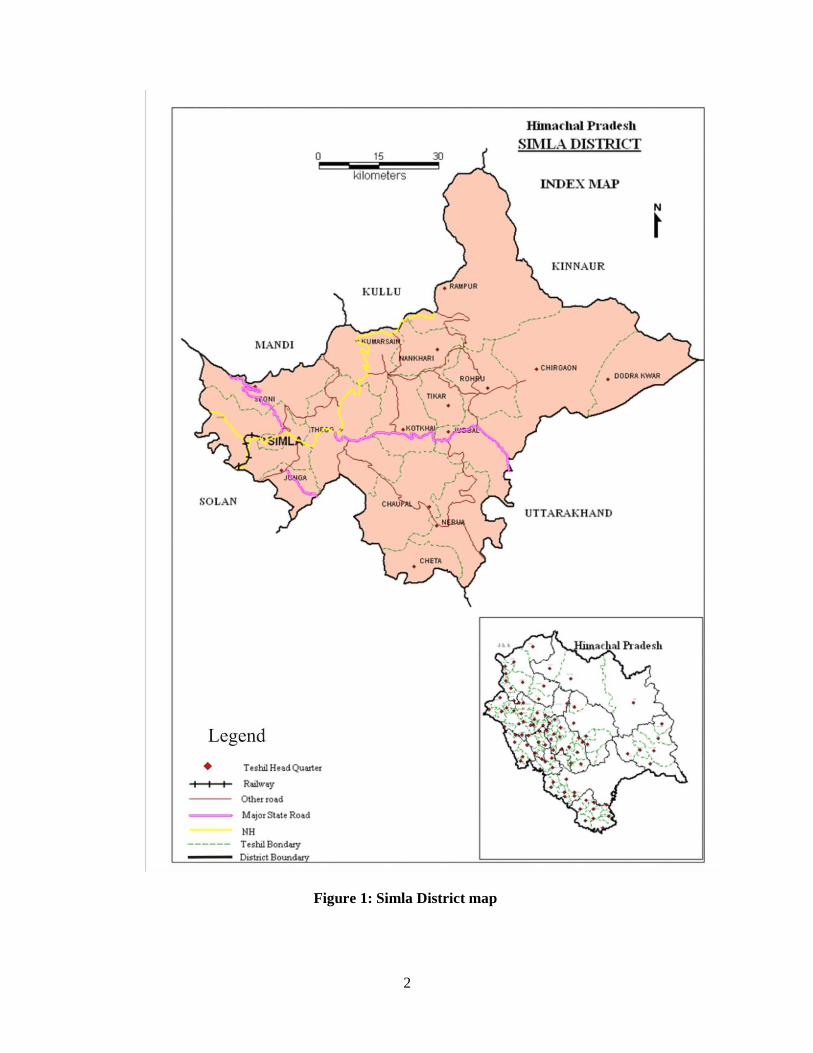
Simla district is located at the south-east of Himachal Pradesh and have geographical area of 5131 sq km. The district lies between north latitude 30º43'00'' and 30º45'48'' and east longitude 76º59'22'' and 78º18'40'' and fall in Survey of India degree-sheets Nos. 53A, 53E, 53F & 53I. The district is bounded by Mandi district in north, Kullu district in north-west, Kinnaur in the north-east, Sirmaur and Solan districts in the south and west respectively. District has inter-state boundary in the south - east with State of Uttrakhand. The district is well connected by rail and road network. The nearest airports are at Simla (Jubbal Hatti) and Chandigarh.
Administratively, Simla is the capital of Himachal Pradesh State and Head
Quarter of Simla district. The district comprises of 7 Sub-Divisions viz., Simla Urban, Simla Rural, Theog, Rampur, Chopal, Rohru and Dodra Kawar and has 12 Tehsils viz., Simla Urban, Simla Rural, Suni, Theog, Kotkhai, Rampur, Kumarsain, Chopal Rohru, Jubbal, Chirgaon, and Dodra Kawar & 6 Sub-Tehsils viz., Junga, Nankhari, Nerwa, Cheta (Kupwi) and Tikkar. For development purpose, the district has been divided into 10 Community Development blocks viz., Mashobra, Theog, Narkanda, Rampur, Jubbal, Rohru, Chhohara, Chopal, Nankhari and Basantpur, 363 Gram Panchayats, 3213 Villages. Important towns in the district are Rampur, Rohru, Jubbal, kothai, Chopal, Kumarsain, Theog, Simla and Kasumpti etc.
The population of the district is 8,14,010 (2011 census), of which 4,25,039 (52
%) are males and 3,88,971 (48 %) females. The rural & urban population is 6,12,659 (75%) and 2,01,351 ( 25 %) respectively.
The local inhabitants mainly depend on agriculture for their subsistence and
adopt several traditional practices conducive for farming in sloping terrains. Since Simla is the state capital, it became a burgeoning city with multifarious activities like trade, commerce, tourism, education, health institution, Govt. offices, infrastructure, traffic and transportation. Large and small scale industrial development however has taken place randomly all over the district.
Central Ground Water Board (CGWB) had carried out Hydro-Geological
studies and Ground Water Exploration in the district. Hydrogeological studies commenced in sixties, and under exploratory drilling programme, one exploratory well of 302 m depth has been drilled in hard rock hilly terrain. Further, many short-term investigations has also been carried out in the district to find out the feasible locations for ground water development and management.
2
Figure 1: Simla District map

3
2.0 Climate & Rainfall
The climate of the district is sub-tropical in the valleys and tends to be temperate at the hilltops. There are four major seasons. The winter season commences from October and lasts up to March, summer extends from March to June followed by monsoon period extending upto September. The average annual rainfall in the district is about 999.64 mm, out of which 75% occurs during monsoon period i.e. June to Sept. In winter season, precipitation as snowfall also occurs at higher reaches and as rainfall at low hills and valleys of the district. The minimum and maximum temperature varies from 2.5°C in January to 26°C in May. 3.0 Geomorphology & Soils
Simla district presents an intricate mosaic of high mountain ranges, hills and narrow deep valleys with altitude ranging from 1000 to 3000 m above MSL. In the areas underlain by high hill ranges of Himalayas, the valleys are narrow and deep with steep slopes trending in NW-SE direction. The terrain is moderate to highly dissected with steep slopes. The altitude is higher in northeastern parts and decreases towards southwestern parts.
Simla district is drained by streams/rivers forming part of the drainage basins of the Sutlej, the Yamuna, the Pabbar and Tons rivers. However, major part of the district is drained by tributaries of Sutlej River. The Sutlej River is the longest river traversing along the north western boundary of the area and Giri River which is the tributary of the Yamuna River originates from the eastern part and runs in the SW direction. Whereas, tributaries of Tons river, flows in the southern parts and the Pabbar river in the eastern parts of the district. In general the density of drainage is moderate to high and is not uniform all over the district.
Soil is generally sandy loam in valley areas of the district and in rest of the
hilly and mountainous areas soil is skeletal. The soil depth is generally shallow except in areas having good vegetative cover. It is generally dry, shallow and deficient in organic matter. Landslides are the common features in mountainous terrains. Soils are rich in nutrients and thus are fertile. 4.0 Ground Water Scenario 4.1 Hydrogeology
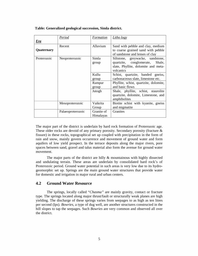
Geologically, the rock formations occupying the district range in age from Pre-Cambrian to Quaternary period. The generalized geological succession encountered in the district is given below

4
Figure 2: Geomorphology of Simla district.
5
Table: Generalized geological succession, Simla district.
Era Period Formation Litho logy
Quaternary Recent Alluvium Sand with pebble and clay, medium
to coarse grained sand with pebble of sandstone and lenses of clay
Proterozoic Neoproterozoic Simla group
Siltstone, greywacke, sandstone, quartzite, conglomerate, Shale, slate, Phyllite, dolomite and meta-volcanics
Kullu group
Schist, quartzite, banded gneiss, carbonaceous slate, limestone etc.
Rampur group
Phyllite, schist, quartzite, dolomite, and basic flows
Jutogh Shale, phyllite, schist, staurolite quartzite, dolomite, Limestone, and amphibolites
Mesoproterozoic Vaikrita Group
Biotite schist with kyanite, gneiss and migmatite
Palaeoproterozoic Granite of Himalayas
Granites
The major part of the district is underlain by hard rock formation of Proterozoic age. These older rocks are devoid of any primary porosity. Secondary porosity (fracture & fissure) in these rocks, topographical set up coupled with precipitation in the form of rain and snow, mainly govern occurrence and movement of ground water and form aquifers of low yield prospect. In the terrace deposits along the major rivers, pore spaces between sand, gravel and talus material also form the avenue for ground water movement.
The major parts of the district are hilly & mountainous with highly dissected and undulating terrain. These areas are underlain by consolidated hard rock’s of Proterozoic period. Ground water potential in such areas is very low due to its hydro-geomorphic set up. Springs are the main ground water structures that provide water for domestic and irrigation in major rural and urban centers. 4.2 Ground Water Resource
The springs, locally called “Chasma” are mainly gravity, contact or fracture type. The springs located along major thrust/fault or structurally weak planes are high yielding. The discharge of these springs varies from seepages to as high as ten litres per second (lps). Bowries, a type of dug well, are another structures constructed in the hill slopes to tap the seepages. Such Bowries are very common and observed all over the district.

6
Figure 3: Geological Formations in Simla District

7
Figure 4: Hydrogeology of Simla district Besides this, two dug wells were also found in the area at village Sandhu and Chambi. These wells were constructed by the local folk to explore the availability of ground water during summer season. These dug wells were reported to have very low yield and dried out during summers. Now these wells are abandoned. To know the aquifer system of the hard rock area, Central Ground Water Board, NHR, Dharamshala, under exploration programme has constructed one deep tube well of 302 m depth at

8
Ashwani Khad. The well has a discharge of about 1173 lpm with transmissivity of 70.39 m2/day.
Recently, the State Department has drilled shallow bore wells fitted with hand-
pumps to provide domestic water. The average depth of these hand pumps is 50 - 60 m, having low discharges up to 1 lps.
4.3 Ground Water Quality
The chemical quality data of ground water samples from springs, hand pumps
and tube wells, indicates that ground water is generally alkaline in nature and all the parameters analyzed are well within the permissible limit as per Bureau of Indian Standard (BIS-1991) and suitable for both domestic and irrigation use.
Though contamination of ground water have not been reported in the district
so far, however, the fast increase in population/tourist population in the major towns, mainly Simla is highly vulnerable to pollution from municipal effluents and small industries. There is thus need to have proper Effluent Treatment Plants (ETPs) and waste disposal system in all industries and major towns and its proper monitoring is very much required.
4.4 Status of Ground Water Development
In most of the district, due to poor potentialities in hilly hard rock areas and hilly sloping terrains, groundwater development is low. However, in these areas, major water supply and water sources are ground water based viz., perennial springs, bowries and hand pumps. Springs are tapped at the source and water is supplied under gravity. All major towns and villages are supplied water from ground water sources. 5.0 Ground Water Management Strategy 5.1 Ground Water Development
In hilly and mountainous area of the district, ground water development through the traditional ground water sources viz. Springs (chasmas), Bowries and perennial streams are possible apart from the shallow bores or hand pumps at favorable locations. Proper development of springs is essential as it is observed that most of the spring does not have collection chamber or tanks from where water can be distributed under gravity. The objective of spring development should be to collect the flowing water underground, to protect it from surface contamination and store it in a sanitary spring box for supply. Similarly, seepage springs along hill sides also need to develop for harnessing ground water in such areas.
In the last decade number of shallow bore wells fitted with hand pumps have
been constructed for serving as source of water supply for domestic use in the district. In the hilly areas the shallow bore wells at favorable location are feasible. However, looking to the fragile eco-system drilling activity should be minimized.
9
5.2 Water Conservation & Artificial Recharge
Ground water is the major source for irrigation and domestic water supply in both rural and urban areas. In most parts of the district the availability of water during summer is limited particularly in hilly areas especially during drought / low rain fall years. There is thus an immediate need to conserve and augment water resources. Based upon the climatic conditions, topography, hydrogeology of the area, rain water harvesting and artificial recharge to ground water need to be planned and implemented by construction of suitable structures. Roof top rainwater harvesting in urban/rural areas and water harvesting in rural area need to be adopted. The proper scientific intervention for spring development and revival of traditional water storage is required in water scarce hilly upland areas.
6.0 Ground Water Related Issues & Problems
Most of the ground water issues and problems in the district are localized and need to be treated independently by taking the micro level study in a particular area. In hilly and mountainous parts, the most common issues relate to scarcity of water, particularly in low precipitation year during non-monsoon period when depleting water levels and dwindling spring discharges are a common factor. The awareness for water conservation and its protection need to be taken up. 7.0 Awareness & Training Activity So far no Mass Awareness Programme (MAP) & Water Management Training Programme (WMTP) has been conducted in the district by CGWB. 8.0 Areas Notified By CGWB/SGWA
No any area or block of the district has been notified for Ground Water Development point of view. 9.0 Recommendations
� In hilly and mountainous terrains, traditional ground water sources viz., springs, bowries etc need to be developed and protected for better health and hygiene condition with proper scientific intervention.
� Springs needs to be inventoried and developed for optimum utilization of their discharges either by fracturing, horizontal drilling or by constructing galleries etc.
� Urban areas are highly prone and vulnerable to surface and ground water pollution thus water quality monitoring at close network is essential.
� Proper waste/effluent disposal measures are required to be adopted by state authorities to check the pollution.
� Roof top rainwater harvesting practices may be adopted in hilly and urban areas, since the district receives fair amount of rainfall.

10
� Rain water harvesting in rural areas should be promoted. Traditional water storage systems need to be revived.
� The Information, Education and Communication (IEC) activities including workshops, seminars, debates, radio and television programs should be taken up to promote rain water harvesting in the district.
� Suggest suitable measures for rain water harvesting, both in rural and urban areas, by the inhabitants at hill tops, spurs and on river/stream banks
� Prepare schemes for ground water management in rural and urban areas � Encourage construction of community rain water storage or percolation tanks,
ponds, check dams or recharge shafts at favorable locations. � Public participation is a must for any type of developmental activities. So
proper awareness for utilization and conservation of water resources is required.
SAVE WATER – SAVE LIFE

11
For Technical Assistance Relating to Rainwater Harvesting and Artificial Recharge to Ground Water
Contact:
CENTRAL GROUND WATER BOARD NORTHERN HIMALAYAN REGION Dove Cottage, Ram Nagar, Dharamsala
Phone: 01892- 229359; 227160 Telefax: 01892-223535 email: [email protected]
Related Documents