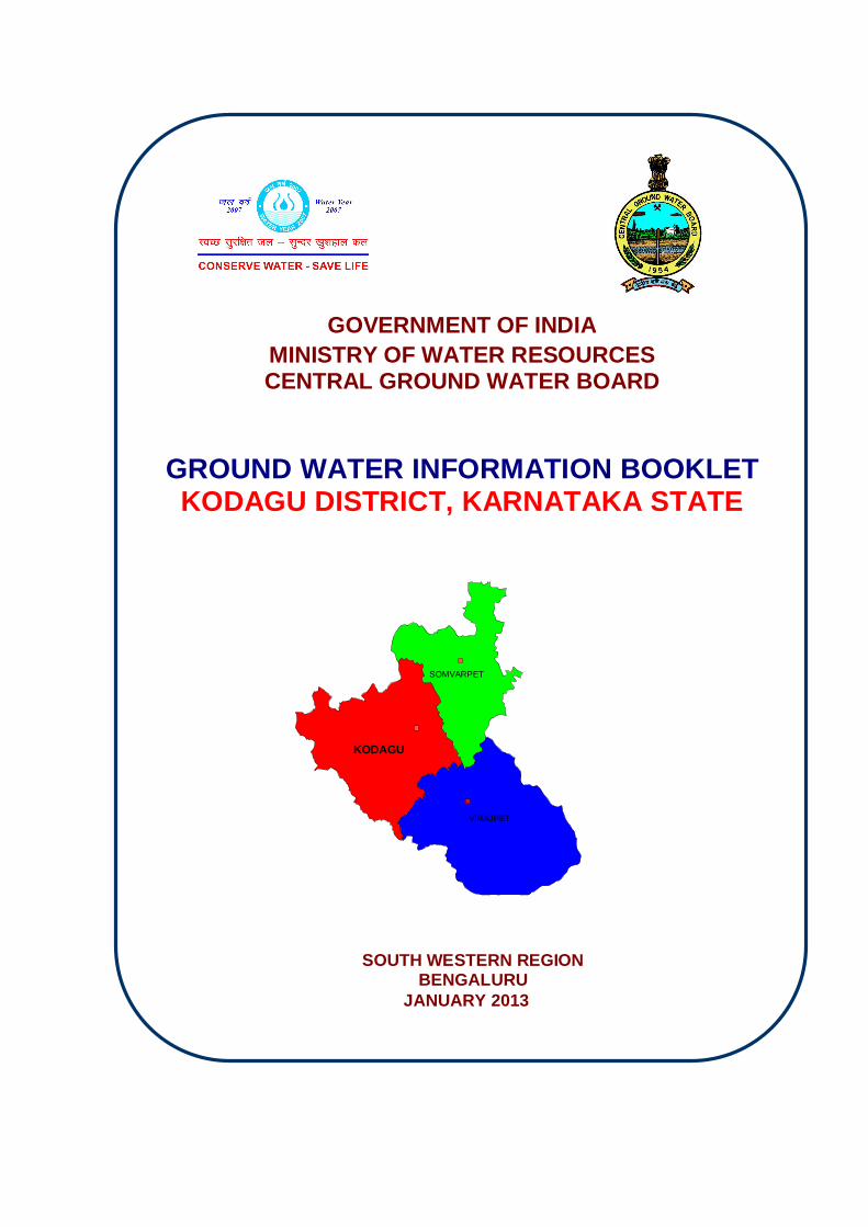
GOVERNMENT OF INDIA MINISTRY OF WATER RESOURCES CENTRAL GROUND WATER BOARD GROUND WATER INFORMATION BOOKLET KODAGU DISTRICT, KARNATAKA STATE SOUTH WESTERN REGION BENGALURU JANUARY 2013 KODAGU SOMVARPET VIRAJPET

Welcome message from author
This document is posted to help you gain knowledge. Please leave a comment to let me know what you think about it! Share it to your friends and learn new things together.
Transcript
GOVERNMENT OF INDIA MINISTRY OF WATER RESOURCES CENTRAL GROUND WATER BOARD
GROUND WATER INFORMATION BOOKLET KODAGU DISTRICT, KARNATAKA STATE
SOUTH WESTERN REGION BENGALURU
JANUARY 2013
KODAGU
SOMVARPET
VIRAJPET
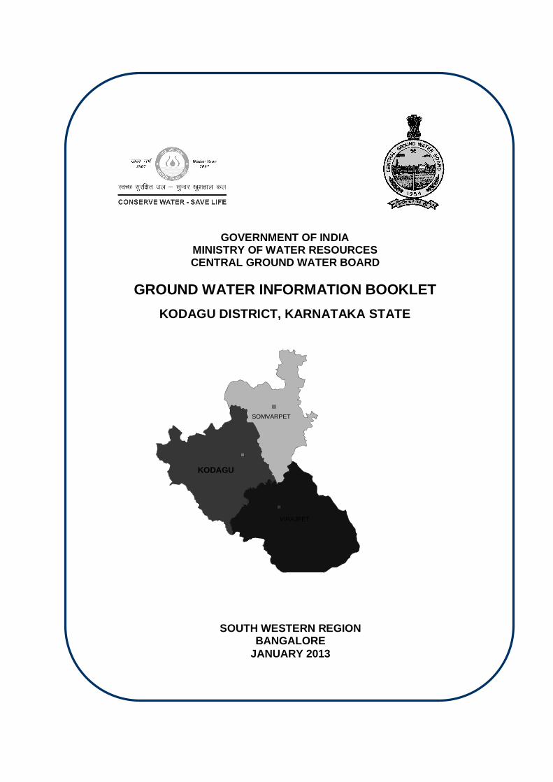
GOVERNMENT OF INDIA MINISTRY OF WATER RESOURCES CENTRAL GROUND WATER BOARD
GROUND WATER INFORMATION BOOKLET
KODAGU DISTRICT, KARNATAKA STATE
SOUTH WESTERN REGION BANGALORE
JANUARY 2013
KODAGU
SOMVARPET
VIRAJPET
FOREWORD
Groundwater is an essential component of the environment and economy. It sustains the flow in
our rivers and plays an important role in maintaining the fragile ecosystems. The groundwater
dependence of agrarian states like Karnataka is high. Recent studies indicate that 26 percent of
the area of Karnataka State is under over exploited category and number of blocks is under
critical category. In view of the growing concerns of sustainability of ground water sources,
immediate attention is required to augment groundwater resources in stressed areas. Irrigated
agriculture in the state is putting additional stress on the groundwater system and needs proper
management of the resources.
Central Ground Water Board is providing all technical input for effective management of ground
water resources in the state. The groundwater scenario compiled on administrative divisions gives
a better perspective for planning various ground water management measures by local
administrative bodies. With this objective, Central Ground Water Board is publishing the revised
groundwater information booklet for all the districts of the state.
I do appreciate the efforts of Dr. K.Md.Najeeb, Regional Director and his fleet of dedicated
Scientists of South Western Region, Bangalore for bringing out this booklet. I am sure these
brochures will provide a portrait of the groundwater resources in each district for planning
effective management measures by the administrators, planners and the stake holders.
Sushil Gupta
CHAIRMAN
PREFACE
Ground water contributes to about eighty percent of the drinking water requirements in
the rural areas, fifty percent of the urban water requirements and more than fifty
percent of the irrigation requirements of the nation. Central Ground Water Board has
decided to bring out district level ground water information booklets highlighting the
ground water scenario, its resource potential, quality aspects, recharge – discharge
relationship, vulnerability area etc., for all the districts of the country. As part of this,
Central Ground Water Board, South Western Region, Bangalore, is preparing such
booklets for all the 30 districts of Karnataka state, incorporating the data up to the
period 2011-12.
The Kodagu district Ground Water Information Booklet has been prepared based on
the information available and data collected from various state and central government
organisations by several hydro-scientists of Central Ground Water Board with utmost
care and dedication. This booklet has been prepared by Dr S.Srinivasa Vittala, Asst
Hydrogeologist, and under the guidance of Dr K.R.Sooryanarayana, Scientist-D,
Central Ground Water Board, South Western Region, Bangalore. The figures were
prepared by Sri.J.Sivaramakrishnan, Assistant Hydrogeologist. The efforts of Report
processing section in finalising and bringing out the report in this format are
commendable.
I take this opportunity to congratulate them for the diligent and careful compilation and
observation in the form of this booklet, which will certainly serve as a guiding
document for further work and help the planners, administrators, academicians,
hydrogeologists and engineers to plan and manage the water resources in a better
way in the district.
(Dr. K.Md.Najeeb)
Regional Director

KODAGU DISTRICT AT A GLANCE Sl.No. Items Statistics
1 General Information
i) Geographical area (sq. km) 4,102 ii) Administrative Divisions Number of Taluks 3 (Madikeri, Somvarpet & Virajpet) No. of Panchayat /Villages : 98/291 iii) Population (As on 2011 Census) 554,762 iv) Annual normal rain fall (1971-2011) 2,598 mm
2 Geomorphology Major Physiographic Units
Malnad area of Western Ghats. The district forms a part of Western Ghats with high range mountains running north – south. The whole district area, except for a narrow elongated strip, is mountainous. The highest peak of the district is Tadiondamol (1908 m amsl). The table land of Madikeri maintains an average altitude of about 1166 m amsl and slopes down a little to reach 910 m amsl near Kushalnagar.
Major Drainages Drained by 6 perennial rivers namely East flowing Cauvery and West flowing Netravati, Payasyani, Ariyakodavu, Kuppam and Velapattanam
3 Land use (sq. km) Forest area 1345.97 Net area sown 1474.53
4 Major soil types Reddish brown forest soil, Yellowish grey to greyish sandy loam soils and mixed soils.
5 Area under principal crops in ha Crop Coffee
Tea Rubber Cashew Coconut
Areca nut Palm
Pepper Ginger
Cardamom Banana Orange
Area 83205 490
1926 2198 1370 1505 903
15975 4550 11957 520
1085
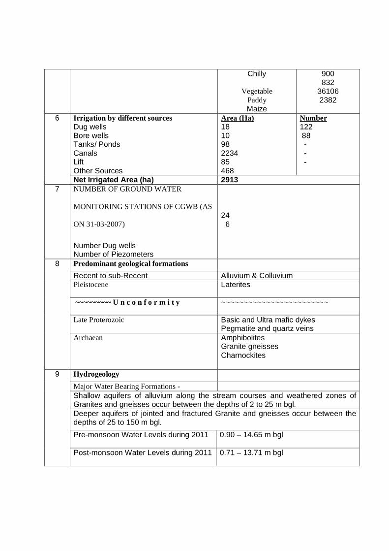
Chilly
Vegetable Paddy Maize
900 832
36106 2382
6 Irrigation by different sources Dug wells Bore wells Tanks/ Ponds Canals Lift Other Sources
Area (Ha) 18 10 98 2234 85 468
Number 122 88 - - -
Net Irrigated Area (ha) 2913 7 NUMBER OF GROUND WATER
MONITORING STATIONS OF CGWB (AS
ON 31-03-2007)
Number Dug wells Number of Piezometers
24 6
8 Predominant geological formations Recent to sub-Recent Alluvium & Colluvium Pleistocene Laterites
~~~~~~~~~ U n c o n f o r m i t y ~~~~~~~~~~~~~~~~~~~~~~~~
Late Proterozoic Basic and Ultra mafic dykes Pegmatite and quartz veins
Archaean Amphibolites Granite gneisses Charnockites
9 Hydrogeology Major Water Bearing Formations - Shallow aquifers of alluvium along the stream courses and weathered zones of Granites and gneisses occur between the depths of 2 to 25 m bgl. Deeper aquifers of jointed and fractured Granite and gneisses occur between the depths of 25 to 150 m bgl. Pre-monsoon Water Levels during 2011
0.90 – 14.65 m bgl
Post-monsoon Water Levels during 2011
0.71 – 13.71 m bgl
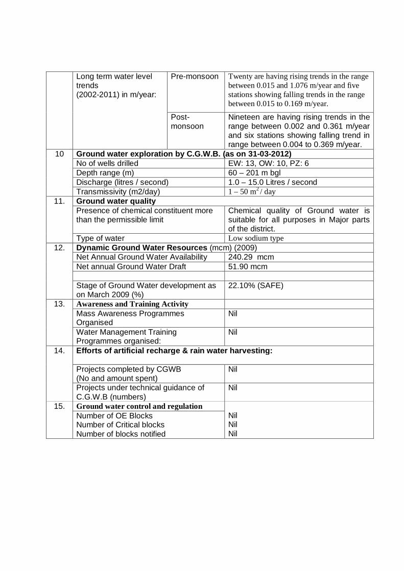
Long term water level trends (2002-2011) in m/year:
Pre-monsoon
Twenty are having rising trends in the range between 0.015 and 1.076 m/year and five stations showing falling trends in the range between 0.015 to 0.169 m/year.
Post-monsoon
Nineteen are having rising trends in the range between 0.002 and 0.361 m/year and six stations showing falling trend in range between 0.004 to 0.369 m/year.
10 Ground water exploration by C.G.W.B. (as on 31-03-2012) No of wells drilled EW: 13, OW: 10, PZ: 6 Depth range (m) 60 – 201 m bgl Discharge (litres / second) 1.0 – 15.0 Litres / second Transmissivity (m2/day) 1 – 50 m2 / day
11. Ground water quality Presence of chemical constituent more than the permissible limit
Chemical quality of Ground water is suitable for all purposes in Major parts of the district.
Type of water Low sodium type 12. Dynamic Ground Water Resources (mcm) (2009)
Net Annual Ground Water Availability 240.29 mcm Net annual Ground Water Draft 51.90 mcm Stage of Ground Water development as on March 2009 (%)
22.10% (SAFE)
13. Awareness and Training Activity Mass Awareness Programmes Organised
Nil
Water Management Training Programmes organised:
Nil
14. Efforts of artificial recharge & rain water harvesting:
Projects completed by CGWB (No and amount spent)
Nil
Projects under technical guidance of C.G.W.B (numbers)
Nil
15. Ground water control and regulation Nil Nil Nil
Number of OE Blocks Number of Critical blocks Number of blocks notified
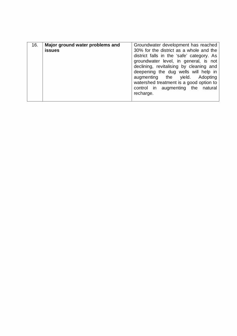
16. Major ground water problems and issues
Groundwater development has reached 30% for the district as a whole and the district falls in the ‘safe’ category. As groundwater level, in general, is not declining, revitalising by cleaning and deepening the dug wells will help in augmenting the yield. Adopting watershed treatment is a good option to control in augmenting the natural recharge.
KODAGU DISTRICT
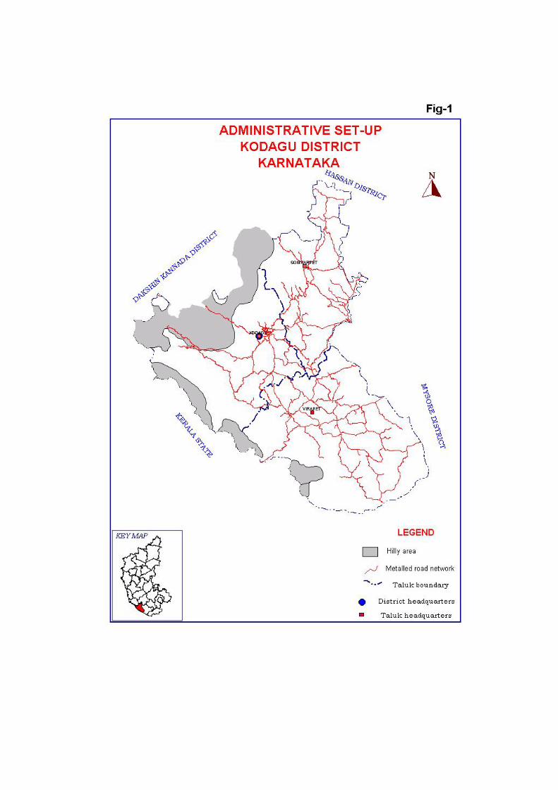
1.0 INTRODUCTION 1.1 GENERAL Kodagu district located in the southwestern part of Karnataka state falls in the high precipitation zone with picturesque topography occupying the eastern and western slopes of the Western Ghats. Closed with primeval forest or glassy glades and broken by a few cultivated villages, it has mountainous configuration, which presents a grand panorama, verdant valleys, ravines, fast flowing streams, lofty peaks and awe-inspiring spurs. The terrain and climatic conditions here are somewhat unique and nature has bestowed the district with an abundance of forest wealth. It enjoys typical tropical climate. In the economy of the State and the country Kodagu enjoys a distinct place in view of its international reputation as a prominent coffee-producing center. Cardamom, pepper and oranges of Kodagu are also quite famous. So also, the honey produced in Kodagu has a reputation for its taste and nutritive value. In conformity with the general pattern prevalent in the hilly regions, in Kodagu also the population density is low and small clusters of houses amidst rich vegetation, that is, scattered houses and homesteads, characterize the settlement pattern. The total population in the district is around 554,762 (as per 2011 census), out of which male and female were 274,725 and 280,037 respectively. There was change of 1.13 percent in the population compared to population as per 2001 census. With regards to Sex Ratio, it stood at 1019 per 1000 male compared to 2001 census figure of 995. Cauvery, one amongst the seven most sacred rivers of the country, is the main and the largest river of the district. 1.2 Location Kodagu district with an area of 4,102 Km2 is the smallest district in the state of Karnataka. Located in the southwestern part of Karnataka state between North latitude 11O 56’ and 11O 52’ and East longitude 75O 22’ and 76O 12’, it falls in the high precipitation zone with picturesque topography occupying the eastern and western slopes of the Western Ghats. It is bounded by, Hassan district on the north, by Mysore district on the east, by Dakshin Kannada district on the west and Kasargod district of Kerala state on the south. In the north a narrow strip of landscape measuring about 20 km in length and 10 km breadth projects into Hassan district. A map showing administrative set-up of the district is given as Figure 1. 1.3 Administrative set up The district comprises of three taluks namely Madikeri, Somvarpet and Virajpet having geographical areas 1449, 999 and 1654 sq. km respectively. The taluks are named after taluk headquartes. Madikeri is the district headquarters of Kodagu district. It is about 262 kms away from Bangalore.

1.4 Communication The district is well connected by highways and other main roads. The Bangalore – Mangalore Highway (SH 88) and Mysore - Cannanore Highway (SH- 88A) passes through the district. Fairly good network of roads exists connecting taluk headquarters with district headquarters and hoblis to various taluk headquarters. Mercara town is well connected with all the important places of the state. It is about 262 km from Bangalore (State Capital), 128 km from Mysore and 130 km from Mangalore. The nearest Railway stations are Hassan and Mysore. Nearest Airport is located at a distance of about 130 km at Mangalore.
1.5 Drainage
The district is drained by 6 perennial rivers namely westernly flowing Netrawati, Payasyani, Ariyakodavu, Kuppam and Velapattanam and easternly flowing Cauvery river. The major perennial tributaries to Cauvery are Harangi, Hemavati, Chikle, Kokkabe, Laxmantirth and Kabini. Cauvery is the main and the largest river of the district. It has its origin in the Brahamgiri Mountains at a place called Talakaveri. The length of river Cauvery from its source to the place where it leaves Kodagu district is about 80 km. The drainage map of the district is presented as Figure 2. Based on the drainage densities the district is divided into 4 zones, viz. areas having (i) drainage density less than 1, (ii) 1 to 2, (iii) 2-3 and (iv) >3 km /km2. It is observed that the drainage density and the ground slope in the plateau areas with a minimum surface runoff and moderate to good rate of water infiltration have enough scope for natural recharge of ground water regime. Rest of the area offers less scope for infiltration as compared to plateau area. Kodagu district is not in any way reputed for lakes and tanks. Now, the Harangi project is completed and a large artificial lake, namely the Harangi Reservoir, has been formed in the eastern sector near Igoor village of Somwarpet taluk. There are numerous springs in the valleys and there is always adequate supply of water for drinking and other purposes.
1.6 Crops and Irrigation Practices The net sown area comprises 36% of the total geographical area. While paddy is grown in favourable areas, Coffee, Tea, Plantain and Areca nut are the main horticulture crops. About 2% of the net sown area is irrigated and of this a mere 10% is irrigated by ground water. Plantation crops constitute the very life-blood of the district economy in that the very name of the district, particularly its anglicized form, Coorg is almost a bye word for coffee and oranges. Cardamom and pepper are also crops of considerable importance. Coffee is the most important plantation crop. It is a common practice for the coffee planters to grow oranges inter-mixed with coffee in their estates. Although paddy is grown extensively, annually only one crop is raised and it is done usually under rain-fed conditions. In certain tracts sugarcane is also raised to a little extent and used for preparing gur.

1.7 Activities carried out by CGWB Central Ground Water Board has carried out Systematic Hydrogeological surveys, Reappraisal Hydrogeological surveys and Groundwater Exploration in the district. The hydrogeological investigations and groundwater exploration have revealed the existence of potential zones within 200 meters depth in granitic and gneissic formations. Besides, CGWB maintains a good network of observation wells (NHS) in the district, which are monitored periodically to keep a close vigil in water level variations.
2.0 RAINFALL AND CLIMATE The district enjoys typical tropical climate characterized by slight to medium humidity due to proximity to coast (about 32 Km). It is known to be quite pleasant and healthy, characterized by high humidity, heavy rainfall and cool summer. A major part of the year consists of rainy season as the monsoon period starting in June lasts till the ends of September. Even during the post monsoon months of October and November certain parts of the district receive a significant amount of rainfall. Because of the cloudy weather, the day would be quite sultry during October and it is only during the second half of the November that the weather becomes brighter. The period from December to February is the cold season marked by a bright weather, foggy mornings and cool nights. The day temperature begins to rise sharply during March and marks the commencement of the summer season, which lasts till the end of May. The highest maximum temperature recorded at Madikeri is 35OC on the 11th of May 1902 and the lowest minimum temperature ever recorded is 8.9OC on the 20th of February 1936.
The southwest monsoon sets in usually during the early part of June. Generally, June, July and August are the months of heavy rainfall and the precipitation in July is incessant and very heavy. The average annual rainfall for the district (2001-2010) is 2581 mm. The Seasonal & Annual Nornmal Rainfall for the period 2001-2010 Kodagu District, Karanataka is given in Table 2 and The district and taluk wise rainfall for the year 2011, Kodagu district, Karnataka is given is Table 3. The number of rainy days ranges between 85 and 153, with an average of about 118 rainy days in a year. The amount of rainfall and the number of rainy days varies considerably within the district. The analysis of the last 10 years data reveals that the highest rainfall (Average 3222 mm) has occurred in Madikeri taluk located in the Western part of the district which is thickly forested and the lowest (Average 2132 mm) in Somvarpet, taluk which is in northern part of the district having less forest cover and adjacent to Maidan (Plain) region. The orographic influence on rainfall is clear from the spatial distribution. Therefore, the rainfall is found to go on decreasing as one proceeds from the western part of the district to the eastern part.

Table: 2 Seasonal & Annual Nornmal Rainfall for the period 2001-2010 Kodagu District, Karanataka
Table: 3 District and taluk wise rainfall for the year 2011, Kodagu district, Karnataka.
DISTRICT AND TALUK WISE RAINFALL FOR THE YEAR 2011, KODAGU DISTRICT, KARNATAKA
DISTRICTS/
TALUKS
JAN
FEB
MAR
APR
MAY
PRE
JUN
JUL AUG
SEPT
SWM
OCT
NOV
DEC
NEM
ANNUAL
Rainfall (mm)
KODAGU 0 8 5
119 76
208
648
591
564 364
2166
188 81 0
269 2643
1 MADIKERI 0
12 1 99 72
184
778
853
866
544
3041
151 56 0
207 3432
2 SOMWARPET 0
11 12 89
114
226
359
363
404
209
1335
273
152 0
425 1986
3 VIRAJPET 0 0 3
169 42
214
806
556
421
339
2122
140 34 0
174 2510
3.0 GEOMORPHOLOGY AND SOIL TYPES The district forms a part of Western Ghats with high range mountains running north – south. Situated on the eastern and western slopes of the Western Ghats, clothed with lush greenery of forests and plantations, and broken by a few cultivated valleys, Kodagu is a picturesque highland. Its physical features are varied. The high hilltops are generally grassy with valley of dense mixed jungles and cardamom plantations. Low hill areas are generally under cultivation with teak plantation or dense mixed jungle. From this main range seven long and elongated ridges run from west to east. These chains of hill range have an elevation ranging from 1000 to 1700 metres amsl. The whole district area, except for a narrow elongated strip, is mountainous (Figure 3). The landscape in northeastern and eastern portion is different and resembles that of the adjoining Mysore district. The highest peak of the district is Tadiondamol (1908 m amsl). The table land of Madikeri maintains an average altitude of about 1166 m amsl and slopes down a little to reach 910 m amsl near Kushalnagar.
Station Pre-
Monsoon SW
Monsoon NE
Monsoon Annual Rainfall (mm)
Madikeri 241 2678 303 3222 Somwarpet 209 1682 241 2132 Virajpet 296 1774 318 2388

The soils of the district are of a heterogeneous profile and consist of lateritic debris found in different stages of weathering and laterization. The valleys and slopes have fertile read loamy soils that are suitable for cultivation. In the eastern zone dark clay soils are predominant. These get water logged during monsoon and deep cracks appear during the summer months. In the central zone loamy soils are predominant. In the central zone loamy soils are predominant. In the western zone, the soil is highly leached and being lateritic in content, tends to be quite shallow.
4.0 GROUND WATER SCENARIO
4.1 HYDROGEOLOGY Hydrogeologically, the area forms a part of hard rock terrain comprising of granites, gneisses, charnockites and amphibolites (Figure 4). Pegmatite veins and dolerite dykes are common intrusives in the area, especially in the eastern and southern sectors of the district. Dolerite dykes occur as detached boulders at places and as intrusives in granitic formations. The flat and low-lying areas are covered by a thick mantle of fertile soil, while the elevated portions and hills are capped by laterites. The alluvium is found along the river course, contains silt, sand and gravel in varying proportions. The ground water occurs under phreatic conditions in weathered zones of granites and gneiss, and under semi-confined to confined conditions in joints and fractures of these rocks at deeper level. Weathering of granites and gneisses, has given rise to thick sandy residuum down to the depth of 2.0 and 25.0 m. bgl and it forms an important phreatic aquifer. Fractured granites and gneisses form prolific deeper aquifers in some parts of the district.
4.1.1 OCCURRENCE OF GROUND WATER Ground water in the district generally occurs under unconfined to semi-confined conditions. In the shallower zones it is under phreatic conditions and in deeper zones it is under semi-confined conditions. The ground water is being exploited from the depth range of 10.00 to 20.00 m bgl through dug wells and from the depth range of 30.00 to 100.00 m bgl through dug-cum-bore wells and bore wells. The ground water exploration has proved the presence of prolific aquifers below the depth of 100 m. The Hydrogeological details of the area are presented in Figure 4.
4.1.2 DEPTH TO WATER LEVEL Out of 24 National Hydrograph Stations (NHS) located in Kodagu district, the depth to water levels in the NHS (dug wells) recorded during May-2011 were in the range of 0.90 – 14.65 m bgl. The depths to water levels in the national hydrograph stations (dug wells) recorded during November 2011 were in the range of 0.71 to 13.71 m bgl.
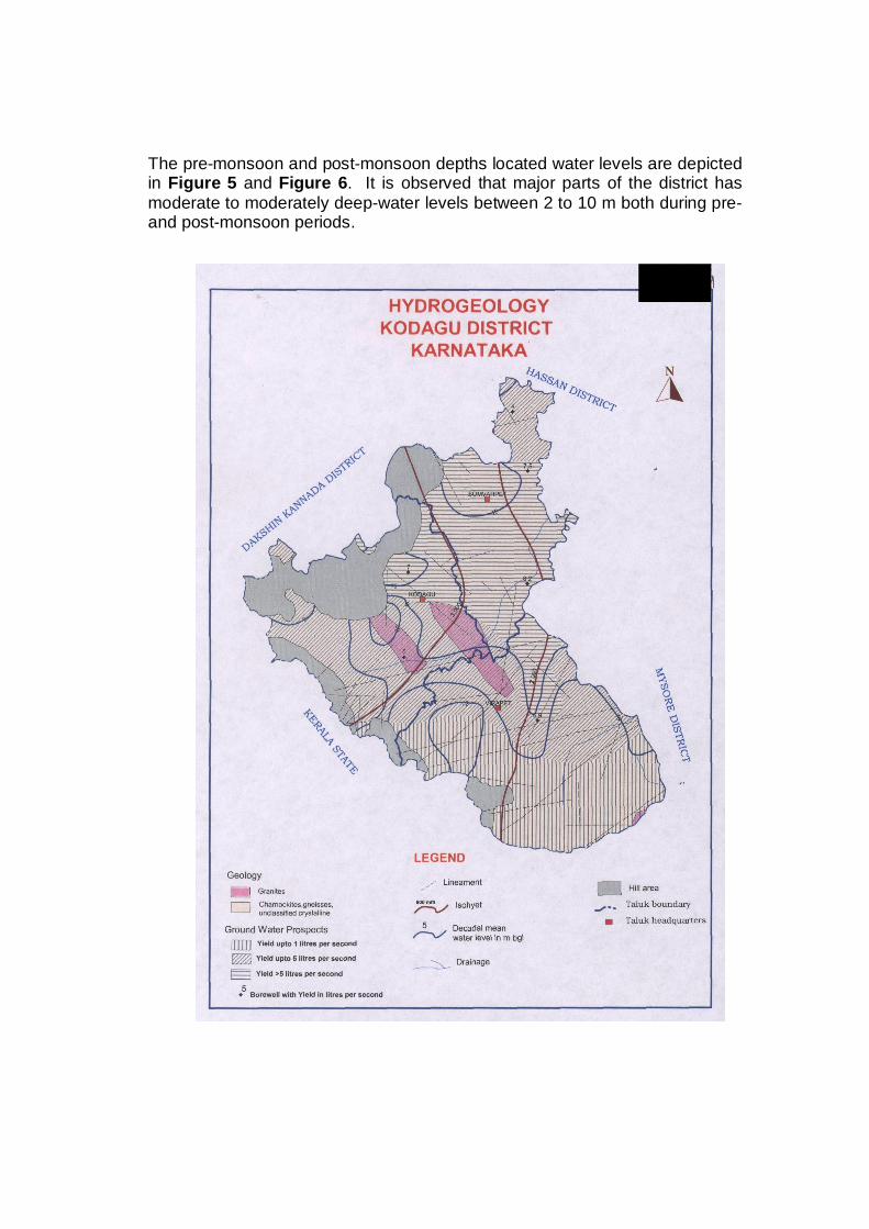
The pre-monsoon and post-monsoon depths located water levels are depicted in Figure 5 and Figure 6. It is observed that major parts of the district has moderate to moderately deep-water levels between 2 to 10 m both during pre- and post-monsoon periods.
FIG-4
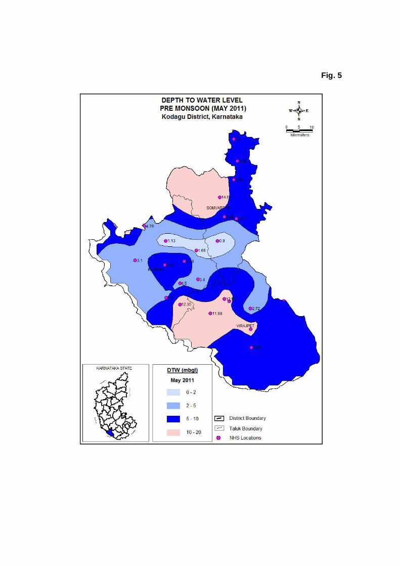
Fig. 5

Fig. 6
4.1.3 SEASONAL WATER LEVEL FLUCTUATION Consequent upon seasonal rainfall, the water levels record a rise, indicating the build up of storage in ground water reservoir. During the non-monsoon period, this gets depleted due to exploitation and natural discharge. Therefore, the water levels, in general show, a receding trend from December to May. The seasonal water level fluctuation for the year 2011 is available for 21 dug well national hydrograph network stations. 4.1.4 LONG-TERM WATER LEVEL TREND Out of pre-monsoon water level trend data available for 25 national hydrograph network stations for the period from 2002 to 2011, twenty are having rising trends in the range between 0.015 and 1.076 m/year. Out of these twenty national hydrograph stations, 12 national hydrograph network stations are showing rise of more than 0.1 m/year. In remaining hydrograph stations the water levels show falling trend in the range between 0.015 to 0.087 m/year. The water levels (five stations) are showing falling trends in the range between 0.015 to 0.169 m/year and of these, three stations have shown a fall of more than 0.1 m/year.
Out of post-monsoon water level trend data available for 25 national hydrograph network stations for the period from 2002 to 2011, nineteen are having rising trends in the range between 0.002 and 0.361 m/year. Out of these nineteen national hydrograph stations, 8 national hydrograph network stations are showing rise of more than 0.1 m/year. In the remaining six hydrograph stations, the water levels are showing falling trends in the range between 0.004 to 0.396 m/year. The water levels (six stations), are showing falling trend range between 0.004 to 0.369 m/year of which only one station has shown a fall of more than 0.1 m/year. 4.1.5 AQUIFER SYSTEMS ENCOUNTERED IN THE AREA The study of aquifer geometry and parameters have been attempted by Central Ground Water Board, South western Region, Bangalore, under its ground water exploration programme through drilling exploratory bore wells at selected places. The aquifer zones are weathered / fractured & jointed granites and gneisses, occurring at various depths from 15 to 201 m bgl. The exploratory bore wells drilled in the district are having depths ranging from 94 to 201 m bgl. The discharge ranges from 1.0 to 16.0 lps. The yield-cum-recuperation tests conducted on the wells show that the general specific capacity ranges from 5.24 to 59.20 lpm /m /dd. The transmissivity of aquifer material in general range from 1 to 50 m2/day.
.2 GROUND WATER RESOURCES Net annual ground water availability in the district is 24029.32 mcm, existing gross ground water draft for all uses is 5190.77 mcm, net ground water availability for future irrigation. The ground water development in the district is 22.10%. The entire district comes under ‘safe’ category. Considering taluk wise,
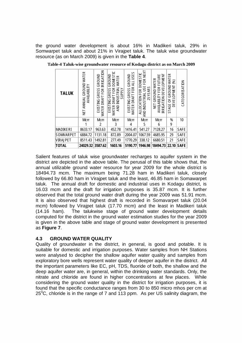
the ground water development is about 16% in Madikeri taluk, 29% in Somwarpet taluk and about 21% in Virajpet taluk. The taluk wise groundwater resource (as on March 2009) is given in the Table 4.
Table-4 Taluk-wise groundwater resource of Kodagu district as on March 2009
TALUK
NET
ANNU
AL G
ROUN
D W
ATER
AV
AILA
BILIT
Y
EXIS
TING
GRO
SS G
ROUN
D W
ATER
DRA
FT FO
R IR
RIGA
TION
EXIS
TING
GRO
SS G
ROUN
D W
ATER
DRA
FT F
OR D
OMES
TIC
AND
INDU
STRI
AL W
ATER
SU
PPLY
EXIS
TING
GRO
SS G
ROUN
D W
ATER
DRA
FT FO
R AL
L USE
S
ALLO
CATI
ON FO
R DO
MEST
IC
AND
INDU
STRI
AL U
SE FO
R NE
XT
25 Y
EARS
NE
T GR
OUND
WAT
ER
AVAI
LABI
LITY
FOR
FUTU
RE
IRRI
GATI
ON D
EVEL
OPME
NT
STAG
E OF
GRO
UND
WAT
ER
DEVE
LOPM
ENT
(%)
CA
TEGO
RISA
TION
Mcm 1
Mcm 2
Mcm 3
Mcm 4
Mcm 5
Mcm 6
% 9
10
MADIKERI 8633.17 963.63 452.78 1416.41 541.27 7128.27 16 SAFE SOMVARPET 6884.72 1131.18 872.89 2004.07 1067.59 4685.95 29 SAFE VIRAJPET 8511.43 1492.81 277.49 1770.29 338.12 6680.51 21 SAFE TOTAL 24029.32 3587.62 1603.16 5190.77 1946.98 18494.73 22.10 SAFE
Salient features of taluk wise groundwater recharges to aquifer system in the district are depicted in the above table. The perusal of this table shows that, the annual utilizable ground water resource for year 2009 for the whole district is 18494.73 mcm. The maximum being 71.28 ham in Madikeri taluk, closely followed by 66.80 ham in Virajpet taluk and the least, 46.85 ham in Somawarpet taluk. The annual draft for domestic and industrial uses in Kodagu district, is 16.03 mcm and the draft for irrigation purposes is 35.87 mcm. It is further observed that the total ground water draft during the year 2009 was 51.91 mcm. It is also observed that highest draft is recorded in Somavarpet taluk (20.04 mcm) followed by Virajpet taluk (17.70 mcm) and the least in Madikeri taluk (14.16 ham). The talukwise stage of ground water development details computed for the district in the ground water estimation studies for the year 2009 is given in the above table and stage of ground water development is presented as Figure 7. 4.3 GROUND WATER QUALITY Quality of groundwater in the district, in general, is good and potable. It is suitable for domestic and irrigation purposes. Water samples from NH Stations were analysed to decipher the shallow aquifer water quality and samples from exploratory bore wells represent water quality of deeper aquifer in the district. All the important parameters like EC, pH, TDS, fluoride of both, the shallow and the deep aquifer water are, in general, within the drinking water standards. Only, the nitrate and chloride are found in higher concentrations at few places. While considering the ground water quality in the district for irrigation purposes, it is found that the specific conductance ranges from 30 to 850 micro mhos per cm at 250C, chloride is in the range of 7 and 113 ppm. As per US salinity diagram, the
ground water falls under C1S1, i.e., low sodium water. Ground Water quality of the district is depicted in Figure 8.
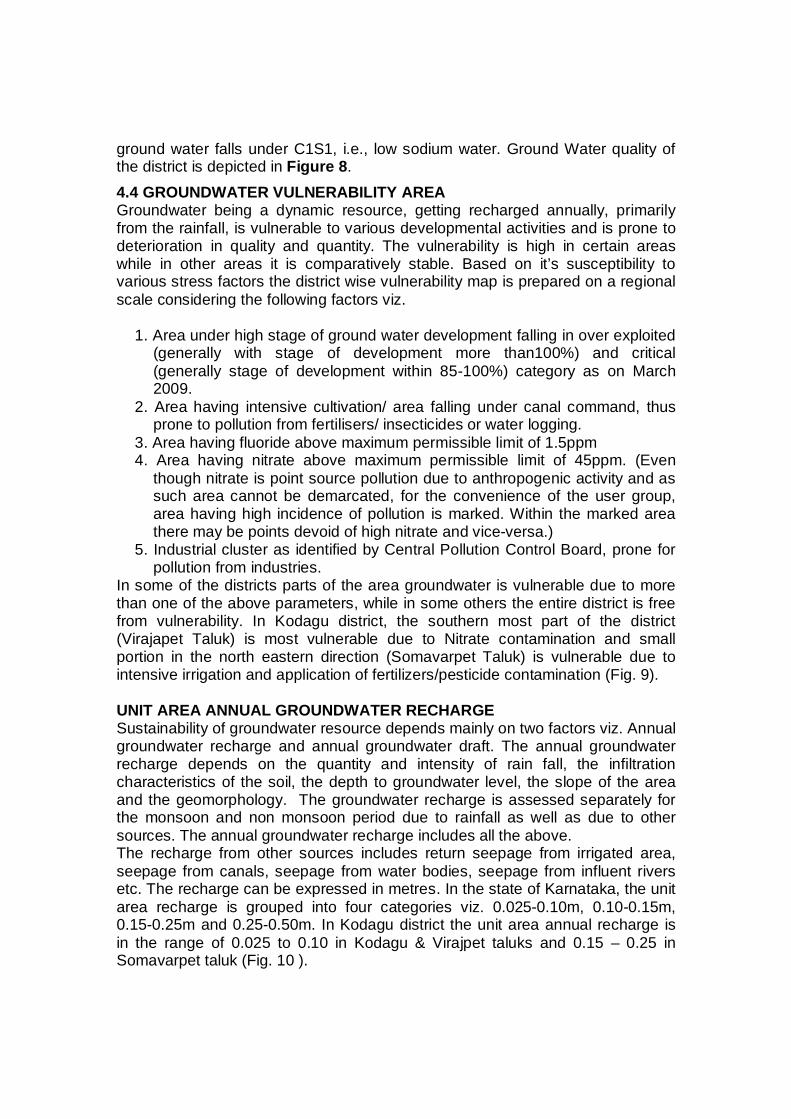
4.4 GROUNDWATER VULNERABILITY AREA Groundwater being a dynamic resource, getting recharged annually, primarily from the rainfall, is vulnerable to various developmental activities and is prone to deterioration in quality and quantity. The vulnerability is high in certain areas while in other areas it is comparatively stable. Based on it’s susceptibility to various stress factors the district wise vulnerability map is prepared on a regional scale considering the following factors viz.
1. Area under high stage of ground water development falling in over exploited (generally with stage of development more than100%) and critical (generally stage of development within 85-100%) category as on March 2009.
2. Area having intensive cultivation/ area falling under canal command, thus prone to pollution from fertilisers/ insecticides or water logging.
3. Area having fluoride above maximum permissible limit of 1.5ppm 4. Area having nitrate above maximum permissible limit of 45ppm. (Even
though nitrate is point source pollution due to anthropogenic activity and as such area cannot be demarcated, for the convenience of the user group, area having high incidence of pollution is marked. Within the marked area there may be points devoid of high nitrate and vice-versa.)
5. Industrial cluster as identified by Central Pollution Control Board, prone for pollution from industries.
In some of the districts parts of the area groundwater is vulnerable due to more than one of the above parameters, while in some others the entire district is free from vulnerability. In Kodagu district, the southern most part of the district (Virajapet Taluk) is most vulnerable due to Nitrate contamination and small portion in the north eastern direction (Somavarpet Taluk) is vulnerable due to intensive irrigation and application of fertilizers/pesticide contamination (Fig. 9). UNIT AREA ANNUAL GROUNDWATER RECHARGE Sustainability of groundwater resource depends mainly on two factors viz. Annual groundwater recharge and annual groundwater draft. The annual groundwater recharge depends on the quantity and intensity of rain fall, the infiltration characteristics of the soil, the depth to groundwater level, the slope of the area and the geomorphology. The groundwater recharge is assessed separately for the monsoon and non monsoon period due to rainfall as well as due to other sources. The annual groundwater recharge includes all the above. The recharge from other sources includes return seepage from irrigated area, seepage from canals, seepage from water bodies, seepage from influent rivers etc. The recharge can be expressed in metres. In the state of Karnataka, the unit area recharge is grouped into four categories viz. 0.025-0.10m, 0.10-0.15m, 0.15-0.25m and 0.25-0.50m. In Kodagu district the unit area annual recharge is in the range of 0.025 to 0.10 in Kodagu & Virajpet taluks and 0.15 – 0.25 in Somavarpet taluk (Fig. 10 ).

Fig. 7
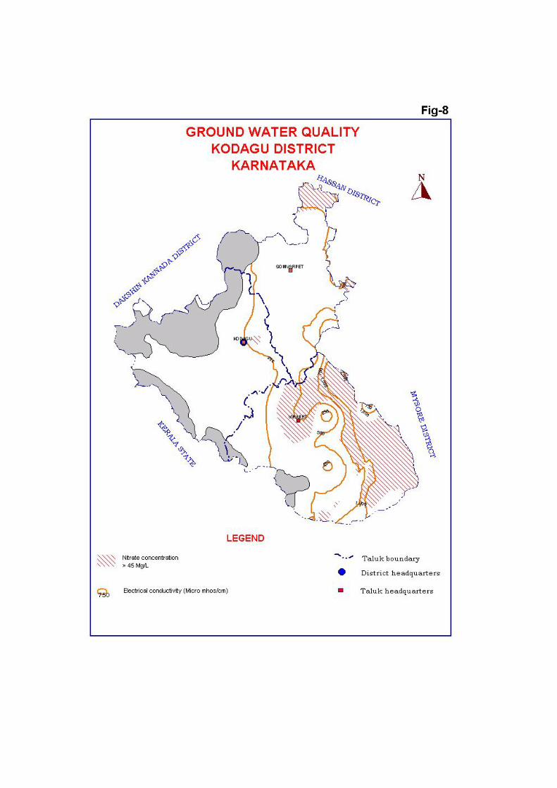

Fig. 9
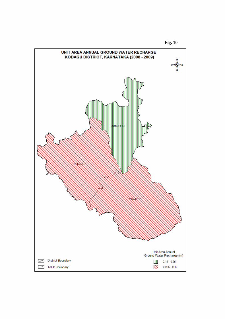
Fig. 10
4.4 STATUS OF GROUND WATER DEVELOPMENT 4.4.1 MADIKERI TALUK Recharge to groundwater mainly takes place through infiltration of rainwater and to a lesser extent from surface water sources and applied surface water irrigation. Groundwater is the main source of drinking water in Madikeri taluk, except for a small contribution from surface water for domestic water supply of Madikeri town. Total irrigated area in the taluk constitutes about 0.12% of the net sown area and groundwater contribution to irrigated agriculture is meager. Ground water development is 16% and falls under ‘Safe’ category. As the pre-monsoon depth to water level is between 2 and 10 m bgl in almost entire taluk, shallow zone ground water can be developed for irrigation through dug wells in topographic low areas and dug-cum-bore wells in valley slope areas having comparatively deeper water levels. Optimum depth of dug well is 7-15 m having a diameter of 6-7 m and the optimum depth of dug-cum bore well is15-30 m having a diameter of 6-7 m in dug part and 100 mm in lower bore well part. The four exploratory bore wells drilled by the Central Ground Water Board have yielded 1.3 to 8.5 litre per second (lps) for drilled depth of 94 to 200 m bgl. The moderate yield up to 5 lps is quite common in the district, and in the northeastern parts of the taluk, wells of higher yields (up to 15 lps) are possible if site selection is done based on sound scientific investigations.
4.4.2 SOMVARPET TALUK Groundwater is the main source of drinking water in the entire Somawarpet taluk. Total irrigated area in the taluk constitutes about 6.6% of the net sown area and groundwater accounts for less than 1% of the net irrigated area. Ground water development is 29% and falls under ‘Safe’ category. As the pre-monsoon depth to water level is between 5 and 10 m bgl in most parts of the taluk, shallow zone ground water can be developed for irrigation through dug wells in topographic low areas and dug-cum-bore wells in valley slope areas having comparatively deeper water levels. Optimum depth of dug well is 8 -15 m having a diameter of 6-7 m and the optimum depth of dug-cum bore well is 15-35 m having a diameter of 6-7 m in dug part and 100 mm in lower bore well part. The four exploratory bore wells drilled by the Central Ground Water Board have yielded 1.0 to 14.0 litre per second (lps) for drilled depth of 94 to 134 m. Good yield up to 15 lps is possible if site selection is done based on sound scientific investigations, except northern parts of the taluk, where wells have lower yields (up to 5 lps). 4.4.3 VIRAJPET TALUK Groundwater is the main source of drinking water in the entire Virajpet taluk. Total irrigated area in the taluk constitutes about 64,469 ha and almost the entire is rain-fed. Ground water development, which is mainly utilised for domestic needs, is only 21% and falls under ‘Safe’ category. As the pre-monsoon depth to water level is between 5 and 10 m bgl in almost 25% area in the northern parts of
the taluk, shallow zone ground water can be developed for irrigation through dug wells in topographic low areas and through dug-cum-bore wells in valley slope areas having comparatively deeper water levels. Optimum depth of dug well is 10 -15 m having a diameter of 6-7 m and the optimum depth of dug-cum bore well is 20- 40 m having a diameter of 6-7 m in dug part and 150 mm in lower bore well part. The five exploratory bore wells drilled by the Central Ground Water Board have yielded less than 1 to 16.0 litre per second (lps) for drilled depth of 160 to 201 m bgl. As depicted in Figure 4, more than half of the taluk area falling on southern and western parts is not having good ground water potential and the bore wells drilled in this area have given quite low yield of less than 1 lps. In other parts of the taluk, the bore wells have given moderate yield ranging up to 5 lps, except a small area located in the northern parts of the taluk, where bore wells give exceptionally better yields ranging up to 15 lps under favourable conditions. 5.0 GROUND WATER MANAGEMENT STRATEGY Kodagu district located in the south western part of Karnataka state falls in the high precipitation zone with undulating rugged topography occupying the eastern and western slopes of the Western Ghats. Almost 35% of the district’s geographical area is covered by forest. As per the data available (Kodagu District at a Glance 2004-05), the net sown area comprises 36% of the total geographical area. Paddy is grown in favourable areas. Coffee, Tea, Plantain and Areca nut are the main horticulture crops. About 2% of the net sown area is irrigated and of this a mere 10% is irrigated by ground water. Although the contribution of groundwater is very low in agriculture sector, it is playing a vital role as being the main source of drinking water, almost in the entire district. Hence, its optimum use and sustainable management is more important. At present ground water is not utilised in agriculture sector to its true worth and hence it is recommended to opt for its increased utilisation. As majority of the crops are basically horticultural, it may be prudent to go for sprinkler and drip irrigation methods. Efforts should be oriented towards judicious utilization, conservation and augmentation of groundwater. In the areas of deeper ground water level and the plains, artificial recharge measures like percolation tanks and check dams are to be implemented to augment the groundwater resource. In the hilly areas, which predominates the district, watershed treatment techniques can help in augmenting the groundwater resources. Point recharge structures would help in recharging deeper depleted fractures and fissures in days to come so as to have a sustainable yield from bore wells tapping deep aquifers. Scientific management of groundwater should be kept in mind while extending institutional finance to farmers and awareness should be created in different user communities. 5.1 GROUND WATER DEVELOPMENT Groundwater development has reached 22.10% for the district as a whole and the district falls in the ‘safe’ category. There is a lot of scope to further development of this useful resource. In general, as groundwater level is not

declining, revitalizing by cleaning and deepening the dug wells will help in augmenting the yield. The shallow zone ground water can further be developed for irrigation through dug wells in topographic low areas and dug-cum-bore wells in valley slope areas having comparatively deeper water levels. Optimum depth of dug well is 8 -12 m having a diameter of 4-6 m, the optimum depth of dug-cum bore well is 15-30 m having a diameter of 4-6 m in dug part and 150 mm in lower bore well part. Bore wells are possible in all topographic conditions. The pinpointing of site, depth, yield prospects, etc., should be done based on sound scientific investigations.
5.2 WATER CONSERVATION AND ARTIFICIAL RECHARGE Kodagu is predominantly a hilly district comprising of undulating and rugged terrain. Although the rainfall is quite high, the topographical conditions lead to high runoff. Under these conditions it is advisable to opt for watershed treatment techniques, which can help in augmenting the groundwater resources. In some parts of the district, especially in Virajpet taluk, where water levels are deep, point recharge structures will help in recharging the deeper depleted aquifers so as to have a sustainable yield from bore wells tapping the deep aquifers. Fast, unchecked and indiscriminate withdrawal of groundwater through different abstraction structures results in the decline of ground water level. Further, deforestation and conversion of grass-covered land for other activities reduces the natural groundwater recharge area. Hence, major quantity of the rainfall leaves the area as run-off causing floods and heavy soil erosion. The moderate to high sloping, undulating terrain in parts of the district covering areas are suitable for artificial recharge structures like gully plugs, gabion structures, cement plugs, nalla bunds, contour bunds and contour trenches. Even in the shallow water level areas, there are deep water levels occurring as patches, where suitable artificial structures can be constructed. By constructing suitable structures the contact time of this flowing water with the land can be increased substantially leading to recharge of the aquifer system. The selection of a suitable artificial recharge structure is site specific. So scientific studies should be conducted while selecting the site for a specific type of structure. 6.0 GROUND WATER RELATED ISSUES & PROBLEMS Thirty-eight suicide cases among farmers were reported in Kodagu district during the last few years of which 17 cases were due to crop failures and the remaining were due to various other reasons. Maximum farmers suicide cases of 11 have occurred in Somawarpet taluk followed by 5 in Virajpet taluk and 1 Madikeri taluk. As the ground water development in the district is still very low (mere 30%), optimum and judicious development of ground water can help in addressing this distress situation being faced by the farmers during the drought periods.
7.0 AWARENESS & TRAINING ACTIVITY Central Ground Water Board has planned to organise Water Management Training Programmes (WMTP) and one Mass Awareness Programmes (MAP) in the district during Annual Action Programme (2007 – 08). These Mass
Awareness and Water Management Training Programme (WMTP) are to be organised as a nation wide programme for generals public and officers of different departments attached to Zilla Panchayat, NGOs’, Representatives from Farmers and Education Institutions etc., Wide spectrum of topics are covered during these programme including rain water harvesting, artificial recharge techniques, water management, ground water conservation, water quality and its effects on human health, role of women in water management etc. 8.0 AREAS NOTIFIED BY CGWA / SGWA As all the three taluks fall under ‘Safe’ category, none of the taluk has been notified under CGWA / SGWA. 9.0 RECOMMENDATIONS As already discussed in the above topics, Kodagu district located on the Western Ghats predominantly comprises of hilly areas consisting of undulating and rugged terrain. Although the average annual rainfall is quite high (1593 - 4398 mm), the topographical conditions lead to high runoff. Under these conditions, in general, adopting watershed treatment is a good option. It includes the construction of Vegetative Checks, Nallah bunds, Contour bunding, check dams and gabion structures, etc. It will help in augmenting the natural recharge. The rejuvenation of the existing tanks by de-silting and construction of additional percolation tanks will help in recharging the phreatic zone. Further, the existing dugwells may be revitalized to yield better by cleaning and deepening. It is observed that majority of the farming in the area is rain-fed. Whatever the hardship on farmers is reported, it seems to be the result of failure of monsoon as almost the entire district has received less than normal rainfall during 2001, 2002 and 2003 respectively. Hence, it is necessary to opt for a scientific management of the available ground resources. In Virajpet taluk, where the water levels are comparatively deeper, artificial recharge to ground water though percolation tank structures are the apt solution to mitigate the water scarcity. The district has good number of small tanks. Rejuvenation of these tanks for storage of water and accelerated ground water recharge along with construction of additional storage structures that will directly recharge the ground water is the most practical solution to prolong the onset of drought. Inter-basin transfer of surface water from west flowing rivers can be used for irrigation and artificial recharge to ground water using percolation tanks to enable ground water recharge during lean periods. As the entire district falls under ‘safe’ category the available resource can be utilized judiciously by going for construction of optimum number of new abstraction structures.
Related Documents