1 Ground-Truthing the Emerald Avenue B. Jacob Skousen University of Illinois Urbana-Champaign Paper presented at the 60 th Annual Meeting of the Midwest Archaeological Conference, Urbana, Illinois, 2014 DO NOT CITE WITHOUT PERMISSION FROM THE AUTHOR Abstract Historical documents, maps, and recent archaeological excavations show that a number of major roadways crossed southern Illinois in the early 19 th century. Many of these routes were likely established during pre-Columbian times, meaning that studying these features could show how and why ancient peoples moved through the landscape. This paper describes my own research on one of these roads, dubbed the Emerald Avenue, which purportedly linked Cahokia to the Emerald site 20 km to the east. Both magnetic survey and targeted excavations performed this summer revealed that some of the anomalies previously identified as remnants of the pre-Columbian road actually correspond to a historic road. Although no direct physical evidence of a pre-Columbian road was found in this area, it is possible that this historic road followed a more ancient route. While indirect, this evidence sheds light on Emerald’s importance in the greater Cahokia region. Introduction Historical documents and maps suggest that many modern highways throughout southern Illinois were used by early European settlers and, before that, Native Americans (Boylan 1933; Koldehoff 1996, 2014; Koldehoff and Galloy 2007; Kruchten 2012; Myer 1928) (Figure 1). It is plausible that early versions of these roads were used during Cahokia’s heyday, as argued by Brad Koldehoff (1996, 2014) and Jeff Kruchten (2012). While these and other associated roads and trails would have enabled travel and communication between distant regions and groups, some likely facilitated ritualized movements to and from special places throughout the greater Cahokia region (Pauketat 2013; Skousen 2015; cf. Ferguson et al. 2009; Oetelaar 2012; Zedeño and Stoffle 2003; Zedeño et al. 2009). Timothy Pauketat (2013) has argued that one of these hypothesized roads, dubbed “the Emerald Avenue”, converged at the Emerald site, a major mound center 24 km east of Cahokia (Figure 2). He suggests that this road was traversed by pilgrims coming to and from Emerald to witness rare lunar events, all of which was part of a new Cahokian religion. Before this summer, the presence of this road had been documented by historical documents, a 1940 aerial photograph, and resistivity survey. However, its presence had not been confirmed through excavation, and exactly when and how the road was constructed was unclear. This paper describes my 2014 field investigations on this road, which consisted of magnetic survey and targeted excavations. This work verified the presence of the road and shed light on when and how it was constructed. I begin by reviewing past descriptions of the road. Then I

Welcome message from author
This document is posted to help you gain knowledge. Please leave a comment to let me know what you think about it! Share it to your friends and learn new things together.
Transcript
1
Ground-Truthing the Emerald Avenue
B. Jacob Skousen
University of Illinois Urbana-Champaign
Paper presented at the 60th
Annual Meeting of the Midwest Archaeological Conference, Urbana,
Illinois, 2014
DO NOT CITE WITHOUT PERMISSION FROM THE AUTHOR
Abstract Historical documents, maps, and recent archaeological excavations show that a number of major roadways crossed
southern Illinois in the early 19th
century. Many of these routes were likely established during pre-Columbian times,
meaning that studying these features could show how and why ancient peoples moved through the landscape. This
paper describes my own research on one of these roads, dubbed the Emerald Avenue, which purportedly linked
Cahokia to the Emerald site 20 km to the east. Both magnetic survey and targeted excavations performed this
summer revealed that some of the anomalies previously identified as remnants of the pre-Columbian road actually
correspond to a historic road. Although no direct physical evidence of a pre-Columbian road was found in this area,
it is possible that this historic road followed a more ancient route. While indirect, this evidence sheds light on
Emerald’s importance in the greater Cahokia region.
Introduction
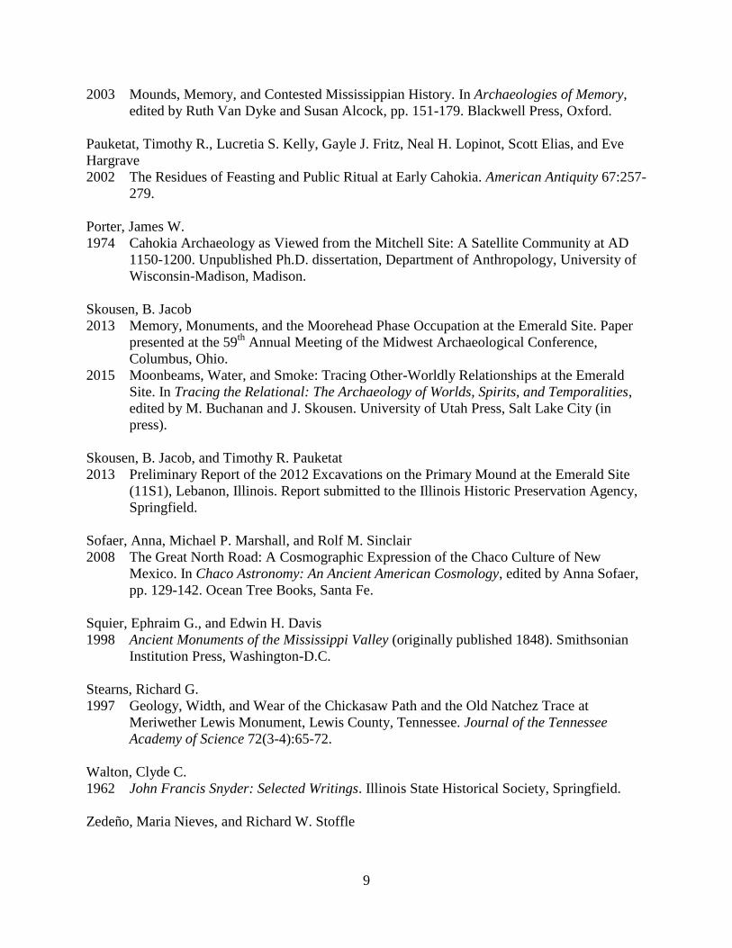
Historical documents and maps suggest that many modern highways throughout southern
Illinois were used by early European settlers and, before that, Native Americans (Boylan 1933;
Koldehoff 1996, 2014; Koldehoff and Galloy 2007; Kruchten 2012; Myer 1928) (Figure 1). It is
plausible that early versions of these roads were used during Cahokia’s heyday, as argued by
Brad Koldehoff (1996, 2014) and Jeff Kruchten (2012). While these and other associated roads
and trails would have enabled travel and communication between distant regions and groups,
some likely facilitated ritualized movements to and from special places throughout the greater
Cahokia region (Pauketat 2013; Skousen 2015; cf. Ferguson et al. 2009; Oetelaar 2012; Zedeño
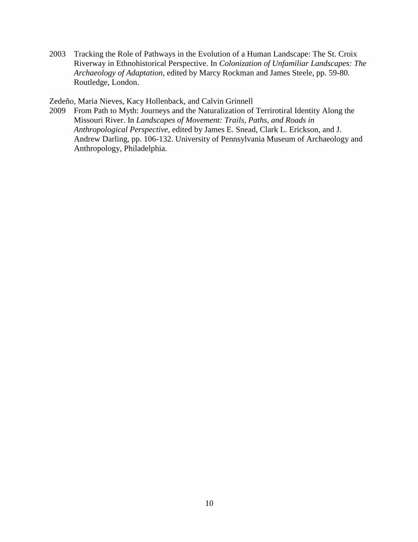
and Stoffle 2003; Zedeño et al. 2009). Timothy Pauketat (2013) has argued that one of these
hypothesized roads, dubbed “the Emerald Avenue”, converged at the Emerald site, a major
mound center 24 km east of Cahokia (Figure 2). He suggests that this road was traversed by
pilgrims coming to and from Emerald to witness rare lunar events, all of which was part of a new
Cahokian religion.
Before this summer, the presence of this road had been documented by historical
documents, a 1940 aerial photograph, and resistivity survey. However, its presence had not been
confirmed through excavation, and exactly when and how the road was constructed was unclear.
This paper describes my 2014 field investigations on this road, which consisted of magnetic
survey and targeted excavations. This work verified the presence of the road and shed light on
when and how it was constructed. I begin by reviewing past descriptions of the road. Then I
2
describe my own excavations and results, and conclude with a brief discussion on the historical
implications of these findings.
The Emerald Avenue
The Emerald Avenue was first described by John Francis Snyder in 1894 and again in
1909. His descriptions were based on the observations of local residents, who described it as “a
deeply-worn footpath”, “trail”, or “road” that led from Cahokia up the eastern bluffs and between
two “sugarloaf” mounds, across Silver Creek, and directly to Emerald’s primary mound
(Moorehead 2000:210; Pauketat 2013:108; Walton 1962:259).
In 1974, James Porter (1974:33-34) claimed to have found this same trail in old aerial
photographs of the Emerald site area. He described the trail as “a faint line” that was difficult to
follow due to modern disturbance. According to Porter, the trail ran from the primary mound
west toward Silver Creek. He also identified another part of the trail, not mentioned by Snyder,
that began south of the primary mound and ran east for an undisclosed distance.
In 1993, Brad Koldehoff, Timothy Pauketat, and John Kelly mentioned the trail during
their discussion of the Emerald site. Though they did not describe or identify the trail, they
suggested that it connected “the American Bottom to the Wabash Valley and beyond”, and that
“Emerald may have occupied a key position” along it (Koldehoff et al. 1993:333). This argument
has been reiterated by Koldehoff and Pauketat in more recent publications and presentations
(Koldehoff 1996, 2014; Pauketat 2013).
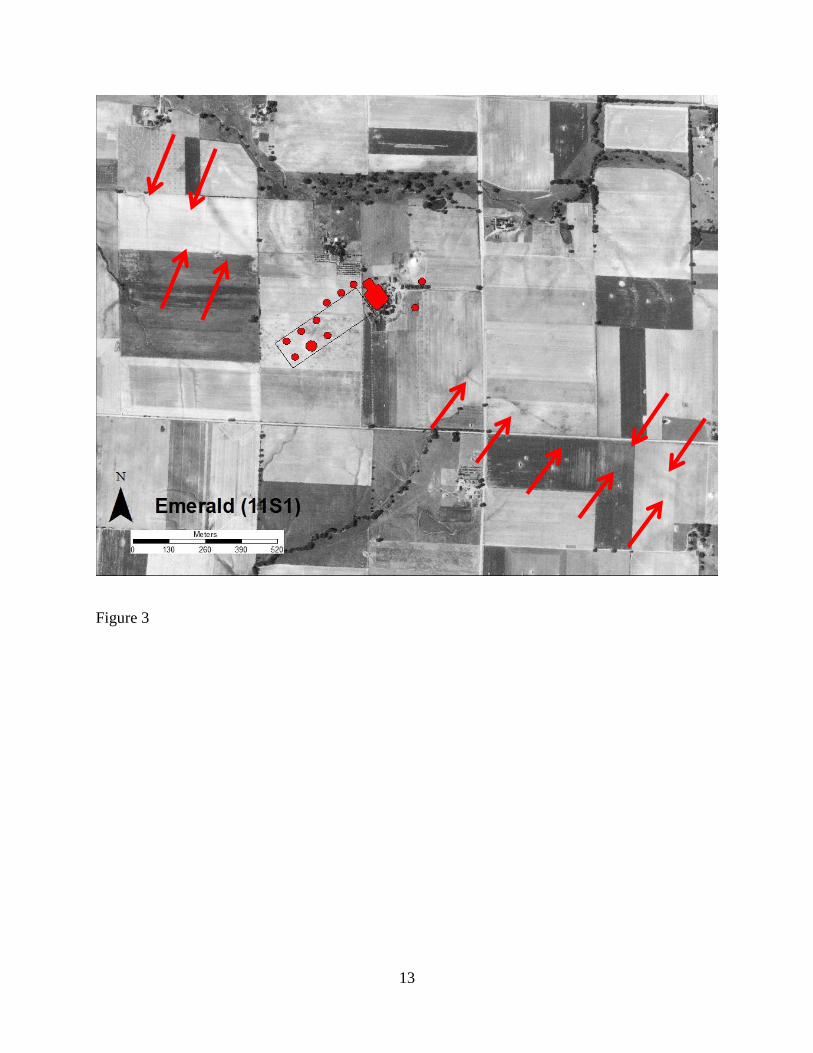
Pauketat (2013) has recently identified the roadway using a 1940 aerial photograph of the
Emerald site area (Figure 3). His findings generally correspond to Porter’s, though his
description is more detailed. According to Pauketat, the road leads from the west to the first
terrace of the primary mound; from the east, it passes south of the primary mound and seemingly
terminates at a possible plaza between the primary mound and one of Emerald’s smaller conical
mounds (Pauketat 2013:143). Furthermore, the aerial photo shows that in some places a second
line runs parallel to the original, which may represent two separate traces or the sides of a single
large road (Pauketat 2013:Figure 7.9). Resistivity survey was performed along portions of the
road in 2012, and the results revealed an anomaly about 40 cm below the surface that
corresponded to one of the lines in the aerial photo (Larson et al. 2013).
3
2014 Fieldwork
The goals of the 2014 fieldwork were to verify the presence of the road and determine
when and how it was constructed. To do this, both magnetic survey and excavations were
performed.
Magnetic Survey
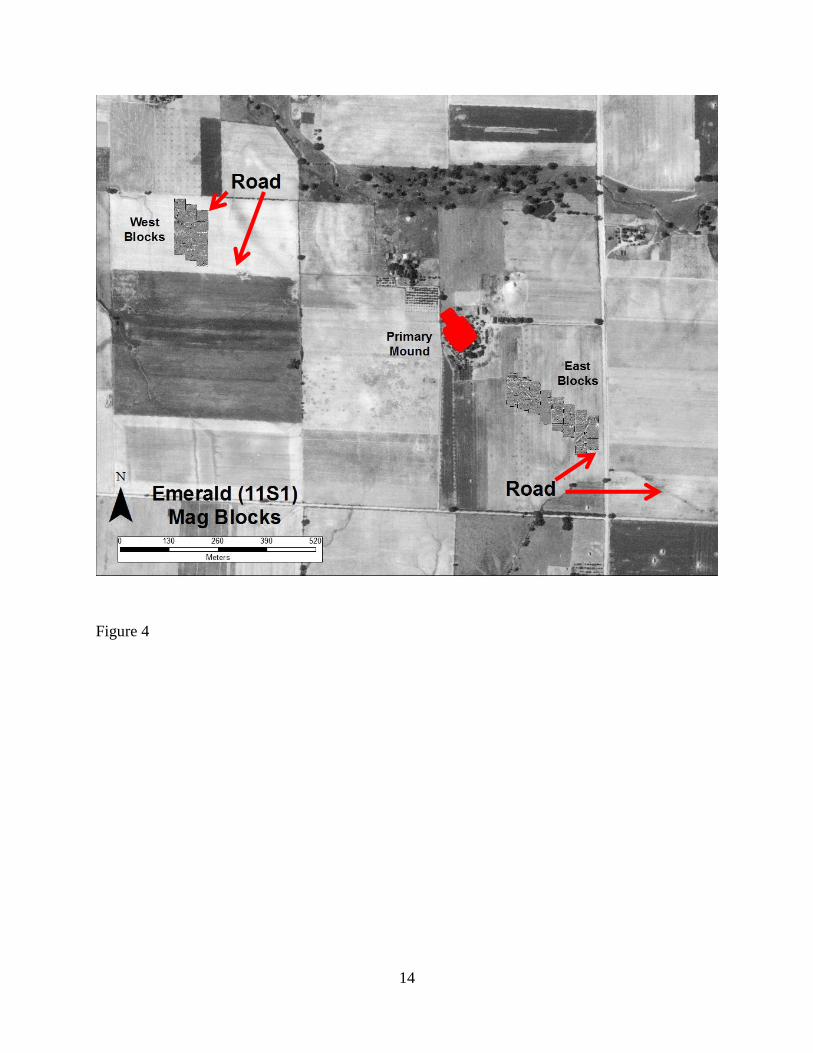
Magnetic survey was done in two areas (Figure 4). The first was situated west of the
primary mound in a place where the road was visible in the aerial photo. The position of the
survey grids was determined by georeferencing the 1940 aerial photo onto a modern one,
obtaining UTM coordinates for the corners of the grids, and finally staking out the corners using
a handheld GPS and measuring tapes. Fifteen 30 x 30 meter blocks were laid out. The magnetic
survey was performed by Liz Watts of Indiana University using a Bartington Grad-601 dual
fluxgate gradiometer, owned by Dr. Susan Alt of Indiana University.
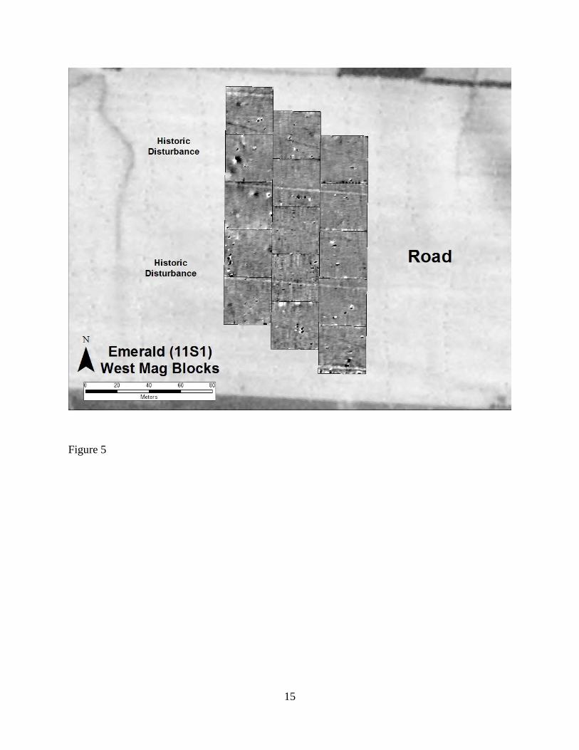
The results show two parallel lines in the northern and southern extremes of the survey
blocks (Figure 5). These match with the lines seen in the aerial photos, identified by Pauketat
(2013:Figure 7.9) as the Emerald Avenue, though they are much clearer. Importantly, another
line located between and parallel to the other two lines was also visible. Based on its position and
orientation, this third line is likely associated with the other two. If the two lines are indeed
remnants of the pre-Columbian road, this third line may represent the edge of another
contemporaneous road or an earlier or later road.
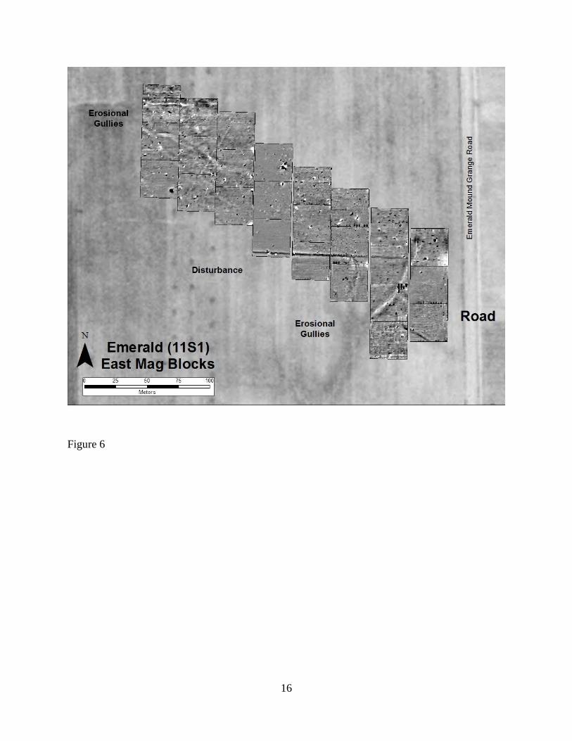
Twenty-five 30 x 30 meter blocks situated east of the primary mound were also surveyed
(Figure 6). The results, however, were not as clear as those of the west-side survey blocks. A
linear feature with a stronger signature was clearly discernable in the eastern-most blocks and
corresponded to one of the road features in the aerial photo. While some remnants may be
discernable, the feature was generally less visible in the blocks closer to the mound, due in part
to erosional gullies and historic disturbances that presumably destroyed the feature. It is also
possible that the feature had eroded away because of the steeper slope.
Excavations
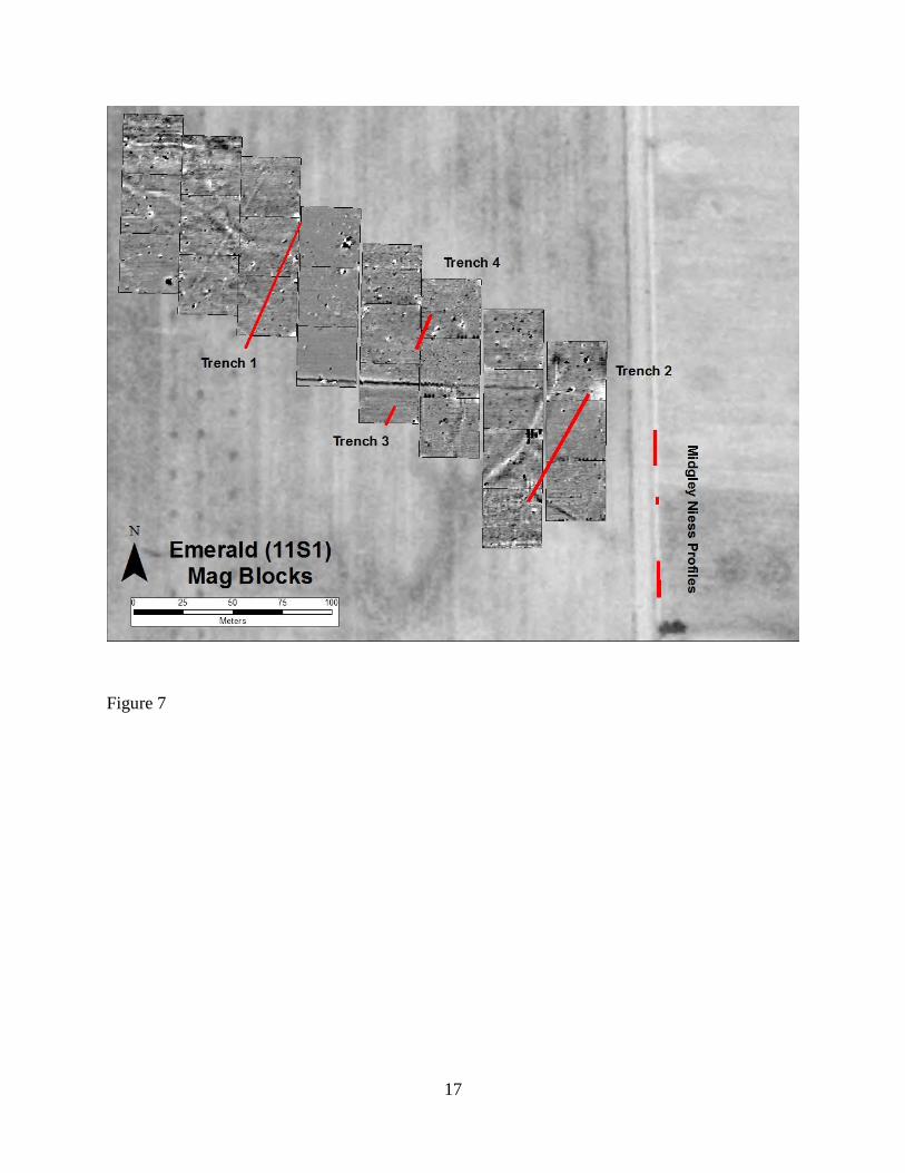
Due to land access issues, all excavations of the road took place east of the Primary
Mound (Figure 7). To obtain profiles of the road, four backhoe trenches were excavated
perpendicularly into portions of the roadway, and two discontinuous profiles were excavated
along the ditches paralleling the modern township roads.
4
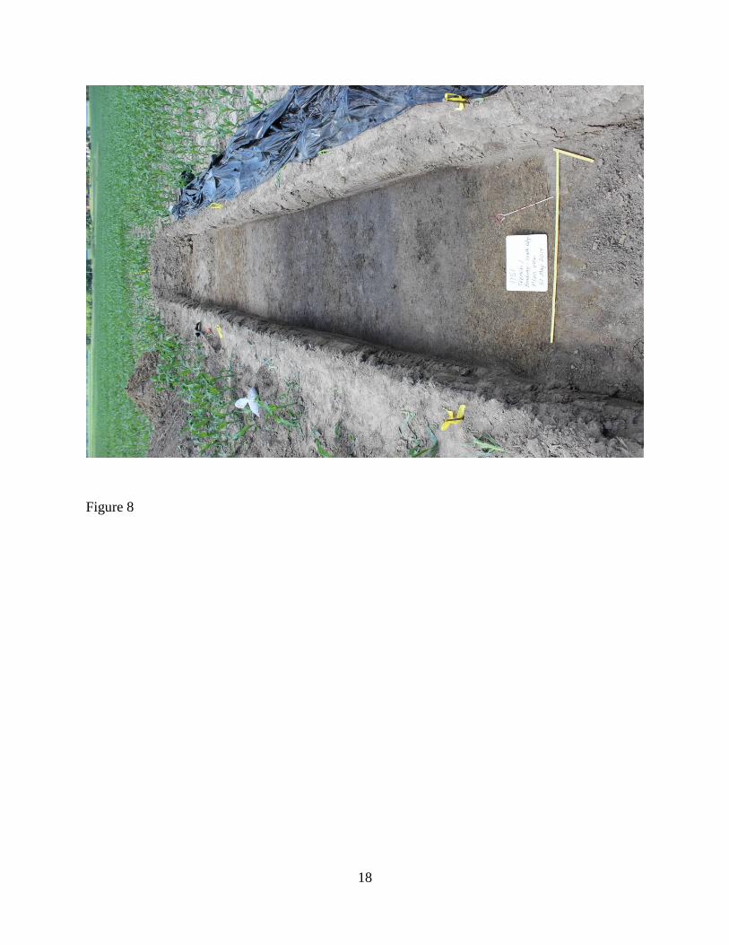
Several features identified in the four trenches corresponded to the features in the aerial
photo and magnetic survey. One of these features, found in the southern end of Trench 1, was
located just below the plow zone and measured about 4 meters wide in plan (Figure 8). The fill
was much darker near the middle of the feature with lighter fill near the edges. The fill was full
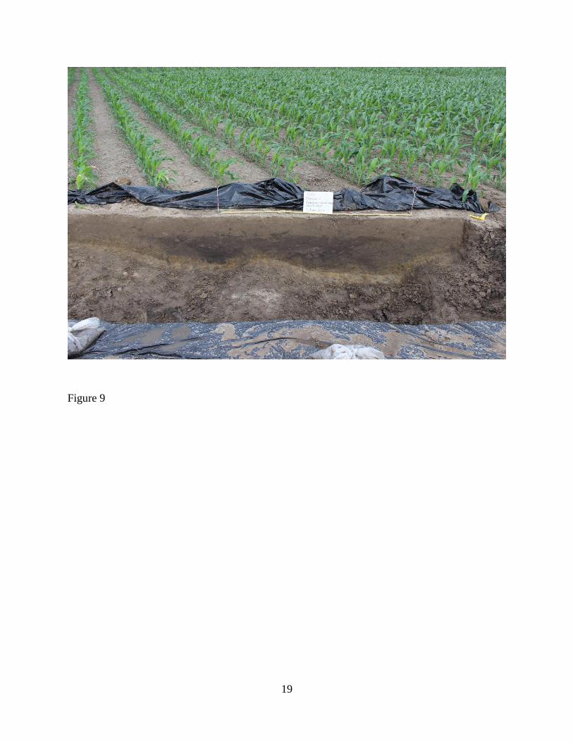
of natural manganese and iron concretions but devoid of artifacts. In profile, the feature consisted
of two inward-slanting basins (Figure 9). Both basins were approximately 1.8 meters wide; one
was 50 cm deep and the other was about 35 cm deep. Their bases were irregular due to several
narrow, square-shaped depressions at the bottom. Numerous fill zones were noted.
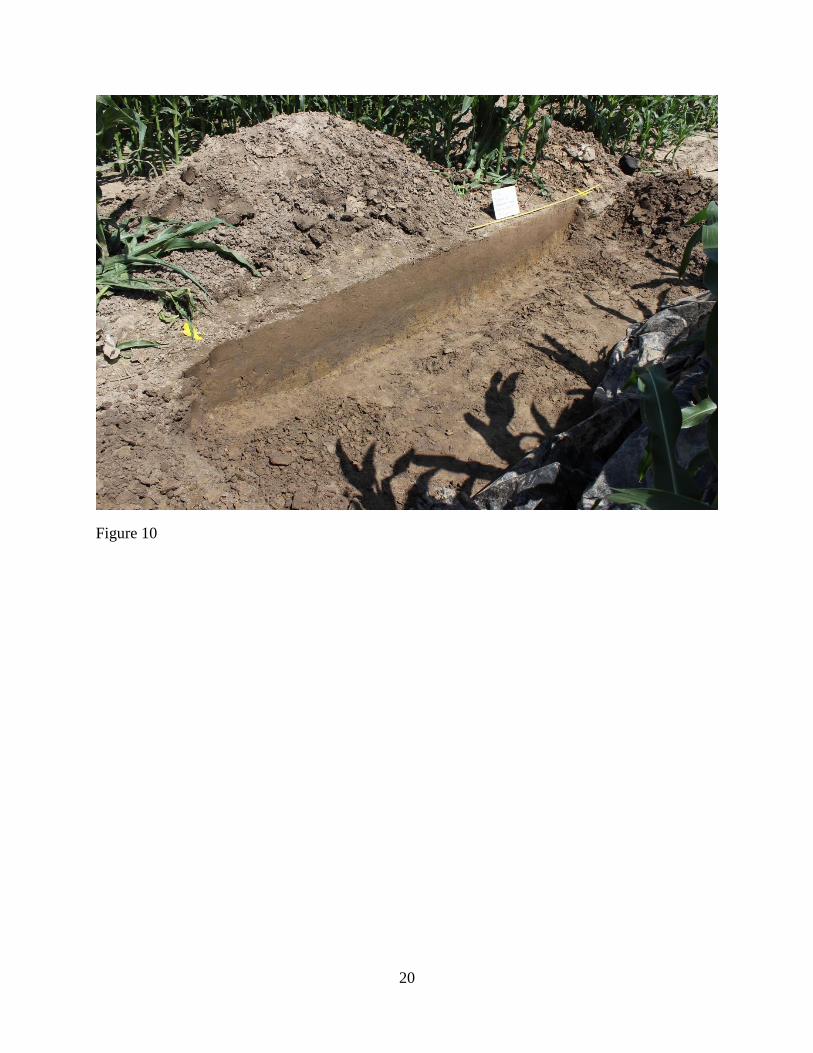
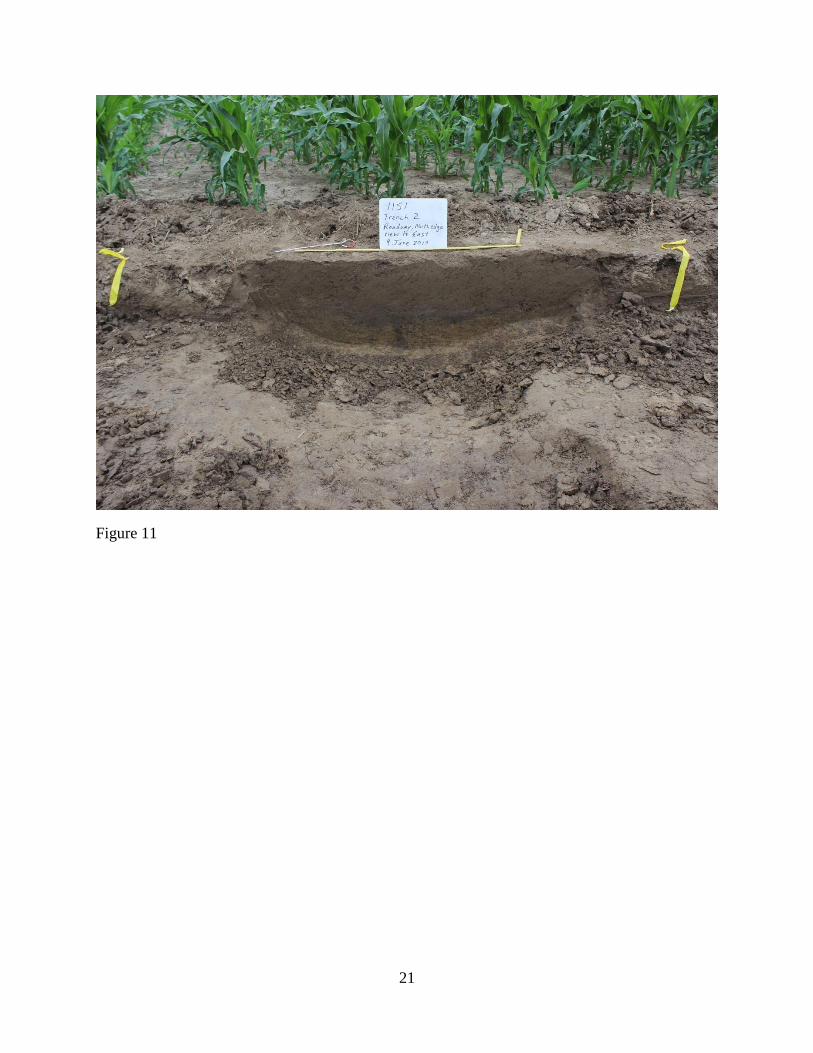
Two other similar features were found in Trench 2. The southern-most feature was 2.2
meters wide (Figure 10). In profile, the feature was an inward-slanting depression, 25 cm deep,
with square-shaped indentations in its base. The feature at the north end of Trench 2 only
measured about 65 cm in width (Figure 11). In profile, this feature was an amorphous, shallow
depression about 15 cm deep with incurving sides and an irregular bottom. No artifacts were
recovered from either of these features. Like the feature in Trench 1, both consisted of dark fill
and contained numerous manganese and iron concretions but no artifacts.
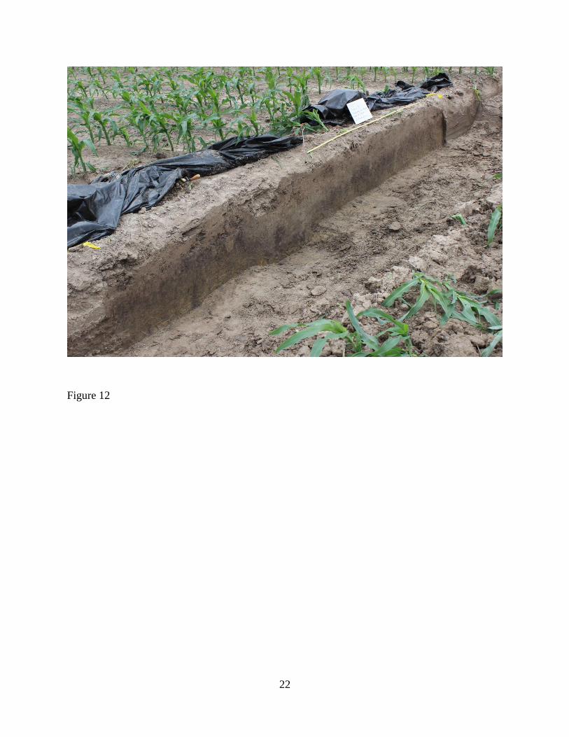
Two features were found in Trenches 3 and 4, but they did not resemble the features in
Trenches 1 or 2 (Figure 12). They were basin-shaped, but their fill was much lighter and the
depressions looked different in profile than those just described. It is unclear whether they
corresponded to the features in Trenches 1 and 2.
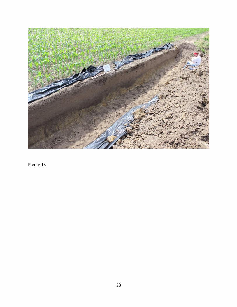
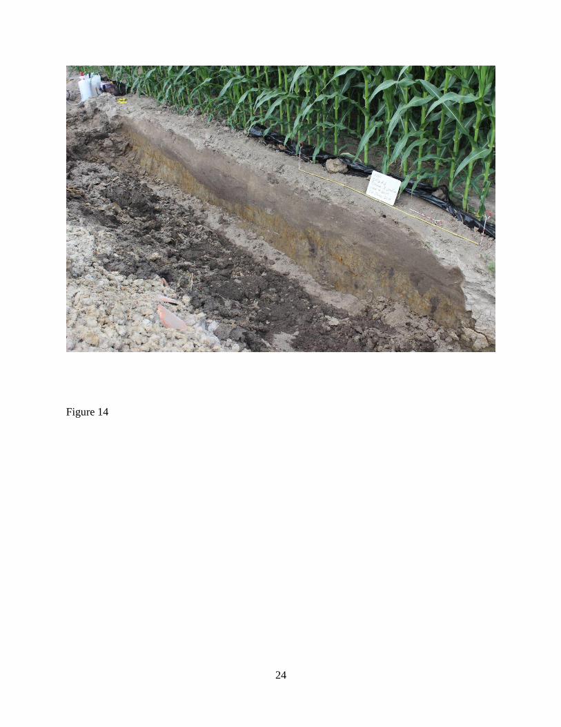
Two features were found in the profiles along one of the modern roads. The northern-
most feature consisted of two very wide, irregular-shaped basin features, each about 50 cm deep
that together measured approximately six meters across (Figure 13). The southern-most feature
consisted of only one irregular basin and was four meters wide and 35 cm deep (Figure 14). Both
contained the same dark fill, natural concretions, and irregular basins with squared-shaped
depressions in their base.
No features were found in the profiles along the other modern road. If any features were
present, they may have been plowed or eroded away. It is also possible that these profiles were
not dug in the right place due to the vagaries of georeferencing an 80 year-old aerial photo to a
modern one.
Discussion
5
The magnetic survey clearly revealed a linear feature that corresponded to the road
identified by Pauketat (2013). Excavations further verified the presence of the feature, at least in
some areas. These features appear to be a road – they seem to represent two separate,
discontinuous traces or paths, not a single large roadway. These features are not natural gullies or
drainages. For one, the aerial photo and magnetic survey show that these features are ususually
straight and cut across the natural contours of the landscape, something that would not happen
with natural gullies (see Ferguson et al. 2009; Larson et al. 2013). More importantly, the shape of
these features in profile is similar to other roads throughout North America (Agbe-Davies 2009;
Stearns 1997). The paired depressions, and especially the square-shaped ruts in the base of the
depressions, are indicative of tire or wagon tracks.
The excavations also shed light on the chronology of the road. The morphology of the
features suggests that they are remnants of a historic road, not a pre-Columbian one. If it were a
large pre-Columbian road or causeway, one might expect a raised linear feature constructed of
layers of prepared fill like the Rattlesnake Causeway at Cahokia (see Baries 2014), or a sunken
roadbed with side ditches and mounded edges, reminiscent of Hopewell roads (see Squier and
David 1998 [1848]). Instead, these features consisted of single or paired deep depressions. While
such depressions or troughs are indicative of prehistoric trails in other parts of the world (see
Ferguson et al. 2009), the features in this case are remnants of what one might expect from
continual pounding and compression by draft animals and wheeled vehicles. The square-shaped
indentations at the base of the depressions are particularly telling, as they mimic wagon ruts
associated with historic roads (see Agbe-Davies 2009; Stearns 1997). Furthermore, the width
between opposing ruts range between three and five feet, which generally corresponds to the axel
widths of wagons and carts used during the 19th
century (cf. Stearns 1997). Therefore, this road
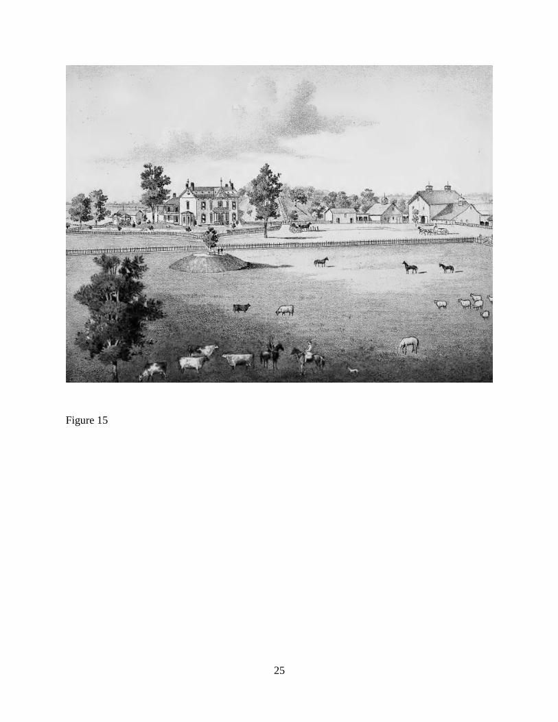
may have been associated with the home that was built into the base of the Primary Mound in
1840 (Walton 1962:260). An artist’s rendition of the homestead even depicts a wagon road
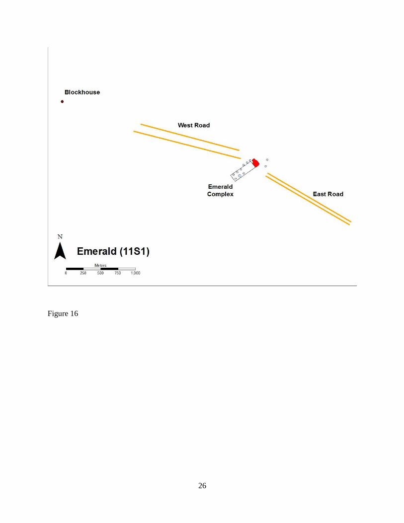
passing by the front of the house (Figure 15). Another possibility is that the road was associated
with an old fort or blockhouse located northwest of Emerald, identified on an early 19th
-century
GLO map of the area (Figure 16). However, more research is needed to verify this.
How the road was initially constructed is more difficult to determine. The depth of the
road suggests that it was formally dug, at least in some places. If the road was formally
excavated, however, its irregular and gradually-inward sloping shape shows that was not
6
maintained. Furthermore, the wide, irregular depressions and ruts may have been caused by
occasional wet conditions, which would have caused wagons and horses to slide around,
resulting in broad, uneven depressions with occasional ruts. Furthermore, the many irregular
zones suggest that the road was filled gradually in numerous erosional events, which is what one
might expect from an abandoned wagon road.
Conclusion
In this paper I have shown that magnetic survey and excavations have verified the
presence of the Emerald Avenue. However, the features identified likely represent traces of a
historic road that was used in the mid-19th
century. Does this mean that there was no pre-
Columbian road that once connected Emerald to Cahokia? Not necessarily. As discussed earlier,
historic and modern roads throughout Illinois often cover and obliterate all remnants of pre-
Columbian paths, roads, and routes. Furthermore, no excavations were performed on the western
area – the roadway in this area had a slightly different magnetic signature and thus could be
remnants of a pre-Columbian road. I plan to excavate a part of this area later this fall. Regardless,
it is reasonable to assume that this historic road followed and erased a more ancient route
associated with Emerald and Cahokia.
While indirect, this evidence for the presence of a road or trail has important implications
for Emerald’s history and purpose. Throughout native North America, regular pilgrimages to
special places via well-known trails was a way to reinforce identity and boundaries, gain
knowledge, and renew relationships with the past, landscape, ancestral spirits, and other-worldly
realms (Basso 1996; Oetelaar 2012; Pauketat 2013; Skousen 2015; Sofaer et al. 2008; Zedeño
and Stoffle 2003; Zedeño et al. 2009). Archaeological evidence, now including the evidence
presented here, suggests that something similar took place at Emerald. Architectural and ceramic
evidence from ISAS’s 1998 and 2011 excavations suggest that Emerald was occupied regularly,
perhaps at distinct intervals, during the Edelhardt and early Lohmann phase. Occupation span
estimates suggest that each occupation in this area was short lived, a few years at the most. This
area was reoccupied for a decade during the early Stirling phase and again during the Moorehead
phase (Skousen 2013). Thus, in this area at least, Emerald was periodically occupied for short
periods of time just before and during Cahokia’s florescence as well as several other times
7
throughout its history. It is also possible that these visits and occupations corresponded to lunar
standstill events that occurred every 18.6 years (Pauketat 2013).
Furthermore, the activities that took place at Emerald would have required and passed on
special knowledge, renewed relationships with the earth and sky, and required the negotiation of
disparate identities, perspectives, and histories (Pauketat 2013; Skousen 2014). According to
Katie Parker, the abundance of starchy seed cultigens throughout the site, particularly maygrass,
is suggestive of spring feasting activities (Katie Parker, personal communication, 2014; see also
Pauketat et al. 2002). Excavations into the primary mound suggest that it was built in numerous
stages that would have required large groups (Pauketat 2000; Skousen and Pauketat 2012; see
also Pauketat and Alt 2003). And certainly the building and rebuilding of structures and the
construction and renewal of mounds referenced lunar events and the memories and activities
associated with them (see Pauketat 2013). In short, the occupation history, the activities that
occurred, and the likely presence of a road or trail suggests that Emerald was a special place – a
pilgrimage center – that forged a new Cahokian identity, disseminated new practices and
cosmological principles, and created new relationships with various human and non-human
entities. All these things were foundational to Cahokia’s religion, rise, and continual formation.
References Cited
Agbe-Davis, Anna
2009 King Street, North of Block 8. Manuscript on file, University of Illinois Urbana-
Champaign.
Baires, Sarah E.
2014 Cahokia’s Rattlesnake Causeway. Midcontinental Journal of Archaeology 39(2):145-162.
Basso, Keith H.
1996 Wisdom Sits in Places: Landscape and Language Among the Western Apache. University
of New Mexico Press, Albuquerque.
Boylan, Josephine
1933 Illinois Highways, 1700-1848: Roads, Rivers, Ferries, Canals. Journal of the Illinois
State Historical Society (1908-1984) 26(1/2):5-59.
Ferguson, T. J., G. Lennis Berlin, and Leigh J. Kuwanwisiwma
2009 Kukhepya: Searching for Hopi Trails. In Landscapes of Movement: Trails, Paths, and
Roads in Anthropological Perspective, edited by James E. Snead, Clark L. Erickson, and
8
J. Andrew Darling, pp. 20-41. University of Pennsylvania Museum of Archaeology and
Anthropology, Philadelphia.
Koldehoff, Brad
1996 Transportation Corridors and Cahokia’s Hinterlands. Paper presented at the Southeastern
Archaeological Conference, Lexington, Kentucky.
2014 Transportation Corridors: Layers of Roads, Layers of History. Illinois Heritage 17(3):10-
14.
Koldehoff, Brad H., and Joseph M. Galloy
2006 Late Woodland Frontiers: Patrick Phase Settlement Along the Kaskaskia Trail, Monroe
County, Illinois. Research Reports No. 23, Illinois Transportation Archaeological
Research Program, University of Illinois Urbana-Champaign.
Koldehoff, Brad, Timothy R. Pauketat, and John E. Kelly
1993 The Emerald Site and the Mississippian Occupation of the Central Silver
Creek Valley. Illinois Archaeology 5(1&2):331-343.
Kruchten, Jeffery D.
2012 Tracing Emerald Through a Natural Landscape. Manuscript on file, University of Illinois,
Urbana-Champaign.
Larson, Timothy, Jacob Skousen, Michael DeLucia, Timothy Pauketat, and Susan Alt
2013 Resistivity Profiling to Delineate a Mississippian Culture Trail at the Emerald Site,
Southwest Illinois. Paper presented at the
Moorehead, Warren K.
2000 The Cahokia Mounds. University of Alabama Press, Tuscaloosa.
Myer, William E.
1928 Indian Trails of the Southeast. In Forty-second Annual Report of the Bureau of American
Ethnology, pp. 727-857. Smithsonian Institution, Washington, D.C.
Oetelaar, Gerald A.
2012 The Archaeological Imprint of Oral Traditions on the Landscape of Northern Plains
Hunter-Gatherers. In The Oxford Handbook of North American Archaeology, edited by
Timothy R. Pauketat, pp. 336-346. Oxford University Press, New York.
Pauketat, Timothy R.
2000 Early Cahokia Project Excavations at the Emerald Site (11-S-2). Report Submitted to the
Illinois Historic Preservation Agency, Springfield.
2013 An Archaeology of the Cosmos: Rethinking Agency and Religion in Ancient America.
Routledge, London.
Pauketat, Timothy R., and Susan M. Alt
9
2003 Mounds, Memory, and Contested Mississippian History. In Archaeologies of Memory,
edited by Ruth Van Dyke and Susan Alcock, pp. 151-179. Blackwell Press, Oxford.
Pauketat, Timothy R., Lucretia S. Kelly, Gayle J. Fritz, Neal H. Lopinot, Scott Elias, and Eve
Hargrave
2002 The Residues of Feasting and Public Ritual at Early Cahokia. American Antiquity 67:257-
279.
Porter, James W.
1974 Cahokia Archaeology as Viewed from the Mitchell Site: A Satellite Community at AD
1150-1200. Unpublished Ph.D. dissertation, Department of Anthropology, University of
Wisconsin-Madison, Madison.
Skousen, B. Jacob
2013 Memory, Monuments, and the Moorehead Phase Occupation at the Emerald Site. Paper
presented at the 59th
Annual Meeting of the Midwest Archaeological Conference,
Columbus, Ohio.
2015 Moonbeams, Water, and Smoke: Tracing Other-Worldly Relationships at the Emerald
Site. In Tracing the Relational: The Archaeology of Worlds, Spirits, and Temporalities,
edited by M. Buchanan and J. Skousen. University of Utah Press, Salt Lake City (in
press).
Skousen, B. Jacob, and Timothy R. Pauketat
2013 Preliminary Report of the 2012 Excavations on the Primary Mound at the Emerald Site
(11S1), Lebanon, Illinois. Report submitted to the Illinois Historic Preservation Agency,
Springfield.
Sofaer, Anna, Michael P. Marshall, and Rolf M. Sinclair
2008 The Great North Road: A Cosmographic Expression of the Chaco Culture of New
Mexico. In Chaco Astronomy: An Ancient American Cosmology, edited by Anna Sofaer,
pp. 129-142. Ocean Tree Books, Santa Fe.
Squier, Ephraim G., and Edwin H. Davis
1998 Ancient Monuments of the Mississippi Valley (originally published 1848). Smithsonian
Institution Press, Washington-D.C.
Stearns, Richard G.
1997 Geology, Width, and Wear of the Chickasaw Path and the Old Natchez Trace at
Meriwether Lewis Monument, Lewis County, Tennessee. Journal of the Tennessee
Academy of Science 72(3-4):65-72.
Walton, Clyde C.
1962 John Francis Snyder: Selected Writings. Illinois State Historical Society, Springfield.
Zedeño, Maria Nieves, and Richard W. Stoffle
10
2003 Tracking the Role of Pathways in the Evolution of a Human Landscape: The St. Croix
Riverway in Ethnohistorical Perspective. In Colonization of Unfamiliar Landscapes: The
Archaeology of Adaptation, edited by Marcy Rockman and James Steele, pp. 59-80.
Routledge, London.
Zedeño, Maria Nieves, Kacy Hollenback, and Calvin Grinnell
2009 From Path to Myth: Journeys and the Naturalization of Terrirotiral Identity Along the
Missouri River. In Landscapes of Movement: Trails, Paths, and Roads in
Anthropological Perspective, edited by James E. Snead, Clark L. Erickson, and J.
Andrew Darling, pp. 106-132. University of Pennsylvania Museum of Archaeology and
Anthropology, Philadelphia.
11
Figure 1
12
Figure 2
13
Figure 3
14
Figure 4
15
Figure 5
16
Figure 6
17
Figure 7
18
Figure 8
19
Figure 9
20
Figure 10
21
Figure 11
22
Figure 12
23
Figure 13
24
Figure 14
25
Figure 15
26
Figure 16
Related Documents


