Grenfell Investigation into Potential Land Contamination Impacts Stage 2 Detailed Design Royal Borough of Kensington and Chelsea Project number: 60632092 19 October 2020

Welcome message from author
This document is posted to help you gain knowledge. Please leave a comment to let me know what you think about it! Share it to your friends and learn new things together.
Transcript
Grenfell Investigation into Potential Land Contamination ImpactsStage 2 Detailed Design
Royal Borough of Kensington and Chelsea
Project number: 60632092
19 October 2020
Grenfell Investigation into Potential LandContamination Impacts
Project number: 60632092
Prepared for: Royal Borough of Kensington and Chelsea AECOM
Quality informationPrepared by Checked by Verified by Approved by
David DysonAssociate
Katie BrucePrincipal Consultant
Simon ColeTechnical Director
Liz PhilpTechnical Director
Revision History
Revision Revision date Details Authorized Name Position
Original 22 September2020
Draft Liz Philp TechnicalDirector
Rev 1 5 October 2020 Final draft Liz Philp TechnicalDirector
Rev 2 19 October 2020 Final Liz Philp TechnicalDirector
Distribution List# Hard Copies PDF Required Association / Company Name
Nil PDF MHCLG for distribution
Grenfell Investigation into Potential LandContamination Impacts
Project number: 60632092
Prepared for: Royal Borough of Kensington and Chelsea AECOM
Prepared for:Royal Borough of Kensington and Chelsea
Prepared by:David DysonProject Manager
AECOM LimitedSunley House4 Bedford Park, SurreyCroydon CRO 2APUnited Kingdom
T: +44 20 8639 3500aecom.com
This document has been prepared by AECOM Limited (“AECOM”) for sole use of our client (the“Client”) in accordance with generally accepted consultancy principles, the budget for fees and theterms of reference agreed between AECOM and the Client (Employer’s reference numberPrj_RBKC_17067 dated 25 May 2020). Any information provided by third parties and referred toherein has not been checked or verified by AECOM, unless otherwise expressly stated in thedocument. No third party may rely upon this document without the prior and express writtenagreement of AECOM.
Grenfell Investigation into Potential LandContamination Impacts
Project number: 60632092
Prepared for: Royal Borough of Kensington and Chelsea AECOM
Table of Contents1. Introduction.............................................................................................................................. 52. Factors Considered in Design of Plan ...................................................................................... 53. Sampling Approaches in Previous National or Regional Studies ............................................. 184. Sampling Strategy ................................................................................................................. 195. BS ISO 18400-101 Sampling Plan ......................................................................................... 206. Data Interpretation ................................................................................................................. 58
6.1 Data Analysis (and presentation) .................................................................................. 606.2 Preliminary Risk Assessment ....................................................................................... 616.3 Generic Quantitative Risk Assessment ......................................................................... 616.4 Detailed Quantitative Risk Assessment ........................................................................ 636.5 Part 2A Significance ..................................................................................................... 646.6 Interpretative Reporting ................................................................................................ 64
7. Reference List ....................................................................................................................... 65Appendix A Figures .......................................................................................................................... 67Appendix B Soil Sampling Protocol .................................................................................................. 68Appendix C Crop Sampling Protocol ................................................................................................ 69Appendix D Example Chain of Custody............................................................................................ 70Appendix E DQRA Checklist ............................................................................................................ 71
FiguresFigure 01. Stage 2 Sampling Areas ................................................................................................. 17
TablesTable 01. Factors considered in design of Sample Plan ..................................................................... 5Table 02. Factors considered in selecting Sampling Areas ................................................................ 9Table 03. Areas identified as sampling areas for Stage 2 Sampling .................................................. 11Table 04. SP1008 summary of UK soil survey sampling approaches ............................................... 18Table 05. Stage 2 Sampling Plan .................................................................................................... 21Table 06. Sample Locations ............................................................................................................ 26Table 07. Analytical Methods for Soil Samples ................................................................................ 51Table 08. Analytical Methods for Crop Samples ............................................................................... 56Table 09. Sample and Testing Schedule .......................................................................................... 58Table TN16-010. Prioritisation Matrix .............................................................................................. 61Table TN16-11. Contaminant linkage prioritisation using soil data* .................................................. 62
Grenfell Investigation into Potential LandContamination Impacts
Project number: 60632092
Prepared for: Royal Borough of Kensingtonand Chelsea AECOM
5
1. IntroductionThis document sets out AECOM’s proposed detailed design for the Stage 2 investigation and is basedon the objectives for Stage 2 as set out in AECOM’s Stage 1 Technical Note 18, RBKC’s tenderdocuments for Stage 2, and subsequent dialogue on scope details between AECOM and members ofthe Multi-Agency Partnership (MAP), including AECOM’s data gap review and recommendationsdiscussed with MAP at the project kick off meeting on the 9th September 2020.
The Sampling Plan set out below has been designed to reflect the relevant guidance contained withinthe following British Standards:
· BS 10175:2011+A2:2017. Investigation of potentially contaminated sites – Code of practice,British Standards Institution Publication. (British Standards Institute, 2017).
· BS ISO 18400-101:2017. Soil quality – Sampling. Part 101: Framework for the preparation andapplication of a sampling plan, British Standards Institution Publication, 2017 (British StandardsInstitute, 2017a).
· BS ISO 26367-1:2017. Guidelines for assessing the adverse environmental impact of fireeffluents. Part 1: General, British Standards Institution Publication, 2017 (British StandardsInstitute, 2017b).
· BS ISO 26367-2:2017. Guidelines for assessing the adverse environmental impact of fireeffluents. Part 2: Methodology for compiling data on environmentally significant emissions fromfires, British Standards Institution Publication, 2017 (British Standards Institute, 2017c).
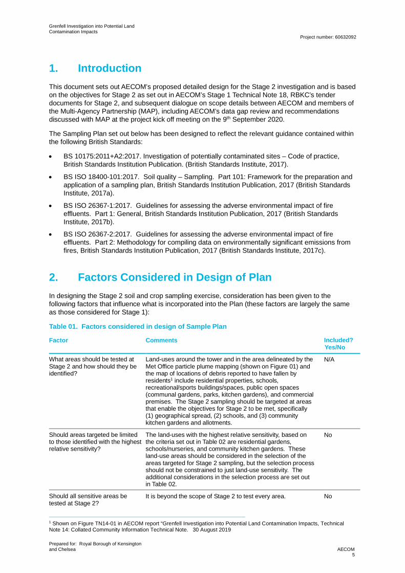
2. Factors Considered in Design of PlanIn designing the Stage 2 soil and crop sampling exercise, consideration has been given to thefollowing factors that influence what is incorporated into the Plan (these factors are largely the sameas those considered for Stage 1):
Table 01. Factors considered in design of Sample Plan
Factor Comments Included?Yes/No
What areas should be tested atStage 2 and how should they beidentified?
Land-uses around the tower and in the area delineated by theMet Office particle plume mapping (shown on Figure 01) andthe map of locations of debris reported to have fallen byresidents1 include residential properties, schools,recreational/sports buildings/spaces, public open spaces(communal gardens, parks, kitchen gardens), and commercialpremises. The Stage 2 sampling should be targeted at areasthat enable the objectives for Stage 2 to be met, specifically(1) geographical spread, (2) schools, and (3) communitykitchen gardens and allotments.
N/A
Should areas targeted be limitedto those identified with the highestrelative sensitivity?
The land-uses with the highest relative sensitivity, based onthe criteria set out in Table 02 are residential gardens,schools/nurseries, and community kitchen gardens. Theseland-use areas should be considered in the selection of theareas targeted for Stage 2 sampling, but the selection processshould not be constrained to just land-use sensitivity. Theadditional considerations in the selection process are set outin Table 02.
No
Should all sensitive areas betested at Stage 2?
It is beyond the scope of Stage 2 to test every area. No
1 Shown on Figure TN14-01 in AECOM report “Grenfell Investigation into Potential Land Contamination Impacts, TechnicalNote 14: Collated Community Information Technical Note. 30 August 2019
Grenfell Investigation into Potential LandContamination Impacts
Project number: 60632092
Prepared for: Royal Borough of Kensingtonand Chelsea AECOM
6
Factor Comments Included?Yes/No
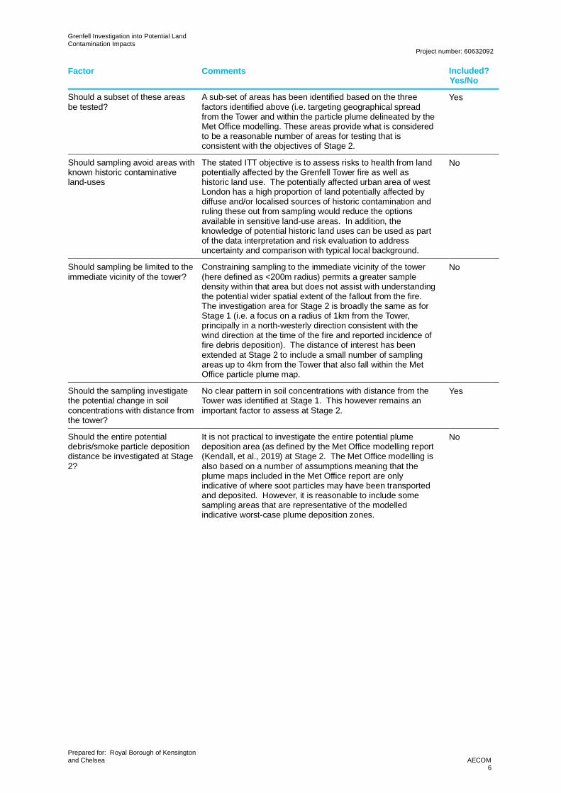
Should a subset of these areasbe tested?
A sub-set of areas has been identified based on the threefactors identified above (i.e. targeting geographical spreadfrom the Tower and within the particle plume delineated by theMet Office modelling. These areas provide what is consideredto be a reasonable number of areas for testing that isconsistent with the objectives of Stage 2.
Yes
Should sampling avoid areas withknown historic contaminativeland-uses
The stated ITT objective is to assess risks to health from landpotentially affected by the Grenfell Tower fire as well ashistoric land use. The potentially affected urban area of westLondon has a high proportion of land potentially affected bydiffuse and/or localised sources of historic contamination andruling these out from sampling would reduce the optionsavailable in sensitive land-use areas. In addition, theknowledge of potential historic land uses can be used as partof the data interpretation and risk evaluation to addressuncertainty and comparison with typical local background.
No
Should sampling be limited to theimmediate vicinity of the tower?
Constraining sampling to the immediate vicinity of the tower(here defined as <200m radius) permits a greater sampledensity within that area but does not assist with understandingthe potential wider spatial extent of the fallout from the fire.The investigation area for Stage 2 is broadly the same as forStage 1 (i.e. a focus on a radius of 1km from the Tower,principally in a north-westerly direction consistent with thewind direction at the time of the fire and reported incidence offire debris deposition). The distance of interest has beenextended at Stage 2 to include a small number of samplingareas up to 4km from the Tower that also fall within the MetOffice particle plume map.
No
Should the sampling investigatethe potential change in soilconcentrations with distance fromthe tower?
No clear pattern in soil concentrations with distance from theTower was identified at Stage 1. This however remains animportant factor to assess at Stage 2.
Yes
Should the entire potentialdebris/smoke particle depositiondistance be investigated at Stage2?
It is not practical to investigate the entire potential plumedeposition area (as defined by the Met Office modelling report(Kendall, et al., 2019) at Stage 2. The Met Office modelling isalso based on a number of assumptions meaning that theplume maps included in the Met Office report are onlyindicative of where soot particles may have been transportedand deposited. However, it is reasonable to include somesampling areas that are representative of the modelledindicative worst-case plume deposition zones.
No
Grenfell Investigation into Potential LandContamination Impacts
Project number: 60632092
Prepared for: Royal Borough of Kensingtonand Chelsea AECOM
7
Factor Comments Included?Yes/No
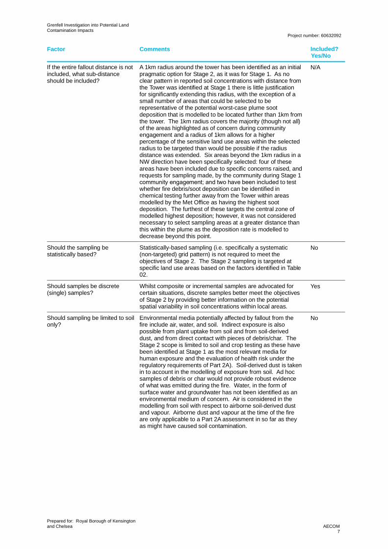
If the entire fallout distance is notincluded, what sub-distanceshould be included?
A 1km radius around the tower has been identified as an initialpragmatic option for Stage 2, as it was for Stage 1. As noclear pattern in reported soil concentrations with distance fromthe Tower was identified at Stage 1 there is little justificationfor significantly extending this radius, with the exception of asmall number of areas that could be selected to berepresentative of the potential worst-case plume sootdeposition that is modelled to be located further than 1km fromthe tower. The 1km radius covers the majority (though not all)of the areas highlighted as of concern during communityengagement and a radius of 1km allows for a higherpercentage of the sensitive land use areas within the selectedradius to be targeted than would be possible if the radiusdistance was extended. Six areas beyond the 1km radius in aNW direction have been specifically selected: four of theseareas have been included due to specific concerns raised, andrequests for sampling made, by the community during Stage 1community engagement; and two have been included to testwhether fire debris/soot deposition can be identified inchemical testing further away from the Tower within areasmodelled by the Met Office as having the highest sootdeposition. The furthest of these targets the central zone ofmodelled highest deposition; however, it was not considerednecessary to select sampling areas at a greater distance thanthis within the plume as the deposition rate is modelled todecrease beyond this point.
N/A
Should the sampling bestatistically based?
Statistically-based sampling (i.e. specifically a systematic(non-targeted) grid pattern) is not required to meet theobjectives of Stage 2. The Stage 2 sampling is targeted atspecific land use areas based on the factors identified in Table02.
No
Should samples be discrete(single) samples?
Whilst composite or incremental samples are advocated forcertain situations, discrete samples better meet the objectivesof Stage 2 by providing better information on the potentialspatial variability in soil concentrations within local areas.
Yes
Should sampling be limited to soilonly?
Environmental media potentially affected by fallout from thefire include air, water, and soil. Indirect exposure is alsopossible from plant uptake from soil and from soil-deriveddust, and from direct contact with pieces of debris/char. TheStage 2 scope is limited to soil and crop testing as these havebeen identified at Stage 1 as the most relevant media forhuman exposure and the evaluation of health risk under theregulatory requirements of Part 2A). Soil-derived dust is takenin to account in the modelling of exposure from soil. Ad hocsamples of debris or char would not provide robust evidenceof what was emitted during the fire. Water, in the form ofsurface water and groundwater has not been identified as anenvironmental medium of concern. Air is considered in themodelling from soil with respect to airborne soil-derived dustand vapour. Airborne dust and vapour at the time of the fireare only applicable to a Part 2A assessment in so far as theyas might have caused soil contamination.
No
Grenfell Investigation into Potential LandContamination Impacts
Project number: 60632092
Prepared for: Royal Borough of Kensingtonand Chelsea AECOM
8
Factor Comments Included?Yes/No
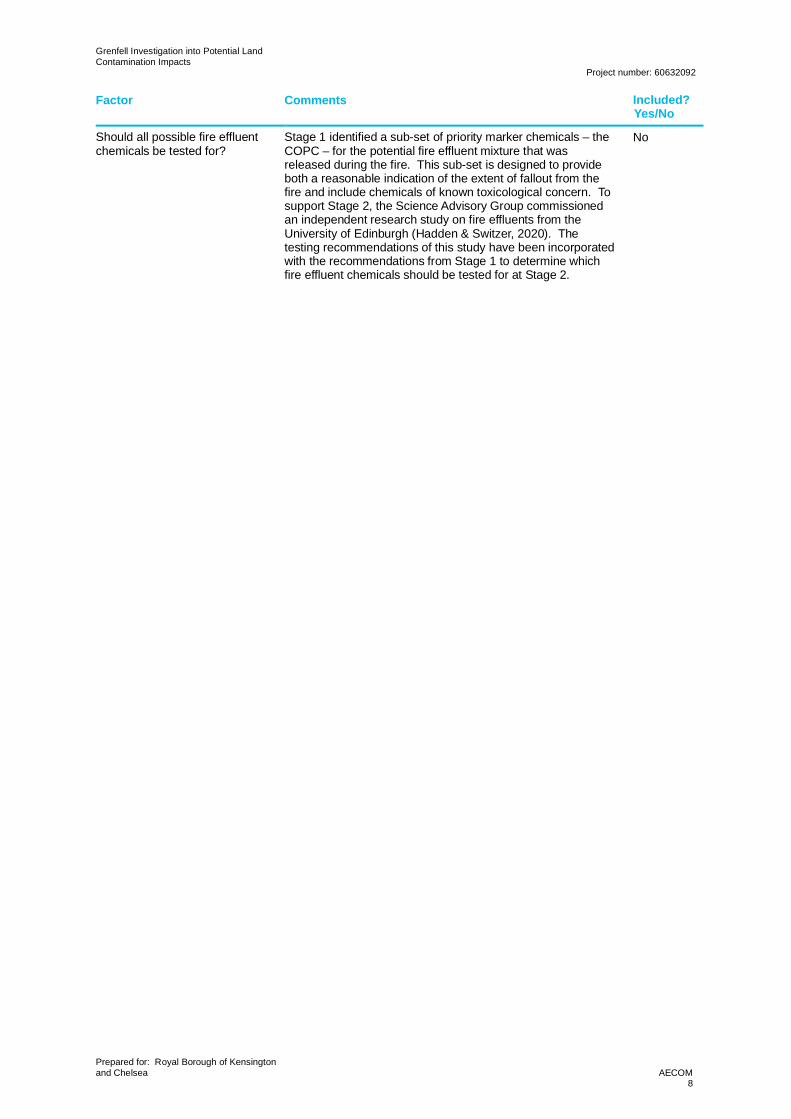
Should all possible fire effluentchemicals be tested for?
Stage 1 identified a sub-set of priority marker chemicals – theCOPC – for the potential fire effluent mixture that wasreleased during the fire. This sub-set is designed to provideboth a reasonable indication of the extent of fallout from thefire and include chemicals of known toxicological concern. Tosupport Stage 2, the Science Advisory Group commissionedan independent research study on fire effluents from theUniversity of Edinburgh (Hadden & Switzer, 2020). Thetesting recommendations of this study have been incorporatedwith the recommendations from Stage 1 to determine whichfire effluent chemicals should be tested for at Stage 2.
No
Grenfell Investigation into Potential LandContamination Impacts
Project number: 60632092
Prepared for: Royal Borough of Kensingtonand Chelsea AECOM
9
Table 02. Factors considered in selecting Sampling Areas
Factor Details
Land-use sensitivity Based on sensitivity of receptor (child vs. adult), frequency and duration of likelyexposure, and nature of land-use in the area of interest (activities undertaken andresultant contact with/exposure to soil)Land-Use Relative Sensitivity
Residential property with private garden High
Residential property without private garden High
School/nursery High
Allotments Moderate to high
Community kitchen garden Moderate to high
Communal or public open space (e.g. residentiallandscaped areas or public parks)
Moderate
Sports facilities Moderate to low
Commercial properties Low
Identified by community asan area of concern
Areas/locations identified during community engagement events during Stage 1,and community feedback during site walkovers for Stage 2 conducted in August2020, and/or previous/subsequent notification to the MHCLG community liaisonteam. Figure TN14-03 in TN142 showed areas where residents had specificallyrequested testing and Figure TN14-04 in TN142 indicated areas that residentsconsidered to have a particularly sensitive land-use. Table TN14-01 in TN142
provided a summary of concerns raised directly to MHCLG by local schools andnurseries, including specific requests for testing at some locations.
Modelled plume depositionarea
Areas within modelled extent of smoke plume as modelled by Met Office (Kendall,et al., 2019)
Reported occurrence of firedebris deposition
Areas/locations identified during community engagement events during Stage 1,and community feedback during site walkovers for Stage 2 conducted in August2020and/or previous/subsequent notification to the MHCLG community liaisonteam. Figure TN14-01 in TN142 showed areas where residents had reportedencountering debris that had fallen from the tower during the fire. The distributionof the reported debris has been used to define the extent of sampling and identifyspecific areas.
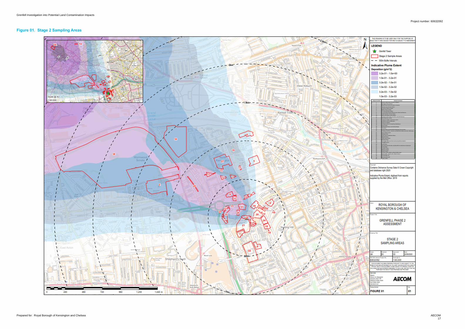
Distance from tower Potential significance of relationship between distance and particle depositionwas explored at Stage 1 and no clearly identifiable relationship was found. TheMet Office modelling results (Kendall, et al., 2019) does suggest a relationshipbetween distance and deposition rate, but the relative amount of predictedparticle deposition is not linear with distance i.e. the deposition rate does notincrease or decrease uniformly with distance away from the tower. The indicativeplume extent shown on Figure 01 indicates an areas of maximum soot particledeposition at a distance of between 3.5km and 4.5km to the northwest of thetower that would be relevant for sampling.
Ease of accessibility The Stage 2 sampling exercise is to be undertaken such that it can beviewed/witnessed by the community. Land areas chosen therefore should beeasily accessible to the public as long as the overall aims and objectives of theproject can continue be met.
Community kitchen gardens and allotments have been assigned a ‘moderate to high’ sensitivity on thebasis of the assumption of lower frequency and duration of exposure compared to the ‘high’ sensitivityassigned to schools and residential areas. This is based on the allotments Suitable 4 Use Levels(S4ULs) (Nathanail, et al., 2015) and Category 4 Screening Levels (C4SLs) (DEFRA, 2014) land-useassumptions, noting the likely potential for cultivation of such large quantities of produce as a full-scale allotments site in shared kitchen gardens is limited). The sensitivity range also indicatesuncertainty and variability with the likely exposure at these locations as a group.
2 AECOM, 30 August 2020. Grenfell Investigation into Potential Land Contamination Impacts, Technical Note 14: CollatedCommunity Information Technical Note.
Grenfell Investigation into Potential LandContamination Impacts
Project number: 60632092
Prepared for: Royal Borough of Kensingtonand Chelsea AECOM
10
The areas identified for sampling in Stage 2 are listed in Table 03 below.
Grenfell Investigation into Potential LandContamination Impacts
Project number: 60632092
Prepared for: Royal Borough of Kensingtonand Chelsea AECOM
11
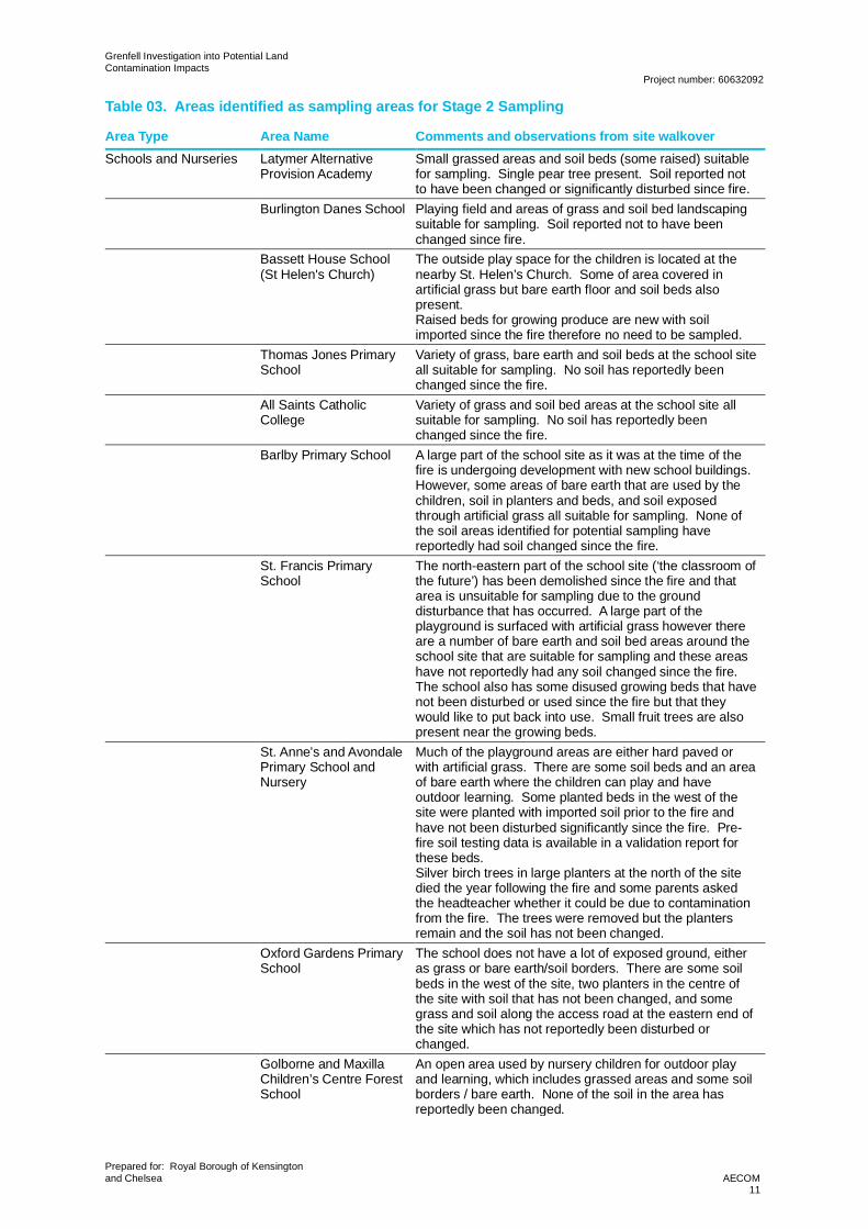
Table 03. Areas identified as sampling areas for Stage 2 Sampling
Area Type Area Name Comments and observations from site walkoverSchools and Nurseries Latymer Alternative
Provision AcademySmall grassed areas and soil beds (some raised) suitablefor sampling. Single pear tree present. Soil reported notto have been changed or significantly disturbed since fire.
Burlington Danes School Playing field and areas of grass and soil bed landscapingsuitable for sampling. Soil reported not to have beenchanged since fire.
Bassett House School(St Helen's Church)
The outside play space for the children is located at thenearby St. Helen’s Church. Some of area covered inartificial grass but bare earth floor and soil beds alsopresent.Raised beds for growing produce are new with soilimported since the fire therefore no need to be sampled.
Thomas Jones PrimarySchool
Variety of grass, bare earth and soil beds at the school siteall suitable for sampling. No soil has reportedly beenchanged since the fire.
All Saints CatholicCollege
Variety of grass and soil bed areas at the school site allsuitable for sampling. No soil has reportedly beenchanged since the fire.
Barlby Primary School A large part of the school site as it was at the time of thefire is undergoing development with new school buildings.However, some areas of bare earth that are used by thechildren, soil in planters and beds, and soil exposedthrough artificial grass all suitable for sampling. None ofthe soil areas identified for potential sampling havereportedly had soil changed since the fire.
St. Francis PrimarySchool
The north-eastern part of the school site (‘the classroom ofthe future’) has been demolished since the fire and thatarea is unsuitable for sampling due to the grounddisturbance that has occurred. A large part of theplayground is surfaced with artificial grass however thereare a number of bare earth and soil bed areas around theschool site that are suitable for sampling and these areashave not reportedly had any soil changed since the fire.The school also has some disused growing beds that havenot been disturbed or used since the fire but that theywould like to put back into use. Small fruit trees are alsopresent near the growing beds.
St. Anne’s and AvondalePrimary School andNursery
Much of the playground areas are either hard paved orwith artificial grass. There are some soil beds and an areaof bare earth where the children can play and haveoutdoor learning. Some planted beds in the west of thesite were planted with imported soil prior to the fire andhave not been disturbed significantly since the fire. Pre-fire soil testing data is available in a validation report forthese beds.Silver birch trees in large planters at the north of the sitedied the year following the fire and some parents askedthe headteacher whether it could be due to contaminationfrom the fire. The trees were removed but the plantersremain and the soil has not been changed.
Oxford Gardens PrimarySchool
The school does not have a lot of exposed ground, eitheras grass or bare earth/soil borders. There are some soilbeds in the west of the site, two planters in the centre ofthe site with soil that has not been changed, and somegrass and soil along the access road at the eastern end ofthe site which has not reportedly been disturbed orchanged.
Golborne and MaxillaChildren’s Centre ForestSchool
An open area used by nursery children for outdoor playand learning, which includes grassed areas and some soilborders / bare earth. None of the soil in the area hasreportedly been changed.
Grenfell Investigation into Potential LandContamination Impacts
Project number: 60632092
Prepared for: Royal Borough of Kensingtonand Chelsea AECOM
12
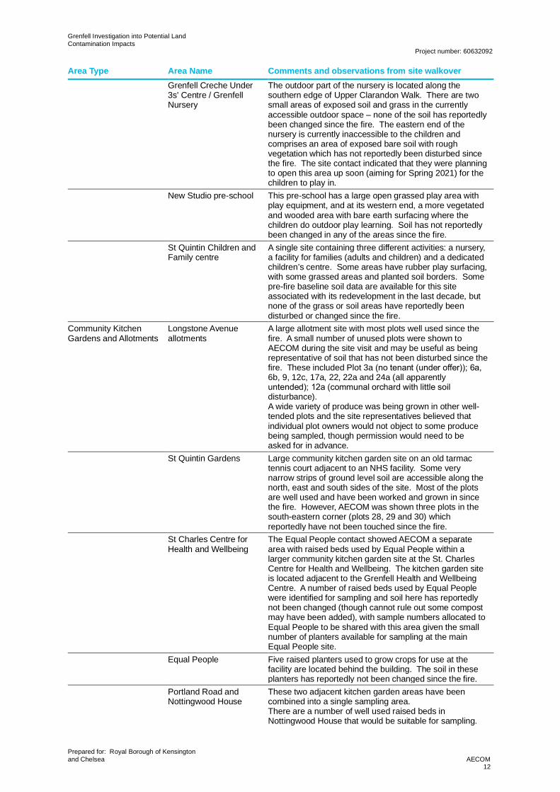
Area Type Area Name Comments and observations from site walkoverGrenfell Creche Under3s' Centre / GrenfellNursery
The outdoor part of the nursery is located along thesouthern edge of Upper Clarandon Walk. There are twosmall areas of exposed soil and grass in the currentlyaccessible outdoor space – none of the soil has reportedlybeen changed since the fire. The eastern end of thenursery is currently inaccessible to the children andcomprises an area of exposed bare soil with roughvegetation which has not reportedly been disturbed sincethe fire. The site contact indicated that they were planningto open this area up soon (aiming for Spring 2021) for thechildren to play in.
New Studio pre-school This pre-school has a large open grassed play area withplay equipment, and at its western end, a more vegetatedand wooded area with bare earth surfacing where thechildren do outdoor play learning. Soil has not reportedlybeen changed in any of the areas since the fire.
St Quintin Children andFamily centre
A single site containing three different activities: a nursery,a facility for families (adults and children) and a dedicatedchildren’s centre. Some areas have rubber play surfacing,with some grassed areas and planted soil borders. Somepre-fire baseline soil data are available for this siteassociated with its redevelopment in the last decade, butnone of the grass or soil areas have reportedly beendisturbed or changed since the fire.
Community KitchenGardens and Allotments
Longstone Avenueallotments
A large allotment site with most plots well used since thefire. A small number of unused plots were shown toAECOM during the site visit and may be useful as beingrepresentative of soil that has not been disturbed since thefire. These included Plot 3a (no tenant (under offer)); 6a, 6b, 9, 12c, 17a, 22, 22a and 24a (all apparentlyuntended); 12a (communal orchard with little soil disturbance).A wide variety of produce was being grown in other well-tended plots and the site representatives believed thatindividual plot owners would not object to some producebeing sampled, though permission would need to beasked for in advance.
St Quintin Gardens Large community kitchen garden site on an old tarmactennis court adjacent to an NHS facility. Some verynarrow strips of ground level soil are accessible along thenorth, east and south sides of the site. Most of the plotsare well used and have been worked and grown in sincethe fire. However, AECOM was shown three plots in thesouth-eastern corner (plots 28, 29 and 30) whichreportedly have not been touched since the fire.
St Charles Centre forHealth and Wellbeing
The Equal People contact showed AECOM a separatearea with raised beds used by Equal People within alarger community kitchen garden site at the St. CharlesCentre for Health and Wellbeing. The kitchen garden siteis located adjacent to the Grenfell Health and WellbeingCentre. A number of raised beds used by Equal Peoplewere identified for sampling and soil here has reportedlynot been changed (though cannot rule out some compostmay have been added), with sample numbers allocated toEqual People to be shared with this area given the smallnumber of planters available for sampling at the mainEqual People site.
Equal People Five raised planters used to grow crops for use at thefacility are located behind the building. The soil in theseplanters has reportedly not been changed since the fire.
Portland Road andNottingwood House
These two adjacent kitchen garden areas have beencombined into a single sampling area.There are a number of well used raised beds inNottingwood House that would be suitable for sampling.
Grenfell Investigation into Potential LandContamination Impacts
Project number: 60632092
Prepared for: Royal Borough of Kensingtonand Chelsea AECOM
13
Area Type Area Name Comments and observations from site walkoverPortland Road is a standalone community kitchen gardensite with a number of raised beds suitable for sampling.Although the site representative stated that they did notthink soil had been changed since the fire it is likely thatsoil improvement has been made by the addition ofcompost in some beds – but precise details are unlikely tobe available. There are also some areas of ground levelsoil where fruit shrubs are grown that are suitable forsampling.
The Grove The Grove has a community kitchen garden on the roof ofthe building. The beds have not been used this year dueto Coronavirus restrictions, however they previously havebeen well used. The soil was reported to have not beenchanged since the fire.
Combined CommunityKitchen Gardens andPublic Open Space
Eynham Road, and landbehind backing onto railtracks
This is a strip of land approximately 5 to 10m wide thatruns behind the back gardens along the full length ofEynham Road. The residents of Eynham Road lease theland from Network Rail and it was originally cleared ofvegetation and debris by the residents so it could be usedas an open space. The condition and history of the landprior to it being cleared is only known as ‘railway land’.The space is accessible to any resident along its fulllength although each resident is informally responsible forthe piece of the land behind their own garden. The land isused in a variety of ways with some play areas, somelandscaped areas, and some areas where fruit andvegetables are grown. The resident representatives werenot aware of any significant soil change being completedsince the fire, although it was acknowledged that someresidents may have added compost in areas wherevegetables were being grown.
Hurstway, Grenfell,Testerton and BarandonWalks (LancasterWalkways)
This area comprises a combination of grassed public openspace, some with soil borders. Two areas of kitchengarden growing beds are present in the northern part ofthis area; there were conflicting accounts of whether soil had been changed to any extent, although some residentsappear to at least have added some fresh compost inplaces. One resident pointed out a location where Prof.Anna Stec (Stec, et al., 2019) collected a sample beneatha tree in the growing area between Testerton Walk andHurstway Walk.More generally in the public open space there is a playarea and a separate nursery school (though this appearsto be fully hard paved)
Henry Dickens Court Includes a community kitchen garden in the north-eastcorner of the estate along with various grassed publicopen space areas with soil borders planted with shrubbery.An orchard is located in the southern central part of theestate area. A representative of the kitchen garden areawas not available at the time of the walkover, althoughvisual inspection suggested that all raised beds were wellused and therefore addition of compost since the firewould be very likely in many of the growing areas.
Silchester East Comprises the public open space areas around WhitstableHouse and Kingsnorth House, including grassed areas,planted soil beds and two separate areas of raised bedsused for growing fruit and vegetables. The raised beds tothe west of Whitstable House are the most heavily usedalthough they are not marked on RBKC GIS mapping forkitchen gardens. The mapped raised beds to the south ofWhitstable House do not appear well used and are notsecure. There was no representative of the kitchengarden areas specifically available for the walkovertherefore the extent of any potential soil change since thefire is unknown.
Grenfell Investigation into Potential LandContamination Impacts
Project number: 60632092
Prepared for: Royal Borough of Kensingtonand Chelsea AECOM
14
Area Type Area Name Comments and observations from site walkoverAllom House and BarlowHouse
Communal garden between the two residential buildingsoccupied by grassed area with raised planters well usedfor growing fruit and vegetables. The site representativewas not aware of any soil change in the raised beds,though addition of some compost since the fire seemslikely. Also raised areas planted with shrubbery and soilborders surrounding the communal area with hedge andother shrub planting.
Morland House andTalbot Grove House
Two residential buildings with courtyards containing raisedplanters used for growing fruit and vegetables. The siterepresentative was not aware of any soil change in theraised beds, though addition of some compost since thefire seems likely. Both also include landscaped openspace with planted soil beds, grass, trees (olive tree atMorland House) and a bare earth area at Morland Housewith some wood chip cover.Two neighbouring areas combined due to small area sizeof kitchen garden plots
Bramley House Raised beds well used for growing fruit and vegetables.Soil reportedly has not been changed though has likelyhad some compost and fertilizer added. One residentconcerned about potential contamination that might havebeen washed through the artificial grass surface in themain communal garden – it would be appropriate to lift acorner of this if possible and sample beneath. Narrowareas of soil beds and grass surround the building on allsides.
Kensington MemorialPark
Includes the wider public open space of the park, includingchildren’s play areas, sports pitches and decorativeplanting, as well as a small orchard and raised bed arealocated within a corner of the park. There was no specificrepresentative for the raised beds present during thewalkover however they appeared poorly used and wouldtherefore be less likely to have had a major soil change orsignificant additional of compost that other well usedgrowing beds.
Treadgold House Treadgold House has one large communal garden areathat is freely accessible from the car park as well as acommunal garden area around the front of the residentialblock which contains some soil borders and three smallraised bed planters that were used for growing fruit andvegetables. There was no specific representative for theraised beds present during the walkover however they didnot appear as well used as some growing beds in otherareas. Some soil improvement since the fire is apossibility but the extent of any such activity is unknown.
Public Open Space Verity Close Verity Close comprises a combination of low-riseresidential properties, a children’s play area, some publicopen space, and footpaths. The play area is partly hardpaved by also has an area of grass adjacent. There aresome small grassed areas in the public open space andalongside the footpaths. Some of the residential propertieshave private gardens and two of the low-rise blocks havecommunal garden areas.
Little Wormwood ScrubsIncluding EPIC CICAdventure Playground
A large area of parkland with short-mown grassed areasand areas of denser tree and shrub vegetation. There is achildren’s outdoor play area in the south-east as well as achildren’s outdoor play centre in the south-west.
Darfield Way The community kitchen garden indicated on the RBKCGIS mapping is not present and appears to be occupiedby a Traveller site. The Traveller site appears to be fullyhard paved and therefore is unsuitable for sampling.Alternative sampling areas along Darfield Way include twochildren’s play areas and the public open space park area.
Grenfell Investigation into Potential LandContamination Impacts
Project number: 60632092
Prepared for: Royal Borough of Kensingtonand Chelsea AECOM
15
Area Type Area Name Comments and observations from site walkoverLancaster Green This area comprises a grass covered public open space
with wide soil borders with shrubbery. The grassed area isin relatively poor repair with areas worn away and bareearth showing through. It was reported that no soil hasbeen changed in this area since the fire, although an areaof shrub planting at the very southern end of LancasterGreen at the point that it joins Treadgold Street hasreportedly been improved by local residents and thereforemay not be suitable for sampling.
Robinson House Residents reports that the soil in the raised beds had beencompleted changed since the fire therefore no benefit insampling. The grassed part of the public open space aswell as large soil beds in the north and south of thecommunal garden are suitable for sampling
Wesley Square The communal garden in the centre of Wesley Square hasa growing area; however, all growing is now done in a newraised plot with soil imported since the fire therefore notsuitable for sampling. A row of herb shrubs is planted insoil that has not been disturbed since the fire and otherparts of the soil borders are known to be used by childrenfor playing. The resident representatives specificallyasked for one of the private gardens at the western end ofWesley Square to be sampled as it was considered that itwas undisturbed, debris was found there, and was closestto the Tower so representative of the worst affected part ofWesley Square.
Silchester West (Northand North-West area)
This comprises mainly grassed public open space areasaround Markland House but also includes communalgardens associated with the low-rise Darfield Wayresidential properties that are also part of the SilchesterWest estate. These communal gardens have substantialsoil borders planted out with shrubs.
Maxilla Walk - MaxillaHall / Maxilla Green
This comprises a grassed piece of public open spaceoutside the Bay 20 community space with soil bordersplanted out with shrubs
Stonebridge Park The area comprises a public open space with a grassedfield, footpaths and some soil borders.
Wormwood Scrubs The area is a large open area of common land comprisinggrassed sports pitches and areas of denser woodedvegetation and shrubbery.
Currently inaccessiblepublic open space
Tower cordon The Tower cordon area comprises a mixture of roadways,temporary hard surfacing and cabins (for constructionactivities), children’s play area with rubber surfacing, andlandscaped areas with grass and soil borders (some ofwhich also have woodchip cover). The areas suitable forsampling are predominantly to the north-west, north andnorth-east of the Tower.
Based on the above, 33 areas within the 1km radius have been chosen as Stage 2 sampling areas.Three areas (Barlby Primary School, Little Wormwood Scrubs and Burlington Danes School) arelocated within 1-1.5km of the Tower and have been included following specific concerns being raised,and testing in these areas requested, during Stage 1. Three additional areas (Stonebridge Park,Longstone Avenue allotments and Wormwood Scrubs3) beyond the initial 1km radius have beenincluded to purposely target areas further away from the Tower in the direction of the smoke plumeand where the Met Office modelling has predicted that relatively higher amounts of smoke and ashparticles may have been deposited. Longstone Avenue allotments was further justified on the basisthat an allotment holder raised concerns about observed ash deposition at the time of the fire at thecommunity engagement workshop during Stage 1. These areas are identified on Figure 01 below.
3 At time of writing, sampling at this location is pending potential requirement for permissions from the Ministry of Defence andthe Old Oak and Park Royal Development Corporation (OPDC).
Grenfell Investigation into Potential LandContamination Impacts
Project number: 60632092
Prepared for: Royal Borough of Kensingtonand Chelsea AECOM
16
The locations include a combination of accessible public and private open spaces, community kitchengardens, and schools that meet a combination of one or more of the following:
· Areas within 1km of the Tower.
· Areas where debris has been reported to have fallen during the fire.
· Areas within the Met Office defined smoke particle deposition plume.
· Areas identified by the public during community engagement events or via communitycommunication channels with MHCLG.
Private gardens, although categorised as high sensitivity, have not been specifically selected assampling locations for Stage 2. Sampling every residential garden is not within the scope of Stage 2and is not necessary to establish the impact of the fire on local soil concentrations. By not prioritisingthe sampling of private gardens this avoids the situation where some private gardens are sampledand others are not and means that community observation of the sampling in the selected areas ispossible. The selected sampling areas should act as reasonable proxies for nearby residentialgardens when informing the health risk evaluation. One exception to this is the private garden thathas been chosen for sampling at Wesley Square. The garden was chosen based on communalfeedback from the Wesley Square contact as being a good location representative of potential impactat the edge of Wesley Square closest to the tower. Since it was not a request from an individualresident to have their own garden tested for personal reasons this was considered to be a reasonablelocation to include.
Grenfell Investigation into Potential Land Contamination Impacts
Project number: 60632092
Prepared for: Royal Borough of Kensington and Chelsea AECOM17
Figure 01. Stage 2 Sampling Areas
Grenfell Investigation into Potential LandContamination Impacts
Project number: 60632092
Prepared for: Royal Borough of Kensingtonand Chelsea AECOM
18
3. Sampling Approaches in Previous National orRegional Studies
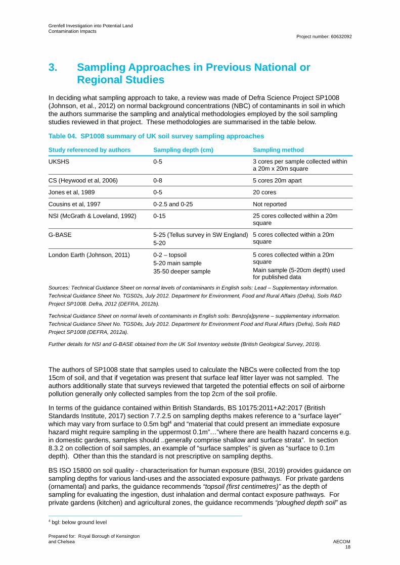
In deciding what sampling approach to take, a review was made of Defra Science Project SP1008(Johnson, et al., 2012) on normal background concentrations (NBC) of contaminants in soil in whichthe authors summarise the sampling and analytical methodologies employed by the soil samplingstudies reviewed in that project. These methodologies are summarised in the table below.
Table 04. SP1008 summary of UK soil survey sampling approaches
Study referenced by authors Sampling depth (cm) Sampling method
UKSHS 0-5 3 cores per sample collected withina 20m x 20m square
CS (Heywood et al, 2006) 0-8 5 cores 20m apart
Jones et al, 1989 0-5 20 cores
Cousins et al, 1997 0-2.5 and 0-25 Not reported
NSI (McGrath & Loveland, 1992) 0-15 25 cores collected within a 20msquare
G-BASE 5-25 (Tellus survey in SW England)5-20
5 cores collected within a 20msquare
London Earth (Johnson, 2011) 0-2 – topsoil5-20 main sample35-50 deeper sample
5 cores collected within a 20msquareMain sample (5-20cm depth) usedfor published data
Sources: Technical Guidance Sheet on normal levels of contaminants in English soils: Lead – Supplementary information.Technical Guidance Sheet No. TGS02s, July 2012. Department for Environment, Food and Rural Affairs (Defra), Soils R&DProject SP1008. Defra, 2012 (DEFRA, 2012b).
Technical Guidance Sheet on normal levels of contaminants in English soils: Benzo[a]pyrene – supplementary information.Technical Guidance Sheet No. TGS04s, July 2012. Department for Environment Food and Rural Affairs (Defra), Soils R&DProject SP1008 (DEFRA, 2012a).
Further details for NSI and G-BASE obtained from the UK Soil Inventory website (British Geological Survey, 2019).
The authors of SP1008 state that samples used to calculate the NBCs were collected from the top15cm of soil, and that if vegetation was present that surface leaf litter layer was not sampled. Theauthors additionally state that surveys reviewed that targeted the potential effects on soil of airbornepollution generally only collected samples from the top 2cm of the soil profile.
In terms of the guidance contained within British Standards, BS 10175:2011+A2:2017 (BritishStandards Institute, 2017) section 7.7.2.5 on sampling depths makes reference to a “surface layer”which may vary from surface to 0.5m bgl4 and “material that could present an immediate exposurehazard might require sampling in the uppermost 0.1m”…”where there are health hazard concerns e.g.in domestic gardens, samples should ..generally comprise shallow and surface strata”. In section8.3.2 on collection of soil samples, an example of “surface samples” is given as “surface to 0.1mdepth). Other than this the standard is not prescriptive on sampling depths.
BS ISO 15800 on soil quality - characterisation for human exposure (BSI, 2019) provides guidance onsampling depths for various land-uses and the associated exposure pathways. For private gardens(ornamental) and parks, the guidance recommends “topsoil (first centimetres)” as the depth ofsampling for evaluating the ingestion, dust inhalation and dermal contact exposure pathways. Forprivate gardens (kitchen) and agricultural zones, the guidance recommends “ploughed depth soil” as
4 bgl: below ground level
Grenfell Investigation into Potential LandContamination Impacts
Project number: 60632092
Prepared for: Royal Borough of Kensingtonand Chelsea AECOM
19
the sampling interval for soil and dust ingestion, dust inhalation and dermal contact; and recommendsthe “plant root zone” as the sampling depth for the ingestion of homegrown produce pathway.
From the above it is concluded that a sampling strategy that primarily targets the top 5cm ofundisturbed soil is appropriate for sampling soil in areas of public open space that is potentiallyimpacted from airborne deposition of fire-related smoke particles and debris where the specificpurpose is to identify whether those fire effluent chemicals are present in the soil that people are likelyto come into contact with. Sampling across a thicker horizon may be appropriate for exposurescenarios such as gardening where the top 35cm of soil might be regularly turned over, however, inthis circumstance it would be expected that the concentration of the fire effluent would be lower as thesurface deposition of those effluent chemicals has been mixed and diluted in a greater volume of soil.The counter argument is that the chemicals could have leached down through the soil column in thethree years since the fire. However, for the COPC being addressed as part of this investigation,leaching vertically through the unsaturated zone is considered unlikely to be a significant transportmechanism in a three-year time period due to their low mobility in unsaturated soil. PAHs, lead,dioxins, furans and PCBs have low solubility and relatively high affinity for the organic matter in soiland do not migrate rapidly through the soil profile.
The sampling approach will therefore be:
· The majority of soil samples where soil disturbance is minimal will be taken at 0-2cm. Thisincludes turfed areas and areas where bare soil does not appear to have been disturbed.Practically, it may be difficult to collect samples in this depth internal beneath thick turf withextensive roots and where this interval cannot be achieved the sample will be taken from 0-5cmdepth.
· In areas where some shallow soil disturbance is evident (e.g. tended decorative flower beds) thesamples will be collected from the 0-5cm depth interval.
· Where crops are grown in kitchen garden or allotment areas, the soil samples will be taken from0-20cm to reflect an approximate root zone and ploughed depth for the soil.
· A sub-set of samples will be taken at three depth intervals in five sample areas (Lancaster WestWalkways, St. Quintin’s Kitchen Garden, Longstone Avenue allotments, Eynham Road andLancaster Green). The three depth intervals will be:
─ 0-2cm (for undisturbed locations) or 0-5cm for disturbed locations.
─ 0-20cm.
─ 50-60cm.
4. Sampling StrategyThe objective of the Stage 2 soil sampling is to build on the data obtained from Stage 1 and identifywhat fire effluent COPC are present in soil and at what concentrations within the geographical area ofinterest. The detail of the exploratory sampling is provided in the form of a Sampling Plan presentedin Section 5 below.
The Stage 2 sampling strategy is designed to provide a greater level of characterisation of any onearea compared to the Stage 1 sampling and adopts a combination of sub-areas and number ofsamples within each sub-area to give sufficient data to understand variability within individual sampleareas and across the wider investigation area. It is not a sample density driven approach, but theadopted approach gives the ability to locate samples in different areas of ground cover and soil usewithin a single sampling area. To achieve this, up to ten sample locations have been identified foreach sampling area (compared to the two randomly located sample locations in each area for Stage1). Ten has been selected as a pragmatic number that enhances the assessment compared to Stage1, reduces uncertainty in typical soil concentrations, and improves the understanding of variabilitywithin each sampling area, but also across the wider investigation area.
In order to assist in the evaluation of the data, the ten samples should be located to provide someevidence of spatial variability in soil concentrations, and to provide information in areas of varying

Grenfell Investigation into Potential LandContamination Impacts
Project number: 60632092
Prepared for: Royal Borough of Kensingtonand Chelsea AECOM
20
ground cover including turf, bare soil in tended beds where some disturbance is evident or likely, andbare soil in areas likely to be substantially undisturbed since the fire. The apportionment of samplesbetween turf and bare soil is judgment-based using the walkover information.
Duplicate samples should be taken in accordance with the requirements of British Standard BS10175(British Standards Institute, 2017). Sample locations have been positioned on a systematic gridwhere possible. Where raised beds or other specific parts of a sampling area need to be tested agrid-based pattern is not possible and sample locations have been positioned to target thoseidentified sub-areas. The intended sampling areas and locations are shown in Figures A1 to A39 inAppendix A.
5. BS ISO 18400-101 Sampling PlanThe content of the Stage 2 Sampling Plan presented in Table 05 to Table 09 below reflects thesuggested items listed in Annex A of BS ISO 18400-101 (British Standards Institute, 2017a).
Grenfell Investigation into Potential LandContamination Impacts
Project number: 60632092
Prepared for: Royal Borough of Kensington and Chelsea AECOM21
Table 05. Stage 2 Sampling Plan
Item Details Reference/SupportingInformation
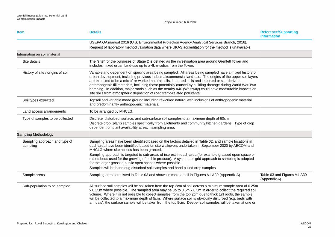
General Information
Aim of investigative programme The complete investigative programme, which includes Stage 1 and Stage 2 (and further Stages asnecessary), aims to assess to what extent the soil environment has been contaminated by fire effluents asa result of the fire at the Tower in 2017, and whether an unacceptable risk to human health (as defined byPart 2A of the Environmental Protection Act 1990 (Crown, 1990)) is associated with that contamination. Itis expected that these aims will be achieved at the end of Stage 2.
Objective for Stage 2 sampling The stated objectives for Stage 2 are to “assess risks to public health from the soil and water environmentin the area surrounding the Grenfell Tower as a result of the fire and from historical contamination byimplementing the recommendations of the Tier 1 preliminary risk assessment. The aims are to:-· Determine so far as possible the geographical extent of any significant contamination caused by the
fire whilst recognising the potential for underlying (pre-fire) contamination.· Carry out generic and detailed quantitative human health risk assessments required under Part 2A to
establish whether there are unacceptable risks to human health.· Provide recommendations in relation to the classification of all potential significant contaminant
linkages investigated as Category 1-4 in accordance with the Statutory Guidance.· Provide recommendations for whether or not any land appears to meet the definition of contaminated
land, under Part 2A.· Undertake the works in accordance with the Environment Agency’s online ‘Land Contamination: Risk
Management’ guidance.”The objective for the Stage 2 sampling is therefore to provide the soil chemistry data (and edible plantconcentration data) necessary to be able to undertake the required assessment of public health risk.Where ‘significant contamination’ is referred to in the bullet points above, this is interpreted as beingcontamination that could lead to determination of land as Contaminated Land in accordance with Part 2A.
RBKC ITT ScopeProject/Contract Information,November 2019 (002 ServiceSpecification Tier 2 and 3)
Quality assurance/quality control Use of AECOM approved laboratory in accordance with AECOM policy and procedure for the appointmentof sub-contractors.Use of a United Kingdom Accreditation Service (UKAS) accredited laboratory that participates in nationallaboratory proficiency testing schemes (AISS, CONTEST and AQUACHECK) where possible.Use of UKAS accredited methods where possible.Use of MCERTs accredited methods where possible.Use of surrogate recovery for organic analysis.Adoption of duplicate sample and duplicate sample extract analysis as per Annex D ofBS10175:2011+A2:2017 (British Standards Institute, 2017).Sample containers, preservation (chemical/temperature), sample volume, and holding times as per
Grenfell Investigation into Potential LandContamination Impacts
Project number: 60632092
Prepared for: Royal Borough of Kensington and Chelsea AECOM22
Item Details Reference/SupportingInformation
USEPA QA manual 2016 (U.S. Environmental Protection Agency Analytical Services Branch, 2016).Request of laboratory method validation data where UKAS accreditation for the method is unavailable.
Information on soil material
Site details The “site” for the purposes of Stage 2 is defined as the investigation area around Grenfell Tower andincludes mixed urban land-use up to a 4km radius from the Tower.
History of site / origins of soil Variable and dependent on specific area being sampled. All areas being sampled have a mixed history ofurban development, including previous industrial/commercial land-use. The origins of the upper soil layersare expected to be a mix of re-worked natural soils, imported soils and imported or site-derivedanthropogenic fill materials, including those potentially caused by building damage during World War Twobombing. In addition, major roads such as the nearby A40 (Westway) could have measurable impacts onsite soils from atmospheric deposition of road traffic-related pollutants.
Soil types expected Topsoil and variable made ground including reworked natural with inclusions of anthropogenic materialand predominantly anthropogenic materials.
Land access arrangements To be arranged by MHCLG.
Type of samples to be collected Discrete, disturbed, surface, and sub-surface soil samples to a maximum depth of 60cm.Discrete crop (plant) samples specifically from allotments and community kitchen gardens. Type of cropdependent on plant availability at each sampling area.
Sampling Methodology
Sampling approach and type ofsampling
Sampling areas have been identified based on the factors detailed in Table 02, and sample locations ineach area have been identified based on site walkovers undertaken in September 2020 by AECOM andMHCLG where site access has been granted.Sampling approach is targeted to sub-areas of interest in each area (for example grassed open space orraised beds used for the growing of edible produce). A systematic grid approach to sampling is adoptedfor the larger grassed public open spaces where possible.Samples will be hand dug disturbed soil samples and hand pulled crop samples.
Sample areas Sampling areas are listed in Table 03 and shown in more detail in Figures A1-A39 (Appendix A) Table 03 and Figures A1-A39(Appendix A)
Sub-population to be sampled All surface soil samples will be soil taken from the top 2cm of soil across a minimum sample area of 0.25mx 0.25m where possible. The sampled area may be up to 0.5m x 0.5m in order to collect the required soilvolume. Where it is not possible to collect samples from the top 2cm due to thick turf roots, the samplewill be collected to a maximum depth of 5cm. Where surface soil is obviously disturbed (e.g. beds withannuals), the surface sample will be taken from the top 5cm. Deeper soil samples will be taken at one or
Grenfell Investigation into Potential LandContamination Impacts
Project number: 60632092
Prepared for: Royal Borough of Kensington and Chelsea AECOM23
Item Details Reference/SupportingInformation
more of the following depth intervals dependent on the individual sampling requirements for that area:· 0-20cm· 50-60cmEdible crop samples will be selected on the basis of plant availability at the time of sampling
Sampling technique Hand dug for soil samples – refer to Appendix BSoil core sampler where VOC analysis requiredHand-pulled for crop samples – refer to Appendix C
Place and point of sampling Provisional sample locations are identified in Figures A1-A39 (Appendix A) with rationale presented inTable 06.
Figures A1-A39 (Appendix A)
Date and time of sampling To be confirmed. Currently programmed for October-November 2020
Person/organisation undertakingsampling
Competent field engineer or scientist from AECOM
Sampling equipment to be used Hand-held stainless-steel trowels, spades, fencepost scissor shovels and plastic sheeting for soil samples.Hand-held soil core for samples to be analysed for VOCsNo specific sampling equipment required for crop samples.Refer to soil and crop sampling protocols in Appendices B and C for further details of samplingmethodology.
AECOM project-specific soilsampling protocol(Appendix B) and AECOMproject-specific crop samplingprotocol (Appendix C)
Sampling scheme/pattern Random samples within targeted sub-areas or systematic grid for larger areas of grassed public openspace.
AECOM project-specific soilsampling protocol(Appendix B)
Number of increments/samples to becollected
Soil samples to be single increments of soil taken from a surface area of 25cm x 25cm at the requireddepth interval. Sample to be cone and quartered to provide well-mixed sub-samples for each laboratorysample container required for the laboratory analyses.Crop samples to be samples of individual crop types. Plants of the same type will be combined to providethe necessary sample weight required for laboratory analysis.Soil samples39 sampling areas have been identified as listed in Table 02 and shown on Figure 01. Each area, with theexceptions of Kensington Memorial Park, Equal People and St. Charles Health and Wellbeing Centre, willhave samples taken from 10 locations within its area. Samples will be collected from 20 locations withinKensington Memorial Park and from five locations at each of Equal People and the St. Charles Health andWellbeing Centre. Sample depths will be dependent on the land use, with surface samples in public openspace areas collected at 0-0.05m depth and surface samples in community kitchen garden growing bedsand allotments collected between 0-0.2m depth.
AECOM project-specific soilsampling protocol(Appendix B)
Grenfell Investigation into Potential LandContamination Impacts
Project number: 60632092
Prepared for: Royal Borough of Kensington and Chelsea AECOM24
Item Details Reference/SupportingInformation
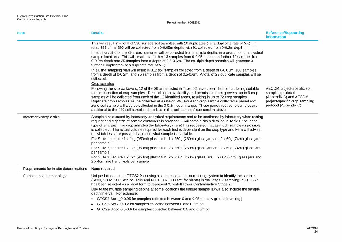
This will result in a total of 390 surface soil samples, with 20 duplicates (i.e. a duplicate rate of 5%). Intotal, 299 of the 390 will be collected from 0-0.05m depth, with 91 collected from 0-0.2m depth.In addition, at 6 of the 39 areas, samples will be collected from multiple depths in a proportion of individualsample locations. This will result in a further 13 samples from 0-0.05m depth, a further 12 samples from0-0.2m depth and 25 samples from a depth of 0.5-0.6m. The multiple depth samples will generate afurther 3 duplicates (at a duplicate rate of 5%).In all, the sampling plan will result in 312 soil samples collected from a depth of 0-0.05m, 103 samplesfrom a depth of 0-0.2m, and 25 samples from a depth of 0.5-0.6m. A total of 22 duplicate samples will becollected.Crop samplesFollowing the site walkovers, 12 of the 39 areas listed in Table 02 have been identified as being suitablefor the collection of crop samples. Depending on availability and permission from growers, up to 6 cropsamples will be collected from each of the 12 identified areas, resulting in up to 72 crop samples.Duplicate crop samples will be collected at a rate of 5%. For each crop sample collected a paired rootzone soil sample will also be collected in the 0-0.2m depth range. These paired root zone samples areadditional to the 440 soil samples described in the ‘soil samples’ sub-section above.
AECOM project-specific soilsampling protocol(Appendix B) and AECOMproject-specific crop samplingprotocol (Appendix C)
Increment/sample size Sample size dictated by laboratory analytical requirements and to be confirmed by laboratory when testingrequest and dispatch of sample containers is arranged. Soil sample sizes detailed in Table 07 for eachtype of analysis. For crop samples the laboratory (Fera) has requested that as much sample as possibleis collected. The actual volume required for each test is dependent on the crop type and Fera will adviseon which tests are possible based on what sample is available.For Suite 1, require 1 x 1kg (950ml) plastic tub, 1 x 250g (260ml) glass jars and 2 x 60g (74ml) glass jarsper sample.For Suite 2, require 1 x 1kg (950ml) plastic tub, 2 x 250g (260ml) glass jars and 2 x 60g (74ml) glass jarsper sample.For Suite 3, require 1 x 1kg (950ml) plastic tub, 2 x 250g (260ml) glass jars, 5 x 60g (74ml) glass jars and2 x 40ml methanol vials per sample.
Requirements for in-site determinations None required
Sample code methodology Unique location code GTCS2-Xxx using a simple sequential numbering system to identify the samples(S001, S002, S003 etc. for soils and P001, 002, 003 etc. for plants) in the Stage 2 sampling. “GTCS 2”has been selected as a short form to represent ‘Grenfell Tower Contamination Stage 2’.Due to the multiple sampling depths at some locations the unique sample ID will also include the sampledepth interval. For example:· GTCS2-Sxxx_0-0.05 for samples collected between 0 and 0.05m below ground level (bgl)· GTCS2-Sxxx_0-0.2 for samples collected between 0 and 0.2m bgl· GTCS2-Sxxx_0.5-0.6 for samples collected between 0.5 and 0.6m bgl
Grenfell Investigation into Potential LandContamination Impacts
Project number: 60632092
Prepared for: Royal Borough of Kensington and Chelsea AECOM25
Item Details Reference/SupportingInformation
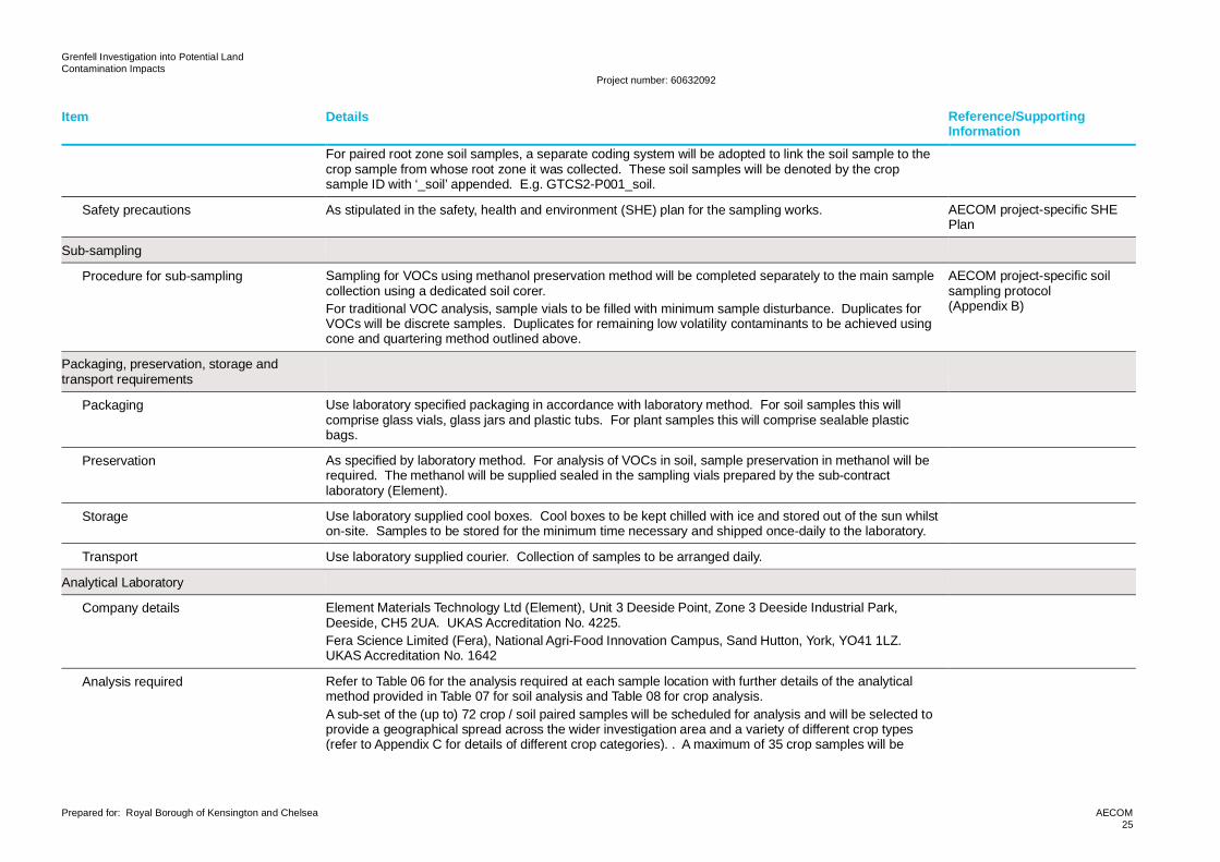
For paired root zone soil samples, a separate coding system will be adopted to link the soil sample to thecrop sample from whose root zone it was collected. These soil samples will be denoted by the cropsample ID with ‘_soil’ appended. E.g. GTCS2-P001_soil.
Safety precautions As stipulated in the safety, health and environment (SHE) plan for the sampling works. AECOM project-specific SHEPlan
Sub-sampling
Procedure for sub-sampling Sampling for VOCs using methanol preservation method will be completed separately to the main samplecollection using a dedicated soil corer.For traditional VOC analysis, sample vials to be filled with minimum sample disturbance. Duplicates forVOCs will be discrete samples. Duplicates for remaining low volatility contaminants to be achieved usingcone and quartering method outlined above.
AECOM project-specific soilsampling protocol(Appendix B)
Packaging, preservation, storage andtransport requirements
Packaging Use laboratory specified packaging in accordance with laboratory method. For soil samples this willcomprise glass vials, glass jars and plastic tubs. For plant samples this will comprise sealable plasticbags.
Preservation As specified by laboratory method. For analysis of VOCs in soil, sample preservation in methanol will berequired. The methanol will be supplied sealed in the sampling vials prepared by the sub-contractlaboratory (Element).
Storage Use laboratory supplied cool boxes. Cool boxes to be kept chilled with ice and stored out of the sun whilston-site. Samples to be stored for the minimum time necessary and shipped once-daily to the laboratory.
Transport Use laboratory supplied courier. Collection of samples to be arranged daily.
Analytical Laboratory
Company details Element Materials Technology Ltd (Element), Unit 3 Deeside Point, Zone 3 Deeside Industrial Park,Deeside, CH5 2UA. UKAS Accreditation No. 4225.Fera Science Limited (Fera), National Agri-Food Innovation Campus, Sand Hutton, York, YO41 1LZ.UKAS Accreditation No. 1642
Analysis required Refer to Table 06 for the analysis required at each sample location with further details of the analyticalmethod provided in Table 07 for soil analysis and Table 08 for crop analysis.A sub-set of the (up to) 72 crop / soil paired samples will be scheduled for analysis and will be selected toprovide a geographical spread across the wider investigation area and a variety of different crop types(refer to Appendix C for details of different crop categories). . A maximum of 35 crop samples will be
Grenfell Investigation into Potential LandContamination Impacts
Project number: 60632092
Prepared for: Royal Borough of Kensington and Chelsea AECOM26
Item Details Reference/SupportingInformation
scheduled for analysis of lead and PAHs at Fera. The paired soil root zone samples will be scheduled foranalysis of lead at Element and for analysis of PAHs at Fera.No soil bioaccessibility analysis is currently indicated in the testing schedule in Table 06. Soil samples willbe scheduled for bioaccessibility analysis following receipt of the results of the main soil sampling exerciseonce it has been determined that bioaccessibility values will be of benefit for the risk assessment stage.More detail of the decision process for scheduling soil bioaccessibility testing is included in Section 6. Upto 25 soil samples will be scheduled for bioaccessibility testing for lead and PAHs at Element.
Chain of custody requirements As per laboratory requirements. AECOM project-specificsampling protocols(Appendices B and C) andexample chain of custody(Appendix D)
Sub-contracted laboratories Sub-contracted laboratories identified by Element are:· Marchwood Scientific Services, 371 Millbrook Road West, Southampton, SO15 0HW. UKAS
Accreditation No. 1668· RPS Environmental Management Limited (RPS Mountainheath), 13 St. Martins Way, Bedford,
Bedfordshire, MK42 0LF. UKAS Accreditation No. 1663
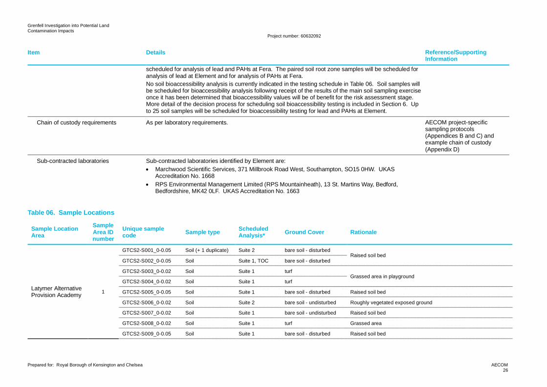
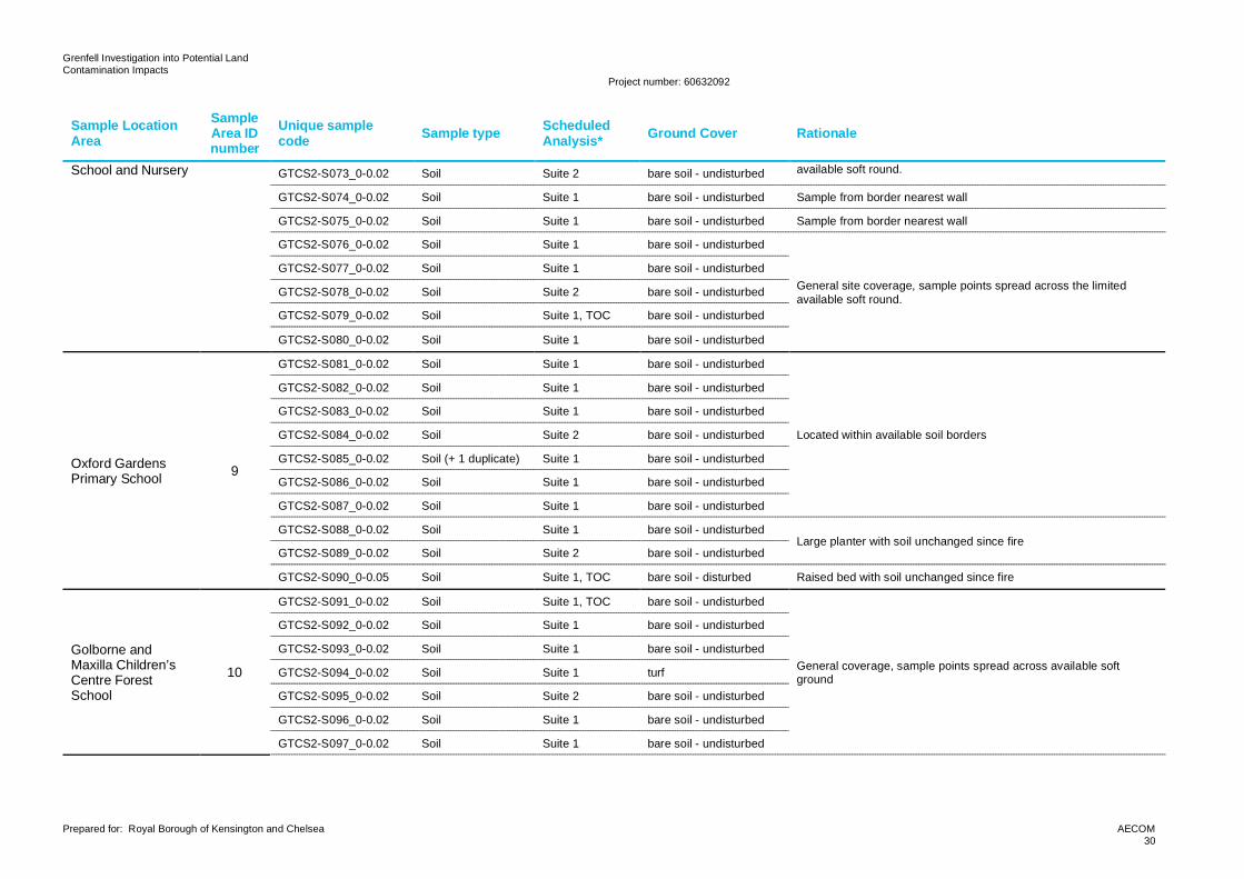
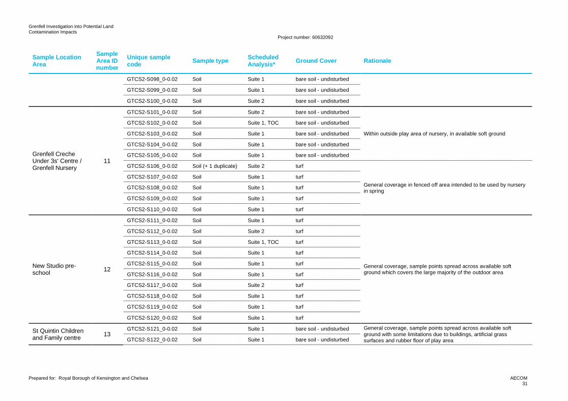
Table 06. Sample Locations
Sample LocationArea
SampleArea IDnumber
Unique samplecode Sample type Scheduled
Analysis* Ground Cover Rationale
Latymer AlternativeProvision Academy 1
GTCS2-S001_0-0.05 Soil (+ 1 duplicate) Suite 2 bare soil - disturbedRaised soil bed
GTCS2-S002_0-0.05 Soil Suite 1, TOC bare soil - disturbed
GTCS2-S003_0-0.02 Soil Suite 1 turfGrassed area in playground
GTCS2-S004_0-0.02 Soil Suite 1 turf
GTCS2-S005_0-0.05 Soil Suite 1 bare soil - disturbed Raised soil bed
GTCS2-S006_0-0.02 Soil Suite 2 bare soil - undisturbed Roughly vegetated exposed ground
GTCS2-S007_0-0.02 Soil Suite 1 bare soil - undisturbed Raised soil bed
GTCS2-S008_0-0.02 Soil Suite 1 turf Grassed area
GTCS2-S009_0-0.05 Soil Suite 1 bare soil - disturbed Raised soil bed
Grenfell Investigation into Potential LandContamination Impacts
Project number: 60632092
Prepared for: Royal Borough of Kensington and Chelsea AECOM27
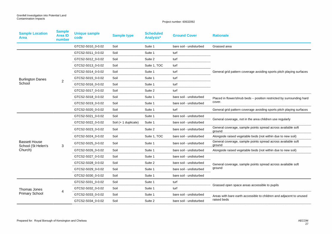
Sample LocationArea
SampleArea IDnumber
Unique samplecode Sample type Scheduled
Analysis* Ground Cover Rationale
GTCS2-S010_0-0.02 Soil Suite 1 bare soil - undisturbed Grassed area
Burlington DanesSchool 2
GTCS2-S011_0-0.02 Soil Suite 1 turf
General grid pattern coverage avoiding sports pitch playing surfaces
GTCS2-S012_0-0.02 Soil Suite 2 turf
GTCS2-S013_0-0.02 Soil Suite 1, TOC turf
GTCS2-S014_0-0.02 Soil Suite 1 turf
GTCS2-S015_0-0.02 Soil Suite 1 turf
GTCS2-S016_0-0.02 Soil Suite 1 turf
GTCS2-S017_0-0.02 Soil Suite 2 turf
GTCS2-S018_0-0.02 Soil Suite 1 bare soil - undisturbed Placed in flower/shrub beds – position restricted by surrounding hardcover.GTCS2-S019_0-0.02 Soil Suite 1 bare soil - undisturbed
GTCS2-S020_0-0.02 Soil Suite 1 turf General grid pattern coverage avoiding sports pitch playing surfaces
Bassett HouseSchool (St Helen'sChurch)
3
GTCS2-S021_0-0.02 Soil Suite 1 bare soil - undisturbedGeneral coverage, not in the area children use regularly
GTCS2-S022_0-0.02 Soil (+ 1 duplicate) Suite 1 bare soil - undisturbed
GTCS2-S023_0-0.02 Soil Suite 2 bare soil - undisturbed General coverage, sample points spread across available softground
GTCS2-S024_0-0.02 Soil Suite 1, TOC bare soil - undisturbed Alongside raised vegetable beds (not within due to new soil)
GTCS2-S025_0-0.02 Soil Suite 1 bare soil - undisturbed General coverage, sample points spread across available softground
GTCS2-S026_0-0.02 Soil Suite 1 bare soil - undisturbed Alongside raised vegetable beds (not within due to new soil)
GTCS2-S027_0-0.02 Soil Suite 1 bare soil - undisturbed
General coverage, sample points spread across available softground
GTCS2-S028_0-0.02 Soil Suite 2 bare soil - undisturbed
GTCS2-S029_0-0.02 Soil Suite 1 bare soil - undisturbed
GTCS2-S030_0-0.02 Soil Suite 1 bare soil - undisturbed
Thomas JonesPrimary School 4
GTCS2-S031_0-0.02 Soil Suite 1 turfGrassed open space areas accessible to pupils
GTCS2-S032_0-0.02 Soil Suite 1 turf
GTCS2-S033_0-0.02 Soil Suite 1 bare soil - undisturbed Areas with bare earth accessible to children and adjacent to unusedraised bedsGTCS2-S034_0-0.02 Soil Suite 2 bare soil - undisturbed
Grenfell Investigation into Potential LandContamination Impacts
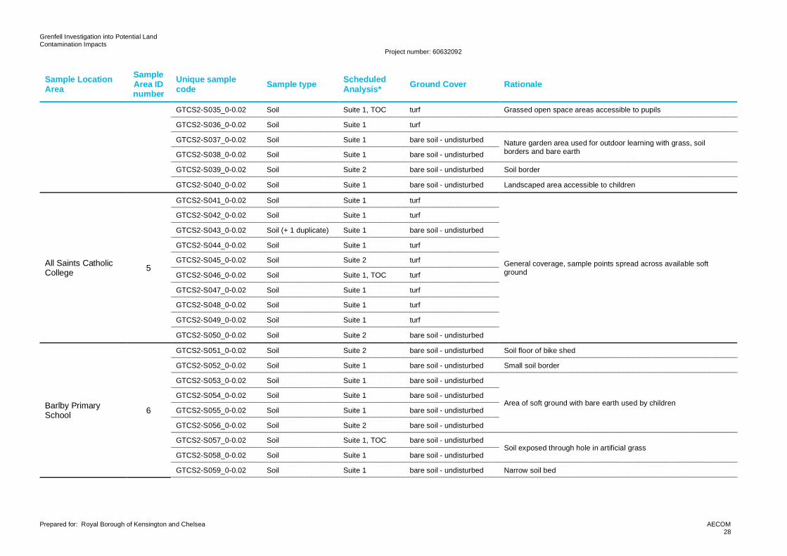
Project number: 60632092
Prepared for: Royal Borough of Kensington and Chelsea AECOM28
Sample LocationArea
SampleArea IDnumber
Unique samplecode Sample type Scheduled
Analysis* Ground Cover Rationale
GTCS2-S035_0-0.02 Soil Suite 1, TOC turf Grassed open space areas accessible to pupils
GTCS2-S036_0-0.02 Soil Suite 1 turf
GTCS2-S037_0-0.02 Soil Suite 1 bare soil - undisturbed Nature garden area used for outdoor learning with grass, soilborders and bare earthGTCS2-S038_0-0.02 Soil Suite 1 bare soil - undisturbed
GTCS2-S039_0-0.02 Soil Suite 2 bare soil - undisturbed Soil border
GTCS2-S040_0-0.02 Soil Suite 1 bare soil - undisturbed Landscaped area accessible to children
All Saints CatholicCollege 5
GTCS2-S041_0-0.02 Soil Suite 1 turf
General coverage, sample points spread across available softground
GTCS2-S042_0-0.02 Soil Suite 1 turf
GTCS2-S043_0-0.02 Soil (+ 1 duplicate) Suite 1 bare soil - undisturbed
GTCS2-S044_0-0.02 Soil Suite 1 turf
GTCS2-S045_0-0.02 Soil Suite 2 turf
GTCS2-S046_0-0.02 Soil Suite 1, TOC turf
GTCS2-S047_0-0.02 Soil Suite 1 turf
GTCS2-S048_0-0.02 Soil Suite 1 turf
GTCS2-S049_0-0.02 Soil Suite 1 turf
GTCS2-S050_0-0.02 Soil Suite 2 bare soil - undisturbed
Barlby PrimarySchool 6
GTCS2-S051_0-0.02 Soil Suite 2 bare soil - undisturbed Soil floor of bike shed
GTCS2-S052_0-0.02 Soil Suite 1 bare soil - undisturbed Small soil border
GTCS2-S053_0-0.02 Soil Suite 1 bare soil - undisturbed
Area of soft ground with bare earth used by childrenGTCS2-S054_0-0.02 Soil Suite 1 bare soil - undisturbed
GTCS2-S055_0-0.02 Soil Suite 1 bare soil - undisturbed
GTCS2-S056_0-0.02 Soil Suite 2 bare soil - undisturbed
GTCS2-S057_0-0.02 Soil Suite 1, TOC bare soil - undisturbedSoil exposed through hole in artificial grass
GTCS2-S058_0-0.02 Soil Suite 1 bare soil - undisturbed
GTCS2-S059_0-0.02 Soil Suite 1 bare soil - undisturbed Narrow soil bed
Grenfell Investigation into Potential LandContamination Impacts
Project number: 60632092
Prepared for: Royal Borough of Kensington and Chelsea AECOM29
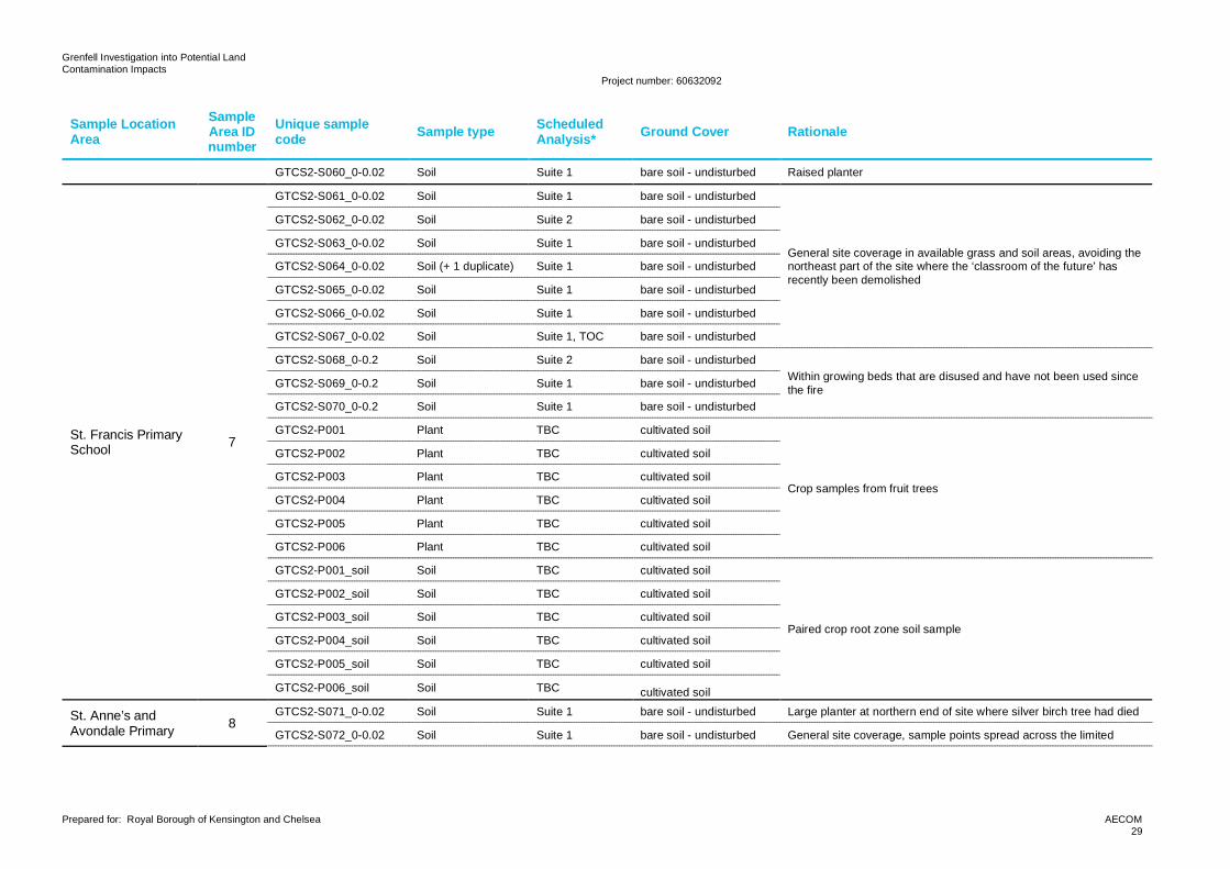
Sample LocationArea
SampleArea IDnumber
Unique samplecode Sample type Scheduled
Analysis* Ground Cover Rationale
GTCS2-S060_0-0.02 Soil Suite 1 bare soil - undisturbed Raised planter
St. Francis PrimarySchool 7
GTCS2-S061_0-0.02 Soil Suite 1 bare soil - undisturbed
General site coverage in available grass and soil areas, avoiding thenortheast part of the site where the ‘classroom of the future’ hasrecently been demolished
GTCS2-S062_0-0.02 Soil Suite 2 bare soil - undisturbed
GTCS2-S063_0-0.02 Soil Suite 1 bare soil - undisturbed
GTCS2-S064_0-0.02 Soil (+ 1 duplicate) Suite 1 bare soil - undisturbed
GTCS2-S065_0-0.02 Soil Suite 1 bare soil - undisturbed
GTCS2-S066_0-0.02 Soil Suite 1 bare soil - undisturbed
GTCS2-S067_0-0.02 Soil Suite 1, TOC bare soil - undisturbed
GTCS2-S068_0-0.2 Soil Suite 2 bare soil - undisturbedWithin growing beds that are disused and have not been used sincethe fireGTCS2-S069_0-0.2 Soil Suite 1 bare soil - undisturbed
GTCS2-S070_0-0.2 Soil Suite 1 bare soil - undisturbed
GTCS2-P001 Plant TBC cultivated soil
Crop samples from fruit trees
GTCS2-P002 Plant TBC cultivated soil
GTCS2-P003 Plant TBC cultivated soil
GTCS2-P004 Plant TBC cultivated soil
GTCS2-P005 Plant TBC cultivated soil
GTCS2-P006 Plant TBC cultivated soil
GTCS2-P001_soil Soil TBC cultivated soil
Paired crop root zone soil sample
GTCS2-P002_soil Soil TBC cultivated soil
GTCS2-P003_soil Soil TBC cultivated soil
GTCS2-P004_soil Soil TBC cultivated soil
GTCS2-P005_soil Soil TBC cultivated soil
GTCS2-P006_soil Soil TBC cultivated soil
St. Anne’s andAvondale Primary 8
GTCS2-S071_0-0.02 Soil Suite 1 bare soil - undisturbed Large planter at northern end of site where silver birch tree had died
GTCS2-S072_0-0.02 Soil Suite 1 bare soil - undisturbed General site coverage, sample points spread across the limited
Grenfell Investigation into Potential LandContamination Impacts
Project number: 60632092
Prepared for: Royal Borough of Kensington and Chelsea AECOM30
Sample LocationArea
SampleArea IDnumber
Unique samplecode Sample type Scheduled
Analysis* Ground Cover Rationale
School and Nursery GTCS2-S073_0-0.02 Soil Suite 2 bare soil - undisturbed available soft round.
GTCS2-S074_0-0.02 Soil Suite 1 bare soil - undisturbed Sample from border nearest wall
GTCS2-S075_0-0.02 Soil Suite 1 bare soil - undisturbed Sample from border nearest wall
GTCS2-S076_0-0.02 Soil Suite 1 bare soil - undisturbed
General site coverage, sample points spread across the limitedavailable soft round.
GTCS2-S077_0-0.02 Soil Suite 1 bare soil - undisturbed
GTCS2-S078_0-0.02 Soil Suite 2 bare soil - undisturbed
GTCS2-S079_0-0.02 Soil Suite 1, TOC bare soil - undisturbed
GTCS2-S080_0-0.02 Soil Suite 1 bare soil - undisturbed
Oxford GardensPrimary School 9
GTCS2-S081_0-0.02 Soil Suite 1 bare soil - undisturbed
Located within available soil borders
GTCS2-S082_0-0.02 Soil Suite 1 bare soil - undisturbed
GTCS2-S083_0-0.02 Soil Suite 1 bare soil - undisturbed
GTCS2-S084_0-0.02 Soil Suite 2 bare soil - undisturbed
GTCS2-S085_0-0.02 Soil (+ 1 duplicate) Suite 1 bare soil - undisturbed
GTCS2-S086_0-0.02 Soil Suite 1 bare soil - undisturbed
GTCS2-S087_0-0.02 Soil Suite 1 bare soil - undisturbed
GTCS2-S088_0-0.02 Soil Suite 1 bare soil - undisturbedLarge planter with soil unchanged since fire
GTCS2-S089_0-0.02 Soil Suite 2 bare soil - undisturbed
GTCS2-S090_0-0.05 Soil Suite 1, TOC bare soil - disturbed Raised bed with soil unchanged since fire
Golborne andMaxilla Children’sCentre ForestSchool
10
GTCS2-S091_0-0.02 Soil Suite 1, TOC bare soil - undisturbed
General coverage, sample points spread across available softground
GTCS2-S092_0-0.02 Soil Suite 1 bare soil - undisturbed
GTCS2-S093_0-0.02 Soil Suite 1 bare soil - undisturbed
GTCS2-S094_0-0.02 Soil Suite 1 turf
GTCS2-S095_0-0.02 Soil Suite 2 bare soil - undisturbed
GTCS2-S096_0-0.02 Soil Suite 1 bare soil - undisturbed
GTCS2-S097_0-0.02 Soil Suite 1 bare soil - undisturbed
Grenfell Investigation into Potential LandContamination Impacts
Project number: 60632092
Prepared for: Royal Borough of Kensington and Chelsea AECOM31
Sample LocationArea
SampleArea IDnumber
Unique samplecode Sample type Scheduled
Analysis* Ground Cover Rationale
GTCS2-S098_0-0.02 Soil Suite 1 bare soil - undisturbed
GTCS2-S099_0-0.02 Soil Suite 1 bare soil - undisturbed
GTCS2-S100_0-0.02 Soil Suite 2 bare soil - undisturbed
Grenfell CrecheUnder 3s' Centre /Grenfell Nursery
11
GTCS2-S101_0-0.02 Soil Suite 2 bare soil - undisturbed
Within outside play area of nursery, in available soft ground
GTCS2-S102_0-0.02 Soil Suite 1, TOC bare soil - undisturbed
GTCS2-S103_0-0.02 Soil Suite 1 bare soil - undisturbed
GTCS2-S104_0-0.02 Soil Suite 1 bare soil - undisturbed
GTCS2-S105_0-0.02 Soil Suite 1 bare soil - undisturbed
GTCS2-S106_0-0.02 Soil (+ 1 duplicate) Suite 2 turf
General coverage in fenced off area intended to be used by nurseryin spring
GTCS2-S107_0-0.02 Soil Suite 1 turf
GTCS2-S108_0-0.02 Soil Suite 1 turf
GTCS2-S109_0-0.02 Soil Suite 1 turf
GTCS2-S110_0-0.02 Soil Suite 1 turf
New Studio pre-school 12
GTCS2-S111_0-0.02 Soil Suite 1 turf
General coverage, sample points spread across available softground which covers the large majority of the outdoor area
GTCS2-S112_0-0.02 Soil Suite 2 turf
GTCS2-S113_0-0.02 Soil Suite 1, TOC turf
GTCS2-S114_0-0.02 Soil Suite 1 turf
GTCS2-S115_0-0.02 Soil Suite 1 turf
GTCS2-S116_0-0.02 Soil Suite 1 turf
GTCS2-S117_0-0.02 Soil Suite 2 turf
GTCS2-S118_0-0.02 Soil Suite 1 turf
GTCS2-S119_0-0.02 Soil Suite 1 turf
GTCS2-S120_0-0.02 Soil Suite 1 turf
St Quintin Childrenand Family centre 13
GTCS2-S121_0-0.02 Soil Suite 1 bare soil - undisturbed General coverage, sample points spread across available softground with some limitations due to buildings, artificial grasssurfaces and rubber floor of play areaGTCS2-S122_0-0.02 Soil Suite 1 bare soil - undisturbed
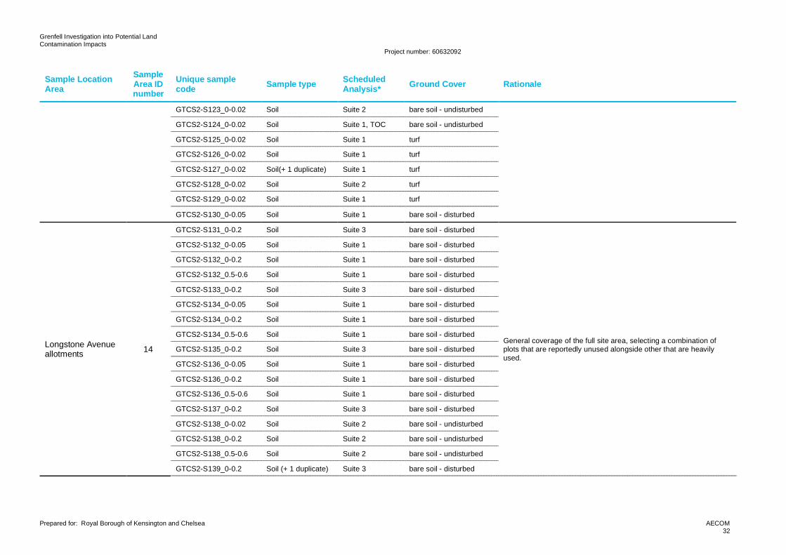
Grenfell Investigation into Potential LandContamination Impacts
Project number: 60632092
Prepared for: Royal Borough of Kensington and Chelsea AECOM32
Sample LocationArea
SampleArea IDnumber
Unique samplecode Sample type Scheduled
Analysis* Ground Cover Rationale
GTCS2-S123_0-0.02 Soil Suite 2 bare soil - undisturbed
GTCS2-S124_0-0.02 Soil Suite 1, TOC bare soil - undisturbed
GTCS2-S125_0-0.02 Soil Suite 1 turf
GTCS2-S126_0-0.02 Soil Suite 1 turf
GTCS2-S127_0-0.02 Soil(+ 1 duplicate) Suite 1 turf
GTCS2-S128_0-0.02 Soil Suite 2 turf
GTCS2-S129_0-0.02 Soil Suite 1 turf
GTCS2-S130_0-0.05 Soil Suite 1 bare soil - disturbed
Longstone Avenueallotments 14
GTCS2-S131_0-0.2 Soil Suite 3 bare soil - disturbed
General coverage of the full site area, selecting a combination ofplots that are reportedly unused alongside other that are heavilyused.
GTCS2-S132_0-0.05 Soil Suite 1 bare soil - disturbed
GTCS2-S132_0-0.2 Soil Suite 1 bare soil - disturbed
GTCS2-S132_0.5-0.6 Soil Suite 1 bare soil - disturbed
GTCS2-S133_0-0.2 Soil Suite 3 bare soil - disturbed
GTCS2-S134_0-0.05 Soil Suite 1 bare soil - disturbed
GTCS2-S134_0-0.2 Soil Suite 1 bare soil - disturbed
GTCS2-S134_0.5-0.6 Soil Suite 1 bare soil - disturbed
GTCS2-S135_0-0.2 Soil Suite 3 bare soil - disturbed
GTCS2-S136_0-0.05 Soil Suite 1 bare soil - disturbed
GTCS2-S136_0-0.2 Soil Suite 1 bare soil - disturbed
GTCS2-S136_0.5-0.6 Soil Suite 1 bare soil - disturbed
GTCS2-S137_0-0.2 Soil Suite 3 bare soil - disturbed
GTCS2-S138_0-0.02 Soil Suite 2 bare soil - undisturbed
GTCS2-S138_0-0.2 Soil Suite 2 bare soil - undisturbed
GTCS2-S138_0.5-0.6 Soil Suite 2 bare soil - undisturbed
GTCS2-S139_0-0.2 Soil (+ 1 duplicate) Suite 3 bare soil - disturbed
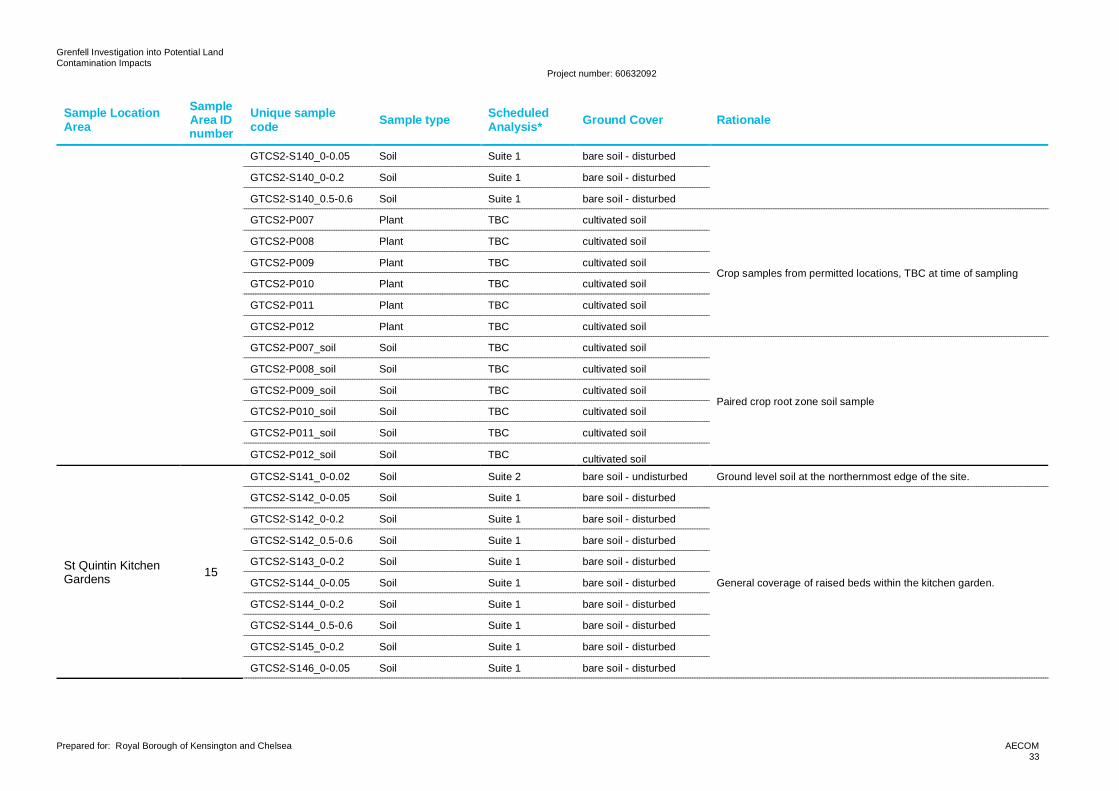
Grenfell Investigation into Potential LandContamination Impacts
Project number: 60632092
Prepared for: Royal Borough of Kensington and Chelsea AECOM33
Sample LocationArea
SampleArea IDnumber
Unique samplecode Sample type Scheduled
Analysis* Ground Cover Rationale
GTCS2-S140_0-0.05 Soil Suite 1 bare soil - disturbed
GTCS2-S140_0-0.2 Soil Suite 1 bare soil - disturbed
GTCS2-S140_0.5-0.6 Soil Suite 1 bare soil - disturbed
GTCS2-P007 Plant TBC cultivated soil
Crop samples from permitted locations, TBC at time of sampling
GTCS2-P008 Plant TBC cultivated soil
GTCS2-P009 Plant TBC cultivated soil
GTCS2-P010 Plant TBC cultivated soil
GTCS2-P011 Plant TBC cultivated soil
GTCS2-P012 Plant TBC cultivated soil
GTCS2-P007_soil Soil TBC cultivated soil
Paired crop root zone soil sample
GTCS2-P008_soil Soil TBC cultivated soil
GTCS2-P009_soil Soil TBC cultivated soil
GTCS2-P010_soil Soil TBC cultivated soil
GTCS2-P011_soil Soil TBC cultivated soil
GTCS2-P012_soil Soil TBC cultivated soil
St Quintin KitchenGardens 15
GTCS2-S141_0-0.02 Soil Suite 2 bare soil - undisturbed Ground level soil at the northernmost edge of the site.
GTCS2-S142_0-0.05 Soil Suite 1 bare soil - disturbed
General coverage of raised beds within the kitchen garden.
GTCS2-S142_0-0.2 Soil Suite 1 bare soil - disturbed
GTCS2-S142_0.5-0.6 Soil Suite 1 bare soil - disturbed
GTCS2-S143_0-0.2 Soil Suite 1 bare soil - disturbed
GTCS2-S144_0-0.05 Soil Suite 1 bare soil - disturbed
GTCS2-S144_0-0.2 Soil Suite 1 bare soil - disturbed
GTCS2-S144_0.5-0.6 Soil Suite 1 bare soil - disturbed
GTCS2-S145_0-0.2 Soil Suite 1 bare soil - disturbed
GTCS2-S146_0-0.05 Soil Suite 1 bare soil - disturbed
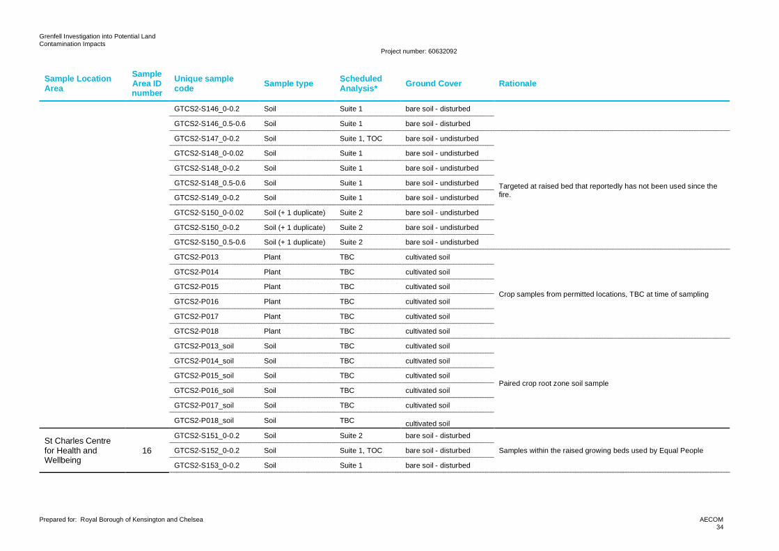
Grenfell Investigation into Potential LandContamination Impacts
Project number: 60632092
Prepared for: Royal Borough of Kensington and Chelsea AECOM34
Sample LocationArea
SampleArea IDnumber
Unique samplecode Sample type Scheduled
Analysis* Ground Cover Rationale
GTCS2-S146_0-0.2 Soil Suite 1 bare soil - disturbed
GTCS2-S146_0.5-0.6 Soil Suite 1 bare soil - disturbed
GTCS2-S147_0-0.2 Soil Suite 1, TOC bare soil - undisturbed
Targeted at raised bed that reportedly has not been used since thefire.
GTCS2-S148_0-0.02 Soil Suite 1 bare soil - undisturbed
GTCS2-S148_0-0.2 Soil Suite 1 bare soil - undisturbed
GTCS2-S148_0.5-0.6 Soil Suite 1 bare soil - undisturbed
GTCS2-S149_0-0.2 Soil Suite 1 bare soil - undisturbed
GTCS2-S150_0-0.02 Soil (+ 1 duplicate) Suite 2 bare soil - undisturbed
GTCS2-S150_0-0.2 Soil (+ 1 duplicate) Suite 2 bare soil - undisturbed
GTCS2-S150_0.5-0.6 Soil (+ 1 duplicate) Suite 2 bare soil - undisturbed
GTCS2-P013 Plant TBC cultivated soil
Crop samples from permitted locations, TBC at time of sampling
GTCS2-P014 Plant TBC cultivated soil
GTCS2-P015 Plant TBC cultivated soil
GTCS2-P016 Plant TBC cultivated soil
GTCS2-P017 Plant TBC cultivated soil
GTCS2-P018 Plant TBC cultivated soil
GTCS2-P013_soil Soil TBC cultivated soil
Paired crop root zone soil sample
GTCS2-P014_soil Soil TBC cultivated soil
GTCS2-P015_soil Soil TBC cultivated soil
GTCS2-P016_soil Soil TBC cultivated soil
GTCS2-P017_soil Soil TBC cultivated soil
GTCS2-P018_soil Soil TBC cultivated soil
St Charles Centrefor Health andWellbeing
16
GTCS2-S151_0-0.2 Soil Suite 2 bare soil - disturbed
Samples within the raised growing beds used by Equal PeopleGTCS2-S152_0-0.2 Soil Suite 1, TOC bare soil - disturbed
GTCS2-S153_0-0.2 Soil Suite 1 bare soil - disturbed
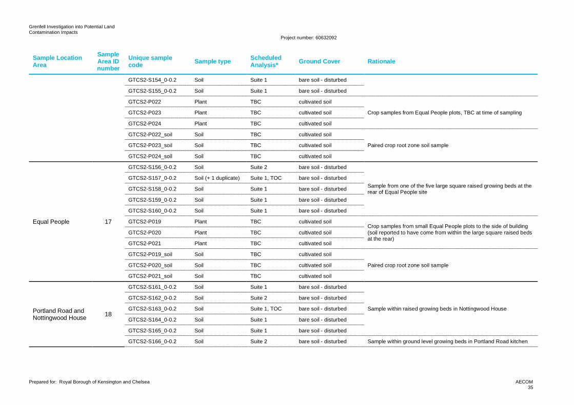
Grenfell Investigation into Potential LandContamination Impacts
Project number: 60632092
Prepared for: Royal Borough of Kensington and Chelsea AECOM35
Sample LocationArea
SampleArea IDnumber
Unique samplecode Sample type Scheduled
Analysis* Ground Cover Rationale
GTCS2-S154_0-0.2 Soil Suite 1 bare soil - disturbed
GTCS2-S155_0-0.2 Soil Suite 1 bare soil - disturbed
GTCS2-P022 Plant TBC cultivated soil
Crop samples from Equal People plots, TBC at time of samplingGTCS2-P023 Plant TBC cultivated soil
GTCS2-P024 Plant TBC cultivated soil
GTCS2-P022_soil Soil TBC cultivated soil
Paired crop root zone soil sampleGTCS2-P023_soil Soil TBC cultivated soil
GTCS2-P024_soil Soil TBC cultivated soil
Equal People 17
GTCS2-S156_0-0.2 Soil Suite 2 bare soil - disturbed
Sample from one of the five large square raised growing beds at therear of Equal People site
GTCS2-S157_0-0.2 Soil (+ 1 duplicate) Suite 1, TOC bare soil - disturbed
GTCS2-S158_0-0.2 Soil Suite 1 bare soil - disturbed
GTCS2-S159_0-0.2 Soil Suite 1 bare soil - disturbed
GTCS2-S160_0-0.2 Soil Suite 1 bare soil - disturbed
GTCS2-P019 Plant TBC cultivated soilCrop samples from small Equal People plots to the side of building(soil reported to have come from within the large square raised bedsat the rear)
GTCS2-P020 Plant TBC cultivated soil
GTCS2-P021 Plant TBC cultivated soil
GTCS2-P019_soil Soil TBC cultivated soil
Paired crop root zone soil sampleGTCS2-P020_soil Soil TBC cultivated soil
GTCS2-P021_soil Soil TBC cultivated soil
Portland Road andNottingwood House 18
GTCS2-S161_0-0.2 Soil Suite 1 bare soil - disturbed
Sample within raised growing beds in Nottingwood House
GTCS2-S162_0-0.2 Soil Suite 2 bare soil - disturbed
GTCS2-S163_0-0.2 Soil Suite 1, TOC bare soil - disturbed
GTCS2-S164_0-0.2 Soil Suite 1 bare soil - disturbed
GTCS2-S165_0-0.2 Soil Suite 1 bare soil - disturbed
GTCS2-S166_0-0.2 Soil Suite 2 bare soil - disturbed Sample within ground level growing beds in Portland Road kitchen
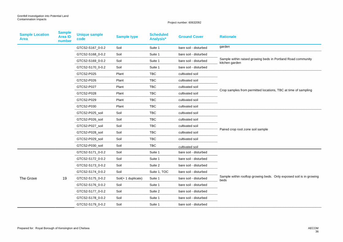
Grenfell Investigation into Potential LandContamination Impacts
Project number: 60632092
Prepared for: Royal Borough of Kensington and Chelsea AECOM36
Sample LocationArea
SampleArea IDnumber
Unique samplecode Sample type Scheduled
Analysis* Ground Cover Rationale
GTCS2-S167_0-0.2 Soil Suite 1 bare soil - disturbed garden
GTCS2-S168_0-0.2 Soil Suite 1 bare soil - disturbedSample within raised growing beds in Portland Road communitykitchen gardenGTCS2-S169_0-0.2 Soil Suite 1 bare soil - disturbed
GTCS2-S170_0-0.2 Soil Suite 1 bare soil - disturbed
GTCS2-P025 Plant TBC cultivated soil
Crop samples from permitted locations, TBC at time of sampling
GTCS2-P026 Plant TBC cultivated soil
GTCS2-P027 Plant TBC cultivated soil
GTCS2-P028 Plant TBC cultivated soil
GTCS2-P029 Plant TBC cultivated soil
GTCS2-P030 Plant TBC cultivated soil
GTCS2-P025_soil Soil TBC cultivated soil
Paired crop root zone soil sample
GTCS2-P026_soil Soil TBC cultivated soil
GTCS2-P027_soil Soil TBC cultivated soil
GTCS2-P028_soil Soil TBC cultivated soil
GTCS2-P029_soil Soil TBC cultivated soil
GTCS2-P030_soil Soil TBC cultivated soil
The Grove 19
GTCS2-S171_0-0.2 Soil Suite 1 bare soil - disturbed
Sample within rooftop growing beds. Only exposed soil is in growingbeds
GTCS2-S172_0-0.2 Soil Suite 1 bare soil - disturbed
GTCS2-S173_0-0.2 Soil Suite 2 bare soil - disturbed
GTCS2-S174_0-0.2 Soil Suite 1, TOC bare soil - disturbed
GTCS2-S175_0-0.2 Soil(+ 1 duplicate) Suite 1 bare soil - disturbed
GTCS2-S176_0-0.2 Soil Suite 1 bare soil - disturbed
GTCS2-S177_0-0.2 Soil Suite 2 bare soil - disturbed
GTCS2-S178_0-0.2 Soil Suite 1 bare soil - disturbed
GTCS2-S179_0-0.2 Soil Suite 1 bare soil - disturbed
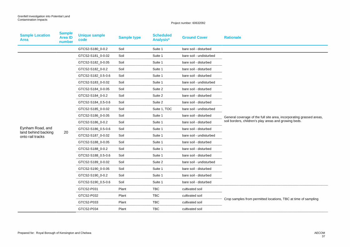
Grenfell Investigation into Potential LandContamination Impacts
Project number: 60632092
Prepared for: Royal Borough of Kensington and Chelsea AECOM37
Sample LocationArea
SampleArea IDnumber
Unique samplecode Sample type Scheduled
Analysis* Ground Cover Rationale
GTCS2-S180_0-0.2 Soil Suite 1 bare soil - disturbed
Eynham Road, andland behind backingonto rail tracks
20
GTCS2-S181_0-0.02 Soil Suite 1 bare soil - undisturbed
General coverage of the full site area, incorporating grassed areas,soil borders, children’s play areas and growing beds.
GTCS2-S182_0-0.05 Soil Suite 1 bare soil - disturbed
GTCS2-S182_0-0.2 Soil Suite 1 bare soil - disturbed
GTCS2-S182_0.5-0.6 Soil Suite 1 bare soil - disturbed
GTCS2-S183_0-0.02 Soil Suite 1 bare soil - undisturbed
GTCS2-S184_0-0.05 Soil Suite 2 bare soil - disturbed
GTCS2-S184_0-0.2 Soil Suite 2 bare soil - disturbed
GTCS2-S184_0.5-0.6 Soil Suite 2 bare soil - disturbed
GTCS2-S185_0-0.02 Soil Suite 1, TOC bare soil - undisturbed
GTCS2-S186_0-0.05 Soil Suite 1 bare soil - disturbed
GTCS2-S186_0-0.2 Soil Suite 1 bare soil - disturbed
GTCS2-S186_0.5-0.6 Soil Suite 1 bare soil - disturbed
GTCS2-S187_0-0.02 Soil Suite 1 bare soil - undisturbed
GTCS2-S188_0-0.05 Soil Suite 1 bare soil - disturbed
GTCS2-S188_0-0.2 Soil Suite 1 bare soil - disturbed
GTCS2-S188_0.5-0.6 Soil Suite 1 bare soil - disturbed
GTCS2-S189_0-0.02 Soil Suite 2 bare soil - undisturbed
GTCS2-S190_0-0.05 Soil Suite 1 bare soil - disturbed
GTCS2-S190_0-0.2 Soil Suite 1 bare soil - disturbed
GTCS2-S190_0.5-0.6 Soil Suite 1 bare soil - disturbed
GTCS2-P031 Plant TBC cultivated soil
Crop samples from permitted locations, TBC at time of samplingGTCS2-P032 Plant TBC cultivated soil
GTCS2-P033 Plant TBC cultivated soil
GTCS2-P034 Plant TBC cultivated soil
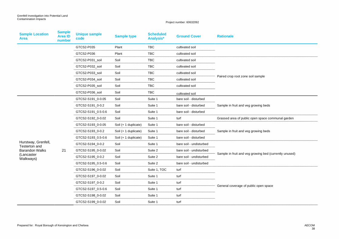
Grenfell Investigation into Potential LandContamination Impacts
Project number: 60632092
Prepared for: Royal Borough of Kensington and Chelsea AECOM38
Sample LocationArea
SampleArea IDnumber
Unique samplecode Sample type Scheduled
Analysis* Ground Cover Rationale
GTCS2-P035 Plant TBC cultivated soil
GTCS2-P036 Plant TBC cultivated soil
GTCS2-P031_soil Soil TBC cultivated soil
Paired crop root zone soil sample
GTCS2-P032_soil Soil TBC cultivated soil
GTCS2-P033_soil Soil TBC cultivated soil
GTCS2-P034_soil Soil TBC cultivated soil
GTCS2-P035_soil Soil TBC cultivated soil
GTCS2-P036_soil Soil TBC cultivated soil
Hurstway, Grenfell,Testerton andBarandon Walks(LancasterWalkways)
21
GTCS2-S191_0-0.05 Soil Suite 1 bare soil - disturbed
Sample in fruit and veg growing bedsGTCS2-S191_0-0.2 Soil Suite 1 bare soil - disturbed
GTCS2-S191_0.5-0.6 Soil Suite 1 bare soil - disturbed
GTCS2-S192_0-0.02 Soil Suite 1 turf Grassed area of public open space communal garden
GTCS2-S193_0-0.05 Soil (+ 1 duplicate) Suite 1 bare soil - disturbed
Sample in fruit and veg growing bedsGTCS2-S193_0-0.2 Soil (+ 1 duplicate) Suite 1 bare soil - disturbed
GTCS2-S193_0.5-0.6 Soil (+ 1 duplicate) Suite 1 bare soil - disturbed
GTCS2-S194_0-0.2 Soil Suite 1 bare soil - undisturbed
Sample in fruit and veg growing bed (currently unused)GTCS2-S195_0-0.02 Soil Suite 2 bare soil - undisturbed
GTCS2-S195_0-0.2 Soil Suite 2 bare soil - undisturbed
GTCS2-S195_0.5-0.6 Soil Suite 2 bare soil - undisturbed
GTCS2-S196_0-0.02 Soil Suite 1, TOC turf
General coverage of public open space
GTCS2-S197_0-0.02 Soil Suite 1 turf
GTCS2-S197_0-0.2 Soil Suite 1 turf
GTCS2-S197_0.5-0.6 Soil Suite 1 turf
GTCS2-S198_0-0.02 Soil Suite 1 turf
GTCS2-S199_0-0.02 Soil Suite 1 turf
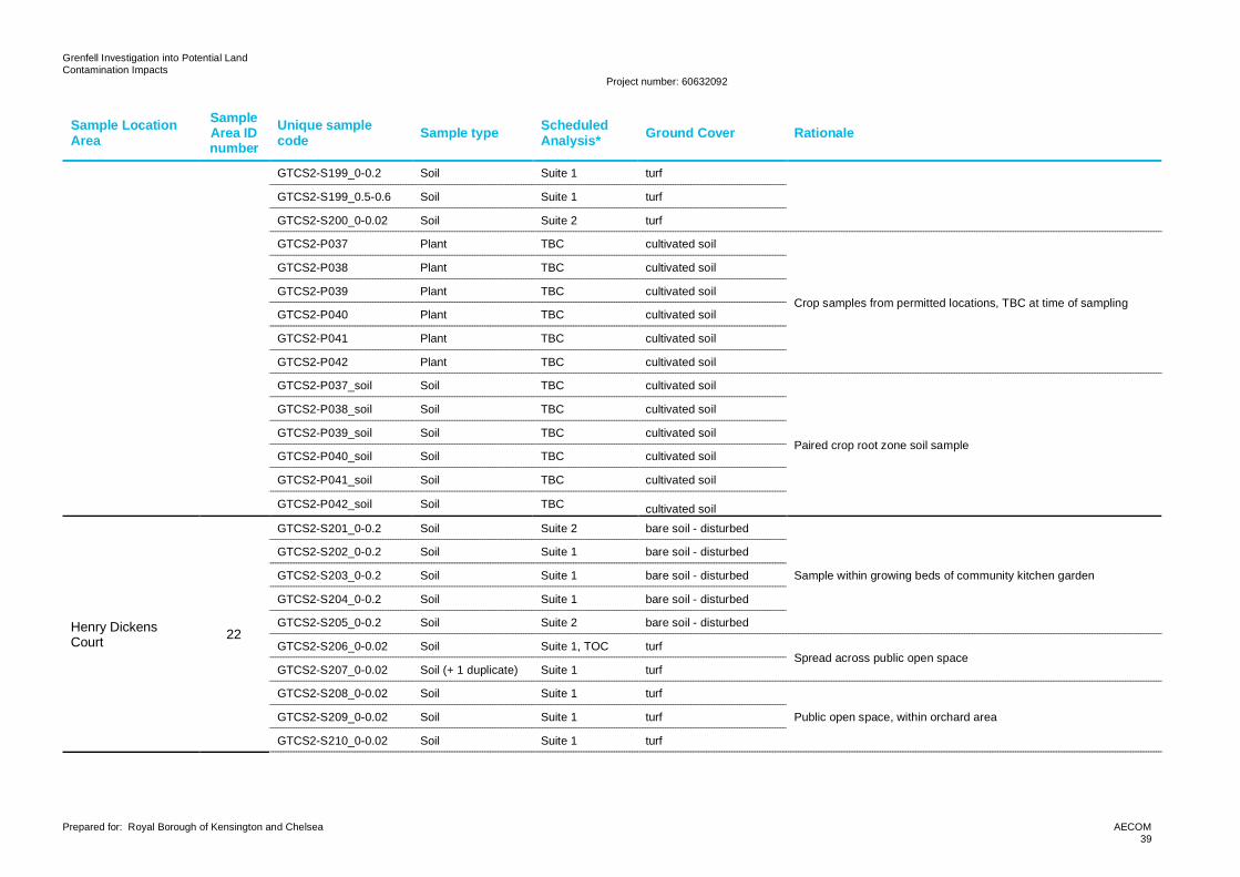
Grenfell Investigation into Potential LandContamination Impacts
Project number: 60632092
Prepared for: Royal Borough of Kensington and Chelsea AECOM39
Sample LocationArea
SampleArea IDnumber
Unique samplecode Sample type Scheduled
Analysis* Ground Cover Rationale
GTCS2-S199_0-0.2 Soil Suite 1 turf
GTCS2-S199_0.5-0.6 Soil Suite 1 turf
GTCS2-S200_0-0.02 Soil Suite 2 turf
GTCS2-P037 Plant TBC cultivated soil
Crop samples from permitted locations, TBC at time of sampling
GTCS2-P038 Plant TBC cultivated soil
GTCS2-P039 Plant TBC cultivated soil
GTCS2-P040 Plant TBC cultivated soil
GTCS2-P041 Plant TBC cultivated soil
GTCS2-P042 Plant TBC cultivated soil
GTCS2-P037_soil Soil TBC cultivated soil
Paired crop root zone soil sample
GTCS2-P038_soil Soil TBC cultivated soil
GTCS2-P039_soil Soil TBC cultivated soil
GTCS2-P040_soil Soil TBC cultivated soil
GTCS2-P041_soil Soil TBC cultivated soil
GTCS2-P042_soil Soil TBC cultivated soil
Henry DickensCourt 22
GTCS2-S201_0-0.2 Soil Suite 2 bare soil - disturbed
Sample within growing beds of community kitchen garden
GTCS2-S202_0-0.2 Soil Suite 1 bare soil - disturbed
GTCS2-S203_0-0.2 Soil Suite 1 bare soil - disturbed
GTCS2-S204_0-0.2 Soil Suite 1 bare soil - disturbed
GTCS2-S205_0-0.2 Soil Suite 2 bare soil - disturbed
GTCS2-S206_0-0.02 Soil Suite 1, TOC turfSpread across public open space
GTCS2-S207_0-0.02 Soil (+ 1 duplicate) Suite 1 turf
GTCS2-S208_0-0.02 Soil Suite 1 turf
Public open space, within orchard areaGTCS2-S209_0-0.02 Soil Suite 1 turf
GTCS2-S210_0-0.02 Soil Suite 1 turf
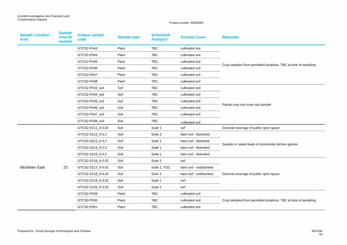
Grenfell Investigation into Potential LandContamination Impacts
Project number: 60632092
Prepared for: Royal Borough of Kensington and Chelsea AECOM40
Sample LocationArea
SampleArea IDnumber
Unique samplecode Sample type Scheduled
Analysis* Ground Cover Rationale
GTCS2-P043 Plant TBC cultivated soil
Crop samples from permitted locations, TBC at time of sampling
GTCS2-P044 Plant TBC cultivated soil
GTCS2-P045 Plant TBC cultivated soil
GTCS2-P046 Plant TBC cultivated soil
GTCS2-P047 Plant TBC cultivated soil
GTCS2-P048 Plant TBC cultivated soil
GTCS2-P043_soil Soil TBC cultivated soil
Paired crop root zone soil sample
GTCS2-P044_soil Soil TBC cultivated soil
GTCS2-P045_soil Soil TBC cultivated soil
GTCS2-P046_soil Soil TBC cultivated soil
GTCS2-P047_soil Soil TBC cultivated soil
GTCS2-P048_soil Soil TBC cultivated soil
Silchester East 23
GTCS2-S211_0-0.02 Soil Suite 1 turf General coverage of public open space
GTCS2-S212_0-0.2 Soil Suite 2 bare soil - disturbed
Sample in raised beds of community kitchen gardenGTCS2-S213_0-0.2 Soil Suite 1 bare soil - disturbed
GTCS2-S214_0-0.2 Soil Suite 1 bare soil - disturbed
GTCS2-S215_0-0.2 Soil Suite 1 bare soil - disturbed
GTCS2-S216_0-0.02 Soil Suite 2 turf
General coverage of public open space
GTCS2-S217_0-0.02 Soil Suite 1, TOC bare soil - undisturbed
GTCS2-S218_0-0.02 Soil Suite 1 bare soil - undisturbed
GTCS2-S219_0-0.02 Soil Suite 1 turf
GTCS2-S220_0-0.02 Soil Suite 1 turf
GTCS2-P049 Plant TBC cultivated soil
Crop samples from permitted locations, TBC at time of samplingGTCS2-P050 Plant TBC cultivated soil
GTCS2-P051 Plant TBC cultivated soil
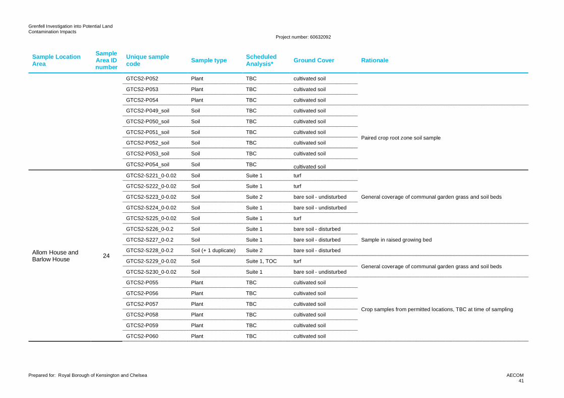
Grenfell Investigation into Potential LandContamination Impacts
Project number: 60632092
Prepared for: Royal Borough of Kensington and Chelsea AECOM41
Sample LocationArea
SampleArea IDnumber
Unique samplecode Sample type Scheduled
Analysis* Ground Cover Rationale
GTCS2-P052 Plant TBC cultivated soil
GTCS2-P053 Plant TBC cultivated soil
GTCS2-P054 Plant TBC cultivated soil
GTCS2-P049_soil Soil TBC cultivated soil
Paired crop root zone soil sample
GTCS2-P050_soil Soil TBC cultivated soil
GTCS2-P051_soil Soil TBC cultivated soil
GTCS2-P052_soil Soil TBC cultivated soil
GTCS2-P053_soil Soil TBC cultivated soil
GTCS2-P054_soil Soil TBC cultivated soil
Allom House andBarlow House 24
GTCS2-S221_0-0.02 Soil Suite 1 turf
General coverage of communal garden grass and soil beds
GTCS2-S222_0-0.02 Soil Suite 1 turf
GTCS2-S223_0-0.02 Soil Suite 2 bare soil - undisturbed
GTCS2-S224_0-0.02 Soil Suite 1 bare soil - undisturbed
GTCS2-S225_0-0.02 Soil Suite 1 turf
GTCS2-S226_0-0.2 Soil Suite 1 bare soil - disturbed
Sample in raised growing bedGTCS2-S227_0-0.2 Soil Suite 1 bare soil - disturbed
GTCS2-S228_0-0.2 Soil (+ 1 duplicate) Suite 2 bare soil - disturbed
GTCS2-S229_0-0.02 Soil Suite 1, TOC turfGeneral coverage of communal garden grass and soil beds
GTCS2-S230_0-0.02 Soil Suite 1 bare soil - undisturbed
GTCS2-P055 Plant TBC cultivated soil
Crop samples from permitted locations, TBC at time of sampling
GTCS2-P056 Plant TBC cultivated soil
GTCS2-P057 Plant TBC cultivated soil
GTCS2-P058 Plant TBC cultivated soil
GTCS2-P059 Plant TBC cultivated soil
GTCS2-P060 Plant TBC cultivated soil
Grenfell Investigation into Potential LandContamination Impacts
Project number: 60632092
Prepared for: Royal Borough of Kensington and Chelsea AECOM42
Sample LocationArea
SampleArea IDnumber
Unique samplecode Sample type Scheduled
Analysis* Ground Cover Rationale
GTCS2-P055_soil Soil TBC cultivated soil
Paired crop root zone soil sample
GTCS2-P056_soil Soil TBC cultivated soil
GTCS2-P057_soil Soil TBC cultivated soil
GTCS2-P058_soil Soil TBC cultivated soil
GTCS2-P059_soil Soil TBC cultivated soil
GTCS2-P060_soil Soil TBC cultivated soil
Morland House andTalbot Grove House 25
GTCS2-S231_0-0.2 Soil Suite 1 bare soil - disturbed
In raised growing beds at Morland HouseGTCS2-S232_0-0.2 Soil Suite 1 bare soil - disturbed
GTCS2-S233_0-0.2 Soil Suite 1 bare soil - disturbed
GTCS2-S234_0-0.2 Soil Suite 2 bare soil - disturbed In soil beds with fruit (fig) tree at Morland House
GTCS2-S235_0-0.02 Soil Suite 1 turf Coverage of public open space in Talbot Grove House
GTCS2-S236_0-0.2 Soil Suite 1 bare soil - disturbed
In raised growing beds at Talbot Grove HouseGTCS2-S237_0-0.2 Soil Suite 1 bare soil - disturbed
GTCS2-S238_0-0.2 Soil Suite 1 bare soil - disturbed
GTCS2-S239_0-0.2 Soil Suite 2 bare soil - disturbed
GTCS2-S240_0-0.02 Soil Suite 1, TOC turf Coverage of public open space in Talbot Grove House
GTCS2-P061 Plant TBC cultivated soil
Crop samples from permitted locations, TBC at time of sampling
GTCS2-P062 Plant TBC cultivated soil
GTCS2-P063 Plant TBC cultivated soil
GTCS2-P064 Plant TBC cultivated soil
GTCS2-P065 Plant TBC cultivated soil
GTCS2-P066 Plant TBC cultivated soil
GTCS2-P061_soil Soil TBC cultivated soil
Paired crop root zone soil sampleGTCS2-P062_soil Soil TBC cultivated soil
GTCS2-P063_soil Soil TBC cultivated soil
Grenfell Investigation into Potential LandContamination Impacts
Project number: 60632092
Prepared for: Royal Borough of Kensington and Chelsea AECOM43
Sample LocationArea
SampleArea IDnumber
Unique samplecode Sample type Scheduled
Analysis* Ground Cover Rationale
GTCS2-P064_soil Soil TBC cultivated soil
GTCS2-P065_soil Soil TBC cultivated soil
GTCS2-P066_soil Soil TBC cultivated soil
Bramley House 26
GTCS2-S241_0-0.02 Soil Suite 1, TOC bare soil - undisturbedGeneral coverage of communal garden area
GTCS2-S242_0-0.02 Soil Suite 1 turf
GTCS2-S243_0-0.02 Soil Suite 1 bare soil - undisturbed Beneath artificial grass where residents say debris was washed afterfire
GTCS2-S244_0-0.02 Soil Suite 1 bare soil - undisturbed In olive tree pot, soil not changed since fire
GTCS2-S245_0-0.02 Soil Suite 2 bare soil - undisturbed Beneath artificial grass where residents say debris was washed afterfire
GTCS2-S246_0-0.02 Soil Suite 1 bare soil - undisturbed In olive tree pot, soil not changed since fire
GTCS2-S247_0-0.02 Soil Suite 1 bare soil - undisturbed General coverage of communal garden area
GTCS2-S248_0-0.2 Soil Suite 1 bare soil - disturbedSample in raised growing beds
GTCS2-S249_0-0.2 Soil (+ 1 duplicate) Suite 2 bare soil - disturbed
GTCS2-S250_0-0.02 Soil Suite 1 turf General coverage of communal garden area
GTCS2-P067 Plant TBC cultivated soil
Crop samples from permitted locations, TBC at time of sampling
GTCS2-P068 Plant TBC cultivated soil
GTCS2-P069 Plant TBC cultivated soil
GTCS2-P070 Plant TBC cultivated soil
GTCS2-P071 Plant TBC cultivated soil
GTCS2-P072 Plant TBC cultivated soil
GTCS2-P067_soil Soil TBC cultivated soil
Paired crop root zone soil sample
GTCS2-P068_soil Soil TBC cultivated soil
GTCS2-P069_soil Soil TBC cultivated soil
GTCS2-P070_soil Soil TBC cultivated soil
GTCS2-P071_soil Soil TBC cultivated soil
GTCS2-P072_soil Soil TBC cultivated soil
Grenfell Investigation into Potential LandContamination Impacts
Project number: 60632092
Prepared for: Royal Borough of Kensington and Chelsea AECOM44
Sample LocationArea
SampleArea IDnumber
Unique samplecode Sample type Scheduled
Analysis* Ground Cover Rationale
KensingtonMemorial Park 27
GTCS2-S251_0-0.02 Soil Suite 2 turf
General coverage of public open space areas - avoid sports pitchplaying surface.
GTCS2-S252_0-0.02 Soil Suite 1, TOC bare soil - undisturbed
GTCS2-S253_0-0.02 Soil Suite 1 bare soil - undisturbed
GTCS2-S254_0-0.02 Soil Suite 1 turf
GTCS2-S255_0-0.02 Soil Suite 1 turf
GTCS2-S256_0-0.02 Soil Suite 2 turf
GTCS2-S257_0-0.02 Soil Suite 1 turf
GTCS2-S258_0-0.02 Soil Suite 1 turf
GTCS2-S259_0-0.02 Soil Suite 1 turf
GTCS2-S260_0-0.02 Soil Suite 1 turf
GTCS2-S261_0-0.02 Soil Suite 2 bare soil - undisturbed
GTCS2-S262_0-0.02 Soil Suite 1, TOC bare soil - undisturbed
GTCS2-S263_0-0.02 Soil Suite 1 bare soil - undisturbed
GTCS2-S264_0-0.02 Soil Suite 1 bare soil - undisturbed
GTCS2-S265_0-0.05 Soil Suite 1 bare soil - disturbed
GTCS2-S266_0-0.02 Soil Suite 2 turfSoil near fruit trees in orchard area
GTCS2-S267_0-0.02 Soil Suite 1 turf
GTCS2-S268_0-0.2 Soil Suite 1 bare soil - disturbed
Raised bed in community kitchen gardenGTCS2-S269_0-0.2 Soil Suite 1 bare soil - disturbed
GTCS2-S270_0-0.2 Soil (+ 1 duplicate) Suite 1 bare soil - disturbed
Treadgold House 28
GTCS2-S271_0-0.02 Soil Suite 1 bare soil - undisturbed
General coverage of public open space garden areas
GTCS2-S272_0-0.02 Soil Suite 2 bare soil - undisturbed
GTCS2-S273_0-0.02 Soil Suite 1, TOC turf
GTCS2-S274_0-0.02 Soil Suite 1 turf
GTCS2-S275_0-0.02 Soil Suite 1 turf
Grenfell Investigation into Potential LandContamination Impacts
Project number: 60632092
Prepared for: Royal Borough of Kensington and Chelsea AECOM45
Sample LocationArea
SampleArea IDnumber
Unique samplecode Sample type Scheduled
Analysis* Ground Cover Rationale
GTCS2-S276_0-0.2 Soil Suite 1 bare soil - disturbed
Sample in raised beds in garden areasGTCS2-S277_0-0.2 Soil Suite 2 bare soil - disturbed
GTCS2-S278_0-0.2 Soil Suite 1 bare soil - disturbed
GTCS2-S279_0-0.02 Soil Suite 1 turf General coverage of public open space garden areas
GTCS2-S280_0-0.05 Soil Suite 1 bare soil - disturbed General coverage of public open space soil bed (indicated as raisedgrowing bed on RBKC mapping)
Verity Close 29
GTCS2-S281_0-0.02 Soil (+ 1 duplicate) Suite 1 turf General coverage of the area including grassed area in public openspaceGTCS2-S282_0-0.02 Soil Suite 1 turf
GTCS2-S283_0-0.05 Soil Suite 2 bare soil - disturbed General coverage of the area including soil bed in public open space
GTCS2-S284_0-0.02 Soil Suite 1, TOC bare soil - undisturbed General coverage of the area including soil beds within communalgardens of low-rise residential blocksGTCS2-S285_0-0.02 Soil Suite 1 bare soil - undisturbed
GTCS2-S286_0-0.02 Soil Suite 1 turf General coverage of the area including grassed area within thechildren’s playground
GTCS2-S287_0-0.02 Soil Suite 1 bare soil - undisturbed General coverage of the area including soil beds within communalgardens of low-rise residential blocksGTCS2-S288_0-0.02 Soil Suite 2 bare soil - undisturbed
GTCS2-S289_0-0.02 Soil Suite 1 turf General coverage of the area including grassed area within thechildren’s playgroundGTCS2-S290_0-0.02 Soil Suite 1 turf
Little WormwoodScrubs IncludingEPIC CICAdventurePlayground
30
GTCS2-S291_0-0.02 Soil Suite 1 bare soil - undisturbed General coverage of public open space including heavily vegetatedarea
GTCS2-S292_0-0.02 Soil Suite 1 turf
General coverage of public open space including scrubby vegetatedarea
GTCS2-S293_0-0.02 Soil Suite 1 turf
GTCS2-S294_0-0.02 Soil Suite 2 turf
GTCS2-S295_0-0.02 Soil Suite 1, TOC turf
GTCS2-S296_0-0.02 Soil Suite 1 turfGeneral coverage of public open space including grassed area
GTCS2-S297_0-0.02 Soil Suite 1 turf
GTCS2-S298_0-0.02 Soil Suite 1 bare soil - undisturbed General coverage of public open space including outdoor gym
GTCS2-S299_0-0.02 Soil Suite 2 turf General coverage of public open space including adventureplayground
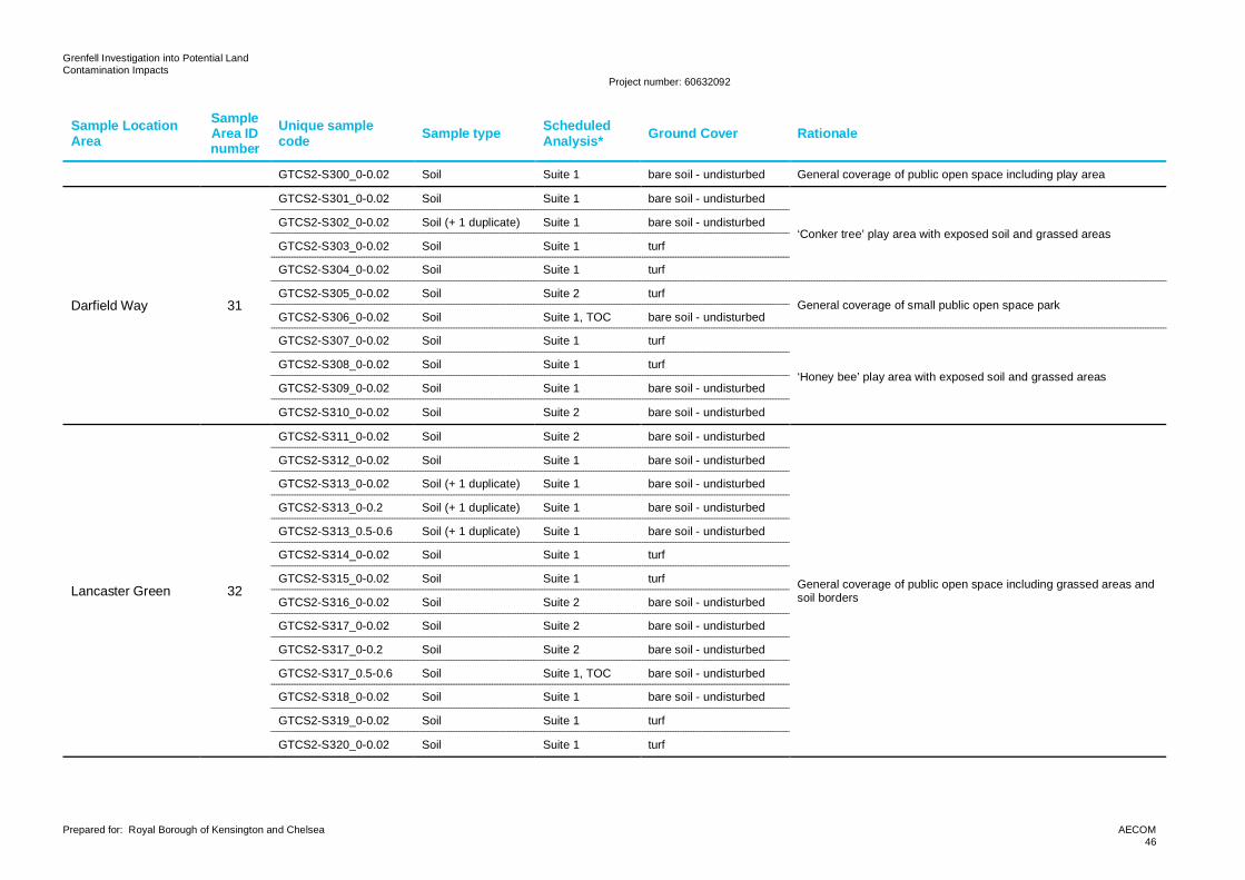
Grenfell Investigation into Potential LandContamination Impacts
Project number: 60632092
Prepared for: Royal Borough of Kensington and Chelsea AECOM46
Sample LocationArea
SampleArea IDnumber
Unique samplecode Sample type Scheduled
Analysis* Ground Cover Rationale
GTCS2-S300_0-0.02 Soil Suite 1 bare soil - undisturbed General coverage of public open space including play area
Darfield Way 31
GTCS2-S301_0-0.02 Soil Suite 1 bare soil - undisturbed
‘Conker tree’ play area with exposed soil and grassed areasGTCS2-S302_0-0.02 Soil (+ 1 duplicate) Suite 1 bare soil - undisturbed
GTCS2-S303_0-0.02 Soil Suite 1 turf
GTCS2-S304_0-0.02 Soil Suite 1 turf
GTCS2-S305_0-0.02 Soil Suite 2 turfGeneral coverage of small public open space park
GTCS2-S306_0-0.02 Soil Suite 1, TOC bare soil - undisturbed
GTCS2-S307_0-0.02 Soil Suite 1 turf
‘Honey bee’ play area with exposed soil and grassed areasGTCS2-S308_0-0.02 Soil Suite 1 turf
GTCS2-S309_0-0.02 Soil Suite 1 bare soil - undisturbed
GTCS2-S310_0-0.02 Soil Suite 2 bare soil - undisturbed
Lancaster Green 32
GTCS2-S311_0-0.02 Soil Suite 2 bare soil - undisturbed
General coverage of public open space including grassed areas andsoil borders
GTCS2-S312_0-0.02 Soil Suite 1 bare soil - undisturbed
GTCS2-S313_0-0.02 Soil (+ 1 duplicate) Suite 1 bare soil - undisturbed
GTCS2-S313_0-0.2 Soil (+ 1 duplicate) Suite 1 bare soil - undisturbed
GTCS2-S313_0.5-0.6 Soil (+ 1 duplicate) Suite 1 bare soil - undisturbed
GTCS2-S314_0-0.02 Soil Suite 1 turf
GTCS2-S315_0-0.02 Soil Suite 1 turf
GTCS2-S316_0-0.02 Soil Suite 2 bare soil - undisturbed
GTCS2-S317_0-0.02 Soil Suite 2 bare soil - undisturbed
GTCS2-S317_0-0.2 Soil Suite 2 bare soil - undisturbed
GTCS2-S317_0.5-0.6 Soil Suite 1, TOC bare soil - undisturbed
GTCS2-S318_0-0.02 Soil Suite 1 bare soil - undisturbed
GTCS2-S319_0-0.02 Soil Suite 1 turf
GTCS2-S320_0-0.02 Soil Suite 1 turf
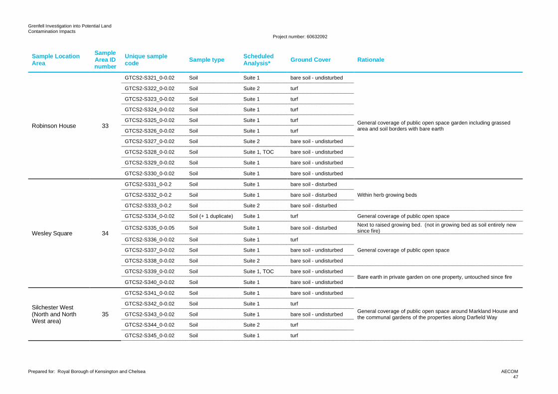
Grenfell Investigation into Potential LandContamination Impacts
Project number: 60632092
Prepared for: Royal Borough of Kensington and Chelsea AECOM47
Sample LocationArea
SampleArea IDnumber
Unique samplecode Sample type Scheduled
Analysis* Ground Cover Rationale
Robinson House 33
GTCS2-S321_0-0.02 Soil Suite 1 bare soil - undisturbed
General coverage of public open space garden including grassedarea and soil borders with bare earth
GTCS2-S322_0-0.02 Soil Suite 2 turf
GTCS2-S323_0-0.02 Soil Suite 1 turf
GTCS2-S324_0-0.02 Soil Suite 1 turf
GTCS2-S325_0-0.02 Soil Suite 1 turf
GTCS2-S326_0-0.02 Soil Suite 1 turf
GTCS2-S327_0-0.02 Soil Suite 2 bare soil - undisturbed
GTCS2-S328_0-0.02 Soil Suite 1, TOC bare soil - undisturbed
GTCS2-S329_0-0.02 Soil Suite 1 bare soil - undisturbed
GTCS2-S330_0-0.02 Soil Suite 1 bare soil - undisturbed
Wesley Square 34
GTCS2-S331_0-0.2 Soil Suite 1 bare soil - disturbed
Within herb growing bedsGTCS2-S332_0-0.2 Soil Suite 1 bare soil - disturbed
GTCS2-S333_0-0.2 Soil Suite 2 bare soil - disturbed
GTCS2-S334_0-0.02 Soil (+ 1 duplicate) Suite 1 turf General coverage of public open space
GTCS2-S335_0-0.05 Soil Suite 1 bare soil - disturbed Next to raised growing bed. (not in growing bed as soil entirely newsince fire)
GTCS2-S336_0-0.02 Soil Suite 1 turf
General coverage of public open spaceGTCS2-S337_0-0.02 Soil Suite 1 bare soil - undisturbed
GTCS2-S338_0-0.02 Soil Suite 2 bare soil - undisturbed
GTCS2-S339_0-0.02 Soil Suite 1, TOC bare soil - undisturbedBare earth in private garden on one property, untouched since fire
GTCS2-S340_0-0.02 Soil Suite 1 bare soil - undisturbed
Silchester West(North and NorthWest area)
35
GTCS2-S341_0-0.02 Soil Suite 1 bare soil - undisturbed
General coverage of public open space around Markland House andthe communal gardens of the properties along Darfield Way
GTCS2-S342_0-0.02 Soil Suite 1 turf
GTCS2-S343_0-0.02 Soil Suite 1 bare soil - undisturbed
GTCS2-S344_0-0.02 Soil Suite 2 turf
GTCS2-S345_0-0.02 Soil Suite 1 turf
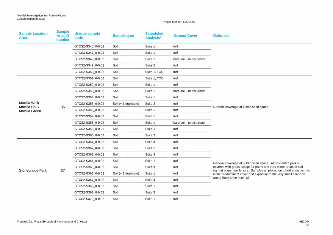
Grenfell Investigation into Potential LandContamination Impacts
Project number: 60632092
Prepared for: Royal Borough of Kensington and Chelsea AECOM48
Sample LocationArea
SampleArea IDnumber
Unique samplecode Sample type Scheduled
Analysis* Ground Cover Rationale
GTCS2-S346_0-0.02 Soil Suite 1 turf
GTCS2-S347_0-0.02 Soil Suite 1 turf
GTCS2-S348_0-0.02 Soil Suite 1 bare soil - undisturbed
GTCS2-S349_0-0.02 Soil Suite 2 turf
GTCS2-S350_0-0.02 Soil Suite 1, TOC turf
Maxilla Walk -Maxilla Hall /Maxilla Green
36
GTCS2-S351_0-0.02 Soil Suite 1, TOC turf
General coverage of public open space
GTCS2-S352_0-0.02 Soil Suite 1 turf
GTCS2-S353_0-0.02 Soil Suite 1 bare soil - undisturbed
GTCS2-S354_0-0.02 Soil Suite 1 turf
GTCS2-S355_0-0.02 Soil (+ 1 duplicate) Suite 2 turf
GTCS2-S356_0-0.02 Soil Suite 1 turf
GTCS2-S357_0-0.02 Soil Suite 1 turf
GTCS2-S358_0-0.02 Soil Suite 1 bare soil - undisturbed
GTCS2-S359_0-0.02 Soil Suite 1 turf
GTCS2-S360_0-0.02 Soil Suite 2 turf
Stonebridge Park 37
GTCS2-S361_0-0.02 Soil Suite 3 turf
General coverage of public open space. Almost entire park iscovered with grass except for paths and very minor areas of soilright at edge near fences. Samples all placed on turfed areas as thisis the predominant cover and exposure to the very small bare soilareas likely to be minimal
GTCS2-S362_0-0.02 Soil Suite 1 turf
GTCS2-S363_0-0.02 Soil Suite 3 turf
GTCS2-S364_0-0.02 Soil Suite 1 turf
GTCS2-S365_0-0.02 Soil Suite 3 turf
GTCS2-S366_0-0.02 Soil (+ 1 duplicate) Suite 1 turf
GTCS2-S367_0-0.02 Soil Suite 3 turf
GTCS2-S368_0-0.02 Soil Suite 1 turf
GTCS2-S369_0-0.02 Soil Suite 3 turf
GTCS2-S370_0-0.02 Soil Suite 1 turf
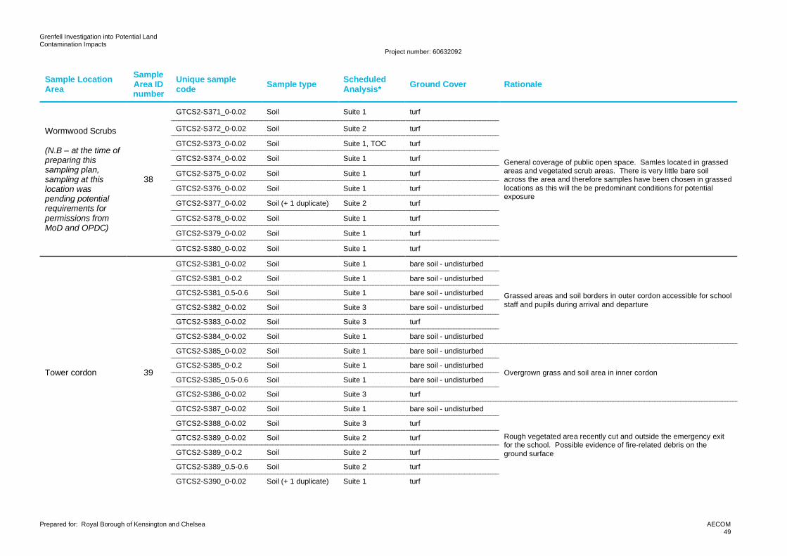
Grenfell Investigation into Potential LandContamination Impacts
Project number: 60632092
Prepared for: Royal Borough of Kensington and Chelsea AECOM49
Sample LocationArea
SampleArea IDnumber
Unique samplecode Sample type Scheduled
Analysis* Ground Cover Rationale
Wormwood Scrubs
(N.B – at the time ofpreparing thissampling plan,sampling at thislocation waspending potentialrequirements forpermissions fromMoD and OPDC)
38
GTCS2-S371_0-0.02 Soil Suite 1 turf
General coverage of public open space. Samles located in grassedareas and vegetated scrub areas. There is very little bare soilacross the area and therefore samples have been chosen in grassedlocations as this will the be predominant conditions for potentialexposure
GTCS2-S372_0-0.02 Soil Suite 2 turf
GTCS2-S373_0-0.02 Soil Suite 1, TOC turf
GTCS2-S374_0-0.02 Soil Suite 1 turf
GTCS2-S375_0-0.02 Soil Suite 1 turf
GTCS2-S376_0-0.02 Soil Suite 1 turf
GTCS2-S377_0-0.02 Soil (+ 1 duplicate) Suite 2 turf
GTCS2-S378_0-0.02 Soil Suite 1 turf
GTCS2-S379_0-0.02 Soil Suite 1 turf
GTCS2-S380_0-0.02 Soil Suite 1 turf
Tower cordon 39
GTCS2-S381_0-0.02 Soil Suite 1 bare soil - undisturbed
Grassed areas and soil borders in outer cordon accessible for schoolstaff and pupils during arrival and departure
GTCS2-S381_0-0.2 Soil Suite 1 bare soil - undisturbed
GTCS2-S381_0.5-0.6 Soil Suite 1 bare soil - undisturbed
GTCS2-S382_0-0.02 Soil Suite 3 bare soil - undisturbed
GTCS2-S383_0-0.02 Soil Suite 3 turf
GTCS2-S384_0-0.02 Soil Suite 1 bare soil - undisturbed
GTCS2-S385_0-0.02 Soil Suite 1 bare soil - undisturbed
Overgrown grass and soil area in inner cordonGTCS2-S385_0-0.2 Soil Suite 1 bare soil - undisturbed
GTCS2-S385_0.5-0.6 Soil Suite 1 bare soil - undisturbed
GTCS2-S386_0-0.02 Soil Suite 3 turf
GTCS2-S387_0-0.02 Soil Suite 1 bare soil - undisturbed
Rough vegetated area recently cut and outside the emergency exitfor the school. Possible evidence of fire-related debris on theground surface
GTCS2-S388_0-0.02 Soil Suite 3 turf
GTCS2-S389_0-0.02 Soil Suite 2 turf
GTCS2-S389_0-0.2 Soil Suite 2 turf
GTCS2-S389_0.5-0.6 Soil Suite 2 turf
GTCS2-S390_0-0.02 Soil (+ 1 duplicate) Suite 1 turf
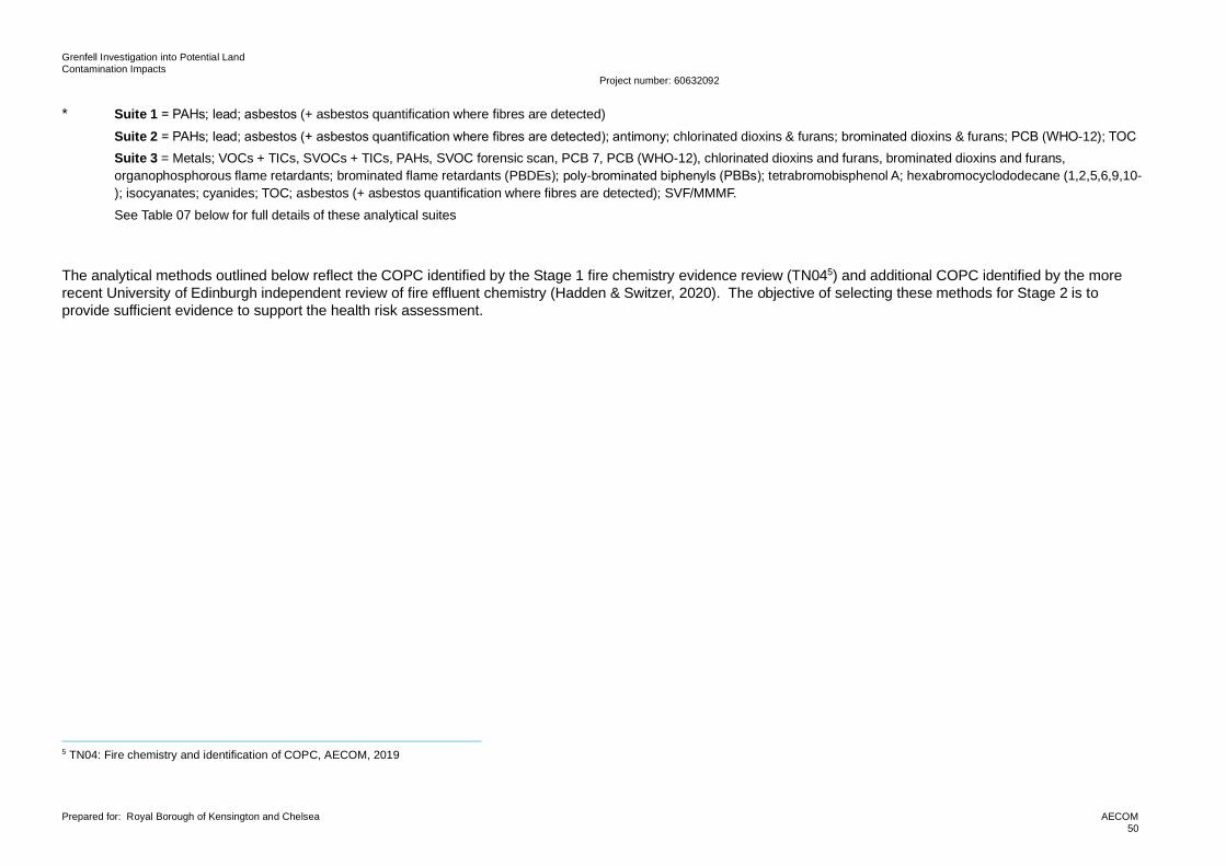
Grenfell Investigation into Potential LandContamination Impacts
Project number: 60632092
Prepared for: Royal Borough of Kensington and Chelsea AECOM50
* Suite 1 = PAHs; lead; asbestos (+ asbestos quantification where fibres are detected)Suite 2 = PAHs; lead; asbestos (+ asbestos quantification where fibres are detected); antimony; chlorinated dioxins & furans; brominated dioxins & furans; PCB (WHO-12); TOCSuite 3 = Metals; VOCs + TICs, SVOCs + TICs, PAHs, SVOC forensic scan, PCB 7, PCB (WHO-12), chlorinated dioxins and furans, brominated dioxins and furans,organophosphorous flame retardants; brominated flame retardants (PBDEs); poly-brominated biphenyls (PBBs); tetrabromobisphenol A; hexabromocyclododecane (1,2,5,6,9,10-); isocyanates; cyanides; TOC; asbestos (+ asbestos quantification where fibres are detected); SVF/MMMF.See Table 07 below for full details of these analytical suites
The analytical methods outlined below reflect the COPC identified by the Stage 1 fire chemistry evidence review (TN045) and additional COPC identified by the morerecent University of Edinburgh independent review of fire effluent chemistry (Hadden & Switzer, 2020). The objective of selecting these methods for Stage 2 is toprovide sufficient evidence to support the health risk assessment.
5 TN04: Fire chemistry and identification of COPC, AECOM, 2019
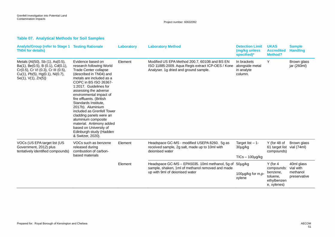
Grenfell Investigation into Potential LandContamination Impacts
Project number: 60632092
Prepared for: Royal Borough of Kensington and Chelsea AECOM51
Table 07. Analytical Methods for Soil Samples
Analyte/Group (refer to Stage 1TN04 for details)
Testing Rationale Laboratory Laboratory Method Detection Limit(mg/kg unlessspecified)*
UKASAccreditedMethod?
SampleHandling
Metals {Al(50), Sb (1), As(0.5),Ba(1), Be(0.5), B (0.1), Cd(0.1),Cr(0.5), Cr VI (0.3), Cr III (0.5),Cu(1), Pb(5), Hg(0.1), Ni(0.7),Se(1), V(1), Zn(5)}
Evidence based onresearch following WorldTrade Center collapse(described in TN04) andmetals are included as aCOPC in BS ISO 26367-1:2017. Guidelines forassessing the adverseenvironmental impact offire effluents. (BritishStandards Institute,2017b). Aluminiumincluded as Grenfell Towercladding panels were analuminium compositematerial. Antimony addedbased on University ofEdinburgh study (Hadden& Switzer, 2020).
Element Modified US EPA Method 200.7, 6010B and BS ENISO 11885:2009. Aqua Regis extract ICP-OES / KoneAnalyser. 1g dried and ground sample.
In bracketsalongside metalin analytecolumn.
Y Brown glassjar (260ml)
VOCs (US EPA target list (USGovernment, 2012) plustentatively identified compounds)
VOCs such as benzenereleased duringcombustion of carbon-based materials
Element Headspace GC-MS - modified USEPA 8260. 5g asreceived sample, 2g salt, made up to 10ml withdeionised water
Target list – 1-30µg/kg
TICs – 100µg/kg
Y (for 48 of61 target listcompounds)
Brown glassvial (74ml)
Element Headspace GC-MS – EPA5035. 10ml methanol, 5g ofsample, shaken, 1ml of methanol removed and madeup with 9ml of deionised water
50µg/kg
100µg/kg for m,p-xylene
Y (for 4compounds:benzene,toluene,ethylbenzene, xylenes)
40ml glassvial withmethanolpreservative
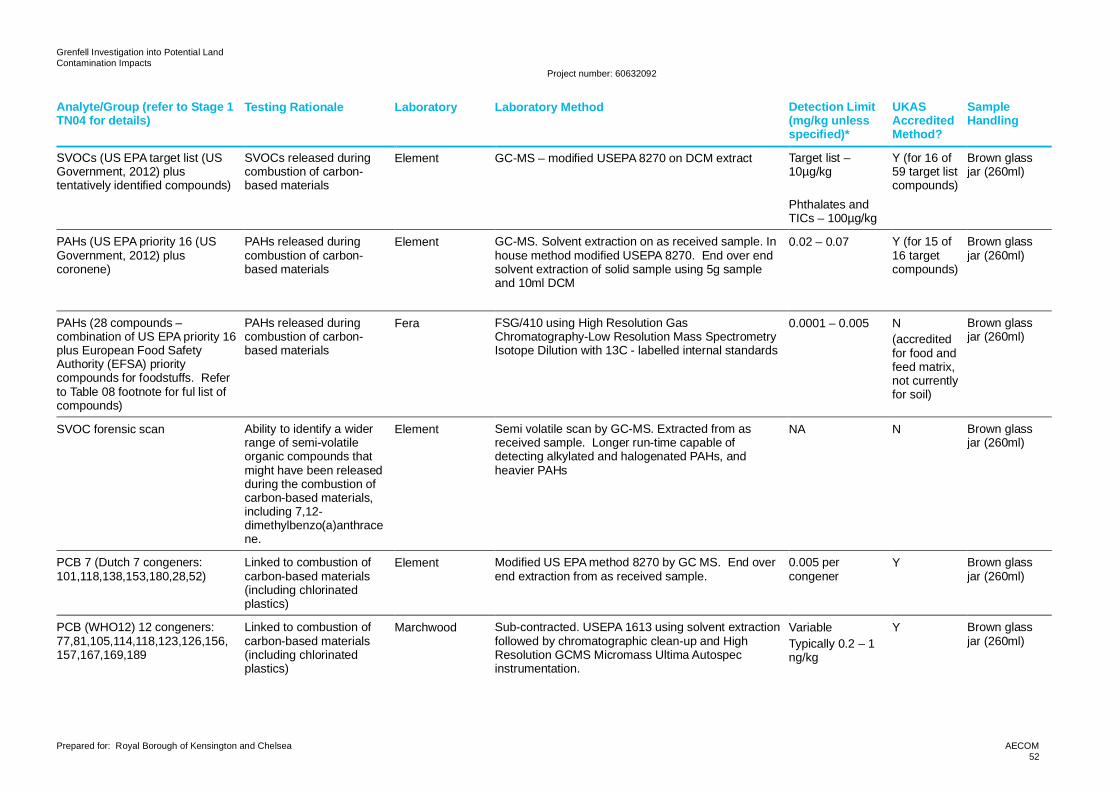
Grenfell Investigation into Potential LandContamination Impacts
Project number: 60632092
Prepared for: Royal Borough of Kensington and Chelsea AECOM52
Analyte/Group (refer to Stage 1TN04 for details)
Testing Rationale Laboratory Laboratory Method Detection Limit(mg/kg unlessspecified)*
UKASAccreditedMethod?
SampleHandling
SVOCs (US EPA target list (USGovernment, 2012) plustentatively identified compounds)
SVOCs released duringcombustion of carbon-based materials
Element GC-MS – modified USEPA 8270 on DCM extract Target list –10µg/kg
Phthalates andTICs – 100µg/kg
Y (for 16 of59 target listcompounds)
Brown glassjar (260ml)
PAHs (US EPA priority 16 (USGovernment, 2012) pluscoronene)
PAHs released duringcombustion of carbon-based materials
Element GC-MS. Solvent extraction on as received sample. Inhouse method modified USEPA 8270. End over endsolvent extraction of solid sample using 5g sampleand 10ml DCM
0.02 – 0.07 Y (for 15 of16 targetcompounds)
Brown glassjar (260ml)
PAHs (28 compounds –combination of US EPA priority 16plus European Food SafetyAuthority (EFSA) prioritycompounds for foodstuffs. Referto Table 08 footnote for ful list ofcompounds)
PAHs released duringcombustion of carbon-based materials
Fera FSG/410 using High Resolution GasChromatography-Low Resolution Mass SpectrometryIsotope Dilution with 13C - labelled internal standards
0.0001 – 0.005 N(accreditedfor food andfeed matrix,not currentlyfor soil)
Brown glassjar (260ml)
SVOC forensic scan Ability to identify a widerrange of semi-volatileorganic compounds thatmight have been releasedduring the combustion ofcarbon-based materials,including 7,12-dimethylbenzo(a)anthracene.
Element Semi volatile scan by GC-MS. Extracted from asreceived sample. Longer run-time capable ofdetecting alkylated and halogenated PAHs, andheavier PAHs
NA N Brown glassjar (260ml)
PCB 7 (Dutch 7 congeners:101,118,138,153,180,28,52)
Linked to combustion ofcarbon-based materials(including chlorinatedplastics)
Element Modified US EPA method 8270 by GC MS. End overend extraction from as received sample.
0.005 percongener
Y Brown glassjar (260ml)
PCB (WHO12) 12 congeners:77,81,105,114,118,123,126,156,157,167,169,189
Linked to combustion ofcarbon-based materials(including chlorinatedplastics)
Marchwood Sub-contracted. USEPA 1613 using solvent extractionfollowed by chromatographic clean-up and HighResolution GCMS Micromass Ultima Autospecinstrumentation.
VariableTypically 0.2 – 1ng/kg
Y Brown glassjar (260ml)
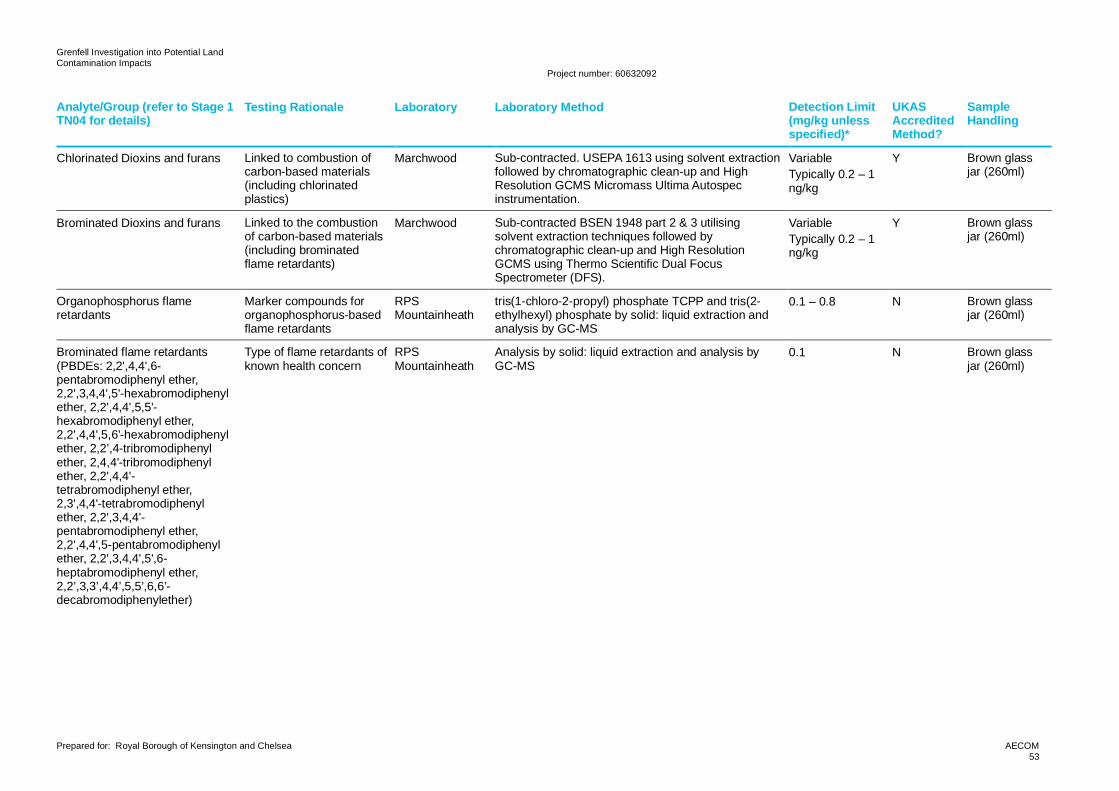
Grenfell Investigation into Potential LandContamination Impacts
Project number: 60632092
Prepared for: Royal Borough of Kensington and Chelsea AECOM53
Analyte/Group (refer to Stage 1TN04 for details)
Testing Rationale Laboratory Laboratory Method Detection Limit(mg/kg unlessspecified)*
UKASAccreditedMethod?
SampleHandling
Chlorinated Dioxins and furans Linked to combustion ofcarbon-based materials(including chlorinatedplastics)
Marchwood Sub-contracted. USEPA 1613 using solvent extractionfollowed by chromatographic clean-up and HighResolution GCMS Micromass Ultima Autospecinstrumentation.
VariableTypically 0.2 – 1ng/kg
Y Brown glassjar (260ml)
Brominated Dioxins and furans Linked to the combustionof carbon-based materials(including brominatedflame retardants)
Marchwood Sub-contracted BSEN 1948 part 2 & 3 utilisingsolvent extraction techniques followed bychromatographic clean-up and High ResolutionGCMS using Thermo Scientific Dual FocusSpectrometer (DFS).
VariableTypically 0.2 – 1ng/kg
Y Brown glassjar (260ml)
Organophosphorus flameretardants
Marker compounds fororganophosphorus-basedflame retardants
RPSMountainheath
tris(1-chloro-2-propyl) phosphate TCPP and tris(2-ethylhexyl) phosphate by solid: liquid extraction andanalysis by GC-MS
0.1 – 0.8 N Brown glassjar (260ml)
Brominated flame retardants(PBDEs: 2,2',4,4',6-pentabromodiphenyl ether,2,2',3,4,4',5'-hexabromodiphenylether, 2,2',4,4',5,5'-hexabromodiphenyl ether,2,2',4,4',5,6'-hexabromodiphenylether, 2,2’,4-tribromodiphenylether, 2,4,4'-tribromodiphenylether, 2,2',4,4'-tetrabromodiphenyl ether,2,3',4,4'-tetrabromodiphenylether, 2,2',3,4,4'-pentabromodiphenyl ether,2,2',4,4',5-pentabromodiphenylether, 2,2',3,4,4',5',6-heptabromodiphenyl ether,2,2’,3,3’,4,4’,5,5’,6,6’-decabromodiphenylether)
Type of flame retardants ofknown health concern
RPSMountainheath
Analysis by solid: liquid extraction and analysis byGC-MS
0.1 N Brown glassjar (260ml)
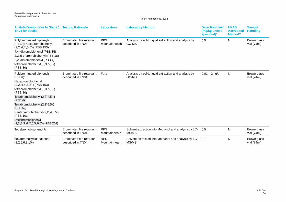
Grenfell Investigation into Potential LandContamination Impacts
Project number: 60632092
Prepared for: Royal Borough of Kensington and Chelsea AECOM54
Analyte/Group (refer to Stage 1TN04 for details)
Testing Rationale Laboratory Laboratory Method Detection Limit(mg/kg unlessspecified)*
UKASAccreditedMethod?
SampleHandling
Polybrominated biphenyls(PBBs): hexabromobiphenyl(2,2',4,4',5,5'-) (PBB 153)4,4'-dibromobiphenyl (PBB 15)2,2',5-tribromobiphenyl (PBB 18)2,2'-dibromobiphenyl (PBB 4)tetrabromobiphenyl (3,3',5,5'-)(PBB 80)
Brominated fire retardantdescribed in TN04
RPSMountainhealth
Analysis by solid: liquid extraction and analysis byGC-MS
0.5 N Brown glassvial (74ml)
Polybrominated biphenyls(PBBs):Hexabromobiphenyl(2,2',4,4',5,5'-) (PBB 153)tetrabromobiphenyl (3,3',5,5'-)(PBB 80)Tetrabromobiphenyl (2,2',4,5'- )(PBB 49)Tetrabromobiphenyl (2,2',5,5'-)(PBB 52)Pentabromobiphenyl (2,2',4,5,5'-)(PBB 101)Decabromobiphenyl(2,2',3,3',4,4',5,5',6,6'-) (PBB 209)
Brominated fire retardantdescribed in TN04
Fera Analysis by solid: liquid extraction and analysis byGC-MS
0.01 – 2 ng/g N Brown glassvial (74ml)
Tetrabromobisphenol A Brominated fire retardantdescribed in TN04
RPSMountainheath
Solvent extraction into Methanol and analysis by LC-MS/MS
0.5 N Brown glassvial (74ml)
hexabromocyclododecane(1,2,5,6,9,10-)
Brominated fire retardantdescribed in TN04
RPSMountainheath
Solvent extraction into Methanol and analysis by LC-MS/MS
0.1 N Brown glassvial (74ml)
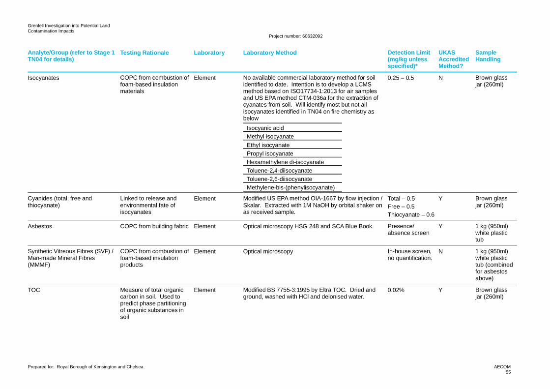
Grenfell Investigation into Potential LandContamination Impacts
Project number: 60632092
Prepared for: Royal Borough of Kensington and Chelsea AECOM55
Analyte/Group (refer to Stage 1TN04 for details)
Testing Rationale Laboratory Laboratory Method Detection Limit(mg/kg unlessspecified)*
UKASAccreditedMethod?
SampleHandling
Isocyanates COPC from combustion offoam-based insulationmaterials
Element No available commercial laboratory method for soilidentified to date. Intention is to develop a LCMSmethod based on ISO17734-1:2013 for air samplesand US EPA method CTM-036a for the extraction ofcyanates from soil. Will identify most but not allisocyanates identified in TN04 on fire chemistry asbelow
Isocyanic acidMethyl isocyanateEthyl isocyanatePropyl isocyanateHexamethylene di-isocyanateToluene-2,4-diisocyanateToluene-2,6-diisocyanateMethylene-bis-(phenylisocyanate)
0.25 – 0.5 N Brown glassjar (260ml)
Cyanides (total, free andthiocyanate)
Linked to release andenvironmental fate ofisocyanates
Element Modified US EPA method OIA-1667 by flow injection /Skalar. Extracted with 1M NaOH by orbital shaker onas received sample.
Total – 0.5Free – 0.5Thiocyanate – 0.6
Y Brown glassjar (260ml)
Asbestos COPC from building fabric Element Optical microscopy HSG 248 and SCA Blue Book. Presence/absence screen
Y 1 kg (950ml)white plastictub
Synthetic Vitreous Fibres (SVF) /Man-made Mineral Fibres(MMMF)
COPC from combustion offoam-based insulationproducts
Element Optical microscopy In-house screen,no quantification.
N 1 kg (950ml)white plastictub (combinedfor asbestosabove)
TOC Measure of total organiccarbon in soil. Used topredict phase partitioningof organic substances insoil
Element Modified BS 7755-3:1995 by Eltra TOC. Dried andground, washed with HCl and deionised water.
0.02% Y Brown glassjar (260ml)
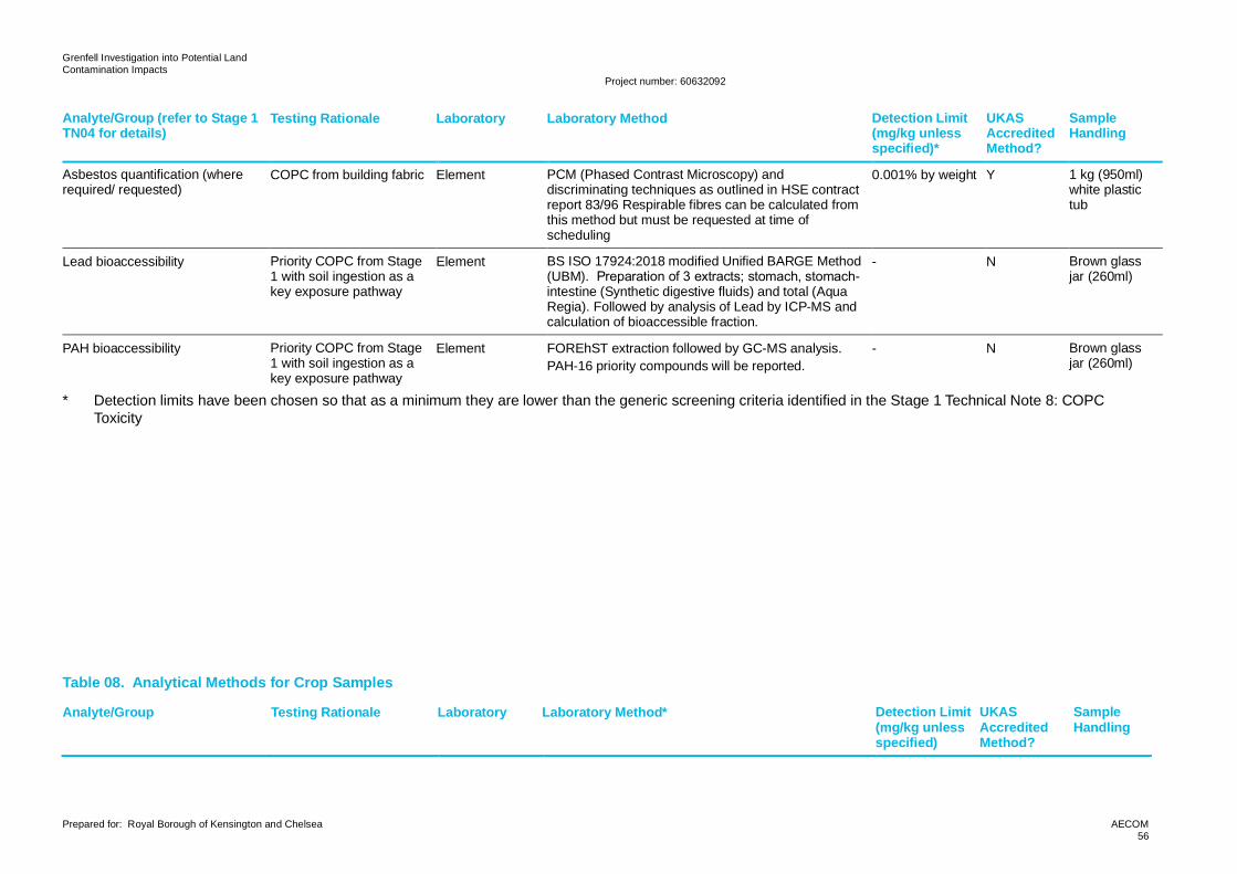
Grenfell Investigation into Potential LandContamination Impacts
Project number: 60632092
Prepared for: Royal Borough of Kensington and Chelsea AECOM56
Analyte/Group (refer to Stage 1TN04 for details)
Testing Rationale Laboratory Laboratory Method Detection Limit(mg/kg unlessspecified)*
UKASAccreditedMethod?
SampleHandling
Asbestos quantification (whererequired/ requested)
COPC from building fabric Element PCM (Phased Contrast Microscopy) anddiscriminating techniques as outlined in HSE contractreport 83/96 Respirable fibres can be calculated fromthis method but must be requested at time ofscheduling
0.001% by weight Y 1 kg (950ml)white plastictub
Lead bioaccessibility Priority COPC from Stage1 with soil ingestion as akey exposure pathway
Element BS ISO 17924:2018 modified Unified BARGE Method(UBM). Preparation of 3 extracts; stomach, stomach-intestine (Synthetic digestive fluids) and total (AquaRegia). Followed by analysis of Lead by ICP-MS andcalculation of bioaccessible fraction.
- N Brown glassjar (260ml)
PAH bioaccessibility Priority COPC from Stage1 with soil ingestion as akey exposure pathway
Element FOREhST extraction followed by GC-MS analysis.PAH-16 priority compounds will be reported.
- N Brown glassjar (260ml)
* Detection limits have been chosen so that as a minimum they are lower than the generic screening criteria identified in the Stage 1 Technical Note 8: COPCToxicity
Table 08. Analytical Methods for Crop Samples
Analyte/Group Testing Rationale Laboratory Laboratory Method* Detection Limit(mg/kg unlessspecified)
UKASAccreditedMethod?
SampleHandling
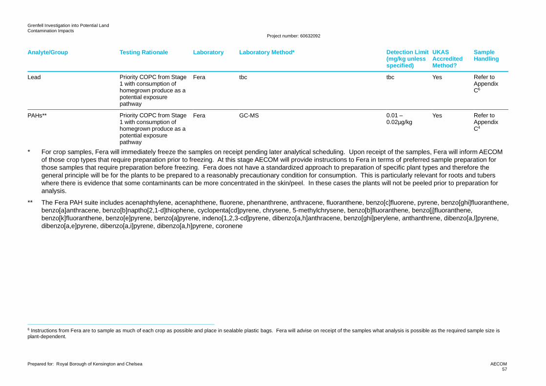
Grenfell Investigation into Potential LandContamination Impacts
Project number: 60632092
Prepared for: Royal Borough of Kensington and Chelsea AECOM57
Analyte/Group Testing Rationale Laboratory Laboratory Method* Detection Limit(mg/kg unlessspecified)
UKASAccreditedMethod?
SampleHandling
Lead Priority COPC from Stage1 with consumption ofhomegrown produce as apotential exposurepathway
Fera tbc tbc Yes Refer toAppendixC6
PAHs** Priority COPC from Stage1 with consumption ofhomegrown produce as apotential exposurepathway
Fera GC-MS 0.01 –0.02µg/kg
Yes Refer toAppendixC4
* For crop samples, Fera will immediately freeze the samples on receipt pending later analytical scheduling. Upon receipt of the samples, Fera will inform AECOMof those crop types that require preparation prior to freezing. At this stage AECOM will provide instructions to Fera in terms of preferred sample preparation forthose samples that require preparation before freezing. Fera does not have a standardized approach to preparation of specific plant types and therefore thegeneral principle will be for the plants to be prepared to a reasonably precautionary condition for consumption. This is particularly relevant for roots and tuberswhere there is evidence that some contaminants can be more concentrated in the skin/peel. In these cases the plants will not be peeled prior to preparation foranalysis.
** The Fera PAH suite includes acenaphthylene, acenaphthene, fluorene, phenanthrene, anthracene, fluoranthene, benzo[c]fluorene, pyrene, benzo[ghi]fluoranthene,benzo[a]anthracene, benzo[b]naptho[2,1-d]thiophene, cyclopenta[cd]pyrene, chrysene, 5-methylchrysene, benzo[b]fluoranthene, benzo[j]fluoranthene,benzo[k]fluoranthene, benzo[e]pyrene, benzo[a]pyrene, indeno[1,2,3-cd]pyrene, dibenzo[a,h]anthracene, benzo[ghi]perylene, anthanthrene, dibenzo[a,l]pyrene,dibenzo[a,e]pyrene, dibenzo[a,i]pyrene, dibenzo[a,h]pyrene, coronene
6 Instructions from Fera are to sample as much of each crop as possible and place in sealable plastic bags. Fera will advise on receipt of the samples what analysis is possible as the required sample size isplant-dependent.
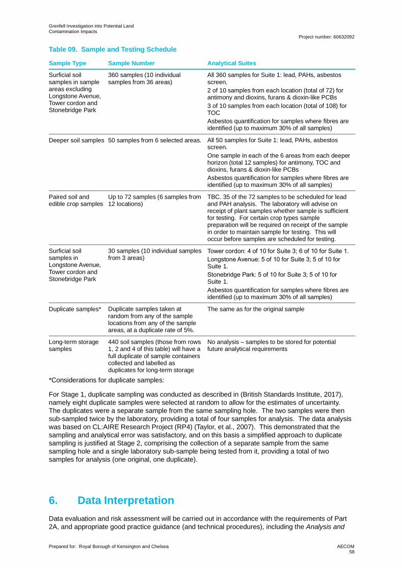
Grenfell Investigation into Potential LandContamination Impacts
Project number: 60632092
Prepared for: Royal Borough of Kensington and Chelsea AECOM58
Table 09. Sample and Testing Schedule
Sample Type Sample Number Analytical Suites
Surficial soilsamples in sampleareas excludingLongstone Avenue,Tower cordon andStonebridge Park
360 samples (10 individualsamples from 36 areas)
All 360 samples for Suite 1: lead, PAHs, asbestosscreen.2 of 10 samples from each location (total of 72) forantimony and dioxins, furans & dioxin-like PCBs3 of 10 samples from each location (total of 108) forTOCAsbestos quantification for samples where fibres areidentified (up to maximum 30% of all samples)
Deeper soil samples 50 samples from 6 selected areas. All 50 samples for Suite 1: lead, PAHs, asbestosscreen.One sample in each of the 6 areas from each deeperhorizon (total 12 samples) for antimony, TOC anddioxins, furans & dioxin-like PCBsAsbestos quantification for samples where fibres areidentified (up to maximum 30% of all samples)
Paired soil andedible crop samples
Up to 72 samples (6 samples from12 locations)
TBC. 35 of the 72 samples to be scheduled for leadand PAH analysis. The laboratory will advise onreceipt of plant samples whether sample is sufficientfor testing. For certain crop types samplepreparation will be required on receipt of the samplein order to maintain sample for testing. This willoccur before samples are scheduled for testing.
Surficial soilsamples inLongstone Avenue,Tower cordon andStonebridge Park
30 samples (10 individual samplesfrom 3 areas)
Tower cordon: 4 of 10 for Suite 3; 6 of 10 for Suite 1.Longstone Avenue: 5 of 10 for Suite 3; 5 of 10 for Suite 1.Stonebridge Park: 5 of 10 for Suite 3; 5 of 10 for Suite 1.Asbestos quantification for samples where fibres areidentified (up to maximum 30% of all samples)
Duplicate samples* Duplicate samples taken atrandom from any of the samplelocations from any of the sampleareas, at a duplicate rate of 5%.
The same as for the original sample
Long-term storagesamples
440 soil samples (those from rows1, 2 and 4 of this table) will have afull duplicate of sample containerscollected and labelled asduplicates for long-term storage
No analysis – samples to be stored for potentialfuture analytical requirements
*Considerations for duplicate samples:
For Stage 1, duplicate sampling was conducted as described in (British Standards Institute, 2017),namely eight duplicate samples were selected at random to allow for the estimates of uncertainty.The duplicates were a separate sample from the same sampling hole. The two samples were thensub-sampled twice by the laboratory, providing a total of four samples for analysis. The data analysiswas based on CL:AIRE Research Project (RP4) (Taylor, et al., 2007). This demonstrated that thesampling and analytical error was satisfactory, and on this basis a simplified approach to duplicatesampling is justified at Stage 2, comprising the collection of a separate sample from the samesampling hole and a single laboratory sub-sample being tested from it, providing a total of twosamples for analysis (one original, one duplicate).
6. Data InterpretationData evaluation and risk assessment will be carried out in accordance with the requirements of Part2A, and appropriate good practice guidance (and technical procedures), including the Analysis and
Grenfell Investigation into Potential LandContamination Impacts
Project number: 60632092
Prepared for: Royal Borough of Kensington and Chelsea AECOM59
Interpretation Methodology for the Soil Investigation at Grenfell Tower (EA, PHE, 2019) developedspecifically by PHE and the EA for this project.
Specific aspects of the data evaluation and risk assessment will include:
· Assessment and comparison of soil concentration data with GSC, including the use ofappropriate spatial or non-spatial statistical techniques. At this stage, AECOM will recommendany additional testing viewed necessary to assist with further stages of DQRA, including (but notnecessarily limited to) soil bioaccessibility, further crop analysis, or analysis of additional samplesfor dioxins and furans. These recommendations will be based on the EA/PHE methodology(which notes that DQRA will be implemented for linkages that cannot immediately be placed intoCategory 4) and AECOM’s experience in completion of DQRA and the benefits of this informationfor SSAC derivation.
· DQRA may be required for some contaminants and some reasonably possible significantcontaminant linkages where shallow soil concentrations exceed both GSC and normalbackground concentrations.
· DQRA may also be required for some contaminants with no GSC or no data on normalbackground levels.
· Similarly, if necessary, a DQRA using further site-specific information and criteria can beundertaken to resolve any residual uncertainties from the GQRA as to whether unacceptablerisks to human health are present. This task may be used as the sole method for quantitativeassessment of risks, or it may be used to refine earlier assessments.
· The development of site-specific screening criteria (SSSC) to reduce uncertainty to acceptablelevels and allow final decisions to be made. SSSC may be derived using soil bioaccessibilitydata of key contaminants or the sampling of home grown produce to investigate fruit andvegetable uptake pathways.
· Similarly, examples of provisional, supplementary work for inform the DQRA could includequantitative asbestos analyses and additional sampling around significant outliers. Theseactivities will be recommended to MAP by AECOM following the initial data screening andevaluation of spatial distributions if they are considered to benefit the risk estimation process.
· Stage 2 data interpretation will include risk assessment to establish whether there areunacceptable risks to human health as defined in Part 2A. The process should follow the tieredrisk assessment steps highlighted in LC:RM. These are:
─ Risk assessment is an iterative process (PRA→GQRA→DQRA).
─ For each tier you must identify the hazard (establish contaminant source), assess thehazard (using the S-P-R approach), estimate the risk by predicting what degree of harmmight result and how likely it is to occur, and evaluate the risk (deciding on whether risk isacceptable).
─ The steps to take for GQRA are: define objectives, identify appropriate GAC, confirmsuitability of GAC, use existing GAC and/or derive new GAC, decide what information isrequired, collect information, confirm pollutant linkages to assess, assess risk, and concludeGQRA by updating the conceptual model, identify potentially unacceptable risks, anddetermine what is required in the form of DQRA to address uncertainties.
─ The steps to take for DQRA are: define the objectives, decide what information to collect,collect information, confirm the relevant pollutant linkages (RPLs) to be assessed, assessthe risk for each RPL using a relevant risk estimation tool, and conclude DQRA by updatingthe conceptual model, identify potentially unacceptable risks, and determine what is requiredin the form of further DQRA to address uncertainties (if appropriate).
· GSC are set out in AECOM’s Stage 1 TN17. They will be used in the order of preference shownin TN17 section 6.1 unless other more appropriate criteria are agreed with MAP.
· The Analysis and Interpretation Methodology (Information Sheet 2) (EA, PHE, 2019) providesadvice on the use of GSC and the hierarchy of GSC that should be used in Stage 2.
Relevant good practice guidance and technical procedures (in addition to the EA’s LC:RM and Defra’sstatutory guidance for Part 2A) are cross-referenced for the proposed individual tasks and sub-tasks
Grenfell Investigation into Potential LandContamination Impacts
Project number: 60632092
Prepared for: Royal Borough of Kensington and Chelsea AECOM60
below and include the Environment Agency’s SC050021 series of science reports including the CLEAmethodology (2006-2015), CIRIA C733 (Nathanail, et al., 2014), Defra SP1010 C4SLs (2014), BSISO 15800:2019 (BSI, 2019), BS ISO 18400 series (British Standards Institute, 2017a), BS ISO10175:20011+A2:2017 (British Standards Institute, 2017), (CL:AIRE, 2020), (Olea, 2009), (McKone.T.E, 2007), (US Department of Defense, 2017), (CIEH, 2009) and (National Institute for Public Healthand the Environment, 2014).
6.1 Data Analysis (and presentation)The first step in data analysis will be the assignment of data to specific groups and sub-groups.These will likely be the investigation area, sample depth, land-use, and soil/ground type (e.g. turf,bare soil, raised beds), but could include additional categories dependent on what is encountered.Duplicate sample analytical data will also be reviewed as part of a wider data adequacy assessmentthat will be informed by the sub-tasks detailed below. The Stage 1 data will be evaluated with theStage 2 data to determine when it may be appropriate to combine the Stage 1 and Stage 2 resultsinto a single dataset.
AECOM will assess and present the soil quality data spatially using our in-house GIS platforms thatcan superimpose sample locations on detailed base maps of the area, and graphically representconcentrations using various symbology and colour scales. This will be used to inform on potentialspatial patterns in the data that might infer different data populations that has relevance to the use ofthe data for traditional statistical analysis of data percentiles, averages, etc. It will also inform whetherthere are areas within the inspection area where contaminant concentrations are noticeably higherthan in other areas, or where individual results appear anomalous. This will include layering theanalytical results over existing and historical land-uses to identify any potential correlation betweenthe spatial pattern in soil concentrations and land-use.
For PAH data and dioxin data, because they are complex mixtures, additional compositional (orprofile) analysis will be used to assess whether there are spatial changes in composition andtherefore potential source. The graphical composition profiling methods used for Stage 1 will also beused for Stage 2.
AECOM will also assess the data using traditional descriptive statistics to determine percentiles,averages, outliers., etc, using existing accepted UK methodologies and software tools. AECOM willuse the USEPA ProUCL software to complete the traditional statistical assessments as well as usingthe (CL:AIRE, 2020) guidance. Statistical tests will only be reported if the data supports their use(specifically sample size) and the statistical output adds weight to the data evaluation (i.e. is a usefulline of evidence). AECOM will use graphical methods to display the data in a way that is meaningfulto the comparison of data against background data and/or screening criteria (for example the box andwhisker plots used for Stage 1). This reflects the guidance in Defra SP1010 Appendix I (2014), theapproach taken by AECOM for Stage 1, and the approach taken in the (CL:AIRE, 2020)guidance.
The statistical analysis will be informed by the spatial analysis of the data. At this stage it isanticipated that the data will be grouped for individual test areas (i.e. an individual school, communitygarden or other area of public open space). Wider spatial variability will also be considered, forexample whether averaging across larger areas is justified. This is specifically aimed at assessing thevalidity of using the data to reliably represent unsampled areas. Data adequacy will also be assessedbased on sample data QA/QC indicators such as duplicate analysis (Ramsey, 2016).
In undertaking the spatial and traditional statistical assessments, data selection will be determined bysample depth, reported soil descriptions, ground cover type (turf, disturbed bare soil, undisturbed baresoil, raised growing beds) and potentially contaminative historic land-use such that differentpopulations of data are separated where possible and not erroneously combined.
The data evaluation and presentation of that data will be determined by the available data for eachcontaminant. The data will be screened using the generic screening criteria established for Stage 1and contaminants that are detected but do not have any reported concentrations above the GSC willnot be subject to detailed data evaluation and presentation. The screening process itself will bereported as part of the generic quantitative risk assessment (see section 6.3).
The data obtained from Stage 2 will be combined with the data from Stage 1 for the purposes of dataevaluation and presentation.
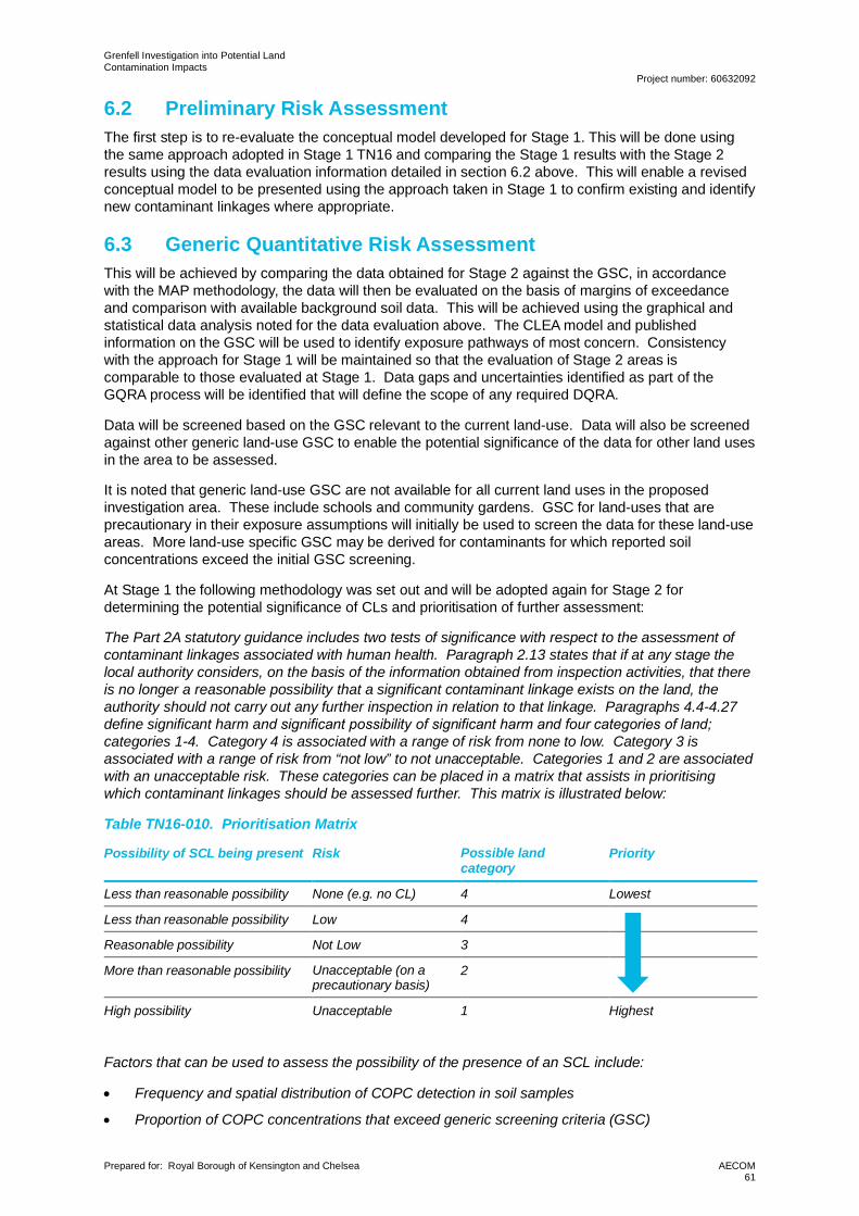
Grenfell Investigation into Potential LandContamination Impacts
Project number: 60632092
Prepared for: Royal Borough of Kensington and Chelsea AECOM61
6.2 Preliminary Risk AssessmentThe first step is to re-evaluate the conceptual model developed for Stage 1. This will be done usingthe same approach adopted in Stage 1 TN16 and comparing the Stage 1 results with the Stage 2results using the data evaluation information detailed in section 6.2 above. This will enable a revisedconceptual model to be presented using the approach taken in Stage 1 to confirm existing and identifynew contaminant linkages where appropriate.
6.3 Generic Quantitative Risk AssessmentThis will be achieved by comparing the data obtained for Stage 2 against the GSC, in accordancewith the MAP methodology, the data will then be evaluated on the basis of margins of exceedanceand comparison with available background soil data. This will be achieved using the graphical andstatistical data analysis noted for the data evaluation above. The CLEA model and publishedinformation on the GSC will be used to identify exposure pathways of most concern. Consistencywith the approach for Stage 1 will be maintained so that the evaluation of Stage 2 areas iscomparable to those evaluated at Stage 1. Data gaps and uncertainties identified as part of theGQRA process will be identified that will define the scope of any required DQRA.
Data will be screened based on the GSC relevant to the current land-use. Data will also be screenedagainst other generic land-use GSC to enable the potential significance of the data for other land usesin the area to be assessed.
It is noted that generic land-use GSC are not available for all current land uses in the proposedinvestigation area. These include schools and community gardens. GSC for land-uses that areprecautionary in their exposure assumptions will initially be used to screen the data for these land-useareas. More land-use specific GSC may be derived for contaminants for which reported soilconcentrations exceed the initial GSC screening.
At Stage 1 the following methodology was set out and will be adopted again for Stage 2 fordetermining the potential significance of CLs and prioritisation of further assessment:
The Part 2A statutory guidance includes two tests of significance with respect to the assessment ofcontaminant linkages associated with human health. Paragraph 2.13 states that if at any stage thelocal authority considers, on the basis of the information obtained from inspection activities, that thereis no longer a reasonable possibility that a significant contaminant linkage exists on the land, theauthority should not carry out any further inspection in relation to that linkage. Paragraphs 4.4-4.27define significant harm and significant possibility of significant harm and four categories of land; categories 1-4. Category 4 is associated with a range of risk from none to low. Category 3 isassociated with a range of risk from “not low” to not unacceptable. Categories 1 and 2 are associatedwith an unacceptable risk. These categories can be placed in a matrix that assists in prioritisingwhich contaminant linkages should be assessed further. This matrix is illustrated below:
Table TN16-010. Prioritisation Matrix
Possibility of SCL being present Risk Possible landcategory
Priority
Less than reasonable possibility None (e.g. no CL) 4 Lowest
Less than reasonable possibility Low 4
Reasonable possibility Not Low 3
More than reasonable possibility Unacceptable (on aprecautionary basis)
2
High possibility Unacceptable 1 Highest
Factors that can be used to assess the possibility of the presence of an SCL include:
· Frequency and spatial distribution of COPC detection in soil samples
· Proportion of COPC concentrations that exceed generic screening criteria (GSC)
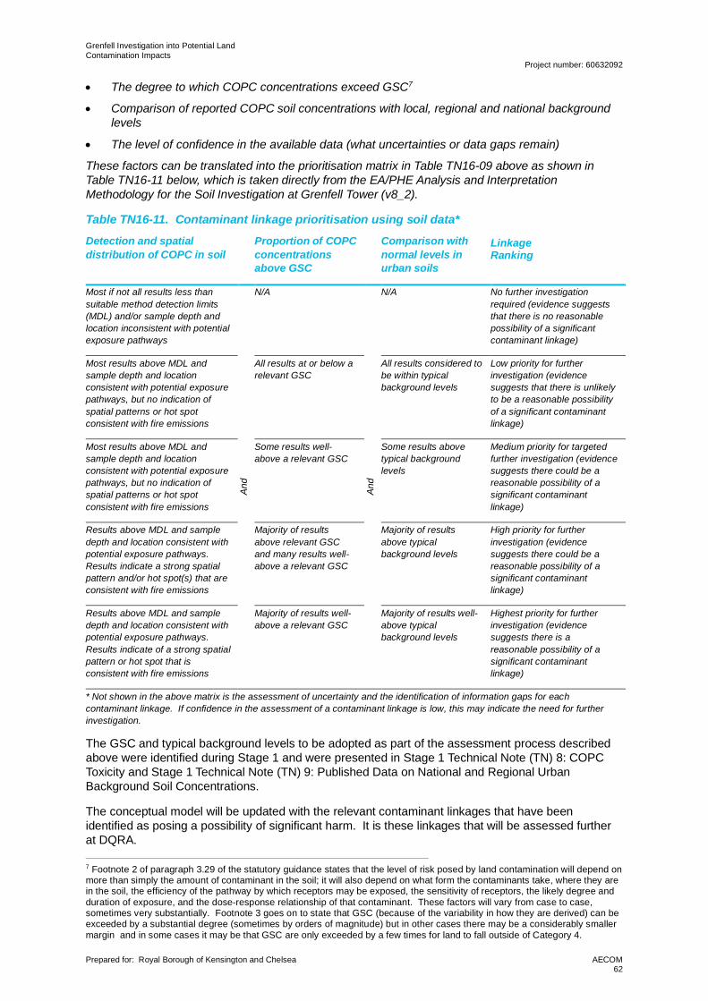
Grenfell Investigation into Potential LandContamination Impacts
Project number: 60632092
Prepared for: Royal Borough of Kensington and Chelsea AECOM62
· The degree to which COPC concentrations exceed GSC7
· Comparison of reported COPC soil concentrations with local, regional and national backgroundlevels
· The level of confidence in the available data (what uncertainties or data gaps remain)
These factors can be translated into the prioritisation matrix in Table TN16-09 above as shown inTable TN16-11 below, which is taken directly from the EA/PHE Analysis and InterpretationMethodology for the Soil Investigation at Grenfell Tower (v8_2).
Table TN16-11. Contaminant linkage prioritisation using soil data*
Detection and spatialdistribution of COPC in soil
Proportion of COPCconcentrationsabove GSC
Comparison withnormal levels inurban soils
LinkageRanking
Most if not all results less thansuitable method detection limits(MDL) and/or sample depth andlocation inconsistent with potentialexposure pathways
And
N/A
And
N/A No further investigationrequired (evidence suggeststhat there is no reasonablepossibility of a significantcontaminant linkage)
Most results above MDL andsample depth and locationconsistent with potential exposurepathways, but no indication ofspatial patterns or hot spotconsistent with fire emissions
All results at or below arelevant GSC
All results considered tobe within typicalbackground levels
Low priority for furtherinvestigation (evidencesuggests that there is unlikelyto be a reasonable possibilityof a significant contaminantlinkage)
Most results above MDL andsample depth and locationconsistent with potential exposurepathways, but no indication ofspatial patterns or hot spotconsistent with fire emissions
Some results well-above a relevant GSC
Some results abovetypical backgroundlevels
Medium priority for targetedfurther investigation (evidencesuggests there could be areasonable possibility of asignificant contaminantlinkage)
Results above MDL and sampledepth and location consistent withpotential exposure pathways.Results indicate a strong spatialpattern and/or hot spot(s) that areconsistent with fire emissions
Majority of resultsabove relevant GSCand many results well-above a relevant GSC
Majority of resultsabove typicalbackground levels
High priority for furtherinvestigation (evidencesuggests there could be areasonable possibility of asignificant contaminantlinkage)
Results above MDL and sampledepth and location consistent withpotential exposure pathways.Results indicate of a strong spatialpattern or hot spot that isconsistent with fire emissions
Majority of results well-above a relevant GSC
Majority of results well-above typicalbackground levels
Highest priority for furtherinvestigation (evidencesuggests there is areasonable possibility of asignificant contaminantlinkage)
* Not shown in the above matrix is the assessment of uncertainty and the identification of information gaps for eachcontaminant linkage. If confidence in the assessment of a contaminant linkage is low, this may indicate the need for furtherinvestigation.
The GSC and typical background levels to be adopted as part of the assessment process describedabove were identified during Stage 1 and were presented in Stage 1 Technical Note (TN) 8: COPCToxicity and Stage 1 Technical Note (TN) 9: Published Data on National and Regional UrbanBackground Soil Concentrations.
The conceptual model will be updated with the relevant contaminant linkages that have beenidentified as posing a possibility of significant harm. It is these linkages that will be assessed furtherat DQRA.
7 Footnote 2 of paragraph 3.29 of the statutory guidance states that the level of risk posed by land contamination will depend onmore than simply the amount of contaminant in the soil; it will also depend on what form the contaminants take, where they arein the soil, the efficiency of the pathway by which receptors may be exposed, the sensitivity of receptors, the likely degree andduration of exposure, and the dose-response relationship of that contaminant. These factors will vary from case to case,sometimes very substantially. Footnote 3 goes on to state that GSC (because of the variability in how they are derived) can beexceeded by a substantial degree (sometimes by orders of magnitude) but in other cases there may be a considerably smallermargin and in some cases it may be that GSC are only exceeded by a few times for land to fall outside of Category 4.
Grenfell Investigation into Potential LandContamination Impacts
Project number: 60632092
Prepared for: Royal Borough of Kensington and Chelsea AECOM63
6.4 Detailed Quantitative Risk AssessmentAECOM considers that the most likely additional data requirements for the DQRA are:
· Additional soil data where individual soil sample results indicate an outlier or concentrationhotspot. The purpose of the data to reduce the uncertainty in the representativeness of that datapoint.
· The testing of deeper soil samples if shallow samples are reported with elevated concentrations.
· Additional soil sampling and testing if unexpected ground conditions are encountered. Thecomparison of soil concentrations against GSC and typical background concentrations asdescribed in Section 6.3 above will help in the identification of unexpected conditions.
· Testing for the bioaccessibility of contaminants other than lead and PAHs. This might be forother metals using the extracts from the UBM tests, or it could include the testing of the extractsfrom the FOREhST tests for dioxins or PCBs.
· Testing of plant tissue samples where the soil results and GSC screening suggests an elevatedexposure from consumption of homegrown produce.
· Detailed quantitative analysis of soil samples identified to contain greater that trace quantities ofasbestos (to include individual fibre counting, reporting of data in fibres per gram, and thepotential for dustiness testing on selected samples if necessary).
· Further evaluation of published background datasets to define normal backgroundconcentrations as per Defra SP1008 (for example for dioxins using the UKSHS dataset), or moredetailed evaluation of reported local concentrations beyond that used at GQRA if this is identifiedas a critical step as a result of the GQRA.
· Detailed extraction of historical analytical data from site investigation reports on council Planningportals. This task will only be completed if it is judged after the initial data presentation andGQRA that there is a high level of uncertainty with potential background concentrations thatcould be complicating the interpretation of the data.
Any extra data requirements considered to be required following the initial data evaluation and GSCscreening will be communicated to MAP along with justifications.
AECOM proposes to undertake the DQRA as follows (dependent on need):
· Use the CLEA model v1.07 to incorporate site-specific bioaccessibility estimates for metals andPAHs and derive site-specific screening criteria.
· Use the CLEA model v1.07 to assess the sensitivity of bioavailability assumptions for dioxins andfurans and PCBs (if required) using literature search of most recent research in this area.
· Use the CLEA model v1.07 to incorporate site-specific plant concentration factors and derivesite-specific screening criteria. (subject to such plant testing being done)
· Compare plant tissue samples to regulatory limits for contaminants in food (subject to such planttesting being done and regulatory limits being available), noting that the regulatory limits are notdirectly applicable to small quantities of homegrown produce but could be a useful comparisonfor risk communication if measured concentrations are below these limits.
· Compare estimates of soil derived exposure doses (using the CLEA model in ratio mode) tobackground intakes from food, water and air where such data is readily available.
· Use the CLEA model v1.07 to assess the sensitivity of some key exposure parameters (thoseidentified in Defra SP1010). For example, soil ingestion rate and dermal absorption factors, ifrelevant.
· Use the CLEA model v1.07 to reduce the homegrown produce consumption rates on the basisthat the kitchen gardens are much smaller than a standard CLEA allotment.
· Recognition of the basis of the health criteria values used in the derivation of the GSC and SSSCand the margin of exceedance of the HCV by the predicted exposure. Relevant information onthe HCV has already been collated in TN8 and AECOM will request information from PHE (intheir role on MAP) on more detailed toxicological aspects where required. AECOM has therefore
Grenfell Investigation into Potential LandContamination Impacts
Project number: 60632092
Prepared for: Royal Borough of Kensington and Chelsea AECOM64
not scoped for detailed toxicological evaluation (either by AECOM or by an independenttoxicologist appointed by AECOM). Toxicological reviews such as those required for thederivation of LLTC are beyond the scope of this project.
Justification for the DQRA scope developed above is provided in the DQRA scoping checklist includedin Appendix E.
6.5 Part 2A SignificanceThe stated aims in the ITT with respect to Part 2A are to:
· Carry out generic and detailed quantitative human health risk assessments required under Part2A to establish whether there are unacceptable risks to human health.
· Provide recommendations in relation to the classification of all potential significant contaminantlinkages investigated as Category 1-4 in accordance with the Statutory Guidance.
· Provide recommendations for whether or not any land appears to meet the definition ofcontaminated land, under Part 2A.
As per the ITT requirements, the data will be assessed using Generic Screening Criteria andassociated assumptions to conclude whether there are likely to be any unacceptable risks. This willfirstly be based on the use of the PHE methodology outlined in section 6.3 to identify contaminantlinkages associated with a reasonable possibility. This step will also identify the key uncertainties thatremain to be resolved before any decision can be made on which Part 2A category land falls withinand set out whether these uncertainties can be resolved by further actions under a DQRA. The stepsfor the DQRA have been outlined in the previous sections. The initial evaluation of the DQRA willfollow the logic of the PHE methodology for the use of GSC, namely that site-specific screeningcriteria (SSSC) and or exposure dose estimates will be used to screen out contaminant linkages thatlikely to be associated with a low level of risk as per paragraph 4.22 of the statutory guidance.
Potentially significant contaminant linkages that are screened out either on the basis of the PHEmethodology for GSC (aligned to paragraph 4.21 of the statutory guidance) or on the basis of theDQRA will be used as the basis for placing individual sample areas into Category 4
If land cannot be clearly placed in Category 4 based on the comparison of reported soilconcentrations to GSC, SSSC, and normal background concentrations, and comparison of exposuredoses to typical daily intakes, AECOM will make preliminary recommendations in line with paragraphs4.24-4.26 of the statutory guidance for consideration by MAP in relation to the likely land category.
6.6 Interpretative ReportingThe Part 2A compliant interpretative report will include:
· The Generic and Detailed Quantitative Risk Assessments.
· A summary of the Stage 2 work and refined Conceptual Model.
· Recommendations under Part 2A (including Category 1-4 classification) for all reasonablypossible significant contaminant linkages investigated and recommendations for any furtheractions that may be needed.
The interpretative report will include any photographs, graphics, plans and tables required to illustratethe outputs of the site inspection work and risk assessment.
The interpretative report will include a succinct non-technical summary which will be intended for usefor wider circulation to a non-specialist audience, and it is recognised that the resulting informationmay be used by RBKC and/or other boroughs for the purposes of making regulatory decisions. Forthis reason, all data / information will be collected in full accordance with relevant guidance, goodpractice and regulations and reported in a clear and unambiguous way.
The structure and content of the report will be in compliance with good practice guidance e.g.minimum reporting requirements from the Environment Agency’s Land Contamination: RiskManagement guidance (the relevant section is “Stage 1: Risk assessment reports” in the LC:RMguidance).
Grenfell Investigation into Potential LandContamination Impacts
Project number: 60632092
Prepared for: Royal Borough of Kensington and Chelsea AECOM65
The interpretative report will include the mechanics of the data presentation (GIS and statistics),GQRA, and DQRA as appendices, with the main report text focused on the clear communication ofwhat those tasks mean in the context of Part 2A, using a line of evidence approach to the explanationof the results.
7. Reference ListBritish Geological Survey, 2019. UKSO. [Online]Available at: http://www.ukso.org/British Standards Institute, 2017a. BS ISO 18400-101:2017. Soil quality – Sampling. Part 101:Framework for the preparation and application of a sampling plan, London: British Standards Institute.British Standards Institute, 2017b. BS ISO 26367-1:2017. Guidelines for assessing the adverseenvironmental impact of fire effluents. Part 1: General, London: British Standards Institute.British Standards Institute, 2017c. BS ISO 26367-2:2017. Guidelines for assessing the adverseenvironmental impact of fire effluents. Part 2: Methodology for compiling data on environmentallysignificant emissions from fires, London: British Standards Institute.British Standards Institute, 2017. Investigation of potentially contaminated sites. Code of practice. BS10175:2011+A2:2017., London: British Standards Institute.BSI, 2019. BS ISO 15800:2019. Soil Quality. Characterisation of soil with respect to human exposure,London: BSI.CIEH, 2009. Reviewing human health risk assessment reports invoking contaminant oralbioavailability measurements or estimates, CIEH Professional Practice Note, London: CIEH.CL:AIRE, 2020. Professional Guidance: Comparing Soil Contamination Data with a CriticalConcentration, Buckinghamshire: CL:AIRE.Crown, 1990. Environmental Protection Act 1990. London: Crown.DEFRA, 2012a. Technical Guidance Sheet on normal levels of contaminants in English soils:Benzo[a]pyrene – supplementary information. Technical Guidance Sheet No. TGS04s.. London:DEFRA.DEFRA, 2012b. Technical Guidance Sheet on normal levels of contaminants in English soils: Lead –Supplementary information. Technical Guidance Sheet No. TGS02s. London: DEFRA.DEFRA, 2014. SP1010 – Development of Category 4 Screening Levels for Assessment of LandAffected by Contamination. London: DEFRA.EA, PHE, 2019. Analysis and Interpretation Methodology for the Soil Investigation at Grenfell Tower,London: Environment Agency.Hadden, R. & Switzer, C., 2020. Combustion Related Fire Products: A Review, Edinburgh: TheUniversity of Edinburgh School of Engineering.Johnson, C., Ander, E., Cave, M. & and Palumbo-Roe, B., 2012. Normal background concentrations(NBCs) of contaminants in English soils: Final project report, Nottingham: British Geological SurveyCommissioned Report, CR/12/035.Kendall, E. L., Leadbetter, S. J., Witham, C. S. & Hort, M. C., 2019. Grenfell Tower fire: modellingdeposition of smoke particulates using NAME. Forecasting Research Technical Report No. 637,Exeter: Met Office.McKone. T.E, a. M. R., 2007. Plant Uptake of Organic Pollutants from Soi: A Critical Review ofBioconcentration Estimates Based on Models and Experiments, Cincinatti: US EnvironmentalProtection Agency National Exposure Research Laboratory, US Department of Energy.Nathanail, C., McCaffrey, C., Gillett, A. & Ogden, R. &. N. J., 2015. The LQM/CIEH S4ULs for HumanHealth Risk Assessment. Nottingham: Land Quality Press, Nottingham.Nathanail, C. P., Jones, A., Ogden, R. & Robertson, A., 2014. Asbestos in soil and made ground: aguide to understanding and managing risks, London: CIRIA.National Institute for Public Health and the Environment, 2014. Oral bioavailability of lead from Dutchmade grounds, A validation study, RIVM report 607711015, Bilthoven: National Institute for PublicHealth and the Environment.Olea, R., 2009. A practical primer on geostatistics, OpenFile Report 2009-1103, Reston: U.S.Geological Survey.Ramsey, M. B. B., 2016. Representative Sampling? Views from a regulator and a measurementscientist. Analytical Methods, I(8), pp. 4783-4784.
Grenfell Investigation into Potential LandContamination Impacts
Project number: 60632092
Prepared for: Royal Borough of Kensington and Chelsea AECOM66
Stec, A., Dickens, J., Barnes, J. & Bedford, C., 2019. Environmental contamination following theGrenfell Tower fire.. Chemosphere, Volume 226,, pp. pp. 576-586.Taylor, P., Boon, K. & Ramsey, M., 2007. Cost-effective investigation of contaminated land. ResearchProject RP4, London: CL:AIRE.U.S. Environmental Protection Agency Analytical Services Branch, 2016. Laboratory Operations andQuality Assurance Manual. Washington: Laboratory Operations and Quality Assurance Manual.US Department of Defense, 2017. PAH Interactions with Soil and Effects on Bioaccessibility andBioavailability to Humans. SERDP Project ER-1743, Washington: US Department of Defense.US Government, 2012. 40 CFR Appendix A to Part 423.. Washington: US Government PublishingOffice.
Grenfell Investigation into Potential LandContamination Impacts
Project number: 60632092
Prepared for: Royal Borough of Kensington and Chelsea AECOM67
Appendix A Figures
!(
!(
!(
!(
!(
!(
!(
!(!(
!(
189
57 to 6350 to 56
191
El Sub Sta
1 to 80
187
187a
29 to 41
El Sub Sta
43 to 49
Hous e
Markland
Tennis
Court
12
6
11
Latimer
Education
Centre
1
Cyc leHire
Play Area
SportsFacility
SportsFacility
Sports Court
1 to 80
Ales tan House
Frins teadHouse
1 to 15
200
Pos t
Travellers
Site
Cyc le Way
38 to 48
SHALFLEETDRIVE
Play Area
15
Mersey House
1 to 6
GTCS2–S001
GTCS2–S002
GTCS2–S003
GTCS2–S004
GTCS2–S005
GTCS2–S006
GTCS2–S007
GTCS2–S008GTCS2–S009
GTCS2–S010
Project Title
Drawing Title
Drawn Checked
MidpointAlençon Link, BasingstokeHampshire, RG21 7PPTelephone (01256) 310200Fax (01256) 310201www.aecom.com
AECOM
DateApproved
RevDrawing Number
FIGURE A1 01
THIS DOCUMENT HAS BEEN PREPARED PURSUANT TO AND SUBJECT TO THETERMS OF AECOM'S APPOINTMENT BY ITS CLIENT. AECOM ACCEPTS NO LIABILITY
FOR ANY USE OF THIS DOCUMENT OTHER THAN BY ITS ORIGINAL CLIENT ORFOLLOWING AECOM'S EXPRESS AGREEMENT TO SUCH USE, AND ONLY FOR THE
PURPOSES FOR WHICH IT WAS PREPARED AND PROVIDED.
AECOM Internal Project No. Scale @ A360632092 1:500GM DD DD 19/10/2020
Client
File Na
me:\\e
u.aeco
mnet.c
om\EM
IA\UK
I\UKC
RD1\J
obs\PR
-45802
0_Gren
fell_To
wer_S
tage_2
\900_C
AD_G
IS\950
_Stag
e2_GIS
\02_M
aps\Fig
ure 06
- Stag
e 2 Sa
mpling
Locat
ions -
All Site
s.mxd
±
0 10 20 30 40 50 60 m
LEGENDSite Outline
!( Proposed SampleFood GrowingRBKC identified potentially contaminatedlandRBKC identified areas ofGeoenvironmental interestFood GrowingRBKC registered trade directoryGeoEnviron Sites Historic
GRENFELL PHASE 2ASSESSMENT
ROYAL BOROUGH OFKENSINGTON & CHELSEA
THIS DRAWING IS TO BE USED ONLY FOR THE PURPOSE OFISSUE THAT IT WAS ISSUED FOR AND IS SUBJECT TO AMENDMENT
CopyrightContains Ordnance Survey Data © Crown Copyright and database right 2020
1LATYMER ALTERNATIVE PROVISION
ACADEMY
Name, Ground_CoverGTCS2–S001, bare soil - dis turbedGTCS2–S002, bare soil - dis turbedGTCS2–S003, turfGTCS2–S004, turfGTCS2–S005, bare soil - dis turbedGTCS2–S006, bare soil - undis turbedGTCS2–S007, bare soil - undis turbedGTCS2–S008, turfGTCS2–S009, bare soil - dis turbedGTCS2–S010, bare soil - undis turbed
!(
!(!(
!(
!(
!(
!(
!(!(
!(
King House89 to 135
Footb allPitc h
El Sub Sta
Mast
Woodlane
El Sub Sta
1 to 11Du CaneFB161 to 179
FS
Ham m ersm ithHospital
FB
10.7m
Stone
LinfordCh ristieStadium
PC
Woodm ans
Mews
37
Path (um )
Terraces
CoveredPrac ticeTrac k
14 to 53
PC
13
Stand
R efresh ment
TankTank
Burling tonDanes Sc h ool
SportsFacility
Tank
PC
R unning Track
Stab les
R ecreationGround
Cyc lingCentre
Play Area
El Sub Sta1 to 188
Clem ent Danes House
1 to 110Holb orn House
19 to 321
126
13 18to7 HouseCh ristie9 to 27
1 to 8
SL
149175
1 to 12
Daley House
MP 7.5
125
87to41
10.3m
House
89
El Sub Sta
113
10.9m
PIONEER WAY
11.4m
137
DU CANE R OAD
10.7m
159
9.3m
MP7.75Vellacott
1 to 40
10.2m
FB
to137
9.7m
10.0m
FB
101161
191
FB
71Galen House
SportsFacility
FB
FB
FB
FB
FB
HouseHolst
Doroth yHodg kinHouse
41
26 to 2914 to 17
34 to 37Sh elters
Playing FieldsLatym er Upper Sc h ool
36 to 49
House
Sta
7 to 1213 to 18
1 to 6243
58 to 61
50 to 53PIONEER WAY
Pankh urst1 to 136
10.4m
1 to 36
House
227
9.6m
9.9m
WOODLANE
10.4m
29
38 to 41
10.0m
SportsFacility
Sh elter
Holst
Sh elter
ESS
14
Worm woodSc rub s 2811.8m
53
SCRUBS LANE
Sc rub sPark
1
29
12.7m
Pavilion
1 to 47
2a
1
SCR UBS
67
2b
10.9m
CF
Th ePavilionHotel
Sh elter
SL
17
SL
30
16
POLE ROAD
215
18
24
15
1
Posts
FW
CW
113
15
6
25
12
5
1115
2
33
16
13
1
22
211
23
2
2
142STREET
Pavilion Terrace
GLENR OY
STREET
NASCOT
STR EET
21
1a 1
CF
FWDef
Def
Def
Def
CF
Sh elter
LB
MP 1.0
GTCS2–S011
GTCS2–S012GTCS2–S013
GTCS2–S014
GTCS2–S015
GTCS2–S016
GTCS2–S017
GTCS2–S018GTCS2–S019
GTCS2–S020
202
205
462
470
472
10552772
3944
255
Project Title
Drawing Title
Drawn Checked
MidpointAlençon Link, BasingstokeHampshire, RG21 7PPTelephone (01256) 310200Fax (01256) 310201www.aecom.com
AECOM
DateApproved
RevDrawing Number
FIGURE A2 01
THIS DOCUMENT HAS BEEN PREPARED PURSUANT TO AND SUBJECT TO THETERMS OF AECOM'S APPOINTMENT BY ITS CLIENT. AECOM ACCEPTS NO LIABILITY
FOR ANY USE OF THIS DOCUMENT OTHER THAN BY ITS ORIGINAL CLIENT ORFOLLOWING AECOM'S EXPRESS AGREEMENT TO SUCH USE, AND ONLY FOR THE
PURPOSES FOR WHICH IT WAS PREPARED AND PROVIDED.
AECOM Internal Project No. Scale @ A360632092 1:2,000GM DD DD 19/10/2020
Client
File Na
me:\\e
u.aeco
mnet.c
om\EM
IA\UK
I\UKC
RD1\J
obs\PR
-45802
0_Gren
fell_To
wer_S
tage_2
\900_C
AD_G
IS\950
_Stag
e2_GIS
\02_M
aps\Fig
ure 06
- Stag
e 2 Sa
mpling
Locat
ions -
All Site
s.mxd
±
0 40 80 120 160 200 240 m
LEGENDSite Outline
!( Proposed Sample LocationLBHF identified potential contaminatedsitesRBKC identified potentially contaminatedlandRBKC registered trade directory entries
GRENFELL PHASE 2ASSESSMENT
ROYAL BOROUGH OFKENSINGTON & CHELSEA
THIS DRAWING IS TO BE USED ONLY FOR THE PURPOSE OFISSUE THAT IT WAS ISSUED FOR AND IS SUBJECT TO AMENDMENT
CopyrightContains Ordnance Survey Data © Crown Copyright and database right 2020
2BURLINGTON DANES SCHOOL
Name, Ground_CoverGTCS2–S011, turfGTCS2–S012, turfGTCS2–S013, turfGTCS2–S014, turfGTCS2–S015, turfGTCS2–S016, turfGTCS2–S017, turfGTCS2–S018, bare soil - undisturb edGTCS2–S019, bare soil - undisturb edGTCS2–S020, turf
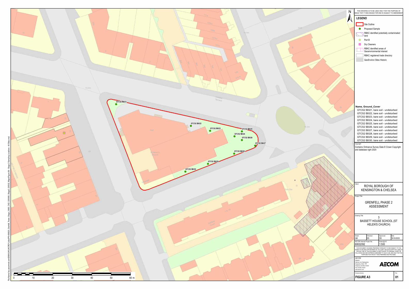
!(
!(
!(
!(
!(
!(
!(
!(
!(
!(
9
5
3
LB
3ac 2ac
2b d
Cow p erTerrace
13.4m
Hall73
75
105
1ac
107b c
107a
3bd2
52a
10
8
1bd
1
14.9m
46
36
109b c
109a
14.3m
TCB
111a
St Helen'sChurch
1 to 18
56g
59
61
El
56
101
Kelfield
Court2
69
Vicarage
Sub Sta
a to e
KELFIELD MEWS
GTCS2–S021
GTCS2–S022GTCS2–S023
GTCS2–S024GTCS2–S025
GTCS2–S026
GTCS2–S027
GTCS2–S028
GTCS2–S029
GTCS2–S030
Project Title
Drawing Title
Drawn Checked
MidpointAlençon Link, BasingstokeHampshire, RG21 7PPTelephone (01256) 310200Fax (01256) 310201www.aecom.com
AECOM
DateApproved
RevDrawing Number
FIGURE A3 01
THIS DOCUMENT HAS BEEN PREPARED PURSUANT TO AND SUBJECT TO THETERMS OF AECOM'S APPOINTMENT BY ITS CLIENT. AECOM ACCEPTS NO LIABILITY
FOR ANY USE OF THIS DOCUMENT OTHER THAN BY ITS ORIGINAL CLIENT ORFOLLOWING AECOM'S EXPRESS AGREEMENT TO SUCH USE, AND ONLY FOR THE
PURPOSES FOR WHICH IT WAS PREPARED AND PROVIDED.
AECOM Internal Project No. Scale @ A360632092 1:500GM DD DD 19/10/2020
Client
File Na
me:\\e
u.aeco
mnet.c
om\EM
IA\UK
I\UKC
RD1\J
obs\PR
-45802
0_Gren
fell_To
wer_S
tage_2
\900_C
AD_G
IS\950
_Stag
e2_GIS
\02_M
aps\Fig
ure 06
- Stag
e 2 Sa
mpling
Locat
ions -
All Site
s.mxd
±
0 10 20 30 40 50 60 m
LEGENDSite Outline
!( Proposed SampleRBKC identified potentially contaminatedland
!( Part B") Dry Cleaners
RBKC identified areas ofGeoenvironmental interestRBKC registered trade directoryGeoEnviron Sites Historic
GRENFELL PHASE 2ASSESSMENT
ROYAL BOROUGH OFKENSINGTON & CHELSEA
THIS DRAWING IS TO BE USED ONLY FOR THE PURPOSE OFISSUE THAT IT WAS ISSUED FOR AND IS SUBJECT TO AMENDMENT
CopyrightContains Ordnance Survey Data © Crown Copyright and database right 2020
3BASSETT HOUSE SCHOOL (ST
HELEN'S CHURCH)
Name, Ground_CoverGTCS2–S021, b are s oil - undis turb edGTCS2–S022, b are s oil - undis turb edGTCS2–S023, b are s oil - undis turb edGTCS2–S024, b are s oil - undis turb edGTCS2–S025, b are s oil - undis turb edGTCS2–S026, b are s oil - undis turb edGTCS2–S027, b are s oil - undis turb edGTCS2–S028, b are s oil - undis turb edGTCS2–S029, b are s oil - undis turb edGTCS2–S030, b are s oil - undis turb ed
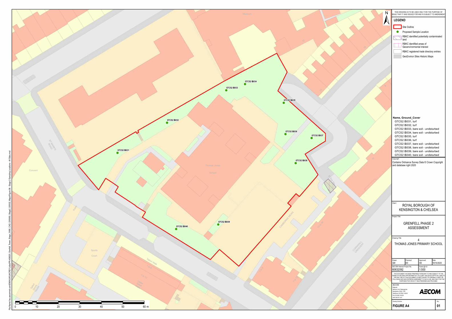
!(
!(
!(
!(
!(
!(
!(
!(
!(
!(
Thom as Jones
School
1 to 12
13 to 36
171 to 6
8
10
1 to 6
13
18
Talbot
Grove
House
Posts
ST MARK'S
ROAD
Talbot Walk
El Sub Sta
CORNWALL
CRESCENT
Con ven t
12
U pperTalbotWalk
CAMBORNE MEWS
Museum
7 to 12
SportsCourt
GTCS2–S031
GTCS2–S032
GTCS2–S033
GTCS2–S034
GTCS2–S035
GTCS2–S036GTCS2–S037
GTCS2–S038
GTCS2–S039GTCS2–S040
Project Title
Drawing Title
Drawn Checked
MidpointAlençon Link, BasingstokeHampshire, RG21 7PPTelephone (01256) 310200Fax (01256) 310201www.aecom.com
AECOM
DateApproved
RevDrawing Number
FIGURE A4 01
THIS DOCUMENT HAS BEEN PREPARED PURSUANT TO AND SUBJECT TO THETERMS OF AECOM'S APPOINTMENT BY ITS CLIENT. AECOM ACCEPTS NO LIABILITY
FOR ANY USE OF THIS DOCUMENT OTHER THAN BY ITS ORIGINAL CLIENT ORFOLLOWING AECOM'S EXPRESS AGREEMENT TO SUCH USE, AND ONLY FOR THE
PURPOSES FOR WHICH IT WAS PREPARED AND PROVIDED.
AECOM Internal Project No. Scale @ A360632092 1:500GM DD DD 19/10/2020
Client
File Na
me:\\e
u.aeco
mnet.c
om\EM
IA\UK
I\UKC
RD1\J
obs\PR
-45802
0_Gren
fell_To
wer_S
tage_2
\900_C
AD_G
IS\950
_Stag
e2_GIS
\02_M
aps\Fig
ure 06
- Stag
e 2 Sa
mpling
Locat
ions -
All Site
s.mxd
±
0 10 20 30 40 50 60 m
LEGENDSite Outline
!( Proposed Sample LocationRBKC identified potentially contaminatedlandRBKC identified areas ofGeoenvironmental interestRBKC registered trade directory entriesGeoEnviron Sites Historic Maps
GRENFELL PHASE 2ASSESSMENT
ROYAL BOROUGH OFKENSINGTON & CHELSEA
THIS DRAWING IS TO BE USED ONLY FOR THE PURPOSE OFISSUE THAT IT WAS ISSUED FOR AND IS SUBJECT TO AMENDMENT
CopyrightContains Ordnance Survey Data © Crown Copyright and database right 2020
4THOMAS JONES PRIMARY SCHOOL
Name, Ground_CoverGTCS2–S031, turfGTCS2–S032, turfGTCS2–S033, bare soil - un disturbedGTCS2–S034, bare soil - un disturbedGTCS2–S035, turfGTCS2–S036, turfGTCS2–S037, bare soil - un disturbedGTCS2–S038, bare soil - un disturbedGTCS2–S039, bare soil - un disturbedGTCS2–S040, bare soil - un disturbed
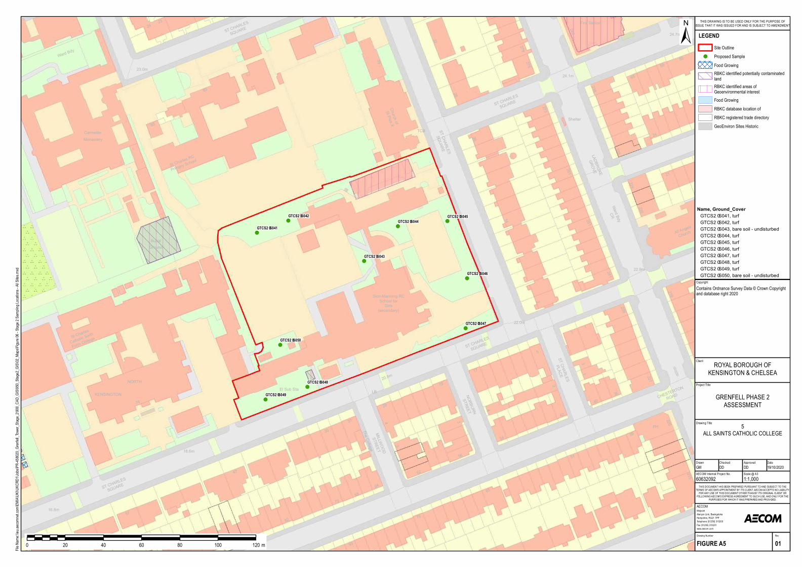
!(
!(
!(
!(!(
!(
!(
!(
!(
!(
TCB ST CHARLES
SQ UARE
273
26
ST CHARLES
SQ UARE
14
32
79
28
275279
Church ofSt Pius X
PH
2
36
218
251
220
24.1m
1
1
261All Ang
e lsChurch
51
224
215
239
242
3
CHESTERTO
N
ROAD
22.9m
LADBROKE
GROVE
40
227
Fire Sta tion
24.7m
238
65
5559
24225
21
241226
39
3
Wa rd BdyCR
She lte r
LB
Sion-Ma nning RCSchool forGirls
4 31 54
65
ST CHARLES
PLACE
56
3
2
29
68
2
62
93
4
The Cotta g eMILLWOOD
STREET
20.8m
31
1
79
5
17
NORBURN
STREET
19
22.0m
ST CHARLES
SQ UARE
42
64
(se conda ry)
16.8m
35
82
72
92
74
57
47
18.6m
ST CHARLES
SQ UARE
KENSINGTONEl Sub Sta
St Charle s
Ca tholic Sixth
Form Colle g e
NORTH
2423
GroundBuria l
ST CHARLES
SQ UARE
83
85
Mona ste ry
St Charle s RC
Prim a ry Scho
ol
Ca rm e lite
23.0m
Wa rd Bdy
GTCS2–S041
GTCS2–S042
GTCS2–S043
GTCS2–S044GTCS2–S045
GTCS2–S046
GTCS2–S047
GTCS2–S048
GTCS2–S049
GTCS2–S050
Project Title
Drawing Title
Drawn Checked
MidpointAlençon Link, BasingstokeHampshire, RG21 7PPTelephone (01256) 310200Fax (01256) 310201www.aecom.com
AECOM
DateApproved
RevDrawing Number
FIGURE A5 01
THIS DOCUMENT HAS BEEN PREPARED PURSUANT TO AND SUBJECT TO THETERMS OF AECOM'S APPOINTMENT BY ITS CLIENT. AECOM ACCEPTS NO LIABILITY
FOR ANY USE OF THIS DOCUMENT OTHER THAN BY ITS ORIGINAL CLIENT ORFOLLOWING AECOM'S EXPRESS AGREEMENT TO SUCH USE, AND ONLY FOR THE
PURPOSES FOR WHICH IT WAS PREPARED AND PROVIDED.
AECOM Internal Project No. Scale @ A360632092 1:1,000GM DD DD 19/10/2020
Client
File Na
me:\\e
u.aeco
mnet.c
om\EM
IA\UK
I\UKC
RD1\J
obs\PR
-45802
0_Gren
fell_To
wer_S
tage_2
\900_C
AD_G
IS\950
_Stag
e2_GIS
\02_M
aps\Fig
ure 06
- Stag
e 2 Sa
mpling
Locat
ions -
All Site
s.mxd
±
0 20 40 60 80 100 120 m
LEGENDSite Outline
!( Proposed SampleFood GrowingRBKC identified potentially contaminatedlandRBKC identified areas ofGeoenvironmental interestFood GrowingRBKC database location ofRBKC registered trade directoryGeoEnviron Sites Historic
GRENFELL PHASE 2ASSESSMENT
ROYAL BOROUGH OFKENSINGTON & CHELSEA
THIS DRAWING IS TO BE USED ONLY FOR THE PURPOSE OFISSUE THAT IT WAS ISSUED FOR AND IS SUBJECT TO AMENDMENT
CopyrightContains Ordnance Survey Data © Crown Copyright and database right 2020
5ALL SAINTS CATHOLIC COLLEGE
Name, Ground_CoverGTCS2–S041, turfGTCS2–S042, turfGTCS2–S043, b a re soil - undisturb e dGTCS2–S044, turfGTCS2–S045, turfGTCS2–S046, turfGTCS2–S047, turfGTCS2–S048, turfGTCS2–S049, turfGTCS2–S050, b a re soil - undisturb e d
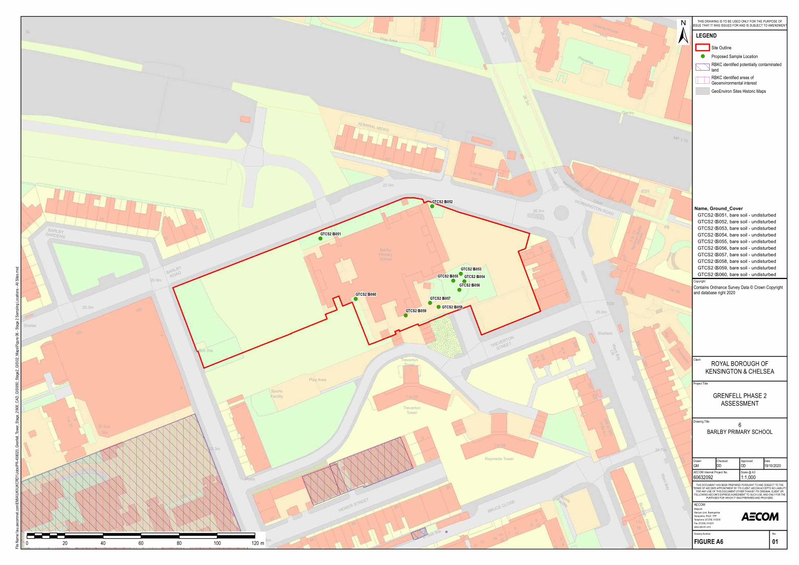
!(
!(
!(
!(!(
!(
!(!(
!(
!(
1
TrevertonTower
5
1 to 16163
26.5m
28.2m
22.0m
351
161
ADMIR AL MEWS
59 to 68
TR EVER TO
N
STR EET
28.3m
339
151
141
to 8
Play Area
355
Barlb yPrim arySc h ool
20.9m
160
2
BAR LBY
R OAD
20.3m
El Sub Sta
BAR LBYGAR DENS
150
1
24
21
158
2
Shelter
SL
298
81
Gantry
FB
312
304
318
WOR NINGTON R OAD
to 4
Kerring ton316b
Court
316a
1TCB
1 to 39
House
Norman Butler
1 to 13
25.0m
Portob ello
341
Oc tavia House
300
310
349
339
308
MP 1.75
Ward BdyCR
314
Playarea
ESS
TCB
Shelters
292
337
319a to j329 to 333
335
House
278
24.7m
Burleig h
Ward Bdy
SportsFac ility
261
5
181 to
7
5
1
1 to 216
El SubSta
FB
17
HEWER STR
EET26
36
46
8
20
18
BR UCE CLO
SE
7
Posts
1 to 55
22.3m 1 to 55
ChapelEl Sub
Sta22.5m
Chy
(private)
TrevertonTower
17
R aym ede Tower
15
9 to 13
7
5
Play Area
SportsFac ility
4
4
13 22
314
1211
GTCS2–S051
GTCS2–S052
GTCS2–S053GTCS2–S054GTCS2–S055
GTCS2–S056
GTCS2–S057GTCS2–S058GTCS2–S059
GTCS2–S060
Project Title
Drawing Title
Drawn Checked
MidpointAlençon Link, BasingstokeHampshire, RG21 7PPTelephone (01256) 310200Fax (01256) 310201www.aecom.com
AECOM
DateApproved
RevDrawing Number
FIGURE A6 01
THIS DOCUMENT HAS BEEN PREPARED PURSUANT TO AND SUBJECT TO THETERMS OF AECOM'S APPOINTMENT BY ITS CLIENT. AECOM ACCEPTS NO LIABILITY
FOR ANY USE OF THIS DOCUMENT OTHER THAN BY ITS ORIGINAL CLIENT ORFOLLOWING AECOM'S EXPRESS AGREEMENT TO SUCH USE, AND ONLY FOR THE
PURPOSES FOR WHICH IT WAS PREPARED AND PROVIDED.
AECOM Internal Project No. Scale @ A360632092 1:1,000GM DD DD 19/10/2020
Client
File Na
me:\\e
u.aeco
mnet.c
om\EM
IA\UK
I\UKC
RD1\J
obs\PR
-45802
0_Gren
fell_To
wer_S
tage_2
\900_C
AD_G
IS\950
_Stag
e2_GIS
\02_M
aps\Fig
ure 06
- Stag
e 2 Sa
mpling
Locat
ions -
All Site
s.mxd
±
0 20 40 60 80 100 120 m
LEGENDSite Outline
!( Proposed Sample LocationRBKC identified potentially contaminatedlandRBKC identified areas ofGeoenvironmental interestGeoEnviron Sites Historic Maps
GRENFELL PHASE 2ASSESSMENT
ROYAL BOROUGH OFKENSINGTON & CHELSEA
THIS DRAWING IS TO BE USED ONLY FOR THE PURPOSE OFISSUE THAT IT WAS ISSUED FOR AND IS SUBJECT TO AMENDMENT
CopyrightContains Ordnance Survey Data © Crown Copyright and database right 2020
6BARLBY PRIMARY SCHOOL
Name, Ground_CoverGTCS2–S051, bare soil - undisturb edGTCS2–S052, bare soil - undisturb edGTCS2–S053, bare soil - undisturb edGTCS2–S054, bare soil - undisturb edGTCS2–S055, bare soil - undisturb edGTCS2–S056, bare soil - undisturb edGTCS2–S057, bare soil - undisturb edGTCS2–S058, bare soil - undisturb edGTCS2–S059, bare soil - undisturb edGTCS2–S060, bare soil - undisturb ed
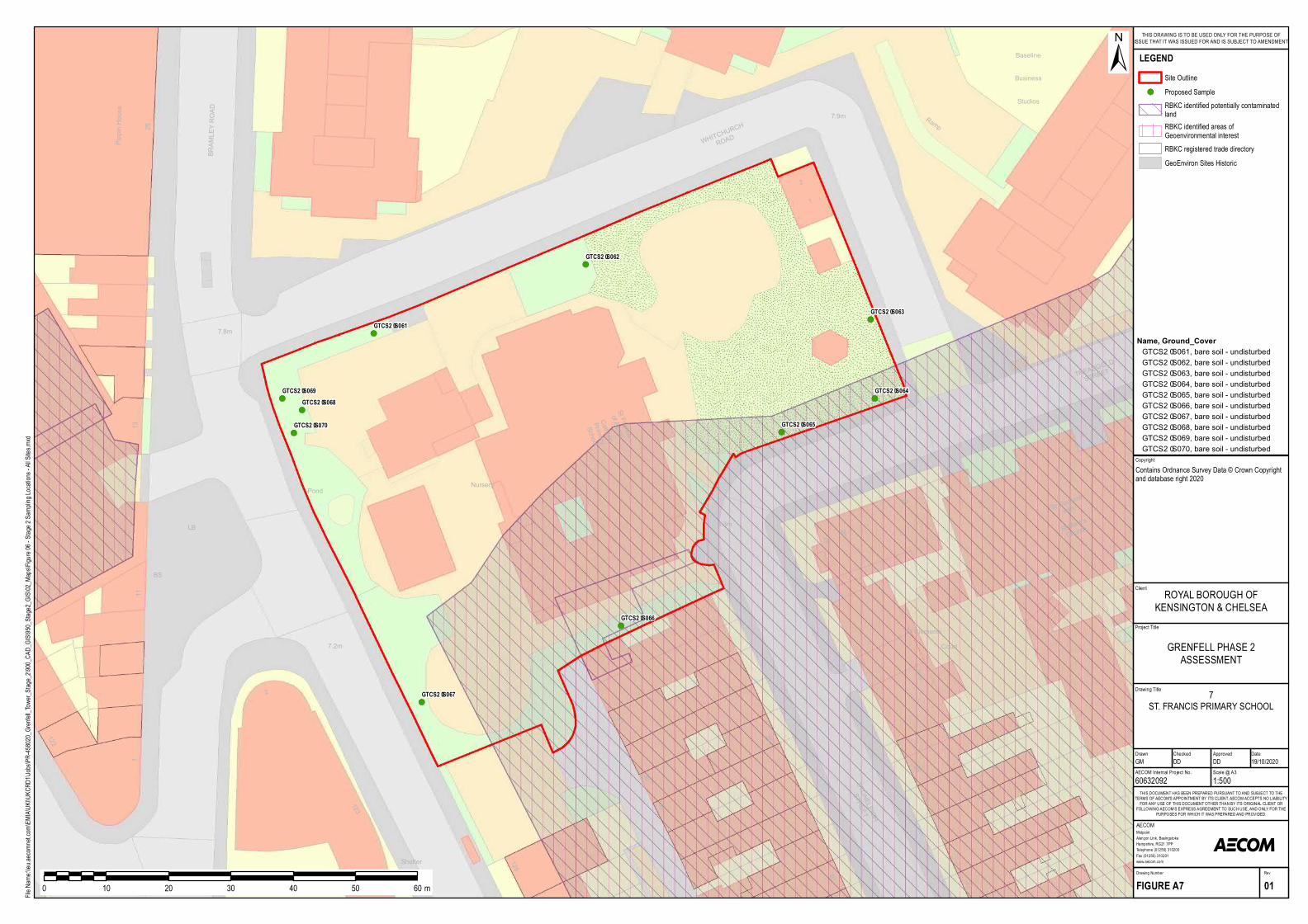
!(
!(
!(
!(
!(
!(
!(
!(
!(
!(
2
123
35
11
35
40
25
122
21
1
27 1 to 6
St Clem entsCourt
BRAMLEY ROAD
Ram p
1
35
126
36
33
St Clement
with
7.8m
7.9m
WHIT CHURC
H
ROAD
T READGOLD
ST REET
ST ONELEIGH
ST REET
St Mark 's
Church
7.2m
6.3m
Pippin House
25
Baseline
Stud ios
Business
CatholicPrim arySchool
BS
LB
Cycle HireStation
Shelter
Pond
13
St Francisof Assisi
2
2829Nursery
GTCS2–S061
GTCS2–S062
GTCS2–S063
GTCS2–S064
GTCS2–S065
GTCS2–S066
GTCS2–S067
GTCS2–S068GTCS2–S069
GTCS2–S070
Project Title
Drawing Title
Drawn Checked
MidpointAlençon Link, BasingstokeHampshire, RG21 7PPTelephone (01256) 310200Fax (01256) 310201www.aecom.com
AECOM
DateApproved
RevDrawing Number
FIGURE A7 01
THIS DOCUMENT HAS BEEN PREPARED PURSUANT TO AND SUBJECT TO THETERMS OF AECOM'S APPOINTMENT BY ITS CLIENT. AECOM ACCEPTS NO LIABILITY
FOR ANY USE OF THIS DOCUMENT OTHER THAN BY ITS ORIGINAL CLIENT ORFOLLOWING AECOM'S EXPRESS AGREEMENT TO SUCH USE, AND ONLY FOR THE
PURPOSES FOR WHICH IT WAS PREPARED AND PROVIDED.
AECOM Internal Project No. Scale @ A360632092 1:500GM DD DD 19/10/2020
Client
File Na
me:\\e
u.aeco
mnet.c
om\EM
IA\UK
I\UKC
RD1\J
obs\PR
-45802
0_Gren
fell_To
wer_S
tage_2
\900_C
AD_G
IS\950
_Stag
e2_GIS
\02_M
aps\Fig
ure 06
- Stag
e 2 Sa
mpling
Locat
ions -
All Site
s.mxd
±
0 10 20 30 40 50 60 m
LEGENDSite Outline
!( Proposed SampleRBKC identified potentially contaminatedlandRBKC identified areas ofGeoenvironmental interestRBKC registered trade directoryGeoEnviron Sites Historic
GRENFELL PHASE 2ASSESSMENT
ROYAL BOROUGH OFKENSINGTON & CHELSEA
THIS DRAWING IS TO BE USED ONLY FOR THE PURPOSE OFISSUE THAT IT WAS ISSUED FOR AND IS SUBJECT TO AMENDMENT
CopyrightContains Ordnance Survey Data © Crown Copyright and database right 2020
7ST. FRANCIS PRIMARY SCHOOL
Name, Ground_CoverGT CS2–S061, bare soil - und isturbedGT CS2–S062, bare soil - und isturbedGT CS2–S063, bare soil - und isturbedGT CS2–S064, bare soil - und isturbedGT CS2–S065, bare soil - und isturbedGT CS2–S066, bare soil - und isturbedGT CS2–S067, bare soil - und isturbedGT CS2–S068, bare soil - und isturbedGT CS2–S069, bare soil - und isturbedGT CS2–S070, bare soil - und isturbed
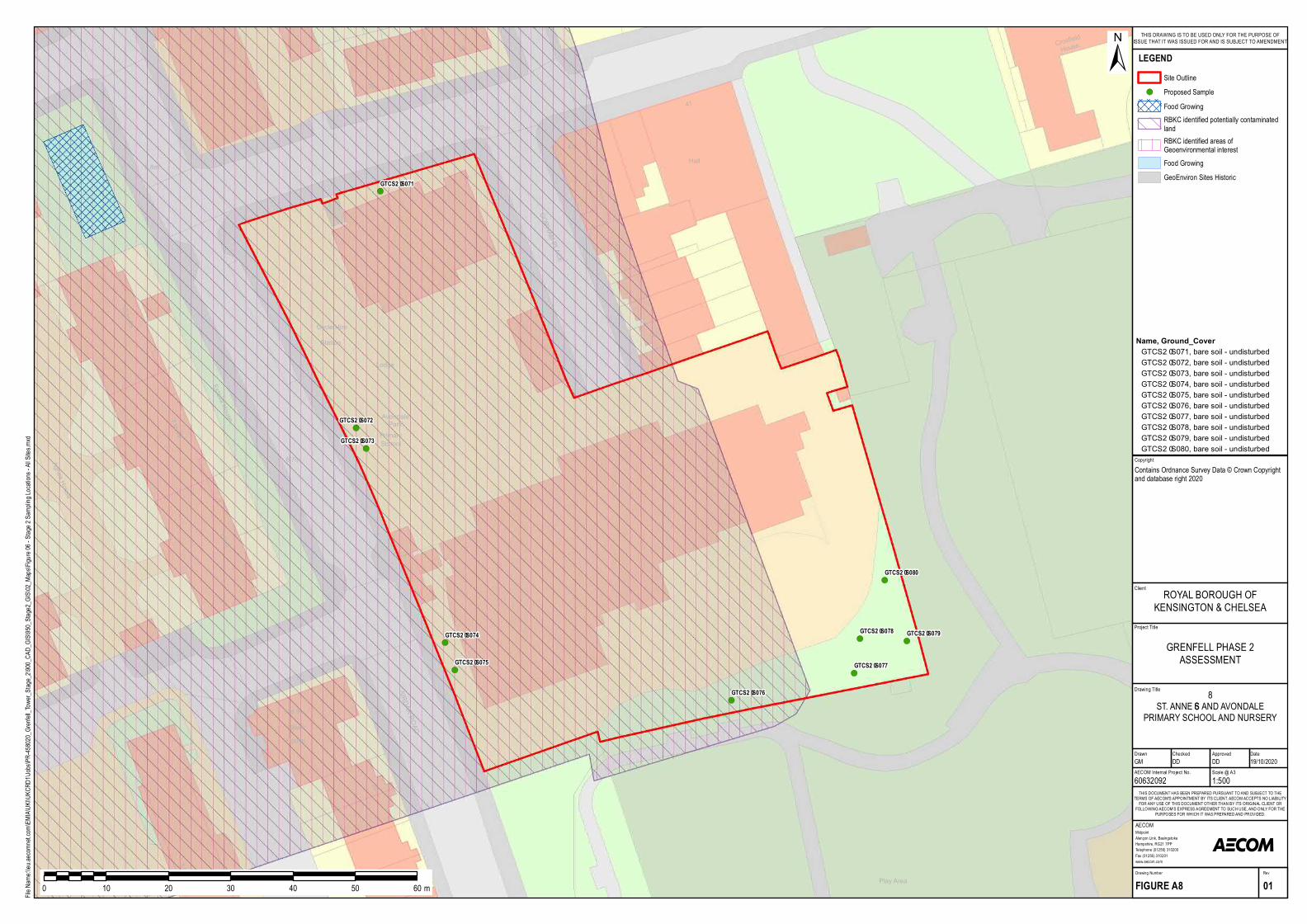
!(
!(
!(
!(
!(
!(
!(
!( !(
!(
6.8m
MarleyHou s e
Agnes Hou s e
Es tella Hou se7 to 12
1 to 6
13 to 18
1 to 47
CrosfieldHou s e34
38
7.2m
41
47Hall
35
Lod ge
4
SIRDAR ROAD29
GORHAM PLACE
Avond alePark
1
PrimarySchool
Cycle HireStation
Play Area
OliverHou s e
1 to 9
6.7m
GTCS2–S071
GTCS2–S072
GTCS2–S073
GTCS2–S074
GTCS2–S075
GTCS2–S076
GTCS2–S077
GTCS2–S078 GTCS2–S079
GTCS2–S080
Project T itle
Drawing T itle
Drawn Check ed
MidpointAlençon Link, Basingstok eHampshire, RG21 7PPTelephone (01256) 310200Fax (01256) 310201www.aecom.com
AECOM
DateApproved
RevDrawing Number
FIGURE A8 01
T HIS DOCU MENT HAS BEEN PREPARED PU RS U ANT T O AND S U BJECT TO T HETERMS OF AECOM'S APPOINTMENT BY IT S CLIENT. AECOM ACCEPT S NO LIABILIT YFOR ANY U S E OF THIS DOCU MENT OT HER T HAN BY IT S ORIGINAL CLIENT ORFOLLOWING AECOM'S EX PRES S AGREEMENT TO S U CH U S E, AND ONLY FOR T HE
PU RPOS ES FOR WHICH IT WAS PREPARED AND PROVIDED.
AECOM Internal Project No. S cale @ A360632092 1:500GM DD DD 19/10/2020
Client
File Name:\\eu.aecomnet.com\EMIA\UKI\UKCRD1\Jobs\PR-458020_Grenfell_Tower_Stage_2\900_CAD_GIS\950_Stage2_GIS\02_Maps\Figure 06 - Stage 2 Sampling Locations - All Sites.mxd
±
0 10 20 30 40 50 60m
LEGENDS ite Outline
!( Proposed S ampleFood GrowingRBK C identified potentially contaminatedlandRBK C identified areas ofGeoenvironmental interestFood GrowingGeoEnviron S ites Historic
GRENFELL PHAS E 2AS S ES S MENT
ROYAL BOROU GH OFK ENS INGTON & CHELS EA
THIS DRAWING IS T O BE U S ED ONLY FOR T HE PU RPOS E OFIS S U E T HAT IT WAS IS S U ED FOR AND IS S U BJECT T O AMENDMENT
CopyrightContains Ordnance S urvey Data © Crown Copyright and database right 2020
8S T. ANNE’S AND AVONDALE
PRIMARY S CHOOL AND NU RS ERY
Name, Ground_CoverGTCS2–S071, bare soil - u nd is tu rbedGTCS2–S072, bare soil - u nd is tu rbedGTCS2–S073, bare soil - u nd is tu rbedGTCS2–S074, bare soil - u nd is tu rbedGTCS2–S075, bare soil - u nd is tu rbedGTCS2–S076, bare soil - u nd is tu rbedGTCS2–S077, bare soil - u nd is tu rbedGTCS2–S078, bare soil - u nd is tu rbedGTCS2–S079, bare soil - u nd is tu rbedGTCS2–S080, bare soil - u nd is tu rbed
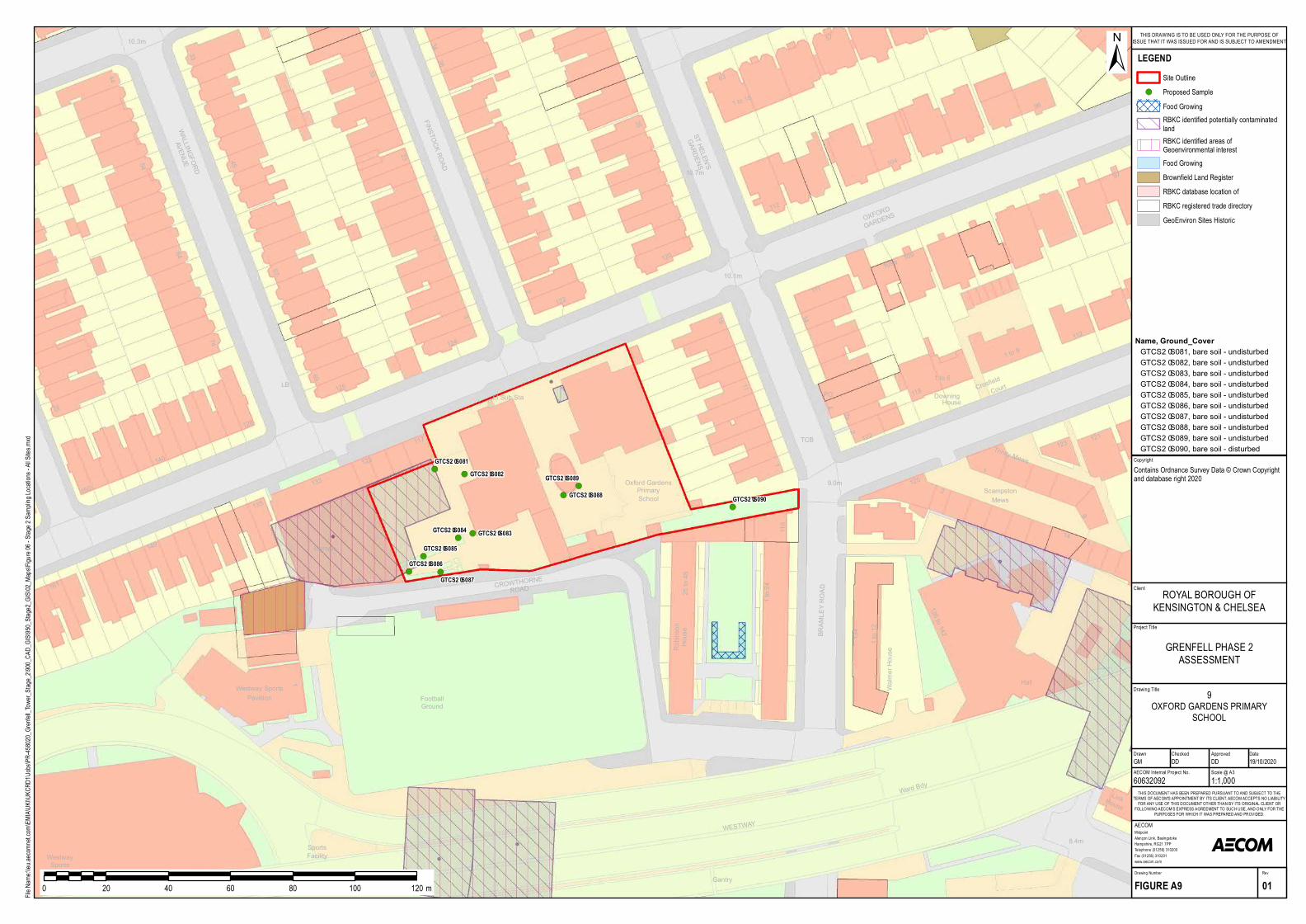
!(!(
!(!(
!(
!( !(
!(
!(
!(
S portsFa cility
Footba llGround
11
Westwa yS portsCentre
74
LB
3
33
150
54
Ga ra g e
23
33
161
FINS TOCK ROAD
140
44
26
64WALLINGFORD
AVENUE 45
117
13
123
14
128
124
135
149
57
3
133
10.3m
126
69
25
5
34
1
Westwa y S portsPa villion
123
1 to 15
El S ub S ta
Robinson
House
122
OXFORD
GARDENS
19
10.1m
4
112
14
96
CROWTHORNEROAD
8.4m
1
2
97
HouseDowning118
Walmer House
1 to 6
S T HELEN'S
GARDENS
35
109a
9.0m
BRAMLEY ROAD
LinkHouse
10.7m
120
111
Ha ll
1 to 9
12a
112
122
2
25 to 48
1 to 12
1 to 24
57
115
1
134
136 to 142
14
9
121
2
Crosfield
104
109
63
Court
125
Wa rd Bdy
Prim a ryS ch ool
Oxford Ga rdens
TCB
WES TWAY
Ga ntry
MewsS ca m pston
PO
Trinity MewsGTCS2–S081GTCS2–S082
GTCS2–S083GTCS2–S084
GTCS2–S085GTCS2–S086
GTCS2–S087
GTCS2–S088
GTCS2–S089
GTCS2–S090
Project Title
Drawing Title
Drawn Checked
MidpointAlençon Link, BasingstokeHampshire, RG21 7PPTelephone (01256) 310200Fax (01256) 310201www.aecom.com
AECOM
DateApproved
RevDrawing Number
FIGURE A9 01
THIS DOCUMENT HAS BEEN PREPARED PURSUANT TO AND SUBJECT TO THETERMS OF AECOM'S APPOINTMENT BY ITS CLIENT. AECOM ACCEPTS NO LIABILITY
FOR ANY USE OF THIS DOCUMENT OTHER THAN BY ITS ORIGINAL CLIENT ORFOLLOWING AECOM'S EXPRESS AGREEMENT TO SUCH USE, AND ONLY FOR THE
PURPOSES FOR WHICH IT WAS PREPARED AND PROVIDED.
AECOM Internal Project No. Scale @ A360632092 1:1,000GM DD DD 19/10/2020
Client
File Na
me:\\e
u.aeco
mnet.c
om\EM
IA\UK
I\UKC
RD1\J
obs\PR
-45802
0_Gren
fell_To
wer_S
tage_2
\900_C
AD_G
IS\950
_Stag
e2_GIS
\02_M
aps\Fig
ure 06
- Stag
e 2 Sa
mpling
Locat
ions -
All Site
s.mxd
±
0 20 40 60 80 100 120 m
LEGENDSite Outline
!( Proposed SampleFood GrowingRBKC identified potentially contaminatedlandRBKC identified areas ofGeoenvironmental interestFood GrowingBrownfield Land RegisterRBKC database location ofRBKC registered trade directoryGeoEnviron Sites Historic
GRENFELL PHASE 2ASSESSMENT
ROYAL BOROUGH OFKENSINGTON & CHELSEA
THIS DRAWING IS TO BE USED ONLY FOR THE PURPOSE OFISSUE THAT IT WAS ISSUED FOR AND IS SUBJECT TO AMENDMENT
CopyrightContains Ordnance Survey Data © Crown Copyright and database right 2020
9OXFORD GARDENS PRIMARY
SCHOOL
Name, Ground_CoverGTCS 2–S 081, ba re soil - undisturbedGTCS 2–S 082, ba re soil - undisturbedGTCS 2–S 083, ba re soil - undisturbedGTCS 2–S 084, ba re soil - undisturbedGTCS 2–S 085, ba re soil - undisturbedGTCS 2–S 086, ba re soil - undisturbedGTCS 2–S 087, ba re soil - undisturbedGTCS 2–S 088, ba re soil - undisturbedGTCS 2–S 089, ba re soil - undisturbedGTCS 2–S 090, ba re soil - disturbed
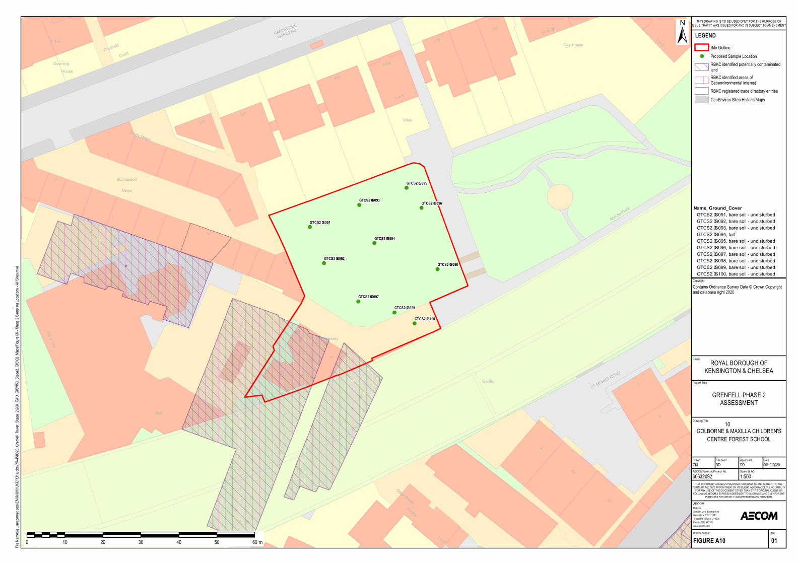
!(
!(
!(
!(
!(
!(
!(
!(
!(
!(
123
Gage Brown
CAMBRIDGE
GARDENS
1
HouseDowning
11
9
10
7
1 to 6
4
1 to 7
House
8Hall
1
Maxilla W
alk
1 to 6
136 to 142
4
14
9
121
115a
2
117
115
1 to 6
111 21 to 26
Villas
Crosfield Ray House
Court
ST MARKS
ROAD
Gantry
Mews
Scampston
Day Nursery
Trinity Mews
GTCS2–S091
GTCS2–S092
GTCS2–S093
GTCS2–S094
GTCS2–S095
GTCS2–S096
GTCS2–S097
GTCS2–S098
GTCS2–S099
GTCS2–S100
Project Title
Drawing Title
Drawn Checked
MidpointAlençon Link, BasingstokeHampshire, RG21 7PPTelephone (01256) 310200Fax (01256) 310201www.aecom.com
AECOM
DateApproved
RevDrawing Number
FIGURE A10 01
THIS DOCUMENT HAS BEEN PREPARED PURSUANT TO AND SUBJECT TO THETERMS OF AECOM'S APPOINTMENT BY ITS CLIENT. AECOM ACCEPTS NO LIABILITY
FOR ANY USE OF THIS DOCUMENT OTHER THAN BY ITS ORIGINAL CLIENT ORFOLLOWING AECOM'S EXPRESS AGREEMENT TO SUCH USE, AND ONLY FOR THE
PURPOSES FOR WHICH IT WAS PREPARED AND PROVIDED.
AECOM Internal Project No. Scale @ A360632092 1:500GM DD DD 05/10/2020
Client
File Na
me:\\e
u.aeco
mnet.c
om\EM
IA\UK
I\UKC
RD1\J
obs\PR
-45802
0_Gren
fell_To
wer_S
tage_2
\900_C
AD_G
IS\950
_Stag
e2_GIS
\02_M
aps\Fig
ure 06
- Stag
e 2 Sa
mpling
Locat
ions -
All Site
s.mxd
±
0 10 20 30 40 50 60 m
LEGENDSite Outline
!( Proposed Sample LocationRBKC identified potentially contaminatedlandRBKC identified areas ofGeoenvironmental interestRBKC registered trade directory entriesGeoEnviron Sites Historic Maps
GRENFELL PHASE 2ASSESSMENT
ROYAL BOROUGH OFKENSINGTON & CHELSEA
THIS DRAWING IS TO BE USED ONLY FOR THE PURPOSE OFISSUE THAT IT WAS ISSUED FOR AND IS SUBJECT TO AMENDMENT
CopyrightContains Ordnance Survey Data © Crown Copyright and database right 2020
10GOLBORNE & MAXILLA CHILDREN'S
CENTRE FOREST SCHOOL
Name, Ground_CoverGTCS2–S091, b are soil - undisturb edGTCS2–S092, b are soil - undisturb edGTCS2–S093, b are soil - undisturb edGTCS2–S094, turfGTCS2–S095, b are soil - undisturb edGTCS2–S096, b are soil - undisturb edGTCS2–S097, b are soil - undisturb edGTCS2–S098, b are soil - undisturb edGTCS2–S099, b are soil - undisturb edGTCS2–S100, b are soil - undisturb ed
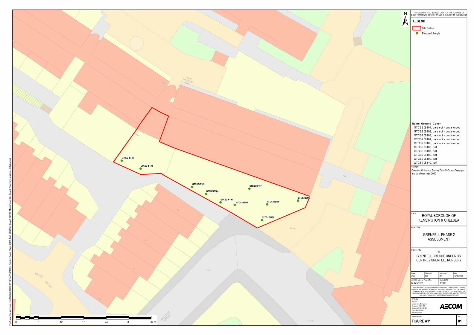
!(
!(
!(
!(
!(!(
!(
!(
!(
!(
60
64
61
1 to 56
1 to 40
Wa lk
UpperCla rendonWa lk
FB
Pos ts
68
CLOSE
66
DULFORD
STREET
9.1m
1 to 199.0m
VERITY
GTCS2–S101
GTCS2–S102
GTCS2–S103
GTCS2–S104
GTCS2–S105GTCS2–S106
GTCS2–S107
GTCS2–S108
GTCS2–S109GTCS2–S110
Project Title
Drawing Title
Drawn Checked
MidpointAlençon Link, BasingstokeHampshire, RG21 7PPTelephone (01256) 310200Fax (01256) 310201www.aecom.com
AECOM
DateApproved
RevDrawing Number
FIGURE A11 01
THIS DOCUMENT HAS BEEN PREPARED PURSUANT TO AND SUBJECT TO THETERMS OF AECOM'S APPOINTMENT BY ITS CLIENT. AECOM ACCEPTS NO LIABILITY
FOR ANY USE OF THIS DOCUMENT OTHER THAN BY ITS ORIGINAL CLIENT ORFOLLOWING AECOM'S EXPRESS AGREEMENT TO SUCH USE, AND ONLY FOR THE
PURPOSES FOR WHICH IT WAS PREPARED AND PROVIDED.
AECOM Internal Project No. Scale @ A360632092 1:300GM DD DD 19/10/2020
Client
File Na
me:\\e
u.aeco
mnet.c
om\EM
IA\UK
I\UKC
RD1\J
obs\PR
-45802
0_Gren
fell_To
wer_S
tage_2
\900_C
AD_G
IS\950
_Stag
e2_GIS
\02_M
aps\Fig
ure 06
- Stag
e 2 Sa
mpling
Locat
ions -
All Site
s.mxd
±
0 6 12 18 24 30 36 m
LEGENDSite Outline
!( Proposed Sample
GRENFELL PHASE 2ASSESSMENT
ROYAL BOROUGH OFKENSINGTON & CHELSEA
THIS DRAWING IS TO BE USED ONLY FOR THE PURPOSE OFISSUE THAT IT WAS ISSUED FOR AND IS SUBJECT TO AMENDMENT
CopyrightContains Ordnance Survey Data © Crown Copyright and database right 2020
11GRENFELL CRECHE UNDER 3S'CENTRE / GRENFELL NURSERY
Name, Ground_CoverGTCS2–S101, ba re soil - undis turbedGTCS2–S102, ba re soil - undis turbedGTCS2–S103, ba re soil - undis turbedGTCS2–S104, ba re soil - undis turbedGTCS2–S105, ba re soil - undis turbedGTCS2–S106, turfGTCS2–S107, turfGTCS2–S108, turfGTCS2–S109, turfGTCS2–S110, turf
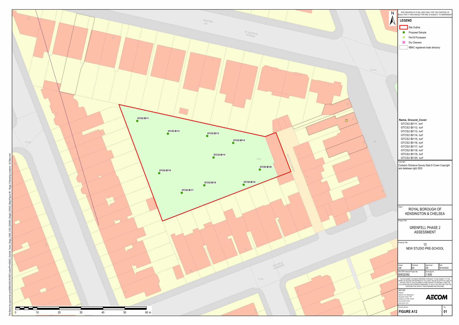
!(
!(!(
!(
!(
!(
!(
!( !(
!(
31
11.0m
18
44
43
9
5
3LB
33
13.4m
1
73
75
23
8
1
11
ST QUINTINAVENUE
11.5m
KELFIELD
GARDENS
61
2
69
30
16
Club
5
17
10
W ard BdyCR
KELFIELD MEW S
GTCS2–S111
GTCS2–S112GTCS2–S113
GTCS2–S114
GTCS2–S115
GTCS2–S116
GTCS2–S117
GTCS2–S118 GTCS2–S119
GTCS2–S120
Project Title
Drawing Title
Drawn Checked
MidpointAlençon Link, BasingstokeHampshire, RG21 7PPTelephone (01256) 310200Fax (01256) 310201www.aecom.com
AECOM
DateApproved
RevDrawing Number
FIGURE A12 01
THIS DOCUMENT HAS BEEN PREPARED PURSUANT TO AND SUBJECT TO THETERMS OF AECOM'S APPOINTMENT BY ITS CLIENT. AECOM ACCEPTS NO LIABILITY
FOR ANY USE OF THIS DOCUMENT OTHER THAN BY ITS ORIGINAL CLIENT ORFOLLOWING AECOM'S EXPRESS AGREEMENT TO SUCH USE, AND ONLY FOR THE
PURPOSES FOR WHICH IT WAS PREPARED AND PROVIDED.
AECOM Internal Project No. Scale @ A360632092 1:500GM DD DD 19/10/2020
Client
File Na
me:\\e
u.aeco
mnet.c
om\EM
IA\UK
I\UKC
RD1\J
obs\PR
-45802
0_Gren
fell_To
wer_S
tage_2
\900_C
AD_G
IS\950
_Stag
e2_GIS
\02_M
aps\Fig
ure 06
- Stag
e 2 Sa
mpling
Locat
ions -
All Site
s.mxd
±
0 10 20 30 40 50 60 m
LEGENDSite Outline
!( Proposed Sample!( Part B Processes") Dry Cleaners
RBKC registered trade directory
GRENFELL PHASE 2ASSESSMENT
ROYAL BOROUGH OFKENSINGTON & CHELSEA
THIS DRAWING IS TO BE USED ONLY FOR THE PURPOSE OFISSUE THAT IT WAS ISSUED FOR AND IS SUBJECT TO AMENDMENT
CopyrightContains Ordnance Survey Data © Crown Copyright and database right 2020
12NEW STUDIO PRE-SCHOOL
Name, Ground_CoverGTCS2–S111, turfGTCS2–S112, turfGTCS2–S113, turfGTCS2–S114, turfGTCS2–S115, turfGTCS2–S116, turfGTCS2–S117, turfGTCS2–S118, turfGTCS2–S119, turfGTCS2–S120, turf
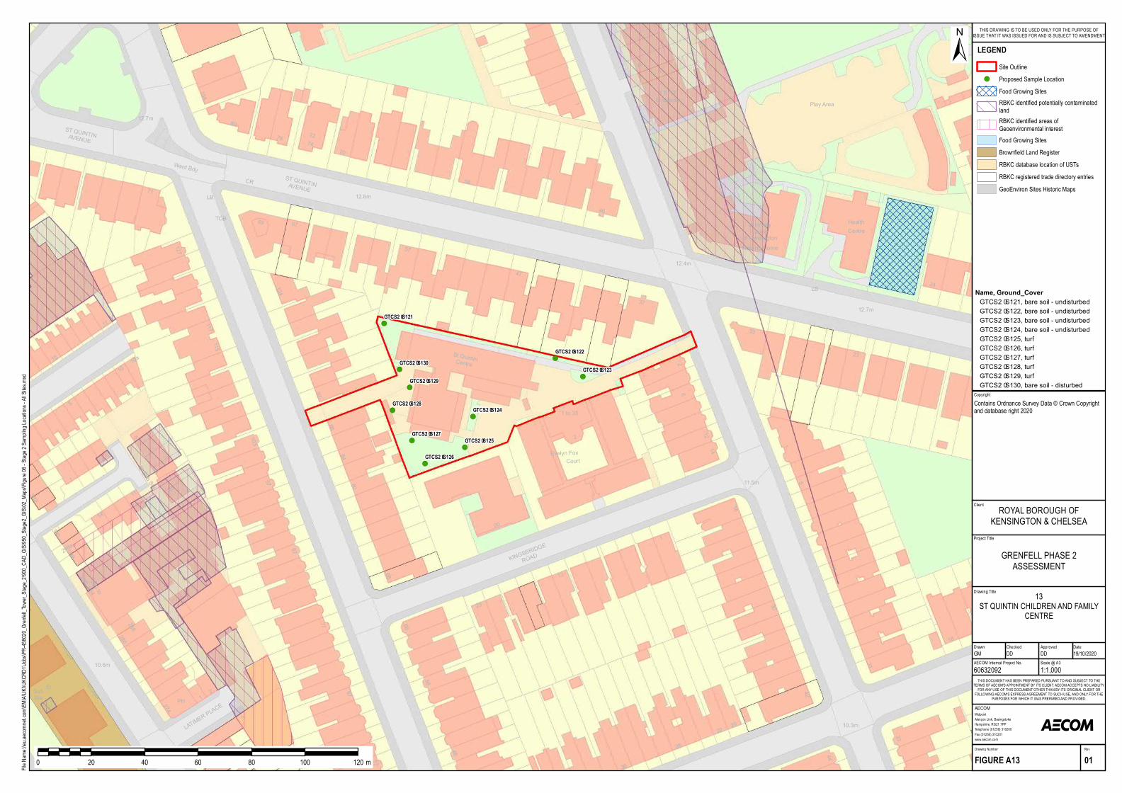
!(
!(
!(
!(
!(
!(
!(
!(
!(
!(
14
4633
44
10.3m20
42
31
18
22
28
58
48
36
58
37
62
4712.4m
1
24
33
HealthCentre
114
LB
23
12
12.7m
11.5m
30
16
5
17
1
13
23
KINGSBRIDG
E
ROAD
20
2
1 to 35
Evelyn FoxCourt
S t QuintinCentre
Play Area
Nursing Home
PrincessLouise
of Kensington
4
1 To 17S t Quintin
11
115
88
57
76
67
92
117
5
80
84
1510
4
103
69
12.7m
104
LB
127
71 12.6m
70
108
5
S T QUINTINAVENUE
TCB
288
290 to294
87
302
67
272
77
8
11
298a
80
57
97
68
66
El
PHS ubS ta
LATIMER PLACE
10.6m
296
274
1
286
1
300298
El S ub S ta
10
3
2
Ward BdyCR
7274
S T QUINTINAVENUE
10a
GTCS2–S121
GTCS2–S122
GTCS2–S123
GTCS2–S124
GTCS2–S125
GTCS2–S126
GTCS2–S127
GTCS2–S128
GTCS2–S129
GTCS2–S130
Project Title
Drawing Title
Drawn Checked
MidpointAlençon Link, BasingstokeHampshire, RG21 7PPTelephone (01256) 310200Fax (01256) 310201www.aecom.com
AECOM
DateApproved
RevDrawing Number
FIGURE A13 01
THIS DOCUMENT HAS BEEN PREPARED PURSUANT TO AND SUBJECT TO THETERMS OF AECOM'S APPOINTMENT BY ITS CLIENT. AECOM ACCEPTS NO LIABILITY
FOR ANY USE OF THIS DOCUMENT OTHER THAN BY ITS ORIGINAL CLIENT ORFOLLOWING AECOM'S EXPRESS AGREEMENT TO SUCH USE, AND ONLY FOR THE
PURPOSES FOR WHICH IT WAS PREPARED AND PROVIDED.
AECOM Internal Project No. Scale @ A360632092 1:1,000GM DD DD 19/10/2020
Client
File Na
me:\\e
u.aeco
mnet.c
om\EM
IA\UK
I\UKC
RD1\J
obs\PR
-45802
0_Gren
fell_To
wer_S
tage_2
\900_C
AD_G
IS\950
_Stag
e2_GIS
\02_M
aps\Fig
ure 06
- Stag
e 2 Sa
mpling
Locat
ions -
All Site
s.mxd
±
0 20 40 60 80 100 120 m
LEGENDSite Outline
!( Proposed Sample LocationFood Growing SitesRBKC identified potentially contaminatedlandRBKC identified areas ofGeoenvironmental interestFood Growing SitesBrownfield Land RegisterRBKC database location of USTsRBKC registered trade directory entriesGeoEnviron Sites Historic Maps
GRENFELL PHASE 2ASSESSMENT
ROYAL BOROUGH OFKENSINGTON & CHELSEA
THIS DRAWING IS TO BE USED ONLY FOR THE PURPOSE OFISSUE THAT IT WAS ISSUED FOR AND IS SUBJECT TO AMENDMENT
CopyrightContains Ordnance Survey Data © Crown Copyright and database right 2020
13ST QUINTIN CHILDREN AND FAMILY
CENTRE
Name, Ground_CoverGTCS 2–S 121, bare soil - undisturbedGTCS 2–S 122, bare soil - undisturbedGTCS 2–S 123, bare soil - undisturbedGTCS 2–S 124, bare soil - undisturbedGTCS 2–S 125, turfGTCS 2–S 126, turfGTCS 2–S 127, turfGTCS 2–S 128, turfGTCS 2–S 129, turfGTCS 2–S 130, bare soil - disturbed
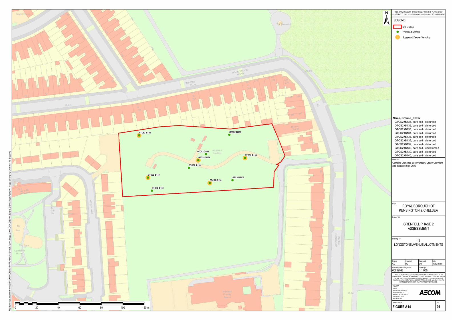
!( !(
!(
!(!(
!(!(
!(
!(
!(
208
220
234
LONGSTONE
AVENUE
to
248
MissionChurch
132
214
108
130
246
42.6m
40.3m
43.9m
Allotm entGardens
174
120
134
236
216to
168
37.0m
NewfieldPrim arySchool
CR
Ward Bdy224
230222 232
1 to 6
128
145126
14
27
35.3m
28
20
134
15
MARIAN WAY
41
25
122
1
13
2
Kier HardieHouse
to
ElSubSta
45 to 6695 to 100
Play Area
PlayArea
1
133
108
116
98
123
School House
FW
Def
War Mem orial
ROUNDWOOD
ROAD38.0m
GTCS2–S132 GTCS2–S131
GTCS2–S133
GTCS2–S134GTCS2–S138
GTCS2–S137GTCS2–S136
GTCS2–S135
GTCS2–S139
GTCS2–S140
Project Title
Drawing Title
Drawn Checked
MidpointAlençon Link, BasingstokeHampshire, RG21 7PPTelephone (01256) 310200Fax (01256) 310201www.aecom.com
AECOM
DateApproved
RevDrawing Number
FIGURE A14 01
THIS DOCUMENT HAS BEEN PREPARED PURSUANT TO AND SUBJECT TO THETERMS OF AECOM'S APPOINTMENT BY ITS CLIENT. AECOM ACCEPTS NO LIABILITY
FOR ANY USE OF THIS DOCUMENT OTHER THAN BY ITS ORIGINAL CLIENT ORFOLLOWING AECOM'S EXPRESS AGREEMENT TO SUCH USE, AND ONLY FOR THE
PURPOSES FOR WHICH IT WAS PREPARED AND PROVIDED.
AECOM Internal Project No. Scale @ A360632092 1:1,000GM DD DD 19/10/2020
Client
File Na
me:\\e
u.aeco
mnet.c
om\EM
IA\UK
I\UKC
RD1\J
obs\PR
-45802
0_Gren
fell_To
wer_S
tage_2
\900_C
AD_G
IS\950
_Stag
e2_GIS
\02_M
aps\Fig
ure 06
- Stag
e 2 Sa
mpling
Locat
ions -
All Site
s.mxd
±
0 20 40 60 80 100 120 m
LEGENDSite Outline
!( Proposed Sample
! Suggested Deeper Sampling
GRENFELL PHASE 2ASSESSMENT
ROYAL BOROUGH OFKENSINGTON & CHELSEA
THIS DRAWING IS TO BE USED ONLY FOR THE PURPOSE OFISSUE THAT IT WAS ISSUED FOR AND IS SUBJECT TO AMENDMENT
CopyrightContains Ordnance Survey Data © Crown Copyright and database right 2020
14LONGSTONE AVENUE ALLOTMENTS
Name, Ground_CoverGT CS2–S131, bare soil - disturbedGT CS2–S132, bare soil - disturbedGT CS2–S133, bare soil - disturbedGT CS2–S134, bare soil - disturbedGT CS2–S135, bare soil - disturbedGT CS2–S136, bare soil - disturbedGT CS2–S137, bare soil - disturbedGT CS2–S138, bare soil - undisturbedGT CS2–S139, bare soil - disturbedGT CS2–S140, bare soil - disturbed
!(
!(
!(
!(
!(
!(!(
!(
!(
!(
!(
!( 18
24
Health
Centre
81
1 to 6
LB
23
83
12.7m
ST QUINTINAVENUE
Ward BdyCR
GTCS2–S141
GTCS2–S142
GTCS2–S143
GTCS2–S144
GTCS2–S146
GTCS2–S145GTCS2–S148
GTCS2–S147
GTCS2–S150GTCS2–S149
GTCS1–29
GTCS1–30
Project Title
Drawing Title
Drawn Checked
MidpointAlençon Link, BasingstokeHampshire, RG21 7PPTelephone (01256) 310200Fax (01256) 310201www.aecom.com
AECOM
DateApproved
RevDrawing Number
FIGURE A15 01
THIS DOCUMENT HAS BEEN PREPARED PURSUANT TO AND SUBJECT TO THETERMS OF AECOM'S APPOINTMENT BY ITS CLIENT. AECOM ACCEPTS NO LIABILITY
FOR ANY USE OF THIS DOCUMENT OTHER THAN BY ITS ORIGINAL CLIENT ORFOLLOWING AECOM'S EXPRESS AGREEMENT TO SUCH USE, AND ONLY FOR THE
PURPOSES FOR WHICH IT WAS PREPARED AND PROVIDED.
AECOM Internal Project No. Scale @ A360632092 1:300GM DD DD 19/10/2020
Client
File Na
me:\\e
u.aeco
mnet.c
om\EM
IA\UK
I\UKC
RD1\J
obs\PR
-45802
0_Gren
fell_To
wer_S
tage_2
\900_C
AD_G
IS\950
_Stag
e2_GIS
\02_M
aps\Fig
ure 06
- Stag
e 2 Sa
mpling
Locat
ions -
All Site
s.mxd
±
0 6 12 18 24 30 36 m
LEGENDSite Outline
!( Stage 1 Sample Location!( Proposed Sample Location
! Suggested Deeper Sampling LocationFood Growing SitesRBKC identified potentially contaminatedlandRBKC identified areas ofGeoenvironmental interestFood Growing SitesRBKC registered trade directory entriesGeoEnviron Sites Historic Maps
GRENFELL PHASE 2ASSESSMENT
ROYAL BOROUGH OFKENSINGTON & CHELSEA
THIS DRAWING IS TO BE USED ONLY FOR THE PURPOSE OFISSUE THAT IT WAS ISSUED FOR AND IS SUBJECT TO AMENDMENT
CopyrightContains Ordnance Survey Data © Crown Copyright and database right 2020
15ST QUINTIN GARDENS
Name, Ground_CoverGTCS2– S141, b are soil - distu rb edGTCS2– S142, b are soil - distu rb edGTCS2– S143, b are soil - distu rb edGTCS2– S144, b are soil - distu rb edGTCS2– S145, b are soil - distu rb edGTCS2– S146, b are soil - distu rb edGTCS2– S147, b are soil - u ndistu rb edGTCS2– S148, b are soil - u ndistu rb edGTCS2– S149, b are soil - u ndistu rb edGTCS2– S150, b are soil - u ndistu rb ed
!(
!(
!(
!(
!(
FB
FB
and Wellbeing
GTCS2–S151GTCS2–S152
GTCS2–S153GTCS2–S154
GTCS2–S155
Project Title
Drawing Title
Drawn Checked
MidpointAlençon Link, BasingstokeHampshire, RG21 7PPTelephone (01256) 310200Fax (01256) 310201www.aecom.com
AECOM
DateApproved
RevDrawing Number
FIGURE A16 01
THIS DOCUMENT HAS BEEN PREPARED PURSUANT TO AND SUBJECT TO THETERMS OF AECOM'S APPOINTMENT BY ITS CLIENT. AECOM ACCEPTS NO LIABILITY
FOR ANY USE OF THIS DOCUMENT OTHER THAN BY ITS ORIGINAL CLIENT ORFOLLOWING AECOM'S EXPRESS AGREEMENT TO SUCH USE, AND ONLY FOR THE
PURPOSES FOR WHICH IT WAS PREPARED AND PROVIDED.
AECOM Internal Project No. Scale @ A360632092 1:300GM DD DD 19/10/2020
Client
File Na
me:\\e
u.aeco
mnet.c
om\EM
IA\UK
I\UKC
RD1\J
obs\PR
-45802
0_Gren
fell_To
wer_S
tage_2
\900_C
AD_G
IS\950
_Stag
e2_GIS
\02_M
aps\Fig
ure 06
- Stag
e 2 Sa
mpling
Locat
ions -
All Site
s.mxd
±
0 6 12 18 24 30 36 m
LEGENDSite Outline
!( Proposed SampleRBKC identified potentially contaminatedlandRBKC identified areas ofGeoenvironmental interestGeoEnviron Sites Historic
GRENFELL PHASE 2ASSESSMENT
ROYAL BOROUGH OFKENSINGTON & CHELSEA
THIS DRAWING IS TO BE USED ONLY FOR THE PURPOSE OFISSUE THAT IT WAS ISSUED FOR AND IS SUBJECT TO AMENDMENT
CopyrightContains Ordnance Survey Data © Crown Copyright and database right 2020
16ST CHARLES CENTRE FOR HEALTH
AND WELLBEING
Name, Ground_CoverGTCS2–S151, bare soil - disturbedGTCS2–S152, bare soil - disturbedGTCS2–S153, bare soil - disturbedGTCS2–S154, bare soil - disturbedGTCS2–S155, bare soil - disturbed
!(
!(
!(
!(
!(
16.8m
Crusade
of Rescue
72
70a
70
c
b
114
107bc
107a
67
8
48
58
68
CLARCHW AY
73
74
5
d
74
72a
57
69
LB
14.9m
46
109bc
109a
113bc
113a
TCB
111bc
111a
ST CHARLES
SQUARE
KENSINGTON
St Charles
Catholic Sixth
Fo rm College
NORTH
Shelter 73
Shelter
GTCS2–S156
GTCS2–S157
GTCS2–S158
GTCS2–S159
GTCS2–S160
Project Title
Drawing Title
Drawn Checked
MidpointAlençon Link, BasingstokeHampshire, RG21 7PPTelephone (01256) 310200Fax (01256) 310201www.aecom.com
AECOM
DateApproved
RevDrawing Number
FIGURE A17 01
THIS DOCUMENT HAS BEEN PREPARED PURSUANT TO AND SUBJECT TO THETERMS OF AECOM'S APPOINTMENT BY ITS CLIENT. AECOM ACCEPTS NO LIABILITY
FOR ANY USE OF THIS DOCUMENT OTHER THAN BY ITS ORIGINAL CLIENT ORFOLLOWING AECOM'S EXPRESS AGREEMENT TO SUCH USE, AND ONLY FOR THE
PURPOSES FOR WHICH IT WAS PREPARED AND PROVIDED.
AECOM Internal Project No. Scale @ A360632092 1:500GM DD DD 19/10/2020
Client
File Na
me:\\e
u.aeco
mnet.c
om\EM
IA\UK
I\UKC
RD1\J
obs\PR
-45802
0_Gren
fell_To
wer_S
tage_2
\900_C
AD_G
IS\950
_Stag
e2_GIS
\02_M
aps\Fig
ure 06
- Stag
e 2 Sa
mpling
Locat
ions -
All Site
s.mxd
±
0 10 20 30 40 50 60 m
LEGENDSite Outline
!( Proposed SampleFood GrowingFood GrowingRBKC registered trade directory
GRENFELL PHASE 2ASSESSMENT
ROYAL BOROUGH OFKENSINGTON & CHELSEA
THIS DRAWING IS TO BE USED ONLY FOR THE PURPOSE OFISSUE THAT IT WAS ISSUED FOR AND IS SUBJECT TO AMENDMENT
CopyrightContains Ordnance Survey Data © Crown Copyright and database right 2020
17EQUAL PEOPLE
Name, Ground_CoverGTCS2–S156, bare soil - disturbedGTCS2–S157, bare soil - disturbedGTCS2–S158, bare soil - disturbedGTCS2–S159, bare soil - disturbedGTCS2–S160, bare soil - disturbed
!(
!(
!(
!(
!(
!(
!(
!(
!(
!(
!(
!(
TCB
188
Centre
8.3m
Welfa reCentre
Ho us e
8
8.2m
El Sub Sta
THRESHERSPLACE
9.7m
Medica l
1 to 6
Nottingw o o dHo us e
PH
Rugby
TCBs
Ea s try Ho us e
a nd Child
1 to 30
RUNCORN PLA
CE
6a to 6h
10 to 20
10.0m
Fo relandHo us e
11.3m
a b
98107
105
80115
96
137
110
123
1 to 100
103c d
176
223
226
a b
225227
to
186
LB
1 to 4
219
227 to 233
1 to 6
El Sub Sta
The Wa lmer
Ro a d Scho o l
192
190
188
Pla y Area
Wa rd Bdy
PO
GTCS2–S161GTCS2–S162
GTCS2–S163GTCS2–S164
GTCS2–S165
GTCS2–S166
GTCS2–S167
GTCS2–S168
GTCS2–S169
GTCS2–S170
GTCS1–18
GTCS1–17
Project Title
Drawing Title
Drawn Checked
MidpointAlençon Link, BasingstokeHampshire, RG21 7PPTelephone (01256) 310200Fax (01256) 310201www.aecom.com
AECOM
DateApproved
RevDrawing Number
FIGURE A18 01
THIS DOCUMENT HAS BEEN PREPARED PURSUANT TO AND SUBJECT TO THETERMS OF AECOM'S APPOINTMENT BY ITS CLIENT. AECOM ACCEPTS NO LIABILITY
FOR ANY USE OF THIS DOCUMENT OTHER THAN BY ITS ORIGINAL CLIENT ORFOLLOWING AECOM'S EXPRESS AGREEMENT TO SUCH USE, AND ONLY FOR THE
PURPOSES FOR WHICH IT WAS PREPARED AND PROVIDED.
AECOM Internal Project No. Scale @ A360632092 1:500GM DD DD 19/10/2020
Client
File Na
me:\\e
u.aeco
mnet.c
om\EM
IA\UK
I\UKC
RD1\J
obs\PR
-45802
0_Gren
fell_To
wer_S
tage_2
\900_C
AD_G
IS\950
_Stag
e2_GIS
\02_M
aps\Fig
ure 06
- Stag
e 2 Sa
mpling
Locat
ions -
All Site
s.mxd
±
0 10 20 30 40 50 60 m
LEGENDSite Outline
!( Stage 1 Sample Location!( Proposed Sample Location
Food Growing SitesRBKC identified potentially contaminatedlandRBKC identified areas ofGeoenvironmental interestFood Growing SitesRBKC database location ofRBKC registered trade directory entriesGeoEnviron Sites Historic Maps
GRENFELL PHASE 2ASSESSMENT
ROYAL BOROUGH OFKENSINGTON & CHELSEA
THIS DRAWING IS TO BE USED ONLY FOR THE PURPOSE OFISSUE THAT IT WAS ISSUED FOR AND IS SUBJECT TO AMENDMENT
CopyrightContains Ordnance Survey Data © Crown Copyright and database right 2020
18NOTTINGWOOD HOUSE AND
PORTLAND ROAD
Name, Ground_CoverGTCS2–S161, ba re s o il - disturbedGTCS2–S162, ba re s o il - disturbedGTCS2–S163, ba re s o il - disturbedGTCS2–S164, ba re s o il - disturbedGTCS2–S165, ba re s o il - disturbedGTCS2–S166, ba re s o il - disturbedGTCS2–S167, ba re s o il - disturbedGTCS2–S168, ba re s o il - disturbedGTCS2–S169, ba re s o il - disturbedGTCS2–S170, ba re s o il - disturbed
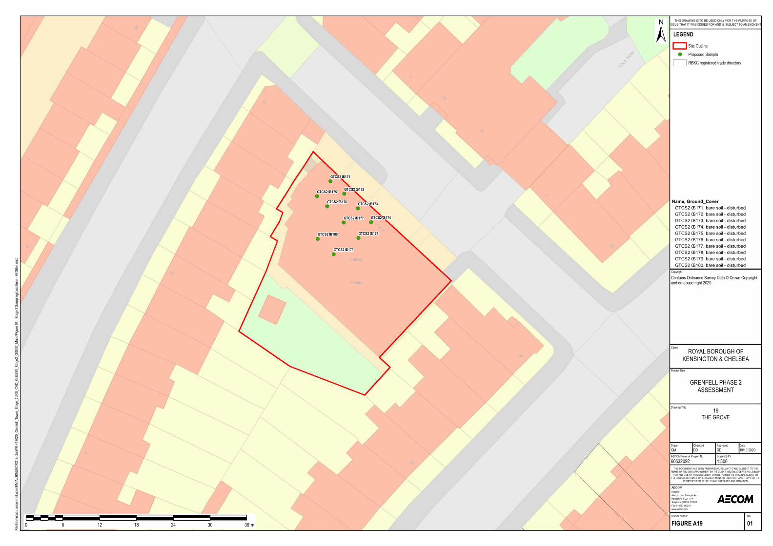
!(
!(
!(
!(
!(
!(
!(
!(
!(
!(
1 to 9
57
18
26
45
2b
2a
Train in g
62
Cen tre
33
DALE ROW
2
60
4
70
GTCS2–S171
GTCS2–S172
GTCS2–S173
GTCS2–S174
GTCS2–S175
GTCS2–S176
GTCS2–S177
GTCS2–S178
GTCS2–S179
GTCS2–S180
Project Title
Drawing Title
Drawn Checked
MidpointAlençon Link, BasingstokeHampshire, RG21 7PPTelephone (01256) 310200Fax (01256) 310201www.aecom.com
AECOM
DateApproved
RevDrawing Number
FIGURE A19 01
THIS DOCUMENT HAS BEEN PREPARED PURSUANT TO AND SUBJECT TO THETERMS OF AECOM'S APPOINTMENT BY ITS CLIENT. AECOM ACCEPTS NO LIABILITY
FOR ANY USE OF THIS DOCUMENT OTHER THAN BY ITS ORIGINAL CLIENT ORFOLLOWING AECOM'S EXPRESS AGREEMENT TO SUCH USE, AND ONLY FOR THE
PURPOSES FOR WHICH IT WAS PREPARED AND PROVIDED.
AECOM Internal Project No. Scale @ A360632092 1:300GM DD DD 19/10/2020
Client
File Na
me:\\e
u.aeco
mnet.c
om\EM
IA\UK
I\UKC
RD1\J
obs\PR
-45802
0_Gren
fell_To
wer_S
tage_2
\900_C
AD_G
IS\950
_Stag
e2_GIS
\02_M
aps\Fig
ure 06
- Stag
e 2 Sa
mpling
Locat
ions -
All Site
s.mxd
±
0 6 12 18 24 30 36 m
LEGENDSite Outline
!( Proposed SampleRBKC registered trade directory
GRENFELL PHASE 2ASSESSMENT
ROYAL BOROUGH OFKENSINGTON & CHELSEA
THIS DRAWING IS TO BE USED ONLY FOR THE PURPOSE OFISSUE THAT IT WAS ISSUED FOR AND IS SUBJECT TO AMENDMENT
CopyrightContains Ordnance Survey Data © Crown Copyright and database right 2020
19THE GROVE
Name, Ground_CoverGTCS2–S171, bare soil - disturbedGTCS2–S172, bare soil - disturbedGTCS2–S173, bare soil - disturbedGTCS2–S174, bare soil - disturbedGTCS2–S175, bare soil - disturbedGTCS2–S176, bare soil - disturbedGTCS2–S177, bare soil - disturbedGTCS2–S178, bare soil - disturbedGTCS2–S179, bare soil - disturbedGTCS2–S180, bare soil - disturbed
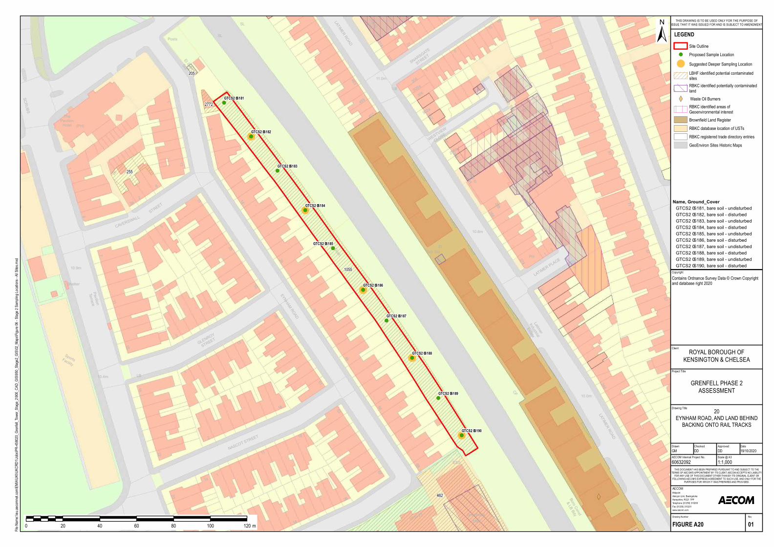
!(
!(
!(
!(
!(
!(
!(
!(
!(
!(
14
1
10.4m
9.9m
SportsFac ility
2a
1
SCR UBS
6
7
2b
10.9m
ThePavilionHotel
SL
SNAR SGATE
STREET
463
88
SL
92
LB
5
3081
21
84
15LATIMER R OAD
10
4
103
El SubSta
306
314
11.0m
5
310
Posts
288
290 to294
CF
Boro Const
& LB Bdy
87
1
302a302
13
15
67
10.0m
272
WESTVIEW
CLOSE
EYNHAM R OAD
23277
6
8
14
455 11
25
298a
12
7
80
57
97
260
5
11
15
2
33
35
El
16
13
1
22
56
51
2
16
11
5319
PHSub Sta
23
67
26
14
2
68
LATIMER PLACE
46
10.6m
26
36
14
459
2
296
Drain
246
STREET
2741
286
1
300298
El Sub Sta
10
3
PavilionTerrace
CAVER SWA
LL
2
LATIMER R OAD
GLENR OY
STREET
NASCOT ST
R EET
306a
19 to 23
ESS
BrickfieldsHall
316 to318
1a1
Latim er
Industrial
Estate
Shelter
LB
(PH)
10a
GTCS2–S181
GTCS2–S182
GTCS2–S183
GTCS2–S184
GTCS2–S185
GTCS2–S186
GTCS2–S187
GTCS2–S188
GTCS2–S189
GTCS2–S190
205
462
1055
2772
255
Project Title
Drawing Title
Drawn Checked
MidpointAlençon Link, BasingstokeHampshire, RG21 7PPTelephone (01256) 310200Fax (01256) 310201www.aecom.com
AECOM
DateApproved
RevDrawing Number
FIGURE A20 01
THIS DOCUMENT HAS BEEN PREPARED PURSUANT TO AND SUBJECT TO THETERMS OF AECOM'S APPOINTMENT BY ITS CLIENT. AECOM ACCEPTS NO LIABILITY
FOR ANY USE OF THIS DOCUMENT OTHER THAN BY ITS ORIGINAL CLIENT ORFOLLOWING AECOM'S EXPRESS AGREEMENT TO SUCH USE, AND ONLY FOR THE
PURPOSES FOR WHICH IT WAS PREPARED AND PROVIDED.
AECOM Internal Project No. Scale @ A360632092 1:1,000GM DD DD 19/10/2020
Client
File Na
me:\\e
u.aeco
mnet.c
om\EM
IA\UK
I\UKC
RD1\J
obs\PR
-45802
0_Gren
fell_To
wer_S
tage_2
\900_C
AD_G
IS\950
_Stag
e2_GIS
\02_M
aps\Fig
ure 06
- Stag
e 2 Sa
mpling
Locat
ions -
All Site
s.mxd
±
0 20 40 60 80 100 120 m
LEGENDSite Outline
!( Proposed Sample Location
! Suggested Deeper Sampling LocationLBHF identified potential contaminatedsitesRBKC identified potentially contaminatedland
XW Waste Oil BurnersRBKC identified areas ofGeoenvironmental interestBrownfield Land RegisterRBKC database location of USTsRBKC registered trade directory entriesGeoEnviron Sites Historic Maps
GRENFELL PHASE 2ASSESSMENT
ROYAL BOROUGH OFKENSINGTON & CHELSEA
THIS DRAWING IS TO BE USED ONLY FOR THE PURPOSE OFISSUE THAT IT WAS ISSUED FOR AND IS SUBJECT TO AMENDMENT
CopyrightContains Ordnance Survey Data © Crown Copyright and database right 2020
20EYNHAM ROAD, AND LAND BEHIND
BACKING ONTO RAIL TRACKS
Name, Ground_CoverGTCS2–S181, bare soil - undisturb edGTCS2–S182, bare soil - disturb edGTCS2–S183, bare soil - undisturb edGTCS2–S184, bare soil - disturb edGTCS2–S185, bare soil - undisturb edGTCS2–S186, bare soil - disturb edGTCS2–S187, bare soil - undisturb edGTCS2–S188, bare soil - disturb edGTCS2–S189, bare soil - undisturb edGTCS2–S190, bare soil - disturb ed
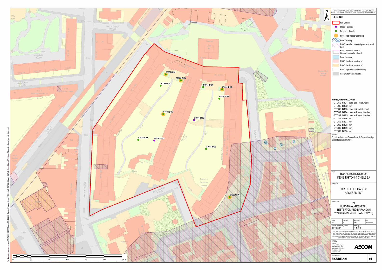
!(
!(
!(!(
!(
!(
!(
!(
!(
!(
!(
!(501 to 562
301 to 339
35
301 to 339
11
Testerton
Walk
Bara ndon Wa lk
132 to 138
11
GRENFELL ROAD
17
25
Surg ery
25
140
Vica rag e
146 to 150
96
10
84
31
Ra m p
BRAMLEY ROAD
a b cd
10
FB
Ra mp
Ra m p
141 to 163
41
130
1
39
Tre a dg old
1 to 38
7
2
St Cle me nt
with
Works
P H
7.8m
7.9mWHITC
HURCH
ROAD
TREADGOLD
STREET
House
Hurstway Walk
7.4m
St Ma rk's Chu
rch6.3m
Pippin House
2533
Ba se line
StudiosBusine ss
Catholic
P rim a ry School
BS
LB
Cycle HireStation
P ond
TCB
Latim er Road
Station (LU)
Ele ctricitySub Station
13
St Fra ncis of Assisi
3
23
1 to 18Shotle yHouse
13Viaduct
LOCKTON
STREET
P osts
2
28
501 to 550
401 to 439
29
401 to 439
401 to 461 P ath
Nurse ry
8.2m P ath
SL
1301 to 339
to1
101 to 111
Surg e ry
18 to 26
38 to 481 to 11
14 to 2412 to 17
2 to 1226 to 36
201 to 211
FBSL
TCB
Surg e ry
206P H
Waynfle teSqua re 8.3m
Gre nfe ll Wa lk
Gre nfe ll9286 to 90
SHALFLEETDRIVE
BLECHY NDENSTREET
54P la yAre a
P osts
P osts
ESS
1 to 18P a cke nha m House15
11 to 7Ble ssing ha m House
16
a b cd
20
AVONDALEP ARKGARDENS
17
16
25
1 to 38
26
SouthwoodHouse
21 IvoryP la ce
1 to 5
13
5
23
14
16
20a
El Sub Sta
26 31to
8 to 25
Ke nsing tonLe isureCe ntre
GTCS2–S191
GTCS2–S193
GTCS2–S192 GTCS2–S194GTCS2–S195
GTCS2–S197
GTCS2–S196
GTCS2–S198
GTCS2–S199
GTCS1–S005
GTCS1–S006
GTCS2–S200
Project Title
Drawing Title
Drawn Checked
MidpointAlençon Link, BasingstokeHampshire, RG21 7PPTelephone (01256) 310200Fax (01256) 310201www.aecom.com
AECOM
DateApproved
RevDrawing Number
FIGURE A21 01
THIS DOCUMENT HAS BEEN PREPARED PURSUANT TO AND SUBJECT TO THETERMS OF AECOM'S APPOINTMENT BY ITS CLIENT. AECOM ACCEPTS NO LIABILITY
FOR ANY USE OF THIS DOCUMENT OTHER THAN BY ITS ORIGINAL CLIENT ORFOLLOWING AECOM'S EXPRESS AGREEMENT TO SUCH USE, AND ONLY FOR THE
PURPOSES FOR WHICH IT WAS PREPARED AND PROVIDED.
AECOM Internal Project No. Scale @ A360632092 1:1,000GM DD DD 19/10/2020
Client
File Na
me:\\e
u.aeco
mnet.c
om\EM
IA\UK
I\UKC
RD1\J
obs\PR
-45802
0_Gren
fell_To
wer_S
tage_2
\900_C
AD_G
IS\950
_Stag
e2_GIS
\02_M
aps\Fig
ure 06
- Stag
e 2 Sa
mpling
Locat
ions -
All Site
s.mxd
±
0 20 40 60 80 100 120 m
LEGENDSite Outline
!( Stage 1 Sample!( Proposed Sample
! Suggested Deeper SamplingFood GrowingRBKC identified potentially contaminatedlandRBKC identified areas ofGeoenvironmental interestFood GrowingRBKC database location ofRBKC database location ofRBKC registered trade directoryGeoEnviron Sites Historic
GRENFELL PHASE 2ASSESSMENT
ROYAL BOROUGH OFKENSINGTON & CHELSEA
THIS DRAWING IS TO BE USED ONLY FOR THE PURPOSE OFISSUE THAT IT WAS ISSUED FOR AND IS SUBJECT TO AMENDMENT
CopyrightContains Ordnance Survey Data © Crown Copyright and database right 2020
21HURSTWAY, GRENFELL,
TESTERTON AND BARANDONWALKS (LANCASTER WALKWAYS)
Name, Ground_CoverGTCS2–S191, b a re soil - disturb e dGTCS2–S192, turfGTCS2–S193, b a re soil - disturb e dGTCS2–S194, b a re soil - undisturb e dGTCS2–S195, b a re soil - undisturb e dGTCS2–S196, turfGTCS2–S197, turfGTCS2–S198, turfGTCS2–S199, turfGTCS2–S200, turf
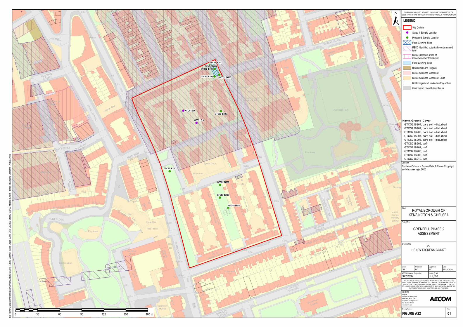
!(!(
!(
!(!(
!(
!(
!(
!(
!(
!(
!(
2
92123
25
80
109 to 121
7874
25 to 59
Flore nceHouse
1 to 23
6.8m
FRESTON ROAD
6
89
85
75
7.1m
35
40
25
LB
91
99
104
OLAF STREET
26
1
STONELEIG
H
P LACE
122
EVESHAM
STREET
21
1
ANSLEIGH
P LACE
8
P H
4527 1 to 6
MORTIMER
Court
125 to 135
Marle y House
Agnes House
61 to 83
6
22
SIRDAR ROAD
114
42
13
85
Carton House
1 to 12
17
W illow W a
y
119
50
107
3
91 to 97
93
23
60
72
13 15
7
35
126
3633
4446
83SQUARE
STONELEIGH
STREET
7.2m
Este lla House
7.0m
32
28
1
NICHOLAS ROAD
1
9
Boro Const
& LB Bd y
BS
2
Cycle Hire
Dora House
ST ANN'SROAD
She lte r
She lte r
Sports Court
14
20
MonsoonBuild ing
7 to 121 to 613 to 18
7 to 12
7 to 12
1 to 6
13 to 181 to 47
121
1 to 47
13 to 18
1 to 6
7 to 12
13 to 18
24
1 to 6
ESS
The Ge orgeBuild ing
1 to 9
LB
W are house 75
13
13 to 186.7m
7 to 12P ickwick House
3
1 to 12
6.6m
19 to 24
OLAFSTREET
1 to 6
1 to 6
13 to 18
1 to 67 to 12
Nickle by Hous
e
19 to 24
7 to 12
10
4
6571
57 59a to g63
P osts
1
100 to 107
3
HUNT CLOSE
8 to 15
91 to 99
19
7
20 to 26
4
27 to 3435 to 41
64
48 to 55 47
56 to 63
Boro Const
& LB Bd y
Und
De f
Und
De f
CR
De f
P lay Area
12
ST ANN'S ROAD
P lay Area
TCB
Cycle Hire
Rifle P lace
5549
58 to 7222 to 36
Mortim e rHouse
He nryDicke nsCourt
St Kathe rine 'sW alk
ESS
103
6.9m
2
DARNLEY
TERRACE
32
6
1 to 176
2416
115
95
69
1 to 16
74
79
80 to 8586 to 90
Bound aryHouse
St Jam es'sHallDe f
De f
De f
W ard Bd y CF
De fCF
She lte rSports Court
27
1 to 2137 to 57 42 to 46
47
28
91
28
51
St James's
21
14
Church
ST JAMES'S
GARDENS
7.9m
35
1
CF
ELGOOD CLOS
E
14
247 W inte rbourne
House
1
P H
1 to 36Crosfie ldHouse34
263
9
2
275
43
32
251
38
2 to 8
11
7.2m
4
10
8.5m
57
3a
11a
41
7.9m
TheCottage
25
19
47
20
MARY PLACE
3 12
15
24
1 to 7
Hall
13
1 2 3
9
D Fn
1 to 4
35
Lod ge
Lod ge
Dale
29
22
5
Club
4
16
1
26Rom illy H
ouse
SIRDAR ROAD29
GORHAM P LACE
12 to 18
Avond ale P ark
Avond ale P ark
9.0m
Ke nle y W alk
9.2m
29
25
321
P osts
6.6m
P rim ary School
1 to 47
14 to 23
24 to 35
1 to 8
1 to 6
5756
10
2 to 12
55
11 to 12
36 to 47
19 to 24
41
504948
5451
64
19 to 22
60
1 to 15
924
1a1b
10
3
59
19 to 24
13 to 18
28
7 to 126.9m
Dombey House
Fre d e rick Dobson House
Coppe rfie ldHouse
Ke nle yW alk
Nottingd ale
COW LING CLOSE
Square
W ILSHAM
STREET
7.1m
Barkis House
TCB6.8m
Nurse ry
3
5865
79
and StJam esP rim arySchool
Hall
Station
Cycle Hire
P lay Area
CFW ardBd y
CF
De fDe fCFDe f
De f
De f
CF
P C
31
2a2b
14 to 2249 to 63
3 to 8
1
2 to 16
5253
7
2 to 16
612
6 to 9
Square
Olive r1 to 9
6.7m
13 to 18
StaEl
GTCS2–S201GTCS2–S202
GTCS2–S203
GTCS2–S204 GTCS2–S205
GTCS2–S206
GTCS2–S207
GTCS2–S208
GTCS2–S209
GTCS2–S210
GTCS1–19
GTCS1–20
Project Title
Drawing Title
Drawn Checked
MidpointAlençon Link, BasingstokeHampshire, RG21 7PPTelephone (01256) 310200Fax (01256) 310201www.aecom.com
AECOM
DateApproved
RevDrawing Number
FIGURE A22 01
THIS DOCUMENT HAS BEEN PREPARED PURSUANT TO AND SUBJECT TO THETERMS OF AECOM'S APPOINTMENT BY ITS CLIENT. AECOM ACCEPTS NO LIABILITY
FOR ANY USE OF THIS DOCUMENT OTHER THAN BY ITS ORIGINAL CLIENT ORFOLLOWING AECOM'S EXPRESS AGREEMENT TO SUCH USE, AND ONLY FOR THE
PURPOSES FOR WHICH IT WAS PREPARED AND PROVIDED.
AECOM Internal Project No. Scale @ A360632092 1:1,500GM DD DD 19/10/2020
Client
File Na
me:\\e
u.aeco
mnet.c
om\EM
IA\UK
I\UKC
RD1\J
obs\PR
-45802
0_Gren
fell_To
wer_S
tage_2
\900_C
AD_G
IS\950
_Stag
e2_GIS
\02_M
aps\Fig
ure 06
- Stag
e 2 Sa
mpling
Locat
ions -
All Site
s.mxd
±
0 30 60 90 120 150 180 m
LEGENDSite Outline
!( Stage 1 Sample Location!( Proposed Sample Location
Food Growing SitesRBKC identified potentially contaminatedlandRBKC identified areas ofGeoenvironmental interestFood Growing SitesBrownfield Land RegisterRBKC database location ofRBKC database location of USTsRBKC registered trade directory entriesGeoEnviron Sites Historic Maps
GRENFELL PHASE 2ASSESSMENT
ROYAL BOROUGH OFKENSINGTON & CHELSEA
THIS DRAWING IS TO BE USED ONLY FOR THE PURPOSE OFISSUE THAT IT WAS ISSUED FOR AND IS SUBJECT TO AMENDMENT
CopyrightContains Ordnance Survey Data © Crown Copyright and database right 2020
22HENRY DICKENS COURT
Name, Ground_CoverGTCS2–S201, bare soil - d isturbe dGTCS2–S202, bare soil - d isturbe dGTCS2–S203, bare soil - d isturbe dGTCS2–S204, bare soil - d isturbe dGTCS2–S205, bare soil - d isturbe dGTCS2–S206, turfGTCS2–S207, turfGTCS2–S208, turfGTCS2–S209, turfGTCS2–S210, turf
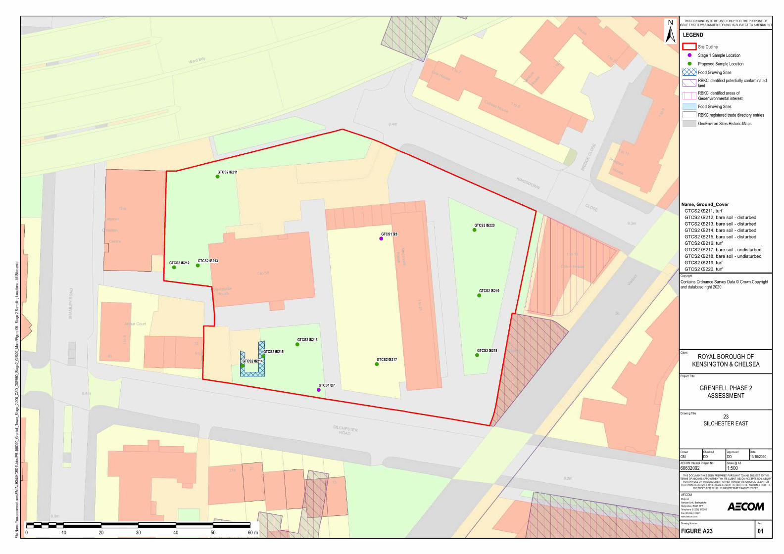
!(
!( !(
!(
!(
!(
!(
!(
!(
!(
!(
!(
V iaduct
8.2m
SILCHESTERROAD
13
21a
8.3m
21
8.4m
1 to 14
Colvin House
House
1 to 11
KINGSDOWN
8.4m
BRIDGE CLOSE
Prospect
8.3m
The
Arthur Court
Centre
Garage
CLOSE
1 to 7
House
V enture
House
1 to 7
Christian
12
40 9 to
1 to 8
Latym er
1 to 6Culross House
Link House
KingsnorthHouse
WhitstableHouse 1 to 21
1 to 80
Ward Bdy
BRAMLEY ROAD
SL
1 to 6
1 to 7
GTCS2–S211
GTCS2–S212 GTCS2–S213
GTCS2–S214GTCS2–S215
GTCS2–S216
GTCS2–S217GTCS2–S218
GTCS2–S219
GTCS2–S220
GTCS1–27
GTCS1–28
Project Title
Drawing Title
Drawn Checked
MidpointAlençon Link, BasingstokeHampshire, RG21 7PPTelephone (01256) 310200Fax (01256) 310201www.aecom.com
AECOM
DateApproved
RevDrawing Number
FIGURE A23 01
THIS DOCUMENT HAS BEEN PREPARED PURSUANT TO AND SUBJECT TO THETERMS OF AECOM'S APPOINTMENT BY ITS CLIENT. AECOM ACCEPTS NO LIABILITY
FOR ANY USE OF THIS DOCUMENT OTHER THAN BY ITS ORIGINAL CLIENT ORFOLLOWING AECOM'S EXPRESS AGREEMENT TO SUCH USE, AND ONLY FOR THE
PURPOSES FOR WHICH IT WAS PREPARED AND PROVIDED.
AECOM Internal Project No. Scale @ A360632092 1:500GM DD DD 19/10/2020
Client
File Na
me:\\e
u.aeco
mnet.c
om\EM
IA\UK
I\UKC
RD1\J
obs\PR
-45802
0_Gren
fell_To
wer_S
tage_2
\900_C
AD_G
IS\950
_Stag
e2_GIS
\02_M
aps\Fig
ure 06
- Stag
e 2 Sa
mpling
Locat
ions -
All Site
s.mxd
±
0 10 20 30 40 50 60 m
LEGENDSite Outline
!( Stage 1 Sample Location!( Proposed Sample Location
Food Growing SitesRBKC identified potentially contaminatedlandRBKC identified areas ofGeoenvironmental interestFood Growing SitesRBKC registered trade directory entriesGeoEnviron Sites Historic Maps
GRENFELL PHASE 2ASSESSMENT
ROYAL BOROUGH OFKENSINGTON & CHELSEA
THIS DRAWING IS TO BE USED ONLY FOR THE PURPOSE OFISSUE THAT IT WAS ISSUED FOR AND IS SUBJECT TO AMENDMENT
CopyrightContains Ordnance Survey Data © Crown Copyright and database right 2020
23SILCHESTER EAST
Name, Ground_CoverGTCS2–S211, turfGTCS2–S212, bare soil - disturbedGTCS2–S213, bare soil - disturbedGTCS2–S214, bare soil - disturbedGTCS2–S215, bare soil - disturbedGTCS2–S216, turfGTCS2–S217, bare soil - undisturbedGTCS2–S218, bare soil - undisturbedGTCS2–S219, turfGTCS2–S220, turf
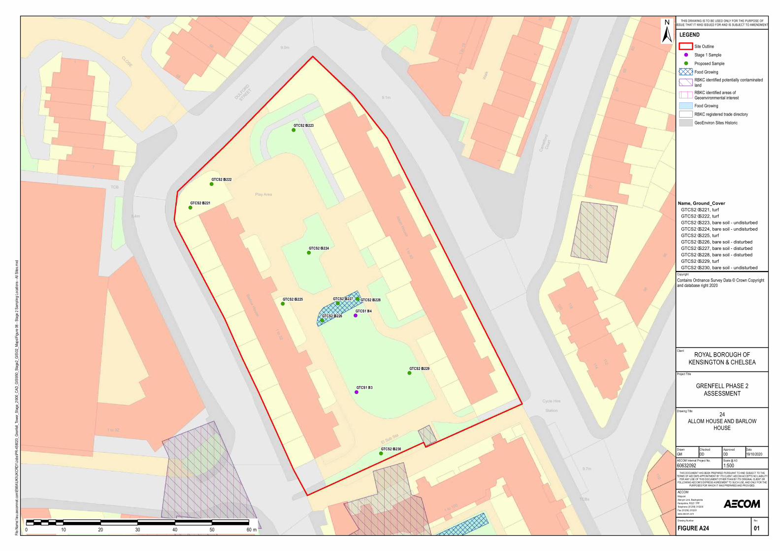
!(
!(
!(
!(
!(
!(
!(!(
!(
!(
!(
!(
10 9
44
68
El Sub Sta
9.7m
TCBs
110
1 to 100
Cycle HireStation
1 to 32
CLOSE
Walk
1 to 40
1
66
1 to 32
7
Barlow Hou se
DULFORD
STREET
Camelford
Court
9.1m
63
1
112
98
96
114
120118
77
6765
1 to 19
Allom Hou s e
9.0m
7
Play Area
8.4m
TCB
GTCS2–S221
GTCS2–S222
GTCS2–S223
GTCS2–S224
GTCS2–S225
GTCS2–S226
GTCS2–S227 GTCS2–S228
GTCS2–S229
GTCS2–S230
GTCS1–13
GTCS1–14
Project Title
Drawing Title
Drawn Checked
MidpointAlençon Link, BasingstokeHampshire, RG21 7PPTelephone (01256) 310200Fax (01256) 310201www.aecom.com
AECOM
DateApproved
RevDrawing Number
FIGURE A24 01
THIS DOCUMENT HAS BEEN PREPARED PURSUANT TO AND SUBJECT TO THETERMS OF AECOM'S APPOINTMENT BY ITS CLIENT. AECOM ACCEPTS NO LIABILITY
FOR ANY USE OF THIS DOCUMENT OTHER THAN BY ITS ORIGINAL CLIENT ORFOLLOWING AECOM'S EXPRESS AGREEMENT TO SUCH USE, AND ONLY FOR THE
PURPOSES FOR WHICH IT WAS PREPARED AND PROVIDED.
AECOM Internal Project No. Scale @ A360632092 1:500GM DD DD 19/10/2020
Client
File Na
me:\\e
u.aeco
mnet.c
om\EM
IA\UK
I\UKC
RD1\J
obs\PR
-45802
0_Gren
fell_To
wer_S
tage_2
\900_C
AD_G
IS\950
_Stag
e2_GIS
\02_M
aps\Fig
ure 06
- Stag
e 2 Sa
mpling
Locat
ions -
All Site
s.mxd
±
0 10 20 30 40 50 60 m
LEGENDSite Outline
!( Stage 1 Sample!( Proposed Sample
Food GrowingRBKC identified potentially contaminatedlandRBKC identified areas ofGeoenvironmental interestFood GrowingRBKC registered trade directoryGeoEnviron Sites Historic
GRENFELL PHASE 2ASSESSMENT
ROYAL BOROUGH OFKENSINGTON & CHELSEA
THIS DRAWING IS TO BE USED ONLY FOR THE PURPOSE OFISSUE THAT IT WAS ISSUED FOR AND IS SUBJECT TO AMENDMENT
CopyrightContains Ordnance Survey Data © Crown Copyright and database right 2020
24ALLOM HOUSE AND BARLOW
HOUSE
Name, Ground_CoverGTCS2–S221, tu rfGTCS2–S222, tu rfGTCS2–S223, b are soil - u ndis tu rb edGTCS2–S224, b are soil - u ndis tu rb edGTCS2–S225, tu rfGTCS2–S226, b are soil - dis tu rb edGTCS2–S227, b are soil - dis tu rb edGTCS2–S228, b are soil - dis tu rb edGTCS2–S229, tu rfGTCS2–S230, b are soil - u ndis tu rb ed
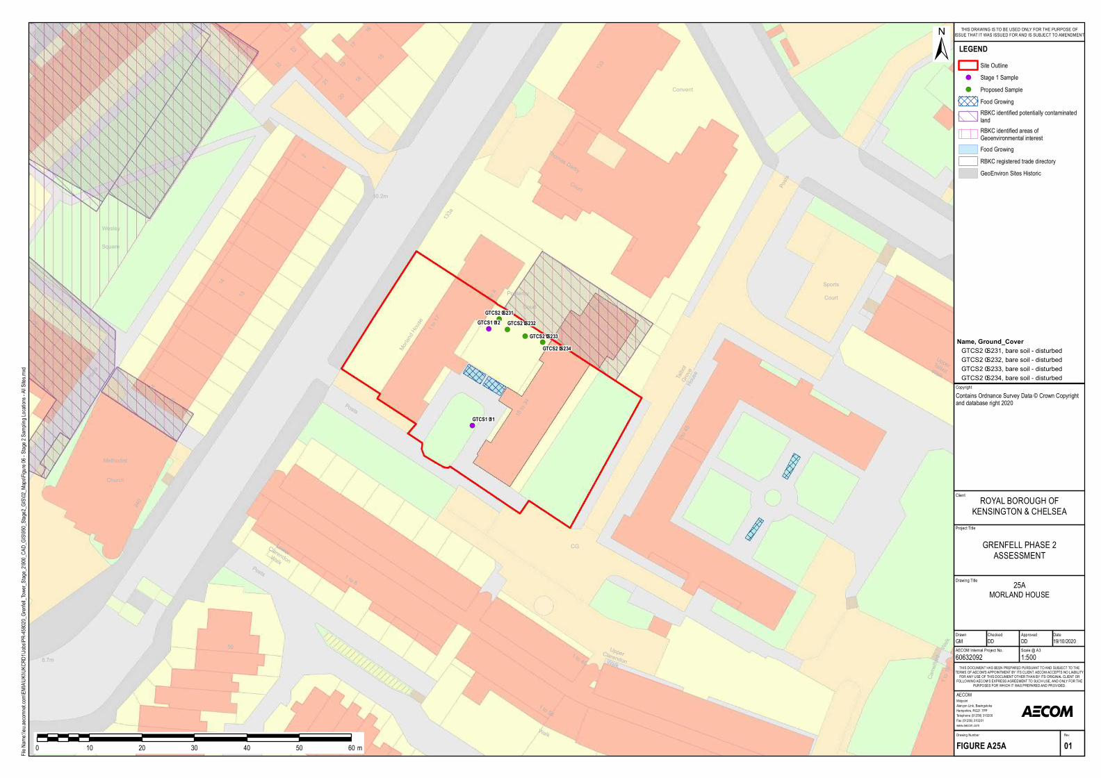
!(
!(!(
!(
!(
!(
8.7m
26
28
1 to 19
1 to 17
Meth odist
240
25
50
14
1 to 8
1 to 45
133
19
1
18 to 34
Pomeroy
Court 5 to 10
133a
1 to 413
18
1 to 56
1 to 40
51
24
15
16
23Cou rt
Talbot
Grove
HousePosts
Ch u rch
Walk
Low erClarendonWalk
UpperClarendonWalk
CamelfordWalk
17
Squ are
Posts
Morland Hou se
Posts
Convent
Wesley
Th omas Darby
2
Posts
10.2m
UpperTalbotWalk
18
2021
19
2322
CG
SportsCourt
GTCS2–S231GTCS2–S232
GTCS2–S233GTCS2–S234
GTCS1–11
GTCS1–12
Project Title
Drawing Title
Drawn Checked
MidpointAlençon Link, BasingstokeHampshire, RG21 7PPTelephone (01256) 310200Fax (01256) 310201www.aecom.com
AECOM
DateApproved
RevDrawing Number
FIGURE A25A 01
THIS DOCUMENT HAS BEEN PREPARED PURSUANT TO AND SUBJECT TO THETERMS OF AECOM'S APPOINTMENT BY ITS CLIENT. AECOM ACCEPTS NO LIABILITY
FOR ANY USE OF THIS DOCUMENT OTHER THAN BY ITS ORIGINAL CLIENT ORFOLLOWING AECOM'S EXPRESS AGREEMENT TO SUCH USE, AND ONLY FOR THE
PURPOSES FOR WHICH IT WAS PREPARED AND PROVIDED.
AECOM Internal Project No. Scale @ A360632092 1:500GM DD DD 19/10/2020
Client
File Na
me:\\e
u.aeco
mnet.c
om\EM
IA\UK
I\UKC
RD1\J
obs\PR
-45802
0_Gren
fell_To
wer_S
tage_2
\900_C
AD_G
IS\950
_Stag
e2_GIS
\02_M
aps\Fig
ure 06
- Stag
e 2 Sa
mpling
Locat
ions -
All Site
s.mxd
±
0 10 20 30 40 50 60 m
LEGENDSite Outline
!( Stage 1 Sample!( Proposed Sample
Food GrowingRBKC identified potentially contaminatedlandRBKC identified areas ofGeoenvironmental interestFood GrowingRBKC registered trade directoryGeoEnviron Sites Historic
GRENFELL PHASE 2ASSESSMENT
ROYAL BOROUGH OFKENSINGTON & CHELSEA
THIS DRAWING IS TO BE USED ONLY FOR THE PURPOSE OFISSUE THAT IT WAS ISSUED FOR AND IS SUBJECT TO AMENDMENT
CopyrightContains Ordnance Survey Data © Crown Copyright and database right 2020
25AMORLAND HOUSE
Name, Ground_CoverGTCS2–S231, bare soil - distu rbedGTCS2–S232, bare soil - distu rbedGTCS2–S233, bare soil - distu rbedGTCS2–S234, bare soil - distu rbed
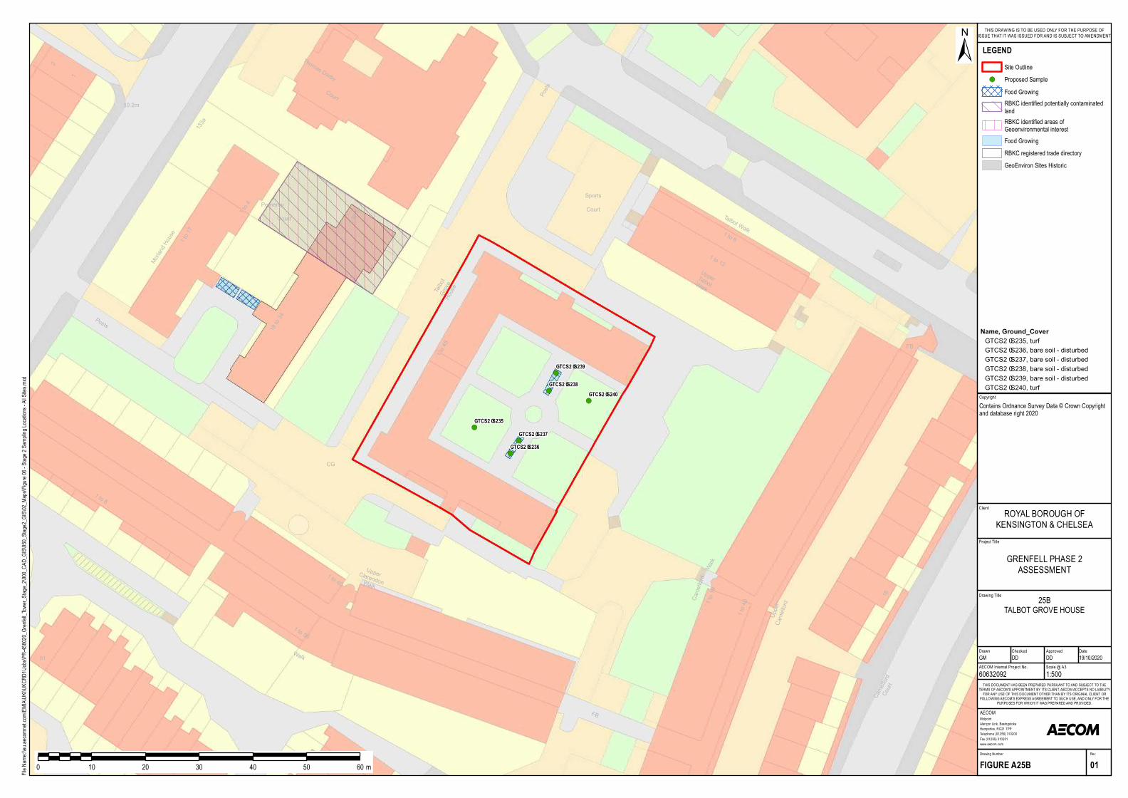
!(
!(
!(
!(
!(
!(
1 to 19
1 to 17
1 to 12
61
1 to 8
18
1 to 45
1 to 6
1
18 to 34
Pomeroy
Court 5 to 10
133a
1 to 4
1 to 56
1 to 40
51
Court
Talbot
Grove
House
Walk
UpperClarendonWalk
CamelfordWalk
Upper
Camelford
FB
Camelford
Court
FB
Posts
Morland House
Talbot Walk
Th omas Darby
2
Posts
10.2m
UpperTalbotWalk
1 to 40
CG
Sports
Court
GTCS2–S235
GTCS2–S236GTCS2–S237
GTCS2–S238
GTCS2–S239
GTCS2–S240
Project Title
Drawing Title
Drawn Checked
MidpointAlençon Link, BasingstokeHampshire, RG21 7PPTelephone (01256) 310200Fax (01256) 310201www.aecom.com
AECOM
DateApproved
RevDrawing Number
FIGURE A25B 01
THIS DOCUMENT HAS BEEN PREPARED PURSUANT TO AND SUBJECT TO THETERMS OF AECOM'S APPOINTMENT BY ITS CLIENT. AECOM ACCEPTS NO LIABILITY
FOR ANY USE OF THIS DOCUMENT OTHER THAN BY ITS ORIGINAL CLIENT ORFOLLOWING AECOM'S EXPRESS AGREEMENT TO SUCH USE, AND ONLY FOR THE
PURPOSES FOR WHICH IT WAS PREPARED AND PROVIDED.
AECOM Internal Project No. Scale @ A360632092 1:500GM DD DD 19/10/2020
Client
File Na
me:\\e
u.aeco
mnet.c
om\EM
IA\UK
I\UKC
RD1\J
obs\PR
-45802
0_Gren
fell_To
wer_S
tage_2
\900_C
AD_G
IS\950
_Stag
e2_GIS
\02_M
aps\Fig
ure 06
- Stag
e 2 Sa
mpling
Locat
ions -
All Site
s.mxd
±
0 10 20 30 40 50 60 m
LEGENDSite Outline
!( Proposed SampleFood GrowingRBKC identified potentially contaminatedlandRBKC identified areas ofGeoenvironmental interestFood GrowingRBKC registered trade directoryGeoEnviron Sites Historic
GRENFELL PHASE 2ASSESSMENT
ROYAL BOROUGH OFKENSINGTON & CHELSEA
THIS DRAWING IS TO BE USED ONLY FOR THE PURPOSE OFISSUE THAT IT WAS ISSUED FOR AND IS SUBJECT TO AMENDMENT
CopyrightContains Ordnance Survey Data © Crown Copyright and database right 2020
25BTALBOT GROVE HOUSE
Name, Ground_CoverGTCS2– S235, turfGTCS2– S236, bare soil - disturbedGTCS2– S237, bare soil - disturbedGTCS2– S238, bare soil - disturbedGTCS2– S239, bare soil - disturbedGTCS2– S240, turf
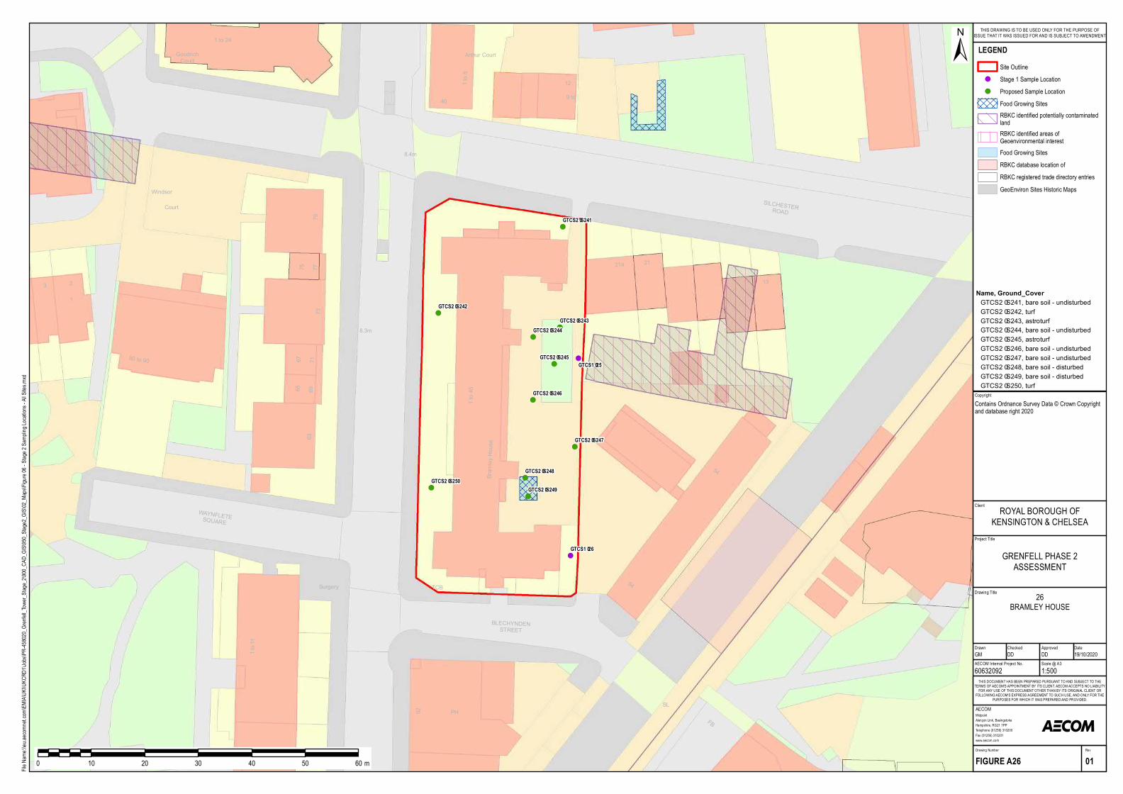
!(
!(
!(
!(
!(
!(
!(
!(
!(
!(
!(
!(
Surgery
1 to 11
FB
SL
TCB
PH92
BLECHYNDENSTREET
54
Posts
80 to 90
541 to 45
3
73
SILCHESTERROAD
63
Win dsor
79
13
WAYNFLETESQU ARE
21a
8.3m
21
Bramley House
Court
8.4m
676965
77
1
2
7175
Arthur Court
1 to 24
GoodrichCourt
12
40 9 to
1 to 8
GTCS2–S241
GTCS2–S242
GTCS2–S243GTCS2–S244
GTCS2–S245
GTCS2–S246
GTCS2–S247
GTCS2–S248
GTCS2–S249GTCS2–S250
GTCS1–25
GTCS1–26Project Title
Drawing Title
Drawn Checked
MidpointAlençon Link, BasingstokeHampshire, RG21 7PPTelephone (01256) 310200Fax (01256) 310201www.aecom.com
AECOM
DateApproved
RevDrawing Number
FIGURE A26 01
THIS DOCUMENT HAS BEEN PREPARED PURSUANT TO AND SUBJECT TO THETERMS OF AECOM'S APPOINTMENT BY ITS CLIENT. AECOM ACCEPTS NO LIABILITY
FOR ANY USE OF THIS DOCUMENT OTHER THAN BY ITS ORIGINAL CLIENT ORFOLLOWING AECOM'S EXPRESS AGREEMENT TO SUCH USE, AND ONLY FOR THE
PURPOSES FOR WHICH IT WAS PREPARED AND PROVIDED.
AECOM Internal Project No. Scale @ A360632092 1:500GM DD DD 19/10/2020
Client
File Na
me:\\e
u.aeco
mnet.c
om\EM
IA\UK
I\UKC
RD1\J
obs\PR
-45802
0_Gren
fell_To
wer_S
tage_2
\900_C
AD_G
IS\950
_Stag
e2_GIS
\02_M
aps\Fig
ure 06
- Stag
e 2 Sa
mpling
Locat
ions -
All Site
s.mxd
±
0 10 20 30 40 50 60 m
LEGENDSite Outline
!( Stage 1 Sample Location!( Proposed Sample Location
Food Growing SitesRBKC identified potentially contaminatedlandRBKC identified areas ofGeoenvironmental interestFood Growing SitesRBKC database location ofRBKC registered trade directory entriesGeoEnviron Sites Historic Maps
GRENFELL PHASE 2ASSESSMENT
ROYAL BOROUGH OFKENSINGTON & CHELSEA
THIS DRAWING IS TO BE USED ONLY FOR THE PURPOSE OFISSUE THAT IT WAS ISSUED FOR AND IS SUBJECT TO AMENDMENT
CopyrightContains Ordnance Survey Data © Crown Copyright and database right 2020
26BRAMLEY HOUSE
Name, Ground_CoverGTCS2–S241, bare soil - un disturbedGTCS2–S242, turfGTCS2–S243, astroturf GTCS2–S244, bare soil - un disturbedGTCS2–S245, astroturf GTCS2–S246, bare soil - un disturbedGTCS2–S247, bare soil - un disturbedGTCS2–S248, bare soil - disturbedGTCS2–S249, bare soil - disturbedGTCS2–S250, turf
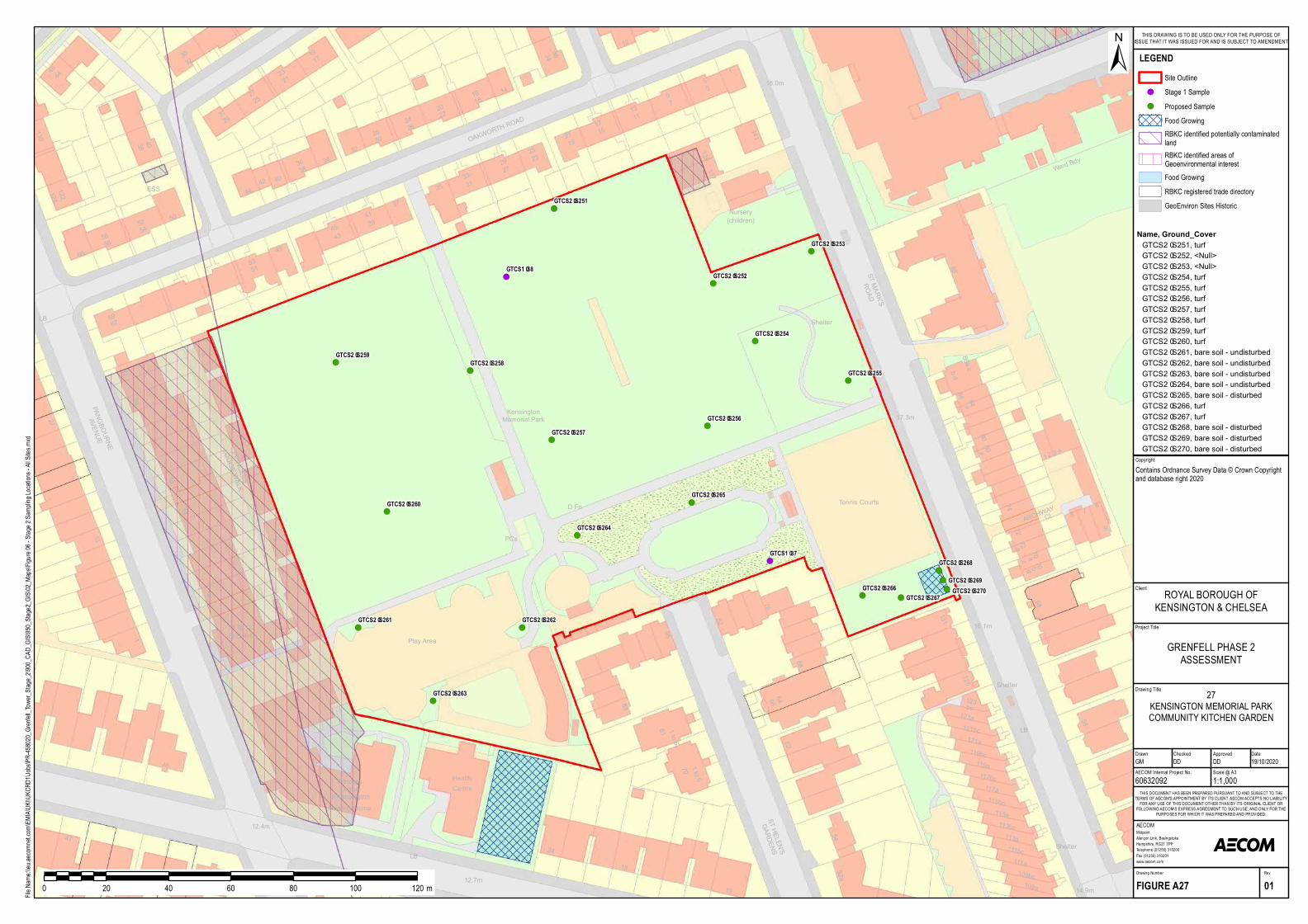
!(
!(
!(
!(
!(
!(
!(
!(!(
!(
!( !(
!(
!(
!(
!(
!(
!( !(
!(
!(!(
D Fn
46
37
PAN GBOU RN E
AV EN U E
4712.4m
13
27
1
121a
18
24
HealthCentre
131
121b c
68
76
Tennis Courts
125
123
115a115b c
a
72
70a 70cb
119b c
678
5881 1 to 6
1 to 679
LB
b c123a
52a
10
54
62
82
68
CL
84
ARCHW AY
84a
8080
119a
5PCs
d
74
117b c
72
117a
a
1
95
83
LB
14.9m12.7m
ST HELEN 'S
GARDEN S
109b c109a
113b c113a
16.1m
17.3m
111b c111a
Play Area
28
Shelter
N ursing Hom e
PrincessLouise
of Kensington
PRIN CESS
LOU ISE W ALK
18
2
4
14
1 To 17St Quintin
66
2 3 4
64
KensingtonMem orial Park
Shelter
42
60
LB
50
4437
49
3540
OAKWORTH
ROAD
12
14
141
139137
34
118.0m
32
32
Shelter
ESS
6
N ursery(child ren)
21
19
243117
3038
13
46
43
2927
5
11
69
3417
16
122
33
21
67
32
3
51
19
54
28
58
7
15
124
9
22
52
27
40
3044
130
45
29
25
25
36
20
23
39
36
26
41
38
56
18
23
53
31
8886a c
ST MARK'SROAD
W ard Bd y
b d
GTCS2–S251
GTCS2–S252
GTCS2–S253
GTCS2–S254
GTCS2–S255
GTCS2–S256GTCS2–S257
GTCS2–S258GTCS2–S259
GTCS2–S260
GTCS2–S261 GTCS2–S262
GTCS2–S263
GTCS2–S264
GTCS2–S265
GTCS1–37
GTCS1–38
GTCS2–S266GTCS2–S267
GTCS2–S268
GTCS2–S269GTCS2–S270
Project Title
Drawing Title
Drawn Checked
MidpointAlençon Link, BasingstokeHampshire, RG21 7PPTelephone (01256) 310200Fax (01256) 310201www.aecom.com
AECOM
DateApproved
RevDrawing Number
FIGURE A27 01
THIS DOCUMENT HAS BEEN PREPARED PURSUANT TO AND SUBJECT TO THETERMS OF AECOM'S APPOINTMENT BY ITS CLIENT. AECOM ACCEPTS NO LIABILITY
FOR ANY USE OF THIS DOCUMENT OTHER THAN BY ITS ORIGINAL CLIENT ORFOLLOWING AECOM'S EXPRESS AGREEMENT TO SUCH USE, AND ONLY FOR THE
PURPOSES FOR WHICH IT WAS PREPARED AND PROVIDED.
AECOM Internal Project No. Scale @ A360632092 1:1,000GM DD DD 19/10/2020
Client
File Na
me:\\e
u.aeco
mnet.c
om\EM
IA\UK
I\UKC
RD1\J
obs\PR
-45802
0_Gren
fell_To
wer_S
tage_2
\900_C
AD_G
IS\950
_Stag
e2_GIS
\02_M
aps\Fig
ure 06
- Stag
e 2 Sa
mpling
Locat
ions -
All Site
s.mxd
±
0 20 40 60 80 100 120 m
LEGENDSite Outline
!( Stage 1 Sample!( Proposed Sample
Food GrowingRBKC identified potentially contaminatedlandRBKC identified areas ofGeoenvironmental interestFood GrowingRBKC registered trade directoryGeoEnviron Sites Historic
GRENFELL PHASE 2ASSESSMENT
ROYAL BOROUGH OFKENSINGTON & CHELSEA
THIS DRAWING IS TO BE USED ONLY FOR THE PURPOSE OFISSUE THAT IT WAS ISSUED FOR AND IS SUBJECT TO AMENDMENT
CopyrightContains Ordnance Survey Data © Crown Copyright and database right 2020
27KENSINGTON MEMORIAL PARKCOMMUNITY KITCHEN GARDEN
Name, Ground_CoverGTCS2–S251, turfGTCS2–S252, <N ull>GTCS2–S253, <N ull>GTCS2–S254, turfGTCS2–S255, turfGTCS2–S256, turfGTCS2–S257, turfGTCS2–S258, turfGTCS2–S259, turfGTCS2–S260, turfGTCS2–S261, b are soil - und isturb edGTCS2–S262, b are soil - und isturb edGTCS2–S263, b are soil - und isturb edGTCS2–S264, b are soil - und isturb edGTCS2–S265, b are soil - d isturb edGTCS2–S266, turfGTCS2–S267, turfGTCS2–S268, b are soil - d isturb edGTCS2–S269, b are soil - d isturb edGTCS2–S270, b are soil - d isturb ed
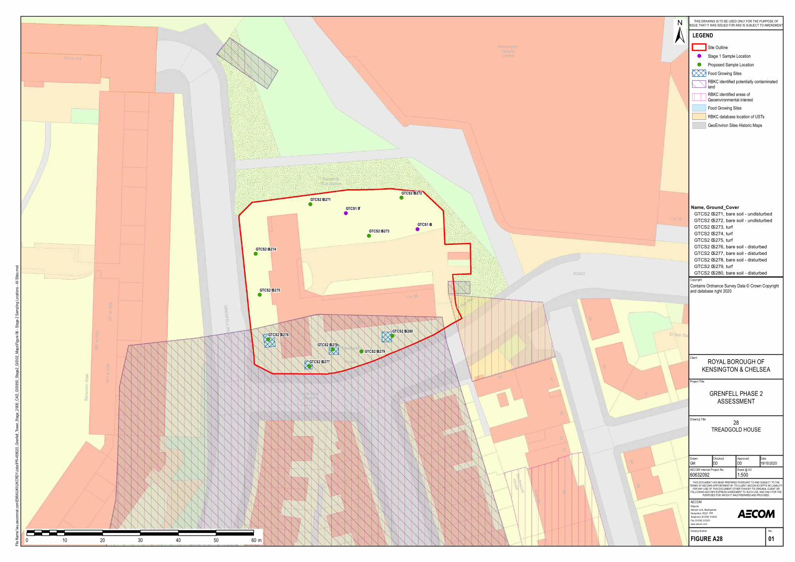
!(
!(
!(
!(
!(
!(
!(
!( !(
!(
!(
!(
301 to 339
Barandon Walk
GRENFELL ROAD
25 Treadgold
1 to 38
7
House
Cyc le HireStation
Elec tric itySub Station
501 to 550
401 to 439
1
101 to 111
16
44
51
5
ROAD
40
49
38
25
1 to 38
26
42
5755
SouthwoodHouse 14 to 25
5
14
El Sub Sta
53
El Sub Sta
1 to 32
KensingtonLeisureCentre
GTCS2–S271GTCS2–S272
GTCS2–S273
GTCS2–S274
GTCS2–S275
GTCS2–S276
GTCS2–S277
GTCS2–S278GTCS2–S279
GTCS2–S280
GTCS1–8
GTCS1–7
Project Title
Drawing Title
Drawn Checked
MidpointAlençon Link, BasingstokeHampshire, RG21 7PPTelephone (01256) 310200Fax (01256) 310201www.aecom.com
AECOM
DateApproved
RevDrawing Number
FIGURE A28 01
THIS DOCUMENT HAS BEEN PREPARED PURSUANT TO AND SUBJECT TO THETERMS OF AECOM'S APPOINTMENT BY ITS CLIENT. AECOM ACCEPTS NO LIABILITY
FOR ANY USE OF THIS DOCUMENT OTHER THAN BY ITS ORIGINAL CLIENT ORFOLLOWING AECOM'S EXPRESS AGREEMENT TO SUCH USE, AND ONLY FOR THE
PURPOSES FOR WHICH IT WAS PREPARED AND PROVIDED.
AECOM Internal Project No. Scale @ A360632092 1:500GM DD DD 19/10/2020
Client
File Na
me:\\e
u.aeco
mnet.c
om\EM
IA\UK
I\UKC
RD1\J
obs\PR
-45802
0_Gren
fell_To
wer_S
tage_2
\900_C
AD_G
IS\950
_Stag
e2_GIS
\02_M
aps\Fig
ure 06
- Stag
e 2 Sa
mpling
Locat
ions -
All Site
s.mxd
±
0 10 20 30 40 50 60 m
LEGENDSite Outline
!( Stage 1 Sample Location!( Proposed Sample Location
Food Growing SitesRBKC identified potentially contaminatedlandRBKC identified areas ofGeoenvironmental interestFood Growing SitesRBKC database location of USTsGeoEnviron Sites Historic Maps
GRENFELL PHASE 2ASSESSMENT
ROYAL BOROUGH OFKENSINGTON & CHELSEA
THIS DRAWING IS TO BE USED ONLY FOR THE PURPOSE OFISSUE THAT IT WAS ISSUED FOR AND IS SUBJECT TO AMENDMENT
CopyrightContains Ordnance Survey Data © Crown Copyright and database right 2020
28TREADGOLD HOUSE
Name, Ground_CoverGTCS2–S271, bare soil - undis turbedGTCS2–S272, bare soil - undis turbedGTCS2–S273, turfGTCS2–S274, turfGTCS2–S275, turfGTCS2–S276, bare soil - dis turbedGTCS2–S277, bare soil - dis turbedGTCS2–S278, bare soil - dis turbedGTCS2–S279, turfGTCS2–S280, bare soil - dis turbed
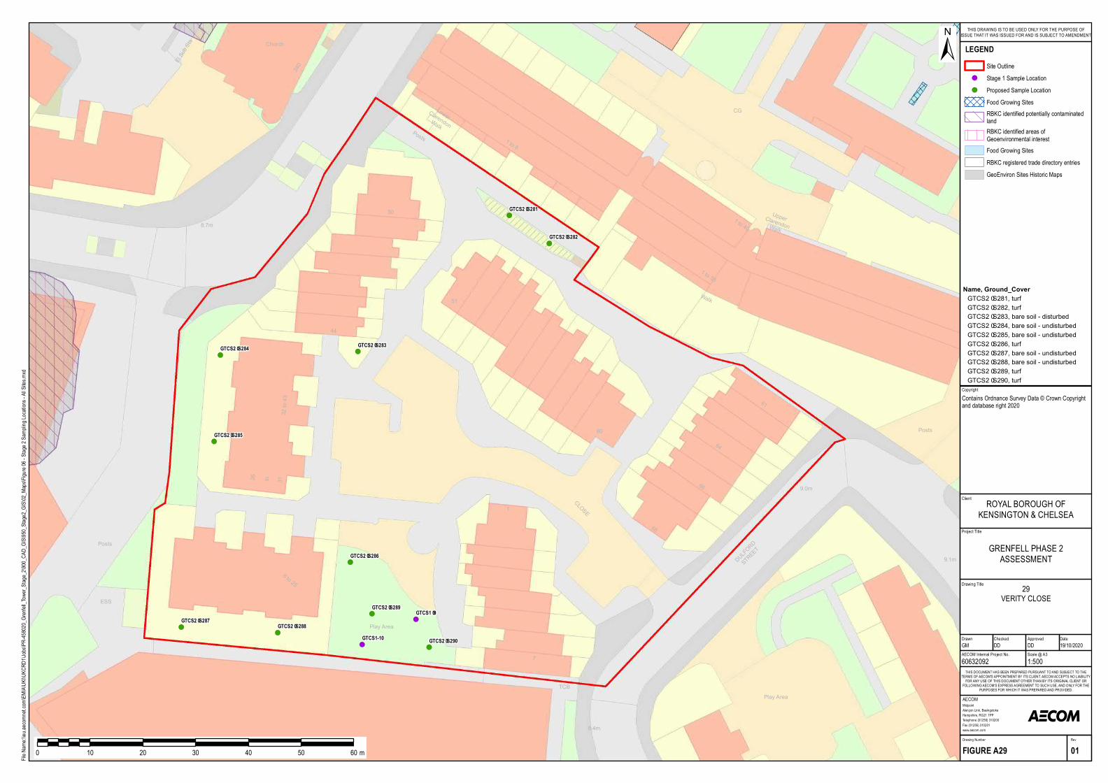
!(
!(
!(!(
!(
!(
!(!(
!(
!(
!(
!(
Pos ts
ESS
8.7m
El Sub Sta
60
64
44
240
50
61
1 to 8
1 to 56
1 to 40
51
Church
Walk
LowerClarendonWalk
UpperClarendonWalk
Pos ts
Pos ts
32 to 43
CG
68CLOSE
26 31to
1
66
8 to 25
7
DULFORD
STREET 9.1m
9.0m
Play Area
Play Area
8.4m
TCB
GTCS2–S281
GTCS2–S282
GTCS2–S283GTCS2–S284
GTCS2–S285
GTCS2–S286
GTCS2–S287GTCS2–S288
GTCS2–S289
GTCS2–S290
GTCS1–9
GTCS1-10
Project Title
Drawing Title
Drawn Checked
MidpointAlençon Link, BasingstokeHampshire, RG21 7PPTelephone (01256) 310200Fax (01256) 310201www.aecom.com
AECOM
DateApproved
RevDrawing Number
FIGURE A29 01
THIS DOCUMENT HAS BEEN PREPARED PURSUANT TO AND SUBJECT TO THETERMS OF AECOM'S APPOINTMENT BY ITS CLIENT. AECOM ACCEPTS NO LIABILITY
FOR ANY USE OF THIS DOCUMENT OTHER THAN BY ITS ORIGINAL CLIENT ORFOLLOWING AECOM'S EXPRESS AGREEMENT TO SUCH USE, AND ONLY FOR THE
PURPOSES FOR WHICH IT WAS PREPARED AND PROVIDED.
AECOM Internal Project No. Scale @ A360632092 1:500GM DD DD 19/10/2020
Client
File Na
me:\\e
u.aeco
mnet.c
om\EM
IA\UK
I\UKC
RD1\J
obs\PR
-45802
0_Gren
fell_To
wer_S
tage_2
\900_C
AD_G
IS\950
_Stag
e2_GIS
\02_M
aps\Fig
ure 06
- Stag
e 2 Sa
mpling
Locat
ions -
All Site
s.mxd
±
0 10 20 30 40 50 60 m
LEGENDSite Outline
!( Stage 1 Sample Location!( Proposed Sample Location
Food Growing SitesRBKC identified potentially contaminatedlandRBKC identified areas ofGeoenvironmental interestFood Growing SitesRBKC registered trade directory entriesGeoEnviron Sites Historic Maps
GRENFELL PHASE 2ASSESSMENT
ROYAL BOROUGH OFKENSINGTON & CHELSEA
THIS DRAWING IS TO BE USED ONLY FOR THE PURPOSE OFISSUE THAT IT WAS ISSUED FOR AND IS SUBJECT TO AMENDMENT
CopyrightContains Ordnance Survey Data © Crown Copyright and database right 2020
29VERITY CLOSE
Name, Ground_CoverGTCS2–S281, turfGTCS2–S282, turfGTCS2–S283, bare soil - dis turbedGTCS2–S284, bare soil - undis turbedGTCS2–S285, bare soil - undis turbedGTCS2–S286, turfGTCS2–S287, bare soil - undis turbedGTCS2–S288, bare soil - undis turbedGTCS2–S289, turfGTCS2–S290, turf
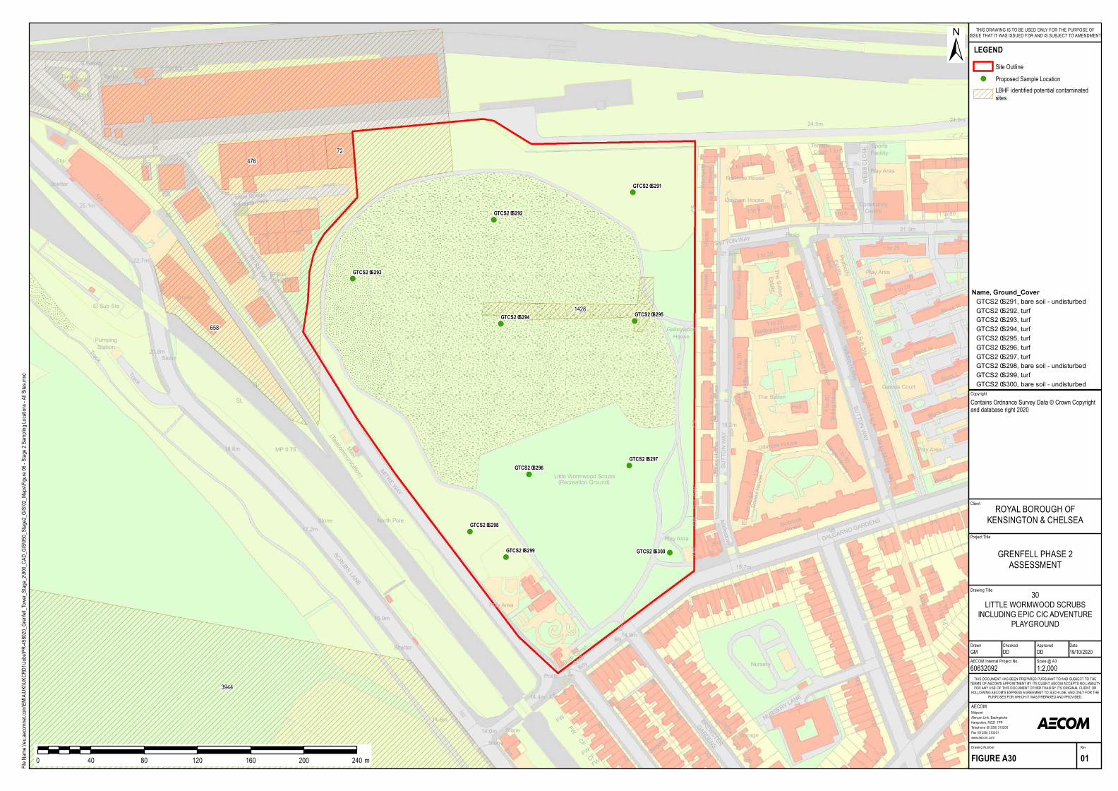
!(
!(
!(
!( !(
!(
!(
!(
!(!(
S Ga ntry
149
Sta
151
Ta nk
Ta nk
17
Mitre Bridg eIndustria l P a rk
18
13
2022.7m
MITRE WAY
912
16
8
25.1m
W orks
22
1
19
Ta nkS Ga ntry
SL
El Sub Sta
Ta nks
She lte r
El SubSta
SL
SL
Track
15.9m
MITRE WAY
18.6m
North P ole
20.8m
17.2mStone
Stone
235
Stone
SCRUBS LANE
Stone
P la y Are a
Tra ck
Ma st
(Te le com m unica tion)
She lte r
MP 0.75
P um pingSta tion
14.6m14.0m
CF
Ketton House
Block R
1 to 3021.5m
Oa kha m House
Te rra ceCourt
1 to 8
Com m unityCe ntre
1 to 8
18
24.9m
20
24.5m
WEBB CLOSEYoxa ll
1 to 25
Markyate
House
House
Ye ovil
Ga lle ywoodHouse
SUTTON WAYP osts
1 to 6
1 to 6
Re db ourn House
9 to 16
1 to 25
1 to 29
1 to 80
P s
9 to 16
House
1 to 30
21 to 9
Northaw House1 to 67 to 12
1 to 6
21.3m
1 to 6
4
1 to 6
10 to 18
P e a b odyEsta teThe Sutton
Esta te
HouseSportsFacility
P la y Are a
P la y Are a
(Re cre a tion Ground)
55Little W orm wood Scrub s
14.9m
55
44
56
2
4
43 Surge ry
18
16
6514.4m
P osts
58
BS
CF
CF
FW
FW
Und
FW
CF
Boro Const
& LBBdy
FWCF
26
132
15.7m
to 6
52
146
18
Ha ll
44 15
1 to 20
Block A
Sarra tt HouseVa ng e House
Ye a don House
to
Binb rook
House
Block L
9 to 16
1 to 30
18.2m
1 to 30
DALGARNO G
ARDENS
21 to 40
Terling House
SUTTON WAY
Udim ore House
74LB
5856
1 to 8
60
Hockliffe House
13 to 18
Block N
32
147
Firle House
173
161
Danes House
143
1 to 30
Addle stone
9 to 16
Cuffley House
5
El Sub Sta
El
SUTTON WAY
1609
1 to 6
Block G
142a
1
11 to 1410
1 to 8
1 to 30
7 to 12
19 to 24
Edgcott House
Nurse ry
42
CFDef
1
P la y Are a
The SuttonGa m e s Court
P la y Are a
30
CWDef
CW
22
98
43 1NURSERY LANE
131
20
BREW STER
GARDENS29 116
Vica ra g e
2
118
32 118a2824
GTCS2–S291
GTCS2–S292
GTCS2–S293
GTCS2–S294 GTCS2–S295
GTCS2–S296GTCS2–S297
GTCS2–S298
GTCS2–S299 GTCS2–S300
72476
658
1428
3944
Project Title
Drawing Title
Drawn Checked
MidpointAlençon Link, BasingstokeHampshire, RG21 7PPTelephone (01256) 310200Fax (01256) 310201www.aecom.com
AECOM
DateApproved
RevDrawing Number
FIGURE A30 01
THIS DOCUMENT HAS BEEN PREPARED PURSUANT TO AND SUBJECT TO THETERMS OF AECOM'S APPOINTMENT BY ITS CLIENT. AECOM ACCEPTS NO LIABILITY
FOR ANY USE OF THIS DOCUMENT OTHER THAN BY ITS ORIGINAL CLIENT ORFOLLOWING AECOM'S EXPRESS AGREEMENT TO SUCH USE, AND ONLY FOR THE
PURPOSES FOR WHICH IT WAS PREPARED AND PROVIDED.
AECOM Internal Project No. Scale @ A360632092 1:2,000GM DD DD 19/10/2020
Client
File Na
me:\\e
u.aeco
mnet.c
om\EM
IA\UK
I\UKC
RD1\J
obs\PR
-45802
0_Gren
fell_To
wer_S
tage_2
\900_C
AD_G
IS\950
_Stag
e2_GIS
\02_M
aps\Fig
ure 06
- Stag
e 2 Sa
mpling
Locat
ions -
All Site
s.mxd
±
0 40 80 120 160 200 240 m
LEGENDSite Outline
!( Proposed Sample LocationLBHF identified potential contaminatedsites
GRENFELL PHASE 2ASSESSMENT
ROYAL BOROUGH OFKENSINGTON & CHELSEA
THIS DRAWING IS TO BE USED ONLY FOR THE PURPOSE OFISSUE THAT IT WAS ISSUED FOR AND IS SUBJECT TO AMENDMENT
CopyrightContains Ordnance Survey Data © Crown Copyright and database right 2020
30LITTLE WORMWOOD SCRUBS
INCLUDING EPIC CIC ADVENTUREPLAYGROUND
Name, Ground_CoverGTCS2–S291, b a re soil - undisturb e dGTCS2–S292, turfGTCS2–S293, turfGTCS2–S294, turfGTCS2–S295, turfGTCS2–S296, turfGTCS2–S297, turfGTCS2–S298, b a re soil - undisturb e dGTCS2–S299, turfGTCS2–S300, b a re soil - undisturb e d
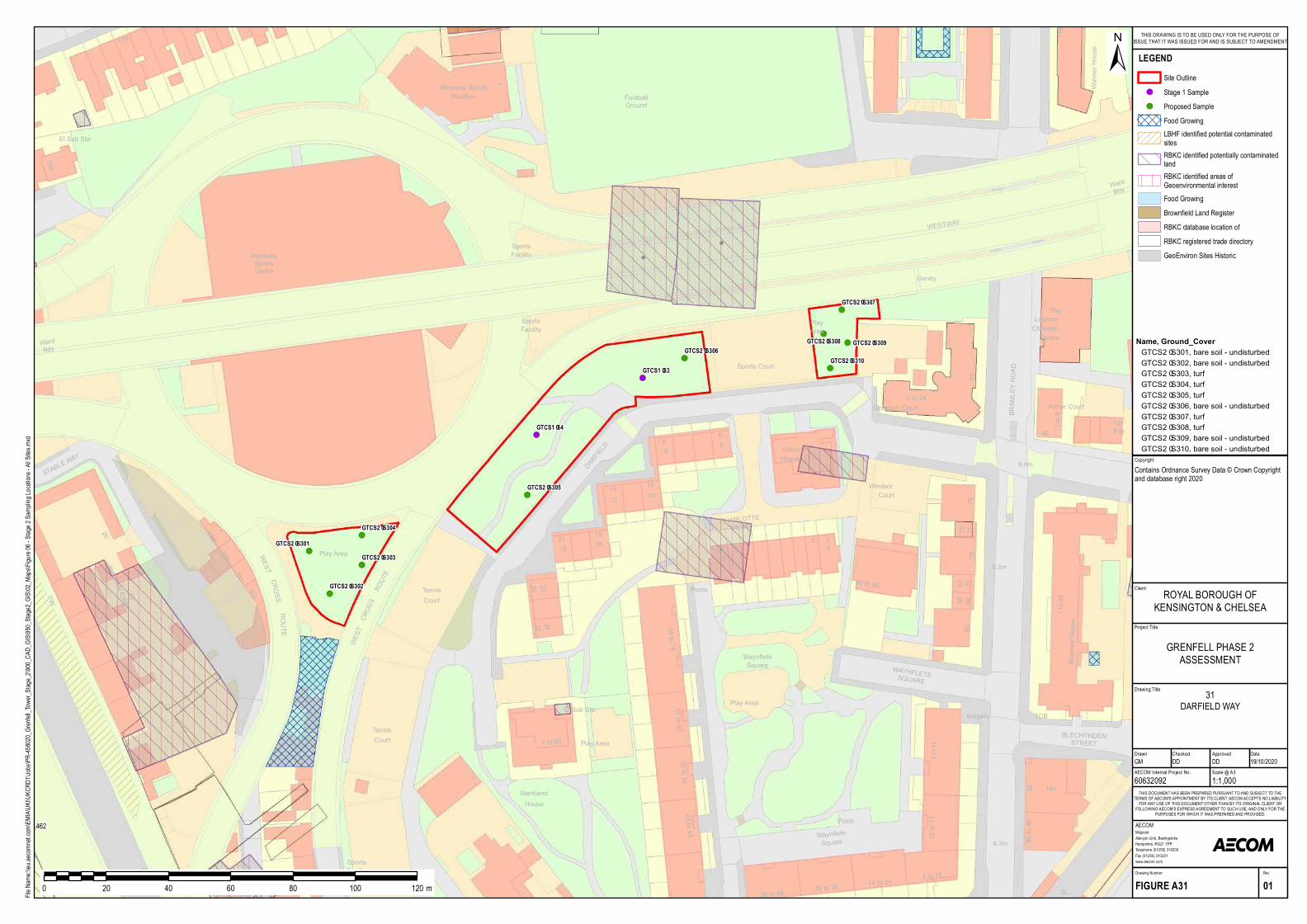
!(
!(
!(
!(
!(
!(
!(
!(!(
!(
!(
!(
57 to 6350 to 56
El Sub Sta
1 to 80
43 to 49
HouseMark land
SL
SL
TennisCourt
CF 1
Play Area
SportsFacility
SL
Surgery
38 to 48
1 to 11
14 to 24
12 to 17
2 to 1226 to 36
T CB
PH
WaynfleteSquare 8.3m
9286 to 90
BLECHYNDENST REET
Play Area
Posts
SportsFacility
SportsFacility
FootballGround
TennisCourt
WestwaySportsCentre
FW
15c
WEST
CROSS
ROUTE
15d Posts
WEST
15b
15a
59
ROUTE 64 to 76
CROSS
22
20
179
196
El Sub Sta
ST ABLE W
AY
1
WardBdy
DARFIELD
Westway SportsPavillion
Play Area
25
15
27
16
10
19
22
12
24
21
13
18
Industrial Estate
80 to 90
1 to 45
CHARLOT T EMEWS
WaynfleteSquare
93
7363
Dixon
Windsor
79
House
WAYNFLET ESQUARE
8.3m
Bramley House
Court
8.4m
10
676965
77
2
12
71
11
75
T he
Walmer House
Arthur Court
Centre
1 to 24
Christian
Goodrich Court12
40 9 to1 to 8
Latymer
81
134
WardBdy
BRAMLEY ROAD
PlayArea
Sports Court
WEST WAY
Gantry
6
GTCS2–S301
GTCS2–S302
GTCS2–S303
GTCS2–S304
GTCS2–S305
GTCS2–S306
GTCS2–S307
GTCS2–S308 GTCS2–S309
GTCS2–S310GTCS1–33
GTCS1–34
462
Project Title
Drawing Title
Drawn Checked
MidpointAlençon Link, BasingstokeHampshire, RG21 7PPTelephone (01256) 310200Fax (01256) 310201www.aecom.com
AECOM
DateApproved
RevDrawing Number
FIGURE A31 01
THIS DOCUMENT HAS BEEN PREPARED PURSUANT TO AND SUBJECT TO THETERMS OF AECOM'S APPOINTMENT BY ITS CLIENT. AECOM ACCEPTS NO LIABILITY
FOR ANY USE OF THIS DOCUMENT OTHER THAN BY ITS ORIGINAL CLIENT ORFOLLOWING AECOM'S EXPRESS AGREEMENT TO SUCH USE, AND ONLY FOR THE
PURPOSES FOR WHICH IT WAS PREPARED AND PROVIDED.
AECOM Internal Project No. Scale @ A360632092 1:1,000GM DD DD 19/10/2020
Client
File Na
me:\\e
u.aeco
mnet.c
om\EM
IA\UK
I\UKC
RD1\J
obs\PR
-45802
0_Gren
fell_To
wer_S
tage_2
\900_C
AD_G
IS\950
_Stag
e2_GIS
\02_M
aps\Fig
ure 06
- Stag
e 2 Sa
mpling
Locat
ions -
All Site
s.mxd
±
0 20 40 60 80 100 120 m
LEGENDSite Outline
!( Stage 1 Sample!( Proposed Sample
Food GrowingLBHF identified potential contaminatedsitesRBKC identified potentially contaminatedlandRBKC identified areas ofGeoenvironmental interestFood GrowingBrownfield Land RegisterRBKC database location ofRBKC registered trade directoryGeoEnviron Sites Historic
GRENFELL PHASE 2ASSESSMENT
ROYAL BOROUGH OFKENSINGTON & CHELSEA
THIS DRAWING IS TO BE USED ONLY FOR THE PURPOSE OFISSUE THAT IT WAS ISSUED FOR AND IS SUBJECT TO AMENDMENT
CopyrightContains Ordnance Survey Data © Crown Copyright and database right 2020
31DARFIELD WAY
Name, Ground_CoverGT CS2–S301, bare soil - undisturbedGT CS2–S302, bare soil - undisturbedGT CS2–S303, turfGT CS2–S304, turfGT CS2–S305, turfGT CS2–S306, bare soil - undisturbedGT CS2–S307, turfGT CS2–S308, turfGT CS2–S309, bare soil - undisturbedGT CS2–S310, bare soil - undisturbed
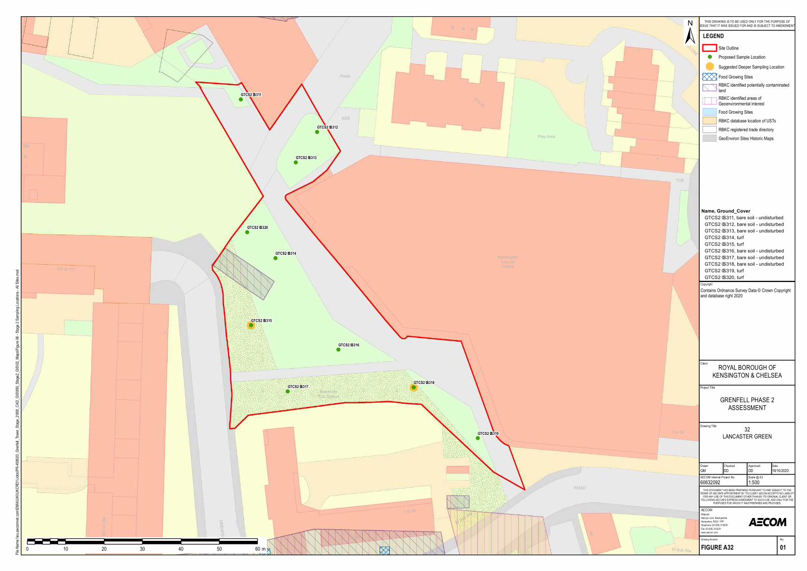
!(
!(
!(
!(
!(
!(
!(!(
!(
!(
301 to 339 GRENFELL ROAD
1 to 38
ElectricitySub Station
1to1
101 to 111
206
Posts
ESS
44
ROAD
25
1 to 38
El Sub Sta
El Sub Sta
1 to 32
CLOSE
26 31to
1
8 to 25
7
Play Area
KensingtonLeisureCentre
TCB
GTCS2–S311
GTCS2–S312
GTCS2–S313
GTCS2–S314
GTCS2–S315
GTCS2–S316
GTCS2–S317GTCS2–S318
GTCS2–S319
GTCS2–S320
Project Title
Drawing Title
Drawn Checked
MidpointAlençon Link, BasingstokeHampshire, RG21 7PPTelephone (01256) 310200Fax (01256) 310201www.aecom.com
AECOM
DateApproved
RevDrawing Number
FIGURE A32 01
THIS DOCUMENT HAS BEEN PREPARED PURSUANT TO AND SUBJECT TO THETERMS OF AECOM'S APPOINTMENT BY ITS CLIENT. AECOM ACCEPTS NO LIABILITY
FOR ANY USE OF THIS DOCUMENT OTHER THAN BY ITS ORIGINAL CLIENT ORFOLLOWING AECOM'S EXPRESS AGREEMENT TO SUCH USE, AND ONLY FOR THE
PURPOSES FOR WHICH IT WAS PREPARED AND PROVIDED.
AECOM Internal Project No. Scale @ A360632092 1:500GM DD DD 19/10/2020
Client
File Na
me:\\e
u.aeco
mnet.c
om\EM
IA\UK
I\UKC
RD1\J
obs\PR
-45802
0_Gren
fell_To
wer_S
tage_2
\900_C
AD_G
IS\950
_Stag
e2_GIS
\02_M
aps\Fig
ure 06
- Stag
e 2 Sa
mpling
Locat
ions -
All Site
s.mxd
±
0 10 20 30 40 50 60 m
LEGENDSite Outline
!( Proposed Sample Location
! Suggested Deeper Sampling LocationFood Growing SitesRBKC identified potentially contaminatedlandRBKC identified areas ofGeoenvironmental interestFood Growing SitesRBKC database location of USTsRBKC registered trade directoryGeoEnviron Sites Historic Maps
GRENFELL PHASE 2ASSESSMENT
ROYAL BOROUGH OFKENSINGTON & CHELSEA
THIS DRAWING IS TO BE USED ONLY FOR THE PURPOSE OFISSUE THAT IT WAS ISSUED FOR AND IS SUBJECT TO AMENDMENT
CopyrightContains Ordnance Survey Data © Crown Copyright and database right 2020
32LANCASTER GREEN
Name, Ground_CoverGTCS2–S311, bare soil - und isturbedGTCS2–S312, bare soil - und isturbedGTCS2–S313, bare soil - und isturbedGTCS2–S314, turfGTCS2–S315, turfGTCS2–S316, bare soil - und isturbedGTCS2–S317, bare soil - und isturbedGTCS2–S318, bare soil - und isturbedGTCS2–S319, turfGTCS2–S320, turf
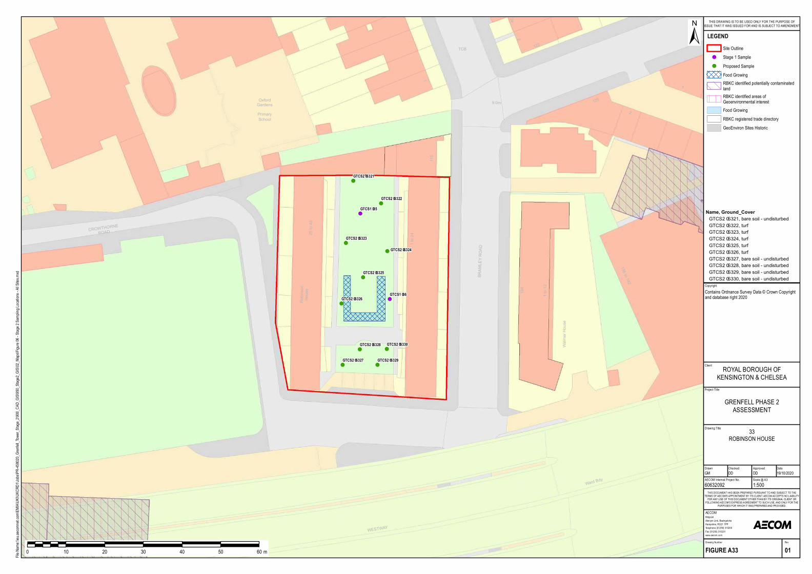
!(
!(
!(
!(
!(
!(
!(
!(
!(
!(
!(
!(
Robinson
House
CROWTHORNEROAD
Walmer House
9.0m
BRAMLEY ROAD
1
2a
122
2
25 to 48
1 to 12
1 to 24
115
1
134
136 to 142
2
125
Wa rd Bdy
Prima rySchool
OxfordGa rdens
TCB
WESTWAY
GTCS2–S321
GTCS2–S322
GTCS2–S323
GTCS2–S324
GTCS2–S325
GTCS2–S326
GTCS2–S327
GTCS2–S328
GTCS2–S329
GTCS2–S330
GTCS1–36
GTCS1–35
Project Title
Drawing Title
Drawn Checked
MidpointAlençon Link, BasingstokeHampshire, RG21 7PPTelephone (01256) 310200Fax (01256) 310201www.aecom.com
AECOM
DateApproved
RevDrawing Number
FIGURE A33 01
THIS DOCUMENT HAS BEEN PREPARED PURSUANT TO AND SUBJECT TO THETERMS OF AECOM'S APPOINTMENT BY ITS CLIENT. AECOM ACCEPTS NO LIABILITY
FOR ANY USE OF THIS DOCUMENT OTHER THAN BY ITS ORIGINAL CLIENT ORFOLLOWING AECOM'S EXPRESS AGREEMENT TO SUCH USE, AND ONLY FOR THE
PURPOSES FOR WHICH IT WAS PREPARED AND PROVIDED.
AECOM Internal Project No. Scale @ A360632092 1:500GM DD DD 19/10/2020
Client
File Na
me:\\e
u.aeco
mnet.c
om\EM
IA\UK
I\UKC
RD1\J
obs\PR
-45802
0_Gren
fell_To
wer_S
tage_2
\900_C
AD_G
IS\950
_Stag
e2_GIS
\02_M
aps\Fig
ure 06
- Stag
e 2 Sa
mpling
Locat
ions -
All Site
s.mxd
±
0 10 20 30 40 50 60 m
LEGENDSite Outline
!( Stage 1 Sample!( Proposed Sample
Food GrowingRBKC identified potentially contaminatedlandRBKC identified areas ofGeoenvironmental interestFood GrowingRBKC registered trade directoryGeoEnviron Sites Historic
GRENFELL PHASE 2ASSESSMENT
ROYAL BOROUGH OFKENSINGTON & CHELSEA
THIS DRAWING IS TO BE USED ONLY FOR THE PURPOSE OFISSUE THAT IT WAS ISSUED FOR AND IS SUBJECT TO AMENDMENT
CopyrightContains Ordnance Survey Data © Crown Copyright and database right 2020
33ROBINSON HOUSE
Name, Ground_CoverGTCS2–S321, ba re soil - undis turbedGTCS2–S322, turfGTCS2–S323, turfGTCS2–S324, turfGTCS2–S325, turfGTCS2–S326, turfGTCS2–S327, ba re soil - undis turbedGTCS2–S328, ba re soil - undis turbedGTCS2–S329, ba re soil - undis turbedGTCS2–S330, ba re soil - undis turbed
!(
!(
!(
!(!(
!(
!(
!(
!(
!(
El Sub Sta
26
28
27
4
1 to 17
11
Metho dist
240
22
7
10
25
5
11
8
14
59
29
28
19
1
3
9
18 to 34
Po m ero y
Co urt
133a
1 to 4
3
13
18
6
10
24
1
15
16
23
4
Posts
Church
Lo werClarendo nWalk
17
1
Square
Morland Ho use
BARTLE
ROAD
STANDREW'S
43SQU ARE
Wesley
2
Po sts
10.2m
18
2021
19
23
22
Ho use
Whitchurch
Co n stanceAllen
11
9
10
30
Ho use
8
1 to 40
BARTLE ROAD
47
31
1 to 6
32
4039
48
GTCS2–S331
GTCS2–S332
GTCS2–S333
GTCS2–S334GTCS2–S335
GTCS2–S336
GTCS2–S337
GTCS2–S338
GTCS2–S339
GTCS2–S340
Project Title
Drawing Title
Drawn Checked
MidpointAlençon Link, BasingstokeHampshire, RG21 7PPTelephone (01256) 310200Fax (01256) 310201www.aecom.com
AECOM
DateApproved
RevDrawing Number
FIGURE A34 01
THIS DOCUMENT HAS BEEN PREPARED PURSUANT TO AND SUBJECT TO THETERMS OF AECOM'S APPOINTMENT BY ITS CLIENT. AECOM ACCEPTS NO LIABILITY
FOR ANY USE OF THIS DOCUMENT OTHER THAN BY ITS ORIGINAL CLIENT ORFOLLOWING AECOM'S EXPRESS AGREEMENT TO SUCH USE, AND ONLY FOR THE
PURPOSES FOR WHICH IT WAS PREPARED AND PROVIDED.
AECOM Internal Project No. Scale @ A360632092 1:500GM DD DD 19/10/2020
Client
File Na
me:\\e
u.aeco
mnet.c
om\EM
IA\UK
I\UKC
RD1\J
obs\PR
-45802
0_Gren
fell_To
wer_S
tage_2
\900_C
AD_G
IS\950
_Stag
e2_GIS
\02_M
aps\Fig
ure 06
- Stag
e 2 Sa
mpling
Locat
ions -
All Site
s.mxd
±
0 10 20 30 40 50 60 m
LEGENDSite Outline
!( Proposed Sample LocationFood Growing SitesRBKC identified potentially contaminatedlandRBKC identified areas ofGeoenvironmental interestFood Growing SitesRBKC registered trade directory entriesGeoEnviron Sites Historic Maps
GRENFELL PHASE 2ASSESSMENT
ROYAL BOROUGH OFKENSINGTON & CHELSEA
THIS DRAWING IS TO BE USED ONLY FOR THE PURPOSE OFISSUE THAT IT WAS ISSUED FOR AND IS SUBJECT TO AMENDMENT
CopyrightContains Ordnance Survey Data © Crown Copyright and database right 2020
34WESLEY SQUARE
Name, Ground_CoverGTCS2–S331, bare so il - disturbedGTCS2–S332, bare so il - disturbedGTCS2–S333, bare so il - disturbedGTCS2–S334, turfGTCS2–S335, bare so il - disturbedGTCS2–S336, turfGTCS2–S337, bare so il - un disturbedGTCS2–S338, bare so il - un disturbedGTCS2–S339, bare so il - un disturbedGTCS2–S340, bare so il - un disturbed
!(!(
!(
!(
!(
!(
!( !(
!(
!(
!(
!(
189
57 to 6350 to 56
191
El Sub Sta
1 to 80
187a
29 to 41
El Sub Sta
43 to 49
HouseMa rkla nd
SL
SL
Te nnisCourt
12
6
17
11
CF
Latim e r
Education
Ce ntre
1
Ga ntry
Play Are a
SportsFacility
SportsFacility
Sports Court
1 to 80
Ale sta n House
Frinste a d House
1 to 15
Post
Trave lle rsSite
Cycle Way
Hurstway
WalkTCB
Latim er Road
Station (LU)
23
13 LOCKTON
STREET
Posts
401 to 439
8.2m
SL
Surg e ry
38 to 48
1 to 11
14 to 24
12 to 17
2 to 1226 to 36
TCB
PH
Waynfle teSqua re 8.3m
9286 to 90
SHALFLEETDRIVE
BLECHYNDENSTREET
Play Are a
Posts
1 to 18Packe nha m House15
1
Me rse y House
1 to 7Ble ssing ha m House1 to 6
SportsFacility
Te nnisCourt
We stwaySportsCe ntre
FW
15c
WEST
CROSS
ROUTE
15d Posts
WEST
15b
15a
59
ROUTE 64 to 76
CROSS
27
22
20
STABLE W
AY
Wa rd Bdy
DARFIELD
Pla y Are a
25
15
27
16
10
19
22
12
24
21
13
18
Industria l Estate
80 to 90
1 to 45
CHARLOTTEMEWS
Waynfle teSqua re
93
7363
Dixon
Windsor
79
House
WAYNFLETESQ UARE
8.3m
Bramle y House
Court
8.4m
10
676965
77
2
12
71
11
75
The
Arthur Court
Ce ntre
1 to 24
Christia n
Goodrich Court12
40 9 to1 to 8
La tym e r
81
BRAMLEY ROAD
Pla y Are a
Sports Court
Ga ntry
6
GTCS2–S341GTCS2–S342
GTCS2–S343
GTCS2–S344
GTCS2–S345
GTCS2–S346
GTCS2–S347GTCS2–S348
GTCS2–S349
GTCS2–S350
GTCS1–32
GTCS1–31
462
Project Title
Drawing Title
Drawn Checked
MidpointAlençon Link, BasingstokeHampshire, RG21 7PPTelephone (01256) 310200Fax (01256) 310201www.aecom.com
AECOM
DateApproved
RevDrawing Number
FIGURE A35 01
THIS DOCUMENT HAS BEEN PREPARED PURSUANT TO AND SUBJECT TO THETERMS OF AECOM'S APPOINTMENT BY ITS CLIENT. AECOM ACCEPTS NO LIABILITY
FOR ANY USE OF THIS DOCUMENT OTHER THAN BY ITS ORIGINAL CLIENT ORFOLLOWING AECOM'S EXPRESS AGREEMENT TO SUCH USE, AND ONLY FOR THE
PURPOSES FOR WHICH IT WAS PREPARED AND PROVIDED.
AECOM Internal Project No. Scale @ A360632092 1:1,000GM DD DD 19/10/2020
Client
File Na
me:\\e
u.aeco
mnet.c
om\EM
IA\UK
I\UKC
RD1\J
obs\PR
-45802
0_Gren
fell_To
wer_S
tage_2
\900_C
AD_G
IS\950
_Stag
e2_GIS
\02_M
aps\Fig
ure 06
- Stag
e 2 Sa
mpling
Locat
ions -
All Site
s.mxd
±
0 20 40 60 80 100 120 m
LEGENDSite Outline
!( Stage 1 Sample!( Proposed Sample
Food GrowingLBHF identified potential contaminatedsitesRBKC identified potentially contaminatedlandRBKC identified areas ofGeoenvironmental interestFood GrowingRBKC registered trade directoryGeoEnviron Sites Historic
GRENFELL PHASE 2ASSESSMENT
ROYAL BOROUGH OFKENSINGTON & CHELSEA
THIS DRAWING IS TO BE USED ONLY FOR THE PURPOSE OFISSUE THAT IT WAS ISSUED FOR AND IS SUBJECT TO AMENDMENT
CopyrightContains Ordnance Survey Data © Crown Copyright and database right 2020
35SILCHESTER WEST (NORTH AND
NORTH WEST AREA)
Name, Ground_CoverGTCS2–S341, b a re soil - undisturb e dGTCS2–S342, turfGTCS2–S343, b a re soil - undisturb e dGTCS2–S344, turfGTCS2–S345, turfGTCS2–S346, turfGTCS2–S347, turfGTCS2–S348, b a re soil - undisturb e dGTCS2–S349, turfGTCS2–S350, turf
!(
!(
!(
!(!(
!(
!(
!(
!(
!(
4
107
1
69
31BAR
TLE ROAD
SL
SL
12.8m
Cycle HireSta tio n
7
102
5
8
6
Ma xilla W
a lk
13.1m
1 to 6
4
115a
117
115
1 to 6
111 21 to 26
Villa s
15 to 20
7 to 14
109
Ra y Ho use
Shelter
ST MARKS
ROAD
Ga ntry
Da y Nurs ery
GTCS2–S351
GTCS2–S352
GTCS2–S353
GTCS2–S354GTCS2–S355
GTCS2–S356
GTCS2–S357
GTCS2–S358
GTCS2–S359
GTCS2–S360
Project Title
Drawing Title
Drawn Checked
MidpointAlençon Link, BasingstokeHampshire, RG21 7PPTelephone (01256) 310200Fax (01256) 310201www.aecom.com
AECOM
DateApproved
RevDrawing Number
FIGURE A36 01
THIS DOCUMENT HAS BEEN PREPARED PURSUANT TO AND SUBJECT TO THETERMS OF AECOM'S APPOINTMENT BY ITS CLIENT. AECOM ACCEPTS NO LIABILITY
FOR ANY USE OF THIS DOCUMENT OTHER THAN BY ITS ORIGINAL CLIENT ORFOLLOWING AECOM'S EXPRESS AGREEMENT TO SUCH USE, AND ONLY FOR THE
PURPOSES FOR WHICH IT WAS PREPARED AND PROVIDED.
AECOM Internal Project No. Scale @ A360632092 1:500GM DD DD 19/10/2020
Client
File Na
me:\\e
u.aeco
mnet.c
om\EM
IA\UK
I\UKC
RD1\J
obs\PR
-45802
0_Gren
fell_To
wer_S
tage_2
\900_C
AD_G
IS\950
_Stag
e2_GIS
\02_M
aps\Fig
ure 06
- Stag
e 2 Sa
mpling
Locat
ions -
All Site
s.mxd
±
0 10 20 30 40 50 60 m
LEGENDSite Outline
!( Proposed Sample LocationRBKC identified potentially contaminatedlandRBKC identified areas ofGeoenvironmental interestGeoEnviron Sites Historic Maps
GRENFELL PHASE 2ASSESSMENT
ROYAL BOROUGH OFKENSINGTON & CHELSEA
THIS DRAWING IS TO BE USED ONLY FOR THE PURPOSE OFISSUE THAT IT WAS ISSUED FOR AND IS SUBJECT TO AMENDMENT
CopyrightContains Ordnance Survey Data © Crown Copyright and database right 2020
36MAXILLA WALK - MAXILLA HALL /
MAXILLA GREEN
Name, Ground_CoverGTCS2–S351, turfGTCS2–S352, turfGTCS2–S353, ba re s o il - undisturbedGTCS2–S354, turfGTCS2–S355, turfGTCS2–S356, turfGTCS2–S357, turfGTCS2–S358, ba re s o il - undisturbedGTCS2–S359, turfGTCS2–S360, turf
!(
!(
!(
!(
!(
!(
!(
!(
!(
!(
2d
Groun dSton ebridgeRecreation
121
28.4m
133
1 to 8
1213
109
LB59
Canal
WESLEY ROAD
WEST END
CLOSE
FIRST DRIVE
29.0m
145
Our Ladyof Lourdes
STONEBRIDGE
3
SL
62
Roman CatholicPrimary School
Feeder
1a
2a1e
Pavilion
Sp orts Court
HILLSIDE28.8m
169
22
1FIRST DRIVE
6
157
Shelter
15115 28.0m
11
153 FB
WEST ENDCLOSE
43
41
9 to 16
40
56
48GTCS2–S361
GTCS2–S362
GTCS2–S363
GTCS2–S364
GTCS2–S365
GTCS2–S366
GTCS2–S367
GTCS2–S368
GTCS2–S369
GTCS2–S370
Project Title
Drawing Title
Drawn Checked
MidpointAlençon Link, BasingstokeHampshire, RG21 7PPTelephone (01256) 310200Fax (01256) 310201www.aecom.com
AECOM
DateApproved
RevDrawing Number
FIGURE A37 01
THIS DOCUMENT HAS BEEN PREPARED PURSUANT TO AND SUBJECT TO THETERMS OF AECOM'S APPOINTMENT BY ITS CLIENT. AECOM ACCEPTS NO LIABILITY
FOR ANY USE OF THIS DOCUMENT OTHER THAN BY ITS ORIGINAL CLIENT ORFOLLOWING AECOM'S EXPRESS AGREEMENT TO SUCH USE, AND ONLY FOR THE
PURPOSES FOR WHICH IT WAS PREPARED AND PROVIDED.
AECOM Internal Project No. Scale @ A360632092 1:1,000GM DD DD 19/10/2020
Client
File Na
me:\\e
u.aeco
mnet.c
om\EM
IA\UK
I\UKC
RD1\J
obs\PR
-45802
0_Gren
fell_To
wer_S
tage_2
\900_C
AD_G
IS\950
_Stag
e2_GIS
\02_M
aps\Fig
ure 06
- Stag
e 2 Sa
mpling
Locat
ions -
All Site
s.mxd
±
0 20 40 60 80 100 120 m
LEGENDSite Outline
!( Proposed Sample
GRENFELL PHASE 2ASSESSMENT
ROYAL BOROUGH OFKENSINGTON & CHELSEA
THIS DRAWING IS TO BE USED ONLY FOR THE PURPOSE OFISSUE THAT IT WAS ISSUED FOR AND IS SUBJECT TO AMENDMENT
CopyrightContains Ordnance Survey Data © Crown Copyright and database right 2020
37STONEBRIDGE PARK
Name, Ground_CoverGTCS2–S361, turfGTCS2–S362, turfGTCS2–S363, turfGTCS2–S364, turfGTCS2–S365, turfGTCS2–S366, turfGTCS2–S367, turfGTCS2–S368, turfGTCS2–S369, turfGTCS2–S370, turf

!(
!(
!(
!(
!(
!(
!(
!(
!(
!(
SL
SL
SP
S Gantry
Drain
149
108
War Mem orial
151
33.3m
TankTank
17
Mitre BridgeIndustrial Park
117
111
13
29.8m
2022.7m
WarWar Mem orial
32.3m
916
29.8m
8
101 to109
119to 129
29.8mDepot
29.9m29.8m
22
1
19
24.4m
Junction
30.2m
28.5mSubw
ay
30.9m
SL
Mary SeacoleMem orialPark
60
S Gantry
Tank
Sh elter
SCRUBSLANE
SL
131
LCEl Sub Sta
El Sub Sta
PaddingtonBranc h
Mitre Bridge
S Gantry
DWSL
Gantries
West LondonJunction
Path (um )
MP 2.75
Sh elter
25.0m SL
SLsSignalGantries
El SubSta
31.4m35
HYTHE ROAD
4
Garage1
24.7m
30.1m
31.6m6 to 13
30.2m
El SubSta
6
2
25.0m
31.9m
8
5
5
Works
439 to 40
30.2m
43 to 44
OldOak
Com m on Sidings
TravellingCrane
PaddingtonGrandUnionCanal
TowPath
LB
King House
Prim aryAcademy
Footb allPitc h
SL
El SubSta
Mast
Woodlane
Worm woodSc rub s Park
Court Larner1 to 20
NewallCourt
El Sub Sta1 to 11
29
FB
27
181 to 199161to 179
FS
11.9m11.4m
FB
121
FB
154a
Ham m ersm ithHospital
LB
FB
SL
Stone
SL
Trac k
15.9m
MITREWAY
18.6m
North Pole
LinfordCh ristieStadium
PC
Woodm ans
Mews
20.8m
3
17.2m
Path (um )
Terraces
Stone235
14 to 53
PC
SCRUBS
LANEPath (um )
Ch angingRoom sSub Sta
Car ParkStandRoom s
Tank
BurlingtonDanes Sc h ool
Play Area
SportsFacility
Drain
Trac k
Running Track
Sh elter
MP 0.75
Stab lesRecreation GroundCyc ling Centre
Path
14.6m
Path
174
SL
Club El Sub Sta
168 166
6 to 13
WESTQ UARTERS
11.1m12.0m180 11.6m
154a
MP 8.0SB
Worm woodSc rub s38
Posts
2452
10
10
SportsFacility
ARTILLERYLANE
El Sub Sta1 to 188
1 to 110
19 to 321 12 to 9 to 27
SL149 175
1 to 12
8676
65 9.6m
DaleyHouse
41
MP 7.5125
10.3m
House
77 13689 10292
113
7468
11.4m
53
137
140
10.7m
134
309
104 120
159
14
9.3m
TERRICKSTREET46
2
56
1 to 40
28 13
30
FB
14 1
9.7m
64
10.0mFB
101 161191
FB
71
SportsFacility
FB
FB
FBFB
FB
Holst1 to 3141
26 to 2914 to 17Sh elters
PlayingFields
BS
BS
BS
BSs
BS
29.9m
Def
39to
SL
OLD OAKCOMMON
SP
30.1m
30.1m30.1m39.0m
47
68
69to
Garage37.1m
93 to 98
55
FactoryLB
OLD OAK
COMMON LANE
36.6m
80
Und
Canal
El Sub StaCF
S Gantry
L Twr
LTwr
El SubSta
25.4m
25.6m
Tank
25.6m SP
28
7Post
LB
28
1201
11.7m
41
13.5m
203
OLDOAK
3a 3
MUIRFIELD
147149
212
1
1
2
812.2m
141
15
8
118
139
13.2m
128
48
2
75
46
35
110
208
52
21 56
57
58
153
155
24
63
76
36
73
176
41
214
40
97
47
7235
118
117
102
170
188
24
14
90
77
138
STREET
SL
24117
44
112
59
105
100
71
162
72
88
64
14
4858a
90
85
9
133
13.8m
128
a
130 108
50 14
105
180
51
164
149
131
70
13
202
47
109
15
156
2
90
118
174
75
78
104
50
2
45
Centre
48
121
23
92
10999
140 1
143131
37
95
67
59
SP 15.7m STREET
21
85
16.2m
80
136143
5064
43STREET
68
148
119
36
47
36
89 83
1 2
23
35
79
30
73
6
148
78
131
185
11
92
1114
4159
98
33
153
126
107101
109121
171
SL
25
139
20
121
186
2 CR
163
Old Oak
47
42
Subway
East
Ac ton Station
MP 1.0
1213
1612.7m
2
101 11
14
16
274224
29
71 5
4
1
33
19 28
3
East Acton222
20213212
10.0m 10.2m
2
40
12 2
MP 8.2536
209
14
232
38 24
266254 2445
6
17
123
Sh elter
Sh elter
SL
13.5m14.7m
1211
1179 173 61
BRAYBROOKSTREET
8698
147
1 to 17 232SubSta
2 to 6
2Sub
SL
El SubSta 25.9m
22.7m
20.8m
26.6m
7
245Posts
Park
87 85
MP3.25
Old OakCom m on
17.7m
50
99111
6274231
161
Old OakCom m on
OLDOAK
COMMON LANE
16.3m
18.7m
SL
48197
104 115
14
113101199
230202
13.7m
137
2436
216 35
21173 53
65127 2
87
7512
MP 8.5
18.0m
149 75
1
SL
2
240187
181
13.1m224
Depot
CR
BS
CW
CW
UndUnd
El SubSta
LevelCrossing
Tank
GantryGantry
Gantries
MP 0.75
SP
Tank
CF
SP
50
5
58
16
71
6
El SubSta
THE GREEN
30
14.1m
38 126
40
24
73
15
55
PlayArea
Th eGreen
39 11
196
29
110.5m
184
36 to 49
StaPIONEER WAY
Pankh urst
10.4m
House
201
8.7m
10.0m
Gantry
SportsFacility
14Worm woodSc rub s 28
(RecreationGround)
55
14.9m
Sc rub sPark
55 44562
4
4329
12.7m
14.4mPosts
Pavilion
1 to 47
CF
FW
2a
1
SCRUBS
67
10.9m
FWCF
Sh elter
1115
16CF
Sh elter
(PH)
GTCS2–S371
GTCS2–S372
GTCS2–S373GTCS2–S374
GTCS2–S375
GTCS2–S376
GTCS2–S377
GTCS2–S378
GTCS2–S379
GTCS2–S380
72
202
470
472
476
658 1428
3944
255Project Title
Drawing Title
Drawn Checked
MidpointAlençon Link, BasingstokeHampshire, RG21 7PPTelephone (01256) 310200Fax (01256) 310201www.aecom.com
AECOM
DateApproved
RevDrawing Number
FIGURE A38 01
THIS DOCUMENT HAS BEEN PREPARED PURSUANT TO AND SUBJECT TO THETERMS OF AECOM'S APPOINTMENT BY ITS CLIENT. AECOM ACCEPTS NO LIABILITY
FOR ANY USE OF THIS DOCUMENT OTHER THAN BY ITS ORIGINAL CLIENT ORFOLLOWING AECOM'S EXPRESS AGREEMENT TO SUCH USE, AND ONLY FOR THE
PURPOSES FOR WHICH IT WAS PREPARED AND PROVIDED.
AECOM Internal Project No. Scale @ A360632092 1:5,000GM DD DD 19/10/2020
Client
File Na
me:\\e
u.aeco
mnet.c
om\EM
IA\UK
I\UKC
RD1\J
obs\PR
-45802
0_Gren
fell_To
wer_S
tage_2
\900_C
AD_G
IS\950
_Stag
e2_GIS
\02_M
aps\Fig
ure 06
- Stag
e 2 Sa
mpling
Locat
ions -
All Site
s.mxd
±
0 100 200 300 400 500 600 m
LEGENDSite Outline
!( Proposed SampleLBHF identified potential contaminatedsites
GRENFELL PHASE 2ASSESSMENT
ROYAL BOROUGH OFKENSINGTON & CHELSEA
THIS DRAWING IS TO BE USED ONLY FOR THE PURPOSE OFISSUE THAT IT WAS ISSUED FOR AND IS SUBJECT TO AMENDMENT
CopyrightContains Ordnance Survey Data © Crown Copyright and database right 2020
38WORMWOOD SCRUBS
Name, Ground_CoverGTCS2–S371, turfGTCS2–S372, turfGTCS2–S373, turfGTCS2–S374, turfGTCS2–S375, turfGTCS2–S376, turfGTCS2–S377, turfGTCS2–S378, turfGTCS2–S379, turfGTCS2–S380, turf
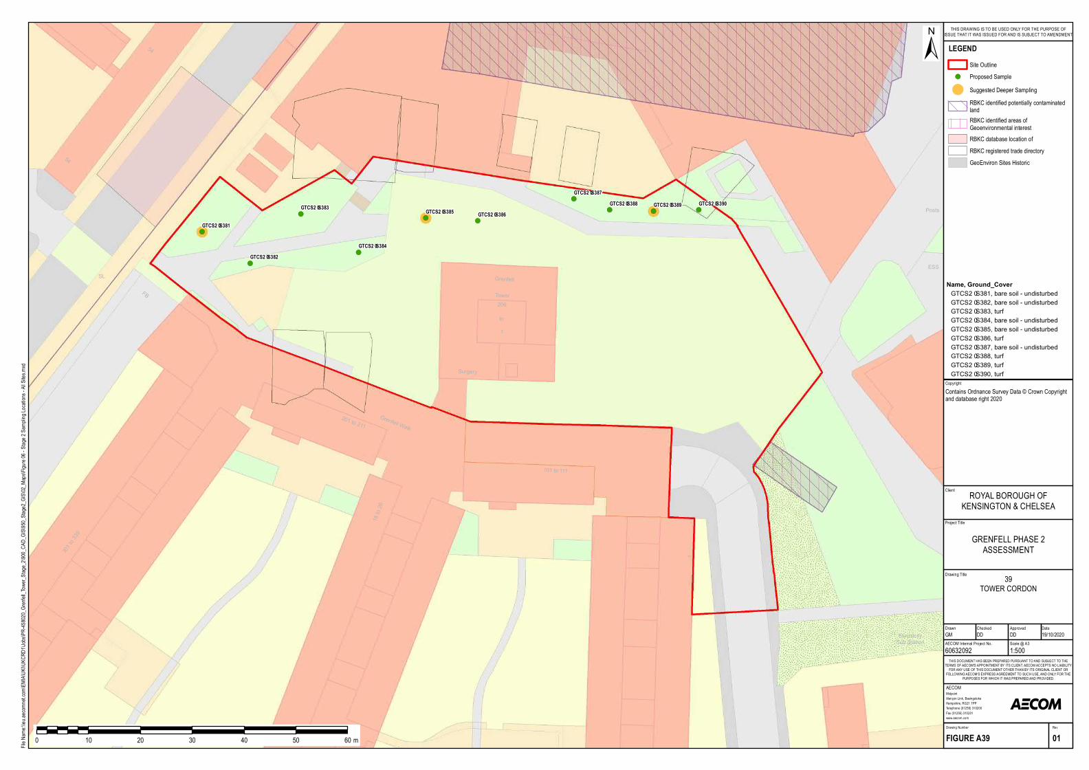
!(
!(
!(
!(
!( !(
!(
!( !( !(
ElectricitySub Station
1301 to 339
to1
101 to 111
18 to 26
201 to 211
FB
SL
Surgery
206Tower
Grenfell Walk
Grenfell
54
Posts
ESS
54
GTCS2–S381
GTCS2–S382
GTCS2–S383
GTCS2–S384
GTCS2–S385 GTCS2–S386
GTCS2–S387GTCS2–S388 GTCS2–S389 GTCS2–S390
Project Title
Drawing Title
Drawn Checked
MidpointAlençon Link, BasingstokeHampshire, RG21 7PPTelephone (01256) 310200Fax (01256) 310201www.aecom.com
AECOM
DateApproved
RevDrawing Number
FIGURE A39 01
THIS DOCUMENT HAS BEEN PREPARED PURSUANT TO AND SUBJECT TO THETERMS OF AECOM'S APPOINTMENT BY ITS CLIENT. AECOM ACCEPTS NO LIABILITY
FOR ANY USE OF THIS DOCUMENT OTHER THAN BY ITS ORIGINAL CLIENT ORFOLLOWING AECOM'S EXPRESS AGREEMENT TO SUCH USE, AND ONLY FOR THE
PURPOSES FOR WHICH IT WAS PREPARED AND PROVIDED.
AECOM Internal Project No. Scale @ A360632092 1:500GM DD DD 19/10/2020
Client
File Na
me:\\e
u.aeco
mnet.c
om\EM
IA\UK
I\UKC
RD1\J
obs\PR
-45802
0_Gren
fell_To
wer_S
tage_2
\900_C
AD_G
IS\950
_Stag
e2_GIS
\02_M
aps\Fig
ure 06
- Stag
e 2 Sa
mpling
Locat
ions -
All Site
s.mxd
±
0 10 20 30 40 50 60 m
LEGENDSite Outline
!( Proposed Sample
! Suggested Deeper SamplingRBKC identified potentially contaminatedlandRBKC identified areas ofGeoenvironmental interestRBKC database location ofRBKC registered trade directoryGeoEnviron Sites Historic
GRENFELL PHASE 2ASSESSMENT
ROYAL BOROUGH OFKENSINGTON & CHELSEA
THIS DRAWING IS TO BE USED ONLY FOR THE PURPOSE OFISSUE THAT IT WAS ISSUED FOR AND IS SUBJECT TO AMENDMENT
CopyrightContains Ordnance Survey Data © Crown Copyright and database right 2020
39TOWER CORDON
Name, Ground_CoverGTCS2–S381, bare soil - undisturbedGTCS2–S382, bare soil - undisturbedGTCS2–S383, turfGTCS2–S384, bare soil - undisturbedGTCS2–S385, bare soil - undisturbedGTCS2–S386, turfGTCS2–S387, bare soil - undisturbedGTCS2–S388, turfGTCS2–S389, turfGTCS2–S390, turf

Grenfell Investigation into Potential LandContamination Impacts
Project number: 60632092
Prepared for: Royal Borough of Kensington and Chelsea AECOM68
Appendix B Soil Sampling Protocol
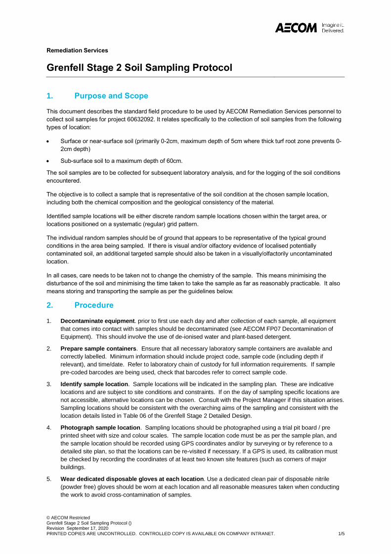
© AECOM RestrictedGrenfell Stage 2 Soil Sampling Protocol ()Revision September 17, 2020PRINTED COPIES ARE UNCONTROLLED. CONTROLLED COPY IS AVAILABLE ON COMPANY INTRANET. 1/5
Remediation Services
Grenfell Stage 2 Soil Sampling Protocol
1. Purpose and Scope
This document describes the standard field procedure to be used by AECOM Remediation Services personnel to collect soil samples for project 60632092. It relates specifically to the collection of soil samples from the following types of location:
· Surface or near-surface soil (primarily 0-2cm, maximum depth of 5cm where thick turf root zone prevents 0-2cm depth)
· Sub-surface soil to a maximum depth of 60cm.
The soil samples are to be collected for subsequent laboratory analysis, and for the logging of the soil conditions encountered.
The objective is to collect a sample that is representative of the soil condition at the chosen sample location, including both the chemical composition and the geological consistency of the material.
Identified sample locations will be either discrete random sample locations chosen within the target area, or locations positioned on a systematic (regular) grid pattern.
The individual random samples should be of ground that appears to be representative of the typical ground conditions in the area being sampled. If there is visual and/or olfactory evidence of localised potentially contaminated soil, an additional targeted sample should also be taken in a visually/olfactorily uncontaminated location.
In all cases, care needs to be taken not to change the chemistry of the sample. This means minimising the disturbance of the soil and minimising the time taken to take the sample as far as reasonably practicable. It also means storing and transporting the sample as per the guidelines below.
2. Procedure
1. Decontaminate equipment. prior to first use each day and after collection of each sample, all equipmentthat comes into contact with samples should be decontaminated (see AECOM FP07 Decontamination ofEquipment). This should involve the use of de-ionised water and plant-based detergent.
2. Prepare sample containers. Ensure that all necessary laboratory sample containers are available andcorrectly labelled. Minimum information should include project code, sample code (including depth ifrelevant), and time/date. Refer to laboratory chain of custody for full information requirements. If samplepre-coded barcodes are being used, check that barcodes refer to correct sample code.
3. Identify sample location. Sample locations will be indicated in the sampling plan. These are indicativelocations and are subject to site conditions and constraints. If on the day of sampling specific locations arenot accessible, alternative locations can be chosen. Consult with the Project Manager if this situation arises.Sampling locations should be consistent with the overarching aims of the sampling and consistent with thelocation details listed in Table 06 of the Grenfell Stage 2 Detailed Design.
4. Photograph sample location. Sampling locations should be photographed using a trial pit board / preprinted sheet with size and colour scales. The sample location code must be as per the sample plan, andthe sample location should be recorded using GPS coordinates and/or by surveying or by reference to adetailed site plan, so that the locations can be re-visited if necessary. If a GPS is used, its calibration mustbe checked by recording the coordinates of at least two known site features (such as corners of majorbuildings.
5. Wear dedicated disposable gloves at each location. Use a dedicated clean pair of disposable nitrile(powder free) gloves should be worn at each location and all reasonable measures taken when conductingthe work to avoid cross-contamination of samples.
© AECOM RestrictedGrenfell Stage 2 Soil Sampling Protocol ()Revision September 17, 2020PRINTED COPIES ARE UNCONTROLLED. CONTROLLED COPY IS AVAILABLE ON COMPANY INTRANET. 2/5
6. Damp down sample area. If the ground is damp, no further damping down is required. If the ground is dryand dusty, damp down the ground before and during sampling using a hand-held water mister. This helpsminimise the generation of airborne dust (and asbestos fibres if present) during sampling. Avoid excessiveuse of water which would make sample more difficult to handle.
7. Clear sampling area. Remove vegetation and surface debris that is not to be sampled. Sampling areashould be a minimum of 50cm x 50cm square. Lay down an approximate 70cm x 70cm piece of clean un-used plastic sheeting next to the sample location, on which the soil targeted for sampling will be placed.
8. Confirm sampling depth requirements. Samples need to be taken (dependent on specific location) ateither:
a. 0-2cm for turfed areas and undisturbed bare soil (e.g. soil beds with perennials and trees). Ifimpractical due to thick turf, this may be extended to 0-5cm;
b. 0-5cm for areas of disturbed bare soil (e.g. in flower beds where annuals are grown).
c. 0-20cm for soil samples in areas where edible crops are grown
d. 50-60cm where deeper soil samples are required
e. At the root zone of the paired plant being sampled, typically in the 0-20cm depth horizon.
9. Confirm requirement for duplicate sample at sample location. Duplicate samples are required at 5% oflocations. The requirement for a duplicate sample is specified in Table 06 of the Grenfell Stage 2 DetailedDesign.
10. Remove overburden soils to reach target sampling depth. Using a decontaminated unpainted stainless-steel hand trowel a square area 50cm x 50cm of soil should be cleared to the required sample depth. If turfis present and a 0-2cm soil sample is required, carefully remove as much soil as possible from the turf [notestep 11 below for VOC samples – a core should be taken through the turf for the VOC sample if possible].The soil removed from the turf should form as much of the 0-2cm sample as possible. Overburden soilshould be carefully placed to the side of the sample location for subsequent use as backfill to restore thesample location once the required soil sample has been recovered.
11. Collect soil sample. Samples for VOC testing must be taken before the soil at the designated samplingdepth is disturbed. The sample vial for VOC laboratory analysis should be filled immediately to minimisevolatile losses and the sampling must be done in accordance with BS10176:2020. This requires the use ofmethanol containing vials and the use of dedicated miniature corers/plungers to extract the required soilplug. Where the soil is too coarse or non-cohesive for the use of the corer/plunger, soil should be sampledusing the trowel. If the use of a trowel is required, ensure soil disturbance is kept to a minimum and that thesoil is placed in the methanol containing vial as quickly as possible. Refer to FP27 for further details onthe specific method for VOC samples. After the VOC sample has been taken, using a decontaminatedunpainted stainless-steel hand trowel a square area 50cm x 50cm of soil should be removed from therequired depth interval and placed on to the clean piece of plastic sheeting in preparation for taking theremainder of the required samples for laboratory analysis.
12. Mix soil sample and fill required pre-labelled laboratory sample containers. Plant roots and otherdebris should be removed as far as is reasonably practicable from the remainder of the sample. If the soil issufficiently granular, the resulting soil should be thoroughly mixed on the sheet using the hand trowel beforebeing placed in the required laboratory sample containers (see below for laboratory sample containerrequirements). See AECOM FP24 Soil Sample Volume Reduction and Sub-sampling by Cone andQuartering for a method for sample mixing. If the sample is cohesive and cannot be easily mixed this shouldbe noted in the field records and the sample transferred to the sample containers without mixing.
13. Duplicate samples. Where specified in the sampling plan these samples should be taken following thecone and quartering of the original sample, not by taking a further sample from the ground adjacent to theoriginal sample.
14. Record oversize fraction that could not be sampled. Oversize fractions of sample that cannot besampled in the required containers should be described in the field notes for each individual sample.
15. Record logging description of soil. A written record of the soil strata encountered should be made usingAECOM’s soil logging proforma. Soil descriptions should be in accordance with BS590:2015+A1:2020 andAGS guidance on the description of anthropogenic materials.
© AECOM RestrictedGrenfell Stage 2 Soil Sampling Protocol ()Revision September 17, 2020PRINTED COPIES ARE UNCONTROLLED. CONTROLLED COPY IS AVAILABLE ON COMPANY INTRANET. 3/5
16. Photograph sampled location and filled sample containers. Photograph the filled sample containersalongside the sampled location. Use the same trial pit board / pre printed sheet with colour and size scaleas per Step 4.
17. Secure samples for transportation. Samples should be securely packaged for transportation as soon aspossible using the appropriate packaging containers provided by the laboratory. Samples should be storedand transported according to the analytical laboratory guidance provided, including sealing to preventevaporative losses and maintenance of a stable temperature (generally in the range 0-4 degrees C wherepracticable to do so).
18. Reinstate sample location. Backfill sample hole using excavated soil and replace turf (if originallypresent). Compress soil lightly in layers by foot when backfilling to minimise future depression of soil in areaof sampling (not applicable in raised beds used for growing crops). A bagged supply of certified topsoilshould be available to complete reinstatement as necessary. If further reinstatement or turf replacement isrequired, this will be recorded in the site notes for subsequent implementation.
19. Photograph reinstated location. This photograph should aim to replicate that taken in Step 4 and shouldbe sufficient to show that reinstatement is satisfactory.
20. Complete and check sample Labelling and Chain of Custody. Ensure all required information isprovided on sample labels and chain of custody (see Step 2). Sample time and sample location are notentered on the Chain of Custody for duplicate samples. This information must be recorded with the sitepersonnel’s notes or on a detailed plan for future QA/QC procedures.
3. Responsibilities
It is the responsibility of the Project Manager to produce and communicate the Sampling Plan to field staff and ensure that this Sampling Protocol aligns with that Sampling Plan.
It is the responsibility of field staff to understand and comply with the Sampling Plan and this Sampling Protocol.
4. Equipment
a. 1 x small clean stainless-steel (unpainted) trowel
b. 1 x set of laboratory sample containers as per Sample plan requirements, including:
i. 1 x 950ml plastic tub.
ii. 2 x 270ml amber glass jar.
iii. 5 x 74ml amber glass jar.
iv. 2 x 40ml glass liquid vial.
c. 1 x clean plastic sheeting
d. 1 x chilled sample container
e. 1 x container of de-ionised water (plus detergent if required)
f. 1 x hand held or backpack-type water sprayer (if ground conditions are expected to be dry and dusty).
g. 1 x disposable cleaning cloths
h. 1 x camera
i. 1 x digital device to record and submit field notes, soil log, and chain of custody
5. Terms and Definitions
Not required.
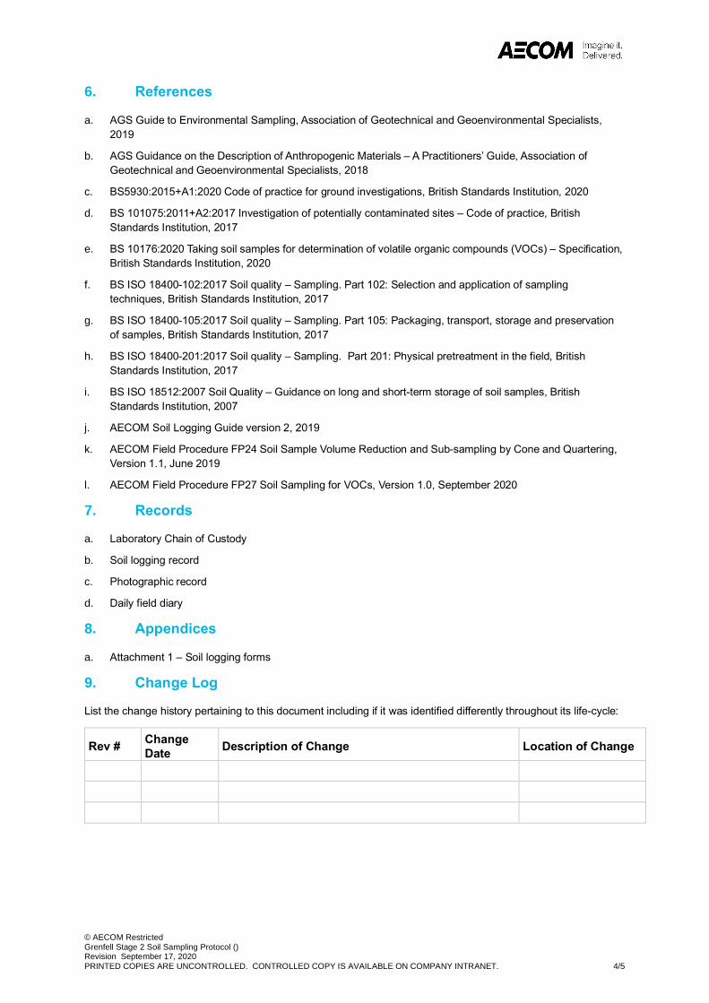
© AECOM RestrictedGrenfell Stage 2 Soil Sampling Protocol ()Revision September 17, 2020PRINTED COPIES ARE UNCONTROLLED. CONTROLLED COPY IS AVAILABLE ON COMPANY INTRANET. 4/5
6. References
a. AGS Guide to Environmental Sampling, Association of Geotechnical and Geoenvironmental Specialists, 2019
b. AGS Guidance on the Description of Anthropogenic Materials – A Practitioners’ Guide, Association of Geotechnical and Geoenvironmental Specialists, 2018
c. BS5930:2015+A1:2020 Code of practice for ground investigations, British Standards Institution, 2020
d. BS 101075:2011+A2:2017 Investigation of potentially contaminated sites – Code of practice, British Standards Institution, 2017
e. BS 10176:2020 Taking soil samples for determination of volatile organic compounds (VOCs) – Specification, British Standards Institution, 2020
f. BS ISO 18400-102:2017 Soil quality – Sampling. Part 102: Selection and application of sampling techniques, British Standards Institution, 2017
g. BS ISO 18400-105:2017 Soil quality – Sampling. Part 105: Packaging, transport, storage and preservation of samples, British Standards Institution, 2017
h. BS ISO 18400-201:2017 Soil quality – Sampling. Part 201: Physical pretreatment in the field, British Standards Institution, 2017
i. BS ISO 18512:2007 Soil Quality – Guidance on long and short-term storage of soil samples, British Standards Institution, 2007
j. AECOM Soil Logging Guide version 2, 2019
k. AECOM Field Procedure FP24 Soil Sample Volume Reduction and Sub-sampling by Cone and Quartering, Version 1.1, June 2019
l. AECOM Field Procedure FP27 Soil Sampling for VOCs, Version 1.0, September 2020
7. Records
a. Laboratory Chain of Custody
b. Soil logging record
c. Photographic record
d. Daily field diary
8. Appendices
a. Attachment 1 – Soil logging forms
9. Change Log
List the change history pertaining to this document including if it was identified differently throughout its life-cycle:
Rev # Change Date Description of Change Location of Change

© AECOM RestrictedGrenfell Stage 2 Soil Sampling Protocol ()Revision September 17, 2020PRINTED COPIES ARE UNCONTROLLED. CONTROLLED COPY IS AVAILABLE ON COMPANY INTRANET. 5/5
Attachment 1
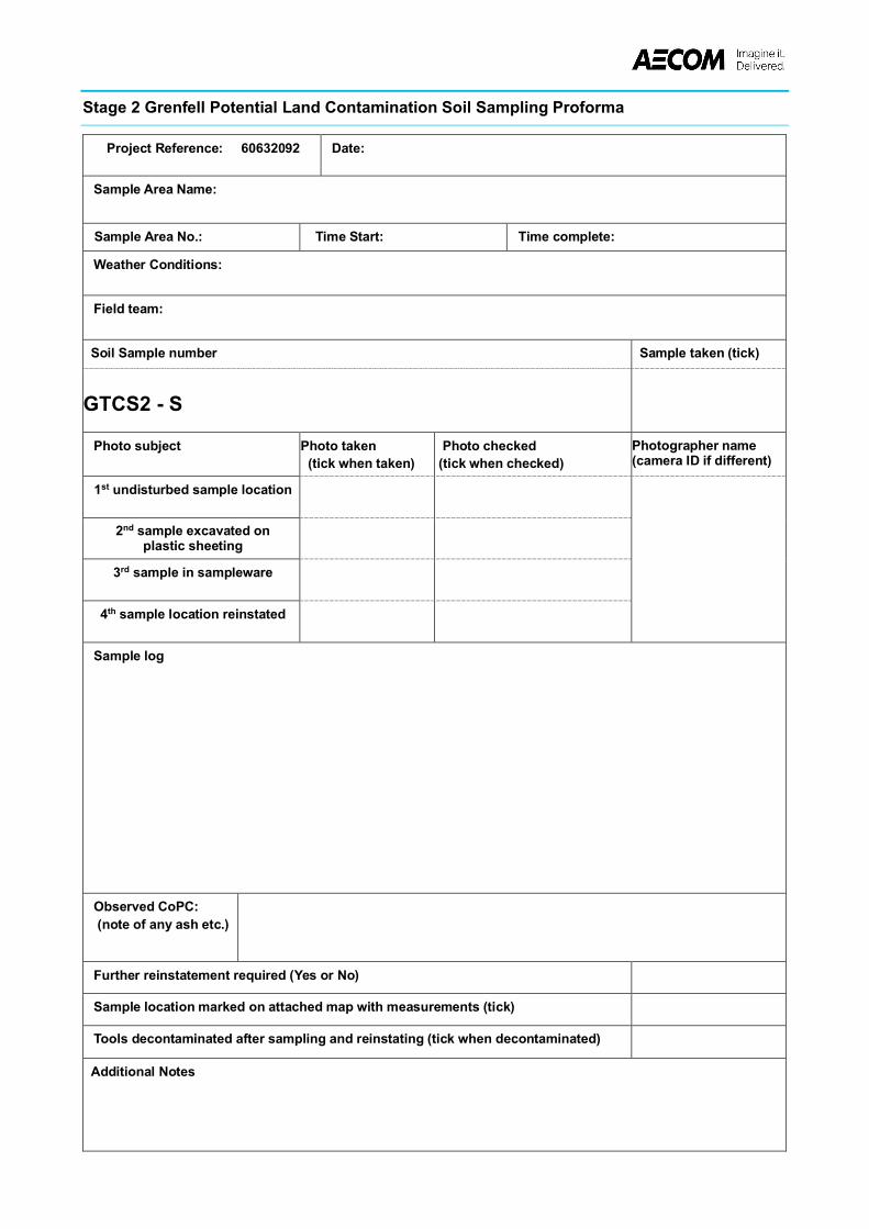
Stage 2 Grenfell Potential Land Contamination Soil Sampling Proforma
Project Reference: 60632092 Date:
Sample Area Name:
Sample Area No.: Time Start: Time complete:
Weather Conditions:
Field team:
Soil Sample number
Sample taken (tick)
GTCS2 - S
Photo subject
Photo taken (tick when taken)
Photo checked (tick when checked)
Photographer name (camera ID if different)
1st undisturbed sample location
2nd sample excavated on plastic sheeting
3rd sample in sampleware
4th sample location reinstated
Sample log
Observed CoPC: (note of any ash etc.)
Further reinstatement required (Yes or No)
Sample location marked on attached map with measurements (tick)
Tools decontaminated after sampling and reinstating (tick when decontaminated)
Additional Notes
Stage 2 Grenfell Potential Land Contamination Soil Sampling Proforma – deeper samples
Project Reference: 60632092 Date:
Sample Area Name:
Sample Area No.:
Sampling Time :
Weather Conditions:
Field team:
Soil Sample number
Sample taken (tick)
GTCS2 - S 0 - 0.2m 0 - 0.5m 0.5 - 0.6m
Photo (tick in box when done)
Photo taken 0 - 0.2m
Photo taken 0 - 0.5m
Photo taken 0.5 - 0.6m
Photos checked
Photographer name (camera ID if different)
undisturbed sample location
samples excavated on plastic sheeting
samples in sampleware
sample location reinstated
Sample log
Observed CoPC: (note of any ash etc.)
Further reinstatement required (Yes or No)
Sample location marked on map with measurements (tick)
Tools decontaminated after sampling and reinstating (tick when decontaminated)
Additional Notes
© AECOM RestrictedSoil Sampling for VOC Analysis Using Methanol Preservation (FP27)Revision 001 September 30, 2020PRINTED COPIES ARE UNCONTROLLED. CONTROLLED COPY IS AVAILABLE ON COMPANY INTRANET. 1/7
Remediation Services
Soil Sampling for VOC Analysis Using Methanol Preservation FP27
1. Purpose and Scope
The purpose of this procedure is to set out the default approach to sampling soil for VOC analysis in accordance with BS10176:2020. This procedure is only applicable to sampling for VOCs, not for other less volatile contaminants. It does include analysis for VOCs, BTEX (and potentially GRO, subject to laboratory capabilities and requirements).
The procedure is mainly applicable to fine to medium grained cohesive or moderately cohesive soils that can be sub-sampled using a miniature coring device. Exclusions are set out for coarse and non-cohesive soils.
The principal procedure adopts the use of methanol as a sample preservative. There are alternatives set out in BS10176, including the use of sodium hydrogen sulphate or water as preservatives, or the use of sealed cores.
It is imperative that the specific requirements of the chosen laboratory are known prior to the field work commencing as these requirements may vary from lab to lab.
2. Procedure
The steps below outline the procure to take when using 40ml methanol preservative sample vials. The alternative procedure for coarse soils is detailed in Section 3. Further detail on this option is provided in BS10176 Clause 6.6.
1. Safety. Methanol is a toxic and flammable liquid. Refer to the project-specific SHE Plan for further details.Note that these details should include the provision of appropriate PPE and access to washing and first aidfacilities. Methanol containing vials should only be used in well ventilated areas. Additional care should betaken to avoid spillage/breakage of the methanol-containing vials. Surplus vials containing methanol shouldbe returned with the samples to the originating laboratory in a safe and secure manner using the appropriatetransportation packaging provided by the laboratory.
2. Applicability. Sampling using miniature corer-type device and 40ml vials should only be used if themaximum grain size is less than 3mm. For coarser materials, refer to the alternative method in section 3.
3. Set out sampling station. Establish a good working environment where the material to be sampled can beaccessed, the sampling equipment can be laid out, the sampling equipment can be cleaned ordecontaminated if necessary, the soil samples can be safely transferred to the required laboratory samplecontainers, the samples can be packaged for transportation, and all field notes and observations can berecorded. As a minimum this can be provided by a clean sheet of plastic laid on the ground next to thesampling location. Methanol has a high affinity for organic compounds so ensure that the sampling locationand sampling station is not affected by external contamination sources such as vehicle exhaust emissions.
4. Check sample vials. Inspect the pre-weighed methanol-filled vials prior to use. Look for evidence ofdamage or obvious loss of methanol. Do not use any vials that appear damaged or appear to have lostsome/all of the methanol. The vials should be pre-labelled with all the required sample identificationinformation.
5. Collect laboratory sample. Using the required corer device supplied by the laboratory, extract the requiredcore size/mass required by the laboratory. This could be 5-10g of soil – check for lab-specific requirements.The sample should be collected immediately after accessing the soil from the windowless sample core, handauger core or from breaking open a bulk soil sample from an excavator bucket. The pre-filled vial should beopened only when the transfer of the sample core is ready to avoid methanol losses to atmosphere. Theminiature corers are typically designed to take either 5g or 10g samples and should have markings toindicate when the required sample volume/mass has been collected. Take care to avoid splashing themethanol when transferring the soil to the vial. Clean the threads on the vial top and seal the vial with theseptum cap as soon as possible. Do not add any additional labels or markings to the vial.
© AECOM RestrictedSoil Sampling for VOC Analysis Using Methanol Preservation (FP27)Revision 001 September 30, 2020PRINTED COPIES ARE UNCONTROLLED. CONTROLLED COPY IS AVAILABLE ON COMPANY INTRANET. 2/7
6. Duplicate sample. Duplicate samples are required for every sample. Not all of these need to be tested(refer to the project-specific sampling plan for details on the number of duplicates requiring testing). Theseduplicate samples should be collected as per the original sample.
7. QA/QC samples. In addition to duplicate samples, field and trip blanks are required. Refer to the project-specific sampling plan for further details.
8. Sample storage. Immediately after the sample has been taken the vial should be placed in the requiredchilled storage/transportation container. The target storage temperature according to the British Standard is4+/-2oC. It is recognised that this is impractical in most instances. The vials must remain upright duringtransit – this is best achieved using dedicated packaging inserts.
9. Collect non-preserved sample for moisture content. Collect a separate sample for soil moisture contentusing the sample container specified by the laboratory. No additional VOC-specific considerations arenecessary. The sample can be obtained using the conventional method (i.e. a trowel).
10. Decontaminate. Decontaminate re-usable sampling equipment using de-ionised water and a plant-baseddetergent or Decon90.
11. Field notes and chains of custody. Complete all necessary field notes and chain of custody.
3. Alternative procedure for coarse soils
3.1 Fine and medium grained non-cohesive soils
For fine and medium grained non-cohesive soils for which the corer devices provide poor recovery, use a traditional sampling device (for example a small narrow width clean stainless-steel trowel) to collect the required soil size and transfer to the methanol-containing vial. Soil disturbance when collecting the sample should be kept to a minimum and transfer to the vial should be done as quickly as possible to minimise volatile losses to atmosphere. Use an electronic balance to determine when the required sample mass has been achieved. Laboratories are typically requiring 5g soil to 10ml of methanol (a ratio of 1:2 compared to the ratio of 1:1 required by the standard and reflects the fact that a 1:1 ratio (i.e. addition of 10g of soil) does not provide adequate coverage of methanol over the soil sample).
3.2 For coarse grained materials
For material with a grain size that does not fit into a 40ml glass vial, Annex C of BS10176 permits the use of unpreserved amber glass jars. In using this alternative approach, volatile losses to atmosphere should be minimised as far as reasonably practicable by:
· Sample the material as soon as reasonably practicable after extraction from the sampling point.
· Avoid incorporation of roots or stones as far as possible.
· Fill container as tightly as possible and compact to minimise headspace within the container.
· Keep samples at low temperatures and out of direct sunlight.
· Ship samples to the laboratory as soon as possible after sampling.
4. Equipment
a. 1 x core sampler
b. 1 x small clean stainless-steel (non-painted) trowel
c. 1 x electronic weighing scale
d. 2 x pre-filled methanol vials
e. 1 x 60g amber glass jar for the determination of moisture content
f. 1 x square of clean plastic sheeting
g. 1 x camera
© AECOM RestrictedSoil Sampling for VOC Analysis Using Methanol Preservation (FP27)Revision 001 September 30, 2020PRINTED COPIES ARE UNCONTROLLED. CONTROLLED COPY IS AVAILABLE ON COMPANY INTRANET. 3/7
h. 1 x electronic device for recording digital field notes and chain of custody
i. 1 x container of de-ionised water (and detergent if required)
j. 1 x disposable cleaning cloths
k. 1 x chilled sample storage container
5. Terms and Definitions
a. Soil Includes natural soils, made ground and fill material
b. VOC Volatile Organic Compound
6. References
a. AGS Guide to Environmental Sampling, Association of Geotechnical and Geoenvironmental Specialists, 2019
b. AGS Guidance on the Description of Anthropogenic Materials – A Practitioners’ Guide, Association of Geotechnical and Geoenvironmental Specialists, 2018
c. BS5930:2015+A1:2020 Code of practice for ground investigations, British Standards Institution, 2020
d. BS 101075:2011+A2:2017 Investigation of potentially contaminated sites – Code of practice, British Standards Institution, 2017
e. BS 10176:2020 Taking soil samples for determination of volatile organic compounds (VOCs) – Specification, British Standards Institution, 2020
f. BS ISO 18400-102:2017 Soil quality – Sampling. Part 102: Selection and application of sampling techniques, British Standards Institution, 2017
g. BS ISO 18400-105:2017 Soil quality – Sampling. Part 105: Packaging, transport, storage and preservation of samples, British Standards Institution, 2017
h. BS ISO 18400-201:2017 Soil quality – Sampling. Part 201: Physical pretreatment in the field, British Standards Institution, 2017
i. BS ISO 18512:2007 Soil Quality – Guidance on long and short-term storage of soil samples, British Standards Institution, 2007
j. AECOM Soil Logging Guide version 2, 2019
k. AECOM Field Procedure FP03, Soil Sampling, Version 2.1m, December 2018
l. AECOM Field Procedure FP24 Soil Sample Volume Reduction and Sub-sampling by Cone and Quartering, Version 1.1, June 2019
7. Records
List of the official records that are generated and support this procedure. List using ‘Alpha List’ option from the AECOM Procedure List dropdown on the Home tab.
a. Laboratory Chain of Custody
b. Soil logging record
c. Photographic record
d. Daily field diary
© AECOM RestrictedSoil Sampling for VOC Analysis Using Methanol Preservation (FP27)Revision 001 September 30, 2020PRINTED COPIES ARE UNCONTROLLED. CONTROLLED COPY IS AVAILABLE ON COMPANY INTRANET. 4/7
8. Appendices
a. Attachment 1 – Examples of sampling corer devices and use.
9. Change Log
List the change history pertaining to this document including if it was identified differently throughout its life-cycle:
Rev # Change Date Description of Change Location of Change
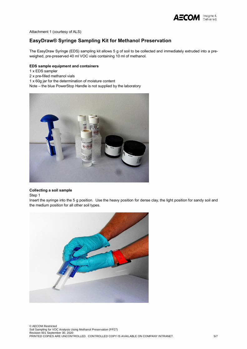
© AECOM RestrictedSoil Sampling for VOC Analysis Using Methanol Preservation (FP27)Revision 001 September 30, 2020PRINTED COPIES ARE UNCONTROLLED. CONTROLLED COPY IS AVAILABLE ON COMPANY INTRANET. 5/7
Attachment 1 (courtesy of ALS)
EasyDraw® Syringe Sampling Kit for Methanol Preservation
The EasyDraw Syringe (EDS) sampling kit allows 5 g of soil to be collected and immediately extruded into a pre-weighed, pre-preserved 40 ml VOC vials containing 10 ml of methanol.
EDS sample equipment and containers1 x EDS sampler 2 x pre-filled methanol vials 1 x 60g jar for the determination of moisture contentNote – the blue PowerStop Handle is not supplied by the laboratory
Collecting a soil sample Step 1Insert the syringe into the 5 g position. Use the heavy position for dense clay, the light position for sandy soil and the medium position for all other soil types.
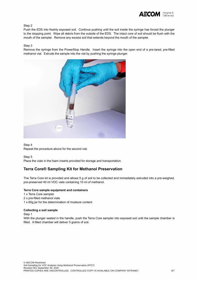
© AECOM RestrictedSoil Sampling for VOC Analysis Using Methanol Preservation (FP27)Revision 001 September 30, 2020PRINTED COPIES ARE UNCONTROLLED. CONTROLLED COPY IS AVAILABLE ON COMPANY INTRANET. 6/7
Step 2Push the EDS into freshly exposed soil. Continue pushing until the soil inside the syringe has forced the plunger to the stopping point. Wipe all debris from the outside of the EDS. The intact core of soil should be flush with the mouth of the sampler. Remove any excess soil that extends beyond the mouth of the sampler.
Step 3Remove the syringe from the PowerStop Handle. Insert the syringe into the open end of a pre-tared, pre-filled methanol vial. Extrude the sample into the vial by pushing the syringe plunger.
Step 4Repeat the procedure above for the second vial.
Step 5Place the vials in the foam inserts provided for storage and transportation.
Terra Core® Sampling Kit for Methanol Preservation
The Terra Core kit is provided and allows 5 g of soil to be collected and immediately extruded into a pre-weighed, pre-preserved 40 ml VOC vials containing 10 ml of methanol.
Terra Core sample equipment and containers1 x Terra Core sampler 2 x pre-filled methanol vials 1 x 60g jar for the determination of moisture content
Collecting a soil sample Step 1With the plunger seated in the handle, push the Terra Core sampler into exposed soil until the sample chamber is filled. A filled chamber will deliver 5 grams of soil.
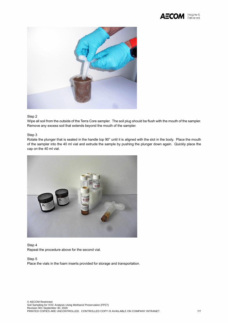
© AECOM RestrictedSoil Sampling for VOC Analysis Using Methanol Preservation (FP27)Revision 001 September 30, 2020PRINTED COPIES ARE UNCONTROLLED. CONTROLLED COPY IS AVAILABLE ON COMPANY INTRANET. 7/7
Step 2Wipe all soil from the outside of the Terra Core sampler. The soil plug should be flush with the mouth of the sampler. Remove any excess soil that extends beyond the mouth of the sampler.
Step 3Rotate the plunger that is seated in the handle top 90° until it is aligned with the slot in the body. Place the mouth of the sampler into the 40 ml vial and extrude the sample by pushing the plunger down again. Quickly place the cap on the 40 ml vial.
Step 4Repeat the procedure above for the second vial.
Step 5Place the vials in the foam inserts provided for storage and transportation.
Grenfell Investigation into Potential LandContamination Impacts
Project number: 60632092
Prepared for: Royal Borough of Kensington and Chelsea AECOM69
Appendix C Crop Sampling Protocol
© AECOM RestrictedGrenfell Stage 2: Crop sampling Procedure ()Revision 1 September 21, 2020PRINTED COPIES ARE UNCONTROLLED. CONTROLLED COPY IS AVAILABLE ON COMPANY INTRANET. 1/8
Remediation Services
Grenfell Stage 2: Crop sampling Procedure
1. Purpose and Scope
The purpose of this field procedure is to set out the process for sampling crops for analysis in a laboratory for potential contamination. It relates specifically to the collection of crop samples from the following types of location:
a. community kitchen gardens;
b. allotments; and
c. informal cultivation of home-grown crops.
This procedure applies to AECOM staff in the UK and Ireland, including subcontractors working on AECOM’s behalf. The procedure should be read and understood by both field staff and project managers undertaking the work.
There are no formal standards or guidance for sampling and testing fruit and vegetables from public allotments or private domestic gardens. However, in order to ensure that crop samples obtained provide representative, reliable and relevant data the collection of crop samples for chemical analysis has been guided by EC Regulation 333/2007. The principles of the approach are in general accordance with EC Regulation 333/2007 but given the size of the sampling areas the full application of methodology and approach is unachievable and cannot and will not be applied.
2. Procedure
Crop samples are to be collected for subsequent laboratory analysis with their condition and type documented. Samples will be collected that are representative of the crops being grown at the chosen sample location, with soil samples from the growing medium root zone being taken at the same time. The soil sampling will follow the Grenfell Stage 2 Soil Sampling Protocol with soil samples collected across the 0-0.2m depth interval.
In all cases, care needs to be taken to maintain the condition of the crop sample. This means minimising the disturbance of the crop during removal and transport and minimising the time taken to take the sample as far as reasonably practicable. It also means storing and transporting the sample as per the guidelines below. Wherever possible, the sampling will be carried out when the crops are ready for eating.
2.1 Steps
1. Decontaminate equipment. prior to first use each day and after collection of each sample, all equipmentthat comes into contact with samples should be decontaminated (see AECOM FP07 Decontamination ofEquipment). This should involve the use of de-ionised water and if necessary plant-based detergent.
2. Prepare crop sample containers. Ensure that all necessary laboratory sample containers or bags areavailable and correctly labelled. Minimum information should include project code, sample area, sample ID,sample type and date. Refer to laboratory chain of custody for full information requirements.
3. Identify crops to sample. Sample areas will be indicated on maps in the detailed design document. Theseare indicative areas and are subject to availability and permission being granted by the land owner/cropgrower to harvest the crop sample. If on the day of sampling specific locations are not accessible, alternativelocations can be chosen. Consult with the Sampling Manager or Project Manager if this situation arises.
Crop sampling should avoid locations where the soil has been changed or greatly added to since June 2017to be consistent with the overarching aims of the sampling.
4. Photograph crop sample location. Crops should be photographed using a trial pit board / pre-printedsheet with size and colour scales prior to harvesting. The sample location and code must be exactly as perthe sample plan.
© AECOM RestrictedGrenfell Stage 2: Crop sampling Procedure ()Revision 1 September 21, 2020PRINTED COPIES ARE UNCONTROLLED. CONTROLLED COPY IS AVAILABLE ON COMPANY INTRANET. 2/8
5. Record sample location. Using GPS coordinates and/or by surveying or by reference to a detailed siteplan, so that the locations can be re-visited if necessary. If a GPS is used, its calibration must be checked byrecording the coordinates of at least two known site features (such as corners of major buildings).
6. Wear dedicated disposable gloves at each location. A dedicated clean pair of disposable nitrile (powderfree) gloves should be worn to collect each sample and all reasonable measures taken when conducting thework to avoid cross-contamination of samples (clean plastic sheeting may be used to assist with cross-contamination minimisation).
7. Confirm requirement for duplicate crop sample at sample location. Duplicate samples are required at5% of locations. The requirement for a duplicate sample in an area will be specified in the sampling planand subject to quantity of crop available.
8. Collect crop sample.
a. For roots and tubers: Using a decontaminated unpainted stainless-steel hand trowel or garden forkcarefully dig up the individual crop.
b. For green vegetables: Either pick by hand or using decontaminated unpainted stainless-steel secateurscarefully harvest the individual crop.
c. For tree, herbaceous or shrub fruit: Either pick by hand or using decontaminated unpainted stainless-steel secateurs carefully harvest the individual crop.
If necessary place crop on to a clean piece of plastic sheeting.
9. Clean and prepare crop sample. Any excess surface soil should be removed using a soft brush anddeionised water as necessary. For carrots, potatoes and turnips etc, the inedible plant tops should beremoved. For strawberries, rhubarb etc the stem or leaves should be removed. For wooded stem herbs theinedible stem should be removed.
10. Weigh individual crop sample. Using clean portable scales weigh each individual crop sample (recordingweight on the sampling sheet). The sample quantity required is dependent on the analytic testing suite thesample is to be tested for.
a. For Lead and PAHs aim to collect a minimum of 200g. The laboratory defined minimum is 100g*
b. For persistent organic pollutants (POPs)**, aim to collect a minimum of 800g. The laboratory definedminimum is 400g*
*Where the water content of a crop is high, a greater sample weight should be harvested
(** POP suite includes polychlorinated dioxins/furans, polychlorinated biphenyls, polybrominateddiphenylethers, polybrominated biphenyls, polybrominated dioxins/furans, mixed bromo-chlorodioxins/furans, mixed bromo-chloro biphenyls)
11. Bag and label crop samples. Place the sample in a labelled freezer bag (individual items which togetherwill make up one sample, such as several beans or plums, can be bagged together), and zip lock or tie thebag. Double bag the samples by placing this bag into a second labelled freezer bag, and zip lock or tie thebag.
12. Photograph wrapped and bagged crop sample. Crop samples should be photographed using a trial pitboard / pre-printed sheet with size and colour scales (as item 4).
13. Record description of crop sample. A written record of the crop sampling should be completed on thesample proforma sheet for each crop sample including any key observations. Complete the ‘Stage 2 GrenfellPotential Land Contamination, Crop and Root Zone Soil Sampling Proforma’ sheets for each sample(Appended as Attachment 1).
14. Secure samples for transportation. Samples should be securely packaged for transportation as soon aspossible using the appropriate packaging containers agreed by the laboratory. Samples should be storedand transported according to the analytical laboratory guidance provided, which includes sealing to preventevaporative losses, maintenance of a stable temperature (generally in the range 0-4 degrees C) using icepacks and not freezing samples prior to or during transit.
15. Complete and check sample labelling and Chain of Custody. Ensure all required information is providedon sample labels and chain of custody (see Step 2). Crop sample time and crop sample location are not
© AECOM RestrictedGrenfell Stage 2: Crop sampling Procedure ()Revision 1 September 21, 2020PRINTED COPIES ARE UNCONTROLLED. CONTROLLED COPY IS AVAILABLE ON COMPANY INTRANET. 3/8
entered on the Chain of Custody for duplicate samples. This information must be recorded with the sitepersonnel’s notes or on a detailed plan for future QA/QC procedures. Chain of Custody must also include anotification to FERA that all samples need to be frozen immediately on arrival at the laboratory, andwhere crops require laboratory pre-treatment prior to freezing (due to the crop water content) FERA are toadvise and discuss with AECOM the appropriate preparation (such as peeling / coring).
16. Photograph completed chain of custody. Email photo to FERA on day of collection to prewarn of thesample quantity and type arriving the next day. The sheets should be placed inside cool box with samples,and cool box sealed and addressed.
17. Courier to laboratory. Transport to laboratory using an overnight courier service, whenever possibledispatching on day of sampling. Notify laboratory of sample dispatch and expected arrival time.
2.2 Crop Sample Types
There are six different types of crop listed in the CLEA guidance, these are detailed in the table below with examples. Wherever possible AECOM will aim to collect as many different crop types as possible from each of the crop sampling areas, with the ideal being one of each type from each sampling area.
Crop Type Examples
Green Vegetables Runner beans / peas / cabbage / cauliflower / kale / spinach / lettuce / chard / squash / courgette / broccoli
Root vegetables Carrot / parsnip / beetroot / horseradish / swede / turnip / radish / onions
Tuber vegetables Potato / Jerusalem artichoke / yam
Herbaceous fruit
(none wooded stems)
Strawberries / rhubarb / soft stem herbs (basil, parsley, mint)
Shrub fruit
(perennial woody plant)
Blackcurrant / gooseberry / blackberry / raspberry / wooded stem herbs e.g. rosemary and thyme
Tree Fruit Apple / pear / plum / fig / lemon
2.3 Crop Sample Areas
Twelve areas have been identified during the site walkovers as potential crop sampling locations. Wherever possible AECOM will aim to collect up to six different samples from each of the crop sampling areas (ideally one of each crop type group detailed in the table above). The areas are listed in the table below along with the detail of the type of growing area at each location.
Potential Crop Sample Area Details
Allom House and Barlow House Raised beds within communal garden
Bramley House Raised beds within communal garden
Equal People (x 2 areas) Raised beds within courtyard at St Charles Square, andCommunity kitchen garden with raised beds at the St Charles Centre for Health and Wellbeing
© AECOM RestrictedGrenfell Stage 2: Crop sampling Procedure ()Revision 1 September 21, 2020PRINTED COPIES ARE UNCONTROLLED. CONTROLLED COPY IS AVAILABLE ON COMPANY INTRANET. 4/8
Potential Crop Sample Area Details
Eynham Road Communal garden with fruit trees, raised and ground level beds
Henry Dickens Court Community kitchen garden, and orchard area within communal garden
Moreland House and Talbot Grove House Raised beds within communal garden
Hurstway, Grenfell, Testerton and Barandon Walks
Raised beds within communal garden
Longstone Avenue allotments Allotment Gardens
Portland Road and Nottingwood House Portland -Community kitchen garden with raised and ground level beds Nottingwood - Raised beds within communal garden
St Francis Primary School Fruit trees on the site
St Quintin Kitchen Garden Community kitchen garden with raised and ground level beds
Silchester East (Whitstable House and Kingsnorth House)
Kitchen garden with raised beds (to the west of Whitstable House)
Note: Robinson House and Wesley Square have been excluded from this list as the soil in the vegetable growing beds has either been completely changed or are new since 2017.
Equipment, PPE & Materials List
Item Essential? Notes
HASP & First Aid Kit Y To provide information
Sample location plan Y To mark up exact sample collection location
Contact details for crop owners Y To ensure permission is provided for collection. Client may hold this information
Sample containers / bags Y To place crop sample in
Sample labels Y To go on individual sample containers
Chain of Custody Forms Y For laboratory
Cool boxes, frozen ice packs (or instant ice pack) and address labels
Y For transportation of samples to laboratory
Plastic sheeting Y To prevent cross contamination
Tape measure Y To mark up exact sample collection location
Stainless steel hand trowel Y To assist with collection of samples
Stainless steel secateurs Y To assist with collection of samples
Measuring scales Y To ensure sufficient quantity of crop sample collected
Soft vegetable brush Y To remove excess soil from roots / tubers
Sample proforma sheets, site diary, pens Y For recording observations and details of sampling
Camera / phone camera Y Important to collect visual record
© AECOM RestrictedGrenfell Stage 2: Crop sampling Procedure ()Revision 1 September 21, 2020PRINTED COPIES ARE UNCONTROLLED. CONTROLLED COPY IS AVAILABLE ON COMPANY INTRANET. 5/8
Item Essential? Notes
Sample ID board / preprinted sheet Y Important to collect visual record
Sampling equipment for decontamination (detergent, deionised water, water spray and cleaning cloth, or disposable wipes)
Y For decontamination of sampling equipment between sample locations
Disposable coveralls, cut resistant gloves, nitrile gloves, laced safety boots
Y Minimum PPE during work which includes potential contact with soil, Made Ground, crops.
Other PPE Y As defined in the SHE Plan (also refer to ELS guidance on mandatory PPE and training requirements for site work available in the Health & Safety folder on the ELS sharepoint site)
3. Responsibilities
It is the responsibility of the Project Manager to communicate the Crop Sampling Plan to field staff and ensure that this Crop Sampling Procedure aligns with that Crop Sampling Plan.
It is the responsibility of field staff to understand and comply with the Crop Sampling Plan and this Crop Sampling Protocol.
4. Safety
All work must be undertaken in accordance with the requirements of the project Safety, Health and Environment (SHE) Plan.
5. Terms and Definitions
Not Required.
6. References
AGS Guide to Environmental Sampling, Association of Geotechnical and Geoenvironmental Specialists, 2019
BS 101075:2011+A2:2017 Investigation of potentially contaminated sites – Code of practice, British Standards Institution Publication, 2017
BS ISO 18400-102:2017 Soil quality – Sampling. Part 102: Selection and application of sampling techniques, British Standards Institution Publication, 2017
BS ISO 18400-105:2017 Soil quality – Sampling. Part 105: Packaging, transport, storage and preservation of samples, British Standards Institution Publication, 2017
BS ISO 18400-201:2017 Soil quality – Sampling. Part 201: Physical pretreatment in the field, British Standards Institution Publication, 2017
BS ISO 18512:2007 Soil Quality – Guidance on long and short-term storage of soil samples, British Standards Institution Publication, 2007
CCME Guidance manual for environmental site characterisation in support of environmental and human health risk assessment, Volume 3, Suggested operating procedures, PN 1555, Canadian Council of Ministers of the Environment, 2016
Commission Regulation (EC) No 333/2007 - Laying down the methods of sampling and analysis for the official control of the levels of lead, cadmium, mercury, inorganic tin, 3-MCPD and benzo(a)pyrene in foodstuffs, 2007.
© AECOM RestrictedGrenfell Stage 2: Crop sampling Procedure ()Revision 1 September 21, 2020PRINTED COPIES ARE UNCONTROLLED. CONTROLLED COPY IS AVAILABLE ON COMPANY INTRANET. 6/8
Environment Agency, UKSHS Report No. 2 – UK Soil and Herbage Pollutant Survey, Chemical and Radiometric Sample Collection Methods, 2007.
7. Records
a. Sample Location map (annotated with exact location measurements)
b. Photographic record (pre sampling and post sampling with samples in containers)
c. Crop and Root Zone Soil Sampling Proforma sheet (including crop owner permission details, soil logging record, sampling observations)
d. Laboratory Chain of Custody
e. Daily field diary
8. Appendices
a. Attachment 1 – Stage 2 Grenfell Potential Land Contamination, Crop and Root Zone Soil Sampling Proforma
9. Change Log
List the change history pertaining to this document including if it was identified differently throughout its life-cycle:
Rev # Change Date Description of Change Location of Change
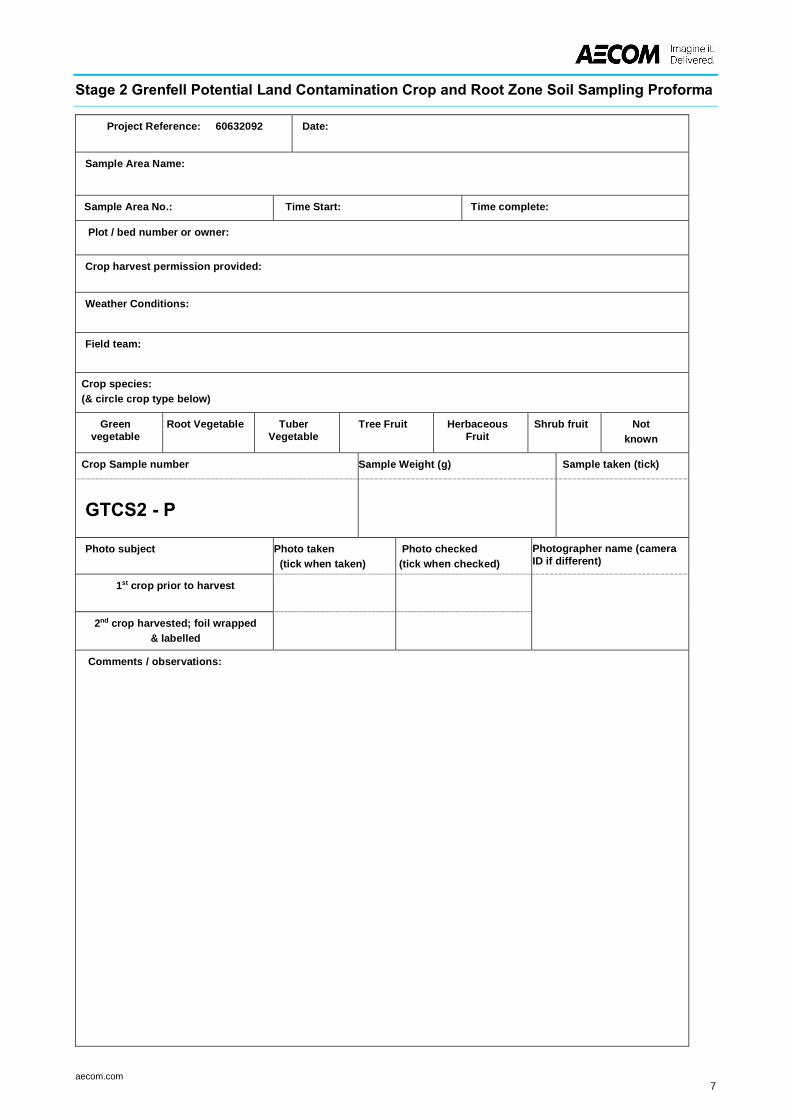
aecom.com7
Stage 2 Grenfell Potential Land Contamination Crop and Root Zone Soil Sampling Proforma
Project Reference: 60632092 Date:
Sample Area Name:
Sample Area No.: Time Start: Time complete:
Plot / bed number or owner:
Crop harvest permission provided:
Weather Conditions:
Field team:
Crop species: (& circle crop type below)
Greenvegetable
Root Vegetable TuberVegetable
Tree Fruit HerbaceousFruit
Shrub fruit Notknown
Crop Sample number Sample Weight (g) Sample taken (tick)
GTCS2 - P
Photo subject Photo taken (tick when taken)
Photo checked (tick when checked)
Photographer name (cameraID if different)
1st crop prior to harvest
2nd crop harvested; foil wrapped& labelled
Comments / observations:
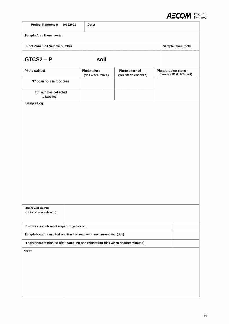
8/8
Project Reference: 60632092 Date:
Sample Area Name cont:
Root Zone Soil Sample number Sample taken (tick)
GTCS2 – P soil
Photo subject Photo taken (tick when taken)
Photo checked (tick when checked)
Photographer name(camera ID if different)
3rd open hole in root zone
4th samples collected& labelled
Sample Log:
Observed CoPC: (note of any ash etc.)
Further reinstatement required (yes or No)
Sample location marked on attached map with measurements (tick)
Tools decontaminated after sampling and reinstating (tick when decontaminated)
Notes
Grenfell Investigation into Potential LandContamination Impacts
Project number: 60632092
Prepared for: Royal Borough of Kensington and Chelsea AECOM70
Appendix D Example Chain of Custody
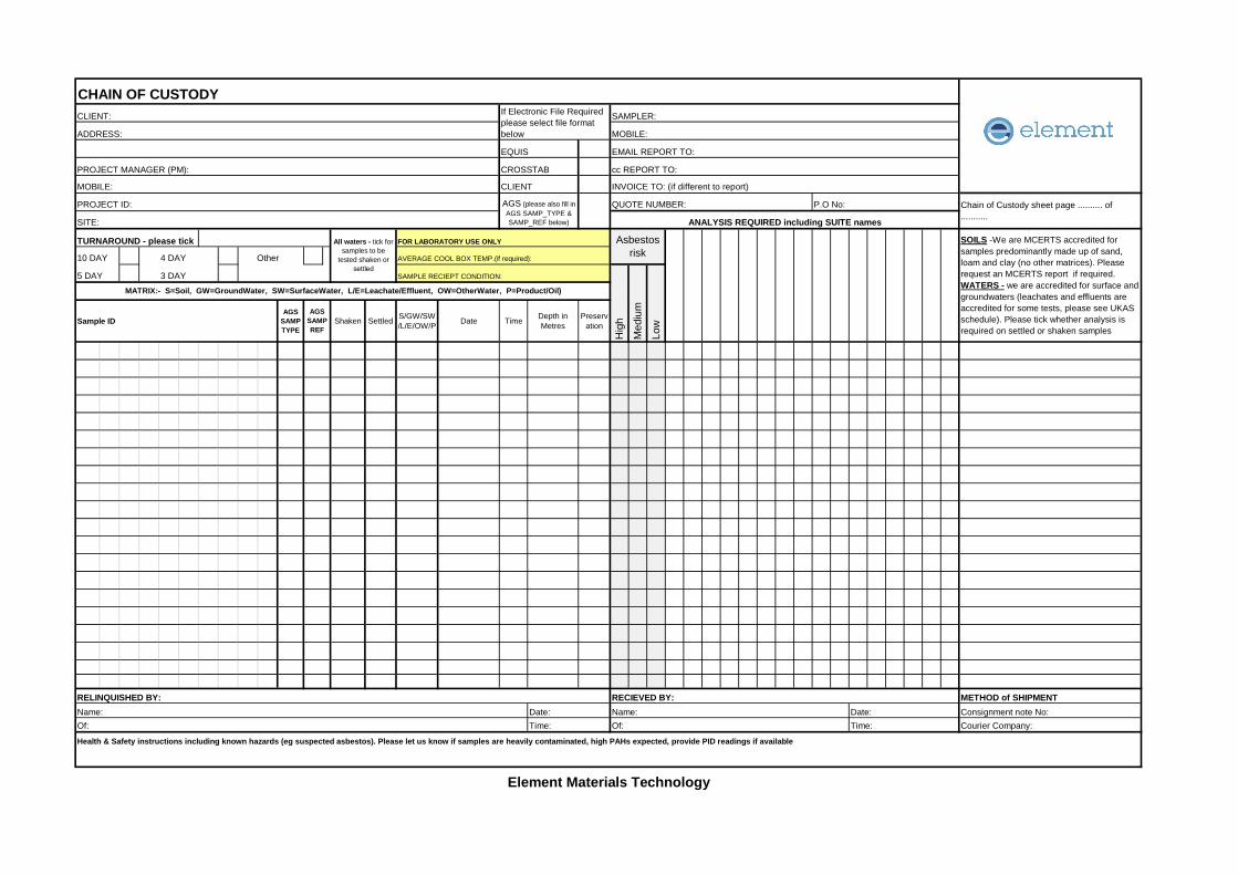
CHAIN OF CUSTODYCLIENT: SAMPLER:
ADDRESS: MOBILE:
EQUIS EMAIL REPORT TO:
PROJECT MANAGER (PM): CROSSTAB cc REPORT TO:
MOBILE: INVOICE TO: (if different to report)
PROJECT ID: QUOTE NUMBER: P.O No:
SITE:
TURNAROUND - please tick FOR LABORATORY USE ONLY
10 DAY 4 DAY Other AVERAGE COOL BOX TEMP.(if required):
5 DAY 3 DAY SAMPLE RECIEPT CONDITION:
Sample IDAGS
SAMPTYPE
Shaken Settled S/GW/SW/L/E/OW/P Date Time Depth in
MetresPreserv
ation
RELINQUISHED BY: RECIEVED BY: METHOD of SHIPMENTName: Date: Name: Date: Consignment note No:Of: Time: Of: Time: Courier Company:
Health & Safety instructions including known hazards (eg suspected asbestos). Please let us know if samples are heavily contaminated, high PAHs expected, provide PID readings if available
Element Materials Technology
All waters - tick forsamples to be
tested shaken orsettled
Asbestosrisk
SOILS -We are MCERTS accredited forsamples predominantly made up of sand,loam and clay (no other matrices). Pleaserequest an MCERTS report if required.WATERS - we are accredited for surface andgroundwaters (leachates and effluents areaccredited for some tests, please see UKASschedule). Please tick whether analysis isrequired on settled or shaken samplesH
igh
Med
ium
Low
MATRIX:- S=Soil, GW=GroundWater, SW=SurfaceWater, L/E=Leachate/Effluent, OW=OtherWater, P=Product/Oil)
AGSSAMPREF
If Electronic File Requiredplease select file formatbelow
CLIENT
AGS (please also fill inAGS SAMP_TYPE &SAMP_REF below)
Chain of Custody sheet page .......... of...........ANALYSIS REQUIRED including SUITE names

Reg Office: Element Materials Technology Environmental UK Limited, 10 Lower Grosvenor Place, London, SW1W 0EN Company Reg No: 11371415 Unit 3 Deeside Point, Zone 3 Deeside Industrial Park, Deeside, CH5 2UA Tel: 0044 1244 833 780
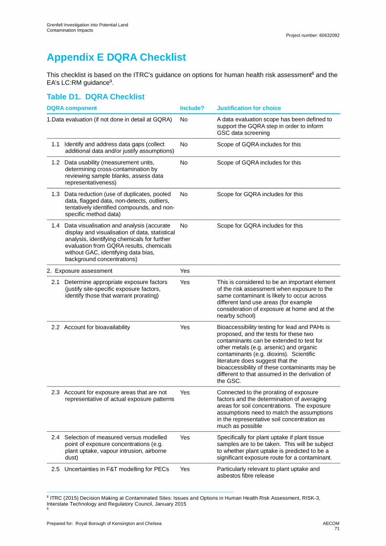
Grenfell Investigation into Potential LandContamination Impacts
Project number: 60632092
Prepared for: Royal Borough of Kensington and Chelsea AECOM71
Appendix E DQRA ChecklistThis checklist is based on the ITRC’s guidance on options for human health risk assessment8 and theEA’s LC:RM guidance9.
Table D1. DQRA ChecklistDQRA component Include? Justification for choice
1.Data evaluation (if not done in detail at GQRA) No A data evaluation scope has been defined tosupport the GQRA step in order to informGSC data screening
1.1 Identify and address data gaps (collectadditional data and/or justify assumptions)
No Scope of GQRA includes for this
1.2 Data usability (measurement units,determining cross-contamination byreviewing sample blanks, assess datarepresentativeness)
No Scope of GQRA includes for this
1.3 Data reduction (use of duplicates, pooleddata, flagged data, non-detects, outliers,tentatively identified compounds, and non-specific method data)
No Scope for GQRA includes for this
1.4 Data visualisation and analysis (accuratedisplay and visualisation of data, statisticalanalysis, identifying chemicals for furtherevaluation from GQRA results, chemicalswithout GAC, identifying data bias,background concentrations)
No Scope for GQRA includes for this
2. Exposure assessment Yes
2.1 Determine appropriate exposure factors(justify site-specific exposure factors,identify those that warrant prorating)
Yes This is considered to be an important elementof the risk assessment when exposure to thesame contaminant is likely to occur acrossdifferent land use areas (for exampleconsideration of exposure at home and at thenearby school)
2.2 Account for bioavailability Yes Bioaccessibility testing for lead and PAHs isproposed, and the tests for these twocontaminants can be extended to test forother metals (e.g. arsenic) and organiccontaminants (e.g. dioxins). Scientificliterature does suggest that thebioaccessibility of these contaminants may bedifferent to that assumed in the derivation ofthe GSC.
2.3 Account for exposure areas that are notrepresentative of actual exposure patterns
Yes Connected to the prorating of exposurefactors and the determination of averagingareas for soil concentrations. The exposureassumptions need to match the assumptionsin the representative soil concentration asmuch as possible
2.4 Selection of measured versus modelledpoint of exposure concentrations (e.g.plant uptake, vapour intrusion, airbornedust)
Yes Specifically for plant uptake if plant tissuesamples are to be taken. This will be subjectto whether plant uptake is predicted to be asignificant exposure route for a contaminant.
2.5 Uncertainties in F&T modelling for PECs Yes Particularly relevant to plant uptake andasbestos fibre release
8 ITRC (2015) Decision Making at Contaminated Sites: Issues and Options in Human Health Risk Assessment, RISK-3,Interstate Technology and Regulatory Council, January 20159
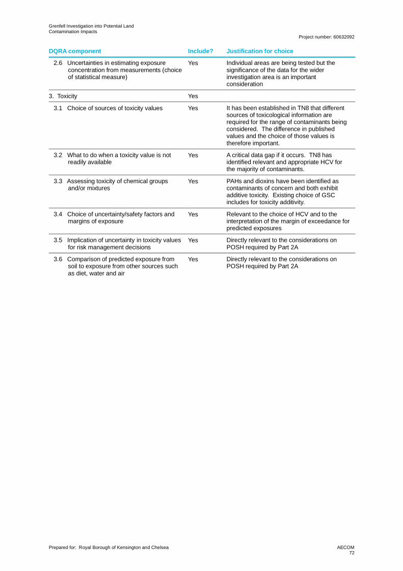
Grenfell Investigation into Potential LandContamination Impacts
Project number: 60632092
Prepared for: Royal Borough of Kensington and Chelsea AECOM72
DQRA component Include? Justification for choice
2.6 Uncertainties in estimating exposureconcentration from measurements (choiceof statistical measure)
Yes Individual areas are being tested but thesignificance of the data for the widerinvestigation area is an importantconsideration
3. Toxicity Yes
3.1 Choice of sources of toxicity values Yes It has been established in TN8 that differentsources of toxicological information arerequired for the range of contaminants beingconsidered. The difference in publishedvalues and the choice of those values istherefore important.
3.2 What to do when a toxicity value is notreadily available
Yes A critical data gap if it occurs. TN8 hasidentified relevant and appropriate HCV forthe majority of contaminants.
3.3 Assessing toxicity of chemical groupsand/or mixtures
Yes PAHs and dioxins have been identified ascontaminants of concern and both exhibitadditive toxicity. Existing choice of GSCincludes for toxicity additivity.
3.4 Choice of uncertainty/safety factors andmargins of exposure
Yes Relevant to the choice of HCV and to theinterpretation of the margin of exceedance forpredicted exposures
3.5 Implication of uncertainty in toxicity valuesfor risk management decisions
Yes Directly relevant to the considerations onPOSH required by Part 2A
3.6 Comparison of predicted exposure fromsoil to exposure from other sources suchas diet, water and air
Yes Directly relevant to the considerations onPOSH required by Part 2A

Grenfell Investigation into Potential LandContamination Impacts
Project number: 60632092
Prepared for: Royal Borough of Kensington and Chelsea AECOM73
aecom.com
Related Documents