Greening Greening the Future: the the Future: the Italian Italian Way Way Bright Bright Green Green Citie Cities Prevention and Control of Land Degradation and Hydrogeological Risk Factors in the Urban Context Mr. Sandro Ruggeri Vice President Public Administration Business Area Rio de Janeiro, 1‐3 June 2011

Welcome message from author
This document is posted to help you gain knowledge. Please leave a comment to let me know what you think about it! Share it to your friends and learn new things together.
Transcript

GreeningGreening the Future: the the Future: the ItalianItalian WayWayBrightBright Green Green CitieCitiessgg
Prevention and Controlof Land Degradation and g
Hydrogeological Risk Factorsin the Urban Context
Mr. Sandro RuggeriVice President Public Administration
Business Area
Rio de Janeiro, 1‐3 June 2011

Agenda
Vitrociset profileVitrociset profile
Competencies in Environment and Territory managementCompetencies in Environment and Territory management
Case study: MIADRA ProjectCase study: MIADRA Project
Rio de Janeiro, 1‐3 June 2011 ‐ 2 ‐ Greening the Future: The Italian Way

COMPANY PROFILE (1 of 2)
Today Vitrociset is one of the largest private Italian groups for size and know-how and g pworks in the field of complex systemsengineering and integrated logistics
Vitrociset was established in 1992 through the merger of Ciset and Vitroselenia, companies thathad been working in the logistics field since the 1960s. At the end of 2006, the company divisionfor management and maintenance of air traffic control equipment and systems was transferred toENAVENAV
TheThe Company’sCompany’s activitiesactivities areare focusedfocused onondedicateddedicated technicaltechnical servicesservices forfor veryvery highhigh
ff tt ii thth f ll if ll iperformanceperformance systemssystems inin thethe followingfollowing areasareas:– Air traffic control– Integrated logistics for military and civil purposes– Space control and launch sites
C d d t l t
Rio de Janeiro, 1‐3 June 2011 ‐ 3 ‐ Greening the Future: The Italian Way
– Command and control systems– Infomobility– Environmental monitoring

COMPANY PROFILE (2 of 2)
In recent years, Vitrociset has put into action afar-reaching strategic plan aimed at positioningthe company in new markets and widening itsthe company in new markets and widening itsrange of products especially in the ICT andMultimedia sectors
With the acquisition of Enterprise Digital Architects S.p.A., a company that designs and manages solutionsand services for Information Technology, Service Maintenance and Telecommunications, Vitrociset hasacquired customers and competences in highly strategic areas in the Country system:
• HOMELAND SECURITY• CENTRAL AND LOCAL GOVERNMENTS• UTILITIES & INDUSTRY
HEALTHCARE• HEALTHCARE
Rio de Janeiro, 1‐3 June 2011 ‐ 4 ‐ Greening the Future: The Italian Way

VITROCISET IN NUMBERS
• Approximately 900 professionalsApproximately 900 professionals– 4.7% Management– 78% University graduates/technicians– 17.3% Staff
• Offices in Italy- Headquarters and executive offices: Rome- 1 Production plant: Capo San Lorenzo (Ca)- 3 Branch offices: Milan, Naples, Venice-Marghera
RM
, p , g
• Abroad Offices- Vitrociset France S.a.r.l., Kourou - FRENCH GUYANA- Vitrociset KSA, Riyadh – KINGDOM OF SAUDI ARABIA, y- Vitrociset Belgium S.p.r.l.
Transinne (Belgium) - Ground operations/Galileo Program- Darmstadt (Germany) – Operations for ESA’s Operating
CentreNoordwijk (Holland) Engineering support to ESA’s- Noordwijk (Holland) – Engineering support to ESAs
Technical Directorate- Vitrociset Kenya (Nairobi)
Rio de Janeiro, 1‐3 June 2011 ‐ 5 ‐ Greening the Future: The Italian Way

World-wide presence
ITALYITALY EUROPEEUROPE
VeneziaMilano
Noordwijk (NL)
Napoli
Roma
Villaputzu (Ca)
Darmstad (DE)
Redu (BE)
Noordwijk (NL)
REST OF THE WORLDREST OF THE WORLD
Ri dh
Kourou(Guyana Francese)
Riyadh(Arabia Saudita)
Malindi(Kenya)
Rio de Janeiro, 1‐3 June 2011 ‐ 6 ‐ Greening the Future: The Italian Way
(Kenya)

Offer Matrix
PUBBLICINTER‐TOP
T6 Markets
DEFENCE TRASPORTATION SPACEPUBBLIC
ADMINISTRATION& HEALTH
INTERPOLICESNETWORK
TOP ACCOUNTS
RESEARC
H &
DEV
ELOPM
ENT
D
Air Traffic Management
Command and Control /Homeland Security/ y
Telecommunications and Unified Communication
Information Systemsr lin
es
Physical and Logical Security
Integrated Logistics and Technical Services8 Offer
Meteo, Environment & Territory, Mobility, Energy
New Media and Multimedia Contents
Rio de Janeiro, 1‐3 June 2011 ‐ 7 ‐ Greening the Future: The Italian Way

Agenda
Vitrociset profileVitrociset profile
Competencies in Environment and Territory managementCompetencies in Environment and Territory management
Case study: MIADRA ProjectCase study: MIADRA Project
Rio de Janeiro, 1‐3 June 2011 ‐ 8 ‐ Greening the Future: The Italian Way

Vitrociset Vision: Knowledge e Governance
VITROCISET expresses its skills and capabilities in the Environment and Territory area, in support of public administrations and agencies, to finalize projects and investments to be placed in two strategic dimensions, the Governance and the Knowledge one:
Knowledge dimension relates to the production, classification, dissemination and use of spatial information
g
pGovernance dimension relates to the definition and implementation of strategic policies and operational practices in relation to statutory or institutional missions and objectives for land managementinstitutional missions and objectives for land management
Both dimensions provide for systems, infrastructures, tools, processes, p y , , , p ,applicationsKnowledge e Governance dimensions feed off recursively with virtuous circles of informations
Rio de Janeiro, 1‐3 June 2011 ‐ 9 ‐ Greening the Future: The Italian Way
circles of informations

Knowledge e Governance strategic dimensions
GOVERNANCEGOVERNANCE KNOWLEDGEKNOWLEDGEGOVERNANCEGOVERNANCE KNOWLEDGEKNOWLEDGE
MonitoringMonitoring SystemsSystemsgg yy
PreventionPrevention and and RiskRiskManagementManagement
RemoteRemote sensingsensing SystemsSystems
LocalizationLocalization SystemsSystems
Data Data BasesBases
Remote Remote sensingsensing SystemsSystems
SecuritySecurity
RepositoryRepository ofof MetadataMetadata
PublishingPublishing ServicesServicesEnhancementEnhancement ofof the the ““resourceresource” ” territoryterritory
CatalogCatalog ServicesServices
InteroperableInteroperable SystemsSystems
yy
Rio de Janeiro, 1‐3 June 2011 ‐ 10 ‐ Greening the Future: The Italian Way
InteroperableInteroperable SystemsSystems

Scopes of Governance strategies
Prevention and Risk Management
Security and Environmental
Enhancement and promotion of territoryRisk Management
• Digital Terrain and Surface Models(DTM/DSM)
• Pollution from human activities
protection
• Landfill Monitoring• Monitor transport of dangerous goods• Waste Tracking
promotion of territory
• Enhancement of forests• Public infrastructure projects• Projects for Technological Networks
• Pollution from industries• Air pollution• Electromagnetic and radiation pollution• WasteH d l i l Ri k
Waste Tracking• Fire Monitoring• Contrast of ecomafie• Monitoring of pollution from human and industrial activitiesS i i f tli d b d
Projects for Technological Networks• Management of State Property• Recovery of tax• Virtuos cycle of waste• Integrated management of water
• Hydrogeological Risk• Subsidences Monitoring• Landslides Risk• Fire Risk• Coastal erosion Risk
• Supervision of coastline and borders• Remote monitoring• Support for criminal investigations• Civil Defence
resources• Land reclamation and environmental remediation
• Sustainable development• Sustainable MobilityCoasta e os o s
• Dams• Nuclear power plants• Nature conservation, biodiversity• Reserves and Protected Areas
f f l
• Tourism• Precisione Agriculture• Traceability of food products• Marketing for District and Supply Chain• Environmental education and training
Multichanneluser experience
• Quantification of environmentaldamage
• Environmental Impact Assessment• Water protection• Projects and actions for Soil protection
• Environmental education and training
• PC/Notebook/Netbook• Smartphone• Tablet
Rio de Janeiro, 1‐3 June 2011 ‐ 11 ‐ Greening the Future: The Italian Way
j p• Digital Terrestrial and Smart TV• Digital Signage

Vitrociset for Best Practices in Italy
The expertise of Vitrociset’s specialists has supported the implementation of reference Best Practices in Italy in terms of interoperability between public administrations:• Geoportale Nazionale (GN), formerly Portale Cartografico Nazionale (PCN)p ( ), y g ( )• Infrastructures for the sharing of spatial data between:
Basin AuthoritiesR i P i d M i i li i i h CONVERGENCE ARegions, Provinces and Municipalities in the CONVERGENCE Area (South Italy)Computerized System for Environmental Protection (SITA) of the Carabinieri (Gendarmery) of the Environment. The SITA is interoperable with GNRegional e Provincial Agencies for Environmental Protection, in the g g ,CONVERGENCE AreaNational Parks and Marine Protected AreasCentres of Excellence of the National Biodiversity Network (NNB)
Rio de Janeiro, 1‐3 June 2011 ‐ 12 ‐ Greening the Future: The Italian Way
Centres of Excellence of the National Biodiversity Network (NNB)
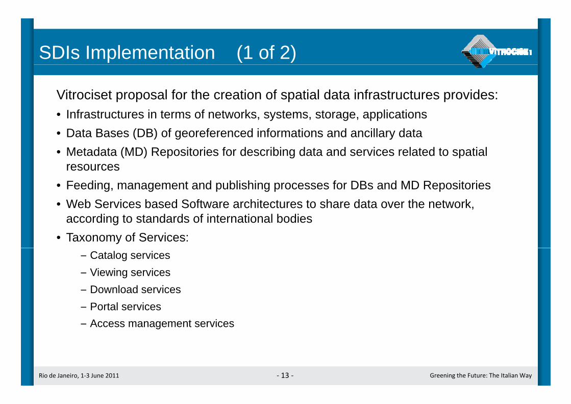
SDIs Implementation (1 of 2)
Vitrociset proposal for the creation of spatial data infrastructures provides:I f t t i t f t k t t li ti• Infrastructures in terms of networks, systems, storage, applications
• Data Bases (DB) of georeferenced informations and ancillary data• Metadata (MD) Repositories for describing data and services related to spatial ( ) p g p
resources• Feeding, management and publishing processes for DBs and MD Repositories
Web Services based Software architectures to share data over the network• Web Services based Software architectures to share data over the network, according to standards of international bodies
• Taxonomy of Services:– Catalog services– Viewing services– Download services– Portal services– Access management services
Rio de Janeiro, 1‐3 June 2011 ‐ 13 ‐ Greening the Future: The Italian Way
SDIs Implementation (2 of 2)
The infrastructure components and all application components of the SDIThe infrastructure components and all application components of the SDI designed by Vitrociset are consistent with the of Open GIS Consortium (OGC) specifications, which form the technological model of INSPIRE
Proposed systems for SDI design are based on OPEN SOURCEProposed systems for SDI design are based on OPEN SOURCE SOFTWARE (OSS) platforms, to manage and publish spatial data
It’s significant Vitrociset experience in the creation and evolution of PortaleCartografico Nazionale and of Sistema Cartografico Cooperativo (togethernow form Geoportale Nazionale); SCC is the National SDI involving aboutnow form Geoportale Nazionale); SCC is the National SDI involving about150 Public Administrations. The Geoportale Nazionale is the access pointat national level to network services through the Repertorio Nazionale deiDati Territoriali (RNDT) and to the catalogs of public administrations
Rio de Janeiro, 1‐3 June 2011 ‐ 14 ‐ Greening the Future: The Italian Way
Dati Territoriali (RNDT), and to the catalogs of public administrations

Types of Spatial Data in Public Data BasesThe data produced by Piano Straordinario di
Telerilevamento (PST), a national remote sensing( ) gproject:
• Digital Terrain and Surfaces Models (DTM and DSM) from LIDAR (laser scanning from airborne platform) DTM
• Differential SAR Interferometry (satellite)
Other data published by the Geoportale Nazionale(GN): Interferometric analysis
(ground movements)• Basic and thematic mapping, vector and raster
mode, 2D and 3D, with coverage of whole national extension
(ground movements)
DSM
• Georeferenced images (orthophotos)• Spectrometry• Bathymetry (backs facing the coastline)
Rio de Janeiro, 1‐3 June 2011 ‐ 15 ‐ Greening the Future: The Italian Way
Scala 1:1.500
Iperspectral sensor Bathymetric Laser scanningOrtophotos3D Models

Vitrociset strategic guidelinesg g
Propagate to other public administrations, Central and regionalIndustrially implement
th d d Central and regional ones, capacities for
the sharing of spatial data, supporting the development of SDI
consistent with distinct
the advanced scenarios and the
emerging standards of standardization bodies
(INSPIRE, OGC, DGIWG DigitPA) specificities and
missions DGIWG, DigitPA)
Implement R&D projects, at national and EU level, to innovate in terms of: sensors, analysis of
data from remote sensing, D i i d M it i S tDecision and Monitoring Support
Systems
Rio de Janeiro, 1‐3 June 2011 ‐ 16 ‐ Greening the Future: The Italian Way

Vitrociset experiencein Environment and Territory segment
Ministry of Environment
in Environment and Territory segment
Ministry of Environment•Geoportale Nazionale
(formerly Portale Cartografico Nazionale)•Data Base of Piano Straordinario di
Telerilevamento Ambientale (PST‐A)
•Project: Environment 2010 System•Biodiversity Nazional Network and related Technical Committee
• Sistema Cartografico Cooperativo (SCC),more than 150 cooperating Public
Administrations : Regions, Provinces, Municipalities, Basin Authorities,Parks, Marine Protected Areas
•Progetto: SITA (Sistema Informativo per la Tutela Ambientale):
D t B
Arma dei Carabinieri (Gendarmery Corps)
Ministry of Environment and Carabinieri• Data Bases• Solutions in support to investigative
and Police activities
•Project: Monitoraggio Impatto Ambientale Dovuto a Reati Ambientali(MIADRA)
• Extension of Sistema Cartografico Cooperativo (SCC) to 28 RegionalAgencies in CONVERGENCE Area
•Non‐invasive surveillance systems (UAVs with optical and thermal IR videocameras)
Rio de Janeiro, 1‐3 June 2011 ‐ 17 ‐ Greening the Future: The Italian Way

Agenda
Vitrociset profileVitrociset profile
Competencies in Environment and Territory managementCompetencies in Environment and Territory management
Case study: MIADRA ProjectCase study: MIADRA Project
Rio de Janeiro, 1‐3 June 2011 ‐ 18 ‐ Greening the Future: The Italian Way

MIADRA Project profile (1 of 2)
Ministero dell’Ambiente e della Tutela del Territorio e del MareMinistero dell’Ambiente e della Tutela del Territorio e del Mare
Data, Data, SystemsSystems and and ServicesServices forfor “Monitoraggio dell’Impatto Ambientale Dovuto a “Monitoraggio dell’Impatto Ambientale Dovuto a Reati Ambientali (MIADRA)”Reati Ambientali (MIADRA)”
ObjectivesObjectives• To implement systems and methodologies to identify and remove the effects of crimes committed with damage
to environment, and specifically those ones related to the increase in hydraulic risk. Scope of the project is in the four regions of Southern Italy included in the EU Convergence Objective (Campania, Puglia, Calabria , Sicily)Sicily)
Administrations involved• The project involves:
• The Environment Protection Command of the Carabinieri (Gendarmerie Nationale): it is a body with missions of Judicial Police which works to combat lawlessness and eco mafia in particular for themissions of Judicial Police, which works to combat lawlessness and eco-mafia, in particular for the prevention and punishment of crimes with environmental impact in terms of increase of hydrogeolocical risk.
• 28 Regional and Provincial Agencies (ARPA) in the 4 regions: they are institutions with technical missions of environmental protection, work site inspections, field surveys, analysis, impact assessments.The Ministry of Environment which provides the Carabinieri and the Agencies with its Databases (held in the• The Ministry of Environment, which provides the Carabinieri and the Agencies with its Databases (held in the Geoportale Nazionale and in the National SDI systems), and tools to support their specific activities
The project is a complete example of implementation of policies and practices for the
Rio de Janeiro, 1‐3 June 2011 ‐ 19 ‐ Greening the Future: The Italian Way
prevention and control of the territory and of hydrogeological risk factors
MIADRA Project profile (2 di 2)
Design and innovation elementsDesign and innovation elements
• In support of the Environment Protection Command of the Carabinieri:• Technological upgrade of the Data Processing Centre of the Carabinieri in Naples
I th it f I f ti S t f E i t P t ti t d i t bilit i SDI• Increase the capacity of Information System for Environment Protection towards interoperability in SDI (infrastructure for spatial data sharing)
• Video surveillance systems based on non-invasive micro UAV (Unmanned Vehicle Aherial), max 2 kg in the air, capable of multiple types of sensors on board
I t f th 28 R i l d P i i l A i f E i t l P t ti• In support of the 28 Regional and Provincial Agencies for Environmental Protection:• Hardware and Services to create 28 new nodes of the network of cooperating distributed portals designed by the
Ministry of Environment (Sistema Cartografico Cooperativo – SCC), attended by more than 150 other public administrations. Each node in the SCC is either an interoperable system in the network either is an independent GIS P t lGIS Portal
• In support either of the Carabinieri either of the Agencies:• Aggiornamento della Banca Dati del del S.I. Tutela Ambiente con dataset da telerilevamento LIDAR
(laser scanning da aereo). La BD di dati LIDAR realizzata da MIADRA risulterà omogenea e l t i tt ll l BD d t t d l PCN d l Mi i t d ll’A bi t R dcomplementare rispetto alla analoga BD detenuta dal PCN del Ministero dell’Ambiente a Roma, ed
entrambe potranno essere fruite in rete come se fossero una risorsa unitaria• Servizi di sviluppo applicativo di applicazioni GIS desktop per funzionalità verticali (analisi e modelli
idrogeologici, elaborazione di indicatori di rischio, …)S i i di i t i t i ti d li ti
Rio de Janeiro, 1‐3 June 2011 ‐ 20 ‐ Greening the Future: The Italian Way
• Servizi di assistenza sistemistica ed applicativa• Servizi di addestramento

Remote sensing: LiDAR
Laser scanning (LiDAR) is an efficient technologyfor the acquisition of digital terrain and surfaceq gmodels (DTM and DSM) of large portions ofterritory. The Digital Terrain Model (DTM) can begenerated with high resolution and detail, makingg g gthe technology more cost-efficient than traditionalphotogrammetric methodsLiDAR systems scan the surface by measuring theLiDAR systems scan the surface by measuring thevegetative layer and penetrating to the ground,providing important information on the ground andmeasuring units with centimeter accuracy. The useg yof additional information such as laser intensityvalues allows to determine the type of surface(soil, vegetation, buildings, ...)
Rio de Janeiro, 1‐3 June 2011 ‐ 21 ‐ Greening the Future: The Italian Way

Remote sensing: LiDARg
General scope of LIDAR scanning:• Forest inventory and statement of biomass• Modeling of floodplain• Transmission lines and distribution systems• Accurate modeling of infrastructure (roads, rivers and railways)• Engineering design• Topographic• Topographic• Modeling and urban planning• Visualization and simulation
Rio de Janeiro, 1‐3 June 2011 ‐ 22 ‐ Greening the Future: The Italian Way
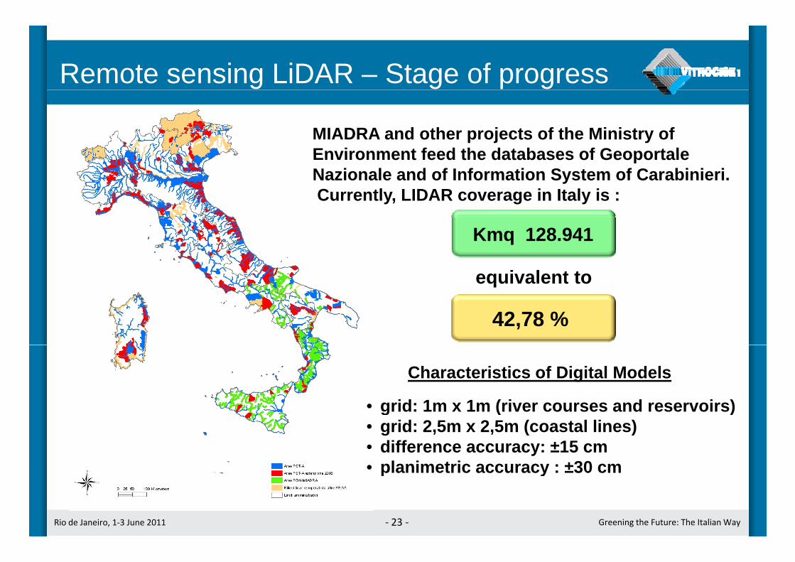
Remote sensing LiDAR – Stage of progress
MIADRA and other projects of the Ministry ofEnvironment feed the databases of GeoportaleEnvironment feed the databases of GeoportaleNazionale and of Information System of Carabinieri.Currently, LIDAR coverage in Italy is :
Kmq 128.941
equivalent to
42,78 %
equivalent to
• grid: 1m x 1m (river courses and reservoirs)
Characteristics of Digital Models
grid: 1m x 1m (river courses and reservoirs)• grid: 2,5m x 2,5m (coastal lines)• difference accuracy: ±15 cm• planimetric accuracy : ±30 cm
Rio de Janeiro, 1‐3 June 2011 ‐ 23 ‐ Greening the Future: The Italian Way
planimetric accuracy : ±30 cm

Remote sensing: Interferometryg yThe Differential SAR Interferometry(DINSar) is a technique that can be(DINSar) is a technique that can beeffectively used to map surfacedisplacements associated withlandslidesThe use of tecnique PermanentScatterers (PS) allows the recognitionof individual landmarks (called(permanent scatters) in the images, tobe used for precision measurements ofdisplacementspScope of DINSar technology covermonitoring of:• Geophysical phenomenaGeophysical phenomena• Effect of subsidence• landslides• Seismic faults
Rio de Janeiro, 1‐3 June 2011 ‐ 24 ‐ Greening the Future: The Italian Way
• Seismic faults• stability of structures and buildings

Remote sensing: Interferometryg y
Rio de Janeiro, 1‐3 June 2011 ‐ 25 ‐ Greening the Future: The Italian Way

Remote sensing: Interferometryg y
Rio de Janeiro, 1‐3 June 2011 ‐ 26 ‐ Greening the Future: The Italian Way

Remote sensing: Interferometryg y
Rio de Janeiro, 1‐3 June 2011 ‐ 27 ‐ Greening the Future: The Italian Way

Video surveillance systemsy
Sensors: optical and thermal (infrared) digital camerascarrier:• Fixed and mobile terrestrial shooting locations• Airborne platform, including UAVAirborne platform, including UAV
There are plans for use of multi-sensorself-configurating wireless mesh networks
Rio de Janeiro, 1‐3 June 2011 ‐ 28 ‐ Greening the Future: The Italian Way28

Fixed or rotary wing UAV fleet for surveillance
Logistic flexibility:Complete system in transportable backpack
Operating abilities:Ready to take off in 6 minutesRange 8-20 Km from the ground stationUp to three aircreft in flight simultaneously for eachground stationOperating day and nightMission autonomy of the aircraft: 2h 30’ (fixed wing) e 30’ (rotary wing)
Rio de Janeiro, 1‐3 June 2011 ‐ 29 ‐ Greening the Future: The Italian Way
Integration with the operating rooms for remote monitoring in real time

UAV for monitoring of pollution
The unmanned aerial systems (UAVs) for surveillance, routinely equippedwith oprical and thermal IR cameras, can also be equipped with sensorssuitable for the analysis of air quality and for monitoring of other forms ofpollution:p• Elettrochemical Sensors• Sensors to capture air samples for in field analysis through portable laboratory
instrumentsinstruments• Sensors to detect radioactive emissions• Acoustic sensors to detect the sources of distinctive noises
Rio de Janeiro, 1‐3 June 2011 ‐ 30 ‐ Greening the Future: The Italian Way

Expansion of the Italian National SDIp
ESDIMIADRA allows
S.I.T.A. e the 28 Agencies to
Province
RegionMunicipality
M iNodeNode NSDI
ESDI S.I.T.A. e the 28 Agencies topartecipate in the National SDI( > 150 Public Administrations)
gMountainCommunityNode
Node
Node
GeoportaleNazionale
BasinAuthority
Department
Node NodeInternet
Ministryof Defence
Org XPortal NodeNode
Node
NodeSub‐NationalSDI
intranet
EnvironmentAgencies
S.I.T.A.Carabinieri
of DefenceNode Node
intranet
Department
Node
DepartmentNode
Rio de Janeiro, 1‐3 June 2011 ‐ 31 ‐ Greening the Future: The Italian Way
AgenciesCarabinieri Departmentp
Vitrociset Solutions for SDIs
For an institution that wishes to create its own SDI, Vitrociset,offers a set of enabling applications, to be customized:
Web-oriented applications, available online from Geoportals and/or from Nodes of the SDI:• Metadata Manager (for Metadata creation and maintenance)Metadata Manager (for Metadata creation and maintenance)• Browser for Metadata Catalog• Cartographic browser
3D C t hi b• 3D Cartographic browser• Tool for administration and publishing of Spatial Data
GIS-desktop Applications:p pp• AdB Toolbox (a modular tool, extensible for verticalizations)
Directions of development for application architectures:I f t t t t i t i GEOSS (S t f S t ith t
Rio de Janeiro, 1‐3 June 2011 ‐ 32 ‐ Greening the Future: The Italian Way
• Infrastructures to partecipate in GEOSS (System of Systems, with supportfor multidisciplinarity)
The AdB Toolbox GIS-desktop application
AdB ToolBox is a modular extensible application tool, for the needs of various types of organizations, specifically in originenriched with functionalities to support River Basin Authorities.An “horizontal” feature is the sharing of spatial databases. It’sAn horizontal feature is the sharing of spatial databases. It s possible to query local databases both vector and raster ones, and remote databases shared by other entities partecipating in the SDIs. The tool is characterized by being based on open source softwareThe tool is characterized by being based on open source software technologies and libraries. That allow to achieve benefits related toopportunity to evolve and specialize this GIS-desktop tool accordingto the type of recipient Agency or Administration
Rio de Janeiro, 1‐3 June 2011 ‐ 33 ‐ Greening the Future: The Italian Way
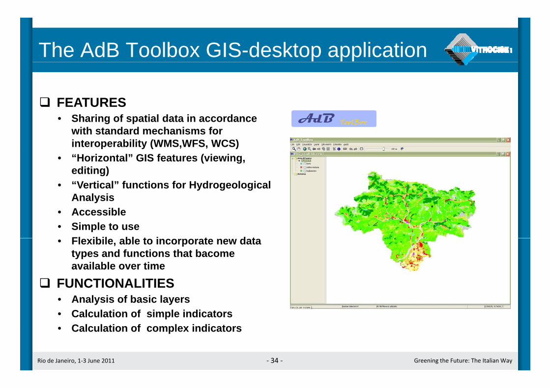
The AdB Toolbox GIS-desktop application
FEATURESFEATURES• Sharing of spatial data in accordance
with standard mechanisms forinteroperability (WMS,WFS, WCS)
• “Horizontal” GIS features (viewing, editing)
• “Vertical” functions for HydrogeologicalA l iAnalysis
• Accessible• Simple to use
Fl ibil bl t i t d t• Flexibile, able to incorporate new data types and functions that bacomeavailable over time
FUNCTIONALITIESFUNCTIONALITIES• Analysis of basic layers• Calculation of simple indicators
Calc lation of comple indicators
Rio de Janeiro, 1‐3 June 2011 ‐ 34 ‐ Greening the Future: The Italian Way
• Calculation of complex indicators

AdB Toolbox: examples of derived data layers
Inherent Factor about Propensity to collapse – SPI (Stream Power Index)Th ti lThematic layer“Drained area”:
it maps the “carrying capacity”
Thematic layerThe processing
of the 2 thematic layersallows the calculation
y“Slope”:
it maps the “speed”allows the calculation
of the complex indicator“Stream Power Index”:
it th t
Rio de Janeiro, 1‐3 June 2011 ‐ 35 ‐ Greening the Future: The Italian Way
it maps the stream powerin the whole basin
Related Documents


