GREEN INFRASTRUCTURE RESOURCE GUIDE SEPTEMBER 2017

Welcome message from author
This document is posted to help you gain knowledge. Please leave a comment to let me know what you think about it! Share it to your friends and learn new things together.
Transcript

GREEN INFRASTRUCTURE RESOURCE GUIDE
SEPTEMBER 2017

ES.1 - EXECUTIVE SUMMARYGREEN INFRASTRUCTURE RESOURCE GUIDE
ACKNOWLEDGMENTSThis guide was developed for the United States Agency for International Development (USAID) by AECOM as part of a series of knowledge products prepared for the USAID-funded Global Climate Change, Adaptation, and Infrastructure Issues Knowledge Management Support Project.
COVER PHOTOSThe cover photo was obtained from Dreamstime.com. The second image was obtained from Adobestock.com.
DISCLAIMERThe authors’ views expressed in this document do not necessarily reflect the views of the United States Agency for International Development or the United States Government.

GLOBAL CLIMATE CHANGE, ADAPTATION, AND INFRASTRUCTURE ISSUES KNOWLEDGE MANAGEMENT SUPPORTCONTRACT NO. EDH-I-00-08-00023-00ORDER NO. OAA-TO-12-00057
September 2017
SUBMITTED TO: PREPARED BY:

Executive Summary ........................................................................................................................................................................................................ES-2
EXECUTIVE SUMMARY
1.1 GreenInfrastructureDefined ......................................................................................................................................................................... 1-21.2 WhyGreenInfrastructureWorksasaSustainableApproachtoHumanInducedandEnvironmentalStressors ....................... 1-21.3 GreenInfrastructureBenefits ......................................................................................................................................................................... 1-2
SECTION 1INTRODUCING GREEN INFRASTRUCTURE
iiINCORPORATING CLIMATE CHANGE ADAPTATION IN INFRASTRUCTURE PLANNING AND DESIGN
LIST OF TABLES AND FIGURES ...................................................................................................................................................................................... ivACRONYMS .......................................................................................................................................................................................................................... vKEY TERMS ........................................................................................................................................................................................................................... vi
2.1 GroundwaterRechargeforWaterSecurity ................................................................................................................................................ 2-42.1.1 EngineeringDesignOptions ........................................................................................................................................................... 2-52.1.2 SiteandCommunitySpecificConsiderationstoMaximizeSustainability ...........................................................................2-52.1.3 EducationandAwarenessRaising ................................................................................................................................................. 2-62.1.4 Design,Evaluation,andMonitoringResources ........................................................................................................................... 2-6
2.2 WaterRetentionandDetentionforWaterSupplyandEcosystemMaintenance...............................................................................2-72.2.1 EngineeringDesignOptions ........................................................................................................................................................... 2-82.2.2 SiteandCommunitySpecificConsiderationstoMaximizeSustainability ...........................................................................2-82.2.3 EducationandAwarenessRaising ................................................................................................................................................. 2-82.2.4 Design,Evaluation,andMonitoringResources ........................................................................................................................... 2-8
2.3 Erosion Control.................................. ..............................................................................................................................................................2-102.3.1 EngineeringDesignOptions .........................................................................................................................................................2-122.3.2 SiteandCommunitySpecificConsiderationstoMaximizeSustainability .........................................................................2-122.3.3 EducationandAwarenessRaising ...............................................................................................................................................2-132.3.4 Design,Evaluation,andMonitoringResources .........................................................................................................................2-13
SECTION 2GREEN INFRASTRUCTURE INTERVENTIONS
TABLE OF CONTENTS
iiiGREEN INFRASTRUCTURE RESOURCE GUIDE
2.4 UrbanStormwaterManagement..... .............................................................................................................................................................2-152.4.1 EngineeringDesignOptions .........................................................................................................................................................2-162.4.2 SiteandCommunitySpecificConsiderationstoMaximizeSustainability .........................................................................2-172.4.3 EducationandAwarenessRaising ...............................................................................................................................................2-182.4.4 Design,Evaluation,andMonitoringResources .........................................................................................................................2-18
2.5 RuralFloodMitigation.......... ...........................................................................................................................................................................2-192.5.1 EngineeringDesignOptions .........................................................................................................................................................2-212.5.2 SiteandCommunitySpecificConsiderationstoMaximizeSustainability .........................................................................2-212.5.3 EducationandAwarenessRaising ...............................................................................................................................................2-222.5.4 Design,Evaluation,andMonitoringResources .........................................................................................................................2-22
2.6 Pollution Abatement................ ........................................................................................................................................................................2-232.6.1 EngineeringDesignOptions .........................................................................................................................................................2-252.6.2 SiteandCommunitySpecificConsiderationstoMaximizeSustainability .........................................................................2-252.6.3 EducationandAwarenessRaising ...............................................................................................................................................2-262.6.4 Design,Evaluation,andMonitoringResources .........................................................................................................................2-26
2.7 ResiliencetoDrought................ .....................................................................................................................................................................2-282.7.1 EngineeringDesignOptions .........................................................................................................................................................2-292.7.2 SiteandCommunitySpecificConsiderationstoMaximizeSustainability .........................................................................2-292.7.3 EducationandAwarenessRaising ...............................................................................................................................................2-302.7.4 Design,Evaluation,andMonitoringResources .........................................................................................................................2-30
2.8 ReducedUrbanHeatIslandEffects ............................................................................................................................................................2-322.8.1 EngineeringDesignOptions .........................................................................................................................................................2-332.8.2 SiteandCommunitySpecificConsiderationstoMaximizeSustainability .........................................................................2-332.8.3 EducationandAwarenessRaising ...............................................................................................................................................2-342.8.4 Design,Evaluation,andMonitoringResources .........................................................................................................................2-34
2.9 BuildingEnergyEfficiency.......... ......................................................................................................................................................................2-362.9.1 EngineeringDesignOptions .........................................................................................................................................................2-372.9.2 SiteandCommunitySpecificConsiderationstoMaximizeSustainability .........................................................................2-372.9.3 EducationandAwarenessRaising ...............................................................................................................................................2-372.9.4 Design,Evaluation,andMonitoringResources .........................................................................................................................2-37
2.10 FoodSecurity............................... ......................................................................................................................................................................2-392.10.1 EngineeringDesignOptions .........................................................................................................................................................2-402.10.2 SiteandCommunitySpecificConsiderationstoMaximizeSustainability .........................................................................2-402.10.3 EducationandAwarenessRaising ...............................................................................................................................................2-412.10.4 Design,Evaluation,andMonitoringResources .........................................................................................................................2-41
2.11 Post-WildfireSoilandSlopeStabilization ..................................................................................................................................................2-432.11.1 EngineeringDesignOptions .........................................................................................................................................................2-442.11.2 SiteandCommunitySpecificConsiderationstoMaximizeSustainability .........................................................................2-442.11.3 EducationandAwarenessRaising ...............................................................................................................................................2-442.11.4 Design,Evaluation,andMonitoringResources .........................................................................................................................2-44
SECTION 2 (continued)GREEN INFRASTRUCTURE INTERVENTIONS
3.1 Watersheds(LargeorRegionalScale) ......................................................................................................................................................... 3-23.1.1 MaintainingNaturalFunctionsofaHealthyWatershed ..........................................................................................................3-23.1.2 IntegratedWatershedManagementPlanning ............................................................................................................................. 3-6
3.2 Urban Environments.............. ............................................................................................................................................................................ 3-63.3 Rural Environments............... ............................................................................................................................................................................. 3-7
3.3.1 GreenInfrastructureandEcosystemServices ........................................................................................................................... 3-83.4 EmergencyResponseSituations ..................................................................................................................................................................... 3-8
3.4.1 NaturalResourceManagementasPartofConflictMitigation ...........................................................................................3-103.5 MonitoringStrategiesatDifferentScales ...................................................................................................................................................3-10
SECTION 3GI CONSIDERATIONS FOR DIFFERENT SETTINGS AND SCALES

ivGREEN INFRASTRUCTURE RESOURCE GUIDE
LIST OF TABLES AND FIGURES
1-1 Benefits.......................................... ....................................................................................................................................................................... 1-3
TABLES - SECTION 1
TABLES - SECTION 22-1 SummaryTableofGreenInfrastructureEngineeringDesignsDiscussedinSection2 ....................................................................... 2-22-2 MajorBenefitsGainedFromGIDesignedforGroundwaterRechargetoEnhanceWaterSecurity ............................................. 2-42-3 MajorBenefitsGainedFromGIDesignedforWaterRetention/DetentiontoEnhanceWaterSupply ........................................ 2-72-4 MajorBenefitsGainedFromGIDesignedforErosionControl ........................................................................................................... 2-102-5 MajorBenefitsGainedFromGIDesignedforUrbanStormwaterManagement ............................................................................. 2-152-6 MajorBenefitsGainedFromGIDesignedforRuralFloodMitigation ................................................................................................ 2-192-7 MajorBenefitsGainedFromGIDesignedtoAbatePollution .............................................................................................................. 2-232-8 MajorBenefitsGainedFromGIDesignedtoIncreaseResiliencetoDrought ................................................................................. 2-282-9 MajorBenefitsGainedFromGIDesignedtoReduceHeatIslandEffects ......................................................................................... 2-322-10 MajorBenefitsGainedFromGIDesignedforIncreasedBuildingEnergyEfficiency........................................................................ 2-362-11 MajorBenefitsGainedFromGIDesignedtoIncreaseFoodSecurity ................................................................................................ 2-392-12 MajorBenefitsGainedFromGIDesignedforPost-WildfireSoilandSlopeStabilization .............................................................. 2-43
TABLES - SECTION 3
3-1 ApplicabilityofGreenInfrastructureEngineeringDesignOptionCategoriesbyWatershedZone .............................................. 3-63-2 Examples of Ecosystem Services in Rural Areas ......................................................................................................................................... 3-8
3-1 Lane’sDynamicEquilibriumDiagram ............................................................................................................................................................ 3-33-2 Differentengineeringdesignoptionsmayberequiredforheadwater,transfer,anddepositionalzonesofawatershed .......... 3-5
FIGURES - SECTION 3
vGREEN INFRASTRUCTURE RESOURCE GUIDE
AGD Age,GenderandDiversity
ASR AquiferStorageandRecovery
BAER BurnedAreaEmergencyResponse
BMP bestmanagementpractice
CMZ Channelmigrationzone
EWRI Environmental & Water Resources Institute
FEMA FederalEmergencyManagementAgency
FHA FederalHousingAdministration
GI Green infrastructure
GSI GreenStormwaterInfrastructure
IDP Internationallydisplacedpersons
IWMP IntegratedWatershedManagementPlanning
LID LowImpactDevelopment
NRCS Natural Resources Conservation Service
SAR Shallowaquiferrecharge
UNHCR UnitedNationsHighCommissionerforRefugees
USEPA UnitedStatesEnvironmentalProtectionAgency
USAID VISTAS USAID Viable Support to Transition & Stability
USAID UnitedStatesAgencyforInternationalDevelopment
USDA UnitedStatesDepartmentofAgriculture
UV Ultraviolet
WADOE StateofWashingtonDepartmentofEcology
WEF WaterEnvironmentFederation
WSUD WaterSensitiveUrbanDesigns
ACRONYMS
viGREEN INFRASTRUCTURE RESOURCE GUIDE
ALLUVIAL–oforrelatedtonaturalmaterialdepositedbytheriver conveyance.
AQUITARD – subsurface layer of material that restricts the downwardflowofinfiltratedwater.
BIO-MIMICRY–engineeredapproachestypicallyusingnaturalmaterialstorecreatenaturalprocessesandfunctions.
BIORETENTION–astormwatertreatmentprocessofremovingpollutantsandsedimentfromstormwaterusingasystemofpondingareaswithvegetation,soil,sandgravel,andorganicmaterial.
BIOSWALE–avegetatedlineardepressionortrenchdesignedforthecollection,conveyance,infiltration,andfiltrationofstormwaterrunoff.
BUFFER(asinlandscapeorriparianbuffer)–astripofvegetationthatactsasabarrierbetweendifferentlandusesorecosystem types.
CHANNEL MIGRATION ZONE (CMZ) – the area associatedwitharivervalleywhereariverchannelcanbeexpectedtomigrateovertimeduetohydrologicallyandgeomorphologicallyrelatedprocesses.
CISTERN –anaboveorbelowgroundstoragedevicethatisusedtocollectandstorerainwater.
CONSERVATION AGRICULTURE–soilmanagementpracticesthatimprovesustainabilitybymaintainingsoilstructure,reducingerosion,andretainingwateronthelandscape.
CONSERVATION TILLAGE–amethodofsoilcultivationinwhichtheremainsofcrops(ex.cornstalks)areleftonthefieldinordertoreduceerosionandstormwaterrunoff.
CONTOUR FARMING–theagriculturalpracticeofgrowingcropsacrossorperpendiculartothelandslope.
CONTOUR PLOWING–tillingsoilinapatternthatrunsperpendiculartothelandslope.
CONSTRUCTED WETLAND–anengineeredwetlandthattreatsandtemporarilystoresstormwaterorotherwastewaterviathenaturalprocessesofwetlandvegetation,soils,andmicrobialassemblages.
KEY TERMS
COVER CROPS–cropsthatareplantedtomanagesoilquality,erosion,moisture,weeds,biodiversity,andtomitigatepollution,asopposedtocropsthatonlygenerateincome(cashcrops).
BASE FLOWS–theportionofstreamflowduringdryperiodsthatisgeneratedfromshallowanddeepgroundwatersources
ECOSYSTEM FLOWS–streamflowratesassociatedwithspecificecologicalfunctionsthatbenefitaquaticspecies,sedimenttransport,orriparianspecies.
ECOSYSTEM SERVICES –anypositivebenefitthatwildlifeorecosystemsprovidetopeople.Thebenefitscanbedirectorindirect,andrangefromsmalltolarge.
FLOODPLAIN–theareaoflandadjacenttoastreamorriverthatextendsfromthebanksofthechanneltothebaseoftheenclosingvalleywallsandexperiencesfloodingduringperiodsofhighdischarge.
GREEN INFRASTRUCTURE (GI) –anyengineeredinterventionthatusesvegetation,soils,andnaturalprocessestomanagewaterandcreatehealthierbuiltenvironmentsforpeopleandthenaturalresourcesthatsustainthem.GIcanrangeinscalefromsmallscaletechnologiessuchasraingardensandgreenroofstoregionalplanningstrategiestargetingconservationorrestorationofnaturallandscapesandwatersheds.GIapproachesmaybeinterconnectedwithexistingandplannedgreyinfrastructurenetworkstocreatesustainableinfrastructurethatcanenhancecommunityresiliencytodisastersandclimatechangeasaresultofincreasedwaterretentionandgroundwaterrecharge,floodmitigation,erosioncontrol,shorelinestabilization,combattingurbanheatislandeffect,improvingwaterquality,conservingenergyforbuildings.
GRAVITY-FED SYSTEMS–asystemthatusesgravitytoprovidetheenergyneededtoperformthework.
GREEN ROOFS–orvegetatedroofsareroofsystemscomprisedofvegetationalongwiththesupportinggrowingmedia(topsoilorlightweightaggregates)thatisdesignedtointerceptrainwater.
HEADWATER–thesourceofflowforariverorstreamthatisfarthestawayfromthemouthofthesystem.

viiGREEN INFRASTRUCTURE RESOURCE GUIDE
HEADWATER CHANNEL TREATMENTS – approaches usedinheadwaterstreamstorestoreormaintainnaturalfunction.
HEAT ISLAND EFFECT–anenvironmentalconditionoftenencounteredinmetropolitanareasthathaveconsistentlyhighertemperaturesthansurroundingareas,duetohumanactivitiesandincreasedsolarradiationabsorbedbyurbaninfrastructure.Theurbanheatislandeffectsincludeincreasedenergyconsumptionforcooling,compromisedhumanhealthandcomfort,andimpairedwaterqualityforsurfacewaters.
HYPORHEIC ZONE–thesaturatedzoneofsoiladjacenttoastreamwhereshallowgroundwaterandsurfacemix.
INDICATOR – a measure of the function or ability of the ecosystemtocontinuetoprovidetherecognizedbenefitsandservicescanbeusedtomonitortheeffectivenessofgreeninfrastructure interventions.
IN-FIELD RAINWATER HARVESTING–anagriculturaltechniquethatdirectsrunofftomulch-coveredbasinsviacompacted,flat,approximatelytwo-meterwidestripsthatareperpendiculartotheslopeoftheland.
INJECTION WELLS –asubsurfaceinfiltrationpathwaythatfacilitatesusingsurfacewatertorechargegroundwaterreservoirs.Thewellcanuseeithergravityormechanicalprocesses.
LEVEE–anembankmentconstructedtolimittheextentoffloodingfromriverineorcoastalflows.
MULCHING–placingaprotectivelayeroforganicmatterusedtoprotectsoilandprovidenutrients.
PERI-URBAN AGRICULTURE–agriculturethatoccursonthefringeofurbanareas.
PERMEABLE PAVEMENTS – alternative pavement materials thataredesignedtoinfiltratestormwaterrunofftothesubsurface
RAIN BARREL –arainwaterharvestingcontainerusedtocollectandstorerainwaterfromrooftops.
RAIN GARDENS–landscapefeaturesthatareplantedwithaselectionofnativeandwater-tolerantplantsanddesignedtocollect,andtreatrunoff.
RECHARGE BASINS–shallowstorageareasdevelopedadjacenttoriversorstreamintendedtoencouragesurfaceflowstoinfiltrateandrechargegroundwaterreservoirs.
RIPARIAN (asinriparianbuffer)–thevegetatedareasoflandadjacenttoandincludingthebanksofariverorstream.
ROUGHNESS–themeasureoftheresistancetoflowassociatedwithmaterials.
SAND FILTER –anundergroundstormwatermanagementsystemcomprisedofchambersandasandbedthatfilterspollutantsfromstormwaterrunoff.
SHALLOW AQUIFER RECHARGE (SAR)–promotingtheinfiltrationofsurfacewatertonearsurfacegroundwaterreservoirsforlaterrecoveryorstreambaseflowsupplement.
SPREADING GROUNDS–anareaforthedistributionofsurfacewateracrosspermeablesoilstoencourageinfiltrationandrechargeoftheunderlyinggroundwaterresources.
TONNE –aunitofmassequalto1,000kgor2,204.6pounds;a metric ton.
TREESCAPING–thestrategicplantingoftreesorvegetativecanopiestoincreaseshadingandreduceheatabsorptionbythebuiltinfrastructurethathashighheatabsorptionpotential.
URBAN AGRICULTURE –activitiesinvolvingthecultivationofplantsandraisinganimalswithinandaroundcitiesandperi-urbanareas,includingtheprocessing,anddistributionoffood.
URBAN HEAL ISLANDS – metropolitan areas that have consistentlyhighertemperaturesthansurroundingareas,duetohumanactivitiesandincreasedsolarradiationabsorbedbyurbaninfrastructure.
WATTLES –bundlesofstraworwoodymaterialusedtomitigateerosion,sedimentandsurfaceflows.
WATERSHED–theareaoflandthatdrainstoacommonoutletorwaterbody.
WIND SCREENS–oneormorerowsoftreesorshrubsplantedinsuchamannerastoprovideshelterfromthewindandtoprotectsoilfromerosion;windbreak.
XERISCAPING–alandscapingtechniquethatutilizesdroughttolerantspeciesandrequireslittletonoirrigation.

XX
ES-2 - EXECUTIVE SUMMARYGREEN INFRASTRUCTURE RESOURCE GUIDE
Recognizing the importance that green infrastructure (GI) plays in sustaining ecosystem services such water resources conservation, flood and stormwater management, groundwater recharge, water supply, and disaster resilience, the United States Agency for International Development (USAID) has identified the need for guidance in planning and design of GI solutions. This resource guide is aimed at providing USAID practitioners involved in the planning and development of sustainable infrastructure projects with a better understanding of GI and identifying GI interventions that can be integrated into USAID projects.
The first section, Introducing Green Infrastructure, presents the definition of GI in the context of USAID’s activities and priorities, describes how GI can be used to help communities adapt to human induced and environmental stressors, and introduces the twelve benefits that are associated with GI interventions. These benefits identified at the bottom of this page and associated icons are used throughout the resource guide to aid in comprehension.
Following this introductory section, a series of GI interventions are introduced to address the following topics or issues:
1. Groundwater recharge for water security
2. Water retention and detention for water supply andecosystem maintenance
3. Erosion control
4. Urban stormwater management
5. Rural flood mitigation.
6. Pollution abatement
7. Resilience to drought
8. Reduced urban heat island effects
9. Building energy efficiency
10. Food security
11. Managing soil and slope stabilization after wildfires.
A general description is provided for each issue, which is followed by specific GI engineering design options that can be implemented to address the issues. Applicable benefits are discussed for each design option as well as the functional responses (i.e., how the benefits are realized) and relevant indicators to aid in monitoring the performance of a GI solution.
Important elements for integrating community needs and local conditions into site-specific GI design are also presented, and examples are provided to illustrate how GI should be planned in coordination with community stakeholders and tailored to site-specific conditions. An education and awareness section is also provided that identifies what specific type of knowledge or information an implementer of a USAID project should consider providing to stakeholders to enable them to construct or manage and operate a successful GI system, which is followed by suggested design, evaluation, and monitoring resources.
The resource guide concludes with a discussion of how GI can be applied to various settings and scales, including urban, rural, and watershed landscapes, which require an understanding of the range of available opportunities and constraints. A discussion is also provided on how GI can build resiliency into the environment by reducing flooding impacts and leading to less emergency response situations.
EXECUTIVE SUMMARY
WATERSHED SUSTAINABILITY
ECOSYSTEM HEALTH
SEDIMENT STABILITY
WATER QUALITY
FLOOD MITIGATION
DROUGHT MITIGATION
REDUCED HEAT ISLAND EFFECT
ENERGY EFFICIENCY
RESILIENCE TO WEATHER
EXTREMES
FOOD SECURITY
PUBLIC HEALTH AND SAFETY
AESTHETICS AND QUALITY
OF LIFE
TWELVE BENEFITS
Dre
amst
ime.
com
1-2 - INTRODUCTIONGREEN INFRASTRUCTURE RESOURCE GUIDE
GI interventions address the natural stressor response of an ecosystem to changes in hydrology, habitat, natural resource availability, and human health and safety in the following ways:
• HYDROLOGY – GI can alter stormwater peak flows andflow durations infiltration capacity, base flow, and stormwaterrunoff volume.
• NATURAL HABITAT – GI can improve riparian streamchannel conditions to protect aquatic and terrestrial habitat, such as binding or processing pollutants that directly affectaquatic and terrestrial species.
• NATURAL RESOURCE AVAILABILITY – GI caninfluence changes in water supply, energy resources orland for water infiltration, food production, and humandevelopment.
• HUMAN HEALTH AND SAFETY – GI offers benefitsin improved drinking water quality, energy conservation andefficiency, flood protection, and sustainable provision of foodand water resources upon which human life depends.
This guide presents engineering design options that enable, strengthen, or improve the hydrological, habitat, and natural resource elements of the ecosystem or watershed.
1.3 Green Infrastructure BenefitsStructures that are engineered to restore or enhance the ecosystem services on which societies depend are generally recognized as GI if one or more of the twelve benefits listed in Table 1.3-1 are achieved. These benefits are realized through individual responses that can be measured and monitored with quantitative indicators to evaluate performance and effectiveness of GI interventions.
1.1 Green Infrastructure DefinedFor the purpose of this resource guide, GI is defined as follows:
Green infrastructure (GI) is any engineered intervention that uses vegetation, soils, and natural processes to manage water and create healthier built environments for people and the natural resources that sustain them. GI can range in scale from small scale technologies such as rain gardens and green roofs to regional planning strategies targeting conservation or restoration of natural landscapes and watersheds. GI approaches may be interconnected with existing and planned grey infrastructure networks to create sustainable infrastructure that can enhance community resiliency to disasters and climate change as a result of increased water retention and groundwater recharge, flood mitigation, erosion control, shoreline stabilization, combatting urban heat island effect, improving water quality, conserving energy for buildings.1
1.2 Why Green Infrastructure Works as a Sustainable Approach to Human Induced and Environmental StressorsDegradation of ecosystem health and services can result from a range of natural and human activities. For example, any change within a healthy watershed may alter the historic and natural functions that are shaped and developed the hydrologic system. Collectively, the impact of environmental stressors such as meteorological events or human activities may cause a response that alters the natural watershed functions that formed the elements critical to the health of the ecosystem (termed below as functional response). GI can be used to help communities adapt to stressors and direct responses toward outcomes that enable sustainable natural resource use, safeguard human health, and/or maintain aesthetics and quality of life. Indicators that measure the function or ability of the ecosystem to continue to provide the recognized benefits and services can be used to monitor the effectiveness of GI interventions.
SECTION 1
INTRODUCING GREEN INFRASTRUCTURE
1 In a recent solicitation for the Peru Green Infrastructure Water Security Project (RFA No. 527-17-000002), USAID defines GI for water supply as “the protection, restoration, improvements, and maintenance of watershed natural landscapes and ecosystems, such as reforestation/afforestation, forest conservation, rangeland management, use of infiltration ditches, and restoration of drained wetlands. Collectively, these activities enhance the ecosystem service of water regulation and prevent soil erosion”.

1-3 - INTRODUCTIONGREEN INFRASTRUCTURE RESOURCE GUIDE
XXTable 1-1: BenefitsBenefit Description Benefit Description
1. Watershed
Sustainability
• Increase infiltration capacity• Maintain water balance and natural hydrological
cycles• Maintaining natural progression in habit
evolution along river continuum• Enable nutrient transport (along river
continuum)
7. Reduced Heat Island Effect
• Provide shading• Lower absorptive and/or retentive heat
capacity
2. Ecosystem
Health
• Improve or maintain forest habitat quality• Improve wetland, riparian and stream habitat
quality• Improve or maintain terrestrial and aquatic
flora and fauna
8. Energy
Efficiency
• Increase use of clean energy alternatives• Reduce energy demand
3. Water Quality
• Maintain internal nutrient cycling andprocessing functions
• Reduce pollution• Protect drinking water quality
9. Resilience
to Weather Extremes
• Reduce intensity of extreme weather impactson infrastructure
• Increase the capacity to tolerate, manage, orrecover from extreme weather events
4. Sediment Transport
• Minimize erosion• Enhance or protect slope stability• Improve or maintain soil and substrate quality• Maintain streambed material health
10. Food Security
• Increase arable land area• Enhance or maintain soil fertility• Enhance or maintain soil quality
5. Flood
Mitigation
• Maintain or restore the natural floodplain area• Increase floodwater retentive capacity• Provide flood protection to residences and
structures• Improve or maintain proper drainage and
stormwater management
11. Public Health
and Safety
• Provide and protect safe drinking water• Reduce flood risks• Improve or maintain air quality
6. Drought
Mitigation
• Conserve water resources• Reduce water consumption/demand (drinking
water, agricultural or industrial)• Reduce evaporation/evapotranspiration
12. Aesthetics and Quality of Life
• Integrate or maintain natural landscapes incommunities and cities
• Promote community satisfaction andacceptance of green infrastructureinterventions
• Support stakeholder engagement in planning, design, operations and maintenance ofsustainable green infrastructure
2-2 - GREEN INFRASTRUCTURE INTERVENTIONSGREEN INFRASTRUCTURE RESOURCE GUIDE
1. Using a “form follows function” approach to engineeringdesign, various design options and approaches (form) willbe presented that offer a range of benefits in response todevelopment needs and objectives (function) in developingcountry contexts. Stressors and the need to preserve orenhance certain functional benefits are also discussed.
2. Considerations for adapting interventions to site andcommunity specific contexts to maximize sustainable andproductive use of the GI asset over the long term areaddressed for each intervention.
3. Specific aspects about the design, functional elements, or maintenance requirements of the GI intervention areprovided to highlight areas where education and awarenessraising for stakeholders may safeguard the physical integrityof the GI asset or enhance its function.
4. Finally, a list of resources is provided on commonly usedtools and information for monitoring and evaluating theeffectiveness of GI interventions over time.
Many GI interventions discussed in this guide are applicable to multiple topics and actions addressed in this section. Cross-referencing is noted in Table 2-1.
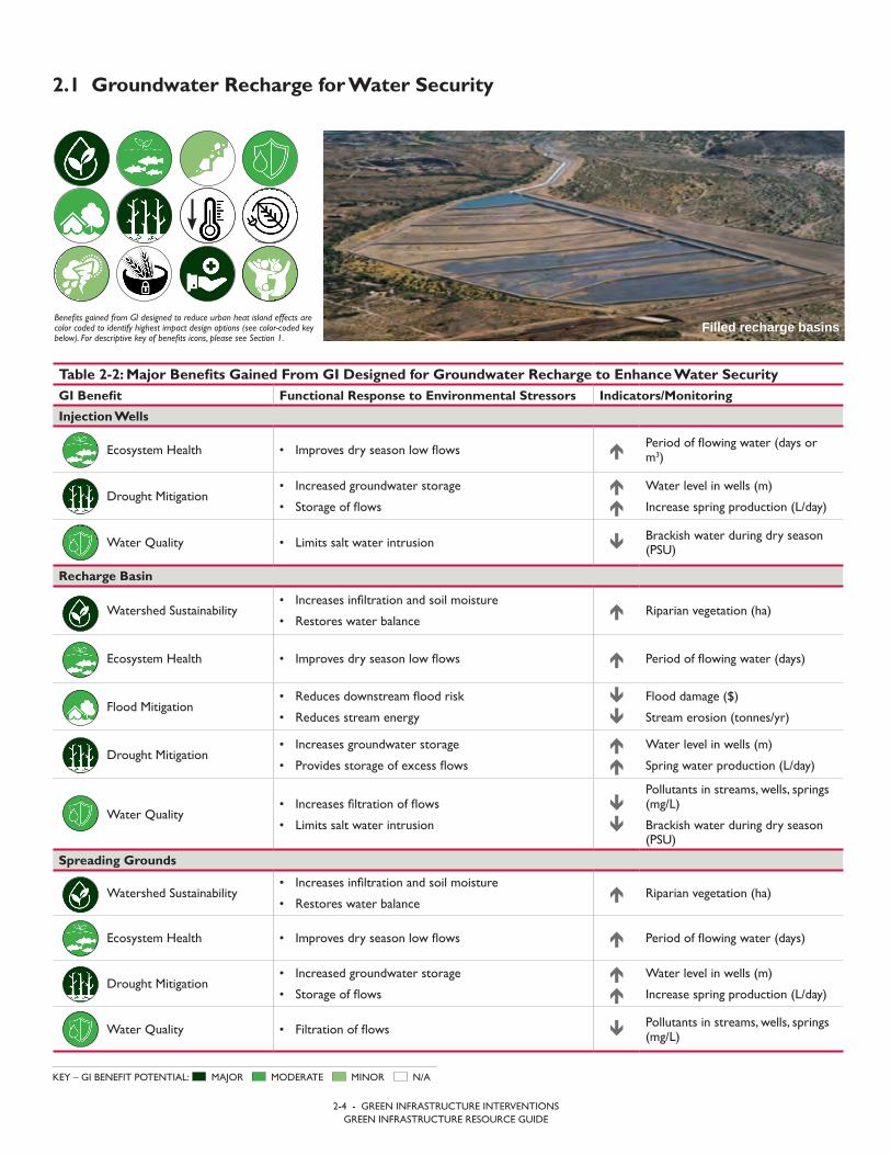
Within the scope of the GI definition provided above, this section presents the range of GI interventions included in this guide, organized by 11 major topics:
1. Groundwater recharge for water security
2. Water retention and detention for water supply andecosystem maintenance
3. Erosion control
4. Urban stormwater management
5. Rural flood mitigation
6. Pollution abatement
7. Drought resilience
8. Reduced urban heat island effects
9. Increased building energy efficiency
10. Food security
11. Managing soil and slope stabilization after wildfires.
For each topic, information is systematically organized into four sub-sections as follows:
SECTION 2
GREEN INFRASTRUCTURE INTERVENTIONS
Table 2-1: Summary Table of Green Infrastructure Engineering Designs Discussed in Section 2 GI Intervention Relevant Section(s) of this Document
Bio-Engineering 2.3 Erosion Control
Bioswale/Filter Strip/ Vegetated Swale 2.4 Urban Stormwater Management2.6 Pollution Abatement
Bridge/Culvert Mitigations 2.5 Rural Flood Mitigation
Buffer/Riparian Buffer 2.3 Erosion Control2.6 Pollution Abatement
Channel Migration Zone 2.3 Erosion Control2.5 Rural Flood Mitigation
Channel Restoration 2.3 Erosion Control and Shoreline Stabilization
Cisterns/Rain Barrels 2.2 Water Retention and Detention for Water Supply and Ecosystem Maintenance 2.4 Urban Stormwater Management2.7 Drought Resilience 2.9 Increased Building Energy Efficiency 2.10 Food Security
Conservation Tillage 2.3 Erosion Control 2.10 Food Security
Constructed Stormwater Wetlands 2.6 Pollution Abatement

2-3 - GREEN INFRASTRUCTURE INTERVENTIONSGREEN INFRASTRUCTURE RESOURCE GUIDE
Table 2-1: Summary Table of Green Infrastructure Engineering Designs Discussed in Section 2 GI Intervention Relevant Section(s) of this Document
Contour Farming / Terracing 2.3 Erosion Control2.7 Resilience to Drought2.11 Managing Soil and Slope Stabilization after Wildfires
Cover Crops 2.3 Erosion Control2.6 Pollution Abatement
Elevated Structures 2.5 Rural Flood Mitigation
Erosion Barriers - Waddles 2.11 Managing Soil and Slope Stabilization after Wildfires
Floodplain Roughness 2.5 Rural Flood Mitigation
Grass Strips 2.3 Erosion Control
Green Roofs/Vegetated Roofs 2.4 Urban Stormwater Management 2.8 Reduced Urban Heat Island Effects 2.9 Increased Building Energy Efficiency2.10 Food Security
Greywater Reuse 2.2 Water Retention and Detention for Water Supply and Ecosystem Maintenance
Headwater Channel 2.11 Managing Soil and Slope Stabilization after Wildfires
In-field Rainwater Harvesting 2.10 Food Security
Infiltration Trenches/Dry Wells 2.4 Urban Stormwater Management
Injection Wells 2.1 Groundwater Recharge for Water Security
Levee Removal/Setback 2.5 Rural Flood Mitigation
Mulching 2.11 Managing Soil and Slope Stabilization after Wildfires
Off Channel Storage 2.5 Rural Flood Mitigation
Permeable Surfaces 2.4 Urban Stormwater Management
Raingarden/Bioretention Basin 2.4 Urban Stormwater Management 2.6 Pollution Abatement
Recharge Basins 2.1 Groundwater Recharge for Water Security
Reflective Paints 2.8 Reduced Urban Heat Island Effects
Sand Filter 2.6 Pollution Abatement
Spreading Grounds 2.1 Groundwater Recharge for Water Security
Storage Ponds/Reservoirs/Dams 2.2 Water Retention and Detention for Water Supply and Ecosystem Maintenance
Treescaping 2.8 Reduced Urban Heat Island Effects
Urban Agriculture 2.10 Food Security
Water Storage/ Redundancy 2.7 Resilience to Drought
Wind Screens 2.3 Erosion Control 2.11 Managing Soil and Slope Stabilization after Wildfires
Xeriscaping 2.7 Resilience to Drought
2-4 - GREEN INFRASTRUCTURE INTERVENTIONSGREEN INFRASTRUCTURE RESOURCE GUIDE
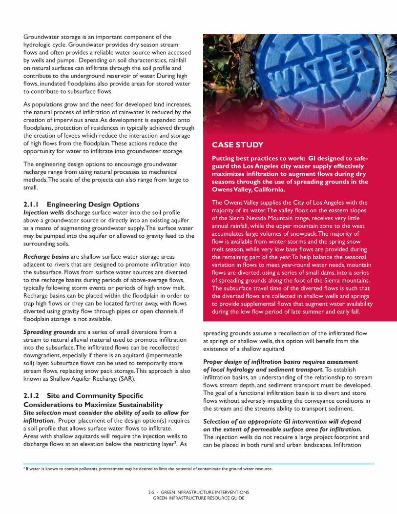
2.1 Groundwater Recharge for Water Security
Benefits gained from GI designed to reduce urban heat island effects are color coded to identify highest impact design options (see color-coded key below). For descriptive key of benefits icons, please see Section 1.
MAJOR MODERATE MINOR N/AKEY – GI BENEFIT POTENTIAL:
Filled recharge basins
Table 2-2: Major Benefits Gained From GI Designed for Groundwater Recharge to Enhance Water SecurityGI Benefit Functional Response to Environmental Stressors Indicators/Monitoring
Injection Wells
Ecosystem Health • Improves dry season low flows Period of flowing water (days orm3)
Drought Mitigation• Increased groundwater storage
• Storage of flows
Water level in wells (m)
Increase spring production (L/day)
Water Quality • Limits salt water intrusion Brackish water during dry season(PSU)
Recharge Basin
Watershed Sustainability• Increases infiltration and soil moisture
• Restores water balance Riparian vegetation (ha)
Ecosystem Health • Improves dry season low flows Period of flowing water (days)
Flood Mitigation• Reduces downstream flood risk
• Reduces stream energy
Flood damage ($)
Stream erosion (tonnes/yr)
Drought Mitigation• Increases groundwater storage
• Provides storage of excess flows
Water level in wells (m)
Spring water production (L/day)
Water Quality• Increases filtration of flows
• Limits salt water intrusion
Pollutants in streams, wells, springs (mg/L)
Brackish water during dry season (PSU)
Spreading Grounds
Watershed Sustainability• Increases infiltration and soil moisture
• Restores water balance Riparian vegetation (ha)
Ecosystem Health • Improves dry season low flows Period of flowing water (days)
Drought Mitigation• Increased groundwater storage
• Storage of flows
Water level in wells (m)
Increase spring production (L/day)
Water Quality • Filtration of flows Pollutants in streams, wells, springs(mg/L)
2-5 - GREEN INFRASTRUCTURE INTERVENTIONSGREEN INFRASTRUCTURE RESOURCE GUIDE
spreading grounds assume a recollection of the infiltrated flow at springs or shallow wells, this option will benefit from the existence of a shallow aquitard.
Proper design of infiltration basins requires assessment of local hydrology and sediment transport. To establish infiltration basins, an understanding of the relationship to stream flows, stream depth, and sediment transport must be developed. The goal of a functional infiltration basin is to divert and store flows without adversely impacting the conveyance conditions in the stream and the streams ability to transport sediment.
Selection of an appropriate GI intervention will depend on the extent of permeable surface area for infiltration. The injection wells do not require a large project footprint and can be placed in both rural and urban landscapes. Infiltration
Groundwater storage is an important component of the hydrologic cycle. Groundwater provides dry season stream flows and often provides a reliable water source when accessed by wells and pumps. Depending on soil characteristics, rainfall on natural surfaces can infiltrate through the soil profile and contribute to the underground reservoir of water. During high flows, inundated floodplains also provide areas for stored water to contribute to subsurface flows.
As populations grow and the need for developed land increases, the natural process of infiltration of rainwater is reduced by the creation of impervious areas. As development is expanded onto floodplains, protection of residences in typically achieved through the creation of levees which reduce the interaction and storage of high flows from the floodplain. These actions reduce the opportunity for water to infiltrate into groundwater storage.
The engineering design options to encourage groundwater recharge range from using natural processes to mechanical methods. The scale of the projects can also range from large to small.
2.1.1 Engineering Design Options Injection wells discharge surface water into the soil profile above a groundwater source or directly into an existing aquifer as a means of augmenting groundwater supply. The surface water may be pumped into the aquifer or allowed to gravity feed to the surrounding soils.
Recharge basins are shallow surface water storage areas adjacent to rivers that are designed to promote infiltration into the subsurface. Flows from surface water sources are diverted to the recharge basins during periods of above-average flows, typically following storm events or periods of high snow melt. Recharge basins can be placed within the floodplain in order to trap high flows or they can be located farther away, with flows diverted using gravity flow through pipes or open channels, if floodplain storage is not available.
Spreading grounds are a series of small diversions from a stream to natural alluvial material used to promote infiltration into the subsurface. The infiltrated flows can be recollected downgradient, especially if there is an aquitard (impermeable soil) layer. Subsurface flows can be used to temporarily store stream flows, replacing snow pack storage. This approach is also known as Shallow Aquifer Recharge (SAR).
2.1.2 Site and Community Specific Considerations to Maximize SustainabilitySite selection must consider the ability of soils to allow for infiltration. Proper placement of the design option(s) requires a soil profile that allows surface water flows to infiltrate. Areas with shallow aquitards will require the injection wells to discharge flows at an elevation below the restricting layer2. As
2 If water is known to contain pollutants, pretreatment may be desired to limit the potential of contaminate the ground water resource.
CASE STUDY
Putting best practices to work: GI designed to safe-guard the Los Angeles city water supply effectively maximizes infiltration to augment flows during dry seasons through the use of spreading grounds in the Owens Valley, California.
The Owens Valley supplies the City of Los Angeles with the majority of its water. The valley floor, on the eastern slopes of the Sierra Nevada Mountain range, receives very little annual rainfall, while the upper mountain zone to the west accumulates large volumes of snowpack. The majority of flow is available from winter storms and the spring snow melt season, while very low base flows are provided during the remaining part of the year. To help balance the seasonal variation in flows to meet year-round water needs, mountain flows are diverted, using a series of small dams, into a series of spreading grounds along the foot of the Sierra mountains. The subsurface travel time of the diverted flows is such that the diverted flows are collected in shallow wells and springs to provide supplemental flows that augment water availability during the low flow period of late summer and early fall.
2-6 - GREEN INFRASTRUCTURE INTERVENTIONSGREEN INFRASTRUCTURE RESOURCE GUIDE
2.1.4 Design, Evaluation, and Monitoring Resources• General ASR information related to background and purpose
has been prepared by the USEPA: www.epa.gov/uic/aquifer-recharge-and-aquifer-storage-and-recovery.
• The following flow chart presented by the State ofWashington Department of Ecology (WADOE) is modifiedfrom the original, Woody, J. (2007), A Preliminary Assessmentof Hydrogeologic Suitability for Aquifer Storage and Recovery(ASR) in Oregon, MS Thesis, Oregon State University. http://www.ecy.wa.gov/programs/wr/asr/images/pdf/ASRFlowChart.pdf.
• The WADOE Code 173-157 provides guidance oninformation the State requires for permitting ASR projects. The Information is background for planning, operating andmonitoring an ASR project. https://fortress.wa.gov/ecy/publications/documents/173157.pdf.
basins and spreading ground require large surface areas and are typically limited to rural landscapes.
The design of groundwater recharge systems should consider existing and future climatic conditions. Areas with anticipated decreases in mean annual precipitation may need to be prioritized for groundwater recharge interventions over other areas.
Communities must be prepared to regularly monitor the performance of the GI asset. These design options require regular inspection to evaluate and mitigate for accumulated sediments that may adversely impact infiltration rates.
2.1.3 Education and Awareness RaisingUnderstanding the benefits provided by natural floodplain function to groundwater recharge is vital to community protection of infiltration areas. Having the community understand the natural benefit of floodplain storage and the resulting increased groundwater recharge encourages the cooperation of the community in protecting the infiltration areas from encroachment of development and adverse land use changes.
Communities often require assistance in the development of GI operation and maintenance plans. For these options the community will need to maintain the diversion and conveyance structures. Typical issues involve accumulation of sediments that are left behind after infiltration. Incorporating vegetation into the design promotes root growth and soil porosity.
AEC
OM

2-7 - GREEN INFRASTRUCTURE INTERVENTIONSGREEN INFRASTRUCTURE RESOURCE GUIDE
2.2 Water Retention and Detention for Water Supply and Ecosystem Maintenance
Benefits gained from GI designed to reduce urban heat island effects are color coded to identify highest impact design options (see color-coded key below). For descriptive key of benefits icons, please see Section 1.
MAJOR MODERATE MINOR N/AKEY – GI BENEFIT POTENTIAL:
Typical residential cistern system
Table 2-3: Major Benefits Gained From GI Designed for Water Retention/Detention to Enhance Water SupplyGI Benefit Functional Response to Environmental Stressors Indicators/Monitoring
Cisterns
Watershed Sustainability • Reduces runoff entering streams
Vegetation (ha)
Crop Production (tonnes)
Localize stream erosion (tonnes/yr)
Flood Mitigation• Reduces downstream flood risk
• Reduces stream energy Flood damage ($)
Drought Mitigation• Retain precipitation for later use
• Minimizes surface water usage Cost for water ($)
Storage Ponds/Reservoir/Dams
Watershed Sustainability• Increases infiltration
• Reduces runoff entering streams
Vegetation (ha)
Crop Production (tonnes)
Downstream Flood Damage ($)
Ecosystem Health
• Improves dry season low flows
• Creates riparian habitat
• Enables aquaculture production
Period of flowing water (days)
Riparian edge habitat (ha)
Crop diversity (tonnes)
Flood Mitigation• Reduces downstream flood risk
• Reduces stream energy Flood damage ($)
Drought Mitigation• Retains precipitation for later use
• Minimizes surface water usage Cost for water ($)
Water Quality • Reduces suspended sediment Turbidity in streams (NTU)
Greywater Reuse
Drought Mitigation • Minimizes surface water usage Cost for water ($)
Water Quality • Reduces potential for pathogens in surface waterthrough reuse and irrigation/infiltration Stream water quality (mg/L)

2-8 - GREEN INFRASTRUCTURE INTERVENTIONSGREEN INFRASTRUCTURE RESOURCE GUIDE
Rainfall patterns and volume guide the design. For cisterns the storage volume is estimated based on impervious area, annual precipitation, and anticipated water consumption. The impact of climate change on future patterns of mean annual precipitation should also be taken into consideration. Emergency overflows are required to account for unexpected large storms during periods of reduced need.
Benefits of indoor plumbing include the potential for reuse. Greywater reuse assumes that wastewater from the residential of commercial site includes flows generated from showers, sinks and dishwaters. All of these sources imply the existence of indoor plumbing. The greywater systems can be on a single residence or applied to entire communities (buildings). The reuse can be internal for toilet use or stored and used as an irrigation source.
Low-tech options are easily adapted to meet emergency conditions. Both cisterns and detention storage are simple structures and typically do not require mechanical interventions and therefore can be quickly adapted to changing conditions related to water supply. Cisterns collecting water from roof and protected surfaces may require less treatment for providing potable water.
2.2.3 Education and Awareness RaisingReuse approaches need coincide with local customs. The concept of wastewater reuse needs to be discussed with communities to promote the idea as a safe alternative for water conservation.
Proper operation and maintenance will protect against downstream impacts. Storage ponds are a common practice globally. The knowledge of how ponds can adversely impact the natural processes in the community are not. To address knowledge gaps, an education program promoting responsible development, operation, and any downstream impacts of these facilities should be included in all development activities.
2.2.4 Design, Evaluation, and Monitoring Resources• Cistern information related to planning, design, and operation
can be found at: https://extension.psu.edu/rainwater-cisterns-design-construction-and-treatment.
• The steps for assessing Storage Pond feasibility and designcriteria as well as safety measures can be found at thislocation: http://irrigationnz.co.nz/practical-resources/irrigation-development/design-construction-irrigation-storage-ponds/.
• Greywater designs can vary based on proposed use ofgreywater and locations. There two references provide a goodfirst step in decision making and designing a greywater reusesystem:
– http://www.waterwise.co.za/export/sites/water-wise/gardening/water-your-garden/downloads/Greywater_pamphlet.pdf.
– http://sfwater.org/modules/showdocument.aspx?documentid=55.
On-site water storage is a small scale approach to reduce the impacts of land-use changes, including development and farming. The goal is to store increased surface water runoff at the source and then use it for beneficial purposes associated with local needs. The added benefit is that downstream impacts associated with land use changes, including flooding and channel erosion can be reduced. Since surface water is being stored for later use, these approaches also reduce the need to divert flows from streams or groundwater reservoirs providing for increased availability during low flow periods.
2.2.1 Engineering Design Options: Cisterns are an above/below ground reservoir used to store portable water or collect and store rainwater from rooftops/impervious surfaces. The collection system can be developed with a filtration system to allow for direct consumption of the collected water. Refer to Sections 2.4, 2.7, 2.9, and 2.10 for additional discussion of cisterns and rain barrels.
Storage ponds, reservoirs, and dams are surface water storage facilities designed to retain flows by constructing a dam across a stream or river. Alternatively, off-channel (or offline) storage diverts flows from the channel or surface water sources to constructed storage volume away from the source.
Greywater reuse involves the collection and reuse of any wastewater generated in households or office buildings from sources without fecal contamination. This limits the sources of greywater to sinks, showers, baths, clothes washing machines or dish washers. Greywater generally does not include wastewater containing fecal content and is therefore considered safer to handle and easier to treat and reuse onsite for toilet flushing, landscape or crop irrigation, and other non-potable uses.
2.2.2 Site and Community Specific Considerations to Maximize SustainabilityConsiderations for storage ponds site selection must include potential impacts on downstream watershed health. As storage ponds reduce flow velocities, pollutants settle out and sediment tends to accumulate. The sediment will require periodic removal to maintain storage capacity. Depending on the typical weather patterns one operational approach is to allow flow through operations during the wet season. This process provides natural stream energy to move sediment though the system, maintaining both dry season storage capacity in the reservoir as well as channel stability downstream. If the facility cannot be operated in this manner, then periodic removal of the accumulated sediment will be required to maintain storage volume.
Individual users of cisterns and greywater system will need to operate and maintain the facilities. Cisterns and greywater reuse are generally site specific or small scale and require owner provided operation and maintenance activities. It is important to design the system to meet the not only the storage needs but also be fabricated in a manner that uses locally available technology and materials.

Isto
ckph
oto.
com

2-10 - GREEN INFRASTRUCTURE INTERVENTIONSGREEN INFRASTRUCTURE RESOURCE GUIDE
2.3 Erosion Control
Benefits gained from GI designed to reduce urban heat island effects are color coded to identify highest impact design options (see color-coded key below). For descriptive key of benefits icons, please see Section 1.
MAJOR MODERATE MINOR N/AKEY – GI BENEFIT POTENTIAL:
Example of contour plowing incorporated into terrace farming
Table 2-4: Major Benefits Gained From GI Designed for Erosion ControlGI Benefit Functional Response to Environmental Stressors Indicators/Monitoring
Farming Practices
Sediment Stability• Maintains top soils
• Holds stream banks together
Crop Production (tonnes)
Streambank erosion (tonnes/yr)
Water Quality• Reduces sedimentation
• Reduces pollutant transport
Turbidity in streams (NTU)
Fertilizers in surface water (mg/L)
Food Security • Increased crop diversity and productio
Crop availability (tonnes)
Variety of crops (tonnes)
Bio-Engineering
Watershed Sustainability• Enables natural channel migration
• Replenishes nutrients and soil in floodplain
Increased moisture in hyporheiczone (mm/mm)
Crop Production (tonnes)
Ecosystem Health
• Improves dry season low flows
• Protects riparian habitat
• Protects aquatic habitat
Period of flowing water (days)
Riparian edge habitat (ha)
Aquatic diversity (# of species)
Sediment Stability• Maintains top soils
• Holds stream banks together Streambank erosion (tonnes/yr)
Water Quality• Reduces soil erosion
• Reduces pollutant transport Turbidity in streams (NTU)
Flood Mitigation
• Reduces frequency and intensity of downstreaminundation
• Reduces erosive stream energy
• Reduces flood damage
Flood damage ($)
Stream erosion (tonnes/yr)
2-11 - GREEN INFRASTRUCTURE INTERVENTIONSGREEN INFRASTRUCTURE RESOURCE GUIDE
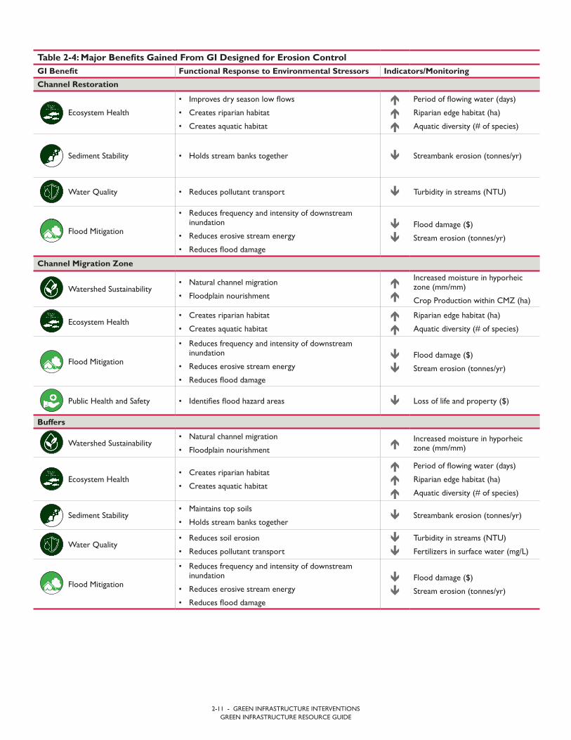
Table 2-4: Major Benefits Gained From GI Designed for Erosion ControlGI Benefit Functional Response to Environmental Stressors Indicators/Monitoring
Channel Restoration
Ecosystem Health
• Improves dry season low flows
• Creates riparian habitat
• Creates aquatic habitat
Period of flowing water (days)
Riparian edge habitat (ha)
Aquatic diversity (# of species)
Sediment Stability • Holds stream banks together Streambank erosion (tonnes/yr)
Water Quality • Reduces pollutant transport Turbidity in streams (NTU)
Flood Mitigation
• Reduces frequency and intensity of downstreaminundation
• Reduces erosive stream energy
• Reduces flood damage
Flood damage ($)
Stream erosion (tonnes/yr)
Channel Migration Zone
Watershed Sustainability• Natural channel migration
• Floodplain nourishment
Increased moisture in hyporheiczone (mm/mm)
Crop Production within CMZ (ha)
Ecosystem Health• Creates riparian habitat
• Creates aquatic habitat
Riparian edge habitat (ha)
Aquatic diversity (# of species)
Flood Mitigation
• Reduces frequency and intensity of downstreaminundation
• Reduces erosive stream energy
• Reduces flood damage
Flood damage ($)
Stream erosion (tonnes/yr)
Public Health and Safety • Identifies flood hazard areas Loss of life and property ($)
Buffers
Watershed Sustainability• Natural channel migration
• Floodplain nourishment Increased moisture in hyporheic
zone (mm/mm)
Ecosystem Health• Creates riparian habitat
• Creates aquatic habitat
Period of flowing water (days)
Riparian edge habitat (ha)
Aquatic diversity (# of species)
Sediment Stability• Maintains top soils
• Holds stream banks together Streambank erosion (tonnes/yr)
Water Quality• Reduces soil erosion
• Reduces pollutant transport
Turbidity in streams (NTU)
Fertilizers in surface water (mg/L)
Flood Mitigation
• Reduces frequency and intensity of downstreaminundation
• Reduces erosive stream energy
• Reduces flood damage
Flood damage ($)
Stream erosion (tonnes/yr)

2-12 - GREEN INFRASTRUCTURE INTERVENTIONSGREEN INFRASTRUCTURE RESOURCE GUIDE
Channel restoration is an approach designed to reduce the erosive forces acting within a stream/river. The design elements are used to promote floodplain storage, limit stream bank erosion, and promote sediment transport through an impacted stream reach. Channel restoration is similar to bio-engineering approaches, but the materials used may include rock structures or other non-native materials. Approaches include:
• In-channel structures – Placing woody debris and rocks intothe active channel
• Secondary channels – Reactiviate historic secondary channelsfor high flow relief and habitat expansion.
Channel migration zone (CMZ) is defined as the area within which a river channel can be expected to shift or migrate over time due to hydrologically and geomorphologically related processes. Establishing and maintaining the CMZ promotes natural watershed functions related to flood storage, soil nutrient replenishment and habitat. Refer to Section 2.5 for additional information about CMZ.
Buffers are a strip of vegetation that acts as a barrier between different land uses or ecosystem types. Riparian buffers lie adjacent to streams. Trees, shrubs, and grass that are planted around agricultural fields can absorb and filter nutrients, reducing the nutrients, bacteria, chemicals, and other pollutants that reach water bodies. Riparian buffers along water bodies are especially important to maintaining water quality, stream temperature, migration corridors and habitat. Refer to Section 2.6 for additional information about buffers.
2.3.2 Site and Community Specific Considerations to Maximize Sustainability After multiple occurrences of catastrophic flooding along rivers communities are recognizing the importance of providing regulated areas so rivers can function naturally with reduced adverse impacts to developed areas. A delineated channel migration zone allows a community to protect vital natural resources (river/stream) while also providing regulatory guidance on beneficial uses within the CMZ, such as farming or recreation. This approach increases the safety of the community from damaging floods while also protecting valuable fertile soils for agriculture.
Protecting flood prone areas from development now will reduce future damage. CMZ delineation typically occurs in undeveloped areas so there is little impact to existing structures and infrastructure. If the CMZ is being delineated in an urban environment, it can be expected that there will be displacement of existing residences but this will result in less potential hazard risks.
Erosion is a natural process that shapes the landscape as wind or water transports soil from one location to another. As land is converted from natural space to urban or farming it is important to address how this impacts erosion and subsequent deposition, both on land surfaces as well as in rivers and streams. The GI elements designed to limit surface erosion are directed to keep farming land productive. Elements for shores and streams are designed to reduce bank erosion while promoting the natural transport of sediment.
Design options for addressing erosion should not focus on eliminating the process, but rather on maintaining or replicating the natural erosion rates that formed the land over time. Typically the best options are those that reproduce natural processes, known as bio-mimicry, while allowing for increased productivity of the land.
2.3.1 Engineering Design Options: Sustainable farming practices protect against the loss of top soil, maintaining productive farmlands and keeping top soil from eroding and contributing to increased water pollution. Most approaches focus on restricting the energy from the two major sources of soil erosion, flowing water and wind. Refer to sections 2.6, 2.7, 2.10, and 2.11 for additional discussion of agricultural practices. Typical approaches include:
• Contour plowing - where the plow alignment follows thenatural terrain
• Cover crops – secondary ground cover crops that protect thesoil
• Wind screens – low screen that disrupt wind velocity
• Grass strips – vegetation grown perpendicular the terrain toreduce surface flow potential
• Terrace Farming – grading sloped land to a series of levelsections.
Bio-engineering is the use of natural processes, materials and biomimicry (i.e., imitation of the models, systems, and elements of nature) to restore or maintain the natural or man-made environment. Bio-engineering has applications in both the terrestrial and aquatic environments with the goal of reducing soil erosion due to wind and water. Approaches include:
• Reforestation – Restoring the landscape using nativevegetation.
• Streambank protection – Using living vegetation to protectedagainst stream bank erosion.
• Floodplain restoration – Allowing flood inundation of historicfloodplains.

2-13 - GREEN INFRASTRUCTURE INTERVENTIONSGREEN INFRASTRUCTURE RESOURCE GUIDE
2.3.3 Education and Awareness RaisingSustainable farming practices need to be directed by local needs. When implementing farming practices, it is important to work with the community to determine crops that are culturally significant. This includes selection of cover crops as well and material for wind screens. The selection of native vegetation as well as crops that provide viable incomes will ensure the long term use of the practice.
Aligning societal needs and natural ecosystem functions leads to sustainability. Working with the community to redevelop the historic relationship between societies and the environment on which they depend is important. The community must recognize the benefit of restoration and protecting the resources within the riverine environment and how these resources shaped the region. Working with and not against natural forces promotes a sustainable, viable community.
2.3.4 Design, Evaluation, and Monitoring Resources• The Natural Resources Conservation Service (NRCS)
provides guidance on many topics. The following link providesin-depth guidance on restoring stream health and habitat. https://www.nrcs.usda.gov/wps/portal/nrcs/main/national/water/manage/restoration/.
• NRCS farming practices guidance informs users on methodsto improve farming production and save top soil the Stateof Washington also provides similar approaches and designcriteria above and beyond the options suggested. https://www.nrcs.usda.gov/wps/portal/nrcs/detailfull/national/technical/cp/ncps/?cid=nrcs143_026849.
• The State of Washington prepared linked document as aframework for delineating the CMZ https://fortress.wa.gov/ecy/publications/summarypages/0306027.html.
The balance between wind protection and usable agricultural acreage needs to be balanced. Wind barrier height needs to be controlled so as to not reduce sunlight on the agricultural area. Selecting vegetation with limited growth height is preferred to continuous pruning.
Preserving soil and adding nutrients promote long term crop health. Cover crop selection can focus on growing a marketable crop, typically a less valuable crop or it can include a crop that repairs and re-nourishes the soil.
Stream restoration approaches provide multiple benefits. As the design options focus on bio-mimicry they should also focus also on improving habitat for a diverse array of terrestrial and aquatic species. Improving the diversity of the natural food web will provide for increased bio-diversity.
Consider long term safety before inhabiting the CMZ. As the channel migration zone is a broad flat open area adjacent to the river, it is an attractive resource when needing to provide useable land for increasing populations. Habitation in the CMZ should only be considered temporary as the zone has the potential to flood and change flow courses within single high flow events. Increased development, even if temporary, needs to mitigate for these potential hazards.
The design of erosion control systems should consider existing and future climatic conditions. In areas where the volume and/or frequency of storm events are projected to increase, systems should be designed to accommodate higher water velocities with more intense storms, thereby increasing water’s erosive power.
DeN
atal
e, A
ECO
M
2-15 - GREEN INFRASTRUCTURE INTERVENTIONSGREEN INFRASTRUCTURE RESOURCE GUIDE
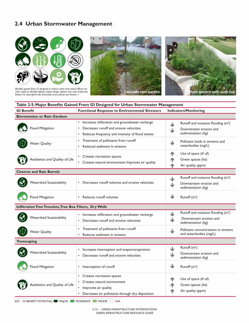
2.4 Urban Stormwater Management
Benefits gained from GI designed to reduce urban heat island effects are color coded to identify highest impact design options (see color-coded key below). For descriptive key of benefits icons, please see Section 1.
MAJOR MODERATE MINOR N/AKEY – GI BENEFIT POTENTIAL:
Rain garden with curb cut
Table 2-5: Major Benefits Gained From GI Designed for Urban Stormwater ManagementGI Benefit Functional Response to Environmental Stressors Indicators/Monitoring
Bioretention or Rain Gardens
Flood Mitigation
• Increases infiltration and groundwater recharge
• Decreases runoff and erosive velocities
• Reduces frequency and intensity of flood events
Runoff and nuisance flooding (m3)
Downstream erosion andsedimentation (kg)
Water Quality• Treatment of pollutants from runoff
• Reduced sediment in streams Pollutant loads in streams and
waterbodies (mg/L)
Aesthetics and Quality of Life• Creates recreation spaces
• Creates natural environment Improves air quality
Use of space (# of)
Green spaces (ha)
Air quality (ppm)
Cisterns and Rain Barrels
Watershed Sustainability • Decreases runoff volumes and erosive velocities
Runoff and nuisance flooding (m3)
Downstream erosion andsedimentation (kg)
Flood Mitigation • Reduces runoff volumes Runoff (m3)
Infiltration Tree Trenches, Tree Box Filters, Dry Wells
Watershed Sustainability• Increases infiltration and groundwater recharge
• Decreases runoff and erosive velocities
Runoff and nuisance flooding (m3)
Downstream erosion andsedimentation (kg)
Water Quality• Treatment of pollutants from runoff
• Reduces sediment in streams Pollutant concentrations in streams
and waterbodies (mg/L)
Treescaping
Watershed Sustainability• Increases interception and evapotranspiration
• Decreases runoff and erosive velocities
Runoff (m3)
Downstream erosion andsedimentation (kg)
Flood Mitigation • Interception of runoff Runoff (m3)
Aesthetics and Quality of Life
• Creates recreation spaces
• Creates natural environment
• Improves air quality
• Decreases air pollutants through dry deposition
Use of space (# of)
Green spaces (ha)
Air quality (ppm)
Cascade rain garden
2-16 - GREEN INFRASTRUCTURE INTERVENTIONSGREEN INFRASTRUCTURE RESOURCE GUIDE
Table 2-5: Major Benefits Gained From GI Designed for Urban Stormwater ManagementGI Benefit Functional Response to Environmental Stressors Indicators/Monitoring
Green Roofs
Watershed Sustainability• Potential reuse of water in the grey water system
• Decreases runoff and erosive velocities
Runoff (m3)
Downstream erosion andsedimentation (kg)
Aesthetics and Quality of Life• Creates natural environment
• Potential urban agriculture
Green spaces (ha)
Available soil for cultivation (m2)
Ecosystem Health
• Reduces nuisance flooding
• Improves air quality
• Decreases pollutants
Runoff (m3)
Air quality (ppm)
Pollutant loads (mg/L)
Permeable Pavements
Watershed Sustainability• Increases infiltration
• Decreases runoff and erosive velocities
Runoff and nuisance flooding (m3)
Downstream erosion andsedimentation (kg)
Water Quality• Treatment of pollutants from runoff
• Reduces sediment in streams Pollutant loads in streams and
waterbodies (mg/L)
Flood Mitigation• Reduces runoff volumes
• Reduces flooding risks
Runoff volume (m3)
Runoff peak flows (m3/s)
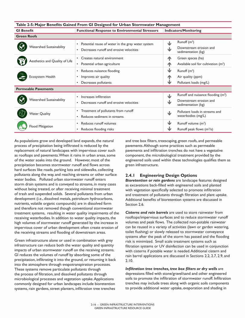
and tree box filters, treescaping, green roofs, and permeable pavements. Although some practices such as permeable pavements and infiltration trenches do not have a vegetative component, the microbiological treatment provided by the engineered soils used within these technologies qualifies them as green infrastructure.
2.4.1 Engineering Design Options Bioretention or rain gardens are landscape features designed as excavations back-filled with engineered soils and planted with vegetation specifically selected to promote infiltration and treatment of pollutants through filtration and plant uptake. Additional benefits of bioretention systems are discussed in Section 2.6.
Cisterns and rain barrels are used to store rainwater from rooftops/impervious surfaces and to reduce stormwater runoff volumes and peak flows. The collected non-potable rainwater can be reused in a variety of activities (lawn or garden watering, toilet flushing) or slowly released to stormwater conveyance systems after the peak of the storm has passed and the flooding risk is minimized. Small scale treatment systems such as filtration systems or UV disinfection can be used in conjunction with cisterns if potable water is needed. Additional cistern and rain barrel applications are discussed in Sections 2.2, 2.7, 2.9, and 2.10.
Infiltration tree trenches, tree box filters or dry wells are depressions filled with stone/gravel/sand and other engineered soils to promote the infiltration of stormwater runoff. Infiltration trenches may include trees along with organic soils components to provide additional water uptake, evaporation and shading in
As populations grow and developed land expands, the natural process of precipitation being infiltrated is reduced by the replacement of natural landscapes with impervious cover such as rooftops and pavements. When it rains in urban areas, some of the water soaks into the ground. However, most of the precipitation becomes stormwater runoff and flows across hard surfaces like roads, parking lots and sidewalks, collecting pollutants along the way, and reaching streams or other surface water bodies. Polluted urban stormwater runoff enters storm drain systems and is conveyed to streams, in many cases without being treated, or after receiving minimal treatment of trash and suspended solids. Several pollutants from urban development (i.e., dissolved metals, petroleum hydrocarbons, nutrients, volatile organic compounds) are in dissolved form and therefore not removed though conventional stormwater treatment systems, resulting in water quality impairments of the receiving waterbodies. In addition to water quality impacts, the high volumes of stormwater runoff generated by the increase in impervious cover of urban development often create erosion of the receiving streams and flooding of downstream areas.
Green infrastructure alone or used in combination with grey infrastructure can reduce both the water quality and quantity impacts of urban stormwater runoff on the receiving streams. GI reduces the volumes of runoff by absorbing some of the precipitation, infiltrating it into the ground, or returning it back into the atmosphere through evapotranspiration processes. These systems remove particulate pollutants through the process of filtration, and dissolved pollutants through microbiological processes and vegetation uptake. Applications commonly designed for urban landscapes include bioretention systems, rain gardens, street planters, infiltration tree trenches

2-17 - GREEN INFRASTRUCTURE INTERVENTIONSGREEN INFRASTRUCTURE RESOURCE GUIDE
Additional design considerations for GI design for urban landscapes include:
• In areas with clay soils, bioretention facilities are designedwith underdrain systems so that the initial first flush ofrunoff is treated before it is directed into the stormwaterconveyance system. Although stormwater volume reductionis not provided due to low infiltration rate of clay soils belowthe systems, this design provides water treatment and waterquality benefits, and may provide additional benefits associatedwith vegetation in an urban setting.
the urban landscapes, or can be design without vegetation, only to promote stormwater volume reduction through groundwater recharge.
Treescaping is the strategic planting of trees or vegetative canopies to increase shading and intercept rainwater before it contacts the ground. Trees with dense canopies can retain significant volumes of precipitations that would otherwise become stormwater runoff.
Green roofs or vegetated roofs are roof systems comprised of vegetation along with the supporting growing media (topsoil or lightweight aggregates). Green roofs can reduce runoff by providing temporary storage in the pore space of the growing media and through evapotranspiration processes. Green roofs are often purchased as prefabricated modular panels, but can also be custom designed for roofs with irregular geometries.
Permeable pavements are specially designed hard surfaces that allow stormwater runoff to pass through the pavement material to the soil beneath. Materials used for permeable surfaces include pervious asphalt and concrete, interlocking pavers, and plastic grid pavers filled with porous materials such as gravels or organic soils. Permeable pavements are often installed in green streets and alleys, parking lots, driveways, and sidewalks that experience relatively low traffic and light weight vehicles or pedestrian traffic, but are not commonly used for roads and highways that serve high traffic volumes and heavy loads.
2.4.2 Site and Community Specific Considerations to Maximize SustainabilitySite selection must consider existing infrastructure and utilities. Open spaces in urban areas are typically occupied by underground or over ground infrastructure serving a variety of needs. Green infrastructure must avoid, or be built around the existing infrastructure. Some utilities can be avoided or relocated, while others may be integrated into the GI design.
Selection of appropriate green infrastructure techniques depends on the stormwater management goals. When runoff volume reduction is the goal, techniques that promote infiltration and/or temporary retention such as permeable pavements, infiltration trenches and cisterns are preferred. If water quality improvement and removal of dissolved pollutants are the main goals, then green infrastructure techniques that provide filtration and biological and vegetative treatment (e.g., biotretention systems, tree trenches) will be more effective.
Communities must be prepared to perform regular maintenance on green infrastructure practices. In some cases, GI is implemented on private properties rather than on public land, and the owners are responsible for maintenance and operation of the stormwater practices. If green infrastructure practices are not maintained, they may not function as designed and may diminish their effectiveness overtime. Maintenance ensures that stormwater runoff will be managed, treated, infiltrated or filtered to meet the targeted goals of the design.
CASE STUDY
PUTTING GI TO WORK.
In areas with clay soils, bioretention facilities are designed with an underdrain system so that first flush of runoff is treated and the underdrain system can pass higher flows to the existing storm drain system. In the Midwest, bioretention facilities have been used in combination with underground storage vaults so that higher amounts of runoff can be stored and slowly released, but the community can also have the benefits associated with vegetation in an urban setting. Many vegetated practices can be used within road rights-of-way, which can help with traffic calming and pedestrian safety. When designing vegetated practices, select plants that are native to the specific area and tolerant to the level of mois-ture in the practice. In areas with good soil infiltration rates, but limited space, permeable pavements can be used over infiltration trenches to promote increased infiltration. These types of treatments have been used in parking lanes along roadways and sidewalk rights-of-way where space is limited for vegetated solutions. This practice has also been successful in right-of-way areas where the surrounding area has many utility conflicts, both underground and aboveground.
2.4.3 Education and Awareness RaisingCommunity education in maintaining and operating of Green Infrastructure. Green infrastructure technologies are relatively new techniques that are new to the public. As many GI technologies are installed on private properties, the public needs to be educated on the operation of these technologies. Typical issues the public needs to be aware of, include accumulation of sediments and trash that may impede the water flow to infiltration practices, emptying cisterns and rain barrels between storm events, pruning and weeding vegetated areas, ensuring that plants are well established in the first year of installation, and the prohibition of pavement coatings on impermeable pavements.
2.4.4 Design, Evaluation, and Monitoring Resources• Communities across the United States, from Washington
D.C. to San Francisco, have developed green infrastructuredesign standards and guidance for their specific region. USEPA provides a wide array of design information, greeninfrastructure effectiveness data, case studies, cost estimatesand GI model ordinances that are transferable to othercommunities and geographic areas: https://www.epa.gov/green-infrastructure. Several European nations have alsodeveloped guidance for urban green infrastructure systemsand practices: http://ec.europa.eu/environment/nature/ecosystems/index_en.htm.
• US EPA in collaboration with other federal agencies andregulatory agencies (WERF, FHA, EWRI), has compilednationwide green infrastructure effectiveness data in theInternational BMP Database: http://www.bmpdatabase.org/cbay.html.
• When groundwater recharge is not desired (close proximityto basements, contaminated soils, karst conditions, or sensitiveunderground infrastructure) bioretention systems can be linedwith impermeable membranes or soils with minimal hydraulicconductivities.
• Bioretention facilities may be used in combination withunderground storage vaults that allow higher amounts ofrunoff to be treated, stored, and slowly released overtimethan with bioretention soils alone.
• Vegetated practices such as raingardens, tree trenches, and tree box filters can be used within the road right-of-way to provide the added benefit of traffic calming andpedestrian safety. When designing vegetated practices, plantselection should consider native species and vegetation thatcan tolerate the level of moisture expected in the greeninfrastructure practice.
• In areas with relatively high soil infiltration rates, but limitedspace, green infrastructure practices with small footprint andability to receive larger drainage areas (such as permeablepavements and tree trenches) can be used instead ofvegetated systems. For example, permeable pavementshave been successfully implemented in parking lanes alongroadways and for sidewalks where vegetated solutions wouldnot be possible.
Wik
iped
ia
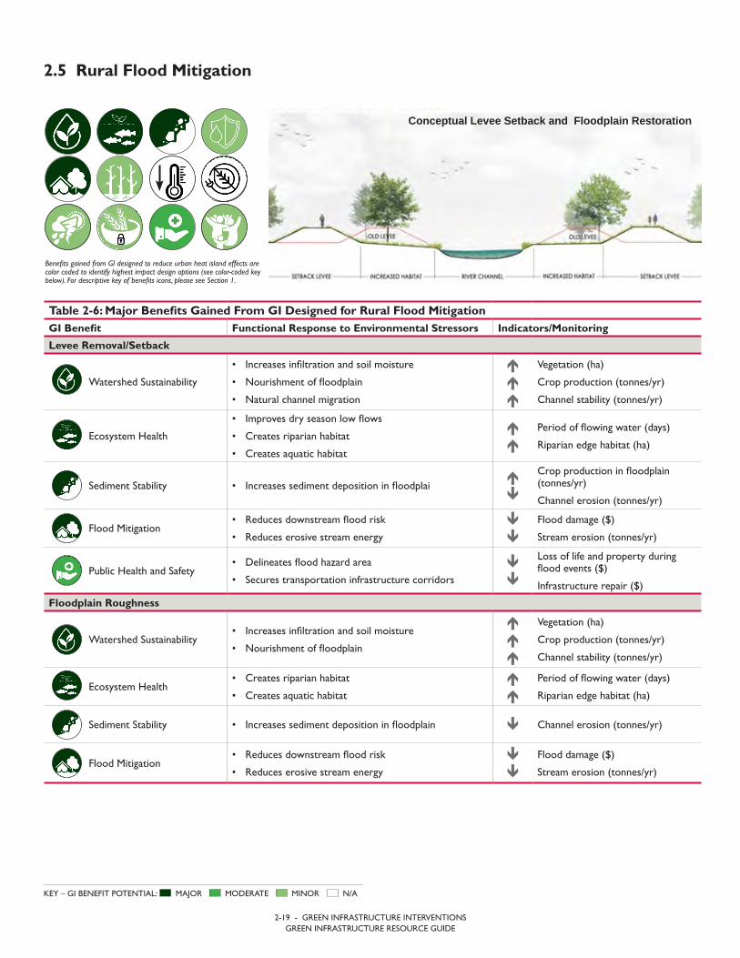
2-19 - GREEN INFRASTRUCTURE INTERVENTIONSGREEN INFRASTRUCTURE RESOURCE GUIDE
2.5 Rural Flood Mitigation
Benefits gained from GI designed to reduce urban heat island effects are color coded to identify highest impact design options (see color-coded key below). For descriptive key of benefits icons, please see Section 1.
MAJOR MODERATE MINOR N/AKEY – GI BENEFIT POTENTIAL:
Conceptual Levee Setback and Floodplain Restoration
Table 2-6: Major Benefits Gained From GI Designed for Rural Flood MitigationGI Benefit Functional Response to Environmental Stressors Indicators/Monitoring
Levee Removal/Setback
Watershed Sustainability
• Increases infiltration and soil moisture
• Nourishment of floodplain
• Natural channel migration
Vegetation (ha)
Crop production (tonnes/yr)
Channel stability (tonnes/yr)
Ecosystem Health
• Improves dry season low flows
• Creates riparian habitat
• Creates aquatic habitat
Period of flowing water (days)
Riparian edge habitat (ha)
Sediment Stability • Increases sediment deposition in floodplai
Crop production in floodplain (tonnes/yr)
Channel erosion (tonnes/yr)
Flood Mitigation• Reduces downstream flood risk
• Reduces erosive stream energy
Flood damage ($)
Stream erosion (tonnes/yr)
Public Health and Safety• Delineates flood hazard area
• Secures transportation infrastructure corridors
Loss of life and property duringflood events ($)
Infrastructure repair ($)
Floodplain Roughness
Watershed Sustainability• Increases infiltration and soil moisture
• Nourishment of floodplain
Vegetation (ha)
Crop production (tonnes/yr)
Channel stability (tonnes/yr)
Ecosystem Health• Creates riparian habitat
• Creates aquatic habitat
Period of flowing water (days)
Riparian edge habitat (ha)
Sediment Stability • Increases sediment deposition in floodplain Channel erosion (tonnes/yr)
Flood Mitigation• Reduces downstream flood risk
• Reduces erosive stream energy
Flood damage ($)
Stream erosion (tonnes/yr)

2-20 - GREEN INFRASTRUCTURE INTERVENTIONSGREEN INFRASTRUCTURE RESOURCE GUIDE
Table 2-6: Major Benefits Gained From GI Designed for Rural Flood MitigationGI Benefit Functional Response to Environmental Stressors Indicators/Monitoring
Off-Channel Storage
Watershed Sustainability• Increases infiltration and soil moisture
• Nourishment of floodplain
Vegetation (ha)
Crop production (tonnes/yr)
Channel stability (tonnes/yr)
Ecosystem Health
• Improves dry season low flows
• Creates riparian habitat
• Creates aquatic habitat
Period of flowing water (days)
Riparian edge habitat (ha)
Sediment Stability • Increases sediment deposition in floodplain
Crop production in floodplain (tonnes/yr)
Channel erosion (tonnes/yr)
Flood Mitigation• Reduces downstream flood risk
• Reduces erosive stream energy
Flood damage ($)
Stream erosion (tonnes/yr)
Bridge and Culvert Mitigations
Flood Mitigation• Reduces downstream flood risk
• Reduces erosive stream energy
Flood damage ($)
Stream erosion (tonnes/yr)
Public Health and Safety• Delineates flood hazard area
• Secures transportation infrastructure corridors
Loss of life and property duringflood events ($)
Infrastructure repair ($)
Elevated Structures
Flood Mitigation • Reduces flood risk Flood damage to structures ($)
Public Health and Safety• Delineates flood hazard area
• Secures transportation infrastructure corridors
Loss of life and property duringflood events ($)
Infrastructure repair ($)
Channel Migration Zone
Watershed Sustainability• Natural channel migration
• Floodplain nourishment
Increased moisture in hyporheic zone (mm/mm)
Crop Production within CMZ (tonnes/yr)
Ecosystem Health• Creates riparian habitat
• Creates aquatic habitat
Riparian edge habitat (ha)
Aquatic diversity (# of species)
Flood Mitigation
• Reduces downstream flood risk
• Reduces erosive stream energy
• Reduces flood damage
Flood damage ($)
Stream erosion (tonnes/yr)
Public Health and Safety • Delineates flood hazard area Loss of life and property ($)
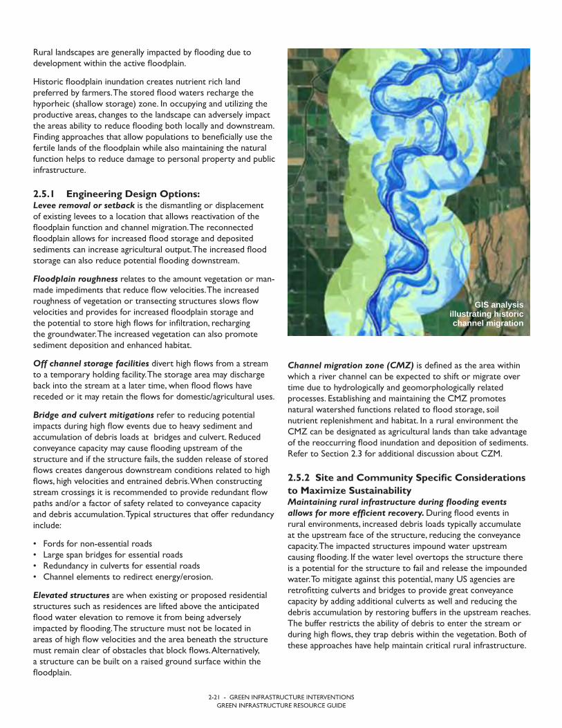
2-21 - GREEN INFRASTRUCTURE INTERVENTIONSGREEN INFRASTRUCTURE RESOURCE GUIDE
Channel migration zone (CMZ) is defined as the area within which a river channel can be expected to shift or migrate over time due to hydrologically and geomorphologically related processes. Establishing and maintaining the CMZ promotes natural watershed functions related to flood storage, soil nutrient replenishment and habitat. In a rural environment the CMZ can be designated as agricultural lands than take advantage of the reoccurring flood inundation and deposition of sediments. Refer to Section 2.3 for additional discussion about CZM.
2.5.2 Site and Community Specific Considerations to Maximize SustainabilityMaintaining rural infrastructure during flooding events allows for more efficient recovery. During flood events in rural environments, increased debris loads typically accumulate at the upstream face of the structure, reducing the conveyance capacity. The impacted structures impound water upstream causing flooding. If the water level overtops the structure there is a potential for the structure to fail and release the impounded water. To mitigate against this potential, many US agencies are retrofitting culverts and bridges to provide great conveyance capacity by adding additional culverts as well and reducing the debris accumulation by restoring buffers in the upstream reaches. The buffer restricts the ability of debris to enter the stream or during high flows, they trap debris within the vegetation. Both of these approaches have help maintain critical rural infrastructure.
Rural landscapes are generally impacted by flooding due to development within the active floodplain.
Historic floodplain inundation creates nutrient rich land preferred by farmers. The stored flood waters recharge the hyporheic (shallow storage) zone. In occupying and utilizing the productive areas, changes to the landscape can adversely impact the areas ability to reduce flooding both locally and downstream. Finding approaches that allow populations to beneficially use the fertile lands of the floodplain while also maintaining the natural function helps to reduce damage to personal property and public infrastructure.
2.5.1 Engineering Design Options: Levee removal or setback is the dismantling or displacement of existing levees to a location that allows reactivation of the floodplain function and channel migration. The reconnected floodplain allows for increased flood storage and deposited sediments can increase agricultural output. The increased flood storage can also reduce potential flooding downstream.
Floodplain roughness relates to the amount vegetation or man-made impediments that reduce flow velocities. The increased roughness of vegetation or transecting structures slows flow velocities and provides for increased floodplain storage and the potential to store high flows for infiltration, recharging the groundwater. The increased vegetation can also promote sediment deposition and enhanced habitat.
Off channel storage facilities divert high flows from a stream to a temporary holding facility. The storage area may discharge back into the stream at a later time, when flood flows have receded or it may retain the flows for domestic/agricultural uses.
Bridge and culvert mitigations refer to reducing potential impacts during high flow events due to heavy sediment and accumulation of debris loads at bridges and culvert. Reduced conveyance capacity may cause flooding upstream of the structure and if the structure fails, the sudden release of stored flows creates dangerous downstream conditions related to high flows, high velocities and entrained debris. When constructing stream crossings it is recommended to provide redundant flow paths and/or a factor of safety related to conveyance capacity and debris accumulation. Typical structures that offer redundancy include:
• Fords for non-essential roads• Large span bridges for essential roads• Redundancy in culverts for essential roads• Channel elements to redirect energy/erosion.
Elevated structures are when existing or proposed residential structures such as residences are lifted above the anticipated flood water elevation to remove it from being adversely impacted by flooding. The structure must not be located in areas of high flow velocities and the area beneath the structure must remain clear of obstacles that block flows. Alternatively, a structure can be built on a raised ground surface within the floodplain.
GIS analysis illustrating historic channel migration
2-22 - GREEN INFRASTRUCTURE INTERVENTIONSGREEN INFRASTRUCTURE RESOURCE GUIDE
2.5.3 Education and Awareness RaisingWorking with the community to build an understanding of the relationship between flooding and land use is an important first step. Knowingly reducing natural flood storage may result in adverse impacts downstream. Community involvement will assist in guiding how the rural community regulates the use of the land.
It is equally important for the engineering options to work in conjunction with the needs of the community to provide mutual benefits for the nature and the affected population. Education of how natural functions like flooding can help to restore the fertile lands needs to be part of all conversations so that rural communities can work with nature and not against it.
2.5.4 Design, Evaluation, and Monitoring Resources• The State of Washington prepared linked document as a
framework for delineating the CMZ. The CMZ delineationcan also be used assist in the potential locations for leveeremoval or setback project. https://fortress.wa.gov/ecy/publications/summarypages/0306027.html.
• Floodplain roughness, reconnection and restoration aredescribed in this document. Included are helpful tools todefining impact floodplains and the importance a functioningfloodplain plays. This information can help identify locationsthat will benefit from restoring floodplains.
• http://s3.amazonaws.com/american-rivers-website/wp-content/uploads/2016/06/17194413/ReconnectingFloodplains_WP_Final.pdf.
• The steps for assessing off channel storage feasibility anddesign criteria as well as safety measures can be found at thislocation: http://irrigationnz.co.nz/practical-resources/irrigation-development/design-construction-irrigation-storage-ponds/.
• FEMA provides detailed information on flood proofingstructures include the determination of flood heights andhydrostatic pressures. https://www.fema.gov/media-library-data/643d07bceee8ade17eef8e11cf7a2abb/P-936_sec2_508.pdf.
• FEMA also provides the following link for elevating structuresabove the flood zone. This document is more general incontent, referring to other documents for more detailscriteria.
• https://www.fema.gov/media-library-data/20130726-1609-20490-7375/fema551_ch_08.pdf.
Limitations on the type of development in flood hazard areas reduce potential damages. CMZ delineation typically occurs in undeveloped and rural areas. The creation of a CMZ in an urban environment typically requires the displacement of existing residences in an effort to limit potential hazard risks.
Protecting structures in flood prone areas sometimes requires thinking “up”. Elevated structures should be located in flood prone areas experiencing lower flow velocity, since accumulated debris and high flow velocities exert erosive forces on supporting structures. Placing the structure on elevated soil can limit the potential of debris accumulation.
Maintained floodplains provide protections to both local and downstream communities. Floodplain roughness and off channel storage rely on available area adjacent or near the potential flooding sources. To provide the benefits, the area must remain or be restored to a natural condition, including the possible removal of structures.
Rural infrastructure protection ensures more rapid recovery. Bridge and culvert mitigations require an understanding of the site conditions related to a hydrologic and hydraulic analysis and debris potential. The culverts, bridges, and overflow paths are sized based on anticipated peak flows and volume of debris that needs to be conveyed through or over the structures.
Placement of large populations is limited by the capacity to provide services. Less population density and open floodplains provide emergency opportunities to house displaced populations. Due to limited infrastructure and other resources associated with the rural setting, utilizing the floodplains as the location for temporary housing subjects the population to additional hazards with little available emergency access.
The design of all systems should consider existing and future climatic conditions. In areas where the volume and/or frequency of storm events are projected to increase, systems should be designed to accommodate additional water or more intense or frequent floods.
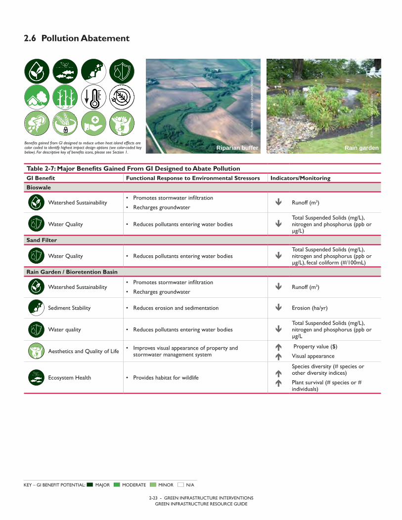
2-23 - GREEN INFRASTRUCTURE INTERVENTIONSGREEN INFRASTRUCTURE RESOURCE GUIDE
2.6 Pollution Abatement
Benefits gained from GI designed to reduce urban heat island effects are color coded to identify highest impact design options (see color-coded key below). For descriptive key of benefits icons, please see Section 1.
MAJOR MODERATE MINOR N/AKEY – GI BENEFIT POTENTIAL:
Rain gardenRiparian buffer
Tom
Sch
ultz
, Iow
a St
ate
Uni
vers
ity N
REM
EPA,
MA
Wat
ersh
ed C
oalit
ion
Table 2-7: Major Benefits Gained From GI Designed to Abate PollutionGI Benefit Functional Response to Environmental Stressors Indicators/Monitoring
Bioswale
Watershed Sustainability• Promotes stormwater infiltration
• Recharges groundwater Runoff (m3)
Water Quality • Reduces pollutants entering water bodies Total Suspended Solids (mg/L), nitrogen and phosphorus (ppb or µg/L)
Sand Filter
Water Quality • Reduces pollutants entering water bodies Total Suspended Solids (mg/L), nitrogen and phosphorus (ppb or µg/L), fecal coliform (#/100mL)
Rain Garden / Bioretention Basin
Watershed Sustainability• Promotes stormwater infiltration
• Recharges groundwater Runoff (m3)
Sediment Stability • Reduces erosion and sedimentation Erosion (ha/yr)
Water quality • Reduces pollutants entering water bodies Total Suspended Solids (mg/L), nitrogen and phosphorus (ppb or µg/L
Aesthetics and Quality of Life • Improves visual appearance of property andstormwater management system
Property value ($)
Visual appearance
Ecosystem Health • Provides habitat for wildlife
Species diversity (# species or other diversity indices)
Plant survival (# species or # individuals)
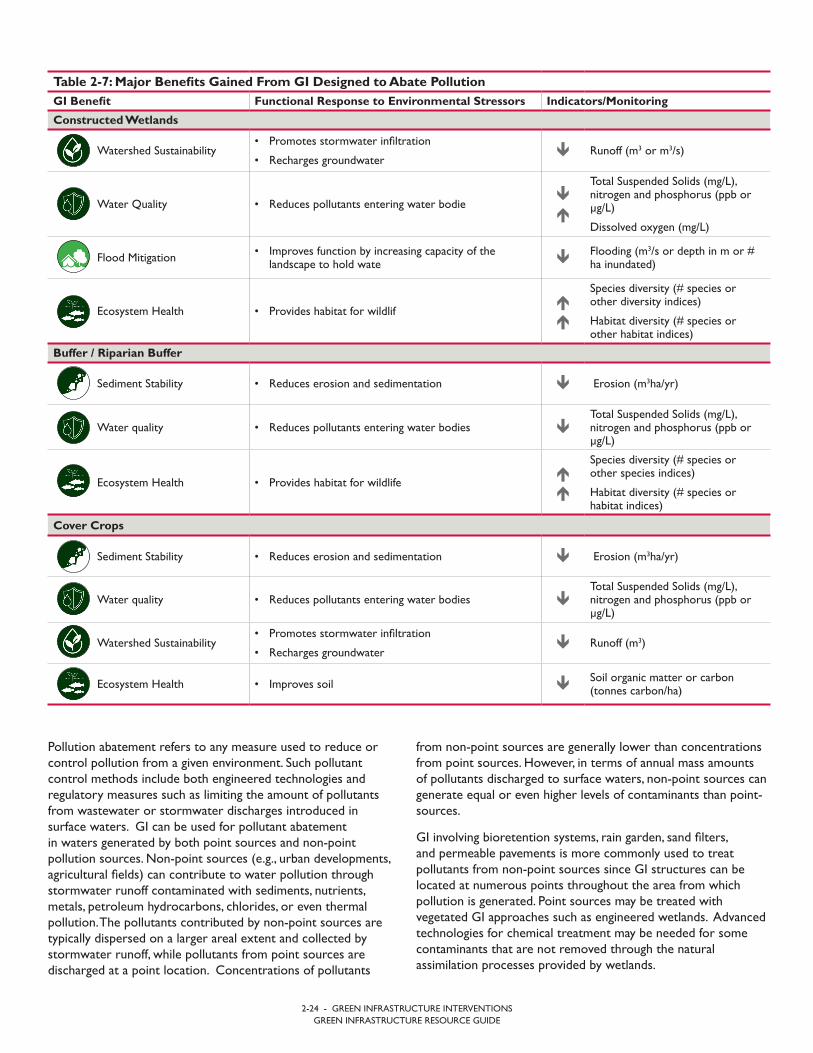
2-24 - GREEN INFRASTRUCTURE INTERVENTIONSGREEN INFRASTRUCTURE RESOURCE GUIDE
from non-point sources are generally lower than concentrations from point sources. However, in terms of annual mass amounts of pollutants discharged to surface waters, non-point sources can generate equal or even higher levels of contaminants than point- sources.
GI involving bioretention systems, rain garden, sand filters, and permeable pavements is more commonly used to treat pollutants from non-point sources since GI structures can be located at numerous points throughout the area from which pollution is generated. Point sources may be treated with vegetated GI approaches such as engineered wetlands. Advanced technologies for chemical treatment may be needed for some contaminants that are not removed through the natural assimilation processes provided by wetlands.
Pollution abatement refers to any measure used to reduce or control pollution from a given environment. Such pollutant control methods include both engineered technologies and regulatory measures such as limiting the amount of pollutants from wastewater or stormwater discharges introduced in surface waters. GI can be used for pollutant abatement in waters generated by both point sources and non-point pollution sources. Non-point sources (e.g., urban developments, agricultural fields) can contribute to water pollution through stormwater runoff contaminated with sediments, nutrients, metals, petroleum hydrocarbons, chlorides, or even thermal pollution. The pollutants contributed by non-point sources are typically dispersed on a larger areal extent and collected by stormwater runoff, while pollutants from point sources are discharged at a point location. Concentrations of pollutants
Table 2-7: Major Benefits Gained From GI Designed to Abate PollutionGI Benefit Functional Response to Environmental Stressors Indicators/Monitoring
Constructed Wetlands
Watershed Sustainability• Promotes stormwater infiltration
• Recharges groundwater Runoff (m3 or m3/s)
Water Quality • Reduces pollutants entering water bodie
Total Suspended Solids (mg/L), nitrogen and phosphorus (ppb or µg/L)
Dissolved oxygen (mg/L)
Flood Mitigation • Improves function by increasing capacity of thelandscape to hold wate Flooding (m3/s or depth in m or #
ha inundated)
Ecosystem Health • Provides habitat for wildlif
Species diversity (# species or other diversity indices)
Habitat diversity (# species or other habitat indices)
Buffer / Riparian Buffer
Sediment Stability • Reduces erosion and sedimentation Erosion (m3ha/yr)
Water quality • Reduces pollutants entering water bodies Total Suspended Solids (mg/L), nitrogen and phosphorus (ppb or µg/L)
Ecosystem Health • Provides habitat for wildlife
Species diversity (# species or other species indices)
Habitat diversity (# species or habitat indices)
Cover Crops
Sediment Stability • Reduces erosion and sedimentation Erosion (m3ha/yr)
Water quality • Reduces pollutants entering water bodies Total Suspended Solids (mg/L), nitrogen and phosphorus (ppb or µg/L)
Watershed Sustainability• Promotes stormwater infiltration
• Recharges groundwater Runoff (m3)
Ecosystem Health • Improves soil Soil organic matter or carbon(tonnes carbon/ha)

2-25 - GREEN INFRASTRUCTURE INTERVENTIONSGREEN INFRASTRUCTURE RESOURCE GUIDE
wetlands, and are provided with subsurface stone reservoirs that replicate the low dissolved oxygen wetland conditions. Gravel wetlands are typically smaller than surface wetlands and are used for treating pollutants that are not easily removed by filtration and vegetation uptake process provided by other green infrastructure technologies.
A buffer is a strip of vegetation that acts as a barrier between different land uses. Trees, shrubs, and grass that are planted around agricultural fields can absorb and filter nutrients, reducing the nutrients, bacteria, chemicals, and other pollutants that reach water bodies.3 Riparian buffers are buffers along water bodies that are especially important to maintaining water quality. Refer to Section 2.3 for additional discussion about buffers.
Cover crops are crops grown between regular grain crop production periods to improve soil quality, prevent soil erosion, maintain moisture and prevent weed growth. Cover crops prevent soil migration though winds and stormwater runoff while the agricultural fields are not used for regular crop production. Refer to Section 2.3 for additional discussion on cover crops.
2.6.2 Site and Community Specific Considerations to Maximize SustainabilityInfiltration practices are not recommended in areas where high pollutant or sediment loading is anticipated due to the potential for groundwater contamination. Green infrastructure technologies that provide higher level of treatment are preferred for catchments that are considered pollutant “hot spots”. Appropriate selection of GI technology that can effectively remove the pollutant of concern is necessary before the stormwater runoff is recharged to groundwater.
Green infrastructure technologies should be selected based on their ability to remove the pollutants of concern for each specific site. Some GI technologies have better pollutant removal abilities than others. For example, bioretention systems can remove sediment, dissolved metals and decompose petroleum hydrocarbons, but have limited potential for removing nutrients. Permeable pavements and sand filters have high removal rates of sediment, petroleum hydrocarbons, metals, and even bacteria and thermal pollution, but are not very efficient at removing nutrients. Surface and subsurface wetlands are the only systems that can provide removal of nutrients, but they are not easily incorporated in densely developed areas. Identifying technologies that are appropriate in a specific context is critical to the long term sustainability of the GI design. This will include a comparative evaluation of both the benefits and constraints of each technology.
Using plant species that are suitable to the local climate and water tolerant is critical to the success of the systems that utilize vegetation. In addition to appropriate species selection, plant density is in important design consideration for
A selection of GI design options that can replace, augment, or retrofit traditional water management designs and practices are discussed below. In addition to water pollution abatement, vegetated GI systems can reduce air pollution through dry deposition of particulates, and also provide some water and air thermal pollution abatement. Additional engineered solutions (e.g., urban tree canopy, conservation tillage practices, green roofs and permeable pavement systems) and thermal pollution mitigation are discussed in Sections 2.4, 2.8, and 2.10.
2.6.1 Engineering Design Options: Rain gardens or bioretention systems, are depressed landscape features that include engineered soil media vegetated with a selection of native and water-tolerant plants that are specifically selected for maximum pollutant removal. Stormwater is collected in the vegetated depression and filters through the engineered soil media before it is recharged to the groundwater. Bioretention systems are typically underlain by stone reservoirs and underdrains that convey the treated water that is not recharged to groundwater to the original flow path. Rain gardens are typically smaller in size and less engineered than bioretention systems and do not include underdrains or stone reservoirs. Raingardens may be designed to manage water from smaller catchments from lawns, rooftops or driveways, and detain and infiltrate runoff on site. Bioretention systems may be part of a more complex treatment train and may be connected to local drainage conveyance systems.
A bioswale (also referred to as a filter strip) is a vegetated linear depression designed for the collection, conveyance, infiltration, and filtration of stormwater runoff. In other words, bioswales are elongated bioretention systems that can be built on a downgradient slope. The engineered soils with higher infiltration rates than natural soils and the vegetation included in the bioswales design may reduce the velocity of runoff and allow for infiltration and treatment through filtration and vegetation uptake processes.
A sand filter is comprised of a system of chambers and sand layers designed to maximize removal of pollutants from stormwater. Sand filters may have a pre-treatment chamber, which initially removes trash and debris, followed by a treatment chamber with a sand bed that is designed to filter stormwater runoff. Sand filters can be designed to infiltrate into the subsoil or exit through an outlet pipe or underdrain systems.
Constructed wetlands are engineered wetlands that temporarily store and treat stormwater or wastewater. Wetland systems provide pollutant treatment through decomposition by wetland vegetation, soils, and microbial assemblages that are normally present in low dissolved oxygen waters. Surface wetlands consist of vegetated marshes and can be used for both non-point sources (stormwater runoff) treatment and point sources (wastewater) treatment. Subsurface gravel wetlands are more engineered treatment systems than surface
3 The Sources and Solutions: Agriculture. (2017, March 10). Retrieved September 15, 2017, from https://www.epa.gov/nutrientpollution/sources-and-solutions-agriculture.

2.6.3 Education and Awareness Raising
Property owners may require education about rain garden design, maintenance, and selection of species and organic and inorganic materials for bioretention. Local nurseries or landscaping businesses may be able to provide assistance with plant selection. General outreach may be needed community-wide to build awareness about rain gardens.
Education about maintenance needs of constructed wetlands may be needed to prevent over maintenance. Installing educational signage about the function and purpose of constructed wetlands at the site of the wetland is one strategy to increase public awareness about stormwater, water quality, and ecosystem services.
2.6.4 Design, Evaluation, and Monitoring Resources
• The State of Oregon Department of Environmental Qualityhas guidance for bioswales, vegetative buffers and constructedwetlands: http://www.deq.state.or.us/wq/stormwater/docs/nwr/biofilters.pdf.
• Guiding principles for constructed wetlands are available fromthe US EPA: https://nepis.epa.gov/Exe/ZyPDF.cgi/2000536S.PDF?Dockey=2000536S.PDF.
• Design guidelines for conservation buffers are available fromthe USDA: https://nac.unl.edu/buffers/docs/conservation_buffers.pdf.
vegetated systems, particularly in areas that are vulnerable to erosion. If erosion is detected or anticipated, riprap can placed at the inlet of the practice to reduce erosion.
Buffer widths may be enlarged to provide additional pollution abatement capacity. The effectiveness of buffers to remove pollutants and reduce erosion and sedimentation are proportional to the width and density of the buffer zone. Wider and denser buffer strips increase the residence time of runoff in the buffer area and result in increased removal of pollutants.
Site and community specific considerations for cover crops include using forage crops and plants that can fix nutrients. Cover crops should be utilized consistently at a site in order to increase recycling and replenishment of nutrients such as nitrogen and phosphorus, and to increase soil organic content.
The design of all systems should consider existing and future climatic conditions. In areas where the volume and/or frequency of storm events are projected to increase, pollution associated with flooding may also become a more frequently encountered problem.

Sar
i Om
er
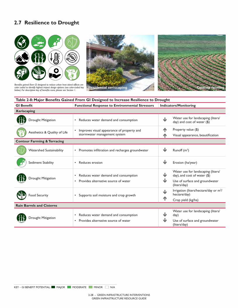
2-28 - GREEN INFRASTRUCTURE INTERVENTIONSGREEN INFRASTRUCTURE RESOURCE GUIDE
2.7 Resilience to Drought
Benefits gained from GI designed to reduce urban heat island effects are color coded to identify highest impact design options (see color-coded key below). For descriptive key of benefits icons, please see Section 1.
MAJOR MODERATE MINOR N/AKEY – GI BENEFIT POTENTIAL:
Contour farming Residential xeriscapingSy
lvia
Hac
ker,
Coo
pera
tive
Exte
nsio
n Sy
stem
USD
A N
RC
S
Table 2-8: Major Benefits Gained From GI Designed to Increase Resilience to DroughtGI Benefit Functional Response to Environmental Stressors Indicators/Monitoring
Xeriscaping
Drought Mitigation • Reduces water demand and consumption Water use for landscaping (liters/day) and cost of water ($)
Aesthetics & Quality of Life • Improves visual appearance of property andstormwater management system
Property value ($)
Visual appearance, beautification
Contour Farming & Terracing
Watershed Sustainability • Promotes infiltration and recharges groundwater Runoff (m3)
Sediment Stability • Reduces erosion Erosion (ha/year)
Drought Mitigation• Reduces water demand and consumption
• Provides alternative source of water
Water use for landscaping (liters/day), and cost of water ($)
Use of surface and groundwater (liters/day)
Food Security • Supports soil moisture and crop growth
Irrigation (liters/hectare/day or m3/hectare/day)
Crop yield (kg/ha)
Rain Barrels and Cisterns
Drought Mitigation• Reduces water demand and consumption
• Provides alternative source of water
Water use for landscaping (liters/day)
Use of surface and groundwater (liters/day)

2-29 - GREEN INFRASTRUCTURE INTERVENTIONSGREEN INFRASTRUCTURE RESOURCE GUIDE
cisterns are sized according to anticipated runoff from a rooftop or other surface area from which water will be collected and can vary from under 150 liters to 10,000 liters or more. The harvesting system can be made of plastic, concrete, metal, or other materials.
Rain barrels and cisterns increase redundancy and build resilience when precipitation and surface and groundwater levels are low. Refer to Sections 2.2, 2.4, 2.9, and 2.10 for additional discussion about cisterns and rain barrels.
2.7.2 Site and Community Specific Considerations to Maximize SustainabilityThe impact of xeriscaping is especially significant in areas where landscape watering accounts for a significant portion of water use. Factors to consider that impact the survival and effectiveness of a xeriscaped landscape include: the availability of an interim irrigation supply to establish plants, if necessary, and the duration of time required for nursery grown plants to become establish and resistant to drought, which may be two or more years. The maintenance requirements of xeriscaped landscapes are minimal and include occasional pruning, weeding and water to establish plants. Fertilizers and pesticides are not typically required when native plants are used and the soil is healthy. After establishment, a decline in water demand for maintaining the landscape and vegetation is an indicator that the system is functioning.
When implementing contour farming, the minimum and maximum grade of the row, ridge height, length of the slope, and outlets must be determined. The effectiveness of contour farming may be improved by removing obstructions and modifying the field boundaries and shape. This design is less effective for slopes that exceed 10 percent or are characterized by a rolling, irregular topography.7 The water demand and consumption of farms with contours or terraces is an indicator of the effectiveness of the design. Contour farming can also reduce soil erosion by 50 percent compared to farming along a slope.8
The capacity of rain barrels and cisterns should be determined by the size of the surface it is draining and local precipitation rates. Overflow is an indicator that the system is not sized properly and that multiple storage tanks may be required. Decreased reliance on surface and groundwater sources and the availability of consistent water supply indicate that the rain barrel is effectively increasing resilience to drought.
Drought is a period of unusually constant dry weather that persists long enough to cause deficiencies in the supply of surface or groundwater.4 Green infrastructure builds resilience to drought by:
• Enabling groundwater recharge
• Reducing water demand through water conservation andstorage
• Preserving soil moisture and integrity.
Integrating strategies that reduce vulnerability to drought is especially critical in areas where water scarcity is an existing threat, as well as areas where future precipitation rates and temperature are projected to result in increased dry periods.
A range of design options can be implemented to increase drought resilience. Xeriscaping, conservation agricultural practices including contour farming and terracing, and rain barrels and cisterns are summarized below. Refer to Section 2.6 for a summary of rain gardens, for a description of permeable surfaces and Section 2.10 for information about in-field rainwater harvesting. In developed areas, permeable surfaces also promote resilience to drought by enhancing groundwater recharge.
2.7.1 Engineering Design Options: Xeriscaping is a landscaping technique that utilizes drought tolerant species and requires little to no irrigation. Native plants are preferable to non-native plants because they have evolved to adapt to the local climate and offer optimal resources for local wildlife. Xeriscaping can reduce landscape water use by 50-60%.5
Conservation agriculture practices help maintain soil structure, reduce erosion, and hold water on the landscape. Contour farming and terracing are agronomic practices that increase soil moisture and improve soil quality by avoiding erosion. In contour farming, crops are grown across or perpendicular to a slope. This design enables crop rows to act as reservoirs that catch and retain water. Similarly, terraced farming is a soil conservation practice that prevents rainfall from running off sloped land with engineered ridges and channels. Refer to Sections 2.3 and 2.11 for additional discussion about contour farming.
Rain barrels and cisterns are rainwater harvesting systems that collect and store rainfall for later use on gardens, fields, and other vegetation. Rainwater harvesting provides a renewable water supply and aids in water conservation. Rain barrels and
4 Mitigation Ideas a resource for reducing risk to natural hazards. (2013). US Federal Emergency Management Agency. Retrieved from https://www.fema.gov/media-library-data/20130726-1904-25045-2423/fema_mitigation_ideas_final_01252013.pdf.5 Conserve water with xeriscape landscape. (n.d.) Cornell University Cooperative Extension Rockland County. Retrieved on September 15, 2017, from http://rocklandcce.org/resources/conserve-water-with-xeriscape-landscaping.6 Terracing as a `Best Management Practice’ for Controlling Erosion and Protecting Water Quality. (n.d.). Retrieved September 15, 2017, from https://www.extension.purdue.edu/extmedia/ae/ae-114.html.7 Best Management Practices for Agricultural Water Users. Section 4.2 Contour Farming. (2013). Texas Water Development Board. Retreived from http://www.twdb.texas.gov/conservation/BMPs/Ag/doc/4.2.pdf. 8 Intro to Soils – York County, Pennsylvania. (2013). USDA Natural Resources Conservation Service. Retrieved from: http://www.envirothonpa.org/documents/WSS_Intro_to_Soils_part2.pdf.
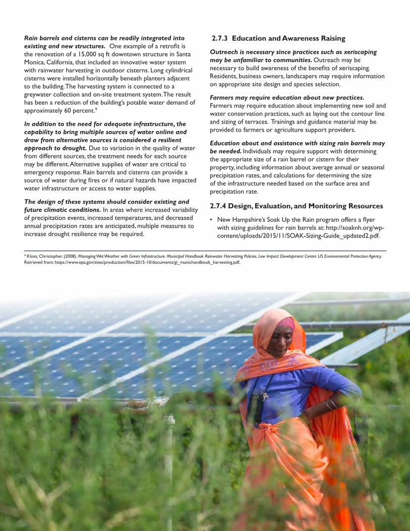
2.7.3 Education and Awareness Raising
Outreach is necessary since practices such as xeriscaping may be unfamiliar to communities. Outreach may be necessary to build awareness of the benefits of xeriscaping. Residents, business owners, landscapers may require information on appropriate site design and species selection.
Farmers may require education about new practices. Farmers may require education about implementing new soil and water conservation practices, such as laying out the contour line and sizing of terraces. Trainings and guidance material may be provided to farmers or agriculture support providers.
Education about and assistance with sizing rain barrels may be needed. Individuals may require support with determining the appropriate size of a rain barrel or cistern for their property, including information about average annual or seasonal precipitation rates, and calculations for determining the size of the infrastructure needed based on the surface area and precipitation rate.
2.7.4 Design, Evaluation, and Monitoring Resources
• New Hampshire’s Soak Up the Rain program offers a flyerwith sizing guidelines for rain barrels at: http://soaknh.org/wp-content/uploads/2015/11/SOAK-Sizing-Guide_updated2.pdf.
Rain barrels and cisterns can be readily integrated into existing and new structures. One example of a retrofit is the renovation of a 15,000 sq ft downtown structure in Santa Monica, California, that included an innovative water system with rainwater harvesting in outdoor cisterns. Long cylindrical cisterns were installed horizontally beneath planters adjacent to the building. The harvesting system is connected to a greywater collection and on-site treatment system. The result has been a reduction of the building’s potable water demand of approximately 60 percent.9
In addition to the need for adequate infrastructure, the capability to bring multiple sources of water online and draw from alternative sources is considered a resilient approach to drought. Due to variation in the quality of water from different sources, the treatment needs for each source may be different. Alternative supplies of water are critical to emergency response. Rain barrels and cisterns can provide a source of water during fires or if natural hazards have impacted water infrastructure or access to water supplies.
The design of these systems should consider existing and future climatic conditions. In areas where increased variability of precipitation events, increased temperatures, and decreased annual precipitation rates are anticipated, multiple measures to increase drought resilience may be required.
9 Kloss, Christopher. (2008). Managing Wet Weather with Green Infrastructure. Municipal Handbook Rainwater Harvesting Policies. Low Impact Development Center. US Environmental Protection Agency. Retrieved from: https://www.epa.gov/sites/production/files/2015-10/documents/gi_munichandbook_harvesting.pdf.
CAR
E, M
icha
el T
sega
ye
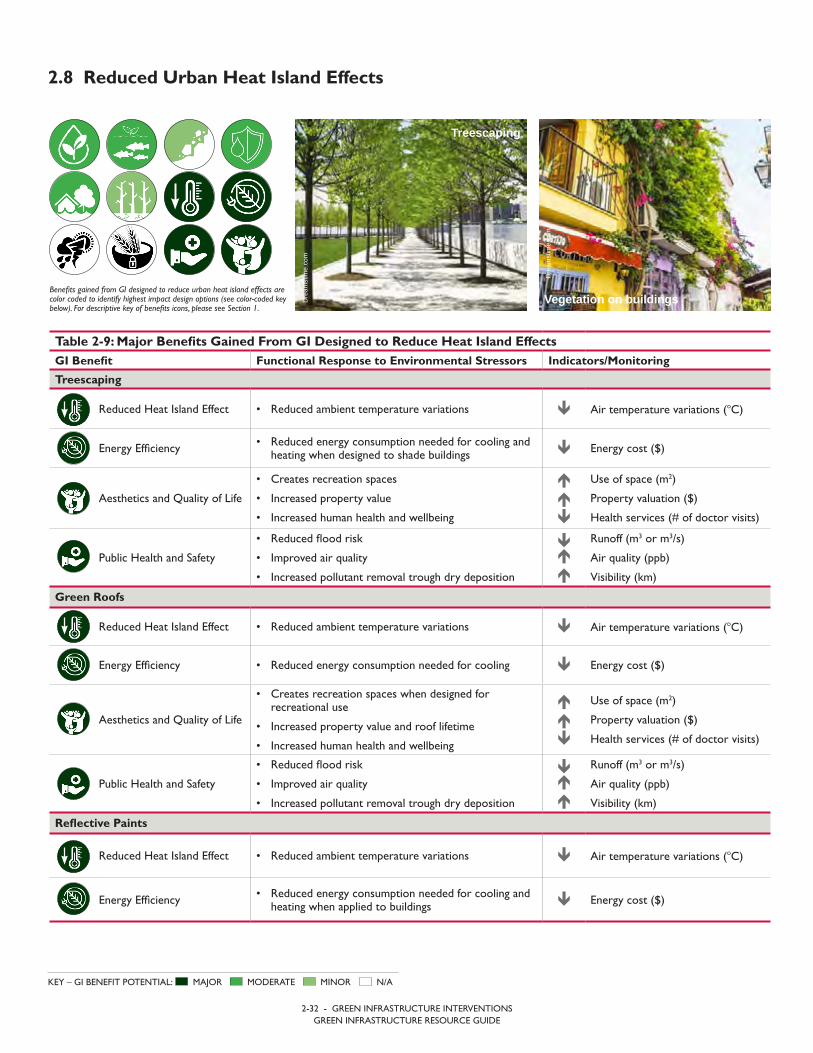
2-32 - GREEN INFRASTRUCTURE INTERVENTIONSGREEN INFRASTRUCTURE RESOURCE GUIDE
2.8 Reduced Urban Heat Island Effects
Benefits gained from GI designed to reduce urban heat island effects are color coded to identify highest impact design options (see color-coded key below). For descriptive key of benefits icons, please see Section 1.
MAJOR MODERATE MINOR N/AKEY – GI BENEFIT POTENTIAL:
Table 2-9: Major Benefits Gained From GI Designed to Reduce Heat Island EffectsGI Benefit Functional Response to Environmental Stressors Indicators/Monitoring
Treescaping
Reduced Heat Island Effect • Reduced ambient temperature variations Air temperature variations (C)
Energy Efficiency • Reduced energy consumption needed for cooling andheating when designed to shade buildings Energy cost ($)
Aesthetics and Quality of Life
• Creates recreation spaces
• Increased property value
• Increased human health and wellbeing
Use of space (m2)
Property valuation ($)
Health services (# of doctor visits)
Public Health and Safety
• Reduced flood risk
• Improved air quality
• Increased pollutant removal trough dry deposition
Runoff (m3 or m3/s)
Air quality (ppb)
Visibility (km)
Green Roofs
Reduced Heat Island Effect • Reduced ambient temperature variations Air temperature variations (C)
Energy Efficiency • Reduced energy consumption needed for cooling Energy cost ($)
Aesthetics and Quality of Life
• Creates recreation spaces when designed forrecreational use
• Increased property value and roof lifetime
• Increased human health and wellbeing
Use of space (m2)
Property valuation ($)
Health services (# of doctor visits)
Public Health and Safety
• Reduced flood risk
• Improved air quality
• Increased pollutant removal trough dry deposition
Runoff (m3 or m3/s)
Air quality (ppb)
Visibility (km)
Reflective Paints
Reduced Heat Island Effect • Reduced ambient temperature variations Air temperature variations (C)
Energy Efficiency • Reduced energy consumption needed for cooling andheating when applied to buildings Energy cost ($)
Dre
amst
ime.
com
Dre
amst
ime.
com
Vegetation on buildings
Treescaping
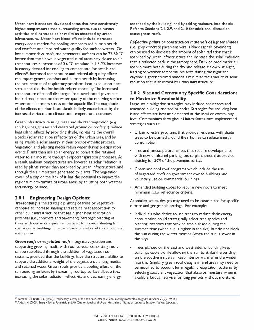
2-33 - GREEN INFRASTRUCTURE INTERVENTIONSGREEN INFRASTRUCTURE RESOURCE GUIDE
absorbed by the building) and by adding moisture into the air. Refer to Sections 2.4, 2.9, and 2.10 for additional discussion about green roofs.
Reflective paints or construction materials of lighter shades (i.e., grey concrete pavement versus black asphalt pavement) can be used to decrease the amount of solar radiation that is absorbed by urban infrastructure and increase the solar radiation that is reflected back in the atmosphere. Dark colored materials absorb more heat during the day and release it slowly at night, leading to warmer temperatures both during the night and daytime. Lighter colored materials minimize the amount of solar radiation that is absorbed by urban infrastructure.
2.8.2 Site and Community Specific Considerations to Maximize Sustainability Large scale mitigation strategies may include ordinances and amended building and zoning codes. Strategies for reducing heat island effects are best implemented at the local or community level. Communities throughout Unites States have implemented strategies such as:
• Urban forestry programs that provide residents with shadetrees to be planted around their homes to reduce energyconsumption
• Tree and landscape ordinances that require developmentswith new or altered parking lots to plant trees that provideshading for 50% of the pavement surface
• Green and cool roof programs which include the useof vegetated roofs on government owned buildings andvoluntary use on commercial buildings
• Amended building codes to require new roofs to meetminimum solar reflectance criteria.
At smaller scales, designs may need to be customized for specific climate and geographic settings. For example:
• Individuals who desire to use trees to reduce their energyconsumption could strategically select tree species andplanting locations that provide ample shade during thesummer time (when sun is higher in the sky), but do not blockthe sun during the winter months (when the sun is lower inthe sky).
• Trees planted on the east and west sides of building keepbuildings cooler, while allowing the sun to strike the buildingon the southern side can keep interior warmer in the wintermonths. Similarly, green roof designs in arid area may need tobe modified to account for irregular precipitation patterns byselecting succulent vegetation that absorbs moisture when isavailable, but can survive for long periods without moisture.
Urban heat islands are developed areas that have consistently higher temperatures than surrounding areas, due to human activities and increased solar radiation absorbed by urban infrastructure. Urban heat island effects include increased energy consumption for cooling, compromised human health and comfort, and impaired water quality for surface waters. On hot summer days, roofs and pavements surfaces can be 27-50 °C hotter than the air, while vegetated rural areas stay closer to air temperatures10. Increases of 0.6 °C translate in 1.5-2% increases in energy demand for cooling to compensate for heat island effects11. Increased temperature and related air quality effects can impact general comfort and human health by increasing the occurrences of respiratory problems, heat exhaustion, heat stroke and the risk for health-related mortality. The increased temperature of runoff discharges from overheated pavements has a direct impact on the water quality of the receiving surface waters and increases stress on the aquatic life. The magnitude of the effects of urban heat islands is likely exacerbated by the increased variation on climate and temperature extremes.
Green infrastructure using trees and shorter vegetation (e.g., shrubs, vines, grasses and vegetated ground or rooftops) reduce heat island effects by providing shade, increasing the overall albedo (solar radiation reflectivity) of the urban area, and by using available solar energy in their photosynthetic process. Vegetation and planting media retain water during precipitation events. Plants then use solar energy to convert the retained water to air moisture through evapotranspiration processes. As a result, ambient temperatures are lowered as solar radiation is used by plants rather than absorbed by urban infrastructure, and through the air moisture generated by plants. The vegetation cover of a city, or the lack of it, has the potential to impact the regional micro-climate of urban areas by adjusting both weather and energy balance.
2.8.1 Engineering Design Options: Treescaping is the strategic planting of trees or vegetative canopies to increase shading and reduce heat absorption by other built infrastructure that has higher heat absorption potential (i.e., concrete and pavement). Strategic planting of trees with dense canopies can be used to provide shading for roadways or buildings in urban developments and to reduce heat absorption.
Green roofs or vegetated roofs integrate vegetation and supporting growing media with roof structures. Existing roofs can be retrofitted through the addition of vegetated roof systems, provided that the buildings have the structural ability to support the additional weight of the vegetation, planting media, and retained water. Green roofs provide a cooling effect on the surrounding ambient by increasing rooftop surface albedo (i.e., increasing the solar radiation reflectivity and decreasing energy
10 Berdahl, P., & Bretz, S. E. (1997). Preliminary survey of the solar reflectance of cool roofing materials. Energy and Buildings, 25(2), 149-158.11 Akbari, H. (2005). Energy Saving Potentials and Air Quality Benefits of Urban Heat Island Mitigation. Lawrence Berkeley National Laboratory.
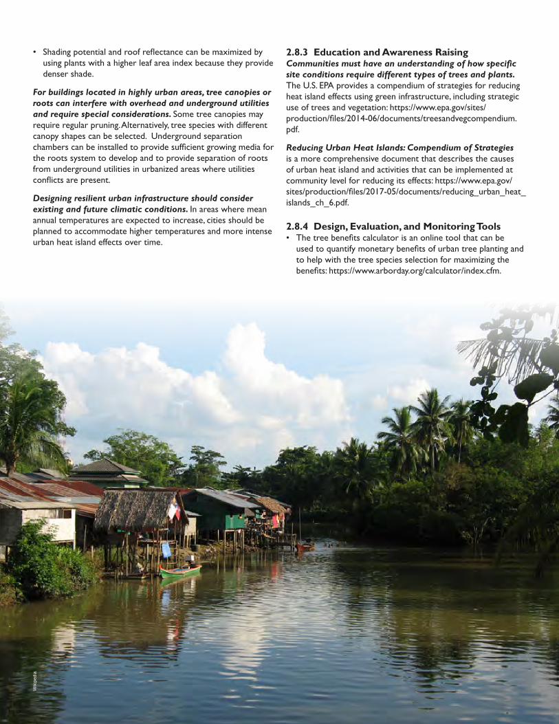
2.8.3 Education and Awareness RaisingCommunities must have an understanding of how specific site conditions require different types of trees and plants. The U.S. EPA provides a compendium of strategies for reducing heat island effects using green infrastructure, including strategic use of trees and vegetation: https://www.epa.gov/sites/production/files/2014-06/documents/treesandvegcompendium.pdf.
Reducing Urban Heat Islands: Compendium of Strategies is a more comprehensive document that describes the causes of urban heat island and activities that can be implemented at community level for reducing its effects: https://www.epa.gov/sites/production/files/2017-05/documents/reducing_urban_heat_islands_ch_6.pdf.
2.8.4 Design, Evaluation, and Monitoring Tools• The tree benefits calculator is an online tool that can be
used to quantify monetary benefits of urban tree planting andto help with the tree species selection for maximizing thebenefits: https://www.arborday.org/calculator/index.cfm.
• Shading potential and roof reflectance can be maximized byusing plants with a higher leaf area index because they providedenser shade.
For buildings located in highly urban areas, tree canopies or roots can interfere with overhead and underground utilities and require special considerations. Some tree canopies may require regular pruning. Alternatively, tree species with different canopy shapes can be selected. Underground separation chambers can be installed to provide sufficient growing media for the roots system to develop and to provide separation of roots from underground utilities in urbanized areas where utilities conflicts are present.
Designing resilient urban infrastructure should consider existing and future climatic conditions. In areas where mean annual temperatures are expected to increase, cities should be planned to accommodate higher temperatures and more intense urban heat island effects over time.
Wik
iped
ia

AEC
OM

2-36 - GREEN INFRASTRUCTURE INTERVENTIONSGREEN INFRASTRUCTURE RESOURCE GUIDE
2.9 Building Energy Efficiency
Benefits gained from GI designed to reduce urban heat island effects are color coded to identify highest impact design options (see color-coded key below). For descriptive key of benefits icons, please see Section 1.
MAJOR MODERATE MINOR N/AKEY – GI BENEFIT POTENTIAL:
to reduce the building interior temperature by as much as 20°C, and to reduce the overall cooling and heating energy use anywhere from 20 to 80%12. Other studies have found that the use of green roofs results in the peak energy demand decreased by as much as 40%13.
In addition to improving insulation capacity, energy efficiencies can be enhanced through the use of rooftop rainwater collection for household uses that do not require potable water. The reuse of water reduces the amount of energy required for pumping water from wells (if groundwater is the main water source) or the energy used in water treatment processes (if the building relies on municipal water).
GI interventions using green roofs and climbing vines offer the potential to generate energy cost savings for buildings both during both warm and cold months. Buildings with poor insulation exhibit greater heat fluxes through the building’s envelope through outflux processes in the winter, and influx during summer. In addition, buildings made out of materials with high heat absorptive capacity can absorb heat and radiate it to the interior of the building for a longer extent of time, increasing the energy use required for cooling.
Green roofs and climbing vines can be used to provide additional insulation for buildings by shielding them from solar radiation and cooling winds. The addition of green roofs has been found
Table 2-10: Major Benefits Gained From GI Designed for Increased Building Energy EfficiencyGI Benefit Functional Response to Environmental Stressors Indicators/Monitoring
Green Roofs
Energy Efficiency • Reduces energy consumption needed for cooling andheating Energy cost ($)
Reduced Heat Island Effect• Increases solar radiation reflectivity
• Increases moisture retention and cooling effects of theimmediately surrounding environment
Air temperature variations (C)
Aesthetics and Quality of Life• Increases home functionality and roof longevity
• Increases aesthetics Property valuation ($)
Resilience to Weather Extremes
• Increases capacity to tolerate, and manage extremetemperatures Air temperature variations (C)
Cisterns / Rain Barrels
Energy Efficiency• Reduces water use
• Reduces energy use for treating water
Water use (m3 or m3/day)
Energy cost ($)
Flood Mitigation • Reduced runoff and flood risk Runoff (m3 or m3/s)
12 Saadatian, O., Sopian, K., Salleh, E., Lim, C. H., Riffat, S., Saadatian, E., & Sulaiman, M. Y. (2013). A review of energy aspects of green roofs. Renewable and Sustainable Energy Reviews, 23, 155-168.13 Taha, H., Akbari, H., Rosenfeld, A., & Huang, J. (1988). Residential cooling loads and the urban heat island—the effects of albedo. Building and environment, 23(4), 271-283.
Isto
ckph
oto.
com
Adob
esto
ck.c
omCollecting rainwaterGreen roof
2-37 - GREEN INFRASTRUCTURE INTERVENTIONSGREEN INFRASTRUCTURE RESOURCE GUIDE
support the retained moisture from rain or snowfall. In cold climate regions or wet regions which receive larger amounts of precipitation, the design of green roofs can be modified to serve the same functions as regular green roofs, but with lighter weight materials. The depth of the soil media can either be reduced, or fully or partially replaced with light weight aggregates. A shallower soil layer on top of a layer of light weight aggregates could be designed to support short vegetation that does not require a deep root zone. The larger aggregates have larger pores than soil to enhance water storage, while a shallow soil layer can provide support to roots and act as thermal insulation for the building.
Design of green roofs should consider operation and maintenance needs. Operational considerations for maintaining sustainable green roofs include waterproofing the roofs before installation of green roofs; designing roofs with vegetation that needs less maintenance; and insuring that appropriate maintenance of vegetation is performed (such as irrigation, weed control and nutrient supply).
Rain barrels may not be appropriate to use as the main source of water supply. Rain Barrels and cisterns may provide energy savings in some settings, but may not be reliable sources to be used as the main water source. Rain barrels and connectivity pipes may be subject to frost during the cold season and may not be a consistent source of water for domestic uses year-round.
2.9.3 Education and Awareness RaisingCommunicating the environmental benefits and energy savings potential of vegetated roofs can facilitate the adoption of green roof approaches. Looking Up: How Green Roofs and Cool Roofs Can Reduce Energy Use, Address Climate Change, and Protect Water Resources in Southern California, is a compendium of environmental benefits and energy savings potentials provided by green roofs: https://www.nrdc.org/sites/default/files/GreenRoofsReport.pdf.
2.9.4 Design, Evaluation, and Monitoring Tools• The Green Roof Energy Calculator is an online tool designed
to aid planners and stakeholders to quantify the water, heatand energy benefits of green roofs, and select the optimalroof type for specific applications: https://www.greenroofs.org/green-roof-energy-calculator.
2.9.1 Engineering Design Options: Green roofs or vegetated roofs are roof systems comprised of vegetation along with the supporting growing media, placed on top a waterproof membrane. Green roofs can be designed for recreational purposes (e.g., landscaped terraces), gardening (e.g., vegetable growing), or simply for providing thermal insulation and to lower the building’s energy use for heating, ventilating and air-conditioning.
Although green roofs provide several other benefits (e.g., reduced stormwater runoff, improved water quality, reduced greenhouse gasses, and acoustic isolation), thermal insulation is a benefit that is often overlooked. The thermal insulation potential of a green roof is directly impacted by the depth and the type of the soil media and by the type of vegetation cover: the deeper the soils, the greater reduction in heat flow through the roof, the denser the vegetation, and the greater the solar reflectance. For multilevel buildings, the thermal impact is felt mainly on the top floor of the building, although their effects can be conveyed to some extent to immediate underlying floors. Refer to Sections 2.4, 2.8, and 2.10 for additional discussion about green roofs.
Cisterns or rain barrels are used for capturing rooftop runoff and are typically connected to rooftop gutters. The rooftop runoff is relatively clean compared to street runoff and can be used for non-potable uses such as garden watering or toilet flushing. The energy savings originates from the use of recycled water in lieu of potable water, and from avoided energy costs for potable water treatment and wastewater treatment. Cisterns capturing rooftop runoff that is relatively clean can be used in conjunction with small scale sand filters or disinfection systems to meet potable water needs. Refer to Sections 2.2, 2.4, 2.7, and 2.10 for additional discussion about cisterns and rain barrels.
2.9.2 Site and Community Specific Considerations to Maximize Sustainability Green roof utilization needs to be accounted for in the structural design or assessment of the building. Sustainable retrofitting of existing roof systems and construction of new green roofs require special consideration to the structural soundness of the building and the ability to support the additional roof weight. Depending on the green roof type and depth of the soil layer, the additional weight of the roof could be between 50 and 700 kg/m2. In addition, the building needs to
10 Berdahl, P., & Bretz, S. E. (1997). Preliminary survey of the solar reflectance of cool roofing materials. Energy and Buildings, 25(2), 149-158.11 Akbari, H. (2005). Energy Saving Potentials and Air Quality Benefits of Urban Heat Island Mitigation. Lawrence Berkeley National Laboratory.


2-39 - GREEN INFRASTRUCTURE INTERVENTIONSGREEN INFRASTRUCTURE RESOURCE GUIDE
2.10 Food Security
Benefits gained from GI designed to reduce urban heat island effects are color coded to identify highest impact design options (see color-coded key below). For descriptive key of benefits icons, please see Section 1.
MAJOR MODERATE MINOR N/AKEY – GI BENEFIT POTENTIAL:
Urban agricultureConservation tillage
implemented in Africa FAO
ACT
Afric
an C
onse
rvat
ion
Tilla
ge N
etw
ork
Table 2-11: Major Benefits Gained From GI Designed to Increase Food SecurityGI Benefit Functional Response to Environmental Stressors Indicators/Monitoring
In-field Rainwater Harvesting
Watershed Sustainability • Promotes infiltration and recharges groundwater Runoff (m3 /second or m3)
Resilience to Weather Extremes
• Increases resiliency to drought through enhancedgroundwater recharge and water storage Water shortages (liters/day)
Drought Mitigation• Preserves soil moisture
• Reduces surface and groundwater consumption
Dependence on irrigation (liters/day)
Crop diversity (#)
Public Health and Safety • Increases availability of food
Hunger and malnutrition (calories)
Health (life expectancy in years)
Conservation Tillage
Ecosystem Health • Improves soil structure Fertilizer application (kg/hectare)
Drought Mitigation• Preserves soil moisture
• Reduces surface and groundwater consumption
Dependence on irrigation (liters/hectare/day)
Crop diversity (#species or other species diversity indicators)
Sediment Stability • Reduces erosion
Erosion (hectare/year)
Sedimentation in water bodies
Urban Agriculture
Ecosystem Health • Creates wildlife habitat Species diversity (#)
Public Health and Safety • Increases availability of food
Distance to food sources (km)
Hunger and malnutrition (calories)
Health (life expectancy in years)
Aesthetics and Quality of Life• Increases access to greenspace in urban areas
• Increases ability to grow food
Household expenditures on food ($)
Opportunities for social interaction and recreation (hours of activity, # services provided)

2-40 - GREEN INFRASTRUCTURE INTERVENTIONSGREEN INFRASTRUCTURE RESOURCE GUIDE
covered with crop residual after planting the next year’s crop. Conservation tillage practices may also include mulch tillage, strip tillage, or ridge tillage. Refer to Section 2.3 for additional discussion about conservation tillage.
Urban and peri-urban agriculture involves growing plants and raising animals within and around cities, and including cultivation, processing, and distribution of food.16 Urban agriculture can be practiced in many locations including gardens, rooftops, empty public land, and other underutilized or vacant areas. The scale of urban agriculture is variable and includes “micro” gardening, subsistence-oriented cultivation, small scale semi-commercial production, and large scale farming and animal husbandry.
2.10.2 Site and Community Specific Considerations to Maximize Sustainability In-field rainwater harvesting is suitable for small farms with high clay content. Because it is gravity fed, in-field rainwater harvesting has minimal maintenance constraints and operational costs. Constraints of this practice may include skills and knowledge of how to effectively employ the production technique and low support from government to scale up practice. Reduction in irrigation demand and the survival of crops are indicators that rainwater is being stored in mulch basins and soil, and thereby available for plant uptake.
Plant selection for conservation tillage practices will vary by site and region. Test plots should be developed and monitored to determine optimal crop residual rate and species composition when employing this practice. An additional consideration is the availability of existing equipment that can be adjusted or amended with attachments in order to cultivate new species.
Monitoring will enable determining whether the interventions are sustainable. A decrease in erosion, fertilizer application, and irrigation indicate that the system is retaining soil moisture, maintaining soil structure, and increasing nutrients in the soil, and therefore increasing the sustainability of a field.
Urban agriculture practices can be implemented on private property or in public or semi-public places. When implementing this practice in public places, involving the local community in planning, design, and maintenance can increase sustainability and maximize the social, environmental, and health benefits. Considerations for larger farms include marketing and transportation.
The suitability of a site for animal husbandry is location-specific. In addition to local regulations, site specific design considerations include availability of sunlight, irrigation, and soil quality.
Production of food is the primary objective of many green infrastructure systems. Food security is achieved when “all people, at all times, have physical, social, and economic access to sufficient, safe, and nutritious food that meets their dietary needs and food preferences for an active and healthy life”.14 Rainwater harvesting systems, tilling practices, and utilization of urban space for food production are methods that increase the quality, quantity, and diversity of agricultural products, while also controlling stormwater runoff and benefitting the hydrological system.
Food security is a secondary benefit of other green infrastructure design options that provide stormwater runoff management, sediment and erosion control, and aquifer recharge. For example:
• By improving infiltration and increasing aquifer recharge, greeninfrastructure contributes to groundwater and surface watersupplies, which are critical for irrigating crops and supportinghealthy livestock populations.
• Swales and constructed wetlands minimize localized floodingthat can be detrimental to crop production.
• In addition to increasing the quantity of water available forfood production, green infrastructure reduces degradation oflakes and streams that provide critical habitat for fish species, an important source of protein.
Five engineering design options that increase food security are included in this section: in-field rainwater harvesting, conservation tillage, urban agriculture. Refer to Section 2.7 for a description of rain barrels and cisterns and Section 2.4, 2.8, and 2.9 for green roofs, which also increase food security. Strategies that increase resilience to drought can also increase food security. Examples of these design options are discussed in Section 2.7.
2.10.1 Engineering Design Options: In-field rainwater harvesting is an agricultural technique that directs runoff to mulch-covered basins via compacted, flat, approximately two-meter wide strips that are perpendicular to the slope of the land. As water accumulates into the basins it infiltrates the soil beyond the evaporation zone. Crops are then planted next to the basins.15
Conservation tillage is a method of soil cultivation where the remains of crops (e.g., corn stalks) are left on the field in order to reduce erosion and runoff. Compared to conventional tillage, in which soil is plowed and inverted for the next season, conservation tillage results in one-third or more of the soil
14 Trade Reforms and Food Security. (2003). Rome, Italy: Food and Agriculture Organization of the United Nations. Retrieved September 15, 2017, from ftp://ftp.fao.org/docrep/fao/005/y4671e/y4671e00.pdf. 15 Integrated Water Harvesting Project Mpumalanga, South Africa. (2009). Tunisia: African Water Facility. Retrieved September 15, 2017, from https://www.africanwaterfacility.org/fileadmin/uploads/awf/Projects/AWF-Project-appraisal-report-SOUTHAFRICA.pdf.16 FAO’s role in Urban Agriculture. (n.d.). Retrieved September 15, 2017, from http://www.fao.org/urban-agriculture/en/.
2-41 - GREEN INFRASTRUCTURE INTERVENTIONSGREEN INFRASTRUCTURE RESOURCE GUIDE
Increase awareness of the purpose and value of urban agriculture. Providing individuals and communities who have not traditionally been exposed to urban agriculture with information about the objectives and benefits of urban agriculture is important. Building awareness through a community workshop or flyer can help engage neighbors and alleviate potential concerns related to food safety, maintenance, or nuisance issues. Individuals who are unaccustomed to gardening may require basic education about growing, caring for, and harvesting food.
2.10.4 Design, Evaluation, and Monitoring Tools• USDA has developed an Urban Agriculture Toolkit for
planning, designing, and implementing urban agriculture: https://www.usda.gov/sites/default/files/documents/urban-agriculture-toolkit.pdf.
• The USDA/NRCS conservation catalog contains guidelines fora number of agricultural practices: https://www.nrcs.usda.gov/Internet/FSE_DOCUMENTS/stelprdb1101559.pdf.
In urban areas, testing soil for contamination prior to planting produce is recommended. In areas where soil quality is not adequate, raised beds or containers can be used for food production.
Urban agriculture can supplement local food supply in an emergency situation. However, it is also critical to evaluate potential exposure to contaminants that crops may be exposed to in a hazard event.
The design of all systems should consider existing and future climatic conditions. In areas where the volume and/or frequency of storm events are projected to increase, systems should be designed to accommodate additional water.
2.10.3 Education and Awareness RaisingEducation about new farming practices may be needed. Education may be required to assist farmers with transitioning to a modified agricultural practice such as conservation tillage. Farmers may require education about erosion and the opportunity to reduce erosion through residue management practices. Meetings, local guidance material, and demonstration plots can be incorporated into an educational program.

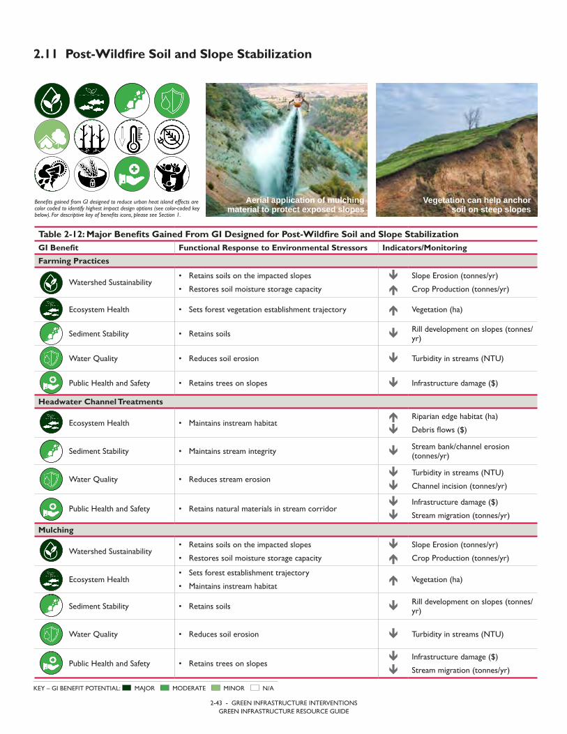
2-43 - GREEN INFRASTRUCTURE INTERVENTIONSGREEN INFRASTRUCTURE RESOURCE GUIDE
2.11 Post-Wildfire Soil and Slope Stabilization
Benefits gained from GI designed to reduce urban heat island effects are color coded to identify highest impact design options (see color-coded key below). For descriptive key of benefits icons, please see Section 1.
MAJOR MODERATE MINOR N/AKEY – GI BENEFIT POTENTIAL:
Vegetation can help anchor soil on steep slopes
Aerial application of mulching material to protect exposed slopes
Table 2-12: Major Benefits Gained From GI Designed for Post-Wildfire Soil and Slope StabilizationGI Benefit Functional Response to Environmental Stressors Indicators/Monitoring
Farming Practices
Watershed Sustainability• Retains soils on the impacted slopes
• Restores soil moisture storage capacity
Slope Erosion (tonnes/yr)
Crop Production (tonnes/yr)
Ecosystem Health • Sets forest vegetation establishment trajectory Vegetation (ha)
Sediment Stability • Retains soils Rill development on slopes (tonnes/yr)
Water Quality • Reduces soil erosion Turbidity in streams (NTU)
Public Health and Safety • Retains trees on slopes Infrastructure damage ($)
Headwater Channel Treatments
Ecosystem Health • Maintains instream habitat
Riparian edge habitat (ha)
Debris flows ($)
Sediment Stability • Maintains stream integrity Stream bank/channel erosion(tonnes/yr)
Water Quality • Reduces stream erosion
Turbidity in streams (NTU)
Channel incision (tonnes/yr)
Public Health and Safety • Retains natural materials in stream corridor
Infrastructure damage ($)
Stream migration (tonnes/yr)
Mulching
Watershed Sustainability• Retains soils on the impacted slopes
• Restores soil moisture storage capacity
Slope Erosion (tonnes/yr)
Crop Production (tonnes/yr)
Ecosystem Health• Sets forest establishment trajectory
• Maintains instream habitat Vegetation (ha)
Sediment Stability • Retains soils Rill development on slopes (tonnes/yr)
Water Quality • Reduces soil erosion Turbidity in streams (NTU)
Public Health and Safety • Retains trees on slopes
Infrastructure damage ($)
Stream migration (tonnes/yr)
2-44 - GREEN INFRASTRUCTURE INTERVENTIONSGREEN INFRASTRUCTURE RESOURCE GUIDE
The wildfire dramatically alters the hydrologic and hydraulic nature of the watershed, typically resulting in increased flows and sediment. To maintain the stream health, damaged trees should be placed in the stream to create small dams. The dams will retain sediment and slow flow velocities. Over the subsequent seasons, the woody material will deteriorate restoring the stream channel to a pre-wildfire condition at around the same time the forest is starting to regenerate.
Mitigation efforts will depend on available resources and terrain. In most cases hand tools such as shovel and hoes are adequate for creating troughs. The moving of woody material into headwater stream channels may require chainsaws and tractors. The mulching process is best conducted with aerial application but straw mulch can be applied by hand.
Communities should be relocated outside of the impacted areas. Following a wildfire event, the impacted landscape results in the potential for flash flooding, debris flows, and landslides. As part of the mitigation effort the population needs to be educated on the potential hazards and if necessary related to a safe location until the safety of the landscape can be better assessed.
2.11.3 Education and Awareness RaisingPost-wildfire mitigation needs to include public awareness of the potential dangers following the event. Communities downstream of the wildfire are at the greatest risk of landslide activity, flashflood potential, and catastrophic debris flows. The community awareness needs to focus on how the damaged watershed will have a different response to precipitation during the subsequent wet season with increased runoff, higher sediment loading, and debris.
2.11.4 Design, Evaluation, and Monitoring Tools• Colorado State University provides many documents related
to wildfires. This link provides post-fire mitigation options forsoil erosion. The NRCS farming practices guidance documentscan also provide general approaches for reducing soil loss. http://static.colostate.edu/client-files/csfs/pdfs/06308.pdf.
• USDA prepared this paper which provides tools for thedecision making process related to post-wildfire mitigations. https://www.fs.fed.us/rm/pubs_other/rmrs_2013_robichaud_p003.pdf.
• One of the tools mentioned in the USDA document, theBurned Area Emergency Response (BAER) tool is linked here: https://forest.moscowfsl.wsu.edu/BAERTOOLS/.
Wildfires result in devastating impacts to the natural environment. The resulting changes to the vegetation and soil infiltration can lead to both local and downstream adverse impacts. Following a wildfire event, the goal of recovery should focus on elements that stabilize the soil land and protect against surface erosion as well as ensure streams and rivers are protected against the potential increase of not only sediment but also surface flows. Maintaining the sediment material within the affected watersheds also protects downstream population from stream aggradation and debris flows.
2.11.1 Engineering Design Options: Farming practices used to prevent top soil loss in agricultural area can be used to protect exposed soils following a wildfire too. Most approaches to stabilizing soil focus on restricting the energy from the two major sources of soil erosion, flowing water and wind. Typical approaches include:
• Contour Plowing or creating troughs along a contour• Erosion barriers – Waddles (straw bales)• Wind Screens – vegetation or fabric curtain• Terracing the terrain.
Headwater channel treatments protect the stability of the stream channels as well as store additional sediment loads in upper watershed using naturally available material. Typical approaches include placing woody debris and rocks in the stream channel to reduce flow velocities. The lower velocities allow sediment to settle out and be temporarily stored in the channel. The accumulated trees placed within a headwater stream will help trap sediment. The lower flow velocities and sediment storage are important factor in maintaining the hydraulic characteristics or stream integrity of the impacted reach.
Mulching is used to provide additional cohesive strength to newly exposed soils from rain drop impact and overland flows. Mulching can be applied as dry mulch using straw or chipped wood. Wet mulching involves applying a slurry of binding materials. In both applications, seeding can be included in the mulch to promote ground cover vegetation.
2.11.2 Site and Community Specific Considerations to Maximize Sustainability Nature has the ability to heal itself, so typically the best approaches to mitigating the impacts of a wildfire is to replicate natural processes. The goal is to not only use natural processes, but also speed up these processes so they all occur for the first wet season. Following the fire event, it is important to protect the soil to limit erosion and landslides. This is accomplished by using techniques that reduce surface runoff channelization such as create troughs perpendicular to the slope. The troughs break up the surface soils damaged by the fire and allow accumulated runoff to infiltrate.

Terraces, conservation tillage, and riparian buffers help retain soil on land and prevent sedimentation of streams and rivers.
USD
A N
atur
al R
esou
rces
Con
serv
atio
n Se
rvic
e
3-2 - GI CONSIDERATIONS FOR DIFFERENT SETTINGS AND SCALESGREEN INFRASTRUCTURE RESOURCE GUIDE
Legal regimes that protect watersheds can be weak. A watershed can be dissected by internal and international administrative boundaries leaving the area with multiple jurisdiction and regimes. They can be part of the commons and in some systems are governed by customary mechanisms as part of their domain held by communities in undivided shares.
Integrated Watershed Management Planning is an important mechanism that brings together the users and authorities that govern it to develop plan with an understanding of the impact. Community decision-making on appropriate GI interventions increases the success rate of the intervention to have a positive impact not only on the community but also on the watershed.
3.1.1 Maintaining Natural Functions of a Healthy Watershed Changes in land use whether it being, forest to agricultural or grassland to urban alter the conditions that shaped the land and streams. In order to understand the interaction between the streams and the land within the study area, it is important to understand the natural dynamics of the landscape and stream system. All stream systems exist in a state of “dynamic equilibrium,” which refers to a system’s ability to maintain a generally consistent balance related to a set of characteristics. Lane17 defined this balance in a river system as a relationship between material supplied from the land; sediment load and sediment size, along with how the material is moved through the watershed based on stream slope, and discharge (see Figure 3-1).
Based on the balance, any change in one of these parameters requires an adjustment in one or more of the other parameters to return the system to a balanced condition. As an example of the typical progression of the stream’s dynamic equiIibrium, if a landslide in the watershed increases the sediment load to the stream, the existing stream power will not provide enough energy to convey the additional material and the stream will deposit the material (aggradate). Consequently, the river will increase its energy by straightening it flow path, resulting in a steeper energy slope. This will allow for the increased sediment to be conveyed by the stream. Once the landslide material is
Different settings and scales require an understanding of the range of available opportunities and constraints. From a landscape perspective GI restores/retains the natural watershed functions and water cycle due to human and natural changes to the watershed. GI can range in scale from site design approaches such as rain gardens and green roofs to regional planning approaches such as conservation or restoration of natural landscapes and watersheds. Typical urban focused GI approaches are designed to reduce precipitation runoff from impervious surface by encouraging infiltration into the underlying soils. Rural GI commonly focuses on crop productivity by increasing the efficiency of water conveyance and use as well as reducing top soil loss due to wind and water erosion. In both urban and rural landscapes GI can build resiliency into the environment reducing flooding impacts leading to less emergency response situations.
3.1 Watersheds (Large or Regional Scale)A watershed can be defined as the area of land that drains to a common outlet or water body. The extent of a watershed depends on the defined outlet so the term can refer to small drainages within larger ones or it can refer to all areas draining to the discharge point at the ocean. Characterizing a watershed as “not functionally healthy” typically is dependent on what percentage of the defined watershed is impacted by land use changes. While a small urbanized watershed may be not be properly functioning, if it discharges into a much large watershed, the impacts from urbanization might not be noticeable to downstream communities.
While watersheds are critical hydrologic areas, they can also function as distinct socio-economic units and in some cases political units, such as the Nile and Lake Chad River Basin initiatives. The watershed can serve as a tangible point of reference for development planning and coordination. They can be the basis for programs that manage competition between users, such as preventing conflict over water or pasture, and they can be the basis for sustainable development for programs like food security and water harvesting.
SECTION 3
GI CONSIDERATIONS FOR DIFFERENT SETTINGS AND SCALES
17 Lane, E.W., 1955. Design of stable channels, Transactions, ASCE, Paper no. 2776, 20, 1234-1279.

3-3 - GI CONSIDERATIONS FOR DIFFERENT SETTINGS AND SCALESGREEN INFRASTRUCTURE RESOURCE GUIDE
• Diverting or storing high flows. Capturing high flows forwater storage and flood reduction results not only in reducedpeaks flows and duration in the stream but also reducesthe stream energy required for shaping the natural system. Generally, river channel geometry is shaped by more recurringevents that fill the channel to the top of the banks. Onceflows spill out onto the floodplain, the river’s energy starts tobe dissipated, so the goal of diverting high flows is to divertflows only when the floodplain is being activated so thesediment transport capacity of the reach is maintained. OnLane’s diagram, this is represented by having less flow with thenatural correction related to the stream creating a steeperslope by straightening the channel.
When addressing the natural function needs in a watershed it is important to understand the relationship between the location within the watershed and the natural fluvial functions. Figure 3-2 illustrates the three general fluvial functions in headwater, middle, and lower reaches of a watershed. Each zone is characterized by how it generates and conveys stream flows and sediment. The three zones are described as:
• Headwaters are characterized by steeper topography andstream flowing in V-shaped valleys. Due to the generallysteeper terrain associated with the Headwaters it is typicallythe least populated area of a watershed. This zone generatesa majority of the water volume and provides the source ofmost of the larger sediment material entering the system.
conveyed through the system and the sediment load returns to its historical values, the stream will again correct by decreasing its slope and reducing the energy. This back-and-forth is continuous as the stream responds to changes in the watershed.
The balance can be used to predict how the watershed will respond to a variety of changes:
• Glacier loss. As glacier coverage recedes, the volume ofmaterial available to transport increases. Based on Lane’s scale, an increase is sediment supply and size will result in streamaggradation downstream. The natural correction is for thestream to straighten in order to generate more stream power. As glacier loss is the result of increased climatic temperaturesthis also results in less snow pack, so that the annual volumeof the water in the system is similar, but the timing of thedelivery of the flows is different. The result is greater peakflows in the winter months and less peak flow during thetypical snowmelt runoff periods.
• Building a dam. Creating a reservoir by damming a rivercreates multiple impacts to the natural functions. The twobiggest impacts; reduced sediment supply downstream ofthe dam and reduced peak flows. The natural response todamming a river based on Lane’s balance would be channeldegradation as the river’s sediment conveyance capacity isgenerally the same, but the supply is no longer available. Thecorrection is for the river slope to lessen. This is generallyaccomplished by the river creating meanders, mean channelmigration and bank erosion.
Figure 3-1: A conceptual diagram of Lane’s Dynamic Equilibrium Model
Coarse Fine Flat Steep
Sediment Size Stream Slope
Stream balance equation (Lane, 1955) where Qs is sediment discharge, D50 is median grainsize of bottom sediment, Qw is water discharge, and S is slope of stream.
Qs . D50 Qw . S
Degradation Aggradation

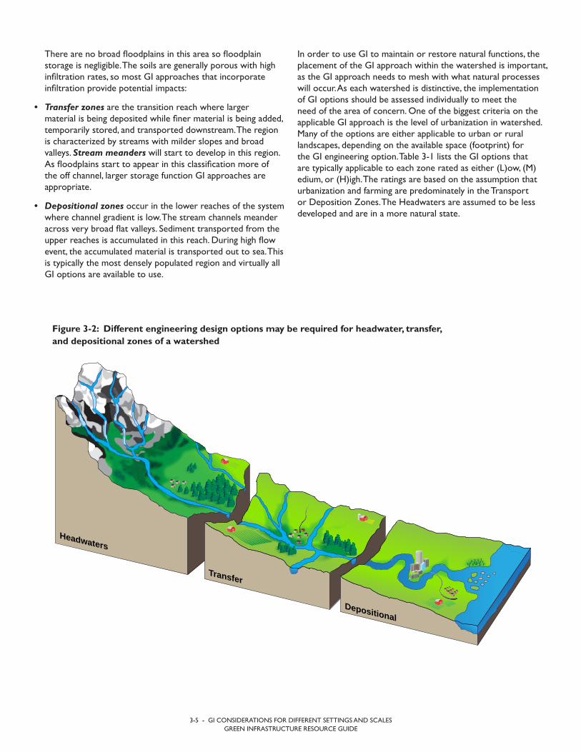
3-5 - GI CONSIDERATIONS FOR DIFFERENT SETTINGS AND SCALESGREEN INFRASTRUCTURE RESOURCE GUIDE
In order to use GI to maintain or restore natural functions, the placement of the GI approach within the watershed is important, as the GI approach needs to mesh with what natural processes will occur. As each watershed is distinctive, the implementation of GI options should be assessed individually to meet the need of the area of concern. One of the biggest criteria on the applicable GI approach is the level of urbanization in watershed. Many of the options are either applicable to urban or rural landscapes, depending on the available space (footprint) for the GI engineering option. Table 3-1 lists the GI options that are typically applicable to each zone rated as either (L)ow, (M)edium, or (H)igh. The ratings are based on the assumption that urbanization and farming are predominately in the Transport or Deposition Zones. The Headwaters are assumed to be less developed and are in a more natural state.
There are no broad floodplains in this area so floodplain storage is negligible. The soils are generally porous with high infiltration rates, so most GI approaches that incorporate infiltration provide potential impacts:
• Transfer zones are the transition reach where largermaterial is being deposited while finer material is being added, temporarily stored, and transported downstream. The regionis characterized by streams with milder slopes and broadvalleys. Stream meanders will start to develop in this region. As floodplains start to appear in this classification more ofthe off channel, larger storage function GI approaches areappropriate.
• Depositional zones occur in the lower reaches of the systemwhere channel gradient is low. The stream channels meanderacross very broad flat valleys. Sediment transported from theupper reaches is accumulated in this reach. During high flowevent, the accumulated material is transported out to sea. Thisis typically the most densely populated region and virtually allGI options are available to use.
Headwaters
Transfer
Depositional
Figure 3-2: Different engineering design options may be required for headwater, transfer, and depositional zones of a watershed
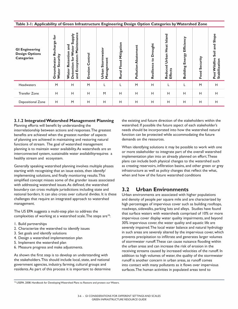
3-6 - GI CONSIDERATIONS FOR DIFFERENT SETTINGS AND SCALESGREEN INFRASTRUCTURE RESOURCE GUIDE
the existing and future direction of the stakeholders within the watershed. If possible the future aspect of each stakeholder’s needs should be incorporated into how the watershed natural function can be protected while accommodating the future demands on the resources.
When identifying solutions it may be possible to work with one or more stakeholder to integrate part of the overall watershed implementation plan into an already planned on effort. These plans can include both physical changes to the watershed such as creating reservoirs, infiltration basins, and other green or grey infrastructure as well as policy changes that reflect the what, when and how of the future watershed conditions
3.2 Urban Environments Urban environments are associated with higher populations and density of people per square mile and are characterized by high percentages of impervious cover such as building rooftops, roadways, sidewalks, parking lots and alleys. Studies have found that surface waters with watersheds comprised of 10% or more impervious cover display water quality impairments, and beyond 30% impervious cover, the water quality and aquatic life are severely impaired. The local water balance and natural hydrology in such areas are severely altered by the impervious cover, which prevents precipitation to infiltrate and generates larger volumes of stormwater runoff. These can cause nuisance flooding within the urban areas and can increase the risk of erosion in the receiving streams caused by increased velocities of the runoff. In addition to high volumes of water, the quality of the stormwater runoff is another concern in urban areas, as runoff comes into contact with many pollutants as it flows over impervious surfaces. The human activities in populated areas tend to
3.1.2 Integrated Watershed Management Planning Planning efforts will benefit by understanding the interrelationship between actions and responses. The greatest benefits are achieved when the greatest number of aspects of planning are achieved in maintaining and restoring natural functions of stream. The goal of watershed management planning is to maintain water availability. As watersheds are an interconnected system, sustainable water availabilityrequires a healthy stream and ecosystem.
Generally speaking watershed planning involves multiple phases starting with recognizing that an issue exists, then identify/implementing solutions, and finally monitoring results. This simplified concept misses some of the grander issues associated with addressing watershed issues. As defined, the watershed boundary can cross multiple jurisdictions including state and national borders. It can also cross over cultural divides. It is these challenges that require an integrated approach to watershed management.
The US EPA suggests a multi-step plan to address the complexities of working at a watershed scale. The steps are18:
1. Build partnerships2. Characterize the watershed to identify issues3. Set goals and identify solutions4. Design a watershed implementation plan5. Implement the watershed plan6. Measure progress and make adjustments.
As shown the first step is to develop an understanding with the stakeholders. This should include local, state, and national government agencies, industry, farming, cultural groups and residents. As part of this process it is important to determine
Table 3-1: Applicability of Green Infrastructure Engineering Design Option Categories by Watershed Zone
GI Engineering Design Options Categories
Gro
undw
ater
Rec
harg
e fo
r W
ater
Sec
urit
y
Wat
er R
eten
tion
and
D
eten
tion
for W
ater
Sup
ply
and
Eco
syst
em M
aint
enan
ce
Ero
sion
Con
trol
Urb
an S
torm
wat
er
Man
agem
ent
Rur
al F
lood
Mit
igat
ion
Pollu
tion
Aba
tem
ent
Res
ilien
ce t
o D
roug
ht
Red
uced
Urb
an H
eat
Isla
nd
Effe
cts
Bui
ldin
g E
nerg
y E
ffici
ency
Food
Sec
urit
y
Post
Wild
fire
Soil
and
Slop
e St
abili
zati
on
Headwaters M H M L L M H L L M H
Transfer Zone H H H M H H H H H H H
Depositional Zone H M H H H H H H H H H
18 USEPA. 2008. Handbook for Developing Watershed Plans to Restore and protect our Waters.

3.3 Rural EnvironmentsWhile in urban areas, GI technologies are often installed to mitigate the impacts associated with impervious surfaces, including lack of infiltration, transport of pollutants via urban runoff, and increased temperatures, in rural settings with low population density and little development, GI is applied to solve a range of challenges related to flooding, water shortages, and agriculture. GI for rural areas encompasses not only small technologies such as rain gardens or tree box filters for rural developments, but also strategies to manage water, watersheds, and landscapes through vegetation, soils, and natural processes. Rural GI applications tend to have a larger scale than urban GI applications and are designed to mitigate or prevent natural process disruptions rather than manage localized concentrated stressors that are common in urban developments.
Floodplain roughness and channel migration are two examples of landscape-scale engineered designs that improve watershed function by increasing floodplain storage and promoting infiltration and groundwater recharge. While traditionally urban GI technologies may be installed to control precipitation traveling over hard surfaces, the ability to accommodate the dynamic levels, flow, and movement of surface water bodies are key objectives of rural GI.
Green Infrastructure systems that store water are implemented in both urban and rural settings. Within rural areas, and in drought-prone areas in particular, rainfall stored in cisterns can provide a critical source of water for agriculture, livestock, and households. Whereas reducing the volume of runoff is an objective of installing rain barrels and cisterns in urban areas, the primary purpose of water storage in rural areas is to supplement water supplies.
Conservation agricultural practices serve a multitude of purposes in rural areas, including reducing the transport of nutrients from soils to surface water, maintaining soil structure and moisture, reducing irrigation or water demand for crops,
generate large amounts of pollutants not typically found in rural environments, such as trash, oil, bacteria, sediment, metals and petroleum compounds from vehicles, and even thermal pollution.
Often, compact urban developments leave little to no open space for the stormwater runoff to be managed and infiltrated into the ground. Green infrastructure for urban developments is tailored to address the specific challenges of urban stormwater runoff such as the ability to remove large concentrations of pollutants and to fit into small spaces that are available in urban landscape. GI is often integrated with existing infrastructure and designed for dual purposes. For example, permeable pavements can serve both as transportation infrastructure and stormwater management technologies, and green roof cisterns can be designed for stormwater management and recreational purposes.
Due to the magnitude of stormwater runoff generated by highly urbanized areas, green infrastructure practices cannot always effectively manage all of the runoff. Green infrastructure is often used in combination with traditional grey infrastructure, as a means of retrofitting existing stormwater infrastructure, or to ease the impacts of expanding developments on existing stormwater and drainage systems.
Urban green infrastructure has developed over the recent years and was termed at times Green Stormwater Infrastructure (GSI), Water Sensitive Urban Designs (WSUD) or structural Low Impact Development (LID) and includes technologies such as bioretention systems, tree filter and tree trenches, green roofs, and permeable pavements. Although this is a field of continuous development and innovation, urban GI generally encompass technologies that integrate vegetation, soils and natural processes within the urban landscape, both for the purpose of managing stormwater runoff and of connecting urban activities to the ecosystem services that support urban life.
Kiril
l Chu
pakh
in

3-8 - GI CONSIDERATIONS FOR DIFFERENT SETTINGS AND SCALESGREEN INFRASTRUCTURE RESOURCE GUIDE
3.4 Emergency Response Situations GI considerations can be integrated into emergency response programming to greatly enhance the sustainability of response measures as well as improve living conditions for displaced persons. This section outlines several GI options for organizations engaged in emergency response. These measures can be especially effective in the planning, creation and management of settlements for refugees and internally displaced persons (IDPs), where competition over natural resources and rights to land (especially communal rights) are weak and therefore present as compounding factors of the crisis.
People impacted by man-made and natural disasters are making critical life-determining decisions, often based on little or misleading information. Their decisions are largely influenced by an immediate need security and access to minimal basic needs of survival such as water, food and shelter. The decision-making environment is also often influenced by trauma. In cases of displacement, an overriding question concerns finding an appropriate location for often large numbers of people to settle. As urgency, lack of optimal environments, and high population densities often converge in such crises, settlement sites for large groups are often located on marginal land on the edge of towns or in rural areas, where land ownership is often less of an issue.
For displaced people, the United Nations High Commissioner for Refugees (UNHCR) recommends that “settlement plans should:
• Take into account national development plans to ensure thatsettlement plans are economically, socially and environmentallysustainable.
• Be people-centred, promoting self-reliance and enablingcommunities to develop suitable solutions themselves.
• Take into account the characteristics and identity of the area, of theenvironment, and of the people and their habitat.
• Systematically apply an Age, Gender and Diversity (AGD)20
approach to ensure that all persons of concern have equal accessto their rights, protection, services and resources, and are able toparticipate as active partners in the decisions that affect them.
• Be dynamic. Settlement designs should be adaptable and capableof responding to changes in a crisis situation. They should foreseean exit strategy when persons of concern find durable solutions.”21
and increasing crop yield and diversity. Green Infrastructure is implemented to build resiliency to stressors and degradation including drought, changes in precipitation, and soil integrity, as well as mitigate the impacts of agriculture on natural systems.
3.3.1 Green Infrastructure and Ecosystem Services Similar to urban areas, GI is implemented to mitigate challenges that derive from the interface between the human, build environment and the function and processes of the natural environment. By mimicking natural processes and by protecting resources and processes from the impacts of human activities, GI increases the direct and indirect benefits provided by natural systems to society.
Each of the four categories of ecosystem services exists in rural areas. A study of the importance of ecosystem services for rural inhabitants implemented in Central Romania found that freshwater was considered the most important ecosystem service by 75% of study participants. Healthy soil was considered the second most important ecosystem service. Flood control was among the top regulating ecosystem services identified by respondents. Cultural services, including sense of place and relaxation and recreation were considered very important by many respondents.19 Green Infrastructure systems can augment and protect each of these services. Table 3-2 includes examples of each category of ecosystem services supported by GI.
Rural society and ecosystems are highly interdependent. Implementing GI in rural communities helps societies adapt to the current and future conditions and stressors within the rural environment. Because of the scale at which many GI designs are implemented in rural areas, watershed-wide benefits to the landscape are achievable with rural GI.
Table 3-2: Examples of ecosystem services in rural areas
Ecosystem Service
CategoryEcosystem Service GI Design
Provisioning Production of food Contour Farming
Regulating Floodplain storage Channel Restoration
Supporting Nutrient cycling Conservation Tillage
CulturalProtection of water quality of rivers and streams for recreation
Riparian Buffer
19 Hartel, T. et al. The importance of ecosystem services for rural inhabitants in a changing cultural landscape in Romania. 2014. Ecology and Science. 19(2): 42. http://dx.doi.org/10.5751/ES-06333-19024220 https://emergency.unhcr.org/entry/9526921 https://emergency.unhcr.org/entry/35944/site-planning-for-camps

• Monitoring and evaluation, and
• Learning and adaptation.
Specific GI interventions that are presented in Section 2 of this guide can all be applied to emergency or disaster response settings, depending on site characteristics and community needs. The difference in applying GI to the emergency setting is that an urgent need to address basic needs for survival reigns most important. Nonetheless, an experienced team will be prepared to integrate GI considerations in a rapid and abbreviated yet efficient form during critical decisions about site selection in order to maximize sustainable quality of life outcomes. Emergency response teams can prepare and improve this decision-making process by reflecting on selected interventions that may have more common application in refugee settlements, such as:
• Groundwater recharge for water security
• Water retention/detention for water supply and ecosystemmaintenance
• Erosion control and shoreline stabilization, including tillage, farming practices
• Urban stormwater management
• Rural flood mitigation
• Pollution abatement, particularly with regard to wastemanagement and sanitation
• Resilience to drought
• Urban heat island effects
• Increased building energy efficiency, especially for homes andlarger service structures in desert environments
• Efficiency in food security, and
• Managing soil and slope stabilization after wildfires.
To meet these criteria, it is important to assess numerous factors that define the multi-dimensional aspects of site suitability, including:
1. Land use and land rights
2. Surface areas of land and its expansion possibilities
3. Topography, elevation, soil condition, water availability, vegetation and climate conditions
4. Sanitation possibilities
5. Harvesting of wood for construction and wood for fuel
6. Availability of electricity and other services, and
7. Proximity to agriculture and income generation.
Assessment of these factors can be made using analyses of hydrology, habitat and natural resource availability that are often applied during the site and community-specific considerations mentioned in Section 2 above.
In addition to understanding the physical environment and the potential for human impact, GI options must be sensitive to their influence on the decisions of impacted communities and hosts. As such, GI interventions must be applied within the same response guided by the humanitarian principles and standards of the United Nations. To do so, it is essential that GI considerations be integrated into the early stages of IDP settlement planning and emergency response. Numerous points in the planning process offer opportunities to do so and include:
• Consultations and planning with local authorities, impactedcommunities and hosts/indirectly impacted
• Environmental surveys and impact assessments, includingconsideration of social dimensions
• Coordination and participation in working groups
• Proposal development
Boy draws water from cistern in the village of Khirbet Jenbah, South Hebron Hills, which is not hooked up to water gridw
ww.
btse
lem
.org
/pho
tobl
og/2
0140
219_
wat
er

3-10 - GI CONSIDERATIONS FOR DIFFERENT SETTINGS AND SCALESGREEN INFRASTRUCTURE RESOURCE GUIDE
However, there are some additional factors that should be given consideration when developing monitoring strategies for GI effectiveness at larger scale:
• Locations of the interventions with regard to response location. For stream related indicators, most of the GI
Aesthetics and quality of life, mental health, and/or psychosocial wellbeing are also important factors to consider during site suitability assessments. UNICEF includes “child friendly spaces” in their emergency response. Other groups recognize psychosocial wellbeing as an important element implicit in the provision of first aid. GI that protects and promotes the natural environment as source of mental health and wellbeing is essential to good quality of life, even in emergency settings.
3.4.1 Natural Resource Management as Part of Conflict Mitigation GI options can serve as part of conflict mitigation especially when competition over resources is contributing factor to conflict. The value of GI and associated management plans in such cases are most evident where the interventions help conserve natural resources, such as water or arable land. The integrated watershed management approach can also be used as a center point for discussions between competing communities or States to include GI planning and design. As mentioned in Section 3.1.2, integrated watershed management planning is an important mechanism that brings together the users and authorities within a watershed to plan and use water resources collaboratively Community decision-making on appropriate GI interventions increases the success rate of the intervention to have a positive impact on not only the watershed or GI asset, but also on community well being and peaceful outcomes.
3.5 Monitoring Strategies at Different Scales The effectiveness of GI at system scale is generally well understood and documented. Monitoring protocols for GI effectiveness for quantitative indicators are generally defined, and for some GI interventions, qualitative methods are developed for supplemental qualitative responses. The GI response at larger scale, such as site, sub-watershed, or watershed level, is dependent on multiple factors (i.e., system design, site specific conditions) and is affected by natural phenomena and dynamics that may not always be understood or anticipated. The unknown factor results in a range of possible GI responses that need to be considered in both planning and monitoring of GI implementation at larger scale.
Generally, the scale at which the intervention is implemented dictates the scale of the monitoring strategy. For example, reforestation applied within a sub-watershed to minimize sediment transport should be monitored at sub watershed level, while implantation of multiple types of GI interventions throughout the watershed that target the same functional response (i.e., reforestation, contour farming and terracing, cover crop) should be monitored a watershed level.
CASE STUDY
INCORPORATING SHARED USER AGREEMENTS IN GI MANAGEMENT PLANS
In South Sudan, the USAID VISTAS Program supports an agreement between three different ethnic groups or commu-nities that jointly share an area of land that has been divid-ed by the administrative boundaries of several states. The “Wunlit Agreement” was developed in consultation with local stakeholders and successfully allows for shared grazing of cattle in this area:
On the border between Sudan and South Sudan Kiir/Bahr el Arab river basin is an area of shared pasture, water sources and associated agricultural GI to support livestock. Several semi-nomadic Sudanese groups move south into this area an-nually during the dry-season. However, the area was divided by a new and disputed international boundary when South Sudan gained independence in 2011, which impeded access. The VISTAS program facilitated bi-annual migration meetings to help coordinate the determination of the timing, migration routes and rules that govern the movement of livestock by these communities to prevent conflict. Management plans concerning GI can protect not only access to GI assets but also the health of the associated ecosystems when people can jointly care for and use natural resources unimpeded by conflict. National and international policies concerning user relationships can be enhanced when the users affected help inform these policies.
Wik
iped
ia C
omm
ons

Additional factors to consider when determining monitoring strategies in urban versus rural areas include:
• The key indicators of effective GI that are measured. Inurban areas, indicators may include water quality, air quality, thermal pollution, green space, percent imperviousness, andwater quality in the receiving body of water. In rural areas, keyindicators may include flood reduction, stream erosion, waterquality, increase crop yield, and ecosystems health.
• Water quality parameters to evaluate. Sediment andnutrients, including nitrogen and phosphorus may be morecritical to measure in rural areas than urban areas, wherepollutants such as dissolved metals, bacteria, total suspendedsolids, and petroleum compounds from vehicular traffic mayhave greater impact on water quality.
• Logistics of monitoring in urban areas can be morechallenging than in rural areas since the monitoringequipment should not disrupt normal activities in busyareas. The collected data in urban environments may beaffected by outside factors if monitoring instruments are notincorporated effectively with the urban landscape.
interventions are implemented within the watershed where the stressors take place (i.e., urban development, agricultural practices), while the responses are expected at the stream level. Monitoring may be needed both at the location of the GI intervention and at specific points of interest at stream level.
• The magnitude and areal extent of the disturbancecreated by the stressors addressed by the GI intervention. Stressors occurring at small scale (i.e., dense urbandevelopment) can have larger magnitude impacts on thereceiving stream at discharge points, while impacts of largerscale stressors (i.e., catastrophic events) may be dispersedthroughout the watershed. Small scale-high impact GIinterventions may only require one or two monitoringlocations and are generally easier to monitor, while GIinterventions dispersed on a larger area may require severalmonitoring locations to capture the change in the indicators.Smaller changes in the indicators measures at larger scale arealso more difficult to measure.
• Location of the stressor and GI intervention within thewatershed. A stressor occurring in the upper reaches ofthe watershed has the potential to disrupt the ecosystemservices locally and may be carried downstream for a longerextent, while disruptions occurring in the lower reaches ofthe watershed are easier to contain and address with GIinterventions. Similarly, GI interventions in the upper reachesof the watersheds may see larger change in the measuredindicators locally, but the responses would be carrieddownstream and may require additional monitoring locationsin the lower reaches of the watershed.


CONCLUDING REMARKS
The benefits of GI extend beyond the ecological, pollution abatement, and climate resilience benefits presented in this guide and also include economic and social benefits. Taking an adaptive management approach to infrastructure asset operations and monitoring, the GI research and development community continues to make advancements in:
• Refining GI design guidelines
• Improving designs to increase pollutant removal of existing technologies to address emerging pollutants, and
• Creating new techniques for integrating GI with grey infrastructure.
As such, the list of GI technologies and interventions included in this guide is not an exhaustive list. The readers of this guide are encouraged to seek additional information on other benefits and applications of GI not discussed in this guide, and to become familiar with the ever-evolving GI technologies as new information becomes available. Readers of this guide are also encouraged to share information and experience gained from application of GI technologies with other practitioners to aid in continued improvement and knowledge sharing in this field.


Related Documents