Green City Guidelines Advice for the protection and enhancement of biodiversity in medium to high-density urban developments

Welcome message from author
This document is posted to help you gain knowledge. Please leave a comment to let me know what you think about it! Share it to your friends and learn new things together.
Transcript

Green City GuidelinesAdvice for the protection and enhancement of biodiversity
in medium to high-density urban developments
Green City GuidelinesAdvice for the protection and enhancement of biodiversity in
medium to high-density urban developments
UCD Urban Institute Ireland,
Dún Laoghaire-Rathdown County Council,
Fingal County Council.
Prepared by NATURA Environmental Consultants (Carmel Brennan) in association with David O’Connor, Planning Consultant.
© 2008, UCD Urban Institute Ireland.
Published in Dublin by UCD Urban Institute Ireland, Richview, Clonskeagh Drive, Dublin 14, Ireland.
ISBN 978-1-905254-33-0
Designed and printed by: Concept 2 Print.
III
Acknowledgements
The Steering Group, comprising Tim Carey, Heritage Officer (Dún Laoghaire-Rathdown County Council), Dr Gerry Clabby, Heritage Officer (Fingal County Council) and Sheila Convery (UCD Urban Institute Ireland) would like to acknowledge the support of the Urban Environment Project and their sponsors, the Environmental Protection Agency (funded through the National Development Plan) in producing these Guidelines. Natura Environmental Consultants Ltd in association with David O’Connor were responsible for preparing the Report which forms the basis for this publication. The principal authors are Dr Carmel Brennan and David O’Connor. The NATURA team included Richard Nairn, Dr Maeve Flynn, Matthew Hague, Ciara Hamilton and Dr Colin Kelleher.
A wide team of professional people contributed to the guidelines including; Síne Kelly (Tom Philips & Associates), Harry McLauchlan (FCC), Rhona Naughton (DLRCC) and Conor Norton (LOCI), as well as Hazel Craigie (FCC), Hans Visser, Biodiversity Officer (FCC) and Dr. Tamara Hochstrasser (UCD) who made a valuable contribution to the process by adding their comments at the mid-point of the project and through the review stages. Thanks also to postgraduate researcher Michael Brennan (UCD) for his support in fieldwork, research and the review process. Many thanks to Denis Daly (DLRCC) and Larry Ryan (FCC) for providing mapping for the project. Thank you to Therese Carrick for her proof-reading services.
All photographs are by NATURA and David O’Connor unless otherwise credited. Aerial photography for sites in Fingal © BKS.
IV
Preface
Whilst conventional wisdom holds that high levels of biodiversity are rarely to be found outside of rural areas and specific protected habitats, this work highlights the role and importance of urban biodiversity as well as providing practical guidance on how to retain and enhance biodiversity in medium-high density developments. Initially a range of sites within Dún Laoghaire-Rathdown and Fingal were selected based on their urban typologies which reflect a range of forms of differing ages, layouts and compositions. The biodiversity resource in each site was identified using standard survey techniques and recorded on a site by site basis. Then an extensive literature review of best practice internationally was carried out. Finally, planners working in local authorities and in private practice were asked for suggestions concerning the form, layout, design and content of the guidelines. We hope that the information and advice contained in the Guidelines will serve as a practical and easy to-access guide for local authorities, planners and property developers such that the design of medium to high-density developments takes proper and appropriate account of the opportunities for retaining and enhancing biodiversity in urban areas.
Professor Frank Convery
Heritage Trust Professor of Environmental PolicyUniversity College Dublin
V
Contents
Acknowledgements III
Preface IV
Overview VII
Glossary IX
1.IntroductiontoGreenCityGuidelines 1
1.1 Background 2
1.2 Defining biodiversity 3
1.3 The value of urban biodiversity 3
1.4 Threats to biodiversity 6
1.5 Halting the loss of Irish biodiversity 6
2.Makingspaceforbiodiversityinurbanareas 9
2.1 Green space 10
2.2 Grey space 10
2.3 Brownfield sites 11
2.4 Private gardens and balconies 11
2.5 The evolution of the green city 12
2.6 Designing green space for biodiversity 15
2.6.1 Landscape-scale design 15
2.6.2 Habitat-scale design 16
3.Overviewofplanninganddevelopmentprocess 19
3.1 Biodiversity management in forward planning 20
3.1.1 Developing a County policy framework for biodiversity 20
3.1.2 Local biodiversity action plans 20
3.1.3 Biodiversity in area plans 21
3.1.4 Approaches to area planning 22
3.2 Biodiversity management within the development management process 25
3.2.1 Guidelines in the development management process 25
3.2.2 Site preparation 25
3.2.3 Pre-planning 25
3.2.4 Planning and design 25
3.2.5 The planning application process 26
3.2.6 Development, construction and post-development management 27
3.2.7 Monitoring and enforcement 27
3.3 Understanding the planning and development benefits of biodiversity 29
3.3.1 High density in the Irish planning environment 29
3.3.2 Why enhanced biodiversity means better development 30
VI
4.Casestudies 33
4.1 Methodology 34
4.2 Typology and case study 35
4.2.1 Selection of suitable case study sites 35
4.2.2 Analysing and describing urban typologies 36
4.2.3 Overview of the planning process 36
4.3 Biodiversity evaluation 36
Case Study 1: Monkstown 37
Case Study 2: Castleknock 40
Case Study 3: Dundrum 43
Case Study 4: Ongar 47
Case Study 5: Stepaside 50
Case Study 6: Swords 55
Case Study 7: Lusk 60
4.4 Pilot biodiversity assessment: Old Connaught and environs 65
4.4.1 An overview of Old Connaught and its environs 65
4.4.2 Protecting and enhancing features of value within the landscape 67
4.4.3 Assessing the existing environment for a new development 69
5.Practicalmeasuresforincorporatingbiodiversity 71 5.1 Site preparation 72
5.1.1 Scoping and Constraints study 72
5.1.2 Basic Habitat Assessment 73
5.2 Pre-planning 75
5.3 Planning and design 75
5.3.1 Evaluation and assessment 75
5.3.2 Protecting and retaining features of value 78
5.3.3 Creating and enhancing biodiversity 79
5.3.4 Connecting to the wider landscape 85
5.4 Development, construction and post-development management 89
5.4.1 Mitigate against adverse impacts 89
5.4.2 Enhance existing habitats through good management 89
5.5 Monitoring and enforcement 90
6.References 91
7.Appendices 95 Appendix 1. Appropriate periods for field survey 95
Appendix 2. Site evaluation scheme 96
Appendix 3. Criteria for assessing impact significance: Terrestrial sites 97
Appendix 4. Criteria for assessing impact significance: Aquatic sites 98
Appendix 5. Appropriate trees and shrubs for planting schemes 99
Overview
The Green City Guidelines are designed to provide practical guidance for planners and developers on how to integrate biodiversity into new developments, specifically medium to high-density housing developments in urban areas. As we grow in awareness of how our activities affect the natural environment, we must rethink how our basic requirements of sanitation, transport and housing are provided. As a result, best practice measures are constantly evolving to better facilitate the incorporation of biodiversity into development.
Recent decades have seen record levels of housing development, much of which, in line with the 1999 Residential Density Guidelines, has been built at higher densities in urban areas. Even with a slowing in the pace of economic growth this is likely to continue with the number of households forecasted to grow from approximately 1.8m at present to 2.5m by 2020. Recent policy and guideline documents from the Department of the Environment, Heritage and Local Government emphasise strongly the need for an improved quality of housing within sustainable and well-planned neighbourhoods. The holistic and integrated approach to planning, which the Department is recommending, should incorporate biodiversity protection and enhancement as a core objective.
In response to the global decline in biodiversity, the 1992 Convention on Biological Diversity (Rio Convention) was dedicated to finding policies to halt the global decline in biodiversity. Ireland, as a signatory to the Convention, undertook to implement its principles at national and local levels by formulating a biodiversity strategy. The National Biodiversity Plan identifies 87 actions that are to be undertaken, including the integration of biodiversity into all sectors, including planning and development. Implementation of this plan requires the integration of policies at national and local level and cross-sectoral co-operation. This means that all sectors, directly or indirectly connected with biodiversity, must examine their activities and minimise any negative impacts they are likely to cause.
In Ireland, many sites and species of national and international biodiversity value are designated as Special Areas of Conservation (SAC), Special Protection Areas (SPA) and Natural Heritage Areas (NHA). These are protected under law and through the planning system. However, they account for only a small amount of the country. Substantial areas with high biodiversity value remain unprotected, and frequently unrecorded. Frequently these areas are subject to pressure from development. The guidelines aim to provide practical examples of how semi-natural habitats such as woodlands, grasslands, treelines, hedgerows and watercourses can be successfully maintained, enhanced and created within new developments through appropriate planning and management. Local Biodiversity Action Plans (LBAP) set out the objectives for biodiversity conservation within a city or county. They bring together existing knowledge on the state of local habitats, flora and fauna and identify conservation needs. A vital component of every local biodiversity strategy is to identify gaps in knowledge and undertake initiatives to fill them. Many initiatives are ongoing around the country that will feed into and inform the planning process, helping to identify sensitive areas where development would be damaging and areas that are suitable for new development.
An outline of the individual chapters of the Green City Guidelines is provided below.
Chapter1:IntroductiontoGreenCityGuidelinesreviews the background to biodiversity; its value to humans and outlines how it is being protected in an Irish context. Considerable coverage has been given to the value of biodiversity in international publications. Maintaining our natural environment not only provides us with amenity and recreational benefits but many of nature’s functions and services support our own existence. Basic requirements such as clean water, fresh air and food supply depend upon a functioning and balanced natural environment. We rely on nature to support many of our economic activities including agriculture and tourism. Greener cities provide more attractive centres for people to live and work, which indirectly supports our economic viability. The restorative effects of nature and psychological benefits are generally acknowledged. Beyond our own benefit, there is an intrinsic value to all life and we have an ethical obligation to respect the living organisms with which we share the planet.
Chapter2:Makingspaceforbiodiversityinurbanareas looks at where biodiversity is typically found in the urban environment. It considers the origin of the green city approach to planning and introduces the principles of ecological planning and design at the landscape and habitat scales. Urban biodiversity is often perceived as being less important than its rural counterpart. Urban habitats are assumed to be highly modified and lacking in the characteristics that define more natural systems. However, while this can be true, many modified habitats are not without biodiversity value and some can support a high number of plants and animals. Unique urban communities have evolved to adapt to the unusual
VII
environmental conditions that urban locations can present. Urban biodiversity occurs in a variety of areas from private gardens and local parks to river corridors and large coastal zones.
Chapter3:Overviewoftheplanninganddevelopmentprocess highlights the key instruments within the planning process that can be used to identify and incorporate biodiversity into new development and considers the inclusion of biodiversity within the development management process. Planning for biodiversity at the landscape-level means considering the overall connectivity of habitats within the wider landscape. The County Development Plan is one of the most influential instruments in the planning process. It has the capacity to provide a strategic and legal framework for ecological planning within the wider landscape. An ecological spatial strategy, informed by the Local Biodiversity Action Plan and based on the existing network of Natura 2000 designated sites, could be implemented through the County Development Plan. Strategic planning tools such as green belts, green wedges and green fingers can also be used to directly or indirectly protect biodiversity at the landscape-scale.
At the local area level, Local Area Plans can provide a framework for biodiversity conservation. Local Area Plans and similar statutory and non-statutory instruments provide a means for highlighting sites and species of high local ecological value that may not be subject to any form of formal protection.
Chapter4:Casestudies examines the biodiversity resources within a sample of eight case study urban sites. All sites were chosen from the administrative areas of Dún Laoghaire-Rathdown County Council and Fingal County Council. Four urban “sectors” were identified, radiating out from the core city area, that broadly reflected the differing urban environments across both areas: (i) Inner Urban; (ii) Inner Suburban; (iii) Outer Suburban; and (iv) Outer Town. A planning analysis and biodiversity evaluation of all study areas was undertaken. An additional site, Old Connaught and environs is used to illustrate and summarise the key biodiversity messages outlined in the Guidelines. This includes the identification of potential locations for development, identification of important landscape patches and the potential for enhancement of biodiversity on the site. This is a theoretical case study.
Chapter5:Practicalmeasuresforincorporatingbiodiversity presents general recommendations with reference to practical case study examples where appropriate. Using a combined approach of field work, data analysis and literature review, practical guidelines have been prepared to address the main stages of planning and development from early site assessment through to the detailed design and monitoring stages. An outline of the essential points is as follows:
• Initiate early consultation between planners and developers• Initiate early ecological surveys to assess the suitability of the site for development and identify considerations and opportunities at an early stage• Design the development footprint to avoid habitats of high ecological value and maximise the area of open space• Protect and incorporate semi-natural habitats, especially those of high ecological value and mature features• Maintain and enhance retained habitats through sensitive management• Reinstate and create new habitats using native species that reflect the character of surrounding semi-natural habitats• Incorporate or create a water feature using native species• Prevent the introduction and spread of invasive species• Use new technologies such as green roofs, green walls, permeable surfaces and SUDS• Protect and create ecological links to the wider landscape• Monitor the ecological effectiveness of prescribed measures and modify as needed and• Get the community positively involved
Sustainability has become a core value in planning and decision-making. Defining sustainability and incorporating its principles into new development has presented many challenges to society. At its broadest definition, sustainable development includes three strands: economic, social and environmental. A key issue in achieving sustainable development is finding a balance between competing interests and giving the appropriate value or weighting to each strand. In the past, biodiversity interests have sometimes taken a back seat to other considerations. While biodiversity considerations are most closely associated with the environment, it is increasingly recognised that it plays a vital role in supporting all three strands. Biodiversity is a fundamental consideration that must be genuinely considered and effectively incorporated into any development for it to be truly considered sustainable.
VIII

GlossaryandAbbreviations
AI Additional Information
CAI Clarification of Additional Information
CBD Convention on Biological Diversity (signed at the United Nations Conference on Environment and Development (Rio 1992) (also Earth Summit)
cSAC candidate Special Area of Conservation. Ecological network. The core natural habitats together with the elements of connectedness i.e. the major wildlife and water corridors, streams and wetlands, rare habitats and species, and topographic sites
DETR Department of the Environment, Transport & the Regions (UK)
DoE Department of the Environment (UK)
EC European Commission
Ecosystem An interacting community of independent organisms and their non-living environment
EIA Environmental Impact Assessment: The process of defining, quantifying and evaluating the potential impacts of defined actions on ecosystems or their components
EIS Environmental Impact Statement: Report resulting from an EIA
EPA Environmental Protection Agency
Fauna A collective term for all kinds of animals
Flora A collective term for all kinds of plants
FPO Flora Protection Order: Statutory Instrument (SI) protecting Ireland’s rarest flora species
Habitat A place in which a particular plant or animal lives. Often used in the wider sense referring to major assemblages of plants and animals found together
IAP Integrated Area Plan
Invertebrates Animals without a backbone
IUCN The World Conservation Union
LBAP Local Biodiversity Action Plan
Mitigation Measures taken to avoid, reduce or remedy adverse impacts
NGO Non-Government Organisation
NPWS National Parks and Wildlife Service
pNHA proposed Natural Heritage Area
RDB Red Data Book
Riparian The edge of streams or rivers
Semi-natural A habitat or ecosystem created or maintained with some human intervention but where plant regeneration is spontaneous
SUDS Sustainable Urban Drainage Systems
TPO Tree Preservation Order - designation under the Planning and Development Act 2000
UN United Nations
UNEP United Nations Environment Programme
WWF World Wildlife Fund
IX
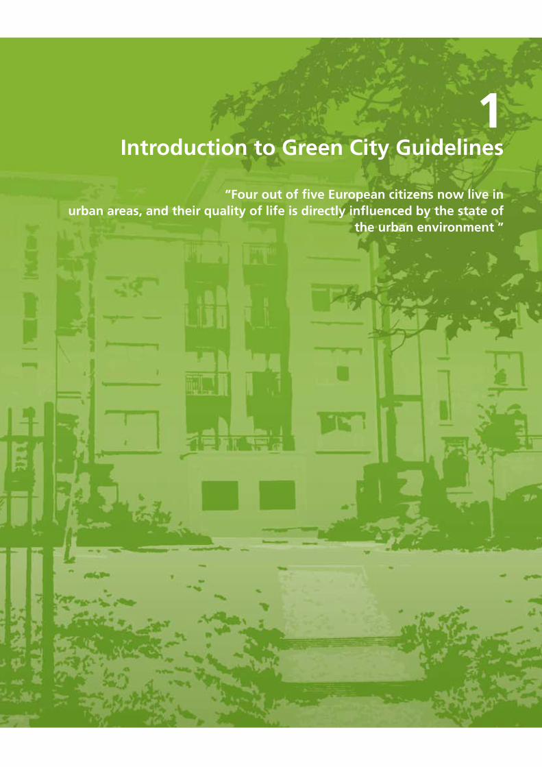
1Introduction to Green City Guidelines
“Four out of five European citizens now live in urban areas, and their quality of life is directly influenced by the state of
the urban environment ”
�
1.IntroductiontoGreenCityGuidelines
1.1 BACkGROUNDIn 2007, for the first time in human history, the world’s urban population exceeded its rural population (UNEP, 2007). Four out of five European citizens now live in urban areas, and their quality of life is directly influenced by the state of the urban environment (EC, 2004). Ireland stands out in Europe in having one of the fastest rates of urbanisation at present. We are changing from a once rural population to a predominantly urban one. The associated problems of urban sprawl, a degraded urban environment and the loss of biodiversity require sustainable urban design and appropriate land-use and planning to help counteract the effects (EC, 2004).
Planning for urban biodiversity presents a number of challenges: higher population densities, strong development pressure and competing demands on space. However, cities are dynamic landscapes that present opportunity for regeneration and enhancement through incorporating innovative design and the latest best practice methods. A series of planning policies, based around optimising the sustainability of urban areas, is promoting higher densities within the Irish housing stock. These trends are likely to continue in the immediate future.
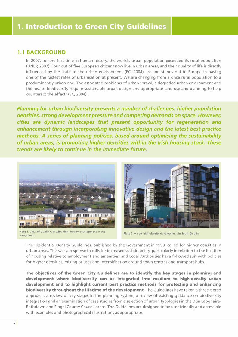
The Residential Density Guidelines, published by the Government in 1999, called for higher densities in urban areas. This was a response to calls for increased sustainability, particularly in relation to the location of housing relative to employment and amenities, and Local Authorities have followed suit with policies for higher densities, mixing of uses and intensification around town centres and transport hubs.
Theobjectivesof theGreenCityGuidelinesare to identify thekey stages inplanninganddevelopment where biodiversity can be integrated into medium to high-density urbandevelopmentand to highlight currentbest practice methods forprotecting andenhancingbiodiversitythroughoutthelifetimeofthedevelopment. The Guidelines have taken a three-tiered approach: a review of key stages in the planning system, a review of existing guidance on biodiversity integration and an examination of case studies from a selection of urban typologies in the Dún Laoghaire-Rathdown and Fingal County Council areas. The Guidelines are designed to be user friendly and accessible with examples and photographical illustrations as appropriate.
Plate 2. A new high-density development in South Dublin.Plate 1. View of Dublin City with high-density development in the foreground.
�
There is currently a substantial body of guidance documents from the United Kingdom, continental Europe and the United States on how biodiversity can be successfully integrated into different aspects of planning and development. The Green City Guidelines have drawn extensively on existing recommendations and best practice guidance, as they relate to urban development. Standard guidance documents are referred to throughout the text and can be consulted for specialist advice on specific areas.
Many documents are now available on-line and links to websites are provided in the bibliography section. The discipline of urban ecology and the process of integrating biodiversity into high-density developments are still relatively new in an Irish context. It is anticipated that the Guidelines will be reviewed and updated to reflect the Irish experience as the planning system and best practice methods evolve. The Guidelines examined the existing biodiversity resources within a representative sample of case study urban sites. Key biodiversity indicators were identified and described from a range of urban typologies specific to the administrative areas of Dún Laoghaire-Rathdown County Council and Fingal County Council. The resources were identified and described in terms of their current and potential value.
1.2 DEFINING BIODIvERSITyBiodiversity is the shorthand for Biological Diversity and refers to the variation of all life on earth (Gaston & Spicer, 2004). It is most commonly divided into three levels of biological organisation; genes, species, and ecosystems, which relate to different aspects of living systems that can be measured in different ways. The term Biodiversity is essentially a new name for an old concept. The term was first used in the late 1980s and then came into popular use following the Convention on Biological Diversity in 1992. Whether we refer to it as nature, flora and fauna, or biodiversity, it remains the variety of all living organisms on the planet at this time.
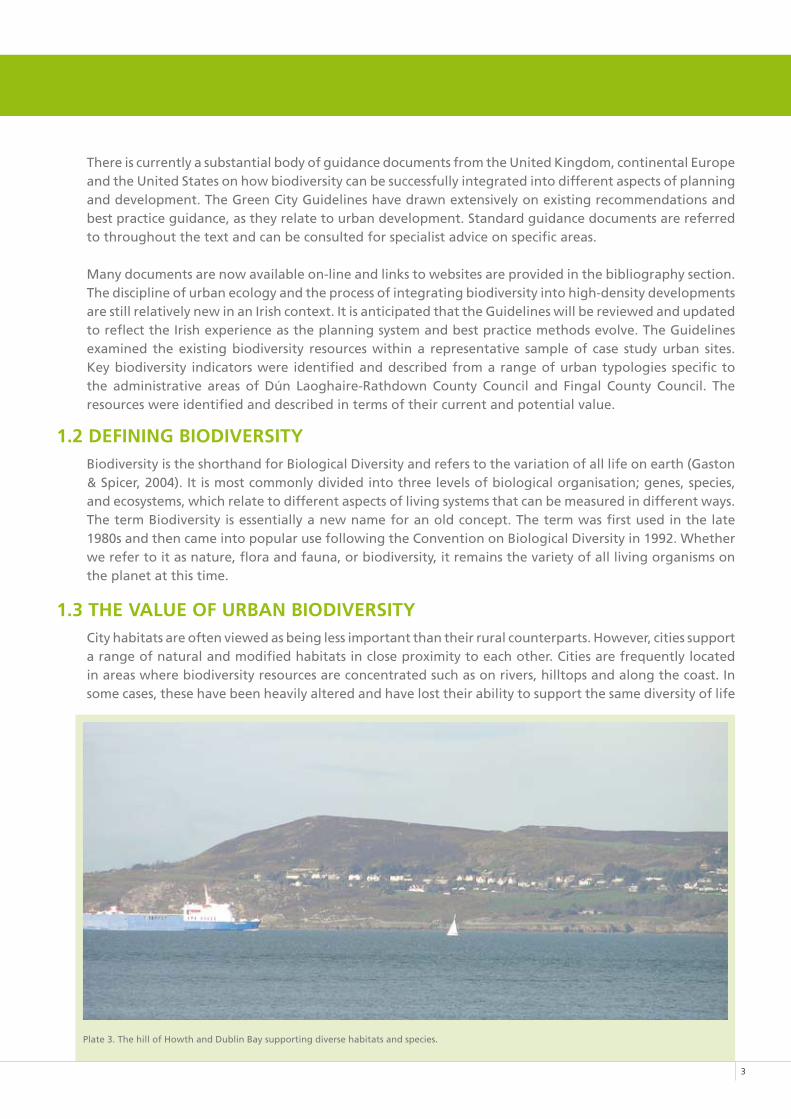
1.3 THE vALUE OF URBAN BIODIvERSITyCity habitats are often viewed as being less important than their rural counterparts. However, cities support a range of natural and modified habitats in close proximity to each other. Cities are frequently located in areas where biodiversity resources are concentrated such as on rivers, hilltops and along the coast. In some cases, these have been heavily altered and have lost their ability to support the same diversity of life
Plate 3. The hill of Howth and Dublin Bay supporting diverse habitats and species.
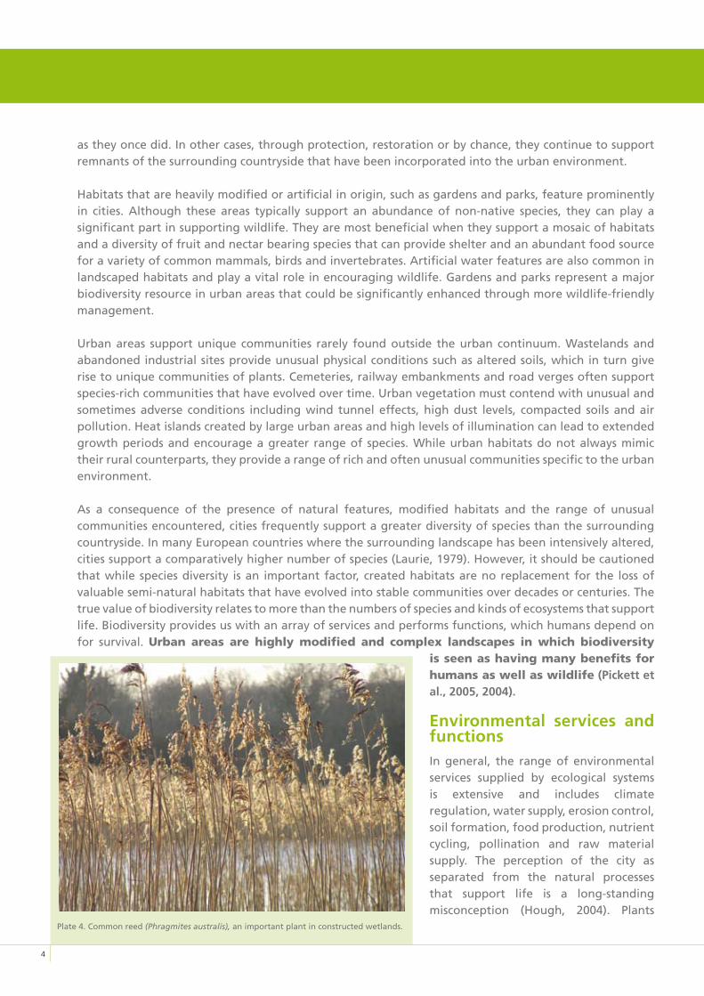
Plate 4. Common reed (Phragmites australis), an important plant in constructed wetlands.
as they once did. In other cases, through protection, restoration or by chance, they continue to support remnants of the surrounding countryside that have been incorporated into the urban environment.
Habitats that are heavily modified or artificial in origin, such as gardens and parks, feature prominently in cities. Although these areas typically support an abundance of non-native species, they can play a significant part in supporting wildlife. They are most beneficial when they support a mosaic of habitats and a diversity of fruit and nectar bearing species that can provide shelter and an abundant food source for a variety of common mammals, birds and invertebrates. Artificial water features are also common in landscaped habitats and play a vital role in encouraging wildlife. Gardens and parks represent a major biodiversity resource in urban areas that could be significantly enhanced through more wildlife-friendly management.
Urban areas support unique communities rarely found outside the urban continuum. Wastelands and abandoned industrial sites provide unusual physical conditions such as altered soils, which in turn give rise to unique communities of plants. Cemeteries, railway embankments and road verges often support species-rich communities that have evolved over time. Urban vegetation must contend with unusual and sometimes adverse conditions including wind tunnel effects, high dust levels, compacted soils and air pollution. Heat islands created by large urban areas and high levels of illumination can lead to extended growth periods and encourage a greater range of species. While urban habitats do not always mimic their rural counterparts, they provide a range of rich and often unusual communities specific to the urban environment.
As a consequence of the presence of natural features, modified habitats and the range of unusual communities encountered, cities frequently support a greater diversity of species than the surrounding countryside. In many European countries where the surrounding landscape has been intensively altered, cities support a comparatively higher number of species (Laurie, 1979). However, it should be cautioned that while species diversity is an important factor, created habitats are no replacement for the loss of valuable semi-natural habitats that have evolved into stable communities over decades or centuries. The true value of biodiversity relates to more than the numbers of species and kinds of ecosystems that support life. Biodiversity provides us with an array of services and performs functions, which humans depend on for survival. Urban areas are highly modified and complex landscapes in which biodiversity
isseenashavingmanybenefitsforhumansaswellaswildlife (Pickett et al., 2005, 2004).
Environmental services and functionsIn general, the range of environmental services supplied by ecological systems is extensive and includes climate regulation, water supply, erosion control, soil formation, food production, nutrient cycling, pollination and raw material supply. The perception of the city as separated from the natural processes that support life is a long-standing misconception (Hough, 2004). Plants
�
improve air quality by removing significant amounts of pollutants and greenhouse gases and consequently improving environmental quality and human health (Nowak, 2006). Vegetation can also have positive energy effects on buildings by providing shelter or shade under appropriate conditions (Nowak, 2000).
Vegetated areas and urban wetlands serve a variety of hydrological functions. In addition to cleaning, storing rainwater in ponds and wetlands, they play a fundamental role in hydrological balance. Soil and vegetation retain moisture much longer than hard surfaces and dramatically slow down runoff to the urban sewer systems. This is particularly useful in times of heavy rainfall when systems can become overloaded and flooding occurs. As climatic changes occur and weather events become moreerratic, theroleofurbanvegetationandwetlands inmaintainingthehydrologicalbalancewillbecomemoreimportant.
Economic valueBiodiversity supplies important economic commodities to a range of diverse sectors including agriculture, mineral extraction, pharmaceuticals and tourism and recreation. Many of these commodities are invaluable to our current way of life and ultimately our existence.
Within the urban environment, there is a new emphasis on eco-friendly developments. Incorporating sustainable features including waste recycling, energy efficiency and renewable material into new developments is becoming an accepted practice as our awareness about environmental issues increases.
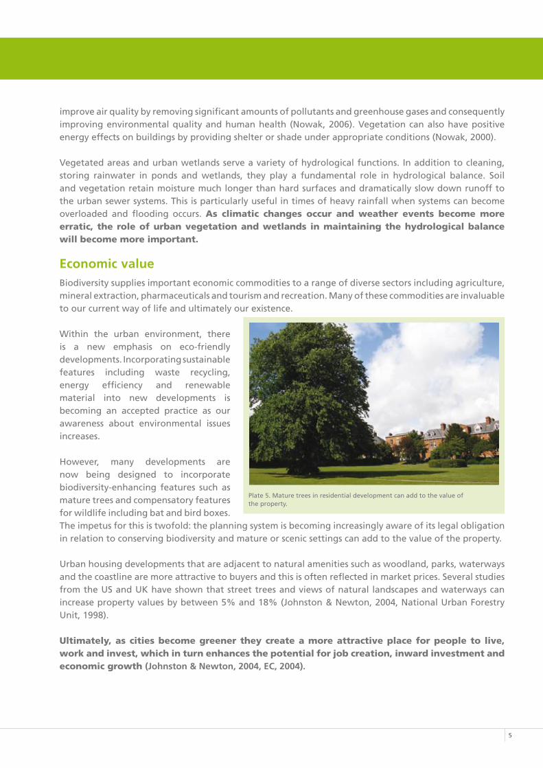
However, many developments are now being designed to incorporate biodiversity-enhancing features such as mature trees and compensatory features for wildlife including bat and bird boxes. The impetus for this is twofold: the planning system is becoming increasingly aware of its legal obligation in relation to conserving biodiversity and mature or scenic settings can add to the value of the property.
Urban housing developments that are adjacent to natural amenities such as woodland, parks, waterways and the coastline are more attractive to buyers and this is often reflected in market prices. Several studies from the US and UK have shown that street trees and views of natural landscapes and waterways can increase property values by between 5% and 18% (Johnston & Newton, 2004, National Urban Forestry Unit, 1998).
Ultimately,ascitiesbecomegreenertheycreateamoreattractiveplaceforpeopleto live,workandinvest,whichinturnenhancesthepotentialforjobcreation,inwardinvestmentandeconomicgrowth(Johnston & Newton, 2004, EC, 2004).
Plate 5. Mature trees in residential development can add to the value of the property.
�
Human valuesThe values placed on biodiversity often arise from its ability to support human life through services and functions and other social benefits relating to recreation and amenity. These elements tend to focus on how the physical environment, such as clean air and water, affects public health (Tzoulas & James, 2004, 2005). Human contact with nature is also recognised as valuable in many ways: contact with nature is promoted as an important factor for child development (Barker and Graf 1989); it provides an immediate restorative effect following stress (Ulrich, et al, 1991) and a more long-term beneficial effect on our sense of well-being (Kaplan, 1995). At a time when more people and families are living in high-density, urban environments, there is a greater need to design new developments that can help realise the potential benefits of biodiversity on physical health and psychological well being.
Biocentric valueMany notable environmentalists have championed the idea that all life has the right to exist and that as humans we are intrinsically connected with all other species (Leopold, 1970, Wilson, 1984). The Convention on Biological Diversity also refers to the intrinsic value of biodiversity, and underlines human responsibility toward other living things. Because human activity is now the primary reason for nearly all extinctions, some believe that our responsibilities extend further than passive interactions and we are obliged to actively protect biodiversity (Noss, 1995).
1.4 THREATS TO BIODIvERSITy
“I think we have an obligation in our generation and in foreseeable generations, to try to protect every species, because virtually every species that is going extinct now is going extinct due to human activity not because of natural processes”.(R. Noss, 1995)
The expansion of life has not been a steady progression. To date, it has been punctuated by five mass extinctions and it is becoming increasingly evident that we are currently in the early stages of a new event. While extinction is a natural process, the current rate of extinction is much higher than “background” or expected rates. This extinction event differs from previous events in that it is caused by the unsustainable management of the planet by just one species: humans (Stuart, 1999).Themostcommoncausesofspecies loss are: habitat destruction and degradation, over exploitation, pollution,disease,invasionsofalienspecies,andmostrecently,theimpactsofglobalclimatechange(IUCN,2004).Theprocessofurbanisationcontributestoeachofthesecommoncausesandisbecomingasignificantglobalproblemintermsofbiodiversityloss.
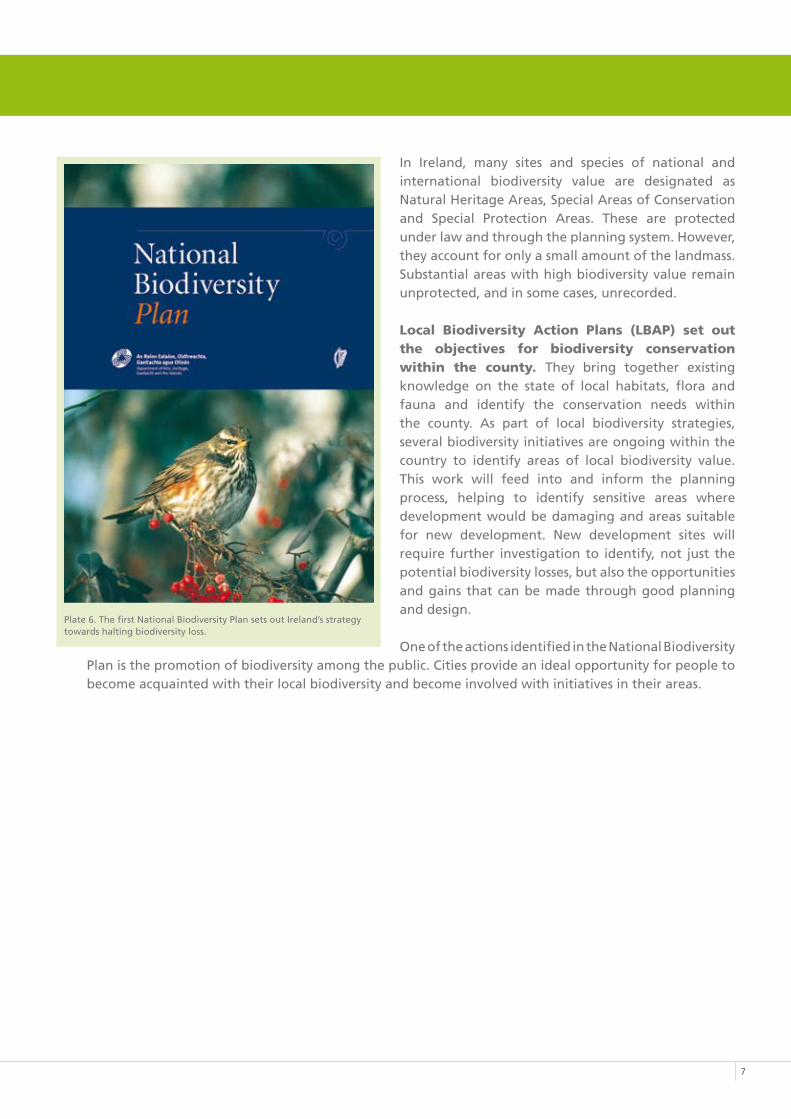
1.5 HALTING THE LOSS OF IRISH BIODIvERSITyIn recognition of increased biodiversity loss, the 1992 Convention on Biological Diversity (Rio Convention) was dedicated to finding global policies to halt the decline.IrelandasasignatorytotheConventionundertooktoimplementitsprinciplesatnationalandlocallevelsbyformulatingastrategyassetoutintheNationalBiodiversityPlan. This identifies 87 actions that are to be undertaken, including the integration of biodiversity into all sectors. Implementation of this plan requires the integration of policies at national and local level and cross-sectoral co-operation. This means that all sectors, directly or indirectly connected with biodiversity, must examine their activities and minimise any negative impacts they are likely to cause.
�
In Ireland, many sites and species of national and international biodiversity value are designated as Natural Heritage Areas, Special Areas of Conservation and Special Protection Areas. These are protected under law and through the planning system. However, they account for only a small amount of the landmass. Substantial areas with high biodiversity value remain unprotected, and in some cases, unrecorded.
Local Biodiversity Action Plans (LBAP) set outthe objectives for biodiversity conservationwithin the county. They bring together existing knowledge on the state of local habitats, flora and fauna and identify the conservation needs within the county. As part of local biodiversity strategies, several biodiversity initiatives are ongoing within the country to identify areas of local biodiversity value. This work will feed into and inform the planning process, helping to identify sensitive areas where development would be damaging and areas suitable for new development. New development sites will require further investigation to identify, not just the potential biodiversity losses, but also the opportunities and gains that can be made through good planning and design.
One of the actions identified in the National Biodiversity Plan is the promotion of biodiversity among the public. Cities provide an ideal opportunity for people to become acquainted with their local biodiversity and become involved with initiatives in their areas.
�
Plate 6. The first National Biodiversity Plan sets out Ireland’s strategytowards halting biodiversity loss.
2Making space for biodiversity in urban areas
“The larger the pie, the greater number of possible slices big enough to sustain the lives of individual species”
(E. O. Wilson)
10
2.Makingspaceforbiodiversityinurbanareas
Urban habitats and species are sometimes considered to be less important than their rural counterparts. However, biodiversity can be higher in cities than surrounding rural areas providing rich and diverse ranges of plants and animals, which often occur as unusual or unique communities (Angold et al., 2006). Urban green space provides a unique landscape that supports a diversity of flora and fauna and provides an ever-expanding human population with direct access to nature. Maintaining our connection with nature is a fundamental need and has significant implications for the quality of life of city dwellers. The presence of high quality biodiversity in urban areas provides us with additional environmental and economic benefits including cleaner air and water, more attractive properties and recreational areas. By examining the planning and development process and promoting best practice, we can ensure that nature and natural processes are employed to help support a functioning city and that our biodiversity resources are safeguarded.
Urbanenvironmentsareoftensub-dividedintogreenspace,greyspace,brownfieldsitesandprivategardensandbalconies.Eachoftheseprovidetheirownopportunitiesforbiodiversityenhancement.
2.1 GREEN SPACEUrban green space includes everything in cities that has vegetation. Collectively it is sometimes referred to as “Green infrastructure”, encompassing the entire working landscape in cities that serve roles such as improving air quality, flood protection and pollution control (Girling and Kellett, 2005).
Common types of urban green spaces include;
• Doorstep and communal green space (including balconies and courtyards)
• Private gardens
• Institutional land
• Local parks
• District and regional parks
• River corridors and floodplains
• Coastal zones
2.2 GREy SPACEGrey space is defined as the built environment, incorporating buildings, pavements and roads. These were traditionally seen as being of limited benefit to biodiversity and were rarely ever designed with biodiversity considerations in mind. Today, advances in design and best practice methods means that the potential for supporting biodiversity has improved. Incorporated features such as green roofs, green walls, modified bricks and roof tiles, have the potential to support wildlife and significantly add to the biodiversity value of a development. Although adding vegetation to the roofs, walls and around buildings
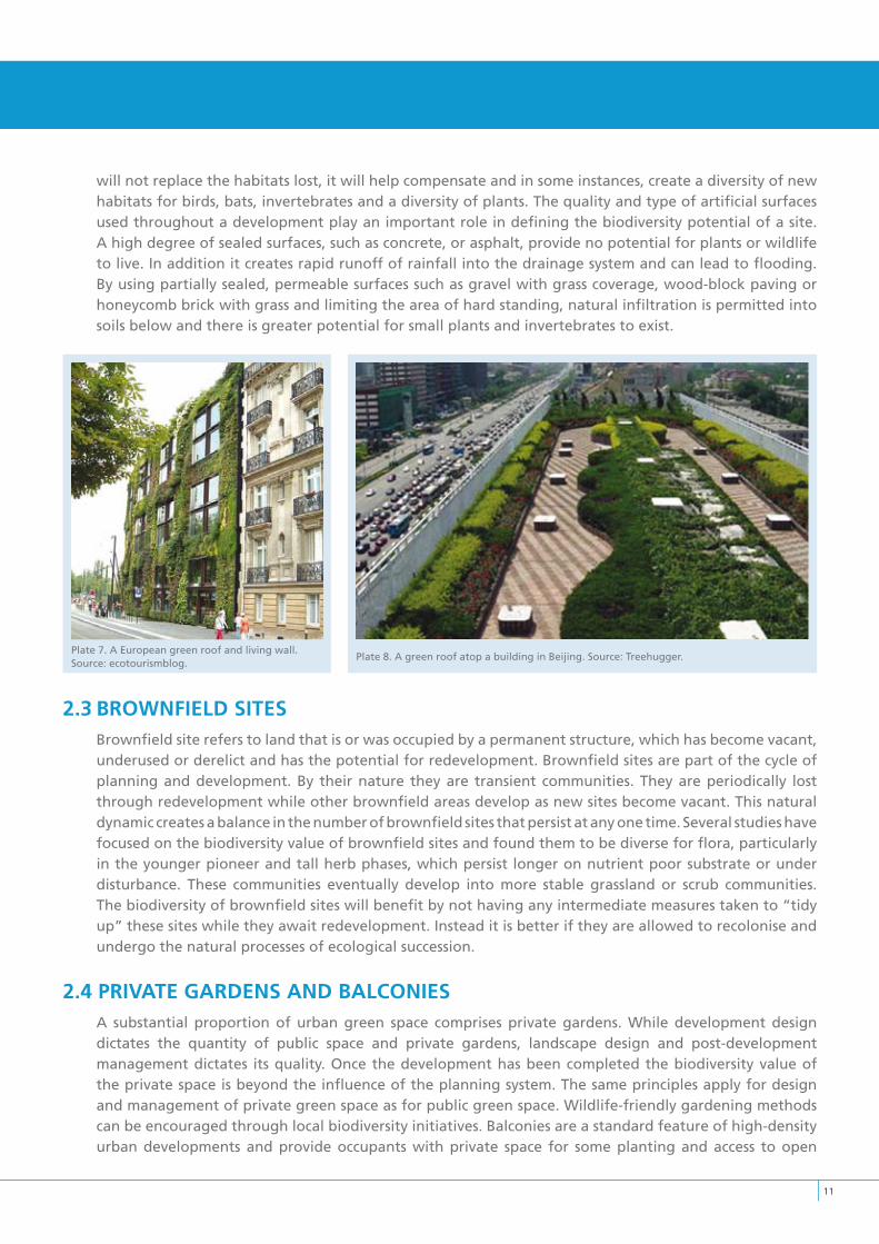
11
will not replace the habitats lost, it will help compensate and in some instances, create a diversity of new habitats for birds, bats, invertebrates and a diversity of plants. The quality and type of artificial surfaces used throughout a development play an important role in defining the biodiversity potential of a site. A high degree of sealed surfaces, such as concrete, or asphalt, provide no potential for plants or wildlife to live. In addition it creates rapid runoff of rainfall into the drainage system and can lead to flooding. By using partially sealed, permeable surfaces such as gravel with grass coverage, wood-block paving or honeycomb brick with grass and limiting the area of hard standing, natural infiltration is permitted into soils below and there is greater potential for small plants and invertebrates to exist.
2.3 BROWNFIELD SITESBrownfield site refers to land that is or was occupied by a permanent structure, which has become vacant, underused or derelict and has the potential for redevelopment. Brownfield sites are part of the cycle of planning and development. By their nature they are transient communities. They are periodically lost through redevelopment while other brownfield areas develop as new sites become vacant. This natural dynamic creates a balance in the number of brownfield sites that persist at any one time. Several studies have focused on the biodiversity value of brownfield sites and found them to be diverse for flora, particularly in the younger pioneer and tall herb phases, which persist longer on nutrient poor substrate or under disturbance. These communities eventually develop into more stable grassland or scrub communities. The biodiversity of brownfield sites will benefit by not having any intermediate measures taken to “tidy up” these sites while they await redevelopment. Instead it is better if they are allowed to recolonise and undergo the natural processes of ecological succession.
2.4 PRIvATE GARDENS AND BALCONIESA substantial proportion of urban green space comprises private gardens. While development design dictates the quantity of public space and private gardens, landscape design and post-development management dictates its quality. Once the development has been completed the biodiversity value of the private space is beyond the influence of the planning system. The same principles apply for design and management of private green space as for public green space. Wildlife-friendly gardening methods can be encouraged through local biodiversity initiatives. Balconies are a standard feature of high-density urban developments and provide occupants with private space for some planting and access to open
Plate 8. A green roof atop a building in Beijing. Source: Treehugger.Plate 7. A European green roof and living wall. Source: ecotourismblog.
1�
space. The value of this personal space is often not fully appreciated. Some studies suggest that residents in high-density developments are less susceptible to illness if they have a balcony or terrace garden and the psychological benefits of seeing and caring for plants are well known (Johnston & Newton, 2004). Larger balconies encourage people to sit out and use the area more. While these small areas may have limited biodiversity value, they contribute to the overall network of green space within a development.
2.5 THE EvOLUTION OF THE GREEN CITyAlmostsincethebeginningofurbanplanning,plannershavesoughtmeansofincorporatingnatureintothecityandpreservingthesurroundinglandscape.The motivation for this has included aesthetics, health, recreation and amenity. However, motivations relating to nature conservation have also been considered for a surprisingly long time.
“The case for the conservation of nature and for the increase of our accesses to her must be stated more seriously and strongly than is customary. Not merely begged for on all grounds of amenity, of recreation, and repose, sound though they are, but insisted upon. On what grounds? In terms of the maintenance and development of life”. (Patrick Geddes, Cities in Evolution, 1915)
Geddes offered a concept of regional planning, emphasising essential connections between the city and its region, which he described as any geographic area that expresses a certain unity of climate, soil, vegetation, industry and culture. His simple three-part component of the regional city incorporated place, folk and work, which equate to environment, society and economy (Hough, 2004), the three strands of modern sustainability.
As cities grew rapidly in the late 19th century there was increased emphasis on integrating nature into the city landscape. Many early landscape architects, most notably Fredrick Law Olmsted (1822- 1903), sought not only to improve the appearance of the city but to improve health and provide areas for rest and recreation for the crowded urban population (Hough, 2004). Olmsted, who was responsible for New York’s Central Park and the ‘Emerald Necklace’ in Boston, viewed his parks and parkway systems as means of extending the rural character of the countryside into the city. His work is viewed as the precursor to the modern concept of greenways; the spatial planning concept where a string of green areas are connected into a system of protected lands, managed for multiple uses including nature conservation (Fabos, 1995; Ahern, 2000). The notion of bringing nature into the city expanded after Olmsted to include the idea of urban containment and buffering. Ebenezer Howard’s (1850-1928) influential Garden Cities of Tomorrow (1902) outlined a model of a self-sustaining town. Howard promoted the idea of planned satellite communities surrounded by greenbelts, containing carefully balanced areas of residences, industry and agriculture. Green belts were designed to define the city limits and preserve the integrity of the countryside surrounding the London area.
The London Metropolitan Green Belt encircles the greater London area covering approximately 5,000 km2. The concept first emerged in the mid-1930s to provide public open space and recreational areas, and was later developed as a means of preventing urban sprawl and preserving both urban and rural character. In addition to their primary planning functions they help preserve valuable landscapes and support nature conservation objectives on the urban fringes. There are currently 14 green belts in England covering

1�
approximately 13% of the English land cover (DoE, 1995).
Strategic gap and green wedges polices provide axes of protected land that extend into the city. The main overlap between strategic gap and green wedge and Green Belt purposes is in the area of preventing the coalescence of settlements. Green wedges penetrate urban areas and can be used to preserve landscape and wildlife links between town and country, providing recreational facilities and promoting positive land management (DETR, 2001). Green Belts primarily buffer and separate areas while greenways are always linear and, in addition to buffering development, provide a corridor for human and wildlife movement (Searns, 1995). Greenways and green networks generally refer to connected patches and linear strips of habitat that have an inbuilt ecological use including hedgerows, woodlands, wetlands and artificial corridors such as roads, railway lines, road margins and streetscapes (Girling and Kellett, 2005).
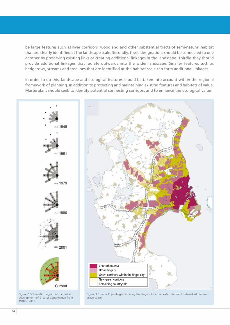
Copenhagen provides an example of regional urban green space planning. The city has evolved from a compact core into the Greater Copenhagen area over the
past 60 years. The master plan for the development of Greater Copenhagen, published in 1947, became known as the ‘Finger Plan’. The five fingers were intended to contain and buffer new settlements and the necessary infrastructure in the form of roads and railways. The landscape between the fingers would remain open, supporting agriculture, recreation and amenity purposes. Since the publication of the plan, the city has expanded radially through a series of regional plans. Provincial towns and suburbs have been linked by transport corridors. Urban areas are confined to the linear corridors. Green wedges protected from urban development fill the spaces between the urban corridors. This provides efficient transport structures though the fingers and assessable landscape close to most people. However, many cities have not had the benefit of such foresightedness and are now faced with repairing and restoring degraded habitats and severed linkages.
Although green belts, green wedges, greenways and green fingers are largely planningdesignations,theycandirectlyorindirectlysupportbiodiversityobjectivesbyprovidingandmaintainingconnectedopenspaceinareasofhighdensityurbandevelopment.Thespatialarrangementofthesedesignationsisimportant. Firstly, they should align with natural features of significance in order to adequately protect elements of greatest biodiversity value. These would generally
Figure 1. Fourteen Green belts in England cover approximately 13% of English land cover (DoE, 1995).
1�
be large features such as river corridors, woodland and other substantial tracts of semi-natural habitat that are clearly identified at the landscape scale. Secondly, these designations should be connected to one another by preserving existing links or creating additional linkages in the landscape. Thirdly, they should provide additional linkages that radiate outwards into the wider landscape. Smaller features such as hedgerows, streams and treelines that are identified at the habitat-scale can form additional linkages.
In order to do this, landscape and ecological features should be taken into account within the regional framework of planning. In addition to protecting and maintaining existing features and habitats of value, Masterplans should seek to identify potential connecting corridors and to enhance the ecological value
Figure 2. Schematic diagram of the radial development of Greater Copenhagen from 1948 to 2001.
Figure 3.Greater Copenhagen showing the finger-like urban extensions and network of planned green space.
Core urban areaUrban fingersGreen corridors within the finger cityNew green corridorsRemaining countryside
1�
of these linkages over time. The ecological benefits may not be realised in the immediate future, but over time an ecologically coherent network of green space will evolve using natural features and the existing landscape as a framework for urban growth.
2.6 DESIGNING GREEN SPACE FOR BIODIvERSITy
Planning for biodiversity must take the spatial requirements of species into consideration by providing sufficient habitat for them in a connected arrangement. A spatial overview at the landscape-scale is required to overcome existing fragmentation and prevent further depletion of connected features.
Designing space for biodiversity requires the integration of knowledge from spatial planning and landscape ecology. Patterns in vegetation are the result of variation in physical conditions such as soil type, hydrological conditions and land use. For example, calcareous grasslands require lime-rich soils with a high pH and that are grazed or mown repeatedly to prevent scrubs and trees encroaching. Patterns in vegetation can be viewed at different spatial scales ranging from the wider landscape-scale to the regional-scale and smaller habitat-scale. Planning for biodiversity needs to be considered at all spatial scales.
2.6.1 Landscape-scale designViewed at the landscape-scale, land cover can appear as a mosaic of patches and linear strips embedded in the surrounding environment, or matrix. In the rural Irish landscape, the dominant matrix is generally agricultural grassland. Patches are formed by areas of woodland, wetland or other habitats that differ from the surrounding matrix. Patches can vary in size from extensive woodlands to a small pond. Hedgerows, treelines, rivers, streams and other linear habitats form networks of connecting features that criss-cross the landscape forming valuable habitat and acting as corridors for the movement of species.
In cities and towns, the surrounding environment is predominantly urban development. Habitat patches and corridors are frequently the remnants of the previous rural landscapes or new habitats that have been created or evolved within the urban matrix. Patches are formed by open spaces such as parks, institutional grounds and gardens. In addition to existing linear features such as streams and treelines, new potential corridors are created by road verges, railway lines and other artificial features where vegetated margins can facilitate movement.
Patch size is an important factor. Conditions within the centre of a patch are generally different to conditions along the edge, creating what is known as the edge effect. As the overall patch size decreases, the internal area (core area) of the patch also decreases and the edge habitat increases. Specialist species adapted to core conditions will be more greatly affected by this loss than generalist species that can happily survive on the edges of habitats. Specialist species tend to be more limited in their ability to adapt to new conditions and are therefore particularly vulnerable to change. They also tend to have a more limited distribution and are therefore relatively rare in the wider landscape. Generalist species on the other hand show greater flexibility in their requirements. They can survive in a variety of habitat types and can move more freely between areas. These species tend to be widespread and generally common within the landscape.
1�
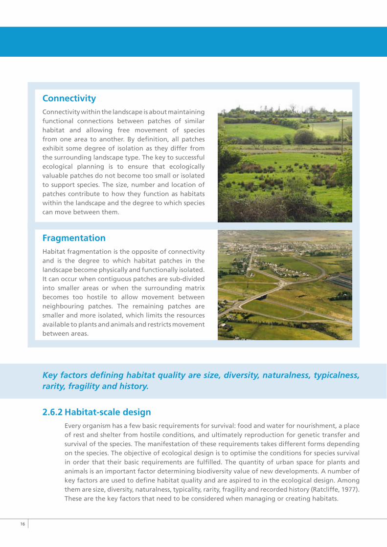
ConnectivityConnectivity within the landscape is about maintaining functional connections between patches of similar habitat and allowing free movement of species from one area to another. By definition, all patches exhibit some degree of isolation as they differ from the surrounding landscape type. The key to successful ecological planning is to ensure that ecologically valuable patches do not become too small or isolated to support species. The size, number and location of patches contribute to how they function as habitats within the landscape and the degree to which species can move between them.
FragmentationHabitat fragmentation is the opposite of connectivity and is the degree to which habitat patches in the landscape become physically and functionally isolated. It can occur when contiguous patches are sub-divided into smaller areas or when the surrounding matrix becomes too hostile to allow movement between neighbouring patches. The remaining patches are smaller and more isolated, which limits the resources available to plants and animals and restricts movement between areas.
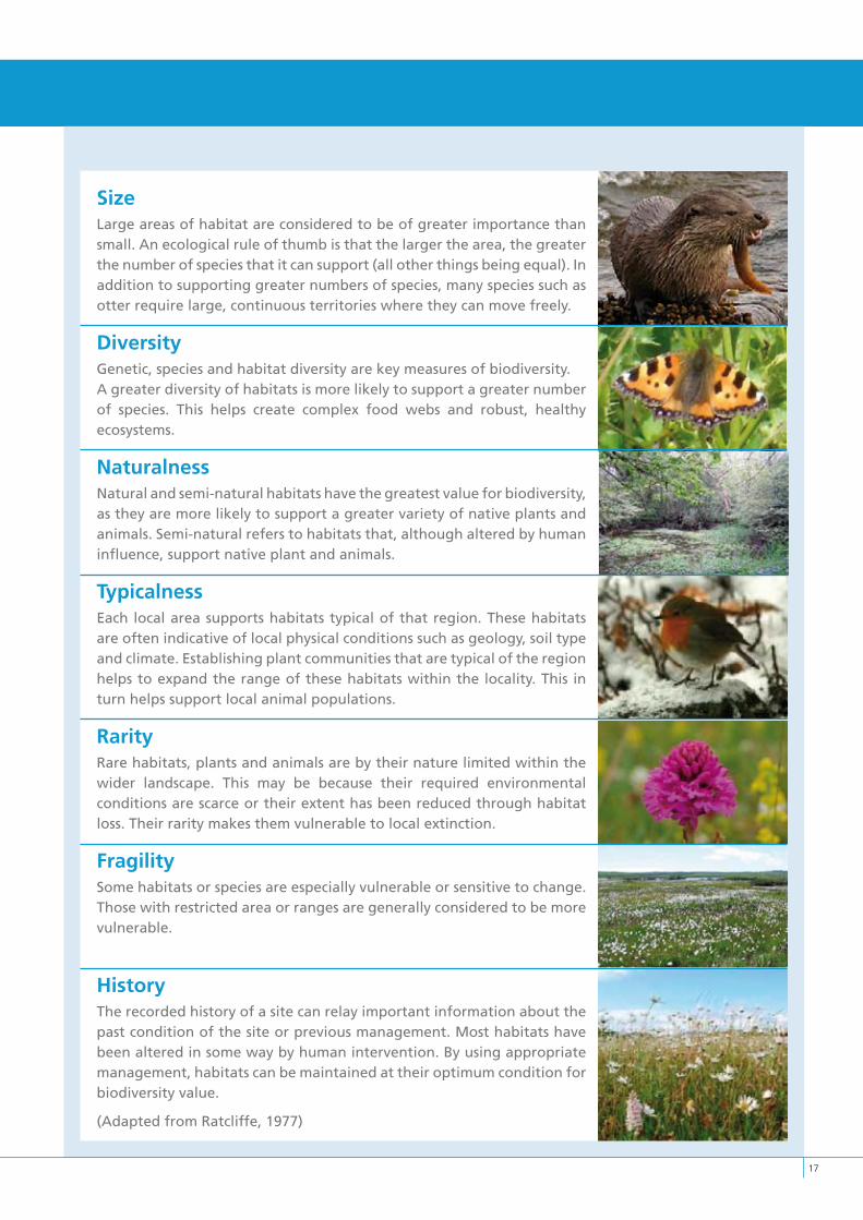
Key factors defining habitat quality are size, diversity, naturalness, typicalness, rarity, fragility and history.
2.6.2 Habitat-scale designEvery organism has a few basic requirements for survival: food and water for nourishment, a place of rest and shelter from hostile conditions, and ultimately reproduction for genetic transfer and survival of the species. The manifestation of these requirements takes different forms depending on the species. The objective of ecological design is to optimise the conditions for species survival in order that their basic requirements are fulfilled. The quantity of urban space for plants and animals is an important factor determining biodiversity value of new developments. A number of key factors are used to define habitat quality and are aspired to in the ecological design. Among them are size, diversity, naturalness, typicality, rarity, fragility and recorded history (Ratcliffe, 1977). These are the key factors that need to be considered when managing or creating habitats.
1�
SizeLarge areas of habitat are considered to be of greater importance than small. An ecological rule of thumb is that the larger the area, the greater the number of species that it can support (all other things being equal). In addition to supporting greater numbers of species, many species such as otter require large, continuous territories where they can move freely.
DiversityGenetic, species and habitat diversity are key measures of biodiversity.A greater diversity of habitats is more likely to support a greater number of species. This helps create complex food webs and robust, healthy ecosystems.
NaturalnessNatural and semi-natural habitats have the greatest value for biodiversity, as they are more likely to support a greater variety of native plants and animals. Semi-natural refers to habitats that, although altered by human influence, support native plant and animals.
TypicalnessEach local area supports habitats typical of that region. These habitats are often indicative of local physical conditions such as geology, soil type and climate. Establishing plant communities that are typical of the region helps to expand the range of these habitats within the locality. This in turn helps support local animal populations.
RarityRare habitats, plants and animals are by their nature limited within the wider landscape. This may be because their required environmental conditions are scarce or their extent has been reduced through habitat loss. Their rarity makes them vulnerable to local extinction.
FragilitySome habitats or species are especially vulnerable or sensitive to change. Those with restricted area or ranges are generally considered to be more vulnerable.
HistoryThe recorded history of a site can relay important information about the past condition of the site or previous management. Most habitats have been altered in some way by human intervention. By using appropriate management, habitats can be maintained at their optimum condition for biodiversity value.
(Adapted from Ratcliffe, 1977)
3Overview of planning
and development process
“It is a challenge to provide an integrated landscape strategy that can meet conflicting demands”
�0
3.Overviewofplanninganddevelopmentprocess
3.1 BIODIvERSITy MANAGEMENT IN FORWARD PLANNING
3.1.1 Developing a County Policy Framework for BiodiversityThe County Development Plan is central to the legal planning framework in the Republic of Ireland and most planning direction takes place at the county level. The County Development Plan sets out the aims of the Council for the proper planning and sustainable development within the county. Among the detailed objectives of the County Development Plan are a number of key policies and objectives relating to the natural heritage. The importance of designated sites, protected species and sensitive landscapes are highlighted within these plans. However, much of our biodiversity is unprotected and occurs outside designated areas. In recognition of this, many County Development Plans contain policies and objectives that aim to protect and enhance biodiversity within the wider landscape. These are objectives that aim to preserve the more widespread features such as streams, hedgerows, small woodlands and species-rich grasslands.
As populations grow, there are increased demands placed on limited resources, such as land for housing, infrastructure and other development. It is a challenge to provide an integrated landscape strategy that can meet conflicting demands. In order to achieve this, a clear strategy is required to effectively address the needs of biodiversity and to integrate biodiversity into all sectors in line with the National Biodiversity Plan. This strategy is embodied in the Local Biodiversity Action Plan; a key document that will inform planning at the county level.
3.1.2 Local Biodiversity Action PlansSome local authorities have Local Biodiversity Action Plans. These provide the framework for the co-ordinated delivery of the local biodiversity strategy. Among the key aims of any Local Biodiversity Action Plan is to gather information on local biodiversity, co-ordinate existing and new initiatives, assist in sustainable planning and development and, raise public awareness and involvement. A core objective of any Local Biodiversity Action Plan is undertaking habitat surveys and a county wide review of biodiversity that will identify habitats, species and sites of local importance. This information can be used to highlight sensitive areas where development could have a negative impact on biodiversity and areas where development could be successfully integrated with the natural environment. Existing nature designations are recognised within the plan and form the basis for a network of important natural heritage sites within the county. In addition, many local authorities currently hold internal databases detailing the known locations of important habitats and species that do not have legal protection but are of high local biodiversity value. As additional surveys are carried out, the level of detail contained in these databases will grow and provide a more informed view of the county.
An important aspect in generating Local Biodiversity Action Plans is the adoption of a “whole landscape” approach. An objective of the Local Biodiversity Action Plan is to maintain and restore connections between important habitats at the landscape scale. This objective could be facilitated through the County Development Plan, which has the capacity to retain and develop landscape connections that provide habitat for species and allow movement between areas.
�1
3.1.3 Biodiversity in Area PlansThe Planning and Development Act 2000 introduced some statutory area planning mechanisms, in particular Local Area Plans and Planning Schemes. It is the intention that these act as masterplans for an area. They should be integrated studies and deal with the co-ordinated and optimal development of the lands in question. As such, biodiversity is a critical assessment layer and should be given consideration in any study. A Local Area Plan (LAP) is a statutory plan made by a local authority for a specific area. LAPs should comprise an integrated framework for the development of the area and should consider biodiversity as a core component.
A Planning Scheme is a statutory plan made by a local authority for an area within a “Strategic Development Zone” (SDZ). The purpose of the SDZ mechanism is to create “fast-track” planning for development within strategic areas. As with LAPs, it is the intention that Planning Schemes provide an integrated framework for the development of the area and should consider biodiversity as a core component.
Integrated Area Plans, introduced under the Urban Renewal Act 1998, take into account a community’s cultural, employment and educational needs. IAPs are generally targeted at urban areas and biodiversity has, perhaps wrongly, not traditionally been incorporated as a factor. However, there is no reason to discount biodiversity as a potentially important aspect of an area’s regeneration.
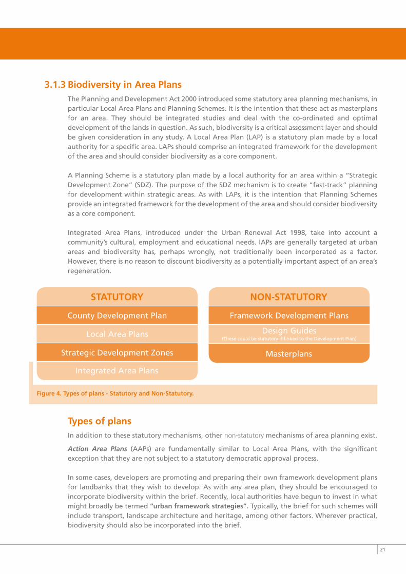
Figure 4. Types of plans - Statutory and Non-Statutory.
Types of plansIn addition to these statutory mechanisms, other non-statutory mechanisms of area planning exist.
Action Area Plans (AAPs) are fundamentally similar to Local Area Plans, with the significant exception that they are not subject to a statutory democratic approval process.
In some cases, developers are promoting and preparing their own framework development plans for landbanks that they wish to develop. As with any area plan, they should be encouraged to incorporate biodiversity within the brief. Recently, local authorities have begun to invest in what might broadly be termed “urban framework strategies”. Typically, the brief for such schemes will include transport, landscape architecture and heritage, among other factors. Wherever practical, biodiversity should also be incorporated into the brief.
STATUTORy
Integrated Area Plans
County Development Plan
Local Area Plans
Strategic Development Zones
NON-STATUTORy
Framework Development Plans
Design Guides (These could be statutory if linked to the Development Plan)
Masterplans
��
Design guides have been used to a limited degree in the Irish urban development context. Design Guides are beneficial where a particular set of specifications, materials and styles can be devised and agreed for an area, either new or old. Once developers comply with the design guide, maintenance departments are certain they will be able to service and upkeep the particular materials used, etc. Where a local authority seeks to develop a design guide, it is recommended that they consult a biodiversity specialist.
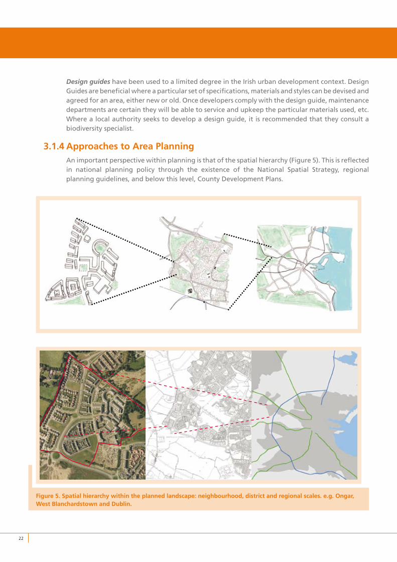
3.1.4 Approaches to Area PlanningAn important perspective within planning is that of the spatial hierarchy (Figure 5). This is reflected in national planning policy through the existence of the National Spatial Strategy, regional planning guidelines, and below this level, County Development Plans.
Figure 5. Spatial hierarchy within the planned landscape: neighbourhood, district and regional scales. e.g. Ongar, West Blanchardstown and Dublin.
��
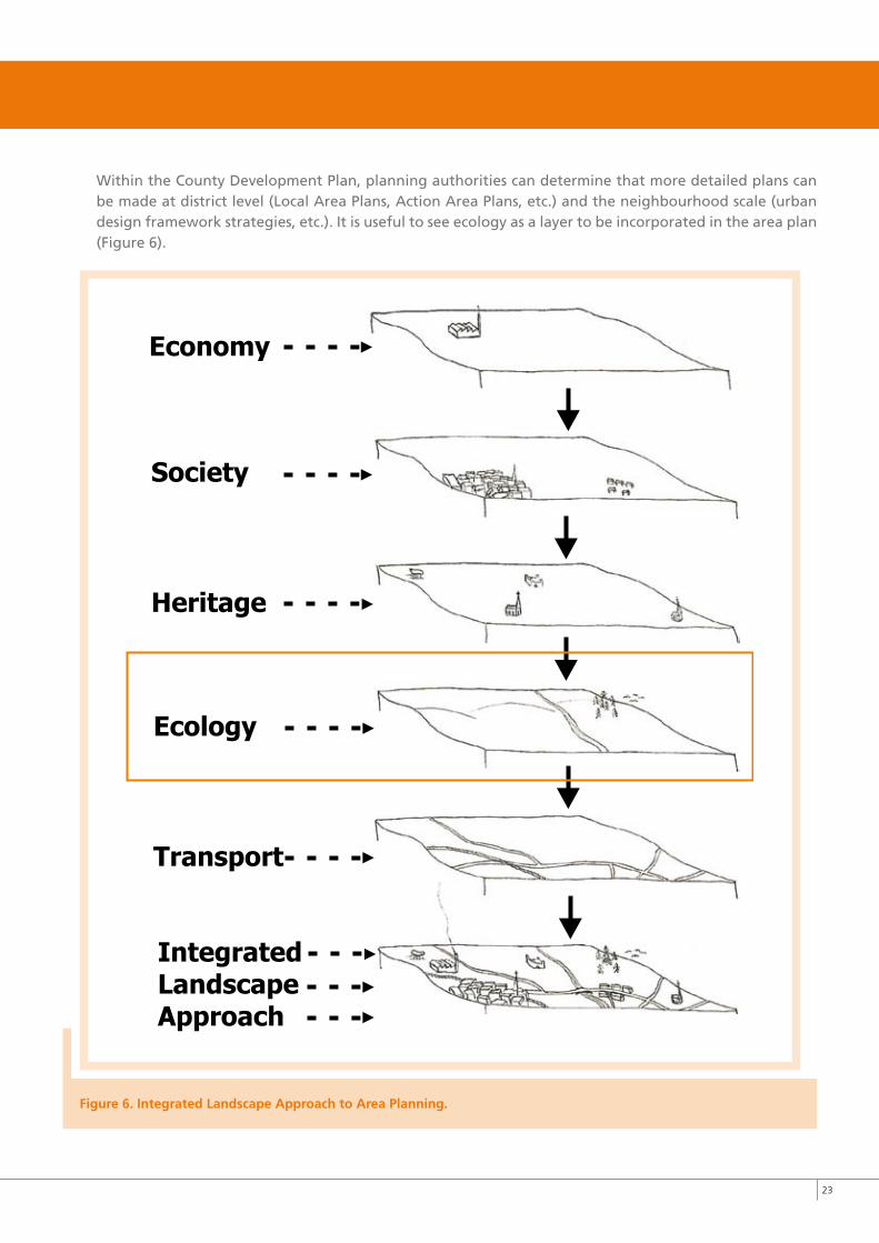
Within the County Development Plan, planning authorities can determine that more detailed plans can be made at district level (Local Area Plans, Action Area Plans, etc.) and the neighbourhood scale (urban design framework strategies, etc.). It is useful to see ecology as a layer to be incorporated in the area plan (Figure 6).
Figure 6. Integrated Landscape Approach to Area Planning.
PRE-PLANNING
Basic Habitat Assessment
Sketch proposals of habitats
Pre-planning meeting
Liaise with council experts
DEvELOPMENT, CONSTRUCTION & POST-DEvELOPMENT
MANAGEMENT
Detailed Design
Construction & Landscaping Management
Maintenance by Councilor Management Companies
MONITORING& ENFORCEMENT
Monitoring & Enforcement*
PLANNING PROCESS
Planning application
Additional Information
Clarification of Additional Information
Planning Appeal
Planning Decision with/out Conditionsor Refusal
PLANNING & DESIGN
Possible biodiversity inputinto design processes
Consider “downstream” services
SITE PREPARATION
Scoping and constraint study
Identify opportunities
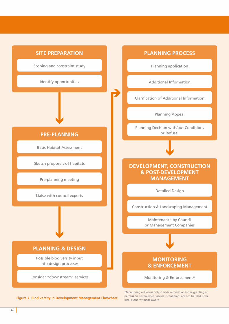
Figure 7. Biodiversity in Development Management Flowchart.
��
*Monitoring will occur only if made a condition in the granting of permission. Enforcement occurs if conditions are not fulfilled & the local authority made aware
��
3.2 BIODIvERSITy MANAGEMENT WITHIN THE DEvELOPMENT MANAGEMENT PROCESS
3.2.1 Guidelines in the Development Management ProcessAfter forward planning, most planning and development is co-ordinated through the “Development Management” process. Guidelines for the development management process (previously referred to as the “development control” process) are set out in “Planning Guidelines 13: Development Management Guidelines for Planning Authorities”, (Department of Environment, Heritage and Local Government, June 2007). The flow chart shown in Figure 7 illustrates the principle stages in development management.
3.2.2 Site PreparationWhen assembling a site, developers should be aware of the responsibilities associated with development of potentially sensitive habitats and conscious of the downstream impacts of significant landscape modifications.
The most important factor in good biodiversity management is early consideration of local ecology. An initial scoping and constraints study will benefit any development proposal. An alternative, or best practice approach to site development is to view environmental constraints as opportunities that can inform design decisions.
3.2.3 Pre-planningPlanners emphasise the benefit of the “pre-planning consultation”, particularly in relation to larger sites. Planners are responsible for co-ordinating the delivery of the development plan and must consider the proper planning and sustainable development of an area.
Carrying out a basic habitat assessment as a pre-planning provisional survey is advisable. The use of sketch proposals in pre-planning stages is recommended. In this regard, it is useful to see ecology as a layer to be incorporated in the development proposal. It is recommended that the developer’s ecology consultant consult with the planner and council expert, who may have a view on the sensitivity or otherwise of a habitat and may be carrying out a study in the area.
3.2.4 Planning and DesignAt the planning and design stage, the pre-planning scoping assessment will determine the extent of involvement necessary by an ecologist. If done properly at pre-planning stage, the sketch examples and Basic Habitat Assessment carried out by the ecologist can be developed and biodiversity-enhancing measures incorporated into the design itself.
At this stage, “downstream” service departments in the council must be consulted. Once development is permitted it is the responsibility of service departments, such as the parks department, infrastructure and transportation departments to implement, service and possibly maintain the development. Often, it is necessary and advisable for these departments to recommend to the Planner the inclusion of conditions outlining their required specifications.
��
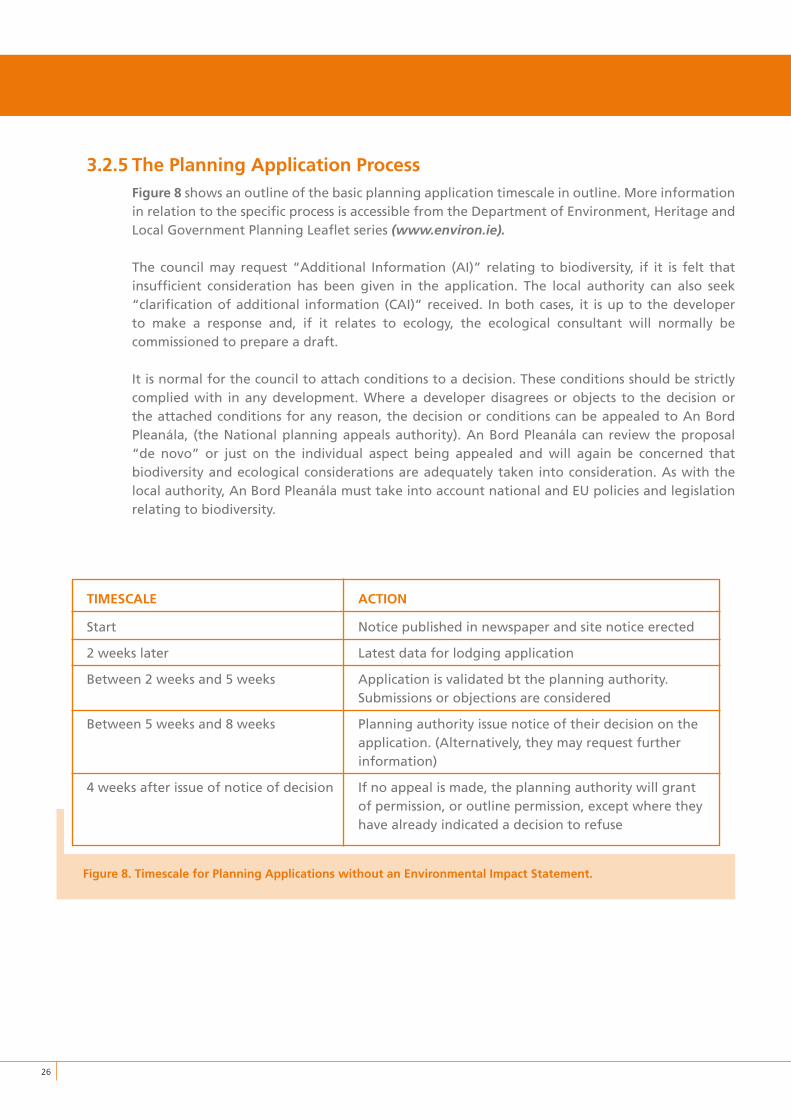
3.2.5 The Planning Application ProcessFigure 8 shows an outline of the basic planning application timescale in outline. More information in relation to the specific process is accessible from the Department of Environment, Heritage and Local Government Planning Leaflet series (www.environ.ie).
The council may request “Additional Information (AI)” relating to biodiversity, if it is felt that insufficient consideration has been given in the application. The local authority can also seek “clarification of additional information (CAI)” received. In both cases, it is up to the developer to make a response and, if it relates to ecology, the ecological consultant will normally be commissioned to prepare a draft.
It is normal for the council to attach conditions to a decision. These conditions should be strictly complied with in any development. Where a developer disagrees or objects to the decision or the attached conditions for any reason, the decision or conditions can be appealed to An Bord Pleanála, (the National planning appeals authority). An Bord Pleanála can review the proposal “de novo” or just on the individual aspect being appealed and will again be concerned that biodiversity and ecological considerations are adequately taken into consideration. As with the local authority, An Bord Pleanála must take into account national and EU policies and legislation relating to biodiversity.
TIMESCALE ACTION
Start Notice published in newspaper and site notice erected
2 weeks later Latest data for lodging application
Between 2 weeks and 5 weeks Application is validated bt the planning authority. Submissions or objections are considered
Between 5 weeks and 8 weeks Planning authority issue notice of their decision on the application. (Alternatively, they may request further information)
4 weeks after issue of notice of decision If no appeal is made, the planning authority will grant of permission, or outline permission, except where they have already indicated a decision to refuse
Figure 8. Timescale for Planning Applications without an Environmental Impact Statement.

��
3.2.6 Development, Construction and Post-development ManagementOnce permission is given, the developer may proceed and carry out the scheme as permitted. A detailed design should be drawn up in consultation with the ecologist and best practice guidelines (e.g. for trees: British Standard 5837, 2005). Often the success of creating biodiversity features or retaining them depends not only on the design of the development, but also on the appropriate protection and procedures during the construction process. Therefore, the ecologist needs to be involved in the design phase as well as when construction and landscaping are taking place and best practice procedures need to be followed. The ecologist should interpret the decision and advise on good practice in construction management. It is also important to involve the ecologist when landscaping is being carried out as this has implications for habitat management.
The involvement of parks, infrastructure and transportation departments will continue into the construction and management phases of development. In most cases, the planning conditions will set out their requirements and how these are to be accomplished. However, their needs must always be initially addressed at the early Planning and Design Stage.
3.2.7 Monitoring and EnforcementUltimately the development is either taken in charge or a management company established to maintain the scheme. The council will not take in charge the area until the full provisions of the planning decision, including biodiversity-related conditions, have been executed.
The local authority can exercise powers of enforcement and injunction to halt development works or to have development removed should it not comply with the planning decision. This is the least desirable outcome for a developer and may have serious financial implications. Non-compliant development can include such things as non-permitted encroachment or disruption of a habitat where it has been specified otherwise within a decision. Once again, early consideration of biodiversity and proper incorporation into the development proposal, including execution of the permitted designs is a priority and will save money in the long run.
�8
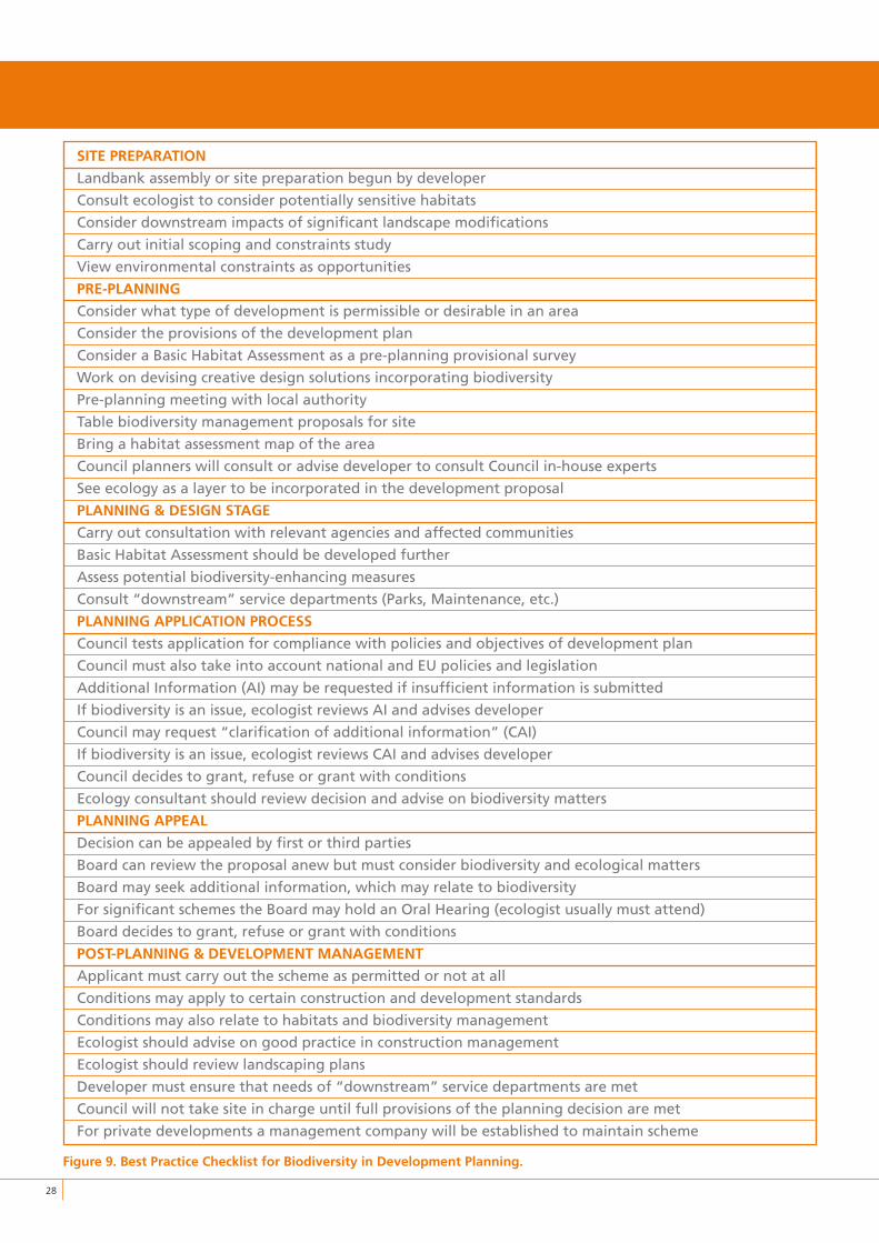
SITE PREPARATION
Landbank assembly or site preparation begun by developer
Consult ecologist to consider potentially sensitive habitats
Consider downstream impacts of significant landscape modifications
Carry out initial scoping and constraints study
View environmental constraints as opportunities
PRE-PLANNING
Consider what type of development is permissible or desirable in an area
Consider the provisions of the development plan
Consider a Basic Habitat Assessment as a pre-planning provisional survey
Work on devising creative design solutions incorporating biodiversity
Pre-planning meeting with local authority
Table biodiversity management proposals for site
Bring a habitat assessment map of the area
Council planners will consult or advise developer to consult Council in-house experts
See ecology as a layer to be incorporated in the development proposal
PLANNING & DESIGN STAGE
Carry out consultation with relevant agencies and affected communities
Basic Habitat Assessment should be developed further
Assess potential biodiversity-enhancing measures
Consult “downstream” service departments (Parks, Maintenance, etc.)
PLANNING APPLICATION PROCESS
Council tests application for compliance with policies and objectives of development plan
Council must also take into account national and EU policies and legislation
Additional Information (AI) may be requested if insufficient information is submitted
If biodiversity is an issue, ecologist reviews AI and advises developer
Council may request “clarification of additional information” (CAI)
If biodiversity is an issue, ecologist reviews CAI and advises developer
Council decides to grant, refuse or grant with conditions
Ecology consultant should review decision and advise on biodiversity matters
PLANNING APPEAL
Decision can be appealed by first or third parties
Board can review the proposal anew but must consider biodiversity and ecological matters
Board may seek additional information, which may relate to biodiversity
For significant schemes the Board may hold an Oral Hearing (ecologist usually must attend)
Board decides to grant, refuse or grant with conditions
POST-PLANNING & DEvELOPMENT MANAGEMENT
Applicant must carry out the scheme as permitted or not at all
Conditions may apply to certain construction and development standards
Conditions may also relate to habitats and biodiversity management
Ecologist should advise on good practice in construction management
Ecologist should review landscaping plans
Developer must ensure that needs of “downstream” service departments are met
Council will not take site in charge until full provisions of the planning decision are met
For private developments a management company will be established to maintain scheme
Figure 9. Best Practice Checklist for Biodiversity in Development Planning.
�9
3.3 UNDERSTANDING THE PLANNING AND DEvELOPMENT BENEFITS OF BIODIvERSITy
3.3.1 High Density in the Irish Planning EnvironmentThe Green City Guidelines examine approaches to enhancing biodiversity within high-density areas or areas undergoing urban “densification”. The Residential Density Guidelines, published by the Government in 1999, called for higher densities in urban areas. This was a response to calls for increased sustainability, particularly in relation to the location of housing with regard to employment and amenities. Local authorities have followed suit with policies for higher densities, mixing of uses and intensification around town centres and transport hubs. In February 2008, the Department of Environment, Heritage and Local Government published draft Guidelines on Sustainable Residential Development in Urban Areas. These guidelines are part of a review and updating of the Residential Density Guidelines,1999. The Department also published Guidelines on Sustainable Urban Housing: Design Standards for New Apartments in September 2007.
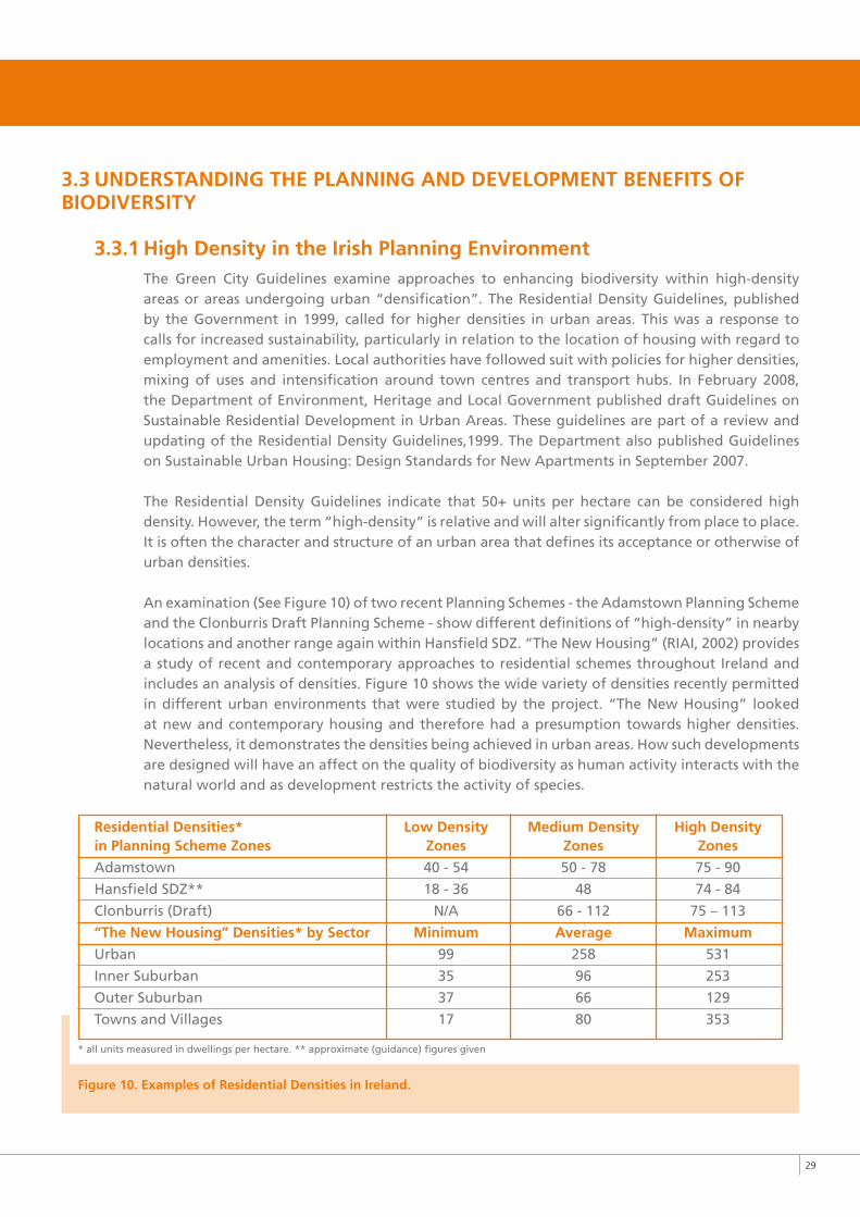
The Residential Density Guidelines indicate that 50+ units per hectare can be considered high density. However, the term “high-density” is relative and will alter significantly from place to place. It is often the character and structure of an urban area that defines its acceptance or otherwise of urban densities.
An examination (See Figure 10) of two recent Planning Schemes - the Adamstown Planning Scheme and the Clonburris Draft Planning Scheme - show different definitions of “high-density” in nearby locations and another range again within Hansfield SDZ. “The New Housing” (RIAI, 2002) provides a study of recent and contemporary approaches to residential schemes throughout Ireland and includes an analysis of densities. Figure 10 shows the wide variety of densities recently permitted in different urban environments that were studied by the project. “The New Housing” looked at new and contemporary housing and therefore had a presumption towards higher densities. Nevertheless, it demonstrates the densities being achieved in urban areas. How such developments are designed will have an affect on the quality of biodiversity as human activity interacts with the natural world and as development restricts the activity of species.
Residential Densities* Low Density Medium Density High Density in Planning Scheme Zones Zones Zones Zones
Adamstown 40 - 54 50 - 78 75 - 90
Hansfield SDZ** 18 - 36 48 74 - 84
Clonburris (Draft) N/A 66 - 112 75 – 113
“The New Housing” Densities* by Sector Minimum Average Maximum
Urban 99 258 531
Inner Suburban 35 96 253
Outer Suburban 37 66 129
Towns and Villages 17 80 353
* all units measured in dwellings per hectare. ** approximate (guidance) figures given
Figure 10. Examples of Residential Densities in Ireland.
�0
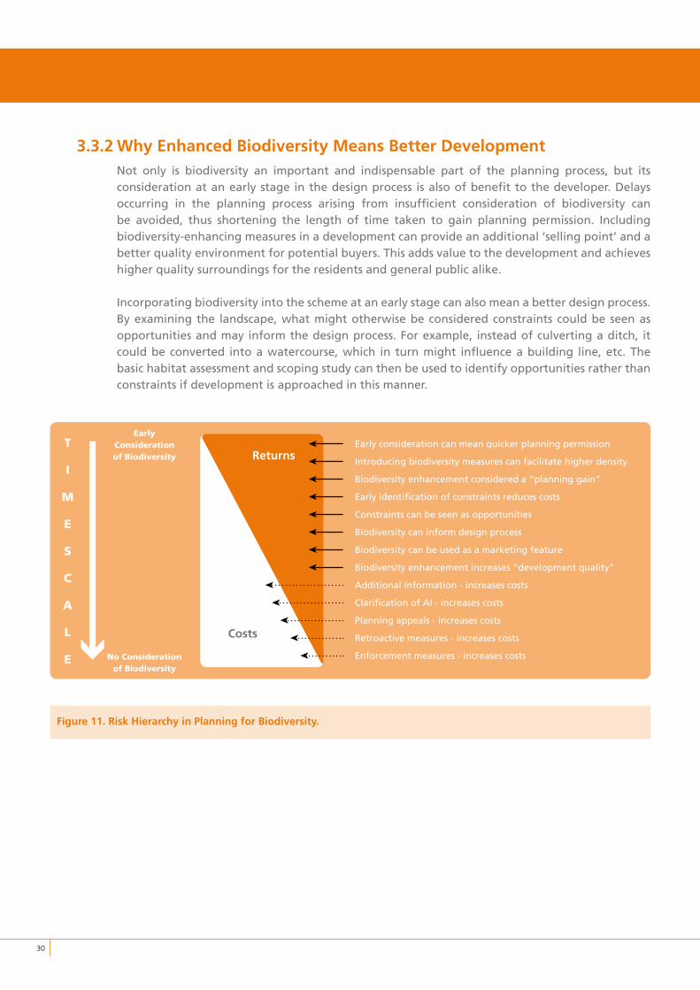
3.3.2 Why Enhanced Biodiversity Means Better DevelopmentNot only is biodiversity an important and indispensable part of the planning process, but its consideration at an early stage in the design process is also of benefit to the developer. Delays occurring in the planning process arising from insufficient consideration of biodiversity can be avoided, thus shortening the length of time taken to gain planning permission. Including biodiversity-enhancing measures in a development can provide an additional ‘selling point’ and a better quality environment for potential buyers. This adds value to the development and achieves higher quality surroundings for the residents and general public alike.
Incorporating biodiversity into the scheme at an early stage can also mean a better design process. By examining the landscape, what might otherwise be considered constraints could be seen as opportunities and may inform the design process. For example, instead of culverting a ditch, it could be converted into a watercourse, which in turn might influence a building line, etc. The basic habitat assessment and scoping study can then be used to identify opportunities rather than constraints if development is approached in this manner.
Figure 11. Risk Hierarchy in Planning for Biodiversity.
Early consideration can mean quicker planning permission
Introducing biodiversity measures can facilitate higher density
Biodiversity enhancement considered a “planning gain”
Early identification of constraints reduces costs
Constraints can be seen as opportunities
Biodiversity can inform design process
Biodiversity can be used as a marketing feature
Biodiversity enhancement increases “development quality”
Additional Information - increases costs
Clarification of AI - increases costs
Planning appeals - increases costs
Retroactive measures - increases costs
Enforcement measures - increases costs
Costs
ReturnsT
I
M
E
S
C
A
L
E
EarlyConsiderationofBiodiversity
NoConsiderationofBiodiversity
➤
➤
➤
➤
➤
➤
➤
➤
➤
➤
➤
➤
➤
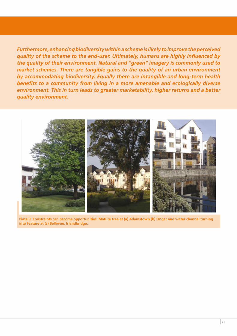
�1
Furthermore, enhancing biodiversity within a scheme is likely to improve the perceived quality of the scheme to the end-user. Ultimately, humans are highly influenced by the quality of their environment. Natural and “green” imagery is commonly used to market schemes. There are tangible gains to the quality of an urban environment by accommodating biodiversity. Equally there are intangible and long-term health benefits to a community from living in a more amenable and ecologically diverse environment. This in turn leads to greater marketability, higher returns and a better quality environment.
Plate 9. Constraints can become opportunities. Mature tree at (a) Adamstown (b) Ongar and water channel turning into feature at (c) Bellevue, Islandbridge.
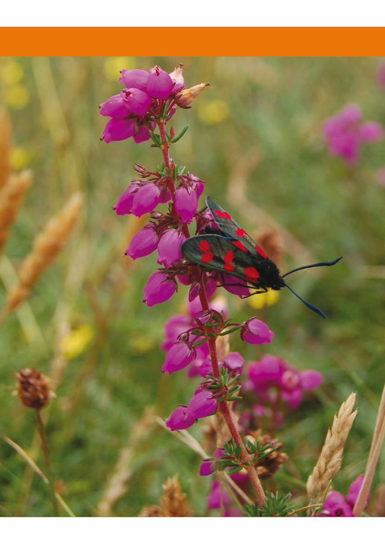
4Case Studies
MonkstownCastleknock
DundrumOngar
StepasideSwords
LuskOld Connaught
4.CaseStudies
Seven sites were selected and assessed using key biodiversity indicators so that the biodiversity value of each site could be described. Each site is described with regard to its land cover, physical factors, surrounding land cover and connecting features. These are presented alongside the biodiversity indicators for the site. Combining these elements with literature review and international best practice the key features on the site are identified. Within each site examples of where good ideas have been implemented are highlighted and opportunities for further enhancement measures are presented. Thus a comprehensive overview of each site is provided including practical advice and descriptions under three key headings: Biodiversity Review, Landscape View Analysis and Potential Enhancement measures.
Biodiversity indicators
• habitat number • habitat type• tree diversity (species and age)• breeding bird diversity
An additional site, Old Connaught, is used to illustrate and summarise the key biodiversity messages outlined in the Guidelines. This includes the identification of potential locations for development, identification of important landscape patches and the potential for enhancement of biodiversity on the site. This is a theoretical case study.
4.1 METHODOLOGyThe Green City project has examined the existing biodiversity resources within a sample of urban sites. Key biodiversity indicators were identified and each site is described in terms of its biodiversity value. The sites were selected from a range of urban typologies occurring in the administrative areas of Dún Laoghaire-Rathdown and Fingal County Councils. However, these typologies are reflected in other urban regions right across the country and can be used to inform understanding of urban sites nationally.
An extensive body of literature and relevant case studies exists throughout Europe regarding the integration of biodiversity into urban planning and development. The literature review was used to inform the field survey and supplement the preparation of the guidelines. Some relevant documents have been referenced throughout the text and a full reference list is contained in the bibliography.
Using the combined approach of field work, data analysis and literature review, the guidelines (Chapter 4-5) have been prepared to address the main stages of planning and development from early site assessment, through to the detailed design and monitoring stages. The guidelines cover the key principles for incorporating biodiversity into development including protection, habitat creation and enhancement, mitigation, compensation, monitoring and enforcement.
��
4.2 TyPOLOGy AND CASE STUDy
4.2.1 Selection of Suitable Case Study SitesBoth Fingal and Dún Laoghaire-Rathdown form part of the Greater Dublin Area (GDA) alongside South Dublin, Dublin City, Wicklow, Kildare and Meath. Fingal, to the north and west of the GDA comprises many of the growing western suburbs of Dublin, including Blanchardstown, Carpenterstown and, recently, Ongar, Littlepace and Tyrrelstown. Fingal also stretches to the north of County Dublin, taking in the airport and Swords. While Fingal has extensive agricultural and greenbelt lands it is also the fastest growing county in housing numbers nationally. Much of this growth is accommodated in towns such as Balbriggan, Lusk and Swords.
Dún Laoghaire-Rathdown lies to the south of the GDA and is constrained by the Dublin and Wicklow Mountains and the Dublin Bay coastline, which it hugs. It contains many older Georgian and Victorian suburbs, including Monkstown and Dún Laoghaire. It also has extensive post-war suburban development in places such as Dundrum and Rathfarnham. Recent expansion has taken place outside of this and into the foothills of the Dublin Mountains in places such as Sandyford and Stepaside. Recent significant developments include the “Dundrum Town Centre” and the Sandyford Industrial Estate. In summary, both areas are important growth regions in the GDA, with a mixture of suburban and rural landscapes. In recent times, development has taken place at increasingly higher densities.
A planning appraisal was undertaken of both administrative areas (Fingal County Council and Dún Laoghaire-Rathdown County Council) in order to develop a typology for sampling appropriate case study sites. Four urban “sectors” were identified, radiating out from the core, that reflected, broadly, the differing urban environments across both areas: (i) Inner Urban; (ii) Inner Suburban; (iii) Outer Suburban, and (iv) Outer Town. A similar classification was used in the 2002 RIAI study “The New Housing”, (RIAI, 2002).
A large number of sites were initially considered. All sites were chosen from the administrative areas of Dún Laoghaire-Rathdown County Council and Fingal County Council. It was also considered important that case study sites were as reflective as possible of the Irish urban environment, its diversity and particular characteristics.
From the four typologies eight sites were selected. Seven were used as case studies to illustrate biodiversity features and potential of sites. While the Old Connaught site was reviewed from the point of view of future theoretical developments. The sites were chosen such that a good distribution was achieved throughout the four identified urban sectors reflecting, in particular, zones experiencing or likely to experience development pressure. A balance was also achieved across both local authorities, although this was considered less important. The selection took account of the potential for further development and the extent of open space, both private and public. Consideration was given to new development areas and more mature neighbourhoods where biodiversity has had the opportunity to become established and form recognisable trends. In some cases, sites straddled both new development and older development and this was considered an advantage. It was considered a priority to take into consideration a number of sites that were developed according to “area plans”.
��
4.2.2 Analysing and Describing Urban TypologiesA detailed planning analysis of each case study site was made. Site studies and investigation of planning permissions and development plans revealed quantifiable development characteristics for each individual area, such as age, composition, density, plot ratio, site coverage, open space provision and other key planning indicators. This provided a description and understanding of the areas from a planning and development perspective. Block layouts were analysed to illustrate the difference in urban structure from site to site.
4.2.3 Overview of the Planning ProcessAn overview of the planning process was also undertaken to outline the stages in the planning process where biodiversity needs to be taken into account. This included studies of relevant national planning statutes and guideline documents.
A plenary session was also conducted with a range of planning and ecology experts from both local authority and private practice backgrounds. This dialogue explored the role of the ecologist in the planning process and also how the planning process can be better utilised to protect and enhance biodiversity. From this it was possible to document the important stages within the planning process where biodiversity needs to be considered. The document is also designed to act as a “best practice” manual for biodiversity practitioners involved in the planning and development process.
4.3 BIODIvERSITy EvALUATIONPrior to the field study, a database and field survey sheets were designed for the data recording and analysis. Database forms were set up and used as recording sheets to maintain consistent recording of information in the field.
In order to identify and describe the biodiversity resource, a set of key urban biodiversity indicators were defined through literature review and in consultation with the steering group. These key indicators included: habitat number and habitat type, tree diversity (species and age) and breeding bird diversity. A preliminary assessment of study sites was carried out using aerial photographs. Habitats were recorded in the field to Level 3 of the standard Heritage Council scheme (Fossitt, 2000). The number of tree species and age structure (immature, semi-mature and mature) were recorded. Breeding bird transects were carried out to identify species richness in each study site. Surveys were restricted to accessible areas. Private gardens were not included within the walkover survey.
The information from the data sheets was entered into the database. This process required the collation of all planning and urban typographical information relating to each site into a clear and searchable tabular format. Data analysis of biodiversity resources from the described typologies formed the basis for outlining constraints and opportunities for biodiversity management and prescribing best practice methods in the planning and development process.
��
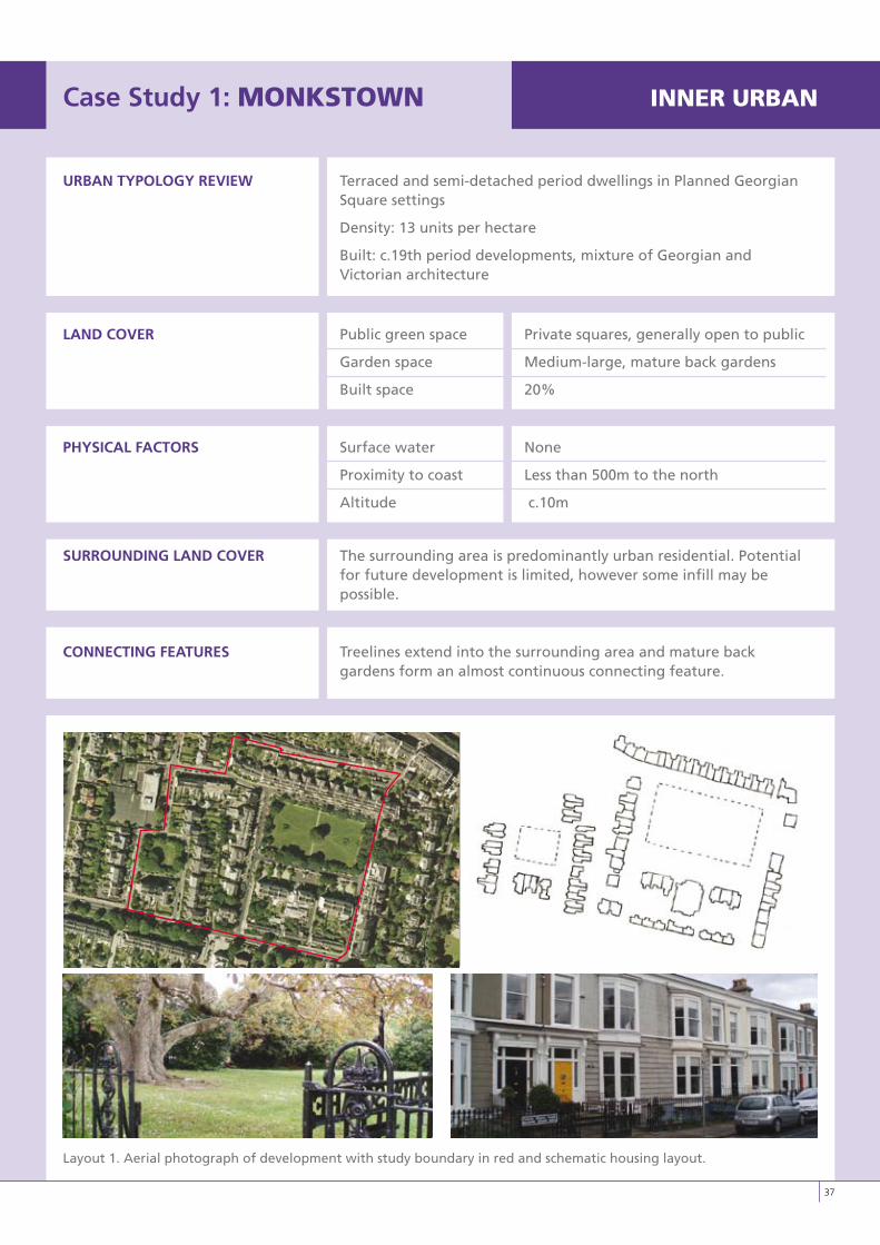
Case Study 1: MONkSTOwN INNERURBAN
URBAN TyPOLOGy REvIEW Terraced and semi-detached period dwellings in Planned Georgian Square settings
Density: 13 units per hectare
Built: c.19th period developments, mixture of Georgian and Victorian architecture
LAND COvER Public green space Private squares, generally open to public
Garden space Medium-large, mature back gardens
Built space 20%
PHySICAL FACTORS Surface water None
Proximity to coast Less than 500m to the north
Altitude c.10m
SURROUNDING LAND COvER The surrounding area is predominantly urban residential. Potential for future development is limited, however some infill may be possible.
CONNECTING FEATURES Treelines extend into the surrounding area and mature back gardens form an almost continuous connecting feature.
Layout 1. Aerial photograph of development with study boundary in red and schematic housing layout.
LO RES IMAGE
��
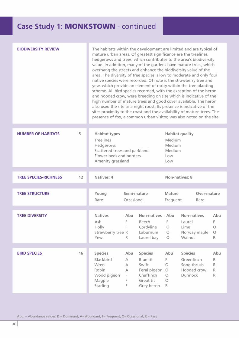
BIODIvERSITy REvIEW The habitats within the development are limited and are typical ofmature urban areas. Of greatest significance are the treelines, hedgerows and trees, which contributes to the area’s biodiversity value. In addition, many of the gardens have mature trees, which overhang the streets and enhance the biodiversity value of the area. The diversity of tree species is low to moderate and only four native species were recorded. Of note is the strawberry tree and yew, which provide an element of rarity within the tree planting scheme. All bird species recorded, with the exception of the heron and hooded crow, were breeding on site which is indicative of the high number of mature trees and good cover available. The heron also used the site as a night roost. Its presence is indicative of the sites proximity to the coast and the availability of mature trees. The presence of fox, a common urban visitor, was also noted on the site.
NUMBER OF HABITATS 5 Habitat types Habitat quality
Treelines Medium Hedgerows Medium Scattered trees and parkland Medium Flower beds and borders Low Amenity grassland Low
TREE SPECIES-RICHNESS 12 Natives: 4 Non-natives: 8
TREE STRUCTURE young Semi-mature Mature Over-mature
Rare Occasional Frequent Rare
TREE DIvERSITy Natives Abu Non-natives Abu Non-natives Abu
Ash F Beech F Laurel F Holly F Cordyline O Lime O Strawberry tree R Laburnum O Norway maple O Yew R Laurel bay O Walnut R
BIRD SPECIES 16 Species Abu Species Abu Species Abu
Blackbird A Blue tit F Greenfinch R Wren A Swift O Song thrush R Robin A Feral pigeon O Hooded crow R Wood pigeon F Chaffinch O Dunnock R Magpie F Great tit O Starling F Grey heron R
Case Study 1:MONkSTOwN - continued
Abu. = Abundance values: D = Dominant, A= Abundant, F= Frequent, O= Occasional, R = Rare
�8
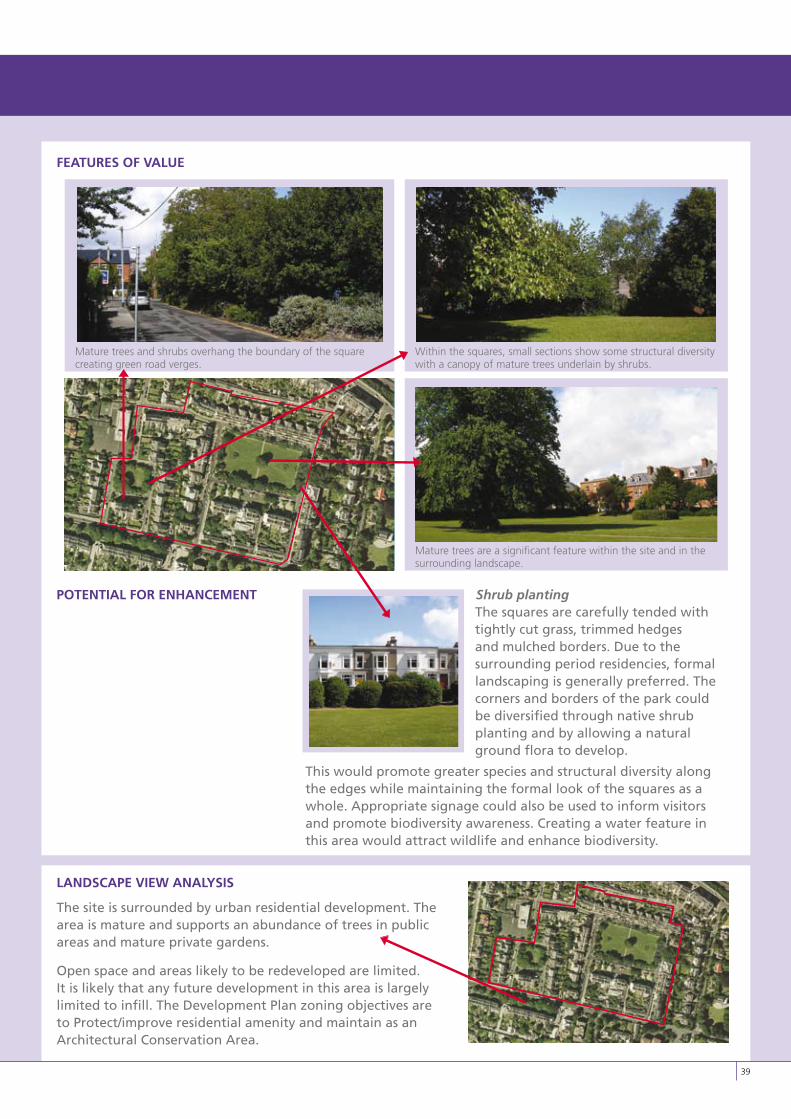
FEATURES OF vALUE
POTENTIAL FOR ENHANCEMENT Shrub plantingThe squares are carefully tended with tightly cut grass, trimmed hedges and mulched borders. Due to the surrounding period residencies, formal landscaping is generally preferred. The corners and borders of the park could be diversified through native shrub planting and by allowing a natural ground flora to develop.
This would promote greater species and structural diversity along the edges while maintaining the formal look of the squares as a whole. Appropriate signage could also be used to inform visitors and promote biodiversity awareness. Creating a water feature in this area would attract wildlife and enhance biodiversity.
LANDSCAPE vIEW ANALySIS
The site is surrounded by urban residential development. The area is mature and supports an abundance of trees in public areas and mature private gardens.
Open space and areas likely to be redeveloped are limited. It is likely that any future development in this area is largely limited to infill. The Development Plan zoning objectives are to Protect/improve residential amenity and maintain as an Architectural Conservation Area.
�9
Within the squares, small sections show some structural diversity with a canopy of mature trees underlain by shrubs.
Mature trees are a significant feature within the site and in the surrounding landscape.
Mature trees and shrubs overhang the boundary of the square creating green road verges.
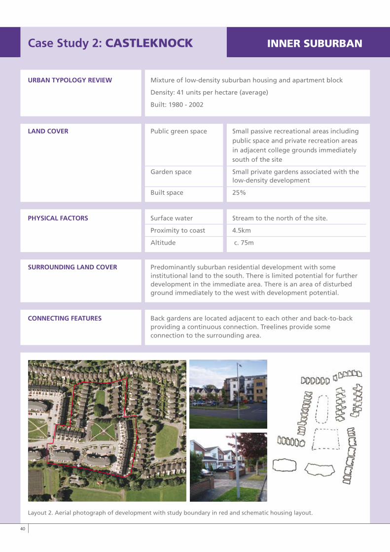
Case Study 2: CASTLEkNOCk INNERSUBURBAN
URBAN TyPOLOGy REvIEW Mixture of low-density suburban housing and apartment block
Density: 41 units per hectare (average)
Built: 1980 - 2002
LAND COvER Public green space Small passive recreational areas including public space and private recreation areas in adjacent college grounds immediately south of the site
Garden space Small private gardens associated with the low-density development
Built space 25%
PHySICAL FACTORS Surface water Stream to the north of the site.
Proximity to coast 4.5km
Altitude c. 75m
SURROUNDING LAND COvER Predominantly suburban residential development with some institutional land to the south. There is limited potential for further development in the immediate area. There is an area of disturbed ground immediately to the west with development potential.
CONNECTING FEATURES Back gardens are located adjacent to each other and back-to-back providing a continuous connection. Treelines provide some connection to the surrounding area.
Layout 2. Aerial photograph of development with study boundary in red and schematic housing layout.
�0
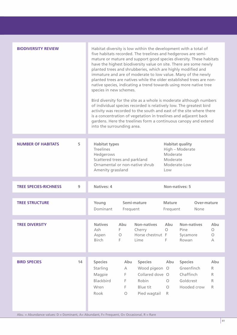
BIODIvERSITy REvIEW Habitat diversity is low within the development with a total offive habitats recorded. The treelines and hedgerows are semi-mature or mature and support good species diversity. These habitats have the highest biodiversity value on site. There are some newly planted trees and shrubberies, which are highly modified and immature and are of moderate to low value. Many of the newly planted trees are natives while the older established trees are non-native species, indicating a trend towards using more native tree species in new schemes.
Bird diversity for the site as a whole is moderate although numbers of individual species recorded is relatively low. The greatest bird activity was recorded to the south and east of the site where there is a concentration of vegetation in treelines and adjacent back gardens. Here the treelines form a continuous canopy and extend into the surrounding area.
NUMBER OF HABITATS 5 Habitat types Habitat quality Treelines High – Moderate Hedgerows Moderate Scattered trees and parkland Moderate Ornamental or non-native shrub Moderate-Low Amenity grassland Low
TREE SPECIES-RICHNESS 9 Natives: 4 Non-natives: 5
TREE STRUCTURE young Semi-mature Mature Over-mature
Dominant Frequent Frequent None
TREE DIvERSITy Natives Abu Non-natives Abu Non-natives Abu Ash F Cherry O Pine O Aspen O Horse chestnut F Sycamore O Birch F Lime F Rowan A
BIRD SPECIES 14 Species Abu Species Abu Species Abu
Starling A Wood pigeon O Greenfinch R
Magpie F Collared dove O Chaffinch R
Blackbird F Robin O Goldcrest R
Wren F Blue tit O Hooded crow R
Rook O Pied wagtail R
Abu. = Abundance values: D = Dominant, A= Abundant, F= Frequent, O= Occasional, R = Rare
�1
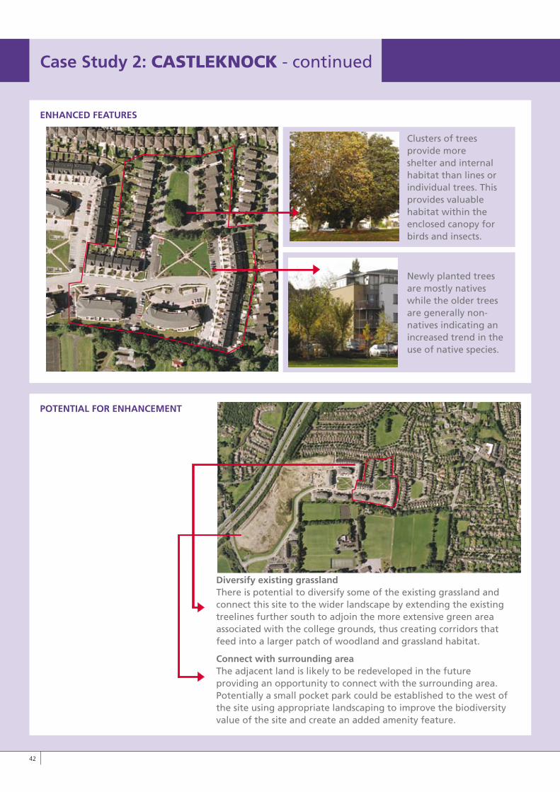
ENHANCED FEATURES
POTENTIAL FOR ENHANCEMENT
Diversify existing grassland There is potential to diversify some of the existing grassland and
connect this site to the wider landscape by extending the existing treelines further south to adjoin the more extensive green area associated with the college grounds, thus creating corridors that feed into a larger patch of woodland and grassland habitat.
Connect with surrounding areaThe adjacent land is likely to be redeveloped in the future providing an opportunity to connect with the surrounding area. Potentially a small pocket park could be established to the west of the site using appropriate landscaping to improve the biodiversity value of the site and create an added amenity feature.
Clusters of trees provide more shelter and internal habitat than lines or individual trees. This provides valuable habitat within the enclosed canopy for birds and insects.
Newly planted trees are mostly natives while the older trees are generally non-natives indicating an increased trend in the use of native species.
LO RES IMAGE
Case Study 2: CASTLEkNOCk - continued
��
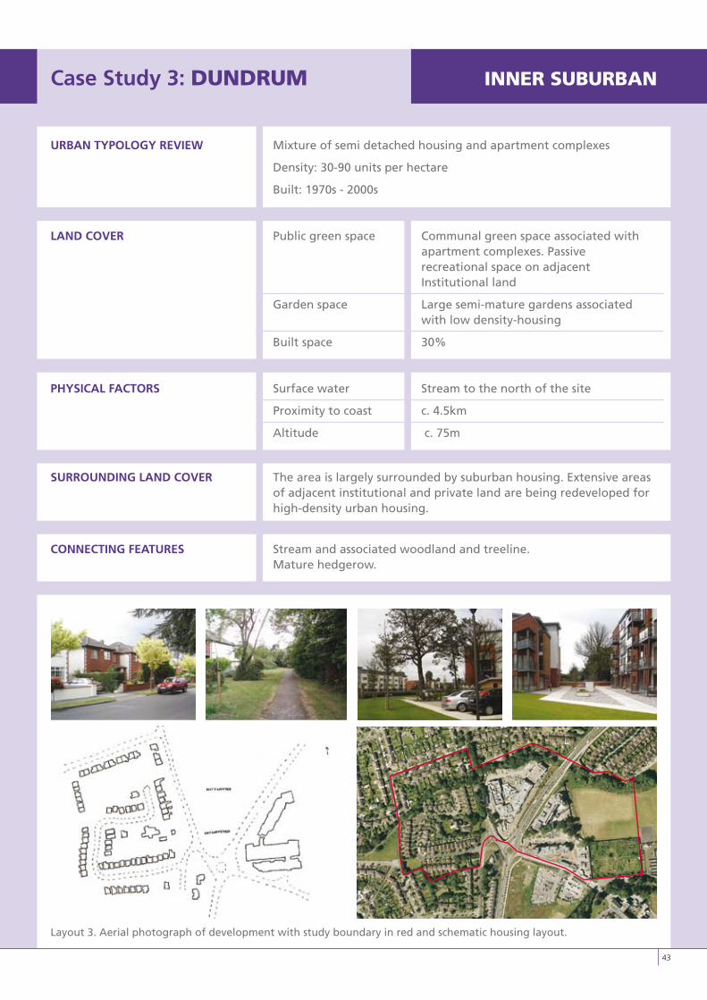
Case Study 3: DUNDRUM INNERSUBURBAN
URBAN TyPOLOGy REvIEW Mixture of semi detached housing and apartment complexes
Density: 30-90 units per hectare
Built: 1970s - 2000s
LAND COvER Public green space Communal green space associated with apartment complexes. Passive recreational space on adjacent Institutional land
Garden space Large semi-mature gardens associated with low density-housing
Built space 30%
PHySICAL FACTORS Surface water Stream to the north of the site
Proximity to coast c. 4.5km
Altitude c. 75m
SURROUNDING LAND COvER The area is largely surrounded by suburban housing. Extensive areas of adjacent institutional and private land are being redeveloped for high-density urban housing.
CONNECTING FEATURES Stream and associated woodland and treeline. Mature hedgerow.
Layout 3. Aerial photograph of development with study boundary in red and schematic housing layout.
��
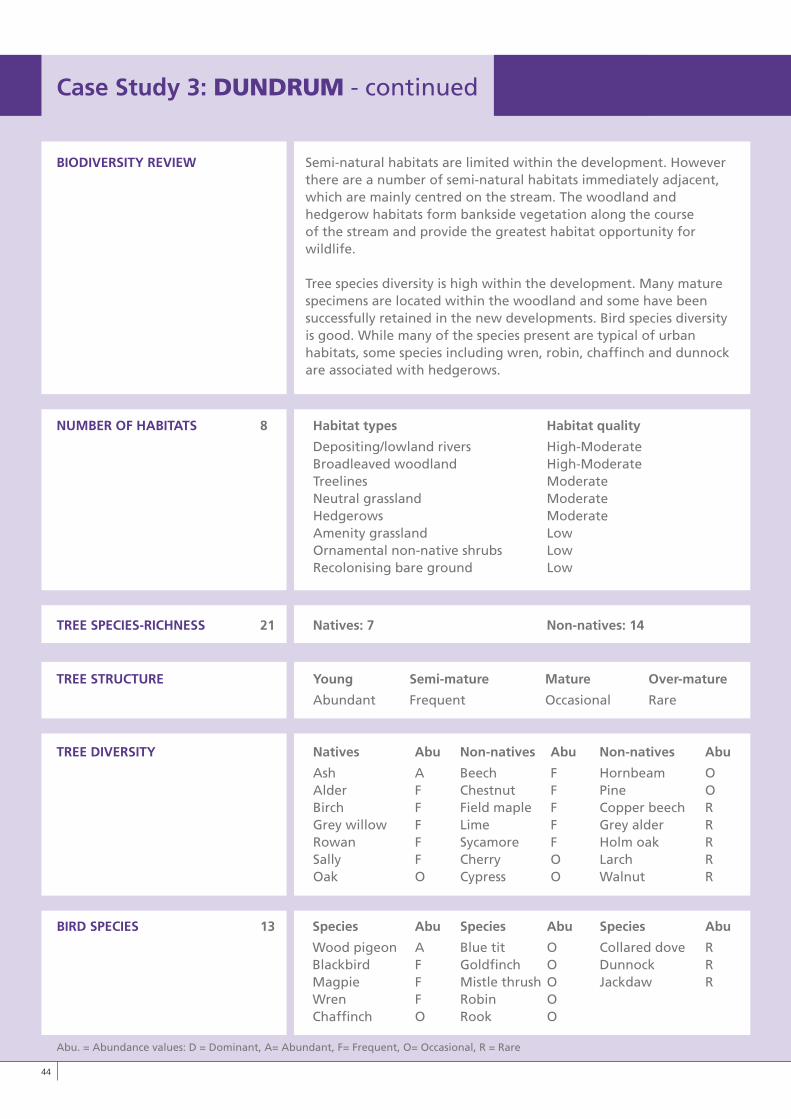
BIODIvERSITy REvIEW Semi-natural habitats are limited within the development. Howeverthere are a number of semi-natural habitats immediately adjacent, which are mainly centred on the stream. The woodland and hedgerow habitats form bankside vegetation along the course of the stream and provide the greatest habitat opportunity for wildlife.
Tree species diversity is high within the development. Many mature specimens are located within the woodland and some have been successfully retained in the new developments. Bird species diversity is good. While many of the species present are typical of urban habitats, some species including wren, robin, chaffinch and dunnock are associated with hedgerows.
NUMBER OF HABITATS 8 Habitat types Habitat quality
Depositing/lowland rivers High-Moderate Broadleaved woodland High-Moderate Treelines Moderate Neutral grassland Moderate Hedgerows Moderate Amenity grassland Low Ornamental non-native shrubs Low Recolonising bare ground Low
TREE SPECIES-RICHNESS 21 Natives: 7 Non-natives: 14
TREE STRUCTURE young Semi-mature Mature Over-mature
Abundant Frequent Occasional Rare
TREE DIvERSITy Natives Abu Non-natives Abu Non-natives Abu
Ash A Beech F Hornbeam O Alder F Chestnut F Pine O Birch F Field maple F Copper beech R Grey willow F Lime F Grey alder R Rowan F Sycamore F Holm oak R Sally F Cherry O Larch R Oak O Cypress O Walnut R
BIRD SPECIES 13 Species Abu Species Abu Species Abu
Wood pigeon A Blue tit O Collared dove R Blackbird F Goldfinch O Dunnock R Magpie F Mistle thrush O Jackdaw R Wren F Robin O Chaffinch O Rook O
Case Study 3: DUNDRUM - continued
Abu. = Abundance values: D = Dominant, A= Abundant, F= Frequent, O= Occasional, R = Rare
��
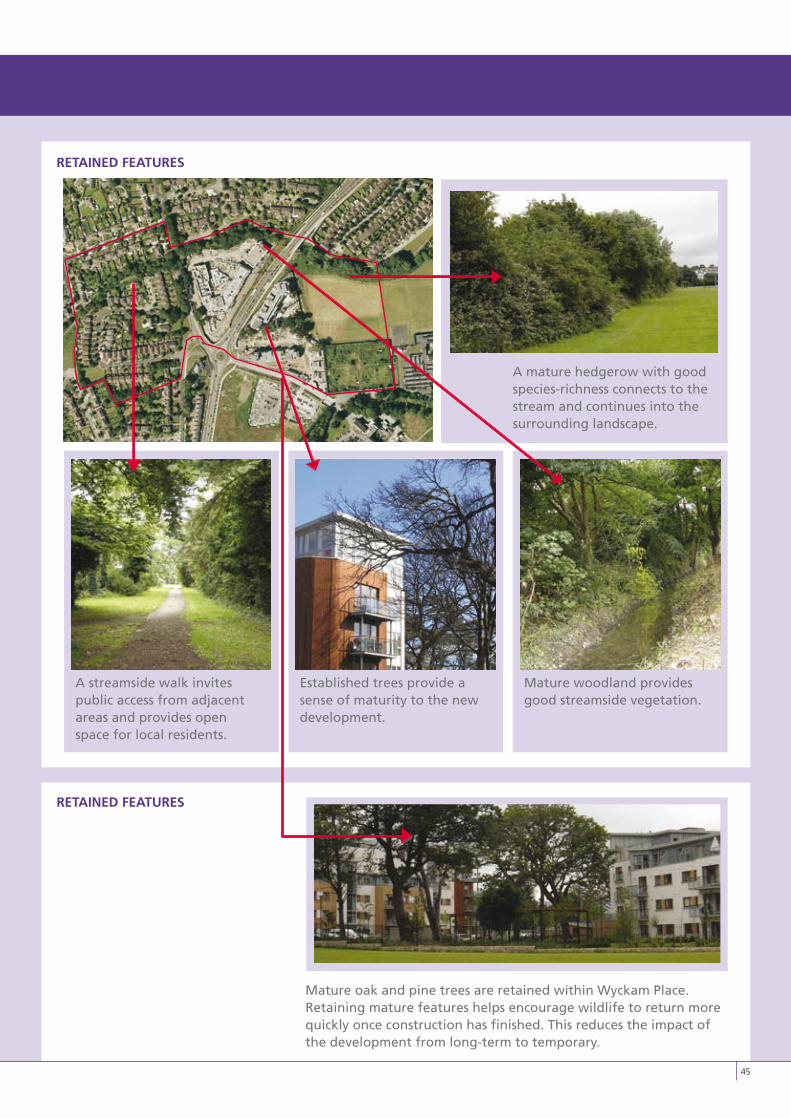
RETAINED FEATURES
RETAINED FEATURES
Mature oak and pine trees are retained within Wyckam Place. Retaining mature features helps encourage wildlife to return more quickly once construction has finished. This reduces the impact of the development from long-term to temporary.
A mature hedgerow with good species-richness connects to the stream and continues into the surrounding landscape.
A streamside walk invites public access from adjacent areas and provides open space for local residents.
Established trees provide a sense of maturity to the new development.
Mature woodland provides good streamside vegetation.
��
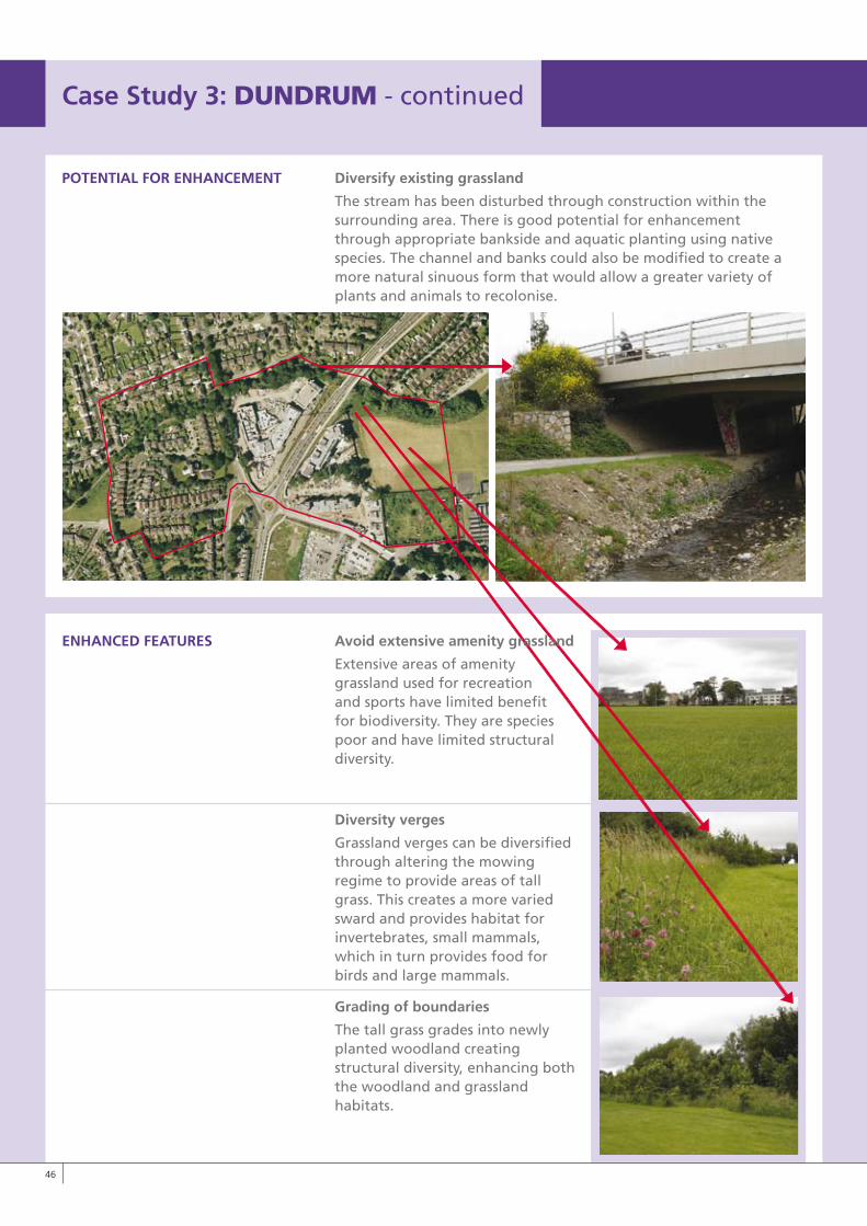
Case Study 3: DUNDRUM - continued
��
POTENTIAL FOR ENHANCEMENT Diversify existing grassland
The stream has been disturbed through construction within the surrounding area. There is good potential for enhancement through appropriate bankside and aquatic planting using native species. The channel and banks could also be modified to create a more natural sinuous form that would allow a greater variety of plants and animals to recolonise.
ENHANCED FEATURES Avoid extensive amenity grassland
Extensive areas of amenitygrassland used for recreation and sports have limited benefit for biodiversity. They are species poor and have limited structural diversity.
Diversity verges
Grassland verges can be diversified through altering the mowing regime to provide areas of tall grass. This creates a more varied sward and provides habitat for invertebrates, small mammals, which in turn provides food for birds and large mammals.
Grading of boundaries
The tall grass grades into newly planted woodland creating structural diversity, enhancing both the woodland and grassland habitats.
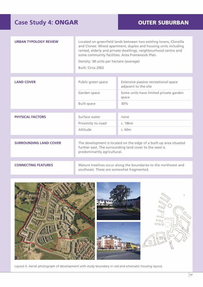
Case Study 4: ONGAR OUTERSUBURBAN
URBAN TyPOLOGy REvIEW Located on greenfield lands between two existing towns, Clonsilla and Clonee. Mixed apartment, duplex and housing units including rented, elderly and private dwellings, neighbourhood centre and some community facilities. Area Framework Plan.
Density: 38 units per hectare (average)
Built: Circa 2002
LAND COvER Public green space Extensive passive recreational space adjacent to the site
Garden space Some units have limited private garden space
Built space 30%
PHySICAL FACTORS Surface water none
Proximity to coast c. 18km
Altitude c. 60m
SURROUNDING LAND COvER The development is located on the edge of a built-up area situated further east. The surrounding land cover to the west is predominantly agricultural.
CONNECTING FEATURES Mature treelines occur along the boundaries to the northwest and southeast. These are somewhat fragmented.
Layout 4. Aerial photograph of development with study boundary in red and schematic housing layout.
��
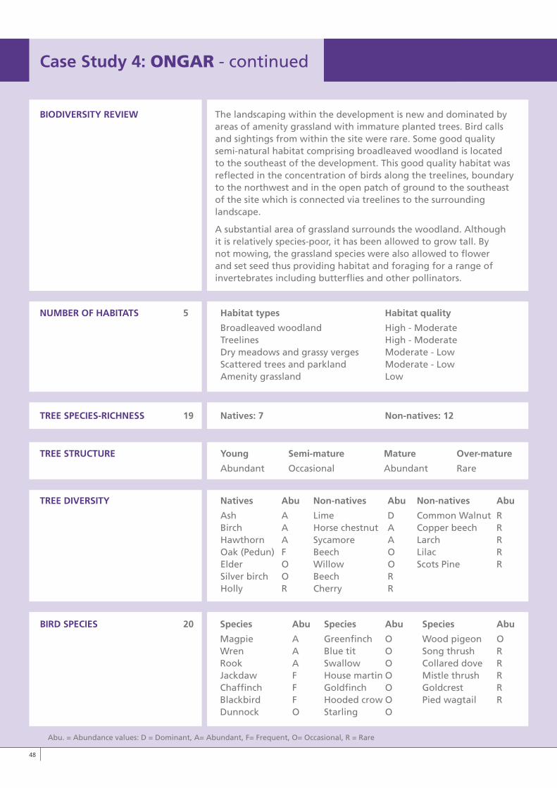
BIODIvERSITy REvIEW The landscaping within the development is new and dominated byareas of amenity grassland with immature planted trees. Bird calls and sightings from within the site were rare. Some good quality semi-natural habitat comprising broadleaved woodland is located to the southeast of the development. This good quality habitat was reflected in the concentration of birds along the treelines, boundary to the northwest and in the open patch of ground to the southeast of the site which is connected via treelines to the surrounding landscape.
A substantial area of grassland surrounds the woodland. Although it is relatively species-poor, it has been allowed to grow tall. By not mowing, the grassland species were also allowed to flower and set seed thus providing habitat and foraging for a range of invertebrates including butterflies and other pollinators.
NUMBER OF HABITATS 5 Habitat types Habitat quality
Broadleaved woodland High - Moderate Treelines High - Moderate Dry meadows and grassy verges Moderate - Low Scattered trees and parkland Moderate - Low Amenity grassland Low
TREE SPECIES-RICHNESS 19 Natives: 7 Non-natives: 12
TREE STRUCTURE young Semi-mature Mature Over-mature
Abundant Occasional Abundant Rare
TREE DIvERSITy Natives Abu Non-natives Abu Non-natives Abu
Ash A Lime D Common Walnut R Birch A Horse chestnut A Copper beech R Hawthorn A Sycamore A Larch R Oak (Pedun) F Beech O Lilac R Elder O Willow O Scots Pine R Silver birch O Beech R Holly R Cherry R
BIRD SPECIES 20 Species Abu Species Abu Species Abu
Magpie A Greenfinch O Wood pigeon O Wren A Blue tit O Song thrush R Rook A Swallow O Collared dove R Jackdaw F House martin O Mistle thrush R Chaffinch F Goldfinch O Goldcrest R Blackbird F Hooded crow O Pied wagtail R Dunnock O Starling O
Case Study 4: ONGAR - continued
Abu. = Abundance values: D = Dominant, A= Abundant, F= Frequent, O= Occasional, R = Rare
�8
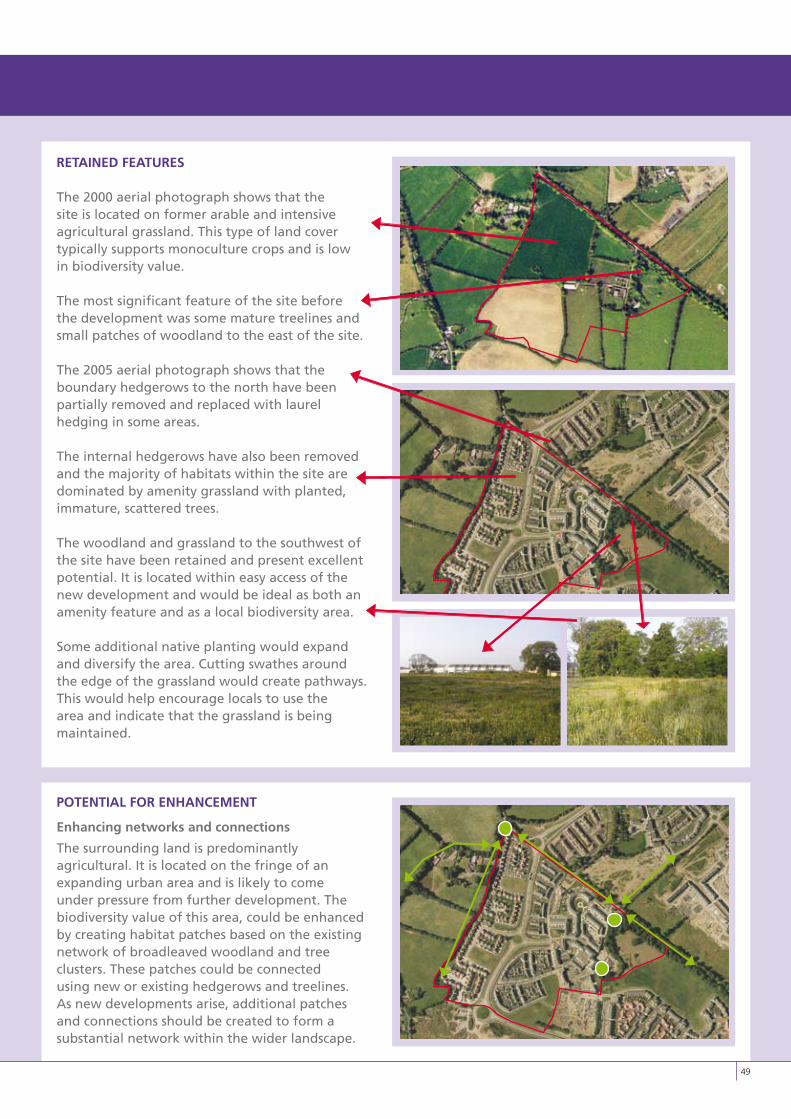
RETAINED FEATURES
The 2000 aerial photograph shows that the site is located on former arable and intensive agricultural grassland. This type of land cover typically supports monoculture crops and is low in biodiversity value.
The most significant feature of the site before the development was some mature treelines and small patches of woodland to the east of the site.
The 2005 aerial photograph shows that the boundary hedgerows to the north have been partially removed and replaced with laurel hedging in some areas.
The internal hedgerows have also been removed and the majority of habitats within the site are dominated by amenity grassland with planted, immature, scattered trees.
The woodland and grassland to the southwest of the site have been retained and present excellent potential. It is located within easy access of the new development and would be ideal as both an amenity feature and as a local biodiversity area.
Some additional native planting would expand and diversify the area. Cutting swathes around the edge of the grassland would create pathways. This would help encourage locals to use the area and indicate that the grassland is being maintained.
POTENTIAL FOR ENHANCEMENT
Enhancing networks and connections
The surrounding land is predominantly agricultural. It is located on the fringe of an expanding urban area and is likely to come under pressure from further development. The biodiversity value of this area, could be enhanced by creating habitat patches based on the existing network of broadleaved woodland and tree clusters. These patches could be connected using new or existing hedgerows and treelines. As new developments arise, additional patches and connections should be created to form a substantial network within the wider landscape.
�9
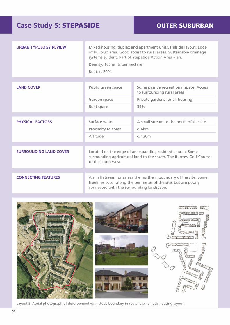
Case Study 5: STEPASIDE OUTERSUBURBAN
URBAN TyPOLOGy REvIEW Mixed housing, duplex and apartment units. Hillside layout. Edge of built-up area. Good access to rural areas. Sustainable drainage systems evident. Part of Stepaside Action Area Plan.
Density: 105 units per hectare
Built: c. 2004
LAND COvER Public green space Some passive recreational space. Access to surrounding rural areas
Garden space Private gardens for all housing
Built space 35%
PHySICAL FACTORS Surface water A small stream to the north of the site
Proximity to coast c. 6km
Altitude c. 120m
SURROUNDING LAND COvER Located on the edge of an expanding residential area. Some surrounding agricultural land to the south. The Burrow Golf Course to the south west.
CONNECTING FEATURES A small stream runs near the northern boundary of the site. Some treelines occur along the perimeter of the site, but are poorly connected with the surrounding landscape.
Layout 5. Aerial photograph of development with study boundary in red and schematic housing layout.
�0
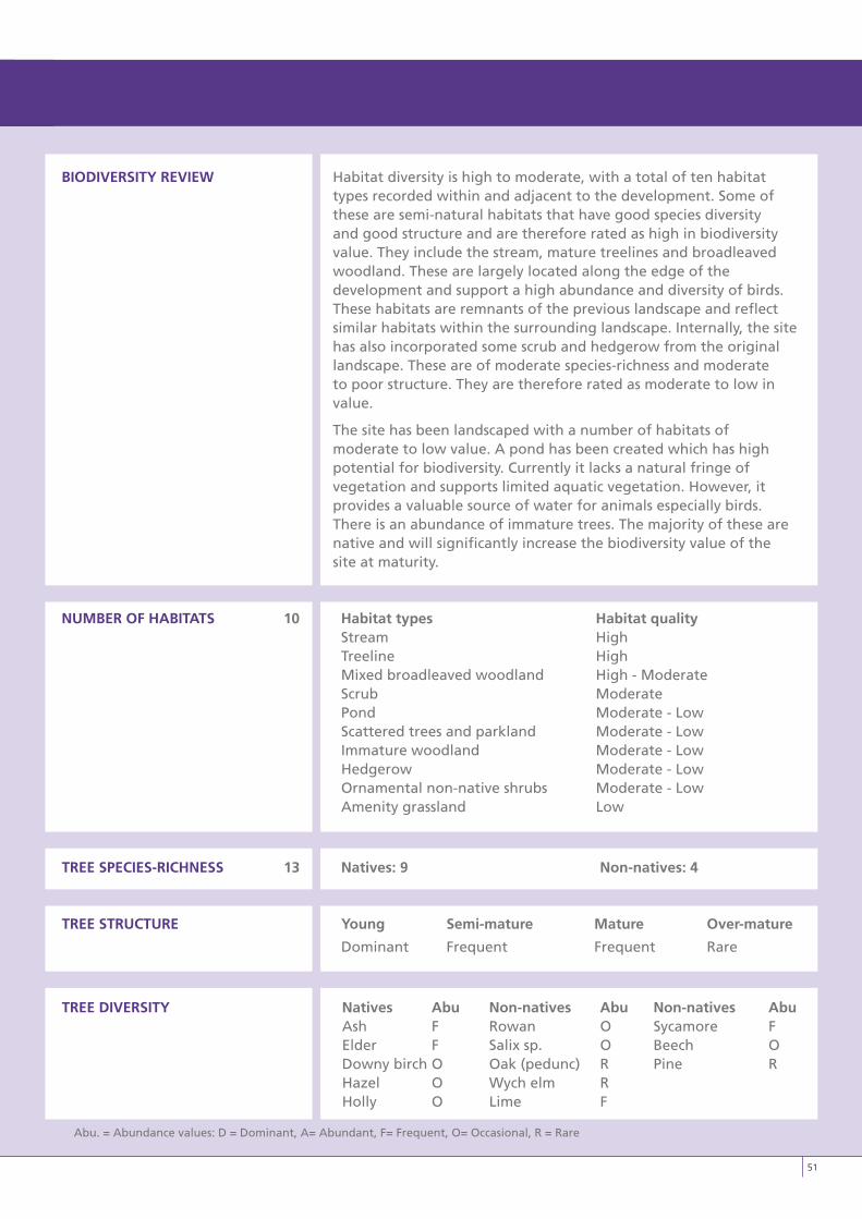
BIODIvERSITy REvIEW Habitat diversity is high to moderate, with a total of ten habitat types recorded within and adjacent to the development. Some of these are semi-natural habitats that have good species diversity and good structure and are therefore rated as high in biodiversity value. They include the stream, mature treelines and broadleaved woodland. These are largely located along the edge of the development and support a high abundance and diversity of birds. These habitats are remnants of the previous landscape and reflect similar habitats within the surrounding landscape. Internally, the site has also incorporated some scrub and hedgerow from the original landscape. These are of moderate species-richness and moderate to poor structure. They are therefore rated as moderate to low in value.
The site has been landscaped with a number of habitats of moderate to low value. A pond has been created which has high potential for biodiversity. Currently it lacks a natural fringe of vegetation and supports limited aquatic vegetation. However, it provides a valuable source of water for animals especially birds. There is an abundance of immature trees. The majority of these are native and will significantly increase the biodiversity value of the site at maturity.
NUMBER OF HABITATS 10 Habitat types Habitat quality Stream High Treeline High Mixed broadleaved woodland High - Moderate Scrub Moderate Pond Moderate - Low Scattered trees and parkland Moderate - Low Immature woodland Moderate - Low Hedgerow Moderate - Low Ornamental non-native shrubs Moderate - Low Amenity grassland Low
TREE SPECIES-RICHNESS 13 Natives: 9 Non-natives: 4
TREE STRUCTURE young Semi-mature Mature Over-mature
Dominant Frequent Frequent Rare
TREE DIvERSITy Natives Abu Non-natives Abu Non-natives Abu Ash F Rowan O Sycamore F Elder F Salix sp. O Beech O Downy birch O Oak (pedunc) R Pine R Hazel O Wych elm R Holly O Lime F
Abu. = Abundance values: D = Dominant, A= Abundant, F= Frequent, O= Occasional, R = Rare
�1
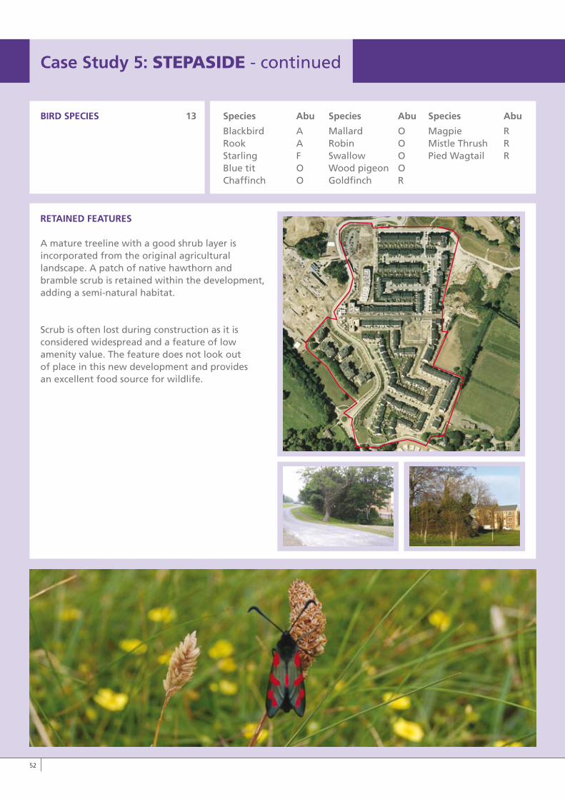
BIRD SPECIES 13 Species Abu Species Abu Species Abu
Blackbird A Mallard O Magpie R Rook A Robin O Mistle Thrush R Starling F Swallow O Pied Wagtail R Blue tit O Wood pigeon O Chaffinch O Goldfinch R
RETAINED FEATURES
A mature treeline with a good shrub layer is incorporated from the original agricultural landscape. A patch of native hawthorn and bramble scrub is retained within the development, adding a semi-natural habitat.
Scrub is often lost during construction as it is considered widespread and a feature of low amenity value. The feature does not look out of place in this new development and provides an excellent food source for wildlife.
Case Study 5: STEPASIDE - continued
��
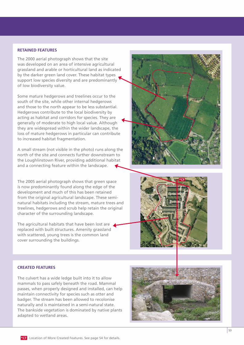
CREATED FEATURES
The culvert has a wide ledge built into it to allow mammals to pass safely beneath the road. Mammal passes, when properly designed and installed, can help maintain connectivity for species such as otter and badger. The stream has been allowed to recolonise naturally and is maintained in a semi-natural state. The bankside vegetation is dominated by native plants adapted to wetland areas.
RETAINED FEATURES
The 2000 aerial photograph shows that the site was developed on an area of intensive agricultural grassland and arable or horticultural land as indicated by the darker green land cover. These habitat types support low species diversity and are predominantly of low biodiversity value.
Some mature hedgerows and treelines occur to the south of the site, while other internal hedgerows and those to the north appear to be less substantial. Hedgerows contribute to the local biodiversity by acting as habitat and corridors for species. They are generally of moderate to high local value. Although they are widespread within the wider landscape, the loss of mature hedgerows in particular can contribute to increased habitat fragmentation.
A small stream (not visible in the photo) runs along the north of the site and connects further downstream to the Loughlinstown River, providing additional habitat and a connecting feature within the landscape.
The 2005 aerial photograph shows that green space is now predominantly found along the edge of the development and much of this has been retained from the original agricultural landscape. These semi-natural habitats including the stream, mature trees and treelines, hedgerows and scrub help retain the original character of the surrounding landscape.
The agricultural habitats that have been lost are replaced with built structures. Amenity grassland with scattered, young trees is the common land cover surrounding the buildings.
��
*CF - Location of More Created Features. See page 54 for details.
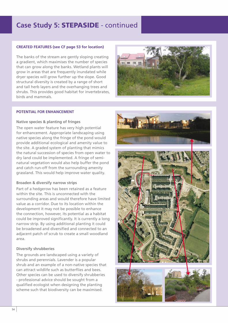
CREATED FEATURES (see CF page 53 for location)
The banks of the stream are gently sloping creating a gradient, which maximises the number of species that can grow along the banks. Wetland plants will grow in areas that are frequently inundated while dryer species will grow further up the slope. Good structural diversity is created by a range of short and tall herb layers and the overhanging trees and shrubs. This provides good habitat for invertebrates, birds and mammals.
POTENTIAL FOR ENHANCEMENT
Native species & planting of fringes
The open water feature has very high potential for enhancement. Appropriate landscaping using native species along the fringe of the pond would provide additional ecological and amenity value to the site. A graded system of planting that mimics the natural succession of species from open water to dry land could be implemented. A fringe of semi-natural vegetation would also help buffer the pond and catch run-off from the surrounding amenity grassland. This would help improve water quality.
Broaden & diversify narrow strips
Part of a hedgerow has been retained as a feature within the site. This is unconnected with the surrounding areas and would therefore have limited value as a corridor. Due to its location within the development it may not be possible to enhance the connection, however, its potential as a habitat could be improved significantly. It is currently a long narrow strip. By using additional planting it could be broadened and diversified and connected to an adjacent patch of scrub to create a small woodland area.
Diversify shrubberies
The grounds are landscaped using a variety of shrubs and perennials. Lavender is a popular shrub and an example of a non-native species that can attract wildlife such as butterflies and bees. Other species can be used to diversify shrubberies - professional advice should be sought from a qualified ecologist when designing the planting scheme such that biodiversity can be maximised.
LO RES IMAGE
Case Study 5: STEPASIDE - continued
��
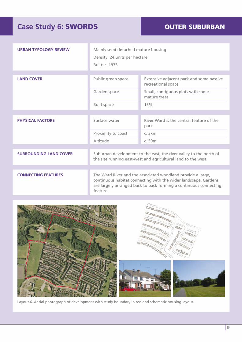
Case Study 6: SwORDS OUTERSUBURBAN
URBAN TyPOLOGy REvIEW Mainly semi-detached mature housing
Density: 24 units per hectare
Built: c. 1973
LAND COvER Public green space Extensive adjacent park and some passive recreational space
Garden space Small, contiguous plots with some mature trees
Built space 15%
PHySICAL FACTORS Surface water River Ward is the central feature of the park
Proximity to coast c. 3km
Altitude c. 50m
SURROUNDING LAND COvER Suburban development to the east, the river valley to the north of the site running east-west and agricultural land to the west.
CONNECTING FEATURES The Ward River and the associated woodland provide a large, continuous habitat connecting with the wider landscape. Gardens are largely arranged back to back forming a continuous connecting feature.
Layout 6. Aerial photograph of development with study boundary in red and schematic housing layout.
��
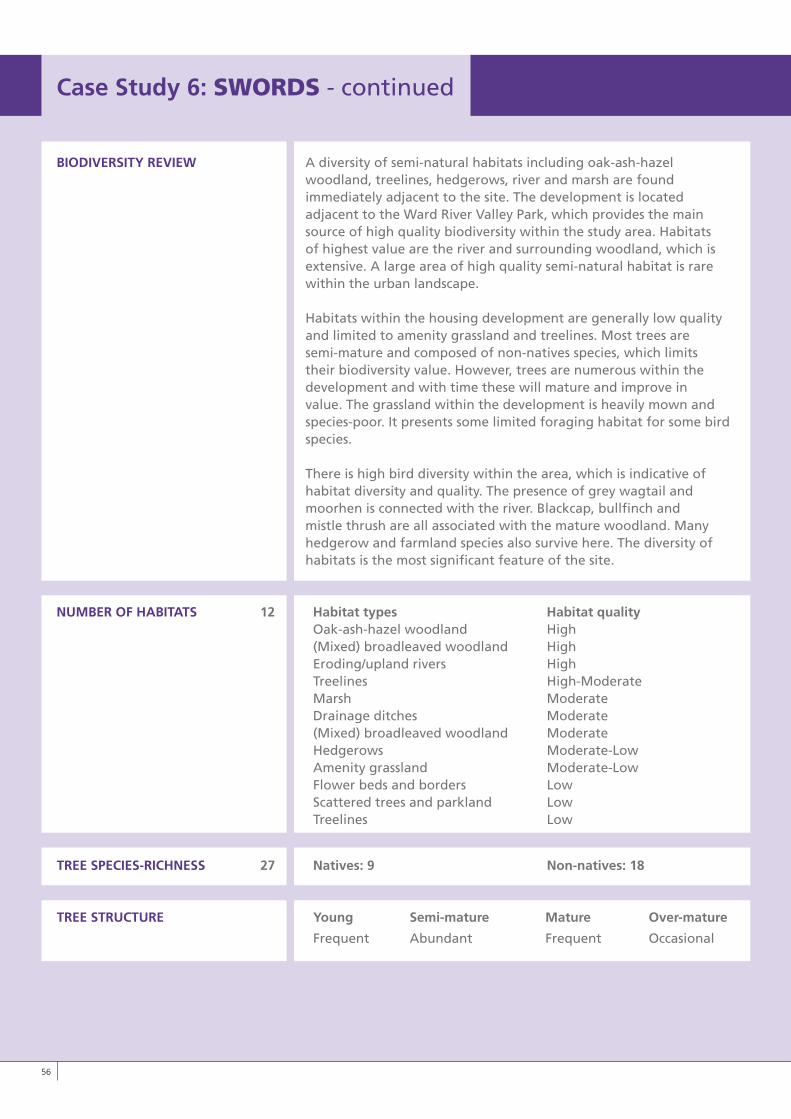
BIODIvERSITy REvIEW A diversity of semi-natural habitats including oak-ash-hazelwoodland, treelines, hedgerows, river and marsh are found immediately adjacent to the site. The development is located adjacent to the Ward River Valley Park, which provides the main source of high quality biodiversity within the study area. Habitats of highest value are the river and surrounding woodland, which is extensive. A large area of high quality semi-natural habitat is rare within the urban landscape.
Habitats within the housing development are generally low quality and limited to amenity grassland and treelines. Most trees are semi-mature and composed of non-natives species, which limits their biodiversity value. However, trees are numerous within the development and with time these will mature and improve in value. The grassland within the development is heavily mown and species-poor. It presents some limited foraging habitat for some bird species.
There is high bird diversity within the area, which is indicative of habitat diversity and quality. The presence of grey wagtail and moorhen is connected with the river. Blackcap, bullfinch and mistle thrush are all associated with the mature woodland. Many hedgerow and farmland species also survive here. The diversity of habitats is the most significant feature of the site.
NUMBER OF HABITATS 12 Habitat types Habitat quality Oak-ash-hazel woodland High (Mixed) broadleaved woodland High Eroding/upland rivers High Treelines High-Moderate Marsh Moderate Drainage ditches Moderate (Mixed) broadleaved woodland Moderate Hedgerows Moderate-Low Amenity grassland Moderate-Low Flower beds and borders Low Scattered trees and parkland Low Treelines Low
TREE SPECIES-RICHNESS 27 Natives: 9 Non-natives: 18
TREE STRUCTURE young Semi-mature Mature Over-mature
Frequent Abundant Frequent Occasional
Case Study 6: SwORDS - continued
��
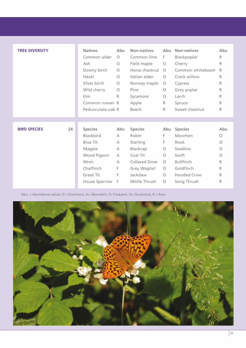
TREE DIvERSITy Natives Abu Non-natives Abu Non-natives Abu
Common alder O Common lime F Blackpoplar R
Ash O Field maple O Cherry R
Downy birch O Horse chestnut O Common whitebeam R
Hazel O Italian alder O Crack willow R
Silver birch O Norway maple O Cypress R
Wild cherry O Pine O Grey poplar R
Elm R Sycamore O Larch R
Common rowan R Apple R Spruce R
Pedunculate oak R Beech R Sweet chestnut R
BIRD SPECIES 24 Species Abu Species Abu Species Abu
Blackbird A Robin F Moorhen O
Blue Tit A Starling F Rook O
Magpie A Blackcap O Swallow O
Wood Pigeon A Coal Tit O Swift O
Wren A Collared Dove O Bullfinch R
Chaffinch F Grey Wagtail O Goldfinch R
Great Tit F Jackdaw O Hooded Crow R
House Sparrow F Mistle Thrush O Song Thrush R
Abu. = Abundance values: D = Dominant, A= Abundant, F= Frequent, O= Occasional, R = Rare
��
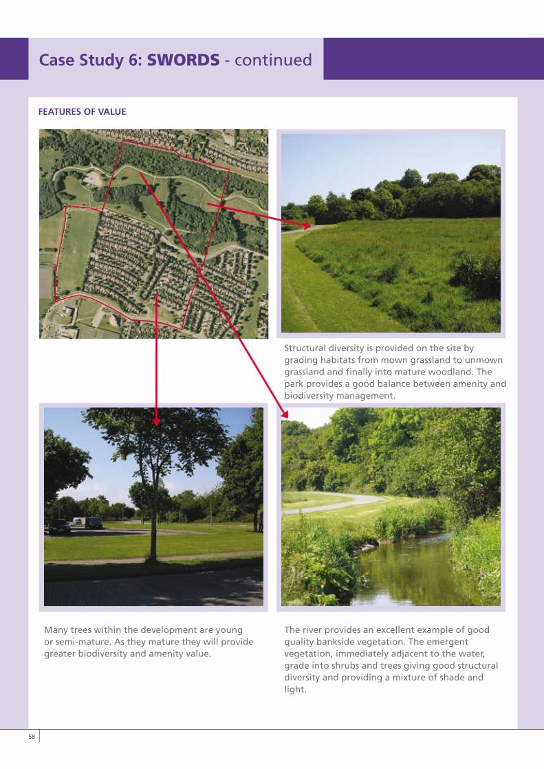
FEATURES OF vALUE
The river provides an excellent example of good quality bankside vegetation. The emergent vegetation, immediately adjacent to the water, grade into shrubs and trees giving good structural diversity and providing a mixture of shade and light.
Many trees within the development are young or semi-mature. As they mature they will provide greater biodiversity and amenity value.
Case Study 6: SwORDS - continued
LO RES IMAGE
Structural diversity is provided on the site by grading habitats from mown grassland to unmown grassland and finally into mature woodland. The park provides a good balance between amenity and biodiversity management.
�8
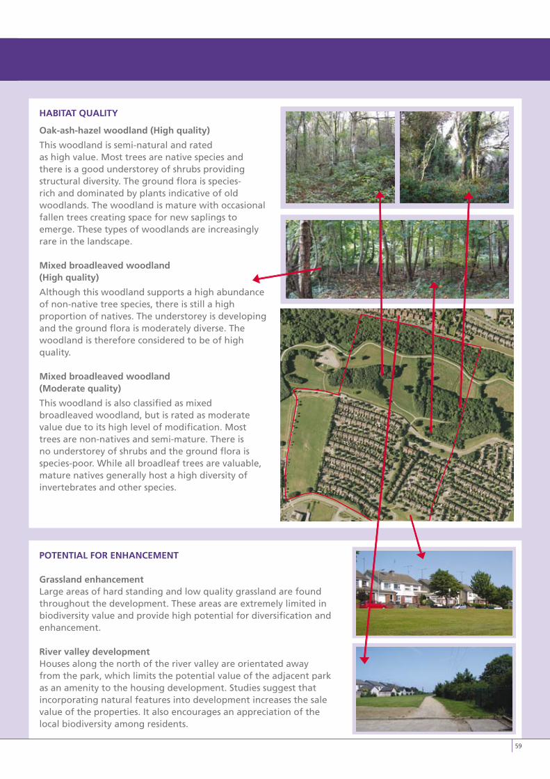
HABITAT QUALITy
Oak-ash-hazel woodland (High quality)
This woodland is semi-natural and rated as high value. Most trees are native species and there is a good understorey of shrubs providing structural diversity. The ground flora is species-rich and dominated by plants indicative of old woodlands. The woodland is mature with occasional fallen trees creating space for new saplings to emerge. These types of woodlands are increasingly rare in the landscape.
Mixed broadleaved woodland (High quality)
Although this woodland supports a high abundance of non-native tree species, there is still a high proportion of natives. The understorey is developing and the ground flora is moderately diverse. The woodland is therefore considered to be of high quality.
Mixed broadleaved woodland (Moderate quality)
This woodland is also classified as mixed broadleaved woodland, but is rated as moderate value due to its high level of modification. Most trees are non-natives and semi-mature. There is no understorey of shrubs and the ground flora is species-poor. While all broadleaf trees are valuable, mature natives generally host a high diversity of invertebrates and other species.
POTENTIAL FOR ENHANCEMENT
Grassland enhancementLarge areas of hard standing and low quality grassland are found throughout the development. These areas are extremely limited in biodiversity value and provide high potential for diversification and enhancement.
River valley developmentHouses along the north of the river valley are orientated away from the park, which limits the potential value of the adjacent park as an amenity to the housing development. Studies suggest that incorporating natural features into development increases the sale value of the properties. It also encourages an appreciation of the local biodiversity among residents.
LO RES IMAGE
�9
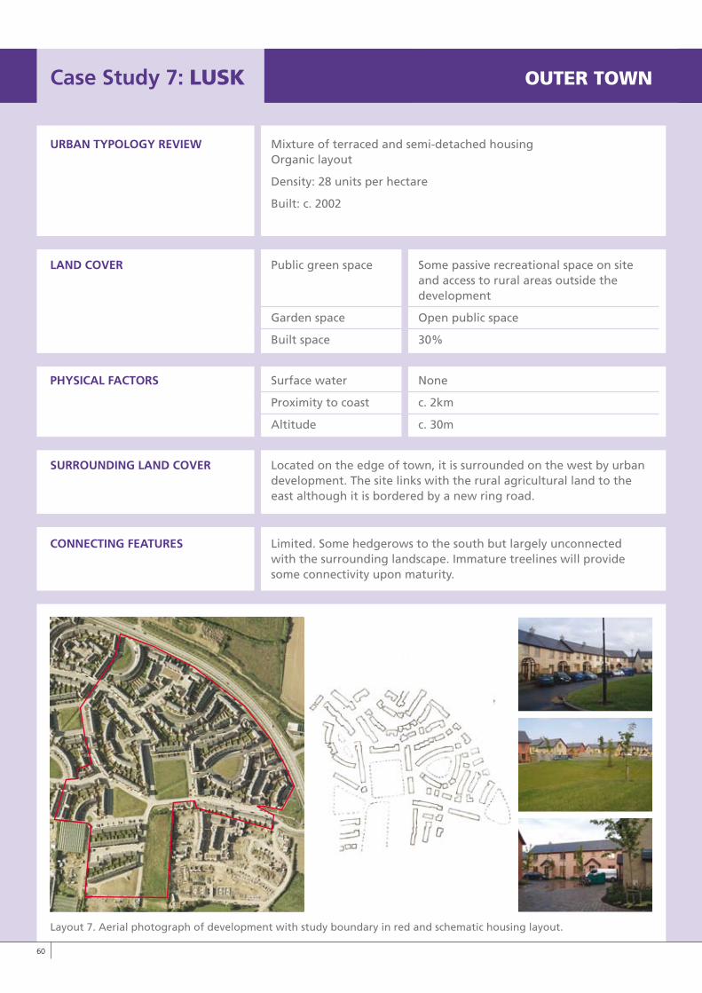
Case Study 7: LUSk OUTERTOwN
URBAN TyPOLOGy REvIEW Mixture of terraced and semi-detached housing Organic layout
Density: 28 units per hectare
Built: c. 2002
LAND COvER Public green space Some passive recreational space on site and access to rural areas outside the development
Garden space Open public space
Built space 30%
PHySICAL FACTORS Surface water None
Proximity to coast c. 2km
Altitude c. 30m
SURROUNDING LAND COvER Located on the edge of town, it is surrounded on the west by urban development. The site links with the rural agricultural land to the east although it is bordered by a new ring road.
CONNECTING FEATURES Limited. Some hedgerows to the south but largely unconnected with the surrounding landscape. Immature treelines will provide some connectivity upon maturity.
Layout 7. Aerial photograph of development with study boundary in red and schematic housing layout.
�0
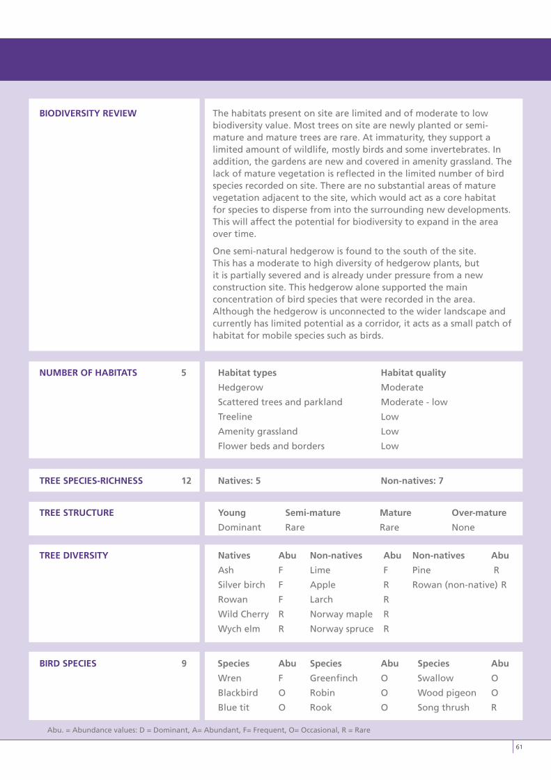
BIODIvERSITy REvIEW The habitats present on site are limited and of moderate to lowbiodiversity value. Most trees on site are newly planted or semi-mature and mature trees are rare. At immaturity, they support a limited amount of wildlife, mostly birds and some invertebrates. In addition, the gardens are new and covered in amenity grassland. The lack of mature vegetation is reflected in the limited number of bird species recorded on site. There are no substantial areas of mature vegetation adjacent to the site, which would act as a core habitat for species to disperse from into the surrounding new developments. This will affect the potential for biodiversity to expand in the area over time.
One semi-natural hedgerow is found to the south of the site. This has a moderate to high diversity of hedgerow plants, but it is partially severed and is already under pressure from a new construction site. This hedgerow alone supported the main concentration of bird species that were recorded in the area. Although the hedgerow is unconnected to the wider landscape and currently has limited potential as a corridor, it acts as a small patch of habitat for mobile species such as birds.
NUMBER OF HABITATS 5 Habitat types Habitat quality
Hedgerow Moderate
Scattered trees and parkland Moderate - low
Treeline Low
Amenity grassland Low
Flower beds and borders Low
TREE SPECIES-RICHNESS 12 Natives: 5 Non-natives: 7
TREE STRUCTURE young Semi-mature Mature Over-mature
Dominant Rare Rare None
TREE DIvERSITy Natives Abu Non-natives Abu Non-natives Abu
Ash F Lime F Pine R
Silver birch F Apple R Rowan (non-native) R
Rowan F Larch R
Wild Cherry R Norway maple R
Wych elm R Norway spruce R
BIRD SPECIES 9 Species Abu Species Abu Species Abu
Wren F Greenfinch O Swallow O
Blackbird O Robin O Wood pigeon O
Blue tit O Rook O Song thrush R
Abu. = Abundance values: D = Dominant, A= Abundant, F= Frequent, O= Occasional, R = Rare
�1
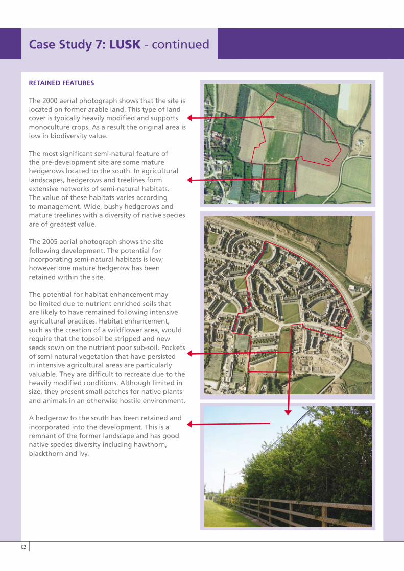
RETAINED FEATURES
The 2000 aerial photograph shows that the site is located on former arable land. This type of land cover is typically heavily modified and supports monoculture crops. As a result the original area is low in biodiversity value.
The most significant semi-natural feature of the pre-development site are some mature hedgerows located to the south. In agricultural landscapes, hedgerows and treelines form extensive networks of semi-natural habitats. The value of these habitats varies according to management. Wide, bushy hedgerows and mature treelines with a diversity of native species are of greatest value.
The 2005 aerial photograph shows the site following development. The potential for incorporating semi-natural habitats is low; however one mature hedgerow has been retained within the site.
The potential for habitat enhancement may be limited due to nutrient enriched soils that are likely to have remained following intensive agricultural practices. Habitat enhancement, such as the creation of a wildflower area, would require that the topsoil be stripped and new seeds sown on the nutrient poor sub-soil. Pockets of semi-natural vegetation that have persisted in intensive agricultural areas are particularly valuable. They are difficult to recreate due to the heavily modified conditions. Although limited in size, they present small patches for native plants and animals in an otherwise hostile environment.
A hedgerow to the south has been retained and incorporated into the development. This is a remnant of the former landscape and has good native species diversity including hawthorn, blackthorn and ivy.
Case Study 7: LUSk - continued
��
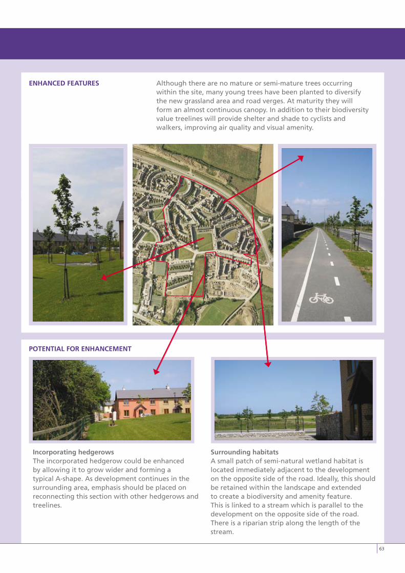
ENHANCED FEATURES Although there are no mature or semi-mature trees occurringwithin the site, many young trees have been planted to diversify the new grassland area and road verges. At maturity they will form an almost continuous canopy. In addition to their biodiversity value treelines will provide shelter and shade to cyclists and walkers, improving air quality and visual amenity.
POTENTIAL FOR ENHANCEMENT
Incorporating hedgerows The incorporated hedgerow could be enhanced by allowing it to grow wider and forming a typical A-shape. As development continues in the surrounding area, emphasis should be placed on reconnecting this section with other hedgerows and treelines.
Surrounding habitatsA small patch of semi-natural wetland habitat is located immediately adjacent to the development on the opposite side of the road. Ideally, this should be retained within the landscape and extended to create a biodiversity and amenity feature. This is linked to a stream which is parallel to the development on the opposite side of the road. There is a riparian strip along the length of the stream.
��
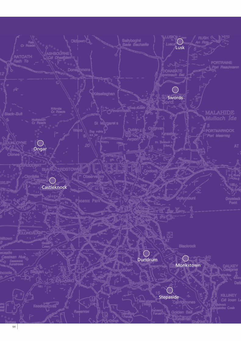
��
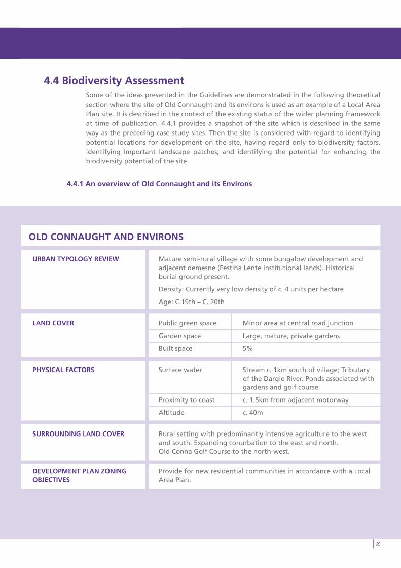
4.4 Biodiversity AssessmentSome of the ideas presented in the Guidelines are demonstrated in the following theoretical section where the site of Old Connaught and its environs is used as an example of a Local Area Plan site. It is described in the context of the existing status of the wider planning framework at time of publication. 4.4.1 provides a snapshot of the site which is described in the same way as the preceding case study sites. Then the site is considered with regard to identifying potential locations for development on the site, having regard only to biodiversity factors, identifying important landscape patches; and identifying the potential for enhancing the biodiversity potential of the site.
4.4.1 An overview of Old Connaught and its Environs
OLD CONNAUGHT AND ENvIRONS
URBAN TyPOLOGy REvIEW Mature semi-rural village with some bungalow development and adjacent demesne (Festina Lente institutional lands). Historical burial ground present.
Density: Currently very low density of c. 4 units per hectare
Age: C.19th – C. 20th
LAND COvER Public green space Minor area at central road junction
Garden space Large, mature, private gardens
Built space 5%
PHySICAL FACTORS Surface water Stream c. 1km south of village; Tributary of the Dargle River. Ponds associated with gardens and golf course
Proximity to coast c. 1.5km from adjacent motorway
Altitude c. 40m
SURROUNDING LAND COvER Rural setting with predominantly intensive agriculture to the west and south. Expanding conurbation to the east and north. Old Conna Golf Course to the north-west.
DEvELOPMENT PLAN ZONING Provide for new residential communities in accordance with a LocalOBJECTIvES Area Plan.
��
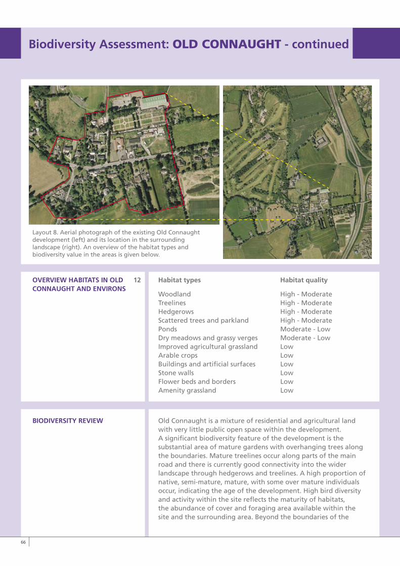
Layout 8. Aerial photograph of the existing Old Connaught development (left) and its location in the surrounding landscape (right). An overview of the habitat types and biodiversity value in the areas is given below.
OvERvIEW HABITATS IN OLD 12 Habitat types Habitat qualityCONNAUGHT AND ENvIRONS
Woodland High - Moderate Treelines High - Moderate Hedgerows High - Moderate Scattered trees and parkland High - Moderate Ponds Moderate - Low Dry meadows and grassy verges Moderate - Low Improved agricultural grassland Low Arable crops Low Buildings and artificial surfaces Low Stone walls Low Flower beds and borders Low Amenity grassland Low
BIODIvERSITy REvIEW Old Connaught is a mixture of residential and agricultural land with very little public open space within the development. A significant biodiversity feature of the development is the substantial area of mature gardens with overhanging trees along the boundaries. Mature treelines occur along parts of the main road and there is currently good connectivity into the wider landscape through hedgerows and treelines. A high proportion of native, semi-mature, mature, with some over mature individuals occur, indicating the age of the development. High bird diversity and activity within the site reflects the maturity of habitats, the abundance of cover and foraging area available within the site and the surrounding area. Beyond the boundaries of the
��
Biodiversity Assessment: OLDCONNAUGhT - continued
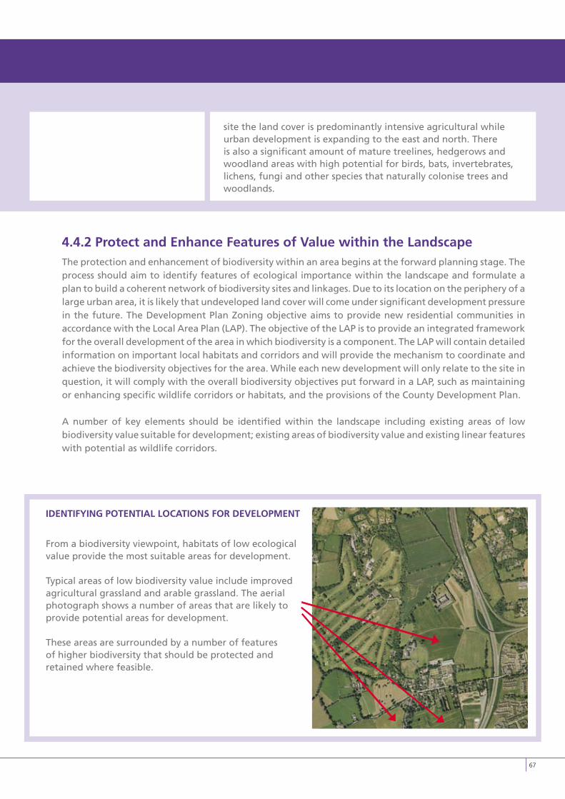
site the land cover is predominantly intensive agricultural while urban development is expanding to the east and north. There is also a significant amount of mature treelines, hedgerows and woodland areas with high potential for birds, bats, invertebrates, lichens, fungi and other species that naturally colonise trees and woodlands.
4.4.2 Protect and Enhance Features of value within the LandscapeThe protection and enhancement of biodiversity within an area begins at the forward planning stage. The process should aim to identify features of ecological importance within the landscape and formulate a plan to build a coherent network of biodiversity sites and linkages. Due to its location on the periphery of a large urban area, it is likely that undeveloped land cover will come under significant development pressure in the future. The Development Plan Zoning objective aims to provide new residential communities in accordance with the Local Area Plan (LAP). The objective of the LAP is to provide an integrated framework for the overall development of the area in which biodiversity is a component. The LAP will contain detailed information on important local habitats and corridors and will provide the mechanism to coordinate and achieve the biodiversity objectives for the area. While each new development will only relate to the site in question, it will comply with the overall biodiversity objectives put forward in a LAP, such as maintaining or enhancing specific wildlife corridors or habitats, and the provisions of the County Development Plan.
A number of key elements should be identified within the landscape including existing areas of low biodiversity value suitable for development; existing areas of biodiversity value and existing linear features with potential as wildlife corridors.
IDENTIFyING POTENTIAL LOCATIONS FOR DEvELOPMENT
From a biodiversity viewpoint, habitats of low ecological value provide the most suitable areas for development.
Typical areas of low biodiversity value include improved agricultural grassland and arable grassland. The aerial photograph shows a number of areas that are likely to provide potential areas for development.
These areas are surrounded by a number of features of higher biodiversity that should be protected and retained where feasible.
��
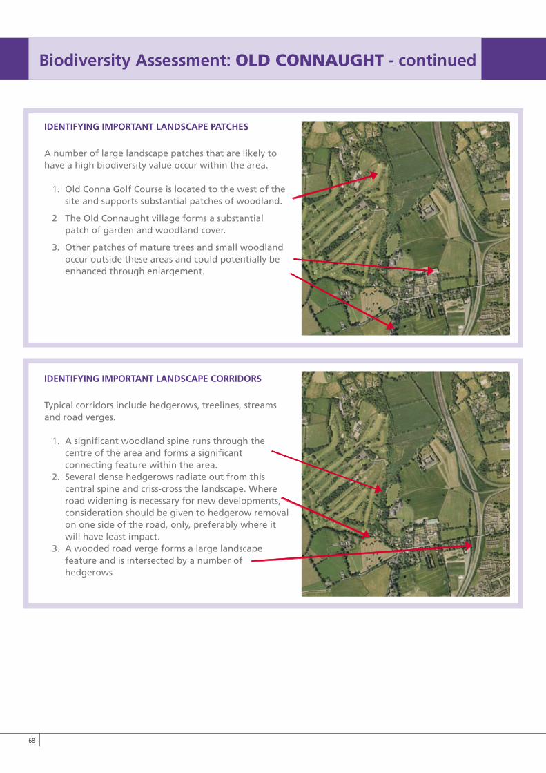
IDENTIFyING IMPORTANT LANDSCAPE PATCHES
A number of large landscape patches that are likely to have a high biodiversity value occur within the area.
1. Old Conna Golf Course is located to the west of the site and supports substantial patches of woodland.
2 The Old Connaught village forms a substantial patch of garden and woodland cover.
3. Other patches of mature trees and small woodland occur outside these areas and could potentially be enhanced through enlargement.
IDENTIFyING IMPORTANT LANDSCAPE CORRIDORS
Typical corridors include hedgerows, treelines, streams and road verges.
1. A significant woodland spine runs through the centre of the area and forms a significant connecting feature within the area.2. Several dense hedgerows radiate out from this central spine and criss-cross the landscape. Where road widening is necessary for new developments, consideration should be given to hedgerow removal on one side of the road, only, preferably where it will have least impact. 3. A wooded road verge forms a large landscape feature and is intersected by a number of hedgerows
�8
Biodiversity Assessment: OLDCONNAUGhT - continued
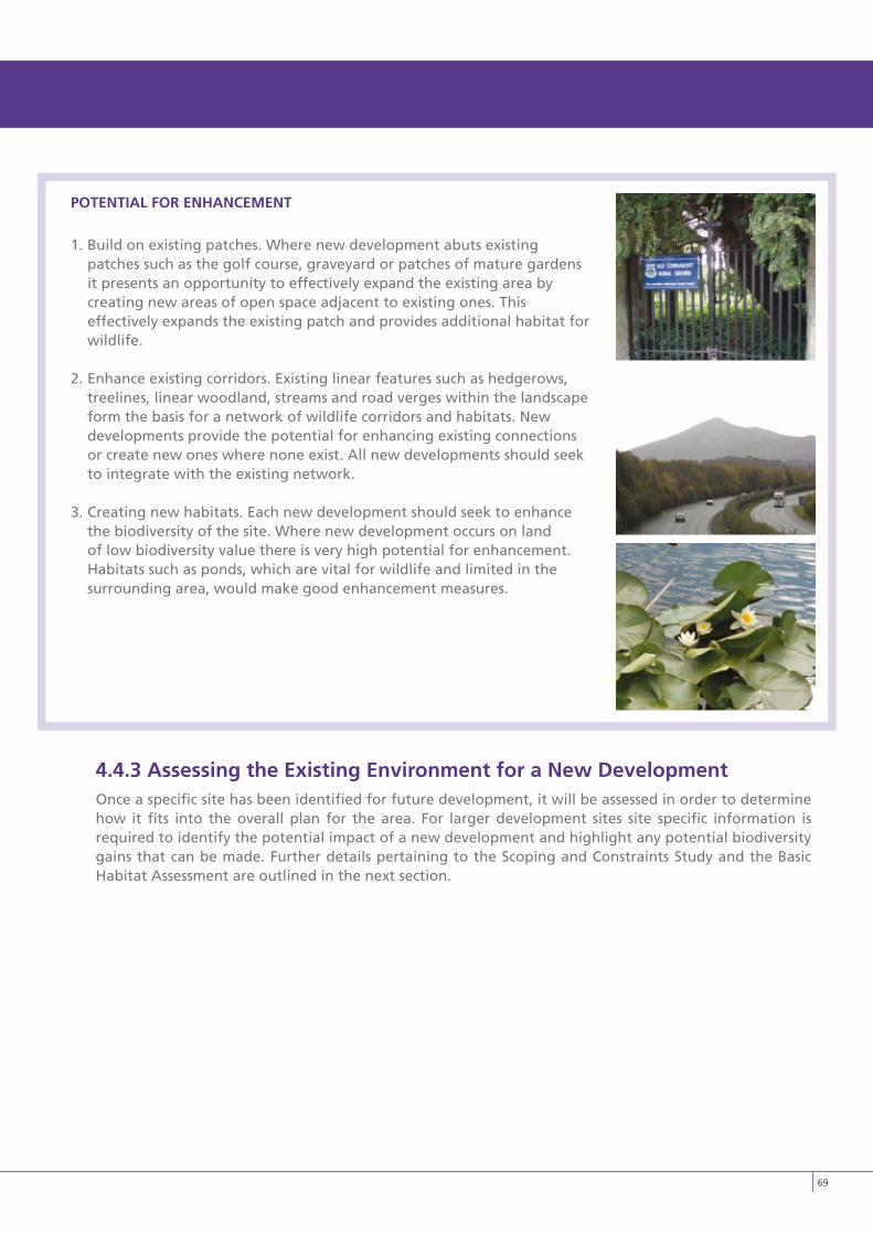
�9
POTENTIAL FOR ENHANCEMENT
1. Build on existing patches. Where new development abuts existing patches such as the golf course, graveyard or patches of mature gardens it presents an opportunity to effectively expand the existing area by creating new areas of open space adjacent to existing ones. This effectively expands the existing patch and provides additional habitat for wildlife.
2. Enhance existing corridors. Existing linear features such as hedgerows, treelines, linear woodland, streams and road verges within the landscape form the basis for a network of wildlife corridors and habitats. New developments provide the potential for enhancing existing connections or create new ones where none exist. All new developments should seek to integrate with the existing network.
3. Creating new habitats. Each new development should seek to enhance the biodiversity of the site. Where new development occurs on land of low biodiversity value there is very high potential for enhancement. Habitats such as ponds, which are vital for wildlife and limited in the surrounding area, would make good enhancement measures.
4.4.3 Assessing the Existing Environment for a New DevelopmentOnce a specific site has been identified for future development, it will be assessed in order to determine how it fits into the overall plan for the area. For larger development sites site specific information is required to identify the potential impact of a new development and highlight any potential biodiversity gains that can be made. Further details pertaining to the Scoping and Constraints Study and the Basic Habitat Assessment are outlined in the next section.
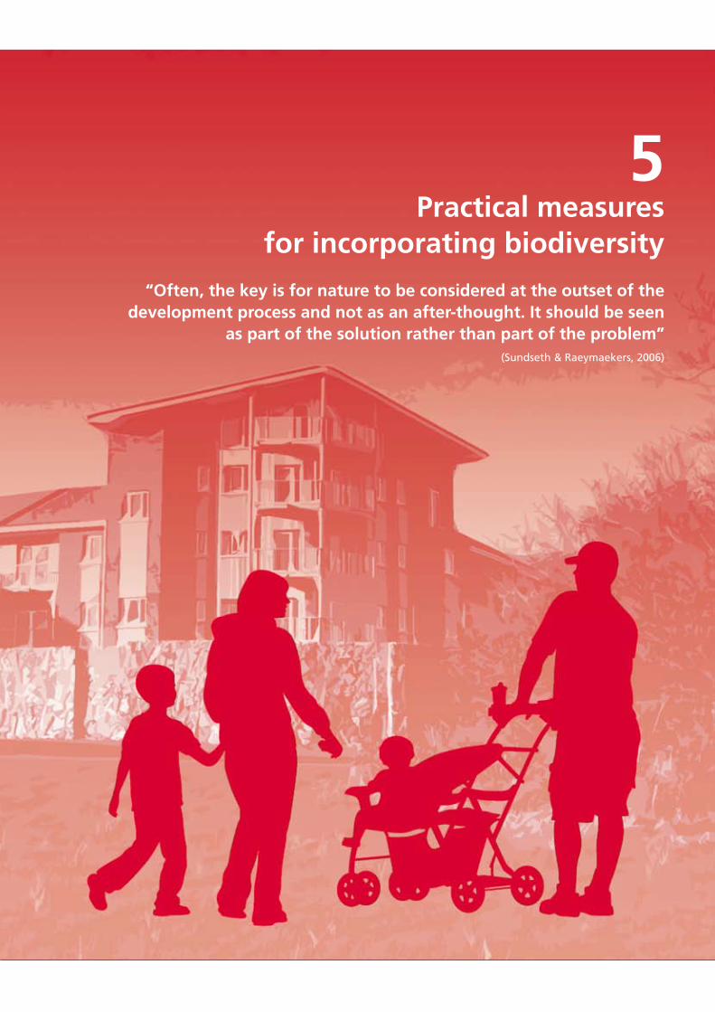
5Practical measures
for incorporating biodiversity
“Often, the key is for nature to be considered at the outset of the development process and not as an after-thought. It should be seen
as part of the solution rather than part of the problem” (Sundseth & Raeymaekers, 2006)
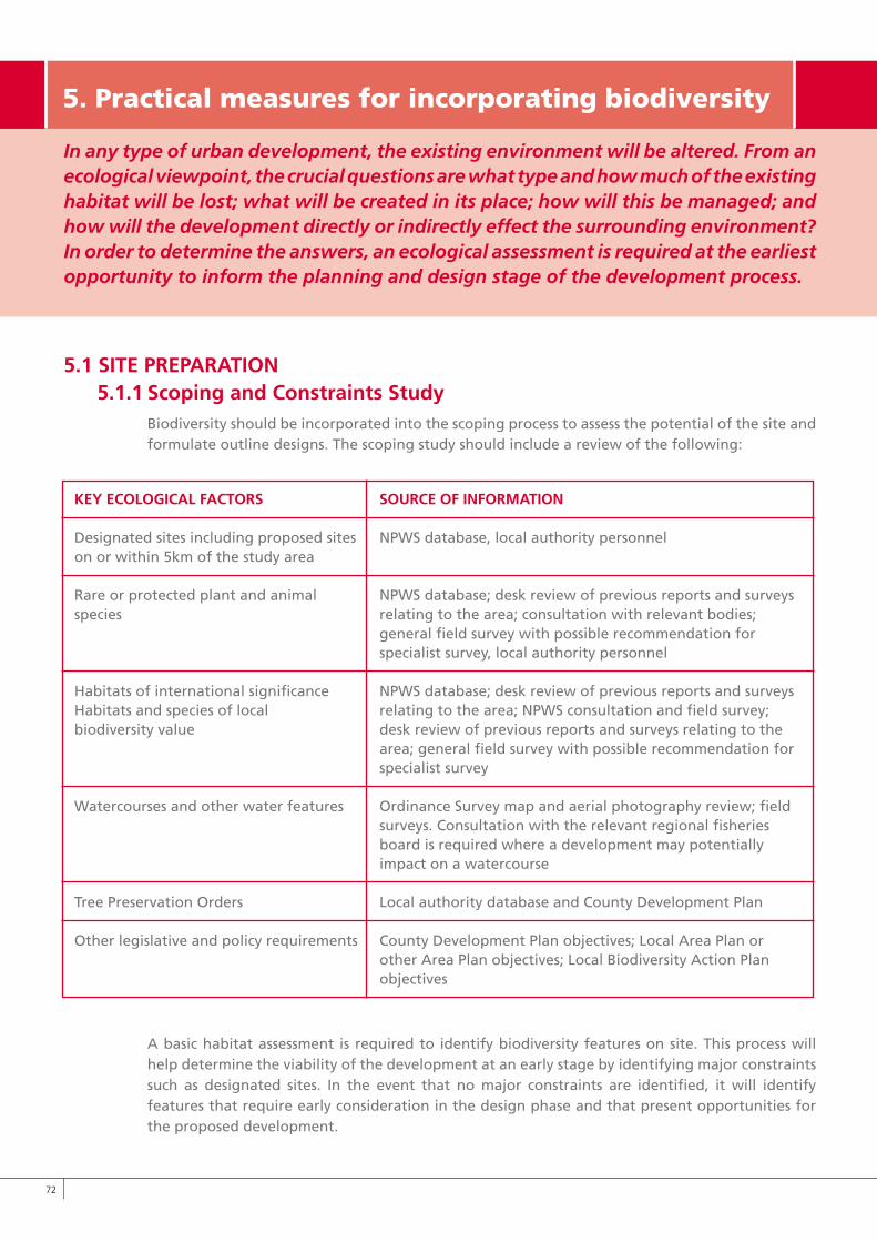
��
In any type of urban development, the existing environment will be altered. From an ecological viewpoint, the crucial questions are what type and how much of the existing habitat will be lost; what will be created in its place; how will this be managed; and how will the development directly or indirectly effect the surrounding environment? In order to determine the answers, an ecological assessment is required at the earliest opportunity to inform the planning and design stage of the development process.
5.1 SITE PREPARATION5.1.1 Scoping and Constraints Study
Biodiversity should be incorporated into the scoping process to assess the potential of the site and formulate outline designs. The scoping study should include a review of the following:
A basic habitat assessment is required to identify biodiversity features on site. This process will help determine the viability of the development at an early stage by identifying major constraints such as designated sites. In the event that no major constraints are identified, it will identify features that require early consideration in the design phase and that present opportunities for the proposed development.
5.Practicalmeasuresforincorporatingbiodiversity
kEy ECOLOGICAL FACTORS SOURCE OF INFORMATION
Designated sites including proposed sites NPWS database, local authority personnelon or within 5km of the study area Rare or protected plant and animal NPWS database; desk review of previous reports and surveysspecies relating to the area; consultation with relevant bodies; general field survey with possible recommendation for specialist survey, local authority personnel
Habitats of international significance NPWS database; desk review of previous reports and surveys Habitats and species of local relating to the area; NPWS consultation and field survey; biodiversity value desk review of previous reports and surveys relating to the area; general field survey with possible recommendation for specialist survey
Watercourses and other water features Ordinance Survey map and aerial photography review; field surveys. Consultation with the relevant regional fisheries board is required where a development may potentially impact on a watercourse
Tree Preservation Orders Local authority database and County Development Plan
Other legislative and policy requirements County Development Plan objectives; Local Area Plan or other Area Plan objectives; Local Biodiversity Action Plan objectives
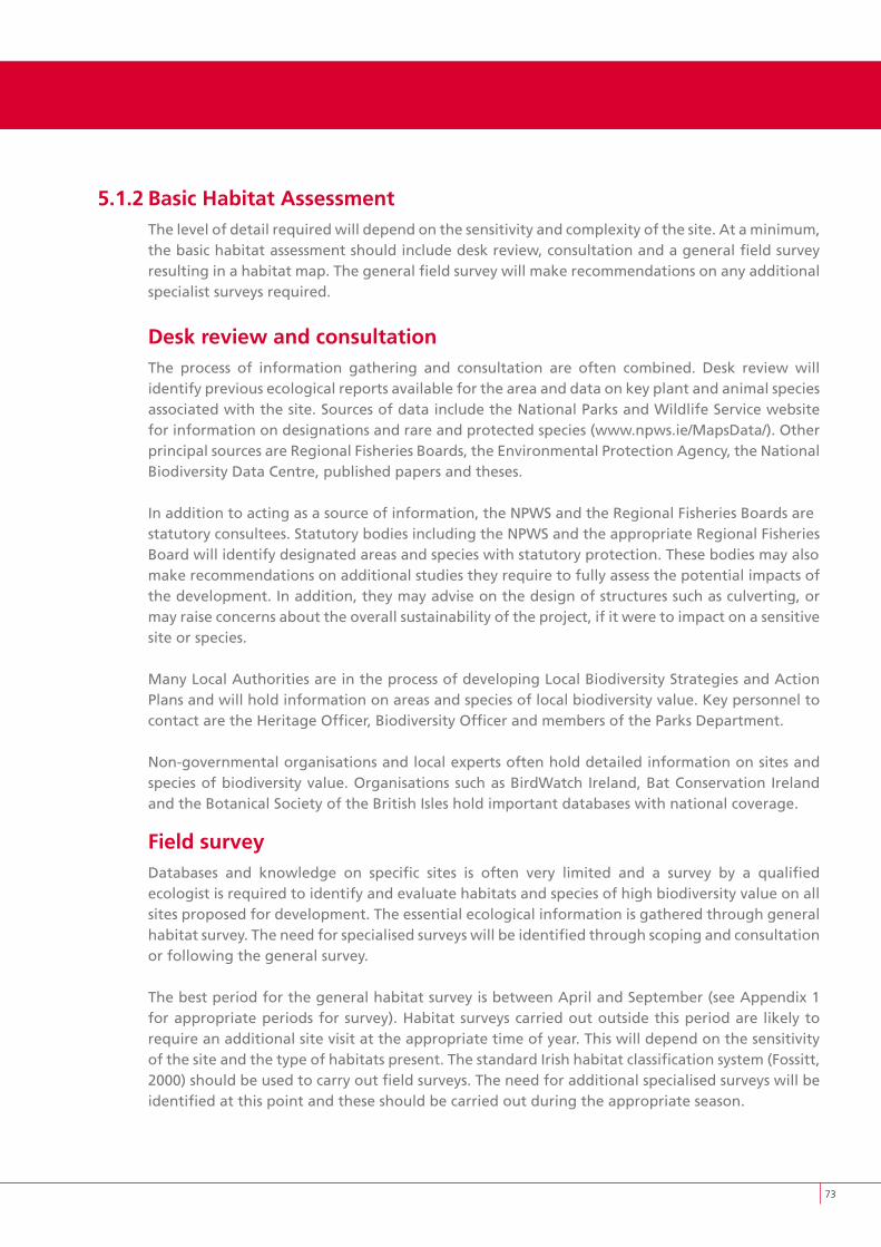
��
5.1.2 Basic Habitat AssessmentThe level of detail required will depend on the sensitivity and complexity of the site. At a minimum, the basic habitat assessment should include desk review, consultation and a general field survey resulting in a habitat map. The general field survey will make recommendations on any additional specialist surveys required.
Desk review and consultationThe process of information gathering and consultation are often combined. Desk review will identify previous ecological reports available for the area and data on key plant and animal species associated with the site. Sources of data include the National Parks and Wildlife Service website for information on designations and rare and protected species (www.npws.ie/MapsData/). Other principal sources are Regional Fisheries Boards, the Environmental Protection Agency, the National Biodiversity Data Centre, published papers and theses.
In addition to acting as a source of information, the NPWS and the Regional Fisheries Boards arestatutory consultees. Statutory bodies including the NPWS and the appropriate Regional FisheriesBoard will identify designated areas and species with statutory protection. These bodies may alsomake recommendations on additional studies they require to fully assess the potential impacts of the development. In addition, they may advise on the design of structures such as culverting, or may raise concerns about the overall sustainability of the project, if it were to impact on a sensitive site or species.
Many Local Authorities are in the process of developing Local Biodiversity Strategies and Action Plans and will hold information on areas and species of local biodiversity value. Key personnel to contact are the Heritage Officer, Biodiversity Officer and members of the Parks Department.
Non-governmental organisations and local experts often hold detailed information on sites and species of biodiversity value. Organisations such as BirdWatch Ireland, Bat Conservation Ireland and the Botanical Society of the British Isles hold important databases with national coverage.
Field surveyDatabases and knowledge on specific sites is often very limited and a survey by a qualified ecologist is required to identify and evaluate habitats and species of high biodiversity value on all sites proposed for development. The essential ecological information is gathered through general habitat survey. The need for specialised surveys will be identified through scoping and consultation or following the general survey.
The best period for the general habitat survey is between April and September (see Appendix 1 for appropriate periods for survey). Habitat surveys carried out outside this period are likely to require an additional site visit at the appropriate time of year. This will depend on the sensitivity of the site and the type of habitats present. The standard Irish habitat classification system (Fossitt, 2000) should be used to carry out field surveys. The need for additional specialised surveys will be identified at this point and these should be carried out during the appropriate season.
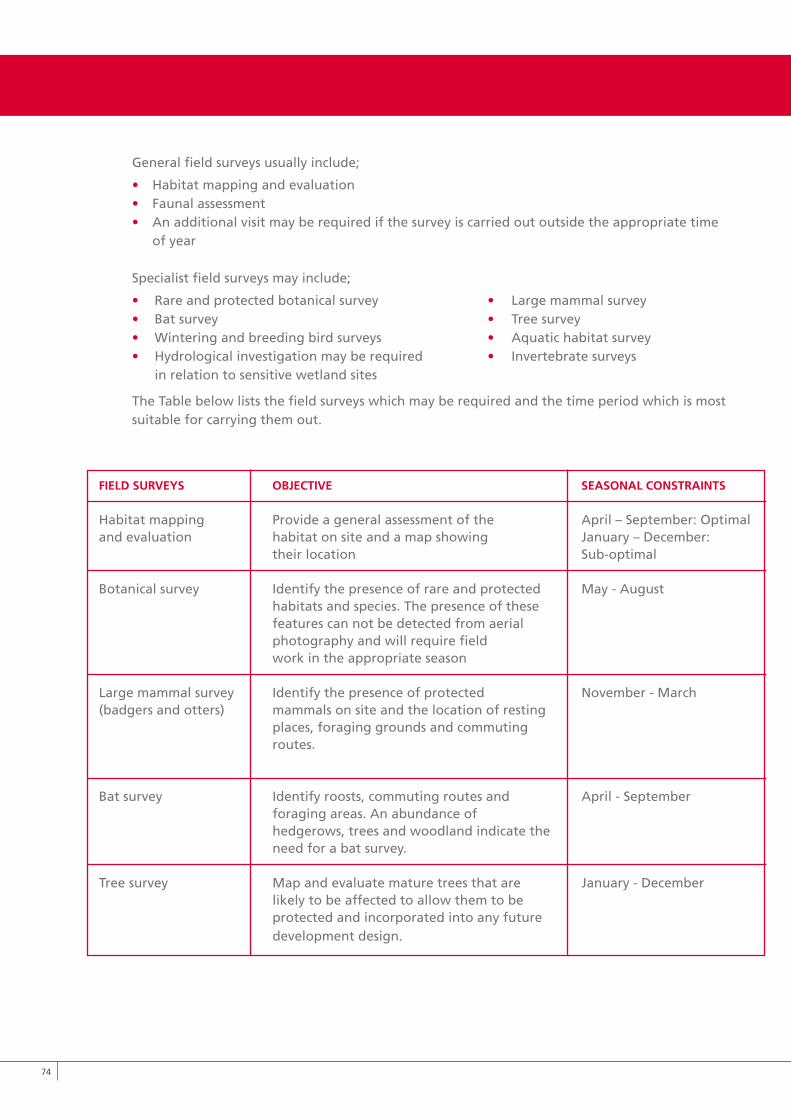
General field surveys usually include;
• Habitat mapping and evaluation • Faunal assessment• An additional visit may be required if the survey is carried out outside the appropriate time of year
Specialist field surveys may include;
• Rare and protected botanical survey • Large mammal survey• Bat survey • Tree survey• Wintering and breeding bird surveys • Aquatic habitat survey• Hydrological investigation may be required • Invertebrate surveys in relation to sensitive wetland sites
The Table below lists the field surveys which may be required and the time period which is most suitable for carrying them out.
��
FIELD SURvEyS OBJECTIvE SEASONAL CONSTRAINTS
Habitat mapping Provide a general assessment of the April – September: Optimaland evaluation habitat on site and a map showing January – December: their location Sub-optimal
Botanical survey Identify the presence of rare and protected May - August habitats and species. The presence of these features can not be detected from aerial photography and will require field work in the appropriate season
Large mammal survey Identify the presence of protected November - March(badgers and otters) mammals on site and the location of resting places, foraging grounds and commuting routes.
Bat survey Identify roosts, commuting routes and April - September foraging areas. An abundance of hedgerows, trees and woodland indicate the need for a bat survey.
Tree survey Map and evaluate mature trees that are January - December likely to be affected to allow them to be protected and incorporated into any future development design.
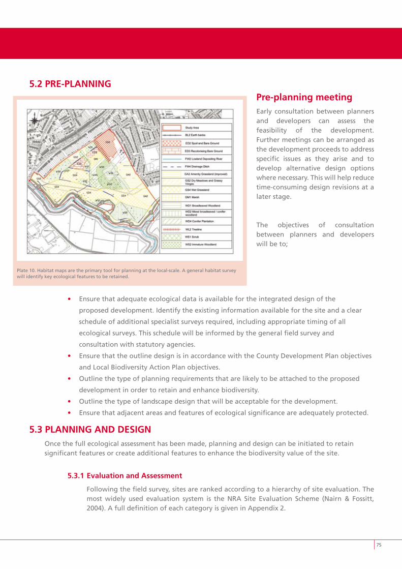
5.2 PRE-PLANNINGPre-planning meetingEarly consultation between planners and developers can assess the feasibility of the development. Further meetings can be arranged as the development proceeds to address specific issues as they arise and to develop alternative design options where necessary. This will help reduce time-consuming design revisions at a later stage.
The objectives of consultation between planners and developers will be to;
• Ensure that adequate ecological data is available for the integrated design of the
proposed development. Identify the existing information available for the site and a clear
schedule of additional specialist surveys required, including appropriate timing of all
ecological surveys. This schedule will be informed by the general field survey and
consultation with statutory agencies.
• Ensure that the outline design is in accordance with the County Development Plan objectives
and Local Biodiversity Action Plan objectives.
• Outline the type of planning requirements that are likely to be attached to the proposed
development in order to retain and enhance biodiversity.
• Outline the type of landscape design that will be acceptable for the development.
• Ensure that adjacent areas and features of ecological significance are adequately protected.
5.3 PLANNING AND DESIGNOnce the full ecological assessment has been made, planning and design can be initiated to retainsignificant features or create additional features to enhance the biodiversity value of the site.
5.3.1 Evaluation and Assessment
Following the field survey, sites are ranked according to a hierarchy of site evaluation. The most widely used evaluation system is the NRA Site Evaluation Scheme (Nairn & Fossitt, 2004). A full definition of each category is given in Appendix 2.
Plate 10. Habitat maps are the primary tool for planning at the local-scale. A general habitat survey will identify key ecological features to be retained.
��
��
Sites are generally categorised as one of the following:• Internationally important
• Nationally important
• High value, locally important
• Moderate value, locally important
• Low value, locally important
Internationally important sites are of highest conservation importance. They contain habitats or species that are protected under the EU Habitats or Birds Directives, designated as SACs or SPAs. They may also include undesignated sites containing good examples of Annex I priority habitats under the EU Habitats Directive. Major salmon river fisheries or major salmonid lake fisheries are also included in this category.
Nationally important sites include sites or waters that are designated or proposed as NHAs or statutory Nature Reserves. Also included are undesignated sites containing good examples of habitats and species protected under EU Habitats and Birds Directives. Important fisheries waters with major trout or amenity fishery value or important commercially coarse fisheries are included here. The Wildlife (Amendment) Act 2000 provides a statutory basis for these NHAs from the time of formal designation. Until that time, proposed NHAs are listed under, and receive protection from, the relevant County Development Plan.
High value, locally important consists of sites supporting semi-natural habitat types with a high degree of naturalness, or significant populations of locally rare species. Small water bodies with known salmonid populations or with good potential salmonid habitat are also included along with sites containing any listed Annex II species under the EU Habitats Directive or Annex I species under the EU Birds Directive. Large water bodies with some coarse fisheries value should also be considered of high local value. These areas are important areas of local biodiversity but are often unrecorded within the wider landscape. Local Biodiversity Action Plans will seek to identify these areas through habitat mapping and other initiatives. Local Area Plans and other strategic planning tools will identify these areas and seek to protect them within the planning process. However, many areas are only first recorded when a preliminary site survey is carried out.
Moderate value, locally important includes sites containing some semi-natural habitat or locally important for wildlife, may also include small water bodies with some coarse fisheries value, some potential salmonid habitat or any stream with an unpolluted Q-value rating. These areas may be noted in LBAPs or LAPs but are more likely to be first recorded in the site survey.
Low value, locally important refers to artificial or highly modified habitats with low species diversity and low wildlife value. Water bodies with no current fisheries value and no significant potential fisheries value are also included. These are generally not significant from a biodiversity view point and are more suitable for habitat creation and development.
The EU Habitats Directive and the EU Birds Directive identify habitats and species of European Community importance (In the Habitats Directive, habitat types are listed in Annex I. Priority habitats are specially protected habitats of which Ireland has 16. Species are listed in Annex
��
II and IV of the Directive. These are commonly referred to as Annex I habitats or Annex II species or Annex IV species. The EU Birds Directive lists species in Annex I of the Directive). SACs and SPAs are designated for the preservation of these habitats and species, although many still occur outside these designated areas. The European network of designated SPAs and SACs is known as Natura 2000. Natura 2000 sites are protected by law to ensure that they are preserved. Only in exceptional circumstances, “imperative reasons of overriding public interest” or where there is no alternative to the plan or project and where it can be shown that it must be carried out, will development be permitted. Where a designated site supports a priority species or habitat, these reasons can only be for human health or public safety. For designated sites that do not hold a priority species or habitat, the reasons can also include social or economic reasons.
Article 6 of the Habitats Directive requires “an appropriate assessment” of any plans or projects that are likely to have a significant effect on a designated site. The onus is on the developer to ensure that all the necessary steps were taken to avoid deterioration to the site or its qualifying interests. The type of appropriate assessment required should be decided in consultation with NPWS.
Certain activities are restricted within SACs, SPAs and NHAs. These are known as notifiable actions and can only be carried out with the permission of the Minister for the Environment, Heritage and Local Government.
Designated sites are a representative sample of Ireland’s most valuable habitats. However, they account for only a very small proportion of land. Substantial areas of high biodiversity value are found outside the existing network of designated sites. One of the main goals of the Local Biodiversity Action Plan is to identify and protect areas of high local value. Extensive mapping projects that tackle countywide areas require significant resources and time to complete. In the mean time, Local Area Plans and individual site assessments can identify these areas and earmark them for protection.
One of the key purposes of an ecological assessment or an EIS is to evaluate the site in terms of its international, national and local value. It will also identify the key features that should be protected in order to safeguard the ecological integrity of the site. These are the features that should be protected retained or enhanced as appropriate.
• Housing developments which directly or indirectly harm the integrity of an internationally important site, or which conflict with the conservation objectives for that site, should not be permitted
• Habitats and species identified as having high local value should be protected, retained, and incorporated within the overall development
• Where feasible, habitats and species identified as having moderate local value should be protected, retained, and incorporated within the overall development with a view to enhancing their overall value. Where retention is not feasible, they should be compensated for by replacing the same quantity and quality of habitat through habitat creation and appropriate management
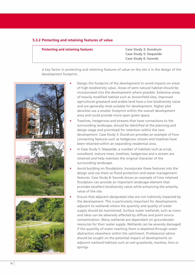
�8
5.3.2 Protecting and retaining features of value
Protecting and retaining features Case Study 3: Dundrum Case Study 5: Stepaside Case Study 6: Swords
A key factor in protecting and retaining features of value on the site is in the design of the development footprint.
• Design the footprint of the development to avoid impacts on areas of high biodiversity value. Areas of semi-natural habitat should be incorporated into the development where possible. Extensive areas of heavily modified habitat such as brownfield sites, improved agricultural grassland and arable land have a low biodiversity value and are generally most suitable for development. Higher plot densities use a smaller footprint within the overall development area and could provide more open green space.
• Treelines, hedgerows and streams that have connections to the surrounding landscape, should be identified at the planning and design stage and prioritised for retention within the new development. Case Study 3: Dundrum provides an example of how connecting features such as hedgerow, stream and treelines have been retained within an expanding residential area.
• In Case Study 5: Stepaside, a number of habitats such as scrub, woodland, mature trees, treelines, hedgerows and a stream are retained and help maintain the original character of the surrounding landscape.
• Avoid building on floodplains. Incorporate these features into the design and use them as flood protection and water management features. Case Study 8: Swords shows an example of how retained floodplain can provide an important landscape element that provides excellent biodiversity value while enhancing the amenity value of the site.
• Ensure that adjacent designated sites are not indirectly impacted by the development. This is particularly important for developments adjacent to wetlands where the quantity and quality of water supply should be maintained. Surface water wetlands, such as rivers and lakes can be adversely affected by diffuse and point source contamination. Many wetlands are dependant on groundwater resources for their water supply. Wetlands can be severely damaged if the quantity of water reaching them is depleted through water abstraction elsewhere within the catchment. Professional advice should be sought on the potential impact of developments on adjacent wetland habitats such as wet grasslands, marshes, fens or springs.
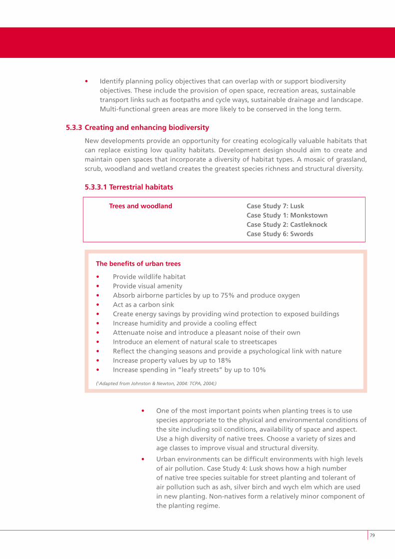
�9
• Identify planning policy objectives that can overlap with or support biodiversity objectives. These include the provision of open space, recreation areas, sustainable transport links such as footpaths and cycle ways, sustainable drainage and landscape. Multi-functional green areas are more likely to be conserved in the long term.
5.3.3 Creating and enhancing biodiversity
New developments provide an opportunity for creating ecologically valuable habitats that can replace existing low quality habitats. Development design should aim to create and maintain open spaces that incorporate a diversity of habitat types. A mosaic of grassland, scrub, woodland and wetland creates the greatest species richness and structural diversity.
5.3.3.1 Terrestrial habitats
Trees and woodland Case Study 7: Lusk Case Study 1: Monkstown Case Study 2: Castleknock Case Study 6: Swords
The benefits of urban trees
• Provide wildlife habitat• Provide visual amenity• Absorb airborne particles by up to 75% and produce oxygen• Act as a carbon sink• Create energy savings by providing wind protection to exposed buildings• Increase humidity and provide a cooling effect• Attenuate noise and introduce a pleasant noise of their own• Introduce an element of natural scale to streetscapes• Reflect the changing seasons and provide a psychological link with nature• Increase property values by up to 18%• Increase spending in “leafy streets” by up to 10%
(1Adapted from Johnston & Newton, 2004: TCPA, 2004;)
• One of the most important points when planting trees is to use species appropriate to the physical and environmental conditions of the site including soil conditions, availability of space and aspect. Use a high diversity of native trees. Choose a variety of sizes and age classes to improve visual and structural diversity.
• Urban environments can be difficult environments with high levels of air pollution. Case Study 4: Lusk shows how a high number of native tree species suitable for street planting and tolerant of air pollution such as ash, silver birch and wych elm which are used in new planting. Non-natives form a relatively minor component of the planting regime.
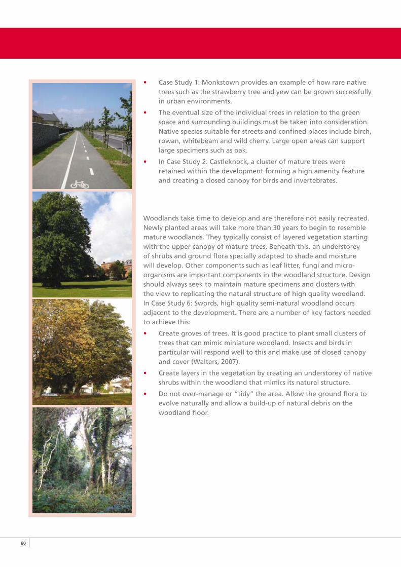
80
• Case Study 1: Monkstown provides an example of how rare native trees such as the strawberry tree and yew can be grown successfully in urban environments.
• The eventual size of the individual trees in relation to the green space and surrounding buildings must be taken into consideration. Native species suitable for streets and confined places include birch, rowan, whitebeam and wild cherry. Large open areas can support large specimens such as oak.
• In Case Study 2: Castleknock, a cluster of mature trees were retained within the development forming a high amenity feature and creating a closed canopy for birds and invertebrates.
Woodlands take time to develop and are therefore not easily recreated. Newly planted areas will take more than 30 years to begin to resemble mature woodlands. They typically consist of layered vegetation starting with the upper canopy of mature trees. Beneath this, an understorey of shrubs and ground flora specially adapted to shade and moisture will develop. Other components such as leaf litter, fungi and micro-organisms are important components in the woodland structure. Design should always seek to maintain mature specimens and clusters with the view to replicating the natural structure of high quality woodland. In Case Study 6: Swords, high quality semi-natural woodland occurs adjacent to the development. There are a number of key factors needed to achieve this:
• Create groves of trees. It is good practice to plant small clusters of trees that can mimic miniature woodland. Insects and birds in particular will respond well to this and make use of closed canopy and cover (Walters, 2007).
• Create layers in the vegetation by creating an understorey of native shrubs within the woodland that mimics its natural structure.
• Do not over-manage or “tidy” the area. Allow the ground flora to evolve naturally and allow a build-up of natural debris on the woodland floor.
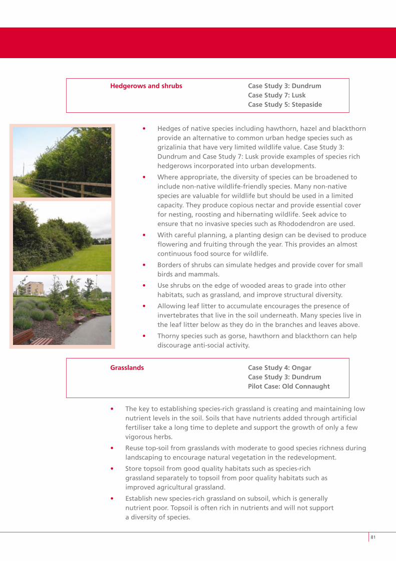
81
Hedgerows and shrubs Case Study 3: Dundrum Case Study 7: Lusk Case Study 5: Stepaside
• Hedges of native species including hawthorn, hazel and blackthorn provide an alternative to common urban hedge species such as grizalinia that have very limited wildlife value. Case Study 3: Dundrum and Case Study 7: Lusk provide examples of species rich hedgerows incorporated into urban developments.
• Where appropriate, the diversity of species can be broadened to include non-native wildlife-friendly species. Many non-native species are valuable for wildlife but should be used in a limited capacity. They produce copious nectar and provide essential cover for nesting, roosting and hibernating wildlife. Seek advice to ensure that no invasive species such as Rhododendron are used.
• With careful planning, a planting design can be devised to produce flowering and fruiting through the year. This provides an almost continuous food source for wildlife.
• Borders of shrubs can simulate hedges and provide cover for small birds and mammals.
• Use shrubs on the edge of wooded areas to grade into other habitats, such as grassland, and improve structural diversity.
• Allowing leaf litter to accumulate encourages the presence of invertebrates that live in the soil underneath. Many species live in the leaf litter below as they do in the branches and leaves above.
• Thorny species such as gorse, hawthorn and blackthorn can help discourage anti-social activity.
Grasslands Case Study 4: Ongar Case Study 3: Dundrum Pilot Case: Old Connaught
• The key to establishing species-rich grassland is creating and maintaining low nutrient levels in the soil. Soils that have nutrients added through artificial fertiliser take a long time to deplete and support the growth of only a few vigorous herbs.
• Reuse top-soil from grasslands with moderate to good species richness during landscaping to encourage natural vegetation in the redevelopment.
• Store topsoil from good quality habitats such as species-rich grassland separately to topsoil from poor quality habitats such as improved agricultural grassland.
• Establish new species-rich grassland on subsoil, which is generally nutrient poor. Topsoil is often rich in nutrients and will not support a diversity of species.
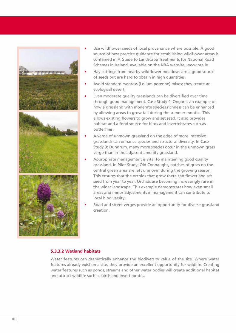
8�
• Use wildflower seeds of local provenance where possible. A good source of best practice guidance for establishing wildflower areas is contained in A Guide to Landscape Treatments for National Road Schemes in Ireland, available on the NRA website, www.nra.ie.
• Hay cuttings from nearby wildflower meadows are a good source of seeds but are hard to obtain in high quantities.
• Avoid standard ryegrass (Lolium perenne) mixes; they create an ecological desert.
• Even moderate quality grasslands can be diversified over time through good management. Case Study 4: Ongar is an example of how a grassland with moderate species richness can be enhanced by allowing areas to grow tall during the summer months. This allows existing flowers to grow and set seed. It also provides habitat and a food source for birds and invertebrates such as butterflies.
• A verge of unmown grassland on the edge of more intensive grasslands can enhance species and structural diversity. In Case Study 3: Dundrum, many more species occur in the unmown grass verge than in the adjacent amenity grassland.
• Appropriate management is vital to maintaining good quality grassland. In Pilot Study: Old Connaught, patches of grass on the central green area are left unmown during the growing season. This ensures that the orchids that grow there can flower and set seed from year to year. Orchids are becoming increasingly rare in the wider landscape. This example demonstrates how even small areas and minor adjustments in management can contribute to local biodiversity.
• Road and street verges provide an opportunity for diverse grassland creation.
5.3.3.2 Wetland habitats
Water features can dramatically enhance the biodiversity value of the site. Where water features already exist on a site, they provide an excellent opportunity for wildlife. Creating water features such as ponds, streams and other water bodies will create additional habitat and attract wildlife such as birds and invertebrates.
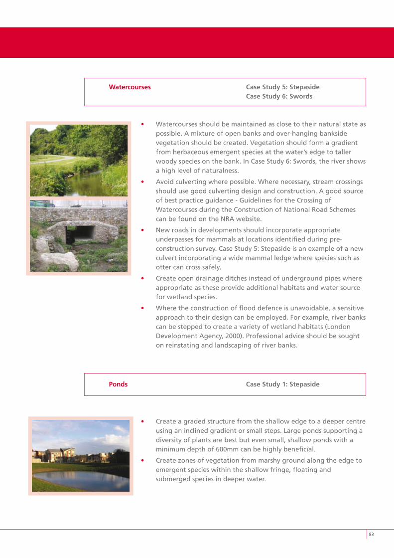
8�
Watercourses Case Study 5: Stepaside Case Study 6: Swords
• Watercourses should be maintained as close to their natural state as possible. A mixture of open banks and over-hanging bankside vegetation should be created. Vegetation should form a gradient from herbaceous emergent species at the water’s edge to taller woody species on the bank. In Case Study 6: Swords, the river shows a high level of naturalness.
• Avoid culverting where possible. Where necessary, stream crossings should use good culverting design and construction. A good source of best practice guidance - Guidelines for the Crossing of Watercourses during the Construction of National Road Schemes can be found on the NRA website.
• New roads in developments should incorporate appropriate underpasses for mammals at locations identified during pre- construction survey. Case Study 5: Stepaside is an example of a new culvert incorporating a wide mammal ledge where species such as otter can cross safely.
• Create open drainage ditches instead of underground pipes where appropriate as these provide additional habitats and water source for wetland species.
• Where the construction of flood defence is unavoidable, a sensitive approach to their design can be employed. For example, river banks can be stepped to create a variety of wetland habitats (London Development Agency, 2000). Professional advice should be sought on reinstating and landscaping of river banks.
Ponds Case Study 1: Stepaside
• Create a graded structure from the shallow edge to a deeper centre using an inclined gradient or small steps. Large ponds supporting a diversity of plants are best but even small, shallow ponds with a minimum depth of 600mm can be highly beneficial.
• Create zones of vegetation from marshy ground along the edge to emergent species within the shallow fringe, floating and submerged species in deeper water.
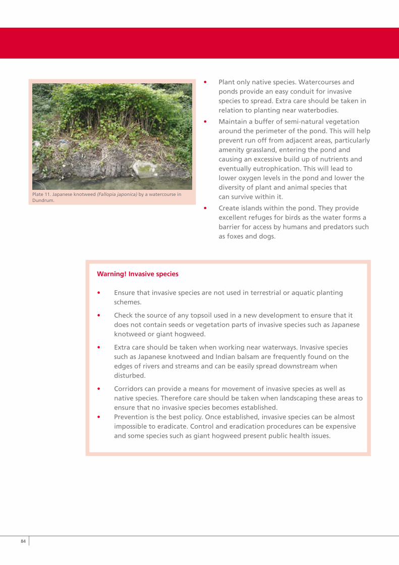
8�
• Plant only native species. Watercourses and ponds provide an easy conduit for invasive species to spread. Extra care should be taken in relation to planting near waterbodies.
• Maintain a buffer of semi-natural vegetation around the perimeter of the pond. This will help prevent run off from adjacent areas, particularly amenity grassland, entering the pond and causing an excessive build up of nutrients and eventually eutrophication. This will lead to lower oxygen levels in the pond and lower the diversity of plant and animal species that can survive within it.
• Create islands within the pond. They provide excellent refuges for birds as the water forms a barrier for access by humans and predators such as foxes and dogs.
Warning! Invasive species
• Ensure that invasive species are not used in terrestrial or aquatic planting schemes.
• Check the source of any topsoil used in a new development to ensure that it does not contain seeds or vegetation parts of invasive species such as Japanese knotweed or giant hogweed.
• Extra care should be taken when working near waterways. Invasive species such as Japanese knotweed and Indian balsam are frequently found on the edges of rivers and streams and can be easily spread downstream when disturbed.
• Corridors can provide a means for movement of invasive species as well as native species. Therefore care should be taken when landscaping these areas to ensure that no invasive species becomes established.• Prevention is the best policy. Once established, invasive species can be almost impossible to eradicate. Control and eradication procedures can be expensive and some species such as giant hogweed present public health issues.
Plate 11. Japanese knotweed (Fallopia japonica) by a watercourse in Dundrum.
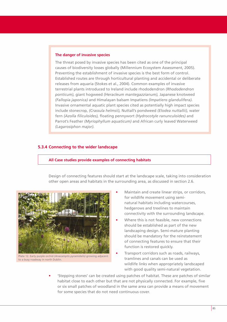
8�
The danger of invasive species
The threat posed by invasive species has been cited as one of the principal causes of biodiversity losses globally (Millennium Ecosystem Assessment, 2005). Preventing the establishment of invasive species is the best form of control. Established routes are through horticultural planting and accidental or deliberate releases from aquaria (Stokes et al., 2004). Common examples of invasive terrestrial plants introduced to Ireland include rhododendron (Rhododendron ponticum), giant hogweed (Heracleum mantegazzianum), Japanese knotweed (Fallopia japonica) and Himalayan balsam Impatiens (Impatiens glandulifera). Invasive ornamental aquatic plant species cited as potentially high impact species include stonecrop, (Crassula helmsii), Nuttall’s pondweed (Elodea nuttallii), water fern (Azolla filiculoides), floating pennywort (Hydrocotyle ranunculoides) and Parrot’s Feather (Myriophyllum aquaticum) and African curly leaved Waterweed (Lagarosiphon major).
5.3.4 Connecting to the wider landscape
All Case studies provide examples of connecting habitats
Design of connecting features should start at the landscape scale, taking into consideration other open areas and habitats in the surrounding area, as discussed in section 2.6.
• Maintain and create linear strips, or corridors, for wildlife movement using semi- natural habitats including watercourses, hedgerows and treelines to maintain connectivity with the surrounding landscape.
• Where this is not feasible, new connections should be established as part of the new landscaping design. Semi-mature planting should be mandatory for the reinstatement of connecting features to ensure that their function is restored quickly.
• Transport corridors such as roads, railways, tramlines and canals can be used as wildlife links when appropriately landscaped with good quality semi-natural vegetation.
• ‘Stepping stones’ can be created using patches of habitat. These are patches of similar habitat close to each other but that are not physically connected. For example, five or six small patches of woodland in the same area can provide a means of movement for some species that do not need continuous cover.
Plate 12. Early purple orchid (Anacamptis pyramidalis) growing adjacent to a busy roadway in north Dublin.
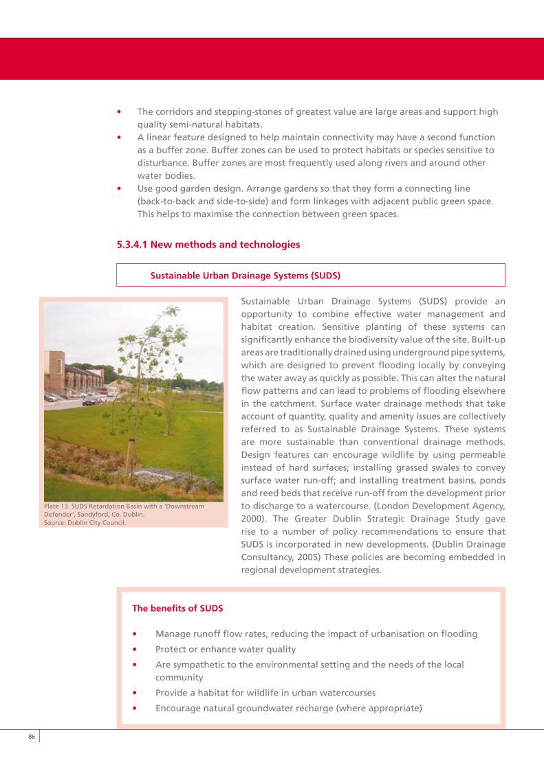
8�
• The corridors and stepping-stones of greatest value are large areas and support high quality semi-natural habitats.• A linear feature designed to help maintain connectivity may have a second function as a buffer zone. Buffer zones can be used to protect habitats or species sensitive to disturbance. Buffer zones are most frequently used along rivers and around other water bodies.• Use good garden design. Arrange gardens so that they form a connecting line (back-to-back and side-to-side) and form linkages with adjacent public green space. This helps to maximise the connection between green spaces.
5.3.4.1 New methods and technologies
Sustainable Urban Drainage Systems (SUDS)
Sustainable Urban Drainage Systems (SUDS) provide an opportunity to combine effective water management and habitat creation. Sensitive planting of these systems can significantly enhance the biodiversity value of the site. Built-up areas are traditionally drained using underground pipe systems, which are designed to prevent flooding locally by conveying the water away as quickly as possible. This can alter the natural flow patterns and can lead to problems of flooding elsewhere in the catchment. Surface water drainage methods that take account of quantity, quality and amenity issues are collectively referred to as Sustainable Drainage Systems. These systems are more sustainable than conventional drainage methods. Design features can encourage wildlife by using permeable instead of hard surfaces; installing grassed swales to convey surface water run-off; and installing treatment basins, ponds and reed beds that receive run-off from the development prior to discharge to a watercourse. (London Development Agency, 2000). The Greater Dublin Strategic Drainage Study gave rise to a number of policy recommendations to ensure that SUDS is incorporated in new developments. (Dublin Drainage Consultancy, 2005) These policies are becoming embedded in regional development strategies.
The benefits of SUDS
• Manage runoff flow rates, reducing the impact of urbanisation on flooding
• Protect or enhance water quality
• Are sympathetic to the environmental setting and the needs of the local community
• Provide a habitat for wildlife in urban watercourses
• Encourage natural groundwater recharge (where appropriate)
Plate 13. SUDS Retardation Basin with a ‘Downstream Defender’, Sandyford, Co. Dublin. Source: Dublin City Council.
8�
Buildings and hard surfaces design
Green roofs are a significant opportunity for greening buildings and are being used successfully throughout Europe. They provide many ecological benefits including the provision of wildlife habitat, reducing stormwater runoff and absorbing pollutants. Studies in Berlin have shown that on average green roofs absorb 75% of precipitation that falls on them so that immediate discharge is reduced to 25% of the normal levels (Johnston and Newton, 2004). They can also be used to off-set the footprint to the development and provide habitat for birds and invertebrates. They provide a range of other benefits including protection from ultra-violet light, thermal insulation and amenity value for residents.
High-density developments provide enormous potential for incorporating green walls. At least some of the new surface area could be used to support climbing species that provide habitat and food source for certain wildlife. In some cases, additional “false walls” can be attached to the outside of buildings. This creates a gap between the original wall and the “false wall” made from a climbing species and a support structure such as latticework. The additional gap encourages some wildlife to nest and shelter here, particularly birds and invertebrates. The most suitable plant species are those with good sources of nectar or berries. There are some technical, planting and management considerations that are discussed in Johnston & Newton (2004).The key to incorporating biodiversity into buildings and hard surface design is to maximise the potential using creative design and landscaping.
• Incorporate green roofs and green walls into the design of buildings.
• Reduce sealed surfaces and integrate alternative ground cover to allow percolation of rainwater and to reduce run-off. Throughout Europe new methods and standards are being devised to counteract the environmental impacts of high-density development and compensate for deficits in open space. A significant advancement is the development of the Biotope Area Factor (BAF) in Berlin, which provides a method for calculating the relative area of land surface with habitat potential that is being lost through urban land use. The scheme (see figure 12) can be used to evaluate and design individual developments. Its objective is to counteract the intensification of land use by maximising the ecological value of all walls, roofs and green areas within the development and minimising sealed surfaces that contribute to runoff.
• Courtyards create very specific conditions of light, moisture and temperature and should be planted accordingly. Areas that are heavily shaded by surrounding buildings will need plants such as ivy, ferns, mosses and a variety of woodland plants that are adapted to low light intensities and moist conditions.
• Bright sheltered courtyards may support species adapted to full sun and dryer soils such as calcareous grassland. The combination of a diversity of flowering plants and sheltered, sunny conditions will help attract a diversity of birds and invertebrates such as butterflies. Seating should be incorporated so that people can enjoy the surrounding nature (Johnston & Newton, 2004).
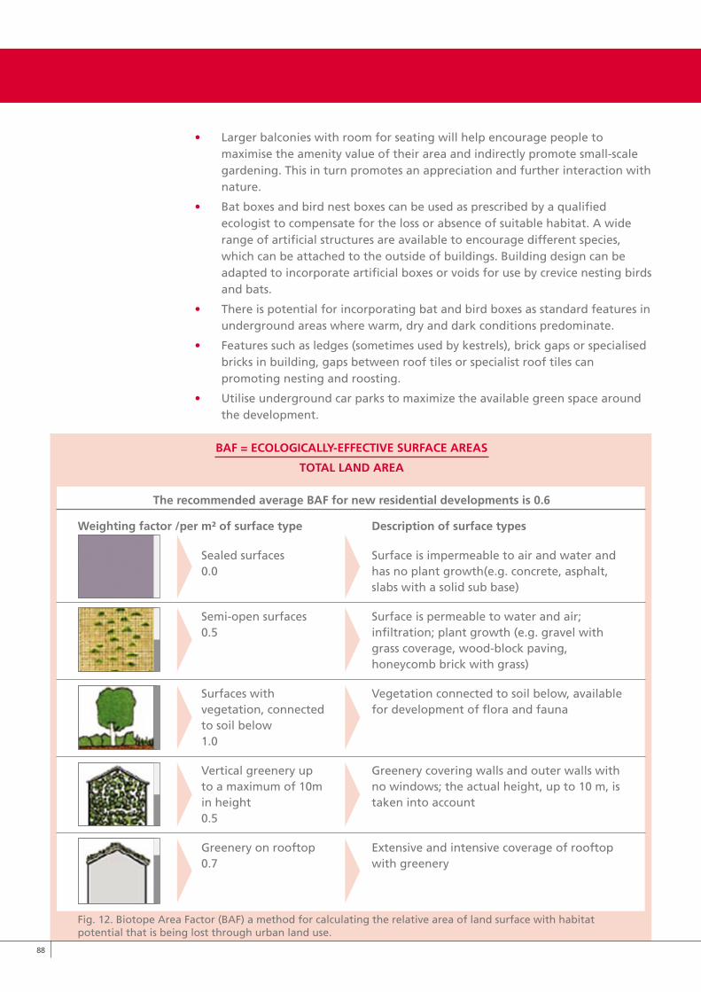
• Larger balconies with room for seating will help encourage people to maximise the amenity value of their area and indirectly promote small-scale gardening. This in turn promotes an appreciation and further interaction with nature.
• Bat boxes and bird nest boxes can be used as prescribed by a qualified ecologist to compensate for the loss or absence of suitable habitat. A wide range of artificial structures are available to encourage different species, which can be attached to the outside of buildings. Building design can be adapted to incorporate artificial boxes or voids for use by crevice nesting birds and bats.
• There is potential for incorporating bat and bird boxes as standard features in underground areas where warm, dry and dark conditions predominate.
• Features such as ledges (sometimes used by kestrels), brick gaps or specialised bricks in building, gaps between roof tiles or specialist roof tiles can promoting nesting and roosting.
• Utilise underground car parks to maximize the available green space around the development.
BAF = ECOLOGICALLy-EFFECTIvE SURFACE AREAS
TOTAL LAND AREA
The recommended average BAF for new residential developments is 0.6
Weighting factor /per m² of surface type Description of surface types
Sealed surfaces Surface is impermeable to air and water and 0.0 has no plant growth(e.g. concrete, asphalt, slabs with a solid sub base)
Semi-open surfaces Surface is permeable to water and air; 0.5 infiltration; plant growth (e.g. gravel with grass coverage, wood-block paving, honeycomb brick with grass)
Surfaces with Vegetation connected to soil below, available vegetation, connected for development of flora and fauna to soil below 1.0
Vertical greenery up Greenery covering walls and outer walls with to a maximum of 10m no windows; the actual height, up to 10 m, is in height taken into account 0.5
Greenery on rooftop Extensive and intensive coverage of rooftop 0.7 with greenery
Fig. 12. Biotope Area Factor (BAF) a method for calculating the relative area of land surface with habitat potential that is being lost through urban land use.
88
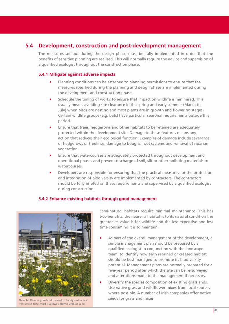
Plate 14. Diverse grassland created in Sandyford where the species-rich sward is allowed flower and set seed.
5.4 Development, construction and post-development managementThe measures set out during the design phase must be fully implemented in order that the benefits of sensitive planning are realised. This will normally require the advice and supervision of a qualified ecologist throughout the construction phase.
5.4.1 Mitigate against adverse impacts
• Planning conditions can be attached to planning permissions to ensure that the measures specified during the planning and design phase are implemented during the development and construction phase.
• Schedule the timing of works to ensure that impact on wildlife is minimised. This usually means avoiding site clearance in the spring and early summer (March to July) when birds are nesting and most plants are in growth and flowering stages. Certain wildlife groups (e.g. bats) have particular seasonal requirements outside this period.
• Ensure that trees, hedgerows and other habitats to be retained are adequately protected within the development site. Damage to these features means any action that reduces their ecological function. Examples of damage include severance of hedgerows or treelines, damage to boughs, root systems and removal of riparian vegetation.
• Ensure that watercourses are adequately protected throughout development and operational phases and prevent discharge of soil, silt or other polluting materials to watercourses.
• Developers are responsible for ensuring that the practical measures for the protection and integration of biodiversity are implemented by contractors. The contractors should be fully briefed on these requirements and supervised by a qualified ecologist during construction.
5.4.2 Enhance existing habitats through good management
Semi-natural habitats require minimal maintenance. This has two benefits: the nearer a habitat is to its natural condition the greater its value is for wildlife and the less expensive and less time consuming it is to maintain.
• As part of the overall management of the development, a simple management plan should be prepared by a qualified ecologist in conjunction with the landscape team, to identify how each retained or created habitat should be best managed to promote its biodiversity potential. Management plans are normally prepared for a five-year period after which the site can be re-surveyed and alterations made to the management if necessary.
• Diversify the species composition of existing grasslands. Use native grass and wildflower mixes from local sources where possible. A number of Irish companies offer native seeds for grassland mixes.
89
90
• Alter the mowing regime in certain areas to create structural diversity in grassland areas. Leave certain areas unmown for periods during the summer season.
• Maintain a strip of tall grass at the base of hedgerows to create habitat diversity.
• Collect grass cuttings after mowing. This will help lower the nutrient levels in the soil over time and help improve species diversity.
• Leave dead wood under trees and in other suitable places. This provides multiple habitats for invertebrates and fungi.
• Leave some standing deadwood and log piles.
• Use additional planting to diversify or connect existing habitats.
• Do not use chemicals such as herbicides, use tree tubes as an alternative to reduce the need for weeding. Avoid pesticides and fungicides.
• Contribute to positive public perception of low-intensity managed areas. Cut a
swathe of grass around/through tall grass or wildflower areas to show that the area is being managed and not abandoned.
• Use interpretive signage to show that the management is part of a local biodiversity initiative.
• Use a Show House garden to promote wildlife gardening.
5.5 Monitoring and enforcementProvision should be made for the long-term, appropriate management of habitats that have been retained or created for the purpose of biodiversity enhancement. This may require attaching planning conditions or reaching an agreement with the property management. A habitat management plan could be submitted as part of the planning submission showing medium to long-term targets (5-10 years) for the establishment and maintenance of habitats.
• Bat boxes and other features that have been employed as mitigation measures should be monitored to ensure that they are effective. If these features are found to be poorly located or badly designed, they can be moved or steps can be taken to improve their effectiveness.
• Watercourses that could potentially be affected by a development should be monitored for water quality and fisheries status. Monitoring should take into account the quality of adjacent riparian habitat and ensure that it is being maintained to maximise its potential as a buffer zone and as habitat for wildlife.
• Involve residents and people who work in the area at the earliest stage of the development. Raising awareness at the earliest stage amongst prospective tenants/residents helps the measures to succeed.
• Biodiversity considerations can be used as a prime marketing tool for the developer.
• Developers should ensure that the management company is aware of its maintenance responsibility in relation to the habitats on site. Planning conditions could be attached to ensure that these responsibilities are successfully undertaken.
• For Local Area Plans, the requirement to monitor certain indicators under the Strategic Environmental Assessment and the Appropriate Assessment mechanisms has the potential to take account of biodiversity indicators and this would link in with a number of the points on monitoring outlined above.
6/7References & Appendices
9�
Ahern, J. (2000). Greenways: A planning strategy for integration nature and culture. Journal of International Landscape Architecture. 64: 113-120.
Angold, P.G., Sadler, J.P., Hill, M.O., Pullin, A., Rushton, S., Austin, k., Small, E., Wood, B. Wadsworth, R., Sanderson, R., Thompson, k. (2006). Biodiversity in urban habitat patches. Science of the Total Environment. 360: 196-204.
Barton, H., Grant, M. & Guise, R. (2006). Shaping Neighbourhoods - a guide for health, sustainability and vitality, Spon Press, Oxon.
Barker, G. & Graf, A. (1989). Principals of nature conservation in towns and cities. Urban wildlife now, No. 3. Nature Conservancy Council, Peterborough.
BS:5837 (2005). Trees in relation to construction - Recommendations. Standards Policy and Strategy Committee, London.
Costanza, R., d’Arge, R., de Groot, R., Farber, S., Grasso, M., Hannon, B., Limburg, k., Naeem, S., O’Neill, R. v., Paruelo, J., Raskin, R. G., Sutton, P., and van der Belt, M. (1997). The value of the world’s services and natural capital. Nature. 387: 253-260.
Department of the Environment (1995). Planning Policy Guidance 2: Green Belts. Department of the Environment, London.http://www.communities.gov.uk/publications/planningandbuilding/planningpolicyguidance
Department of the Environment, Heritage and Local Government (1999). Residential density:Guidelines for Planning Authorities. Government Publications Office, Dublin. www.pleanala.ie
Department of the Environment, Heritage and Local Government (2000). Planning and Development Act, Government Publications Office, Dublin.
Department of the Environment, Heritage and Local Government (2000). Planning leaflet series. Government Publications Office, Dublin.
Department of the Environment, Heritage and Local Government (2007). Development management guidelines. Government Publications Office, Dublin.
Department of the Environment, Transport and the Regions (DETR) (2001). Strategic Gap and Green Wedge Policies in Structure Plans. www.planning.dtlr.gov.uk/sggwpsp
Department of the Environment, Heritage and Local Government (2008). Urban Design Manual: A best practice guide. Government Publications Office, Dublin.
Department of the Environment, Heritage and Local Government (2008). Sustainable Residential Development in Urban Areas – consultation draft guidelines for local authorities. Government Publications Office, Dublin.
Department for Transport (2007). Manual for Streets. Thomas Telford Publishing, London.
Dublin Drainage Consultancy 2005 Greater Dublin Strategic Drainage Study: Regional Drainage Policies – Volume 2 New Development http://195.218.114.214/gaeilge/shaping_the_city/environment/drainage_services/greater_dublin_strategic_drainage_study/new_development_policy.asp
Dún Laoghaire-Rathdown County Council (2000). Stepaside Action Area Plan.
English Partnerships (2007). Urban Design Compendium Volumes I & II. Llewelyn-Davies, London.
European Commission (2004). EU Research for Sustainable Urban Development and Land Use Sustainable Urban Environment. Office for Official Publications of the European Communities, Luxembourg.
6.References
European Union Birds Directive, (1979). Council Directive 79/209/EEC of 2 April 1979 on the conservation of wild birds.
European Union Habitats Directive, (1992). Council Directives 92/43/EEC of 21 May 1992 on the conservation of natural habitats and of wild fauna and flora.
Fingal County Council (2005). Hansfield Planning Scheme. Fingal County Council, Dublin.
Fabos, J. G. (1995). Introduction and overview: the greenway movement, uses and potentials of greenways. Landscape and urban planning. 33: 1-13.
Fossitt, J.A., (2000). A guide to habitats in Ireland. The Heritage Council, Kilkenny.
Gaston, k.J. & Spicer, J.I. (2004). Biodiversity: An introduction. Blackwell Publishing, Oxford.
Girling, S. & kellett, R. (2005). Skinny Streets and Green Neighbourhoods. Design for environment and community. Island Press, Washington.
Geddes, P. (1915). Cities in Evolution. Oxford University Press, Oxford.
Hough, M. (2004). Cities & Natural Process: a basis for sustainability. (2nd edition) Rutledge, Oxen.
Howard, E. (1902) Gardens cities of Tomorrow. MIT Press, Cambridge.
IUCN (2004) IUCN Red List of Threatened Species. IUCN, Gland.
Johnston, J. & Newton, J. (2004). Building Green. A guide to using plants on roofs, walls and pavements. Greater London Authority, London.
kaplan, S. (1995). The restorative effects of nature: towards an integrative framework. Journal of Environmental Psychology. 16: 169-182
Laurie, I.C. (1979). Nature in cities: The natural environment in the design and development of urban green space. John Wiley & Sons, London. (Error in text 1997)
Leopold, A. (1970). A Sand County Almanac. Sierra Club, San Francisco.
London Development Agency (2000). Design for biodiversity. London Development Agency, London.
Millennium Ecosystem Assessment, (2005). Ecosystems and human well-being: Biodiversity synthesis. World Resources Institute, Washington, DC.
National Urban Forestry Unit (1998). Trees matter! The benefits of trees & woods in towns. National Urban Forestry Unit, Wolverhampton.
Nairn, R. & Fossitt, J. (2004). The ecological impacts of roads, and an approach to their assessment for national roads schemes. In: J. Davenport & J.L. Davenport (eds) The effects of human transport on ecosystems: cars and planes, boats and trains, 98-114. Royal Irish Academy, Dublin.
National Roads Authority (2006). A guide to landscape treatments for national road schemes in Ireland. National Roads Authority, National Roads Authority, Dublin.
Noss, R. (1995). Maintaining ecological integrity in representative reserve networks. A WWF-Canada/WWF-US Discussion Paper. Toronto.
Nowak, D.J., Civerolo, k.L., Rao, S.T., Sistla, G., Luley, C.J., Crane, D.E. (2000). A modelling study of the impact of urban trees on ozone. Atmospheric Environment. 34: 1610-1613.
Nowak, D.J., Crane, D.E. & Stevens, J.C. (2006). Air removal by urban trees and shrubs in the United States. Urban Forestry & Urban Greening. 4: 115-123.
9�

9�
Pickett, S.T.A, Cadenasso, M.L, Grove, J.M, Nilon, C.H, Pouyat, R.v, Zipperer, W.C, Costanza, R. (2005). Urban ecological systems: Linking terrestrial ecological, physical, and socioeconomic components of metropolitan areas. Annual Review of Ecological and Systematics. 32: 127-157.
Pickett, S.TA, Cadenasso, M.L, Grove, J.M. (2004). Resilient cities: meaning, models, and metaphor for integrating the ecological, socio-economic, and planning realms. Landscape and Urban Planning. 69: 369-384.
Ratcliffe, D.A. (1977). A nature conservation review: The selection of sites of biological national importance to nature conservation in Britain. Volumes 2. Cambridge University Press, Cambridge.
Royal Institute of Architects Ireland (2000). The New Housing. Royal Institute of Architects Ireland, Dublin.
Searns, R.M. (1995). The evolution of greenways as an adaptive urban landscape form. Landscape and Urban Planning. 33: 65-80
South Dublin County Council (2004). Adamstown Planning Scheme. South Dublin County Council, Dublin.
South Dublin County Council (2007). Clonburris Draft Planning Scheme. South Dublin County Council, Dublin.
Stokes, k., O’Neill, k. & McDonald, R.A. (2004). Invasive species in Ireland. Unpublished report to Environment & Heritage Service and National Parks & Wildlife Service. Quercus, Queens University Belfast, Belfast.
Stuart, S. (1999). Species: Unprecedented extinction rate, and it’s increasing. Special Feature. IUCN, Gland.
Sundseth, k., Raeymaekers, G. (2006). Biodiversity and Natura 2000 in urban areas: Nature in cities across europe: A review of key issues and experiences. Ecosystems Limited, Brussels.
Town and Country Planning Association (TCPA) (2004). Biodiversity by design. A guide for sustainable communities. TCPA, London.
Tzoulas, k & James, P (2005). Surrogate measures for Biodiversity and human health and well-being. 5th International Postgraduate Research Conference in the Built and Human Environment, The Lowry Centre, Salford, 14th – 15th April 2005.
Tzoulas, k & James, P. (2004). Finding links between urban biodiversity and human health and wellbeing.4th International Postgraduate Research Conference in the Built and Human Environment, Salford, 29th March – 2nd April 2004.
Ulrich, R.S., Simons, R.F., Losito, B.D., Fiorito, E., Miles, M.A., and Zelson, M., (1991). Stress recovery during exposure to natural and urban environments. Journal of Environmental Psychology. 11: 201-230.
UNEP (2007). Cities and biodiversity: Engaging Local Authorities during the enhanced phases of the implementation of the Convention on Biological Diversity. Mayors’ Meeting on the Contribution of Cities to the Achievement of the 2010 Biodiversity Target Curitiba, Brazil, 26- 28 March, 2007. UNEP, Brussels.
Walters, M. (2007). Gardens for wildlife. Aura Books, Bicester.
Wildlife Act (1976). Wildlife Act, Ireland, 22 December 1976, No. 39 of 1976
Wildlife Amendment Act (2000). Wildlife Amendment Act, Ireland, 18 December 2000, No. 38 of 2000.
Wilson, Edward O. (1984). Biophilia. Harvard University Press, Cambridge, Boston.
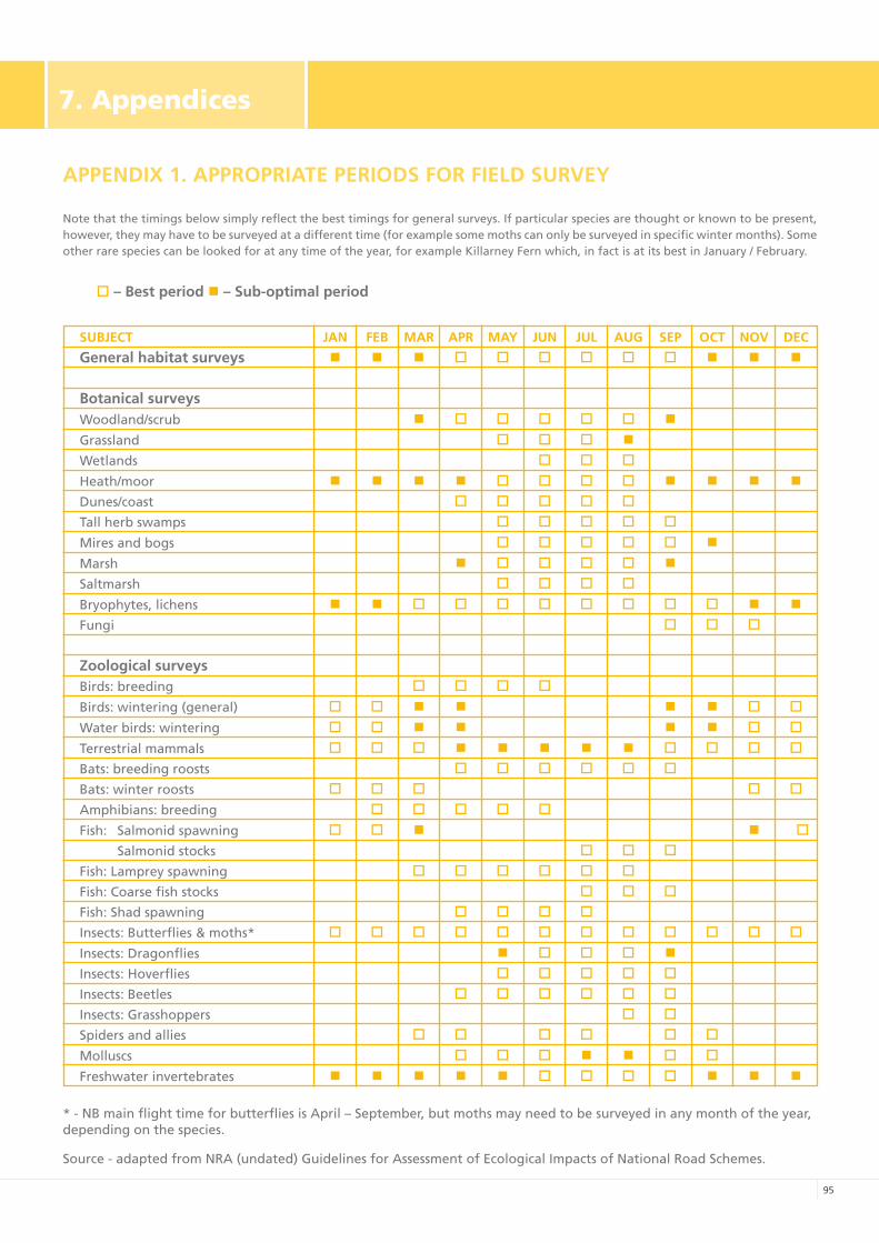
9�
7.Appendices
APPENDIX 1. APPROPRIATE PERIODS FOR FIELD SURvEy
Note that the timings below simply reflect the best timings for general surveys. If particular species are thought or known to be present, however, they may have to be surveyed at a different time (for example some moths can only be surveyed in specific winter months). Some other rare species can be looked for at any time of the year, for example Killarney Fern which, in fact is at its best in January / February.
o – Best period n – Sub-optimal period
SUBJECT JAN FEB MAR APR MAy JUN JUL AUG SEP OCT NOv DEC
General habitat surveys n n n o o o o o o n n n
Botanical surveysWoodland/scrub n o o o o o n
Grassland o o o nWetlands o o o
Heath/moor n n n n o o o o n n n nDunes/coast o o o o oTall herb swamps o o o o o
Mires and bogs o o o o o n
Marsh n o o o o nSaltmarsh o o o o
Bryophytes, lichens n n o o o o o o o o n nFungi o o o
Zoological surveysBirds: breeding o o o o
Birds: wintering (general) o o n n n n o o
Water birds: wintering o o n n n n o o
Terrestrial mammals o o o n n n n n o o o oBats: breeding roosts o o o o o oBats: winter roosts o o o o oAmphibians: breeding o o o o o
Fish: Salmonid spawning o o n n o Salmonid stocks o o oFish: Lamprey spawning o o o o o oFish: Coarse fish stocks o o oFish: Shad spawning o o o oInsects: Butterflies & moths* o o o o o o o o o o o o
Insects: Dragonflies n o o o nInsects: Hoverflies o o o o oInsects: Beetles o o o o o oInsects: Grasshoppers o oSpiders and allies o o o o o o
Molluscs o o o n n o o
Freshwater invertebrates n n n n n o o o o n n n
* - NB main flight time for butterflies is April – September, but moths may need to be surveyed in any month of the year, depending on the species.
Source - adapted from NRA (undated) Guidelines for Assessment of Ecological Impacts of National Road Schemes.
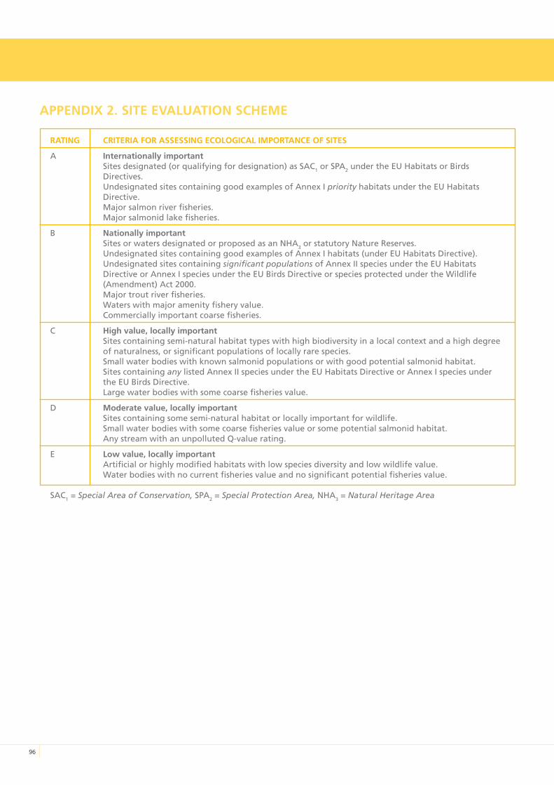
9�
APPENDIX 2. SITE EvALUATION SCHEME
RATING CRITERIA FOR ASSESSING ECOLOGICAL IMPORTANCE OF SITES
A Internationally importantSites designated (or qualifying for designation) as SAC1 or SPA2 under the EU Habitats or Birds Directives.Undesignated sites containing good examples of Annex I priority habitats under the EU Habitats Directive.Major salmon river fisheries.Major salmonid lake fisheries.
B Nationally importantSites or waters designated or proposed as an NHA3 or statutory Nature Reserves.Undesignated sites containing good examples of Annex I habitats (under EU Habitats Directive).Undesignated sites containing significant populations of Annex II species under the EU Habitats Directive or Annex I species under the EU Birds Directive or species protected under the Wildlife (Amendment) Act 2000.Major trout river fisheries.Waters with major amenity fishery value.Commercially important coarse fisheries.
C High value, locally importantSites containing semi-natural habitat types with high biodiversity in a local context and a high degree of naturalness, or significant populations of locally rare species.Small water bodies with known salmonid populations or with good potential salmonid habitat.Sites containing any listed Annex II species under the EU Habitats Directive or Annex I species under the EU Birds Directive.Large water bodies with some coarse fisheries value.
D Moderate value, locally importantSites containing some semi-natural habitat or locally important for wildlife.Small water bodies with some coarse fisheries value or some potential salmonid habitat.Any stream with an unpolluted Q-value rating.
E Low value, locally importantArtificial or highly modified habitats with low species diversity and low wildlife value.Water bodies with no current fisheries value and no significant potential fisheries value.
SAC1 = Special Area of Conservation, SPA2 = Special Protection Area, NHA3 = Natural Heritage Area
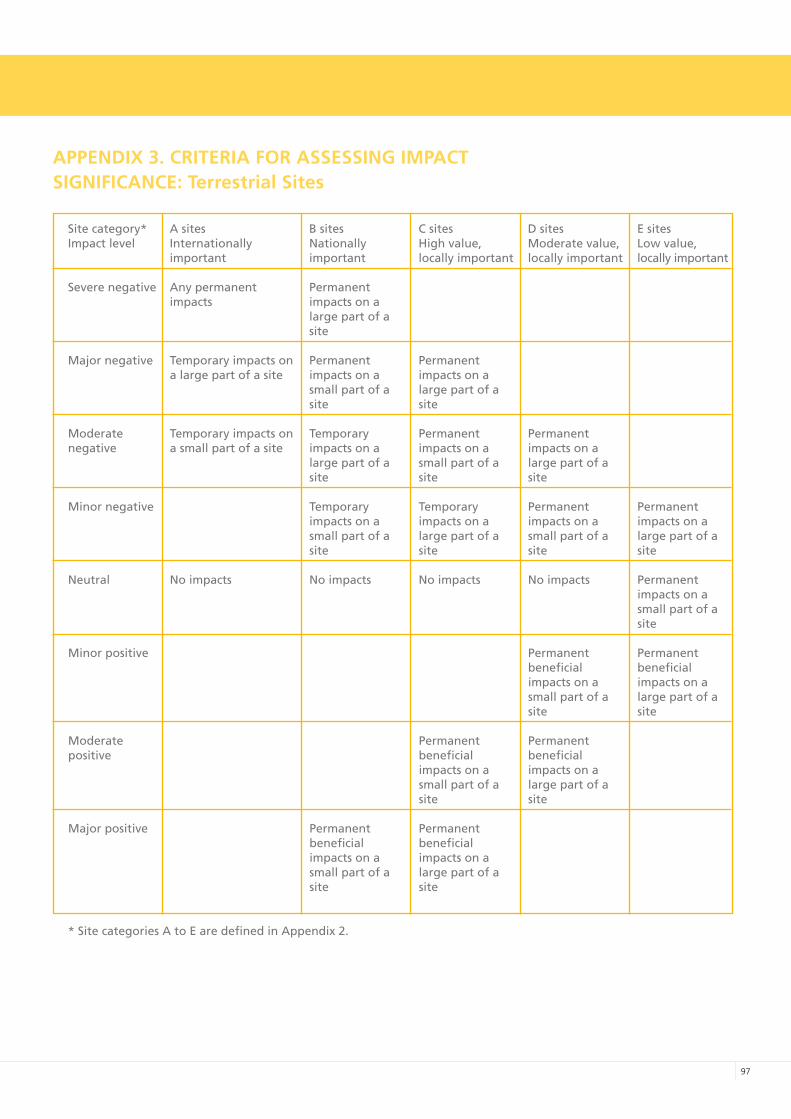
9�
APPENDIX 3. CRITERIA FOR ASSESSING IMPACTSIGNIFICANCE: Terrestrial Sites
Site category* A sites B sites C sites D sites E sitesImpact level Internationally Nationally High value, Moderate value, Low value,
important important locally important locally important locally important
Severe negative Any permanent Permanent impacts impacts on a large part of a
site
Major negative Temporary impacts on Permanent Permanent a large part of a site impacts on a impacts on a small part of a large part of a
site site
Moderate Temporary impacts on Temporary Permanent Permanentnegative a small part of a site impacts on a impacts on a impacts on a large part of a small part of a large part of a
site site site
Minor negative Temporary Temporary Permanent Permanent impacts on a impacts on a impacts on a impacts on a
small part of a large part of a small part of a large part of a site site site site
Neutral No impacts No impacts No impacts No impacts Permanent impacts on a small part of a
site
Minor positive Permanent Permanent beneficial beneficial impacts on a impacts on a small part of a large part of a
site site
Moderate Permanent Permanentpositive beneficial beneficial impacts on a impacts on a small part of a large part of a
site site
Major positive Permanent Permanent beneficial beneficial impacts on a impacts on a small part of a large part of a site site
* Site categories A to E are defined in Appendix 2.
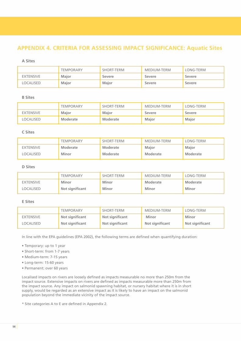
98
APPENDIX 4. CRITERIA FOR ASSESSING IMPACT SIGNIFICANCE: Aquatic Sites
A Sites
TEMPORARY SHORT-TERM MEDIUM-TERM LONG-TERM
ExTENSIVE Major Severe Severe Severe
LOCALISED Major Major Severe Severe
B Sites
TEMPORARY SHORT-TERM MEDIUM-TERM LONG-TERM
ExTENSIVE Major Major Severe Severe
LOCALISED Moderate Moderate Major Major
C Sites
TEMPORARY SHORT-TERM MEDIUM-TERM LONG-TERM
ExTENSIVE Moderate Moderate Major Major
LOCALISED Minor Moderate Moderate Moderate
D Sites
TEMPORARY SHORT-TERM MEDIUM-TERM LONG-TERM
ExTENSIVE Minor Minor Moderate Moderate
LOCALISED Not significant Minor Minor Minor
E Sites
TEMPORARY SHORT-TERM MEDIUM-TERM LONG-TERM
ExTENSIVE Not significant Not significant Minor Minor
LOCALISED Not significant Not significant Not significant Not significant
In line with the EPA guidelines (EPA 2002), the following terms are defined when quantifying duration:
• Temporary: up to 1 year
• Short-term: from 1-7 years
• Medium-term: 7-15 years
• Long-term: 15-60 years
• Permanent: over 60 years
Localised impacts on rivers are loosely defined as impacts measurable no more than 250m from theimpact source. Extensive impacts on rivers are defined as impacts measurable more than 250m fromthe impact source. Any impact on salmonid spawning habitat, or nursery habitat where it is in shortsupply, would be regarded as an extensive impact as it is likely to have an impact on the salmonidpopulation beyond the immediate vicinity of the impact source.
* Site categories A to E are defined in Appendix 2.
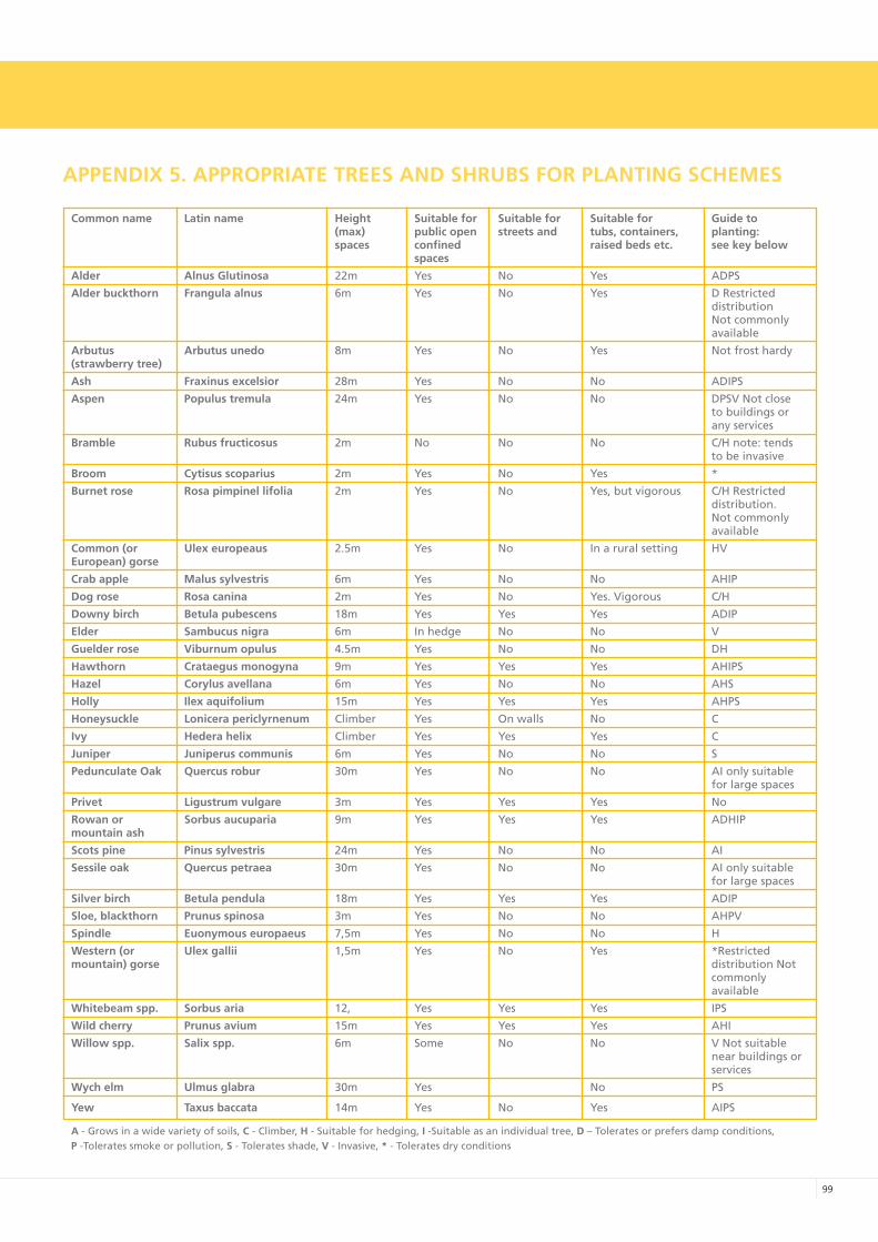
99
APPENDIX 5. APPROPRIATE TREES AND SHRUBS FOR PLANTING SCHEMES
Common name Latin name Height Suitable for Suitable for Suitable for Guide to (max) public open streets and tubs, containers, planting: spaces confined raised beds etc. see key below spaces
Alder Alnus Glutinosa 22m Yes No Yes ADPS
Alder buckthorn Frangula alnus 6m Yes No Yes D Restricted distribution Not commonly available
Arbutus Arbutus unedo 8m Yes No Yes Not frost hardy(strawberry tree)
Ash Fraxinus excelsior 28m Yes No No ADIPS
Aspen Populus tremula 24m Yes No No DPSV Not close to buildings or any services
Bramble Rubus fructicosus 2m No No No C/H note: tends to be invasive
Broom Cytisus scoparius 2m Yes No Yes *
Burnet rose Rosa pimpinel lifolia 2m Yes No Yes, but vigorous C/H Restricted distribution. Not commonly available
Common (or Ulex europeaus 2.5m Yes No In a rural setting HVEuropean) gorse
Crab apple Malus sylvestris 6m Yes No No AHIP
Dog rose Rosa canina 2m Yes No Yes. Vigorous C/H
Downy birch Betula pubescens 18m Yes Yes Yes ADIP
Elder Sambucus nigra 6m In hedge No No V
Guelder rose viburnum opulus 4.5m Yes No No DH
Hawthorn Crataegus monogyna 9m Yes Yes Yes AHIPS
Hazel Corylus avellana 6m Yes No No AHS
Holly Ilex aquifolium 15m Yes Yes Yes AHPS
Honeysuckle Lonicera periclyrnenum Climber Yes On walls No C
Ivy Hedera helix Climber Yes Yes Yes C
Juniper Juniperus communis 6m Yes No No S
Pedunculate Oak Quercus robur 30m Yes No No AI only suitable for large spaces
Privet Ligustrum vulgare 3m Yes Yes Yes No
Rowan or Sorbus aucuparia 9m Yes Yes Yes ADHIPmountain ash
Scots pine Pinus sylvestris 24m Yes No No AI
Sessile oak Quercus petraea 30m Yes No No AI only suitable for large spaces
Silver birch Betula pendula 18m Yes Yes Yes ADIP
Sloe, blackthorn Prunus spinosa 3m Yes No No AHPV
Spindle Euonymous europaeus 7,5m Yes No No H
Western (or Ulex gallii 1,5m Yes No Yes *Restricted mountain) gorse distribution Not commonly available
Whitebeam spp. Sorbus aria 12, Yes Yes Yes IPS
Wild cherry Prunus avium 15m Yes Yes Yes AHI
Willow spp. Salix spp. 6m Some No No V Not suitable near buildings or services
Wych elm Ulmus glabra 30m Yes No PS
yew Taxus baccata 14m Yes No Yes AIPS
A - Grows in a wide variety of soils, C - Climber, H - Suitable for hedging, I -Suitable as an individual tree, D – Tolerates or prefers damp conditions,P -Tolerates smoke or pollution, S - Tolerates shade, v - Invasive, * - Tolerates dry conditions

A
Notes

A
Notes

A
Notes

UCD Urban Institute Ireland, Dún Laoghaire-Rathdown County Council & Fingal County Council
Prepared by NATURA Environmental Consultants in association with David O’Connor, Planning Consultant
This publication is printed on FSC certified paper
I
Related Documents