Gray Wolf Population 2010-2011 By Adrian P. Wydeven and Jane E. Wiedenhoeft Abstract The Wisconsin gray wolf (Canis lupus) population in late winter 2011 was 782 to 824 wolves, including 762 to 805 wolves in 202 or 203 packs and 19 or 20 loners. A total of 751 + wolves occurred outside of Indian reservations, thus the population exceeded its management goal of 350 wolves outside of Indian reservations by 401+ wolves. The wolf population increased 11% above the 2010 count of 704+ wolves. Wolf packs occurred in 34 Wisconsin counties and wolves were reported for 55 counties in the state. The wolf population is currently again listed as federally endangered after being delisted for 19 months in 2007-2008, and 2 months in 2009. A new federal delisting process started on May 5, 2011, and wolves should again be delisted late in 2011. Gray wolves have been state delisted since 2004. Introduction Gray wolves recolonized Wisconsin in the mid-1970’s and WDNR has monitored populations annually since 1979. In 1975 the Wisconsin DNR listed the gray wolf as a state endangered species and downlisted them to threatened status in 1999. On August 1 2004, wolves were removed from the list of threatened species and classified as protected wild animals. The U.S. Fish and Wildlife Service (USFWS) listed gray wolves in the eastern U.S. as endangered in 1967 and again in 1974. The USFWS downlisted wolves to a federally threatened species on April 1, 2003, as part of the Eastern Gray Wolf Distinct Population Segment. But because of a federal district court decision, on January 31, 2005 wolves were relisted as endangered in Wisconsin and other locations. Special Section 10 permits were granted by the USFWS in both 2005 and 2006 to allow limited take of depredating wolves, but permits were lost both years due to lawsuits. Wolves were designated as delisted in the Western Great Lakes Distinct Population Segment on March 12, 2007, but were relisted again on September 29, 2008, delisted again on May 3, 2009, and again relisted on July 1, 2009. This report represents wolf population information for a population that continues to be listed as federally endangered. The USFWS again published a proposed rule to delist wolves in the Western Great Lakes region on May 5, 2011, and expects to have wolves again delisted by the end of 2011. When federal delisting is completed, intense population surveys will be required for the first five years after federal delisting. The enclosed report includes the type of information that will be provided for the eventual post-delisting monitoring. These surveys are also important for determining future management by the state. This report summarizes wolf survey activity for 2010 and portions of 2011. Method Wolf numbers were determined by live-trapping/ radio tracking (Mech 1974, Fuller and Snow 1988), howl surveys (Harrington and Mech 1982), and winter track surveys (Thiel and Welch 1981, Wydeven et al. 1996, Wydeven et al. 2009). Track surveys were conducted in blocks of suitable habitat (Mladenoff et al. 1995, 2009), or areas where wolves had been reported. Additional information on wolf abundance was determined from wolves reported by agency personnel or the general public through “Rare Mammal Observation Cards” (Wydeven 1992) and the “Rare Mammal

Welcome message from author
This document is posted to help you gain knowledge. Please leave a comment to let me know what you think about it! Share it to your friends and learn new things together.
Transcript

Gray Wolf Population 2010-2011
By Adrian P. Wydeven and Jane E. Wiedenhoeft
Abstract The Wisconsin gray wolf (Canis lupus) population in late winter 2011 was 782 to 824 wolves, including 762 to 805 wolves in 202 or 203 packs and 19 or 20 loners. A total of 751 + wolves occurred outside of Indian reservations, thus the population exceeded its management goal of 350 wolves outside of Indian reservations by 401+ wolves. The wolf population increased 11% above the 2010 count of 704+ wolves. Wolf packs occurred in 34 Wisconsin counties and wolves were reported for 55 counties in the state. The wolf population is currently again listed as federally endangered after being delisted for 19 months in 2007-2008, and 2 months in 2009. A new federal delisting process started on May 5, 2011, and wolves should again be delisted late in 2011. Gray wolves have been state delisted since 2004. Introduction Gray wolves recolonized Wisconsin in the mid-1970’s and WDNR has monitored populations annually since 1979. In 1975 the Wisconsin DNR listed the gray wolf as a state endangered species and downlisted them to threatened status in 1999. On August 1 2004, wolves were removed from the list of threatened species and classified as protected wild animals. The U.S. Fish and Wildlife Service (USFWS) listed gray wolves in the eastern U.S. as endangered in 1967 and again in 1974. The USFWS downlisted wolves to a federally threatened species on April 1, 2003, as part of the Eastern Gray Wolf Distinct Population Segment. But because of a federal district court decision, on January 31, 2005 wolves were relisted as endangered in Wisconsin and other locations. Special Section 10 permits were granted by the USFWS in both 2005 and 2006 to allow limited take of depredating wolves, but permits were lost both years due to lawsuits. Wolves were designated as delisted in the Western Great Lakes Distinct Population Segment on March 12, 2007, but were relisted again on September 29, 2008, delisted again on May 3, 2009, and again relisted on July 1, 2009. This report represents wolf population information for a population that continues to be listed as federally endangered. The USFWS again published a proposed rule to delist wolves in the Western Great Lakes region on May 5, 2011, and expects to have wolves again delisted by the end of 2011. When federal delisting is completed, intense population surveys will be required for the first five years after federal delisting. The enclosed report includes the type of information that will be provided for the eventual post-delisting monitoring. These surveys are also important for determining future management by the state. This report summarizes wolf survey activity for 2010 and portions of 2011. Method Wolf numbers were determined by live-trapping/ radio tracking (Mech 1974, Fuller and Snow 1988), howl surveys (Harrington and Mech 1982), and winter track surveys (Thiel and Welch 1981, Wydeven et al. 1996, Wydeven et al. 2009). Track surveys were conducted in blocks of suitable habitat (Mladenoff et al. 1995, 2009), or areas where wolves had been reported. Additional information on wolf abundance was determined from wolves reported by agency personnel or the general public through “Rare Mammal Observation Cards” (Wydeven 1992) and the “Rare Mammal

Observation” web reporting form, http://www.dnr.state.wi.us/org/land/er/forms/rare_mammal.asp. See Wydeven et al. (2009) for more details on the methods. Results and Discussion A minimum count of 782-824 wolves was obtained in Wisconsin in late winter 2010-2011 (Table 1). Average size of 158 northern packs (zone 1) was 3.6 to 3.8 wolves, 27 Central Forest packs (zone 2) was 4.4 to 4.6 wolves, and 17 or 18 west and central Wisconsin packs (zone 3) was 4.5 wolves per pack (Table 1). A total of 19 or 20 wolves were identified as lone wolves, but the total number of lone wolves across the state was probably underestimated. The wolf population estimation for 2009-2010 was 690-733 wolves (Wydeven and Wiedenhoeft 2010), but surveys in summer indicated that at least 7 pairs were missed. Thus we revised the 2010 count to 704 to 747 wolves, and thus the 2011 wolf population may have increased by 11 %. Between 1990 and 2000, the Wisconsin wolf population increased at an average annual increase of 22%, but between 2000 and 2007 had slowed to an annual growth rate of 12% (Wydeven et al. 2009). Average growth rate between 2000 and 2010 was 11%. While population growth rates have decreased some, suspected carrying capacity may be considerably higher than recent estimates (Van Deelen 2009), but more active management with delisting will likely also affect long-term potential for carrying capacity. At least 202 or 203 packs were located in 34 Wisconsin counties (Figure 1, Tables 1 & 2). Average year-round territory area per collared wolf was 55.6 square miles in zone 1 (n=47), 41.0 square miles in zone 2 (n=8), and 62.0 square miles in zone 3 (n=1) (Table 2). We used 55.6 square miles for zone 1 territorial wolves and 41.0 square miles for zone 2 and 3 territorial wolves to assess amount of occupied wolf range. Although the single sample we have for zone 3 was higher, we feel zone 3 wolves probably occupy smaller territories similar to zone 2. The year-round area occupied by territorial wolves would be estimated at about 10,940 square miles in northern and central Wisconsin in 2010-2011, and if we included an interstitial area of 37% (see Fuller 1989), wolf range would cover 14,940 square miles. Among 769 wolves that appeared to occupy regular territory areas, average density would be about 1 wolf per 14 square miles. Wolf territories were focused on heavily forested areas of public and industrial forest land in those regions of the state, but more wolves were beginning to move into more mixed forest/agricultural areas in northwest and central Wisconsin. Figure 2 illustrates the changes in the Wisconsin wolf population over the last 32 years. Although population growth rate averaged 22% annually during the 1990s, it declined to an average of 11% between 2000 and 2010. With federal downlisting in 2003, and by special permits in 2005 and 2006, some limited lethal controls were applied to depredating wolves. Between 2003 and 2006, when a mean of 5.5 % of the winter wolf population was removed by lethal control activities of depredating wolves, the population grew at an annual rate of 13% (2003 to 2007). In 2007, 37 wolves and 1 wolf-dog hybrid were lethally removed by USDA-Wildlife Services (WS), plus landowners legally shot 3 wolves on their land or 7.3% of the wolf population in winter 2007 was lethally removed (546+ wolves). In 2008, 39 wolves and 2 wolf dog hybrids were lethally removed, as well as 4 wolves legally shot by landowners, or 7.8% of the wolf population in winter 2008 (549+ wolves). In 2009 only 10 wolves were removed by government trapper or landowners due to the short period of delisting, resulting in only 1.6% of the winter population being removed. In 2010, only 16 wolves and 1 wolf-dog hybrid involved in human safety situations were removed, or 2.3 % of the winter 2010 population. Lack of lethal controls is one of the factors that allows this population to continue to increase. Even when in effect, there is little risk that any major decline would occur in the wolf population from these controls. If delisting had been in effect in 2010, only about 17% of state wolf packs would have been exposed to controls.
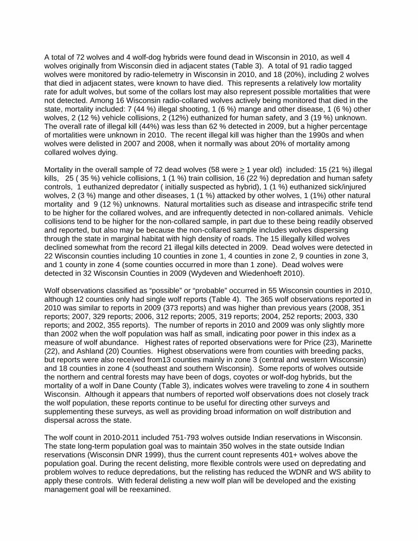
A total of 72 wolves and 4 wolf-dog hybrids were found dead in Wisconsin in 2010, as well 4 wolves originally from Wisconsin died in adjacent states (Table 3). A total of 91 radio tagged wolves were monitored by radio-telemetry in Wisconsin in 2010, and 18 (20%), including 2 wolves that died in adjacent states, were known to have died. This represents a relatively low mortality rate for adult wolves, but some of the collars lost may also represent possible mortalities that were not detected. Among 16 Wisconsin radio-collared wolves actively being monitored that died in the state, mortality included: 7 (44 %) illegal shooting, 1 (6 %) mange and other disease, 1 (6 %) other wolves, 2 (12 %) vehicle collisions, 2 (12%) euthanized for human safety, and 3 (19 %) unknown. The overall rate of illegal kill (44%) was less than 62 % detected in 2009, but a higher percentage of mortalities were unknown in 2010. The recent illegal kill was higher than the 1990s and when wolves were delisted in 2007 and 2008, when it normally was about 20% of mortality among collared wolves dying. Mortality in the overall sample of 72 dead wolves (58 were > 1 year old) included: 15 (21 %) illegal kills, 25 ( 35 %) vehicle collisions, 1 (1 %) train collision, 16 (22 %) depredation and human safety controls, 1 euthanized depredator ( initially suspected as hybrid), 1 (1 %) euthanized sick/injured wolves, 2 (3 %) mange and other diseases, 1 (1 %) attacked by other wolves, 1 (1%) other natural mortality and 9 (12 %) unknowns. Natural mortalities such as disease and intraspecific strife tend to be higher for the collared wolves, and are infrequently detected in non-collared animals. Vehicle collisions tend to be higher for the non-collared sample, in part due to these being readily observed and reported, but also may be because the non-collared sample includes wolves dispersing through the state in marginal habitat with high density of roads. The 15 illegally killed wolves declined somewhat from the record 21 illegal kills detected in 2009. Dead wolves were detected in 22 Wisconsin counties including 10 counties in zone 1, 4 counties in zone 2, 9 counties in zone 3, and 1 county in zone 4 (some counties occurred in more than 1 zone). Dead wolves were detected in 32 Wisconsin Counties in 2009 (Wydeven and Wiedenhoeft 2010). Wolf observations classified as “possible” or “probable” occurred in 55 Wisconsin counties in 2010, although 12 counties only had single wolf reports (Table 4). The 365 wolf observations reported in 2010 was similar to reports in 2009 (373 reports) and was higher than previous years (2008, 351 reports; 2007, 329 reports; 2006, 312 reports; 2005, 319 reports; 2004, 252 reports; 2003, 330 reports; and 2002, 355 reports). The number of reports in 2010 and 2009 was only slightly more than 2002 when the wolf population was half as small, indicating poor power in this index as a measure of wolf abundance. Highest rates of reported observations were for Price (23), Marinette (22), and Ashland (20) Counties. Highest observations were from counties with breeding packs, but reports were also received from13 counties mainly in zone 3 (central and western Wisconsin) and 18 counties in zone 4 (southeast and southern Wisconsin). Some reports of wolves outside the northern and central forests may have been of dogs, coyotes or wolf-dog hybrids, but the mortality of a wolf in Dane County (Table 3), indicates wolves were traveling to zone 4 in southern Wisconsin. Although it appears that numbers of reported wolf observations does not closely track the wolf population, these reports continue to be useful for directing other surveys and supplementing these surveys, as well as providing broad information on wolf distribution and dispersal across the state. The wolf count in 2010-2011 included 751-793 wolves outside Indian reservations in Wisconsin. The state long-term population goal was to maintain 350 wolves in the state outside Indian reservations (Wisconsin DNR 1999), thus the current count represents 401+ wolves above the population goal. During the recent delisting, more flexible controls were used on depredating and problem wolves to reduce depredations, but the relisting has reduced the WDNR and WS ability to apply these controls. With federal delisting a new wolf plan will be developed and the existing management goal will be reexamined.

The federal delisting goal for Wisconsin and Michigan was a population of 100 or more wolves for a period of 5 or more years (U. S. Fish and Wildlife Service1992). The wolf population currently is about 1500 wolves for both states, and has been at 100 or more since 1994. The delisting process for the Western Great Lakes Distinct Population Segment completed on March 12, 2007, gave the states of Wisconsin, Michigan and Minnesota more flexible management programs for dealing with wolves in the region. Because of a lawsuit, wolves were again relisted on September 29, 2008. The USFWS again delisted wolves in the region on May 3, 2009, after addressing shortcomings of the initial delisting, but the USFWS failed to provide a public comment period on the updating of the delisting rule and resulted in wolves again being listed as endangered on July 1, 2009 (relisted as threatened in Minnesota). On May 4, 2011 the U.S Fish and Wildlife Service published a new proposed delisting rule for the Western Great Lakes region, and provided a public comment period on the new rule between May 5 and July 5, 2011. http://www.fws.gov/midwest/wolf/delisting/FRProposedDelistMay2011.htm A final rule delisting wolves in the region is expected to be completed by the end of 2011 or early 2012. Acknowledgments Wolf population monitoring was funded by USFW PR funds; U.S. Forest Service; Wisconsin Endangered Resources fund; Defenders of Wildlife; Timber Wolf Alliance, Ho-Chunk Nation, Menominee Tribe, Munsee-Stockbridge Tribe, Bad River Band Chippewa, Lac Courtes Oreilles Chippewa, and private donations. Major assistance on wolf monitoring was received from Ron Schultz, Sarah Boles, Dick Thiel, Randy Jurewicz, Jean Bruner, Ken Jonas, Bruce Bacon, Greg Kessler, Todd Naas, Nancy Christel, Gary Dunsmoor, Bob Hanson, Michele Windsor, Aaron Buchholz, Dave Halfmann, Mike Zeckmeister, Nancy Businga, Lindsey Long Bob Willging, Chip Lovell, Dave Ruid, Ed Zydzik, Jim Rollman, Eric Fromm, Chad Alberg, Phil Peterson, Jeremy Irish, Jim Miller, DeWayne Snobl, Barry Benson, Steve Krueger, Mark Kerr, John Nuce, Mike Petrie, Aaron Freund, Karen Karash, Bob Wilmer, Lacey Hill, Paul Christel, Don Reiter, Bob Frank, Tim Wilder, Phil Miller, Joe Sprenger, Mike Weinfurter, Dan Cardinal, Beverly Paulan, Leo Bunderson, Shawn Rossler, Dan Eklund, Tom Matthiae, Scott Anderson, Mike Peczynski, Christine Anhalt, Erik Olson, Jen Stenglein, Tim Van Deelen, Adrian Treves, Northland College wolf research team, and about 200 volunteer trackers Literature Cited Fuller, T.K. and W.J. Snow 1988. Estimating wolf densities from radio-telemetry data. Wildlife Society Bulletin16:367-370. Harrington, F.H. and L.D. Mech. 1982. An analysis of howling response parameters useful for wolf pack censusing, Journal of Wildlife Management 46:686-693. Mech, L.D. 1974. Current techniques in the study of elusive wilderness carnivores. Pages 315-332 in Proc. XIth International Congress Game Biologists, Stockholm, Sweden. Mladenoff, D.J., T.A. Sickley, R.G. Haight, and A.P. Wydeven. 1995. A regional landscape analysis and prediction of favorable gray wolf habitat in the northern Great Lakes Region. Conservation Biology 9:279-294. Mladenoff, D.J., M.K. Clayton, S.D. Pratt, T.A. Sickley, and A.P. Wydeven. 2009. Changes in occupied wolf habitat in the Northern Great Lakes Region. pp. 119-138 in A.P. Wydeven, T.R. Van Deelen, and E.J. Heske, eds. Recovery of Gray Wolves in the Great Lakes Region of the United States: An Endangered Species Success Story. Springer, New York, NY, USA. 350pp.

Thiel, R.P. and R.J. Welch. 1981. Evidence of recent breeding activity in Wisconsin wolves. American Midland Naturalist. 106:401-402. U.S. Fish and Wildlife Service. 1992. Recovery Plan for the Eastern Timber Wolf. Twin Cities, MN. 73 pp. Van Deelen, T.R. 2009. Growth characteristics of a recovering wolf population in the Great Lakes Region. pp. 139-153 in A.P. Wydeven, T.R. Van Deelen, and E.J. Heske, eds. Recovery of Gray Wolves in the Great Lakes Region of the United States: An Endangered Species Success Story. Springer, New York, NY, USA. 350pp Wisconsin DNR. 1999. Wisconsin Wolf Management Plan. Wisconsin DNR, Madison, WI Publ-ER-099 99. 74 pp. Wydeven, A.P. 1992. Rare mammal observations, 1991. In Wisconsin Wildlife Surveys Report, February 1992. Wisconsin Dept. Nat. Resources, Monona, WI, 144 pp. Wydeven, A.P. , R.N. Schultz, and R. P. Thiel. 1995. Monitoring a recovering gray wolf population in Wisconsin, 1979-1991. pp. 147-156 in Carbyn, L.N., S.H. Fritts, and D.R. Seip (eds.). Ecology and Conservation of Wolves in a Changing World. Canadian Circumpolar Institute, Occasional Publication No.35, Edmonton, Alberta, Canada. Wydeven, A.P., R.N. Schultz, and R.A. Megown. 1996. Guidelines for carnivore track surveys during winter in Wisconsin. Wisconsin Endangered Resources Report #112 Madison, WI, 11 pp. Wydeven, A.P., A. Treves, B. Brost, and J.E. Wiedenhoeft. 2004. Characteristics of wolf packs in Wisconsin: Identification of traits influencing depredations. Pp. 28-50 in Fascione, N., A. Delach, and M. E. Smith (eds.). People and Predators: From Conflict to Coexistence. Defenders of Wildlife, Island Press, Washington, D.C. USA. Wydeven, A.P. and J.E. Wiedenhoeft. 2010. Gray wolf population, 2009-2010. Wisconsin Wildlife Surveys, 20 (5):140-160. Wydeven, A.P., J.E. Wiedenhoeft, R.N. Schultz, R.P. Thiel, R.L. Jurewicz, B.E. Kohn, and T.R. Van Deelen. 2009. History, population growth, and management of wolves in Wisconsin. Pp. 87-105 in A.P. Wydeven, T.R. Van Deelen, and E.J. Heske, eds. Recovery of Gray Wolves in the Great Lakes Region of the United States: An Endangered Species Success Story. Springer, New York, NY, USA. 350pp

Table 1. Pack and lone wolf summaries for Wisconsin in winter 2010-2011 (Map numbers refer to Figure 1). Evidence included Rvadio telemetry (R), Track surveys (T), Observations by agency or general public (O), and Depredation reports (D). Map No. Pack or Area
Survey Block Counties
Win. Est.
Collared Wolves
Breeding Detected Evidence
Zone 1 1 Pokegama River 1 Douglas 3-5 Y T 2 Belden Swamp 2 Douglas 6 W760F Y Y R & T 3 Breitzman Lake 2 Douglas 5 Y T 4 Jackson Box 3,4 Douglas 4 Y T 5 North Empire 3,4 Douglas 3-5 Y T 6 South Empire 3,4 Douglas 3 Y T 7 Moose Lake 4,5 Douglas 4 Y T & O 8 Pikes Peak 4,5 Douglas 2 W616F A ? R & T 9 Amnicon River 5,6 Douglas 3 W669F A Y T & R 10 South Range 5,7 Douglas 4-5 Y? T
11 Brule River 6 Douglas 1 W637M A died N T & R
12 Lake Nebagamon 6 Douglas 9 Y T 13 Muck Lake 6,26 Douglas,Bayfield 3 ? T 14 Casey Creek 7 Douglas 3 Y O & T 15 Poplar River 7 Douglas 3-4 Y T & O 16 Chain Lake 8,23 Douglas,Washburn 6 W791M A Y R & T 17 Shoberg Lake 8,26 Douglas,Bayfield 6 W664F A Y R & T 18 Ox Creek 8 Douglas 2 Y T W753F disperser 8 1 W753F Y N R 19 Bird Sanctuary 9,8,4,6 Douglas 3 W672F A Y T & R 20 Crotte Creek 9 Douglas 3-5 W602F A Y R & T 21 Leder Lake 9,10 Douglas,Washburn 4 Y T 22 Namakagon Barrens 10 Burnett,Doug.,Wash. 6 Y T & O 23 Riverside 10,12 Burnett 4 W776F A Y R & T 24 Chase Brook 11 Burnett,Douglas 3 Y T 25 Moose Road 11,2 Douglas 12 W564F A Y R & T 26 Lipsett Lake 12 Burnett 2 W774F Y ? T, R & O 27 Stuntz Brook 12,10 Washburn 4 Y T 28 Webb Creek 12 Washburn 2 W761M A ? O, R & T 29 Amsterdam Slough 13 Burnett 2 Y T 30 Crex Meadow 13 Burnett 5 Y T & O 31 Falun Meadows 13 Burnett 4 Y T & O 32 Sterling Barrens 14 Burnett 4 Y T & O 33 Wolf Creek 14 Polk 2 Y T 34 Wolf Lake 19 Washburn,Sawyer 3 Y T 35 Weirgor Lake 20A,19 Sawyer 2 Y T 36 Nail Creek 20A Rusk,Sawyer 6-7 Y T 37 Blue Hills North 20A Rusk,Sawyer 5 Y T 38 Dugan Lake 21 Washburn 2-3 N T & O 39 Bean Brook 21 Washburn,Sawyer 1 N O & T 40 Spring Brook 22 Washburn 2 Y T

Table 1. Continued.
Map No. Pack or Area
Survey Block Counties
Win. Est.
Collared Wolves
Breeding Detected Evidence
41 Tranus Lake 22 Washburn 4 Y T
42 Chittamo 23,10,22 Washburn 2 W784M A died Y R & T
43 Frog Creek 23 Washburn,Sawyer 4 Y T & O 44 Smoky Hill 23,8 Douglas,Bayfield 4 Y T & O 45 Ghost Lake 24,37 Sawyer,Bayfield 6-7 Y T & O 46 Seeley Hills 24,29 Sawyer,Bayfield 6 Y T & O
47 Bearsdale 25 Bayfield 3 W663F A died Y T & R
48 Sabin Lake 25,24 Sawyer,Bayfield 2 Y O & T
49 Moreland Lake 26,6 Bayfield,Douglas 6 W670F A W757M A Y R, T & O
50 Rainbow Lake 26,27,25 Bayfield 4 W626F A Y T & R 51 Delta 27,28 Bayfield 2 Y T 52 Ino Swamp 27,30 Bayfield 7 Y T 53 Pigeon Lake 27,25 Bayfield 4 W615F A Y T & R 54 Bibon Swamp 28 Bayfield 3-5 Y T 55 Mason 28,34 Bayfield 3 Y T 56 Porcupine Lake 29,35 Bayfield 4 Y T 57 Moquah 30 Bayfield 3 Y T & O
58 Flag River 31,30,32 Bayfield 4 W673M A died Y T & R
59 Orienta Falls 31 Bayfield,Douglas 2 Y T & O 60 Siskiwit Lake 32,33 Bayfield 3 Y T 61 Echo Valley 33 Bayfield 4 ? T 62 Twin Lakes 33,30,32 Bayfield 2 W773M Y ? R 63 Beaver Dam Lake 34,35,36 Ashland,Bayfield 3-4 W671F A ? R, T & O 64 White River 34 Bayfield,Ashland 2 ? O 65 Hellhole Creek 35 Bayfield,Ashland 3 ? T 66 Brush Creek 36,57 Ashland 6-7 W651M A Y R, T & O
67 Black Lake 37,38,40 Sawyer,Ashland 3 W573F A dispersed Y T, O & R
68 Mukwonago Trails 37 Sawyer 5 Y O & T 69 Round Lake 37,42 Sawyer 2 ? T 70 Venison Creek 37,42 Sawyer 2 ? T 71 Shanagolden 38,36 Ashland 3 Y T
72 Torch River 38,37,36 Ashland 2 W764M A dispersed Y R & T
73 Kakagon Sloughs 39,34 Ashland 5 W667M A Y? R & O
74 West Firelane 39,60 Ashland,Iron 2 W779M P W780F Y ? R & T
W774F loner 39 Ashland 1 W774F Y N R W764M disperser 40 Ashland 1 W764M A N R 75 Hungry Run 40 Ashland,Sawyer 4-5 Y T 76 Log Creek 40 Price,Sawyer 5 Y T 77 Pine Creek 40,38,55,56 Price,Ashland 3 Y T

Table 1. Continued. Map No. Pack or Area
Survey Block Counties
Win. Est.
Collared Wolves
Breeding Detected Evidence
78 Davis Lake 41,52 Price 3 Y T & O 79 Price Creek 41,44,43 Price,Sawyer 4 W691M A Y R 80 Thornapple River 41 Sawyer 2 Y 81 Tuscobia Trail 41,37 Sawyer 2 W630F A N? R & T W573F disperser 42 Sawyer 1 W573F A N R 82 Eddy Creek 42 Sawyer 3 Y T 83 Winter 42,43,41 Sawyer 4 Y T & O 84 Haystack Corner 43 Sawyer,Rusk 2 W650F A Y R & T 85 Lea Lake 43 Rusk 4 W759M Y ? R & T 86 Main Creek 43,45 Rusk 2 ? T 87 Tupper Creek 43,20A Sawyer 4 Y T 88 Carpenter Creek 44 Price 3 W752F Y ? R & T 89 Skinner Creek 44 Price,Sawyer,Rusk 5 W555M A Y T & R 90 Spring Creek 44,46 Price 4 Y T & O 91 Catawba 46 Price 2 ? T 92 Green Creek 46 Price,Rusk,Taylor 3 ? T
93 Chequamegon Waters 47, 153 Taylor 2-4 Y T
94 Kidrick Swamp 47 Taylor 2-3 Y T 95 Mondeaux Flowage 47,46 Taylor 2 Y T 96 Averill Creek South 48,70,135 Lincoln 3 ? T & O 97 Little Black River 48 Taylor 4 Y T 98 Alcohol Creek 49,50 Price 2 Y T 99 Spirit Lake 49,48 Taylor,Price 2 ? T 100 Marheimie Creek 50,49 Price,Lincoln 3 W686M A ? R & T W754F disperser 50 Price 1 W754F Y N R 101 Clifford 51 Price,Oneida 4 Y? T 102 Dover Loop 51 Price 6 Y T 103 Musser Creek 51,53,52 Price 10 Y T
104 Thunder Creek 51,53,65 Price,Oneida 6 W687M A dispersed Y T, R & O
105 Wintergreen 52,54,55 Price 3 W793F A Y T, R & D 106 Wilson Flowage 52,53 Price 3 Y T 107 Bootjack Lake 53,54,65 Oneida,Price,Vilas 5 W623F A Y? T, O & R 108 Miles Lake 54 Iron,Vilas 2 ? T 109 Hoffman Lake 55,54 Price,Iron,Ashland 4-6 Y T & O 110 Murray's Landing 55,64,62 Iron 2 Y T 111 Chippewa River 56,58,57 Iron,Ashland 4 Y? T 112 Magee Creek 56,57 Ashland 2 ? T & D 113 Augustine Lake 57 Iron,Ashland 4 Y T 114 O'Brien Lake 57,59 Iron 4 Y? T & O W694F disperser 58 Iron 1 W694F A N R 115 Pine Lake 58,55,61 Iron 2 W508F A ? R 116 Merril Lake 61,62,MI Iron 2 ? T 117 Cedar Lake 62,63 Vilas,Iron 2-3 Y T & O 118 Whitney Lake 63 Vilas 4 Y? O & T

Table 1. Continued. Map No. Pack or Area
Survey Block Counties
Win. Est.
Collared Wolves
Breeding Detected Evidence
119 Little Rock Lake 64,80 Vilas 5 W692F A Y? R, T & O Pokegama Trail 64 Vilas 1 N T
120 North Willow 65,67 Oneida 9
W754F Y dispersed W792F P Y R & T
121 Scotchman Lake 65,54 Oneida 2 W690F A ? R 122 Bradley 67,68 Lincoln,Oneida 6 Y T & O
123 Little Rice River 67,51 Oneida 5
W687M A W755F A dispersed Y R & T
124 Swamp Creek 67 Oneida 3 Y T 125 Somo River 68 Lincoln 3 ? T 126 Ranger Island 69 Lincoln 4 Y T 127 Averill Creek North 70,69 Lincoln 6 Y T 128 Harrison Hills 71,75 Lincoln 3 ? T & O 129 Clearwater Creek 72,74 Langlade 3 Y T 130 Prairie River 74 Langlade 2 ? T 131 Crescent Flats 75 Oneida,Lincoln 2-3 ? O & T 132 Pelican Lake 76,74 Oneida 6-7 Y? T & O 133 Stella Lake 77 Oneida 3 Y T 134 Casian 78,79,77 Oneida 3-5 W688F A ? R, T & O 135 Escanaba Lake 80,81 Vilas 3 W500B F A Y R & T 136 Pincherry Lake 80 Vilas 2 Y T & O 137 Nineweb Lake 81,80,82 Vilas 3 Y T 138 Muskrat Creek 82 Vilas 3 Y T Kentuck Lake loner 83 Vilas 1 N T & O 139 Giant Pine 84,85,96,97 Forest 10 M2749F A Y R, T & O 140 Atkins Lake 86,77 Oneida,Forest 3 Y O & T 141 Jack Lake 88 Langlade 3-5 ? T 142 Evergreen 90,66,91 Menom,Lang,Oconto 2 M2761F A N? R & T 143 South Branch 90, 131 Menominee,Oconto 2 ? T 144 West Branch 90, 130 Menominee,Shawano 2 ? T 145 Zoar 90,66,130 Menominee,Langlade 3 M2778F Y ? T W768M disperser 90 Menominee 1 W768M A N R 146 Ada Lake 92 Oconto,Langlade 3 Y T 147 Bob's Lake 94,95,101 Forest 3 M734M A Y R, O & T 148 McArthur Pine 95,85,100 Forest 4 Y O & T 149 Lost Lake 98 Florence 2 Y T 150 Mud Lake 99,98 Florence & MI 2 Y T & O 151 Morgan Lake 100,98 Florence,Forest 5 Y T 152 Camp 6 101 Forest,Marinette 2-3 ? T 153 Knowles Creek 102 Forest 4 Y T 154 Peshtigo Brook 104 Oconto,Marinette 2 N? O & T 155 Eagle Creek 106, 102 Marinette 3-4 Y T & O 156 Pike River 107 Marinette 3-4 ? T
157 Spread Eagle Barrens 108, 109 Florence 4 Y T

Table 1. Continued. Map No. Pack or Area
Survey Block Counties
Win. Est.
Collared Wolves
Breeding Detected Evidence
158 Dunbar 108 Florence,Marinette 4 Y? T 159 Pemene 110 Marinette,Florence 6 W782F A Y O, T & R 160 Island Lake 112, 106 Marinette 3 ? T
Zone 1 Total
568-600 in 158 packs + 11 loners = 579-611 (3.6-3.8 wolves / pack)
Zone 2 161 Augusta 117 Eau Claire 5 Y T 162 Dickison Creek 117 Clark 4 Y T 163 Eau Claire River 117 Eau Claire,Clark 5 W657M A Y T & R 164 Iron Run 117, 118 Clark,Eau Claire 5-6 Y T 165 Meadows Creek 118, 117 Clark 4 Y T 166 Wedges Creek 118 Clark 6 Y T 167 Ballard Road 119 Clark,Jackson 6 Y T 168 Brushy Ridge 119 Clark,Jackson 4 Y T 169 Davidson Creek 119 Jackson 5 Y T 170 Noch Hanai 119 Jackson 4 W772M A Y T & R 171 Pray 120,119,121 Jackson 2 W652F A Y T & R 172 Starlight 120 Jackson 3-4 W654F A ? T & R 173 Wildcat Mound 120 Jackson 5-7 Y T 174 Bear Bluff 121 Jackson 4 ? O & T 175 Mather West 121, 122 Monroe,Jackson 5 Y? T 176 McKenna 121 Jackson 8 Y T 177 South Bluff 121, 122 Wood,Juneau 7 Y T & O 178 Turner Creek 121, 124 Wood 3 ? O 179 Mather East 122, 121 Juneau 4 W635F A Y T, R & O 180 Silo 122, 129 Juneau 7 Y T & O 181 Seneca 124, 140 Wood 6-7 Y T 182 2-Korner 124 Wood,Jackson 4 W684F A N? R & T 183 Rattail 125 Juneau 1 N T 184 Creamery 125 Wood 3 Y T 185 Colburn 127, 128 Adams,Waushara 3 Y T & O 186 Leola Marsh 127 Adams,Portage 2 W763F Y Y R
187 Petenwell 127 Adams 2 W763F Y dispersed Y T & R
188 Caves Creek 128 Marquette 1 N O & T 189 Quincy Bluff 128 Adams 1 N T Meredith 129 Juneau 1 N T & O 190 Mill Bluff 129 Juneau,Monroe 2-3 Y T
Zone 2 Total
118-124 in 27 packs + 4 loners = 122-128 (4.4-4.6 wolves/ pack)
Zone 3 191 Clam River 17 Burnett,Polk 3 Y T 192 Sand Creek 17,18 Burn,Polk,Barr,Wash. 3 ? T 193 Blue Hills South 20B,20A,126 Barron,Rusk 3 N? T 194 Ackley Wildlife Area 72,73 Lincoln,Lang,Marath. 3 ? O & T

Table 1. Continued. Map No. Pack or Area
Survey Block Counties
Win. Est.
Collared Wolves
Breeding Detected Evidence
195 Lake Mary 113 Marinette & MI 4 N? T & O 196 Lake Noquebay 113 Marinette 5 Y T 197 Clear Creek 120, 123 Jackson,Monroe 4 Y O & T 198 Ft. McCoy 123 Monroe 12 Y T & O 199 South Post 123 Monroe 8 W751F A Y T, O & R 200 Spence Lake 126 Chippewa,Rusk 4 Y T 201 Long Lake 126,45 Rusk 1-2 N? O & T 202 Miller Creek 130,90 Shawano,Menominee 6 W658F A Y? R & T 203 Tilleda 130, 138 Shawano 3-5 Y T & O 204 Mead 133 Marath,Wood,Portage 8 Y T 205 Dewey Marsh 137 Portage,Marathon 3-4 Y T 206 Split Rock 138 Shawano,Waupaca 3 Y T & O 207 Navarino 139 Shawano,Waupaca 2 N? O 208 Fogarty Marsh 140 Portage,Wood 1 N T 209 Lamb's Creek 148, 149 Dunn 2 Y T Loner 151 Chippewa 1 N T W778F disperser 0 Jackson 1 W778F Y N R
Zone 3 Total
76-81 in 17-18 packs + 4-5 loners = 81-85 (4.5 wolves / pack)
STATEWIDE TOTAL
762-805 in 202-203 packs + 19-20 loners = 782-824 (3.8-4.0 wolves / pack) 751-793 off reservations
MI Packs detected in WI, but counted in MI 210 Little Girl's Point 60,39 Iron & MI 6 Y O & T 211 Menominee River 111 Marinette & MI 2-3 ? T

Table 2. Wolf pack territories 2010-2011 (mapped in Figure 1).
Pack Name Map
# Yeara Collared Wolf
# of radio locations
# of other locationsb
Area (Mi2)
Zone 1 Ada Lake 146 Approx. none 0 3 NEAlcohol Creek 98 Approx. none 0 1 NE
Amnicon River 9 2011 W669c 47(43) 8 46.3Amsterdam Slough 29 Approx. none 0 0 NEAtkins Lake 140 Approx. none 0 4 NEAugustine Lake 113 Approx. none 0 8 NE
Averill Creek North 127 2010 W647c 0 14 NEAverill Creek South 96 Approx. none 0 6 NEBean Brook 39 Approx. none 0 1 NE
Bearsdale 47 2011 W663c 48(47) 5 26.4
Beaver Dam Lake 63 2011 W671c 51 8 90.1
Belden Swamp 2 2011 W760c 48 4 25.6Bibon Swamp 54 Approx. none 0 1 NE
Bird Sanctuary 19 2011 W672c 50(48) 2 48.3
Black Lake 67 2011 W573c 43(42) 130 69.1Blue Hills North 37 Approx. none 0 3 NEBob's Lake 147 2011 M734 56 2 56.4
Bootjack Lake 107 2011 W623c 56(55) 4 83.3
Bradley 122 2009 W617c 0 5 NEBreitzman Lake 3 Approx. none 0 5 NE
Brule River 11 Approx. W637c 19 4 NEBrush Creek 66 2011 W651 54(52) 3 42.0Camp 6 152 Approx. none 0 4 NECarpenter Creek 88 2011 W752 22 1 10.7Casey Creek 14 2011 W757 33(29) 8 32.7
Casian 134 2011 W688c 50(47) 3 129.5Catawba 91 Approx. none 0 1 NE
Cedar Lake 117 2010 W674c 0 3 NE
Chain Lake 16 Approx. W791c 16(10) 4 NEChase Brook 24 Approx. none 0 8 NEChequamegon Waters 93 Approx. none 0 2 NEChippewa River 111 Approx. none 0 1 NE
Chittamo 42 2011 W784c 33(32) 5 50.4Clearwater Creek 129 Approx. none 0 3 NEClifford 101 Approx. none 0 4 NE
Crescent Flats 131 2007 W568c 0 8 NE
Crex Meadow 30 2010 W698c 0 5 NECrotte Creek 20 2011 W602 50 2 28.0Davis Lake 78 Approx. none 0 7 NE
Delta 51 2010 W627c 0 2 NEDover Loop 102 Approx. none 0 5 NEDugan Lake 38 Approx. none 0 3 NE
Dunbar 158 2009 W646c 0 6 NE
Eagle Creek 155 Approx. none 0 12 NE

Table 2. Continued.
Pack Name Map
# Yeara Collared Wolf
# of radio locations
# of other locationsb
Area (Mi2)
Echo Valley 61 Approx. none 0 3 NEEddy Creek 82 Approx. none 0 1 NEEscanaba Lake 135 2011 W500B 56 3 98.6
Evergreen 142 2011 M2761c 56(52) 4 236.4Falun Meadows 31 Approx. none 0 8 NE
Flag River 58 Approx. W673c 14 7 NEFrog Creek 43 Approx. none 0 6 NE
Ghost Lake 45 2011 W694c 32(28) 34 40.4
Giant Pine 139 2011 M2749c 55 18 192.6Green Creek 92 Approx. none 0 3 NE
Harrison Hills 128 2010 W617c 0 7 NEHaystack Corner 84 2011 W650 53(52) 1 85.0Hellhole Creek 65 Approx. none 0 4 NE
Hoffman Lake 109 2009 W632c 0 14 NEHungry Run 75 Approx. none 0 18 NE
Ino Swamp 52 2009 W561c 0 5 NEIsland Lake 160 Approx. none 0 5 NEJack Lake 141 Approx. none 0 4 NEJackson Box 4 Approx. none 0 3 NE
Kakagon Sloughs 73 2011 W667c 51(47) 0 58.4Kidrick Swamp 94 Approx. none 0 2 NEKnowles Creek 153 Approx. none 0 3 NE
Lake Nebagamon 12 2010 W679c 15 12 NELea Lake 85 2011 W759 52 1 22.6Leder Lake 21 Approx. none 0 2 NE
Lipsett Lake 26 2011 W774c 35 2 24.4Little Black River 97 Approx. none 0 2 NELittle Rice River 123 2011 W687,W755 66(63) 3 46.0
Little Rock Lake 119 2011 W692c 56 4 49.5Log Creek 76 Approx. none 0 3 NELost Lake 149 Approx. none 0 1 NE
Magee Creek 112 2010 M726,W696c 0 2 NEMain Creek 86 Approx. none 0 1 NEMarheimie Creek 100 2011 W686 56(55) 3 43.3
Mason 55 Approx. W627c 17(14) 3 NEMcArthur Pine 148 Approx. none 0 4 NEMerril Lake 116 Approx. none 0 1 NE
Miles Lake 108 2010 W503c 0 1 NEMondeaux Flowage 95 Approx. none 0 3 NEMoose Lake 7 Approx. none 0 4 NE
Moose Road 25 2011 W564c 50 6 45.2
Moquah 57 2010 W662c 0 6 NE
Moreland Lake 49 2011 W670,W757c 66(64) 5 23.2
Morgan Lake 151 2010 M719c 0 5 NE
Muck Lake 13 Approx. none 0 3 NE
Mud Lake 150 Approx. W783c 4 4 NE

Table 2. Continued.
Pack Name Map
# Yeara Collared Wolf
# of radio locations
# of other locationsb
Area (Mi2)
Mukwonago Trails 68 Approx. none 0 10 NE
Murray's Landing 110 2009 W680c 0 3 NEMuskrat Creek 138 Approx. none 0 4 NEMusser Creek 103 Approx. none 0 11 NENail Creek 36 Approx. none 0 3 NENamakagon Barrens 22 Approx. none 0 10 NE
Nineweb Lake 137 Approx. W645c 0 4 NENorth Empire 5 Approx. none 0 8 NENorth Willow 120 2011 W754,W792,W793 81 3 80.8O'Brien Lake 114 Approx. none 0 2 NEOrienta Falls 59 Approx. none 0 8 NE
Ox Creek 18 2011 W637c 24(23) 2 27.1Pelican Lake 132 Approx. none 0 6 NE
Pemene 159 2011 W782c 43(42) 12 56.4Peshtigo Brook 154 Approx. none 0 8 NEPigeon Lake 53 2011 W615 50 6 42.3Pike River 156 Approx. none 0 7 NEPikes Peak 8 2011 W616 49 0 37.4Pincherry Lake 136 Approx. none 0 1 NEPine Creek 77 Approx. none 0 8 NEPine Lake 115 2011 W508 56 0 43.1Pokegama River 1 Approx. none 0 2 NEPoplar River 15 Approx. none 0 5 NE
Porcupine Lake 56 2004 W241c 0 5 NEPrairie River 130 Approx. none 0 3 NE
Price Creek 79 2011 W691,W752c 43 3 70.9Rainbow Lake 50 2011 W570,W626,W697 72 3 64.5
Ranger Island 126 2004 G99,W479c 0 20 NE
Riverside 23 2011 W776c 39 7 31.6Round Lake 69 Approx. none 0 2 NE
Sabin Lake 48 2010 M2737, W511c 8 6 NEScotchman Lake 121 2011 W690 26(24) 0 14.7Seeley Hills 46 Approx. none 0 5 NE
Shanagolden 71 2011 W475c 28 11 43.8
Shoberg Lake 17 2011 W664c 50(48) 4 38.9
Siskiwit Lake 60 2003 W369c 0 6 NE
Skinner Creek 89 2011 W555c 53 5 43.6
Smoky Hill 44 2008 W638c 0 12 NE
Somo River 125 2006 W514c 0 2 NESouth Branch 143 Approx. none 0 2 NESouth Empire 6 Approx. none 0 3 NESouth Range 10 Approx. none 0 9 NE
Spirit Lake 99 Approx. W456c 0 1 NE
Spread Eagle Barrens 157 Approx. none 0 2 NE
Spring Brook 40 Approx. none 0 6 NE
Spring Creek 90 Approx. none 0 2 NE

Table 2. Continued.
Pack Name Map
# Yeara Collared Wolf
# of radio locations
# of other locationsb
Area (Mi2)
Stella Lake 133 Approx. none 0 4 NESterling Barrens 32 Approx. none 0 12 NEStuntz Brook 27 Approx. none 0 1 NE
Swamp Creek 124 2009 W611c 0 7 NEThornapple River 80 Approx. none 0 2 NE
Thunder Creek 104 2011 W687c 38 4 40.7
Torch River 72 2011 W764c 35(34) 3 35.4Tranus Lake 41 Approx. none 0 5 NETupper Creek 87 Approx. none 0 4 NETuscobia Trail 81 2011 W630 34(32) 0 33.4Twin Lakes 62 2011 W773 46 0 40.3Venison Creek 70 Approx.. none 0 3 NE
Webb Creek 28 2011 W761c 24 1 28.7
Weirgor Lake 35 2008 W606c 0 3 NEWest Branch 144 Approx. none 0 1 NE
West Firelane 74 2011 W779,W780c 20(19) 3 64.8White River 64 Approx. none 0 0 NE
Whitney Lake 118 2008 W649c 0 3 NEWilson Flowage 106 Approx. none 0 6 NEWinter 83 Approx. none 0 19 NE
Wintergreen 105 2011 W770,W682,W793c 63(56) 813 70.9Wolf Creek 33 Approx. none 0 0 NEWolf Lake 34 Approx. none 0 8 NE
Zoar 145 Approx. M2778c 5 2 NE
Zone 1 Avg. territory size = 55.6 mi2 (n=47) Zone 2 Augusta 161 Approx. none 0 7 0.0Ballard Road 167 Approx. none 0 11 0.0
Bear Bluff 174 2011 W778,W790c 130 5 20.6Brushy Ridge 168 Approx. none 0 9 0.0Caves Creek 188 Approx. none 0 3 0.0
Colburn 185 2011 W762,W763c 25(24) 19 93.9Creamery 184 Approx. none 0 4 0.0
Davidson Creek 169 Approx. W487c 19 6 0.0Dickison Creek 162 Approx. none 0 7 0.0Eau Claire River 163 Approx. W657 20(19) 8 0.0
Iron Run 164 2010 W676c 0 7 0.0Leola Marsh 186 Approx. W763 18(16) 0 0.0
Mather East 179 2011 W635c 67 21 62.3
Mather West 175 2010 W641c 0 0 0.0McKenna 176 Approx. none 0 8 0.0
Meadows Creek 165 2011 W657c 28(25) 2 34.3
Mill Bluff 190 Approx. none 0 5 0.0
Noch Hanai 170 2011 W683,W772c 31(29) 48 25.0
Petenwell 187 Approx. W763c 9(8) 3 0.0
Pray 171 2011 W652,W771c 59(49) 6 44.2

Table 2. Continued.
Pack Name Map
# Yeara Collared Wolf
# of radio locations
# of other locationsb
Area (Mi2)
Quincy Bluff 189 Approx. none 0 3 0.0Rattail 183 Approx. none 0 2 0.0
Seneca 181 2004 W341,W414c 0 9 0.0Silo 180 Approx. none 0 17 0.0
South Bluff 177 2008 W559c 0 20 0.0
Starlight 172 2011 W654c 49 3 29.8Turner Creek 178 Approx. none 0 1 0.0
2-Korner 182 2011 W684c 49 3 18.2
Wedges Creek 166 2010 W677c 0 4 0.0Wildcat Mound 173 Approx. none 0 7 0.0
Zone 2 Avg. territory size = 41.0 mi2 (n=8) Zone 3 Ackley Wildlife Area 194 Approx. none 0 2 0.0Blue Hills South 193 Approx. none 0 4 0.0
Clam River 191 2007 M2715c 0 3 0.0Clear Creek 197 Approx. none 0 3 0.0Dewey Marsh 205 Approx. none 0 9 0.0Fogarty Marsh 208 Approx. none 0 1 0.0Ft. McCoy 198 Approx. none 0 20 0.0Lake Mary 195 Approx. none 0 4 0.0Lake Noquebay 196 Approx. none 0 11 0.0Lamb's Creek 209 Approx. none 0 7 0.0Long Lake 201 Approx. none 0 2 0.0Mead 204 Approx. none 0 2 0.0Miller Creek 202 2011 W658 61 4 62.0Navarino 207 Approx. none 0 4 0.0Sand Creek 192 Approx. none 0 2 0.0
South Post 199 Approx. W751c 15 18 0.0Spence Lake 200 Approx. none 0 6 0.0Split Rock 206 Approx. none 10 9 0.0
Tilleda 203 Approx. W659c 16(13) 4 0.0
Zone 3 Avg. territory size = 62.0 Mi2 (n=1) NE = No estimate a Pack territory boundaries based on available radio locations between 15 April of the previous year to 14 April of the year listed. Approx = Territory boundaries were approximated based on track surveys, mortalities, depredations, public and agency reports, and historical location of pack. b Other locations from track surveys, mortalities, depredations, & public and agency reports in 2010-2011. c Territory boundaries based on radiolocations have been significantly modified based on additional location information for this pack and/or surrounding packs.

Table 3. Wolf mortality in Wisconsin in 2010.
Date Wolf Number
Age/Sex
County Cause Pack
Zone 1
01/02/10 A/F Vilas Illegally killed Miles Lake 01/05/10 W693* A/F Bayfield Disease – mange Rainbow Lake 01/12/10 P/F Douglas Vehicle collision Spruce River 01/12/10 W498* A/F Douglas Vehicle collision?/ trauma Shoberg Lake 02/04/10 M2752** A/F Vilas Trauma (Possible trap injury) MI Pack 02/11/10 A/M Rusk Vehicle collision Lea Lake 02/16/10 A/M Ashland Vehicle collision Black Lake 02/20/10 A/M Ashland Vehicle collision Beaver Dam Lake 03/15/10 W503* A/F Price Illegally killed – shot Miles Lake 03/31/10 A/F Ashland Disease-mange West Firelane 04/03/10 A/M Lincoln Vehicle collision Disperser 04/29/10 Y/F Douglas Vehicle collision Bird Sanctuary 04/30/10 A/? Douglas Unknown Shoberg Lake 05/03/10 W634* A/F Douglas Unknown Belden Swamp 05/15/10 (H)?a A/F Price Euthanized – Depredation Skinner Creek 05/24/10 W697* A/M Bayfield Vehicle collision Rainbow Lake 07/18/10 W511* A/F Sawyer Illegally killed - Shot Sabin Lake 07/27/10 Y?/M Iron Vehicle collision Murray’s Landing 08/03/10 W682* A/M Price Unknown Wintergreen North 08/06/10 A/F Douglas Vehicle collision Casey Creek 08/11/10 A/M Price Euthanized – Health & Safety Wintergreen South 08/17/10 Y/F Price Euthanized – Health & Safety Wintergreen South 08/17/10 W627* A/F Bayfield Unknown Mason 08/25/10 Y/F Vilas Vehicle Collision Pin Cherry Lake 08/25/10 P/M Price Euthanized – Health & Safety Wintergreen South 08/26/10 Hybridb A/F Price Euthanized – Health & Safety Wintergreen South 08/26/10 A/M Price Euthanized – Health & Safety Wintergreen South 08/26/10 P/F Price Euthanized – Health & Safety Wintergreen South 09/01/10 P/? Douglas Vehicle Collision Ox Creek 09/05/10 A/F Price Euthanized – Health & Safety Wintergreen South 09/06/10 P/F Douglas Vehicle collision Poplar River? 09/08/10 Hybrid? A/M Bayfield Unknown Unknown 09/15/10 Y/M Ashland Vehicle collision Disperser? 09/29/10 Y/M Price Euthanized – Health & Safety Wintergreen South 10/03/10 A/F Price Euthanized – Health & Safety Wintergreen South 10/12/10 P?/F Douglas Illegally killed Lake Nebagamon 10/14/10 W475* A/F Ashland Illegally killed - shot Shanagolden 10/15/10 Y?/F Douglas Vehicle collision Poplar River 10/24/10 W770* A/M Price Euthanized – Health & Safety Disperser? 10/25/10 A/F Price Euthanized – Health & Safety Wintergreen South 10/28/10 W777* Y/F Sawyer Illegally killed – shot Disperser 11/06/10 A/F Burnett Euthanized – poor condition Crex Meadow 11/10/10 P?/? Burnett Unknown Namakagon Barrs. 11/11/10 A/M Ashland Vehicle collision Little Girls Point

Table 3. Continued.
Date Wolf Number
Age/Sex
County Cause Pack
11/27/10 Y/M Rusk Illegally killed – shot Blue Hills North 12/28/10 A?/? Burnett Unknown Namakagon Barrs. 12/31/10 ?/ F Oneida Vehicle Collision Disperser Zone 2 01/16/10 A/M Eau Claire Illegally killed - Shot, poisoned Eau Claire River? 01/29/10 A/? Jackson Illegally killed – shot Wildcat Mound 02/26/10 W655* A/M Clark Other wolves? Brushy Ridge 03/30/10 Hybridb ?/M Monroe Vehicle collision? Unknown 05/08/10 P/F Jackson Unknown Unknown 10/01/10 A/M Jackson Euthanized – Health & Safety Bear Bluff 10/07/10 P/M Jackson Euthanized – Health & Safety Bear Bluff 10/07/10 Y/F Jackson Euthanized – Health & Safety Bear Bluff 10/08/10 P/F Jackson Euthanized – Health & Safety Bear Bluff 10/10/10 W790* A/F Jackson Euthanized – Health & Safety Bear Bluff 10/13/10 P/M Jackson Vehicle collision Noch Hanai 10/14/10 P/F Jackson Euthanized – Health & Safety Bear Bluff 10/18/10 M2782 A/M Clark Vehicle collision (train) Disperser 11/18/10 W683* A/M Jackson Illegally killed - shot Noch Hanai 11/23/10 W771* A/F Jackson Illegally killed - shot Noch Hanai Zone 3 02/05/10 A/F Portage Vehicle collision Disperser 02/07/10 A/F Portage Illegally killed-gunshot Fogarty Marsh 02/25/10 A/M Monroe Vehicle collision/ euthanized Ft McCoy? 03/09/10 ?/F Portage Vehicle collision? Disperser 03/29/10 A/M Buffalo Unknown Disperser 04/03/10 A?/ F Wood Illegally killed - shot Disperser? 04/26/10 A/M Marathon Vehicle collision? Disperser 04/29/10 A/M Monroe Illegally killed-gunshot Disperser? 06/28/10 P/? Wood Vehicle collision ? 10/25/10 W659* A/F Shawano Illegally killed - shot (w/arrow) Loner 11/12/10 A/F Wood Vehicle collision Seneca 11/22/10 A/F Jackson Unknown Disperser? 12/04/10 A?/M Polk Vehicle collision Disperser Zone 4 01/06/10 Y/F Dane Vehicle collision Disperser WI Collared Wolves found dead outside of WI 01/04/10 W648* A/F Iron, MI Mange? Disperser? 09/20/10 W639* A/F Pine, MN Illegally killed – shot MN pack 10/03/10 W455 A/F Gogebic, MI Unknown MI pack 10/15/10 W406** A/F Schoolcraft, MI Disease – congestion, edema MI pack
Zone 1 = 47 mortalities, (12 collared), 3 or 4 wolf-dog hybrids Zone 2 = 15 mortalities, (5 collared, 1 of which was not being actively monitored), 1 wolf-dog hybrid Zone 3 = 13 mortalities, (1 collared) Zone 4 = 1 mortality Outside of WI = 4 mortalities; 2 WI monitored wolf mortalities
*Actively monitored at time of death by WI DNR. **Actively monitored at time of death by MI DNR. a Genetically tested as wolf, but physically appeared to be a wolf-dog hybrid. b Genetically tested as hybrid.

Table 4. Probable and possible wolf observations reported by natural resource agency personnel and private citizens in Wisconsin, 2010.
County Number of Sightings
Wolves Seen
Track or Sign Observations
Total Wolf Observations
Adams* 4 4 1 5 Ashland* 20 45 0 20 Barron* 1 1 3 4 Bayfield* 10 21 7 17 Burnett* 11 21 0 11 Chippewa* 4 9 2 6 Clark* 1 2 0 1 Columbia 3 4 2 5 Dane 6 6 0 6 Door 3 4 1 4 Douglas* 12 32 6 18 Dunn 1 7 1 2 Eau Claire* 1 9 0 1 Florence* 13 16 0 13 Fond du Lac 1 2 0 1 Forest* 3 7 1 4 Green Lake 1 1 0 1 Iowa 1 1 0 1 Iron* 8 16 4 12 Jackson* 5 16 0 5 Juneau* 3 7 3 6 Kenosha 3 3 0 3 Kewaunee 2 3 1 3 Langlade* 1 1 0 1 Lincoln* 5 7 0 5 Manitowoc 10 12 0 10 Marathon* 9 13 1 10 Marinette* 20 31 2 22 Marquette 4 6 0 4 Menominee* 3 4 0 3 Monroe* 4 15 0 4 Oconto* 10 18 2 12 Oneida* 14 33 2 16 Outagamie 3 4 0 3 Ozaukee 1 1 0 1 Pepin 1 1 0 1 Polk* 4 12 1 5 Portage* 5 8 1 6 Price* 19 40 4 23 Richland 2 2 0 2 Rock 1 1 0 1 Rusk* 3 4 1 4 Sauk 5 6 0 5 Sawyer* 14 21 1 15 Shawano* 14 30 0 14 Trempealeau 1 1 0 1 Vernon 1 1 0 1

Table 4. Continued.
County Number of Sightings
Wolves Seen
Track or Sign Observations
Total Wolf Observations
Vilas* 14 19 2 16 Walworth 1 1 0 1 Washburn* 5 7 2 7 Washington 2 2 0 2 Waupaca 7 9 1 8 Waushara 3 4 1 4 Winnebago 4 4 0 4 Wood* 5 10 0 5 Total 312 565 53 365
*Counties believed to have packs with breeding activity in 2010. No observations were reported from Taylor county where breeding packs are known to exist.
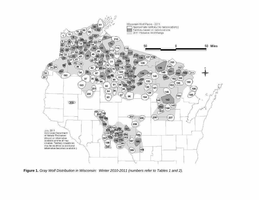
Figure 1. Gray Wolf Distribution in Wisconsin: Winter 2010-2011 (numbers refer to Tables 1 and 2).

Figure 2. Changes in Wisconsin Gray Wolf Population: 1980-2011.
25 20 23 19 18 14 15 18 26 31 34 39 45 40 5483 99
148178
204
327 335
435467
782
202
549546
704
637
248257
373
188168150141
5 5 4 5 4 4 5 5 6 7 10 12 13 12 16 20 31 35 47 57 65 70 83 94 108 113 116
198
0
'81
'82
'83
'84
'85
'86
'87
'88
'89
1990 '9
1
'92
'93
'94
'95
'96
'97
'98
'99
200
0
'01
'02
'03
'04
'05
'06
'07
'08
'09
2010 11
Related Documents

![2008 Wolf Conservation and Management Progress Report · Population Segment (DPS) of the Gray Wolf [50 CFR Part 17.84]). The new 10(j) Rule allowed states with USFWS-approved wolf](https://static.cupdf.com/doc/110x72/601f942695ddf76dca0270a8/2008-wolf-conservation-and-management-progress-report-population-segment-dps-of.jpg)