Gravel Extraction Inventory for Lower Fraser River (Mission to Hope) - 1964 to 1998 prepared for District of Chilliwack 8550 Young Road Chilliwack, British Columbia, V2P 4P1 under District of Chilliwack OP01220 by Hamish Weatherly and Michael Church Department of Geography The University of British Columbia Vancouver, British Columbia, V6T 1Z2 March 15, 1999

Welcome message from author
This document is posted to help you gain knowledge. Please leave a comment to let me know what you think about it! Share it to your friends and learn new things together.
Transcript

Gravel Extraction Inventory for Lower Fraser River(Mission to Hope) - 1964 to 1998
prepared forDistrict of Chilliwack
8550 Young RoadChilliwack, British Columbia, V2P 4P1
under District of Chilliwack OP01220
byHamish Weatherly and Michael Church
Department of GeographyThe University of British Columbia
Vancouver, British Columbia, V6T 1Z2
March 15, 1999
2
Table of Contents
1.0 INTRODUCTION .................................................................................................................. 1
2.0 INVENTORY RESULTS....................................................................................................... 2
3.0 GRAVEL REMOVAL OPERATIONS.................................................................................. 2
4.0 PRIVATE LAND.................................................................................................................... 6
5.0 SCUFFLER DREDGING....................................................................................................... 6
1
1.0 INTRODUCTION
Between Laidlaw and Sumas Mountain, Fraser River occupies a wandering gravel-bed channelthat is characterized by an irregular pattern of gravel bar deposition and channel islanddevelopment. At the present time, there is a concern that the channel bed is rising, whichincreases flood hazards and threatens the channel banks. The reach also has an exceptionallydiverse aquatic ecosystem with high economic value (in alternate years, up to two million pinksalmon use the gravel-bed reach for spawning). Any strategy to manage flood hazard mustrecognize and attempt to maintain this value. As part of the analysis of this problem, theDepartment of Geography at the University of British Columbia is using detailed survey data andhistoric airphotos to establish a sediment budget for the river. This substantially improves ourunderstanding of gravel recruitment and deposition in the reach.
In order to accurately reconstruct the historic gravel budget of the Lower Fraser River, however,past gravel removals from the river must be documented. A previous inventory of gravelremoval for the period 1973-1986 was completed by Kellerhals Engineering Services Ltd.(KESL) in 1987. Much of the information in this inventory was gathered by discussions withlocal gravel operators and representatives of the Department of Fisheries and Oceans (DFO),Provincial Ministry of Forests and Lands (the Lands function of which is now administered byBritish Columbia Assets and Land Corporation), and British Columbia Ministry ofTransportation and Highways (MOTH).
Because gravel extraction from Fraser River has been regulated since 1974 by what is nowBritish Columbia Assets and Land Corporation (BCAL), the inventory compiled by KESLappears to be a fairly accurate record. This regulatory agency requires that a provincial royaltybe paid for every cubic metre of gravel removed from crown land. This policy was initiallyrequested of the province by DFO as a means of controlling the location and volume of gravelextraction. However, these records alone do not represent a complete record of gravel removalbecause
Provincial records of gravel removal are based on volumes reported by gravel operators. Pre-and post-excavation survey information is generally not available and therefore the actualamount of gravel removed cannot be verified.
• The British Columbia Ministry of Transportation and Highways has a number of establishedgravel reserves along the Fraser River and these reserves are not subject to the regulationsimposed by BCAL. In addition, MOTH has no internal records of gravel removal.
• Gravel removal operations on private land are also not controlled by BCAL.
Fortunately since 1980 DFO has required permits for gravel extraction (due to concerns thatgravel mining may be adversely affecting fish habitat) and additional records of gravel removal,particularly from private land, are available. The effect of this policy has been to restrict permitsfor instream gravel extraction to a small number of established operations. In some cases sincethe late 1980s DFO has requested pre- and post-excavation surveys to verify removal volumes.
2
2.0 INVENTORY RESULTS
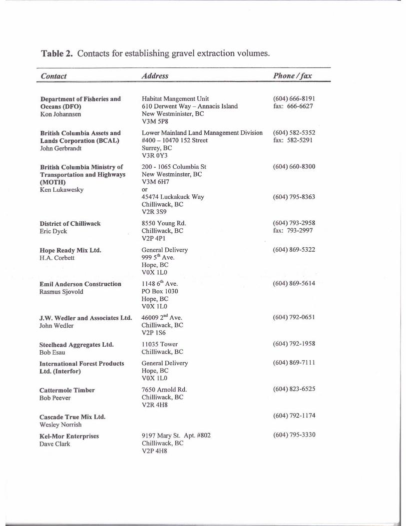
In preparing this inventory, the intent was not only to update records but also to determine if theprevious inventory was complete and whether additional information on gravel removals prior to1973 could be retrieved. In updating gravel removals to 1998, reliance was largely placed onrecords compiled by DFO and BCAL. Mr. Kon Johansen of DFO and Mr. John Gerbrandt ofBCAL were extremely helpful in this regard.
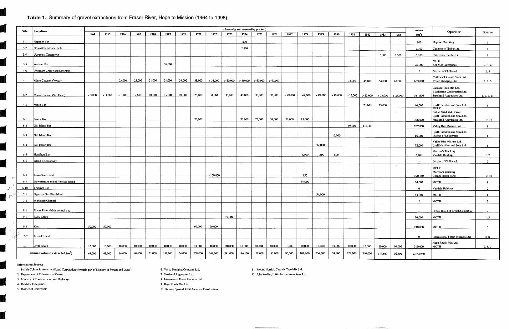
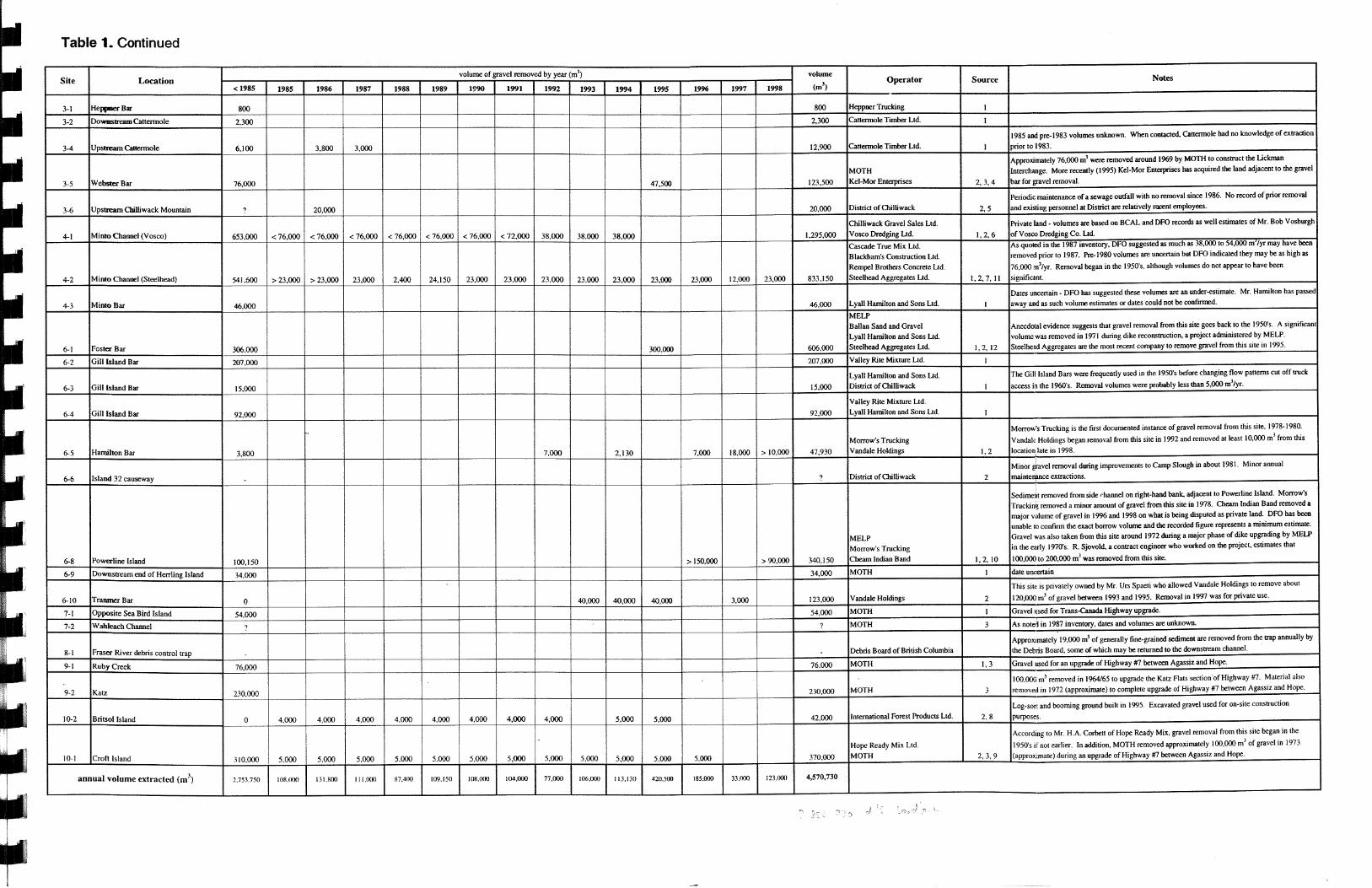
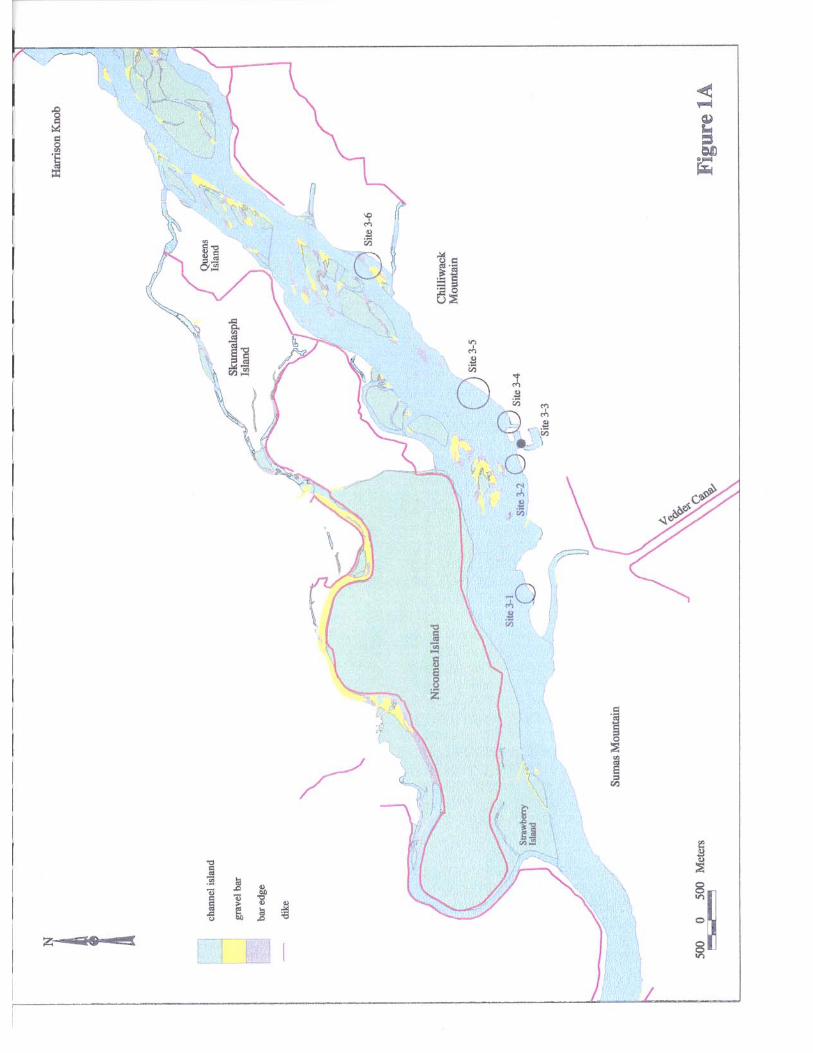
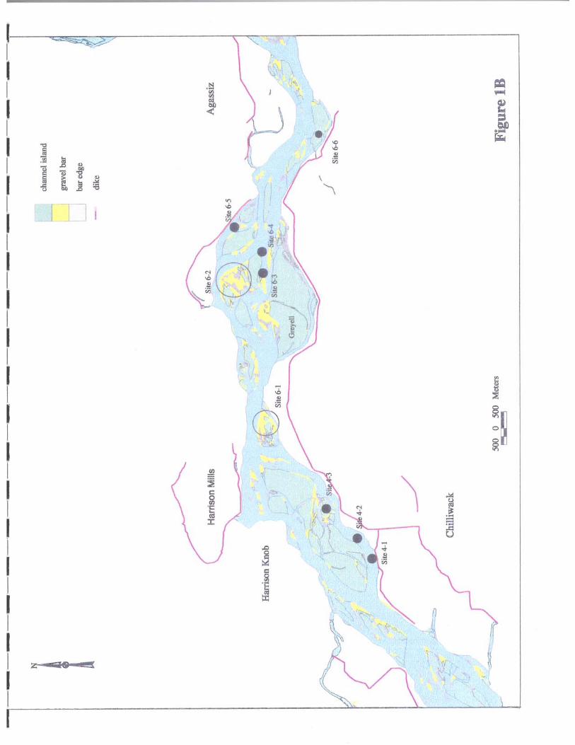
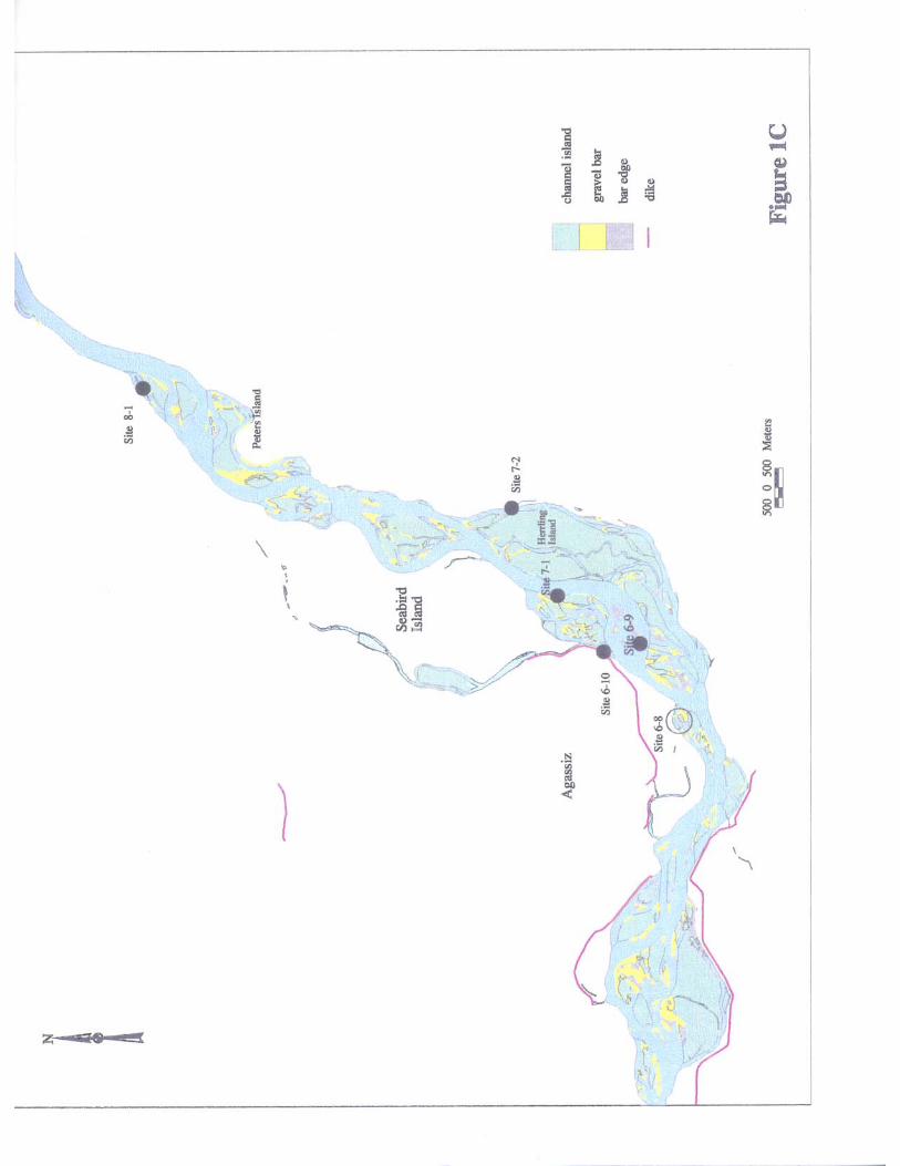
Table 1 lists known gravel removal volumes to date and the location of each site is shown onFigures 1A-D (to maintain consistency, the site numbers used in the 1987 inventory have beenretained). Included in this table are some updates to gravel removal volumes from the period1973-1986 that were discovered during the current research. For example, Mr. Ken Lukaweskyof MOTH indicated that approximately 306,000 m3 of gravel was removed from Fraser Riverbetween 1969 and 1974 during an upgrade of Highway #7 between Agassiz and Hope whilesimilar volumes were removed during dike reconstruction in the early 1970’s (see Section 3.0).Table 2 is a list of local gravel operators and government representatives that were contacted toupdate the gravel removal inventory.
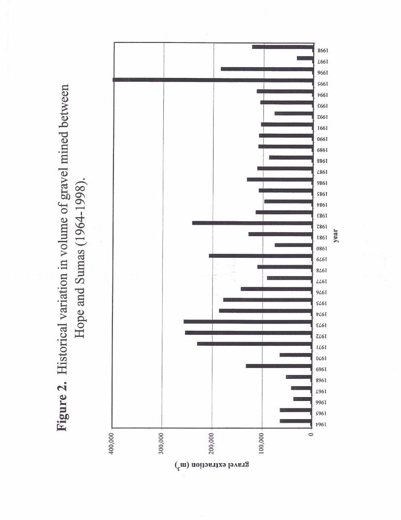
This inventory documents the removal of approximately 4,570,000 m3 of gravel since 1964 -- anaverage of 130,000 m3 per year. Figure 2 illustrates the historical variation in annual gravelremoval in the area between Hope and Sumas Mountain. Apart from two large gravel removalsin 1995 (Foster Bar) and 1996 (Powerline Island), maximum volumes of gravel removaloccurred in the 1970’s and early 1980’s. Scuffler dredge activity, to increase the depth of themainstem channel for navigation purposes, is not included in these totals as this material is notremoved from the channel (see Section 5.0). Additionally, KESL reported that 92,000 m3 ofgravel was moved in 1974 during construction of a buried pipeline upstream of the AgassizBridge (West Coast Transmission Co. Ltd.). Because the waste pile was retained within theactive channel (the sediment was stockpiled at the downstream end of the island locatedimmediately upstream of the bridge), the excavated volume is not included in this inventory.Also not included in this inventory are documented removals adjacent to Strawberry Island andMission Bar where only sand was dredged.
Information on gravel removal prior to 1974 is more difficult to obtain as the industry was notregulated and no provincial or federal records were kept. Discussions with local gravel operatorshave provided some information on historical gravel removals but the volumes documented inthis report do not represent the total amount. For example, approximate volumes of gravelremovals in Minto Channel have been documented back to the mid-1960s. However, historicalairphotos clearly show that gravel removals in this area extend back to the 1940’s (small-scaleexcavations on Minto Bar are visible on 1949 and 1954 airphotos).
3.0 GRAVEL REMOVAL OPERATIONS
At the present time, there are few active gravel removal operations on the Fraser River. Indeedthere is currently a moratorium on all gravel removal as DFO is concerned that gravel extractionwill adversely affect critical spawning and rearing habitat. However, there is an increasingdemand for this resource with rapid urbanization of the Fraser Valley. The following is a partial
3
list of gravel operations that are discussed in more detail as they have been operating for anumber of years or they represent a significant removal volume.
Vosco Dredging Company Ltd. (formerly Chilliwack Gravel Sales Ltd.), Minto Channel(Site 4-1, Figure 1B)
This is one of the oldest gravel removal sites on the Lower Fraser River and the majority ofgravel has been removed by dragline from the central portion of the channel. Gravel has alsobeen removed by bar scalping from a site located immediately downstream of the draglineexcavation. Mr. Bob Vosburgh, who owns Vosco Dredging, has been working at this site forover thirty years and in an interview with KESL he indicated that gravel removal commenced in1966 with the excavation of approximately 23,000 m3. Prior to regulation of the industry in1974, Mr. Vosburgh indicated that a number of small, unlicensed operations were removinggravel from exposed river bars throughout the study area.
Because this gravel operation is on private land, Vosco is not subject to provincial regulations.Since 1980, however, they have required a permit from DFO and a ban on dragline excavationsby DFO ended operations in 1994. A number of pre- and post-excavation surveys wereconducted for both the instream and bar scalping operations in the period 1987-1990.
Steelhead Aggregates Ltd. (formerly Cascade True Mix Ltd., Blackhams Construction Ltd.and Rempel Brothers Concrete Ltd.), Minto Channel (Site 4-2, Figure 1B)
This gravel removal site is located about 1 km upstream of Vosco Dredging and is also situatedon private land. Unlike the downstream operation, the majority of gravel has been removed bybar scalping on the south side of Minto Channel (the bar is situated downstream of a sharp bendin the channel). According to Mr. Wesley Norrish, Lyall Hamilton and Sons Ltd. and BallanSand and Gravel initially used this site in the 1950’s and early 1960’s. He estimates that removalvolumes at this time were initially modest with less than 3,000 m3 of gravel being excavatedannually. During those early years, the site was used by a number of contractors and anyonecould access the bar. In 1967, the Norrish family bought the land around Minto Landing,effectively preventing other contractors from removing gravel from the site. At this time, theyalso established a concrete business (Cascade True Mix Ltd.) and gravel removal volumesincreased significantly. According to the records of Mr. Norrish, about 7,600 m3 of gravel wasremoved in the first year of business with up to 40,000 m3 being excavated annually by the timethey sold the business in 1976. The concrete portion of the business was sold to RempelBrothers Concrete Ltd., while the rights for gravel removal were sold to Blackham’sConstruction Ltd. Both of these businesses eventually sold out to Steelhead Aggregates.
According to Mr. Bob Esau, who has been working at this site since 1972, scalped volumes weresupplemented by mid-channel dragline excavations up until about 1978. Gravel excavation atthis site is ongoing and pre- and post-excavation surveys have been conducted intermittentlysince 1987.
Steelhead Aggregates has also recently been involved in gravel extraction at Foster Bar, locatedat the entrance to Upper Minto Channel (Site 6-1, Figure 1B). According to DFO records, at
4
least 300,000 m3 of gravel was scalped from this site in 1994-1995 during low flow conditions.Foster Bar is not on private land and gravel removal is subject to provincial royalties.
On a side note, Mr. Norrish was also able to provide some insight into gravel removals in generalin the 1950’s. Between 1948 and 1956, the Norrish family removed gravel from Gill Bar(Sites 6-2 to 6-4) along with a number of other contractors. Total removals during this time weregenerally low (< 5,000 m3/yr) as the gravel was initially loaded by hand into small trucks (thetrucks could haul about 4 m3). By the 1960’s, changing flow patterns cut off access to the barand trucks could no longer drive onto the site. Foster Bar (Site 6-1) was also a common site ofgravel removal during this time but it was not used as frequently as Gill Bar.
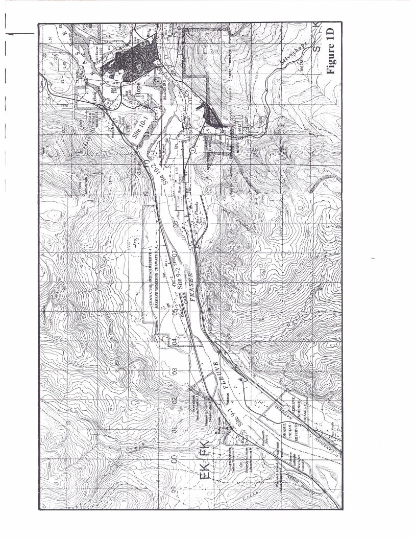
Hope Ready Mix Ltd., Croft Island (Site 10-1, Figure 1D)
Although large volumes of gravel have not been removed from this site annually, it has been inoperation since at least the 1950’s. During that time period, between 5,000 and 10,000 m3/yr ofgravel have been removed from a large bar, immediately downstream of Croft Island. The bar islocated on the right-hand side of Fraser River about 3 km downstream of Hope Bridge. Gravel atthis site is removed by bar scalping – a process that involves the use of heavy machinery to lowerthe bar surface, generally to the low water mark.
Mr. H.A. Corbett owns Hope Ready Mix Ltd. and has been working at this site since 1964.When Mr. Corbett arrived on the scene, Rutledge Gravel initially supplied gravel from the bar tohis business until he took over the gravel removal in 1968. According to Mr. Corbett, RutledgeGravel began working this site in the 1950s and gravel removal from the bar likely extends backinto the 1930s and 1940s (if not earlier) as it was a good gravel source for the town of Hope. Itis not expected that removal volumes were significant during this time, as demand would nothave been high. However, Mr. Corbett indicated that Rutledge Gravel did supply gravel to CNRail for lining tunnels through the Coquihalla.
This bar was also a major source of gravel for MOTH during an upgrade of Highway #7 between1969 and 1974. For this project, Mr. Corbett estimates that approximately 75,000 m3 of gravelwas removed from his site in 1973.
Highway #7 – Agassiz to Hope (Sites 9-1, 9-2, 9-3 and 10-1)
According to Ken Lukawesky of MOTH, approximately 306,000 m3 of gravel was dredged fromthe north side of the Fraser during an upgrade of Highway #7 between Agassiz and Hope. Theupgrade occurred over a period of several years from 1969 to 1974. This estimated volume doesnot include the 100,000 m3 of gravel removed in 1964-65 to construct the Katz Flats section ofthis highway (Site 9-2, Figure 1D). This earlier construction phase was handled by MOTHpersonnel while the later phase was contracted out. Unfortunately, Mr. Lukawesky was unableto give exact locations for the larger gravel removal. However, we were able to contact a roadengineer (Mr. Rasmus Sjovold of Emil Anderson Contracting Co. Ltd.) who worked on thisproject for Catree Construction. By his recollection, gravel was removed from three locations:Ruby Creek (Site 9-1), Katz Flats (Site 9-2) and immediately downstream of Croft Island(Site 10-1).
5
A portion of this larger removal was accounted for in the 1987 inventory with the recordedremoval of 76,000 m3 from Ruby Creek in 1973. In addition, Mr. Corbett of Hope Ready MixLtd. has estimated that MOTH removed about 100,000 m3 from his site downstream of CroftIsland for the highway upgrade. For the purposes of this inventory, the remaining volume(130,000 m3) has been allocated to Site 9-2, Katz Flats.
It should also be noted that the 1987 inventory has a recorded removal of 111,000 m3 from theFraser River Debris Control Trap (Site 8-1, Figure 1C) in 1977-78. This estimate was providedby Mr. Frank Csizmadia of the Ministry of Forest and Lands who indicated that the gravel wasused by MOTH. However, Mr. Csizmadia was unsure of the date of gravel removal. Becausethis site is adjacent to Highway #7, this recorded volume is most likely a reference to theconstruction that occurred between 1969 and 1974. As such, this removal volume has not beenrecorded in this updated inventory nor has this site been included as a removal site.
Dike Upgrades in the Early 1970’s (Sites 6-1, 6-8 and ?)
In the early 1970’s (1971 to 1974), MELP secured significant funding to upgrade dikes in theLower Fraser Valley. This work generally involved building the dikes up with gravel (the dikesrequired widening) and facing them with riprap. MELP administered the construction contractsand a number of local firms were involved in the process. Unfortunately, as MELP contractedthe work out, there are no provincial records of gravel removal. We were able to contact aformer MELP employee, Mr. Bob Edwards, who oversaw the various contracts. Mr. Edwardshas no recollection of removal volumes but he was aware of gravel being removed from HarrisonBar, Foster Bar (Site 6-1), and Powerline Island (Site 6-8) for the dike upgrades and fromGreyell Slough for construction of a wing dam (Figure 1B).
In the study area, contracts for the engineering of the dike reconstruction were awarded to twocompanies. Willis, Cunliffe and Tait secured the contract for dike upgrades on the south side ofthe river from Chilliwack Mountain to Rosedale. Mr. John Wedler, the principal of J.W. Wedlerand Associates, worked for Willis, Cunliffe and Tait at this time and he recollects that about76,000 m3 of gravel was removed from Foster Bar between 1971 and 1973 for the dike work.Emil Anderson Construction was sub-contracted to do the construction and a former foremansupervisor, Mr. Alec Nichol, recollects additional gravel removal (bar scalping) from a siteimmediately upstream of the Agassiz-Rosedale bridge on the left hand side. However, Mr.Nichol was unable to provide an estimate of gravel removal from this site.
The contract for the north side of the river, between Harrison Mills and Seabird Island, wassecured by Catree, a company formed by Bob Cattermole and Tretheway. Mr. Rasmus Sjovoldworked for Catree on this project and he estimates that approximately 100,000 to 200,000 m3 ofgravel was taken from Powerline Island (Site 6-8) for some of the upgrades. Gravel was alsoprobably removed from Harrison Bar, located at the confluence of Harrison River and FraserRiver, for upgrades around Harrison Mills. Unfortunately, both of the principals of Catree havepassed away and removal volumes can not be estimated at this time.
6
4.0 PRIVATE LAND
As previously noted, there are several sites along Fraser River that are private land and graveloperations at these locations are not subject to provincial regulations. This list includesSteelhead Aggregates Ltd. and Vosco Dredging Company Ltd. in Minto Channel as well asTranmer Bar – a site owned by Mr. Spaeti who allowed Vandale Holdings to extract gravel in1993, 1994 and 1995 (Site 6-10, Figure 1C).
The question is how are these sites within the main channel of the river privately owned? Thisproblem extends back to the end of the 19th century when land titles were handed out. Becausethe river is constantly changing its course, portions of some of these properties have been erodedaway and are now part of the main channel. However, they are still considered private propertyunder their original property line.
5.0 SCUFFLER DREDGING
Since 1950 there has been a dramatic increase in boat traffic between Mission and Hope. Mostof this activity is related to the forestry industry as the river provides cost-effective transportationfor wood products. Public Works Canada maintains a navigation channel along Lower FraserRiver, which requires annual dredging as the river naturally tends to form riffles. Thismaintenance dredging is carried out using a scuffler dredge, a device that drags sediment awayfrom shallow spots in the channel and deposits it along the margins of the navigation channel orwithin deeper pools. Since the sediment remains in the active channel, dredged volumes havenot been included in this report. KESL reported that the annual volume of gravel moved byscuffler dredge in the study area varied between 54,000 and 82,000 m3 in the period 1979 to1986.
Because few boats used the Sumas to Hope reach of Fraser River prior to 1950, Public Workswas initially not very active in this reach. When demand for a navigation channel grew, gravelwas moved using the scuffler dredge. However, Public Works was involved in limited dredgingbefore this time and the records are ambiguous as to whether the gravel was simply moved toanother area of the channel or onto shore. Records indicate that 58,000 m3 was dredged by clam-shell adjacent to Chilliwack Mountain in 1944-451. Also between 1914 and 1922, approximately190,000 m3 was hydraulically dredged from Nicomen Bar to relieve pressure against NicomenIsland where banks were being heavily eroded. A similar volume was removed by drag-linefrom this bar but the records clearly indicate that this gravel was retained within the channel.
6.0 MAINTENANCE DREDGING
There are a number of sites where small-scale maintenance dredging is required to removeannual accumulations of generally fine-textured sediments. Cattermole Timber operates adryland sort and booming ground downstream of Chilliwack Mountain (Site 3-3, Figure 1A).Cattermole has indicated that dredging of the entrance is required every few years due toexcessive accumulations of sand and silt. In the past (1974, 1983-1987), they have dredged 1 Fraser River System History of Improvements 1871 to 1948, Public Works Canada, July 1949.
7
gravel from the main channel with the material being used onsite for construction purposes asnoted in Table 1.
A similar situation is found on the downstream side of Bristol Island where International ForestProducts Ltd. (Interfor) also operates a dryland sort and booming ground (Site 10-2, Figure 1D).This facility was constructed in 1985 and because it is situated in a “slack” water area, dredgingof sand and silt-sized sediment is required every three to four years to maintain boat access. Inaddition to this maintenance dredging, Interfor has mined an adjacent gravel bar for onsiteconstruction purposes. According to DFO, BCAL and Interfor records, approximately 50,000 m3
of gravel was removed between 1985 and 1995.
The District of Chilliwack undertakes periodic removal of sediment deposited adjacent to asewer outfall located upstream of Chilliwack Mountain (Site 3-6, Figure 1A). According to Mr.Eric Dyck, Superintendent of Facilities, clean-up of this outfall last occurred in about 1986although there is no record of volume removed. According to the records of Kon Johansen(DFO), however, approximately 20,000 m3 of sediment was dredged at this time. There is norecord of sediment removal at this site prior to 1986. A new outfall was constructed severalhundred metres downstream of the old site in 1995 but sediment removal has not been requiredas of yet.
The largest annual maintenance operation is located at the Fraser River Debris Control Trap(Site 8-1, Figure 1C), which has been in operation since the 1970’s. According to KESL records,approximately 19,000 m3 of sediment are removed annually from this site. The dredged materialis predominantly sand and silt with a minor gravel component (< 10 percent). Because some ofthis material is returned to the downstream channel and the gravel component is minor, thesevolumes have not been included in Table 1.
7.0 FLOOD OF 1948
The possibility that gravel from Fraser River was used during the flood of 1948 was investigatedduring the preparation of this inventory. The 1948 flood is one of the largest floods on recordand it affected much of the Lower Fraser Valley. In response to extremely high water levelsassociated with rapid spring melting, an Emergency Flood Committee was established inChilliwack for the period May 27 – June 16, 1948. In the District of Chilliwack, this floodcommittee was assisted by the Canadian Army which took over the direction of flood operationson June 1st. During this time period, the existing dike system failed at several locations and amajority of the work consisted of repairing failures and reinforcing the dikes with sand bags.This work was complicated by the general disrepair of the dikes, which had become overgrownwith brush and trees. Additionally, in some areas the dikes had been constructed over a woodentrestle frame, that had rotted over time.
During this time period, gravel was used to fill the sand bags and all dike road surfaces weregravelled to permit vehicle access. The sand bags were used not only to reinforce the dikes butalso for road fills – many of the approach roads to the dikes passed through slough beds and were
8
under three to six feet of water. Records from the Chilliwack Archives indicate that the gravelcame from four pits2:
• The Keith Wilson Pit on Vedder River, which was already operating as a municipal gravelpit.
• A pit was opened at the Royal Canadian School of Military Engineering. This pit wassituated on Kieth Wilson Road, with gravel extraction from the fan of Vedder River.
• Jesperson Pit was opened on the Jesperson farm, which is located on the left-hand side ofFraser River immediately upstream of Carey Point. This pit was capable of producing3,800 m3 of gravel on two eight hour shifts.
• The McGrath Pit at Rosedale was a private pit and removed gravel from the contemporaryfloodplain.
Of the four pits, the Jesperson Pit is the only pit from which gravel might have been removeddirectly from Fraser River. However, the records are ambiguous as to whether a pit wasestablished on the floodplain or whether gravel was removed by dragline from the river. Therecords indicate that four bulldozers, two draglines and one shovel were used at the site. Assuch, it is probable that the bulldozers and shovel were used to remove gravel from thefloodplain while the draglines may have extracted gravel from the river (this may have been adifficult task, however, given the height of the river). If we assume that this pit was in fulloperation for about 14 days and that half the gravel was being removed from the river,approximately 26,000 m3 of gravel may have been removed from Fraser River.
Following the flood, the Government of Canada and the Government of British Columbiaestablished the Fraser Valley Dyking Board. The mandate of this board was to repair, strengthenand reconstruct the dikes in the Fraser River and remove water and debris from the flooded land.Approximately $10,000,000 was allocated to the board with the majority of the work to becompleted within two years.
A final report prepared by the board gives some information of possible gravel removal fromFraser River3. A majority of original dikes in the Valley had been built by building a ditch orborrow pit parallel to the dike on the land side and using the material to form the dike. However,these ditches were too close to the dike, inducing seepage through the dikes and weakening thestructure at the toe. During the flood of 1948 many of the failures were directly attributed to thissituation. As such, one of the mandates of the board was to fill in all of these ditches(approximately 110 km of ditches throughout the Valley had to be filled). A majority of theseditches were filled in by hydraulic dredge, using material from Fraser River.
2 Chilliwack Archives. Chilliwack Emergency Flood Committee Report of Operations. June, 1948. Add.MSS. 654.
3 Final Report on the Activities of Fraser Valley Dyking Board from its inception on July 22nd 1948 to March 1st
1950. Fraser Valley Dyking Board. March 15th 1950.
9
The report does not give specific volumes dredged at each site but it does include the cost ofhydraulic dredging (including average cost per m3) as well as a figure showing the location ofdredging. In our study area, there are two areas where dredging occurred:
At East and West Nicomen Islands, $15,209 was spent on hydraulic dredge filling. At anaverage cost of $0.33/m3, this works out to about 46,000 m3 of dredged material. Since only halfof the dike system around Nicomen Island is on the Fraser River side, approximately 23,000 m3
of sediment would have been dredged from Fraser River. Because about 20% of the instreamsediment is sand-sized, this value must be adjusted by a factor of 0.8 to represent the gravelfraction only ( ~ 18,000 m3). The other half of the diking system faces Nicomen Slough and it isassumed sediment would have been dredged from the slough, which is not of interest for ourcalculations since it is isolated from Fraser River sediment inputs
The second area is in the vicinity of the confluence of Sumas River with Vedder Canal. Thefigure shows that hydraulic dredging occurred alongside the dike extending east from theconfluence. Because of its closer proximity, sediment for these ditches was probably dredgedfrom Sumas River. As such it is outside our area of interest.
Mr. Wesley Norrish worked in the gravel industry at this time and he recalls that in excess of100,000 m3 of gravel was dredged from Fraser River for dike repairs. However, he was unableto provide exact locations or a more reliable estimate as a number of contractors were involvedin the dike repairs.
8.0 LIMITATIONS OF INVENTORY
This updated inventory represents an attempt to record the majority of gravel removals that haveoccurred over the past fifty years. However, there are a number of limitations to this survey:
• Gravel removal from the 1950’s and 1960’s is very difficult to establish. Prior to regulationof the industry in 1974, Mr. Bob Vosburgh of Vosco Dredging has noted that a number ofsmall, unlicensed operations were removing gravel from exposed river bars throughout thestudy area. Records do not exist for these removals and many of the people involved in theindustry during this time period have either passed away or are no longer in the area. Forexample, gravel extraction in Minto Channel has been established back to the mid 1960’s.However, small-scale extractions are visible on airphotos from 1954. Although there are norecords of these excavations, demand during the 1950’s and 1960’s would have been muchless than it is today.
• There is a certain degree of uncertainty regarding removal volumes from Minto Channel.Vosco Dredging and Steelhead Aggregates extract gravel from private land in this sidechannel which, as noted, is not subject to provincial regulations. As a result, removalvolumes are based on estimates from the gravel operators and the estimates of DFO andBCAL representatives. These estimates do not always agree and the removal volumes forsome years have upper or lower limits (Table 1). However, the upper and lower limits maywell cancel each other out, giving a fairly reliable estimate of gravel removal.
10
• Records of gravel removal from MOTH have been extremely difficult to gather. This hasresulted not only from a lack of proper documentation but also a difficulty in establishingcontacts with relevant personnel who would be able to provide approximate volumeestimates. For example, the 1987 inventory notes that sediment was removed fromWahleach Channel but MOTH has been unable to provide a date or volume estimate for thisextraction. In addition, Frank Csizmadia of the Ministry of Forestry and Lands (1987inventory) had knowledge of gravel removals by MOTH at the downstream end of HerrlingIsland (Site 6-9) and opposite Sea Bird Island (Site 7-1). However, MOTH has been unableto account for these removals. Despite these limitations, two of the larger projects in the areahave been accounted for. Gravel removals for construction of Highway #7 between Agassizand Hope have been recorded. In addition, we were able to contact a former employee whowas involved in the construction of Highway #1 in the Lower Fraser Valley in the late 1950’sand early 1960’s. According to Mr. Gordon Vance, material for this constructionpredominantly came from two sources. For construction of the highway west of LickmanInterchange, gravel was removed from Evans Pit – a gravel pit located on the west side ofVedder Canal. For areas further east, the gravel came from Bailey Pit, which has since beenconverted into a municipal dump. Mr. Vance had no knowledge of Fraser River gravelremovals during this major construction project.
There is little doubt that the total recorded volume of gravel extraction in Table 1 represents aminimum estimate. However, the province has regulated the industry since 1974 and DFO hasrequired an additional permit since 1980. As such, the post 1974 inventory appears to representa relatively complete record of removal volumes. Discussions with local operators did notuncover additional gravel removals that were unrecorded by the representatives of these twogovernment agencies. The greatest uncertainty remains in the period prior to 1974.
Related Documents


