F F F I I I N N N A A A L L L E E E N N N V V V I I I R R R O O O N N N M M M E E E N N N T T T A A A L L L I I I M M M P P P A A A C C C T T T A A A S S S S S S E E E S S S S S S M M M E E E N N N T T T A A A N N N D D D E E E N N N V V V I I I R R R O O ON N N M M M E E E N N N T T T A A A L L L M M M A A A N N N A A A G G G E E E M M M E E E N N N T T T P P P L L L A A A N N N O O O F F F M M M A A A N N N G G G U U U W W WA A A L L L S S S A A A N N N D D D M M M I I I N N N I I I N N N G G G P P P R R R O O OJ J J E E E C C C T T T Village: Manguwal, Tehsil: Rupnagar, District: Rupnagar, State: Punjab Area: 16.48 ha, Proposed Capacity: 20,000 TPA A A A P P P P P P L L L I I I C C C A A A N N N T T T DEPARTMENT OF INDUSTRIES AND COMMERCE Government of Punjab Chandigarh P P P r r r e e e p p p a a a r r r e e e d d d B B B y y y GRASS ROOTS RESEARCH & CREATION INDIA (P) LTD. (An ISO 9001:2008 Certified Co.: Accredited by QCI / NABET: Approved by MoEF, GoI) F-374-375, Sector-63, Noida, U.P. Ph.: 0120- 4044630, Telefax: 0120- 2406519 Email: eia@grc-india.com, [email protected] Website: http://www.grc-india.com GRC INDIA TRAINING & ANALYTICAL LABORATORY (Accredited by NABL & Recognized by MoEF, GoI) A unit of GRC India

Welcome message from author
This document is posted to help you gain knowledge. Please leave a comment to let me know what you think about it! Share it to your friends and learn new things together.
Transcript
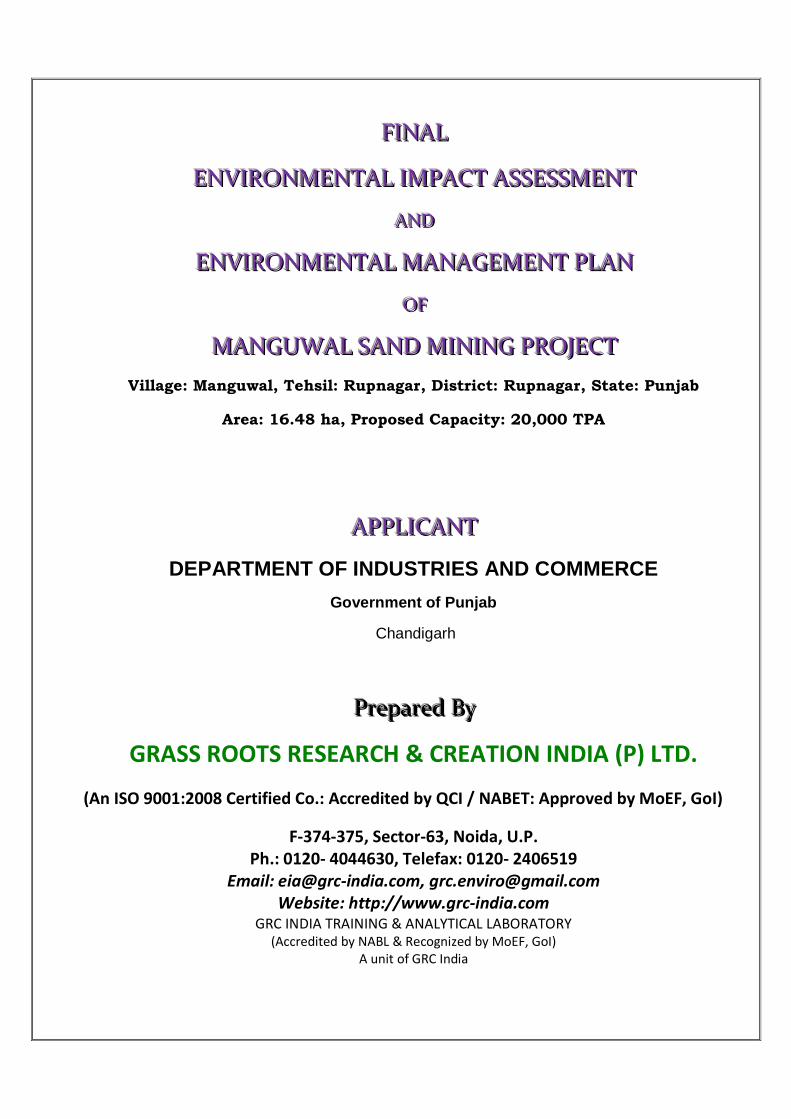
FFFIIINNNAAALLL
EEENNNVVVIIIRRROOONNNMMMEEENNNTTTAAALLL IIIMMMPPPAAACCCTTT AAASSSSSSEEESSSSSSMMMEEENNNTTT
AAANNNDDD
EEENNNVVVIIIRRROOONNNMMMEEENNNTTTAAALLL MMMAAANNNAAAGGGEEEMMMEEENNNTTT PPPLLLAAANNN
OOOFFF
MMMAAANNNGGGUUUWWWAAALLL SSSAAANNNDDD MMMIIINNNIIINNNGGG PPPRRROOOJJJEEECCCTTT
Village: Manguwal, Tehsil: Rupnagar, District: Rupnagar, State: Punjab
Area: 16.48 ha, Proposed Capacity: 20,000 TPA
AAAPPPPPPLLLIIICCCAAANNNTTT
DEPARTMENT OF INDUSTRIES AND COMMERCE
Government of Punjab
Chandigarh
PPPrrreeepppaaarrreeeddd BBByyy
GRASS ROOTS RESEARCH & CREATION INDIA (P) LTD.
(An ISO 9001:2008 Certified Co.: Accredited by QCI / NABET: Approved by MoEF, GoI)
F-374-375, Sector-63, Noida, U.P.Ph.: 0120- 4044630, Telefax: 0120- 2406519
Email: [email protected], [email protected]: http://www.grc-india.com
GRC INDIA TRAINING & ANALYTICAL LABORATORY(Accredited by NABL & Recognized by MoEF, GoI)
A unit of GRC India
INDEX
Serial No. CONTENTS Page No.
INTRODUCTION
1.0 PURPOSE OF THE REPORT 2/I
1.1 IDENTIFICATION OF PROJECT PROPONENT 2/I
1.2 BRIEF DESCRIPTION OF PROJECT 3/I
1.3REGULATORY COMPLIANCES & APPLICABLELAWS/REGULATIONS
4/I
1.4 SCOPE OF THE STUDY 4/I
PROJECT DESCRIPTION
2.0 GENERAL 2/II
2.1 DESCRIPTION OF THE PROJECT 2/II
2.2 NEED FOR THE PROJECT 2/II
2.3 LOCATION DETAILS 2/II
2.4 LEASE HOLD AREA 3/II
2.5 GEOLOGY 3/II
2.6 RESERVES 4/II
2.7 MINING 5/II
2.8 GENERAL FEATURES 7/II
DESCRIPTION OF ENVIRONMENT
3.0 INTRODUCTION 2/III
3.1 LAND ENVIRONMENT 2/III
3.2 AIR ENVIRONMENT 3/III
3.3 WATER ENVIRONMENT 8/III
3.3 (a) GROUND WATER 8/III
3.3 (b) SURFACE WATER 13/III
3.4 SOIL ENVIRONMENT 17/III
3.5 NOISE ENVIRONMENT 19/III
3.6 TRAFFFIC STUDY 20/III
3.7 BIOLOGICAL ENVIRONMENT 21/III
ANTICIPATED ENVIRONMENTAL IMPACT AND MITIGATION MEASURES
4.0 GENERAL 2/IV
4.1 LAND ENVIRONMENT 2/IV
4.2 WATER ENVIRONMENT 7/IV
4.3 AIR ENVIRONMENT 8/IV
4.4 NOISE ENVIRONMENT 11/IV
4.5 BIOLOGICAL ENVIRONMENT 13/IV
4.6 TRAFFIC ANALYSIS 17/IV
4.7 OVERALL IMPACT OF THE PROPOSED PROJECT 18/IV
4.8 STATUTORY REQUIREMENTS 19/IV
ENVIRONMENTAL MONITORING PROGRAMME
5.0 INTRODUCTION 2/V
5.1 PROPOSED SET UP 2/V
5.2 MONITORING SCHEDULE AND PARAMETERS 3/V
ADDITIONAL STUDIES
6.0 PUBLIC CONSULTATION 2/VI
6.1 HAZARD IDENTIFICATION AND RISK ASSESSMENTMETHOLODOGY
4/VI
6.2 POTENTIAL HAZARD & ‘ALARP’ CONDITION 9/VI
6.3 RISK PRIORITISATION BASED ON HAZARDS 9/VI
6.4 ADDITIONAL MITIGATION MAJORS TO BRING HAZARDS UNDER“ALARP” ZONE
11/VI
6.5 NATURAL RESOURCE CONSERVATION 13/VI
6.6 SOCIAL IMPACT ASSESMENT, REHABILITATION &
RESETTLEMENT (R&R) ACTION PLAN
13/VI
6.7 SUGGESSTION 25/VI
6.8 CONCLUSION 26/VI
PROJECT BENEFITS
7.0 GENERAL 2/VII
7.1 BENEFITS OF MINING 2/VII
7.2 EMPLOYMENT 2/VII
7.3 IMPROVEMENTS IN PHYSICAL AND SOCIAL
INFRASTRUCTURE
2/VII
7.4 HEALTH 3/VII
ENVIRONMENTAL MANAGEMENT PLAN
8.0 INTRODUCTION 2/VIII
8.1 ENVIRONMENTAL MANAGEMENT PLAN (EMP) 2/VIII
8.2 ENVIRONMENTAL MANAGEMENT PLAN IMPLEMENTATION 3/VIII
8.3 PROPOSED SET UP 4/VIII
8.4BU BUDGET ALLOCATION FOR EMP IMPLEMENTATION 4/VIII
8.5 MONITORING SCHEDULE AND ACTIVITIES 5/VIII
8.6 DIVISION OF RESPONSIBILITY 6/VIII
EXECUTIVE SUMMARY
9.1 INTRODUCTION OF PROJECT & PROPONENT 2/IX
9.2 LOCATION 2/IX
9.3 RESERVES 2/IX
9.4 MINING PROCESS 3/IX
9.5 WATER SUPPLY 3/IX
9.6 BASE LINE DATA 3/IX
9.7 BIOLOGICAL ENVIRONMENT 5/IX
9.8 LAND ENVIRONMENT 8/IX
9.9 AIR ENVIRONMENT 9/IX
9.10 WATER ENVIRONMET 10/IX
9.11 NOISE ENVIRONMENT 10/IX
9.12 TRAFFIC ANALYSIS 11/IX
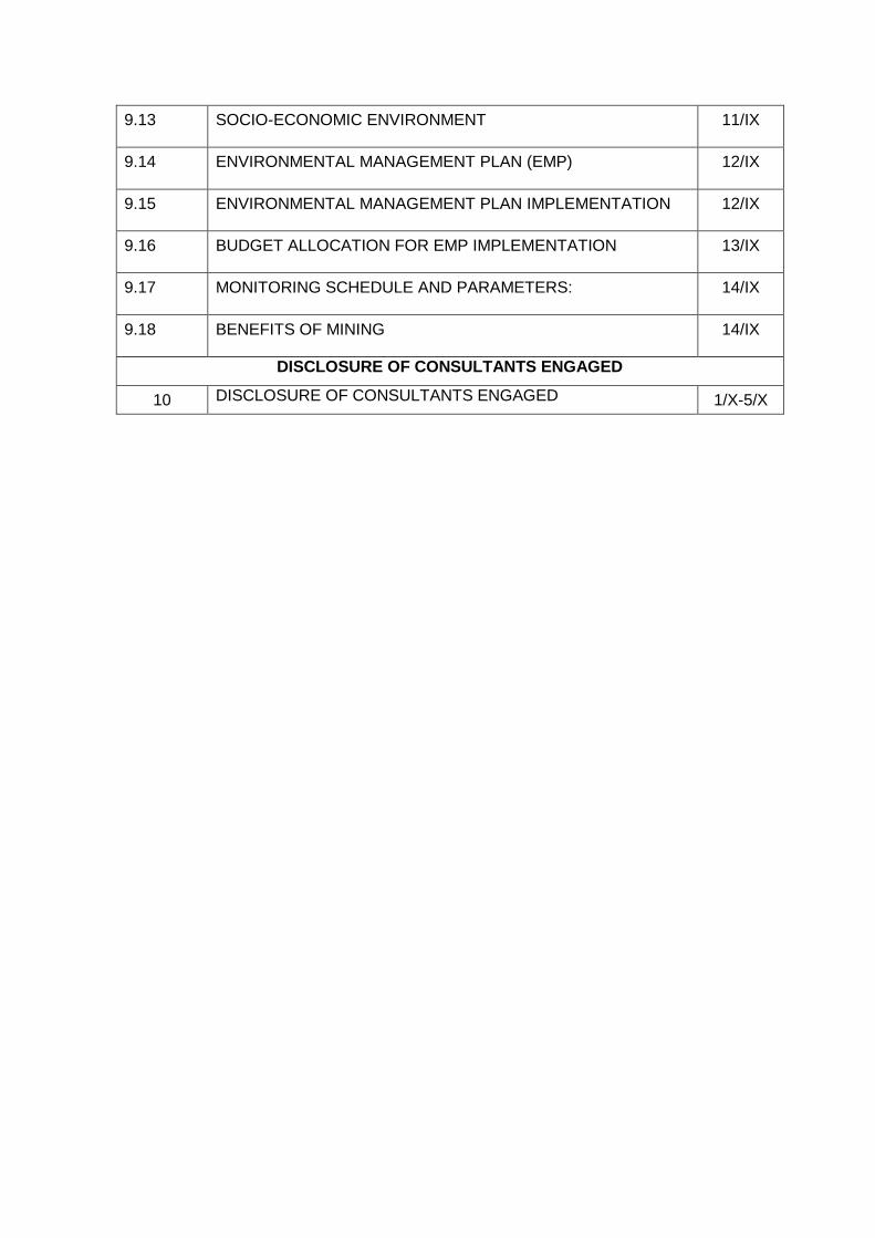
9.13 SOCIO-ECONOMIC ENVIRONMENT 11/IX
9.14 ENVIRONMENTAL MANAGEMENT PLAN (EMP) 12/IX
9.15 ENVIRONMENTAL MANAGEMENT PLAN IMPLEMENTATION 12/IX
9.16 BUDGET ALLOCATION FOR EMP IMPLEMENTATION 13/IX
9.17 MONITORING SCHEDULE AND PARAMETERS: 14/IX
9.18 BENEFITS OF MINING 14/IX
DISCLOSURE OF CONSULTANTS ENGAGED
10 DISCLOSURE OF CONSULTANTS ENGAGED 1/X-5/X
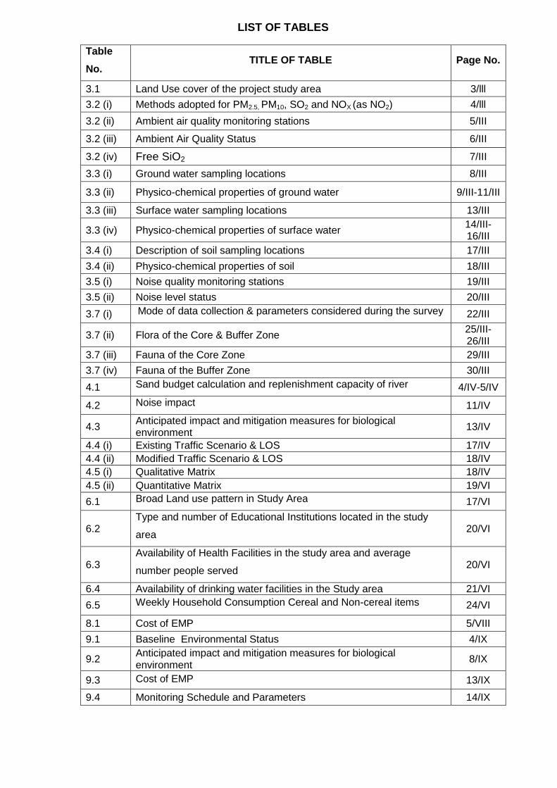
LIST OF TABLES
Table
No.TITLE OF TABLE Page No.
3.1 Land Use cover of the project study area 3/lll
3.2 (i) Methods adopted for PM2.5, PM10, SO2 and NOX (as NO2) 4/lll
3.2 (ii) Ambient air quality monitoring stations 5/III
3.2 (iii) Ambient Air Quality Status 6/III
3.2 (iv) Free SiO2 7/III
3.3 (i) Ground water sampling locations 8/III
3.3 (ii) Physico-chemical properties of ground water 9/III-11/III
3.3 (iii) Surface water sampling locations 13/III
3.3 (iv) Physico-chemical properties of surface water14/III-16/III
3.4 (i) Description of soil sampling locations 17/III
3.4 (ii) Physico-chemical properties of soil 18/III
3.5 (i) Noise quality monitoring stations 19/III
3.5 (ii) Noise level status 20/III
3.7 (i) Mode of data collection & parameters considered during the survey 22/III
3.7 (ii) Flora of the Core & Buffer Zone25/III-26/III
3.7 (iii) Fauna of the Core Zone 29/III
3.7 (iv) Fauna of the Buffer Zone 30/III
4.1 Sand budget calculation and replenishment capacity of river 4/IV-5/IV
4.2 Noise impact 11/IV
4.3Anticipated impact and mitigation measures for biologicalenvironment
13/IV
4.4 (i) Existing Traffic Scenario & LOS 17/IV
4.4 (ii) Modified Traffic Scenario & LOS 18/IV
4.5 (i) Qualitative Matrix 18/IV
4.5 (ii) Quantitative Matrix 19/VI
6.1 Broad Land use pattern in Study Area 17/VI
6.2Type and number of Educational Institutions located in the study
area20/VI
6.3Availability of Health Facilities in the study area and average
number people served20/VI
6.4 Availability of drinking water facilities in the Study area 21/VI
6.5 Weekly Household Consumption Cereal and Non-cereal items 24/VI
8.1 Cost of EMP 5/VIII
9.1 Baseline Environmental Status 4/IX
9.2Anticipated impact and mitigation measures for biologicalenvironment
8/IX
9.3 Cost of EMP 13/IX
9.4 Monitoring Schedule and Parameters 14/IX
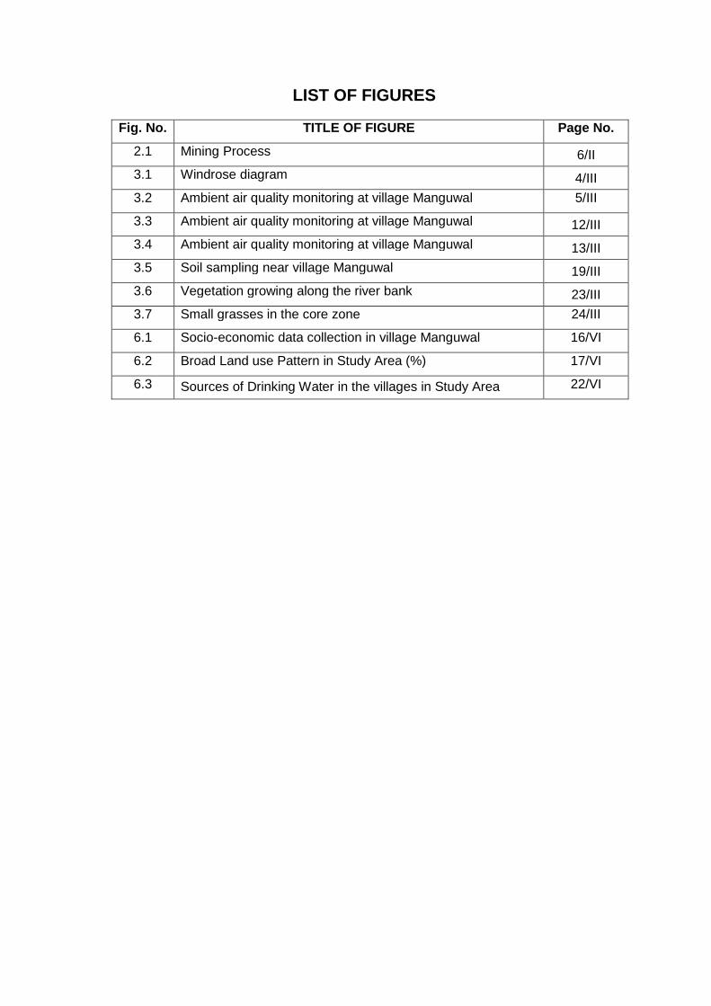
LIST OF FIGURES
Fig. No. TITLE OF FIGURE Page No.
2.1 Mining Process 6/II
3.1 Windrose diagram 4/III
3.2 Ambient air quality monitoring at village Manguwal 5/III
3.3 Ambient air quality monitoring at village Manguwal 12/III
3.4 Ambient air quality monitoring at village Manguwal 13/III
3.5 Soil sampling near village Manguwal 19/III
3.6 Vegetation growing along the river bank 23/III
3.7 Small grasses in the core zone 24/III
6.1 Socio-economic data collection in village Manguwal 16/VI
6.2 Broad Land use Pattern in Study Area (%) 17/VI
6.3 Sources of Drinking Water in the villages in Study Area 22/VI
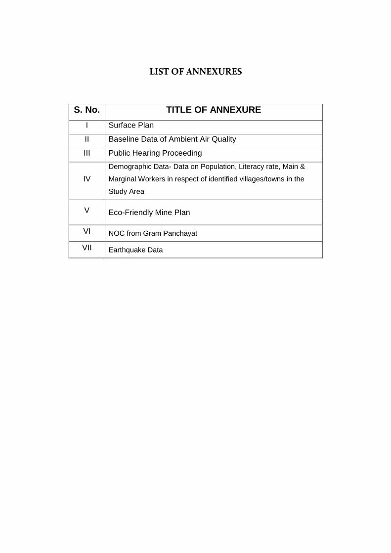
LIST OF ANNEXURES
S. No. TITLE OF ANNEXURE
I Surface Plan
II Baseline Data of Ambient Air Quality
III Public Hearing Proceeding
IV
Demographic Data- Data on Population, Literacy rate, Main &
Marginal Workers in respect of identified villages/towns in the
Study Area
V Eco-Friendly Mine Plan
VI NOC from Gram Panchayat
VII Earthquake Data
ABBREVIATIONS
EIA Environmental Impact Assessment
EMP Environment Management Plan
MoEF Ministry of Environment and Forest
TOR Term of Reference
EAC Expert Appraisal Committee
SEAC State Expert Appraisal Committee
SPCB State Pollution Control Board
CPCB Central Pollution Control Board
NOC No Objection Certificate
bgl Below Ground Level
GLC Ground Level Concentration
NH National Highway
SH State Highway
dB Decibel
Leq Equivalent Noise Level
Ha Hectare
UNFC United Nations Framework Classification
HFL High Flood Level
LFL Low Flood Level
KLD Kilo litre Per Day
T/cum Tons Per Cubic Meter
Km Kilo Meter
RL River Level
EPA The Environment Protection Act
Ham Hectare Meter
BOD Biochemical Oxygen Demand
DO Dissolved Oxygen
COD Chemical Oxygen Demand
TKN Total Kjeldahl Nitrogen
PM Particulate Matter
AAQ Ambient Air Quality
TPA Tonnes Per Annum
R & R Rehabilitation & Resettlement
CSR Corporate Social Responsibility
VWG Village Working Group
EMC Environmental Management Cell
DIC Department of Industries and Commerce
RBM River Bed Material
GoP Government of Punjab
NGO Non Governmental Organisation
PCU Passenger Car Unit
LOS Level of Service
PUC Pollution Under Control
NABET National Accreditation Board for Education and Training
QCI Quality Council of India
OSHA Occupational Safety and Health Administration
Project Name: Manguwal Sand Mine, Punjab Final EIA/EMP Section - I: Introduction
Page 1/I
SECTION-I
INTRODUCTION
INDEX
S. No. CONTENTS Page No.
1.0 PURPOSE OF THE REPORT 2/I
1.1 IDENTIFICATION OF PROJECT PROPONENT 2/I
1.2 BRIEF DESCRIPTION OF PROJECT 3/I
1.3REGULATORY COMPLIANCES & APPLICABLE
LAWS/REGULATIONS4/I
1.4 SCOPE OF THE STUDY 4/I
Project Name: Manguwal Sand Mine, Punjab Final EIA/EMP Section - I: Introduction
Page 2/I
1.0 PURPOSE OF THE REPORT
Environmental Impact Assessment (EIA) is a decision making tool, in the hands of the
Authorities which brings forth the factual position about a project that enables them in
arriving at an appropriate conclusion for the proposed projects, to retain them if
environmentally sound, and reject if found having deleterious overall impact. EIA identifies
the extent of the environmental, social and economic impacts of a project prior to decision-
making. EIA systematically examines both beneficial and adverse impacts of the proposed
project over and above the prevailing conditions of environmental parameters and ensure
that these impacts are taken into account during the project designing stage itself and the
values of the combined impacts are never allowed to exceed and remain within the statutory
norms. This process has been envisioned and set in motion by the Ministry of Environment
and Forests for sustainable development and the final decision is arrived at only, when those
who matter are made known of the salient features of the project being envisaged close to
them and their opinion has been sought in a widely advertised Public Hearing Event under
the chairmanship of the district authorities so that public could also express their opinion
free, without favour and fear.
A Draft Environmental Impact Assessment report was prepared to comply with the Terms of
Reference (TOR) received from MoEF under EIA notification of the MoEF dated 14-9-2006,
as amended on 1st Dec 2009 & 4th April 2011 and also the EIA Guidance Manual for Mining
of Minerals (Feb, 2010) of MoEF, Govt. of India, for seeking environmental clearance for
mining of sand in the applied mining lease area measuring 16.48 hectares falling under
category “A” due to the presence of interstate boundary of Himachal Pradesh and Punjab
and Ropar Wetland within 10 km radius of the project site. The mining lease area lies near
Village: Manguwal, Taluka: Rupnagar, District: Rupnagar, Punjab. The public hearing was
held on 10th Feb., 2012 at village Manguwal and the points raised in the PH along with the
compliance report of the project proponent has been incorporated in this Final EIA by
amending the draft EIA report.
1.1 IDENTIFICATION OF PROJECT PROPONENT
The project is being proposed by the Department of Industries and Commerce (DIC). GM-
cum-Mining Officer, District Industries Centre, Rupnagar, is in-charge of mining of minor
minerals on behalf of the Govt. of Punjab. The EIA-EMP report was prepared as per the TOR
granted under the EIA Notification. In order to assess the impact on environment due to
proposed mine, it is necessary to ascertain present status of environment prevailing at the
project site and identification and assessment of impacts on the environment of the
proposed operations.
Project Name: Manguwal Sand Mine, Punjab Final EIA/EMP Section - I: Introduction
Page 3/I
1.2 BRIEF DESCRIPTION OF PROJECT
The proposed project is to mine sand and the estimated project cost is Rs. 8.2 lacs.
Department of Industries and Commerce, GoP, Chandigarh has identified the mining lease
in the name of Manguwal Sand Mine.
The proposed mine site on Sutlej River bed has approx. 60,000 tonnes of sand deposit in it,
which is replenishable due to sediment inflow.
Project Nature, Size & Location:
Nature
The proposed project is river bed sand mining project.
Size
It has been proposed to collect approximately 20,000 tonnes of river bed material annually
over an area of 16.48 Hectare.
Location
The mining area is located in Village: Manguwal, Taluka: Rupnagar, District: Rupnagar,
Punjab. The mining lease / proposed project area falls in Survey of India Toposheet No.
53A/12.
The mine lease area is located between:
Latitude 31° 3'36.03"N to 31° 3'59.18"N
Longitude 76°37'11.45"E to 76°37'28.77"E
Nearest Railway StationGhanauli Railway Station (About 5 km in SW direction)
Nearest AirportChandigarh Airport (About 45 km in SE direction)
Nearest Highway NH-21 (About 2 km in West direction)
Project’s importance to the country and the region
The project involves collection of river bed material. This is very essential to prevent
widening of the riverbed due to the deposition of sediments which if not mined out will cause
flooding and damage to the adjoining areas. This can only be prevented by maintaining the
existing width and course of the river. If riverbed sand is not mined, the widening of river
banks will result in excessive erosion; causing further damage to flora, agricultural land and
settlements situated in close proximity.
This project operation will generate employment to the people residing in vicinity for about
250 days annually and approximately 100 people will be benefited directly and indirectly by
the project.
Project Name: Manguwal Sand Mine, Punjab Final EIA/EMP Section - I: Introduction
Page 4/I
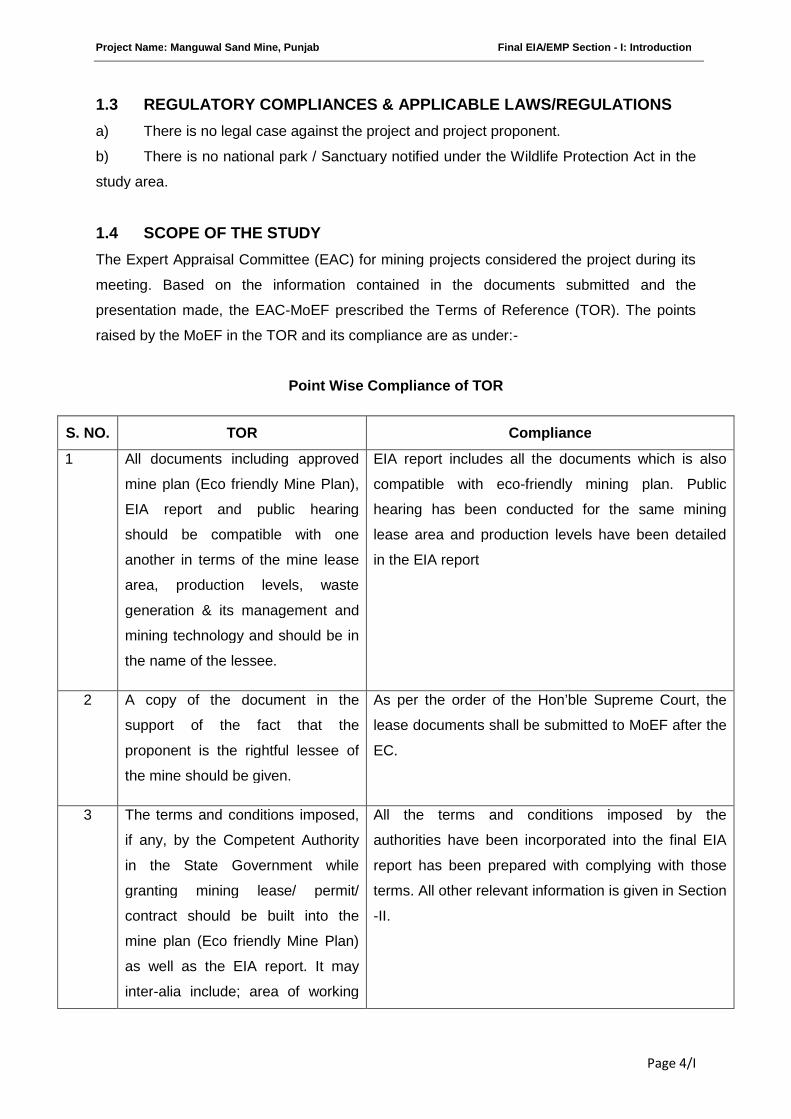
1.3 REGULATORY COMPLIANCES & APPLICABLE LAWS/REGULATIONS
a) There is no legal case against the project and project proponent.
b) There is no national park / Sanctuary notified under the Wildlife Protection Act in the
study area.
1.4 SCOPE OF THE STUDY
The Expert Appraisal Committee (EAC) for mining projects considered the project during its
meeting. Based on the information contained in the documents submitted and the
presentation made, the EAC-MoEF prescribed the Terms of Reference (TOR). The points
raised by the MoEF in the TOR and its compliance are as under:-
Point Wise Compliance of TOR
S. NO. TOR Compliance
1 All documents including approved
mine plan (Eco friendly Mine Plan),
EIA report and public hearing
should be compatible with one
another in terms of the mine lease
area, production levels, waste
generation & its management and
mining technology and should be in
the name of the lessee.
EIA report includes all the documents which is also
compatible with eco-friendly mining plan. Public
hearing has been conducted for the same mining
lease area and production levels have been detailed
in the EIA report
2 A copy of the document in the
support of the fact that the
proponent is the rightful lessee of
the mine should be given.
As per the order of the Hon’ble Supreme Court, the
lease documents shall be submitted to MoEF after the
EC.
3 The terms and conditions imposed,
if any, by the Competent Authority
in the State Government while
granting mining lease/ permit/
contract should be built into the
mine plan (Eco friendly Mine Plan)
as well as the EIA report. It may
inter-alia include; area of working
All the terms and conditions imposed by the
authorities have been incorporated into the final EIA
report has been prepared with complying with those
terms. All other relevant information is given in Section
-II.
Project Name: Manguwal Sand Mine, Punjab Final EIA/EMP Section - I: Introduction
Page 5/I
(length and breadth of the river
stretch), mode of working, working
shift, transportation of mineral,
restriction, if any imposed for
working etc.
4 Involvement of the forest land, if
any, in the project and status of
forestry clearance should be given.
There is no forest land involved; hence no forest
clearance will be required.
The entire lease hold area of 16.48 ha, lies in Sutlej
River bed. The present breakup of the land use for
ancillary feature around the mining area is given
below and Surface Plan is attached as Annexure I :
S. No. Land type Area in
ha
1. Govt. waste land -
2. Agriculture land -
3. Grazing land -
4. Forest land -
5. Others (River Bed) 16.48
Total 16.48
5 The study area will comprise of 10
km zone around the mine lease
from lease periphery and the data
contained in the EIA such as waste
generation etc should be for the life
of the mine/ lease period.
The EIA study has been carried out for 10 km radius
zone from the periphery of Mine lease area. All the
data e.g. production are incorporated in EIA/EMP
reports in Section -II. The topographical map showing
the 10 km study area is attached at the end of section-
II.
It is a river bed sand mining project and no waste will
be generated.
6 Land use of the study area
delineating forest area, agricultural
land, grazing land, wildlife
sanctuary and national park,
migratory routes of fauna, water
The landuse details are discussed in Section III, and
the landuse map is attached at the end of same
section.
Project Name: Manguwal Sand Mine, Punjab Final EIA/EMP Section - I: Introduction
Page 6/I
bodies, human settlements and
other ecological features.
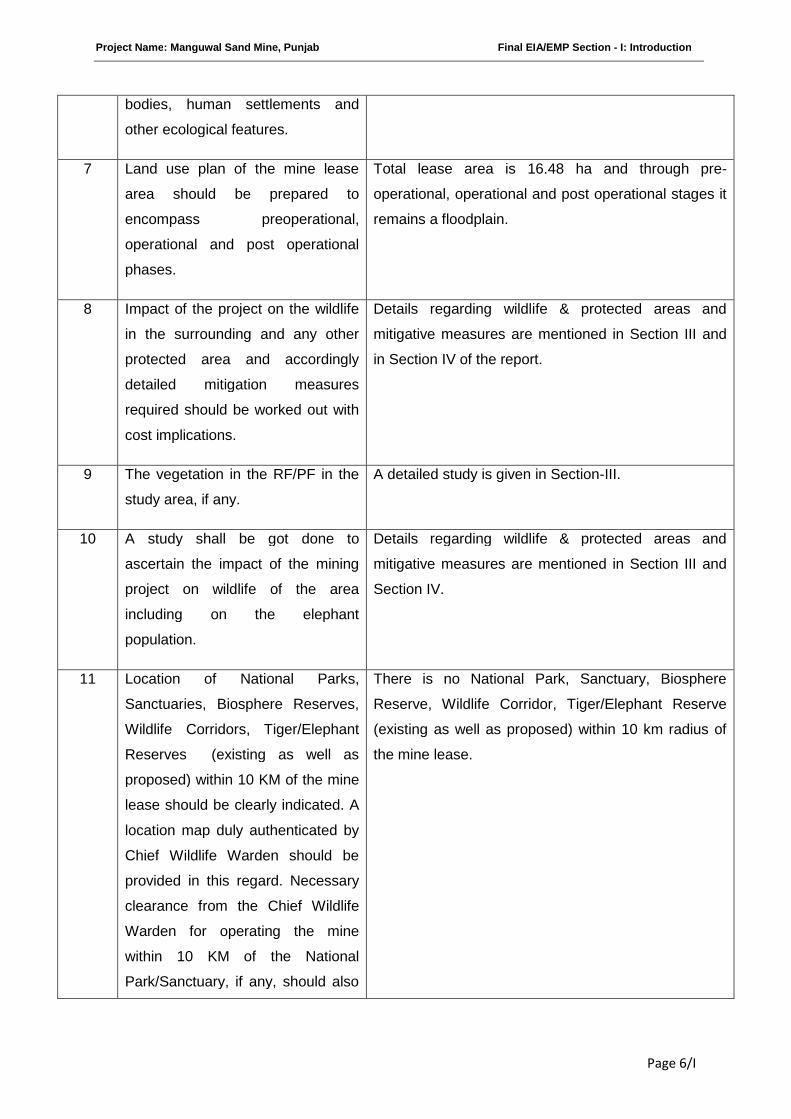
7 Land use plan of the mine lease
area should be prepared to
encompass preoperational,
operational and post operational
phases.
Total lease area is 16.48 ha and through pre-
operational, operational and post operational stages it
remains a floodplain.
8 Impact of the project on the wildlife
in the surrounding and any other
protected area and accordingly
detailed mitigation measures
required should be worked out with
cost implications.
Details regarding wildlife & protected areas and
mitigative measures are mentioned in Section III and
in Section IV of the report.
9 The vegetation in the RF/PF in the
study area, if any.
A detailed study is given in Section-III.
10 A study shall be got done to
ascertain the impact of the mining
project on wildlife of the area
including on the elephant
population.
Details regarding wildlife & protected areas and
mitigative measures are mentioned in Section III and
Section IV.
11 Location of National Parks,
Sanctuaries, Biosphere Reserves,
Wildlife Corridors, Tiger/Elephant
Reserves (existing as well as
proposed) within 10 KM of the mine
lease should be clearly indicated. A
location map duly authenticated by
Chief Wildlife Warden should be
provided in this regard. Necessary
clearance from the Chief Wildlife
Warden for operating the mine
within 10 KM of the National
Park/Sanctuary, if any, should also
There is no National Park, Sanctuary, Biosphere
Reserve, Wildlife Corridor, Tiger/Elephant Reserve
(existing as well as proposed) within 10 km radius of
the mine lease.
Project Name: Manguwal Sand Mine, Punjab Final EIA/EMP Section - I: Introduction
Page 7/I
be obtained and furnished.
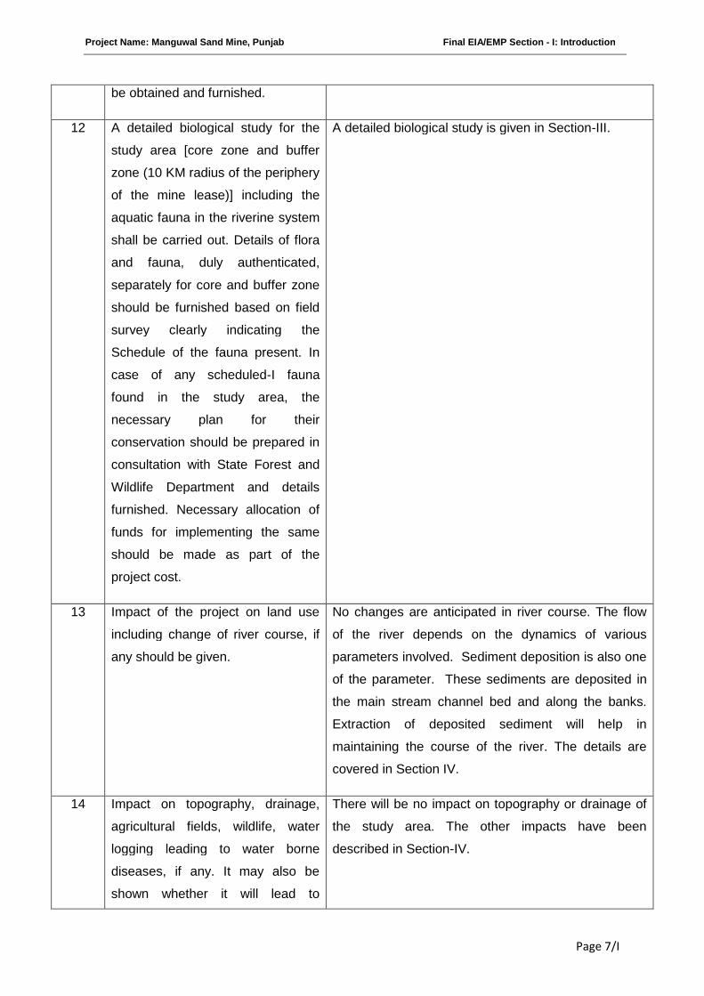
12 A detailed biological study for the
study area [core zone and buffer
zone (10 KM radius of the periphery
of the mine lease)] including the
aquatic fauna in the riverine system
shall be carried out. Details of flora
and fauna, duly authenticated,
separately for core and buffer zone
should be furnished based on field
survey clearly indicating the
Schedule of the fauna present. In
case of any scheduled-I fauna
found in the study area, the
necessary plan for their
conservation should be prepared in
consultation with State Forest and
Wildlife Department and details
furnished. Necessary allocation of
funds for implementing the same
should be made as part of the
project cost.
A detailed biological study is given in Section-III.
13 Impact of the project on land use
including change of river course, if
any should be given.
No changes are anticipated in river course. The flow
of the river depends on the dynamics of various
parameters involved. Sediment deposition is also one
of the parameter. These sediments are deposited in
the main stream channel bed and along the banks.
Extraction of deposited sediment will help in
maintaining the course of the river. The details are
covered in Section IV.
14 Impact on topography, drainage,
agricultural fields, wildlife, water
logging leading to water borne
diseases, if any. It may also be
shown whether it will lead to
There will be no impact on topography or drainage of
the study area. The other impacts have been
described in Section-IV.
Project Name: Manguwal Sand Mine, Punjab Final EIA/EMP Section - I: Introduction
Page 8/I
change of water course of the river.
Modeling exercise should also be
carried out through an expert
agency to show the change in river
flow dynamics, if any.
15 Collection of one season (non-
monsoon) primary baseline data on
ambient air quality (PM10, SO2,
and NOx), water quality, noise level,
soil and flora and fauna. Site-
specific meteorological data should
also be collected. The location of
the monitoring stations should be
justified. Date wise collected
baseline AAQ data should form part
of EIA and EMP report. The
mineralogical composition of PM10
particularly for free silica should be
given. There should be at least one
AAQ monitoring station within 500
m of the mine lease in the pre-
dominant downwind direction.
Baseline data on ambient air quality, water quality,
noise level, soil and flora and fauna have been
collected. Site-specific meteorological data have been
collected for non monsoon season from March, 2011
to May, 2011. (Section-III of EIA report)
Date wise baseline data collected is given in
Annexure-II.
The composition of free silica in PM10 is shown in
Section III
Source: GRC India Training & Analytical Laboratory.
16 Air quality modeling should be
carried out for prediction of impact
of the project on the air quality of
the area. It should also take into
account the impact of movement of
vehicles for transportation of
mineral. The details of the model
used and input parameters used for
modeling should be provided. The
air quality contours may be shown
on a location map clearly indicating
the location of the site, location of
sensitive receptors, if any and the
Air quality modeling has been carried out for
prediction of impact due to proposed project activities
on the present air quality of the area as shown in
Section IV.
The Windrose diagram indicating predominant wind
direction is shown in Figure 3.1 of EIA report. The
required details are given in Section-III.
Project Name: Manguwal Sand Mine, Punjab Final EIA/EMP Section - I: Introduction
Page 9/I
habitation. The wind roses showing
pre-dominant wind direction may
also be indicated on the map.
17 The water requirement for the
project, its availability and source to
be furnished. A detailed water
balance should also be provided.
Fresh water requirement for the
project should also be indicated.
The water requirement for the project is 0.86 KLD
which includes both for dust suppression and for
domestic purpose.
The details of water requirement are given in Section
II.
18 Necessary clearance from the
Competent Authority for drawl of
requisite quantity of water for the
project should be provided.
NOC for drawl of water from the Gram Panchayat has
been obtained and enclosed as an Annexure-VI.
19 Impact of the project on the water
quality should be assessed and
necessary safeguard measures, if
any required should be provided.
The proposed mining will not intercept the ground
water table. No water pollution is expected as mining
will be confined to 3m bgl or above the ground water
level, whichever is less. And moreover surface water
will not be touched, during the mining activity.
The detailed impact and mitigative measure w.r.t. to
the quality of water in the surrounding area, is
discussed under Section-IV.
20 Information on site elevation,
working depth, groundwater table
should be provided both in AMSL
and bgl. A schematic diagram may
also be provided for the same.
site elevation Highest- 286 m AMSL
Lowest- 283 m AMSL
working depth 3 m bgl
groundwater table
pre-monsoon
4.5 m – 17m bgl
groundwater table
post monsoon
5 m – 14 m bgl
21 Quantity of solid waste generation,
if any, to be estimated and details
for its disposal and management be
provided.
Negligible amount of solid waste will be generated by
workers, which will be disposed off through municipal
way.
Project Name: Manguwal Sand Mine, Punjab Final EIA/EMP Section - I: Introduction
Page 10/I
22 Impact on local transport
infrastructure due to the project,
Projected increase in truck traffic as
a result of the project in the present
road network (including those
outside the project area) and
whether it is capable of handling the
increased load. Arrangement for
improving the infrastructure, if
contemplated including action to be
taken by other agencies such as
State Government, if any, should be
covered.
Vehicular Traffic Density
The roads connect from the mine site to National
Highway No. 21. These roads are wide enough to
facilitate easy and smooth movement of heavy duty
trucks as discussed in section IV.
On this Highway dumpers/ tippers ply regularly and
this can easily accommodate additional 1 dumper/
tipper per hour as anticipated for the project.
23 Details of the infrastructure facilities
to be provided for the mine workers.
The site services like rest shelter, first aid box,
drinking water facilities will be provided to workers at
the mine site.
24 Phase-wise plan of greenbelt
development, plantation and
compensatory afforestation clearly
indicating the area to be covered
under plantation and the species to
be planted.
Plantation will be done along the road sides and near
civic amenities, which will be allotted by Government
bodies/ local authorities.
25 Occupational health impact of
project should be anticipated and
prevention measures initiated.
Details in this regard should be
provided.
The details of Occupational health impact are given in
Section VI.
All safety measures prescribed under mining laws will
be followed. All workers will be medically examined in
pre-placement phase and also periodically, as per
Rule 29 (A) and (B) of Mines Rule 1955 Medical
Examination of Persons Employed or to be employed.
26 Occupational health impact of
project. Details of pre-placement
medical examination and periodical
medical examination schedules and
All safety measures prescribed under mining laws as
applicable for the project will be followed. All workers
will be medically examined initially and also
periodically as per Rule 29 (A) and (B) of Mines Rule
Project Name: Manguwal Sand Mine, Punjab Final EIA/EMP Section - I: Introduction
Page 11/I
medical facilities proposed to be
provided should be incorporated in
the EMP.
1955- Medical Examination of Persons Employed or to
be employed.
27 Measures of socio economic
influence to the local community
proposed to be provided by project
proponent. As far as possible,
quantitative dimension to be given.
Measures of socio-economic influence to the local
community have been furnished and described under
Section-VI
The activity creates employment for local persons
directly and indirectly depending upon their skill.
Development activities will be taken up in
consultation with local bodies.
Education, safety and health campaigns will be
carried out in nearby villages. Initial and Periodical
medical examination / checking of workers will be
carried out as per requirement under Mines Rules,
1955.
28 Detailed environmental
management plan to mitigate the
environmental impacts. Specific
safeguard measures to control
PM10 as well as pollution due to
transportation should be given.
Detailed Environmental Management Plan is
discussed under Section-VIII. The proposed project
provides for measures to control PM10 during
transportation; like covering the vehicles with
tarpaulin, wetting of sand if need be, regular water
spray on road, occasional scraping of the road to keep
it levelled to prevent spillage of sand from moving
vehicles and ward off any stagnating dust on road to
the sides.
29 Public hearing points raised and
commitment of the project
proponent on the same along with
time bound action plan to
implement the same should be
provided.
Issues raised in the Public Hearing and their
compliance is attached as Annexure-III .The extract of
salient features of the Public Hearing are also detailed
in Section VI.
30 Details of litigation pending against
the project, if any, with direction/
order passed by any Court of Law
There is no litigation with this project.
Project Name: Manguwal Sand Mine, Punjab Final EIA/EMP Section - I: Introduction
Page 12/I
against the project should be given.
31 The cost of the project (capital cost
and recurring cost) as well as the
cost towards implementation of
EMP should clearly be spelt out.
Detailed Environmental Management Plan cost is
discussed under Section-VIII.
II. Besides the above, the below mentioned general points will also to be followed:-
a All documents to be properly referenced
with index, page numbers and continuous
page numbering.
Complied.
b Where data are presented in the report
especially in tables, the period in which the
data were collected and the sources should
be indicated.
Complied whenever applicable.
c Where the documents provided in a
language other than English, an English
translation should be provided.
Complied.
d The questionnaire for environmental
appraisal of mining projects as devised
earlier by the ministry shall also be filled
and submitted.
The completed questionnaire is attached as
Appendix.
e Approved mine plan along with copy of the
approval letter for the proposed capacity
should also be submitted.
As per the Punjab Mineral Concession Rule,
there is no requirement of approved mine
plan. However an eco-friendly mine plan is
attached along with the report.
f While preparing the EIA report, the
instructions for the proponents and
instructions for the consultants issued by
MoEF vide O.M. No. J-11013/41/2006-
IA.II(I) dated 4th August , 2009, which are
available on the website of this ministry
should also be followed.
The EIA report has been prepared complying
with the circulars issued by MoEF vide O.M.
No. J-11013/41/2006-IA.II (I) dated 4th August,
2009.
Project Name: Manguwal Sand Mine, Punjab Final EIA/EMP Section - I: Introduction
Page 13/I
III. The EIA report should also include surface
plan of the area indication contours of main
topographic features, drainage and mining area.
Complied.
(The surface plan is attached as Annexure I)
***********
Project Name: Manguwal Sand Mine, Punjab Final EIA/EMP Section -II: Project Description
Page 1/II
SECTION-II
PROJECT DESCRIPTION
INDEX
S. No. CONTENTS Page No.
2.0 GENERAL 2/II
2.1 DESCRIPTION OF THE PROJECT 2/II
2.2 NEED FOR THE PROJECT 2/II
2.3 LOCATION DETAILS 2/II
2.4 LEASE HOLD AREA 3/II
2.5 GEOLOGY 3/II
2.6 RESERVES 4/II
2.7 MINING 5/II
2.8 GENERAL FEATURES 7/II
Project Name: Manguwal Sand Mine, Punjab Final EIA/EMP Section -II: Project Description
Page 2/II
2.0 GENERAL
The Environmental Impact Assessment report has been prepared in terms of EIA notification of the
MoEF dated 14th Sept 2006, as amended on 1st Dec 2009 & 4th April 2011 and the EIA Guidance
Manual for Mining of Minerals (Feb, 2010) of MoEF, Govt. of India, for seeking environmental
clearance for mining in the existing area of sand mining lease measuring 16.48 hectares falling
under category “A” due to the presence of interstate boundary between Himachal Pradesh &
Punjab within 10 km radius of the project site
2.1 DESCRIPTION OF THE PROJECT
The proposed project is to mine sand. The estimated project cost is Rs 8.2 lacs. The Department
of Industries and Commerce, Chandigarh, GoP has applied for mining lease in the name of
Manguwal Sand mine over an area of 16.48 ha at Village: Manguwal, Taluka: Rupnagar, District:
Rupnagar, Punjab. The proposed production of the mine is 20,000 TPA.
2.2 NEED FOR THE PROJECT
The river carries with it huge quantity of sediment consisting of stones and sand during every
monsoon. The sediment in the form of river bed material (RBM) deposited from the time
immemorial had changed the shape of the river bed from a mere valley to a raised land. Because
of this, every year during the monsoon, heavy and devastating floods damage large tracts of land
lying on both the banks of the river. Hence, it is necessary to remove the materials so that the river
gets channelized.
2.3 LOCATION DETAILS
The mining area is located in Village: Manguwal, District: Rupnagar, Punjab. The mining lease /
proposed project area falls in Survey of India Topo-sheet No. 53A/12. The mine lease area is
located between:
Latitude 31° 3'36.03"N to 31° 3'59.18"N
Longitude 76°37'11.45"E to 76°37'28.77"E
Nearest Railway Station Ghanauli Railway Station (About 5 km in SW direction)
Nearest Airport Chandigarh Airport (About 45 km in SE direction)
Nearest Highway NH-21 (About 2 km in West direction)
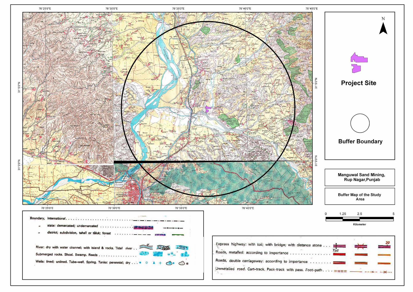
A 10 km radius buffer map is attached in the end of this section.
2.4 LEASE HOLD AREA
The entire lease hold area of 16.48 ha lies in the river bed of Sutlej. The breakup of the land use
for ancillary feature around the mining area is given below: -
Project Name: Manguwal Sand Mine, Punjab Final EIA/EMP Section -II: Project Description
Page 3/II
S. No. Land type Area in ha
1. Govt. waste land -
2. Agriculture land -
3. Grazing land -
4. Forest land -
5. Others (river bed) 16.48
Total 16.48
2.5 GEOLOGY
Based on geomorphology the entire district can be grouped into 4 units such as Siwalik Hills,
Intermontane valley, alluvial fan and alluvial plain. The Siwalik Hills separates the main Himalayan
ranges from the Indo-Gangetic alluvial plain. The area is highly dissected and has an uneven
topography. Adjacent to the hills is a long narrow intermontane valley, which extends from Nangal to
Ropar trending northwest to southeast. Anandpur Sahib tehsil of the district lies in the intermontane
valley and occupies a length of 40 km. The average width of the valley in the district is 5 km. Sutlej
River and its tributaries drain this valley. Adjacent to this is the alluvial fan which forms the
transitional area between the alluvial plains and hilly area of Himalayan foot hills. The coarse
sediments brought down by hill torrents forms the alluvial fan deposits. These alluvial fans
coalesced to form Kandi and Sirowal formation. The southern part of the district is mainly alluvial
plain, which forms a part of vast Indo-Gangetic alluvial plain.
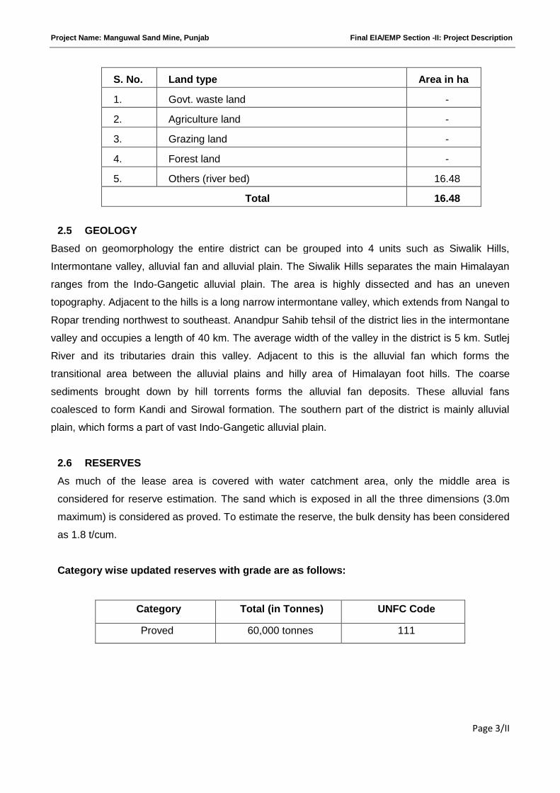
2.6 RESERVES
As much of the lease area is covered with water catchment area, only the middle area is
considered for reserve estimation. The sand which is exposed in all the three dimensions (3.0m
maximum) is considered as proved. To estimate the reserve, the bulk density has been considered
as 1.8 t/cum.
Category wise updated reserves with grade are as follows:
Category Total (in Tonnes) UNFC Code
Proved 60,000 tonnes 111
Project Name: Manguwal Sand Mine, Punjab Final EIA/EMP Section -II: Project Description
Page 4/II
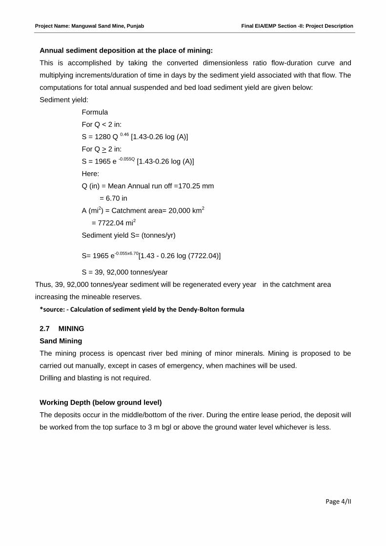
Annual sediment deposition at the place of mining:
This is accomplished by taking the converted dimensionless ratio flow-duration curve and
multiplying increments/duration of time in days by the sediment yield associated with that flow. The
computations for total annual suspended and bed load sediment yield are given below:
Sediment yield:
Formula
For Q < 2 in:
S = 1280 Q 0.46 [1.43-0.26 log (A)]
For Q > 2 in:
S = 1965 e -0.055Q [1.43-0.26 log (A)]
Here:
Q (in) = Mean Annual run off =170.25 mm
= 6.70 in
A (mi2) = Catchment area= 20,000 km2
= 7722.04 mi2
Sediment yield S= (tonnes/yr)
S= 1965 e-0.055x6.70[1.43 - 0.26 log (7722.04)]
S = 39, 92,000 tonnes/year
Thus, 39, 92,000 tonnes/year sediment will be regenerated every year in the catchment area
increasing the mineable reserves.
*source: - Calculation of sediment yield by the Dendy-Bolton formula
2.7 MINING
Sand Mining
The mining process is opencast river bed mining of minor minerals. Mining is proposed to be
carried out manually, except in cases of emergency, when machines will be used.
Drilling and blasting is not required.
Working Depth (below ground level)
The deposits occur in the middle/bottom of the river. During the entire lease period, the deposit will
be worked from the top surface to 3 m bgl or above the ground water level whichever is less.
Project Name: Manguwal Sand Mine, Punjab Final EIA/EMP Section -II: Project Description
Page 5/II
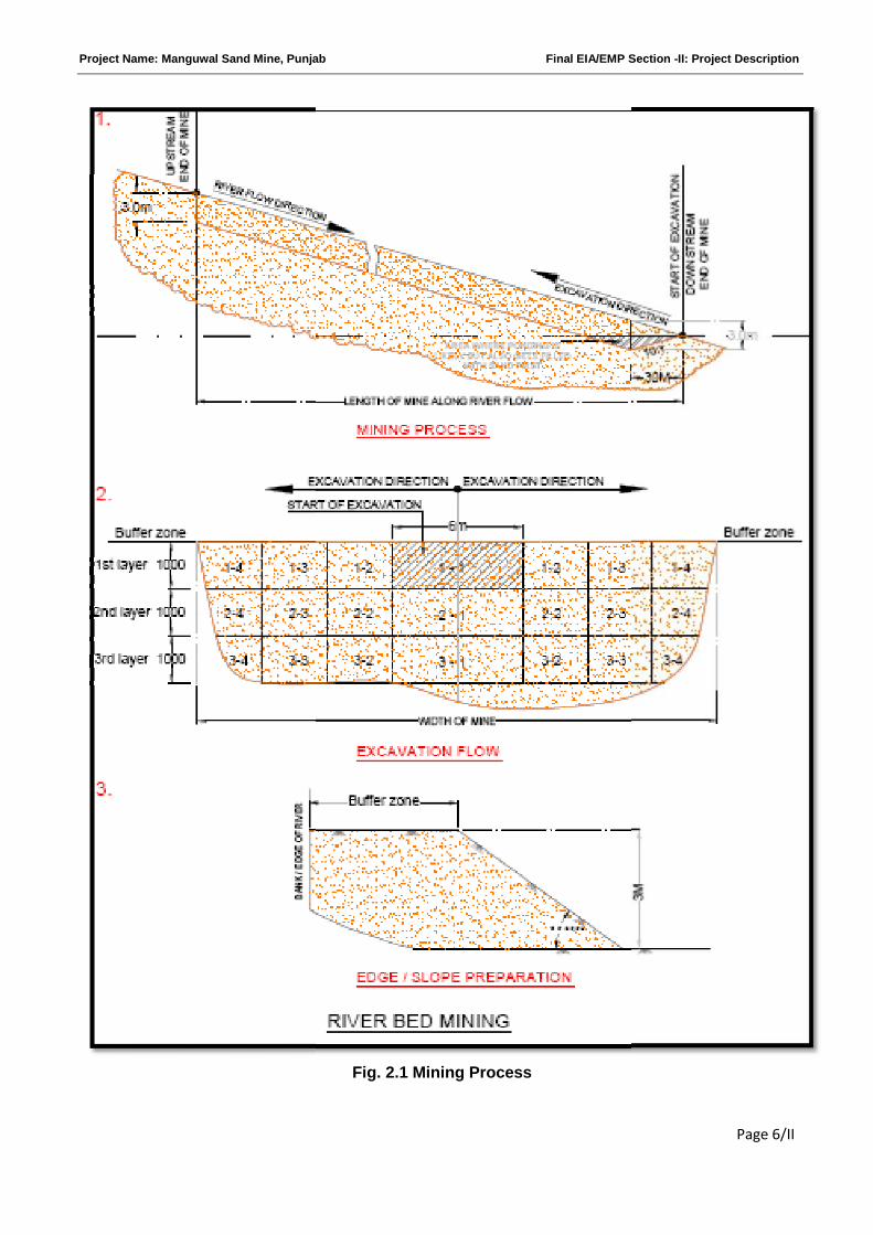
Mining Process:
Refer to Figure 2.1;
1. Mining will be started at the farthest downstream end, moving upstream from there.
2. At the cross section of the flood plain at the downstream end, the mining will be initiated from
the middle of the cross section of the river bed.
3. Mining will be continued in layers of 1 m depth to avoid ponding effect.
4. Mining will be done in such a way that the process of mining remains confined to the middle
of the flood plain. For achieving this purpose, a width of about 6m, suitable for locating the
truck/trolley for simultaneous loading will be first excavated. To start with it may be covered
with wooden plank or metal sheet if required to prevent any sagging.
5. Having excavated that, the process will be continued to the flanks, of a truck width,
alternating from one side to the other every time.
6. After the first layer is excavated, the process will be repeated for next layers.
Project Name: Manguwal Sand Mine, PunjabSand Mine, Punjab Final EIA/EMP Section
Fig. 2.1 Mining Process
Section -II: Project Description
Page 6/II
Project Name: Manguwal Sand Mine, Punjab Final EIA/EMP Section -II: Project Description
Page 7/II
Restriction on mining:
The mining is prohibited to distance of 500 m on upstream and downstream from the high level
bridge and 250 m form the other bridges on upstream and down stream
If width of the river is less than 120 m the mining will be restricted within the bed of river. If higher
than 120 m the mining will be restricted after leaving the area of 30 m from the edge of
embankment on either side of the river bed.
The mining will not be allowed below the water table.
No mining operation will be allowed in forest area.
Unless benches are formed in accordance with regulation 106 of Metalliferrous Mine
Regulations, 1961, the max. permissible depth of the quarry pit will be 3 m.
The contractors will abide by various provisions laid down under Mines Act, 1952, Mines &
Minerals (Regulation and Development) Act, 1957, Forest (Conservation) Act, 1980, MMR, 1961.
The contractor will abide at the time of mining by the provisions of Mines Act, 1952, Interstate
Migrant Workman Act. The contractor with the satisfaction of competent authority will provide
drinking water, rest shelter, first aid box, welfare facilities as per Central and State Govt. labor
laws
The contractor will not do any quarry operations within the distance of 75m from railway line, 60m
from national highway and 50m from reservoir tank, canal roads, public works or buildings and
in-habitat sites etc.
The river bed areas dug during one season i.e. other than rainy season will get refilled
Sand/Gravel deposit in rainy season in which the material so deposited will be available for fresh
quarrying.
The contractors will abide by the State Minor Mineral Concession Rules, Punjab, 1964.
2.8 GENERAL FEATURES
Topography:
The proposed area is a river bed which is flat. The difference of the highest & the lowest elevation
of the area is about 2 m to 3 m. The surrounding area is devoid of any thick vegetation except for
patched agricultural lands.
Surface Drainage Pattern
It is a river bed mining project. The total lease area is located in the Sutlej river catchment/water
shed area.
Project Name: Manguwal Sand Mine, Punjab Final EIA/EMP Section -II: Project Description
Page 8/II
Vehicular Traffic Density
The roads connect from the mine site to National Highway No. 21. These roads are wide enough
to facilitate easy and smooth movement of heavy duty trucks.
The National Highway has traffic density less than 20 trucks per hour. On these Highway
dumper/tipper ply regularly and these will easily accommodate additional 1 dumper/tipper per
hour.
Accessibility
The lease area is situated in district Rupnagar of Punjab and is approachable through NH 21. The
mine lease connects the national highway through metalled road. Nearest Railway Station is
Ghanauli Railway Station approximately 5 Km and nearest Airport is Chandigarh Airport which is
approximately 45 Km away from the mine site. Total mining area is completely outside of any
restricted or protected area.
Township
Since this mining is intermittent and labour employed would be mostly from adjoining areas, no
colony is proposed.
Power, Water Supply and other Infrastructure requirement
Power
All the activities will be carried out manually by the working people, only during day time. Hence,
no power is required.
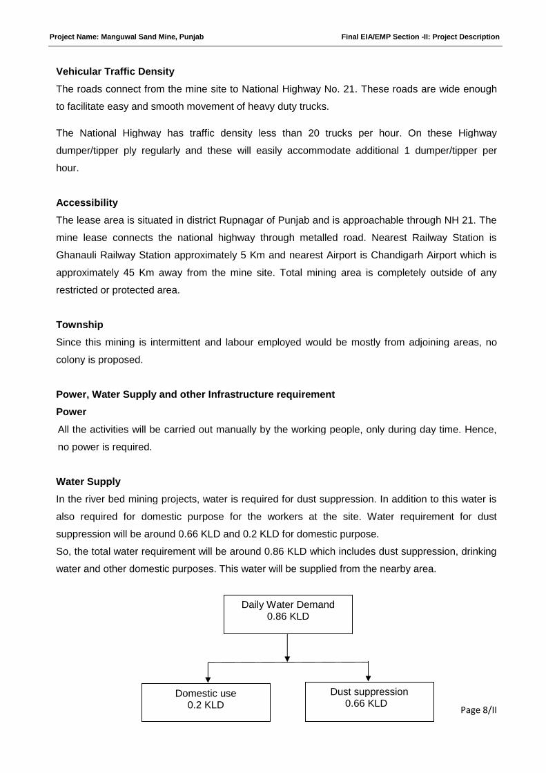
Water Supply
In the river bed mining projects, water is required for dust suppression. In addition to this water is
also required for domestic purpose for the workers at the site. Water requirement for dust
suppression will be around 0.66 KLD and 0.2 KLD for domestic purpose.
So, the total water requirement will be around 0.86 KLD which includes dust suppression, drinking
water and other domestic purposes. This water will be supplied from the nearby area.
Daily Water Demand0.86 KLD
Domestic use0.2 KLD
Dust suppression0.66 KLD
Project Name: Manguwal Sand Mine, Punjab Final EIA/EMP Section -II: Project Description
Page 9/II
Infrastructure:
The site services like temporary rest shelter, portable toilets, first aid box, and drinking water
facilities will be provided to workers at the mine site.
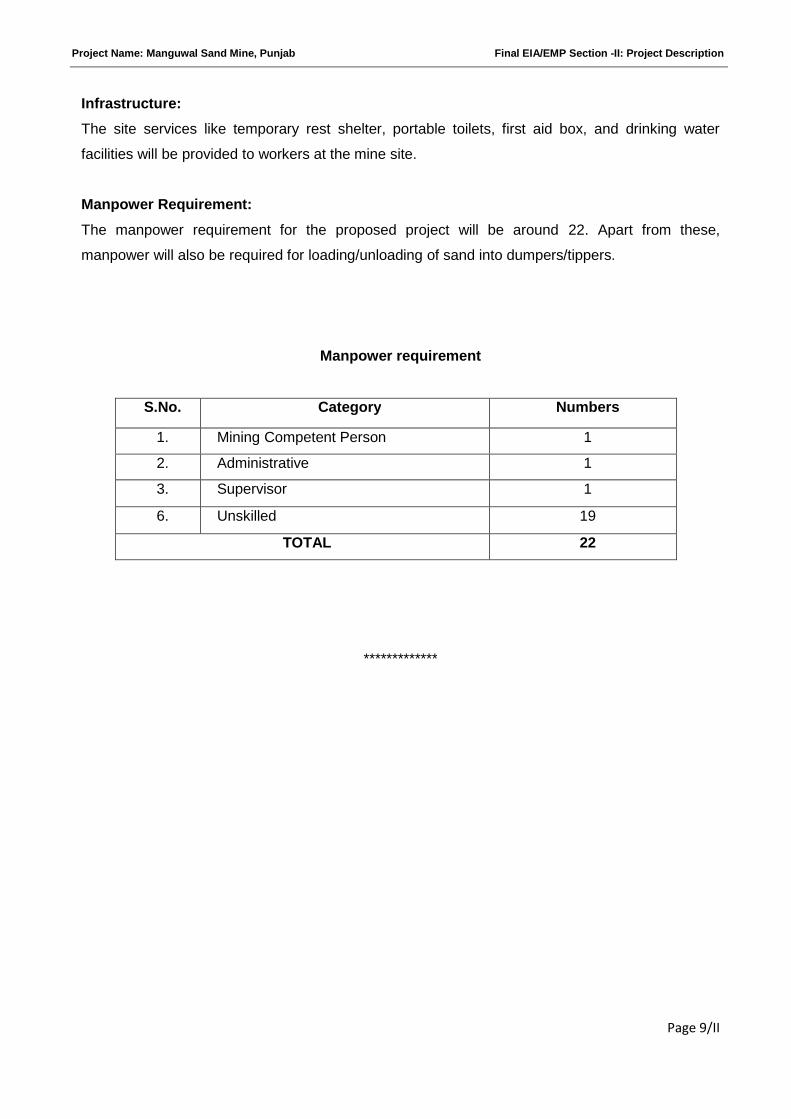
Manpower Requirement:
The manpower requirement for the proposed project will be around 22. Apart from these,
manpower will also be required for loading/unloading of sand into dumpers/tippers.
Manpower requirement
*************
S.No. Category Numbers
1. Mining Competent Person 1
2. Administrative 1
3. Supervisor 1
6. Unskilled 19
TOTAL 22
Project Name: Manguwal Sand Mine, Punjab Final EIA/EMP-Section - III Description of Environment
Page 1/III
SECTION-III
DESCRIPTION OF ENVIRONMENT
INDEX
S. No. CONTENTS Page No.
3.0 INTRODUCTION 2/III
3.1 LAND ENVIRONMENT 2/III
3.2 AIR ENVIRONMENT 3/III
3.3 WATER ENVIRONMENT: 8/III
3.3 (a) GROUND WATER 8/III
3.3 (b) SURFACE WATER 13/III
3.4 SOIL ENVIRONMENT 17/III
3.5 NOISE ENVIRONMENT 19/III
3.6 TRAFFFIC STUDY 20/III
3.7 BIOLOGICAL ENVIRONMENT 21/III
Project Name: Manguwal Sand Mine, Punjab Final EIA/EMP-Section - III Description of Environment
Page 2/III
3.0 INTRODUCTION
This section contains the description of baseline studies of the area within 10 Km radius
surrounding the Manguwal Sand Mine, Rupnagar, Punjab. The study was undertaken for
prevailing environment in respect of land, air, water (both ground and surface), soil, noise,
biological (both flora and fauna). The data collected has been used to understand the
existing environment scenario around the proposed mining project against which the
potential impacts of the proposed project can be assessed.
3.1 LAND ENVIRONMENT
This section includes the study of natural features like topography, climate etc. Land use/
Land cover map.
Topography
The proposed area is a river bed which is flat. The difference of the highest & the lowest
elevation of the area is about 2 to 3 meter. The surrounding area is devoid of any thick
vegetation except for patched agricultural lands.
Climate:
The climate of the district can be classified as tropical steppe hot and semi-arid type, a hot
summer and a bracing cold winter. The temperature ranges from minimum of 4°C in winter
to 45°C in summer. The district receives normal annual rainfall of 855 mm, which was
spread over 41 days. 78% of the annual rainfall is contributed by southwest monsoon.
Generally, rainfall increases from southwest to north eastern part of the district.
Project Name: Manguwal Sand Mine, Punjab Final EIA/EMP-Section - III Description of Environment
Page 3/III
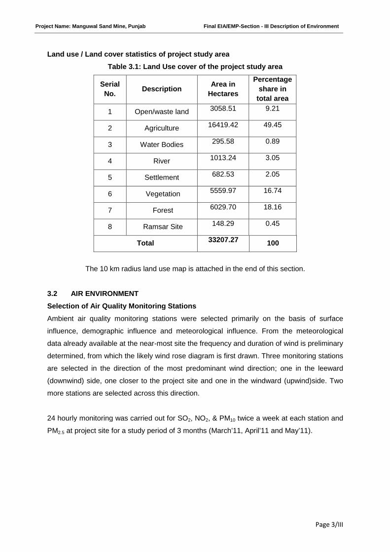
Land use / Land cover statistics of project study area
Table 3.1: Land Use cover of the project study area
Serial
No.Description
Area in
Hectares
Percentage
share in
total area
1 Open/waste land 3058.51 9.21
2 Agriculture 16419.42 49.45
3 Water Bodies 295.58 0.89
4 River 1013.24 3.05
5 Settlement 682.53 2.05
6 Vegetation 5559.97 16.74
7 Forest 6029.70 18.16
8 Ramsar Site 148.29 0.45
Total 33207.27 100
The 10 km radius land use map is attached in the end of this section.
3.2 AIR ENVIRONMENT
Selection of Air Quality Monitoring Stations
Ambient air quality monitoring stations were selected primarily on the basis of surface
influence, demographic influence and meteorological influence. From the meteorological
data already available at the near-most site the frequency and duration of wind is preliminary
determined, from which the likely wind rose diagram is first drawn. Three monitoring stations
are selected in the direction of the most predominant wind direction; one in the leeward
(downwind) side, one closer to the project site and one in the windward (upwind)side. Two
more stations are selected across this direction.
24 hourly monitoring was carried out for SO2, NO2, & PM10 twice a week at each station and
PM2.5 at project site for a study period of 3 months (March’11, April’11 and May’11).
Project Name: Manguwal Sand Mine, Punjab Final EIA/EMP-Section - III Description of Environment
Page 4/III
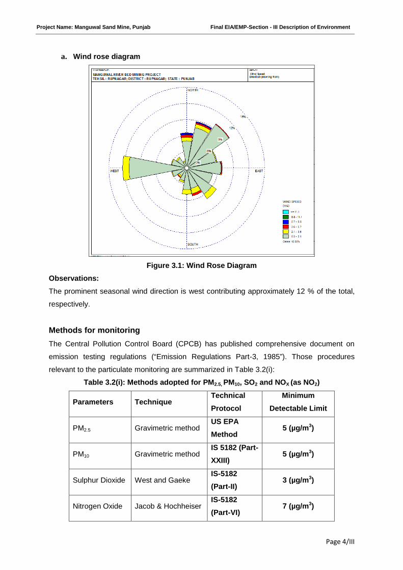
a. Wind rose diagram
Figure 3.1: Wind Rose Diagram
Observations:
The prominent seasonal wind direction is west contributing approximately 12 % of the total,
respectively.
Methods for monitoring
The Central Pollution Control Board (CPCB) has published comprehensive document on
emission testing regulations (“Emission Regulations Part-3, 1985”). Those procedures
relevant to the particulate monitoring are summarized in Table 3.2(i):
Table 3.2(i): Methods adopted for PM2.5, PM10, SO2 and NOX (as NO2)
Parameters TechniqueTechnical
Protocol
Minimum
Detectable Limit
PM2.5 Gravimetric methodUS EPA
Method5 (µg/m3)
PM10 Gravimetric methodIS 5182 (Part-
XXIII)5 (µg/m3)
Sulphur Dioxide West and GaekeIS-5182
(Part-II)3 (µg/m3)
Nitrogen Oxide Jacob & HochheiserIS-5182
(Part-VI)7 (µg/m3)

Project Name: Manguwal Sand Mine, Punjab Final EIA/EMP-Section - III Description of Environment
Page 5/III
i. Particulate Matter (PM):-
The CPCB method and IS 5182 (Part-XXIII) adopt a very similar approach to particulate
sampling. There are some differences in the expressions used, but they are generally of no
practical significance. It is recommended that CPCB method is adapted.
ii. Equipment calibration:
For accurate testing of emission sources, the components of the sampling train is calibrated
by outsource and supplier (Master Calibrator) standards and solutions are used, calibrated
under certified reference material.
The ambient air quality data were collected to find the existing GLC. The data is given in
Table No. 3.2 (iii)
Table 3.2 (ii)
Ambient air quality monitoring stations
S. No. Location Station nameDistance and direction
from the lease area (km)
Zone (Core/
Buffer)
1. AQ1 Majri W 2.9 Buffer zone
2. AQ2 Dhabota NE 2.3 Buffer zone
3. AQ3 Bada Basot SE 0.5 Core zone
4. AQ4 Indarpura S 2.6 Buffer zone
5. AQ5 Kanganwal SE 4.2 Buffer zone
Fig.3.2 Ambient air quality monitoring at village Manguwal
Project Name: Manguwal Sand Mine, Punjab Final EIA/EMP-Section - III Description of Environment
Page 6/III
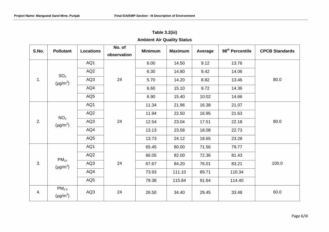
Table 3.2(iii)
Ambient Air Quality Status
S.No. Pollutant LocationsNo. of
observationMinimum Maximum Average 98th Percentile CPCB Standards
1.SO2
(µg/m3)
AQ1
24
6.00 14.50 9.12 13.76
80.0
AQ2 6.30 14.80 9.42 14.06
AQ3 5.70 14.20 8.82 13.46
AQ4 6.60 15.10 9.72 14.36
AQ5 6.90 15.40 10.02 14.66
2.NO2
(µg/m3)
AQ1
24
11.34 21.96 16.38 21.07
80.0
AQ2 11.94 22.50 16.95 21.63
AQ3 12.54 23.04 17.51 22.18
AQ4 13.13 23.58 18.08 22.73
AQ5 13.73 24.12 18.65 23.28
3.PM10
(µg/m3)
AQ1
24
65.45 80.00 71.56 79.77
100.0
AQ2 66.05 82.00 72.36 81.43
AQ3 67.67 84.20 76.01 83.21
AQ4 73.93 111.10 89.71 110.34
AQ5 79.38 115.84 91.64 114.40
4.PM2.5
(µg/m3)AQ3 24 26.50 34.40 29.45 33.48 60.0
Project Name: Manguwal Sand Mine, Punjab Final EIA/EMP-Section - III Description of Environment
Page 7/III
Observations:
Ambient Air Quality Monitoring reveals that the maximum& minimum concentrations of PM10
for all the 5 AQ monitoring stations were found to be 115.84 µg/m3 at AQ5 and 65.45 µg/m3
at AQ1, respectively.
As far as the gaseous pollutants SO2 and NO2 are concerned, the prescribed CPCB limit of
80 µg/m3 for residential and rural areas has never surpassed at any station. The maximum
& minimum concentrations of SO2 were found to be 15.40 µg/m3 at AQ5 & 5.70 µg/m3 at
AQ3, respectively. The maximum & minimum concentrations of NO2 were found to be 24.12
µg/m3 at AQ5 & 11.34 µg/m3 at AQ1, respectively.
The PM10 readings during the month of April to starting May are exceeding the norms. It has
been clearly observed that after wheat harvesting season the villagers are commonly
burning the left over wheat stubble so that the fields can be kept ready for next sowing at the
earliest. This entrainment in higher PM10 value is a temporary phase as seen from the PM10
values for next few values.
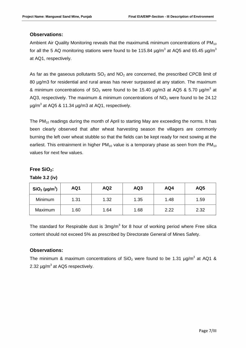
Free SiO2:
Table 3.2 (iv)
SiO2 (µg/m3) AQ1 AQ2 AQ3 AQ4 AQ5
Minimum 1.31 1.32 1.35 1.48 1.59
Maximum 1.60 1.64 1.68 2.22 2.32
The standard for Respirable dust is 3mg/m3 for 8 hour of working period where Free silica
content should not exceed 5% as prescribed by Directorate General of Mines Safety.
Observations:
The minimum & maximum concentrations of SiO2 were found to be 1.31 µg/m3 at AQ1 &
2.32 µg/m3 at AQ5 respectively.
Project Name: Manguwal Sand Mine, Punjab Final EIA/EMP-Section - III Description of Environment
Page 8/III
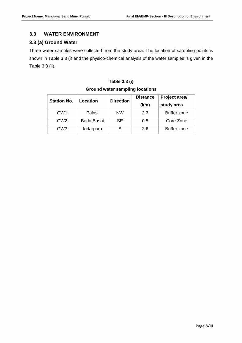
3.3 WATER ENVIRONMENT
3.3 (a) Ground Water
Three water samples were collected from the study area. The location of sampling points is
shown in Table 3.3 (i) and the physico-chemical analysis of the water samples is given in the
Table 3.3 (ii).
Table 3.3 (i)
Ground water sampling locations
Station No. Location DirectionDistance
(km)
Project area/
study area
GW1 Palasi NW 2.3 Buffer zone
GW2 Bada Basot SE 0.5 Core Zone
GW3 Indarpura S 2.6 Buffer zone
Project Name: Manguwal Sand Mine, Punjab Final EIA/EMP-Section - III Description of Environment
Page 9/III
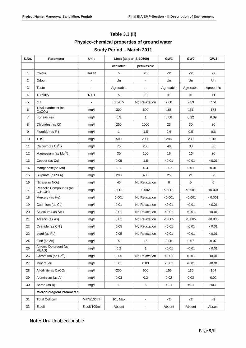
Table 3.3 (ii)
Physico-chemical properties of ground water
Study Period – March 2011
S.No. Parameter Unit Limit (as per IS:10500) GW1 GW2 GW3
desirable permissible
1 Colour Hazen 5 25 <2 <2 <2
2 Odour - Un - Un Un Un
3 Taste - Agreeable - Agreeable Agreeable Agreeable
4 Turbidity NTU 5 10 <1 <1 <1
5 pH - 6.5-8.5 No Relaxation 7.68 7.59 7.51
6Total Hardness (asCaCO3)
mg/l 300 600 168 151 173
7 Iron (as Fe) mg/l 0.3 1 0.08 0.12 0.09
8 Chlorides (as Cl) mg/l 250 1000 23 30 20
9 Fluoride (as F ) mg/l 1 1.5 0.6 0.5 0.6
10 TDS mg/l 500 2000 298 280 313
11 Calcium(as Ca2+) mg/l 75 200 40 33 36
12 Magnesium (as Mg2+) mg/l 30 100 16 16 20
13 Copper (as Cu) mg/l 0.05 1.5 <0.01 <0.01 <0.01
14 Manganese(as Mn) mg/l 0.1 0.3 0.02 0.01 0.01
15 Sulphate (as SO4) mg/l 200 400 25 21 30
16 Nitrate(as NO3) mg/l 45 No Relaxation 6 5 6
17Phenolic Compounds (asC6H5OH)
mg/l 0.001 0.002 <0.001 <0.001 <0.001
18 Mercury (as Hg) mg/l 0.001 No Relaxation <0.001 <0.001 <0.001
19 Cadmium (as Cd) mg/l 0.01 No Relaxation <0.01 <0.01 <0.01
20 Selenium ( as Se ) mg/l 0.01 No Relaxation <0.01 <0.01 <0.01
21 Arsenic (as As) mg/l 0.01 No Relaxation <0.005 <0.005 <0.005
22 Cyanide (as CN ) mg/l 0.05 No Relaxation <0.01 <0.01 <0.01
23 Lead (as Pb) mg/l 0.05 No Relaxation <0.01 <0.01 <0.01
24 Zinc (as Zn) mg/l 5 15 0.06 0.07 0.07
25Anionic Detergent (asMBAS)
mg/l 0.2 1 <0.01 <0.01 <0.01
26 Chromium (as Cr6+) mg/l 0.05 No Relaxation <0.01 <0.01 <0.01
27 Mineral oil mg/l 0.01 0.03 <0.01 <0.01 <0.01
28 Alkalinity as CaCO3 mg/l 200 600 155 136 164
29 Aluminium (as Al) mg/l 0.03 0.2 0.02 0.02 0.02
30 Boron (as B) mg/l 1 5 <0.1 <0.1 <0.1
Microbiological Parameter
31 Total Coliform MPN/100ml 10 , Max - <2 <2 <2
32 E.coli E.coli/100ml Absent - Absent Absent Absent
Note: Un- Unobjectionable
Project Name: Manguwal Sand Mine, Punjab Final EIA/EMP-Section - III Description of Environment
Page 10/III
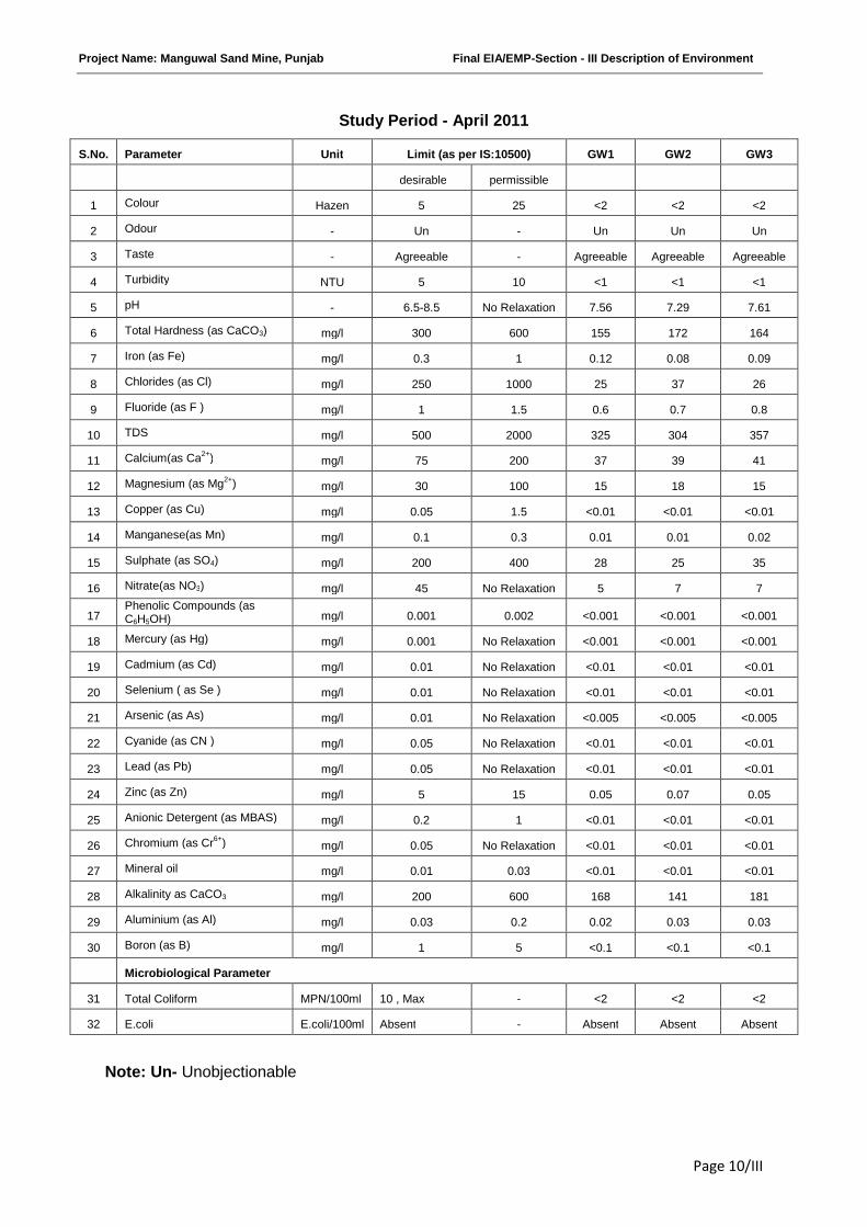
Study Period - April 2011
S.No. Parameter Unit Limit (as per IS:10500) GW1 GW2 GW3
desirable permissible
1 Colour Hazen 5 25 <2 <2 <2
2 Odour - Un - Un Un Un
3 Taste - Agreeable - Agreeable Agreeable Agreeable
4 Turbidity NTU 5 10 <1 <1 <1
5 pH - 6.5-8.5 No Relaxation 7.56 7.29 7.61
6 Total Hardness (as CaCO3) mg/l 300 600 155 172 164
7 Iron (as Fe) mg/l 0.3 1 0.12 0.08 0.09
8 Chlorides (as Cl) mg/l 250 1000 25 37 26
9 Fluoride (as F ) mg/l 1 1.5 0.6 0.7 0.8
10 TDS mg/l 500 2000 325 304 357
11 Calcium(as Ca2+) mg/l 75 200 37 39 41
12 Magnesium (as Mg2+) mg/l 30 100 15 18 15
13 Copper (as Cu) mg/l 0.05 1.5 <0.01 <0.01 <0.01
14 Manganese(as Mn) mg/l 0.1 0.3 0.01 0.01 0.02
15 Sulphate (as SO4) mg/l 200 400 28 25 35
16 Nitrate(as NO3) mg/l 45 No Relaxation 5 7 7
17Phenolic Compounds (asC6H5OH) mg/l 0.001 0.002 <0.001 <0.001 <0.001
18 Mercury (as Hg) mg/l 0.001 No Relaxation <0.001 <0.001 <0.001
19 Cadmium (as Cd) mg/l 0.01 No Relaxation <0.01 <0.01 <0.01
20 Selenium ( as Se ) mg/l 0.01 No Relaxation <0.01 <0.01 <0.01
21 Arsenic (as As) mg/l 0.01 No Relaxation <0.005 <0.005 <0.005
22 Cyanide (as CN ) mg/l 0.05 No Relaxation <0.01 <0.01 <0.01
23 Lead (as Pb) mg/l 0.05 No Relaxation <0.01 <0.01 <0.01
24 Zinc (as Zn) mg/l 5 15 0.05 0.07 0.05
25 Anionic Detergent (as MBAS) mg/l 0.2 1 <0.01 <0.01 <0.01
26 Chromium (as Cr6+) mg/l 0.05 No Relaxation <0.01 <0.01 <0.01
27 Mineral oil mg/l 0.01 0.03 <0.01 <0.01 <0.01
28 Alkalinity as CaCO3 mg/l 200 600 168 141 181
29 Aluminium (as Al) mg/l 0.03 0.2 0.02 0.03 0.03
30 Boron (as B) mg/l 1 5 <0.1 <0.1 <0.1
Microbiological Parameter
31 Total Coliform MPN/100ml 10 , Max - <2 <2 <2
32 E.coli E.coli/100ml Absent - Absent Absent Absent
Note: Un- Unobjectionable

Project Name: Manguwal Sand Mine, Punjab Final EIA/EMP-Section - III Description of Environment
Page 11/III
Study Period - May 2011
S.No. Parameter Unit Limit (as per IS:10500) GW1 GW2 GW3
desirable permissible
1 Colour Hazen 5 25 <2 <2 <2
2 Odour - Un - Un Un Un
3 Taste - Agreeable - Agreeable Agreeable Agreeable
4 Turbidity NTU 5 10 <1 <1 <1
5 pH - 6.5-8.5 No Relaxation 7.58 7.62 7.46
6 Total Hardness (as CaCO3) mg/l 300 600 157 169 143
7 Iron (as Fe) mg/l 0.3 1 0.08 0.12 0.09
8 Chlorides (as Cl) mg/l 250 1000 30 42 23
9 Fluoride (as F ) mg/l 1 1.5 0.7 0.8 0.8
10 TDS mg/l 500 2000 321 310 293
11 Calcium(as Ca2+) mg/l 75 200 44 40 34
12 Magnesium (as Mg2+) mg/l 30 100 11 16 14
13 Copper (as Cu) mg/l 0.05 1.5 <0.01 <0.01 <0.01
14 Manganese(as Mn) mg/l 0.1 0.3 0.01 0.01 0.01
15 Sulphate (as SO4) mg/l 200 400 24 32 27
16 Nitrate(as NO3) mg/l 45 No Relaxation 6 8 6
17Phenolic Compounds (asC6H5OH) mg/l 0.001 0.002 <0.001 <0.001 <0.001
18 Mercury (as Hg) mg/l 0.001 No Relaxation <0.001 <0.001 <0.001
19 Cadmium (as Cd) mg/l 0.01 No Relaxation <0.01 <0.01 <0.01
20 Selenium ( as Se ) mg/l 0.01 No Relaxation <0.01 <0.01 <0.01
21 Arsenic (as As) mg/l 0.01 No Relaxation <0.005 <0.005 <0.005
22 Cyanide (as CN ) mg/l 0.05 No Relaxation <0.01 <0.01 <0.01
23 Lead (as Pb) mg/l 0.05 No Relaxation <0.01 <0.01 <0.01
24 Zinc (as Zn) mg/l 5 15 0.04 0.06 0.06
25Anionic Detergent (asMBAS) mg/l 0.2 1 <0.01 <0.01 <0.01
26 Chromium (as Cr6+) mg/l 0.05 No Relaxation <0.01 <0.01 <0.01
27 Mineral oil mg/l 0.01 0.03 <0.01 <0.01 <0.01
28 Alkalinity as CaCO3 mg/l 200 600 163 121 148
29 Aluminium (as Al) mg/l 0.03 0.2 0.01 0.02 0.02
30 Boron (as B) mg/l 1 5 <0.1 <0.1 <0.1
Microbiological Parameter
31 Total Coliform MPN/100ml 10 , Max - <2 <2 <2
32 E.coli E.coli/100ml Absent - Absent Absent Absent
Note: Un- Unobjectionable
Project Name: Manguwal Sand Mine, Punjab Final EIA/EMP-Section - III Description of Environment
Page 12/III
Observation:
Analysis of results of ground water reveals the following: -
pH varies from 7.29 at GW2 in the month of April to 7.68 at GW1 in the month of
March.
Total hardness varies from 143 mg/l at GW3 in the month of May to 173 mg/l at GW3
in the month of March.
Total dissolved solids vary from 280 mg/l at GW2 in the month of March to 357 mg/l
at GW3 in the month of April.
The ground water from all sources remains suitable for drinking purposes as all the
constituents are within the limits prescribed by drinking water standards promulgated by
Indian Standards IS: 10500.
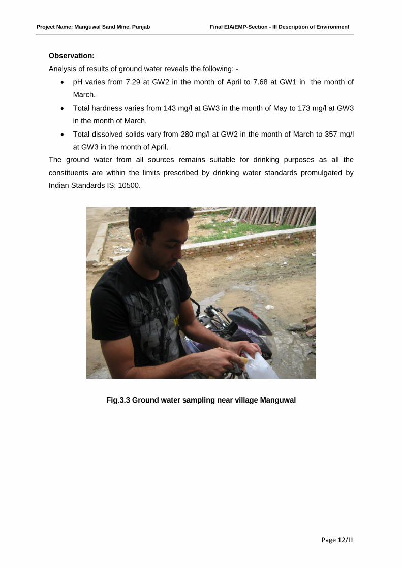
Fig.3.3 Ground water sampling near village Manguwal
Project Name: Manguwal Sand Mine, Punjab Final EIA/EMP-Section - III Description of Environment
Page 13/III
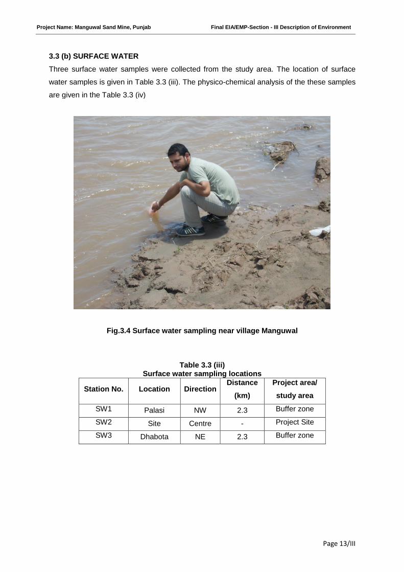
3.3 (b) SURFACE WATER
Three surface water samples were collected from the study area. The location of surface
water samples is given in Table 3.3 (iii). The physico-chemical analysis of the these samples
are given in the Table 3.3 (iv)
Fig.3.4 Surface water sampling near village Manguwal
Table 3.3 (iii)Surface water sampling locations
Station No. Location DirectionDistance
(km)
Project area/
study area
SW1 Palasi NW 2.3 Buffer zone
SW2 Site Centre - Project Site
SW3 Dhabota NE 2.3 Buffer zone
Project Name: Manguwal Sand Mine, Punjab Final EIA/EMP-Section - III Description of Environment
Page 14/III
Table 3.3 (iv)Physico-chemical properties of surface water (March 2011)
S.No. Parameter UnitS.W. 1 S.W. 2 S.W. 3
Upstream Centre Downstream
1 pH - 8.81 8.39 8.57
2 Dissolved oxygen mg/l 7.4 7.1 7.2
3 BOD (3 Days at 27°C) mg/l 2 3 2
4 Free Ammonia (as N) mg/l <0.1 <0.1 <0.1
5 Sodium Adsorption Ratio - 2.04 2.07 1.92
6 Boron mg/l <0.1 <0.1 <0.1
7 Conductivity µmhos/cm 609 688 630
8 Turbidity NTU 6 6 8
9 Magnesium Hardness ( asCaCO3)
mg/l 54 60 59
10 Total Alkalinity (as CaCO3) mg/l 192 228 208
11 Chloride (as Cl) mg/l 58 66 49
12 sulphate (as SO4) mg/l 22 18 26
13 Nitrate (as NO3) mg/l 1.7 2.1 1.9
14 Fluoride (as F) mg/l 0.6 0.5 0.6
15 Sodium (as Na) mg/l 60 65 58
16 Potassium (as K) mg/l 2.4 2.1 2.2
17 TKN (as N) mg/l 1.0 1.2 1.3
18 Total Phosphorous (as P) mg/l 0.32 0.26 0.24
19 COD mg/l 8 12 10
20 Phenolic compounds (asC6H5OH)
mg/l <0.001 <0.001 <0.001
21 Iron (as Fe) mg/l 0.39 0.56 0.72
22 Zinc (as Zn) mg/l 0.05 0.04 0.04
23 Arsenic (as As) mg/l <0.005 <0.005 <0.005
24 Mercury (as Hg) mg/l <0.001 <0.001 <0.001
25 Total Coliform MPN/100ml 170 300 320
26 Faecal Coliform MPN/100ml 70 130 110
Project Name: Manguwal Sand Mine, Punjab Final EIA/EMP-Section - III Description of Environment
Page 15/III
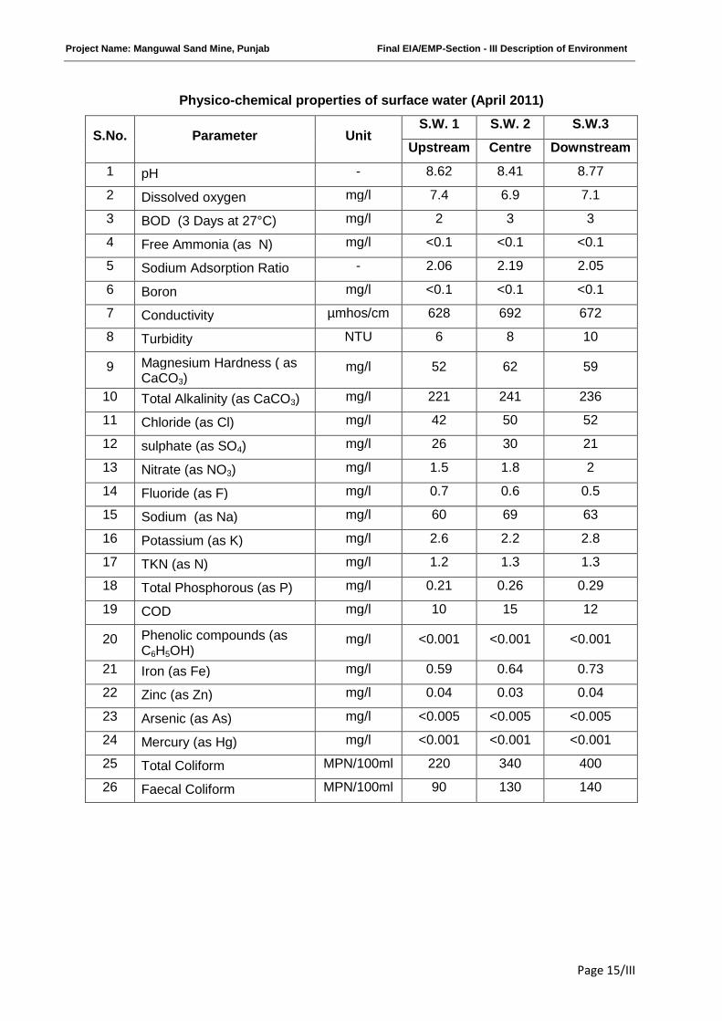
Physico-chemical properties of surface water (April 2011)
S.No. Parameter UnitS.W. 1 S.W. 2 S.W.3
Upstream Centre Downstream
1 pH - 8.62 8.41 8.77
2 Dissolved oxygen mg/l 7.4 6.9 7.1
3 BOD (3 Days at 27°C) mg/l 2 3 3
4 Free Ammonia (as N) mg/l <0.1 <0.1 <0.1
5 Sodium Adsorption Ratio - 2.06 2.19 2.05
6 Boron mg/l <0.1 <0.1 <0.1
7 Conductivity µmhos/cm 628 692 672
8 Turbidity NTU 6 8 10
9 Magnesium Hardness ( asCaCO3)
mg/l 52 62 59
10 Total Alkalinity (as CaCO3) mg/l 221 241 236
11 Chloride (as Cl) mg/l 42 50 52
12 sulphate (as SO4) mg/l 26 30 21
13 Nitrate (as NO3) mg/l 1.5 1.8 2
14 Fluoride (as F) mg/l 0.7 0.6 0.5
15 Sodium (as Na) mg/l 60 69 63
16 Potassium (as K) mg/l 2.6 2.2 2.8
17 TKN (as N) mg/l 1.2 1.3 1.3
18 Total Phosphorous (as P) mg/l 0.21 0.26 0.29
19 COD mg/l 10 15 12
20 Phenolic compounds (asC6H5OH)
mg/l <0.001 <0.001 <0.001
21 Iron (as Fe) mg/l 0.59 0.64 0.73
22 Zinc (as Zn) mg/l 0.04 0.03 0.04
23 Arsenic (as As) mg/l <0.005 <0.005 <0.005
24 Mercury (as Hg) mg/l <0.001 <0.001 <0.001
25 Total Coliform MPN/100ml 220 340 400
26 Faecal Coliform MPN/100ml 90 130 140
Project Name: Manguwal Sand Mine, Punjab Final EIA/EMP-Section - III Description of Environment
Page 16/III
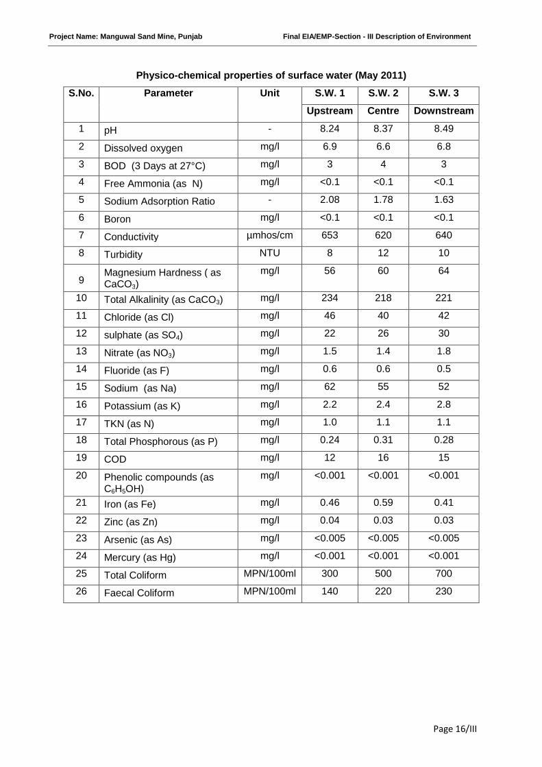
Physico-chemical properties of surface water (May 2011)
S.No. Parameter Unit S.W. 1 S.W. 2 S.W. 3
Upstream Centre Downstream
1 pH - 8.24 8.37 8.49
2 Dissolved oxygen mg/l 6.9 6.6 6.8
3 BOD (3 Days at 27°C) mg/l 3 4 3
4 Free Ammonia (as N) mg/l <0.1 <0.1 <0.1
5 Sodium Adsorption Ratio - 2.08 1.78 1.63
6 Boron mg/l <0.1 <0.1 <0.1
7 Conductivity µmhos/cm 653 620 640
8 Turbidity NTU 8 12 10
9Magnesium Hardness ( asCaCO3)
mg/l 56 60 64
10 Total Alkalinity (as CaCO3) mg/l 234 218 221
11 Chloride (as Cl) mg/l 46 40 42
12 sulphate (as SO4) mg/l 22 26 30
13 Nitrate (as NO3) mg/l 1.5 1.4 1.8
14 Fluoride (as F) mg/l 0.6 0.6 0.5
15 Sodium (as Na) mg/l 62 55 52
16 Potassium (as K) mg/l 2.2 2.4 2.8
17 TKN (as N) mg/l 1.0 1.1 1.1
18 Total Phosphorous (as P) mg/l 0.24 0.31 0.28
19 COD mg/l 12 16 15
20 Phenolic compounds (asC6H5OH)
mg/l <0.001 <0.001 <0.001
21 Iron (as Fe) mg/l 0.46 0.59 0.41
22 Zinc (as Zn) mg/l 0.04 0.03 0.03
23 Arsenic (as As) mg/l <0.005 <0.005 <0.005
24 Mercury (as Hg) mg/l <0.001 <0.001 <0.001
25 Total Coliform MPN/100ml 300 500 700
26 Faecal Coliform MPN/100ml 140 220 230
Project Name: Manguwal Sand Mine, Punjab Final EIA/EMP-Section - III Description of Environment
Page 17/III
Observation:
The analysis results indicate that the pH ranges between 8.24 at S.W.1 in the month of May
and 8.81 at S.W.1 in the month of March.
Dissolved Oxygen (DO) was observed in the range of 6.6 at S.W.2 in the month of May,
2011 to 7.4 mg/l at S.W.1 & S.W.2 in the month of March, 2011 & April, 2011 against the
minimum requirement of 4 mg/l. BOD values were observed to be in the range of 2-4 mg/l.
The chlorides and Sulphates were found to be in the range of 40mg/l at S.W.2 in the month of
May, 2011 to 66 mg/l at S.W.2 in the month of March, 2011 and 18 mg/l at S.W.2 in the month
of March, 2011 -30.0 mg/l at S.W.2 & S.W.3 in the month of April & May respectively.
Bacteriological examination of surface water samples revealed the presence of total coliform in
range of 170 MPN/100 ml to 700 MPN/100 ml
Based on the results it is evident that most of the parameters of the samples comply with
‘Category ‘C’ standards of CPCB indicating their suitability for Drinking water source after
conventional treatment and disinfection.
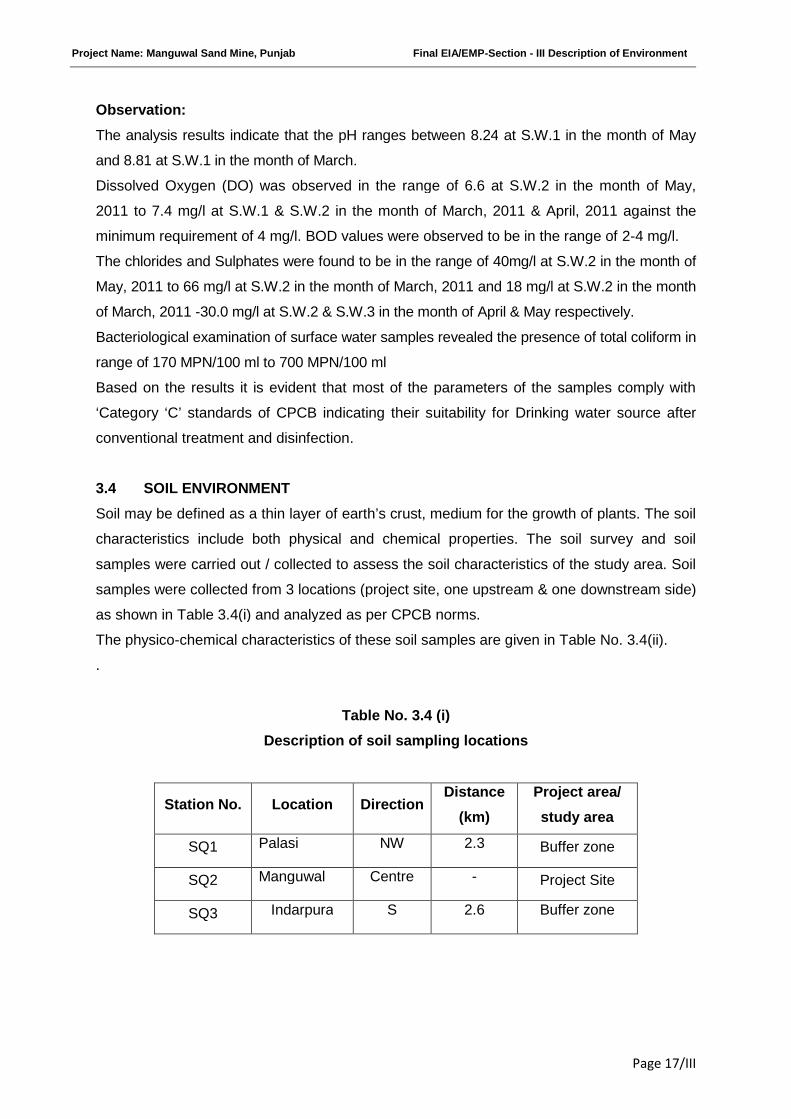
3.4 SOIL ENVIRONMENT
Soil may be defined as a thin layer of earth’s crust, medium for the growth of plants. The soil
characteristics include both physical and chemical properties. The soil survey and soil
samples were carried out / collected to assess the soil characteristics of the study area. Soil
samples were collected from 3 locations (project site, one upstream & one downstream side)
as shown in Table 3.4(i) and analyzed as per CPCB norms.
The physico-chemical characteristics of these soil samples are given in Table No. 3.4(ii).
.
Table No. 3.4 (i)
Description of soil sampling locations
Station No. Location DirectionDistance
(km)
Project area/
study area
SQ1 Palasi NW 2.3 Buffer zone
SQ2 Manguwal Centre - Project Site
SQ3 Indarpura S 2.6 Buffer zone
Project Name: Manguwal Sand Mine, Punjab Final EIA/EMP-Section - III Description of Environment
Page 18/III
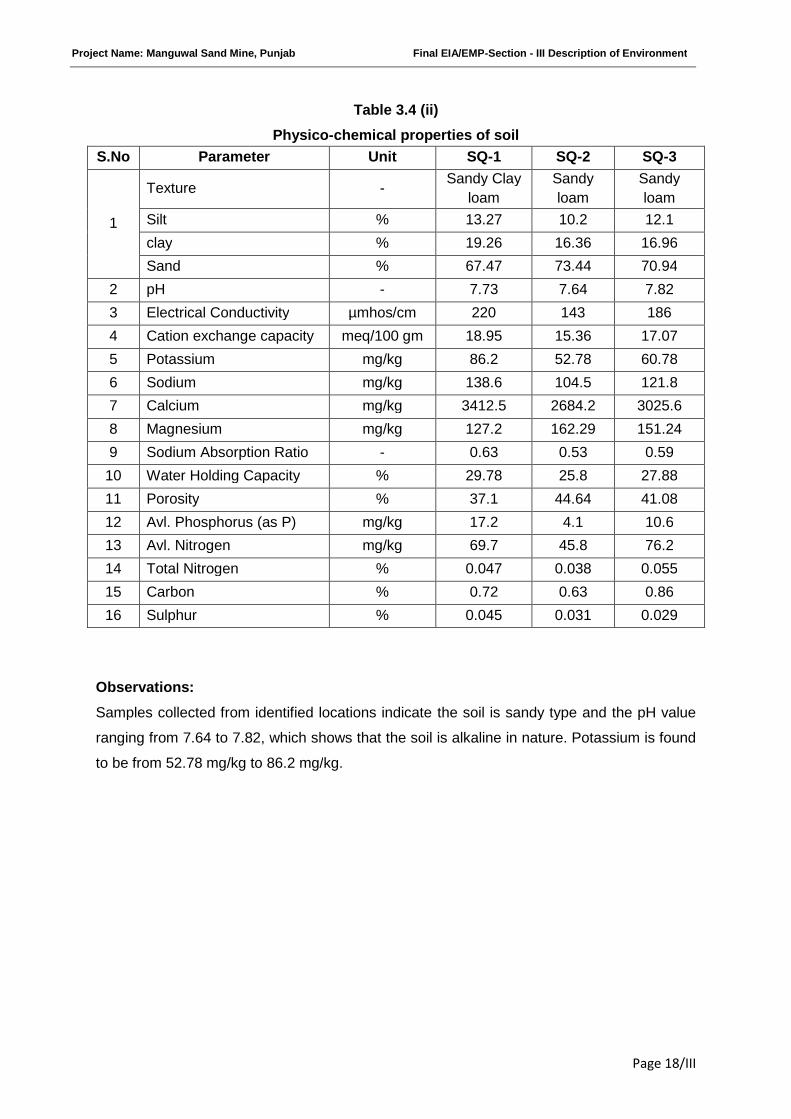
Table 3.4 (ii)
Physico-chemical properties of soil
S.No Parameter Unit SQ-1 SQ-2 SQ-3
1
Texture -Sandy Clay
loam
Sandy
loam
Sandy
loam
Silt % 13.27 10.2 12.1
clay % 19.26 16.36 16.96
Sand % 67.47 73.44 70.94
2 pH - 7.73 7.64 7.82
3 Electrical Conductivity µmhos/cm 220 143 186
4 Cation exchange capacity meq/100 gm 18.95 15.36 17.07
5 Potassium mg/kg 86.2 52.78 60.78
6 Sodium mg/kg 138.6 104.5 121.8
7 Calcium mg/kg 3412.5 2684.2 3025.6
8 Magnesium mg/kg 127.2 162.29 151.24
9 Sodium Absorption Ratio - 0.63 0.53 0.59
10 Water Holding Capacity % 29.78 25.8 27.88
11 Porosity % 37.1 44.64 41.08
12 Avl. Phosphorus (as P) mg/kg 17.2 4.1 10.6
13 Avl. Nitrogen mg/kg 69.7 45.8 76.2
14 Total Nitrogen % 0.047 0.038 0.055
15 Carbon % 0.72 0.63 0.86
16 Sulphur % 0.045 0.031 0.029
Observations:
Samples collected from identified locations indicate the soil is sandy type and the pH value
ranging from 7.64 to 7.82, which shows that the soil is alkaline in nature. Potassium is found
to be from 52.78 mg/kg to 86.2 mg/kg.
Project Name: Manguwal Sand Mine, Punjab Final EIA/EMP-Section - III Description of Environment
Page 19/III
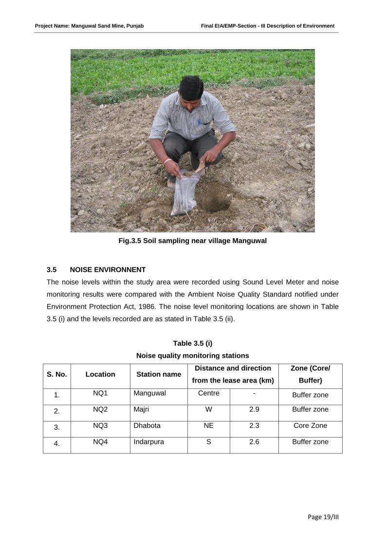
Fig.3.5 Soil sampling near village Manguwal
3.5 NOISE ENVIRONNENT
The noise levels within the study area were recorded using Sound Level Meter and noise
monitoring results were compared with the Ambient Noise Quality Standard notified under
Environment Protection Act, 1986. The noise level monitoring locations are shown in Table
3.5 (i) and the levels recorded are as stated in Table 3.5 (ii).
Table 3.5 (i)
Noise quality monitoring stations
S. No. Location Station nameDistance and direction
from the lease area (km)
Zone (Core/
Buffer)
1. NQ1 Manguwal Centre - Buffer zone
2. NQ2 Majri W 2.9 Buffer zone
3. NQ3 Dhabota NE 2.3 Core Zone
4. NQ4 Indarpura S 2.6 Buffer zone
Project Name: Manguwal Sand Mine, Punjab Final EIA/EMP-Section - III Description of Environment
Page 20/III
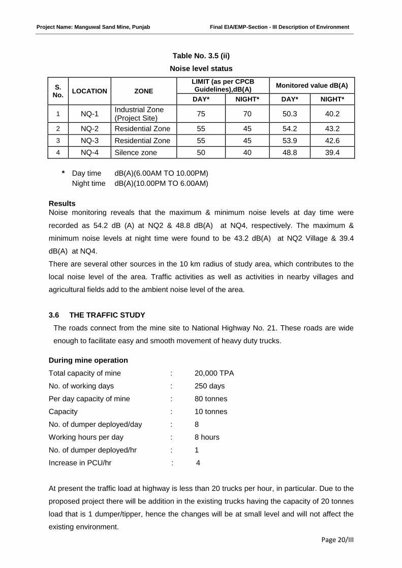
Table No. 3.5 (ii)
Noise level status
S.No.
LOCATION ZONE
LIMIT (as per CPCBGuidelines),dB(A)
Monitored value dB(A)
DAY* NIGHT* DAY* NIGHT*
1 NQ-1Industrial Zone(Project Site)
75 70 50.3 40.2
2 NQ-2 Residential Zone 55 45 54.2 43.2
3 NQ-3 Residential Zone 55 45 53.9 42.6
4 NQ-4 Silence zone 50 40 48.8 39.4
* Day time dB(A)(6.00AM TO 10.00PM)
Night time dB(A)(10.00PM TO 6.00AM)
ResultsNoise monitoring reveals that the maximum & minimum noise levels at day time were
recorded as 54.2 dB (A) at NQ2 & 48.8 dB(A) at NQ4, respectively. The maximum &
minimum noise levels at night time were found to be 43.2 dB(A) at NQ2 Village & 39.4
dB(A) at NQ4.
There are several other sources in the 10 km radius of study area, which contributes to the
local noise level of the area. Traffic activities as well as activities in nearby villages and
agricultural fields add to the ambient noise level of the area.
3.6 THE TRAFFIC STUDY
The roads connect from the mine site to National Highway No. 21. These roads are wide
enough to facilitate easy and smooth movement of heavy duty trucks.
During mine operation
Total capacity of mine : 20,000 TPA
No. of working days : 250 days
Per day capacity of mine : 80 tonnes
Capacity : 10 tonnes
No. of dumper deployed/day : 8
Working hours per day : 8 hours
No. of dumper deployed/hr : 1
Increase in PCU/hr : 4
At present the traffic load at highway is less than 20 trucks per hour, in particular. Due to the
proposed project there will be addition in the existing trucks having the capacity of 20 tonnes
load that is 1 dumper/tipper, hence the changes will be at small level and will not affect the
existing environment.
Project Name: Manguwal Sand Mine, Punjab Final EIA/EMP-Section - III Description of Environment
Page 21/III
3.7 BIOLOGICAL ENVIRONMENT
Biological diversity comprises the variability of species, genus and ecosystems and is very
crucial for maintaining the basic processes on which the life depends. Broadly it can be
divided in to two types i.e. the floral diversity and faunal diversity. Conservation of the
biodiversity is essential for the sustainable development as it not only provides the food,
fodder and medicine but also contribute in improvement of essential environmental attributes
like air, water, soil, etc.
Before starting any Environmental Impact Assessment study, it is necessary to identify the
baseline of relevant environmental parameters which are likely to be affected as a result of
operation of the proposed project. A similar approach has been adopted for conducting the
study on Biological Environment for this Project. Both terrestrial and aquatic ecosystems
have been studied to understand the biological environment.
3.7.1 Physical Environment of the study area:
The State of Punjab can be divided physiographically into two broad regions viz. Shivalik
Himalayan region and alluvial plain region. Satluj, Beas, Ravi and Ghagghar are four main
rivers of the State, which after traversing through Shivalik region, irrigate the plain areas and
make them fertile. Shivalik regions are the lower most part of the Himalaya providing a rich
biodiversity to the State of Punjab. The proposed study area is falling in the alluvial plains of
Punjab. It mainly comprises of agricultural land, river beds, human settlements and barren
land followed by agro-plantation and social forestry.
3.7.2 Forests cover in Rupnagar district:
The Rupnagar district has 387 km2 forest cover out of which 126 km2 is moderately dense
and 261 km2 is open forest (India State of Forests Report 2009), now the total forest cover is
increased to 390 km2 in which moderately dense forest is increased to 146 km2 due to
enhanced plantation activities undertaken in recent past by the State Forest Department and
spurt in agro-forestry practices in the state but the open forest cover has been decline to 244
km2 (India State of Forest Report 2011). The area comprises of agricultural land and riverine
vegetation. Due to high temperature and humidity the area comprises of Tropical Deciduous
vegetation. No wildlife protected area declared protected under “Wildlife (Protection) Act-
1972” is located within 10 km radius of the proposed mining area. However four PF namely
Palasi, Hatra, Himmatpur and Raipur are located in SE, NW, NE & N direction within the
study area.
3.7.3 Methodology, Study period, survey sites etc.:
Detailed survey was conducted to evaluate floral and faunal composition of the study area.
Primary data on floral and faunal composition was recorded during site visit and secondary
Project Name: Manguwal Sand Mine, Punjab Final EIA/EMP-Section - III Description of Environment
Page 22/III
data was collected from the Forest department and published relevant literature. Inventory of
flora and fauna has been prepared on the basis of collected data. The mode of data and
parameters considered during field investigations is given in Table 3.7(i).
Field study period: The ecological survey has been conducted for one season. The detailsare given as below:
Pre-monsoon: May-2011Survey sites :Core zone : At the project site along Sutlej river,Buffer zone : Around the project site in 10 km radius.
Table 3.7(i)
Mode of data collection & parameters considered during the survey
Aspect Data Mode of data collection Parameters
monitored
TerrestrialEcology
Primary datacollection
By field surveyFloral and Faunaldiversity
Secondarydata collection
From authentic sources like Forestsdepartment of Punjab and availablepublished literatures like -[Biodiversity in the ShivalikEcosystem of Punjab (2006) byPunjab State Council for Scientific &Technology, Chandigarh]
Floral and Faunaldiversity and studyof vegetation, foresttype, importanceetc.
AquaticEcology
Primary datacollection
By field surveyFloral and Faunaldiversity
Secondarydata collection
From authentic sources like Forestsdepartment of Punjab and availablepublished literatures like -[Biodiversity in the ShivalikEcosystem of Punjab (2006) byPunjab State Council for Scientific &Technology, Chandigarh]
Floral and Faunaldiversity and studyof vegetation, foresttype, importanceetc.
3.7.4 General Vegetation Study of the area:
The study area comprises of tropical dry deciduous vegetation. The area contains several
Choes (small hilly streams) originating from Himachal and passing through the plain area of
Rupnagar. These plains support the species of Zizyphus, Acacia, Carissa, Adhatoda,
Calotropis, Lantana, Ricinus, etc. Trees are of short stature and never exceed 10 Meters.
The nature of trees is Xerophytic like Capparis sepiaria, Flacourtia indica, Rhamnus
persicus, A. nilotica, A. catechu, A. leucophloea, A. modesta, Diospyros cordifolia etc.
Ground vegetation mainly consists of grasses and small shrubs. Useful fodder grasses,
Cynodon dactylon, Eleusine indica, Trifolium alexandrinum, etc. can be seen growing in the
area. The large weeds which infest uncultivated tracts are aak (Calotropis procera), castor
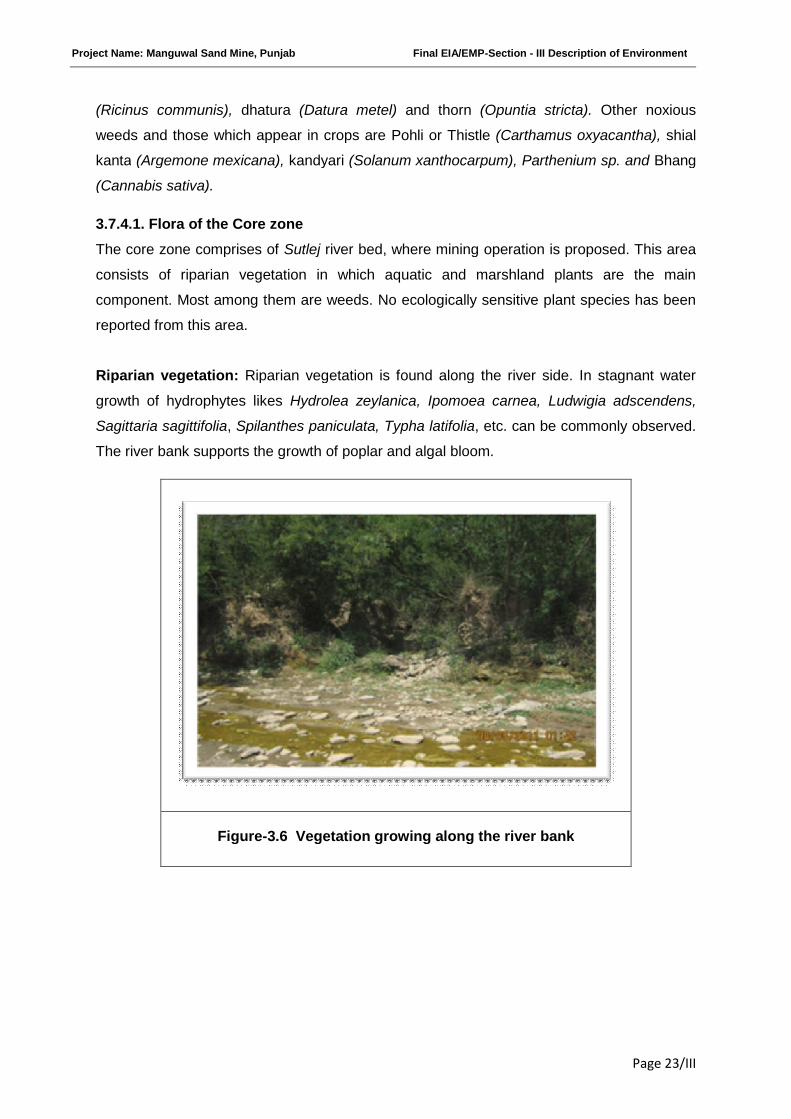
Project Name: Manguwal Sand Mine, Punjab Final EIA/EMP-Section - III Description of Environment
Page 23/III
(Ricinus communis), dhatura (Datura metel) and thorn (Opuntia stricta). Other noxious
weeds and those which appear in crops are Pohli or Thistle (Carthamus oxyacantha), shial
kanta (Argemone mexicana), kandyari (Solanum xanthocarpum), Parthenium sp. and Bhang
(Cannabis sativa).
3.7.4.1. Flora of the Core zone
The core zone comprises of Sutlej river bed, where mining operation is proposed. This area
consists of riparian vegetation in which aquatic and marshland plants are the main
component. Most among them are weeds. No ecologically sensitive plant species has been
reported from this area.
Riparian vegetation: Riparian vegetation is found along the river side. In stagnant water
growth of hydrophytes likes Hydrolea zeylanica, Ipomoea carnea, Ludwigia adscendens,
Sagittaria sagittifolia, Spilanthes paniculata, Typha latifolia, etc. can be commonly observed.
The river bank supports the growth of poplar and algal bloom.
Figure-3.6 Vegetation growing along the river bank
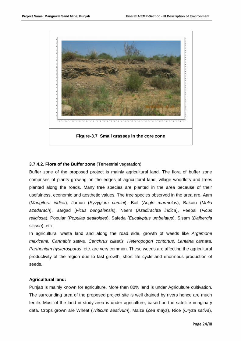
Project Name: Manguwal Sand Mine, Punjab Final EIA/EMP-Section - III Description of Environment
Page 24/III
3.7.4.2. Flora of the Buffer zone (Terrestrial vegetation)
Buffer zone of the proposed project is mainly agricultural land. The flora of buffer zone
comprises of plants growing on the edges of agricultural land, village woodlots and trees
planted along the roads. Many tree species are planted in the area because of their
usefulness, economic and aesthetic values. The tree species observed in the area are, Aam
(Mangifera indica), Jamun (Syzygium cumini), Bail (Aegle marmelos), Bakain (Melia
azedarach), Bargad (Ficus bengalensis), Neem (Azadirachta indica), Peepal (Ficus
religiosa), Popular (Populas dealtoides), Safeda (Eucalyptus umbelatus), Sisam (Dalbergia
sissoo), etc.
In agricultural waste land and along the road side, growth of weeds like Argemone
mexicana, Cannabis sativa, Cenchrus cilitaris, Heteropogon contortus, Lantana camara,
Parthenium hysterosporus, etc. are very common. These weeds are affecting the agricultural
productivity of the region due to fast growth, short life cycle and enormous production of
seeds.
Agricultural land:
Punjab is mainly known for agriculture. More than 80% land is under Agriculture cultivation.
The surrounding area of the proposed project site is well drained by rivers hence are much
fertile. Most of the land in study area is under agriculture, based on the satellite imaginary
data. Crops grown are Wheat (Triticum aestivum), Maize (Zea mays), Rice (Oryza sativa),
Figure-3.7 Small grasses in the core zone
Project Name: Manguwal Sand Mine, Punjab Final EIA/EMP-Section - III Description of Environment
Page 25/III
Sugarcane (Saccharum officinarum), Bajra (Pennisetum glaucum), Sunflower (Helianthus
annuus) etc. Seasonal vegetables are also grown by village people as cash crops.
Waste land:
Most of the areas nearby the Core zone are waste land. Commonly seen plant species in
such areas are Cannabis sativa, Lantana camara, Ipomea carnea, Calotropis procera,
Cassia tora, Parthenium hysterophorus, Ziziphus mauritiana, Heteropogon contortus,
Argemone Mexicana, etc. These weeds are affecting the agricultural productivity of the
region due to fast growth, short life cycle and enormous production of seeds.
Vegetation in and around human settlement:
Vegetation pattern in villages and surrounding areas are slightly different from the rest of the
areas. The common species grown near villages are mostly edible or useful plants such as
Mangifera indica, Madhuca indica, Syzygium cumini, Azadirachta indica, Albizia lebbeck,
Delonix regia, Tamarindus indica, Ficus religiosa, etc.
A list of flora of the study area is enclosed as Table 3.7(ii).
Table 3.7(ii)
Flora of the Core zone
Sl.No. Species Family Habit
1 Ageratum conyzoides L. Asteraceae Herb
2 Amaranthus spinosus L. Amaranthaceae Herb
3 Calotropis procera (Aiton) R.Br. Asclepiadaceae Shrub
4 Cannabis sativa L. Canabaceae Herb
7 Chenopodium album L. Chenopodiaceae Herb
8 Datura innoxia Mill. Solanaceae Shrub
9 Hydrolea zeylanica (L.) Vahl Hydrophylaceae Herb
10 Ipomoea carnea Jacq. Convolvulaceae Shrub
11 Salix babylonia Salicaceae Tree
12 Terminalia arjuna Combretaceae Tree
13 Dalbergia sissoo Fabaceae Tree
14 Bombax ceiba Bombacaceae TreeNote:Trees are near the banks of the river(Periphery of the leased area)
Project Name: Manguwal Sand Mine, Punjab Final EIA/EMP-Section - III Description of Environment
Page 26/III
Flora of the Buffer zone
Sl.No. Species Family Habit
1 Alternanthera paronychioides A.St.-Hil. Amaranthaceae Herb
2 Alternanthera pungens Kunth Amaranthaceae Herb
3 Amaranthus spinosus L. Amaranthaceae Herb
4 Colocasia esculenta (L.) Schott Araceae Herb
5 Ageratum conyzoides L. Asteraceae Herb
6 Grangea maderaspatana (L.) Poir. Asteraceae Herb
7 Parthenium hysterophorus L. Asteraceae Herb
8 Cassia tora L. Caesalpinaceae Herb
9 Cannabis sativa L. Cannabaceae Herb
10 Chenopodium album L. Chenopodiaceae Herb
11 Argemone mexicana L. Papaveraceae Herb
12 Brachiaria ramosa (L.) Stapf. Poaceae Herb
13 Cynodon dactylon (L.) Pers. Poaceae Herb
14 Eleusine indica (L.) Gaertn. Poaceae Herb
15 Eragrostis tenella (L.) Roem. & Schult. Poaceae Herb
16 Imperata cylindrica (L.) P. Beauv. Poaceae Herb
17 Saccharum spontaneum L. Poaceae Herb
18 Physalis minima L. Solanaceae Herb
19 Calotropis procera (Aiton) R.Br. Asclepiadaceae Shrub
20 Cassia occidentalis L. Caesalpinaceae Shrub
21 Croton bonplandianum Baill. Euphorbiaceae Shrub
22 Abutilon indicum (L.) Sweet Malvaceae Shrub
23 Bougainvillea spectabilis Willd. Nyctaginaceae Shrub
24 Ziziphus mauritiana Lam. Rhamnaceae Shrub
25 Datura innoxia Mill. Solanaceae Shrub
26 Solanum virginianum L. Solanaceae Shrub
27 Lantana camara L. Verbenaceae Shrub
28 Mangifera indica L. Anacardiaceae Tree
29 Polyalthia longifolia (Sonn.) Thw. Annonaceae Tree
30 Alstonia scholaris (L.) R. Br. Apocynaceae Tree
31 Cassia fistula L. Caesalpinaceae Tree
32 Ricinus communis L. Euphorbiaceae Tree
33 Albizia lebbeck (L.) Benth. Fabaceae Tree
34 Bauhinia acuminata L. Fabaceae Tree
35 Butea monosperma (Lam.) Taub. Fabaceae Tree
36 Dalbergia sissoo Roxb. Fabaceae Tree
37 Bombax ceiba L. Malvaceae Tree
38 Azadirachta indica A.Juss. Meliaceae Tree
39 Melia azedarach L. Meliaceae Tree
Project Name: Manguwal Sand Mine, Punjab Final EIA/EMP-Section - III Description of Environment
Page 27/III
3.7.5. Wild life and avifauna of the study area:
The major part of the study area lies under agriculture field and human settlements which
restrict the wildlife habitat significantly. Most of the mammalian species reported in the study
area are domesticated animals.
There are many rivulets present in the buffer zone of study area which are the major
attraction sites for avifauna. Common Myna, Kingfisher, Spotted dove, Pintail and Pond
Heron are some dominant bird species present in the study area. Migratory movement of
birds in the study area has not been reported. As far as the reptile community was
concerned, rat snake and house lizard are reported from the study area.
A list of animals of the study area has been prepared on the basis of local inquiry from the
village people and from the available published literatures. The animals thus recorded were
cross checked with Wildlife (Protection) Act, 1972 for their schedule. No established
habitats of any mammals or birds are noticed in river bed and along the banks.
The fauna of study area can be grouped in to aquatic and terrestrial as the core area mostly
comprises of aquatic fauna and the buffer area provides shelter to the terrestrial animals.
3.7.5.1. Aquatic fauna: Aquatic fauna mostly comprises of Amphibians, Molluscs & Fish
which cannot survive without water. The aquatic fauna of the project site is given as below:
Avian fauna: No bird’s habitats like nesting, breeding and forging patterns are noticed in the
core zone. Local birds are noticed crossing over the banks in search of food. No fixed
pattern in migratory behavior is noticed.
Amphibian: Amphibians are commonly found at the places along the margin of aquatic and
terrestrial systems. Due to presence of water bodies like river, nalas, etc. the study area is
providing shelter to many amphibian species. Some of the commonly reported species are
Bufo melanostictus (common Indian toad), Euphlyctis cyanophlyctis (Indian skipper frog),
Hoplobatrachus tigerinus (Indian bull frog) etc.
Fish: The fish species which are commonly found in the proposed site are Labio bata
(Bhangan or Bata), Gudusia chapara (Chappera or Palla), Labio rohita (Dumra or Dhambra),
Notopterus notopterus (Pari or Battu), Catla catla (Theila), etc
Molluscs: Fresh water molluscs play very important role in aquatic ecosystems. Many
species serve as food for many aquatic animals as well as for human. Species like Bellamya
benghalensis, Pila globosa, Brotia costula, Angulyara oxytropis and Lemellidens marginalis
play an important role in human food.
Project Name: Manguwal Sand Mine, Punjab Final EIA/EMP-Section - III Description of Environment
Page 28/III
3.7.5.2. Terrestrial fauna:
Mammals: Many domesticated mammal species are reported from buffer zone during the
field survey. Common grazing animals like Buffalo, cow, goat etc. can be noticed in open
grass fields. Small mammals like Indian palm squirrel (Funambulus palmarum) and field
mouse (Apodemus sylvaticus) are noticed in vicinity of village. Inquiry from village people
regarding wild animals reveals that Rhesus macaque (Macaca mulatta), Indian hare (Lepus
nigricollis), fruits bat (Pteropus conspicillatus), Nilgai (Boselaphus tragocamelus), etc. are
often seen in the area.
.
Avifauna: Water birds like Gadwall (Anas strepera), Common teal (Anas crecca), White
throated kingfisher (Halcyon smyrnensis), Pied kingfisher (Ceryle rudis), Red wattled lapwing
etc are noticed. House crow (Corvus splendens), House sparrow (Passer domesticus),
Common Myna (Acridotheres tristis), Gracula religiosa), Red-rumped Swallow (Cecropis
daurica), Hoopoe (Upupa epops ceylonensis) are of common occurrence.
Reptiles: The reptilians species commonly reported are Agama (Laudakia tuberculata) in
settlement area, Garden lizard (Calotes versicolor) and Eutropis macularia along shady
places in agricultural field or where growth of bushes is noticed. Among non poisonous
snakes rat snakes (Ptyas mucosus) are commonly noticed in field, followed by poisonous
snakes like Cobra (Naja naja) and Banded krait (Bungarus multicinctus) are reported to be
seen by farmers.
A list of Fauna of the study area is presented in Table 3.7(iii) and Table 3.7(iv).
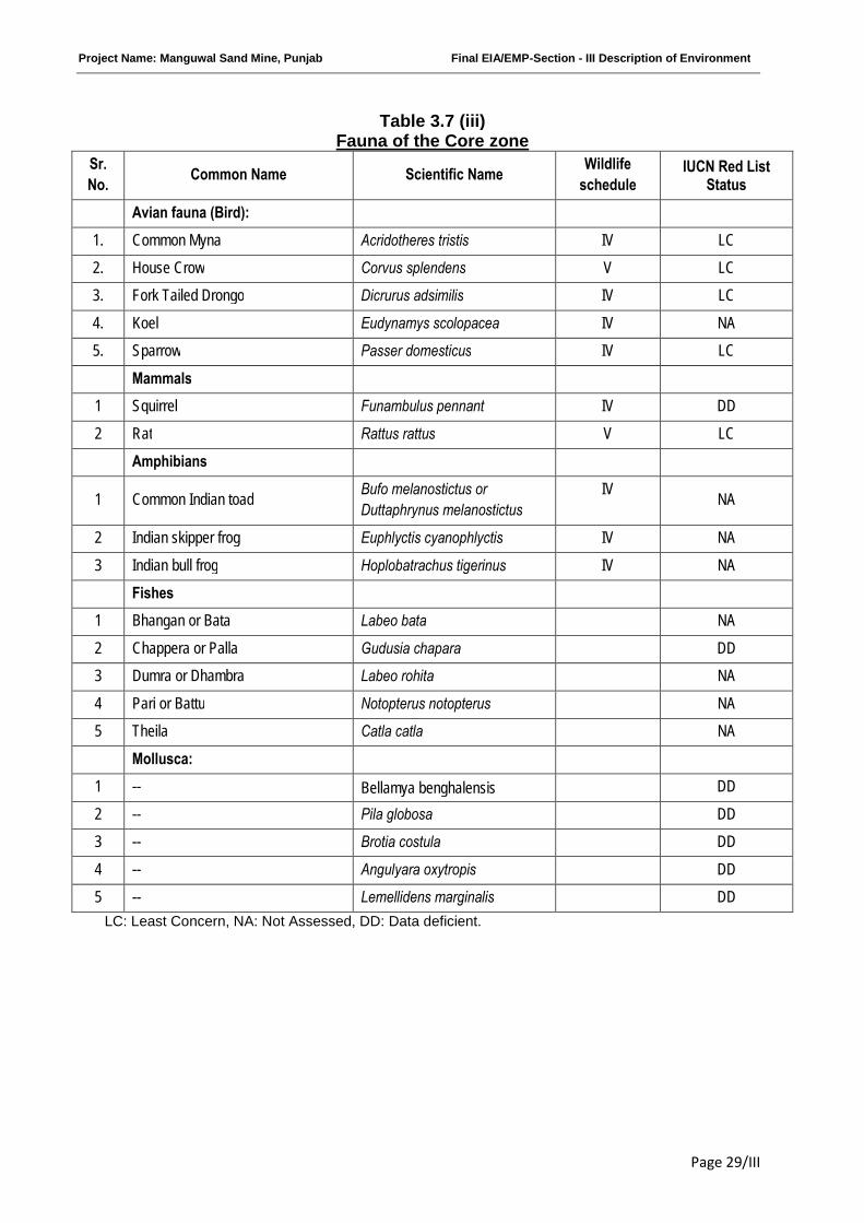
Project Name: Manguwal Sand Mine, Punjab Final EIA/EMP-Section - III Description of Environment
Page 29/III
Table 3.7 (iii)Fauna of the Core zone
Sr.
No.Common Name Scientific Name
Wildlife
scheduleIUCN Red List
Status
Avian fauna (Bird):
1. Common Myna Acridotheres tristis IV LC
2. House Crow Corvus splendens V LC
3. Fork Tailed Drongo Dicrurus adsimilis IV LC
4. Koel Eudynamys scolopacea IV NA
5. Sparrow Passer domesticus IV LC
Mammals
1 Squirrel Funambulus pennant IV DD
2 Rat Rattus rattus V LC
Amphibians
1 Common Indian toadBufo melanostictus or
Duttaphrynus melanostictus
IVNA
2 Indian skipper frog Euphlyctis cyanophlyctis IV NA
3 Indian bull frog Hoplobatrachus tigerinus IV NA
Fishes
1 Bhangan or Bata Labeo bata NA
2 Chappera or Palla Gudusia chapara DD
3 Dumra or Dhambra Labeo rohita NA
4 Pari or Battu Notopterus notopterus NA
5 Theila Catla catla NA
Mollusca:
1 -- Bellamya benghalensis DD
2 -- Pila globosa DD
3 -- Brotia costula DD
4 -- Angulyara oxytropis DD
5 -- Lemellidens marginalis DD
LC: Least Concern, NA: Not Assessed, DD: Data deficient.
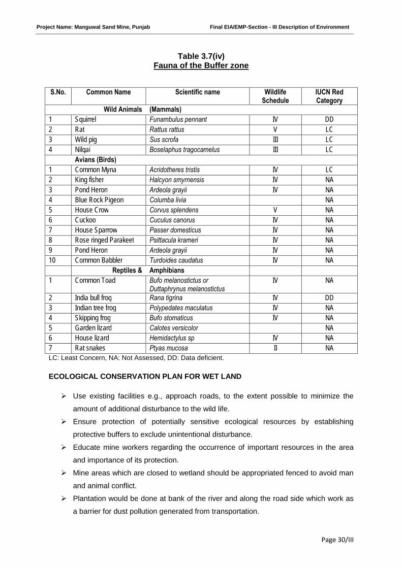
Project Name: Manguwal Sand Mine, Punjab Final EIA/EMP-Section - III Description of Environment
Page 30/III
Table 3.7(iv)Fauna of the Buffer zone
S.No. Common Name Scientific name WildlifeSchedule
IUCN RedCategory
Wild Animals (Mammals)
1 Squirrel Funambulus pennant IV DD
2 Rat Rattus rattus V LC
3 Wild pig Sus scrofa III LC
4 Nilgai Boselaphus tragocamelus III LC
Avians (Birds)
1 Common Myna Acridotheres tristis IV LC
2 King fisher Halcyon smyrnensis IV NA
3 Pond Heron Ardeola grayii IV NA
4 Blue Rock Pigeon Columba livia NA
5 House Crow Corvus splendens V NA
6 Cuckoo Cuculus canorus IV NA
7 House Sparrow Passer domesticus IV NA
8 Rose ringed Parakeet Psittacula krameri IV NA
9 Pond Heron Ardeola grayii IV NA
10 Common Babbler Turdoides caudatus IV NA
Reptiles & Amphibians
1 Common Toad Bufo melanostictus orDuttaphrynus melanostictus
IV NA
2 India bull frog Rana tigrina IV DD
3 Indian tree frog Polypedates maculatus IV NA
4 Skipping frog Bufo stomaticus IV NA
5 Garden lizard Calotes versicolor NA
6 House lizard Hemidactylus sp IV NA
7 Rat snakes Ptyas mucosa II NA
LC: Least Concern, NA: Not Assessed, DD: Data deficient.
ECOLOGICAL CONSERVATION PLAN FOR WET LAND
Use existing facilities e.g., approach roads, to the extent possible to minimize the
amount of additional disturbance to the wild life.
Ensure protection of potentially sensitive ecological resources by establishing
protective buffers to exclude unintentional disturbance.
Educate mine workers regarding the occurrence of important resources in the area
and importance of its protection.
Mine areas which are closed to wetland should be appropriated fenced to avoid man
and animal conflict.
Plantation would be done at bank of the river and along the road side which work as
a barrier for dust pollution generated from transportation.
Project Name: Manguwal Sand Mine, Punjab Final EIA/EMP-Section - III Description of Environment
Page 31/III
Local plant species and grasses would be selected for plantation on the basis of
strong root system as they retain sand and silt locally and prevent their further
transportation to wetland areas.
Aware workers not to throw plastic into water bodies as many water animals confuse
plastic with food. When ingested, their digestive tracts may become blocked and they
may die from starvation.
***********
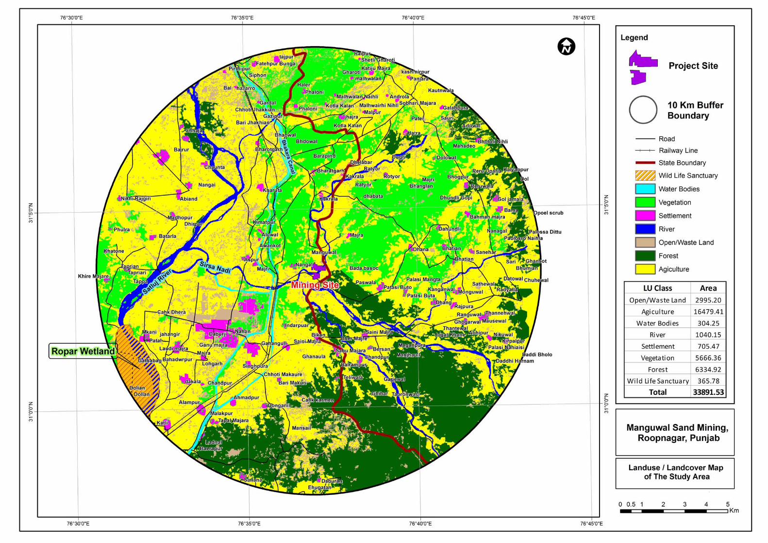
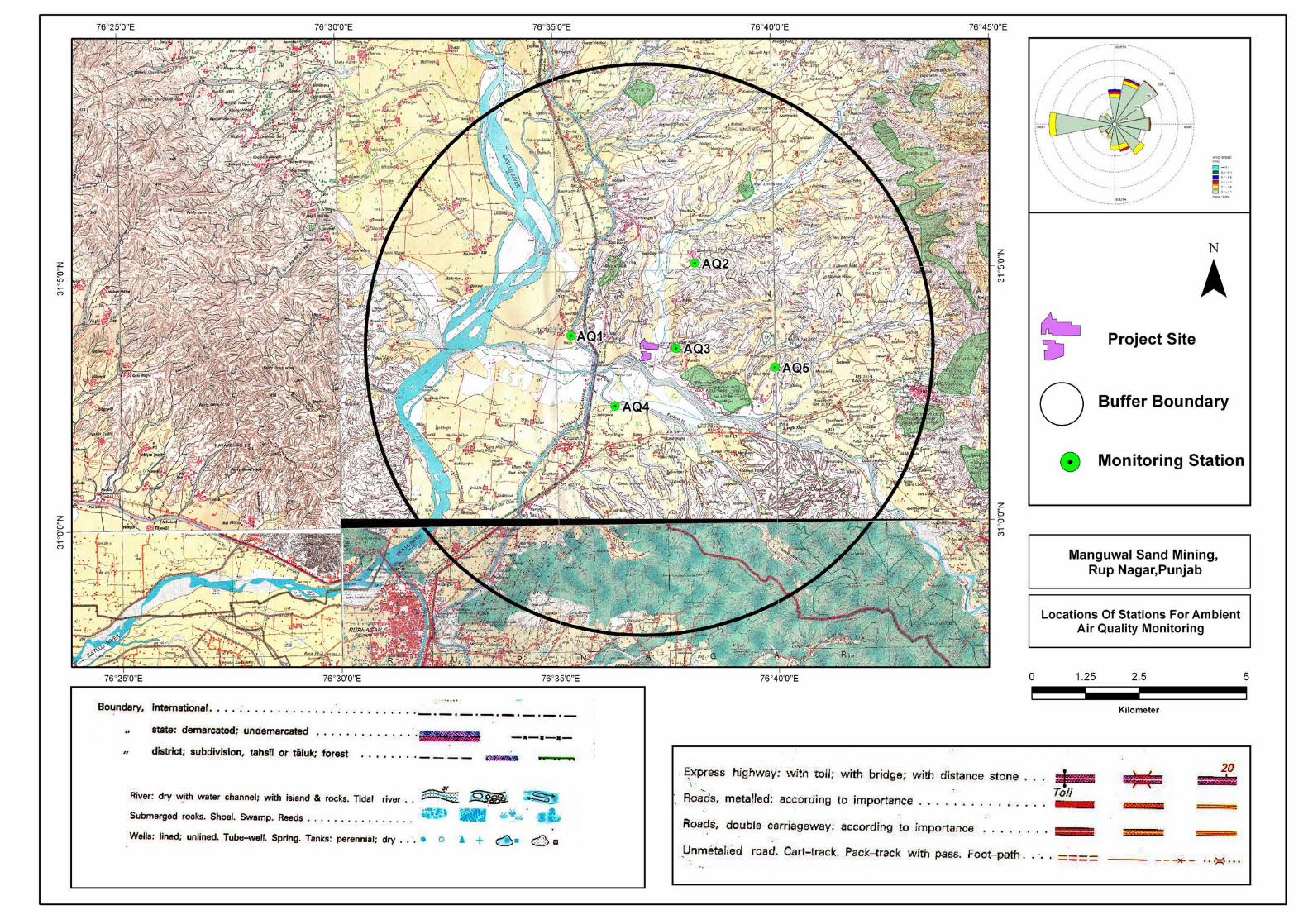
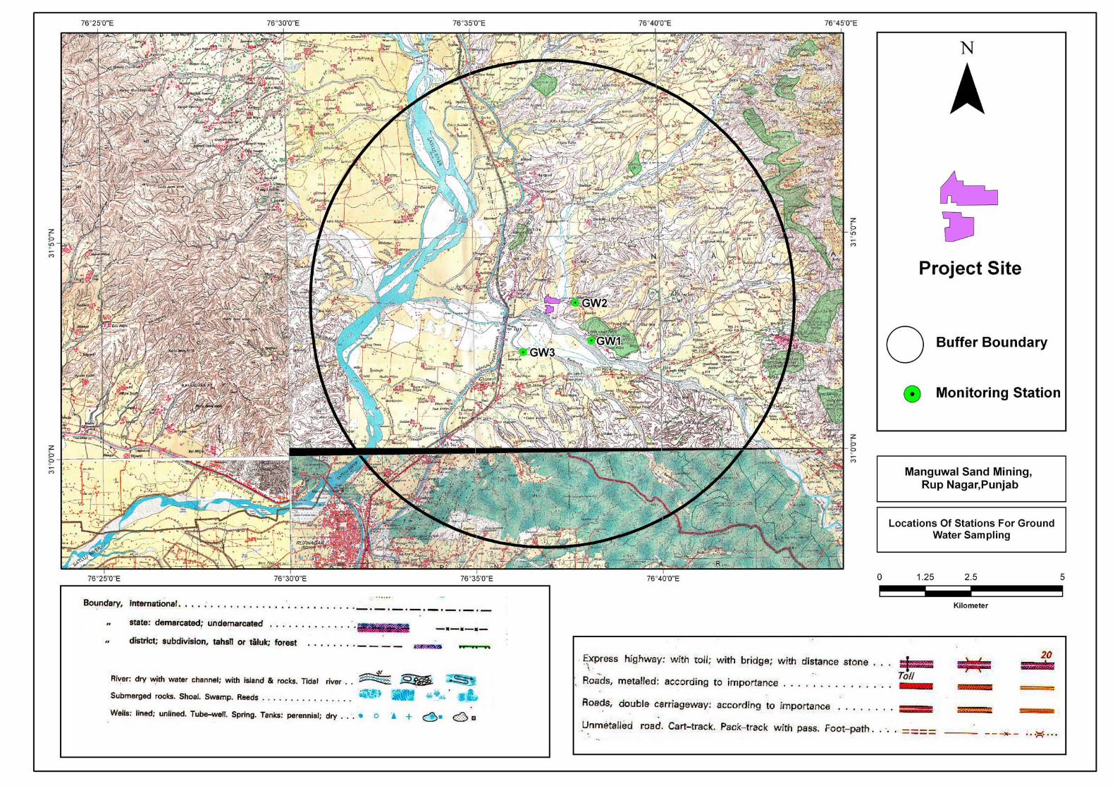
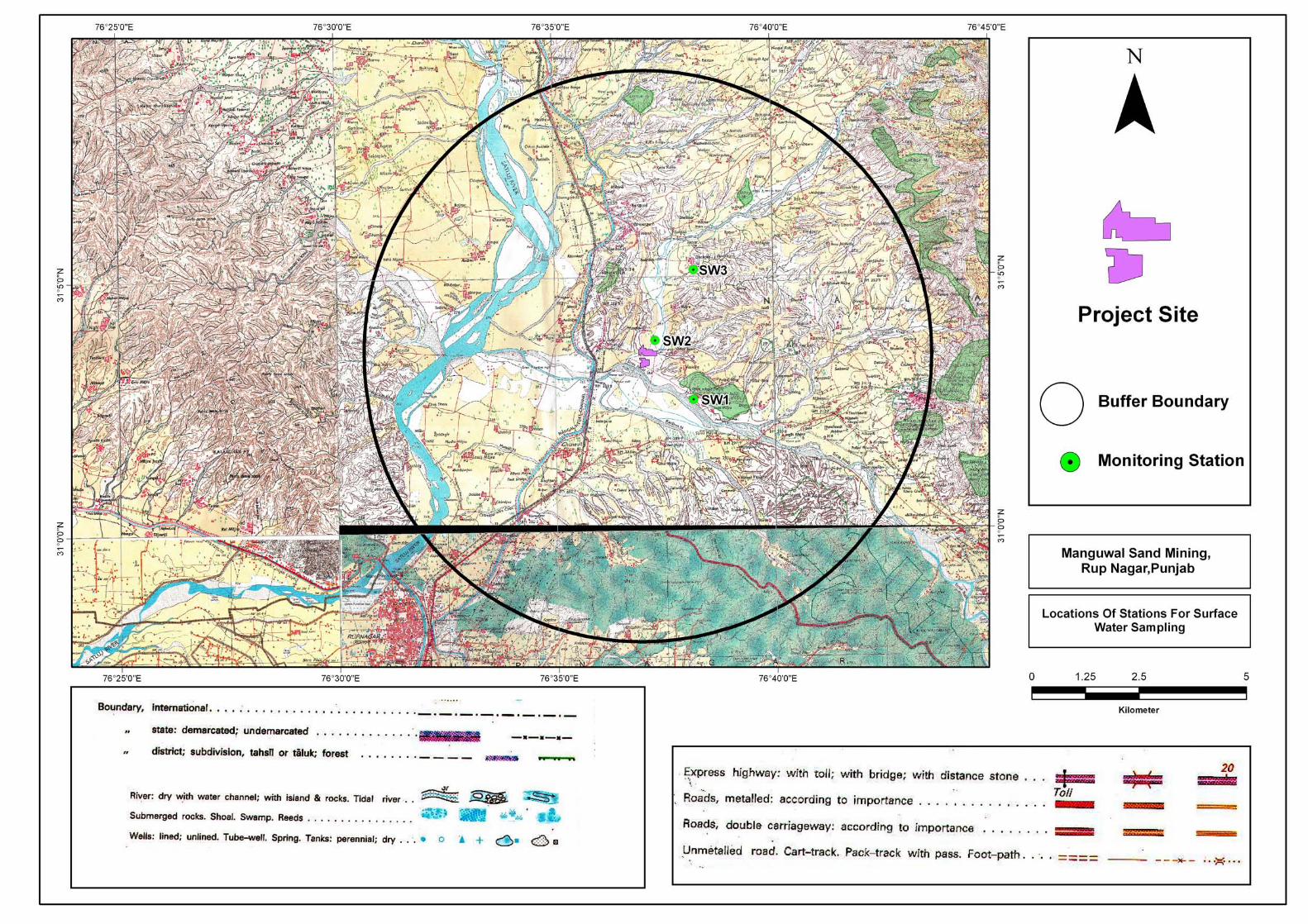


Project Name: Manguwal Sand Mine, Punjab Final EIA/EMP-Section – IV Anticipated Environmental Impact
and Mitigation Measures
Page 1/IV
SECTION-IV
ANTICIPATED ENVIRONMENTAL IMPACT AND MITIGATION MEASURES
INDEX
S. No. CONTENTS Page No.
4.0 GENERAL 2/IV
4.1 LAND ENVIRONMENT 2/IV
4.2 WATER ENVIRONMENT 7/IV
4.3 AIR ENVIRONMENT 8/IV
4.4 NOISE ENVIRONMENT 11/IV
4.5 BIOLOGICAL ENVIRONMENT 13/IV
4.6 TRAFFIC ANALYSIS 17/IV
4.7 OVERALL IMPACT OF THE PROPOSED PROJECT 18/IV
4.8 STATUATORY REQUIREMENTS 19/IV
Project Name: Manguwal Sand Mine, Punjab Final EIA/EMP-Section – IV Anticipated Environmental Impact
and Mitigation Measures
Page 2/IV
4.0 GENERAL
All development projects whether new, under modernization or renovation, do have an
impact on the natural set up of the environment. This impact may be beneficial or adverse,
depending on the improvement or the deterioration it brings about change in the status of air,
water, land, ecology, natural systems, socio-cultural life styles and economics of the
population. Depending on the nature of activities and baseline environment status, the
impacts are assessed for their importance. On the basis of the impact analysis, the
mitigating action and future monitoring requirement are focused in the Environmental
Management plan for countering or minimizing the impacts.
Keeping in mind, the environmental baseline scenario as detailed in Section III and the
proposed mining activity described in Section II, it is attempted to assess the likely impact
and its extent on various environmental parameters and likely mitigation measures to be
adopted.
4.1 LAND ENVIRONMENT
The mining and allied activities involved in river bed mining are creation of temporary haul
roads / transportation track and formation of mined pits inside river, etc. The scientific mining
i.e. systematic removal of sand will not cause bed degradation and will not affect aquatic
environment. This RBM project does not involve any waste generation. Thus no waste dump
sites are needed for the project. Impacts of these activities are given below:
IMPACT OF SAND MINING
The proposed extraction of streambed materials, mining below the existing streambed, and
alteration of channel-bed form and shape leads to several impacts such as erosion of
channel bed and banks, increase in channel slope, and change in channel morphology.
These impacts may cause:
a. Undercutting and collapse of river banks.
b. Loss of adjacent land and/or structures.
c. Upstream erosion as a result of an increase in channel slope and changes in flow
velocity.
d. Downstream erosion due to increased carrying capacity of the stream
e. Downstream changes in patterns of deposition.
f. Changes in channel bed and habitat type.
Project Name: Manguwal Sand Mine, Punjab Final EIA/EMP-Section – IV Anticipated Environmental Impact
and Mitigation Measures
Page 3/IV
Mitigation measures
a. Since the project is mainly for sand excavation (soil deficient), no loss of top soil is
involved /anticipated.
b. The RBM mining activity will be done manually which will avoid adverse effects
associated with heavy machinery / equipments / their functioning.
c. Sand mining will be restricted down to 3 m below river bed or the water table
whichever less.
d. The RBM will be done in unsaturated zone, thus minimising loss to habitat.
e. Dredging will not be allowed.
Sand Budget
Determining the sand budget for a particular stream reach requires site-specific topographic,
hydrologic, and hydraulic information. This information is used to determine the amount of
sand that can be removed from the area without causing undue erosion or degradation,
either at the site or at a nearby location, upstream or downstream.
In-channel or near-channel sand-and-gravel mining changes the sediment budget, and may
result in substantial changes in the channel hydraulics. These interventions can have
variable effects on aquatic habitat, depending on the magnitude and frequency of the
disturbance, mining methods, particle-size characteristics of the sediment, the
characteristics of riparian vegetation, and the magnitude and frequency of hydrologic events
following the disturbance.
Temporal and spatial responses of alluvial river systems are a function of geomorphic
thresholds, feedbacks, lags, upstream or downstream transmission of disturbances, and
geologic/physiographic controls. Minimization of the negative effects of sand-and-gravel
mining requires a detailed understanding of the response of the channel to mining
disturbances.
Decisions on where to mine, how much and how often require the definition of a reference
state, i.e., a minimally acceptable or agreed-upon physical and biological condition of the
channel. Present understanding of alluvial systems is generally not sufficient to enable the
prediction of channel responses quantitatively and with confidence; therefore, reference
states are difficult to determine. Still, a general knowledge of fluvial processes can provide
guidelines to minimize the detrimental effects of mining. Well-documented cases and related
field data are required to properly assess physical, biological, and economic tradeoffs.
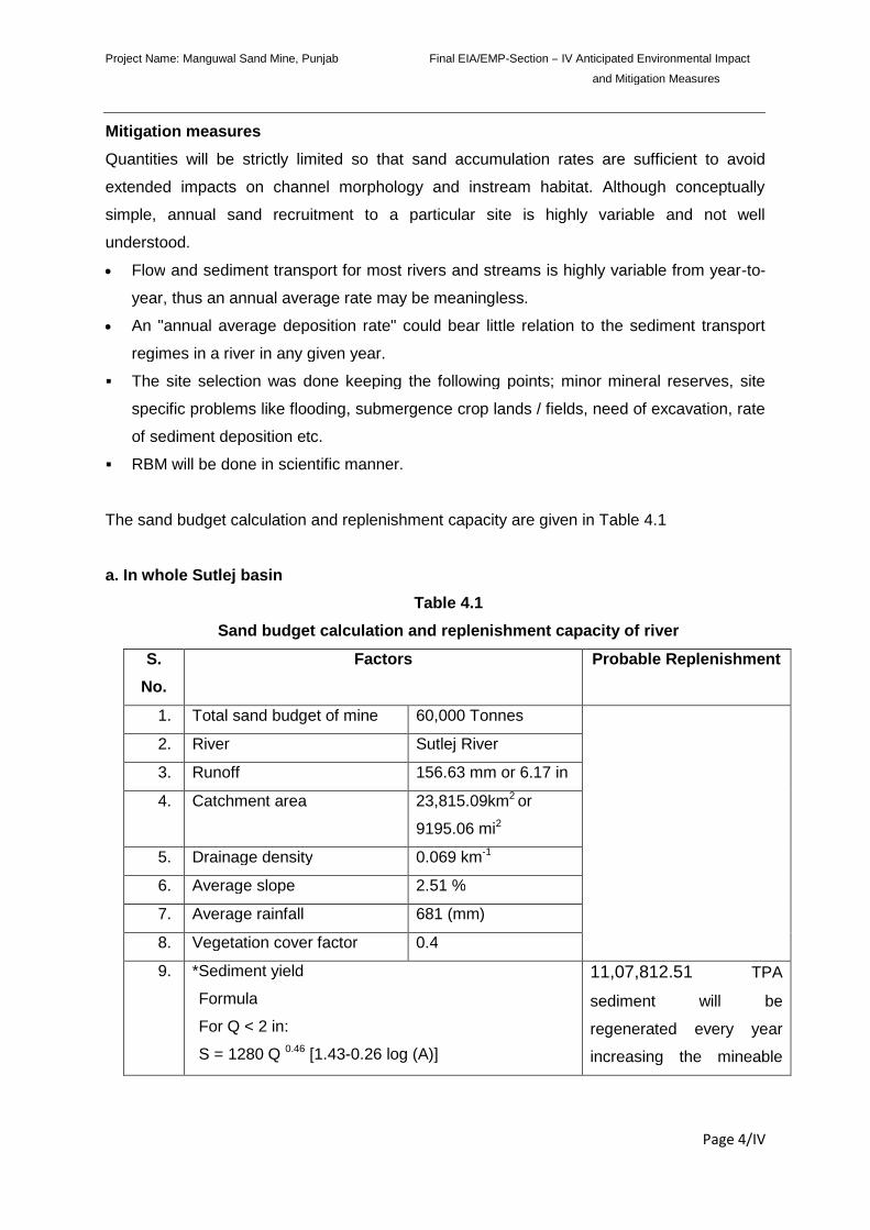
Project Name: Manguwal Sand Mine, Punjab Final EIA/EMP-Section – IV Anticipated Environmental Impact
and Mitigation Measures
Page 4/IV
Mitigation measures
Quantities will be strictly limited so that sand accumulation rates are sufficient to avoid
extended impacts on channel morphology and instream habitat. Although conceptually
simple, annual sand recruitment to a particular site is highly variable and not well
understood.
Flow and sediment transport for most rivers and streams is highly variable from year-to-
year, thus an annual average rate may be meaningless.
An "annual average deposition rate" could bear little relation to the sediment transport
regimes in a river in any given year.
The site selection was done keeping the following points; minor mineral reserves, site
specific problems like flooding, submergence crop lands / fields, need of excavation, rate
of sediment deposition etc.
RBM will be done in scientific manner.
The sand budget calculation and replenishment capacity are given in Table 4.1
a. In whole Sutlej basin
Table 4.1
Sand budget calculation and replenishment capacity of river
S.
No.
Factors Probable Replenishment
1. Total sand budget of mine 60,000 Tonnes
2. River Sutlej River
3. Runoff 156.63 mm or 6.17 in
4. Catchment area 23,815.09km2 or
9195.06 mi2
5. Drainage density 0.069 km-1
6. Average slope 2.51 %
7. Average rainfall 681 (mm)
8. Vegetation cover factor 0.4
9. *Sediment yield
Formula
For Q < 2 in:
S = 1280 Q 0.46 [1.43-0.26 log (A)]
11,07,812.51 TPA
sediment will be
regenerated every year
increasing the mineable
Project Name: Manguwal Sand Mine, Punjab Final EIA/EMP-Section – IV Anticipated Environmental Impact
and Mitigation Measures
Page 5/IV
For Q > 2 in:
S = 1965 e -0.055Q [1.43-0.26 log (A)]
Here:
Q (in) = Mean Annual run off =156.63 mm
= 6.17 in
A (mi2) = Catchment area= 23,815.09 km2
= 9195.06 mi2
Sediment yield S= (tons/yr)
S= 1965 e-0.055x6.17[1.43 - 0.26 log (9195.06)]
S = 11,07,812.51 tons/year
*source:- Calculation of sediment yield by the Dendy-
Bolton formula
reserves.
4.2 WATER ENVIRONMENT
Damage in the water body, depends on its assimilative capacity. To find out assimilative
capacity of receiving water body, water samples were collected from different groundwater
and surface water sources.
Mining of sand from within or near a streambed has a direct impact on the stream’s physical
habitat characteristics. These characteristics include geometry, bed evaluation, substrate
composition and stability, in stream roughness elements, depth, velocity, turbidity, sediment
transport, stream discharge and temperature. Altering these habitat characteristics can have
deleterious impacts on both in stream biota and associated riparian habitat.
The detrimental effects, if any, to biota resulting from bed material mining are caused by
three main processes:
i. Alteration of flow patterns resulting from modification of the river bed
ii. An excess of suspended sediment
iii. Damage to riparian vegetation and in stream habitat
The disturbance activities can also disrupt the ecological diversity in many ways.
As the project activity is carried out in the meandering part of the river bed, none of the
project activities affect the water environment or riparian habitats. In the projects, it is not
Project Name: Manguwal Sand Mine, Punjab Final EIA/EMP-Section – IV Anticipated Environmental Impact
and Mitigation Measures
Page 6/IV
proposed to divert or truncate any stream. No proposal is envisaged for pumping of water
either from the river or tapping the ground water. In the lean months, the proposed sand
mining will not expose the base flow of the river and hence, there will not be any adverse
impact on surface hydrology and ground water regime due to this project. DIC, GoP will
adhere all guidelines and rules for proper and scientific method of mining during the period
of extracting the sand. Thus, the project activities shall not have any adverse affect on the
physical components of the environment and therefore may not have any effect on the
recharge of ground waters or affect the water quality.
Mitigation measures
The deposits occur in the middle/bottom of the river. During the lease period, the deposit will
be worked from the top surface to 3 m bgl or above the ground water table whichever is less.
Thus no ground water pollution is expected, as mining will not intersect ground water. It is
not proposed to divert or truncate any part of the stream and at no point of time mining will
be done from the stream.
4.3 AIR ENVIRONMENT
Anticipated impacts and evaluation
Information on air quality was studied and various modeling techniques predicted that the
mining activity is not likely to affect the air quality in a significant manner. However, loading
of sand, its transportation and unloading operations may cause some deterioration in air
quality due to handling dry materials. In the present case, only wet materials will be handled,
thus eliminating problems of fugitive dust. Also, the collection and lifting of minerals will be
done manually without any blasting. Therefore the dust generated is likely to be insignificant
as compared to mining processes involving drilling, blasting, mechanized loading etc.
Air Modeling
In general, mining operations generate substantial quantities of airborne respirable dust,
which may lead to the development of respirable diseases in mine workers. The increasing
trend of mining leads to release of huge amount of dust. These air borne dust particles,
generally below 100 micron in size, are nuisance particulates and cause health hazards as
an ill effect of mining activities. Extraction activities like drilling, blasting, material handling
and transport are a potential source of air pollution. Therefore, a detailed study on emission
sources and quantification of pollutant concentration by means of dispersion modeling is
Project Name: Manguwal Sand Mine, Punjab Final EIA/EMP-Section – IV Anticipated Environmental Impact
and Mitigation Measures
Page 7/IV
required to access the environmental impact of a mine. On the basis of the predicted
increments to air pollutant concentrations, an effective mitigation and environmental plan can
be devised for sensitive areas. In case of river bed sand mining, as there is no blasting and
drilling activities, the impacts may only be caused by material handling and transportation
activities of mostly wet sand and the same are minimal.
FUGITIVE DUST- MODELING
Air quality modeling was done using line source model as published by USEPA “Workbook
of Dispersion Modeling” by Turner, for transportation though roads and the empirical
emission factor equations from USEPA. Emission factors to be used in Line source
Dispersion equation is adopted from formula as given below:
E= k * (1.7) * (s/12)*(S/48) * (W/2.7)0.7 * (w/4)0.5 * (365-p/365) kg/VKT
Where
E = Emission Rate (kg/VKT)
k= Particle size multiplier = (0.36)
s = Silt Content of the Road surface material (%) = 10%
S = Mean Vehicle Speed (km/hr) = 20 km/hr
W=Mean Vehicle Weight (tonnes) = 10 tonnes
w= Mean number of wheels = 8
p= Number of days with at least 0.254 mm of precipitation per year = 60
f = frequency of Vehicle movement in no per hour = 1 vehicle / hour
Thus using equation (1)
E = 0.61766 kg/VKT
E = 0.0002 g/sec/m
Concentration of the fugitive dust was calculated using the empirical equations for unpaved
roads published by USEPA- AP42. The Concentration of the fugitive Dust is given below:
C = (2/π) 1/2 (E / σz υ) Exp- [(h2) / (2 σz2)] x 106 ---------------------------- (2)
Where
C = Hourly Concentration in microgram/ m3
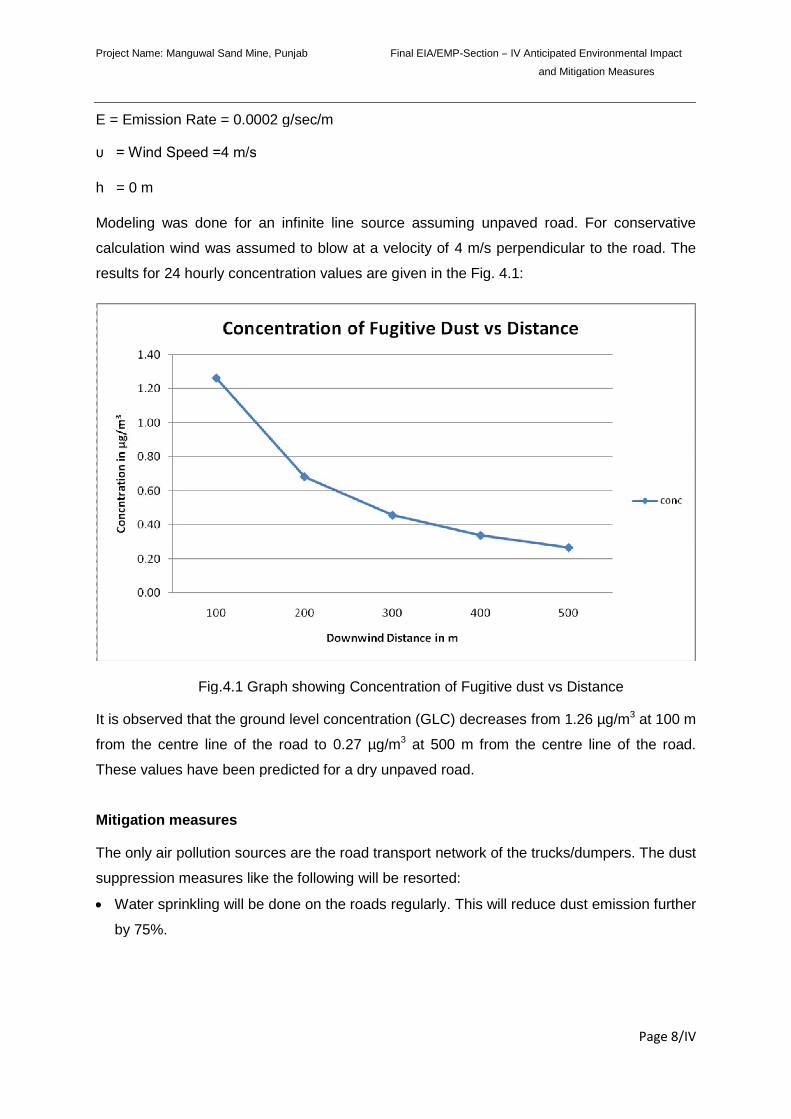
Project Name: Manguwal Sand Mine, Punjab Final EIA/EMP-Section – IV Anticipated Environmental Impact
and Mitigation Measures
Page 8/IV
E = Emission Rate = 0.0002 g/sec/m
υ = Wind Speed =4 m/s
h = 0 m
Modeling was done for an infinite line source assuming unpaved road. For conservative
calculation wind was assumed to blow at a velocity of 4 m/s perpendicular to the road. The
results for 24 hourly concentration values are given in the Fig. 4.1:
Fig.4.1 Graph showing Concentration of Fugitive dust vs Distance
It is observed that the ground level concentration (GLC) decreases from 1.26 µg/m3 at 100 m
from the centre line of the road to 0.27 µg/m3 at 500 m from the centre line of the road.
These values have been predicted for a dry unpaved road.
Mitigation measures
The only air pollution sources are the road transport network of the trucks/dumpers. The dust
suppression measures like the following will be resorted:
Water sprinkling will be done on the roads regularly. This will reduce dust emission further
by 75%.
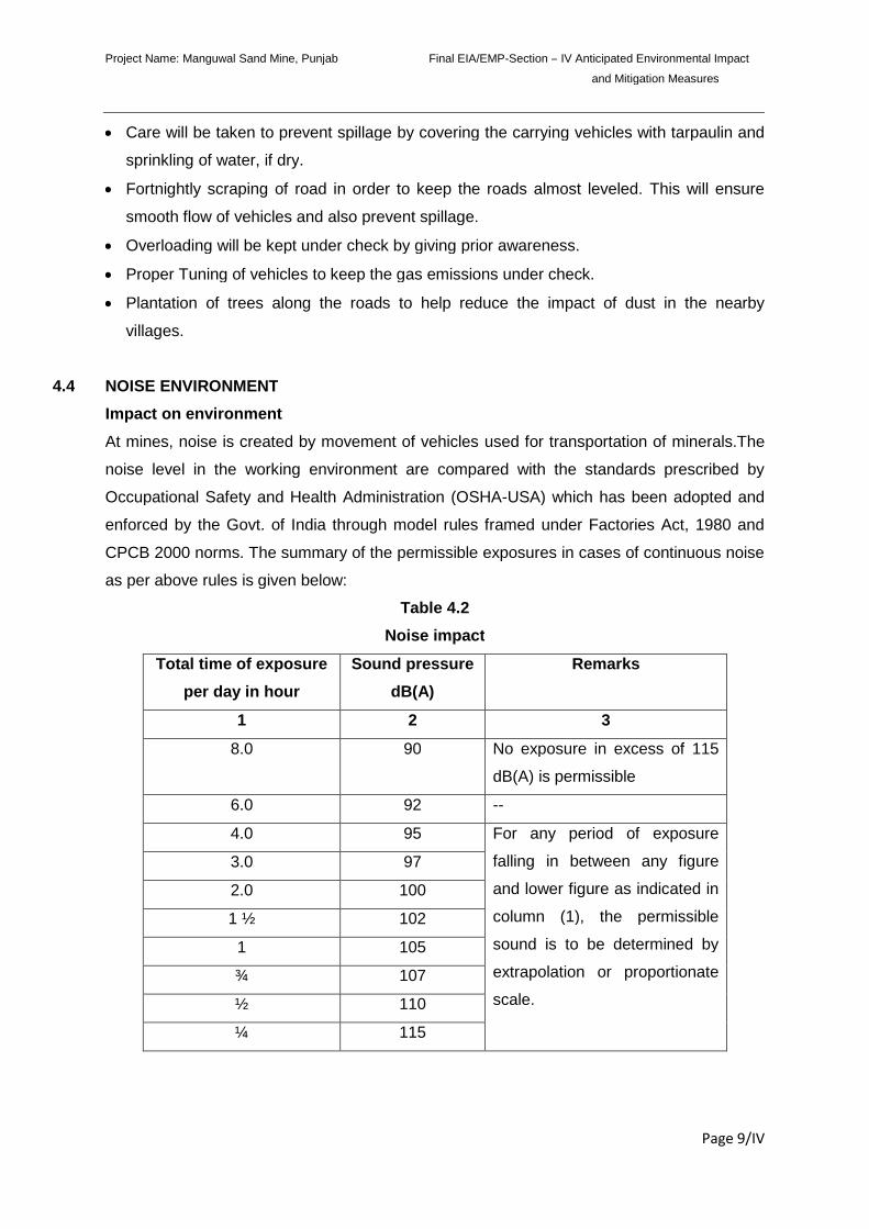
Project Name: Manguwal Sand Mine, Punjab Final EIA/EMP-Section – IV Anticipated Environmental Impact
and Mitigation Measures
Page 9/IV
Care will be taken to prevent spillage by covering the carrying vehicles with tarpaulin and
sprinkling of water, if dry.
Fortnightly scraping of road in order to keep the roads almost leveled. This will ensure
smooth flow of vehicles and also prevent spillage.
Overloading will be kept under check by giving prior awareness.
Proper Tuning of vehicles to keep the gas emissions under check.
Plantation of trees along the roads to help reduce the impact of dust in the nearby
villages.
4.4 NOISE ENVIRONMENT
Impact on environment
At mines, noise is created by movement of vehicles used for transportation of minerals.The
noise level in the working environment are compared with the standards prescribed by
Occupational Safety and Health Administration (OSHA-USA) which has been adopted and
enforced by the Govt. of India through model rules framed under Factories Act, 1980 and
CPCB 2000 norms. The summary of the permissible exposures in cases of continuous noise
as per above rules is given below:
Table 4.2
Noise impact
Total time of exposure
per day in hour
Sound pressure
dB(A)
Remarks
1 2 3
8.0 90 No exposure in excess of 115
dB(A) is permissible
6.0 92 --
4.0 95 For any period of exposure
falling in between any figure
and lower figure as indicated in
column (1), the permissible
sound is to be determined by
extrapolation or proportionate
scale.
3.0 97
2.0 100
1 ½ 102
1 105
¾ 107
½ 110
¼ 115
Project Name: Manguwal Sand Mine, Punjab Final EIA/EMP-Section – IV Anticipated Environmental Impact
and Mitigation Measures
Page 10/IV
Noise at lower levels (sound pressure) is quite acceptable and does not have any bad effect
on human beings, but when it is abnormally high- it incurs some maleficent effects.
a. Mitigation measures
i. On-site
a) Well maintained vehicle will be used which will reduced the noise level.
b) Plantation: Plantation of trees along the bank will be done to dampen the noise, if
possible.
c) Hearing Protection: No hearing protection is generally needed for RBM mining projects.
ii. Off-site
The off-site receptors are not significantly affected as noise generated by RBM is
insignificant but some disturbances due to vehicle movement may not be avoidable.
However the following measures have been envisaged:
a) The vehicles will be maintained in good running condition so that noise will be
reduced to minimum possible level.
b) Awareness will be imparted prior to mining operations that smoke silencers remain in
a good conditions not to generate noise.
c) In addition, trucks drivers will be instructed to make minimum use of horns at the
village area.
d) Where ever space is made available by the authorities plantation will be done and
also post plantation care will be provided.
4.5 BIOLOGICAL ENVIRONMENT
Table 4.3
Anticipated impact and mitigation measures for biological environment:
Impact Predicted Suggestive measure
Disturbance to free
movement / living of
wild fauna viz. Birds,
Reptiles etc.
Noise produced due to vehicular movement for carrying
sand materials will be within permissible noise limit.
Higher noise level in the area may lead to restlessness
and failure in detection of calls of mates and young
ones;
Care will be taken not to hunt animals/birds by
labourers;
Project Name: Manguwal Sand Mine, Punjab Final EIA/EMP-Section – IV Anticipated Environmental Impact
and Mitigation Measures
Page 11/IV
If wild animals/birds are noticed crossing the core zone,
they will not be disturbed at all;
Labourers will not be allowed to discard food, polythene
waste etc., which can attract animals/birds near the core
site;
Only low polluting vehicles having PUC will be allowed
for carrying mining materials.
Noise level will be maintained within permissible limit
(silent zone-50dB (A) during day time or residential zone
55dB (A) as per Noise Pollution (Regulation and
Control) Rules 2000, CPCB norms.
Disturbance of riparian
ecosystem/ wetlands
The riparian ecosystem or the wetlands will not be
destroyed by the mine owners/workers. Mining will be
carried out on the dry river bed area and the river water
channel will not be disturbed at all.
Impact on Agriculture There will be no impact on the Agriculture. Dust
generated will be suppressed during mining operation at
mining site as well as during transportation will be
suppressed by sprinkling.
Impact on land use and
vegetation
There will be no conversion of Forest land. Mining will
be carried out on the dry part of the river Channel.
Ecological Impacts
Mining which leads to the removal of channel substrate, re-suspension of streambed
sediment and stockpiling on the streambed, will have ecological impacts. These impacts
may have an effect on the direct loss of stream reserve habitat, disturbances of species
attached to streambed deposits, reduced light penetration, reduced primary production, and
reduced feeding opportunities.
For thousands of years, sand and gravel have been used in the construction of roads and
buildings. Today, demand for sand and gravel continues to increase. Mining operators, in
conjunction with cognizant resource agencies, must work to ensure that sand mining is
conducted in a responsible manner.
Excessive and unscientific riverbed sand mining causes the degradation of rivers. Riverbed
mining lowers the stream bottom, which may lead to bank erosion. Depletion of sand in the
Project Name: Manguwal Sand Mine, Punjab Final EIA/EMP-Section – IV Anticipated Environmental Impact
and Mitigation Measures
Page 12/IV
streambed causes the deepening of rivers, and the enlargement of river mouths. Any volume
of sand exported from streambeds is a loss to the system.
Excessive and unscientific Riverbed sand mining is a threat to bridges, river banks and
nearby structures. Sand mining may also affects the groundwater system and the uses that
local people make of the river.
Excessive and unscientific riverbed sand mining results in the destruction of aquatic and
riparian habitat through large changes in the channel morphology. Impacts include bed
degradation, bed coarsening, lowered water tables near the streambed, and channel
instability. These physical impacts cause degradation of riparian and aquatic biota and may
lead to the undermining of bridges and other structures. Continued extraction may also
cause the entire streambed to degrade to the depth of excavation.
Sand mining generates extra vehicle traffic, which negatively impairs the environment.
Where access roads cross riparian areas, the local environment may be impacted.
Mitigation measures
As the proposed mining will be carried out in a scientific manner as mentioned before, not
much significant impact is anticipated, however, the following mitigation measure will be
taken to further minimize it:
1. The activity will mainly be carried out manually to minimize associate loss, as stated
earlier.
2. No mining will be carried out in the vicinity of important structure like bridges, dam and
other structures if any.
3. No mining will be carried out during the rainy season to minimize impact on aquatic life.
4. As the mining site has no vegetation, no clearance of vegetation is required.
5. The mining activity will deploy a few dumpers/trucks for transportation of sand from the
mine to desired destination that may cause some loss to riparian habitat. Safe site / site
having least impact will be selected for transportation, all the vehicles employed for
transportation purpose will be PUC certified. On closure of mining operations / during the
rainy season the eroded bank will be restored / reclaimed to minimize negative impacts.
6. No lighting will be allowed in the lease area.
7. No piling of sand will be allowed in the area.
Flora and Fauna of Riparian Habitat
If sand mining is done in an unscientific way, i.e. beyond the replenishment capacity,
riverbed mining can have adverse effects at the mine sites. The fertile streamside land will
Project Name: Manguwal Sand Mine, Punjab Final EIA/EMP-Section – IV Anticipated Environmental Impact
and Mitigation Measures
Page 13/IV
be lost gradually and the wildlife in the riparian areas may start vanishing. Degraded stream
habitats will result in loss of fisheries productivity, biodiversity, and recreational potential.
Thus the severely degraded channels may lower the aesthetic value too.
All species require specific habitat conditions to ensure long-term survival. Native species in
streams are uniquely adapted to the habitat conditions that existed before humans began
alterations. These have caused major habitat disruptions that favored some species over
others and caused overall declines in biological diversity and productivity. In most streams
and rivers, habitat quality is strongly linked to the stability of channel bed and banks.
Unstable stream channels are inhospitable to most aquatic species.
Factors that increase or decrease sediment supplies often destabilize bed and banks and
result in dramatic channel readjustments. For example, human activities that accelerate
stream bank erosion, such as riparian forest clearing / Riverbed mining cause stream banks
to become net sources of sediment that often have severe consequences for aquatic
species. Anthropogenic activities that artificially lower stream bed elevation cause bed
instabilities that result in a net release of sediment in the local vicinity. Unstable sediments
simplify and, therefore, degrade stream habitats for many aquatic species.
The most important effects of excessive and unscientific Riverbed sand mining on aquatic
habitats are bed degradation and sedimentation, which can have substantial negative effects
on aquatic life. The stability of sand-bed streams depends on a delicate balance between
stream flow, sediment supplied from the watershed, and channel form. Mining-induced
changes in sediment supply and channel form disrupt channel and habitat development
processes. Furthermore, movement of unstable substrates results in downstream
sedimentation of habitats. The affected distance depends on the intensity of mining, particles
sizes, stream flows, and channel morphology.
Channel widening causes swallowing of the streambed, producing braided flow or
subsurface intersand flow in riffle areas, hindering movement of fishes between pools.
Channel reaches become more uniformly shallow as deep pools fill with sand and other
sediments, reducing habitat complexity, riffle-pool structure, and numbers of large predatory
fishes.
All such impacts can be reduced by following scientific mining practices and mitigation
measures as restricted.
Mitigation measures
Sand extraction operations will be managed to avoid or minimize damage to stream/river
banks and riparian habitats
Project Name: Manguwal Sand Mine, Punjab Final EIA/EMP-Section – IV Anticipated Environmental Impact
and Mitigation Measures
Page 14/IV
Sand extraction in vegetated riparian areas will be avoided.
Undercut and incised vegetated banks will not be altered.
Large woody debris in the riparian zone will be left undisturbed or replaced when
moved and not be burnt.
Sand stockpiles, overburden and/or vegetative debris will not be stored within the
riparian zone.
It is essential that overburden is evenly redistributed over exposed areas as soon as
possible after the operation has been completed for faster revegetation.
Operation and storage of heavy equipment within riparian habitat will be restricted.
Access roads will not encroach into the riparian zones
No exotic species will be introduced by the RBM project activity & associated persons at all.
As the mining will not be done beyond the stipulated limit, so the chances of river mouth
widening, bank widening will be negligible.
The river channel will get shallowed due to sediment deposition which will lead to widening
of the river channel and inturn cause submergence of the nearby areas. Thus, mining in a
scientific and systematic way will reduce such impending effects.
Thus there is a requirement to establish a stable ecosystem with both ecological and
economic returns. Minimization of soil erosion and dust pollution enhances the aesthetic
value of the core and the buffer zone. To achieve this, it is advised to have planned increase
in the area of green cover of plantation and green belts activities, wherever possible. The
basic objectives of plantations are as follows:
• Improvement of Soil quality,
• Quick vegetative cover to check soil erosion,
• Improvement in mining site stability,
• Conservation of biological diversity of plants, birds and animals,
• As dust receptor and dust filter, this is likely to be produced during mining.
The plantation in our case can only be taken up if mining is done beyond the banks and
buffer zone is available, otherwise it will be resorted to in areas allotted by the authorities
4.6 TRAFFIC ANALYSIS
Traffic analysis is carried out by understanding the existing carrying capacity of the roads
near to the project site and the connecting main roads in the area. Then depending on the
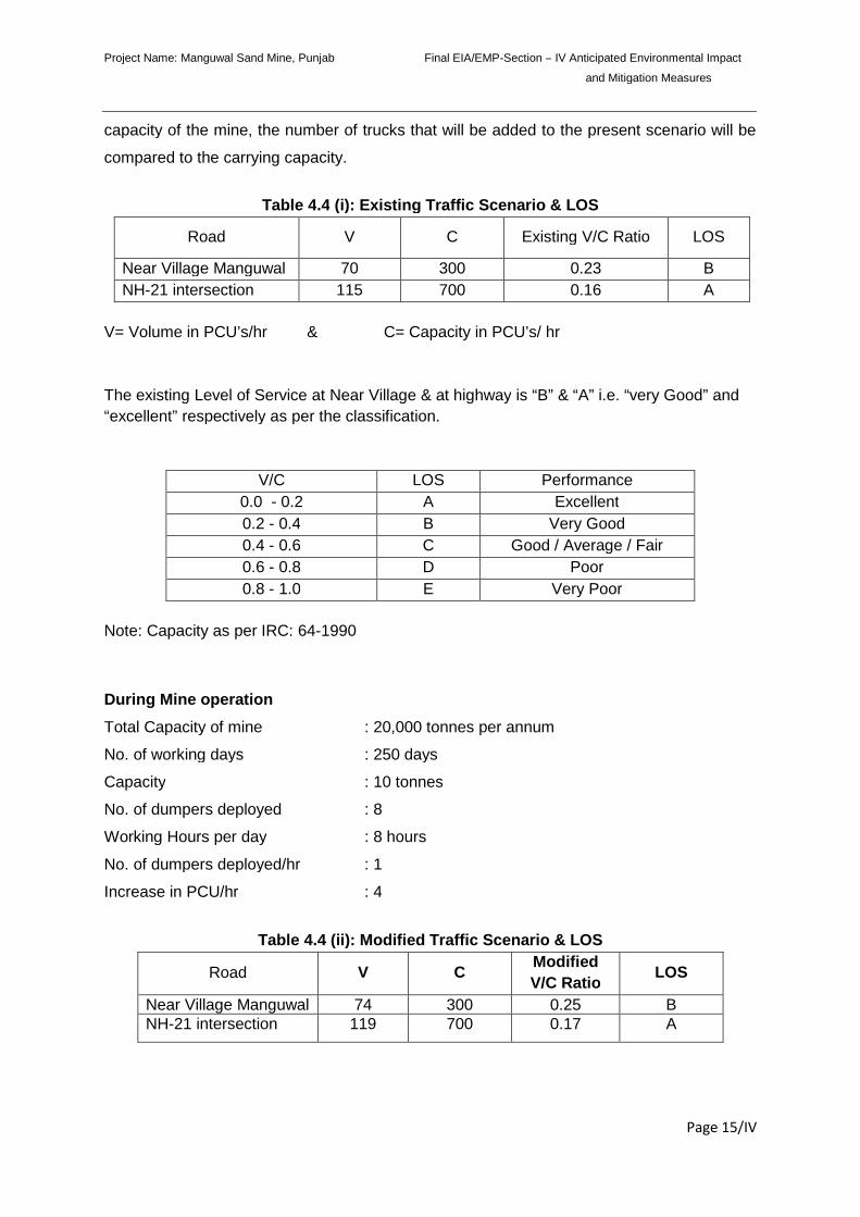
Project Name: Manguwal Sand Mine, Punjab Final EIA/EMP-Section – IV Anticipated Environmental Impact
and Mitigation Measures
Page 15/IV
capacity of the mine, the number of trucks that will be added to the present scenario will be
compared to the carrying capacity.
Table 4.4 (i): Existing Traffic Scenario & LOS
Road V C Existing V/C Ratio LOS
Near Village Manguwal 70 300 0.23 B
NH-21 intersection 115 700 0.16 A
V= Volume in PCU’s/hr & C= Capacity in PCU’s/ hr
The existing Level of Service at Near Village & at highway is “B” & “A” i.e. “very Good” and
“excellent” respectively as per the classification.
V/C LOS Performance
0.0 - 0.2 A Excellent
0.2 - 0.4 B Very Good
0.4 - 0.6 C Good / Average / Fair
0.6 - 0.8 D Poor
0.8 - 1.0 E Very Poor
Note: Capacity as per IRC: 64-1990
During Mine operation
Total Capacity of mine : 20,000 tonnes per annum
No. of working days : 250 days
Capacity : 10 tonnes
No. of dumpers deployed : 8
Working Hours per day : 8 hours
No. of dumpers deployed/hr : 1
Increase in PCU/hr : 4
Table 4.4 (ii): Modified Traffic Scenario & LOS
Road V CModified
V/C RatioLOS
Near Village Manguwal 74 300 0.25 BNH-21 intersection 119 700 0.17 A
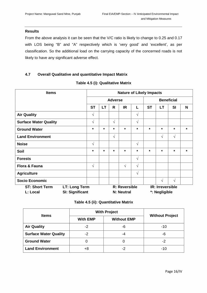
Project Name: Manguwal Sand Mine, Punjab Final EIA/EMP-Section – IV Anticipated Environmental Impact
and Mitigation Measures
Page 16/IV
Results
From the above analysis it can be seen that the V/C ratio is likely to change to 0.25 and 0.17
with LOS being “B” and “A” respectively which is ‘very good’ and ‘excellent’, as per
classification. So the additional load on the carrying capacity of the concerned roads is not
likely to have any significant adverse effect.
4.7 Overall Qualitative and quantitative Impact Matrix
Table 4.5 (i): Qualitative Matrix
Items Nature of Likely Impacts
Adverse Beneficial
ST LT R IR L ST LT SI N
Air Quality √ √
Surface Water Quality √ √ √
Ground Water * * * * * * * * *
Land Environment √ √ √
Noise √ √
Soil * * * * * * * * *
Forests √
Flora & Fauna √ √ √
Agriculture √
Socio Economic √ √
ST: Short Term LT: Long Term R: Reversible IR: Irreversible
L: Local SI: Significant N: Neutral *: Negligible
Table 4.5 (ii): Quantitative Matrix
ItemsWith Project
Without ProjectWith EMP Without EMP
Air Quality -2 -6 -10
Surface Water Quality -2 -4 -6
Ground Water 0 0 -2
Land Environment +8 -2 -10
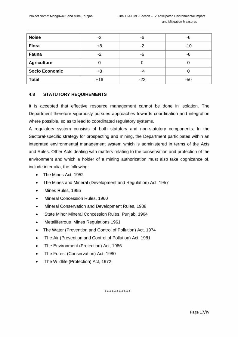
Project Name: Manguwal Sand Mine, Punjab Final EIA/EMP-Section – IV Anticipated Environmental Impact
and Mitigation Measures
Page 17/IV
Noise -2 -6 -6
Flora +8 -2 -10
Fauna -2 -6 -6
Agriculture 0 0 0
Socio Economic +8 +4 0
Total +16 -22 -50
4.8 STATUTORY REQUIREMENTS
It is accepted that effective resource management cannot be done in isolation. The
Department therefore vigorously pursues approaches towards coordination and integration
where possible, so as to lead to coordinated regulatory systems.
A regulatory system consists of both statutory and non-statutory components. In the
Sectoral-specific strategy for prospecting and mining, the Department participates within an
integrated environmental management system which is administered in terms of the Acts
and Rules. Other Acts dealing with matters relating to the conservation and protection of the
environment and which a holder of a mining authorization must also take cognizance of,
include inter alia, the following:
The Mines Act, 1952
The Mines and Mineral (Development and Regulation) Act, 1957
Mines Rules, 1955
Mineral Concession Rules, 1960
Mineral Conservation and Development Rules, 1988
State Minor Mineral Concession Rules, Punjab, 1964
Metalliferrous Mines Regulations 1961
The Water (Prevention and Control of Pollution) Act, 1974
The Air (Prevention and Control of Pollution) Act, 1981
The Environment (Protection) Act, 1986
The Forest (Conservation) Act, 1980
The Wildlife (Protection) Act, 1972
***************
Project Name: Manguwal Sand Mine, Punjab Final EIA/EMP Section-V: Environmental Monitoring Programme
Page 1/V
SECTION-V
ENVIRONMENTAL MONITORING PROGRAMME
INDEX
S. No. CONTENTS Page No.
5.0 INTRODUCTION 2/V
5.1 PROPOSED SET UP 2/V
5.2 MONITORING SCHEDULE AND PARAMETERS 3/V
Project Name: Manguwal Sand Mine, Punjab Final EIA/EMP Section-V: Environmental Monitoring Programme
Page 2/V
5.0 INTRODUCTION
Success of any post-project environmental monitoring programme depends upon the efficiency
of the organizational set up responsible for the implementation of the programme. Regular
monitoring of the various environmental parameters is also necessary to evaluate the
effectiveness of the management programme so that the necessary corrective measures can be
taken in case there are some drawbacks in the proposed programme. Since environmental
quality parameters at work zone and surrounding areas are important for maintaining sound
operating practices of the project in line with conformity with environmental regulations, the post
project monitoring work, therefore, forms a part of EMP.
5.1 PROPOSED SET UP
Keeping the utility of monitoring results in the implementation of the environmental management
program in view, an organizational chart has been proposed, headed by General Manager as
shown in Fig. 5.1.
The said team will be responsible for:
a. Collecting water and air samples from surrounding area and work zone
monitoring for pollutants.
b. Analyzing the water and air samples.
c. Implementing the control and protective measures.
d. Co-coordinating the environment related activities within the project as well as
with outside agencies.
e. Collecting statistics of health of workers and population of surrounding villages.
f. Monitoring the progress of implementation of environmental management
program. Greenbelt development, etc.
The laboratory will be suitably equipped for sampling/testing for various environmental
pollutants.
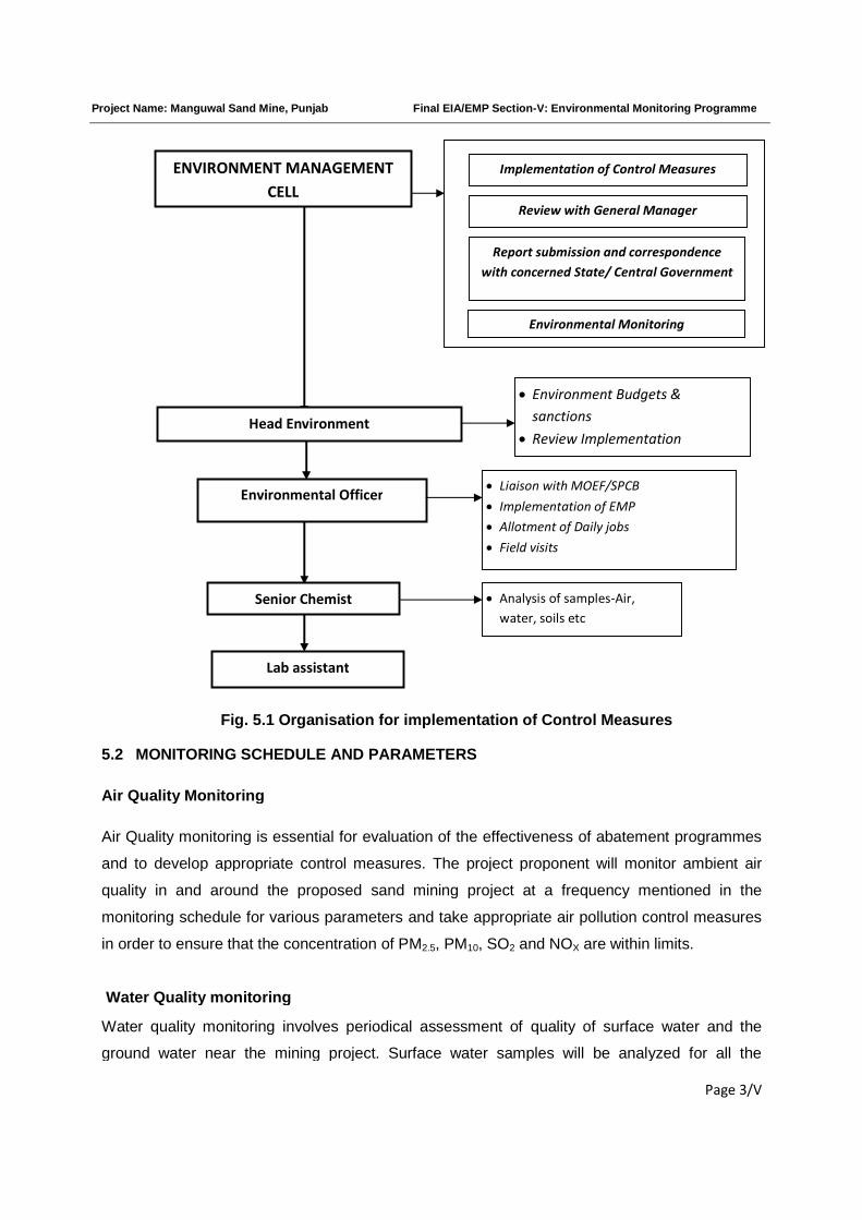
Project Name: Manguwal Sand Mine, Punjab Final EIA/EMP Section-V: Environmental Monitoring Programme
Page 3/V
Fig. 5.1 Organisation for implementation of Control Measures
5.2 MONITORING SCHEDULE AND PARAMETERS
Air Quality Monitoring
Air Quality monitoring is essential for evaluation of the effectiveness of abatement programmes
and to develop appropriate control measures. The project proponent will monitor ambient air
quality in and around the proposed sand mining project at a frequency mentioned in the
monitoring schedule for various parameters and take appropriate air pollution control measures
in order to ensure that the concentration of PM2.5, PM10, SO2 and NOX are within limits.
Water Quality monitoring
Water quality monitoring involves periodical assessment of quality of surface water and the
ground water near the mining project. Surface water samples will be analyzed for all the
ENVIRONMENT MANAGEMENT
CELL
Implementation of Control Measures
Review with General Manager
Report submission and correspondence
with concerned State/ Central Government
Environmental Monitoring
Environmental Officer
Head Environment
Liaison with MOEF/SPCB
Implementation of EMP
Allotment of Daily jobs
Field visits
Analysis of samples-Air,
water, soils etc
Environment Budgets &
sanctions
Review Implementation
Lab assistant
Senior Chemist
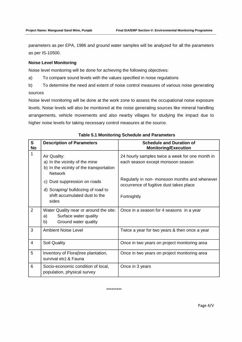
Project Name: Manguwal Sand Mine, Punjab Final EIA/EMP Section-V: Environmental Monitoring Programme
Page 4/V
parameters as per EPA, 1986 and ground water samples will be analyzed for all the parameters
as per IS-10500.
Noise Level Monitoring
Noise level monitoring will be done for achieving the following objectives:
a) To compare sound levels with the values specified in noise regulations
b) To determine the need and extent of noise control measures of various noise generating
sources
Noise level monitoring will be done at the work zone to assess the occupational noise exposure
levels. Noise levels will also be monitored at the noise generating sources like mineral handling
arrangements, vehicle movements and also nearby villages for studying the impact due to
higher noise levels for taking necessary control measures at the source.
Table 5.1 Monitoring Schedule and Parameters
SNo
Description of Parameters Schedule and Duration ofMonitoring/Execution
1Air Quality:
a) In the vicinity of the mine
b) In the vicinity of the transportation
Network
c) Dust suppression on roads
d) Scraping/ bulldozing of road to
shift accumulated dust to the
sides
24 hourly samples twice a week for one month in
each season except monsoon season
Regularly in non- monsoon months and whenever
occurrence of fugitive dust takes place
Fortnightly
2 Water Quality near or around the site:
a) Surface water quality
b) Ground water quality
Once in a season for 4 seasons in a year
3 Ambient Noise Level Twice a year for two years & then once a year
4 Soil Quality Once in two years on project monitoring area
5 Inventory of Flora(tree plantation,
survival etc) & Fauna
Once in two years on project monitoring area
6 Socio-economic condition of local,
population, physical survey
Once in 3 years
*********
Project Name: Manguwal Sand Mine, Punjab. Final EIA/EMP Section –VI Additional Studies
Page 1/VI
SECTION-VI
ADDITIONAL STUDIES
INDEX
S. No CONTENTS Page No.
6.0 PUBLIC CONSULTATION 2/VI
6.1 HAZARD IDENTIFICATION AND RISK ASSESSMENT
METHOLODOGY
4/VI
6.2 POTENTIAL HAZARD & ‘ALARP’ CONDITION 9/VI
6.3 RISK PRIORITISATION BASED ON HAZARDS 9/VI
6.4 ADDITIONAL MITIGATION MAJORS TO BRING HAZARDS
UNDER “ALARP” ZONE
11/VI
6.5 NATURAL RESOURCE CONSERVATION 13/VI
6.6 SOCIAL IMPACT ASSESMENT, REHABILITATION &
RESETTLEMENT (R&R) ACTION PLAN
13/VI
6.7 SUGGESTIONS 25/VI
6.8 CONCLUSIONS 26/VI
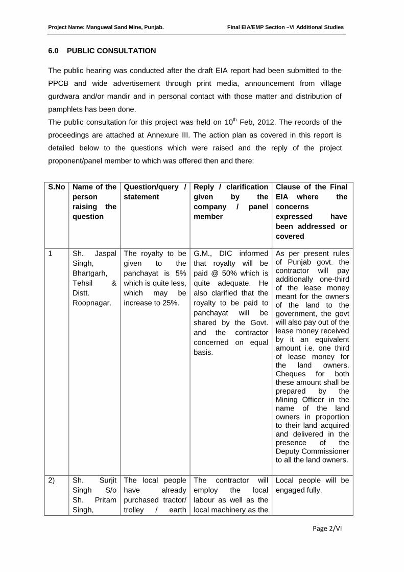
Project Name: Manguwal Sand Mine, Punjab. Final EIA/EMP Section –VI Additional Studies
Page 2/VI
6.0 PUBLIC CONSULTATION
The public hearing was conducted after the draft EIA report had been submitted to the
PPCB and wide advertisement through print media, announcement from village
gurdwara and/or mandir and in personal contact with those matter and distribution of
pamphlets has been done.
The public consultation for this project was held on 10th Feb, 2012. The records of the
proceedings are attached at Annexure III. The action plan as covered in this report is
detailed below to the questions which were raised and the reply of the project
proponent/panel member to which was offered then and there:
S.No Name of the
person
raising the
question
Question/query /
statement
Reply / clarification
given by the
company / panel
member
Clause of the Final
EIA where the
concerns
expressed have
been addressed or
covered
1 Sh. Jaspal
Singh,
Bhartgarh,
Tehsil &
Distt.
Roopnagar.
The royalty to be
given to the
panchayat is 5%
which is quite less,
which may be
increase to 25%.
G.M., DIC informed
that royalty will be
paid @ 50% which is
quite adequate. He
also clarified that the
royalty to be paid to
panchayat will be
shared by the Govt.
and the contractor
concerned on equal
basis.
As per present rulesof Punjab govt. thecontractor will payadditionally one-thirdof the lease moneymeant for the ownersof the land to thegovernment, the govtwill also pay out of thelease money receivedby it an equivalentamount i.e. one thirdof lease money forthe land owners.Cheques for boththese amount shall beprepared by theMining Officer in thename of the landowners in proportionto their land acquiredand delivered in thepresence of theDeputy Commissionerto all the land owners.
2) Sh. Surjit
Singh S/o
Sh. Pritam
Singh,
The local people
have already
purchased tractor/
trolley / earth
The contractor will
employ the local
labour as well as the
local machinery as the
Local people will be
engaged fully.
Project Name: Manguwal Sand Mine, Punjab. Final EIA/EMP Section –VI Additional Studies
Page 3/VI
Village
Diwarhi,
Tehsil &
Distt.
Roopnagar.
moving machinery
by procuring loan
from the financial
institutions and
with this project
the machinery will
become redundant
/ idle and the
people will
become
unemployed.
labour /machinery
from far-off places will
not be economically
viable.
As would be seen, the points raised by the public mainly pertain to any or many of the
following:
1. Existing haphazard state of mining.
2. Their annoyance to the state of the existing environment.
3. Problem of drinking water level having gone very deep due to the unchecked depth of
mining, resulting in drying up of their hand pumps in the homes.
4. The dilapidated condition/state of the roads on which the Dumpers/Trolleys pass
through.
5. The dust pollution created by the falling dry sand from the dumpers/trucks/trolleys
moving on uneven roads, which gets crushed further with the movement of the loaded
vehicles and easily become airborne.
6. The public is dissatisfied with the prevailing dust pollution being created when the
process of dry crushing instead of wet crushing of stones/gravel into bajri is resorted.
They attribute this heavy dust pollution to mining, because presently the mining and
the crushing is done by the same party, difficult to differentiate.
7. The nuisance created by the noise of DJ during night transportation of sand.
8. Heavy dust pollution in the air, which enters their houses.
9. Their children not able to pass the roads because of the narrowness of the roads and
movement of large 6 to 18 tyres dumpers/trucks.
10. The problem being faced by them from the sand/gravel mafia operating which
charges them when any one is mining sand.
11. Non availability or petty compensation to owners of land.
12. Extent of prevailing unauthorized/unregulated mining, not following any of the
imposed restrictions on mining under eco-friendly mine plan.
13. A number of people said the mining activity and the crushing activity going in their
area has in fact provided them with jobs thereby they have been able to sustain their
living and rearing up of their families, though under a difficult environment
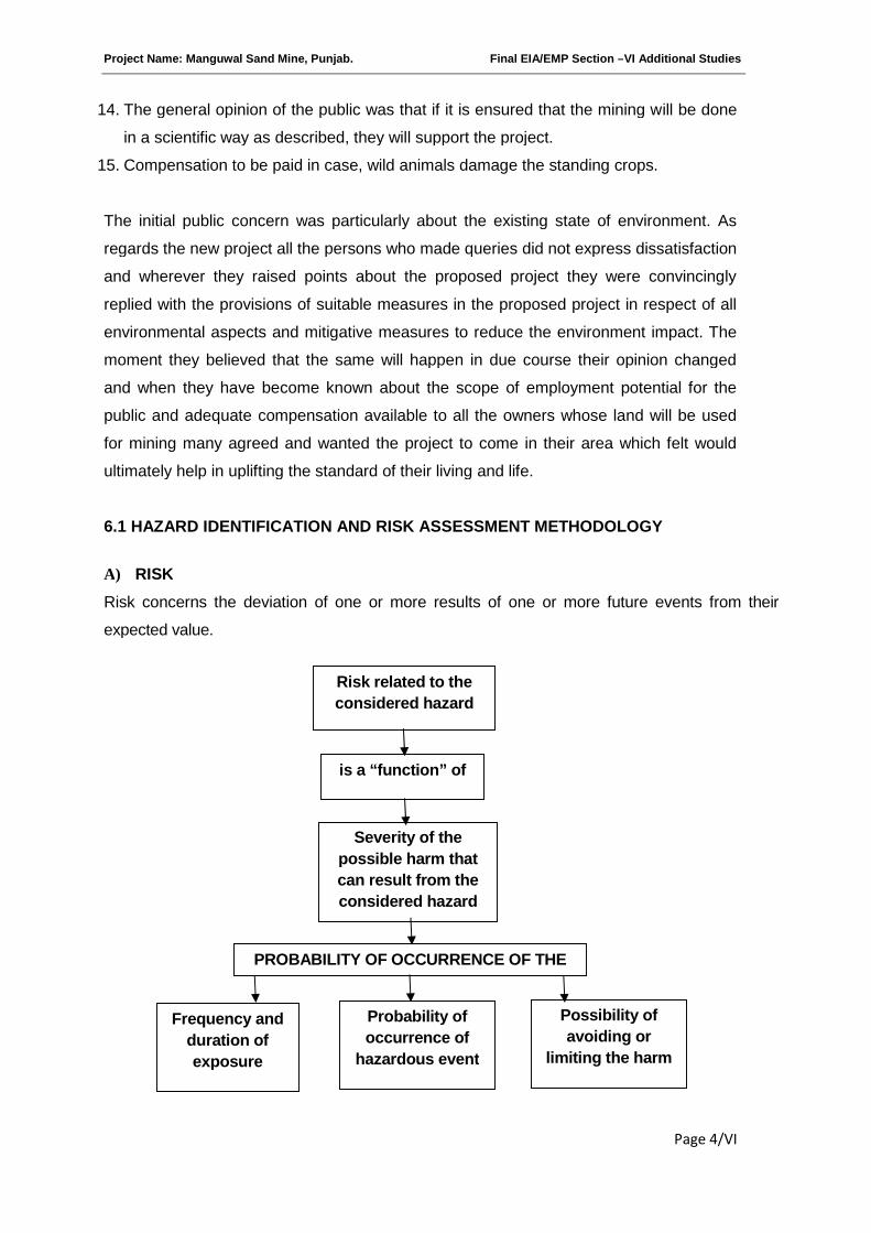
Project Name: Manguwal Sand Mine, Punjab. Final EIA/EMP Section –VI Additional Studies
Page 4/VI
14. The general opinion of the public was that if it is ensured that the mining will be done
in a scientific way as described, they will support the project.
15. Compensation to be paid in case, wild animals damage the standing crops.
The initial public concern was particularly about the existing state of environment. As
regards the new project all the persons who made queries did not express dissatisfaction
and wherever they raised points about the proposed project they were convincingly
replied with the provisions of suitable measures in the proposed project in respect of all
environmental aspects and mitigative measures to reduce the environment impact. The
moment they believed that the same will happen in due course their opinion changed
and when they have become known about the scope of employment potential for the
public and adequate compensation available to all the owners whose land will be used
for mining many agreed and wanted the project to come in their area which felt would
ultimately help in uplifting the standard of their living and life.
6.1 HAZARD IDENTIFICATION AND RISK ASSESSMENT METHODOLOGY
A) RISK
Risk concerns the deviation of one or more results of one or more future events from their
expected value.
Risk related to the
considered hazard
is a “function” of
Severity of the
possible harm that
can result from the
considered hazard
PROBABILITY OF OCCURRENCE OF THE
Frequency and
duration of
exposure
Probability of
occurrence of
hazardous event
Possibility of
avoiding or
limiting the harm
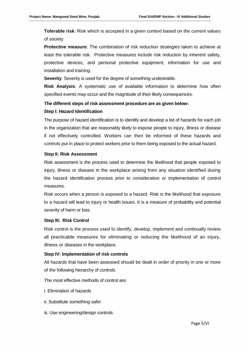
Project Name: Manguwal Sand Mine, Punjab. Final EIA/EMP Section –VI Additional Studies
Page 5/VI
Tolerable risk: Risk which is accepted in a given context based on the current values
of society
Protective measure: The combination of risk reduction strategies taken to achieve at
least the tolerable risk. Protective measures include risk reduction by inherent safety,
protective devices, and personal protective equipment, information for use and
installation and training.
Severity: Severity is used for the degree of something undesirable.
Risk Analysis: A systematic use of available information to determine how often
specified events may occur and the magnitude of their likely consequences.
The different steps of risk assessment procedure are as given below:
Step I: Hazard Identification
The purpose of hazard identification is to identify and develop a list of hazards for each job
in the organization that are reasonably likely to expose people to injury, illness or disease
if not effectively controlled. Workers can then be informed of these hazards and
controls put in place to protect workers prior to them being exposed to the actual hazard.
Step II: Risk Assessment
Risk assessment is the process used to determine the likelihood that people exposed to
injury, illness or disease in the workplace arising from any situation identified during
the hazard identification process prior to consideration or implementation of control
measures.
Risk occurs when a person is exposed to a hazard. Risk is the likelihood that exposure
to a hazard will lead to injury or health issues. It is a measure of probability and potential
severity of harm or loss.
Step III: Risk Control
Risk control is the process used to identify, develop, implement and continually review
all practicable measures for eliminating or reducing the likelihood of an injury,
illness or diseases in the workplace.
Step IV: Implementation of risk controls
All hazards that have been assessed should be dealt in order of priority in one or more
of the following hierarchy of controls
The most effective methods of control are:
i. Elimination of hazards
ii. Substitute something safer
iii. Use engineering/design controls
Project Name: Manguwal Sand Mine, Punjab. Final EIA/EMP Section –VI Additional Studies
Page 6/VI
iv. Use administrative controls such as safe work procedures
v. Protect the workers i.e. By ensuring competence through supervision and training, etc.
Each measure must have a designated person and date assigned for the
implementation of controls. This ensures that all required safety measures will be
completed.
Step V: Monitor and Review
Hazard identification, risk assessment and control are an on-going process.
Therefore regularly review the effectiveness of your hazard assessment and control
measures. Make sure that you undertake a hazard and risk assessment when there is
change to the workplace including when work systems, tools, machinery or equipment
changes. Provide additional supervision when the new employees with reduced skill
levels or knowledge are introduced to the workplace.
B) RISK ANALYSIS
The risk assessment portion of the process involves three levels of site evaluation:
a) Initial Site Evaluation,
b) Detailed Site Evaluation,
c) Priority Site Investigations and Recommendations.
The risk assessment criteria used for all levels of site evaluation take into account two
basic factors:
The existing site conditions
The level of the travelling public's exposure to those conditions.
The Initial Site Evaluation and Detailed Site Evaluation both apply weighted criteria to the
existing information and information obtained from one site visit. The Initial Site Evaluation
subdivides the initial inventory listing of sites into 5 risk assessment site groups. The Detailed Site
Evaluation risk assessment is then performed on each of the three highest risk site groups in
order of the group priority level of risk. The result of the Detailed Site Evaluation process is a
prioritized listing of the sites within each of the three highest risk site groups.
Risk analysis is done for:
Forecasting any unwanted situation
Estimating damage potential of such situation
Decision making to control such situation
Evaluating effectiveness of control measures

Project Name: Manguwal Sand Mine, Punjab. Final EIA/EMP Section –VI Additional Studies
Page 7/VI
C) ACCEPTABLE RISK
Risk that is acceptable to regulatory agency and also to the public is called acceptable
risk. There are no formally recognized regulatory criteria for risk to personnel in the
mining industry. Individual organizations have developed criteria for employee risk and
the concepts originally arising from chemical process industries and oil and gas
industries. Because of the uncertainties linked with probabilistic risk analysis used for
quantification of the risk levels the general guiding principle is that the risk be reduced
to a level considered As Low as Reasonably Practicable (ALARP). The risk
acceptability criteria are given in following Table. It can be seen that there are three
tiers:
a. A tolerable region where risk has been shown to be negligible and comparable with
everyday risks such as travel to work.
b. A middle level where it is shown the risk has been reduced to As Low As Reasonably
Practicable level and that further risk reduction is either impracticable or the cost is
grossly disproportionate to the improvement gained. This is referred as the ALARP
region.
c. An intolerable region where risk cannot be justified on any grounds. The ALARP region
is kept sufficiently extensive to allow for flexibility in decision making and allow for the
positive management initiatives which may not be quantifiable in terms of risk
reduction.
The risk acceptability criteria are given in following table:
1 Risk unacceptance and must be reduced. The actions
may include equipments and people or procedural
measures. If risk cannot be reduced to ALARP level,
operating philosophy must be fundamentally reviewed
by the management.
Intolerable Region
2 Efforts must be made to reduce risk further and to as
low as reasonably practicable, without expenditure that
is grossly disproportionate to the benefit gained
ALARP Region
(As Low as Reasonably
Practicable)
3 Risk level is so low as to not require actions to reduce
its magnitude further. Tolerable Region
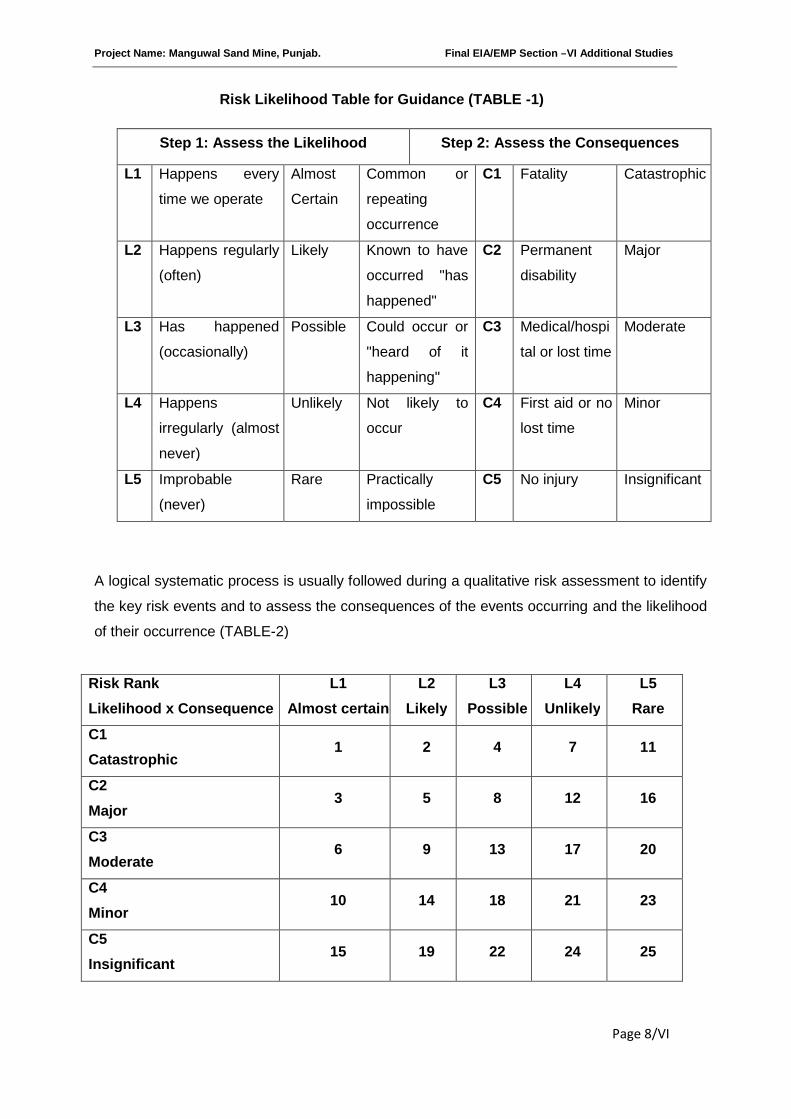
Project Name: Manguwal Sand Mine, Punjab. Final EIA/EMP Section –VI Additional Studies
Page 8/VI
Risk Likelihood Table for Guidance (TABLE -1)
A logical systematic process is usually followed during a qualitative risk assessment to identify
the key risk events and to assess the consequences of the events occurring and the likelihood
of their occurrence (TABLE-2)
Step 1: Assess the Likelihood Step 2: Assess the Consequences
L1 Happens every
time we operate
Almost
Certain
Common or
repeating
occurrence
C1 Fatality Catastrophic
L2 Happens regularly
(often)
Likely Known to have
occurred "has
happened"
C2 Permanent
disability
Major
L3 Has happened
(occasionally)
Possible Could occur or
"heard of it
happening"
C3 Medical/hospi
tal or lost time
Moderate
L4 Happens
irregularly (almost
never)
Unlikely Not likely to
occur
C4 First aid or no
lost time
Minor
L5 Improbable
(never)
Rare Practically
impossible
C5 No injury Insignificant
Risk Rank
Likelihood x Consequence
L1
Almost certain
L2
Likely
L3
Possible
L4
Unlikely
L5
Rare
C1
Catastrophic1 2 4 7 11
C2
Major3 5 8 12 16
C3
Moderate6 9 13 17 20
C4
Minor10 14 18 21 23
C5
Insignificant15 19 22 24 25
Project Name: Manguwal Sand Mine, Punjab. Final EIA/EMP Section –VI Additional Studies
Page 9/VI
RISK RATING:
HIGH RISK 1-6
MEDIUM RISK 7-15
LOW RISK 16-25
6.2 POTENTIAL HAZARDS & ‘ALARP’ CONDITION
Mining and allied activities are associated with several potential hazards and risk to both the
employees and the public at large. A worker in a mine should be able to work under “ALARP”
conditions (as stated above), which are adequately safe and healthy. At the same time the
environmental conditions should be such as not to be impair his working efficiency. This is
possible only when there is adequate safety in mines.
6.3 RISK PRIORITISATION BASED ON HAZARDS
There are various factors, which can create unsafe working conditions/hazards in mining of
minor minerals from river bed.
The key risk (hazard x probability) event rating associated with sand bed mining and to
assess its consequences of such events occurring and the likelihood based on above Table-2
are as:-
The Risk rating of such hazards is as follows:
a) Inundation / Flooding (C1 xL3=4)
b) Quick Sand Condition (C2 x L3=8)
c) Drowning.(C5 xL5=25)
d) Accident due to vehicular movement.(C3 xL3=13)
e) Accident during sand loading, transporting and dumping=14.
(i.e., C4 xL2=14)
6.3.1 Accident during sand/mineral loading, transportation and dumping
The risk rating assigned to this activity is assigned as “14 i.e. it is likely event with minor
consequences”, as frequency of this operation is more but the predicted/assumed
intensity(Based on experience) is less like minor cuts, abbration, fall due to river bank collapse
& falling of cattles, if not under proper supervision to bring under ALARP ZONE.
Project Name: Manguwal Sand Mine, Punjab. Final EIA/EMP Section –VI Additional Studies
Page 10/VI
a. The minerals are loaded in the trucks using hand shovels. There is possibility of injury
in the hands during loading with shovels.
b. There is possibility that the workers standing on the other side of loading may get injury
due to over thrown sand with pebbles.
c. There is possibility of workers getting injured during opening of side covers to facilitate
loading.
d. There is possibility of riverbank collapse.
e. There are chances of falling of cattle/children into pits in river bed by overlooking of
fenced area near worksite or improper supervision.
6.3.2 Accident due to vehicular movement
The risk rating assigned to this activity is assigned as 13 i.e., it is possible event with
moderate consequences as frequency of this operation is more but the predicted/assumed
intensity(Based on experience) is less like minor cuts, bodily injury due to rackless or
untrained driver. However, a strict control to be exercised to deploy trained drivers with valid
driving license with a helper. A strict supervision/control to be exercised to avoid drunken
driving or driving by unauthorized person to bring under ALARP ZONE.
The minerals loaded in trucks are being sent to through public roads.
a. All possibilities of road accidents are possible due to rash driving.
b. Accident may also occur during movement in the mine, in case pathway is not
compacted suitably or movement is at the embankment.
c. There are possibilities that due to overloading. Some pebbles or big boulder may injure
the passerby public. In case Traffic & vehicle load bearing licensed capacity is
neglected.
6.3.3 Inundation/Flooding
The risk rating assigned to this activity is assigned as 4(C1 xL3=4) i.e., it is only possible, if
warnings are neglected and work started without assessment of the river bed condition
specially during monsoon season ,the event will be catastrophic with major consequences as
frequency of this operation is possible. However the event has to be brought under ‘ALARP’
Zone by strict supervision based on river water and other metrological data.
a. The possibility of inundation/flooding of the mines are very high during monsoon or
during heavy rains as the mine area lies in the riverbed.
b. There is danger to the trucks and other machineries due to flooding.
c. There is danger to the workers working in the mines.
Project Name: Manguwal Sand Mine, Punjab. Final EIA/EMP Section –VI Additional Studies
Page 11/VI
Inundation or flooding is expected and beneficial for these mines as during this time
only the mineral reserve gets replenished.
6.3.4 Quick Sand Condition
The risk rating assigned to this activity is assigned as 8 (C2 x L3 =5) i.e., it is likely event with
major consequences as frequency of this operation is likely but the predicted/assumed
intensity (Based on experience) is major.
Hence data of water table must be collected and the mining work must be above the water
table (about 1.5 m above to bring under ALARP ZONE.) to avoid dangerous condition to
vehicles playing over sand dunes.
This condition occurs when the working crosses the water table at a certain depth and the
permeability of the strata is very high. This condition occurs when the effective stress in the
sand becomes zero due to influx of water i.e.
i = icr = y’/yw-;
Where, i = Hydraulic gradient,
icr = Critical Hydraulic gradient,
y’ = submerged unit weight,
yw = unit weight of water.
This creates danger condition to the trucks and other machineries plying over the sand dunes
on the river banks.
6.3.5 Drowning
The risk rating assigned to this activity is assigned as 25 i.e., it is insignificant due to dry
season mining.
There are no possibilities of drowning in the river, since mining operations are carried out only
in the dry seasons. All mining activities will be stopped during the monsoon season.
6.4 ADDITIONAL MITIGATION MEASURES TO BRING HAZARDS UNDER “ALARP”
ZONE
6.4.1 Measures to Prevent Accidents during Loading
1. The truck should be brought to a lower level so that the loading operation suits to the
ergonomic condition of the workers.
2. The loading should be done from one side of the truck only.
3. The workers should be provided with gloves and safety shoes during loading.
4. Opening of the side covers (pattas) should be done carefully and with warning to
prevent injury to the loaders.
Project Name: Manguwal Sand Mine, Punjab. Final EIA/EMP Section –VI Additional Studies
Page 12/VI
5. Operations during daylight only.
6. No foreign material should be allowed to remain/spill in river bed and catchment area,
or no pits/pockets are allowed to be filled with such material.
7. Stockpiling of harvested material on the river bank should be avoided.
6.4.2 Measures to Prevent Accidents during Transportation
1. All transportation within the main working should be carried out directly under the
supervision and control of the management.
2. The Vehicles must be maintained in good repairs and checked thoroughly at least once
a week by the competent person authorized for the purpose by the Management.
3. To avoid danger while reversing the trackless vehicles especially at the embankment
and tipping points, all areas for reversing of lorries should be made man free as far as
possible.
4. A statutory provision of the fences, constant education, training etc. will go a long way
in reducing the incidents of such accidents.
5. Generally, overloading should not be permitted.
6. The truck should be covered and maintained to prevent any spillage.
7. The maximum permissible speed limit should be ensured.
8. The truck drivers should have proper driving license.
6.4.3 Measures to prevent Dangerous Incidents during Inundation/Flooding
Inundation of flooding is expected and beneficial for these mines as during this time
only the mineral reserve gets replenished.
1. During monsoon months and heavy rains the mining operations are ceased.
2. There should be mechanism/warning system of heavy rains and discharges from the
upstream dams.
6.4.4 Measures to Prevent Quick Sand Condition
1. The only way to avoid quick sand condition is by avoiding mineral lifting below water
table.
2. The critical hydraulic gradient (icr) should be maintained at less than 1 to prevent high
artesian pressure in a coarse sand area.
3. At least 0.5 m sand bed should be left in-situ while harvesting sand from riverbed.
6.4.5 Measure to Prevent Drowning
1. The mining should be done under strict supervision and only during the dry season.
2. Deep water areas must be identified.
3. No go zones should be clearly marked and made aware to the mine workers.
Project Name: Manguwal Sand Mine, Punjab. Final EIA/EMP Section –VI Additional Studies
Page 13/VI
6.5 NATURAL RESOURCE CONSERVATION
Mining at the concave side of the river channel should be avoided to prevent bank erosion.
Similarly meandering segment of a river should be selected for mining in such a way as to
avoid natural eroding banks and to promote mining on naturally building (aggrading) meander
components.
6.6 SOCIAL IMPACT ASSESSMENT, REHABILITATION & RESETTLEMENT (R&R)
ACTION PLAN
There will be no resettlement or rehabilitation involved in the project being on
meandering course of the river. However, a detailed Socio Economic Assessment has
been performed, which is given below:
Introduction
In this section of the report an attempt has been made to assess the impact of the proposed
river bed mining project at village Manguwal, on Socio-economic aspect of the study area.
The various attributes that have been taken into account are population composition,
employment generation, occupational shift, household income, consumption pattern, ethnic
issue and law & order problem.
The objectives of the socio-economic impact assessment are as follows:
a) To study the socio-economic status of the people living in the study area of the
proposed mining project.
b) To assess the impact of the project on socio-economic environment in the study area.
c) To assess the impact of the project on Quality of life of the people in the study area.
d) To evaluate the community development measures proposed to be taken up by the
project proponent, if any.
e) To recommend Community Development measures needs to be taken up in the
Approach & Methodology
a) A mixture of both quantitative and qualitative approach has been adopted in the
current socio-economic study.
b) The study has been conducted based on primary and secondary data. While primary
data has been collected through a sample survey of selected households, the
secondary data has been collected from the administrative records of the Government
of Punjab, Census 2001, district hand books and from the Punjab government portal.
c) The details regarding population composition, number of literates, workers etc have
been collected from secondary sources and analyzed. Also village/city/town wise
Project Name: Manguwal Sand Mine, Punjab. Final EIA/EMP Section –VI Additional Studies
Page 14/VI
details regarding amenities available in the study area have been collected from
secondary sources and analyzed.
d) Two stage sampling design has been adopted to select the sampling units. The first
stage units are census villages in the rural areas and towns/cities in urban areas. The
ultimate stage units are households in the selected villages and towns/cities. Simple
Random Sampling without Replacement (SSWOR) has been adopted to select the
sampling units.
e) Estimation of various parameters has been made based on sample data and bottom
top approach has been adopted.
f) On the basis of a preliminary reconnaissance survey, two questionnaires were
developed to make it suitable to fulfill the objectives of the study. The questionnaires
contained both open ended and close ended questions
g) The data collected during the above survey was analyzed to evaluate the prevailing
socio-economic profile of the area.
h) Based on the above data, impacts due to mining operation on the community have
been assessed and recommendations for improvement have been made.
Concept & Definition of terms used
a) Study Area: The study area, also known as impact area has been defined as the sum
total of core area and buffer area with a radius of 10 Kilometers from the periphery of
the core area. The study area includes all the land marks both natural and manmade,
falling therein.
b) QoL: The Quality of Life (QoL) refers to degree to which a person enjoys the important
possibilities of his/her life. The ‘Possibilities’ result from the opportunities and
limitations, each person has in his/her life and reflect the interaction of personal and
environmental factors. Enjoyment has two components: the experience of satisfaction
and the possession or achievement of some characteristic.
c) Household: A group of persons who normally live together and take their meals from
a common kitchen are called a household. Persons living in a household may be
related or unrelated or a mix of both. However, if a group of related or unrelated
persons live in a house but do not take their meals from the common kitchen, then
they are not part of a common household. Each such person is treated as a separate
household. There may be one member households, two member households or multi-
member households.
d) Sex Ratio: Sex ratio is the ratio of females to males in a given population. It is
expressed as 'number of females per 1000 males'.

Project Name: Manguwal Sand Mine, Punjab. Final EIA/EMP Section –VI Additional Studies
Page 15/VI
e) Literates: All persons aged 7 years and above who can both read and write with
understanding in any language are taken as literate. It is not necessary for a person to
have received any formal education or passed any minimum educational standard for
being treated as literate. People who are blind but can read in Braille are also treated
as literates.
f) Literacy Rate: Literacy rate of population is defined as the percentage of literates to
the total population aged 7 years and above.
g) Labour Force: The labour force is the number of people employed and unemployed in
a geographical entity. The size of the labour force is the sum total of persons
employed and unemployed. An unemployed person is defined as a person not
employed but actively seeking work. Normally, the labour force of a country consists of
everyone of working age (commencing from 14 to 16 years) and below retirement
(around 65 years) that are participating workers, that is people actively employed or
seeking employment. People not counted under labour force are students, retired
persons, stay-at home people, people in prisons, permanently disabled persons and
discouraged workers.
h) Work: Work is defined as participation in any economically productive activity with or
without compensation, wages or profit. Such participation may be physical and/or
mental in nature. Work involves not only actual work but also includes effective
supervision and direction of work. The work may be part time or full time or unpaid
work in a farm, family enterprise or in any other economic activity.
i) Worker: All persons engaged in 'work' are defined as workers. Persons who are
engaged in cultivation or milk production even solely for domestic consumption are
also treated as workers.
j) Main Workers: Those workers who had worked for the major part of the reference
period (i.e. 6 months or more in the case of a year) are termed as Main Workers.
k) Marginal Workers: Those workers who did not work for the major part of the
reference period (i.e. less than 6 months) are termed as Marginal Workers
l) Work participation rate: The work participation rate is the ratio between the labour
force and the overall size of their cohort (national population of the same age range).
In the present study the work participation rate is defined as the percentage of total
workers (main and marginal) to total population.
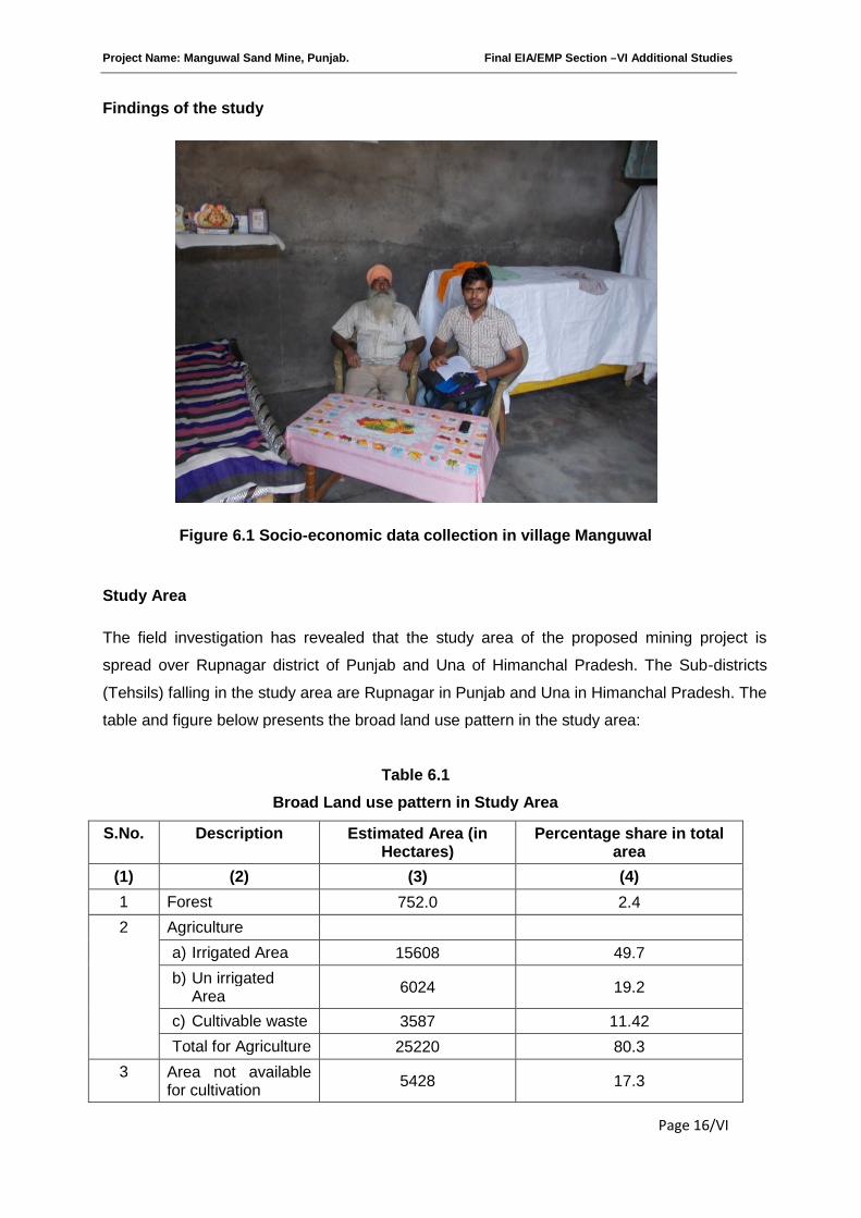
Project Name: Manguwal Sand Mine, Punjab. Final EIA/EMP Section –VI Additional Studies
Page 16/VI
Findings of the study
Figure 6.1 Socio-economic data collection in village Manguwal
Study Area
The field investigation has revealed that the study area of the proposed mining project is
spread over Rupnagar district of Punjab and Una of Himanchal Pradesh. The Sub-districts
(Tehsils) falling in the study area are Rupnagar in Punjab and Una in Himanchal Pradesh. The
table and figure below presents the broad land use pattern in the study area:
Table 6.1
Broad Land use pattern in Study Area
S.No. Description Estimated Area (inHectares)
Percentage share in totalarea
(1) (2) (3) (4)
1 Forest 752.0 2.4
2 Agriculture
a) Irrigated Area 15608 49.7
b) Un irrigatedArea
6024 19.2
c) Cultivable waste 3587 11.42
Total for Agriculture 25220 80.3
3 Area not availablefor cultivation
5428 17.3
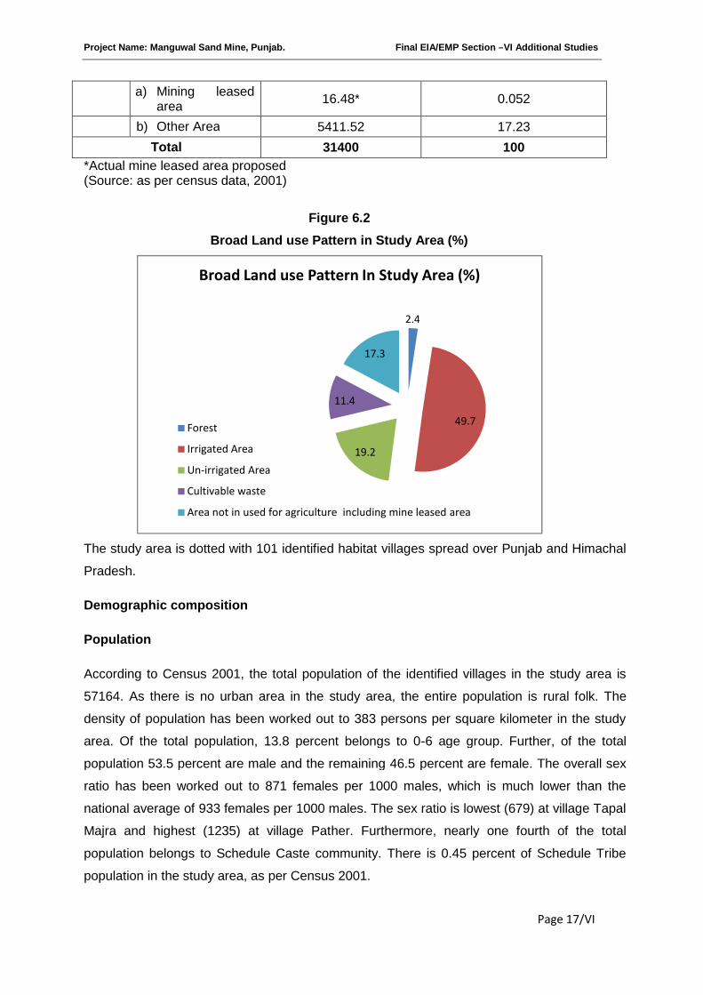
Project Name: Manguwal Sand Mine, Punjab. Final EIA/EMP Section –VI Additional Studies
Page 17/VI
a) Mining leasedarea
16.48* 0.052
b) Other Area 5411.52 17.23
Total 31400 100
*Actual mine leased area proposed(Source: as per census data, 2001)
Figure 6.2
Broad Land use Pattern in Study Area (%)
The study area is dotted with 101 identified habitat villages spread over Punjab and Himachal
Pradesh.
Demographic composition
Population
According to Census 2001, the total population of the identified villages in the study area is
57164. As there is no urban area in the study area, the entire population is rural folk. The
density of population has been worked out to 383 persons per square kilometer in the study
area. Of the total population, 13.8 percent belongs to 0-6 age group. Further, of the total
population 53.5 percent are male and the remaining 46.5 percent are female. The overall sex
ratio has been worked out to 871 females per 1000 males, which is much lower than the
national average of 933 females per 1000 males. The sex ratio is lowest (679) at village Tapal
Majra and highest (1235) at village Pather. Furthermore, nearly one fourth of the total
population belongs to Schedule Caste community. There is 0.45 percent of Schedule Tribe
population in the study area, as per Census 2001.
2.4
49.7
19.2
11.4
17.3
Broad Land use Pattern In Study Area (%)
Forest
Irrigated Area
Un-irrigated Area
Cultivable waste
Area not in used for agriculture including mine leased area
Project Name: Manguwal Sand Mine, Punjab. Final EIA/EMP Section –VI Additional Studies
Page 18/VI
Number of households and household size
The entire population of the study area has been grouped into 9674 households and the
average household size is 6. The household size is lowest (4) at village Radyana and highest
(10) at village Tejpur.
Literates and Literacy rate
The total number of literates in the study area has been worked out to 69887, which is slightly
above 71 percent of the total population. However, the overall literacy rate increases to 82
percent when the population under 6 years of age is deducted from the total population. The
literacy rate of male population has been worked out to 87.5 percent as against 76 percent for
female, creating a gender gap of 11.5 percent. The gender gap in literacy rates varies from a
minimum of 0.6 percent to a maximum of 22.4 percent. It is lowest at village Dhagangarh and
highest at village Dhundli Gopi.
Number of Workers and Work Participation Rate
The total number of workers in the study area is 25299, which is 44 percent of the total
population. Among the total workers 77.1 percent are main workers and the remaining 22.9
percent are marginal workers. The percentage of male in the main workers is 74.4 percent,
while it is only 34.8 percent in the case of marginal workers. On the other hand, the
percentage share of female in the main workers is only 25.6 percent; it is 65.2 percent in the
case of marginal workers. This indicates that male dominates in main workers and female
dominates in the marginal workers.
The classification of workers based on occupation reveals that 50.5 percent of the total
workers are Agricultural workers. However, its share in the total population is only 22.3
percent. This indicates that people in the study are no more depended upon agriculture alone.
There has been an occupational shift of population from agriculture to other sectors, without
making a negative effect on agricultural production and its yield rate. Further, among the
agricultural workers 87.4 percent are cultivators and the remaining 12.6 percent are
agricultural labours who do not possess land but cultivate the land of big farmers as wage
earners. The field investigation has revealed that these agricultural labours are generally
migrants from distant states like Bihar and U.P.
The percentage share of household industrial workers in the total workers is barely 1.5
percent. Though over the years industrial development in the state has been spectacular,
there exists a declining trend in the number of household industrial workers in the total work
force. Deep probe made during field survey has exposed that low percentage of household

Project Name: Manguwal Sand Mine, Punjab. Final EIA/EMP Section –VI Additional Studies
Page 19/VI
workers in the total workers is due to the fact that industries in the study area are not confined
to household cottage industries but they have expanded into micro, small, medium and even
large industries due to greater government intervention and high doses of public and private
investment in industrial sector. It may be added here that the workers engaged in above four
categories of industrial undertakings are not covered under ‘household industrial workers’ but
form part of ‘Other Workers’.
The percent share of ‘Other workers’ constitute 48 percent total workers in the study area.
This includes white collar workers, professional workers, shop keepers, industrial workers
other than household industrial workers, traders and businessmen.
Village wise data on number of households, population, sex ratio, literacy rate, main and
marginal workers etc. is presented in Annexure IV.
Amenities
Various facilities presently available in the study area are described below:
House Structure
The field survey has revealed that 94 percent of the households in the study area have Semi-
Pucca or Pucca structures to live in and only six percent households live in kutcha houses.
Education facilities
Secondary sources reveal that 69 villages out of 101 are provided with educational facilities.
The Table below indicates number and types of educational institutions located in the study
area.
Table 6.2
Type and number of Educational Institutions located in the study area
S.No. Educational Institution Number Percentage to total
(1) (2) (3) (4)
1 Primary Schools 78 72.90
2 Middle Schools 19 17.76
3 Secondary Schools 8 7.48
4 Senior Secondary Schools 2 1.87
There is no provision for higher education in the rural area. Hence, students are compelled to
travel to nearby town/city, which generally lie beyond 10 kilometres from their residence
village. The rural part of study area is also devoid of Industrial and Training schools which are
the need of the day.
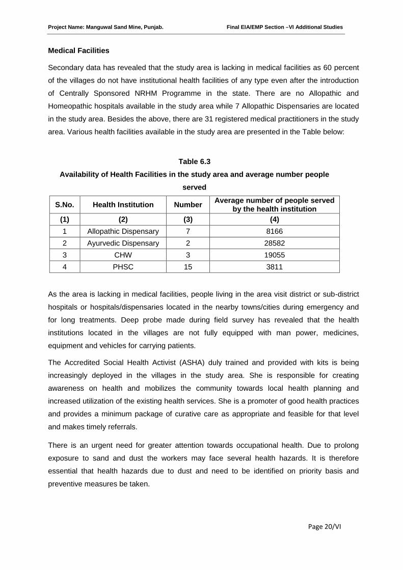
Project Name: Manguwal Sand Mine, Punjab. Final EIA/EMP Section –VI Additional Studies
Page 20/VI
Medical Facilities
Secondary data has revealed that the study area is lacking in medical facilities as 60 percent
of the villages do not have institutional health facilities of any type even after the introduction
of Centrally Sponsored NRHM Programme in the state. There are no Allopathic and
Homeopathic hospitals available in the study area while 7 Allopathic Dispensaries are located
in the study area. Besides the above, there are 31 registered medical practitioners in the study
area. Various health facilities available in the study area are presented in the Table below:
Table 6.3
Availability of Health Facilities in the study area and average number people
served
S.No. Health Institution NumberAverage number of people served
by the health institution
(1) (2) (3) (4)
1 Allopathic Dispensary 7 8166
2 Ayurvedic Dispensary 2 28582
3 CHW 3 19055
4 PHSC 15 3811
As the area is lacking in medical facilities, people living in the area visit district or sub-district
hospitals or hospitals/dispensaries located in the nearby towns/cities during emergency and
for long treatments. Deep probe made during field survey has revealed that the health
institutions located in the villages are not fully equipped with man power, medicines,
equipment and vehicles for carrying patients.
The Accredited Social Health Activist (ASHA) duly trained and provided with kits is being
increasingly deployed in the villages in the study area. She is responsible for creating
awareness on health and mobilizes the community towards local health planning and
increased utilization of the existing health services. She is a promoter of good health practices
and provides a minimum package of curative care as appropriate and feasible for that level
and makes timely referrals.
There is an urgent need for greater attention towards occupational health. Due to prolong
exposure to sand and dust the workers may face several health hazards. It is therefore
essential that health hazards due to dust and need to be identified on priority basis and
preventive measures be taken.
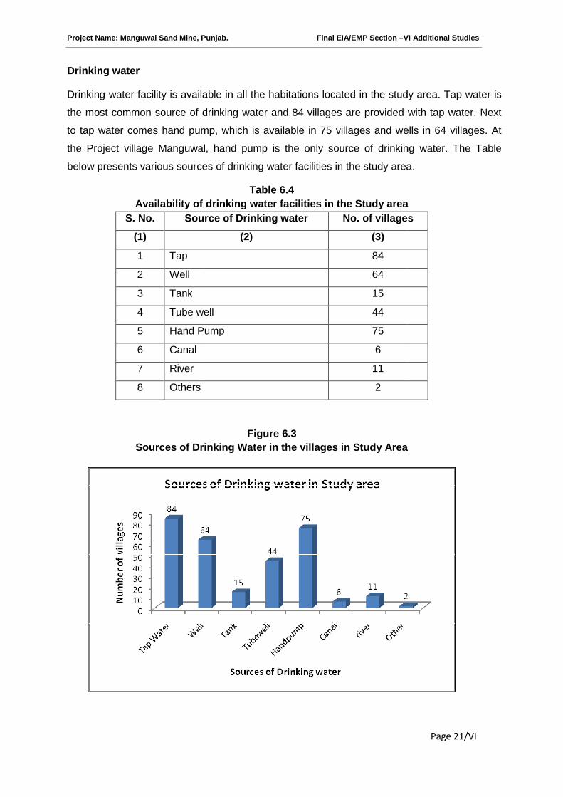
Project Name: Manguwal Sand Mine, Punjab
Drinking water
Drinking water facility is available i
the most common source of drinking water and 84 villages are provided with tap water. Next
to tap water comes hand pump, which is available in 75 villages and wells in 64 villages. At
the Project village Manguwal, hand pump is the only source of drinking water. The Table
below presents various sources of drinking water facilities in the study area
Availability of drinking water facilities in the Study area
S. No. Source of Drinking wat
(1)
1 Tap
2 Well
3 Tank
4 Tube well
5 Hand Pump
6 Canal
7 River
8 Others
Sources of Drinking Water in the villages in Study Area
Mine, Punjab. Final EIA/EMP Section –VI
Drinking water facility is available in all the habitations located in the study area. Tap water is
the most common source of drinking water and 84 villages are provided with tap water. Next
to tap water comes hand pump, which is available in 75 villages and wells in 64 villages. At
t village Manguwal, hand pump is the only source of drinking water. The Table
below presents various sources of drinking water facilities in the study area
Table 6.4
Availability of drinking water facilities in the Study area
Source of Drinking water No. of villages
(2) (3)
84
64
15
Tube well 44
Hand Pump 75
6
11
2
Figure 6.3
Sources of Drinking Water in the villages in Study Area
VI Additional Studies
Page 21/VI
n all the habitations located in the study area. Tap water is
the most common source of drinking water and 84 villages are provided with tap water. Next
to tap water comes hand pump, which is available in 75 villages and wells in 64 villages. At
t village Manguwal, hand pump is the only source of drinking water. The Table
below presents various sources of drinking water facilities in the study area.
Availability of drinking water facilities in the Study area
No. of villages
Sources of Drinking Water in the villages in Study Area
Project Name: Manguwal Sand Mine, Punjab. Final EIA/EMP Section –VI Additional Studies
Page 22/VI
Electricity
According to secondary sources electricity has reached all the villages in the study area.
Electricity is available for domestic lighting and agricultural operations. The demand for
electricity for industrial uses is fast growing due to rapid industrialization. It will further increase
when the proposed mining activities will commence.
Roads
Seventy five villages out of 101 in the study area are provided with paved roads. In 54
villages mud roads are also available along with paved roads. The project village Manguwal is
provided with both paved roads and mud roads. However, the quarry is connected with project
village with mud road.
Communication Facilities
The study area is provided with 12 Post offices and 1217 Land line phone connections. At the
project village Manguwal there is no post office but there are 5 land line phone connections.
Bus and Railway services
In the study area, 60 villages are connected by bus services but no one by railways as yet.
The project village Manguwal is not connected by bus and railway services.
Bank and institutional finance
There is no banking facility in the study area.
Social Condition
With the advancement of education and under the stresses and strains of the modern
economic and social set up, the joint family system in the study area is breaking up very fast.
The field survey has revealed that 92 percent of the households are nuclear families or
conjugal families consisting of a father, mother and their children. The remaining eight percent
are extended families, also known as consanguineous families or joint families. Due to
increase in population and adoption the new ways of life, there is a general tendency among
the younger generation to move out to urban areas in search of job and business
opportunities. However, it cannot be concluded that the institution of joint family system has
disappeared totally. During the field survey it was observed that in many cases, the younger
people keep their families with their parents or extend financial help to them at the time of
marriages, hospitalization, repaying of outstanding debts, purchase of land and construction of
houses etc. Besides the above, they often send their families to their parents or keep the
Project Name: Manguwal Sand Mine, Punjab. Final EIA/EMP Section –VI Additional Studies
Page 23/VI
parents with them for a period convenient to both sides. Thus joint family system has not yet
completely broken. Though many men and women have left their villages for higher
education, jobs and business but they still have close link with their parents and make regular
visits to them, who have preferred to stay back in the villages.
The condition of women in the study area has considerably improved and they are competing
with men in all walks of life. They receive higher education and do jobs in schools, colleges
and offices. All avenues of life are now open to them. Further, they are fast becoming
economically independent.
It has also been observed that in the study area the caste feeling in the society is in the wane
and the people of different castes and creed mix together quite freely in their day-to -day life.
Lastly, the study area is somewhat free from poverty as number of BPL Card holders is only
5.3 percent.
Income
The sample survey in randomly selected villages in the study area covering 20 households in
each village have revealed that average monthly income of a households from all sources is
Rs. 8770.5, which is nearly two times the national average of Rs. 3874.33 per month during
2009-10.
Consumption Pattern
In the study area wheat is the staple food. Other food articles consumed in the area are rice,
pulses & grams, edible oils, milk & milk products, fruits & vegetables, eggs, meat & meat
products. The Table below presents average weekly consumption of cereals and non-cereal
items in the study area.
Table 6.5
Weekly Household Consumption Cereal and Non-cereal items
S. No. ItemsUnit of
measurementConsumption
(1) (2) (3) (4)
1 Wheat Kg. 11.5
2 Rice Kg. 6.3
3 Pulses & Grams Kg. 1.52
4 Edible oils & other
cooking media
Litre 3.02
5 Spices Kg. 0.48
Project Name: Manguwal Sand Mine, Punjab. Final EIA/EMP Section –VI Additional Studies
Page 24/VI
6 Milk Liters 9.41
7 Fruits & Vegetables Kg. 2.43
8 Eggs pieces 15
9 Meat & Meat Products Kg. 1.26
Impact on population composition
The impact of the proposed mining project on population composition will be marginal as only
few skilled and managerial staff will be recruited from outside and the rest will be recruited
locally. The impact will be significant if a large number of people from outside get employed in
the project. In that case not only the population of the study area will go up but also the
skewed sex ratio may make permanent social effects like rise in exploitation of women, higher
crime rate, an increase in sexual diseases and depression among youth.
Impact on Family income
During the field survey an attempt was made to gather information on household income in
the study area. As many as 20 sample households spread over in each sample village were
approached for collection of information. Based on the above data the average monthly
income of a household in the study area has been worked out to Rs. 8770.5, which is high in
comparison to national average of Rs. 3874.33 per month during 2009-10. The impact of the
proposed mining activity on household income in the study area will be positive since it will
provide employment to local people. It is expected that monthly income of those households
recruited for mining operation will increase further but for 250 days in a year.
Impact on consumption pattern
The field survey has revealed that people in the study are not poverty ridden. Increased
household income may change the consumption pattern substantially. There may be a
marginal or no increase in the consumption of food articles but consumption of non-food items
may go up due to increased income.
Impact on road development
Movement of trucks and other vehicles to and fro the quarry site is expected to increase
substantially, when the construction and operation of the mine will commence. The existing
roads connecting the quarry with the national and state highways are narrow mud roads.
There will be mud slide and traffic bottle neck if these roads are not widened and their
conditions are not improved by making them paved roads. Hence, there is scope for road
development in the area.

Project Name: Manguwal Sand Mine, Punjab. Final EIA/EMP Section –VI Additional Studies
Page 25/VI
Impact on law & Order
If local people are employed to run the quarry, there will be no law & order problem. The mine
workers will attend to their duties from their residence and return to their homes after the day’s
work is over. However, there may cause law & order problem due to ethnic issues if the
workers are migrants and live nearby. Hence, to meet any untoward incident one police post
may be set up to tackle law & order problem in the project village.
6.7 SUGGESTIONS
Provision of First Aid at mining site
Extraction of sand, boulder and bazri from the river bed poses serious health risks due to dust,
quarrying and stone crushing. The effects vary depending on the nature of the dust particles,
silica content in it and the size of the particle. To meet any emergency during extraction of the
minerals from the river bed and subsequent loading in the transport vehicles, provision for
First Aid should be made by the project proponent. Before the affected person is removed to a
doctor or health institution for necessary medical aid, the miner should be provided with First
Aid.
Tie up with the nearest PHC for medical help
To meet the medical needs of the mine workers it is suggested that tie-ups with nearest
hospital or Primary Health Center (PHC) may be made. Few beds may be exclusively
reserved for the mine workers in the above health institutions. This will ensure timely medical
aid to the affected persons.
Supply of Mask, Gloves
The mine workers are subject to respiratory diseases, muscular-skeletal and gastro-intestinal
disorders and skin diseases. For protection from dust it may be made compulsory for all mine
workers to wear masks and gloves while working in the mines.
Regular health checkups
The miners may be encouraged to undergo health checkups at regular intervals in order to
protect themselves from various diseases. The health Department of Punjab Government
must Organize Health Camps at regular intervals preferably in every quarter. Further, free
medical facilities may be made available to the workers and their family members.
Administration of Anti-venom injections
Provision of Anti-venom therapy must be made available at the near health institution. Anti-
venom injections may be administrated to the mine workers in case of snake, spider and
insect bites, while working in the mines.
Project Name: Manguwal Sand Mine, Punjab. Final EIA/EMP Section –VI Additional Studies
Page 26/VI
Special telephone number
A special telephone number may be made available to the mine workers. In case of
emergency the miners can dial the above number for medical assistance. Vehicle may be
provided to the patients in short duration for shifting to the health institution.
Special Group Insurance Scheme
All the mine workers may be covered under a Group Insurance Scheme of LIC or any other
Insurance company.
6.8 CONCLUSIONS
The implementation of the Manguwal sand mining project will generate both direct and indirect
employment. Besides, it will provide a check on existing system of mining operation. Since the
quarries will be allotted on lease basis, mining operation will be legally valid and it will bring
income to the state exchequer. It will also reduce flooding of river banks, destruction of
standing crops, land and property to a great extent. The project will also provide impetus to
industrialization of the area. Where transfer of boulders into bajri is necessary crushing units
will come up. It is expected that intending entrepreneurs will venture to set up micro and small
scale units in the near future making the area a mixed society, dependent on industry, trade
and business. At present agriculture is the main occupation of the people as more than half of
the population depends on it. With the implementation of the proposed mining project the
occupational pattern of the people in the area will change making more people engaged in
industrial and business activities rather in agriculture. Thus there will be a gradual shifting of
population from agriculture to mining and industry. Further, the mining and industrial activities
in the area may lead to rapid increase in population and thereby urbanization. Due to
urbanization of the area, employment opportunities will further increase.
The study area is still lacking in education, health, housing, water, electricity etc. It is expected
that same will improve to a great extent due to proposed mining project and associated
industrial and business activities. It is therefore suggested that extraction of minerals should
be taken up on regular basis during the post monsoon period. This will dredge the river bed on
regular basis, regulate the course of the river and check flooding of the catchment area.
Proposed activities and expenses on Corporate Social Responsibility will be as per CSR
Mandate of the Government.
*********
Project Name: Manguwal Sand Mine, Punjab Final EIA/EMP Section – VII Project benefits
Page 1/VII
SECTION-VII
PROJECT BENEFITS
INDEX
S. No. CONTENTS Page No.
7.0 GENERAL 2/VII
7.1 BENEFITS OF MINING 2/VII
7.2 EMPLOYMENT 2/VII
7.3 IMPROVEMENTS IN PHYSICAL AND SOCIAL INFRASTRUCTURE 2/VII
7.4 HEALTH 3/VII
Project Name: Manguwal Sand Mine, Punjab Final EIA/EMP Section – VII Project benefits
Page 2/VII
7.0 GENERAL
The execution of the project i.e removal of sediments will protect against widening of the
river channel and flooding of adjoining areas, bring overall improvement in the locality,
neighbourhood and the State by bringing industry, roads, water supply, electricity,
employment, living standard and economic growth.
7.1 BENEFITS OF MINING
i. Controlling river channel.
ii. Protecting river banks.
iii. Protecting flooding
iv. Reducing submergence of adjoining agricultural lands.
v. Protection of crops being cultivated along the river bank
vi. Reducing aggradations of river level.
vii. Generating useful economic resource for construction.
viii. Generating employment.
ix. Improvement in socio economic conditions of the people of the study area
7.2 EMPLOYMENT
The socio-economic conditions of the surrounding villages indicate that employment
generation is seasonal. The occupational activities are agriculture, cattle rearing and
employment in mines but on daily wages. The mining activity will provide employment to
local people which will increase socio- economic status of the area.
7.3 IMPROVEMENTS IN PHYSICAL AND SOCIAL INFRASTRUCTURE
The opening of the proposed project will enhance the socio-economic activities in the
adjoining areas. This will result in following benefits:-
a. Improvements in physical infrastructure.
b. Improvements in Social Infrastructure.
c. Increase in Employment Potential
d. Contribution to the Exchequer.
e. Prevention of illegal mining.
f. During and Post-mining enhancement of green cover.
7.3(a) IMPROVEMENTS IN PHYSICAL INFRASTRUCTURE
The opening of the proposed project will improve the physical infrastructure of the adjoining
areas. This will include the following:-
Improved road communication due to opening of the proposed project.
Project Name: Manguwal Sand Mine, Punjab Final EIA/EMP Section – VII Project benefits
Page 3/VII
Strengthening of existing community facilities through the Community Development
Programme.
Creation of community assets (infrastructure) like provision for drinking water,
construction of school buildings, village roads/ linked roads, dispensary & health centre,
community centre, market place etc.
Awareness program and community activities, like health camps, medical aids, family
welfare programs, immunization camp sports & cultural activities, plantation etc.
7.3(b) IMPROVEMENTS IN SOCIAL INFRASTRUCTURE
There will be some obvious changes in various environmental parameters due to mining
activity. There will be positive impact in socio-economic area due to increased economic
activities, creation of new employment opportunities, infrastructural development and better
educational and health facilities. Lessee will also undertake awareness program and
community activities like health, camps, medical aids, family welfare camps, AIDS
awareness program etc.
7.3(c) INCREASE IN EMPLOYMENT POTENTIAL: -
There is a possibility of creation of direct and indirect employment opportunities due to
working of this mine.
7.3(d) PREVENTION OF ILLEGAL MINING & CONTRIBUTION TO THE EXCHEQUER: -
Since the quarries will be leased out to successful allottees, mining operation in the state will
get legalized and it will fetch income to the state exchequer.
7.3(e) ENHANCEMENT OF GREEN COVER
Plantation/afforestation will be done as per program i.e. along the road sides and near civic
amenities, which will be allotted by Government bodies as it is not feasible to plant trees
near the mine lease area. Post plantation, the area will be regularly monitored in every
season for evaluation of success rate. For selection of plant species local people will also be
involved. The management will provide free saplings of fruit and other trees, etc. to local
during rain for plantation.
7.4 HEALTH
Periodic medical checkups as per Mines Act/ Rules and other social development and
promotional activities will be undertaken. All this will lift the general health status of the
residents of the area around mines.
*********
Project Name: Manguwal Sand Mine, Punjab Final EIA/EMP Section - VIII Environment Management Plan
Page 1/VIII
SECTION-VIII
ENVIRONMENTAL MANAGEMENT PLAN
INDEX
S. No. CONTENTS Page No.
8.0 INTRODUCTION 2/VIII
8.1 ENVIRONMENTAL MANAGEMENT PLAN (EMP) 2/VIII
8.2 ENVIRONMENTAL MANAGEMENT PLAN IMPLEMENTATION 3/VIII
8.3 PROPOSED SET UP 4/VIII
8.4BU BUDGET ALLOCATION FOR EMP IMPLEMENTATION 4/VIII
8.5 MONITORING SCHEDULE AND ACTIVITIES 5/VIII
8.6 DIVISION OF RESPONSIBILITY 6/VIII
Project Name: Manguwal Sand Mine, Punjab Final EIA/EMP Section - VIII Environment Management Plan
Page 2/VIII
8.0 INTRODUCTION
To mitigate the adverse impacts which are likely to be caused due to the mining operation and
overall scientific development of local habitat, environmental management plan (EMP) has been
formulated and integrated with the mine planning. The details of the anticipated impacts and
mitigative measures have been discussed in Section IV of this report, based on the results of
present environmental conditions and environmental impact assessment. This EMP has
therefore been made considering implementation and monitoring of environmental protection
measures during and after mining operations.
Though the mitigation measures which would reduce the impact have already been identified as
mentioned above in Section IV, there are certain additional EMP measures as enumerated
below, which will be taken while implementation of mining project.
8.1 ENVIRONMENTAL MANAGEMENT PLAN (EMP)
Proper environmental management plan is proposed for “Sand” mining project to mitigate the
impact during the mining operations.
a. No labour camps will be established on river bed.
b. No cooking, or burning of woods will be allowed in the nearby area.
c. Prior to commencement of mining, a short awareness program will be conducted for
labours to make them aware of way of working and various precautions to be taken while at
work. Such program will be repeated occasionally.
d. In the event of any some causality or injury to any animal occurs, proper treatment will be
given.
e. No tree cutting, chopping, lumbering, uprooting of shrubs and herbs will be allowed.
f. Corridor movement of wild animals, if exists mining operations will be avoided in the area.
g. It will be ensured that noise produced due to vehicles movement while carrying sand are
within the permissible noise level.
h. No piling of River Bed Material will be done in adjoining area.
i. If wild animals are noticed crossing the river bed, they will not be disturbed or chased away,
instead the labours will move away from their path.

Project Name: Manguwal Sand Mine, Punjab Final EIA/EMP Section - VIII Environment Management Plan
Page 3/VIII
8.2 ENVIRONMENTAL MANAGEMENT PLAN IMPLEMENTATION
Environmental Management Plan serves no purpose if it is not implemented with true spirit.
Some loopholes in the EMP can also be detected afterwards when it is implemented and
monitored. Thus, an implementation and monitoring programme has to be prepared.
The major attributes of environment are not confined to the mining site alone. Implementation of
proposed control measures and monitoring programme has an implication on the surrounding
area as well as for the region. Therefore, mine management should strengthen the existing
control measures as elaborated earlier in this report and monitor the efficacy of the control
measures implemented within the mining area relating to the following specific areas for eco-
friendly mining plan:
a. Collection of air and water samples at strategic locations with frequency suggested and by
analyzing thereof. If the parameters exceed the permissible tolerance limits, corrective
regulation measure will be taken.
b. Collection of soil samples at strategic locations once in every two years and analysis thereof
with regard to deleterious constituents, if any.
c. Measurement of water level fluctuations in the nearby ponds, dug wells and bore wells.
d. Regular visual examination will be carried out to look for erosion of river banks. Any abnormal
condition, if observed will be taken care of. The banks will be restored before the monsoon
during the suspension of mining activity.
e. Measurement of noise levels at mine site, stationary and mobile sources, and adjacent villages
will be done twice a year for the first two years and thereafter once a year.
f. Plantation/afforestation as should be done as per program i.e along the road sides and near
civic amenities, which will be allotted by Government, Post plantation, the area will be regularly
monitored in every two years for evaluation of success rate. For selection of plant species local
people should also be involved.
Mine management will be in regular touch with local surrounding villages to update the various
developmental schemes made for or by them. It will also consider any immediate requirement,
which could be taken care of in near future.
An Environmental Management Cell (EMC) is envisaged which will be responsible for
monitoring EMP and its implementation. EMC members shall meet periodically to assess the
progress and analyze the data collected during the month. The EMC will function as per Fig. 5.1
(Section V).
Project Name: Manguwal Sand Mine, Punjab Final EIA/EMP Section - VIII Environment Management Plan
Page 4/VIII
EMC will be in regular touch with State Pollution Control Board and send them regular progress
report. Any new regulations considered by State/Central Pollution Control Board for the mining
industry will be taken care of by it.
8.3 PROPOSED SET UP
Keeping the utility of monitoring results in the implementation of the environmental management
program in view, an organizational chart headed by General Manager has been proposed, as
shown in Fig. 5.1(Section V).
The said team will be responsible for:
a. Collecting water and air samples from surrounding area and work zone monitoring for
pollutants.
b. Analyzing the water and air samples.
c. Implementing the control and protective measures.
d. Co-coordinating the environment related activities within the project as well as with outside
agencies.
e. Collecting statistics of health of workers and population of surrounding villages.
f. Monitoring the progress of implementation of environmental management program. Greenbelt
development, etc.
The laboratory will be suitably equipped for sampling/testing for various environmental
pollutants.
8.4 BUDGET ALLOCATION FOR EMP IMPLEMENTATION
Annual budget for EMP is very essential for successful implementation of EMP. As there are no
pollution control systems, no capital cost of Pollution Control systems are envisaged. Costs will
be annual operating costs as given below. The fund allocated will not be diverted for any other
purposes and the top management will be responsible for this. The budget will take into
consideration the following expenses:
a. Field cost for monitoring of parameters.
b. Cost of any defined outsourcing
c. Cost of chemicals, consumables and transport for data generation
d. Man power cost for environmental cell
e. Any other cost as per EC condition.
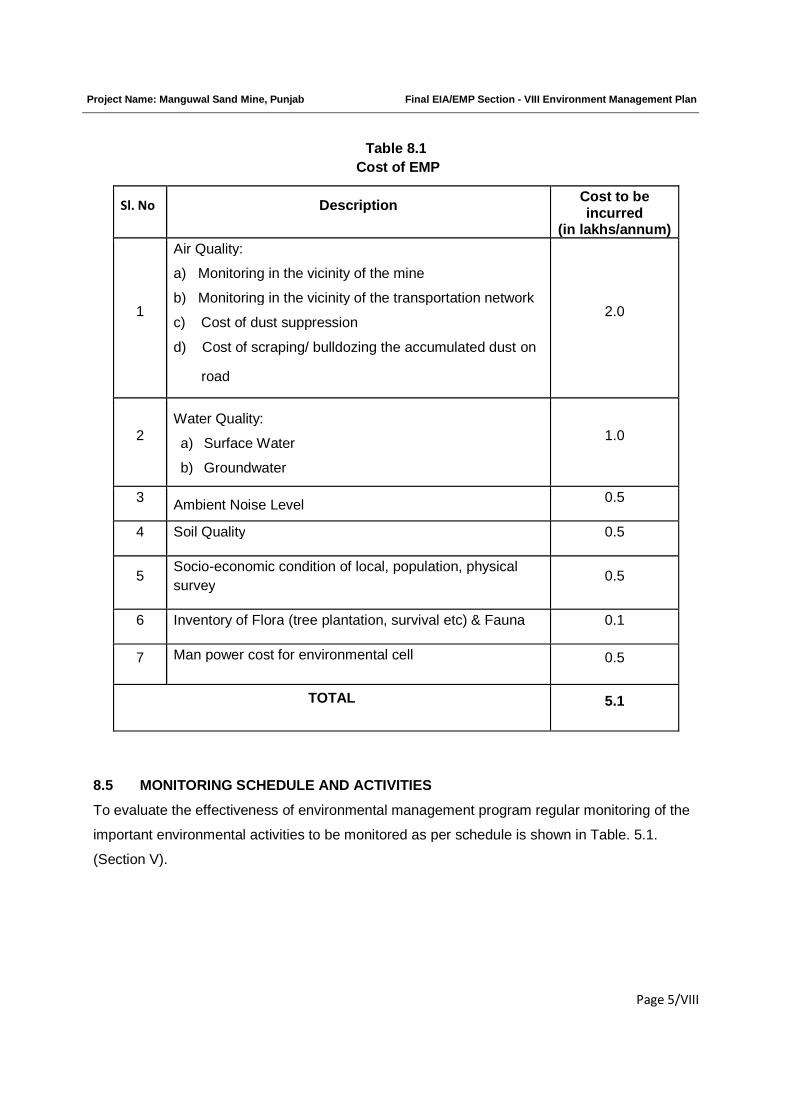
Project Name: Manguwal Sand Mine, Punjab Final EIA/EMP Section - VIII Environment Management Plan
Page 5/VIII
Table 8.1
Cost of EMP
Sl. No DescriptionCost to beincurred
(in lakhs/annum)
1
Air Quality:
a) Monitoring in the vicinity of the mine
b) Monitoring in the vicinity of the transportation network
c) Cost of dust suppression
d) Cost of scraping/ bulldozing the accumulated dust on
road
2.0
2Water Quality:
a) Surface Water
b) Groundwater
1.0
3Ambient Noise Level
0.5
4 Soil Quality 0.5
5Socio-economic condition of local, population, physical
survey0.5
6 Inventory of Flora (tree plantation, survival etc) & Fauna 0.1
7 Man power cost for environmental cell 0.5
TOTAL 5.1
8.5 MONITORING SCHEDULE AND ACTIVITIES
To evaluate the effectiveness of environmental management program regular monitoring of the
important environmental activities to be monitored as per schedule is shown in Table. 5.1.
(Section V).

Project Name: Manguwal Sand Mine, Punjab Final EIA/EMP Section - VIII Environment Management Plan
Page 6/VIII
8.6 Division of Responsibility of various Activities for a Sand Mine Project
S.No Activity Responsibility
of the Project
Proponent
(Regulator)
Responsibility
of the
Contractor
(Operator)
1 Demarcation of mine area (Outermost boundary)
as per Khasra Numbers of the mine
Regulator
through
revenue dept.
2 Demarcation of Buffer zone on either side of
River/Choe bank
Operator-
Based on the
regulations
passed from
time to time
3 Restriction on Mining :i. The mining is prohibited to a distance of 500
m both on upstream and downstream from the
high level bridge and 250 m form the other
bridges.
ii. If width of the river is less than 120 m the
mining will be restricted within the bed of river. If
higher than 120 m the mining will be restricted
after leaving the area within 30 m from the edge
of embankment on either side of the river bed.
iii. The contractor will not do any quarry
operations within the distance of:
a. 75m from railway line
b. 60m from national highway
c. 50m from reservoir tank, canal roads, public
works or buildings and in-habitat sites etc.
iv. The mining will not be allowed below the
water table.
v. No mining operation will be allowed in forest
area.
Operator
Operator
Operator
Operator
Operator
Project Name: Manguwal Sand Mine, Punjab Final EIA/EMP Section - VIII Environment Management Plan
Page 7/VIII
vi. Compliance to various provisions laid down
under Mines Act, 1952, Mines & Minerals
(Regulation and Development) Act, 1957, Forest
(Conservation) Act, 1980, MMR, 1961.
vii. Assuring for the provisions of Mines Act,
1952, Interstate Migrant Workman Act and
Central and State Govt. labor laws in respect of
following:
a. drinking water
b. rest shelter
c. first aid box
d. welfare facilities
viii. Abiding by the Punjab Minor Mineral
Concession Rules, 1964 and 2008.
ix. Adherence to the Eco-friendly mine plan for
mining of minor minerals.
x. Compliance to the measures kept in theEMP
Operator
Operator
Operator
Operator
Operator
4 Making amenities available :
i. Water for Drinking purposes
ii. Water for Sprinkling on roads
iii. Water for wetting of dry sands
iv. Provisions of Portable/Community toilets
and making water available for them.
Operator
5a Mitigation Measures for Land environment:
i. Assuring sand mining to a depth of 3m or
maximum upto ground water table whichever is
minimum
ii. The RBM will be done in unsaturated zone.
iii. No mining will be done nearby the dam and
important structure to prevent hungry water
problem.
iv. Mining will not exceed beyond the
Operator
Operator
Operator
Operator
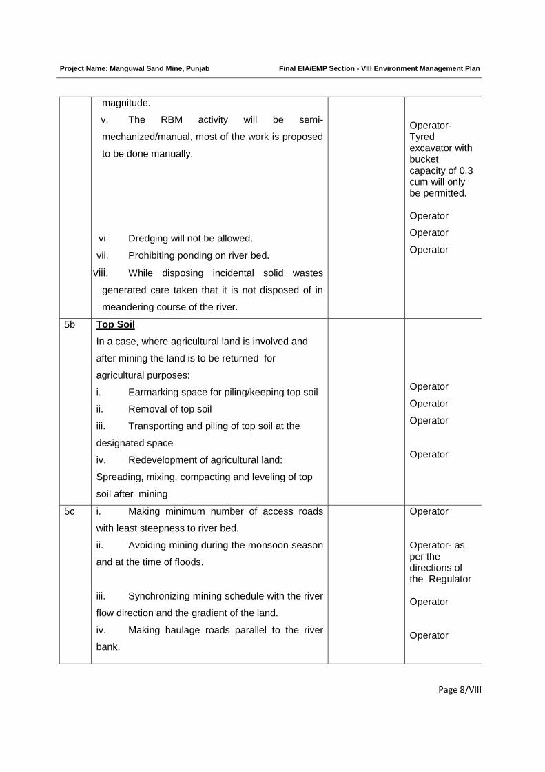
Project Name: Manguwal Sand Mine, Punjab Final EIA/EMP Section - VIII Environment Management Plan
Page 8/VIII
magnitude.
v. The RBM activity will be semi-
mechanized/manual, most of the work is proposed
to be done manually.
vi. Dredging will not be allowed.
vii. Prohibiting ponding on river bed.
viii. While disposing incidental solid wastes
generated care taken that it is not disposed of in
meandering course of the river.
Operator-Tyredexcavator withbucketcapacity of 0.3cum will onlybe permitted.
Operator
Operator
Operator
5b Top Soil
In a case, where agricultural land is involved and
after mining the land is to be returned for
agricultural purposes:
i. Earmarking space for piling/keeping top soil
ii. Removal of top soil
iii. Transporting and piling of top soil at the
designated space
iv. Redevelopment of agricultural land:
Spreading, mixing, compacting and leveling of top
soil after mining
Operator
Operator
Operator
Operator
5c i. Making minimum number of access roads
with least steepness to river bed.
ii. Avoiding mining during the monsoon season
and at the time of floods.
iii. Synchronizing mining schedule with the river
flow direction and the gradient of the land.
iv. Making haulage roads parallel to the river
bank.
Operator
Operator- asper thedirections ofthe Regulator
Operator
Operator
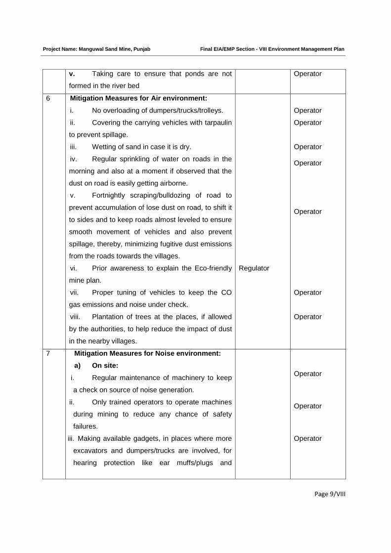
Project Name: Manguwal Sand Mine, Punjab Final EIA/EMP Section - VIII Environment Management Plan
Page 9/VIII
v. Taking care to ensure that ponds are not
formed in the river bed
Operator
6 Mitigation Measures for Air environment:
i. No overloading of dumpers/trucks/trolleys.
ii. Covering the carrying vehicles with tarpaulin
to prevent spillage.
iii. Wetting of sand in case it is dry.
iv. Regular sprinkling of water on roads in the
morning and also at a moment if observed that the
dust on road is easily getting airborne.
v. Fortnightly scraping/bulldozing of road to
prevent accumulation of lose dust on road, to shift it
to sides and to keep roads almost leveled to ensure
smooth movement of vehicles and also prevent
spillage, thereby, minimizing fugitive dust emissions
from the roads towards the villages.
vi. Prior awareness to explain the Eco-friendly
mine plan.
vii. Proper tuning of vehicles to keep the CO
gas emissions and noise under check.
viii. Plantation of trees at the places, if allowed
by the authorities, to help reduce the impact of dust
in the nearby villages.
Regulator
Operator
Operator
Operator
Operator
Operator
Operator
Operator
7 Mitigation Measures for Noise environment:
a) On site:
i. Regular maintenance of machinery to keep
a check on source of noise generation.
ii. Only trained operators to operate machines
during mining to reduce any chance of safety
failures.
iii. Making available gadgets, in places where more
excavators and dumpers/trucks are involved, for
hearing protection like ear muffs/plugs and
Operator
Operator
Operator
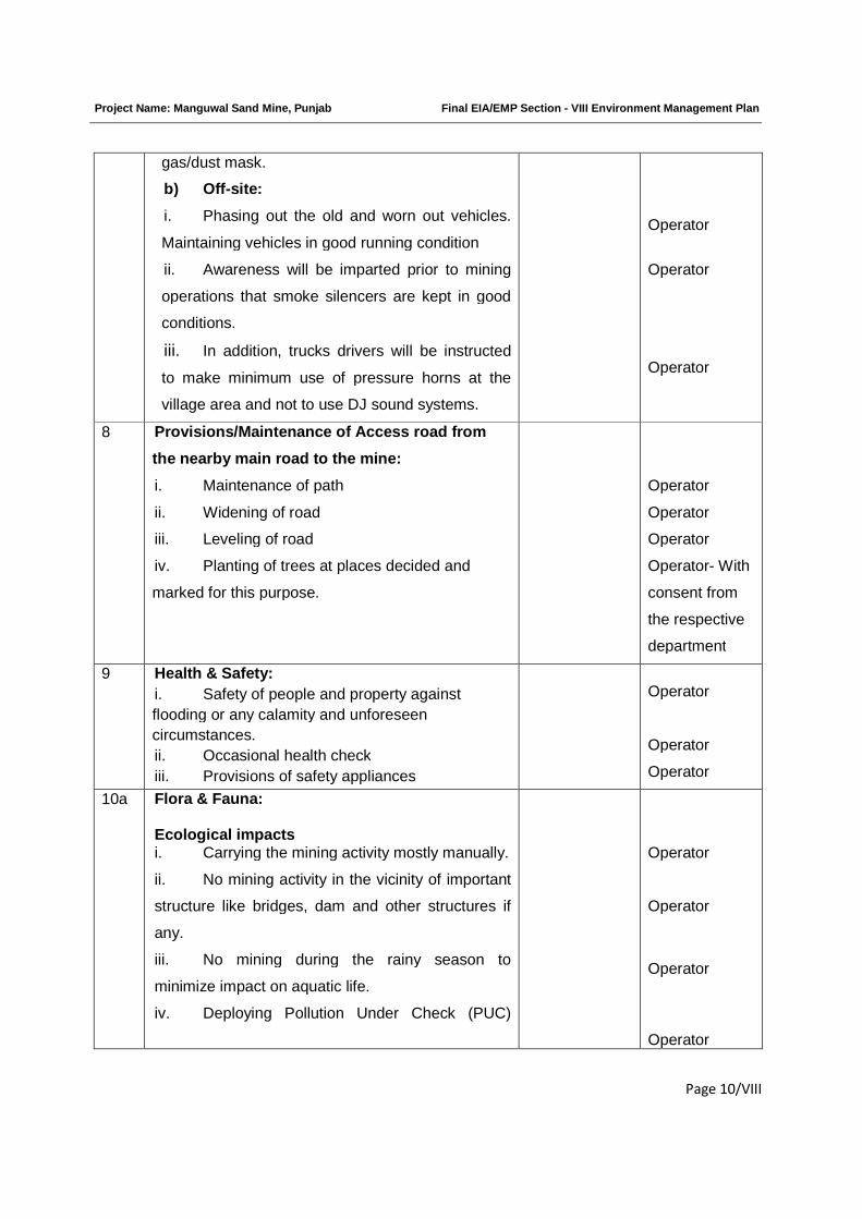
Project Name: Manguwal Sand Mine, Punjab Final EIA/EMP Section - VIII Environment Management Plan
Page 10/VIII
gas/dust mask.
b) Off-site:
i. Phasing out the old and worn out vehicles.
Maintaining vehicles in good running condition
ii. Awareness will be imparted prior to mining
operations that smoke silencers are kept in good
conditions.
iii. In addition, trucks drivers will be instructed
to make minimum use of pressure horns at the
village area and not to use DJ sound systems.
Operator
Operator
Operator
8 Provisions/Maintenance of Access road from
the nearby main road to the mine:
i. Maintenance of path
ii. Widening of road
iii. Leveling of road
iv. Planting of trees at places decided and
marked for this purpose.
Operator
Operator
Operator
Operator- With
consent from
the respective
department
9 Health & Safety:
i. Safety of people and property against
flooding or any calamity and unforeseen
circumstances.
ii. Occasional health check
iii. Provisions of safety appliances
Operator
Operator
Operator
10a Flora & Fauna:
Ecological impactsi. Carrying the mining activity mostly manually.
ii. No mining activity in the vicinity of important
structure like bridges, dam and other structures if
any.
iii. No mining during the rainy season to
minimize impact on aquatic life.
iv. Deploying Pollution Under Check (PUC)
Operator
Operator
Operator
Operator
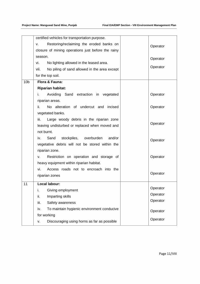
Project Name: Manguwal Sand Mine, Punjab Final EIA/EMP Section - VIII Environment Management Plan
Page 11/VIII
certified vehicles for transportation purpose.
v. Restoring/reclaiming the eroded banks on
closure of mining operations just before the rainy
season.
vi. No lighting allowed in the leased area.
vii. No piling of sand allowed in the area except
for the top soil.
Operator
Operator
Operator
10b Flora & Fauna:
Riparian habitat:
i. Avoiding Sand extraction in vegetated
riparian areas.
ii. No alteration of undercut and incised
vegetated banks.
iii. Large woody debris in the riparian zone
leaving undisturbed or replaced when moved and
not burnt.
iv. Sand stockpiles, overburden and/or
vegetative debris will not be stored within the
riparian zone.
v. Restriction on operation and storage of
heavy equipment within riparian habitat.
vi. Access roads not to encroach into the
riparian zones
Operator
Operator
Operator
Operator
Operator
Operator
11 Local labour:
i. Giving employment
ii. Imparting skills
iii. Safety awareness
iv. To maintain hygienic environment conducive
for working
v. Discouraging using horns as far as possible
Operator
Operator
Operator
Operator
Operator
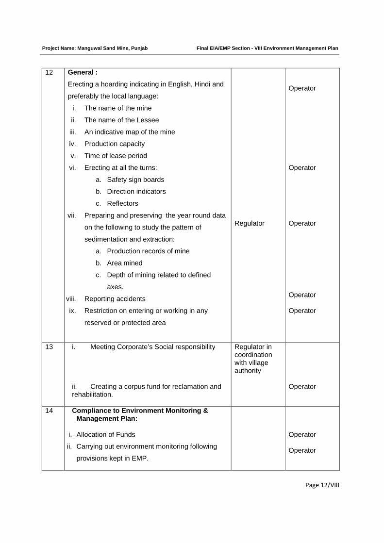
Project Name: Manguwal Sand Mine, Punjab Final EIA/EMP Section - VIII Environment Management Plan
Page 12/VIII
12 General :
Erecting a hoarding indicating in English, Hindi and
preferably the local language:
i. The name of the mine
ii. The name of the Lessee
iii. An indicative map of the mine
iv. Production capacity
v. Time of lease period
vi. Erecting at all the turns:
a. Safety sign boards
b. Direction indicators
c. Reflectors
vii. Preparing and preserving the year round data
on the following to study the pattern of
sedimentation and extraction:
a. Production records of mine
b. Area mined
c. Depth of mining related to defined
axes.
viii. Reporting accidents
ix. Restriction on entering or working in any
reserved or protected area
Regulator
Operator
Operator
Operator
Operator
Operator
13 i. Meeting Corporate’s Social responsibility
ii. Creating a corpus fund for reclamation andrehabilitation.
Regulator incoordinationwith villageauthority
Operator
14 Compliance to Environment Monitoring &Management Plan:
i. Allocation of Funds
ii. Carrying out environment monitoring following
provisions kept in EMP.
Operator
Operator
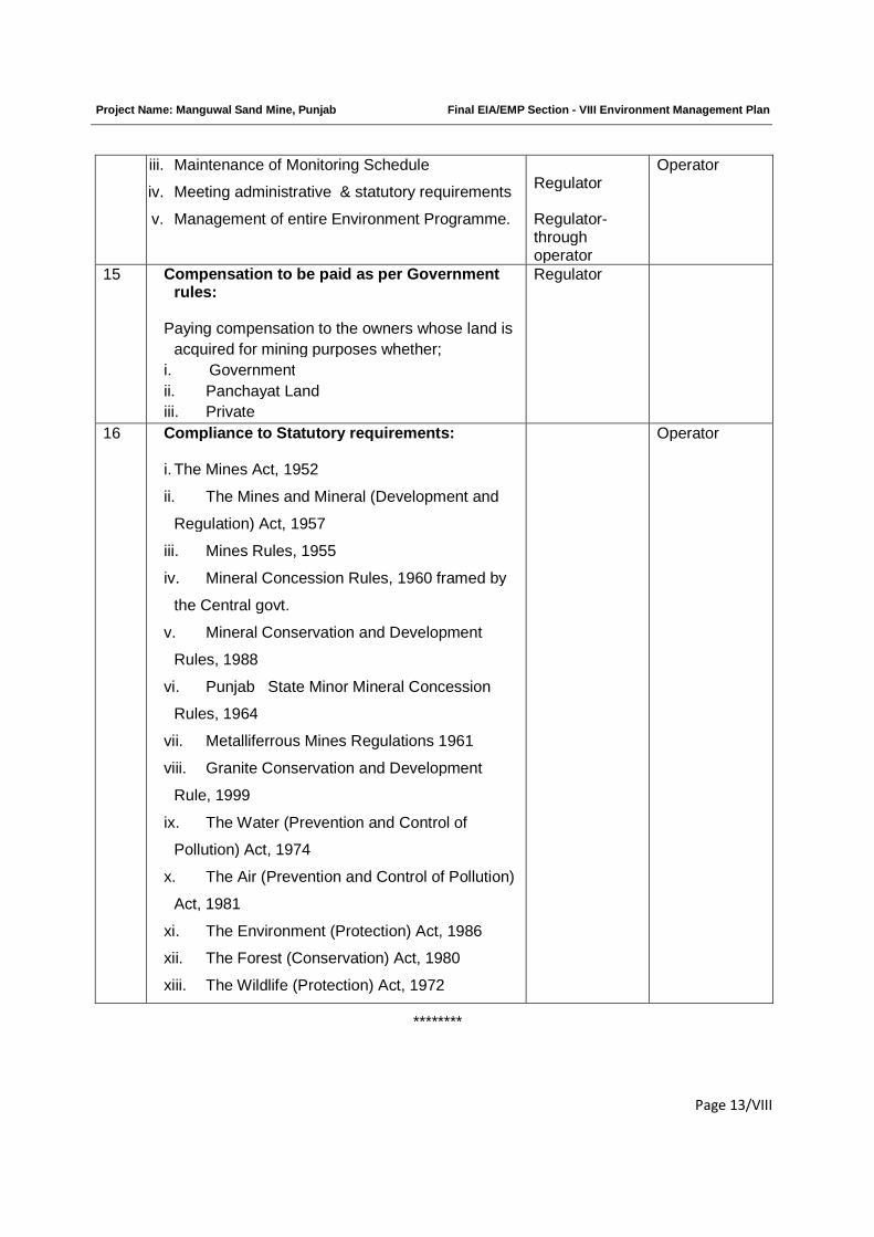
Project Name: Manguwal Sand Mine, Punjab Final EIA/EMP Section - VIII Environment Management Plan
Page 13/VIII
iii. Maintenance of Monitoring Schedule
iv. Meeting administrative & statutory requirements
v. Management of entire Environment Programme.
Regulator
Regulator-throughoperator
Operator
15 Compensation to be paid as per Governmentrules:
Paying compensation to the owners whose land is
acquired for mining purposes whether;
i. Government
ii. Panchayat Land
iii. Private
Regulator
16 Compliance to Statutory requirements:
i. The Mines Act, 1952
ii. The Mines and Mineral (Development and
Regulation) Act, 1957
iii. Mines Rules, 1955
iv. Mineral Concession Rules, 1960 framed by
the Central govt.
v. Mineral Conservation and Development
Rules, 1988
vi. Punjab State Minor Mineral Concession
Rules, 1964
vii. Metalliferrous Mines Regulations 1961
viii. Granite Conservation and Development
Rule, 1999
ix. The Water (Prevention and Control of
Pollution) Act, 1974
x. The Air (Prevention and Control of Pollution)
Act, 1981
xi. The Environment (Protection) Act, 1986
xii. The Forest (Conservation) Act, 1980
xiii. The Wildlife (Protection) Act, 1972
Operator
********
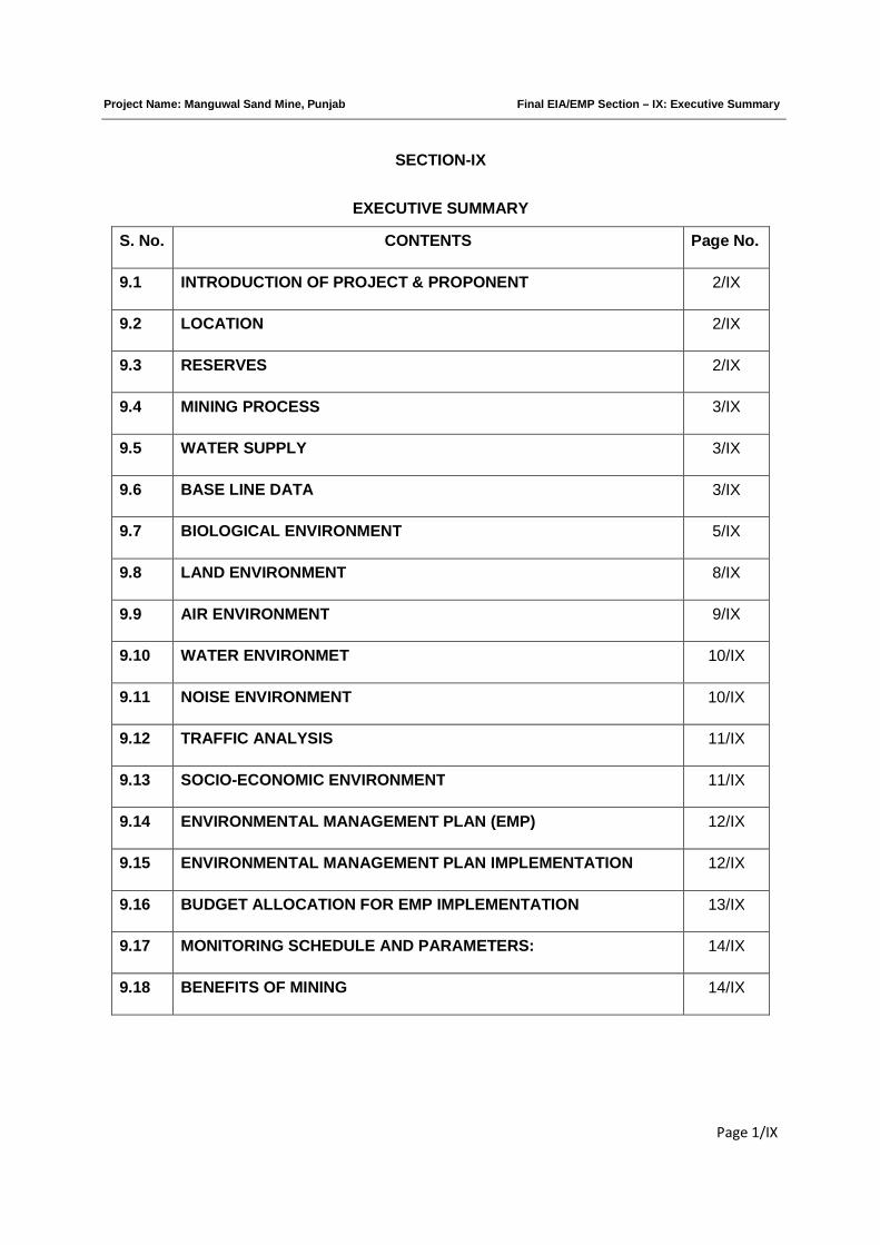
Project Name: Manguwal Sand Mine, Punjab Final EIA/EMP Section – IX: Executive Summary
Page 1/IX
SECTION-IX
EXECUTIVE SUMMARY
S. No. CONTENTS Page No.
9.1 INTRODUCTION OF PROJECT & PROPONENT 2/IX
9.2 LOCATION 2/IX
9.3 RESERVES 2/IX
9.4 MINING PROCESS 3/IX
9.5 WATER SUPPLY 3/IX
9.6 BASE LINE DATA 3/IX
9.7 BIOLOGICAL ENVIRONMENT 5/IX
9.8 LAND ENVIRONMENT 8/IX
9.9 AIR ENVIRONMENT 9/IX
9.10 WATER ENVIRONMET 10/IX
9.11 NOISE ENVIRONMENT 10/IX
9.12 TRAFFIC ANALYSIS 11/IX
9.13 SOCIO-ECONOMIC ENVIRONMENT 11/IX
9.14 ENVIRONMENTAL MANAGEMENT PLAN (EMP) 12/IX
9.15 ENVIRONMENTAL MANAGEMENT PLAN IMPLEMENTATION 12/IX
9.16 BUDGET ALLOCATION FOR EMP IMPLEMENTATION 13/IX
9.17 MONITORING SCHEDULE AND PARAMETERS: 14/IX
9.18 BENEFITS OF MINING 14/IX
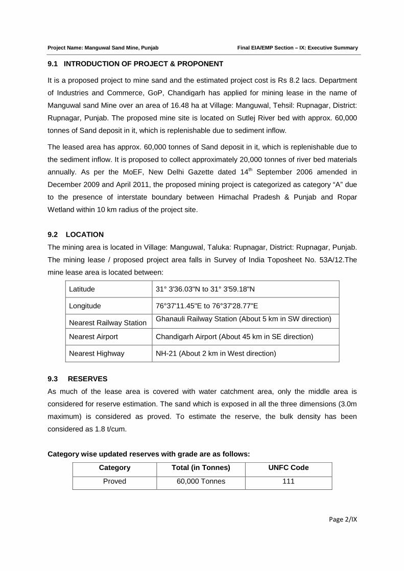
Project Name: Manguwal Sand Mine, Punjab Final EIA/EMP Section – IX: Executive Summary
Page 2/IX
9.1 INTRODUCTION OF PROJECT & PROPONENT
It is a proposed project to mine sand and the estimated project cost is Rs 8.2 lacs. Department
of Industries and Commerce, GoP, Chandigarh has applied for mining lease in the name of
Manguwal sand Mine over an area of 16.48 ha at Village: Manguwal, Tehsil: Rupnagar, District:
Rupnagar, Punjab. The proposed mine site is located on Sutlej River bed with approx. 60,000
tonnes of Sand deposit in it, which is replenishable due to sediment inflow.
The leased area has approx. 60,000 tonnes of Sand deposit in it, which is replenishable due to
the sediment inflow. It is proposed to collect approximately 20,000 tonnes of river bed materials
annually. As per the MoEF, New Delhi Gazette dated 14th September 2006 amended in
December 2009 and April 2011, the proposed mining project is categorized as category “A” due
to the presence of interstate boundary between Himachal Pradesh & Punjab and Ropar
Wetland within 10 km radius of the project site.
9.2 LOCATION
The mining area is located in Village: Manguwal, Taluka: Rupnagar, District: Rupnagar, Punjab.
The mining lease / proposed project area falls in Survey of India Toposheet No. 53A/12.The
mine lease area is located between:
Latitude 31° 3'36.03"N to 31° 3'59.18"N
Longitude 76°37'11.45"E to 76°37'28.77"E
Nearest Railway StationGhanauli Railway Station (About 5 km in SW direction)
Nearest Airport Chandigarh Airport (About 45 km in SE direction)
Nearest Highway NH-21 (About 2 km in West direction)
9.3 RESERVES
As much of the lease area is covered with water catchment area, only the middle area is
considered for reserve estimation. The sand which is exposed in all the three dimensions (3.0m
maximum) is considered as proved. To estimate the reserve, the bulk density has been
considered as 1.8 t/cum.
Category wise updated reserves with grade are as follows:
Category Total (in Tonnes) UNFC Code
Proved 60,000 Tonnes 111
Project Name: Manguwal Sand Mine, Punjab Final EIA/EMP Section – IX: Executive Summary
Page 3/IX
9.4 MINING PROCESS
Sand Mining
The mining process is opencast river bed mining of minor minerals. Mining is proposed to be
carried out manually, except in cases of emergency, when machines will be used.
Drilling and blasting is not required.
Working Depth (below ground level)
The deposits occur in the middle/bottom of the river. During the entire lease period, the deposit
will be worked from the top surface to 3 m bgl or above the ground water level whichever is less.
9.5 WATER SUPPLY
In the river bed mining projects, water is required for dust suppression. In addition to this water
is also required for domestic purpose for the workers at the site. Water requirement for dust
suppression will be around 0.66 KLD and 0.2 KLD for domestic purpose.
So, the total water requirement will be around 0.86 KLD which includes dust suppression,
drinking water and other domestic purposes. This water will be supplied from the nearby area.
9.6 BASE LINE DATA
This section contains the description of baseline studies of the 10 km radius of the area
surrounding Manguwal Sand Mine, Rupnagar, Punjab. The data collected has been used to
understand the existing environment scenario around the proposed mining project against which
the potential impacts of the project can be assessed.
Environmental data has been collected in relation to proposed mining for:-
(a) Air
(b) Noise
(c) Water
(d) Soil
(e) Ecology and Biodiversity
(f) Socio-economy
Project Name: Manguwal Sand Mine, Punjab Final EIA/EMP Section – IX: Executive Summary
Page 4/IX
Table 9.1: BASELINE ENVIRONMENTAL STATUS
Attribute Baseline status
Ambient AirQuality
Ambient Air Quality Monitoring reveals that the minimum &
maximum concentrations of PM10 for all the 5 AQ monitoring
stations were found to be 65.45 µg/m3at AQ1 and 115.84 µg/m3 at
AQ5, respectively.
As far as the gaseous pollutants SO2 and NO2 are concerned, the
prescribed CPCB limit of 80 µg/m3 for residential and rural areas
has never been surpassed at any station.
Noise Levels Noise monitoring was carried out at four locations. The results of
the monitoring program indicated that both the daytime and night
time levels of noise were well within the prescribed limits of
NAAQS, at all the four locations monitored.Water Quality 3 Groundwater samples and 3 surface water samples were
analyzed and concluded that:
The ground water from all sources remains suitable for drinking
purposes as all the constituents are within the limits prescribed by
drinking water standards by Indian Standards IS: 10500.
From the Surface water analysis it is evident that most of the
parameters of the samples comply with ‘Category ‘C’ standards of
CPCB indicating their suitability for Drinking water source after
conventional treatment and disinfection.
Soil Quality Samples collected from identified locations indicate the soil is
sandy type and the pH value ranging from 7.64 to 7.82, which
shows that the soil is alkaline in nature.
Ecology andBio-diversity
Ropar Wetland is present in the study area, and many protected
forests regions do surround the project area namely Palasi, Hatra,
Himmatpur and Raipur are located in SE, NW, NE & N direction
respectively.
Socio-economy The implementation of the Manguwal sand mining project on river
Sutlej in district Rupnagar will throw opportunities to local people
for both direct and indirect employment.
The study area is still lacking in education, health, housing, water,
electricity etc. It is expected that same will improve to a great
extent due to proposed mining project and associated industrial
and business activities.

Project Name: Manguwal Sand Mine, Punjab Final EIA/EMP Section – IX: Executive Summary
Page 5/IX
9.7 BIOLOGICAL ENVIRONMENT
General Vegetation Study of the area:
The study area comprises of tropical dry deciduous vegetation. The area contains several
Choes (small hilly streams) originating from Himachal and passing through the plain area of
Rupnagar. These plains support the species of Zizyphus, Acacia, Carissa, Adhatoda,
Calotropis, Lantana, Ricinus, etc. Trees are of short stature and never exceed 10 Meters. The
nature of trees is Xerophytic.
Ground vegetation mainly consists of grasses and small shrubs. Useful fodder grasses,
Cynodon dactylon, Eleusine indica, Trifolium alexandrinum, etc. can be seen growing in the
area. The large weeds which infest uncultivated tracts are aak (Calotropis procera), castor
(Ricinus communis), dhatura (Datura metel) and thorn (Opuntia stricta). Other noxious weeds
and those which appear in crops are Pohli or Thistle (Carthamus oxyacantha), shial kanta
(Argemone mexicana), kandyari (Solanum xanthocarpum), Parthenium sp. and Bhang
(Cannabis sativa).
Flora of the Core zone
This area consists of riparian vegetation in which aquatic and marshland plants are the main
component. Most among them are weeds. No ecologically sensitive plant species has been
reported from this area.
Riparian vegetation: Riparian vegetation is found along the river side. In stagnant water growth
of hydrophytes likes Hydrolea zeylanica, Ipomoea carnea, Ludwigia adscendens, Sagittaria
sagittifolia, Spilanthes paniculata, Typha latifolia, etc. can be commonly observed. The river
bank supports the growth of poplar and algal bloom.
Flora of the Buffer zone (Terrestrial vegetation)
Buffer zone of the proposed project is mainly agricultural land. The flora of buffer zone
comprises of plants growing on the edges of agricultural land, village woodlots and trees planted
along the roads. Many tree species are planted in the area because of their usefulness,
economic and aesthetic values. The tree species observed in the area are, Aam (Mangifera
indica), Jamun (Syzygium cumini), Bail (Aegle marmelos), Bakain (Melia azedarach), Bargad
(Ficus bengalensis), Neem (Azadirachta indica), Peepal (Ficus religiosa), Popular (Populas
dealtoides), Safeda (Eucalyptus umbelatus), Sisam (Dalbergia sissoo), etc.
In agricultural waste land and along the road side, growth of weeds like Argemone mexicana,
Cannabis sativa, Cenchrus cilitaris, Heteropogon contortus, Lantana camara, Parthenium
Project Name: Manguwal Sand Mine, Punjab Final EIA/EMP Section – IX: Executive Summary
Page 6/IX
hysterosporus, etc. are very common. These weeds are affecting the agricultural productivity of
the region due to fast growth, short life cycle and enormous production of seeds.
Vegetation in and around human settlement:
Vegetation pattern in villages and surrounding areas are slightly different from the rest of the
areas. The common species grown near villages are mostly edible or useful plants such as
Mangifera indica, Madhuca indica, Syzygium cumini, Azadirachta indica, Albizia lebbeck,
Delonix regia, Tamarindus indica, Ficus religiosa, etc.
Wild life and avifauna of the study area:
The major part of the study area lies under agriculture field and human settlements which
restrict the wildlife habitat significantly. Most of the mammalian species reported in the study
area are domesticated animals.
Aquatic fauna: Aquatic fauna mostly comprises of Amphibians, Molluscs & Fish which cannot
survive without water. The aquatic fauna of the project site is given as below:
Avian fauna: No bird’s habitats like nesting, breeding and forging patterns are noticed in the
core zone. Local birds are noticed crossing over the banks in search of food. No fixed pattern in
migratory behavior is noticed.
Amphibian: Amphibians are commonly found at the places along the margin of aquatic and
terrestrial systems. Due to presence of water bodies like river, nalas, etc. the study area is
providing shelter to many amphibian species. Some of the commonly reported species are Bufo
melanostictus (common Indian toad), Euphlyctis cyanophlyctis (Indian skipper frog),
Hoplobatrachus tigerinus (Indian bull frog) etc.
Fish: The fish species which are commonly found in the proposed site are Labio bata (Bhangan
or Bata), Gudusia chapara (Chappera or Palla), Labio rohita (Dumra or Dhambra), Notopterus
notopterus (Pari or Battu), Catla catla (Theila), etc
Molluscs: Fresh water molluscs play very important role in aquatic ecosystems. Many species
serve as food for many aquatic animals as well as for human. Species like Bellamya
benghalensis, Pila globosa, Brotia costula, Angulyara oxytropis and Lemellidens marginalis play
an important role in human food.
Project Name: Manguwal Sand Mine, Punjab Final EIA/EMP Section – IX: Executive Summary
Page 7/IX
Terrestrial fauna:
Mammals: Many domesticated mammal species are reported from buffer zone during the field
survey. Common grazing animals like Buffalo, cow, goat etc. can be noticed in open grass
fields. Small mammals like Indian palm squirrel (Funambulus palmarum) and field mouse
(Apodemus sylvaticus) are noticed in vicinity of village. Inquiry from village people regarding
wild animals reveals that Rhesus macaque (Macaca mulatta), Indian hare (Lepus nigricollis),
fruits bat (Pteropus conspicillatus), Nilgai (Boselaphus tragocamelus), etc. are often seen in the
area.
Avifauna: Water birds like Gadwall (Anas strepera), Common teal (Anas crecca), White
throated kingfisher (Halcyon smyrnensis), Pied kingfisher (Ceryle rudis), Red wattled lapwing
etc are noticed. House crow (Corvus splendens), House sparrow (Passer domesticus),
Common Myna (Acridotheres tristis), Gracula religiosa), Red-rumped Swallow (Cecropis
daurica), Hoopoe (Upupa epops ceylonensis) are of common occurrence.
Reptiles: The reptilians species commonly reported are Agama (Laudakia tuberculata) in
settlement area, Garden lizard (Calotes versicolor) and Eutropis macularia along shady places
in agricultural field or where growth of bushes is noticed. Among non poisonous snakes rat
snakes (Ptyas mucosus) are commonly noticed in field, followed by poisonous snakes like
Cobra (Naja naja) and Banded krait (Bungarus multicinctus) are reported to be seen by farmers.
Table 9.2
Anticipated impact and mitigation measures for biological environment
Impact Predicted Suggestive measure
Disturbance to free
movement / living of
wild fauna viz. Birds,
Reptiles etc.
Noise produced due to vehicular movement for carrying
sand materials will be within permissible noise limit.
Higher noise level in the area may lead to restlessness
and failure in detection of calls of mates and young
ones;
Care will be taken not to hunt animals/birds by
labourers;
If wild animals/birds are noticed crossing the core zone,
they will not be disturbed at all;
Labourers will not be allowed to discard food, polythene
waste etc., which can attract animals/birds near the core
Project Name: Manguwal Sand Mine, Punjab Final EIA/EMP Section – IX: Executive Summary
Page 8/IX
site;
Only low polluting vehicles having PUC will be allowed
for carrying mining materials.
Noise level will be maintained within permissible limit
(silent zone-50dB (A) during day time or residential zone
55dB (A) as per Noise Pollution (Regulation and
Control) Rules 2000, CPCB norms.
Disturbance of riparian
ecosystem/ wetlands
The riparian ecosystem or the wetlands will not be
destroyed by the mine owners/workers. Mining will be
carried out on the dry river bed area and the river water
channel will not be disturbed at all.
Impact on Agriculture There will be no impact on the Agriculture. Dust
generated will be suppressed during mining operation at
mining site as well as during transportation will be
suppressed by sprinkling.
Impact on land use and
vegetation
There will be no conversion of Forest land. Mining will
be carried out on the dry part of the river Channel.
9.8 LAND ENVIRONMENT
Mining Activity: Harvesting of river bed minerals and other associated activities are the main
sources of environmental degradations and most serious ones are detailed hereunder:
a. Damage of river bank due to access ramps to river bed, causing damage to vegetation, soil
erosion, micro disturbance to ground water, possible inducement of charged river course.
b. Loss of riparian vegetation standing along the bank due to making roads connecting
successive access to river bed.
c. Contamination of sand aquifer water due to ponding: Due to uneven rocky bed of river, sand
bed thickness vary considerably and digging more sand from a pocket where thickness of sand
is more may cause ponding. In this stagnant water, bio-degradable materials especially flora
waste gets accumulated causing contamination and inducing an unhealthy environment.
d. Surface degradation due to stockpiling and road network.
Mitigation measures
i. Minimum number of access roads to river bed for which cutting of river banks will be
avoided and ramps are to be maintained.
Project Name: Manguwal Sand Mine, Punjab Final EIA/EMP Section – IX: Executive Summary
Page 9/IX
ii. Access points to the river bed will be decided basing on least steepness of river bank and
least human activity.
iii. Mining is avoided during the monsoon season and at the time of floods.
iv. Mining schedule is synchronized with the river flow direction and the gradient of the land.
v. Haulage roads parallel to the river bank and roads connecting access to river bed will be
made away from the bank
vi. Care will be taken to ensure that ponds are not formed in the river bed
vii. Access roads from public roads and up to river bank will be aligned in such a way that it
would cause least environmental damage.
viii. Vegetation development is proposed along the road sides of the approach roads, to arrest
soil erosion. While selecting the plant species, preference will be given for planting native
species of the area.
9.9 AIR ENVIRONMENT
Anticipated impacts and evaluation
Information on air quality was studied and various modelling techniques predicted that the
mining activity will not affect the air quality in a significant manner. In mining operations, loading,
transportation and unloading operations may cause deterioration in air quality due to handling
dry materials. In the present case, only wet materials will be handled, thus eliminating problems
of fugitive dust. Also, the collection and lifting of minerals will be done manually without any
blasting. Therefore the dust generated is insignificant as compared to mining process of other
hard minerals like the process of drilling, blasting, mechanized loading etc.
Mitigation measures
The only air pollution sources are the road transport network of the trucks.
i. Water sprinkling will be done on the roads regularly.
ii. Care will be taken to prevent spillage by covering the carrying vehicles with tarpaulin and
sprinkling of water, if dry.
iii. Fortnightly scraping of road in order to keep the roads almost leveled. This will ensure
smooth flow of vehicles and also prevent spillage.
iv. Overloading will be kept under check by giving prior awareness.
v. Proper tuning of vehicles to keep the gas emissions under check.
vi. Plantation of trees along the roads to help reduce the impact of dust in the nearby
villages.
Project Name: Manguwal Sand Mine, Punjab Final EIA/EMP Section – IX: Executive Summary
Page 10/IX
9.10 WATER ENVIRONMENT
Mining of sand from within or near a streambed has a direct impact on the stream’s physical
habitat characteristics. These characteristics include geometry, bed evaluation, substrate
composition and stability, in stream roughness elements, depth, velocity, turbidity, sediment
transport, stream discharge and temperature. Altering these habitat characteristics can have
deleterious impacts on both in stream biota and associated riparian habitat.
The detrimental effects to biota resulting from bed material mining are caused by three main
processes:
i. Alteration of flow patterns resulting from modification of the river bed
ii. An excess of suspended sediment
iii. Damage to riparian vegetation and in stream habitat.
Mitigation measures
The deposits occur in the middle/bottom of the river. During the lease period, the deposit will be
worked from the top surface to 3 m bgl or above the ground water table whichever is less. Thus
no ground water pollution is expected, as mining will not intersect ground water. It is not
proposed to divert or truncate any part of the stream and at no point of time mining will be done
from the stream.
9.11 NOISE ENVIRONMENT
Anticipated impacts and evaluation
As there will be no heavy earth moving machinery there will not be any major impact on noise
level due to the mining and other association activities a detailed noise survey has been carried
out and results are discussed in Section III. Blasting technique is not used for sand lifting, hence
no possibility of land vibration. It was found that the mining activity will not have any significant
impact on the noise environment of the region. The only impact will be due to transportation of
materials by trucks. trucks and movement of small machinery.
a. Mitigation measures
i. On-site
a) Well maintained vehicle will be used which will reduced the noise level.
b) Plantation: Plantation of trees along the bank will be done to dampen the noise, if possible.
c) Hearing Protection: No hearing protection is generally needed for RBM mining projects.
Project Name: Manguwal Sand Mine, Punjab Final EIA/EMP Section – IX: Executive Summary
Page 11/IX
ii. Off-site
The off-site receptors are not significantly affected as noise generated by RBM is insignificant
but some disturbances due to vehicle movement may not be avoidable. However the following
measures have been envisaged:
a) The vehicles will be maintained in good running condition so that noise will be reduced to
minimum possible level.
b) Awareness will be imparted prior to mining operations that smoke silencers remain in a good
conditions not to generate noise.
c) In addition, trucks drivers will be instructed to make minimum use of horns at the village
area.
9.12 TRAFFIC ANALYSIS
From the analysis it has been seen that the V/C ratio will be modified to 0.25 and 0.17 with LOS
being “B” and “A” which is ‘very good’ and ‘excellent’ respectively. So the additional load on the
carrying capacity will not be affected to any significant level.
9.13 SOCIO-ECONOMIC ENVIRONMENT
The implementation of the Manguwal sand mining project will generate both direct and indirect
employment. Besides, it will provide a check on existing system of mining operation. Since the
quarries will be allotted on lease basis, mining operation will be legally valid and it will bring
income to the state exchequer. It will also reduce flooding of river banks, destruction of
standing crops, land and property to a great extent. The project will also provide impetus to
industrialization of the area. Where transfer of boulders into bajri is necessary crushing units will
come up. It is expected that intending entrepreneurs will venture to set up micro and small scale
units in the near future making the area a mixed society, dependent on industry, trade and
business. At present agriculture is the main occupation of the people as more than half of the
population depends on it. With the implementation of the proposed mining project the
occupational pattern of the people in the area will change making more people engaged in
industrial and business activities rather in agriculture. Thus there will be a gradual shifting of
population from agriculture to mining and industry. Further, the mining and industrial activities in
the area may lead to rapid increase in population and thereby urbanization. Due to urbanization
of the area, employment opportunities will further increase.
9.14 ENVIRONMENTAL MANAGEMENT PLAN (EMP)
Proper environmental management plan are proposed for “Sand” mining project to mitigate the
impact during the mining operation.
Project Name: Manguwal Sand Mine, Punjab Final EIA/EMP Section – IX: Executive Summary
Page 12/IX
a. No labour camps will be established on river bed.
b. No cooking, or burning of woods will be allowed in the nearby area.
c. Prior to commencement of mining, a short awareness program will be conducted for
labours to make them aware of way of working and various precautions to be taken while at
work. Such program will be repeated occasionally.
d. In the event of any some causality or injury to any animal occurs, proper treatment will be
given.
e. No tree cutting, chopping, lumbering, uprooting of shrubs and herbs will be allowed.
f. Corridor movement of wild animals, if exists mining operations will be avoided in the area.
g. It will be ensured that noise produced due to vehicles movement while carrying sand are
within the permissible noise level.
h. No piling of River Bed Material will be done in adjoining area.
i. If wild animals are noticed crossing the river bed, they will not be disturbed or chased away,
instead the labours will move away from their path.
8.2 ENVIRONMENTAL MANAGEMENT PLAN IMPLEMENTATION
Environmental Management Plan serves no purpose if it is not implemented with true spirit.
Some loopholes in the EMP can also be detected afterwards when it is implemented and
monitored. Thus, an implementation and monitoring programme has to be prepared.
The major attributes of environment are not confined to the mining site alone. Implementation of
proposed control measures and monitoring programme has an implication on the surrounding
area as well as for the region. Therefore, mine management should strengthen the existing
control measures as elaborated earlier in this report and monitor the efficacy of the control
measures implemented within the mining area relating to the following specific areas for eco-
friendly mining plan:
a. Collection of air and water samples at strategic locations with frequency suggested and by
analyzing thereof. If the parameters exceed the permissible tolerance limits, corrective
regulation measure will be taken.
b. Collection of soil samples at strategic locations once in every two years and analysis thereof
with regard to deleterious constituents, if any.
c. Measurement of water level fluctuations in the nearby ponds, dug wells and bore wells.
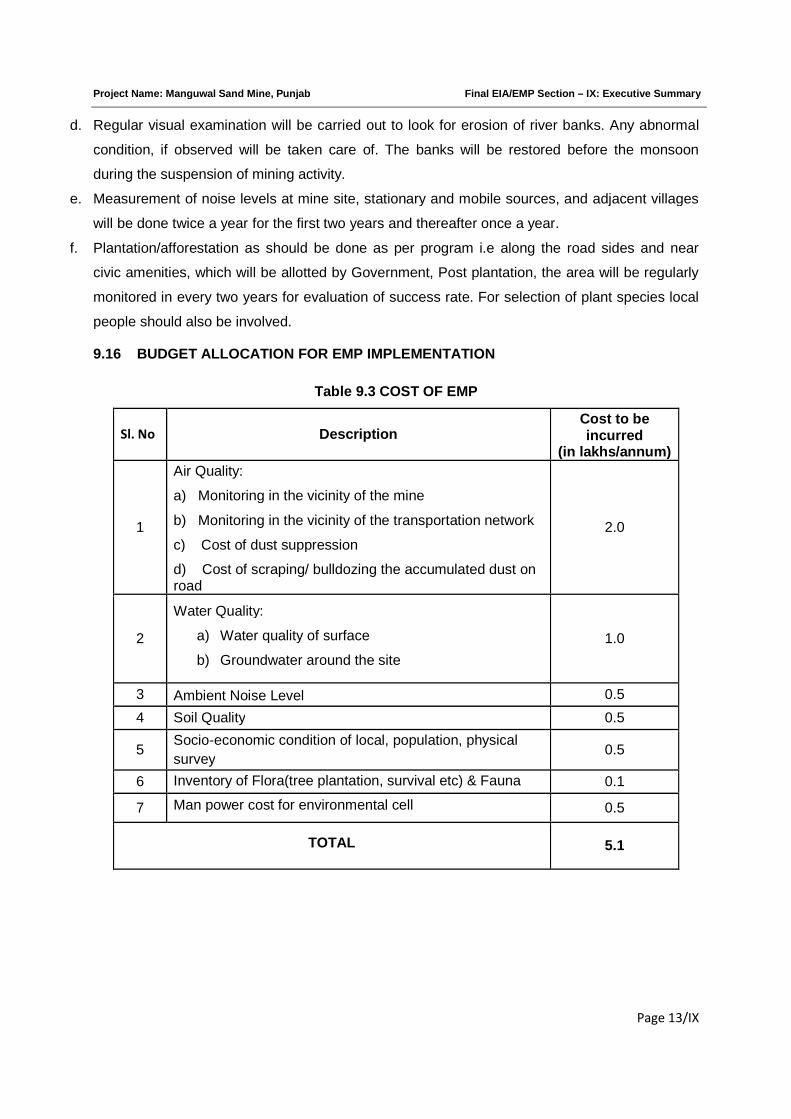
Project Name: Manguwal Sand Mine, Punjab Final EIA/EMP Section – IX: Executive Summary
Page 13/IX
d. Regular visual examination will be carried out to look for erosion of river banks. Any abnormal
condition, if observed will be taken care of. The banks will be restored before the monsoon
during the suspension of mining activity.
e. Measurement of noise levels at mine site, stationary and mobile sources, and adjacent villages
will be done twice a year for the first two years and thereafter once a year.
f. Plantation/afforestation as should be done as per program i.e along the road sides and near
civic amenities, which will be allotted by Government, Post plantation, the area will be regularly
monitored in every two years for evaluation of success rate. For selection of plant species local
people should also be involved.
9.16 BUDGET ALLOCATION FOR EMP IMPLEMENTATION
Table 9.3 COST OF EMP
Sl. No DescriptionCost to beincurred
(in lakhs/annum)
1
Air Quality:
a) Monitoring in the vicinity of the mine
b) Monitoring in the vicinity of the transportation network
c) Cost of dust suppression
d) Cost of scraping/ bulldozing the accumulated dust onroad
2.0
2
Water Quality:
a) Water quality of surface
b) Groundwater around the site
1.0
3 Ambient Noise Level 0.5
4 Soil Quality 0.5
5Socio-economic condition of local, population, physical
survey0.5
6 Inventory of Flora(tree plantation, survival etc) & Fauna 0.1
7 Man power cost for environmental cell 0.5
TOTAL 5.1

Project Name: Manguwal Sand Mine, Punjab Final EIA/EMP Section – IX: Executive Summary
Page 14/IX
9.17 MONITORING SCHEDULE AND PARAMETERS:
Table 9.4 Monitoring Schedule and Parameters
SNo
Description of Parameters Schedule and Duration ofMonitoring/Execution
1Air Quality:
a) In the vicinity of the mine
b) In the vicinity of the transportation
Network
c) Dust suppression on roads
d) Scraping/ bulldozing of road to shift
accumulated dust to the sides
24 hourly samples twice a week for one month
in each season except monsoon season
Regularly in non- monsoon months and
whenever occurrence of fugitive dust takes
place
Fortnightly
2 Water Quality near or around the site:
a) Surface water quality
b) Ground water quality
Once in a season for 4 seasons in a year
3 Ambient Noise Level Twice a year for two years & then once a year
4 Soil Quality Once in two years on project monitoring area
5 Inventory of Flora(tree plantation,
survival etc) & Fauna
Once in two years on project monitoring area
6 Socio-economic condition of local,
population, physical survey
Once in 3 years
9.18 BENEFITS OF MINING
i. Controlling river channel.
ii. Protecting river banks.
iii. Protecting flooding
iv. Reducing submergence of adjoining agricultural lands.
v. Protection of crops being cultivated along the river bank
vi. Reducing aggradations of river level.
vii. Generating useful economic resource for construction.
viii. Generating employment.
ix. Improvement in socio economic conditions of the people of the study area
***********
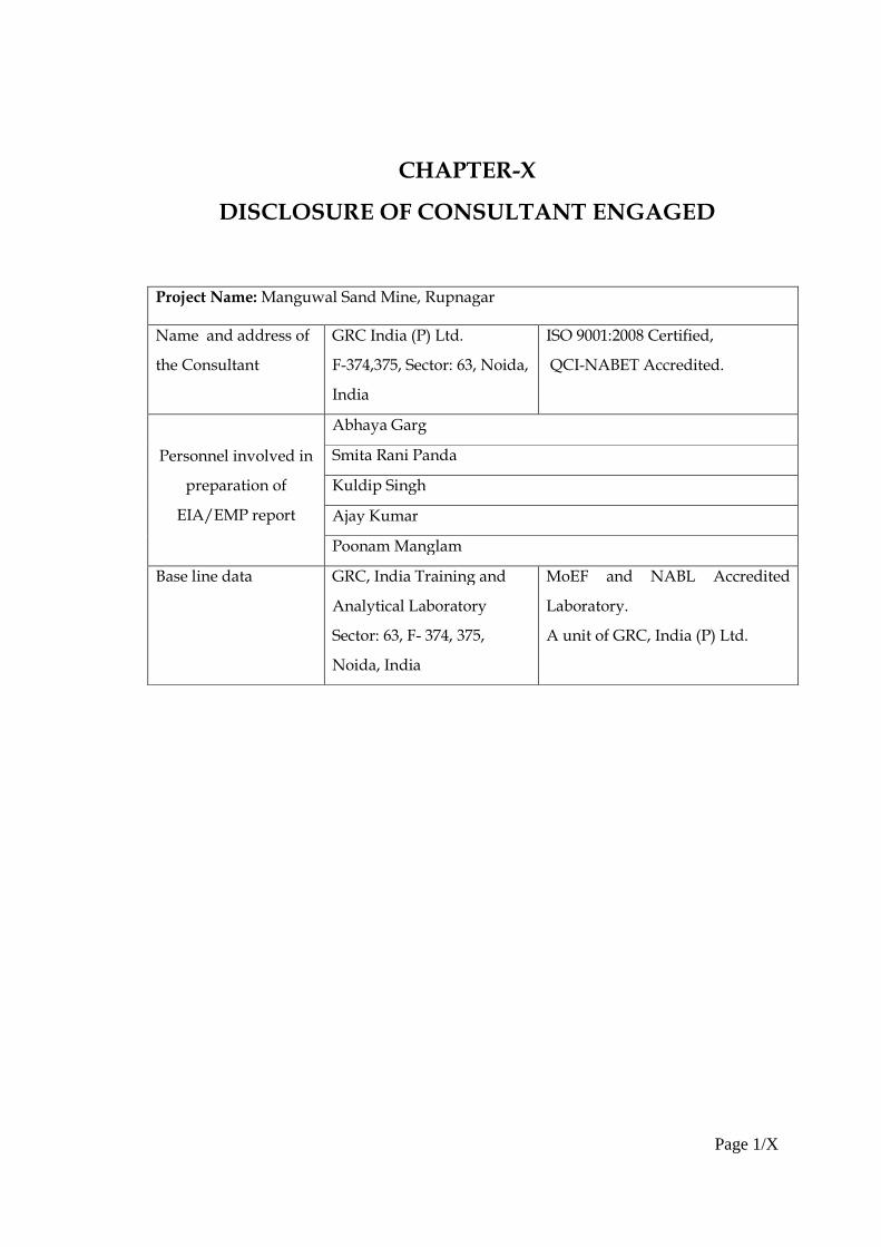
Page 1/X
CHAPTER-X
DISCLOSURE OF CONSULTANT ENGAGED
Project Name: Manguwal Sand Mine, Rupnagar
Name and address of
the Consultant
GRC India (P) Ltd.
F-374,375, Sector: 63, Noida,
India
ISO 9001:2008 Certified,
QCI-NABET Accredited.
Personnel involved in
preparation of
EIA/EMP report
Abhaya Garg
Smita Rani Panda
Kuldip Singh
Ajay Kumar
Poonam Manglam
Base line data GRC, India Training and
Analytical Laboratory
Sector: 63, F- 374, 375,
Noida, India
MoEF and NABL Accredited
Laboratory.
A unit of GRC, India (P) Ltd.
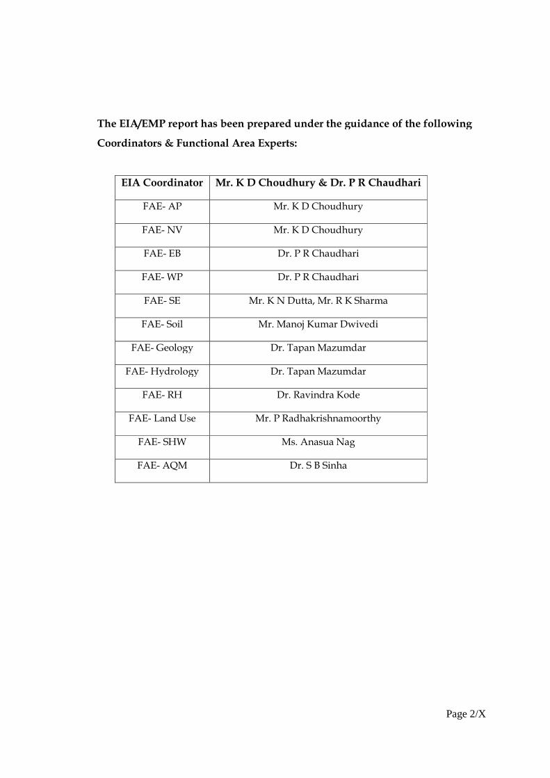
Page 2/X
The EIA/EMP report has been prepared under the guidance of the following
Coordinators & Functional Area Experts:
EIA Coordinator Mr. K D Choudhury & Dr. P R Chaudhari
FAE- AP Mr. K D Choudhury
FAE- NV Mr. K D Choudhury
FAE- EB Dr. P R Chaudhari
FAE- WP Dr. P R Chaudhari
FAE- SE Mr. K N Dutta, Mr. R K Sharma
FAE- Soil Mr. Manoj Kumar Dwivedi
FAE- Geology Dr. Tapan Mazumdar
FAE- Hydrology Dr. Tapan Mazumdar
FAE- RH Dr. Ravindra Kode
FAE- Land Use Mr. P Radhakrishnamoorthy
FAE- SHW Ms. Anasua Nag
FAE- AQM Dr. S B Sinha
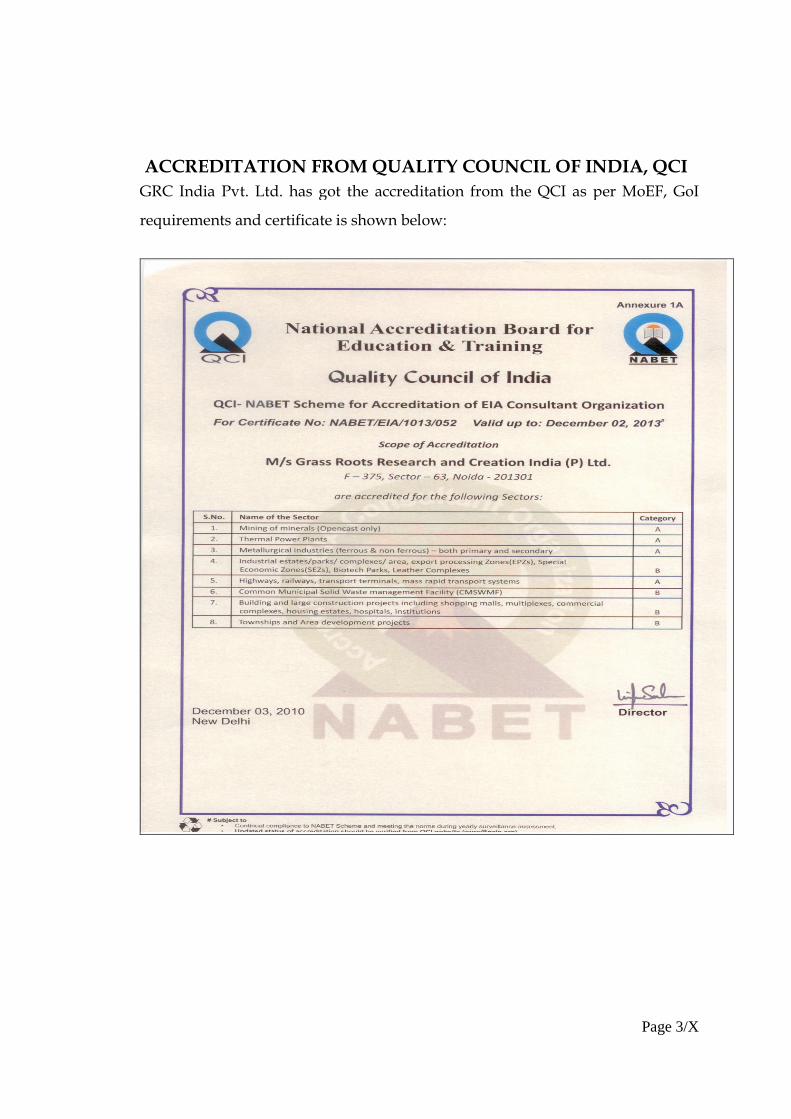
Page 3/X
ACCREDITATION FROM QUALITY COUNCIL OF INDIA, QCI
GRC India Pvt. Ltd. has got the accreditation from the QCI as per MoEF, GoI
requirements and certificate is shown below:
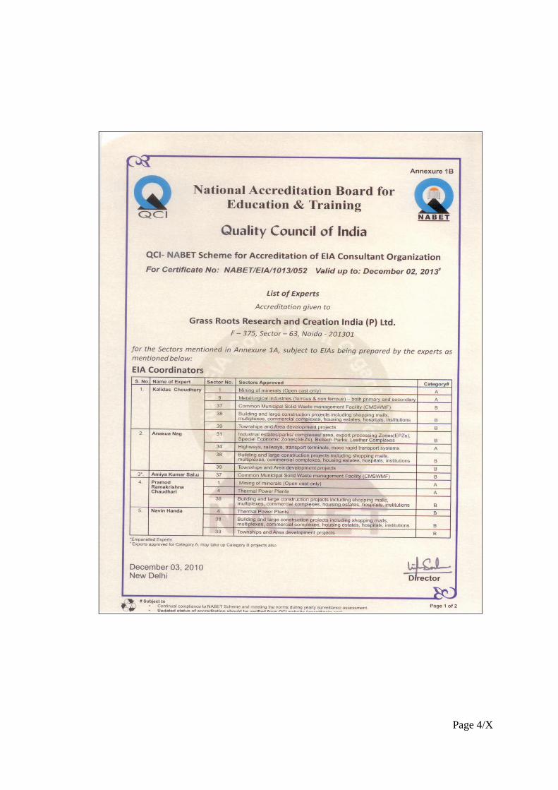
Page 4/X
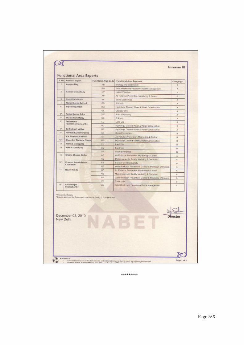
Page 5/X
*********

ANNEXURES
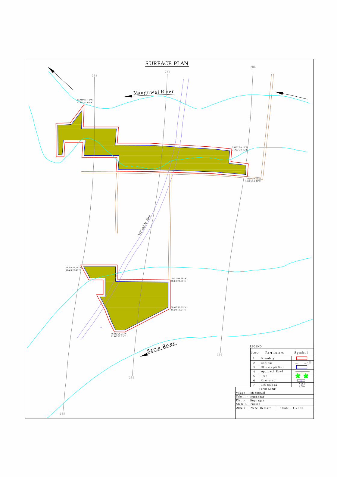
Sarsa River
Manguwal River
LEGEND
S.no Particulars Symbol1
23
4
Boundary
Khasra no
Village :-Tehsil :-Dist :-State :-
SAND MINE
Area :- 25.51 Hectare SCALE - 1:2000
5
Contour 286
Ultmate pit limit Approach Road
Tree
6GPS Reading7 N 30Á
E 76Á
70
Manguwal
Punjab
RupnagarRupnagar
HT
cabl
e lin
e
SURFACE PLAN
286
286
285
285
285
284
76Á37'01.10"N31Á03'41.04"E
76Á37'20.26"N31Á03'33.45"E
76Á37'20.59"N31Á03'26.56"E
76Á36'54.79"N31Á03'25.43"E
76Á36'56.35"N31Á03'12.93"E
76Á37'09.99"N31Á03'15.21"E
76Á37'09.76"N31Á03'22.56"E
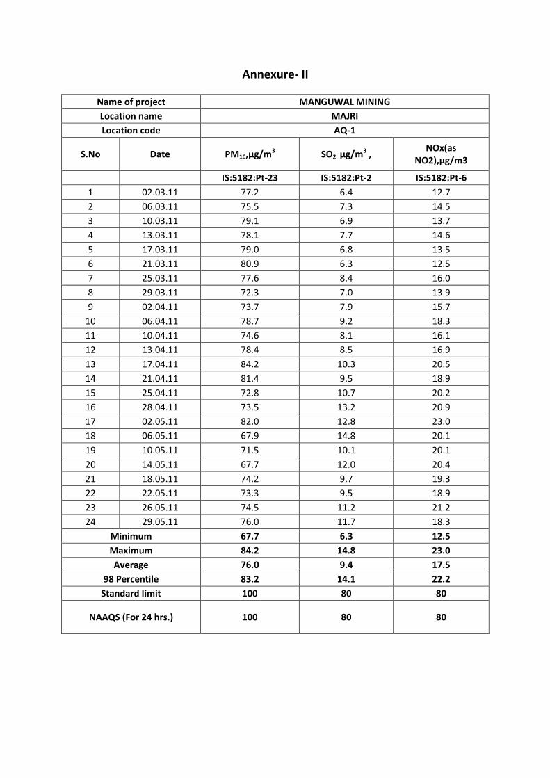
Annexure- II
Name of project MANGUWAL MINING
Location name MAJRI
Location code AQ-1
S.No Date PM10,µg/m3 SO2 µg/m3 ,NOx(as
NO2),µg/m3
IS:5182:Pt-23 IS:5182:Pt-2 IS:5182:Pt-6
1 02.03.11 77.2 6.4 12.7
2 06.03.11 75.5 7.3 14.5
3 10.03.11 79.1 6.9 13.7
4 13.03.11 78.1 7.7 14.6
5 17.03.11 79.0 6.8 13.5
6 21.03.11 80.9 6.3 12.5
7 25.03.11 77.6 8.4 16.0
8 29.03.11 72.3 7.0 13.9
9 02.04.11 73.7 7.9 15.7
10 06.04.11 78.7 9.2 18.3
11 10.04.11 74.6 8.1 16.1
12 13.04.11 78.4 8.5 16.9
13 17.04.11 84.2 10.3 20.5
14 21.04.11 81.4 9.5 18.9
15 25.04.11 72.8 10.7 20.2
16 28.04.11 73.5 13.2 20.9
17 02.05.11 82.0 12.8 23.0
18 06.05.11 67.9 14.8 20.1
19 10.05.11 71.5 10.1 20.1
20 14.05.11 67.7 12.0 20.4
21 18.05.11 74.2 9.7 19.3
22 22.05.11 73.3 9.5 18.9
23 26.05.11 74.5 11.2 21.2
24 29.05.11 76.0 11.7 18.3
Minimum 67.7 6.3 12.5
Maximum 84.2 14.8 23.0
Average 76.0 9.4 17.5
98 Percentile 83.2 14.1 22.2
Standard limit 100 80 80
NAAQS (For 24 hrs.) 100 80 80
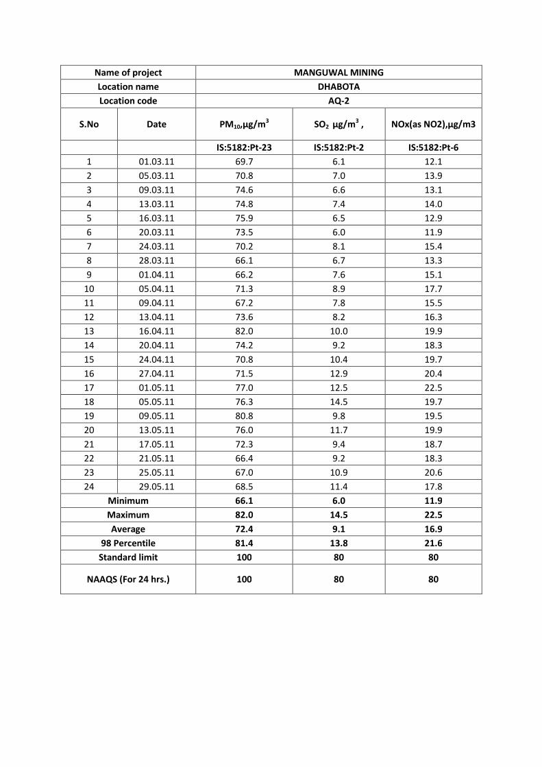
Name of project MANGUWAL MINING
Location name DHABOTA
Location code AQ-2
S.No Date PM10,µg/m3 SO2 µg/m3 , NOx(as NO2),µg/m3
IS:5182:Pt-23 IS:5182:Pt-2 IS:5182:Pt-6
1 01.03.11 69.7 6.1 12.1
2 05.03.11 70.8 7.0 13.9
3 09.03.11 74.6 6.6 13.1
4 13.03.11 74.8 7.4 14.0
5 16.03.11 75.9 6.5 12.9
6 20.03.11 73.5 6.0 11.9
7 24.03.11 70.2 8.1 15.4
8 28.03.11 66.1 6.7 13.3
9 01.04.11 66.2 7.6 15.1
10 05.04.11 71.3 8.9 17.7
11 09.04.11 67.2 7.8 15.5
12 13.04.11 73.6 8.2 16.3
13 16.04.11 82.0 10.0 19.9
14 20.04.11 74.2 9.2 18.3
15 24.04.11 70.8 10.4 19.7
16 27.04.11 71.5 12.9 20.4
17 01.05.11 77.0 12.5 22.5
18 05.05.11 76.3 14.5 19.7
19 09.05.11 80.8 9.8 19.5
20 13.05.11 76.0 11.7 19.9
21 17.05.11 72.3 9.4 18.7
22 21.05.11 66.4 9.2 18.3
23 25.05.11 67.0 10.9 20.6
24 29.05.11 68.5 11.4 17.8
Minimum 66.1 6.0 11.9
Maximum 82.0 14.5 22.5
Average 72.4 9.1 16.9
98 Percentile 81.4 13.8 21.6
Standard limit 100 80 80
NAAQS (For 24 hrs.) 100 80 80
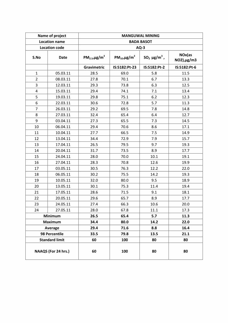
Name of project MANGUWAL MINING
Location name BADA BASOT
Location code AQ-3
S.No Date PM2.5,µg/m3 PM10,µg/m3 SO2 µg/m3 ,NOx(as
NO2),µg/m3
Gravimetric IS:5182:Pt-23 IS:5182:Pt-2 IS:5182:Pt-6
1 05.03.11 28.5 69.0 5.8 11.5
2 08.03.11 27.8 70.1 6.7 13.3
3 12.03.11 29.3 73.8 6.3 12.5
4 15.03.11 29.4 74.1 7.1 13.4
5 19.03.11 29.8 75.1 6.2 12.3
6 22.03.11 30.6 72.8 5.7 11.3
7 26.03.11 29.2 69.5 7.8 14.8
8 27.03.11 32.4 65.4 6.4 12.7
9 03.04.11 27.3 65.5 7.3 14.5
10 06.04.11 29.4 70.6 8.6 17.1
11 10.04.11 27.7 66.5 7.5 14.9
12 13.04.11 34.4 72.9 7.9 15.7
13 17.04.11 26.5 79.5 9.7 19.3
14 20.04.11 31.7 73.5 8.9 17.7
15 24.04.11 28.0 70.0 10.1 19.1
16 27.04.11 28.3 70.8 12.6 19.9
17 03.05.11 30.5 76.3 12.2 22.0
18 06.05.11 30.2 75.5 14.2 19.3
19 10.05.11 32.0 80.0 9.5 18.9
20 13.05.11 30.1 75.3 11.4 19.4
21 17.05.11 28.6 71.5 9.1 18.1
22 20.05.11 29.6 65.7 8.9 17.7
23 24.05.11 27.4 66.3 10.6 20.0
24 27.05.11 28.0 67.8 11.1 17.3
Minimum 26.5 65.4 5.7 11.3
Maximum 34.4 80.0 14.2 22.0
Average 29.4 71.6 8.8 16.4
98 Percentile 33.5 79.8 13.5 21.1
Standard limit 60 100 80 80
NAAQS (For 24 hrs.) 60 100 80 80
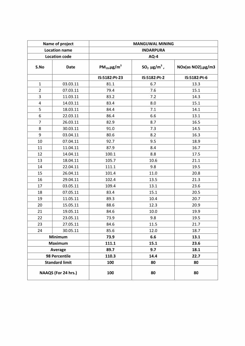
Name of project MANGUWAL MINING
Location name INDARPURA
Location code AQ-4
S.No Date PM10,µg/m3 SO2 µg/m3 , NOx(as NO2),µg/m3
IS:5182:Pt-23 IS:5182:Pt-2 IS:5182:Pt-6
1 03.03.11 81.1 6.7 13.3
2 07.03.11 79.4 7.6 15.1
3 11.03.11 83.2 7.2 14.3
4 14.03.11 83.4 8.0 15.1
5 18.03.11 84.4 7.1 14.1
6 22.03.11 86.4 6.6 13.1
7 26.03.11 82.9 8.7 16.5
8 30.03.11 91.0 7.3 14.5
9 03.04.11 80.6 8.2 16.3
10 07.04.11 92.7 9.5 18.9
11 11.04.11 87.9 8.4 16.7
12 14.04.11 100.1 8.8 17.5
13 18.04.11 105.7 10.6 21.1
14 22.04.11 111.1 9.8 19.5
15 26.04.11 101.4 11.0 20.8
16 29.04.11 102.4 13.5 21.3
17 03.05.11 109.4 13.1 23.6
18 07.05.11 83.4 15.1 20.5
19 11.05.11 89.3 10.4 20.7
20 15.05.11 88.6 12.3 20.9
21 19.05.11 84.6 10.0 19.9
22 23.05.11 73.9 9.8 19.5
23 27.05.11 84.6 11.5 21.7
24 30.05.11 85.6 12.0 18.7
Minimum 73.9 6.6 13.1
Maximum 111.1 15.1 23.6
Average 89.7 9.7 18.1
98 Percentile 110.3 14.4 22.7
Standard limit 100 80 80
NAAQS (For 24 hrs.) 100 80 80
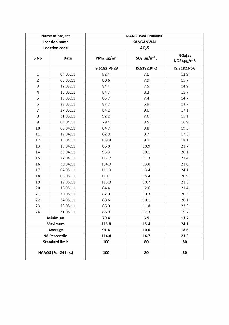
Name of project MANGUWAL MINING
Location name KANGANWAL
Location code AQ-5
S.No Date PM10,µg/m3 SO2 µg/m3 ,NOx(as
NO2),µg/m3
IS:5182:Pt-23 IS:5182:Pt-2 IS:5182:Pt-6
1 04.03.11 82.4 7.0 13.9
2 08.03.11 80.6 7.9 15.7
3 12.03.11 84.4 7.5 14.9
4 15.03.11 84.7 8.3 15.7
5 19.03.11 85.7 7.4 14.7
6 23.03.11 87.7 6.9 13.7
7 27.03.11 84.2 9.0 17.1
8 31.03.11 92.2 7.6 15.1
9 04.04.11 79.4 8.5 16.9
10 08.04.11 84.7 9.8 19.5
11 12.04.11 82.9 8.7 17.3
12 15.04.11 109.8 9.1 18.1
13 19.04.11 86.0 10.9 21.7
14 23.04.11 93.3 10.1 20.1
15 27.04.11 112.7 11.3 21.4
16 30.04.11 104.0 13.8 21.8
17 04.05.11 111.0 13.4 24.1
18 08.05.11 110.1 15.4 20.9
19 12.05.11 115.8 10.7 21.3
20 16.05.11 84.4 12.6 21.4
21 20.05.11 82.0 10.3 20.5
22 24.05.11 88.6 10.1 20.1
23 28.05.11 86.0 11.8 22.3
24 31.05.11 86.9 12.3 19.2
Minimum 79.4 6.9 13.7
Maximum 115.8 15.4 24.1
Average 91.6 10.0 18.6
98 Percentile 114.4 14.7 23.3
Standard limit 100 80 80
NAAQS (For 24 hrs.) 100 80 80

Proceeding of the Public Hearing of Mining Site at Manguwal, Distt.Ropar.
1
Proceedings of the Public Hearing conducted on 10.02.2012 at 3.00 p.m. in connection with application filed by Department of Industries & Commerce, Govt. of Punjab, for obtaining environmental clearance under EIA Notification dated 14/9/2006 for the mining site (16.48 hectare) at Village Manguwal, Tehsil and Distt. Roopnagar.
The following were present to supervise the proceedings:-
1. Sh. Sucha Singh Mast, PCS, Additional Deputy Commissioner, Roopnagar.
2. Er. Joginder Singh, Environmental Engineer, Punjab Pollution Control Board, Regional Office, SAS Nagar.
3. Er. A.K. Sharma,
Asstt. Environmental Engineer, Punjab Pollution Control Board, Regional Office, SAS Nagar.
Environmental Engineer, Punjab Pollution Control Board, SAS Nagar
welcomed the Supervising-cum-Presiding Officer and people from adjoining
Towns/Villages who came to attend the public hearing for mining sites in the revenue
estate of Village Manguwal, Tehsil and Distt. Roopnagar. He apprised the public about
the requirement of conducting the public hearing before grant of environmental
clearance under EIA Notification no.1533 (E) dtd.14.9.2006 of the Ministry of
Environment and Forests, Govt. of India, New Delhi. He also brought into the notice
of public that the Department of Industries & Commerce, Govt. of Punjab has
submitted copies of draft rapid EIA report alongwith the Executive Summary of the
same and a copy of each such document was placed in the office of Deputy
Commissioner, Roopnagar; Zila Parishad, Roopnagar; General Manager District
Industries Centre, SAS Nagar; Executive Officer, Municipal Council, Roopnagar,
Regional Office of MoEF at Chandigarh and Regional Office, SAS Nagar of the PPCB
for access to the public and other stakeholders. He further brought out that a notice
Proceeding of the Public Hearing of Mining Site at Manguwal, Distt.Ropar.
2
of public hearing was published in two prominent newspapers namely, ‘The Tribune'
(English Daily) on 6/1/2012 and in ‘Ajit (Punjabi Daily) on 6/1/2012 to make the
public aware of the date, time & venue of the public hearing and about the
places/offices where the public could access the draft EIA report and its Executive
Summary report before the said hearing. Thereafter, he requested the representative
of the M/s Grass Roots Research & Creation India (P) Ltd, Noida, Consultant of
Department of Industries & Commerce to elaborate about the main features of the
project and the draft EIA study report.
Prof. Kuldeep Singh, representative of M/s Grass Roots Research &
Creation India (P) Ltd, Noida engaged by Department of Industries & Commerce, for
conducting the EIA study for this project brought out the details of the project before
the public as under:-
1) The development of the infrastructure is based upon the building materials
such as sand and gravel for which controlled mining at the source is required.
Govt. of Punjab has to allot / earmark the various sites from which the mining
of minerals has to be undertaken. Accordingly, this site is also one of such site
from where mining is to be carried out, hence the environmental clearance is
required.
2) PROJECT DESCRIPTION
A) The mining site of the project is in HB of Village Manguwal, Tehsil and
Distt. Roopnagar. The site is near the National Highway-21 and the
nearest Railway Station is Village Ghanauli.
(B) The total area of the proposed site is 16.48 hectare.
(C) The estimated project cost is Rs. 8.2 lacs.
3) The land of the mining site will be with the State Government on lease. There
will be approx. 60,000 tonne of sand mining with UNFC code 111. The mining
will be carried out by excavator of 1.1 cubic meter capacity. No drilling or
blasting will be carried out at the site and the mining will be with simplest
Proceeding of the Public Hearing of Mining Site at Manguwal, Distt.Ropar.
3
procedure of lifting the material and loading to the vehicles mechanically. The
mining will be done with working depth of 3 m BGL.
4) Baseline data has been collected with respect to land, water, air, ecological and
noise in the area of 10 km radius surrounding the site.
5) Mitigation measures for different Environment parameters:
A) Air Environment: The dust emitting will only be possible from the
movement of the vehicles for which water spraying will be carried out on
the road. Overloading of vehicles will be avoided.
B) Water Environment:
There will be no degradation of water quality, only natural flow of the river
will be maintained.
C) Soil Environment:
The mining will not effect in any way the quality of the soil as the level of
the area lowered by the mining will be compensated by the flowing river,
during rainy season.
D) Noise Environment:
There will be no heavy machinery to be used in the mining, the possible
noise will be from movement of vehicles only.
The movement of vehicles will be restricted to the day time only with
minimum use of horns.
E) Social Aspects
River channel will be controlled and protection of banks will lead to safety
of adjoining agricultural land.
Employment will be generated hence improvement of socio-economic
aspects of the area.
6) Budget for Implementation of Environmental Management Plan
S. No
Items Cost to be incurred (in Lac/annum)
1. Air quality monitoring 0.14
2. Water quality 0.10
3. Ambient Noise level 0.03

Proceeding of the Public Hearing of Mining Site at Manguwal, Distt.Ropar.
4
Thereafter, Environmental Engineer brought into the
notice of public present at the venue of hearing that as per the provision of EIA
notification dated 14.9.2006 as amended time to time, the persons present at the
venue may seek information or clarifications on the mining site from the project
promoter/consultant. It was also brought into the notice of the persons present there
that the information or clarifications sought by them and reply given by the project
promoter will be recorded in the proceeding of the hearing, which will be sent to the
Ministry of Environment & Forests, for further consideration. Accordingly, he
requested the persons present in the hearing to seek information or clarifications on
the project one by one.
Thereupon, the detail of the information/ clarifications raised by the
persons present at the venue of hearing and the reply given by the consultant of the
industry / project proponent is as under:
S. No
Name of the person
Questions/ query / statements of the person
Reply / clarification given by the company/ panel member
1 Sh. Jaspal Singh, Bhartgarh, Tehsil & Distt. Roopnagar.
The royalty to be given to the panchayat is 5% which is quite less, which may be increase to 25%.
G.M., DIC informed that royalty will be paid @ 50% which is quite adequate. He also clarified that the royalty to be paid to panchayat will be shared by the Govt. and the contractor concerned on equal basis.
2) Sh. Surjit Singh S/o Sh. Pritam Singh, Village Diwarhi, Tehsil & Distt. Roopnagar.
The local people have already purchased tractor/ trolley / earth moving machinery by procuring loan from the financial institutions and with this project the machinery will become redundant / idle
The contractor will employ the local labour as well as the local machinery as the labour /machinery from far-off places will not be economically viable.
4. Soil Quality 0.05
5. Socio Economic condition of local population, physical survey
O.02
6. Manpower of environmental cell 0.08
Total 0.42
Proceeding of the Public Hearing of Mining Site at Manguwal, Distt.Ropar.
5
and the people will become unemployed.
Environmental Engineer requested the public if any one else want to ask
any question about the proposed project, but no one came forward. The
Environmental Engineer asked to give opinion / objections if any with respect to the
project from the public, but no one showed any resistance/opposition to the said
project.
The public hearing ended with vote of thanks to Presiding Officer-cum-
Supervisor and the public present in the hearing.
(A.K. Sharma) Asstt Environmental Engineer, Pb. Pollution Control Board, Regional Office, SAS Nagar.
(Joginder Singh) Environmental Engineer, Punjab Pollution Control Board, Regional Office, SAS Nagar
(Sucha Singh Mast, PCS), Addl. Deputy Commissioner,
Roopnagar

Annexure IV
Data on Population, Literacy rate, Main & Marginal Workers in respect of identified villages/towns in the Study Area
S.No. Village/Town/City NameNumber of
HH
PopulationSex Ratio SC
Literacyrate
Gender gap inLiteracy rateTotal Male Female
(1) (2) (3) (4) (5) (6) (7) (8) (9) (10)
1 Abiana Khurd 163 931 494 437 885 388 68.8 21.0
2 Ahmedpur 46 252 139 113 813 163 86.0 7.8
3 Alampur 63 425 231 194 840 217 74.0 15.1
4 Alowal 135 797 440 357 811 226 72.4 19.5
5 Asspur 81 552 310 242 781 23 73.3 4.7
6 Awankot 155 903 488 415 850 488 66.9 17.3
7 Bahadarpur 69 433 245 188 767 45 73.6 1.1
8 Bajrur 419 2412 1281 1131 883 459 71.3 20.5
9 Bal 19 108 59 49 831 4 77.4 9.7
10 Balrampur 67 384 213 171 803 290 66.4 15.7
11 Bara Pind 467 2773 1539 1234 802 625 61.5 13.9
12 Bari Jhakhian 272 1598 847 751 887 291 72.3 20.2
13 Bari Makori 60 369 203 166 818 157 71.1 6.0
14 Batarla 44 292 159 133 836 43 79.7 14.5
15 Bhagowal 68 490 279 211 756 0 86.8 12.1
16 Bharatgarh 432 2480 1311 1169 892 726 78.7 9.8
17 Bhalowal 41 197 104 93 894 28 85.5 15.5
18 Bikkon 84 518 274 244 891 0 79.3 14.7
19 Chak Dhera 71 431 220 211 959 225 70.3 7.2
20 Chak Karman 87 559 288 271 941 199 75.2 15.7
21 Chandpur 189 1058 540 518 959 83 69.8 17.3
22 Chonta 105 536 276 260 942 166 72.7 20.0
23 Chhaja 64 474 237 237 1000 0 79.1 10.8
24 Chhoti Jhakhian 73 466 242 224 926 177 77.0 16.4
25 Chhoti Makori 65 364 186 178 957 278 61.0 12.9
26 Doburji 134 746 443 303 684 253 74.1 16.7
27 Dakala 102 590 318 272 855 0 82.7 16.2
28 Dhirpur 32 264 149 115 772 0 78.2 18.0
29 Guno Majra 96 583 303 280 924 239 75.7 10.1
30 Gajjpur 176 990 519 471 908 93 73.0 18.5
31 Ghanaula 237 1539 817 722 884 637 64.8 22.5
32 Inderpura 69 422 235 187 796 94 67.0 19.3
33 Jahangir 4 22 12 10 833 0 90.5 22.2
34 Kakrala 60 361 189 172 910 32 69.1 11.4
35 Kakrali 260 1605 867 738 851 576 72.6 16.9
36 Kimatpur 14 87 51 36 706 0 65.8 22.1
37 Ladhal 39 285 158 127 804 180 77.0 15.3
38 Laudi Majra 185 1040 557 483 867 260 85.1 15.0
39 Lohgarh 138 795 407 388 953 27 81.4 15.5
40 Mado Majra 29 177 90 87 967 74 74.4 11.9
41 Madhopur 129 750 390 360 923 176 69.7 10.1
42 Majra 250 1448 837 611 730 678 66.2 10.5
43 Majri 30 252 133 119 895 13 60.3 20.7
44 Malikpur 294 1805 985 820 832 252 81.2 14.4
45 Manguwal 49 300 164 136 829 117 48.8 18.8
46 Miani 23 114 56 58 1036 3 75.5 10.8
47 Naglian 120 650 353 297 841 252 71.1 11.9
48 Nangal 123 680 342 338 988 75 82.7 22.8
49 Patial 94 641 341 300 880 62 77.9 10.8
50 Saini Majra 278 1512 779 733 941 230 76.5 20.4
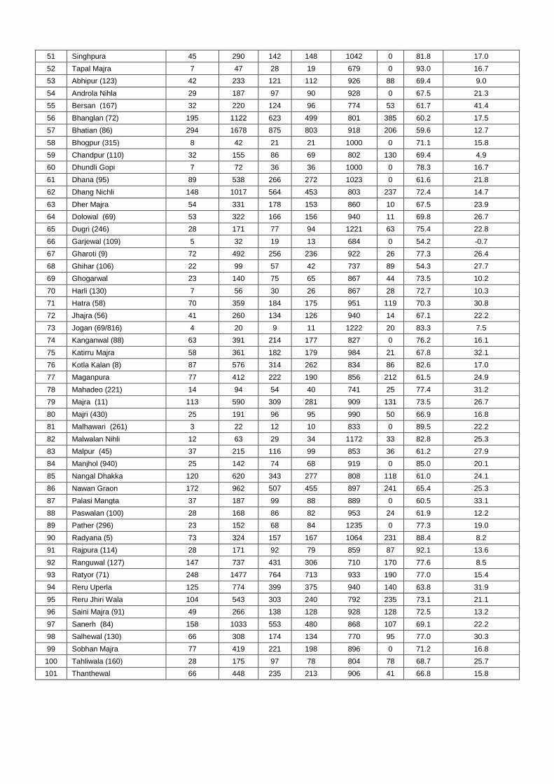
51 Singhpura 45 290 142 148 1042 0 81.8 17.0
52 Tapal Majra 7 47 28 19 679 0 93.0 16.7
53 Abhipur (123) 42 233 121 112 926 88 69.4 9.0
54 Androla Nihla 29 187 97 90 928 0 67.5 21.3
55 Bersan (167) 32 220 124 96 774 53 61.7 41.4
56 Bhanglan (72) 195 1122 623 499 801 385 60.2 17.5
57 Bhatian (86) 294 1678 875 803 918 206 59.6 12.7
58 Bhogpur (315) 8 42 21 21 1000 0 71.1 15.8
59 Chandpur (110) 32 155 86 69 802 130 69.4 4.9
60 Dhundli Gopi 7 72 36 36 1000 0 78.3 16.7
61 Dhana (95) 89 538 266 272 1023 0 61.6 21.8
62 Dhang Nichli 148 1017 564 453 803 237 72.4 14.7
63 Dher Majra 54 331 178 153 860 10 67.5 23.9
64 Dolowal (69) 53 322 166 156 940 11 69.8 26.7
65 Dugri (246) 28 171 77 94 1221 63 75.4 22.8
66 Garjewal (109) 5 32 19 13 684 0 54.2 -0.7
67 Gharoti (9) 72 492 256 236 922 26 77.3 26.4
68 Ghihar (106) 22 99 57 42 737 89 54.3 27.7
69 Ghogarwal 23 140 75 65 867 44 73.5 10.2
70 Harli (130) 7 56 30 26 867 28 72.7 10.3
71 Hatra (58) 70 359 184 175 951 119 70.3 30.8
72 Jhajra (56) 41 260 134 126 940 14 67.1 22.2
73 Jogan (69/816) 4 20 9 11 1222 20 83.3 7.5
74 Kanganwal (88) 63 391 214 177 827 0 76.2 16.1
75 Katirru Majra 58 361 182 179 984 21 67.8 32.1
76 Kotla Kalan (8) 87 576 314 262 834 86 82.6 17.0
77 Maganpura 77 412 222 190 856 212 61.5 24.9
78 Mahadeo (221) 14 94 54 40 741 25 77.4 31.2
79 Majra (11) 113 590 309 281 909 131 73.5 26.7
80 Majri (430) 25 191 96 95 990 50 66.9 16.8
81 Malhawari (261) 3 22 12 10 833 0 89.5 22.2
82 Malwalan Nihli 12 63 29 34 1172 33 82.8 25.3
83 Malpur (45) 37 215 116 99 853 36 61.2 27.9
84 Manjhol (940) 25 142 74 68 919 0 85.0 20.1
85 Nangal Dhakka 120 620 343 277 808 118 61.0 24.1
86 Nawan Graon 172 962 507 455 897 241 65.4 25.3
87 Palasi Mangta 37 187 99 88 889 0 60.5 33.1
88 Paswalan (100) 28 168 86 82 953 24 61.9 12.2
89 Pather (296) 23 152 68 84 1235 0 77.3 19.0
90 Radyana (5) 73 324 157 167 1064 231 88.4 8.2
91 Rajpura (114) 28 171 92 79 859 87 92.1 13.6
92 Ranguwal (127) 147 737 431 306 710 170 77.6 8.5
93 Ratyor (71) 248 1477 764 713 933 190 77.0 15.4
94 Reru Uperla 125 774 399 375 940 140 63.8 31.9
95 Reru Jhiri Wala 104 543 303 240 792 235 73.1 21.1
96 Saini Majra (91) 49 266 138 128 928 128 72.5 13.2
97 Sanerh (84) 158 1033 553 480 868 107 69.1 22.2
98 Salhewal (130) 66 308 174 134 770 95 77.0 30.3
99 Sobhan Majra 77 419 221 198 896 0 71.2 16.8
100 Tahliwala (160) 28 175 97 78 804 78 68.7 25.7
101 Thanthewal 66 448 235 213 906 41 66.8 15.8
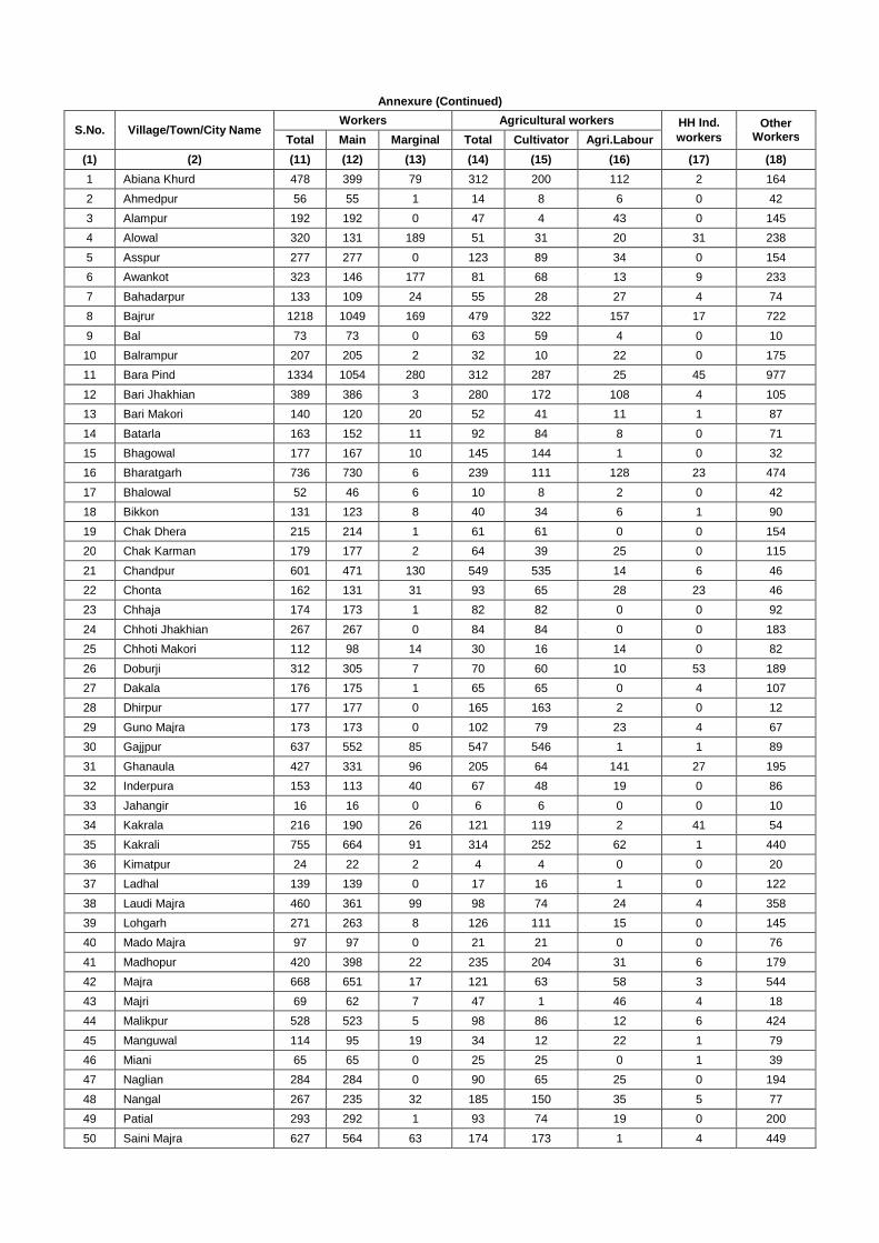
Annexure (Continued)
S.No. Village/Town/City NameWorkers Agricultural workers HH Ind.
workersOther
WorkersTotal Main Marginal Total Cultivator Agri.Labour
(1) (2) (11) (12) (13) (14) (15) (16) (17) (18)
1 Abiana Khurd 478 399 79 312 200 112 2 164
2 Ahmedpur 56 55 1 14 8 6 0 42
3 Alampur 192 192 0 47 4 43 0 145
4 Alowal 320 131 189 51 31 20 31 238
5 Asspur 277 277 0 123 89 34 0 154
6 Awankot 323 146 177 81 68 13 9 233
7 Bahadarpur 133 109 24 55 28 27 4 74
8 Bajrur 1218 1049 169 479 322 157 17 722
9 Bal 73 73 0 63 59 4 0 10
10 Balrampur 207 205 2 32 10 22 0 175
11 Bara Pind 1334 1054 280 312 287 25 45 977
12 Bari Jhakhian 389 386 3 280 172 108 4 105
13 Bari Makori 140 120 20 52 41 11 1 87
14 Batarla 163 152 11 92 84 8 0 71
15 Bhagowal 177 167 10 145 144 1 0 32
16 Bharatgarh 736 730 6 239 111 128 23 474
17 Bhalowal 52 46 6 10 8 2 0 42
18 Bikkon 131 123 8 40 34 6 1 90
19 Chak Dhera 215 214 1 61 61 0 0 154
20 Chak Karman 179 177 2 64 39 25 0 115
21 Chandpur 601 471 130 549 535 14 6 46
22 Chonta 162 131 31 93 65 28 23 46
23 Chhaja 174 173 1 82 82 0 0 92
24 Chhoti Jhakhian 267 267 0 84 84 0 0 183
25 Chhoti Makori 112 98 14 30 16 14 0 82
26 Doburji 312 305 7 70 60 10 53 189
27 Dakala 176 175 1 65 65 0 4 107
28 Dhirpur 177 177 0 165 163 2 0 12
29 Guno Majra 173 173 0 102 79 23 4 67
30 Gajjpur 637 552 85 547 546 1 1 89
31 Ghanaula 427 331 96 205 64 141 27 195
32 Inderpura 153 113 40 67 48 19 0 86
33 Jahangir 16 16 0 6 6 0 0 10
34 Kakrala 216 190 26 121 119 2 41 54
35 Kakrali 755 664 91 314 252 62 1 440
36 Kimatpur 24 22 2 4 4 0 0 20
37 Ladhal 139 139 0 17 16 1 0 122
38 Laudi Majra 460 361 99 98 74 24 4 358
39 Lohgarh 271 263 8 126 111 15 0 145
40 Mado Majra 97 97 0 21 21 0 0 76
41 Madhopur 420 398 22 235 204 31 6 179
42 Majra 668 651 17 121 63 58 3 544
43 Majri 69 62 7 47 1 46 4 18
44 Malikpur 528 523 5 98 86 12 6 424
45 Manguwal 114 95 19 34 12 22 1 79
46 Miani 65 65 0 25 25 0 1 39
47 Naglian 284 284 0 90 65 25 0 194
48 Nangal 267 235 32 185 150 35 5 77
49 Patial 293 292 1 93 74 19 0 200
50 Saini Majra 627 564 63 174 173 1 4 449
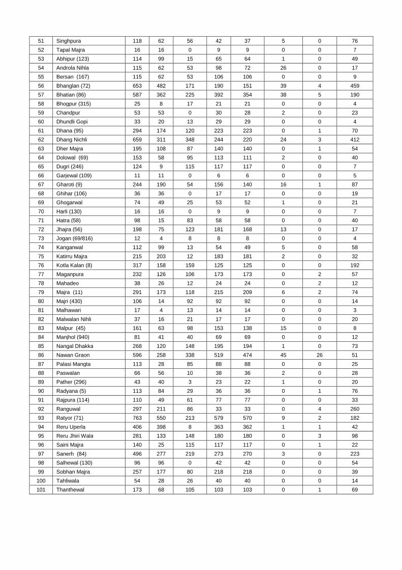
51 Singhpura 118 62 56 42 37 5 0 76
52 Tapal Majra 16 16 0 9 9 0 0 7
53 Abhipur (123) 114 99 15 65 64 1 0 49
54 Androla Nihla 115 62 53 98 72 26 0 17
55 Bersan (167) 115 62 53 106 106 0 0 9
56 Bhanglan (72) 653 482 171 190 151 39 4 459
57 Bhatian (86) 587 362 225 392 354 38 5 190
58 Bhogpur (315) 25 8 17 21 21 0 0 4
59 Chandpur 53 53 0 30 28 2 0 23
60 Dhundli Gopi 33 20 13 29 29 0 0 4
61 Dhana (95) 294 174 120 223 223 0 1 70
62 Dhang Nichli 659 311 348 244 220 24 3 412
63 Dher Majra 195 108 87 140 140 0 1 54
64 Dolowal (69) 153 58 95 113 111 2 0 40
65 Dugri (246) 124 9 115 117 117 0 0 7
66 Garjewal (109) 11 11 0 6 6 0 0 5
67 Gharoti (9) 244 190 54 156 140 16 1 87
68 Ghihar (106) 36 36 0 17 17 0 0 19
69 Ghogarwal 74 49 25 53 52 1 0 21
70 Harli (130) 16 16 0 9 9 0 0 7
71 Hatra (58) 98 15 83 58 58 0 0 40
72 Jhajra (56) 198 75 123 181 168 13 0 17
73 Jogan (69/816) 12 4 8 8 8 0 0 4
74 Kanganwal 112 99 13 54 49 5 0 58
75 Katirru Majra 215 203 12 183 181 2 0 32
76 Kotla Kalan (8) 317 158 159 125 125 0 0 192
77 Maganpura 232 126 106 173 173 0 2 57
78 Mahadeo 38 26 12 24 24 0 2 12
79 Majra (11) 291 173 118 215 209 6 2 74
80 Majri (430) 106 14 92 92 92 0 0 14
81 Malhawari 17 4 13 14 14 0 0 3
82 Malwalan Nihli 37 16 21 17 17 0 0 20
83 Malpur (45) 161 63 98 153 138 15 0 8
84 Manjhol (940) 81 41 40 69 69 0 0 12
85 Nangal Dhakka 268 120 148 195 194 1 0 73
86 Nawan Graon 596 258 338 519 474 45 26 51
87 Palasi Mangta 113 28 85 88 88 0 0 25
88 Paswalan 66 56 10 38 36 2 0 28
89 Pather (296) 43 40 3 23 22 1 0 20
90 Radyana (5) 113 84 29 36 36 0 1 76
91 Rajpura (114) 110 49 61 77 77 0 0 33
92 Ranguwal 297 211 86 33 33 0 4 260
93 Ratyor (71) 763 550 213 579 570 9 2 182
94 Reru Uperla 406 398 8 363 362 1 1 42
95 Reru Jhiri Wala 281 133 148 180 180 0 3 98
96 Saini Majra 140 25 115 117 117 0 1 22
97 Sanerh (84) 496 277 219 273 270 3 0 223
98 Salhewal (130) 96 96 0 42 42 0 0 54
99 Sobhan Majra 257 177 80 218 218 0 0 39
100 Tahliwala 54 28 26 40 40 0 0 14
101 Thanthewal 173 68 105 103 103 0 1 69
Project Name: Manguwal Sand Mine, Punjab Eco-friendly Mining Plan
Page No.1
ECO-FRIENDLY MINING PLAN
FOR
SAND MINING PROJECT
Area: 16.48 ha
At village: Manguwal; Tehsil: Rupnagar & District: Rupnagar, Punjab
Applicant:
DEPARTMENT OF INDUSTRIES & COMMERCE
GoP, Chandigarh
Prepared By
GRASS ROOTS RESEARCH & CREATION INDIA (P) LTD.(An ISO 9001:2008 Certified Co.: Accredited by QCI / NABET: Approved by MoEF, GoI)
F-374-375, Sector-63, Noida, U.P.Ph.: 0120- 4044630, Telefax: 0120- 2406519
Email: [email protected], [email protected]: http://www.grc-india.com
GRC INDIA TRAINING & ANALYTICAL LABORATORY(Recognized by MoEF, GoI : Accredited by NABL)
A unit of GRC India
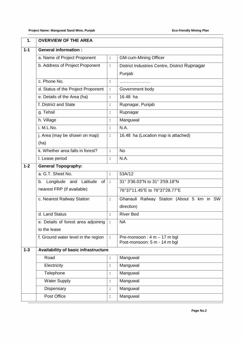
Project Name: Manguwal Sand Mine, Punjab Eco-friendly Mining Plan
Page No.2
1. OVERVIEW OF THE AREA
1-1 General information :
a. Name of Project Proponent : GM-cum-Mining Officer
b. Address of Project Proponent : District Industries Centre, District Rupnagar
Punjab
c. Phone No. : …………………
d. Status of the Project Proponent : Government body
e. Details of the Area (ha) : 16.48 ha
f. District and State : Rupnagar, Punjab
g. Tehsil : Rupnagar
h. Village : Manguwal
i. M.L.No. : N.A.
j. Area (may be shown on map)
(ha)
: 16.48 ha (Location map is attached)
k. Whether area falls in forest? : No
l. Lease period : N.A.
1-2 General Topography:
a. G.T. Sheet No. : 53A/12
b. Longitude and Latitude of
nearest FRP (if available)
: 31° 3'36.03"N to 31° 3'59.18"N
76°37'11.45"E to 76°37'28.77"E
c. Nearest Railway Station : Ghanauli Railway Station (About 5 km in SW
direction)
d. Land Status : River Bed
e. Details of forest area adjoining
to the lease
: NA
f. Ground water level in the region : Pre-monsoon : 4 m – 17 m bglPost-monsoon: 5 m - 14 m bgl
1-3 Availability of basic infrastructure
Road : Manguwal
Electricity : Manguwal
Telephone : Manguwal
Water Supply : Manguwal
Dispensary : Manguwal
Post Office : Manguwal
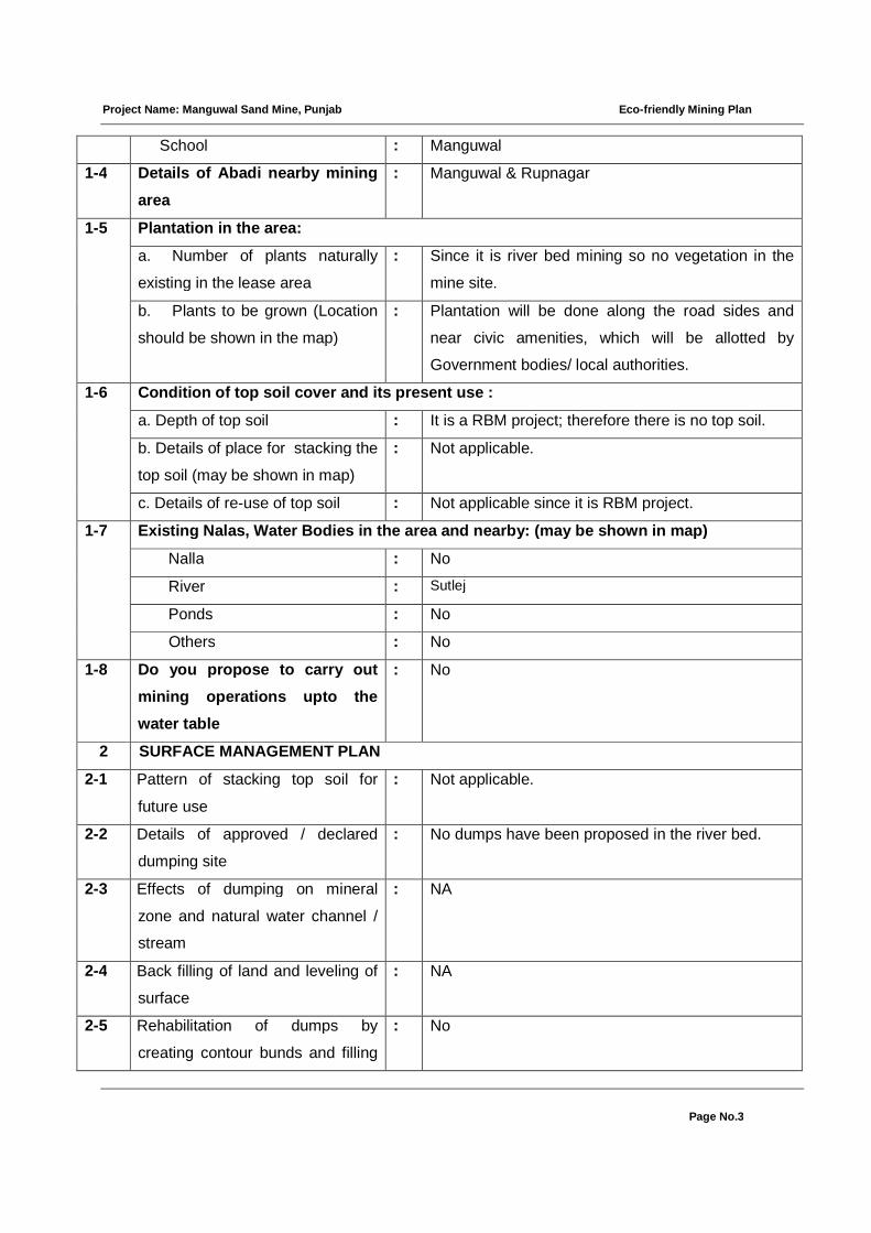
Project Name: Manguwal Sand Mine, Punjab Eco-friendly Mining Plan
Page No.3
School : Manguwal
1-4 Details of Abadi nearby mining
area
: Manguwal & Rupnagar
1-5 Plantation in the area:
a. Number of plants naturally
existing in the lease area
: Since it is river bed mining so no vegetation in the
mine site.
b. Plants to be grown (Location
should be shown in the map)
: Plantation will be done along the road sides and
near civic amenities, which will be allotted by
Government bodies/ local authorities.
1-6 Condition of top soil cover and its present use :
a. Depth of top soil : It is a RBM project; therefore there is no top soil.
b. Details of place for stacking the
top soil (may be shown in map)
: Not applicable.
c. Details of re-use of top soil : Not applicable since it is RBM project.
1-7 Existing Nalas, Water Bodies in the area and nearby: (may be shown in map)
Nalla : No
River : Sutlej
Ponds : No
Others : No
1-8 Do you propose to carry out
mining operations upto the
water table
: No
2 SURFACE MANAGEMENT PLAN
2-1 Pattern of stacking top soil for
future use
: Not applicable.
2-2 Details of approved / declared
dumping site
: No dumps have been proposed in the river bed.
2-3 Effects of dumping on mineral
zone and natural water channel /
stream
: NA
2-4 Back filling of land and leveling of
surface
: NA
2-5 Rehabilitation of dumps by
creating contour bunds and filling
: No
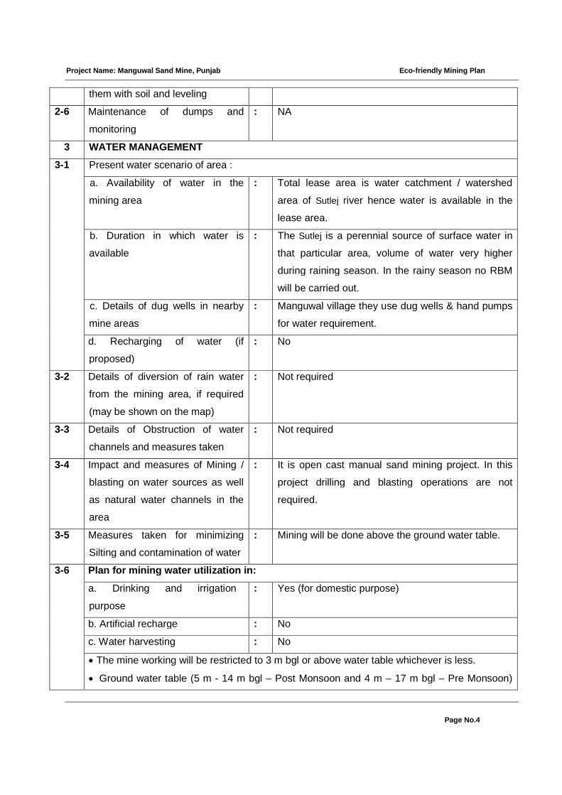
Project Name: Manguwal Sand Mine, Punjab Eco-friendly Mining Plan
Page No.4
them with soil and leveling
2-6 Maintenance of dumps and
monitoring
: NA
3 WATER MANAGEMENT
3-1 Present water scenario of area :
a. Availability of water in the
mining area
: Total lease area is water catchment / watershed
area of Sutlej river hence water is available in the
lease area.
b. Duration in which water is
available
: The Sutlej is a perennial source of surface water in
that particular area, volume of water very higher
during raining season. In the rainy season no RBM
will be carried out.
c. Details of dug wells in nearby
mine areas
: Manguwal village they use dug wells & hand pumps
for water requirement.
d. Recharging of water (if
proposed)
: No
3-2 Details of diversion of rain water
from the mining area, if required
(may be shown on the map)
: Not required
3-3 Details of Obstruction of water
channels and measures taken
: Not required
3-4 Impact and measures of Mining /
blasting on water sources as well
as natural water channels in the
area
: It is open cast manual sand mining project. In this
project drilling and blasting operations are not
required.
3-5 Measures taken for minimizing
Silting and contamination of water
: Mining will be done above the ground water table.
3-6 Plan for mining water utilization in:
a. Drinking and irrigation
purpose
: Yes (for domestic purpose)
b. Artificial recharge : No
c. Water harvesting : No
The mine working will be restricted to 3 m bgl or above water table whichever is less.
Ground water table (5 m - 14 m bgl – Post Monsoon and 4 m – 17 m bgl – Pre Monsoon)
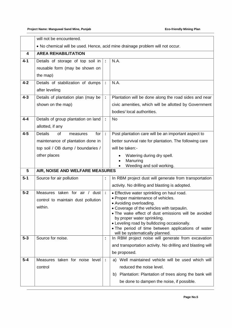
Project Name: Manguwal Sand Mine, Punjab Eco-friendly Mining Plan
Page No.5
will not be encountered.
No chemical will be used. Hence, acid mine drainage problem will not occur.
4 AREA REHABILITATION
4-1 Details of storage of top soil in
reusable form (may be shown on
the map)
: N.A.
4-2 Details of stabilization of dumps
after leveling
: N.A.
4-3 Details of plantation plan (may be
shown on the map)
: Plantation will be done along the road sides and near
civic amenities, which will be allotted by Government
bodies/ local authorities.
4-4 Details of group plantation on land
allotted, if any
: No
4-5 Details of measures for
maintenance of plantation done in
top soil / OB dump / boundaries /
other places
: Post plantation care will be an important aspect to
better survival rate for plantation. The following care
will be taken:-
Watering during dry spell. Manuring Weeding and soil working.
5 AIR, NOISE AND WELFARE MEASURES
5-1 Source for air pollution : In RBM project dust will generate from transportation
activity. No drilling and blasting is adopted.
5-2 Measures taken for air / dust
control to maintain dust pollution
within.
: Effective water sprinkling on haul road.Proper maintenance of vehicles.Avoiding overloading.Coverage of the vehicles with tarpaulin. The wake effect of dust emissions will be avoided
by proper water sprinkling. Leveling road by bulldozing occasionally. The period of time between applications of water
will be systematically planned.5-3 Source for noise. : In RBM project noise will generate from excavation
and transportation activity. No drilling and blasting will
be proposed.
5-4 Measures taken for noise level
control
: a) Well maintained vehicle will be used which will
reduced the noise level.
b) Plantation: Plantation of trees along the bank will
be done to dampen the noise, if possible.

Project Name: Manguwal Sand Mine, Punjab Eco-friendly Mining Plan
Page No.6
c) Hearing Protection: No hearing protection is
generally needed for RBM mining projects.
5-5 Welfare measures taken for mining laborers
a. Drinking water : Nearby village
b. Sanitary condition : Portable toilets are envisaged.
c. First Aid facility : First aid box will be made available at mining site.
d. Labour Health : All safety measures prescribed under mining laws will
be followed strictly. All workers will be medically
examined in pre placement phase and also
periodically as per Rule 29 (B) of Mines Rule 1955.
e.Social Welfare and Upliftment : Development activities will be taken up in
consultation with local bodies.
Education, safety and health campaigns will be
carried out in nearby villages.
Periodic medical examination / checking of workers
will be carried out as per requirement under Mines
Rules, 1955.
Local people will be given employment depending
upon their skill.
The project will provide job to local workers directly
employed for mining work, wages as per state norm.
6 METHOD OF MINING (OPEN CAST / UNDERGROUND)
6-1 Bench Height : N.A.
6-2 Bench width : N.A.
6-3 Machinery used : Dumpers
6-4 Explosive used (if blasting done) : No
6-5 Details of crusher or any plant (if
constructed within lease area)
: No
Mining is carried out by open cast manual method. The mining involve following steps-
I. Soil will be removed /scraped and loaded in the trucks/dumpers.
II. The loading of sand/boulder will be done manually and by excavator and then
transported by vehicles.
III. The proposed production of the mine is 20,000 TPA
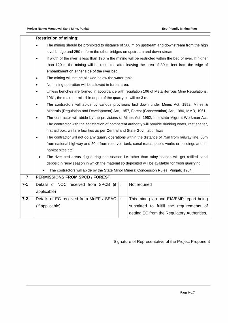
Project Name: Manguwal Sand Mine, Punjab Eco-friendly Mining Plan
Page No.7
Restriction of mining:
The mining should be prohibited to distance of 500 m on upstream and downstream from the high
level bridge and 250 m form the other bridges on upstream and down stream
If width of the river is less than 120 m the mining will be restricted within the bed of river. If higher
than 120 m the mining will be restricted after leaving the area of 30 m feet from the edge of
embankment on either side of the river bed.
The mining will not be allowed below the water table.
No mining operation will be allowed in forest area.
Unless benches are formed in accordance with regulation 106 of Metalliferrous Mine Regulations,
1961, the max. permissible depth of the quarry pit will be 3 m.
The contractors will abide by various provisions laid down under Mines Act, 1952, Mines &
Minerals (Regulation and Development) Act, 1957, Forest (Conservation) Act, 1980, MMR, 1961.
The contractor will abide by the provisions of Mines Act, 1952, Interstate Migrant Workman Act.
The contractor with the satisfaction of competent authority will provide drinking water, rest shelter,
first aid box, welfare facilities as per Central and State Govt. labor laws
The contractor will not do any quarry operations within the distance of 75m from railway line, 60m
from national highway and 50m from reservoir tank, canal roads, public works or buildings and in-
habitat sites etc.
The river bed areas dug during one season i.e. other than rainy season will get refilled sand
deposit in rainy season in which the material so deposited will be available for fresh quarrying.
The contractors will abide by the State Minor Mineral Concession Rules, Punjab, 1964.
7 PERMISSIONS FROM SPCB / FOREST
7-1 Details of NOC received from SPCB (if
applicable)
: Not required
7-2 Details of EC received from MoEF / SEAC
(if applicable)
: This mine plan and EIA/EMP report being
submitted to fulfill the requirements of
getting EC from the Regulatory Authorities.
Signature of Representative of the Project Proponent
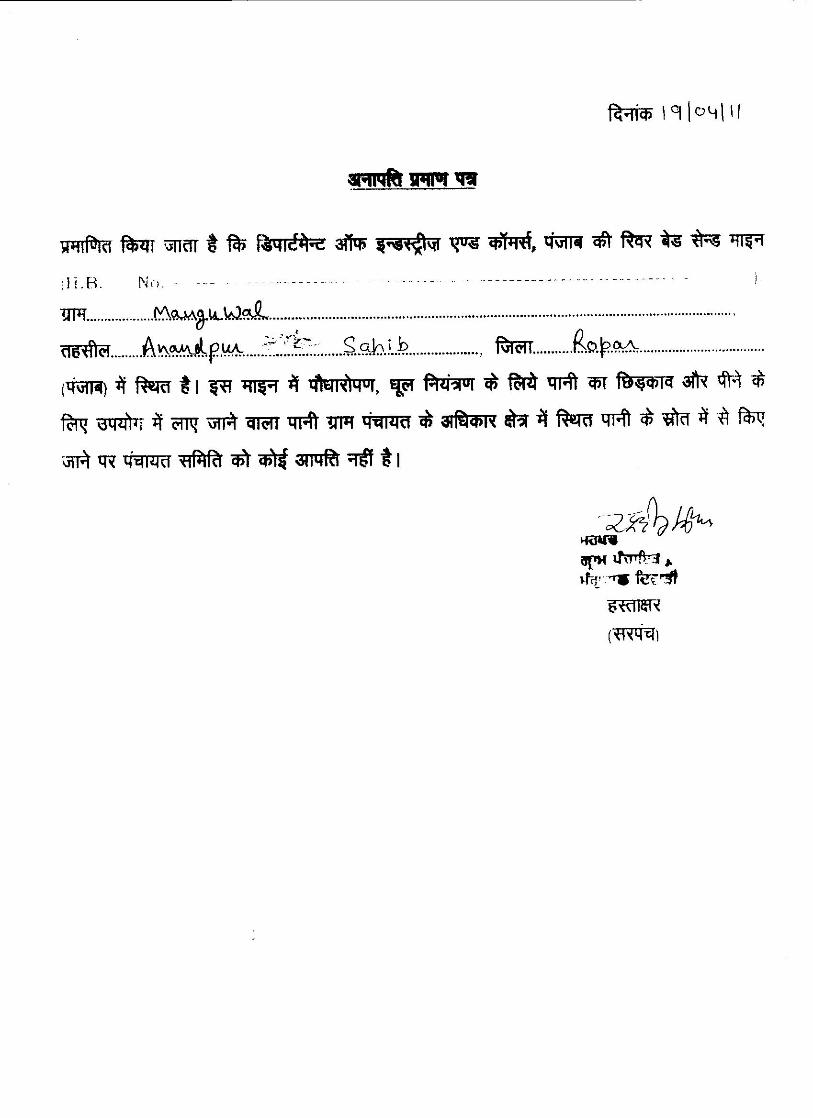
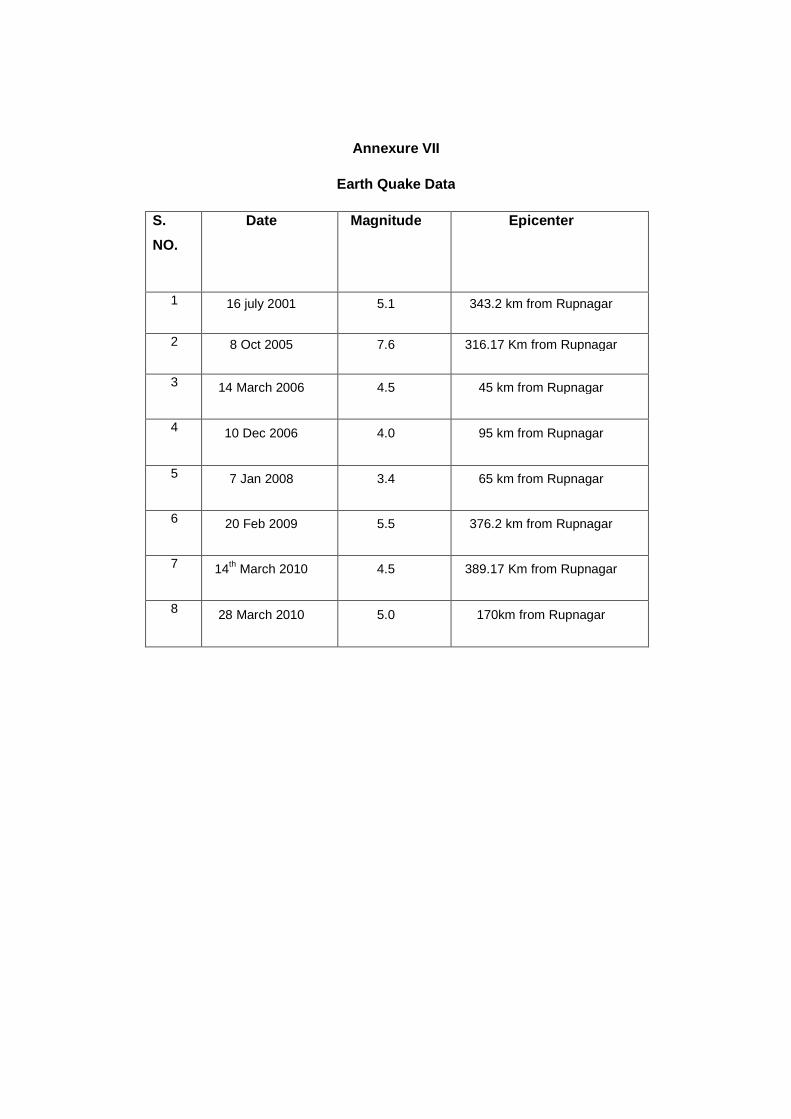
Annexure VII
Earth Quake Data
S.
NO.
Date Magnitude Epicenter
1 16 july 2001 5.1 343.2 km from Rupnagar
2 8 Oct 2005 7.6 316.17 Km from Rupnagar
3 14 March 2006 4.5 45 km from Rupnagar
4 10 Dec 2006 4.0 95 km from Rupnagar
5 7 Jan 2008 3.4 65 km from Rupnagar
6 20 Feb 2009 5.5 376.2 km from Rupnagar
7 14th
March 2010 4.5 389.17 Km from Rupnagar
8 28 March 2010 5.0 170km from Rupnagar

APPENDIX
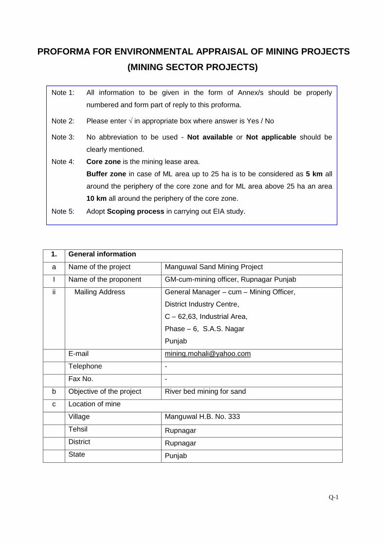
Q-1
PROFORMA FOR ENVIRONMENTAL APPRAISAL OF MINING PROJECTS
(MINING SECTOR PROJECTS)
1. General Information
1. General information
a Name of the project Manguwal Sand Mining Project
I Name of the proponent GM-cum-mining officer, Rupnagar Punjab
ii Mailing Address General Manager – cum – Mining Officer,
District Industry Centre,
C – 62,63, Industrial Area,
Phase – 6, S.A.S. Nagar
Punjab
E-mail [email protected]
Telephone -
Fax No. -
b Objective of the project River bed mining for sand
c Location of mine
Village Manguwal H.B. No. 333
Tehsil Rupnagar
District Rupnagar
State Punjab
Note 1: All information to be given in the form of Annex/s should be properly
numbered and form part of reply to this proforma.
Note 2: Please enter √ in appropriate box where answer is Yes / No
Note 3: No abbreviation to be used - Not available or Not applicable should be
clearly mentioned.
Note 4: Core zone is the mining lease area.
Buffer zone in case of ML area up to 25 ha is to be considered as 5 km all
around the periphery of the core zone and for ML area above 25 ha an area
10 km all around the periphery of the core zone.
Note 5: Adopt Scoping process in carrying out EIA study.
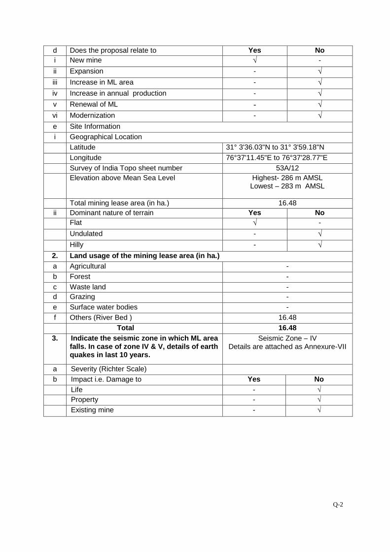
Q-2
d Does the proposal relate to Yes No
i New mine √ -
ii Expansion - √
iii Increase in ML area - √
iv Increase in annual production - √
v Renewal of ML - √
vi Modernization - √
e Site Information
i Geographical Location
Latitude 31° 3'36.03"N to 31° 3'59.18"N
Longitude 76°37'11.45"E to 76°37'28.77"E
Survey of India Topo sheet number 53A/12
Elevation above Mean Sea Level Highest- 286 m AMSLLowest – 283 m AMSL
Total mining lease area (in ha.) 16.48
ii Dominant nature of terrain Yes No
Flat √ -
Undulated - √
Hilly - √
2. Land usage of the mining lease area (in ha.)
a Agricultural -
b Forest -
c Waste land -
d Grazing -
e Surface water bodies -
f Others (River Bed ) 16.48
Total 16.48
3. Indicate the seismic zone in which ML areafalls. In case of zone IV & V, details of earthquakes in last 10 years.
Seismic Zone – IVDetails are attached as Annexure-VII
a Severity (Richter Scale)
b Impact i.e. Damage to Yes No
Life - √
Property - √
Existing mine - √
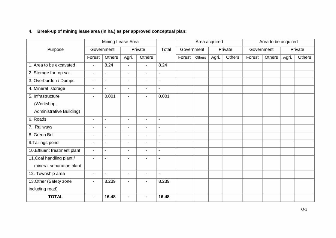
Q-3
4. Break-up of mining lease area (in ha.) as per approved conceptual plan:
Purpose
Mining Lease Area
Total
Area acquired Area to be acquired
Government Private Government Private Government Private
Forest Others Agri. Others Forest Others Agri. Others Forest Others Agri. Others
1. Area to be excavated - 8.24 - - 8.24
2. Storage for top soil - - - - -
3. Overburden / Dumps - - - - -
4. Mineral storage - - - - -
5. Infrastructure
(Workshop,
Administrative Building)
- 0.001 - - 0.001
6. Roads - - - - -
7. Railways - - - - -
8. Green Belt - - - - -
9.Tailings pond - - - - -
10.Effluent treatment plant - - - - -
11.Coal handling plant /
mineral separation plant
- - - - -
12. Township area - - - - -
13.Other (Safety zone
including road)
- 8.239 - - 8.239
TOTAL - 16.48 - - 16.48
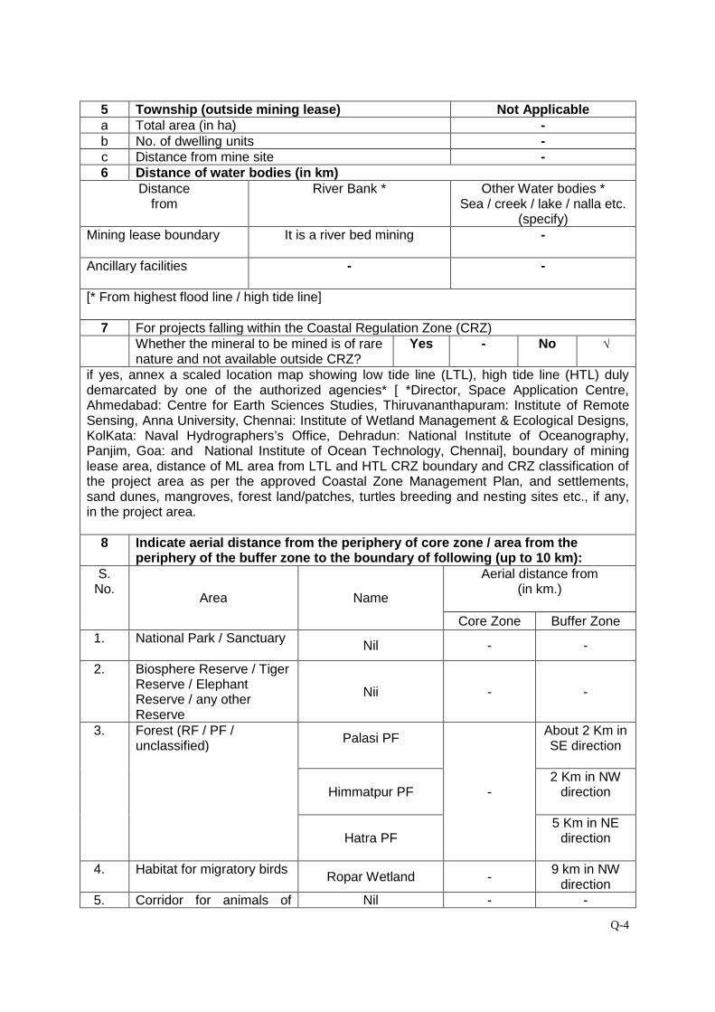
Q-4
5 Township (outside mining lease) Not Applicablea Total area (in ha) -b No. of dwelling units -c Distance from mine site -6 Distance of water bodies (in km)
Distancefrom
River Bank * Other Water bodies *Sea / creek / lake / nalla etc.
(specify)Mining lease boundary It is a river bed mining -
Ancillary facilities - -
[* From highest flood line / high tide line]
7 For projects falling within the Coastal Regulation Zone (CRZ)Whether the mineral to be mined is of rarenature and not available outside CRZ?
Yes - No √
if yes, annex a scaled location map showing low tide line (LTL), high tide line (HTL) dulydemarcated by one of the authorized agencies* [ *Director, Space Application Centre,Ahmedabad: Centre for Earth Sciences Studies, Thiruvananthapuram: Institute of RemoteSensing, Anna University, Chennai: Institute of Wetland Management & Ecological Designs,KolKata: Naval Hydrographers’s Office, Dehradun: National Institute of Oceanography,Panjim, Goa: and National Institute of Ocean Technology, Chennai], boundary of mininglease area, distance of ML area from LTL and HTL CRZ boundary and CRZ classification ofthe project area as per the approved Coastal Zone Management Plan, and settlements,sand dunes, mangroves, forest land/patches, turtles breeding and nesting sites etc., if any,in the project area.
8 Indicate aerial distance from the periphery of core zone / area from theperiphery of the buffer zone to the boundary of following (up to 10 km):
S.No.
Area Name
Aerial distance from(in km.)
Core Zone Buffer Zone
1. National Park / SanctuaryNil - -
2. Biosphere Reserve / TigerReserve / ElephantReserve / any otherReserve
Nii - -
3. Forest (RF / PF /unclassified)
Palasi PF
-
About 2 Km inSE direction
Himmatpur PF2 Km in NW
direction
Hatra PF5 Km in NE
direction
4. Habitat for migratory birdsRopar Wetland -
9 km in NWdirection
5. Corridor for animals of Nil - -
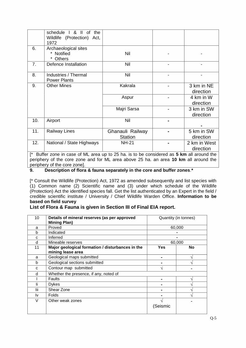
Q-5
schedule I & II of theWildlife (Protection) Act,1972
6. Archaeological sites* Notified* Others
Nil - -
7. Defence Installation Nil - -
8. Industries / ThermalPower Plants
Nil - -
9. Other Mines Kakrala - 3 km in NEdirection
Aspur - 4 km in Wdirection
Majri Sarsa - 3 km in SWdirection
10. Airport Nil --
11. Railway Lines Ghanauli RailwayStation
- 5 km in SWdirection
12. National / State Highways NH-21 - 2 km in Westdirection
[* Buffer zone in case of ML area up to 25 ha. is to be considered as 5 km all around theperiphery of the core zone and for ML area above 25 ha. an area 10 km all around theperiphery of the core zone].9. Description of flora & fauna separately in the core and buffer zones.*
[* Consult the Wildlife (Protection) Act, 1972 as amended subsequently and list species with(1) Common name (2) Scientific name and (3) under which schedule of the Wildlife(Protection) Act the identified species fall. Get the list authenticated by an Expert in the field /credible scientific institute / University / Chief Wildlife Warden Office. Information to bebased on field surveyList of Flora & Fauna is given in Section III of Final EIA report.
10 Details of mineral reserves (as per approvedMining Plan)
Quantity (in tonnes)
a Proved 60,000b Indicated -c Inferred -d Mineable reserves 60,00011 Major geological formation / disturbances in the
mining lease areaYes No
a Geological maps submitted - √b Geological sections submitted - √c Contour map submitted √ -d Whether the presence, if any, noted ofI Faults - √Ii Dykes - √Iii Shear Zone - √Iv Folds - √V Other weak zones √
(Seismic-
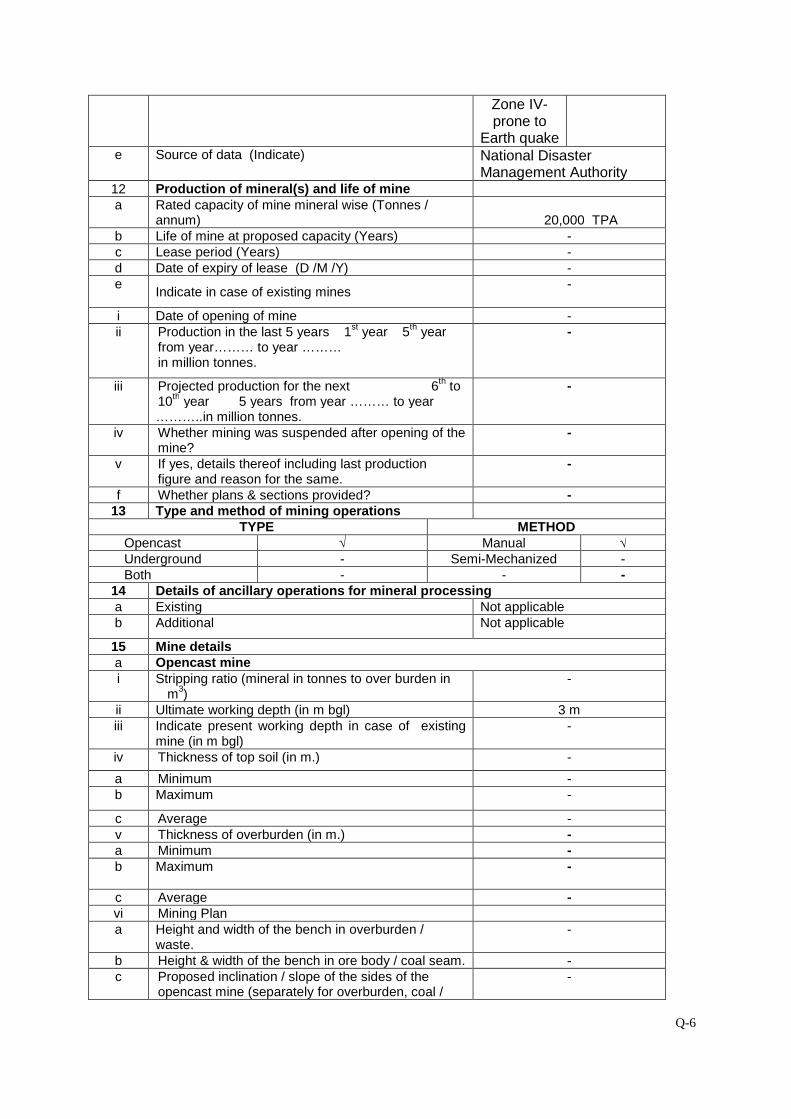
Q-6
Zone IV-prone to
Earth quakee Source of data (Indicate) National Disaster
Management Authority12 Production of mineral(s) and life of minea Rated capacity of mine mineral wise (Tonnes /
annum) 20,000 TPAb Life of mine at proposed capacity (Years) -c Lease period (Years) -d Date of expiry of lease (D /M /Y) -e
Indicate in case of existing mines-
i Date of opening of mine -ii Production in the last 5 years 1
styear 5
thyear
from year……… to year ………in million tonnes.
-
iii Projected production for the next 6th
to10
thyear 5 years from year ……… to year
………..in million tonnes.
-
iv Whether mining was suspended after opening of themine?
-
v If yes, details thereof including last productionfigure and reason for the same.
-
f Whether plans & sections provided? -13 Type and method of mining operations
TYPE METHODOpencast √ Manual √Underground - Semi-Mechanized -Both - - -
14 Details of ancillary operations for mineral processinga Existing Not applicableb Additional Not applicable
15 Mine detailsa Opencast minei Stripping ratio (mineral in tonnes to over burden in
m3)
-
ii Ultimate working depth (in m bgl) 3 miii Indicate present working depth in case of existing
mine (in m bgl)-
iv Thickness of top soil (in m.) -
a Minimum -b Maximum -
c Average -v Thickness of overburden (in m.) -a Minimum -b Maximum -
c Average -vi Mining Plana Height and width of the bench in overburden /
waste.-
b Height & width of the bench in ore body / coal seam. -c Proposed inclination / slope of the sides of the
opencast mine (separately for overburden, coal /-

Q-7
ore and overall slope of the pit sides) both whileoperating the mine as well as at the time ofclosure of the mine.
d Whether transverse sections across the opencast mine at the end of fifth year and at the end ofthe life of the mine have been submitted?
-
vii Type of blasting, if any, to be adopted -b Underground mine- Not Applicablei Seam / Ore body
Min. Depth (m) -Max. Depth (m) -Avg. thickness (m) -Rate of dip -Direction of dip in degree -
ii Mode of entry into the mineShaft -
Adit -
Incline -
iii Details of machineryOn surface -At Face -For transportation -Others -
iv Method of stopping (metalliferrous mines)Open -Filled -Shrinkage -Caving -Combination of above -Others (Specify) -
v Extraction methodCaving -Stowing -Partial extraction -
vi SubsidencePredicted max. subsidence (in m) -Max. value of tensile strain (in mm/m) -Max. slope change (in mm/m) -Whether identified possible subsidencearea(s) superimposed on Surface Plan has beensubmitted?
-
Major impacts on surface features like naturaldrainage pattern, houses, buildings, water bodies,roads, forest, etc.
-
Salient features of subsidencemanagement (monitoring and control).
-
16 Surface drainage pattern at mine site Yes Noa Whether the pre-mining surface drainage plan
submitted?- √
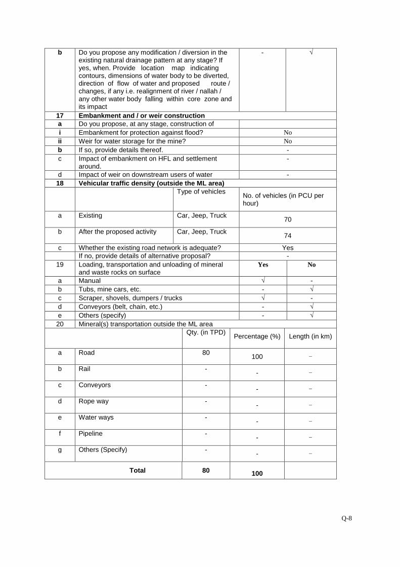
Q-8
b Do you propose any modification / diversion in theexisting natural drainage pattern at any stage? Ifyes, when. Provide location map indicatingcontours, dimensions of water body to be diverted,direction of flow of water and proposed route /changes, if any i.e. realignment of river / nallah /any other water body falling within core zone andits impact
- √
17 Embankment and / or weir constructiona Do you propose, at any stage, construction of
i Embankment for protection against flood? No
ii Weir for water storage for the mine? No
b If so, provide details thereof. -
c Impact of embankment on HFL and settlementaround.
-
d Impact of weir on downstream users of water -
18 Vehicular traffic density (outside the ML area)Type of vehicles
No. of vehicles (in PCU perhour)
a Existing Car, Jeep, Truck70
b After the proposed activity Car, Jeep, Truck74
c Whether the existing road network is adequate? YesIf no, provide details of alternative proposal? -
19 Loading, transportation and unloading of mineraland waste rocks on surface
Yes No
a Manual √ -
b Tubs, mine cars, etc. - √
c Scraper, shovels, dumpers / trucks √ -
d Conveyors (belt, chain, etc.) - √
e Others (specify) - √
20 Mineral(s) transportation outside the ML areaQty. (in TPD)
Percentage (%) Length (in km)
a Road 80100 -
b Rail -- -
c Conveyors -- -
d Rope way -- -
e Water ways -- -
f Pipeline -- -
g Others (Specify) -- -
Total 80 100
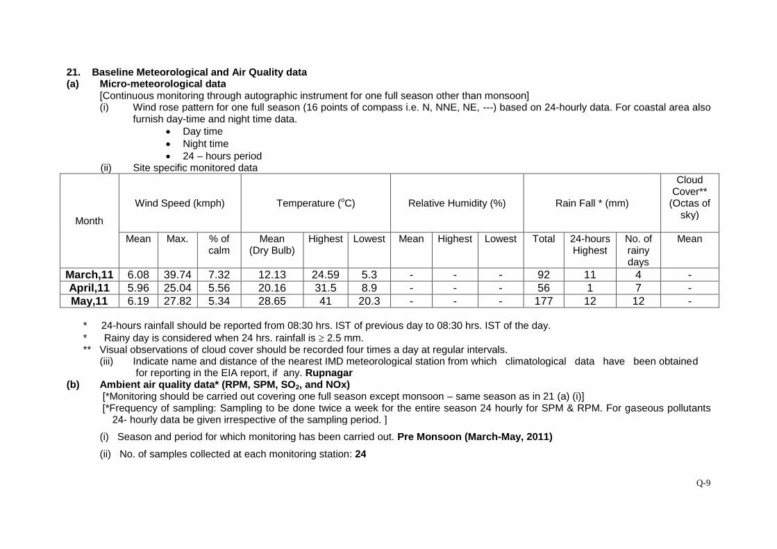
Q-9
21. Baseline Meteorological and Air Quality data(a) Micro-meteorological data
[Continuous monitoring through autographic instrument for one full season other than monsoon](i) Wind rose pattern for one full season (16 points of compass i.e. N, NNE, NE, ---) based on 24-hourly data. For coastal area also
furnish day-time and night time data. Day time Night time 24 – hours period
(ii) Site specific monitored data
Month
Wind Speed (kmph) Temperature (oC) Relative Humidity (%) Rain Fall * (mm)
CloudCover**
(Octas ofsky)
Mean Max. % ofcalm
Mean(Dry Bulb)
Highest Lowest Mean Highest Lowest Total 24-hoursHighest
No. ofrainydays
Mean
March,11 6.08 39.74 7.32 12.13 24.59 5.3 - - - 92 11 4 -April,11 5.96 25.04 5.56 20.16 31.5 8.9 - - - 56 1 7 -May,11 6.19 27.82 5.34 28.65 41 20.3 - - - 177 12 12 -
* 24-hours rainfall should be reported from 08:30 hrs. IST of previous day to 08:30 hrs. IST of the day.* Rainy day is considered when 24 hrs. rainfall is 2.5 mm.** Visual observations of cloud cover should be recorded four times a day at regular intervals.
(iii) Indicate name and distance of the nearest IMD meteorological station from which climatological data have been obtainedfor reporting in the EIA report, if any. Rupnagar
(b) Ambient air quality data* (RPM, SPM, SO2, and NOx)[*Monitoring should be carried out covering one full season except monsoon – same season as in 21 (a) (i)][*Frequency of sampling: Sampling to be done twice a week for the entire season 24 hourly for SPM & RPM. For gaseous pollutants
24- hourly data be given irrespective of the sampling period. ]
(i) Season and period for which monitoring has been carried out. Pre Monsoon (March-May, 2011)
(ii) No. of samples collected at each monitoring station: 24
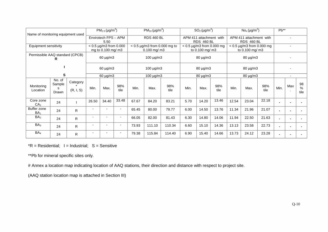
Q-10
Name of monitoring equipment usedPM2.5 (µg/m
3) PM10 (µg/m
3) SO2 (µg/m
3) Nox (µg/m
3) Pb**
Envirotech FPS – APM5.50
RDS 460 BL APM 411 attachment withRDS 460 BL
APM 411 attachment withRDS 460 BL
-
Equipment sensitivity < 0.5 µg/m3 from 0.000mg to 0.100 mg/ m3
< 0.5 µg/m3 from 0.000 mg to0.100 mg/ m3
< 0.5 µg/m3 from 0.000 mgto 0.100 mg/ m3
< 0.5 µg/m3 from 0.000 mgto 0.100 mg/ m3
-
Permissible AAQ standard (CPCB)R
I
S
60 µg/m3 100 µg/m3 80 µg/m3 80 µg/m3 -
60 µg/m3 100 µg/m3 80 µg/m3 80 µg/m3 -
60 µg/m3 100 µg/m3 80 µg/m3 80 µg/m3 -
MonitoringLocation
No. ofSample
sDrawn
Category*
(R, I, S)Min. Max.
98%tile
Min. Max.98%tile
Min. Max.98%tile
Min. Max.98%tile
Min.Max
.
98%tile
Core zoneCA1
24 I 26.50 34.40 33.48 67.67 84.20 83.21 5.70 14.20 13.46 12.54 23.04 22.18- - -
Buffer zoneBA1
24 R- - - 65.45 80.00 79.77 6.00 14.50 13.76 11.34 21.96 21.07 - - -
BA2 24 R- - - 66.05 82.00 81.43 6.30 14.80 14.06 11.94 22.50 21.63 - - -
BA3 24 R- - - 73.93 111.10 110.34 6.60 15.10 14.36 13.13 23.58 22.73 - - -
BA4 24 R- - - 79.38 115.84 114.40 6.90 15.40 14.66 13.73 24.12 23.28 - - -
*R = Residential; I = Industrial; S = Sensitive
**Pb for mineral specific sites only.
# Annex a location map indicating location of AAQ stations, their direction and distance with respect to project site.
(AAQ station location map is attached in Section III)
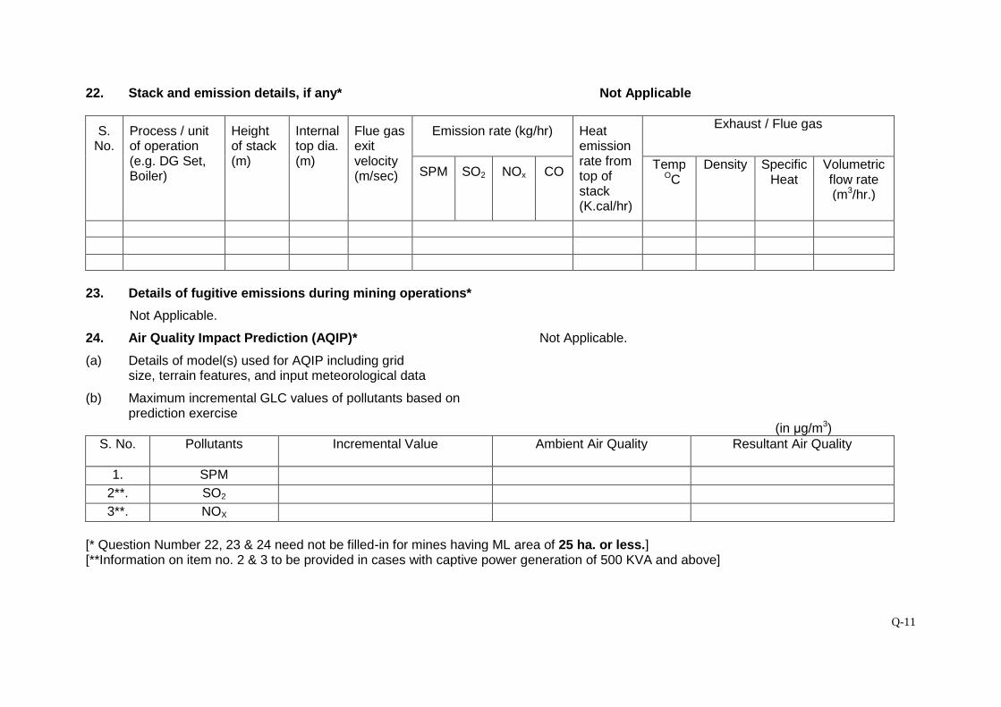
Q-11
22. Stack and emission details, if any* Not Applicable
S.No.
Process / unitof operation(e.g. DG Set,Boiler)
Heightof stack(m)
Internaltop dia.(m)
Flue gasexitvelocity(m/sec)
Emission rate (kg/hr) Heatemissionrate fromtop ofstack(K.cal/hr)
Exhaust / Flue gas
SPM SO2 NOx COTemp
OCDensity Specific
HeatVolumetricflow rate(m3/hr.)
23. Details of fugitive emissions during mining operations*
Not Applicable.
24. Air Quality Impact Prediction (AQIP)* Not Applicable.
(a) Details of model(s) used for AQIP including gridsize, terrain features, and input meteorological data
(b) Maximum incremental GLC values of pollutants based onprediction exercise
(in μg/m3)S. No. Pollutants Incremental Value Ambient Air Quality Resultant Air Quality
1. SPM
2**. SO2
3**. NOX
[* Question Number 22, 23 & 24 need not be filled-in for mines having ML area of 25 ha. or less.][**Information on item no. 2 & 3 to be provided in cases with captive power generation of 500 KVA and above]

Q-12
25. Water requirement (m3/day)
Purpose Avg. Demand Peak DemandA. Mine site1. Mine operation - -
2. Land reclamation - -
3. Dust suppression 0.66 0.66
4. Drinking 0.04 0.04
5. Green Belt - -
6. Beneficiation - -
7. Washeries - -
8. Fire Service - -
9. Others (additional
Domestic purposes)
0.11 0.11
B. Township
1. Green Belt - -
2. Domestic - -
C. Other (specify)- -
Total0.86 0.86
26. Source of water supply*
S. No. Source m3/day
1 River (name) -
2 Ground water 0.86 KLD from nearby village
3 Mine water (sump / pit) -
4 Other surface water bodies (specify) -
[*Annex a copy of sanction letter / permission from the concerned authority (CentralGround Water Authority in case of ground water abstraction is from notified area /State Ground Water Board in case of non-notified area / State Irrigation Departmentfor surface water pumping) for drawing water.]
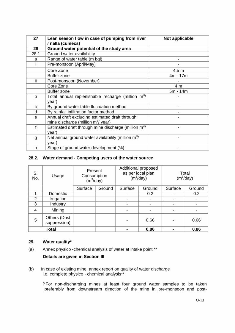
Q-13
27 Lean season flow in case of pumping from river/ nalla (cumecs)
Not applicable
28 Ground water potential of the study area28.1 Ground water availability
a Range of water table (m bgl) -i Pre-monsoon (April/May) -
Core Zone 4.5 mBuffer zone 4m– 17m
ii Post-monsoon (November) -Core Zone 4 mBuffer zone 5m - 14m
b Total annual replenishable recharge (million m3/year)
-
c By ground water table fluctuation method -d By rainfall infiltration factor method -e Annual draft excluding estimated draft through
mine discharge (million m3/ year)-
f Estimated draft through mine discharge (million m3/year)
-
g Net annual ground water availability (million m3/year)
-
h Stage of ground water development (%) -
28.2. Water demand - Competing users of the water source
S.No.
UsagePresent
Consumption(m3/day)
Additional proposedas per local plan
(m3/day)Total
(m3/day)
Surface Ground Surface Ground Surface Ground1 Domestic - 0.2 - 0.22 Irrigation - - - -3 Industry - - - -
4 Mining - - - -
5Others (Dustsuppression)
- 0.66 - 0.66
Total - 0.86 - 0.86
29. Water quality*
(a) Annex physico -chemical analysis of water at intake point **
Details are given in Section III
(b) In case of existing mine, annex report on quality of water dischargei.e. complete physico - chemical analysis**
[*For non-discharging mines at least four ground water samples to be takenpreferably from downstream direction of the mine in pre-monsoon and post-

Q-14
monsoon periods and analysed. For discharging mines six samples are to beanalysed]
**All parameters as per BIS 10500. Indicate name of Methodology, Equipment usedfor analysis, and Detection Level (DL) for each parameter.
*** Wherever any analytical parameter is below detection level, “BDL” (BelowDetection Level) should be written instead of ‘NIL’.
30. Impact on ground water regime / stream /lake / springs due to mine dewatering *
a Radius of influence (in m)[To be estimated based on analysis ofpumping test data and application ofempirical formula]
-
b Whether saline water ingress will take place?(applicable to coastal areas)
-
c Impact on stream / lake / springs -[* Provide a comprehensive hydro-geological assessment report if the averagemine dewatering is more than 100 m3/day and or going below water table in non-monsoon period. The report should be based on preferably latest one year pre-monsoon and post-monsoon baseline data covering information on ground watersituation, aquifer characteristics, water level conditions (April – May andNovember), estimate of ground water resources, predicted impact of the project onground water regime and detailed remedial / conservation measures such asartificial recharge of ground water etc. The report should be based on actual fieldinventory out of existing wells, at least 30 observation wells in the buffer zone withsupplementary information from secondary sources (mention name). Forestimation** of ground water resource (refer question no. 28 above) be designatedstudy area of the buffer zone may be sub-divided into command and non-commandareas, watershed-wise (in case of hard rock / consolidated formations) / block-wise /mandal-wise in case of alluvial / unconsolidated formations)]
[**For estimating ground water resources in the area follow the Ground WaterEstimation Committee recommendations of 1997]
31. Waste Water Management Not Applicablea Daily average discharge (m3/day) from
different sourcesi Mine water discharge during
Lean periodMonsoon period
ii Workshopiii Domestic (mine site)iv Beneficiation / Washeriesv Coal Handling Plantvi Tailings pondvii Others (Specify)
Totalb Waste water treatment plant; flow sheet for
treatment process attached.c Quantity of water recycled / reused / to be
recycled ini Percentage
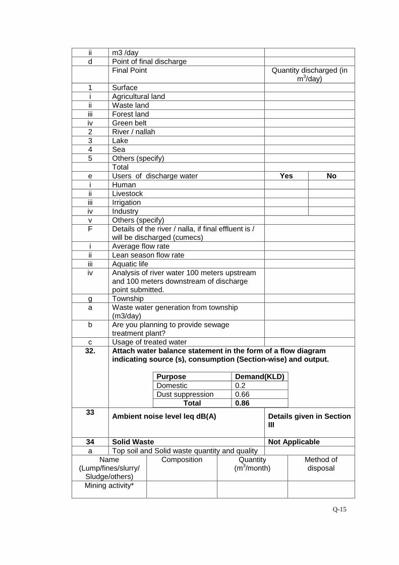
Q-15
ii m3 /dayd Point of final discharge
Final Point Quantity discharged (inm3/day)
1 Surfacei Agricultural landii Waste landiii Forest landiv Green belt2 River / nallah3 Lake4 Sea5 Others (specify)
Totale Users of discharge water Yes Noi Humanii Livestockiii Irrigationiv Industryv Others (specify)F Details of the river / nalla, if final effluent is /
will be discharged (cumecs)i Average flow rateii Lean season flow rateiii Aquatic lifeiv Analysis of river water 100 meters upstream
and 100 meters downstream of dischargepoint submitted.
g Townshipa Waste water generation from township
(m3/day)b Are you planning to provide sewage
treatment plant?c Usage of treated water
32. Attach water balance statement in the form of a flow diagramindicating source (s), consumption (Section-wise) and output.
Purpose Demand(KLD)Domestic 0.2Dust suppression 0.66
Total 0.8633
Ambient noise level leq dB(A) Details given in SectionIII
34 Solid Waste Not Applicablea Top soil and Solid waste quantity and quality
Name(Lump/fines/slurry/
Sludge/others)
Composition Quantity(m3/month)
Method ofdisposal
Mining activity*
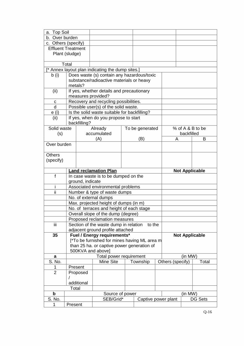
Q-16
a. Top Soilb. Over burdenc. Others (specify)Effluent Treatment
Plant (sludge)
Total[* Annex layout plan indicating the dump sites.]
b (i) Does waste (s) contain any hazardous/toxicsubstance/radioactive materials or heavymetals?
(ii) If yes, whether details and precautionarymeasures provided?
c Recovery and recycling possibilities.d Possible user(s) of the solid waste.
e (i) Is the solid waste suitable for backfilling?(ii) If yes, when do you propose to start
backfilling?Solid waste
(s)Already
accumulated(A)
To be generated
(B)
% of A & B to bebackfilled
A BOver burden
Others(specify)
Land reclamation Plan Not Applicablef In case waste is to be dumped on the
ground, indicatei Associated environmental problemsii Number & type of waste dumps
No. of external dumpsMax. projected height of dumps (in m)No. of terraces and height of each stageOverall slope of the dump (degree)Proposed reclamation measures
iii Section of the waste dump in relation to theadjacent ground profile attached
35 Fuel / Energy requirements*[*To be furnished for mines having ML area morethan 25 ha. or captive power generation of500KVA and above]
Not Applicable
a Total power requirement (in MW)S. No. Mine Site Township Others (specify) Total
1 Present2 Proposed
/additionalTotal
b Source of power (in MW)S. No. SEB/Grid* Captive power plant DG Sets
1 Present
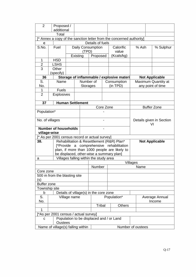
Q-17
2 Proposed /additional
Total[* Annex a copy of the sanction letter from the concerned authority]
c Details of fuelsS.No. Fuel Daily Consumption
(TPD)Calorific
value(Kcals/kg)
% Ash % Sulphur
Existing Proposed1 HSD2 LSHS3 Other
(specify)36 Storage of inflammable / explosive materials Not Applicable
S.No.
Name Number ofStorages
Consumption(in TPD)
Maximum Quantity atany point of time
1 Fuels2 Explosives
37 Human SettlementCore Zone Buffer Zone
Population* -
Details given in SectionVI
No. of villages -
Number of householdsvillage-wise
-
[* As per 2001 census record or actual survey]38. Rehabilitation & Resettlement (R&R) Plan*
[*Provide a comprehensive rehabilitationplan, if more than 1000 people are likely tobe displaced, other-wise a summary plan]
Not Applicable
a Villages falling within the study areaVillages
Number NameCore zone500 m from the blasting site(s)Buffer zoneTownship site
b Details of village(s) in the core zoneS.
No.Village name Population* Average Annual
IncomeTribal Others
1[*As per 2001 census / actual survey]
c Population to be displaced and / or LandOustees
Name of village(s) falling within Number of oustees

Q-18
Land(only)
Homestead(only)
Land andHomestead (both)
Mining Lease1.
Township Site1.
d Whether R&R package has been finalised?If yes, salient features of R&R plan foroustees.
Not Applicable
i Site details where the people are proposed tobe resettled & facilities existing / to becreated.
ii Funds earmarked for compensation packageiii Agency /Authority responsible for their
resettlement.iv Time of commencement of resettlement of
Project Affected People (PAP).v Period by which resettlement of PAP will be
over.39 Lease -wise plantation details Not Applicablea Lease area (in ha.) Existing Proposed
i. Area broken up - -ii. To be broken up - -iii. Area not to be broken-up - -
b Township area (in ha.) -c Area afforested and proposed (in ha.) -
Peripheral Dumps Roads Township Othersi Existingii Proposed
d No. and type of trees planted and proposedi Existing
When plantation was started? Month / YearNo.of plant species planted Number saplings (per
ha.)- -
Survival rate % Avg. height
ii ProposedNo. of plant species to be planted Number of saplings (per
ha.)- -
40 Environmental health and safetya What major health and safety hazards are
anticipated?None
What provisions have been made/proposedto be made to conform to health and safety
As per Mines Act/ Rules
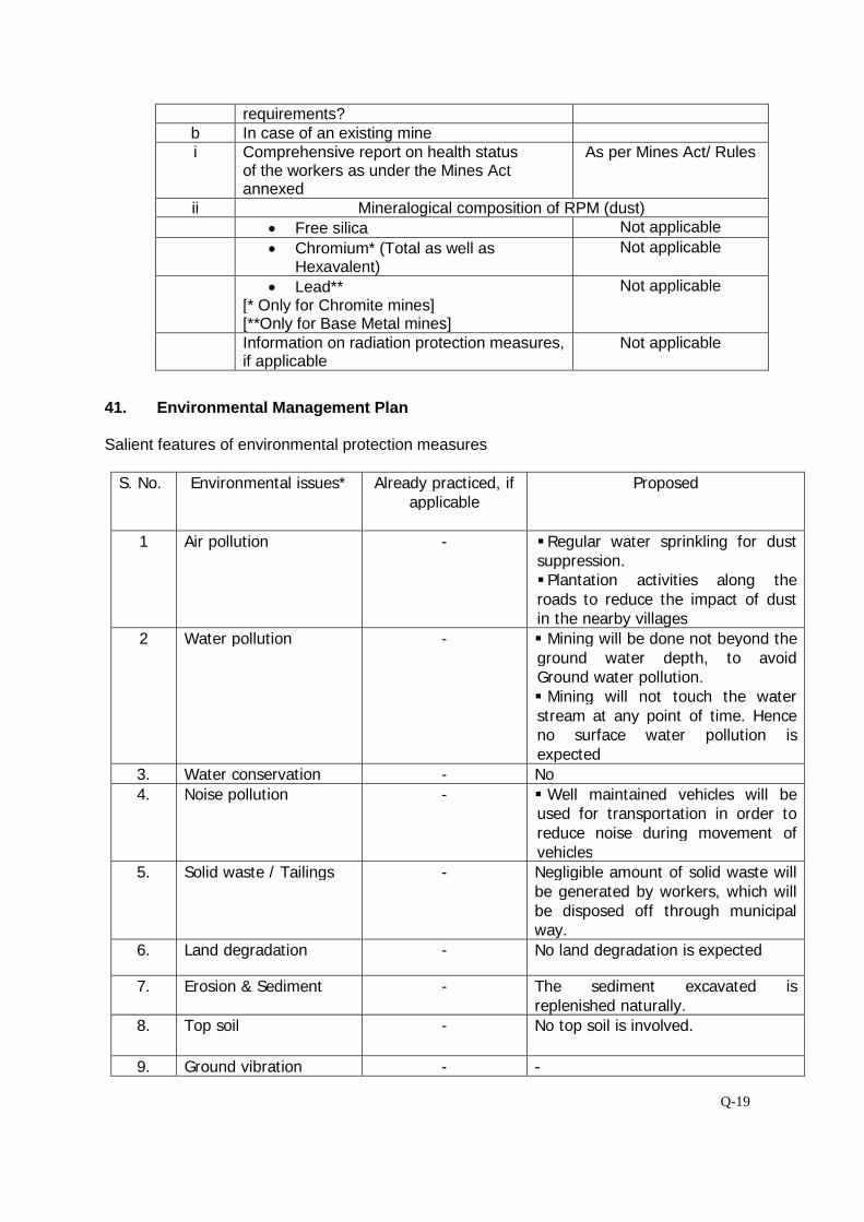
Q-19
requirements?b In case of an existing minei Comprehensive report on health status
of the workers as under the Mines Actannexed
As per Mines Act/ Rules
ii Mineralogical composition of RPM (dust)
Free silica Not applicable
Chromium* (Total as well asHexavalent)
Not applicable
Lead**[* Only for Chromite mines][**Only for Base Metal mines]
Not applicable
Information on radiation protection measures,if applicable
Not applicable
41. Environmental Management Plan
Salient features of environmental protection measures
S. No. Environmental issues* Already practiced, ifapplicable
Proposed
1 Air pollution - Regular water sprinkling for dustsuppression. Plantation activities along theroads to reduce the impact of dustin the nearby villages
2 Water pollution - Mining will be done not beyond theground water depth, to avoidGround water pollution. Mining will not touch the waterstream at any point of time. Henceno surface water pollution isexpected
3. Water conservation - No
4. Noise pollution - Well maintained vehicles will beused for transportation in order toreduce noise during movement ofvehicles
5. Solid waste / Tailings - Negligible amount of solid waste willbe generated by workers, which willbe disposed off through municipalway.
6. Land degradation - No land degradation is expected
7. Erosion & Sediment - The sediment excavated isreplenished naturally.
8. Top soil - No top soil is involved.
9. Ground vibration - -
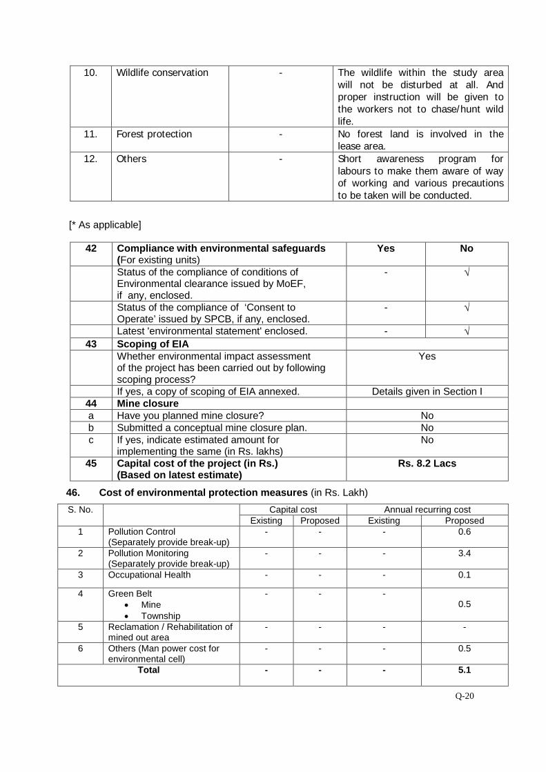
Q-20
10. Wildlife conservation - The wildlife within the study areawill not be disturbed at all. Andproper instruction will be given tothe workers not to chase/hunt wildlife.
11. Forest protection - No forest land is involved in thelease area.
12. Others - Short awareness program forlabours to make them aware of wayof working and various precautionsto be taken will be conducted.
[* As applicable]
42 Compliance with environmental safeguards(For existing units)
Yes No
Status of the compliance of conditions ofEnvironmental clearance issued by MoEF,if any, enclosed.
- √
Status of the compliance of ‘Consent toOperate’ issued by SPCB, if any, enclosed.
- √
Latest 'environmental statement' enclosed. - √43 Scoping of EIA
Whether environmental impact assessmentof the project has been carried out by followingscoping process?
Yes
If yes, a copy of scoping of EIA annexed. Details given in Section I44 Mine closurea Have you planned mine closure? Nob Submitted a conceptual mine closure plan. Noc If yes, indicate estimated amount for
implementing the same (in Rs. lakhs)No
45 Capital cost of the project (in Rs.)(Based on latest estimate)
Rs. 8.2 Lacs
46. Cost of environmental protection measures (in Rs. Lakh)
S. No. Capital cost Annual recurring costExisting Proposed Existing Proposed
1 Pollution Control(Separately provide break-up)
- - - 0.6
2 Pollution Monitoring(Separately provide break-up)
- - - 3.4
3 Occupational Health - - - 0.1
4 Green Belt Mine Township
- - -0.5
5 Reclamation / Rehabilitation ofmined out area
- - - -
6 Others (Man power cost forenvironmental cell)
- - - 0.5
Total - - - 5.1
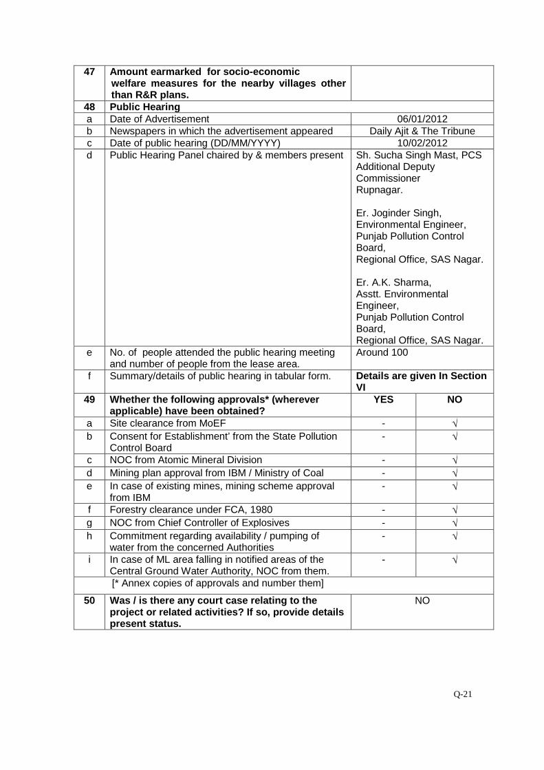
Q-21
47 Amount earmarked for socio-economicwelfare measures for the nearby villages otherthan R&R plans.
48 Public Hearinga Date of Advertisement 06/01/2012b Newspapers in which the advertisement appeared Daily Ajit & The Tribunec Date of public hearing (DD/MM/YYYY) 10/02/2012d Public Hearing Panel chaired by & members present Sh. Sucha Singh Mast, PCS
Additional DeputyCommissionerRupnagar.
Er. Joginder Singh,Environmental Engineer,Punjab Pollution ControlBoard,Regional Office, SAS Nagar.
Er. A.K. Sharma,Asstt. EnvironmentalEngineer,Punjab Pollution ControlBoard,Regional Office, SAS Nagar.
e No. of people attended the public hearing meetingand number of people from the lease area.
Around 100
f Summary/details of public hearing in tabular form. Details are given In SectionVI
49 Whether the following approvals* (whereverapplicable) have been obtained?
YES NO
a Site clearance from MoEF - √b Consent for Establishment’ from the State Pollution
Control Board- √
c NOC from Atomic Mineral Division - √d Mining plan approval from IBM / Ministry of Coal - √e In case of existing mines, mining scheme approval
from IBM- √
f Forestry clearance under FCA, 1980 - √g NOC from Chief Controller of Explosives - √h Commitment regarding availability / pumping of
water from the concerned Authorities- √
i In case of ML area falling in notified areas of theCentral Ground Water Authority, NOC from them.
- √
[* Annex copies of approvals and number them]
50 Was / is there any court case relating to theproject or related activities? If so, provide detailspresent status.
NO
Related Documents